26
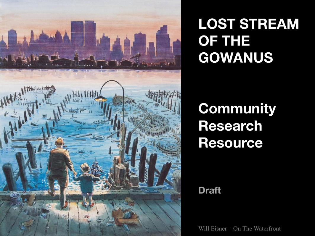
LOST STREAM OF THE GOWANUS Community Research Resource Draft Will Eisner – On The Waterfront
| Date post: | 28-Mar-2016 |
| Category: |
Documents |
| Upload: | hall-of-the-gowanus-digital-library |
| View: | 215 times |
| Download: | 1 times |
LOST STREAM OF THE GOWANUS Community Research Resource Draft
Will Eisner – On The Waterfront
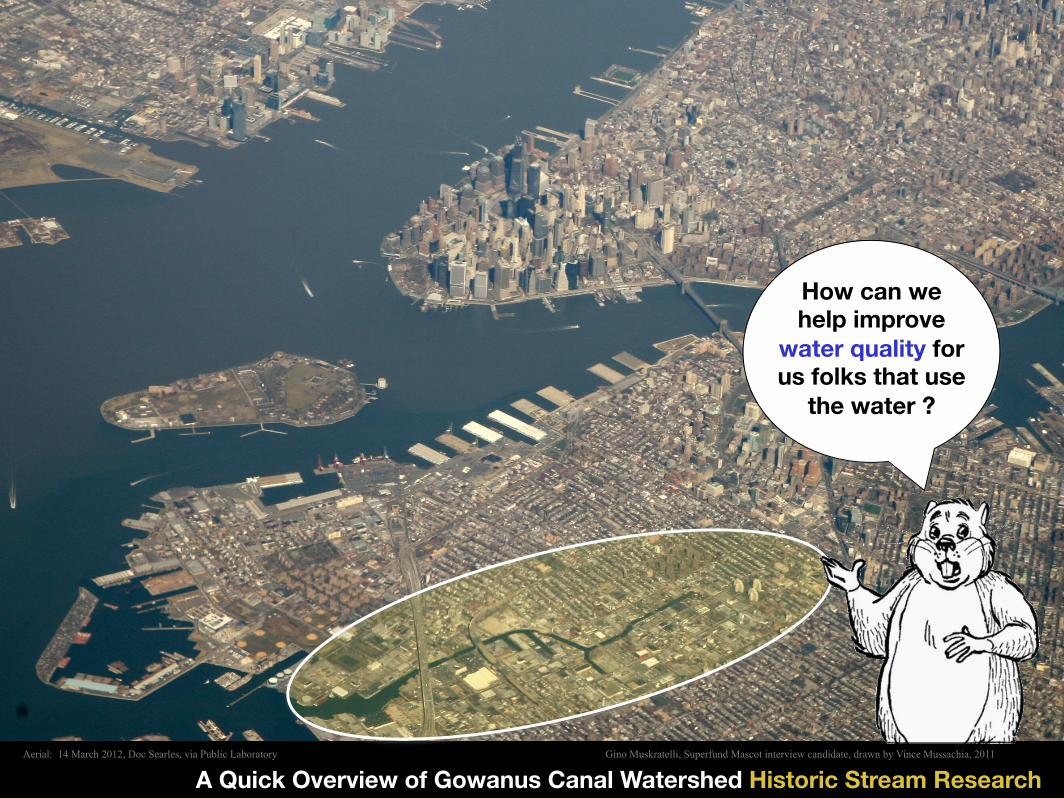
A Quick Overview of Gowanus Canal Watershed Historic Stream Research
“Sludgie” Superfund mascot: Anna Martin 2009
How can we help improve
water quality for us folks that use
the water ?
Gino Muskratelli, Superfund Mascot interview candidate, drawn by Vince Mussachia, 2011 Aerial: 14 March 2012, Doc Searles, via Public Laboratory

Manhattan
Gowanus Watershed
The Canal
Historic Landfilled Tidal Marsh (sponge)
Massive Landscape Transformation with landfilling and hardening of Watershed Local Community Groups are gathering data to improve water quality
1766 Historical Watershed Modeling by Lucas Kronawitter, 2011
1640
2012
THE GOWANUS CANAL A VALLEY WITH A TIDAL MARSH
Proposed Third Ave Storm Sewer IS THERE A BETTER DESIGN ?

Because of excess runoff, the Gowanus Canal gets an average of over a million gallons a day of sewage.
This is huge Community issue. The Superfund Plan will require sewage overflows to be dramatically reduced.
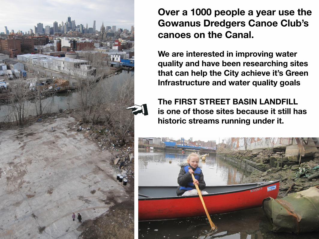
Over a 1000 people a year use the Gowanus Dredgers Canoe Club’s canoes on the Canal.
We are interested in improving water quality and have been researching sites that can help the City achieve it’s Green Infrastructure and water quality goals The FIRST STREET BASIN LANDFILL is one of those sites because it still has historic streams running under it.
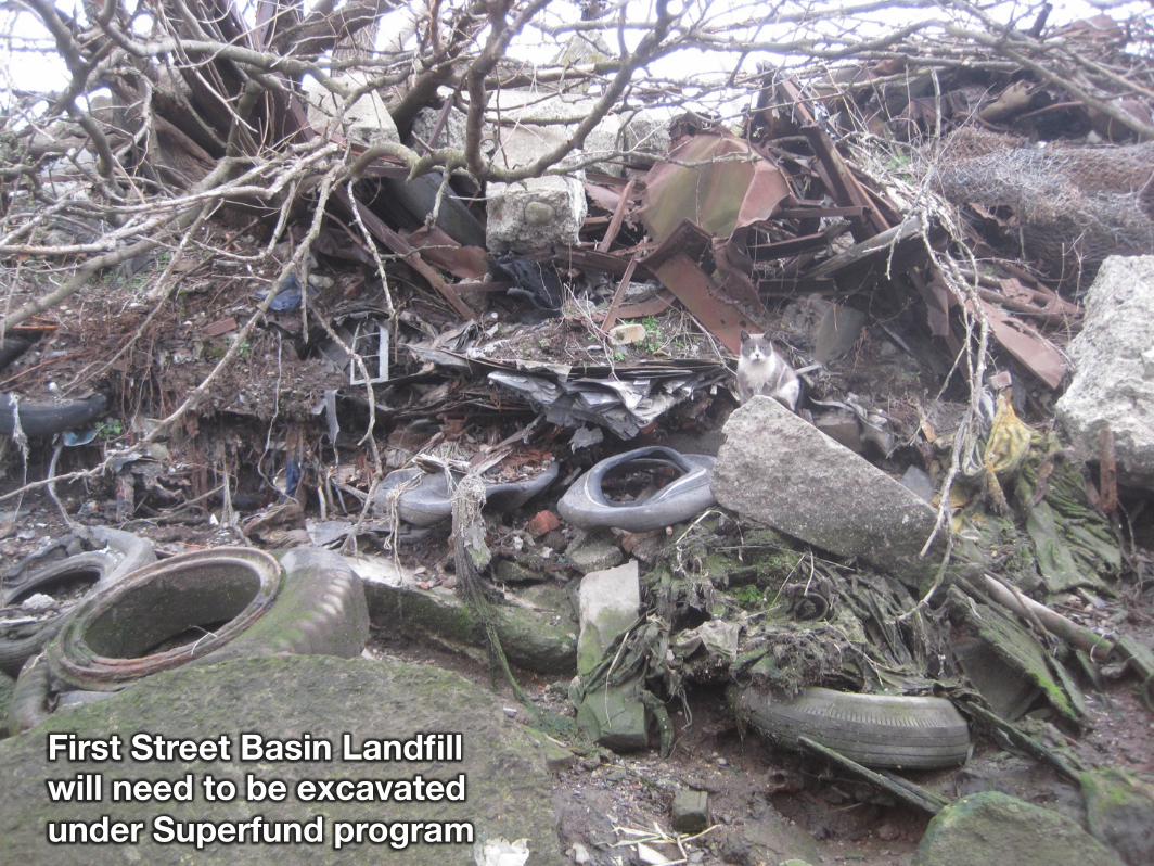
First Street Basin Landfill will need to be excavated under Superfund program

LAND (non naturale)!
1776!2009, Eymund Diegel, Potential Extent of Superfund Area, based on Culligan Columbia Sanborn Study
GOWANUS CANAL POLLUTION: +/- 178 Acres of contaminated area Canal water is a federal Superfund site
= proposals for new housing means greater interest in water quality


Citizen Science Water Testing Program
We are working with the City to make things better

Test Site One
GOWANUS CANAL RIVER PROJECT TEST SITES Test Site One had Enterococcus Counts of up to 24,000 cfu per 100 ml Test Site Two had Zero Why ? FRESH WATER INFLOWS http://www.nycwatertrail.org/water_quality_test.html
FIRST STREET RIGHT OF WAY
Test Site Two
2011 Balloon Aerial

2007
Bob
Gus
skin
d
Reappearance of Denton’s Pond during Whole Foods site remediation
Test Site One
Test Site Two
RIVER PROJECT / GOWANUS DREDGERS 2012 WATER QUALITY TEST SITES
DRAMATICALLY DIFFERENT WATER QUALITY RESULTS BECAUSE OF POSITIVE INFLUENCE OF FRESH WATER INFLOWS

Test
Site Two

RECONSTRUCTING THE PATH OF THE GOWANUS WATERSHED’S HISTORIC STREAMS BY MAPPING VEGETATION PATTERNS USING BALLOON CAMERAS WEEDS GROWING THROUGH CONCRETE TRACK OLD STREAM BED

VIDEO OF STREAM LOCATED WITH AERIAL PHOTOGRAPHY VEGETATION MAPPING http://www.flickr.com/photos/51802375@N04/8245432643/in/set-72157632146485724
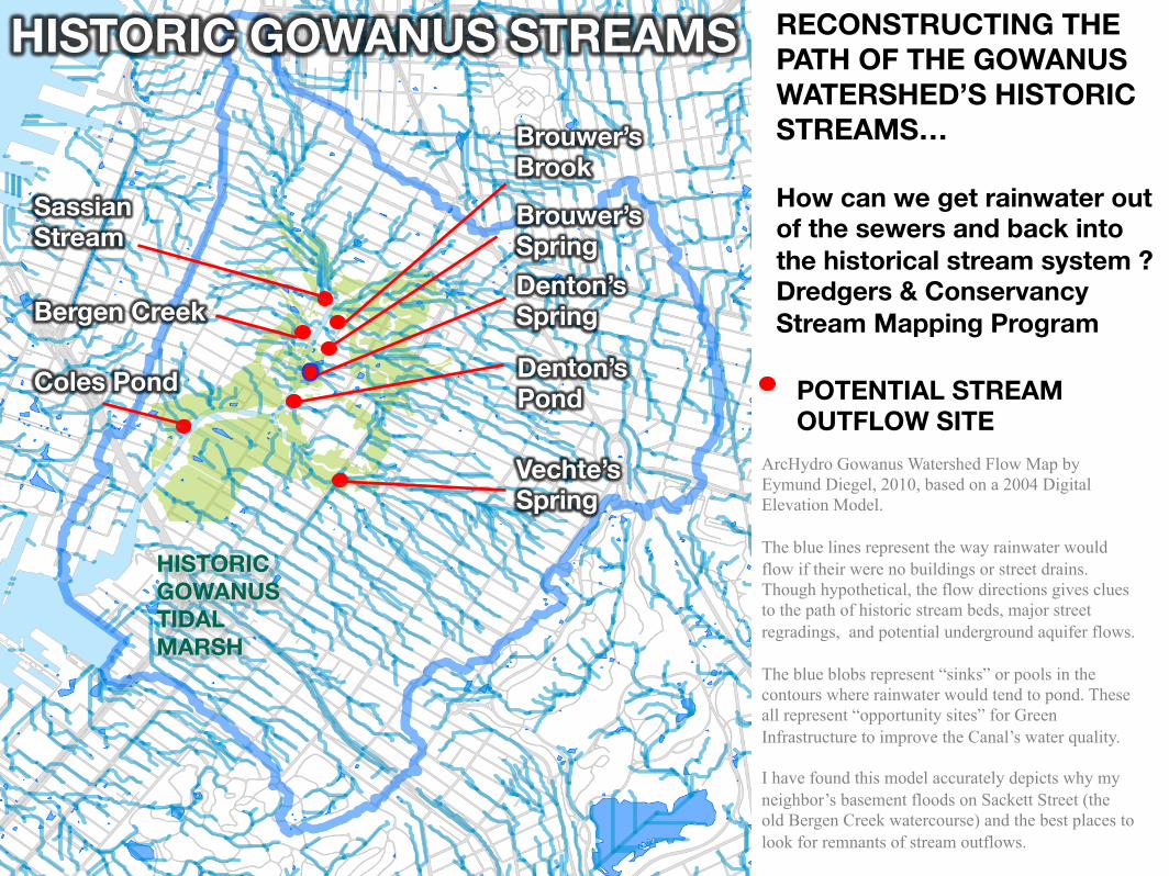
RECONSTRUCTING THE PATH OF THE GOWANUS WATERSHED’S HISTORIC STREAMS… How can we get rainwater out of the sewers and back into the historical stream system ? Dredgers & Conservancy Stream Mapping Program
ArcHydro Gowanus Watershed Flow Map by Eymund Diegel, 2010, based on a 2004 Digital Elevation Model. The blue lines represent the way rainwater would flow if their were no buildings or street drains. Though hypothetical, the flow directions gives clues to the path of historic stream beds, major street regradings, and potential underground aquifer flows. The blue blobs represent “sinks” or pools in the contours where rainwater would tend to pond. These all represent “opportunity sites” for Green Infrastructure to improve the Canal’s water quality. I have found this model accurately depicts why my neighbor’s basement floods on Sackett Street (the old Bergen Creek watercourse) and the best places to look for remnants of stream outflows.
Bergen Creek
Brouwer’s Brook
Sassian Stream
Denton’s Spring
Denton’s Pond
Coles Pond
Vechte’s Spring
HISTORIC GOWANUS TIDAL MARSH
POTENTIAL STREAM OUTFLOW SITE
Brouwer’s Spring
HISTORIC GOWANUS STREAMS

1766 American Revolution Battle Site. Eligible for Federal commemoration funds, with building site identified as a potential commemoration candidate by Gowanus Superfund Archeological Report Battle of Long Island at Denton’s Mill, painted by Alonzo Chappel, 1858
First Street Basin Denton’s Spring Site is a Revolutionary War Site
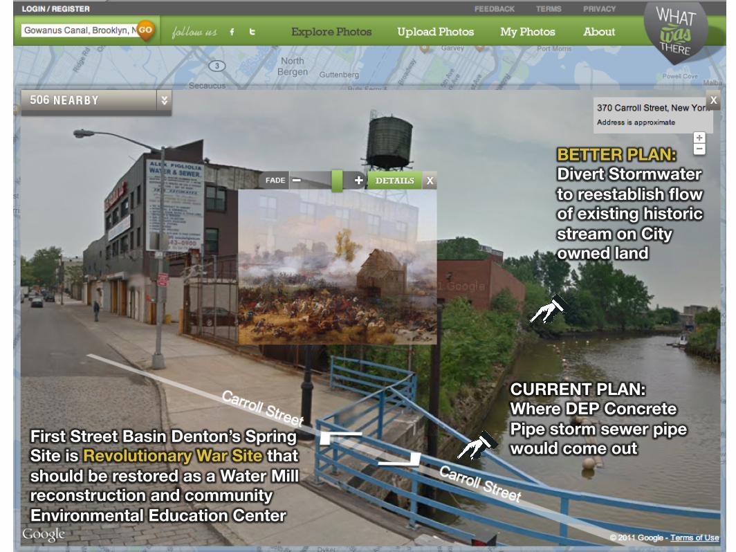
First Street Basin Denton’s Spring Site is Revolutionary War Site that should be restored as a Water Mill reconstruction and community Environmental Education Center
CURRENT PLAN: Where DEP Concrete Pipe storm sewer pipe would come out
BETTER PLAN: Divert Stormwater to reestablish flow of existing historic stream on City owned land

circuit boards
Where Denton’s Spring currently flows into Canal

CANAL WATERFRONT IS RAPIDLY CHANGING: MULTIPLE HOUSING PROPOSALS An Opportunity to implement Water Sensitive Urban Design
First Street Basin Site
Existing Dredgers Boat House
Proposed Lightstone Development
Powerhouse Environmental Arts Foundation Site
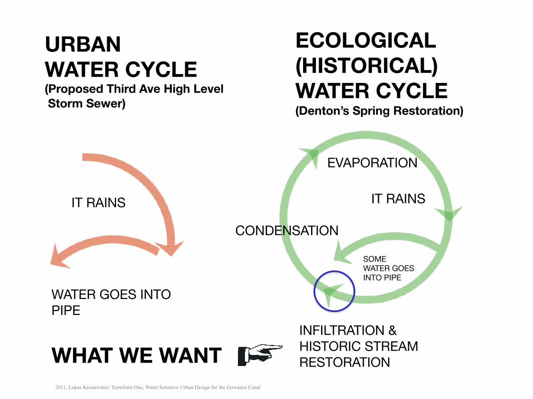
ECOLOGICAL (HISTORICAL) WATER CYCLE (Denton’s Spring Restoration)
URBAN WATER CYCLE (Proposed Third Ave High Level Storm Sewer)
IT RAINS
WATER GOES INTO PIPE
CONDENSATION
EVAPORATION
INFILTRATION & HISTORIC STREAM RESTORATION
IT RAINS
SOME WATER GOES INTO PIPE
WHAT WE WANT 2011, Lukas Kronawitter, Terreform One, Water Sensitive Urban Design for the Gowanus Canal

Denton’s Spring Restoration
Proposed Third Ave Storm Sewer Rerouting Alternative
Runoff Direction
Bas
e M
ap D
ata
avai
lab
le f
rom
info
@p
rote
usg
ow
anus
.org
-
The
Hal
l of
the
Go
wan
us C
om
mun
ity
Res
our
ce
http://issuu.com
/proteusgowanus#http://issuu.com/proteusgowanus
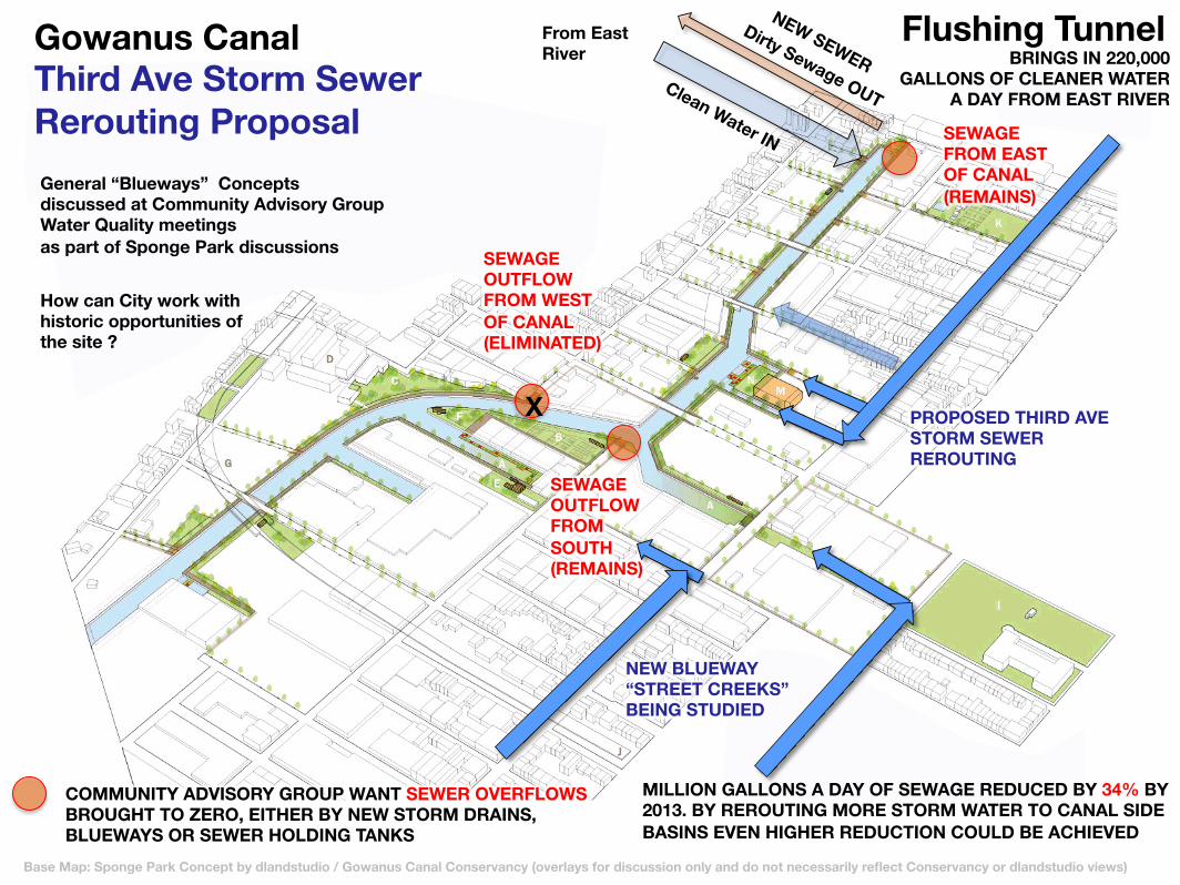
MILLION GALLONS A DAY OF SEWAGE REDUCED BY 34% BY 2013. BY REROUTING MORE STORM WATER TO CANAL SIDE BASINS EVEN HIGHER REDUCTION COULD BE ACHIEVED
Flushing Tunnel BRINGS IN 220,000
GALLONS OF CLEANER WATER A DAY FROM EAST RIVER
Gowanus Canal Third Ave Storm Sewer Rerouting Proposal
Base Map: Sponge Park Concept by dlandstudio / Gowanus Canal Conservancy (overlays for discussion only and do not necessarily reflect Conservancy or dlandstudio views)
From East River
PROPOSED THIRD AVE STORM SEWER REROUTING
General “Blueways” Concepts discussed at Community Advisory Group Water Quality meetings as part of Sponge Park discussions
SEWAGE OUTFLOW FROM WEST OF CANAL (ELIMINATED)
SEWAGE OUTFLOW FROM SOUTH (REMAINS)
X
COMMUNITY ADVISORY GROUP WANT SEWER OVERFLOWS BROUGHT TO ZERO, EITHER BY NEW STORM DRAINS, BLUEWAYS OR SEWER HOLDING TANKS
SEWAGE FROM EAST OF CANAL (REMAINS)
NEW BLUEWAY “STREET CREEKS” BEING STUDIED
How can City work with historic opportunities of the site ?
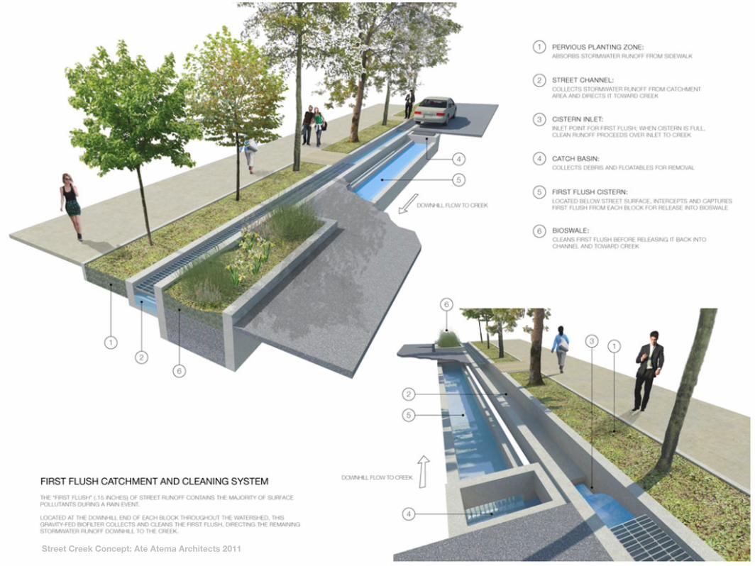
Street Creek Concept: Ate Atema Architects 2011
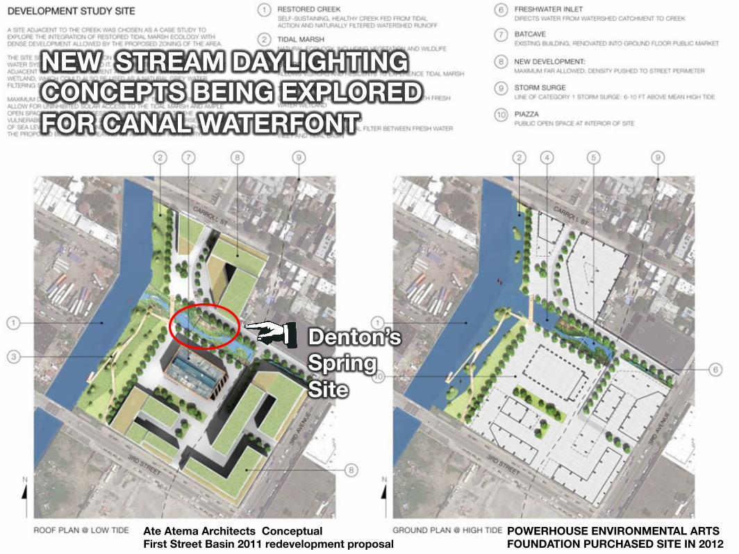
Denton’s Spring Site
Ate Atema Architects Conceptual First Street Basin 2011 redevelopment proposal
POWERHOUSE ENVIRONMENTAL ARTS FOUNDATION PURCHASED SITE IN 2012
NEW STREAM DAYLIGHTING CONCEPTS BEING EXPLORED FOR CANAL WATERFONT

Volunteer Groups are ready to work with you to restore our water quality. How can we help ?
2012 photo of Gowanus Canal Conservancy / Gowanus Dredgers Canoe Club street end replanting programs

Like This ? Check out Lost Rivers
http://vimeo.com/50839044


