Hobbit Environmental Consulting Corp. Newtok Environmental Site Inventory and Assessment Project Part I: Hazardous Materials Inventory Prepared by: Hobbit Environmental Consulting Corp. Prepared for: State of Alaska Department of Commerce, Community and Economic Development October 29, 2015
Transcript
Hobbit Environmental Consulting Corp.
Newtok Environmental Site Inventory and Assessment Project
Part I: Hazardous Materials Inventory
Prepared by:
Hobbit Environmental Consulting Corp.
Prepared for:
State of Alaska
Department of Commerce, Community and Economic Development
October 29, 2015
This Hazardous Materials Inventory is funded by a grant to the State of Alaska by the U.S. Department of the Interior, Fish and Wildlife Service, Coastal Impact Assistance Program, Federal Award F12AF00727, “Newtok Environmental Site Inventory and Assessment”.
Newtok Environmental Site Inventory and Assessment Project
Part I: Hazardous Materials Inventory
Prepared by:
Hobbit Environmental Consulting Corp.
Prepared for:
State of Alaska
Department of Commerce, Community and Economic Development
October 29, 2015
Prepared by: /JU~ Annemieke Powers
Reviewed by:
Newtok Hazardous Waste Inventory i
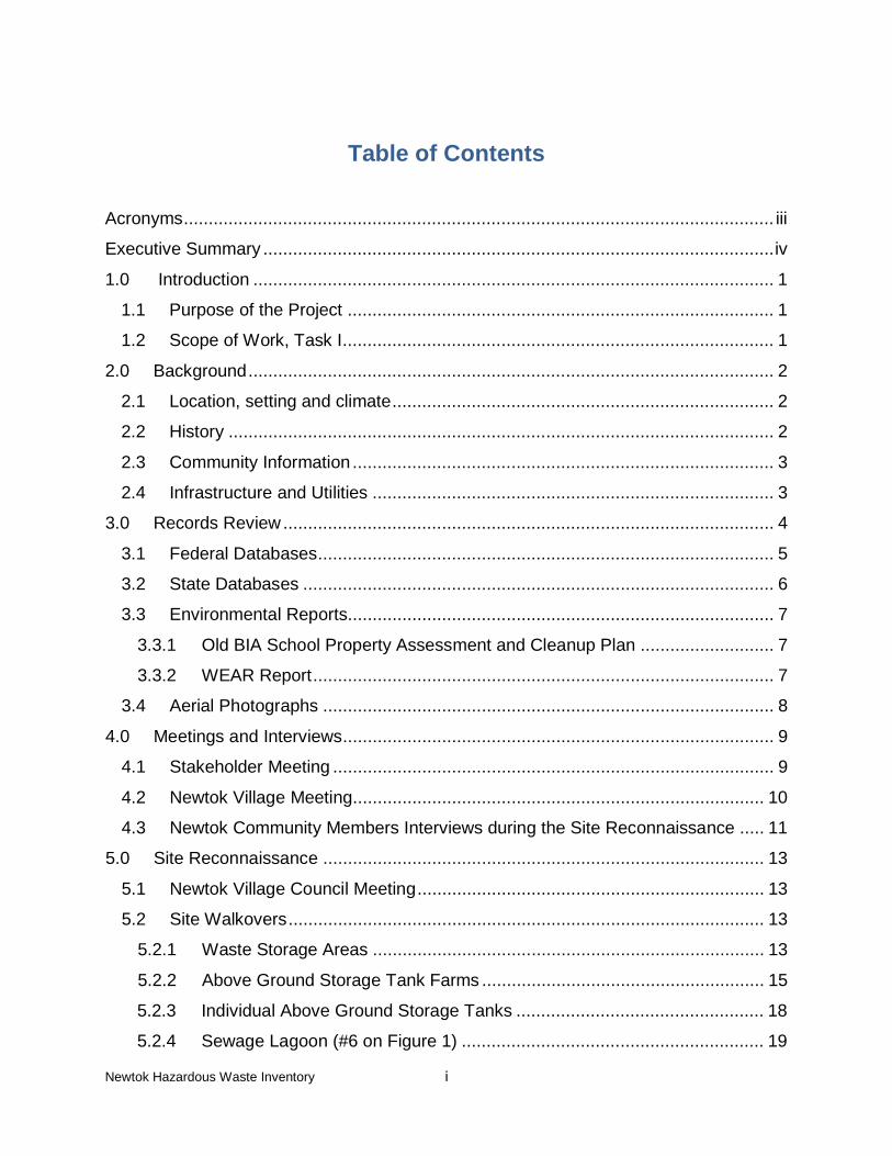
Table of Contents
Acronyms ....................................................................................................................... iii
Executive Summary ....................................................................................................... iv
10.0 Limitation of Liability ........................................................................................... 27
Table 1 Newtok Hazardous Materials Inventory
Figure 1 Village Plan, Newtok, Alaska
Appendix A Federal Database Records
Appendices
Appendix B State Database Records
Appendix C Aerial Photographs
Appendix D Site Photographs
Appendix E Copies of Field Notes
Newtok Hazardous Waste Inventory iii
Acronyms
ACM Asbestos Containing Material
ADEC Alaska Department of Environmental Conservation
Armory Alaska Armory National Guard Newtok FSA
ASTM American Society for Testing and Materials
BIA Bureau of Indian Affairs
CERCLIS Comprehensive Environmental Response, Compensation and Liability Information System DCCED Department of Commerce, Community and Economic Development
USEPA Environmental Protection Agency
F Fahrenheit
ft Feet
Hobbit Hobbit Environmental Consulting Corp.
HVAC Heating, ventilation and air conditioning
IGAP Indian General Assistance Program
NPL National Priorities List
NRC National Response Center
NTC Newtok Traditional Council
NVC Newtok Village Council
RCRA Resource Conservation and Recovery Act
SLR SLR International Corp.
UPC Ungusraq Power Company
USACE United States Army Corps of Engineers
USFWS United States Fish and Wildlife Service
WEAR Waste Erosion Assessment and Review
YDNWR Yukon Delta National Wildlife Refuge
Newtok Hazardous Waste Inventory iv
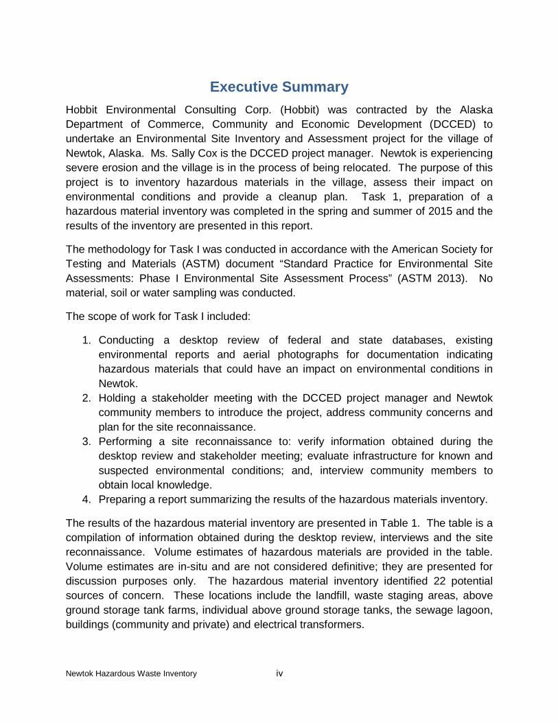
Executive Summary Hobbit Environmental Consulting Corp. (Hobbit) was contracted by the Alaska Department of Commerce, Community and Economic Development (DCCED) to undertake an Environmental Site Inventory and Assessment project for the village of Newtok, Alaska. Ms. Sally Cox is the DCCED project manager. Newtok is experiencing severe erosion and the village is in the process of being relocated. The purpose of this project is to inventory hazardous materials in the village, assess their impact on environmental conditions and provide a cleanup plan. Task 1, preparation of a hazardous material inventory was completed in the spring and summer of 2015 and the results of the inventory are presented in this report.
The methodology for Task I was conducted in accordance with the American Society for Testing and Materials (ASTM) document “Standard Practice for Environmental Site Assessments: Phase I Environmental Site Assessment Process” (ASTM 2013). No material, soil or water sampling was conducted.
The scope of work for Task I included:
1. Conducting a desktop review of federal and state databases, existing environmental reports and aerial photographs for documentation indicating hazardous materials that could have an impact on environmental conditions in Newtok.
2. Holding a stakeholder meeting with the DCCED project manager and Newtok community members to introduce the project, address community concerns and plan for the site reconnaissance.
3. Performing a site reconnaissance to: verify information obtained during the desktop review and stakeholder meeting; evaluate infrastructure for known and suspected environmental conditions; and, interview community members to obtain local knowledge.
4. Preparing a report summarizing the results of the hazardous materials inventory.
The results of the hazardous material inventory are presented in Table 1. The table is a compilation of information obtained during the desktop review, interviews and the site reconnaissance. Volume estimates of hazardous materials are provided in the table. Volume estimates are in-situ and are not considered definitive; they are presented for discussion purposes only. The hazardous material inventory identified 22 potential sources of concern. These locations include the landfill, waste staging areas, above ground storage tank farms, individual above ground storage tanks, the sewage lagoon, buildings (community and private) and electrical transformers.
Newtok Hazardous Waste Inventory 1
1.0 Introduction Hobbit Environmental Consulting Corp. (Hobbit) was contracted by the Alaska Department of Commerce, Community and Economic Development (DCCED) to undertake an Environmental Site Inventory and Assessment project for the village of Newtok, Alaska. Ms. Sally Cox is the DCCED project manager. The project consists of three tasks:
• Task I - prepare an inventory of hazardous materials; • Task II - assess the hazardous materials in relation to environmental conditions;
and, • Task III - develop a cleanup strategy.
Task 1, preparation of a hazardous material inventory was completed in the spring and summer of 2015 and the results of the inventory are presented below.
1.1 Purpose of the Project Newtok is a Yup’ik village located within the Yukon Delta National Wildlife Refuge (YDNWR). Severe erosion along the Ninglick River is threatening the village and Newtok is being relocated to a new location. Continued erosion could destroy the village with infrastructure potentially slumping into the river and becoming waterborne hazards.
The proximity of the village to terrestrial and marine water bodies and its location within the wildlife refuge precipitates the need to inventory, assess and manage potential environmental impacts that could be influenced by the erosion.
1.2 Scope of Work, Task I The scope of work for Task I included:
1. Conducting a desktop review of federal and state databases, existing environmental reports and aerial photographs for documentation indicating hazardous materials that could have an impact on environmental conditions in Newtok.
2. Holding a stakeholder meeting with the DCCED project manager and Newtok community members to introduce the project, address community concerns and plan for the site reconnaissance.
3. Performing a site reconnaissance to: verify information obtained during the desktop review and stakeholder meeting; evaluate infrastructure for known and suspected environmental conditions; and, interview community members to obtain local knowledge.
Newtok Hazardous Waste Inventory 2
4. Preparing a report summarizing the results of the hazardous materials inventory.
Hobbit performed the work under the DCCED term contract #15-013-128. The inventory was conducted in accordance with the American Society for Testing and Materials (ASTM) document “Standard Practice for Environmental Site Assessments: Phase I Environmental Site Assessment Process” (ASTM 2013). No material, soil or water sampling was conducted.
Table 1, The Newtok Hazardous Materials Inventory, and Figure 1, showing the location of Newtok and a village plan follow the report text. Appendices A and B include the federal and state database records. Aerial photographs and site photographs are provided in Appendices C and D. Appendix E has copies of the field notes.
2.0 Background
2.1 Location, setting and climate Newtok is located in western Alaska, approximately 94 miles northwest of Bethel as shown in the Figure 1 inset. The village is within the Bethel Census Area in the Unorganized Borough.
Newtok sits at the northwest corner of the confluence of the Ninglick and Newtok Rivers. The Newtok River is also referred to on some maps as the Kealavik River. Both the Ninglick and the Newtok Rivers are influenced by ocean tides. At low tide the Newtok River completely discharges its water and becomes mud flats. The village is within the YDNWR at 600 56’40” north latitude and 1640 38’ 39” west longitude. The YDNWR is an important waterfowl and fish refuge. It is characterized by low lying, flat, wetlands comprising lakes, rivers, sloughs and creeks.
Newtok’s climate is in a transition area between maritime and continental climates (DCCED 2008). Due to its proximity to the Bering Sea, local weather is influenced by coastal storms and storm surges can produce flooding in the village. Average summer temperatures range from 560 Fahrenheit (F) to 600F and average winter temperatures are 180F to 190F. Average rainfall is 17 inches per year and average snowfall is 28 inches per year.
2.2 History The Yup’ik have occupied the Newtok surroundings for many years. The village site was originally a winter camp. In 1958, the Bureau of Indian Affairs (BIA) School was built within the current village footprint. The location was chosen for practical reasons, the barge carrying the construction materials could not continue further upstream. Development continued around the school and by the 1970s Newtok became a
Newtok Hazardous Waste Inventory 3
permanent village. Flooding during coastal storms, permafrost melt, and severe erosion by the Ninglick River has been a threat to the integrity of village infrastructure. Erosional studies were conducted in the 1980s. The studies concluded that continued erosion by the Ninglick River would eventually wash away portions of the village. A former dumpsite and the former barge landing have already been destroyed. Mitigation costs were calculated to be prohibitively high and the decision was made to move the village. In 2003, a land swap between the Newtok Native Corporation and U.S. Fish and Wildlife Service (USFWS) was completed. The new village, Mertarvik, is located approximately 9 miles across the Ninglick River on Nelson Island. It is currently in the process of construction.
2.3 Community Information According to 2010 Census Data, Newtok had a population of 354 residents; 96% were Alaskan Native (U.S. Census Bureau 2010). Newtok had 72 homes and a 97% occupancy rate. Many Newtok residents were bilingual; 94.3% of the population spoke a language (Yup’ik) other than English while 5.7% spoke only English. The Newtok School conducts classes in both the Yup’ik and English languages. The Census data
indicated that 30.1% of Newtok residents lived below the poverty level. The community relies heavily on subsistence hunting, fishing and gathering. Herring, salmon, seal, musk ox, moose, waterfowl and berries supply some of the subsistence needs.
Conflict between the Newtok Traditional Council (NTC) and the Newtok Village Council (NVC) over governance of Newtok has impacted relocation efforts. In 2013, the BIA and DCCED recognized NVC as the governing council (ADN 2015). Appeals by the NTC resulted in a federal ruling in August, 2015 upholding the NVC’s governing position.
2.4 Infrastructure and Utilities Newtok is not linked to a road system. An air strip is located west of the village and regional transportation to Newtok is primarily by air with regular flights from Bethel. A
Photo 1: Fish Drying
Newtok Hazardous Waste Inventory 4
network of wooden boardwalks connects residences, public buildings and infrastructure. Residents use all terrain vehicles, snow machines and small boats for local transportation.
Most residences and public buildings do not have running water. Drinking water is pumped from a pond near the air strip to the washeteria where it is treated and available for village use. Residents can obtain water from an outdoor spout and haul it to their homes. Some residents haul water from Mertarvik or melt snow or ice in the winter. The Newtok School has a separate well and water treatment system which serves the school and teacher housing. There is no sewage infrastructure in the village. Honey buckets are used in most residences and emptied into the Newtok River. The school has bathrooms and discharges sewage to a lagoon located between the school and the Newtok River.
Electricity is supplied by the Ungusraq Power Company (UPC) with a diesel powered generator. Electrical lines are above ground. The Newtok School generates its own power.
Heating oil is used to heat residences and public buildings. Fuel is stored in tank farms and individual storage tanks.
Solid waste is disposed in a landfill located on the east side of the Newtok River across from the village. In the summer, access to the landfill is only possible at high tide. Some segregation of hazardous and recyclable material has occurred and these materials are stored in a shed behind the NTC building. Prohibitive costs have postponed shipment of these materials out of the village.
Public buildings include: two schools (an abandoned BIA school and the current Newtok School); a health clinic; washeteria; the UPC generation building; churches; post office; community hall; Alaska Armory National Guard Newtok FSA (Armory); and, tribal offices. Tom’s Store sells food and nonfood items. A United States Army Corp of Engineers (USACE) foundation study examined seventy residences in Newtok to determine which structures were sufficiently sound for relocation (USACE 2007). The study indicated that sixty houses could be relocated, five houses could not be relocated and five houses were possible candidates for relocation.
3.0 Records Review Federal and state databases, environmental reports and aerial photographs were obtained and reviewed for information pertaining to environmental conditions in Newtok. The results of the records review are summarized below. The federal records, state records and aerial photographs are provided in Appendices A, B and C, respectively.
Newtok Hazardous Waste Inventory 5
3.1 Federal Databases The National Priorities List (NPL) provides a listing of properties having the United States Environmental Protection Agency’s (USEPA) highest priority for environmental cleanup or Superfund sites. Ten properties in Alaska were listed on the NPL; none of the properties were in or near Newtok.
The Comprehensive Environmental Response, Compensation and Liability Information System (CERCLIS) is a database compiled by the USEPA which tracks sites that are potentially hazardous and require investigation, and sites proposed for inclusion on the NPL. There were no sites in or near Newtok listed on the CERCLIS database.
The Resource Conservation and Recovery Act (RCRA) Information Database provides data regarding hazardous waste generation and handling. No hazardous waste generators were identified in the village of Newtok.
A list of Treatment Storage and Disposal Facilities under RCRA is compiled in the USEPA Region 10 Report. Seven facilities were listed in Alaska but none of the facilities were located in or near Newtok.
Two incidents related to fuel discharges were reported in Newtok on the National Response Center (NRC) Spills and Accidents Database. On May 28, 2014 a caller reported a leaking 10,000 gallon storage tank at a tank farm. There were no waterways impacted and there had been no cleanup attempts. The suspected responsible party was the UPC Power Company. The second incident occurred on August 2, 2001. A caller reported an oil sheen sighting on the Bering Sea near Newtok. No other information about this incident was available.
The USEPA Brownfields database indicated no sites in Newtok designated for clean up or Brownfield Grants Jurisdictions.
A database of endangered species is compiled by the USFWS. Seventeen species were listed for Alaska with three species identified for the “county” of Bethel. The Bethel area species included two species of birds, Spectacled Eider and Steller’s Eider which are threatened and one species, the Short-Tailed Albatross, which is endangered. The National Wetlands Inventory compiled by the USFWS for the YDNWR characterized wetlands near Newtok as freshwater emergent wetland. There was no data for the Newtok village site.
Cultural resources are listed in the National Register of Historic Resources. There were no cultural resources listed for Newtok.
Newtok Hazardous Waste Inventory 6
3.2 State Databases The ADEC Contaminated Sites Database included two sites in Newtok, the Alaska Armory National Guard Newtok FSA (Armory) and the Old BIA School. The Armory underwent a site investigation and remediation between 1998 and 2010. 25 cubic yards of soil contaminated with diesel range organics and residual range organics were transported off site for disposal at the Columbia Ridge Landfill in Oregon. ADEC issued a letter on December 14, 2011 stating that the cleanup was determined to be complete and the site was closed. The Old BIA School underwent a site assessment from 2009 to 2010 under the ADEC Brownfields Assessment program. The assessment indicated the likelihood of contaminated soil on the property and recommended that further characterization of soil be conducted. Asbestos was also identified in the school building. The assessment report is discussed in more detail in Section 3.3.1, below.
The ADEC Underground Storage Tank Database indicated no underground storage tanks in Newtok.
The ADEC Statewide Oil and Hazardous Substance Spills Database was accessed to determine reported spills in Newtok. Eighteen spills were recorded between 1995 and 2015. All of the spills involved fuel.
• Seven spills were recorded for the Newtok School. The most recent spill occurred on August 2, 2015 and consisted of 520 gallons of diesel released and 520 gallons recovered and recycled. Other spills occurred in 2009 (15 gallons used oil), in 2000 (400 gallons diesel) in 2000 (75 gallons diesel), in 1998 (20 gallons diesel), in 1997 (50 gallons diesel) and in 1995 (30 gallons diesel).
• One spill was recorded for the Newtok School tank farm in 1999 (580 gallons diesel).
• Two spills were recorded for the teacher’s housing in 2006 (5 gallons diesel) and in 2004 (70 gallons diesel).
• One spill each was recorded at the following locations: Ninglick River Barge Landing in 2005 (1 gallon gasoline and 1 gallon propylene glycol); the Old BIA School in 2004 (50 gallons diesel); the Newtok Clinic in 2003 (20 gallons diesel); the Newtok Gasoline Pump Station in 2002 (28 gallons gasoline); the Newtok Community Home in 2001 (15 gallons diesel); the Newtok Water Pump in 2001 (6 gallons gasoline); mystery spill from river bank in 2001 (1 gallon unknown); and, the Newtok Tank Farm in 2001 (40 gallons diesel).
All of the spill sites were eventually designated as closed and requiring no further action by ADEC.
The State Solid Waste Information Management System listed ten sites within Newtok: the Newtok 1996 dump site which has eroded into the Ninglick River; six tank farms; the
Newtok Hazardous Waste Inventory 7
Backhaul Staging area; the Newtok Landfill; and the UPC Generator Building. The landfill was classified as a Class III, Active landfill. The Class III designation indicates a solid waste landfill not connected by road to a larger landfill and serving fewer than 1000 people.
An ADEC Water Permit search was conducted and the results indicated that a wastewater discharge permit has been issued to the Newtok School. The permit was issued in 2012 and expires in 2017.
The Alaska Department of Natural Resources maintains a Well Log Database. Water well records were searched for wells existing in the village. The only well record on file was for the Old BIA School water well which had been drilled on March 10, 1964. No record could be found for the Newtok School water well. The well log indicated frozen soils from surface to 244 feet (ft.) below grade. Soils comprised brown and grey silt and fine sand. The well was drilled to a depth of 248 ft and the water level in the well was measured at 16 ft below grade.
3.3 Environmental Reports
3.3.1 Old BIA School Property Assessment and Cleanup Plan
SLR International Corp (SLR) conducted an assessment of the Old BIA School from 2009 to 2010 for the ADEC Brownfield Program (SLR, 2010). The assessment included reviewing historical data, interviewing community members, conducting a site reconnaissance, assessing the results and recommending environmental actions. No material sampling was conducted. The SLR representative was not able to enter the school building; however an asbestos survey report ordered by the Lower Kuskokwim School District in 1996 identified asbestos in gaskets of the boiler, furnace, insulating pad in the stove and some floor tiles. SLR recommended:
• Focused asbestos abatement if moving or demolishing the school building; • Removal of solid waste debris (fuel tanks, generators, miscellaneous debris)
from the site and reuse within the community or disposal at the landfill; • Abandonment of the water well; • Decommissioning of the tank farm; and, • Characterization of potentially contaminated soils identified at the northwest and
northeast corners of the warehouse, between the well house and the school building, and in the tank farm.
3.3.2 WEAR Report
ADEC solid waste personnel conducted the WEAR site visit in Newtok on June 17th, 2013 (ADEC, 2015). The site visit included visiting solid waste staging areas, above ground storage tank farms and the UPC Generator Building. ADEC personnel could not
Newtok Hazardous Waste Inventory 8
visit the landfill as it was low tide and they could not cross the Newtok River. The report summarized conditions at each of the visited locations. Environmental conditions of note included observations of a sheen on water and distressed vegetation at the Tom’s Store tanks and blackened soil, dead vegetation and sheen on water at the UPC Generator Building. The report provided recommended action plans for the UPC Generator Building and the Backhaul Staging Area (Appliance/Snow Machine Staging Area on Figure 1) including removing structures and debris, assessing soils and remediating contaminated soils if necessary.
3.4 Aerial Photographs Aerial photographs of Newtok were acquired from Quantum Spatial in Anchorage, Alaska for the years 1964, 1983, 1996 and 2005.
• 1964 – A few structures are evident in this photograph. The principal structure is the Old BIA School building. Four above ground storage tanks are located near the school. There does not appear to be secondary containment surrounding the tanks. The school warehouse building is also visible in this photograph. Approximately 15 other buildings are scattered to the north and south of the school. One of these buildings is at the current location of the Armory. Construction materials are stacked near the school.
• 1983 – The Old BIA School has expanded with the wellhouse and outdoor basketball court visible. The tank farm has expanded to the current configuration of six above ground storage tanks and containment is visible surrounding it. What appears to be a vertical water storage tank sits just west of the main school building. The village has grown; more buildings have been constructed and a trail or boardwalk system is in place between structures. Three above ground tanks and a horizontal tank are visible in the current location of the NVC tank farms. No secondary containment is evident surrounding the tanks. The Newtok School building has been constructed and the associated above ground storage tank farm can be seen with containment surrounding it. What appears to be above ground piping leads from the main school building to a depression. The location of the depression corresponds to the northern section of the current sewage lagoon. The air strip is evident in its current location.
• 1996 – The UPC and NVC tank farms can be seen in their current configurations and locations. They do not appear to have secondary containment. The washeteria and its vertical water holding tank, as well as the nearby UPC electrical generator building are visible. The sewage lagoon has expanded to its current shape and size and above ground piping from the washeteria leads to the sewage lagoon. The Newtok School building has disappeared (it burned down in 1994) but the tank farm is intact. The water storage tank next to the Old BIA School building has been removed, but the platform remains evident.
Newtok Hazardous Waste Inventory 9
• 2005 – The 2005 aerial photograph shows the village in what appears to be its current extent. The Newtok School has been rebuilt and expanded from its earlier footprint. The school outbuildings have also been built. The washeteria does not yet have its current horizontal tanks. The Newtok Clinic is visible. It is not clear in the photograph if the UPC and NVC tank farms have secondary containment.
4.0 Meetings and Interviews
4.1 Stakeholder Meeting May 20, 2015 Attendees: Newtok: Paul Charles and Romy Cadiente in Anchorage and Bernice John and Lisa Charles by phone. DCCED: Sally Cox Hobbit: Annemieke Powers and Jeff Powers
The purpose of the Stakeholder Meeting was to introduce Hobbit to Newtok community members and to discuss the scope and purpose of the project.
• Sally Cox opened the meeting by introducing the attendees and the project. • Annemieke and Jeff Powers described their company and summarized their
experience conducting similar projects. • Annemieke Powers summarized the project scope of work and discussed the
various elements including examining historical information and conducting the site reconnaissance.
• Paul Charles asked about what the cleanup would entail and Jeff Powers described common remediation strategies and discussed equipment needs to excavate and transport hazardous materials.
• Sally Cox mentioned that the Department of Homeland Security had conducted an evaluation of houses damaged in previous flooding and was planning to relocate twelve homes and demolish five. She said she would provide Hobbit with copies of SLR’s Brownfield Assessment report on the Old BIA School and the Army Corps of Engineers Foundations Study.
Newtok Hazardous Waste Inventory 10
• Romy Cadiente provided Hobbit with contact names in Newtok: Steven Andy and Joseph John Jr. were the Indian General Assistance Program (IGAP) representatives and Tom John was the Tribal Administrator.
• The meeting closed with discussion about the site visit. It was agreed to tentatively schedule the visit for the week of June 22nd, 2015. Romy Cadiente would make arrangements for Hobbit to sleep in the Newtok School. Sally Cox would accompany Hobbit to Newtok if her schedule allowed.
4.2 Newtok Village Meeting June 23rd, 2015
Attendees: Newtok: Paul Charles, Bernice John, Romy Cadiente, Lisa Charles, Katherine Charles, George Carl, Tom John, Steve Andy, Joseph John Jr. Hobbit: Annemieke Powers and Jeff Powers
Hobbit visited Newtok to conduct the site reconnaissance from June 23rd to 25th, 2015. Newtok community members were having a meeting when Hobbit arrived in the village and invited Hobbit to join them and discuss the project.
• Hobbit introduced the purpose and scope of the project and described what the site reconnaissance would entail.
• The landfill could only be accessed at high tide and Steven Andy and Joseph John Jr. offered to take Hobbit to the landfill at the next high tide later that evening.
• Most of the discussion centered around the methodology and cost of cleanup. Discussion included: the possibility of winter excavation of contaminated soils and stockpiling them for removal during summer; the possibility for local labor to do the work; and, Hazwoper training.
• The possibility of asbestos in the ceiling tiles or flooring and lead paint on the walls of older houses was also discussed. Hobbit agreed to meet with Tom John at 9:00 the next morning to walk the village and potentially inspect some houses.
Newtok Hazardous Waste Inventory 11
4.3 Newtok Community Members Interviews during the Site Reconnaissance
Steven Andy and Joseph John Jr.
Steven Andy and Joseph John Jr. were the IGAP representatives for Newtok. They transported Hobbit across the Newtok River to conduct a walkover of the landfill and provided the following waste handling information:
• Freon is removed from appliances and oil is removed from snow machines prior to disposing at the landfill and staging areas. The removed materials were stored in containers in the hazardous waste shed behind the NTC building. Freon has been shipped to Total Reclaim in Anchorage and the used oil has been shipped by barge when possible.
• Used oil was also stored at the Newtok School. The school had an oil burning unit. Individuals occasionally used oil as a lubricant. Oil used to be dumped in the old dumpsite (no longer exists) but they have stopped that practice at the landfill.
• The old dumpsite was located south of the village. This dumpsite eroded into the Ninglick River prior to the current landfill being used in the early 1990s.
• The landfill was not controlled in any way. All residents had access to the landfill and could dispose any materials. The wind could blow materials away. The landfill had been set on fire by an unknown person prior to Hobbit’s visit and had burned for several days.
• The burn box near the center of the landfill was not often used. • The clinic handled its own medical wastes. Nonmedical waste was disposed in
the landfill. • They had segregated e-waste to one side of the landfill in hopes of sending it to
Anchorage for recycling but it may have been damaged by the fire. • School children had gathered trash in the spring from around the village and the
bagged trash was currently stockpiled on the west side of the Newtok River waiting to be hauled to the landfill.
Tom John
Tom John is the Newtok Tribal Administrator. He walked with Hobbit through the village, identified the owners of the tank farms and brought Hobbit to his mother’s BIA house to inspect the inside. He provided the following information:
• The red tanks belonged to the NVC and he pointed out which tanks contained heating oil and which tanks contained unleaded gas.
Newtok Hazardous Waste Inventory 12
• The UTC tanks contained diesel for the generator. The eastern 15,000 gallontank was no longer in use.
• A gas man filled the private heating oil tanks.• The oldest homes in the village were built in the 1970s by the BIA.• The old dump eroded into the Ningick River. It was the primary location of refuse
disposal from the 1960s to the 1980s. The current landfill has been used sincethen.
• School was held in the Old BIA School building from the early 1960s to the mid1980s when the new school was built. After the new school burned down in1994, the BIA School building was again used as a school until 2000 when thecurrent Newtok School building was completed.
• Waste material from the Old BIA School was incinerated and buried until the1980s. Some village garbage was burned as well. The number and frequency ofburning garbage were not known. The ash burial site was believed to be in thevicinity of the current bagged waste staging area.
• The current fuel delivery and terminal set up was installed in the early 2000s afterthe delivery barge became stuck in the Newtok River channel northeast of thevillage.
• The washeteria discharge line to the lagoon was no longer functional due todifferential settlement of the steel pilings that support the overhead line.
• Tom John estimated that depth to permafrost was approximately 1 ft. below thesurface.
Stanley Tom
Stanley Tom was the Tribal Administrator of the NTC. He confirmed that the two tanks located between the UTC and NVC tank farms belonged to the NTC. The white tank was 10,000 gallons in volume and the other tank held 3000 gallons. Both tanks have contained heating oil but only the 3000 gallon tank was currently in use. All of the other tanks, including the tanks located behind Tom’s Store, were currently empty.
Frieda Carl
Frieda Carl worked for the village of Newtok and escorted Hobbit to the hazardous materials storage shed behind the NTC building.
• Waste stored in the shed was a combination of recyclable materials (soda cansand cardboard) and hazardous materials.
• The objective was to collect and store these materials for recycling or disposalbut the cost of transport had been too high.
• She confirmed that garbage burning occurred in the past at the Old BIA Schoolsomewhere near where the bagged trash staging area currently was located.
Newtok Hazardous Waste Inventory 13
• Newtok residents collected drinking water from several sources. Water from apond near the airport was piped to the washeteria where it was treated andavailable for village use. Some villagers hauled drinking water from Mertarvik orused melted snow or ice in the winter. There was also a water well at theNewtok School for the school’s water system.
5.0 Site Reconnaissance Jeff Powers and Annemieke Powers of Hobbit visited Newtok from June 23rd to 25th, 2015 to conduct the site reconnaissance. The purpose of the site reconnaissance was threefold: to verify information obtained during the desktop records review and stakeholder meeting; to observe known and suspected hazardous material sources; and, to meet with community members to obtain local knowledge. Observations were limited to those that were visibly available. No material, soil or water testing was conducted. Photos are presented in the report and in Appendix D. A copy of the field notes can be found in Appendix E.
5.1 Newtok Village Council Meeting Hobbit met with the Newtok Village Council upon arrival in the village to introduce and discuss the purpose and scope of the project. Details of the meeting were provided in Section 4.2.
5.2 Site Walkovers Hobbit’s site walkovers focused on locations identified by document review or interview to be the most likely to contain hazardous materials or potential sources of soil or groundwater contamination. The site locations are presented on Figure 1 and discussed below.
5.2.1 Waste Storage Areas
Newtok Class III Landfill (#15 on Figure 1)
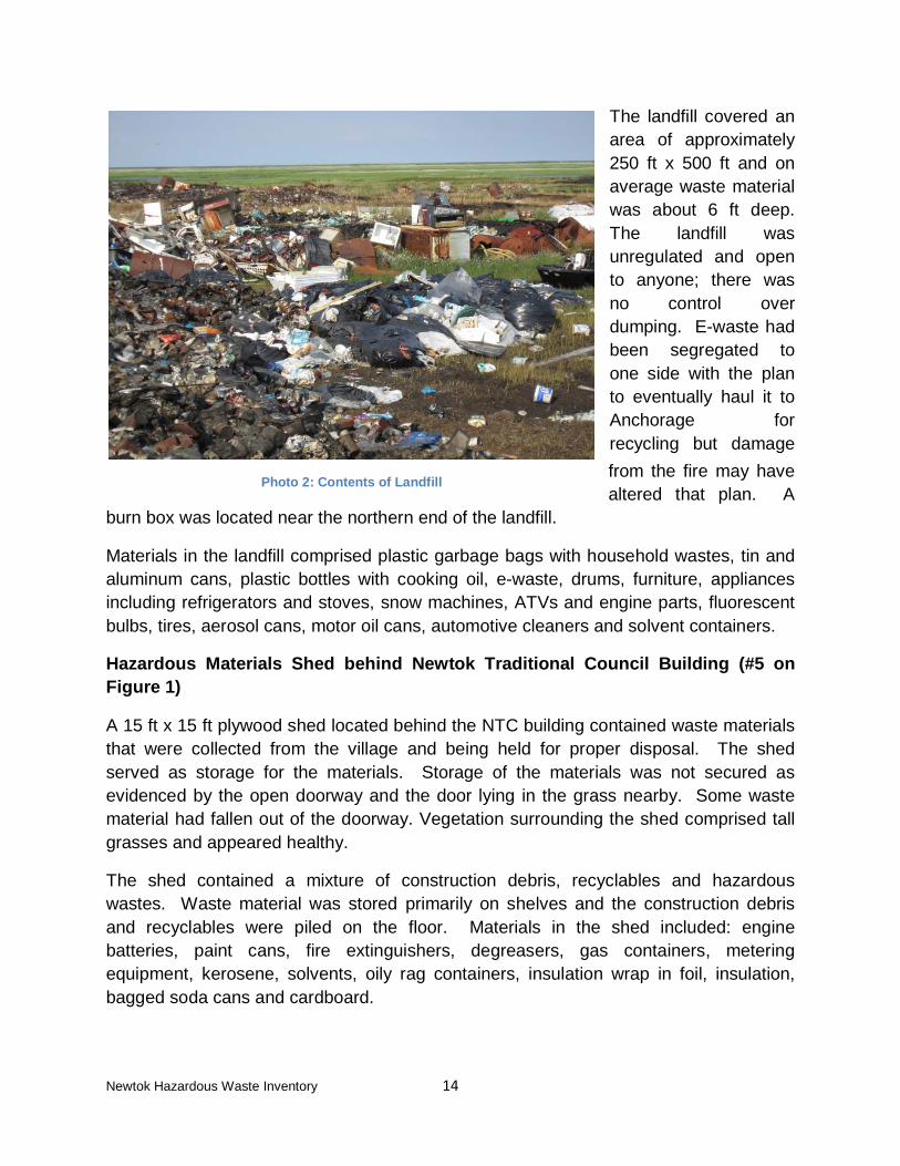
Hobbit visited the landfill on June 23, 2015. The landfill was located on the east side of the Newtok River, across from the village, and access was by boat at high tide. A wooden boardwalk provided access from the boat landing to the landfill. The landfill had been burning prior to Hobbit’s arrival; a local resident had set it on fire and the fire burned for several days across the landfill and nearby vegetation. Surrounding land comprised the Newtok River to the west, and wetlands to the north, east and south. There was no other village infrastructure on the landfill side of the river. Vegetation immediately proximate to the landfill had been burned, but vegetation farther away appeared lush and healthy.
Newtok Hazardous Waste Inventory 14
The landfill covered an area of approximately 250 ft x 500 ft and on average waste material was about 6 ft deep. The landfill was unregulated and open to anyone; there was no control over dumping. E-waste had been segregated to one side with the plan to eventually haul it to Anchorage for recycling but damage from the fire may have altered that plan. A
burn box was located near the northern end of the landfill.
Materials in the landfill comprised plastic garbage bags with household wastes, tin and aluminum cans, plastic bottles with cooking oil, e-waste, drums, furniture, appliances including refrigerators and stoves, snow machines, ATVs and engine parts, fluorescent bulbs, tires, aerosol cans, motor oil cans, automotive cleaners and solvent containers.
Hazardous Materials Shed behind Newtok Traditional Council Building (#5 on Figure 1)
A 15 ft x 15 ft plywood shed located behind the NTC building contained waste materials that were collected from the village and being held for proper disposal. The shed served as storage for the materials. Storage of the materials was not secured as evidenced by the open doorway and the door lying in the grass nearby. Some waste material had fallen out of the doorway. Vegetation surrounding the shed comprised tall grasses and appeared healthy.
The shed contained a mixture of construction debris, recyclables and hazardous wastes. Waste material was stored primarily on shelves and the construction debris and recyclables were piled on the floor. Materials in the shed included: engine batteries, paint cans, fire extinguishers, degreasers, gas containers, metering equipment, kerosene, solvents, oily rag containers, insulation wrap in foil, insulation, bagged soda cans and cardboard.
Photo 2: Contents of Landfill
Newtok Hazardous Waste Inventory 15
Appliances/Snow Machine Staging Area (#7 on Figure 1)
The staging area was located between the sewage lagoon and the Newtok River and covered an area of approximately 60 ft x 20 ft at its greatest width. The staging area was uncontrolled and open to residents. Materials comprised: snow machines, stoves, washing machines, freezers, schools desks and chairs, drums and furniture.
Bagged Waste Staging Area (#8 on Figure 1)
Newtok encouraged school children to collect trash from the village in the spring. The trash was stored in yellow garbage bags which were piled along with other trash bags on the west side of the Newtok River near the Old BIA School. This waste was slated for transport across the river for disposal in the landfill.
This area was also believed to be a historical burial location for waste incineration ash from the Old BIA School and residential trash between the 1960s and the 1980s. The volume and frequency of waste incineration were not known.
5.2.2 Above Ground Storage Tank Farms
The village has four above ground storage tank farms. The current fuel delivery terminal was located at the Ninglick River and was installed in the early 2000s. Historic fuel delivery was from a terminal at the Newtok River and was discontinued after a barge became stuck in the channel.
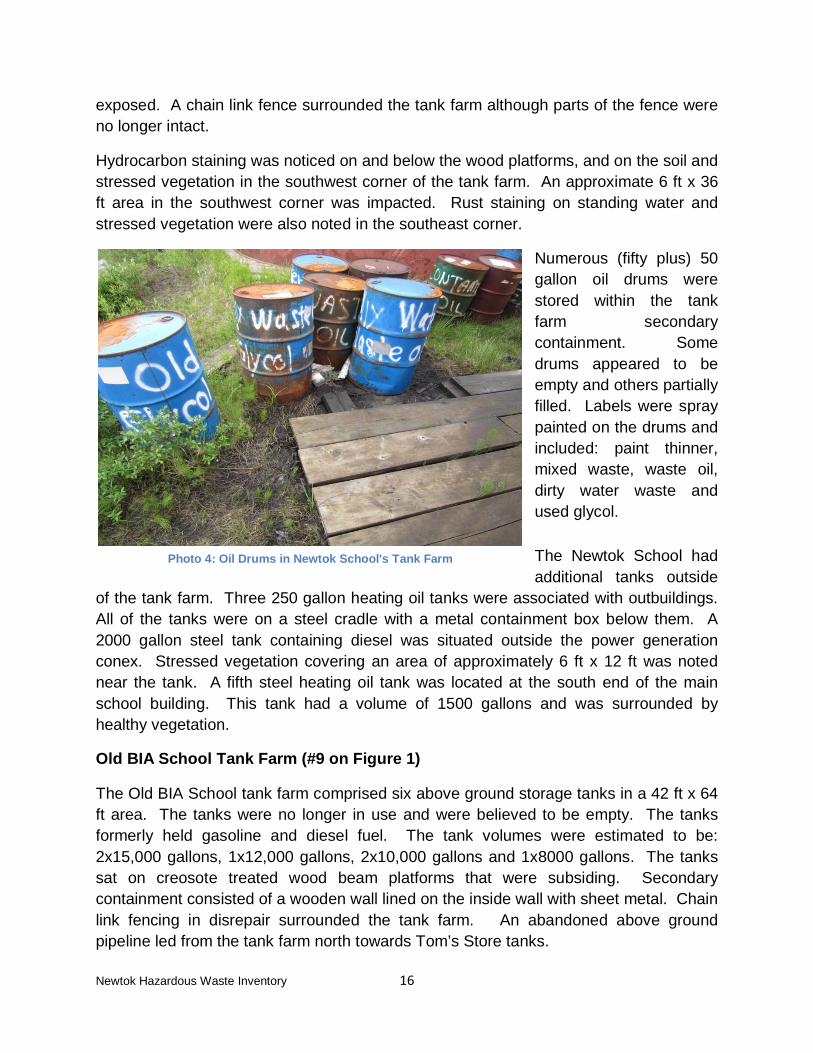
Newtok School Tank Farm (#1 on Figure 1)
The school tank farm consisted of two 40,000 gallon steel tanks sitting on creosote treated wood platforms. The tanks contained heating oil and were in fair condition although the eastern tank has differential settling. The tank farm was enclosed by 49 ft x 75 ft of secondary containment comprising an approximate 3 ft high plywood wall, covered by a polyethylene liner followed by sheet metal. The southwest corner of the containment was in disrepair with the sheet metal damaged and the plastic liner
Photo 3: Bagged Waste Staging Area
Newtok Hazardous Waste Inventory 16
exposed. A chain link fence surrounded the tank farm although parts of the fence were no longer intact.
Hydrocarbon staining was noticed on and below the wood platforms, and on the soil and stressed vegetation in the southwest corner of the tank farm. An approximate 6 ft x 36 ft area in the southwest corner was impacted. Rust staining on standing water and stressed vegetation were also noted in the southeast corner.
Numerous (fifty plus) 50 gallon oil drums were stored within the tank farm secondary containment. Some drums appeared to be empty and others partially filled. Labels were spray painted on the drums and included: paint thinner, mixed waste, waste oil, dirty water waste and used glycol.
The Newtok School had additional tanks outside
of the tank farm. Three 250 gallon heating oil tanks were associated with outbuildings. All of the tanks were on a steel cradle with a metal containment box below them. A 2000 gallon steel tank containing diesel was situated outside the power generation conex. Stressed vegetation covering an area of approximately 6 ft x 12 ft was noted near the tank. A fifth steel heating oil tank was located at the south end of the main school building. This tank had a volume of 1500 gallons and was surrounded by healthy vegetation.
Old BIA School Tank Farm (#9 on Figure 1)
The Old BIA School tank farm comprised six above ground storage tanks in a 42 ft x 64 ft area. The tanks were no longer in use and were believed to be empty. The tanks formerly held gasoline and diesel fuel. The tank volumes were estimated to be: 2x15,000 gallons, 1x12,000 gallons, 2x10,000 gallons and 1x8000 gallons. The tanks sat on creosote treated wood beam platforms that were subsiding. Secondary containment consisted of a wooden wall lined on the inside wall with sheet metal. Chain link fencing in disrepair surrounded the tank farm. An abandoned above ground pipeline led from the tank farm north towards Tom’s Store tanks.
Photo 4: Oil Drums in Newtok School's Tank Farm
Newtok Hazardous Waste Inventory 17
Approximately 72 cubic feet of soil had been stockpiled on plastic on the northwest tank platform. This soil may be the contaminated soil referred to in the SLR report (SLR 2010). Grass was growing on the stockpile. Vegetation in and surrounding the tank farm appeared healthy.
Newtok Village Council Tank Farm (#12 on Figure 1)
The NVC tank farm consisted of three separately contained areas.
1. Two 9000 gallon vertical above ground tanks were contained in a 26 ft x 45 ft x 3ft enclosure constructed of plywood and covered with a polyethylene liner. The containment was intact and in good condition. The tanks. contained heating oil. They rested on creosote treated wooden platforms. Vegetation inside and
outside of the containment appeared healthy.
2. A single 9000 gallon vertical above ground tank was contained within a 26 ft x 28 ft x 3ft enclosure. The wall was constructed of plywood and covered with a polyethylene liner. The tank and the containment were in good condition. This tank also rested on a creosote treated wooden platform and contained unleaded gasoline. Vegetation inside and outside of the containment appeared healthy.
3. Three horizontal above ground storage tanks were located southeast of the vertical tanks. Two of the tanks were 10,000 gallons in volume and contained gasoline. The third tank had a volume of 5000 gallons and contained heating oil. All of the tanks were in good condition. The secondary containment was L shaped and covered an area of approximately 2300 square feet. The secondary containment consisted of plywood walls covered in a polyethylene liner and appeared to be in good condition. Three oil drums and some empty plastic containers were stored within the tank farm. Vegetation inside and outside of the containment was healthy.
Photo 5: Secondary Containment around NVC Tank Farm
Newtok Hazardous Waste Inventory 18
Ungusraq Power Company Tank Farm (#14 on Figure 1)
The UPC tank farm consisted of five steel above ground storage tanks; one of the tanks was empty and not in use. Two of the tanks were 10,000 gallons in volume and three of the tanks are 15,000 gallons in volume. The top 2/3 of the 10,000 gallon tanks were rusted. The tanks sat on wooden boards, some of which were broken. All of the tanks in use contained diesel used for the UPC generator. Secondary containment was provided by a plywood wall covered with a polyethylene liner and surrounded an area of 43 ft x 54 ft. The liner was torn in areas. Some staining was noted on the soils below the fill spouts. Vegetation inside the tank farm and outside of the secondary containment appeared healthy.
5.2.3 Individual Above Ground Storage Tanks
Numerous above ground storage tanks were present in Newtok. Most residences and public buildings had a heating oil tank associated with them. Volumes were usually on the order of 50 gallons for residences and up to 2000 gallon tanks for public buildings. Properties having multiple above ground storage tanks not contained in a tank farm are summarized below.
Newtok Traditional Council Tanks (#13 on Figure 1)
The NTC had two above ground tanks located between the UPC and NVC tank farms. One of the tanks was a 3000 gallon, steel, heating oil tank and sat horizontally on a wooden frame covered in plastic. There was no containment surrounding the tank. The tank was in good condition and vegetation surrounding the tank appeared healthy. This tank was still in use.
The second tank was a double walled, steel, 10,000 gallon tank. This tank had contained heating oil in the past but was currently empty and no longer in use. Vegetation surrounding the tank appeared healthy.
Photo 6: Jeff Powers Pointing Out the Empty Tank
Newtok Hazardous Waste Inventory 19
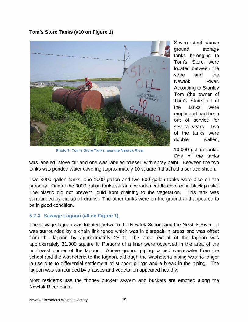
Tom’s Store Tanks (#10 on Figure 1)
Seven steel above ground storage tanks belonging to Tom’s Store were located between the store and the Newtok River. According to Stanley Tom (the owner of Tom’s Store) all of the tanks were empty and had been out of service for several years. Two of the tanks were double walled,
10,000 gallon tanks. One of the tanks
was labeled “stove oil” and one was labeled “diesel” with spray paint. Between the two tanks was ponded water covering approximately 10 square ft that had a surface sheen.
Two 3000 gallon tanks, one 1000 gallon and two 500 gallon tanks were also on the property. One of the 3000 gallon tanks sat on a wooden cradle covered in black plastic. The plastic did not prevent liquid from draining to the vegetation. This tank was surrounded by cut up oil drums. The other tanks were on the ground and appeared to be in good condition.
5.2.4 Sewage Lagoon (#6 on Figure 1)
The sewage lagoon was located between the Newtok School and the Newtok River. It was surrounded by a chain link fence which was in disrepair in areas and was offset from the lagoon by approximately 28 ft. The areal extent of the lagoon was approximately 31,000 square ft. Portions of a liner were observed in the area of the northwest corner of the lagoon. Above ground piping carried wastewater from the school and the washeteria to the lagoon, although the washeteria piping was no longer in use due to differential settlement of support pilings and a break in the piping. The lagoon was surrounded by grasses and vegetation appeared healthy.
Most residents use the “honey bucket” system and buckets are emptied along the Newtok River bank.
Photo 7: Tom’s Store Tanks near the Newtok River
Newtok Hazardous Waste Inventory 20
5.2.5 Other Potential Hazardous Material Sources
Newtok School (#1 on Figure 1)
The primary school building was supported on untreated wooden piles. PVC piping was attached to the piles for permafrost retention. Although the school was relatively new, the potential for asbestos containing material (ACM) existed in the bathroom tiles, kitchen tiles, false ceiling panels and the kitchen vent. Lighting in the school was by fluorescent lights. The school had its own water source (well) and water treatment system. Wastewater flowed through above ground piping to the sewage lagoon.
Outbuildings included a power generation conex, a heating, ventilating and air conditioning (HVAC) building and various storage and mechanical sheds. The power generation conex held two diesel generators and sat on a wooden pile platform. No spills or staining was noted on the floor and the operation looked clean. Piping, plywood and other construction materials are piled outside the conex. Inside the HVAC building conditions were also good, with no staining or spillage on the floors. Discharge water from the HVAC building was carried by above ground piping to the river bank.
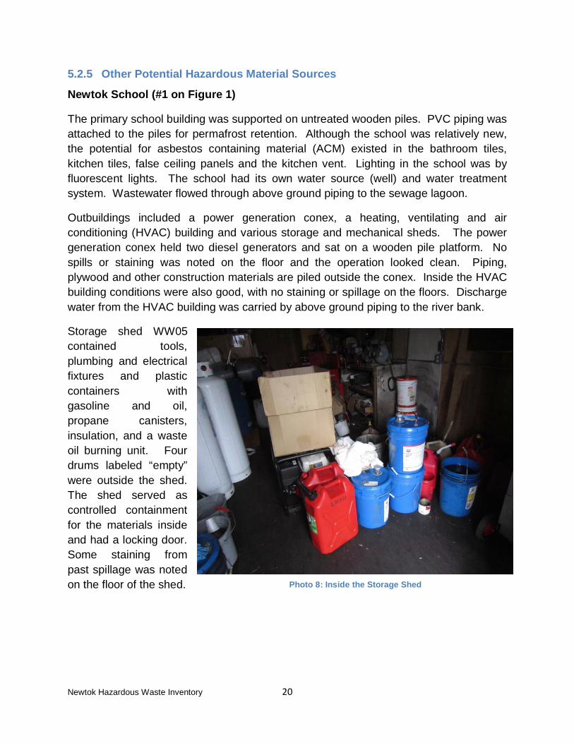
Storage shed WW05 contained tools, plumbing and electrical fixtures and plastic containers with gasoline and oil, propane canisters, insulation, and a waste oil burning unit. Four drums labeled “empty” were outside the shed. The shed served as controlled containment for the materials inside and had a locking door. Some staining from past spillage was noted on the floor of the shed.
Photo 8: Inside the Storage Shed
Newtok Hazardous Waste Inventory 21
Newtok Clinic (#2 on Figure 1)
The Newtok Clinic handled its own medical waste. Only nonmedical wastes are disposed in the landfill. Medical wastes are shipped to Anchorage.
Washeteria (#3 on Figure 1)
The washeteria was built in the 1980s. It housed the water treatment equipment for the village (except the Newtok School) and laundry facilities. Water was pumped to the water treatment system from ponds near the airstrip, filtered, treated with chlorine, and made available for village use by an outside fill spout. Chlorine and propylene glycol were stored onsite. A 211,000 gallon storage tank located outside the washeteria was
used for water storage. Five new, 20,000 gallon foam insulated horizontal tanks were housed next to the washeteria but were not currently in use.
The laundry facility comprised six washers and four dryers, none of which were in use. The break in the discharge pipeline to the sewage lagoon and incompatibility between the dryers and the transformer precluded their use.
UPC Generator Building (#4 on Figure 1)
The UPC Generator Building was located south of the washeteria. Power generation provides electricity to the entire village except for the Newtok School which generates its own power. The diesel powered Marathon Electric generator was housed within a wood building supported on wood pilings. Significant oil staining was noted below the building in an area of approximately 20 ft x 30 ft and vegetation near the building was stressed. Oil staining was also noted on a 6 ft x 15 ft area east of the building near an old genset motor. Empty oil drums, piping, construction materials and electrical conduits were scattered about the yard surrounding the building.
Photo 9: Break in Pipeline from Washeteria to Sewage Lagoon
Newtok Hazardous Waste Inventory 22
Old BIA School Buildings (#9 on Figure 1)
The Old BIA School comprised the main school building, a well house, a warehouse and the tank farm discussed above. The main building rested on 45 creosote treated piles. The water supply well could be seen under the building at its approximate center. The main building and the warehouse were boarded up due to past vandalism and Hobbit was unable to enter them. The well house stored the water treatment system and smelled strongly of chlorine. A holding tank and associated piping that appeared to be wrapped in fiberglass insulation were in the well house.
Armory (#11 on Figure 1)
According to the desktop review 25 cubic yards of diesel contaminated soil had been excavated from the vicinity of the Armory in 2010 and transported to a landfill in Oregon for disposal. Hobbit inspected the land surrounding the armory for visual indications of residual contamination. Vegetation appeared healthy and no indications of the former excavation were evident. The armory had a 1500 gallon heating oil tank on site.
Residential Home – BIA Home (Near #9 on Figure 1)
Tom John brought Hobbit to a BIA home to view the inside. The house had been built by the BIA in the 1970s and was the oldest type of housing in Newtok. The flooring was a mixture of old and new tile with the potential for ACM. Given the vintage of the house, paint peeling in the entryway may be lead containing or lead based. Hobbit did not visit other houses so as not to be intrusive to residents.
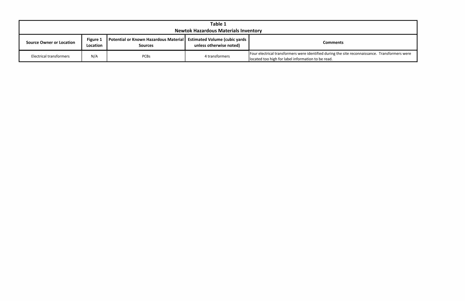
Electrical Transformers
Four electrical transformers were located throughout the village. The transformers were situated too high for Hobbit to be able to read identifying labels.
Photo 10: BIA built home from the 1970s
Newtok Hazardous Waste Inventory 23
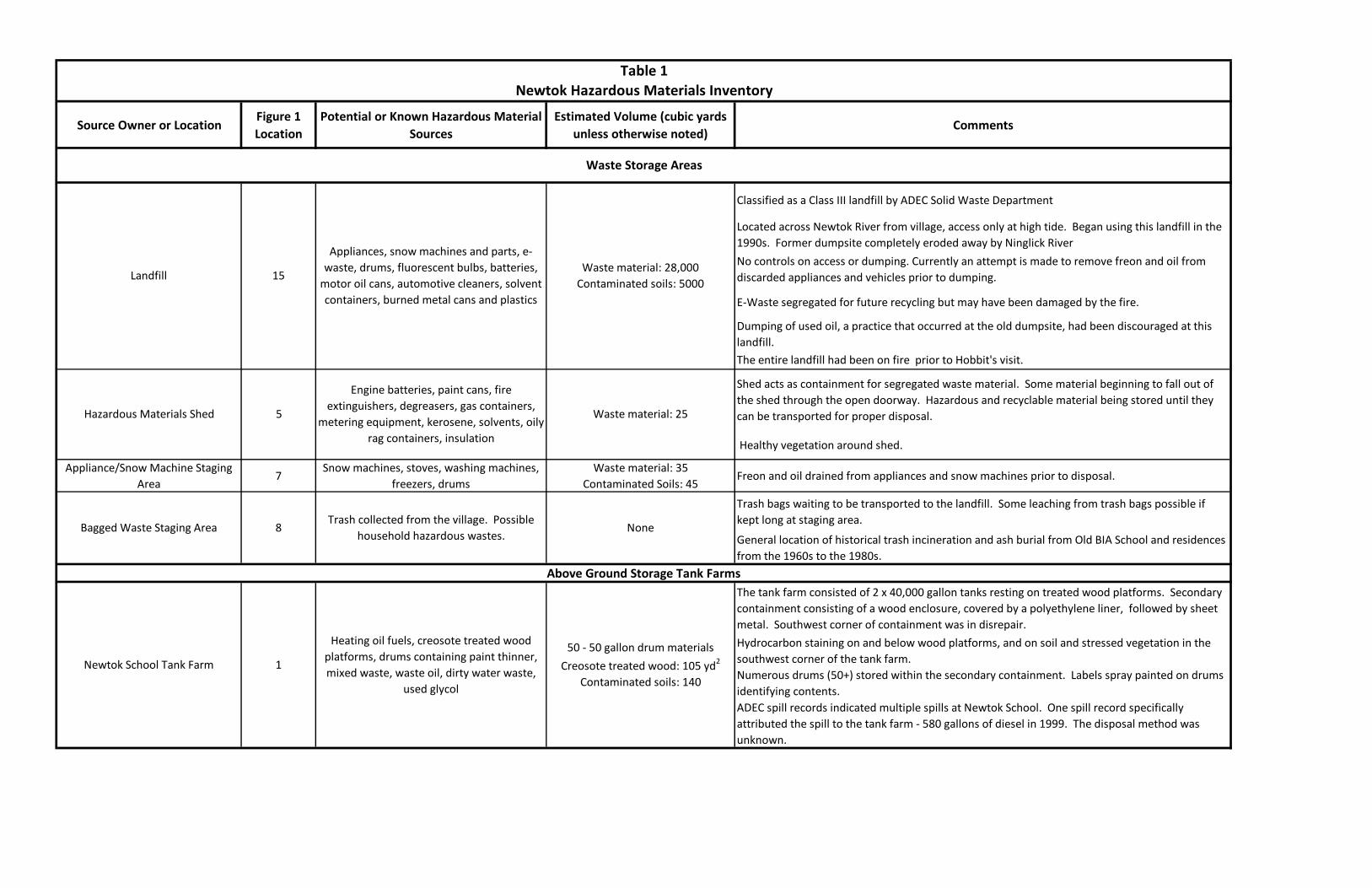
6.0 Hazardous Material Inventory A summary of the hazardous material inventory is presented in Table 1 following this report. The table is a compilation of information obtained from the desktop review, the interviews and the site reconnaissance, and includes estimated volumes based on visual observations and site measurements. No material, soil or groundwater sampling contributed to the estimated volumes. Potential contaminated soil volumes were calculated using a depth of 1 ft., the assumed depth to permafrost. Volume estimates are in-situ and are not considered definitive; they are provided for discussion purposes only. All information applies to conditions observed from June 23rd to 25th, 2015.
The hazardous material inventory identified 22 potential sources of concern. These locations include: the landfill; waste staging areas; above ground storage tank farms; individual above ground storage tanks; the sewage lagoon; older buildings (community and private); and, electrical transformers.
7.0 Personnel Qualifications This report was prepared by Annemieke Powers and reviewed by Jeff Powers of Hobbit. Both Annemieke and Jeff qualify as environmental professionals as defined in ASTM E1527-13, Appendix X2 (ASTM 2015). Annemieke Powers has a B.Sc in Civil Engineering, a B.A. in Government and 20 years of relevant environmental consulting experience. Jeff Powers has a B.Sc. and a M.Sc. in Geology, is a Certified Professional Geologist, and has 30 years of relevant environmental consulting experience.
We declare that, to the best of our professional knowledge and belief, we meet the definition of Environmental Professional as defined in part 312.10 of 40 CFR part 312. We have the specific qualifications based on education, training, and experience to assess properties of the nature, history, and setting of those in Newtok. We have developed and performed all appropriate inquiries in conformance with the standards and practices set forth in 40 CFR Part 312.
8.0 Limiting Conditions/Deviations and Data Gaps Some elements of ASTM E1527-13 (ASTM 2015) did not apply to this hazardous materials inventory; however, none of these elements limited our compilation of the inventory.
• Historical records for Newtok only extended back to 1958 when the Old BIA School was built and the village began to form around the school. ASTM E1527-
Newtok Hazardous Waste Inventory 24
13 suggests historical searches back to 1940. The earliest aerial photograph that could be obtained was from 1964.
• With the exception of aerial photographs and topographic maps, the Standard Historical Sources listed in Section 8.3.4 were not available for Newtok. These sources included: Fire Insurance Maps, Property Tax Files, Building Department Records and Local Street Directories.
• ASTM E1527-13 includes researching adjacent properties within an “appropriate minimum search distance” from the property being assessed. The entire village of Newtok was the subject of this project. As there are no other villages or potential hazardous material sources in the vicinity of Newtok, the assessment did not extend beyond the village infrastructure.
• The primary data gap for this project is the extent of contaminated soil and water in the village of Newtok.
Newtok Hazardous Waste Inventory 25
9.0 References Alaska Department of Commerce, Community and Economic Development. (2008).
Alaska Department of Environmental Conservation, Solid Waste Program. (2015).
Waste Erosion Assessment and Review, Final Report. Retrieved from: http://dec.alaska.gov/eh/sw/wear.html.
American Society for Testing and Materials. (2013). Standard Practice for Environmental Site Assessments: Phase I Environmental Site Assessment Process. Designation: E1527-13. ASTM International.
Demer, Lisa, (2015, August 7). Appeals Panel Sides with New Newtok Council,
Easing Village Move. Alaska Dispatch News. Retrieved from: http://www.adn.com/article/20150807/appeals-panel-sides-new-newtok-council-easing-village-move.
SLR International Corp. (2010). Final Property Assessment and Cleanup Plan, Old BIA
School, Newtok, Alaska. Prepared for Alaska Department of Environmental Conservation.
United States Army Corps of Engineers. (2007). Foundation Survey, Newtok, Alaska,
Appendix B. Prepared for Newtok Traditional Council. United States Census Bureau. (2010). American Fact Finder. Retrieved from:
United States Environmental Protection Agency. (2015). National Priorities List. Retrieved from: http://www2.epa.gov/fedfac/federal-facilities-national-priorities-list-npl-your-area#ak.
United States Environmental Protection Agency. (2015). Region 10 Report: List of
TSD Facilities Sorted by Handler Name. United States Environmental Protection Agency (2015). Resource Conservation and
Recovery Act Information Database. Retrieved from: http://www3.epa.gov/enviro/facts/rcrainfo/search.html#_ga=1.177115233.597609425.1443803543.
United States Environmental Protection Agency Region 10. (2015). List of TSD
Facilities Sorted by Handler Name, State of Alaska. United States Fish and Wildlife Service. (2015). Endangered Species List. Retrieved
10.0 Limitation of Liability This report has been prepared and the work referred to in this report has been undertaken by Hobbit Environmental Consulting Corporation hereinafter referred to as Hobbit for the Alaska Department of Commerce, Community and Economic Development. The work was performed in accordance with generally accepted environmental consulting practices. The work undertaken by Hobbit with respect to this report and any conclusions or recommendations made in this report reflect Hobbit’s judgment based on the site conditions observed at the time of the site inspection on the date(s) set out in this report and on information available at the time of preparation of this report. This report has been prepared for specific application to this site and it is based solely upon visual observation of the site and readily available information, all as described in this report. No material, soil or water sampling was conducted. Unless otherwise stated, the findings cannot be extended to previous or future site conditions, or portions of the site which were unavailable for viewing directly. No warranty, express or implied, is made.
If site conditions or applicable standards change or if any additional information becomes available at a future date, modifications to the findings in this report may be necessary.
Classified as a Class III landfill by ADEC Solid Waste Department
Located across Newtok River from village, access only at high tide. Began using this landfill in the 1990s. Former dumpsite completely eroded away by Ninglick RiverNo controls on access or dumping. Currently an attempt is made to remove freon and oil from discarded appliances and vehicles prior to dumping.
E-Waste segregated for future recycling but may have been damaged by the fire.
Dumping of used oil, a practice that occurred at the old dumpsite, had been discouraged at this landfill.The entire landfill had been on fire prior to Hobbit's visit.
Shed acts as containment for segregated waste material. Some material beginning to fall out of the shed through the open doorway. Hazardous and recyclable material being stored until they can be transported for proper disposal.
Healthy vegetation around shed.
Appliance/Snow Machine Staging Area
7Snow machines, stoves, washing machines,
freezers, drumsWaste material: 35
Contaminated Soils: 45Freon and oil drained from appliances and snow machines prior to disposal.
Trash bags waiting to be transported to the landfill. Some leaching from trash bags possible if kept long at staging area.
General location of historical trash incineration and ash burial from Old BIA School and residences from the 1960s to the 1980s.
The tank farm consisted of 2 x 40,000 gallon tanks resting on treated wood platforms. Secondary containment consisting of a wood enclosure, covered by a polyethylene liner, followed by sheet metal. Southwest corner of containment was in disrepair.Hydrocarbon staining on and below wood platforms, and on soil and stressed vegetation in the southwest corner of the tank farm.Numerous drums (50+) stored within the secondary containment. Labels spray painted on drums identifying contents.ADEC spill records indicated multiple spills at Newtok School. One spill record specifically attributed the spill to the tank farm - 580 gallons of diesel in 1999. The disposal method was unknown.
Five above ground storage tanks: 3-250 gallon tanks having metal containment boxes below, 1-2000 gallon tank by power generation connex, 1-1500 gallon tank at south end of school building.
Stressed vegetation covering an area of 6 ft. x 12 ft noticed near the power generation connex tank.
7 spills for the property were reported on ADEC spill reports. It was not clear where on the school property the spills had occurred; some may have occurred within the tank farm. The most current spill was in August 2015 - 520 gallons of diesel and the disposal method was recycling. 6 historical spills occurred between 1995 and 2009 with volumes ranging from 15 gallons to 400 gallons. The 15 gallon spill was used oil and the rest of the spills were diesel. Disposal methods for the 400 gallon spill was recycling; no disposal methods were provided for the other spills.
2 spills reported on ADEC spill reports were associated with teacher housing in the vicinity of the school. One spill was in 2006 (5 gallons diesel) and disposal was by incineration. The second spill was in 2004 (70 gallons desel) and disposal was by placing in barrels.
Secondary containment consisted of a wood enclosure lined on the inside with sheet metal. Tanks were no longer in use but had contained gasoline and diesel fuel in the past.Approximately 72 cubic feet of soil stockpiled on plastic on the northwest tank platform. This soil may be the contaminated soil referred to in the SLR report.
Abandoned above ground pipeline led from the tank farm north towards Tom's Store tanks.
Tank farm consisted of three contained areas. Area 1 had 2 - 9000 gallon vertical tanks containing heating oil. Area 2 had 1 -9000 gallon vertical tank containing unleaded gasoline. Area 3 had 2 - 10,000 gallon horizontal tanks containing gasoline and 1-5000 gallon tank containing fuel oil.
Secondary containment consisted of a wood enclosure covered by a polyethylene liner for all three areas. The containment was in good condition.
3 - 50 gallon oil drums stored within the secondary containment of the horizontal tanks.
Possible location of the 2001 spill indicated in ADEC records providing the spill location as the Newtok Tank Farm. 40 gallons of diesel was released and the disposal method was incineration.
Secondary containment consisted of a wood enclosure covered with a polyethylene liner. The liner was torn in some areas.The tank farm had 2 - 10,000 gallon tanks and 3-15,000 gallon tanks. One of the 15,000 gallon tanks was currently not in use.
Some staining noted on soils below the fill spout.
2014 NRC incident report indicated a leaking 10,000 gallon storage tank. The volume discharged was unknown.
Contaminated soil near connex: 5Diesel and heating oil1Newtok School Tanks
Creosote treated wood: 75 yd2
Contaminated soils: 110Diesel and gasoline fuels, creosote treated
3000 gallon tank containing heating oil. The tank rested on a cradle covered in a plastic liner and did not have secondary containment.10,000 gallon double walled tank. The tank was empty and no longer in use. It used to contain heating oil.Seven above ground tanks: 2 double walled 10,000 gallon tanks, 2- 3000 gallon tanks, 1-1000 gallon tank and 2-500 gallon tanks.
No secondary containment around the single walled tanks.
Sheen observed on ponded water between the 10,000 gallon tanks.
2014 WEAR report indicated sheen on ponded water and distressed vegetation.
All of the tanks were empty and had not been in use for several years.Mutiple tanks at residences and
other buildingsN/A Heating oil Unknown
Most private residences and public buidings have heating oil tanks associated with them ranging in size from 50 gallons to 2000 gallons.
The areal extent of the sewage lagoon was approximately 31,000 square feet. The depth of the lagoon was unknown.
Sewage and wastewater was discharged into the sewage lagoon from the Newtok School.The washeteria formerly discharged wastewater into the lagoon but the practice was discontinued when the piping system was no longer functional.
Honey buckets were dumped along the Newtok River.
Buildings comprised the main school building, the power generation conex, the HVAC building and various storage and mechanical sheds.
Possible ACM in bathroom tiles, kitchen tiles, false ceiling panels and kitchen vent in the main school building.
The storage shed served as containment for materials inside and had a locking door. Materials were stored for use at the school. Some staining from historical spillage noted on the floor.
The school generated its own power with two disel powered generators located in the power generation conex. The operation looked clean with no staining on the floor.
The HVAC building was clean with no staining on the floor.
The school had a wastewater discharge permit issued by ADECThe school had a water well and water treatment system.
Medical wastes shipped to Anchorage. Nonmedical wastes were disposed in the landfill.
ADEC spill report indicated a 20 gallon diesel spill in 2003. The disposal method was incineration.
UnknownSewage, wastewater6Sewage Lagoon
Other Sources of Hazardous Materials
250Diesel fuel, stove oil, heating oil10Tom's Store Tanks
Multiple Above Ground Storage Tanks Not Contained in a Tank Farm
100Heating oil 13Newtok Traditional Council Tanks
UnknownAsbestos, fluorescent lights, Storage shed
containing gasoline and oil containers, propane cannisters, insulation
Water was pumped from ponds near the air strip, treated and available for village drinking water use. A 211,000 gallon blue tank was used for water storage. 5-20,000 gallon, foam insulated, horizontal tanks were not currently in use.
Chloride and propylene glycol were stored on site in labeled containers and used for the water treatment system.
Wastewater used to be piped to the sewage lagoon when the piping system was functional.
The laundry facilities were not currently in use.A diesel powered Marathon Electric generator was housed in the building
Significant oil staining was noted below building and in an area east of the building near an old genset motor.The 2014 WEAR report indicated a sheen on ponded surface water, blackened soil and dead vegetation in vicinity of building.The buildings comprised the main school building,a well house and a warehouse. The school building and warehouse were boarded up and could not be accessed.
In the 1983 aerial photograph what appeared to be a water storage tank was located just west of the main school building. By 1996 the tank had been removed.
The main school building had a water well near its center. The well was drilled to 244 ft and the water level in the well in 1964 was 16 feet below surface grade.
The Brownfield assessment (no sampling) conducted by SLR in 2010 identified possible contaminated soil at the NW and NE corners of the warehouse and between the well house and the school building.
A 2004 ADEC spill report indicated that 50 gallons of diesel was spilled and placed in barrels for disposal. The report did not indicate where the spill occurred on the property.
An Asbestos Survey Report 1996 indicated ACM in gaskets of the boiler, furnace, insulating pad in cookstove, and some floor tiles.
25 cubic yards of disel contaminated soil had been excavated in 2010 from the vicinity of the armory and transported to a landfill in Oregon for disposal
Vegetation appeared healthy and no signs of the former excavation were evident.
1500 gallon heating oil tank on the property
BIA Home Near 9 Asbestos, lead paint UnknownThe house was built in the 1970s by the BIA. Potential ACM in floor ties. Potential lead paint in the entryway.Older houses and buildings may have ACM material and/or lead paint. BIA housing was built in the 1970s. Other buildings built primarily in the 1980s, 1990s and 2000s.The USACE Foundations report indicated that of 70 residences, 60 could be relocated, 5 could not be moved and 5 were indeterminate.
NoneHeating oil11Armory
UnknownAsbestos, lead paintN/ABuildings
9 45 creosote treated piles, ACM, lead paint45 wooden piles of unknown length.
Electrical transformers N/A PCBs 4 transformersFour electrical transformers were identified during the site reconnaissance. Transformers were located too high for label information to be read.


![Highlands Environmental Resource Inventory for the [insert ...€¦ · Highlands Environmental Resource Inventory for the [insert municipal name]Tewksbury Township 5 Purpose and Scope](https://static.documents.pub/doc/80x56/5f6c77a5c7b0b02c0571057d/highlands-environmental-resource-inventory-for-the-insert-highlands-environmental.jpg)


![Highlands Environmental Resource Inventory for the [insert ... › ... › 1024_ERI_100312_HC.pdf · Highlands Environmental Resource Inventory for the [insert municipal name]Tewksbury](https://static.documents.pub/doc/80x56/5f26c27adebe1d011100aaf3/highlands-environmental-resource-inventory-for-the-insert-a-a-1024eri100312hcpdf.jpg)