HTRA HTT/GOVERNMENT OF INDIA T HATT/MINISTRY OF RAILWAY?s tr as)/ (RAILWAY BOARD) FNo. 2015/Track-I/24(1)/18/1 fi/Date: 1.12.2018 GMs/DGs/MDs/Directors/PCEs All Indian Railways & all concerned (as per mailing list). faT/Sub: GIS Mapping of Indian Railways' Assets - Technical Guidelines for GPS Survey by Hand Held Devices. HqtRef: 1. Railway Board's letter of even no. dated 10.05.2018. 2. Railway Board's letters of even no. dated 10.11.2016, 31.03.2017 and 25.04.2018. CE/TMS/NR Letter no. 198-W/e-GOV/TMS/GIS- GPS/Pt-I dated 03.12.2018 3. As per the Budget Pronouncement made by Hon'ble MR, GIS/GPS mapping of various assets of Indian Railways (Land, Route, Track, Bridges, Level Crossings, Stations, SEJs, Other Track Features, Buildings, Signals, Axle counters, OHE Masts, SP/SSP, etc.) was to be done. IR's Al Assets (belonging to all departments including production units) were to be mapped. It is to be made possible to view these on Satellite and other Imageries on GIS platform of Indian Railways. This was communicated vide Ref-1 to all Zonal Railways and Production Units, Zonal Railways were to do GPS survey of track and track side assets by using RDPS and Orthophoto/Photogrammetry Survey by Unmanned Aerial System (UAS-Drone). GPS Survey of assets away from track e.g. Land, Buildings, Colonies, Workshops, Hospitals, Production Units, CTls, RDSO, schools etc. is to be done by using Survey Grade Hand Held Devices (without Differential ground stations). All the assets pertaining to all department viz. Engineering. Mechanical, Electrical, Signal 8& Telecommunication, Stores, Security etc. were to be identified, listed and surveyed by GPS based survey. The GPS Survey of off-track assets is to be carried out by Zonal Railways, Production Units, etc. either by procuring the devices or by outsourcing the same. GPS survey of RDSO, Central Training Institutes (IRICEN, IRIEE, IRIMEE, IRITM, CAMTECH, etc.) was also to be carried out. The survey includes collecting GPS survey data of off-track assets along with attributes. As informed vide Ref-1, Technical Guidelines for GPS Handheld devices for capturing off-track assets has been finalized by CRIS and is enclosed hereurith for necessarv action.
Transcript
HTRA HTT/GOVERNMENT OF INDIA
T HATT/MINISTRY OF RAILWAY?s tr as)/ (RAILWAY BOARD)
FNo. 2015/Track-I/24(1)/18/1 fi/Date: 1.12.2018
GMs/DGs/MDs/Directors/PCEs All Indian Railways & all concerned (as per mailing list).
faT/Sub: GIS Mapping of Indian Railways' Assets - Technical
Guidelines for GPS Survey by Hand Held Devices.
HqtRef: 1. Railway Board's letter of even no. dated 10.05.2018. 2. Railway Board's letters of even no. dated 10.11.2016,
31.03.2017 and 25.04.2018. CE/TMS/NR Letter no. 198-W/e-GOV/TMS/GIS- GPS/Pt-I dated 03.12.2018
3.
As per the Budget Pronouncement made by Hon'ble MR, GIS/GPS
mapping of various assets of Indian Railways (Land, Route, Track, Bridges, Level Crossings, Stations, SEJs, Other Track Features, Buildings, Signals, Axle counters, OHE Masts, SP/SSP, etc.) was to be done. IR's Al Assets
(belonging to all departments including production units) were to be mapped.
It is to be made possible to view these on Satellite and other Imageries on GIS
platform of Indian Railways. This was communicated vide Ref-1 to all Zonal
Railways and Production Units,
Zonal Railways were to do GPS survey of track and track side assets by
using RDPS and Orthophoto/Photogrammetry Survey by Unmanned Aerial
System (UAS-Drone). GPS Survey of assets away from track e.g. Land, Buildings, Colonies,
Workshops, Hospitals, Production Units, CTls, RDSO, schools etc. is to be
done by using Survey Grade Hand Held Devices (without Differential ground
stations). All the assets pertaining to all department viz. Engineering.
Mechanical, Electrical, Signal 8& Telecommunication, Stores, Security etc. were to be identified, listed and surveyed by GPS based survey.
The GPS Survey of off-track assets is to be carried out by Zonal
Railways, Production Units, etc. either by procuring the devices or by
outsourcing the same. GPS survey of RDSO, Central Training Institutes
(IRICEN, IRIEE, IRIMEE, IRITM, CAMTECH, etc.) was also to be carried out.
The survey includes collecting GPS survey data of off-track assets along with
attributes.
As informed vide Ref-1, Technical Guidelines for GPS Handheld devices
for capturing off-track assets has been finalized by CRIS and is enclosed
hereurith for necessarv action.
surve work Appropriate action may be taken so that above GPS hac
R and is completed by March' 2019. Surv data should be sent to CE/TMS/NP GM/CEP/CRIS for further necessary action.
TT/DA: As above
(Anurag Yadav Director, Track (P)
Railway Board Phone: 011-23073358
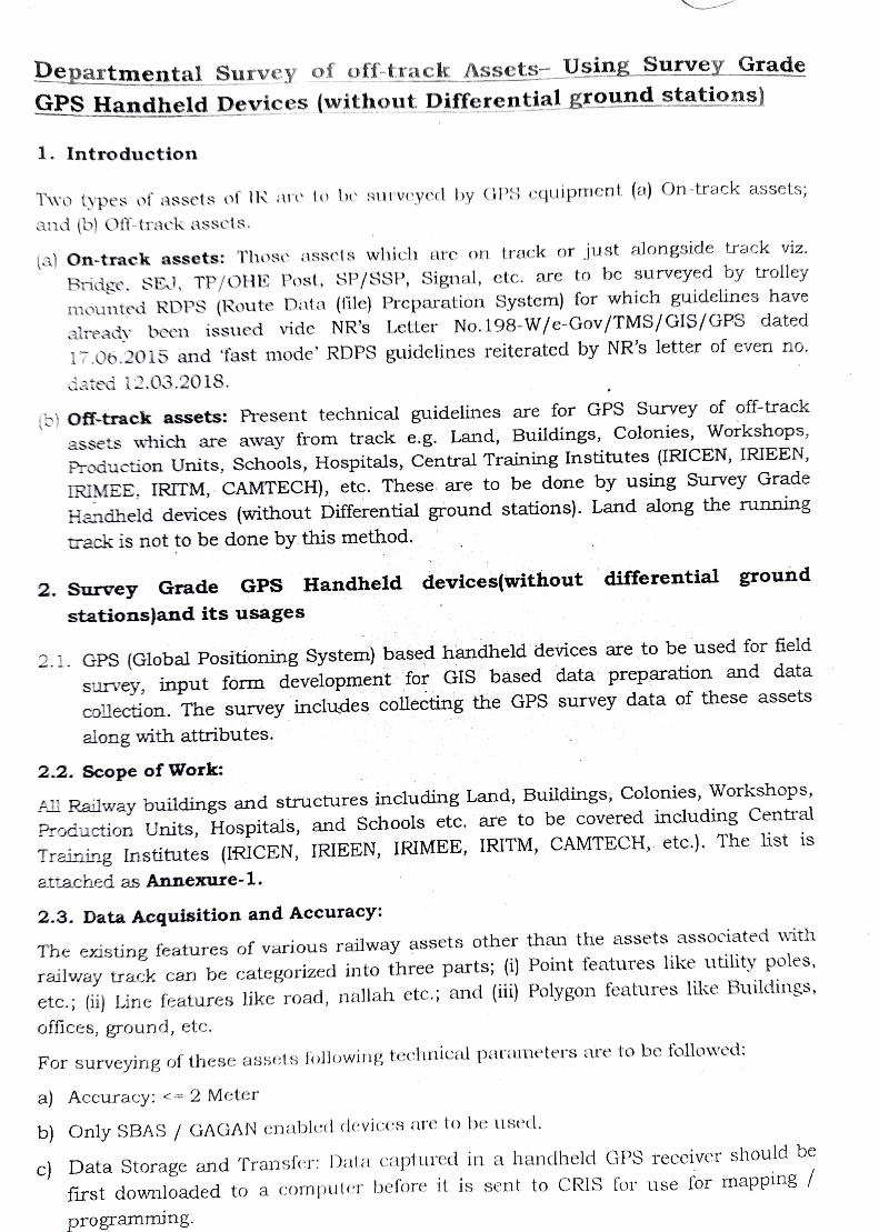
Departmental Survey of off-track Assets- Using Survey Grade
2.1. GPS (Global Positioning System) based handheld devices are to be used for field
survey, input form development for GIS based data preparation and data
collection. he survey includes collecting the GPS survey data of these assets
along with attributes.
2.2. Scope of Work:
All Railway buildings and structures including Land, Buildings, Colonies, Workshops,
Production Units, Hospitals, and Schools etc. are to be covered including Central
Training Institutes (IRICEN, IRIEEN, IRIMEE, IRITM, CAMTECH, etc.). The list is
attached as Annexure-1.
2.3. Data Acquisition and Accuracy:
The existing features of various railway assets other than the assets associated with
railway track can be categorized into three parts; (1) Point features like utility poles,
etc.; (ii) Line features like road, nallah etc.; and (ii) Polygon features like Buildings,
offices, ground, etc.
For surveying of these assets following technical parameters are to be followed:
a Accuracy: <= 2 Meter
b) Only SBAS/ GAGAN enabled devices are to be used.
c Data Storage and Transfer: Data captured in a handheld GPS receiver should be
first downloaded to a compuler before it is sent to CRIS for use for mapping /
programming.
( d) Coordinate Reference System (CRs): WGS 84
2.4. Data Collection Process:
a) Identification& Linking of Railway assets All the off-track assets pertaining to all departments viz. Engineering, Mechanical,
Electrical, Signal & Telecommunication, Stores, Security, etc. should be identified and
listed for GPS based survey.
b) Designing of data collection forms Data collection format along with attributes is attached as Annexure 2. Customized
Pplication can be developed for the devices to fulfill the requirement of the data
collection formats.
c) Precautions: 1. Capturing of data to be done when 7 or more GPS Satellites are available. During
heavy cloud and rai
2. SBAS/ GAGAN enabled Receiver should be used for data collection. weather, the survey work should not be done.
3. Output (File Format):
3.1.The output from the handheld device should be in .shp file format duly linked
with attribute of the assets.
Note: If the output provided by the device is in a different format than .Shp then it
should be converted to .Shp fle format using desktop software provided by the device supplier. Data in only .Shp file is to be sent to CRIS for further processing.
3.2.File naming system -Every recorded file should be saved in Railway
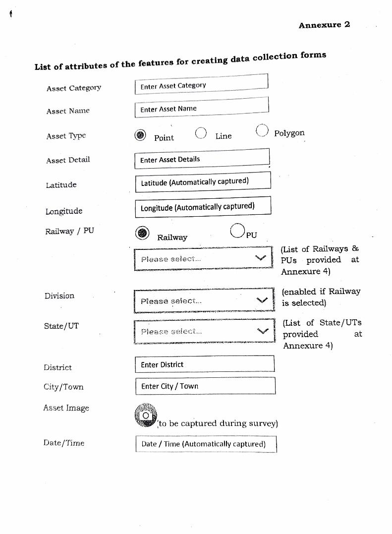
4. List of attributes of the features for creating data collection forms
1. Asset Category (As given in Annexure-1)
2. Asset Name (to be input)
3. Asset Type (Point, Line, Polygon) 4. Asset Detail (to be input) 5. Latitude (Automatically captured by devices) 6. Longitude (Automatically captured by devices) 7. Railway/PU (dropdown to be prepared in device as per list given in Annexure-2)
8. Division (dropdown to be prepared in device as per list given in Annexure-2.
9. State/UT (dropdown to be prepared in device as per list given in Annexure2.
10. District (to be input) 11. City/Town (to be input) 12. Asset Image (to be captured during survey) 13. Date/'Time (Automatically captured by devices)
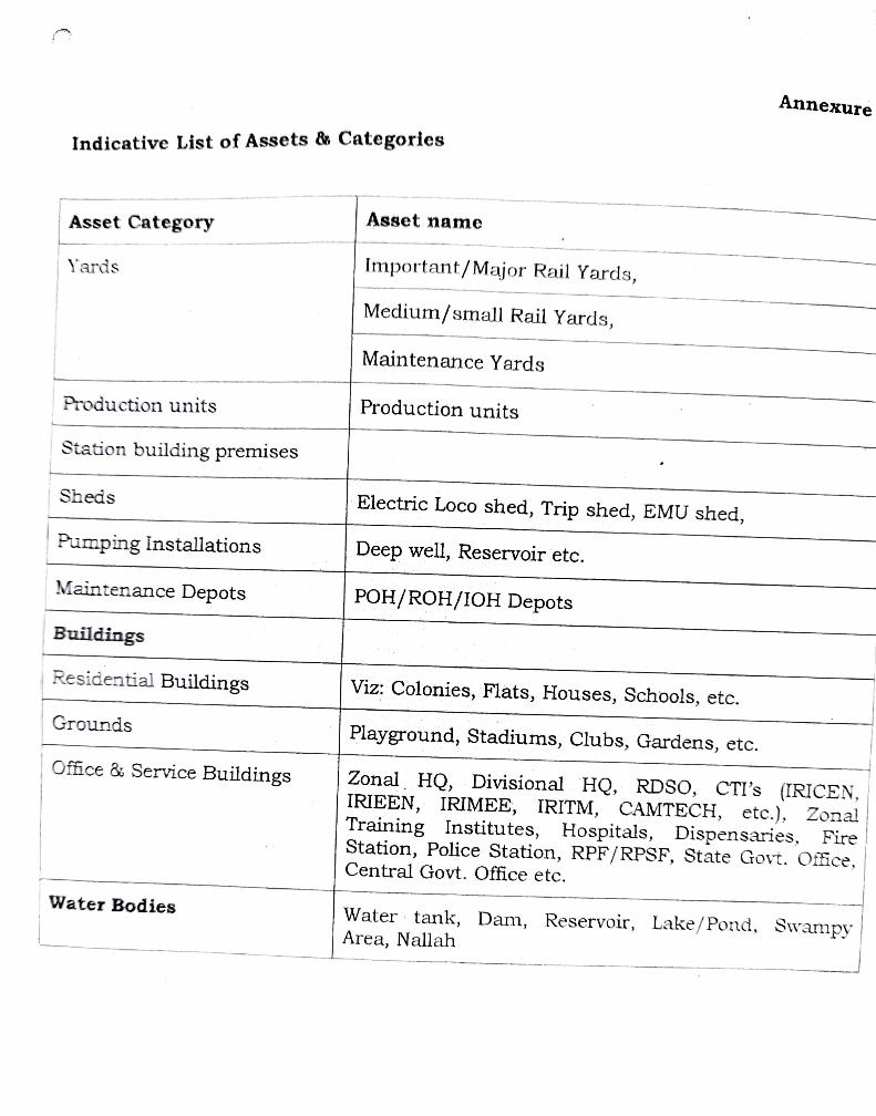
Annexure Indicative List of Assets & Categories
Asset name Asset Category
Yards Important/Major Rail Yards,
Medium/small Rail Yards,
Maintenance Yards
Production units Production units
Station building premises
Sheds Electric Loco shed, Trip shed, EMU shed, Pumping Installations Deep well, Reservoir etc.
Maintenance Depots POH/ROH/1OH Depots Buildings
Residential Buildings Viz: Colonies, Flats, Houses, Schools, etc.
Grounds Playground, Stadiums, Clubs, Gardens, etc.
Zonal HQ, Divisional HQ, RDSO, CTI's (IRICEN, IRIEEN, IRIMEE, IRITM, CAMTECH, etc.), Zonal Training Institutes, Hospitals, Dispensaries, Fire
Office & Service Buildings
Station, Police Station, RPF/RPSF, State Govt. Oftice, Central Govt. Office etc.
Water Bodies Water tank, Dam, Reservoir, Lake/Pond, Swampy Area, Nallah
Annexure 2
List of attributes of the features for creating data collection forms
Asset Category Enter Asset Category
Asset Name Enter Asset Name
PolygonAsset Type Point Line
Asset Detail Enter Asset Details
Latitude Latitude (Automatically captured)
Longitude Longitude (Automatically captured)
Railway/ PU PU Railway
List (List of Railways &
V PUs provided at dnazba
Annexure 4)
(enabled if Railwayy
is selected) Division
ASe Seieci..
(List of State/UTs
provided Annexure 4)
State/UTT Pease Gele;.. at
District Enter District
City/Town Enter City/Town
Asset Image
to be captured during survey)
Date/Time Date/Timne (Automatically captured)
Annexure 3
Minimum Required Specifications for Survey Grade Handheld GPs Devices
The device should have following minimum specifications:
1. GPS handheld device which is capable of Tracking Satellites in Triangulation
Method is to be taken.
2. Mininmum Single Frequency GPS with more than 20 channels.
3. Accuracy: <= 2 meter.
4. Latest Windows or any other operating systems.
Should have minimum @ 800 MHz processor or better.
6 Should have minimum 1GB RAM to run the Application.
7. Should have minimum 4 GB internal storage.
8. Should have support for external memory upto 32 GB via SD card or MicroSD.
9. Shouid have minimum 4 inch diagonal display.
10.Should have minimum 640 x 480 pixels screen resolution.
11.Should have minimum 5MP camera with Geo-Tag facility.
12. Should support Wi-Fi for ease of internet access.
13. Should run minimum 8 hours with GPS on.
14. Battery should be rechargeable type with hot Swappable function with the device
15. Working Temperature range: (-)10 to 50 Degree Celsius. 16.Should have capacity to capture asset data such as point, line and polygon in .Shp
file format with its respective attributes. If the data provided by the device is in any
other format, it should be converted to .Shp file using desktop software provided by
the device supplier and then sent to CRIS for further processing 17.Should be possible to export/inmport GIS data from device to any other system
(Desktop/ Laptop) and vice versa. 18. Should be possible to Geo-Tag images and link it with the asset.
19.Should support GAGAN | SBAS.
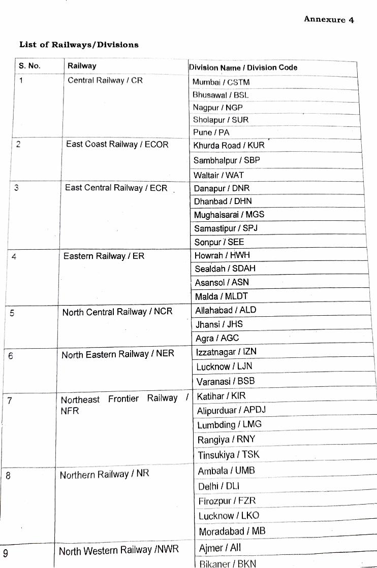
Annexure 4
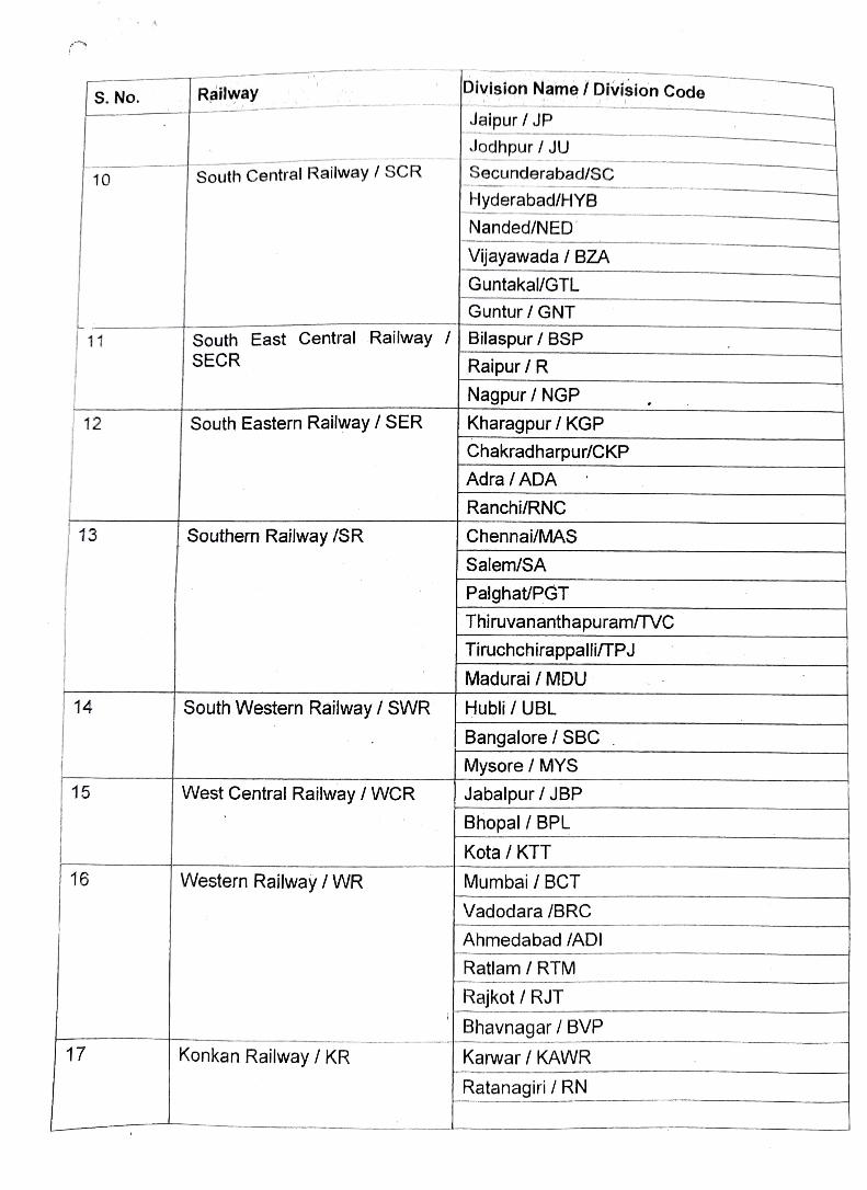
List of Railways/Divisions
S. No. Railway Division Name / Division Code
Central Railway/ CR Mumbai/ CSTM Bhusawal BSL
Nagpur/ NGP
Sholapur / SUR
Pune/PA
East Coast Railway / ECOR Khurda Road/ KUR
Sambhalpur/ SBP
Waltair/WAT
East Central Railway/ECR Danapur / DNR
Dhanbad/ DHN Mughalsarai / MGS
Samastipur / SPJ
Sonpur 7 SEE
4 Eastern Railway/ ER Howrah / HWH
Sealdah / SDAH
Asansol / ASN
Malda /MLDT
5 North Central Railway / NCR Allahabad/ALD
Jhansi/ JHS
Agra / AGC
6 North Eastern Railway / NER Izzatnagar / IZN
Lucknow / LJN
Varanasi/ BSB
Katihar/ KIR Northeast Frontier Railway NFR Alipurduar/ APDJ
Lumbding/ LMG
Rangiya/ RNY
Tinsukiya/TSK Ambala /UMB
8 Northern Railway / NR
Delhi/DLI
Firozpur / FZR
Lucknow/ LKO
Moradabad /MB
9 North Western Railway /NWR Ajmer AlI Bikaner/ BKN