15
CHAPTER ONE I I I ' I INTRODUCTION I . ,. ·--h <·-- ·'--··· _- -F - .. ... -- - _,
| Date post: | 27-Jul-2018 |
| Category: |
Documents |
| Upload: | nguyendang |
| View: | 221 times |
| Download: | 0 times |
CHAPTER ONE I
I I f=-·-!r~.~~~J
' I
INTRODUCTION
I . ,. ·--h ~ <·-- ·'--··· _- -F '-'~. -~"'-- ~"''·· .. ~ ... -- - _,
1.1 INTRODUCTION:
The form of land is dependent upon the nature, frequency and intensity of I
natural geomorphic processes acting upon it, at ~ny geographical site. Although, the
natural process is all encompassing in shaping: the Earth's surface but one cannot
ignore the role of human as a surface mo:difying agent. The present study
investigates and reconciles the role and impact Of both natural and human factors in
the evolution of a landscape and suggests its development within a balanced
geomorphic framework. There are two broad !factors responsible in altering the
landform and landscape in any geographical are~ can be defined as:
I I
A. Natural factors '
I Natural factors follow cyclic characteristics. Various studies have been
I conducted in the field of geomorphology based on this assumption by renowned
I geomorphologists. This assumption is very i much a proven fact in historical
I
geomorphology by Hutton's (1785), statement as 'Present is key to the past'. i
The Contemporary geomorphologists also support this fact.
B. Human induced factors I
With the passage of time, humans along :with other species have become a I
proven medium to alter the landform and landscape of a particular geographical I
area. Man is quite capable of providing suddert as well as periodic changes in the I
face of geomorphic structure of any landscape \in a given time. ;
I I
In order to study involvement of natural and human induced factors, it becomes !
important to understand the physical formation :of a region at global scale. The I
causes for the formation of the Doon valley cani be traced in the collision of the I
Indian and Eurasian plates. Since the collision of the plate between 54-49 Ma ago,
India has continued to move northward at the rate ~f 4-5 cm/yr (Searle, 2000). This I
lead to the continuous rise of the Himalayan blocks of mountains and altered climate
in number of ways. Firstly, the rising Tibetan plateau would have deflected and I
blocked regional air systems, such as jet streams, ~hich in tum affected atmospheric
air circulation on global scale. Secondly, the elevated region would have enhanced
temperature driven atmospheric flows as higher 1~nd lower atmospheric pressure
1

system developed over plateau during summer and winter, respectively. This would
have intensified Indian monsoon, leading to heavier rainfall along the frontal ranges
of the Himalayas (Wadia, 1975).
Tectonism has affected macro level climate on global scale and micro level '
climate within the Himalayas. Keeping i~ view the utilitarian approach in physical
geography, purpose of this study is concentrated in the Dun between the river I
Ganges and river Yamuna. In the present·study, Dun is used with "Dehra Dun" and I
Doon is used with "Doon Valley", these have been used synonymously elsewhere in I
many studies. Dun is defined as, "the flat: floored structural valleys. Duns of sub -'
Himalayas are the instances of tectonic- valleys, these being synclinal troughs I
enclosed between two contiguous anticlinal flexures." (Wadi a, 197 5) I
Thus, the Doon is an inter-mountaip valley located within Siwalik foreland
basin in Garhwal Himalaya. It is 80 km in length and 20 km in average width within I
the Siwalik range to its south and Mussoorie range to the north. Along the northern '
margin of the Doon valley, the Main !Boundary Thrust (MBT) brings the
Precambrian rocks to the Lesser Himalayk zone to override the Siwalik range, I,
demarcating the Himalayan Frontal Thrust (HFT), locally called the Mohand l
Thrust. The Himalayan Frontal Thrust (HF'J1) separates the Siwalik group from the
recent alluvium of the plains. The large part of the valley is occupied by a broad I
synclinal depression called the Doon syncli~e. To its south lies a complementary '
fold structure called the Mohand anticline: and to its north is the Santokgarh I
anticline. These fold structure have further folded the Siwalik strata and owe their '
origin as fault-propagation fold, developed as ~result of southwestward propagating I
the Mohand thrust (HFT). The Mohand anticline is a growing fold structure, which I
has uplifted the Siwalik range and restricted the drainage within the Doon valley.
Uplifting of the Siwalik created a water-divid~ separating the NE flowing streams I I
into the Doon valley, from the SW flowing streams across the Siwalik range into l
the Bhabar plains. Doon gravels, the post Si~alik sediments, were deposited as
coeval sediments with the growth of fold struc~res and neotectonic activity along
the Main Boundary Thrust (MBT). It is inferred!that tectonic evolution of the Doon I
valley began around 5,00,000 B.P. Initiation of:the Himalayan Frontal Thrust and I
synchronous development of the Mohand anticline, the Doon syncline and the I
Santokgarh anticline together with reactivation of the MBT resulted in coeval I
deposition ofthe Doon gravels (Thakur, 1995). 1
2
• I
Apart from its geological formatiOns, 1 the present landscape is more a
resultant of human actions. The people living ill the Doon Valley believe that the
environmental quality has deteriorated during their living memory. The most visible I
sign of environmental deterioration are the scarring of the Himalayan slopes due to
limestone quarrying, with billowing white smoke downwind of the limestone kilns. \
There is always a drop in the water table in the. vicinity of Debra Dun during dry
seasons. Deforestation is also visible due to im increase in firewood demand.
Number of valued species of birds, animals an~ fish has also declined. The most
important reason for the general decline in the ehvironmental quality has been put
on population pressure, particularly within Debra Dun city and the vicinity (Munn
et. al1986).
Climate is of vacillating nature. There are irrefutable evidences to support it.
Geomorphic processes are controlled by climate. It is the climate that decides the
type and the intensity of the agents of the gradation and in return, the resultant
landform. Man as an agent of environmental change cannot be underestimated.
Through his activities, such as changing the natural flow of streams, constructional
activities, increasing greenhouse gases etc. can change the process of landform
evolution. An attempt has been made to evolve a relationship between palaeo
climate and landform evolution, keeping in consideration the tectonic situation of
the region and man as an agent of change in landform development.
The study area has witnessed traditional human induced impact on landscape
as well as paradigm shift in human-nature relationship in the recent years. A
detailed study on environmental and anthropogenic impact on landform and
landscape evolution and the assessment of future trend can provide a base for
planners for a better management of land resources. Moreover, after the creation of
Debra Dun as capital of Uttaranchal, this region may need planned attention for its
development in the coming decades.
1.2 RATIONALE BEHIND SELECTION OF PRESENT THEME:
The Doon valley presents an extremely fragile ecosystem that needs to be
preserved for sustainable development to support growing population. Climatic
change that includes extreme weather phenomenon can pose a serious threat and
may have harmful impact on the life of the Earth. Therefore, past climatic changes
3

need to be evaluated in order to make the future projections. The study area
represents a complete geomorphic unit. River Asan watershed and river Song are the
two sub-watersheds present in this region which drains into river Yamuna and river
Ganges, respectively. After the creation of Dehra Dun as the capital of Uttaranchal
state, this region is expected to have an immense population pressure and probably
will have rapid environmental deterioration in the face of non-planned development.
This region falls in the zone of active tectonic. "Active tectonic refers to
movements that are expected to occur in a future and can affect society" (Philip,
1995). This fact makes it all the more imperative for assessment and in depth study.
A lot has already been done in terms of tectonics of this region, but this is an
attempt to construct relationship been in palaeo-climatic conditions, landform
evolution and human activities, keeping in mind the tectonic situation of the region.
Rationales can be summarized as below:
• It responded to the glacially induced climatic changes so far that area has
never been covered with glaciers or directly influenced by periglacial or
proglacial conditions.
• It is located in tectonically active region and affected by the Pleistocene and
post- Pleistocene movements.
• Doon valley is made up of fan deposits that are now relict, like landscape
fossils. The existing streams are deeply entrenched and hardly modify the
surface configuration anymore.
• Creating Dehra Dun as the capital city, construction of big dams in nearby
areas and popular destination for settlement; the valley may have increase in
population pressure.
1.3 THEORETICAL BASE OF THE STUDY:
Scale is an indispensable concept in the measurement technique; the
adjudication of scale in geomorphology is necessary both for the landform and
processes in the backdrop of time and space. Time is a strong determinant in the
evolution of landforms, ranging from continental dimensions involving a huge
magnitude of time to smaller landforms formed in much shorter time. Davis
emphasized on the evolution of landforms as a function of structure, process and
4
stage. Many others, such as Penck, King and Gilbert stressed on the role of time in
landscape evolution (Singh, 1998). In fact, the geomorphic time scale is an
altogether different concept from that of geological time scale, derived mainly on
the basis of stratigraphic orders and geological history. Time independent models
counter the previous concepts and provide new idea such as dynamic equilibrium
theory, which does not adhere to the role of time.
Simultaneously with concept of time scale, the geomorphic spatial scale is
equally important which focuses on the different dimensions of process-response
landforms, ranging from those of continental dimensions to micro forms.
Summerfield (1991) proposes fourfold divisions of spatial scale as micro, meso,
macro and mega in linear and areal dimensions, processes and time involved. The
micro geomorphic space has the dimensions of less than 0.5 km (linear) and less
than 0.25 km2 (areal), meso space 0.5-10 km (linear) and 0.25-102 sq km (areal),
macro space 10-103 (linear) and 102-106 (areal), mega space has more than 103
(linear) and more than 106 (areal). The nature of time and duration involved is 10
year (steady time), 103 year (dynamic time), 107 year and above 107 (cyclic time) for
micro, meso, macro and mega scales respectively. Thus, the hierarchy of
geomorphic landforms is not the simple exercise of working out different orders of
relief features on the surface of the Earth. It is a matter of conjunction that the
different orders of geomorphic spatial scale is intricately bound up with different
magnitude of time, the higher order involving longer time, decreasing subsequently
for lower orders.
Although, nature modifies the landscape but in the purview of technological
development and decreasing land-man ratio the importance of human factor cannot
be ignored. Human activities accelerates the processes such as weathering, erosion
and deposition, mobilization evolves new landforms such as pits, ponds, terraces,
bank cut, embankments, canals and reservoirs etc.
1.4 STUDY AREA:
The study area for the present analysis extends from approximately
29°58'02" to 30°32'04" N latitude and 77°34'02" to 78°18'06" E longitude (Figure
1.1 ). The study area is naturally demarcated by the rivers Yamuna and Ganges in the
NW and SE respectively. Structurally, the Main Boundary Thrust (MBT) and
5
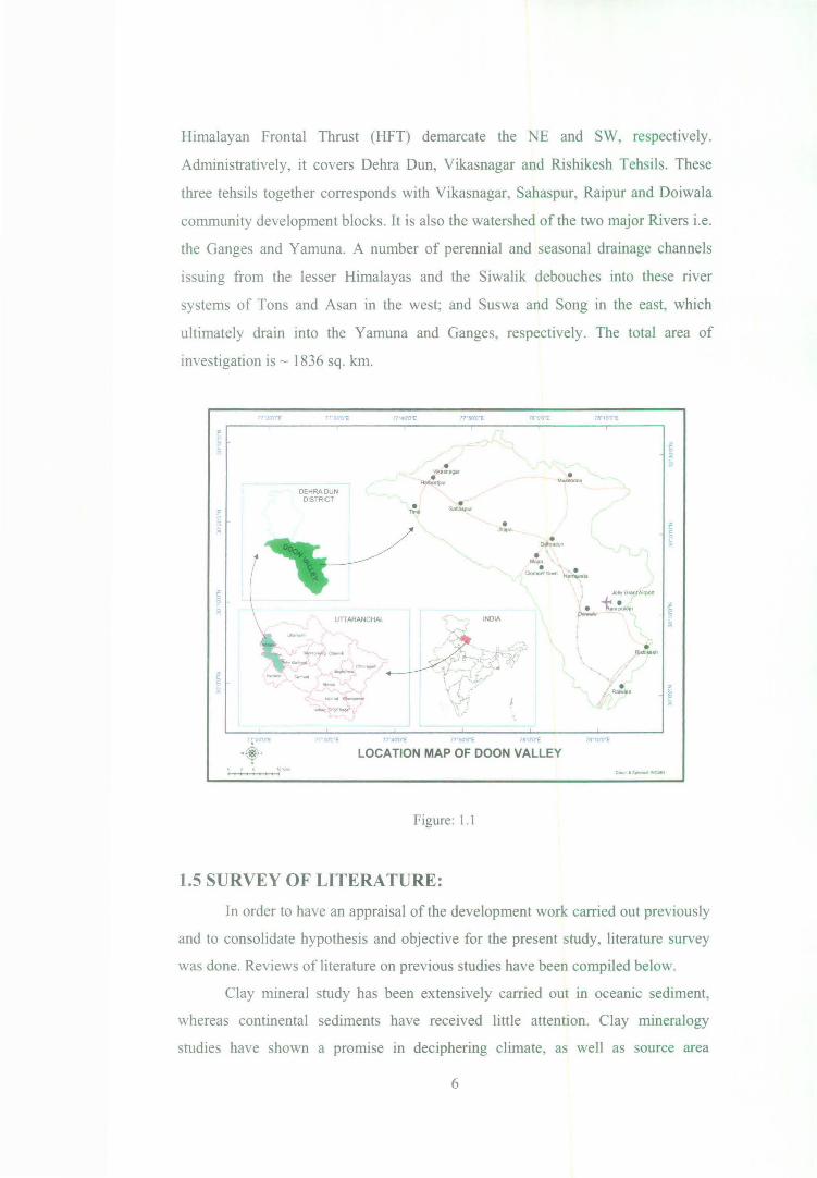
Himalayan Frontal Thrust (HFT) demarcate the NE and SW, respectively.
Administratively, it covers Debra Dun, Vikasnagar and Rishikesh Tehsils. These
three tehsils together corresponds with Vikasnagar, Sahaspur, Raipur and Doiwala
community development blocks. It is also the watershed of the two major Rivers i.e.
the Ganges and Yam una. A number of perennial and seasonal drainage channels
issuing from the lesser Himalayas and the Siwalik debouches into these river
systems of Tons and Asan in the west; and Suswa and Song in the east, which
ultimately drain into the Yamuna and Ganges, respectively. The total area of
investigation is - 1836 sq. km.
OEHRADUN DISTRICT
n :v-·e
• ,..,. • ._ • ......
INDIA
• .,...,~
• • ..... • • Clam&l1. ._, lian'¥ala
T8"10U"E
..bly GnM\tMpofl
p.!... t...~" ~ lo<
- ., 711'10'0"£
LOCATION MAP OF DOON VALLEY
Figure: 1.1
1.5 SURVEY OF LITERATURE:
In order to have an appraisal of the development work carried out previously
and to consolidate hypothesis and objective for the present study, literature survey
was done. Reviews of literature on previous studies have been compiled below.
Clay mineral study has been extensively carried out in oceanic sediment,
whereas continental sediments have received little attention. Clay mineralogy
studies have shown a pronuse m deciphering climate, as well as source area
6

tectonics (Charnley, 1989). Clay mineral show temporal variation and is not related
to lithofacies, while these show good relationship with provenance and climate.
Distribution in the lower part (up to 640 m) indicates frequent ponding/ lacustrine
conditions. The source area for clay mineral also changed from the lower part to the
upper part of basin i.e., from dominance of igneous/metamorphic to meta
sedimentary and sedimentary rocks. During this period, climatic oscillations were
frequent from cold to dry, warm humid and warm sub-arid. The clay mineral data
are in fair agreement with other sedimentological parameters (Bagati and Rohtas,
1995).
Alluvial fans are abundant in the valleys or in the foothills of the mountains
in all latitudes, irrespective of prevailing climatic conditions. These were formed
and still are being formed, at the front of ice caps and glaciers as well as in moderate
semi-arid and arid regions. Alluvial fans have been used as an indicator of palaeo
climate (Rachocki, 1981 ). Alluvial fans develop at the base of a mountain front or
other upland areas, where emerging mountain streams deposit a segment of a cone.
Development of these fans is generally related to tectonic activity in source area;
however, the climatically induced events can also result in the development of such
features (Rohtas and Ghosh, 1995).
The drainage map of Dehra Dun reveals that the area under study might be
divided sharply into two sectors by bisecting the area transversely into: (a) SE sector
and (b) NW sector. The SE sector is associated with the streams and rivers (Bindal,
Rispina, Susva and Song) that join the major river system of the Ganges towards the
eastern boundary. The NW sector on the other hand is associated with rivers and
streams (Asan, Sitla, Moti, Koti and Tons) that join the river Yamuna towards the
western boundary. These geomorphological feature arrangements have given rise to
a water-divide known as Landour-Asharodi water-divide. In terms of land-use, the
Yamuna catchment is less densely populated with large area under forest cover as
compared to the Ganga catchment sector (Saini et el, 1997).
Important geomorphic features of this region are raos (torrents), which
remain usually dry. These are the braided channels with gravel beds. A vigorous
process of erosion was initiated in the Himalayan zone during the Pliocene period
when a multitude of stream draining the area carried detrital waste down the
mountain and deposited in the Indo-Gangetic trough. The initially laid sediments
were involved in the latest mountain building activity that resulted not only in the
7
uplift of the Himalaya but also in the creation of parallel range of Siwalik Hills in
the south. The valley between the Himalaya and the Siwalik was filled with the
sediments from both sides, though the contribution from former was greater because
of its huge drainage area. The alluvial plains, broken by streams represent the
landscape ofDoon valley (Gupta and Sharma, 1995).
It is composed of alluvial fans and river terraces and traversed by seasonal
braided streams/rivers. The entire structure of the Siwalik from top to bottom is
extremely fragile and prone to erosion by wind and rain if cleared of vegetative
cover. This extreme vulnerability gives rise to exceptional conservation needs
(Ghosh, 1995).
Term "tectonic" refers to all the deformational structures and architecture of
the Earth's crust and the evolution of these features through time whereas
"neotectonics" (introduced by Obruchev, 1948) describes the study of 'young and
recent movements taking place at the end of Tertiary and the first half of the
Quaternary'. Recently, the definition of neotectonics has been modified as the
branch of tectonics concerned with understanding of earth movements that occurred
in the past and are continuing in the present day (Pavlides, 1989, Steward and
Hancock, 1994).
Nossin (1971) prepared the first geomorphological map using aerial
photographs. He determined that this synclinal valley to be post upper Siwalik in
age and that the regional uplift of the valley occurred since the upper Siwalik times
to ~bout 950 to 1250 ft. Thereafter, Nakata (1972 and 1975) described some recent
movements and suggested that the Doon valley evolved by the intricate
superimposition of alternate depositional and erosional phases, caused by climatic
changes and crustal movement over the hundred thousand years. Rao (1977 and
1978) observed tilted post-Siwalik boulder bed, the Langha Boulder bed, which
rested uncomfortably on the upturned Siwalik sediments in the Doon valley. The
cross profile showed that the eastern portion of the fan is at higher elevation than the
western lateral side, indicating westerly tilt of the whole fan sequence. The
migrations of Himalayan antecedent rivers (river Ganga and river Yamuna) are,
therefore, in an opposite direction, which is probably due to the compression
between the Siwalik and the Lesser Himalayas, resulting in the recent uplift of the
Doon valley. Geomorphological analysis indicates that a regional uplift of the Doon
valley is of about 380 m that occurred after the end of Siwalik deposition (Rao,
8
1986) and the Tectonic rate reflected in rates and pattern of geomorphic processes
and forms (Philip, 1995).
Erosion is high in the Himalayas because of the presence of highly fractured
and jointed unstable rocks. In addition, there are areas of instability having frequent
high magnitude seismic activity which causing severe mass movements, thereby
contributing enormous amounts of loose debris to the streams and to river systems
of the region. These geologicaly unstable formations occur in the seismic zone and
are prone to serious erosional problems at slight disturbances (Sastry et el., 1995).
The Main Boundary Fault (MBT) of the Himalayas separates the Doon
valley from the mountain scarp of the Mussoorie range. Uplifted high level fan
terraces overstep the boundary fault, and the principal fans are deeply dissected at
the mountain foot. Terraces indicate various episodes of incision and infilling. The
various sub-units in the morphology of the Siwalik range are all lithologically
controlled. All channels are braided; the Yam una and Ganges break through the
Siwalik range along the transcurrent fault lines, while there is no other break
through the range in this region. The two main rivers are flanked by several terrace
level, all below the level of principal Doon fans. Uniformity of incision suggests the
regional uplift of the area, supplementing that differential movements have occurred
especially along transversal offshoots of main boundary fault. These movements
continue even today. (N ossin, 1971)
1.6 OBJECTIVES OF THE STUDY:
1. To reconstruct palaeo-environmental conditions in landscape evolutions
in order to assess and evaluate evolutionary climatic phases.
2. To analyze morphometric parameters in order to quantitatively
understand geomorphological characteristics of the Doon Valley.
3. To examine direct and indirect impact of human actions on landscape
evolution in order to assess spatial and temporal rate of changes on local
landforms and processes.
1. 7 RESEARCH QUESTIONS:
A. Whether palaeo-environment caused any direct or indirect impact on the
morphology and structural setting?
9

B. What is the intensity of morphometric processes operating its variations over
the surface?
C. What are the changes in anthropogenic activities over time and space?
D. Whether man is a prominent exogenic force whose activities (i.e. economic,
social, cultural etc.) have direct as well as indirect impact on landscape
evolution?
E. How would the human activities influence landscape evolution?
1.8 DATABASE:
Any research requires database to achieve the intended objectives. To
achieve the results, following data sources have been used for the present analysis.
Secondary data:
• Toposheet numbered 53F14, 53Fl5, 53F16, 53J3, 5314, 5318, 5319,
53Kl and 53Fll (scale 1: 50,000) Survey of India, 1967 (see Figure
1.2).
• Digital satellite imageries-
a. Landsat Multispectral Scanner (MSS), dated 14-11-1972.
b. L~ndsat Thematic Mapper (TM), dated 21-10-1990.
c. Landsat Enhanced Thematic Mapper (ETM), dated 25-11-2000.
d. Advance Spaceborne Thermal Emission and Reflection Radiometer
(ASTER), dated 31-10-2008.
e. QuickBird Satellite (merged panchromatic- 61 centimeters and
multispectral- 2.4 meters at nadir) provided through image connect of
Digital Globe, Dated December 2007.
• Population, industrialization and infrastructure data and literature from
Census, Govt. Gazetteers and other sources.
• Thematic maps of Debra Dun prepared by the NATMO.
• Weather data will be taken from Gazetteer of Debra Dun from and of
almost all the IMD weather stations surrounding Doon Valley.
10

.
~
' Primal)' data: I
I I I
I
• Field Survey for identifying landuse categories with GPS (Garrnin e
trex).
• People's perception about geomorphic change human activities in living
memory among different age groups.
• Terrestrial photographs to support the data .
. ....... .... ~
\ .. .,_, S:U:/14
53-J/2 53-J/7 53-F/10
•""" - . ._a-.. --~ - I ......
--~t &
~QrttptA I \ ""'.. ~-.
Jt-st•$11111 1/ - \_ ( - .. - ""·-~ . I .. • -- . -- - '"'l"" ;- ~ . J r-
~rnl · ... - '1. .(- .:~
53-F/11 S:U:/15 ' .1.' ... ,> .,__ •1,-.t: ' ........ 53-J/8 .-l!;;-- lf' .., 53-J/3 '} -· . BerJstwmJq.
~ .. .~:-• I ... ~ ' ( - _ll
t ~
J )
_ ...... _ .f-"'!":~..;;. .... ,,..,. . . { . . \ ~ ... . ) '· . -· AA I >
53-F/12 . ~ .... . Rft;.I 'Y'IGr.t..n II-• . ' ' ~,. ..... .-J \ ~OtiwJ• .. .. -
' ........ .._
l~ .. 5:U:I16 \ r ·· ;::~ .. -· .. -- ' 53-J/4 53-J{g
SOl !2fQ~~ICA!. ~1:11:ns .. l / IN sniDY AREA. {1:5000!!}
I :l,Y ..... . " ~~- ~~-r )
-~· -0 5 10 20 141omelws 53-G/13
53~/1 /r: 53~15
.,
Figure: 1.2
1.9 METHODOLOGY:
In order to achieve desired objectives of the study, the following
methodologies have been used:
Objective: 1
To reconstruct palaeo-environmental conditions m landscape evolutions in
order to assess and evaluate evolutionary climatic phases.
• The evidences are examined for different geological period and
11
related climatic changes and corroborated with earlier studies for
time-framed evolution.
• Tectonic setting of the study area is evaluated by mapping various
tectonic structures such as thrusts, faults and lineaments from the
data obtained from ASTER imagery and verified with existing data.
The whole valley is divided into different zones based on density of
tectonic structure and seismic data. Apart from this activities along
Main Boundary Thrust (MBT), Himalayan Frontal Thrust (HFT) and
other active tectonic regions will be identified by observing channel
shifts, new landforms with the help of spatial data and literature
available of different times.
• Base map for geomorphic features is obtained from Nossin (1971);
and modified and evaluated according to the need of present
objective.
• It is modified using visual identification and digital interpretation
techniques and GPS readings.
• Peoples view related to climatic, visual geomorphic features (slope,
landslide etc.) among different age groups. Their perceptions are
integrated in analysis.
Objective: 2
To analyze morphometric parameters in order to quantitatively understand
geomorphological characteristics of the Doon Valley.
• Mosaic, Sub-set and georeferenced toposheet and satellite inmagery.
• Divide the whole region into 500 m X 500 m sq. Grids.
• Count and measure the stream length, stream number, number of
contours crossing, highest and lowest value of contour, and contour
intervals in each grid.
• Calculate various areal (stream frequency, drainage density, drainage
texture) and relief (absolute relief, relative relief, dissection index,
ruggedness index) properties are calculated for each grid cells.
• Values of each grid cells are interpolated for entire study area and
12
divide in five classes from very high to very low.
• Further area extraction and other statistical data extraction such as
area under various height categories, percentage of area under
various morphometric processes will be done.
• Composite index of the morphometric parameters are calculated
using PCA.
• Final impact zonation map is generated considering vegetation cover.
Objective: 3
To examine direct and indirect impact of human actions on landscape
evolution in order to assess spatial and temporal rate of changes on local landforms
and processes.
• Analyse village wise data through literature, government gazetteer
and census for population distribution.
• Settlement clusters are identified through high resolution satellite
imageries for understanding the nature of population clusters.
• People perception about the changes in the activities of people over
time and space is incorporated.
• Data is obtained from above exercise and analyze to project the
growth trends.
• Land-use data is analyzed through change matrix and their
conversion capacities are also analyzed.
• Its relation is established through human and natural landscapes.
Finally, land-use change zonation is derived using spatia-statistical
methods.
1.10 ORGANIZATION OF MATERIAL:
The first chapter introduces the theme of the present study including
literature survey. Objectives are specified along with type and source of the data
used and methodology. This also includes the location of study area.
Second chapter gives a general description on the background of the study
area, which includes physiography, geology, soil, climate (temperature, rainfall,
13

humidity, cloudiness, wind and special weather phenomenon), vegetation and
general land use and landform characteristics along with information about
agriculture, irrigation, animal husbandry, Industries, trade commerce, export, fairs &
festivals, education etc.
The third chapter deals with the structural setting and landform evolution of
the study area. It gives information about various thrusts, faults and lineaments. It
also deals with landform evolution and traces the combined role of tectonism and
climate. It also suggests the various stages in the evolution of the study area.
The fourth chapter is dedicated to measurement and calculation of surface
modifying natural factors through morphometric analysis and its impact zonation
considering cover.
The fifth chapter deals with the temporal and spatial changes in the
population in the study area. It also covers land-use changes, influencing factors,
pattern and distribution and finally landscape change dynamics considering
anthropogenic activities.
The final chapter summarizes and presents conclusion of this study.
1.11 PRACTICAL UTILITY OF THE STUDY:
Present study has a high degree of practical utility as it takes into
consideration both human and environmental factors in landscape evolution of a
region. The study provides an open ended choice to mould the option of land use
according to specific needs. This study will help planners, administrators,
developers and researchers equally.
14


![Denotational Seman tics for prialt -free Handel-C · tics, i.e taking the denotational seman tics of CSP [BR84]or o ccam [Ros84] and mo difying them to suit all rapidly fail, the](https://static.documents.pub/doc/80x56/5fbafc104a74070ac2185df0/denotational-seman-tics-for-prialt-free-handel-c-tics-ie-taking-the-denotational.jpg)


