i I~ i:i • I I I I il ..... 11 , MINERAL APPRAISAL OF THE CORONADO NATIONAL FOREST PART 1, PINALENO-GREASEWOOD MOUNTAINS UNIT, GRAHAM COUNTY, ARIZONA by S. Don Brown MLA 8-93 1993 Intermountain Field Operations Center Denver, Colorado UNITED STATES DEPARTMENT OF THE INTERIOR BRUCE BABBITT, Secretary BUREAU OF MINES HERMANN ENZER, Acting Director
Transcript
i I~ iii:i •
I
I I I
i l ..... 11 ,
MINERAL APPRAISAL OF THE CORONADO NATIONAL FOREST
PART 1, PINALENO-GREASEWOOD MOUNTAINS UNIT, GRAHAM COUNTY, ARIZONA
by
S. Don Brown
MLA 8-93 1993
Intermountain Field Operations Center Denver, Colorado
UNITED STATES DEPARTMENT OF THE INTERIOR BRUCE BABBITT, Secretary
BUREAU OF MINES HERMANN ENZER, Acting Director
'm
I I I I I I
l
j 7
PREFACE
A January 1987 Interagency Agreement between the Bureau of Mines, U.S.
Geological Survey, and U.S. Forest Service describes the purpose, authority, and
program operation for the forest-wide studies. The program is intended to assist the
Forest Service in incorporating mineral resource data in forest plans as specified by the
National Forest Management Act (1976) and Title 36, Chapter 2, Part 219, Code of
Federal Regulations, and to augment the Bureau's mineral resource data base so that
it can analyze and make available minerals information as required by the National
Materials and Minerals Policy, Research and Development Act (1980).
I I I I
I
This open-file report summarizes the results of a Bureau of Mines forest-wide study. The report is preliminary and has not been edited or reviewed for conformity with the Bureau of Mines editorial standards. This study was conducted by personnel from the Resource Evaluation Branch, Intermountain Field Operations Center, Building 20, Denver Federal Center, Denver, CO 80225.
10. Adit in Righthand Canyon showing sample localities PI 57-60 . . . . . 75
11. Adit between Ash Creek and White Streaks Canyon showing sample localities PI 66-75 . . . . . . . . . . . . . . . . . . . . • . . . . . . . . . . 76
ilili;i, . o °
I I I
!~ [ ;~i~
' l
I I I I I I I I I I ;;I I I I1
i I
UNIT OF MEASURE ABBREVIATIONS USED IN THIS REPORT
cps counts per second
$ dollar (U.S.)
ft foot
in. inch
Ib pound
mi mile
% percent
oz troy ounce
oz/st troy ounce per short ton
ppb part per billion
ppm part per million
st short ton (2,000 Ib)
stu short ton unit (20 Ib)
iv
~j i I •
:L
MINERAL APPRAISAL OF THE CORONADO NATIONAL FOREST, PART 1, PINALENO-GREASEWOOD MOUNTAINS UNIT, GRAHAM COUNTY, ARIZONA
By S. Don Brown 1
i I i I I I I I i I I I
SUMMARY
Between 1990 and 1992, the Bureau of Mines conducted a mineral
investigation of the Pinaleno-Greasewood Mountains part of the Coronado National
Forest to appraise the mineral resources and to identify and describe areas with past
mining activity. The study included a comprehensive literature search combined with
a field investigation involving the examination of known mines, prospects, and
mineralized areas. This study is part of the Bureau's overall mineral evaluation of the
Coronado National Forest and will be included in a summary report of the Forest.
The Pinaleno Mountains have few mineral occurrences and mines and prospects
are few and scattered. The only clear record of mineral production is from the Black
Beauty prospect, where 240 Ibs of tungsten oxide was produced in 1955. No mineral
resources were identified during this study; only occurrences of precious and base
metals, and tungsten. There is no known current mining activity in this part of the
Forest.
INTRODUCTION
During 1990-1992, the Bureau of mines studied the mineral resources of the
Pinaleno-Greasewood Mountains, on land administered by the U.S. Forest Service.
1 Mining Engineer, Intermountain Field Operations Center, U.S. Bureau of Mines, Denver, Colorado
I 1 I
I I I I I I I I I I I I I I I I
This study is part of the Bureau's overall mineral evaluation of 13 study units of the
C(;ronado National Forest.
Geographic setting
The Pinaleno-Greasewood Mountains include 198,411 acres (310 mi =) of the
Coronado National Forest, in Graham County, southeastern Arizona (fig. 1). The
southern part of the range is generally referred to as the Greasewood Mountains.
Pima, Thatcher, and Safford are major communities north-northeast of the range, and
Willcox is a major community south of the range. Sulphur Springs Valley borders the
Pinaleno Mountains on the west and southwest, and San Simon Valley borders the
range on the east side. Elevations in the Forest range from 3,440 ft on the east side
to 10,720 ft on Mount Graham. Interstate Highway 10 is south of the Forest. U.S.
Highway 666 parallels the Forest on the east from which State Highway 366 provides
access to the central part of the range, and State Highway 266 crosses through the
range to the west. U.S. Highway 70 is northeast of the Forest, an unnamed all
weather road is north of the Forest, and the Aravaipi Road is on the west side of the
Forest. From these highways and roads, numerous Forest trails and unimproved dirt
roads provide access to the Forest.
Previous investigations
The most comprehensive report on the geology of the Pinaleno Mountains was
by Thorman (1981). The geology of the southern part of the range was mapped by
Cooper (1960). Bergquist (1979) compiled a geologic map of the Blue Jay Peak
Quadrangle, which includes a northwestern part of the Forest. Swan (1976) discussed
a major structural feature in the Forest, the Stockton Pass fault (plate 1 ). A number
of unpublished field engineers' reports that evaluate unpatented mining claims and
2
m
I I I I I I I I I I I I I
I
I
110" 109"45 ' R. Z1E. R.22E. R,Z3E.
t I Santa Tere==a j Moun~alnsl !
R,24E.
109*30 '
R.25E. R.26E.
109o15 s
R.27E, R,2BE.
I
Thafcher T ,6S .
3 2 . 4 5 ~ -
Q
z
32 °30 ~ " 9.
3 2 " 1 5 ' ~ ....
Mountallns
I t l l 11
........ 2++- I . . . . . . . . . . . . . . + .
I I
..... N ~
Mt
!,;"
WI I laox
~N
Bowie
T,' i 'S.
32°45 ,
T,8S.
T.gS.
T,IOS,
32°30 ,
T.11S,
T. 12S.
T, 13S,
32=15 '
T, t4S.
110" 109°45 ,
J . Ar i z o n a \ /
I I Map L o c a t i o n
109=30 ' ~ 109+15'
-N-
I I I I I
0 10 15 20 25mr l e s
F T g u r e 1 , - - I n d e x map o f t h e P i n a l e n o - G r e a s e w o o d M o u n t a i n s U n i t C o r o n a d o N o t i o n a l F o r e s t , Graham C o u n t y , A r i z o n a
3
il/
I I I I I I I I I I I I I I I I
prospects are on file with the Arizona State Department of Mines and Mineral
Re'sources in Phoenix, and at the Anaconda Geological Document Collection at the
University of Wyoming in Laramie, Wyoming.
Methods of investigation
A detailed literature search for pertinent geologic and mining information for the
Forest was made prior to the field investigation. Bureau of Land Management and
county records were examined for patented and unpatented mining claim locations.
The Bureau's field study concentrated on the examination of known mines,
prospects, and mineralized areas inside the Forest boundary. A total of 20 field-days
was spent during the spring of 1990 and the winter of 1991. Accessible mine and
prospect workings were mapped and sampled. Veins, potentially mineralized
structures, altered and/or mineralized outcrops, and dumps of inaccessible workings
were sampled.
Seventy-six samples were taken; they consisted of four types: 1) chip - a
regular series of rock chips taken in a continuous line across a mineralized zone or rock
face; 2) grab - rock collected randomly from a dump, stockpile, other rock at a mine
working, or float; 3) select - sample intentionally selected from mineralized rock
resulting in maximum mineral concentrations; 4) dump - rock collected from a mine
dump on a grid or spaced such that a representative sample of the dump is taken. All
samples were analyzed by Chemex Labs, Inc. of Vancouver, British Columbia for 32
elements by an inductively coupled plasma (ICP) method, and by Bondar-Clegg, Inc.
of Vancouver, British Columbia for 34 elements by a neutron activation method.
Selected samples were re-analyzed by Chemex for specific elements when the assay
values were above the saturation limits for instrumental analysis; these elements
4
I I I I I I I I I I I I I I I I
include barium, copper, lead, silver, and zinc. Sample descriptions are summarized in
ap'pendix A, and all the analytical results are in appendixes B and C. Where sample
analytical data is presented in this report, the higher of the two values, either Chemex
and Bondar-Clegg, is shown.
Geologic setting
The Pinaleno Mountains are a north- to northwest-trending mountain range in
the Mexican Highland section of the Basin and Range physiographic province. They
constitute one of the highest and most rugged ranges in southeastern Arizona. Most
of the bedrock in the range consists of Precambrian granite and granitic gneiss.
Tertiary volcanic units are common in the southern part of the range, along with a
Tertiary granitic stock. A major structural feature in the range is the Stockton Pass
fault zone, a four-mile-wide left-lateral fault system trending west-northwest through
the area of Stockton Pass (plate 1).
Mining history
The Pinaleno Mountains have few mineral occurrences and mines and prospects
are few and scattered. The only clear record of production is for the Black Beauty
prospect where 4.5 st of ore yielded 12 stu (240 Ib) of tungsten oxide (WO3) in 1955.
The claim was originally located in 1916 for gold (Dale, 1959, p. 65). Unpublished
field engineers' reports on file with the Arizona State Department of Mines and Mineral
Resources discuss prospecting activity at the Stony Peak and White Rock uranium
prospects in the mid and late 1950's, and rotary drilling in 1959 near Willow Springs
Canyon to test for base and precious metals. During the present investigation, no
evidence of recent mining activity in the Forest was found.
I I I I I I I I I I I I I I I I
MINERAL APPRAISAL
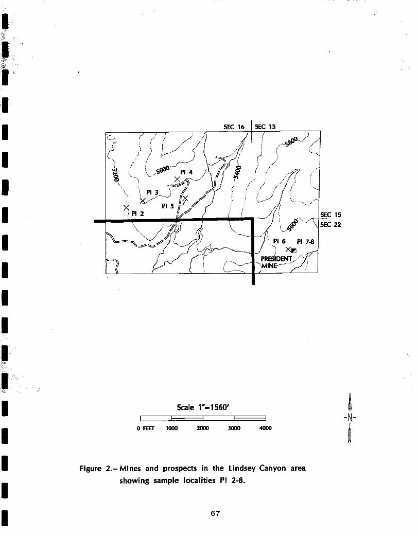
Lindsey Canyon area
A number of mines and prospects are in the Lindsey Canyon area in and near
the northwest part of the Forest (plate 1, fig. 2). Sample PI 1 is from a quartz
stockpile at an adit driven about 250 ft on an of aphanitic, dark gray dike and a quartz
vein. The adit was not mapped or sampled because of loose rock conditions. The
assay showed low metal concentrations in the quartz sample; pyrite is the only metallic
mineral identified. Sample PI 2 is from a quartz vein in a prospect pit in granite. A
minor amount of pyrite is in the quartz, and the assay showed low concentrations of
metals (appendix B, C). Sample PI 3 is from a quartz stockpile alongside a prospect
pit. Azurite, galena, and malachite are in the quartz, and the sample contained 0.772
oz/st gold, 17.9 oz/st silver, 1.3% copper, and 1.9% lead. The quartz vein could not
be seen in place due to sloughing and does not have continuity at the surface. Sample
PI 4 is from a quartz stockpile alongside a small prospect pit that crops out
intermittently for about 100 ft at the surface. The quartz contains blebs of galena and
pyrite, and the sample assayed 6.6 oz/st silver, 583 ppm copper, and 1.4% lead.
Sample PI 5 is from a quartz vein containing minor pyrite, galena, and malachite stains
in a pit in granitic rock. The sample contained low metal concentrations. The quartz
vein crops out intermittently for about 400 ft along strike.
The President Mine is about 1/2 mi southeast of Lindsey Canyon (fig. 2). The
main working is a shaft sunk on a 5- to 6-ft-thick quartz vein adjacent to prominent
shearing in granite. Continuity of the quartz vein is not evident at the surface. A
select sample (PI 7) from a quartz stockpile with disseminated pyrite and pyrite
stringers assayed 1.32 oz/st gold and 9.0 oz/st silver. A random grab of the quartz
6
I I I I I I I I I I I I I I I I I
stockpile (PI 8) had low metal concentrations, 2 ppm gold and 8 ppm silver. Sample
PI'6 is a chip sample from a 2-ft-thick quartz vein in a nearby prospect pit. This
sample also contained low metal concentrations. No resources could be identified in
the Lindsey Canyon area because of limited and discontinuous exposures of
mineralized rock.
Swan and Chakarun (1973)identify a favorable porphyry-type copper deposit
target area in the Lindsey Canyon area, about 1 mi southwest of the Forest. The
target area is at or near a contact between Tertiary volcanic rock and Precambrian
granite, at a depth of 500-2,000 ft. The supposition of a mineralized area is based
upon favorable geologic conditions at the intersection of a prominent west-northwest-
trending basement thrust fault and a northeast-trending dike swarm. According to that
report, the base-metal-sulfide veining associated with the dikes, and persistent copper-
oxide mineralization related to the thrust fault suggest remobilization of copper from
a source area southwest of the Forest. The rock type at the Forest boundary and in
the Forest is Precambrian granite and is about 1 mi distant from the contact with
Tertiary volcanic rocks. The target area, therefore, probably does not extend into the
Forest because of the change in rock type and geologic environment.
Numerous prospects are present outside the Forest in the Lindsey Canyon area,
but were not examined during this investigation because they are located on private
land.
Northeast of Lindsey Canyon, near Bellows Canyon, an 80-ft-long adit exposes
a highly fractured quartz vein in altered granite (plate 1, fig. 3). Five samples from this
adit have low metal concentrations (PI 9-13, Appendixes B, C) and no ore minerals
were recognized.
i|!
I I I I I I I I I I I I I I I I
Black Beauty prospect
The Black Beauty tungsten prospect is just inside the Forest boundary, between
Van Valer Canyon and Durkee Canyon (plate 1, fig. 4). The major working is an open
cut about 50 x 15 x 15 ft deep at the face, from which 12 short ton units (240 Ib) of
WO3 was produced from 4.5 st of ore in 1955 (Dale, 1959, p. 65). The cut exposes
a discontinuous quartz vein as much as 3 ft thick in Precambrian schist. An inspection
for the presence of scheelite with a black light revealed sparse disseminated scheelite
in the schist and none in the quartz. A sample of the schist (PI 14) assayed 27 ppm
tungsten; tungsten was not detected in a sample of the quartz (PI 15, appendix B).
Apparently a small, high-grade zone of scheelite was mined out in the open cut. A
number of quartz outcrops are exposed on the hill above the Black Beauty prospect.
Trace amounts of tungsten were detected in the five samples taken from the quartz
outcrops (samples PI 16-20, fig. 4).
Gold Gulch prospects
A number of small adits, shafts, and pits are in and near Gold Gulch, about 2
mi east of Fort Grant (plate 1, figs. 5-8). The workings apparently are gold prospects;
gold was detected in 13 of 18 samples taken from the prospects (samples PI 21-38,
appendix C), with the highest gold assay being 2200 ppb (0.064 oz/st). Most of the
workings were dug on narrow fault zones and shears, some with thin quartz veins and
stringers, in Precambrian granite and altered granite. The faults and shears are likely
related to the northwest-trending Stockton Pass fault zone (plate 1). Pyrite was the
only ore mineral identified in this area, and all the samples have low metal
concentrations. No resources could be identified in the Gold Gulch area because of
8
! ! ! ! ! ! ! ! ! ! ! ! ! ! ! !
low metal concentrations and the small size of the structures. The individual workings
are summarized in appendix D.
Prospects in the southern Pinaleno Mountains
There are a number of small prospects in the southern part of the Pinaleno
Mountains, south of State Highway 266. Near Mothers Canyon is an 11-ft deep shaft
on a contact between granite and a mafic dike. A small amount of the granite contains
disseminated chalcopyrite (mostly in quartz veinlets), and abundant malachite stains.
Two samples (PI 39, 40) taken at this working assayed 1,118 and 6,071 ppm copper,
with low concentrations for other metals (appendix B, plate 1).
The Stony Peak and White Rock uranium prospects are near Cove Canyon (plate
1, samples 41-43). At the Stony Peak prospect is a small, open-cut in Precambrian
granite. Scintillometer readings in the cut were up to six times the background of
about 160 cps. Sample PI 42 from the cut assayed 46 ppm uranium and 46 ppm
thorium and sample PI 43 from the dump assayed 54 ppm uranium and 47 ppm
thorium (appendix B). At the White Rock prospect is a shallow, sloughed pit in
Precambrian granite. Scintillometer readings in the pit are about twice the background
of 80 cps. Sample PI 41 from a small dump assayed 30 ppm uranium and 39 ppm
thorium. No uranium minerals or resources were identified at either prospect.
Near O-Bar-O Canyon (plate 1, samples PI 45, 46) a 15-ft-deep shaft exposes
a shear zone at least 5 ft thick between a contact of fine-grained dacite and dacite
porphyry. This is likely a turquoise prospect because a 3/8 in. thick seam of turquoise
is exposed in the shaft, and pieces of turquoise are on the dump. Sample PI 45 from
the shear zone had a copper concentration of 1,932 ppm, and a select sample (PI 46)
from the dump assayed 3.92% copper and 47 ppm silver. Both samples had low
9
I, I I I I I I I I I I I I I I I I
concentrations of other metals, and no resources were identified at this shaft. About
2,()00 ft northwest of this shaft is an altered area near a contact between granitic and
volcanic rock. A grab sample (PI 44) of the altered rock had negligible metal values.
Near Gillman Canyon (plate 1, sample PI 47) is a 31-ft-deep shaft in a sheared
zone in maroon andesite porphyry. Chrysocolla fills some of the fractures in the rock.
A select sample from a small ore stockpile assayed 7.7% copper, 117 ppm silver, and
3,345 ppm arsenic, with low concentrations of other metals (appendix B). At the
surface, the mineralized structure could not be traced beyond the shaft.
South of Willow Spring Canyon (fig. 9) several prospects were dug on mafic
dikes in Precambrian granite. A select sample (PI 51) of altered rock from the dump
of a 30 ft decline containing galena, smithsonite, and sphalerite assayed 6.9% lead,
17.1% zinc, 1,320 ppm cadmium, 1,016 ppm copper, and 23 ppm silver. No
mineralized rock was identified in-situ in the decline, or at any of the other workings
in this area, and the other samples have low metal concentrations (samples PI 48-53).
The prospects are summarized in appendix D.
Near the head of Willow Springs Canyon (Plate 1, samples PI 54, 55) are
several small prospects in volcanic rock. Sample PI 54 is a select sample from a small
stockpile alongside a bulldozer cut. A minor amount of chrysocolla is in the stockpile;
the sample assayed 2.7% copper. No structure or mineralized rock was visible in the
bedrock. Near the bulldozer cut is a small pit exposing a shear zone with altered,
clayey gouge and abundant limonite. No ore minerals were observed, but sample PI
55 from the shear assayed 5,734 ppm lead and 5,938 ppm zinc. The shear is not
exposed beyond the pit due to ground cover. No resources were identified from
surface exposures near the head of Willow Springs Canyon.
10
'i I I I I I I I I I I I I I I I ' I
Near the head of Little Cottonwood Canyon (plate 1, sample PI 56) is a 34-ft-
deep shaft in alluvium consisting of volcanic debris. On the dump is a minor amount
of chrysocolla. A grab sample (PI 56) from the dump had low metal concentrations,
and no resources were identified at the shaft.
Prospects in the east and northeast part of the Pinaleno Mountains
In Righthand Canyon a l O0-ft-long adit with a stope to the surface and an
adjoining trench expose a major fault zone in Precambrian granite. Pyrite and galena
are present in the fault zone. Of four samples taken from the fault, two had 2,730 and
2,600 ppb gold, and 1,690 and 3,440 ppm lead. The metal concentrations are well
below ore-grade for a vein-type deposit. All the samples (PI 57-60) have low
concentrations of other metals.
North of Spring Canyon (plate 1, Samples PI 61,62) is a trench on a major fault
zone in Precambrian granite. A select sample of dump rock containing chrysocolla
contained 5.1% copper (sample PI 61 ) and sample PI 62 from the fault zone contained
4,172 ppm copper. The samples had low concentrations of other metals.
Near Lefthand Canyon is a small cut in altered Precambrian gneiss, adjacent to
a quartz outcrop about 10 ft across. No ore minerals were identified at the cut, and
sample PI 63 from the altered gneiss had low metal concentrations. However, the
sample assayed 564 ppm thorium and 112 ppm uranium, which is well above all the
other samples taken in the Forest but below commercial grade for large-scale deposits.
In Marijilda Canyon is a small prospect along a shear zone adjacent to a silicified
zone with abundant disseminated pyrite (plate 1, samples PI 64, 65). Samples from
this prospect had low metal concentrations.
11
i l l I
I I I I I I I I I I |
In the northeast part of the Forest, between Ash Creek and White Streaks
Canyon, are 255-ft-long and 23-ft-long adits in mafic, granitic schist (plate 1, samples
PI 66-76). The only ore mineral identified in the adits was minor amounts of
malachite. The 11 samples from the adits all had low metal concentrations.
No resources were identified at any of the prospects in the east and northeast
part of the Forest because of low concentrations of metals and discontinuous
occurrences of ore minerals.
CONCLUSIONS
No mineral resources were identified in the Pinaleno-Greasewood Mountains
Unit due to the spotty mineral occurrences and weak mineralization at and near
prospects. The only known production from within the Forest is a small amount of
tungsten from the Black Beauty prospect. Any production from other prospects would
have been small. Based upon mineral occurrences examined, future prospecting
activity would most likely occur in the Lindsay Canyon area, in the Gold Gulch area,
and the area south of and near Willow Springs Canyon.
12
I
I I I I I I I I I ,I I i f I ~
I I ili,i~,
REFERENCES
Bergquist, J. R. 1979, Reconnaissance geologic map of the Blue Jay Peak Quadrangle, Graham County, Arizona: U.S. Geological Survey Miscellaneous Field Studies Map MF-1083, scale 1:24,000.
Cooper, J. R., 1960, Reconnaissance map of the Willcox, Fisher Hills, Cochise, and Dos Cabezas quadrangles, Cochise and Graham Counties, Arizona: U.So Geological Survey Mineral Investigations Field Studies Map MF-231, scale 1:62,500.
Dale, V° B., 1959, Tungsten deposits of Yuma, Maricopa, Pinal, and Graham counties, Arizona: U.S. Bureau of Mines Report of Investigations 5516, 68 p.
Swan, M. Mo, 1976, The Stockton Pass fault: an element of the Texas lineament: unpublished M.S. thesis, University of Arizona, Tucson, 119 p.
Swan, M. M., Chakarun, J. D., 1973, Bear Creek Mining Company memo, unpublished field examination report on file with the Arizona Department of Mines and Mineral Resources: The Cedar Springs-Lindsey Canyon area (006-21-0820), Graham County, Arizona, 4 p.
Thorman, C. H., 1981, Geology of the Pinaleno Mountains, Arizona: a preliminary report: Arizona Geological Society Digest, v. 13, p. 5-12.
<
T ' -
13
m i . r ,
!1 ~ ' i:
i
APPENDIX A
I I I |,
DATA FOR SAMPLES FROM THE PINALENO-GREASEWOOD MOUNTAINS UNIT, CORONADO NATIONAL FOREST, GRAHAM COUNTY, ARIZONA
i~i ¸¸ ,
14
Appendix A.--Data for samples from the Pinaleno-Greasewood Mountains, Coronado National Forest. {xx, not applicable}
II I I I I I I I I I I I
Sample Number
PI 1
PI 2
PI 3
PI 4
PI 5
PI 6
PI 7
Type
Select
Chip
Select
Grab
Chip
Chip
Select
Length
XX
1.5 ft
XX
XX
4 ft
1.3 ft
XX
Remarks
Adit, large dump; quartz stockpile, minor pyrite; rock on dump weathered granite and dark gray, aphanitic dike rock.
Prospect pit; quartz vein in granite, strike N. 35 ° W., vertical dip; minor fine disseminated pyrite, manganese stains.
Small prospect pit; quartz vein up to 2.5 ft thick, strike N. 40 ° W., near vertical dip; crops out intermittently on surface for approximately 100 ft; blebs of galena, minor pyrite, most pyrite oxidized.
Prospect pit; 4-ft-thick quartz vein in fine-grained granitic rock, strike, N. 85 ° W., dip 88 ° N.; crops out on surface intermittently for approximately 400 ft; sparse disseminated pyrite, galena, malachite.
Quartz vein in granite, on strike with and 60 ft from President Mine shaft, sample PI 7.
President Mine shaft dump; medium dump 1; shaft sunk on 5-ft to 6-ft-thick quartz vein adjacent to prominent shearing, strike N. 85 ° E., vertical dip; granitic rock outcrops on surface. Most of dump is a bluish-gray, aphanitic, rock, possibly a dike; sample of quartz stockpile with disseminated pyrite and pyrite stringers, some oxidation.
PI 8 Grab xx Do.
1 Dump size was used to estimate length of a 4-ft x 6-ft working. Small dump = 10-100-ft long adit. Medium dump = 100-300-ft long adit. Large dump = over 300-ft long adit. 15
! i
I Appendix A.--Data for samples from the Pinaleno-Greasewood Mountains,
Coronado National Forest.--Continued
I I I I I I I I I I I I I I
Sample Number
PI 9
PI 10
PI 11
PI 12
PI 13
PI 14
PI 15
PI 16
PI 17
Type
Chip
Chip
Chip
Chip
Chip
Chip
Chip
Chip
Chip
Length
5 ft
2.5 ft
4 ft
4 ft
4.5 ft
2 ft
3 ft
4 ft
4 ft
Remarks
Adit, 80 ft long; highly fractured quartz vein, limonite stains, general strike N. 70 ° E., dip 60 ° NW.; country rock altered granitic rock (figure 3).
Same adit as sample PI 9; Prominent fault, up to 1-ft-thick zone of clayey gouge, minor limonite stains.
Do.
Same adit as sample PI 9; fractured quartz, abundant limonite; sheared and gougy granitic rock adjoining quartz.
Same adit as sample PI 9; major 2-ft-thick shear zone in altered granitic rock; fractured and limonite stained quartz.
Open cut, zone in schist with sparse disseminated scheelite.
Open cut, 3-ft-thick quartz vein in muscovite schist, strike N. 45 ° E., vertical dip; sparse disseminated scheelite; within 50 ft of contact with granite.
Quartz vein, as much as 12 ft thick, crops out 50 ft along strike, N. 85 ° E., near vertical dip, in muscovite schist.
Quartz vein, as much as 8 ft thick, crops out 40 ft along strike, strike N. 75 ° W., dip 83 ° N., in muscovite schist.
PI 18 Chip 2 ft Small quartz outcrop in muscovite schist.
PI 19 Chip 6 ft Outcrop, 6-ft-thick quartz vein in muscovite schist.
PI 20 Chip 2.5 ft Outcrop, quartz vein as much as 3 ft thick, crops out 10 ft along strike, strike N. 85 ° E., dip 60 ° N., in muscovite schist.
16
i l i •
I I
I Appendix A.--Data for samples from the Pinaleno-Greasewood Mountains,
Coronado National Forest.--Continued
I I I I I I I I I I I I I I I
Sample Number
PI 21
PI 22
PI 23
PI 24
PI 25
PI 26
PI 27
PI 28
PI 29
PI 30
Type
Chip
Chip
Chip
Chip
Chip
Chip
Chip
Chip
Select
Chip
Length
1.5 ft
1.5 ft
2.5 ft
3 ft
3 ft
3 ft
8 ft
4 ft
X X
3 ft
Remarks
Prospect pit, fault, strike N. 50 ° W., vertical dip; granite, altered granite, limonite and manganese stains, minor pyrite and pyrite pseudomorphs.
Open cut; dike, strike N. 50 ° W., vertical dip; aphanitic, tan, weathered; minor limonite and manganese stains; country rock weathered granite.
Prospect pit, 10 ft deep; prominent shear zone, strike N. 45 ° E., dip 75 ° NE.; altered and sheared granite, disseminated pyrite, some oxidation.
Prospect pit, 10 ft deep; same shear zone as sample PI 23, altered granite, disseminated pyrite.
Prospect pit, 10 ft deep; same shear zone as sample PI 23, strike N. 55 ° E., near vertical dip; altered and sheared granite, limonite stained; prominent quartz vein 4 in. thick.
Prospect pit, 10 ft deep; prominent fault zone in altered and fractured granite; quartz lens 4 in. thick.
Portal of adit, approximately 75 ft long; prominent fault zone, altered and limonite stained granite.
Pit dug into adit, same adit as sample PI 27, two parallel fault zones, altered granite and a dike of black, aphanitic rock.
Small prospect pit, above adit sample PI 30, same structure; sample from stockpile of quartz vein material, country rock altered and weathered granite, limonite stained.
Adit, at least 95 ft of workings; major fault zone in altered granite, gouge, silicified rock.
17
I I I I I I I I I I I I I I I I I
Appendix A.--Data for samples from the Pinaleno-Greasewood Mountains, Coronado National Forest.--Continued
Sample Number
PI 31
PI 32
PI 33
PI 34
PI 35
PI 36
PI 37
PI 38
PI 39
PI 40
PI 41
PI 42
Type
Chip
Chip
Chip
Chip
Chip
Chip
Chip
Select
Grab
Select
Dump
Chip
Length
2 ft
2 ft
3 ft
2.5 ft
2.5 ft
2.5 ft
4 ft
XX
XX
XX
XX
5 ft
Remarks
Same adit as sample PI 30; intersection of two thin quartz veins, limonitic gouge and altered granite.
Same adit as sample PI 30; 8-in.-thick quartz vein; limonite stained, altered granite; minor gouge.
Adit, 90 ft long; prominent fault zone in altered, fine-grained granite, strike E-W, dip 60o-85 ° N.
Same adit as sample PI 33; altered and fractured granite, minor gouge.
Same adit as sample PI 33; altered and fractured granite, limonite stains.
Same adit as sample PI 33; fractured, medium- grained granite, minor limonite stains.
Prospect pit, 10 ft deep; wide shear zone in white quartzite, strike N. 75 ° W., vertical dip; pyrite pseudomorphs replaced with limonite.
Shaft, 20 ft deep; prominent shear zone 2 to 2- 1/2 ft thick, strike N. 25 ° E., dip75 ° SE;, white quartzite, disseminated pyrite pseudomorphs replaced with limonite.
Shaft, 11 ft deep; contact between granite and mafic dike; sample of dike rock.
Same shaft as sample PI 39; sample of granite, abundant malachite stains, chalcopyrite disseminated in quartz veinlets; granite altered near contact.
Uranium prospect pit; granite, limonite stains; adjacent to big quartz outcrop; scintillometer reading about two times background.
Open cut; uranium prospect; granite; shear zone, strike N. 78 ° W., vertical dip; scintillometer readings up to six times background.
18
Appendix A.--Data for samples from the Pinaleno-Greasewood Mountains, Coronado National Forest.--Continued
I I I I I I I I I I I I I I I
Sample Number Type Length
Pi 43 Dump xx
XX Grab
Chip 4.5 ft
XX
PI 44
PI 45
PI 46
PI 47
PI 48
PI 49
PI 50
Select
Select
Chip
Dump
Chip
XX
4.5 ft
XX
2 ft
PI 51 Select xx
PI 52 Chip 6 ft
PI 53 Dump xx
PI 54 Select xx
Remarks
Dump; open cut, s a m e a s sample PI 42; granite.
Outcrop, altered and bleached rock, abundant limonite on or near contact between granite and volcanic rock; alteration zone about 100 ft diameter.
Shaft, 15 ft deep; shear zone, 5 ft thick, strike N. 60 ° E., dip 86 ° SE.; between two rock types: fine grained dacite and dacite porphyry; sparse copper staining, 3/8-in.-thick seam of turquoise.
Same shaft as sample PI 45; sample of rock on dump with most turquoise in it.
Dump, small ore stockpile; shaft, 31 ft deep; fracture zone, strike N. 75 ° W., vertical dip; maroon andesite porphyry, chrysocolla in fractures.
Trench; contact similar to sample PI 50, strike N. 70 ° E., dip 65 ° S.; granitic country rock about 70 ft either side of trench.
Dump of water filled shaft, 28 ft deep; dark gray to black, mafic dike rock.
Decline, about 30 ft long; contact, strike N. 55 ° W., dip 45 ° SW.; hanging wall: aphanitic, crumbly, chocolate-colored rock; footwalh aphanitic, bluish-purple-dark gray rock.
Same working as sample PI 50; small stockpile, altered rock, disseminated galena, smithsonite, limonitic gossan material.
Decline, approximately 50 ft long; sheared dike and quartz stringers; country rock granite.
Prospect pit; mafic dike rock and altered granite.
Bulldozer cut, small stockpile, volcanic rock, minor chrysocolla.
19
I I I I I I I I I I I I I I I I
Appendix A.--Data for samples from the Pinaleno-Greasewood Mountains, Coronado National Forest.--Continued
Sample Number
PI 55
PI 56
PI 57
PI 58
PI 59
PI 60
PI 61
PI 62
PI 63
PI 64
PI 65
Type
Chip
Grab
Chip
Chip
Chip
Chip
Select
Chip
Chip
Chip
Chip
Length
2 ft
XX
3 ft
3.5 ft
1.5 ft
3.5 ft
XX
4 ft
3.5 ft
3 ft
1 ft
Remarks
Prospect pit; shear zone in volcanic breccia, strike N.-S., vertical dip; altered, weathered, clayey gouge; abundant limonite.
Dump of shaft, 34 ft deep; alluvium, volcanic debris, minor chrysocolla.
Adit, 100 ft long; stopes, trench; prominent fault, strike N. 38 ° E., vertical dip; fractured and altered granite, quartz stringers and fragments, pyrite pseudomorphs, limonite; granite country rock. (See figure 10.)
Same adit as sample PI 57; sample similar to sample PI 57, abundant pyrite, minor galena.
Same adit as sample PI 57; sample similar to sample PI 57, minor pyrite.
Trench on same fault as sample PI 57; fractured granite, intermixed quartz, clayey gouge.
Dump of trench; quartz pods and lenses in fault zone; abundant chrysocolla, hematite, limonite; country rock granitic gneiss.
Same trench as sample PI 57; major fault zone, strike N. 35 o W., near vertical dip; sheared granite gneiss, clayey gouge, limonite.
Zone of altered gneiss, adjacent to big outcrop of bull quartz; limonite; country rock granitic gneiss.
Tunnel, 10 ft long; siliceous zone, mostly quartz, abundant disseminated pyrite; zone about 6 ft long; country rock intermixed granitic gneiss and biotite gneiss.
Same working as sample PI 64; shear zone adjacent to pyritized zone, strike N.-S., dip 25 ° E.; sheared gneiss, clayey gouge.
20
11
I I I I I I I I I I I I I
I
Appendix A.--Data for samples from the Pinaleno-Greasewood Mountains, Coronado National Forest.--Continued
Sample Number
PI 66
PI 67
PI 68
PI 69
PI 70
PI 71
PI 72
PI 73
Type
Chip
Chip
Chip
Chip
Chip
Chip
Chip
Chip
PI 74 Chip
PI 75 Chip
PI 76 Chip
Length
7 ft
3 ft
1.5 ft
3 ft
2.5 ft
2 ft
1 ft
1 ft
Remarks
Adit, 255 ft long; mafic schist; aplite stringers up to 8 in. thick. (See figure 11 .)
Same adit as sample PI 66; mafic schist; quartz- aplite stringers up to 10 in. thick.
Same adit as sample PI 66; mafic schist; prominent aplite vein, minor limonite stains.
Same adit as sample PI 66; mafic schist; 2.5-in. aplite vein, minor malachite and limonite stains.
Same adit as sample PI 66; weathered mafic schist; prominent quartz vein; minor limonite stains.
Same adit as sample PI 66; mafic schist; intermixed quartz lenses up to 8 in. thick.
Same adit as sample PI 66; mafic schist; discontinuous shear with intermixed quartz and weathered schist; minor malachite and limonite stains.
Same adit pod about
as sample PI 66; mafic schist; quartz 1 ft by 4 ft.
2 ft Same adit as sample PI 66; mafic schist; minor shear and limonite.
3 ft Same adit as sample PI 66; mafic schist.
3 ft Adit, 23 ft long; mafic, granitic schist, minor structure.
21
!11 ¸
!ill ¸
APPENDIX B
INDUCTIVELY COUPLED PLASMA-ATOMIC EMISSION SPECTROSCOPY MULTI- ELEMENT ANALYTICAL DATA FOR SAMPLES ANALYZED BY
CHEMEX LABS, INC.
22
I I I I 1 1 / 1 1 1 1 | 1 1 1 | 1 1 i
Appendix B.--Inductively coupled plasma-atomic emission spectroscopy multi-element analytical data for samples analyzed by Chemex Labs, Inc.
[<, less than lower detection limit (some elements have elevated lower detection limits due to interference from other elements); >, greater than; o/t, results, in ounces per ton, of overlimits rerun by fire assay; *, results of overlimits in %, rerun by AAS.]
NEUTRON ACTIVATION MULTI-ELEMENT ANALYTICAL DATA FOR SAMPLES ANALYZED BY BONDAR-CLEGG & COMPANY LTD.
i
" 25
m m n n m m m m m mm m n m m m m mm m
Appendix C.--Neutron activation multi-element analytical data for samples analyzed by Bondar-Cle~l~l & Company Ltd.
[<, less than lower detection limit (some elements have elevated lower detection limits due to interference from other elements); >, greater than; _ _ , rerun values are given in Appendix B; olt, results, in ounces per ton, of overlimits rerun by fire assay.]
sa'mDI e AO AS AU Oa Cd Eu H f L a Na ~ t Rb U ~ o .
DATA FOR INDIVIDUAL MINES AND PROSPECTS IN THE PINALENO-GREASEWOOD MOUNTAINS UNIT, CORONADO NATIONAL FOREST, GRAHAM COUNTY, ARIZONA
28
i I I I i i I I i I I i i ii i
Mine Name or Mineralized Area
Unnamed adit
Location
About 1 mi NE. of Lindsey Canyon. NE. 1/4 sec. 17, T. 8 S.,R. 22 E.
Production
Small, if any.
Development
Adit, approximately 250 ft long.
Current Status
Inactive.
Miscellaneous
Sample PI 1, plate 1. About 750 st of dump. Loose, dangerous rock in adit.
Geologic Description and Ore Mineralogy
Aphanitic, dark gray dike, about 3 ft thick with intermixed quartz stringers and veins up to 2 ft thick, strike N. 50 ° E., dip 70 ° SE.; pyrite and oxidized pyrite in quartz. Country rock medium-coarse grained granite.
References
None.
29
I I I I I I I I I I I I |
r
Mine Name or Mineralized Area
Unnamed pit
Location
Near Lindsey Canyon. SW. 1/4 sec. 16, T. 8 S., R. 22 E.
Production
Likely none.
Development
Pit 20 ft diameter, 4 ft deep.
Current Status
Inactive.
Miscellaneous
Sample PI 2, fig. 2. Less than 100 st of dump.
Geologic Description and Ore Mineralogy
Quartz vein in granite, strike N. 35 ° E., vertical dip; minor disseminated pyrite, hematite and manganese stains.
References
None.
30
~i~! ii ~
I I I I I I I I I I I I ~.I
Mine Name or Mineralized Area
Unnamed pit
Location
Near Lindsey Canyon SW. 1/4 sec. 36, T. 17 S., R. 31 E.
Production
Small, if any.
Development
Pit 2 5 x 1 2 x 8 f t d e e p .
Current Status
Inactive.
Miscellaneous
Sample PI 3, fig. 2. Less than 200 st of dump.
Geolo.qic Description and Ore Mineralo.qy
Quartz vein material, not exposed in place; azurite, galena, malachite, minor chalcopyrite, oxidized sulfides.
References
None.
31
!!,, , i ....
I I I I I I I I I I I I
Mine Name or Mineralized Area
Unnamed pit
Location
Lindsey Canyon. SE. 1/4 sec. 16, T. 8 S., R. 22 E.
Production
Likely none.
Development
Prospect pit 15 x 12 x 3 ft deep.
Current Status
Inactive.
Miscellaneous
Sample PI 4, fig. 2. Small dump.
Geologic Description and Ore Mineralogy
Quartz vein 2 to 2 112 ft thick, strike N. 40 ° E., near vertical dip; crops out intermittently on surface for about 100 ft; blebs of galena, pyrite, oxidized pyrite; granitic country rock.
References
None.
32
I I !
I I I I I I I I
~g
Mine Name or Mineralized Area
Unnamed pit
Location
Lindsey Canyon. SE. 1/4 sec. 16, T. 8 S., R. 22 E.
Production
Likely none.
Development
Pit 1 5 x 1 2 x 6 f t d e e p .
Current Status
Inactive.
Miscellaneous
Sample PI 5, fig. 2. Small dump.
Geologic Description and Ore Mineralogy
Quartz vein 4 ft thick in granitic country rock, strike N. 85 ° Wo, dip 88 ° N.; crops out on surface intermittently for 400 ft; sparse disseminated pyrite, galena, malachite.
References
None.
I 33
Mine Name or Mineralized Area
Prospect pit, near President Mine.
Location
About 1/2 mi SE. of Lindsey Canyon. NW. 1/4 sec. 22, T. 8 S., R. 22 E.
Production
Likely none.
Development
Pit 15 ft diameter, 8 ft deep.
Current Status
Inactive.
Miscellaneous
Sample PI 6, fig. 2. Small dump.
Geolo.qic Description and Ore Mineralogy
Quartz vein 2 ft thick, strike N. 45 ° E., vertical dip, in granitic rock, minor pyrite in quartz.
References
None.
34
i l Mine Name or Mineralized Area
President Mine.
Location
About 1/2 mi SE. of Lindsey Canyon. NW. 1/4 sec. 22, T. 8 S., R. 22 E.
Production
Likely small gold and silver.
Development
Shaft, about 11 x 8 ft collar, 32 ft down to water; size of dump indicates 100 to 200 ft of workings.
Current Status
Inactive.
Miscellaneous
Samples PI 7, 8; fig. 2. Approximately 500 st of dump.
Geoloqic Description and Ore Mineraloqy
Quartz vein, 5 to 6 ft thick, strike N. 85 ° E., vertical dip; adjacent to 1 to 2 ft of sheared granite; some quartz contains disseminated pyrite and pyrite stringers; outcropping rock medium to coarse grained granite. On dump is an aphanitic, bluish-gray rock, may be a dike.
References
None.
35
!?
i l iE
I I I I I I I I I I I I I
!~iII
Mine Name or Mineralized Area
Unnamed adit prospect
Location
Near the head of Bellows Canyon, northeast of Lindsey Canyon. SE. 1/4 SeCo 10, T. 8 S., R. 22 E.
Production
None.
Development
80 ft adit.
Current Status
Inactive.
Miscellaneous
Samples PI 9-13, fig. 3. About 200 st dump.
Geoloqic Description and Ore Mineralogy
Highly fractured quartz vein in altered granitic rock, general strike N. 70 ° E., dip 60 NW.; numerous faults and shears with altered granitic rock and gouge, common limonite stains.
References
None.
36
!i!i!i
I I I I I I I I I I I I II
Mine Name or Mineralized Area
Black Beauty prospect
Location
Between Van Valer Canyon and Durkee Canyon. SW. 1/4 sec. 36, T. 8 S., R. 22 E.
Production
12 st units of WOs from 4 1/2 st of ore in 1955.
Development
Open cut about 50 x 15 x 15 ft deep; eroded trench about 150 ft long; 3 small prospect pits.
Current Status
Inactive.
Miscellaneous
Samples PI 14-20, fig. 4, PI 1 6-20 from quartz outcrops. About 500 st of dump.
Geologic Description and Ore Mineralogy
Quartz vein in Precambrian schist, sparse disseminated scheelite in the schist, near contact with Precambrian granite.
References
Dale, 1959, p. 65-67.
ii!~ I , 37
I I r
i
Mine Name or Mineralized Area
Unnamed pit
Location
Near Gold Gulch, 1 1/2 mi E. of Fort Grant. NW. 1/4 sec 29, T. 9 S., Ro 24 E.
Production
None
Development
Pit, 1 2 x 6 x 4 f t d e e p .
Current Status
Inactive
Miscellaneous
Sample PI 21, fig. 5. Small dump.
Geolo.qic Description and Ore Mineralo.qy
Prominent footwall fault plane in granite and altered granite, strike N. 45 ° E., dip 70 SE.; limonite and manganese stains, minor pyrite and pyrite pseudomorphs.
References
None.
38
i !:
I I I !
I I I I I I I ii ii
0
Mine Name or Mineralized Area
Unnamed open cut
Location
In Gold Gulch, 1 2/3 mi E. of Fort Grant. SW. 1/4 sec. 29, T. 9 S., R. 24 E.
Production
None.
Development
Open cut, 10 ft wide.
Current Status
Inactive.
Miscellaneous
Sample PI 22, fig. 5.
Geologic Description and Ore Mineralogy
Dike, strike N. 50 ° W., vertical dip, aphanitic, tan, weathered; minor limonite and manganese stains; country rock weathered Precambrian granite.
References
None.
39
Mine Name or Mineralized Area
Unnamed pits
Location
Near Gold Gulch, 1 2/3 mi east of Fort Grant. N. 1/2 sec 29, T. 9 S., R. 24 E.
Production
Likely none.
Development
Seven pits, largest one is 10 x 20 x 10 ft deep.
Current Status
Inactive.
Miscellaneous
Samples PI 23-25, fig. 5 Small dumps.
Geologic Description and Ore Mineralogy
Prominent shear zone, strike N. 45 ° E.-N. 55 ° E., dip 75 ° NW.-near vertical; altered and sheared granite, disseminated pyrite, some oxidation.
References
None.
40
!!il
I I I I I I I I I I I I I
Mine Name or Mineralized Area
Unnamed pit
Location
Near Gold Gulch, 2 mi east of Fort Grant. NE. 1/4 sec 29 or SE 1/4 sec. 20, T. 9 S., R. 24 E.
Production
None.
Development
Pit, 7 x 8 x 10f tdeep.
Current Status
Inactive.
Miscellaneous
Sample PI 26, fig. 5. Small dump.
Geolo.qic Description and Ore Mineralogy
Prominent fault in altered and highly fractured granite, quartz lens 4 in. thick.
References
None.
41
i
I I I !
I I I I I I I I il
Mine Name or Mineralized Area
Unnamed adit
Location
Near Gold Gulch, about 2 mi east of Fort Grant. NE. 1/4 sec. 29 or SE 1/4 sec. 20, T. 9 S., R. 24 E.
Production
Likely none.
Development
Adit, approximately 75 ft long.
Current Status
Inactive.
Miscellaneous
Samples PI 27, 28, fig. 6. Small dump. Numerous bats in back half of adit.
Geologic Description and Ore Mineralo.qy
Altered and limonite-stained granite, two prominent fault zones.
References
None.
42
!!,
R i ~ i ¸ .
I I I I I I I I I I I |
I , I
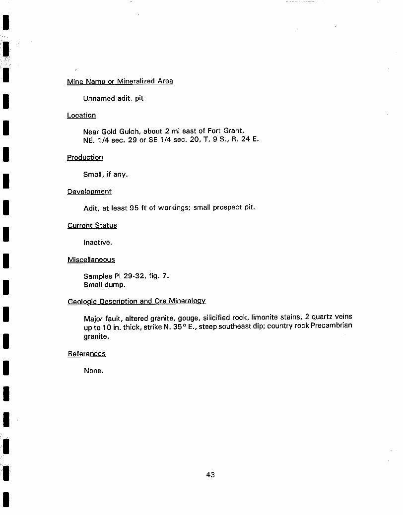
Mine Name or Mineralized Area
Unnamed adit, pit
Location
Near Gold Gulch, about 2 mi east of Fort Grant. NE. 1/4 sec. 29 or SE 1/4 sec. 20, T. 9 S., R. 24 E.
Production
Small, if any.
Development
Adit, at least 95 ft of workings; small prospect pit.
Current Status
Inactive.
Miscellaneous
Samples PI 29-32, fig. 7. Small dump.
Geolo.qic Description and Ore Mineraloav
Major fault, altered granite, gouge, silicified rock, limonite stains, 2 quartz veins up to 10 in. thick, strike N. 35 ° E., steep southeast dip; country rock Precambrian granite.
References
None.
43
I il,
I I I I I I I I I I I ~;i
Mine Name or Mineralized Area
Unnamed adit
Location
Near Gold Gulch, about 2 mi east of Fort Grant. NE. 1/4 sec. 29 or SE 1/4 sec. 20, T. 9 S., R. 24 E.
Near Gold Gulch, about 2 mi east of Fort Grant. NE. 1/4 sec 29 or SE. 1/4 sec. 20, T. 9 S., R. 24 E.
Production
None.
Development
Pit, 10 ft diameter, 10 ft deep.
Current Status
Inactive.
Miscellaneous
Sample PI 37, fig. 5. Small dump.
Geologic Description and Ore Mineralogy
Wide shear zone in white quartzite, strike N. 75° E., vertical dip; disseminated pyrite pseudomorphs.
References
None.
45
e li
~ i ~
I I I I I I I I I I I i i
i!i ti
Mine Name or Mineralized Area
Unnamed shaft
Location
Near Gold Gulch, about 2 mi E. of Fort Grant. SE. 1/4 sec. 20, T. 9 S., R. 24 E.
Production
None.
Development
Irregular shaft 15 x 8 x 20 ft deep.
Current Status
Inactive.
Miscellaneous
Sample PI 38, fig. 5. Small dump.
Geologic Description and Ore Mineraloqy
Prominent shear zone, 2 to 2 1/2 ft thick, in white quartzite, strike N. 25 o E., dip 75 ° E.; disseminated pyrite pseudomorphs.
References
None.
46
I ~ ~'i'i'
I I I I I I I I I I I I I I
Mine Name or Mineralized Area
Unnamed shaft
Location
Near Mothers Canyon. NE. 1/4 sec. 3, T. 10 S., R. 24 E.
Production
None.
Development
Shaft 10 ft diameter, 11 ft deep.
Current Status
Inactive.
Miscellaneous
Samples PI 39, 40; plate 1. Small dump. Shaft filled with water.
Geolo.qic Description and Ore Mineralogy
Mafic dike in Precambrian granite, granite altered near contact; disseminated chalcopyrite in granite, mostly in quartz veinlets; abundant malachite stains.
References
None.
47
Mine Name or Mineralized Area
White Rock uranium prospect
Location
Near Cove Canyon. SE. 1/4 sec. 20, T. 10 S., R. 25 E.
Production
None.
Development
Pit, 10 x 12 x 3 ft deep, sloughed in.
Current Status
Inactive.
Miscellaneous
Sample PI 41, plate 1. Small dump.
Geologic Description and Ore Mineralogy
Precambrian granite, limonite stains, adjacent to big quartz outcrop; scintillometer reading about twice background of 80 cps.
References
Unpublished field engineers report on file with Arizona Department of Mineral Resources.
48
i~i!~!i! ,~ i~ ~ i i ~ ' ' !~ • ,~ •
I I I I I I I I I I I I II !i|
Mine Name or Mineralized Area
Stony Peak uranium prospect
Location
Near Cove Canyon. SW. 1/4 sec. 21, T. 10 S., R. 25 E.
Production
None.
Development
Open cut, about 25 x 24 x 16 ft deep at face.
Current Status
Inactive.
Miscellaneous
Samples PI 42-43, plate 1. About 300 st dump.
Geolo.qic Description and Ore Mineralo.qy
Precambrian granite, shear zone up to 1 ft thick, strike N. 78 o W., vertical dip; scintillometer reading up to six times background of 160 cps.
References
Unpublished field engineers report on file with Arizona Department of Mineral Resources.
49
:i
i l l i ¸¸ ' ~
I I I I I I I I I I I I
Mine Name or Mineralized Area
Unnamed shaft.
Location
Near O-Bar-O Canyon. NE. 1/4 sec. 18, T. 11 S.,R. 25 E.
Production
Small, if any.
Development
Shaft, about 6 ft diameter, 15 ft deep.
Current Status
Inactive.
Miscellaneous
Samples PI 45, 46; plate 1.
Geolo.qic Description and Ore Mineralogy
Shear zone, at least 5 ft thick, at contact between fine-grained dacite and dacite porphyry, strike N. 60 ° E., dip 86 ° SE.; turquoise seam 3/8 in. thick, sparse malachite stains.
References
None.
50
i l }ii ~'
I I I I I I I I I I I I I
Mine Name or Mineralized Area
Unnamed shaft
Location
Near Gillman Canyon. SW. 1/4 sec. 20, T. 11 S., R. 25 E.
Production
Small, if any.
Development
Shaft, 15 x 8 ft at collar, 31 ft deep.
Current Status
Inactive.
Miscellaneous
Sample PI 47, plate 1. About 300 st dump.
Geologic Description and Ore Mineraloqy
Fracture zone in maroon andesite porphyry, strike N. 75 ° W., vertical dip; chrysocolla in fractures.
References
None.
51
,
i i
I I I I I I I I I I I I I i,
Mine Name or Mineralized Area
Unnamed trench
Location
South of Willow Springs Canyon. SE. 1/4 sec. 13, T. 11 S., R. 25 E.
Production
None.
Development
Trench, 40 x 20 x 8 ft deep at deepest part.
Current Status
Inactive.
Miscellaneous
Sample PI 48, fig. 9. About 250 st of dump.
Geologic Description and Ore MineraloQy
Contact between aphanitic, crumbly, chocolate-colored rock and amorphous, aphanitic, bluish-purple-dark gray rock, likely an altered and weathered dike, strike N. 70 ° E., dip 65 ° S.; granite country rock about 70 ft from both sides of trench.
References
None.
52
i!i~!
Mine Name or Mineralized Area
Unnamed shaft
Location
South of Willow Springs Canyon. SE. 1/4 sec. 13, T. 11 S., R. 25 E.
Production
None.
Development
Shaft, 28 ft deep.
Current Status
Inactive.
Miscellaneous
Sample PI 49, fig. 9. Small dump. Water in shaft, 6 ft below collar.
Geologic Description and Ore Mineralo.qy
Dark gray to black mafic dike rock, granite country rock.
References
None.
53
I
Mine Name or Mineralized Area
Unnamed decline
Location
South of Willow Springs Canyon. SE. 1/4 sec. 13, T. 11 S., R. 25 E.
Production
Small, if any.
Development
Decline, irregular-shaped, about 30 ft long.
Current Status
Inactive.
Miscellaneous
Samples PI 50, 51; fig. 9. About 200 st dump.
Geologic Description and Ore Mineraloa¥
Contact, hanging wall is aphanitic, crumbly, chocolate-colored rock; footwall is aphanitic, bluish-purple-dark gray rock, likely altered and weathered dike; strike N. 55 ° W., dip 45 ° SW. Small stockpile on dump contains altered rock, limonitic gossan, galena, sphalerite, and smithsonite.
References
None.
54
i,
i!i!:ii~i m
I I I I i I I I i I I i
I
Mine Name or Mineralized Area
Unnamed decline
Location
South of Willow Springs Canyon. SW. 1/4 sec. 18, T. 11 S., R. 26 E.
Production
None.
Development
Decline, approximately 50 ft long.
Current Status
Inactive.
Miscellaneous
Sample PI 52. About 150 st dump.
Geologic Description and Ore Mineraloqy
Sheared dike and quartz stringers, granite country rock.
References
None.
55
I I I I I I I I I I I I
Mine Name or Mineralized Area
Unnamed pit
Location
South of Willow Springs Canyon. SW. 1/4 sec. 18, or NW 1/4 sec. 19, T. 11 S., R. 26 E.
Production
None.
Development
Pit, 20 x 15 x 8 ft deep.
Current Status
Inactive.
Miscellaneous
Sample PI 53, fig. 9. About 100 st dump.
Geolo.qic Description and Ore Mineralogy
Mafic dike and altered granite.
References
None.
ilI 56
I I I I I I I I I I I I
Mine Name or Mineralized Area
Unnamed bulldozer cut
Location
Near head of Willow Springs Canyon. SW. 1/4 sec. 13, T. 11 S., R. 25 E.
Production
None.
Development
Bulldozer cut, mostly sloughed in.
Current Status
Inactive.
Miscellaneous
Sample PI 54, plate 1.
Geologic Description and Ore Mineralogy
Volcanic rock, probably andesite, minor chrysocolla.
References
None.
57
iilii~
i ,~ ....
I i I !
I I I I I I I I
i
Mine Name or Mineralized Area
Unnamed pit
Location
Near head of Willow Springs Canyon. SW. 1/4 sec. 13, T. 11 S., R. 25 E.
Production
None.
Development
Small pit.
Current Status
Inactive.
Miscellaneous
Sample PI 55, plate 1.
Geoloqic Description and Ore Mineralo.qy
Shear zone in volcanic breccia, strike N.-S., vertical dip; clayey gouge; altered, weathered rock; abundant limonite.
References
None.
i i 58
| i ' i:i:i
I I I I I I I I I I I I I !,i I
!i!
i!ill
Mine Name or Mineralized Area
Unnamed shaft
Location
Little Cottonwood Canyon. SW. 1/4 sec. 2, T. 11 S., R. 25 E.
Production
None.
Development
Shaft, 34 ft deep.
Current Status
Inactive.
Miscellaneous
Sample PI 56, plate 1. About 100 st dump.
Geologic Description and Ore Mineralogy
Volcanic alluvium material, minor chrysocolla on dump.
References
None.
59
. ~+ •
I I I I I I I I I I I I I
Mine Name or Mineralized Area
Unnamed adit
Location
Righthand Canyon SW. 1/4 sec. 2 or NW. 1/4 sec. 11, T. 10 S., R. 25 E.
Production
Small, if any.
Development
Adit, 100 ft long, stope to surface; trench, 40 ft long, 10 ft deep.
Current Status
Inactive
Miscellaneous
Samples PI 57-60, fig. 10.
Geologic Description and Ore Mineralogy
Prominent fault in Precambrian granite; strike N. 38° E., vertical dip; fractured, altered granite, clayey gouge, quartz stringers and fragments, pyrite and galena.
References
None.
60
I i
I I I I I I I I I I I ii
Mine Name or Mineralized Area
Unnamed trench
Location
North of Spring Canyon. SE. 1/4 sec. 13, T. 9 S., R. 25 E.
Production
Small, if any.
Development
Trench, about 100 ft long, 15 ft deep at deepest.
Current Status
Inactive.
Miscellaneous
Samples PI 61,62; plate 1.
Geolo.qic Description and Ore Mineralogy
Major fault zone, up to 10 ft thick, strike N. 35 ° W., near vertical dip; shattered and sheared gneiss, clayey gouge, chrysocolla, hematite, limonite; country rock Precambrian granitic gneiss.
References
None.
!i ~ : i
O
61
in ¸
i • [!~:i ~, ~ • ili~ ~ ~.
I I I I I I I I I I I I I
Mine Name or Mineralized Area
Unnamed cut
Location
Near Lefthand Canyon. NW. 1/4 sec. 12, T. 9 S., R. 25 E.
Production
None.
Development
Small cut.
Current Status
Inactive.
Miscellaneous
Sample PI 63, plate 1.
Geologic Description and Ore Mineralogy
Zone of altered, Precambrian gneiss adjacent to big outcrop of bull quartz; gneiss is shattered and limonite stained, big crystals of hornblende up to 3 in. across.
References
None.
62
i
I I I I I I I I I I I I
p
Mine Name or Mineralized Area
Unnamed prospect
Location
Marijilda Canyon NE. 1/4 sec. 33, T. 8 S., R. 25 E.
Production
None.
Development
10-ft-long tunnel, connects with pit 15 x 7 x 6 ft deep.
Current Status
Inactive.
Miscellaneous
Sample PI 64, 65; plate 1.
Geoloqic Description and Ore Mineralogy
Shear zone, strike N.-S., dip 25° E., sheared gneiss, clayey gouge, adjacent to silicified zone with abundant disseminated pyrite; country rock Precambrian granitic and biotite gneiss.
References
None.
! in ~ .... 63
I ~
I I I I I I I I I I I I i I
! i
Mine Name or Mineralized Area
Unnamed adit
Location
Between Ash Creek and White streaks Canyon. SW. 1/4 sec. 35, T. 7 S., R. 24 E.
Production
None.
Development
Adit, 255 ft long.
Current Status
Inactive.
Miscellaneous
Samples PI 66-75, fig. 11. About 600 st dump.
Geologic Description and Ore Mineralogy
Precambrian mafic, granitic schist, minor structure, quartz-aplite stringers and veins, minor malachite and limonite stains.
References
None.
64
!;
I I I I I I I I I I I ,|
i I
Mine Name or Mineralized Area
Unnamed adit
Location
Between Ash Creek and White Streaks Canyon. NW. 1/4 sec. 35, T. 7 S., R. 24 E.
Production
None.
Development
Adit, 23 ft long.
Current Status
Inactive.
Miscellaneous
Sample PI 76, plate 1. Small dump.
Geologic Description and Ore Mineralo.qy
Precambrian mafic, granitic gneiss, minor structure, no ore minerals identified.
References
None.
65
i
m i i; ~, ,
!i ::
i!~!i
i ~ ,
i i!
A P P E N D I X E
MINE LOCATION AND MINE MAP FIGURES FOR THE PINALENO-GREASEWOOD MOUNTAINS UNIT, CORONADO