POTENTIAL .ENVIRONMENTAL HAZARDS ON INACTIVE/ABANDONED MINE LANDS, ! i,i; I CORONADO NATIONAL FOREST, SOUTHEAST ARIZONA ! ANALYSIS OF THE USBM COMPREHENSIVE MINE AND PROSPECT INVENTORY AND MINERAL RESOURCE ASSESSMENT IN CORONADO NATIONAL FOREST ! II U.S. DEPARTMENT OF THE INTERIOR BUREAU OF MINES OCTOBER 1993 !
Transcript
POTENTIAL .ENVIRONMENTAL HAZARDS ON
INACTIVE/ABANDONED MINE LANDS,
!
i,i; I
CORONADO NATIONAL FOREST, SOUTHEAST ARIZONA
! ANALYSIS OF
THE USBM COMPREHENSIVE MINE AND PROSPECT INVENTORY AND MINERAL RESOURCE ASSESSMENT IN
POTENTIAL ENVIRONMENTAL HAZARDS ON INACTIVE/ABANDONED MINE LANDS,
CORONADO NATIONAL FOREST, SOUTHEAST ARIZONA
by Staff, U.S. Bureau of Mines
I I I I I I I I I I I I I I
INTRODUCTION
In 19931, U.S. Bureau of Mines (USBM) staff from the Branch of Resource
Evaluation, Intermountain Field Operations Center (IFOC), Denver, CO, evaluated the
potential for environmental and human hazards on inactive/abandoned mine land sites
(IAMLS) in Coronado National Forest, southeast Arizona. Potential hazard identification
is based on information compiled during a USBM comprehensive inventory of mine,
mill, and prospect sites in Coronado National Forest 2, which was conducted, with field
work and mapping, from 1988 through 1992.
USBM's mine, mill, and prospect inventory was originally designed to assess
mineral resources present in Coronado National Forest, and to determine their likelihood
of future development. Recent Forest Service interest in discerning the status of
hazards on their IAMLS created additional utility for the USBM inventory data. These
data were processed further by USBM mineral-resource professionals to determine
which IAMLS on public lands in the Forest exhibited potential for environmental or
human hazards. Environmental hazards pertain primarily to the release of toxic
materials into the environment. Human hazards pertain primarily to physical conditions
that could pose a risk to public safety. Hazard potentials were calculated, using a relative numerical scale developed
by USBM, and IAMLS were ranked, Forest-wide, according to potential for
environmental hazards (see composite ranking list, appendix A). This contribution is
of particular value because it utilizes USBM first-hand knowledge derived during field
examinations of hundreds of IAMLS, and will minimize Forest Service research and
field costs to identify, locate, and quantify potential hazards at IAMLS within the
Forest. Through use of the site rankings, subsequent Forest Service efforts can be
1 Hazard evaluation conducted during July, August, and September of 1993.
2 Inventory undertaken with the authority of a January 1987 Interagency Agreement between the USBM and U.S. Department of Agriculture, Forest Service, among others.
1
I I I I I I I I l I I I I I I I I I
directed towards priority IAMLS, some of which may warrant additional field visits for
a detailed environmental site characterization (e.g., measuring effluent water flow, pH,
conductivity; detailing waste dump mineralogy). Detailed environmental site
characterizations allow assessment of the need for remediation at a site, if any, and
can be utilized in the design of remediation approaches. Under some circumstances,
the remediation of environmental hazards can be a long-term, high-cost undertaking.
In contrast, remediation of human (physical) hazards is often a short-term engineering
task, which can be of relatively low cost. Consequently, results of this study were
used to rank IAMLS by potential for environmental hazards, rather than potential for
human hazards. Mines, mills, and prospects on private land, including mineral patents,
were not assessed for potential environmental or human hazards.
METHODOLOGY FOR DETERMINING POTENTIAL ENVIRONMENTAL HAZARDS
AND POTENTIAL HUMAN HAZARDS
Methodology used to determine the potential for environmental and human
hazards at IAMLS in the Coronado National Forest was based largely on USBM's
Abandoned Mine Land Inventory and Hazard Evaluation Handbook (July 1993 draft
version). That handbook utilizes the concept that various elements, materials, and
conditions observed at IAMLS can be assigned relative numerical values (see tables in
appendix B), and that a higher numerical value indicates a higher potential for
environmental or safety risks at the site. Specific numerical values reflect professional
USBM opinions concerning the degree to which a characteristic will relate to promoting
potential hazards. Characteristics relating to an IAMLS's type, size, status,
commodity, milling method (if any), and the acid generating potential of its waste rock
or open excavations are those assigned specific numerical values. These numerical
values are used to derive two overall ratings, representing: 1) potential environmental
hazard (EH) for the IAMLS, and 2) potential human hazard (HH) for the IAMLS. First,
however, a screening of characteristics of all IAMLS was done to determine whether
or not the analysis resulting in assignation of potential hazard values was warranted.
The screening process is described below.
Identification of minimum thresholds for potential hazards
Minimum thresholds that concern potential environmental hazards and potential
human hazards were set specifically for this processing of Coronado National Forest
data, A screening of all IAMLS was done to determine if the minimum thresholds were
2
I I I I I I I I I I I I I I I I
met . For IAMLS at wh i ch the min imum thresho lds were met , fur ther analys is w a s
conduc ted , w h i c h resul ted in assignat ion of potent ia l hazard values. Data concern ing
IAMLS on publ ic land in Coronado National Forest 3 we re examined to determine
whe the r the IAMLS exceeded min imum thresholds for potent ia l env i ronmenta l or
human hazards, considered to occur if any of the e lements , mater ia ls , or cond i t ions in
t ex t table 1 (see below) were appl icable to any work ings , bui ld ings, s tockp i les , etc . ,
at a mine, mil l , or group of prospects. If none of these i tems were appl icable to a
part icular IAMLS, it w a s el iminated f rom fur ther analysis, and no EH or HH values were
assigned to it.
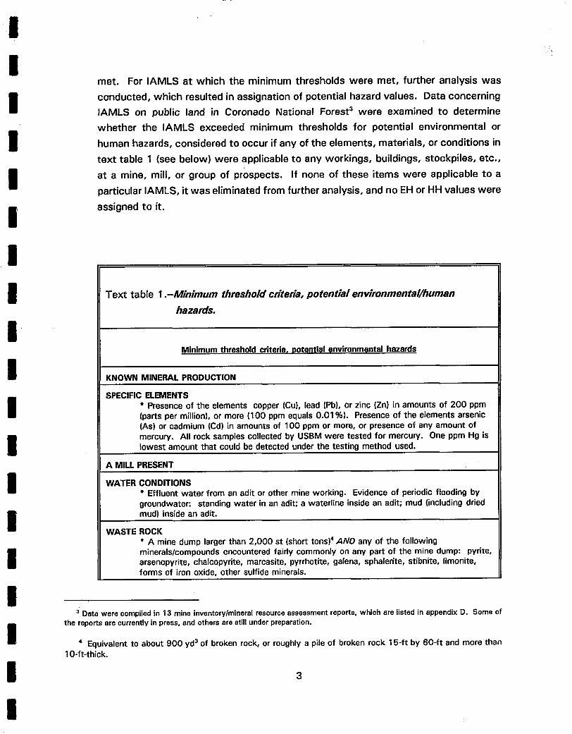
Tex t table 1 .--Minimum threshold criteria, potential environmental/human
SPECIFIC ELEMENTS * Presence of the elements copper (Cu), lead (Pb), or zinc (Zn} in amounts of 200 ppm (parts per million}, or more (100 ppm equals 0.01%). Presence of the elements arsenic (As) or cadmium (Cd) in amounts of 100 ppm or more, or presence of any amount of mercury. All rock samples collected by USBM were tested for mercury. One ppm Hg is lowest amount that could be detected under the testing method used.
A MILL PRESENT
WATER CONDITIONS * Effluent water from an adit or other mine working. Evidence of periodic flooding by groundwater: standing water in an adit; a waterline inside an adit; mud (including dried mud) inside an adit.
WASTE ROCK * A mine dump larger than 2,000 st (short tons) 4 AND any of the following minerals/compounds encountered fairly commonly on any part of the mine dump: pyrite, arsenopyrite, chalcopyrite, marcasite, pyrrhotite, galena, sphalerite, stibnite, limonite, forms of iron oxide, other sulfide minerals.
3 Data were compiled in 13 mine inventory/mineral resource assessment reports, which are listed in appendix D. Some of the reports are currently in press, and others are still under preparation.
4 Equivalent to about 900 yd 3 of broken rock, or roughly a pile of broken rock 15-ft by 60-ft and more than 10-ft-thick.
3
I I I I I I I
Text table 1 .--Minimum threshold criteria, potential environmental/human ' hazards--contin.
Minimum threshold criteriat potential human hazards
DEEP (NEAR)VERTICAL EXCAVATIONS * Presence of an open shaft, stope, etc., that is more than 20-ft-deep. Presence of an open adit 5 w i th a winze [vertical excavat ion into the adit sill (or floor)] more than 20-f t -
deep.
HAZARDOUS ATMOSPHERE * Presence of an open edit w i th known or suspected "bad air "6.
POTENTIAL FALLING ROCK * Presence of an open adit w i th bad rock condit ions resulting f rom a var iety of sources/conditions, such as overblasting, mine collapse, weather ing, wa te r movement, intersection of a fault zone in the mine, or deteriorat ion of supports installed by miners.
SUBSIDENCE * Presence of active or potential surface subsidence as a result of mine collapse.
If any item in text table 1 (above) was applicable to any working, structure, or
condition at a mine, mill, or group of prospects, then further analysis was conducted,
which resulted in calculation of EH and HH values for the group of workings. Those
calculation methodologies are described below.
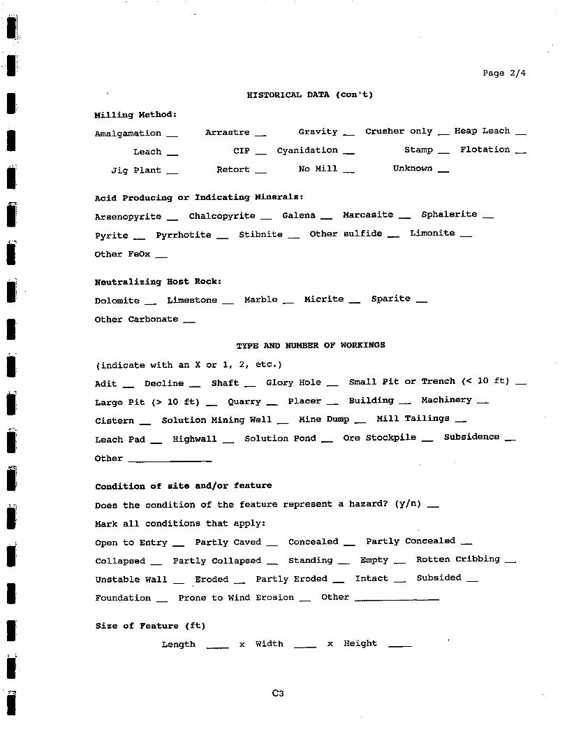
Determining the potential environmental hazard (EH) value
Sites that met minimum threshold criteria for potential environmental hazards
underwent further analysis, resulting in assignation of a numerical potential
environmental hazard value (EH) to the sites. These EH ratings were derived using the
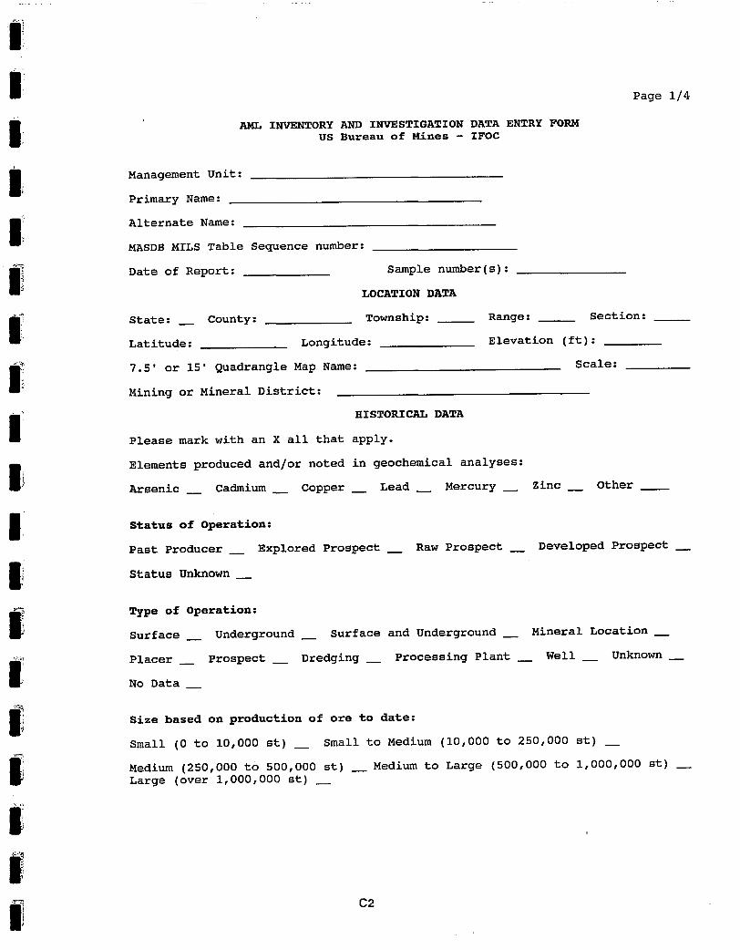
detailed AML7 Inventory and Investiqation Data Entry Form (appendix C), which is a
tabulation of numerous characteristics of specific IAMLS. Upon completion of the
inventory and investigation form, numerical values from the tables in appendix B were
s A mine edit is an underground excavation of several ft to several thousands of ft in length that is usually an essentially horizontal working.
8 Inactive mines can have a variety of hazards that are considered generally as "bad air", e.g., depleted oxygen content; increased levels of carbon monoxide, carbon dioxide; presence of methane, radon gas, oxides of sulfur or nitrogen.
7 Abandoned Mine Land.
4
I I I I I I I I I I I I I I I I I I
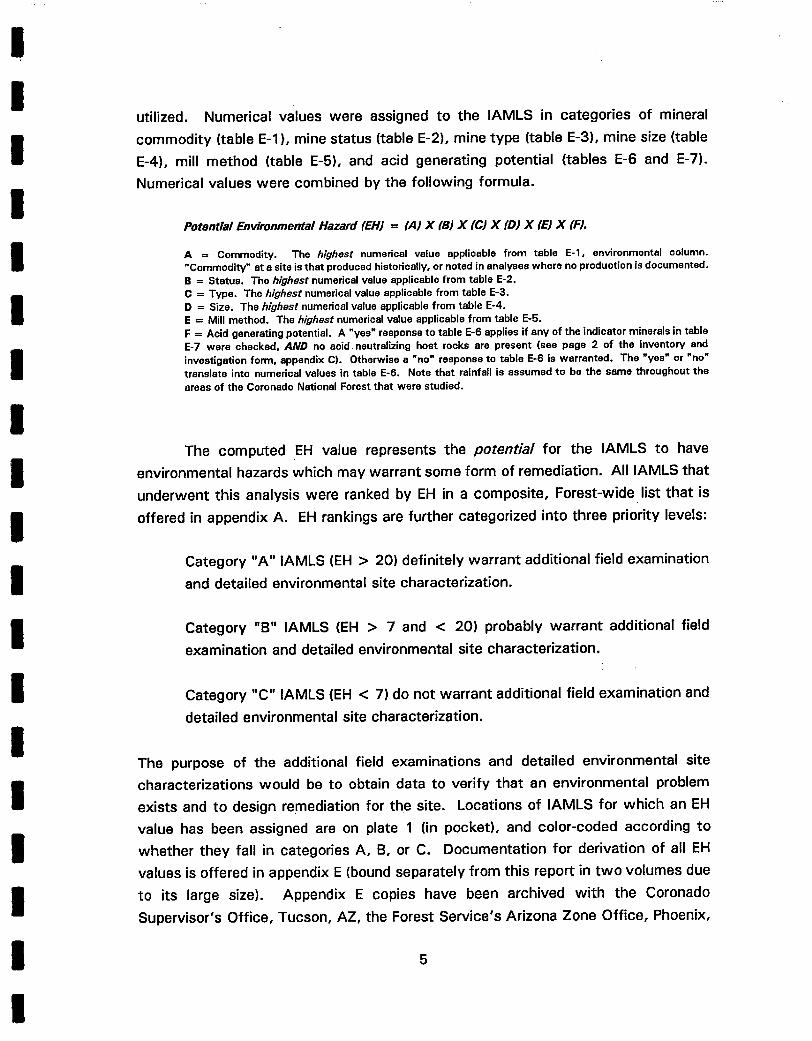
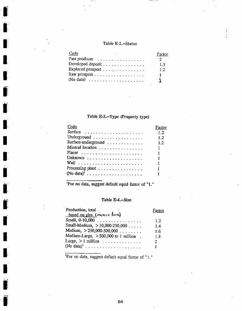
utilized. Numerical values were assigned to the IAMLS in categories of mineral
commodity (table E-l), mine status (table E-2), mine type (table E-3), mine size (table
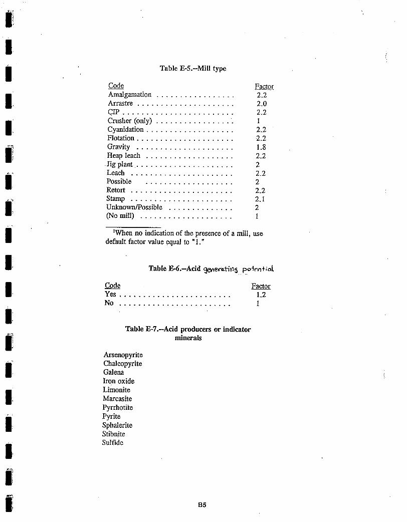
E-4), mill method (table E-5), and acid generating potential (tables E-6 and E-7).
Numerical values were combined by the following formula.
Potential Environmental Hazard (EHJ = (,4) X (BJ X (C) X (D) X (E) X (FJ.
A = Commodity. The highest numerical value applicable from table E- l , environmental column. "Commodity" at a site is that produced historically, or noted in analyses where no production is documented. B = Status. The highest numerical value applicable from table E-2. C -- Type. The highest numerical value applicable from table E-3. D = Size. The highest numerical value applicable from table E-4. E = Mill method. The highest numerical value applicable from table E-5. F = Acid generating potential. A "yes" response to table E-6 applies if any of the indicator minerals in table E-7 were checked, AND no acid neutralizing host rocks are present (see page 2 of the inventory and investigation form, appendix C). Otherwise a "no" response to table E-6 is warranted. The "yes" or "no" translate into numerical values in table E-6. Note that rainfall is assumed to be the same throughout the areas of the Coronado National Forest that were studied.
The computed EH value represents the potential for the IAMLS to have
environmental hazards which may warrant some form of remediation. All IAMLS that
underwent this analysis were ranked by EH in a composite, Forest-wide list that is
offered in appendix A. EH rankings are further categorized into three priority levels:
Category "A" IAMLS (EH > 20) definitely warrant additional field examination
and detailed environmental site characterization.
Category "B" IAMLS (EH > 7 and < 20) probably warrant additional field
examination and detailed environmental site characterization.
Category "C" IAMLS (EH < 7) do not warrant additional field examination and
detailed environmental site characterization.
The purpose of the additional field examinations and detailed environmental site
characterizations would be to obtain data to verify that an environmental problem
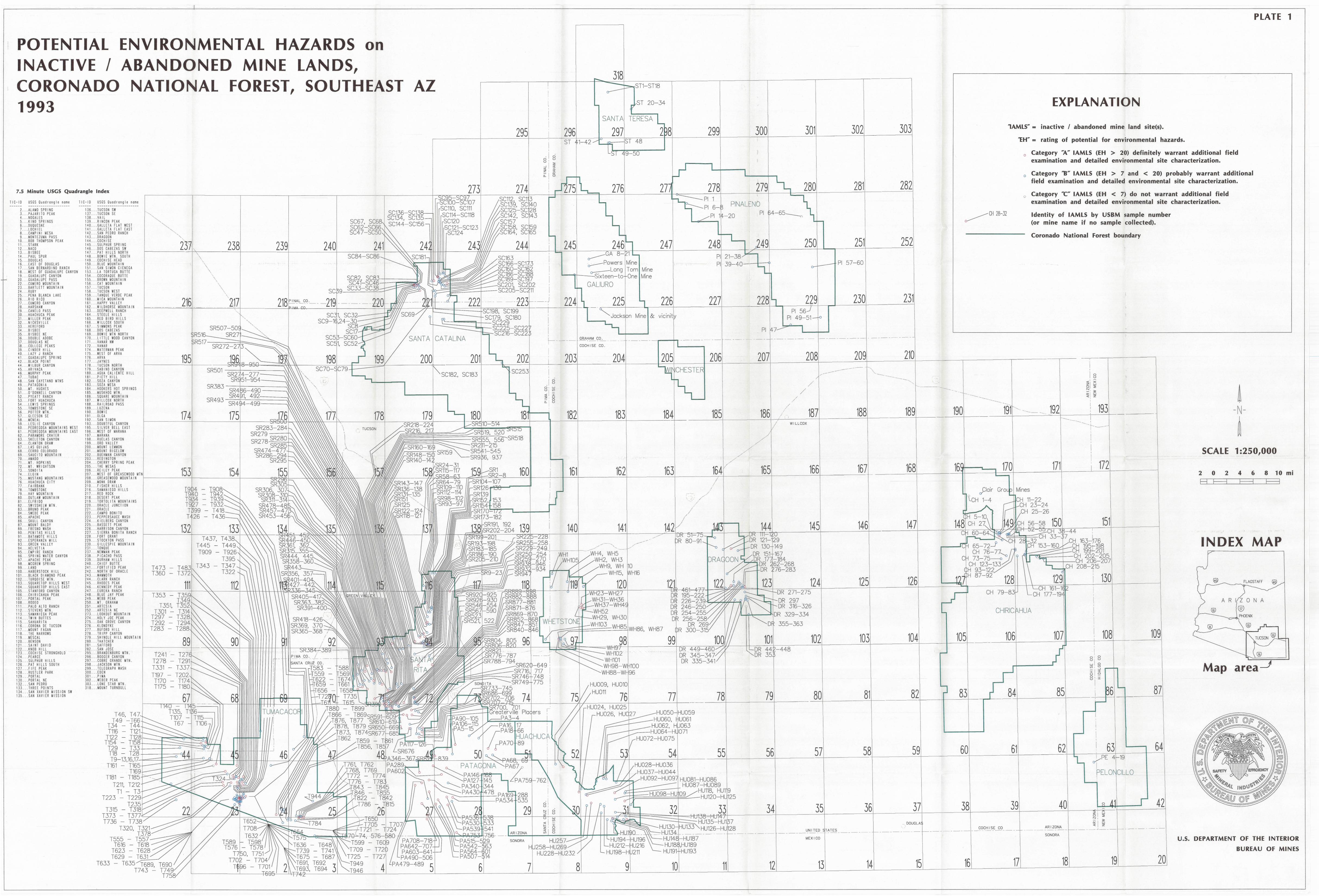
exists and to design remediation for the site. Locations of IAMLS for which an EH
value has been assigned are on plate 1 (in pocket), and color-coded according to
whether they fall in categories A, B, or C. Documentation for derivation of all EH
values is offered in appendix E (bound separately from this report in two volumes due
to its large size). Appendix E copies have been archived with the Coronado
Supervisor's Office, Tucson, AZ, the Forest Service's Arizona Zone Office, Phoenix,
5
AZ, the Forest Service Regional Office, Albuquerque, NM, and the Coronado's District
Ranger Offices in Tucson, Safford, Nogales, Sierra Vista, and Douglas, AZ.
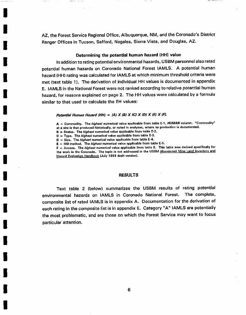
Determining the potential human hazard (HH) value
In addition to rating potential environmental hazards, USBM personnel also rated
potential human hazards on Coronado National Forest IAMLS. A potential human
hazard (HH) rating was calculated for IAMLS at which minimum threshold criteria were
met (text table 1). The derivation of individual HH values is documented in appendix
E. IAMLS in the National Forest were not ranked according to relative potential human
hazard, for reasons explained on page 2. The HH values were calculated by a formula
similar to that used to Calculate the EH values:
Potential Human Hazard (HHJ = (AJ X (B) X (C) X (D) X rE) X (F).
A = Commodity. The highest numerical value applicable from table E-l, HUMAN column. "Commodity" at a site is that produced historically, or noted in analyses, where no production is documented. B = Status. The highest numerical value applicable from table E-2. C = Type. The highest numerical value applicable from table E-3. D = Size. The highest numerical value applicable from table E-4. E = Mill method. The highest numerical value applicable from table E-5. F = Access. The highest numerical value applicable from table 9. This table was derived specifically for the work in the Coronado. The topic is not addressed in the USBM Abandoned Mine Land Inventory and Hazard Evaluation Handbook (July 1993 draft version).
RESULTS
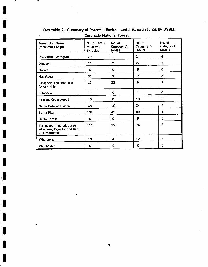
Text table 2 (below) summarizes the USBM results of rating potential
environmental hazards on IAMLS in Coronado National Forest. The complete,
composite list of rated IAMLS is in appendix A. Documentation for the derivation of
each rating in the composite list is in appendix E. Category "A" IAMLS are potentially
the most problematic, and are those on which the Forest Service may want to focus
particular attention.
6
I I I
T e x t table 2.--Summary of Potential Environmental Hazard ratings by USBM, Coronado National Forest.
Forest Unit Name No. of IAMLS No. of No. of No. of (Mountain Range) rated with Category A Category B Category C
EH value IAMLS IAMLS IAMLS
Chiricahua-Pedregosa 29 1 24 4
Dragoon 27 2 22 3
Galiuro 5 0 5 0
Huachuca 32 9 18 5
Patagonia (includes also 33 23 9 1 Canelo Hills)
Peloncillo 1 0 1 0
Pinaleno-Greasewood 10 0 10 0
Santa Catalina-Rincon 48 10 34 4
Santa Rita 139 49 89 1
Santa Teresa 5 0 5 0
Tumacacori (includes also 112 32 74 6 Atascosa, Pajarito, and San Luis Mountains)
Whetstone 19 4 12 3
Winchester 0 0 0 0
I I I I I i I I I I
I
7
I I I I 1 I I I
I
i!~ I ¸
I
I
I
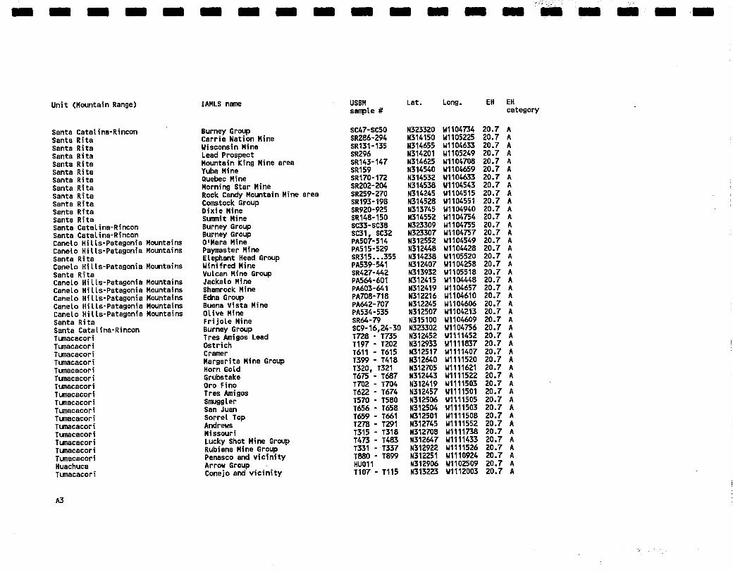
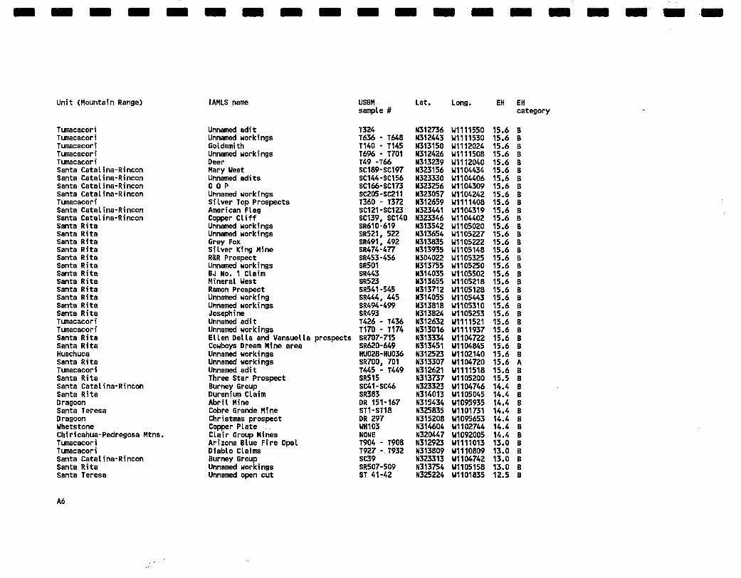
APPENDIX A
COMPOSITE LIST, FOREST-WIDE, OF IAMLS FOR WHICH EH
VALUES WERE ASSIGNED; ALL ARE RANKED BY EH VALUE
A1
m n I I | mm I I m i m m m m m ~ •~+ ~ y+! +i/¸ ~T
m i m m
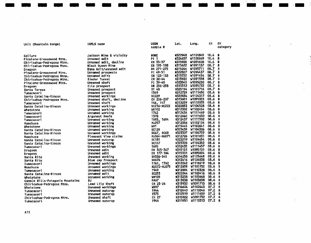
Unit (Mountain Range) IAMLS name
IAMLS ordered by EH (high to low), and then HH (high to Low).
USBM sanpte #
Lat . Long. EH EH category
Cane[o Hi l ls -Patagonia Mountains Dragoon Santa Ri ta Tumacacori Tumacacori Santa Ri ta Tumacacori Canelo Hi l ls -Patagonia Mountains Tumacacori Chiricahua-Pedregosa Mtns. Santa Ri ta Santa Catal ina-Rincon Dragoon Tumacacori Tumacacori Canelo Hi l ls -Patagonia Mountains Santa Ri ta Huachuca Huachuca Santa Catal ina-Rincon Santa Catal ina-Rincon Santa Ri ta Santa Ri ta Santa Ri ta Santa Ri ta Santa Ri ta Santa Ri ta Santa Ri ta Santa Ri ta Santa Ri ta Santa Catal ina-Rincon Caneto Hi l ts -Patagonia Mountains Canelo Hi l l s -Patagonia Mountains Cane[o Hi l l s -Patagonia Mountains Cane[o H i l l s -Patagon ia Mountains Canelo Hi l ts -Patagonia Mountains Whetstone Santa Ri ta Whetstone Caneto Hi l l s -Patagonia Mountains
A2
FtuxMine Middtemarch Mine Gringo Mine area Blue Ribbon & Gold H i l t Group Oro Blanco Mansfield Group Payoff and v i c i n i t y Trench Camp Minerat ized Area Ajax and v i c i n i t y Hilltop Mine Glove Mine Taratdson claim Seneca Mine Idaho Mine Group Aus te r t i t z v i c i n i t y Christmas Gift Mine Phi ladelphia Mine Wakefield Tungsten Reef Carol ina Moon Group Highj inks BLue Lead Mine Mohawk Mine Al to Mine Group Apache Mine San Ramon Mine S i l ver Sal ty Ar izona-Pi t tsburg Mine Compadre Mine Group Tia Juana Mine Burney Group Aztec Mine Group Denver Mine Ventura Mine Lookout Mine Thunder Mine Chadwick Gold Fish Mine Evening Star Tres de Mayo Mineral ized Area
A A A A A A A A A A A A A A A A A A A A A A A A A A A A A A A A A A A A A A A k
i~/~if ~i~ ~ ̧!~ m I m U R I I I B m m m BIB m m m m m m m
Unit (Mountain Range)
Santa Catatina-Rincon Santa Ri ta Santa Ri ta Santa Ri ta Santa Ri ta Santa Ri ta Santa Ri ta Santa Ri ta Santa Ri ta Santa Ri ta Santa R~ta Santa Ri ta Santa Catatina-Rincon Santa Catatina-Rincon Caneto Hi l ts -Patagonia Mountains Caneto Hi t ts-Patagon|a Mountains Santa Ri ta Caneto Hi l ts -Patagonia Mountains Santa Ri ta Cane[o Hi l ls -Patagonia Mountains Cane[o Hi l ts -Patagonia Mountains Caneto Hi l ts -Patagonia Mountains Caneto Hi l ts -Patagonia Mountains Caneto Hi l ls -Patagonia Mountains Santa Ri ta Santa Catatina-Rincon Tumacacorl Tumacacori Tumacacori Tumacacort Tumacacorl Tumacacorl Tumacacorl Tumacacori Tumacacori Tumacacori Tumacacori Tumacacorl Tumacacorl Tumacacorl Tumacacorl Tumacacori Huachuca Tumacacori
IANLS name
Burney Group Carr ie Nation Mine Wisconsin Mine Lead Prospect Mountain King Mine area Yuba Mine Quebec Mine Morning Star Mine Rock Cano~/Mountain Mine area Comstock Group D ix ie Mine summit Mine Burney Group Burney Group O'Mara Mine Paymaster Mine ELephant Head Group Winifred Mine Vulcan Mine Group Jackato Mine Shamrock Mine Edna Group Buena Vis ta Mine Ol ive Mine F r i j o t e Mine Burney Group Tres Amigos Lead Ostr ich Cramer Margari ta Mine Group Horn Gold Grubstake Oro Fino Tres Amigos Smuggler San Juan Sorrel Top Andrews Missouri Lucky Shot Mine Group Rub|ana Mine Group Penasco and v i c i n i t y Arrow Group Conejo and v i c i n i t y
A A A A A A A A A A A A A A A A A A A A A A A A A A A A A A A A A A A A A A A A A A A A
A3
m m m n m m m m m m m mm m m n m
Uni t (Mountain Range)
Tumacacori Tumacacori Tumecacori Tumacacori Tumacacori Santa Catat ina-Rincon Santa Ri ta Santa Ri ta Caneto HiLls-Patagonia Mountains Santa Ri ta Santa Ri ta Santa Ri ta Tumacacori Tumacacori Huachuca Tumacacori Huachuca Canelo Hilts-Patagonia Mountains Santa Ri ta Santa Ri ta Santa Ri ta Santa Ri ta Santa Ri ta Santa Ri ta Santa Ri ta Santa Ri ta Santa Ri ta Santa R i ta Santa Ri ta Canelo HiLLs-Patagonia Mountains Santa Catat ina-Rincon CaneLo HiLLs-Patagonia Mountains Santa Ri ta Huachuca Tumacacori Huachuca Whetstone Whetstone Huachuca Caneto HiLts-Patagonia Mountains Caneto HiLts-Patagonia Mountains Huachuca Santa Ri ta Santa Ri ta
IAMLS name
Sunset and v i c i n i t y Big Steve St. Pa t r i ck White Oaks Dos Amigos GoLden EagLe Butt Springs Mine V ic to r Mine Haist Mine FS-1 Herr Mine Jersey Gi r t Last Chance Brown B i rd Mine Group Eureka BLack Peak Armistace Benton Mine Jackson Group Sweet Water Group HoseyMine area Lexington Mine Treasure Vautt Mine Santa Ri ta Mines Connecticut Hine Extension Prospect Braathern L i t t Le Shot Mine Hancock Mine Sansimon Mine Pre t t y Fair Lead Queen Unnamed workings Lucky S t r i ke Br ick Copper GLance Two Peaks and v i c i n i t y BLuestone Tako #9 New York La PLata Mine Morgan Merry Widow Happy Jack Mine
B A A A A A A A A A A A A A A A A A A A A A A A A A A A A A A A A A
A4
m m m m m m m m m m m m m m m m
Unit (Mountain Range)
Santa Rita Santa Rita Dragoon Chiricahua-Pedregosa Mtns. Pinaleno-Greasewood Mtns. Dragoon Chiricahua-Pedregosa Mtns. Dragoon Dragoon Chiricahua*Pedregosa Mtns. Dragoon Dragoon Dragoon Santa Catalina-Rincon Huachuca Huachuca Dragoon Whetstone Santa Rita Caneio Hills-Patagonia Mountains Santa Rita Santa Rita Santa Rita Santa Rita Tumacacori Chiricahua-Pedregosa Mtns. Huachuca Chiricahua-Pedregosa Mtns. Huachuca Huachuca Huachuca Chiricahua-Pedregosa Mtns, Chiricahua-Pedregosa Mtns. Galiuro Gatiuro Santa Rita Santa Rita Santa Rita Santa Rita Santa Rita Santa Rita Huachuca Tumacacori Tumacacori
IAMLS name
Helena Mine and v i c i n i t y Last Chance San Juan Mine Unnamed ad|t , decline Black Beauty prospect Standard Tungsten Btu~berg Canyon adit Festerl ing Mine Moonlight Mine Si lver Prince Mine
Cobra Loma Mine Buena Vista Mine Naoe workings Old Maudina Power claim Cave Muheim Mine Windnilt Group Golden Gate Mine Hardshell Mineralized Area Snyder Mine Bonanza Mine Montosa Mine Santa Rita No. 26 Morning Unnamed adi t conptex James Group EL Tigre Mine Samson claim Lutz Tunnel Western Tungsten Si lver Hi l t Mine Columbia Mine Powers Mine Long Tom Mine Unnamed workings Armada Mine Ultimo Mine L i t t l e Joker Mine St. Louis Mine Double Header Mine Baumkirchner Unnamed workings Unnamed adi t
USBM sample #
SR9-23 SR776-787 DR 195-222 CH 60-64 PI 14-20 DR 300-315 CH 5-10 DR 316-326 DR 355-363 CH 65-72 DR 246-25O DR 80-91 DR 111o120 SC160-SC162 HUO98-HUI09 HU198-HU211 DR 226-239 WH9, WH 10 SR126-130 P~40-344 SR229-249 SR363...382 SR405-417 SRl12-114 T776 - T783 CH 93-122 HUOSO-HU059 CH ~-~ HU188,HU189 HU138-HU147 HU228-HU232 CH 163-176 CH 153-160 NONE NONE SR518 SR852-868 SR871-876 SR889-898 SR882-888 SR869-870 HU120-flU125 T589 - T598 T691, T692
A A A B B B B B B B B B B B B B B B B B B B B B B B B B B B B B B B B B B B B B B B B B
A5
I I I I I | I I I I I I I I / I + ~
Unit (Mountain Range)
Tumacscori Tumacacori Tumacacori Tumacacori Tumacacori Santa Catat ina-Rincon Santa Catat ina-Rincon santa Catal ina-Rincon Santa Catat ina-Rincon Tumacacori Santa catat ina-Rincon Santa Catal ina-Rincon Santa Ri ta santa Ri ta Santa Ri ta santa Ri ta Santa Ri ta Santa Ri ta Santa Ri ta Santa Ri ta Santa Ri ta Santa Ri ta Santa Ri ta Santa Ri ta Tumacacori Tumacacori Santa R i ta Santa R i ta Huachuca Santa R i ta Tumacacori Santa R i ta Santa Catat ina-Rincon Santa Ri ta Dragoon Santa Teresa Dragoon Whetstone Chiricahua-Pedregosa Mtns. Tumacacori Tumacacori Santa Catal ina-Rincon Santa R i ta Santa Teresa
IAMLS name
Unnamed ad i t Unnamed workings Goldsmith Unnamed workings Deer Mary West Unnamed adits GOP Unnan~+dworkings Silver Top Prospects American Flag Copper C l i f f Unnamed workings Unnamed workings Grey Fox S i l ve r King Mine R&R Prospect Unnamed workings BJ No. 1 Claim Mineral West Ramon Prospect Unnamed working Unnamed workings Josephine Unnamed ad i t Unnamed workings El len Del la and Vansuetta prospects Cowboys Dream Mine area Unnamed workings Unnamed workings Unnamed ad i t Throe Star Prospect Burney Group DuraniumCtaim Abr i t Mine Cobre Grande Mine Christmas prospect Copper Plate + Clair Group Mines Arizona Blue F i re Opal Diablo Claims Burney Group Unnan~d workings Unnamed open cut
Dragoon Dragoon GaLiuro PinaLeno-Greasewood Mtns. PinaLeno Greasewood Mtns. Santa Rita Cane[o Hi[Is-Patagonia Mountains Santa Rita Santa Rita Tumacacori Huachuca Huachuca Santa Rita Santa Rita CaneLo HiLLs-Patagonia Mountains santa Rita Santa Rita Santa Rita santa Rita Santa Rita Santa Rita Santa Rita Santa Rita Santa Rita Santa Rita santa Rita Santa Rita Santa Rita Santa Rita CaneLo HiLLs-Patagonia Mountains Santa Rita CaneLo HiLLs-Patagonia Mountains Tumacacori Santa CataLina-Rincon Santa CataLina-Rincon Santa CataLina-Rincon Santa CataLina-Rincon Santa Catatina-Rincon Tumecacori Santa CataLina-Rincon Huachuca Huachuca Tumecacori Tumacacori
IAMLS name
St. Francis Hine Jordan Canyon prospects Gotd Mountain Mine President Mine Gotd Gulch prospects Unnamed workings Hidden Col~oer Mountain Dragon Z Mine Unnamed adit Unnamed adits Huachuca ctaims Curtice Mine Taylor Prospect Pollywog Group Otd Madera Mine Gold Ledge Gold Buck UnnanL=d prospects Roya[ Mountain Mine Unnamed workings ALiso Springs Prospect Unnamed workings SiLver Cane Unnamed workings Zeckendorf Sitver Leaf Keith Unnamed prospect May Unnamed prospects Four MetaLs Mine Unnamed working Unnamed working Unnan~=d workings L i t tLe Hi[ [ Unnamed workings Unnamed workings Unnamed workings Suena det Oro Unnan~dworkings Unnan~=dworkings Brouse and v i c i n i t y Arr ieta v i c i n i t y
Huachuca Tumacacori Huachuca Tumacacori Santa Catal ina-Rincon Tumecacori Tumecacori Tumacacori PetonciLLo Tumacacori Tumacacori Tumacacori Whetstone Tumcacori Tumcacort Tumacacori Tumacacorl Tumacacori Tumecacori Tumecacort Tumacacort Tumecacori Tumacacori Santa CataLina-Rincon Tumacacorl Tu~acacorl Tumacacorl Tumacacori Tumecacori Tumacacori Tumacacort Turflacacorl Tun~cacorl Tumacacori Tumecacori Santa Ri ta Santa Ri ta Santa Ri ta Santa Ri ta Santa Ri ta Santa Ri ta Santa Ri ta Santa Ri ta Santa Ri ta
IAMLS name
Unnamed ad i t Unnamed workings Unnamed workings Unnamed ad i t Pima Joe c la im #1 Unnamed workings SLack Copper Queen Unnamed ad i t SiLver Tip Hine Unnamed workings Unnamed ad i t Unnamed workings Unnamed workings Unnamed ad i t Unnamed workings Unnamed workings Unnamed working Unnamed workings stymie Owl Group Unnan~dworkings Unnamed workings Unnamed workings Unnamed ad i t Unnamed ad i t Unnamed workings Unnamed workings J a r i l l a s Easter Mine Group Unnamed workings Unnamed workings Hole-in-the-Rock Contact Unnamed workings Unnamodworkings Unnamed workings Unnamed workings Los Burr i tos Prospect Unnamed workings Star Pointer Mine Sun Lode Group Santa Rita Group PLata Cascabel Old Tucson Mine area Unnamed working
Santa Rita Santa Rita Santa Rita Santa Rita Santa Rita Santa Rita Santa Rita Santa Rita Santa Rita Santa Rita santa Rita Turnacacori Turnacacori Tumacacori Tumacacori Canelo Hills-Patagonia Mountains Tumacacori Canelo Hills-Patagonia Mountains Huachuca Whetstone Santa Rita Santa Rita Santa Rita Canelo Hi l ls-Patagonia Mountains Santa Rita Santa Catalina-Rincon Dragoon Santa Catalina-Rincon Santa Catalina-Rincon Santa Rita Santa Rita Santa Rita Santa Rita Santa Rita Tumacacori Dragoon Dragoon Dragoon Santa CataLina-Rincon Santa Catatina-Rincon Santa Catatina-Rincon Chiricahua-Pedregosa Mtns. Whetstone Chiricahua-Pedregosa Htns.
IAMLS name
Spear Prospect Blacksmith Prospect Hermits Home Mine Unnamed working Jenkins Prospect? Unnamed workings Unnamed prospect Old Baldy Prospect Florida Mine area Unnamed workings Walden Mine Unnamed working Unnamed workings Unnamed workings Unnamed working Candelerio Peak Unnamed shaft Sulphide Mine Oversite David Lee Unnamed working Unnamed workings Friez Prospect Copper Mountain Unnamed workings Unnamed workings Garden Spring prospects CoLden Contract Unnamed adi t Go Devil Group Merchant Nine Unnamed workings Last Chance Unnamed workings Unnamed workings Unnamed Workings "The p i t " prospect Unnamed shafts Unnamed workings Unnamed edi t Unnamed edi t Blacksmith West Unnamed working Unnamed adi ts
USBM Lat. Long. EH EH sample # category
SR295 N314200 Wl105231 12.4 S SR308-310 N314201 Wl105332 12.4 B SR311-314 N314208 Wl105346 12.4 B SR356, 357 N314203 Wl105612 12.4 B SR361, 362 N314135 Wl105436 12.4 S SR401-404 N314042 Wl105546 12.4 B SR125 N314809 Wl104558 12.4 B SR280 N314258 Wl105208 12.4 B SR271 N314452 Wl105015 12.4 B SR926-930 N313710 g1104985 12.4 B SR948-950 N314015 Wl105000 12.4 S T175 - T180 N313016 Wl111937 12.4 B T859 - T861 N312225 ,1110730 12.4 S T856, T857 N312209 Wl110709 12.4 S T909 - T926 N313357 ~1111149 12.4 B PA3-4 N313316 Wl103937 12.4 S T862 N312208 Wl110738 12.4 S PA68, 69 N313043 Wl103600 12.4 S HU212-HU216 N312349 Wl101854 12.4 S WH98-WH100 N314558 Wl102521 12.4 S SR1 N315455 Wl104515 12.4 B SR2-8 M315455 Wl104450 12.4 S SR151 N314702 Wl104602 12.4 B PAl6, 17 N313257 Wl103808 12.4 S SR716, 717 N313335 Wl104745 12.4 B SC158, SC159 M323321 Wl104348 10.8 S DR 449-460 N31510Z W1095826 10.4 B SC124 N323420 Wl104306 10.4 B SC225-SC227 N322833 Wl104332 10.4 B SR391-400 N314010 Wl105628 10.4 B SR98-102 N315018 Ml104524 10.4 B SRl15-117 N314907 Wl104557 10,4 B SR109-110 N314945 Ml104554 10.4 B SR24-31 N315315 Wl104634 10.4 B T940 - T942 M313132 Wl110644 10.4 B DR 335-341 N315107 W1095649 10.4 B DR 262-268 N315256 M1095207 10.4 B DR 329-334 N315117 W1095647 10.4 B SC163 N323307 Wl104323 10.4 S SC186-SC188 M323220 Wl104438 10.4 B SC201, SC202 N323141 Wl104239 10.4 B CH 25-26 N315921 W1091715 10.4 B WH15, WH16 N315301 Wl102147 10.4 B CH 11-22 N315935 W1091717 10.4 B
A9
m m m m m m m n m m m m m n n m m .m m
Unit (Mountain Range)
Chiricahua-Pedregosa Mtns. Dragoon Chiricahua-Pedregosa Mtns. Dragoon Pinaleno-Greasewood Mtns. Santa Rite Santa Rite Santa Rita Santa Catatina-Rincon Chiricahua-Pedregosa Mtns. Tumacacori Tumacacori Chiricahua-Pedregosa Mtns. Pinateno-Greasewood Mtns. Santa Rite Santa Rite Santa Rite Tumacaeori Tumacacori Huachuca Tumacacori Santa Catatina-R|ncon Santa Catatina-Rincon Santa Catalina-Rincon Huachuca Whetstone Huachuca Santa Teresa Tumacacori Tumacacori Tumaeacori Tumacacori Santa Rite Huachuca Whetstone Huachuca Galiuro Chiricahua-Pedregosa Mtns. Whetstone Chiricahua-Pedregosa Mtns. Santa Teresa Santa Rite Santa Rite Chiricehua-Pedregosa Mtns.
IARLS name
Unnamed shaft and prospects Unnamed workings Unnamed workings Sala Ranch prospects Unnamed shaft B i l tey Sunday Prospect Ague Catliente Caves Unnamed workings Golden Earth & v i c i n i t y Grace Mine Unnamed workings Unnamed workings Unnamed prospect Unnamed adit Deniers Mine Unnamed working Unnamed workings Unnamed outcrop Unnamed prospects Joe Bailey prospect & v i c i n i t y Loma de Manganese Unnamed edits Unnamed workings Unnamed working Unnamed werking Unnamed working Thomas Tungsten claims Unnamed prospects Unnamed working Unnamed prospect Unnamed working Unnamed working Unnamed workings Unnamed edit Unnamed edit Unnamed edit Sixteen-to-One Mine Unnamed edit - Unnamed edit Unnamed edit Fisher prospects Unnamed working Wildcat Mine Unnamed edit , shaft
B B B B B B B B B B B B B B B B B B B B B B B B B B B B B B B B B B B B B B B B B B B B
AIO
i ~ ~7 ¸
m m m m m m m m m m m m m m m I IBI m m . m
Unit (Mountain Range)
Gatiuro Pinateno-Greasewood Mtns. Chiricahua-Pedregosa Mtns. Chiricahua-Pedregosa Mtns. Dragoon Pinateno-Greasewood Mtns. Chiricahua-Pedregosa Mtns. Chiricahua-Pedregosa Mtns. PinaLeno-Greasewood Mtns. Dragoon Santa Teresa Tumacacori Santa CataLina-Rincon Chiricahua-Pedregosa Mtns. Tumacacori Santa CataLina-Rincon Whetstone Tumacacori Tumacacori Tumacacori Huachuca Whetstone santa CataLina-Rincon Santa Catalina-Rincon Huachuca Santa CataLina-Rincon Santa CataLina-Rincon Tumaoacori Dragoon Dragoon Santa Rita Santa Rita Tumacacori Huachuca Tumacacori Santa CataLina-Rincon Whetstone Cane[o Hitts-Patagonia Mountains Chiricahua-Pedregosa Mtns. Whetstone Tumecacori Tumacacor| Chiricahua-Pedregosa Mtns. Tumecacori
IAHLS name
Jackson Mine & v i c i n i t y Unnamed edi t Unnamed edi t , dectine Stack Queen Mine Emma Adit/unnam¢~i adi t Unnamed prospects Unnamed edits Rieder Tunnet Unnamed shaft Etta prospect Unnamed prospect Unnamed prospect Unnamed workings Unnamed shaft, dectine Unnamed shaft Unnamed workings Unnamed working Unnamed working Argonaut Reefs Unnamed working Unnamed working Unnamed working Unnamed working Unnamed workings PLeasant View claims Unnamed outcrop Unnamed working Unnamed workings Unnamed edit Unnamed edi t Unnamed working BLue Jay Prospect Unnamed workings Unnamed workings Unnamed working Unnamed edi t Unnamed working RJ Lead L i t y Shaft Unnamed workings Unnamed outcrop Unnamed outcrop Unnamed shaft Unnamed outcrop
B B B B B B B B B B B B B B B B B B B B B B B B B B B B B B B B B B B B B B B B B B B B
Al l
mm
Unit (Mountain Range)
Santa Catat ina-Rincon Nhetstone Santa R i ta Caneto HiLts-Patagonia Mountains Nhetstone Tumacacori Santa Catatina-Rincon Chiricahua-Pedregosa Htns. Chiricahua-Pedregosa Htns. Nhetstone Chiricahua=Pedregosa Rtns. Tumacacori Santa Catat ina-Rincon Santa Catat ina-Rincon Tumacacori Tumacacori Chiricahua-Pedregosa Htns. TLenacacori Pinateno-Greasevood Htns. Tumacacori Dragoon Dragoon Dragoon Pinateno-Greasewood Htns.
IAHLS name
Unnamed working Unnamed workings Grea te rv i t t e PLacers BLuebird Group James Unnamed workings GoLd Hitt Unknown Unnamed dectine, shaft Lone Star Chiricahua Nine Unnamed shafts Unnamed working Unnamed working Unnamed workings Unnamed edit Unnamed prospects Unnamed shaft Unnamed prospect Unnamed working HcDaniet's Cut prospect Unnamed shaf t Unnamed shaf t Unnamed shaf t
Power Substations __ Transformers __ Chemicals __ Other
Page 4/4
HAZARD CALCULATIONS
Environmental Hazard (EH):
A = Commodity (Table E-I, Environmental column) produced historically or noted in analyses. Use the highest number for commodities
noted. B = Status (Table E-2). C = Type (Table E-3). D = Size (Table E-4). E = Milling Method (Table E-5). F = Acid potential: If any indicator minerals were checked AND
neutralizing hos rocks are not present, F = 1.2; otherwise F = 1.0
IEH = A x B x C x D x E x F =
Human Hazard (HH):
A = Commodity (Table E-l, Human column). B = Status (Table E-2). C = Type (Table E-3). D = Size (Table E-4). E = Milling Method (Table E-5). F = Access (Table 9).
*HH = A x B x C x D x E x F = _ _
PRIORITY
Sites will be ranked for each mountain range. The FS is presently under the gun on environmental hazards only. Numerical ranking will, therefore, be
by EH as follows:
Category A: Category B:
EH > 20 EH between 7 and 20
Category C: EH < 7
These are priority sites. These sites should be examined in order of rank after category A is dealt with. These sites may not need to be examined.
The category for this site is _ _
*Within a table, table.
take only the highest value as the total value for that
C5
i APPENDIX D
The fol lowing list of USBM reports was the start ing point for analysis of
potential environmental hazards at IAMLS in Coronado National Forest. They contain
all the data available to USBM for the determinat ion of wh ich sites exceed a threshold
level of potential environmental hazards. These reports, when completed, all wil l be
distr ibuted to appropriate Forest Service off ices at the Washington and regional levels,
and to the local Forest managers in Arizona.
REPORT LIST:
Mineral al~praisal of Coronado National Forest, part 1, Pinaleno-Greasewood Mountains Unit, Graham County, Arizona: U.S. Bureau of Mines Open-file Report MLA 8-93, by S. Don Brown.
Mineral appraisal of Coronado National Forest, part 2, Chiricahua-Pedregosa Mountains Unit, Cochise County, Arizona: U.S. Bureau of Mines Open-file Report MLA 12-93, by S. Don Brown.
Mineral appraisal of Coronado National Forest, part 3, Winchester Mountains Unit, Cochise County, Arizona: U.S. Bureau of Mines Open-file Report MLA 10-93, by Robert C. Armstrong and S. Don Brown.
Mineral appraisal of Coronado National Forest, part 4, Peloncillo Mountains Unit, Cochise County, Arizona, Hildago County, New Mexico: U.S. Bureau of Mines Open-file Report MLA 18-93, by Robert C. Armstrong.
Mineral appraisal of Coronado National Forest, part 5, Santa Catalina-Rincon Mountains Unit, Cochise, Pima, andPinal Counties, Arizona: Manuscript in preparation; will be in U.S. Bureau of Mines Open-file MLA series.
Mineral appraisal of Coronado National Forest, part 6, Dragoon Mountains Unit, Cochise County, Arizona: In press; will be in U.S. Bureau of Mines Open-file MLA series, by Mark L. Chatman.
Mineral appraisal of Coronado National Forest, part 7, Canelo Hills-Patagonia Mountains Unit, Cochise and Santa Cruz Counties, Arizona: Manuscript in preparation; will be in U.S. Bureau of Mines Open-file MLA series.
Mineral appraisal of Coronado National Forest, part 8, Huachuca Mountains Unit, Cochise and Santa Cruz Counties, Arizona: Manuscript in preparation; will be in U.S. Bureau of Mines Open-file MLA series, by Robert C. Armstrong.
Mineral appraisal of Coronado National Forest, part 9, Galiuro Mountains Unit, Graham County, Arizona: U.S. Bureau of Mines Open-file Report MLA 21-93 (still in press), by S. Don Brown.
Mineral appraisal of Coronado National Forest, part 10, Santa Teresa Mountains Unit, Graham County, Arizona: U.S. Bureau of Mines Open-file Report MLA 26-93 (still in ~ress), by S. Don Brown.
D1
I i:i I1 ' |
APPENDIX D--cont in .
Miheral appraisal of Coronado National Forest, part 1 1, Whetstone Mountains Unit, Cochise and Pima Counties, Arizona: Manuscript in preparation; will be in U.S. Bureau of Mines Open-file MLA series, by Mark L. Chatman.
Mineral appraisal of Coronado National Forest, part 12, Santa Rita Mountains Unit, Pima and Santa Cruz Counties, Arizona: Manuscript in preparation; will be in U.S. Bureau of Mines Open-file MLA series, by John R. McDonnell.
Mineral appraisal of Coronado National Forest, part 13, Atascosa-Pajarito-San Luis-Tumacacori Mountains Unit, Pima and Santa Cruz Counties, Arizona: Manuscript in preparation; will be in U.S. Bureau of Mines Open-file MLA series.


![I ~LAIs-88 - AZGS Document Repositoryrepository.azgs.az.gov/sites/default/files/dlio/files/nid1798/usbm_mla_005-88.pdfI ~LAIs-88 i Mineral Land Assessment Open File Report/1988 Minera]](https://static.documents.pub/doc/80x56/5f03cc267e708231d40ad1cf/i-lais-88-azgs-document-i-lais-88-i-mineral-land-assessment-open-file-report1988.jpg)


