Urbanism Impacts of urbanization and tourism on the erosion and accretion [...] • H. D. Nguyen, W. Hamma , M.-I. Stan et al . 123 IMPACTS OF URBANIZATION AND TOURISM ON THE EROSION AND ACCRETION OF EUROPEAN,ASIAN AND AFRICAN COASTAL AREAS AND POSSIBLE SOLUTIONS Huu Duy NGUYEN PhD, Faculty of Geography, Vietnam National University, VNU University of Science, Ha Noi, Viet Nam, 10000, e-mail: [email protected]Walid HAMMA Associate Professor, PhD, Laboratory of Archaeological Heritage and Its Enhancement, Department of Architecture, Faculty of Technology, University of Tlemcen, Tlemcen, Algeria, 13000, e-mail: [email protected]Mari-Isabella STAN Assistant Professor, PhD, Department of Administrative and Social Sciences, Faculty of of Law and Administrative Sciences, Ovidius University of Constanţa, Constanţa, Romania, 900470, e-mail: [email protected]Van Truong TRAN PhD, Faculty of Geography, Vietnam National University, VNU University of Science, Ha Noi, Viet Nam, 10000, e-mail: [email protected]Roxana AŞTEFĂNOAIEI Department of Marketing and Management in Tourism, National Institute for Research and Development in Tourism, Bucharest, Romania, 50741, e- mail: [email protected]Quang-Thanh BUI Professor, PhD, Center of Applied Research in Remote sensing and GIS (CARGIS), Faculty of Geography, Vietnam National University, VNU University of Science, Ha Noi, Viet Nam, e-mail: [email protected]Dragoş-Florian VINTILĂ Assistant Professor, PhD, Department of Civil Engineering, Faculty of Civil Engineering, Ovidius University of Constanţa, Constanţa, Romania, 900470, e-mail: [email protected]Quang Tuan PHAM Associate Professor, Faculty of Geography, Vietnam National University, VNU University of Science, Ha Noi, Viet Nam, 10000, e-mail: [email protected]
Transcript
Urbanism Impacts of urbanization and tourism on the erosion andaccretion [...] • H. D. Nguyen, W. Hamma , M.-I. Stan et al.
123
IMPACTS OF URBANIZATION AND TOURISM ON THEEROSION AND ACCRETION OF EUROPEAN, ASIAN ANDAFRICAN COASTAL AREAS AND POSSIBLE SOLUTIONS
Huu Duy NGUYENPhD, Faculty of Geography, Vietnam National University, VNU University
Roxana AŞTEFĂNOAIEIDepartment of Marketing and Management in Tourism, National Institutefor Research and Development in Tourism, Bucharest, Romania, 50741, e-
Cristina LIXĂNDROIUDepartment of Marketing and Management in Tourism, National Institutefor Research and Development in Tourism, Bucharest, Romania, 50741, e-
Quang Hai TRUONGProfessor, PhD, Institute of Vietnamese Studies & Development Sciences,
Vietnam National University (VNU), Hanoi, 10000, Vietnam, e-mail:[email protected]
Diana-Doina ŢENEAAssistant Professor, PhD, Department of Civil Engineering, Faculty of Civil
Engineering, Ovidius University of Constanţa, Constanţa, Romania, 900470,e-mail: [email protected]
Ioan IANOŞProfessor, PhD, Interdisciplinary Centre of Advanced Research on
Territorial Dynamics, University of Bucharest, Bucharest, Romania, 050663,e-mail: [email protected]
Abstract. Coastal areas are very important due to the ecosystem servicesprovided to the inhabitants. However, these advantages have resulted intoan increasing attraction, especially in the recent centuries. The humanpressure determined numerous impacts on the ecosystems and ultimatelyon the safety and welfare of the coastal inhabitants, aggravated by theconsequences of the global changes. The present study aims to explore twoparticular impacts, erosion and accretion, based on statistical data andunpublished studies, in an effort to increase the awareness towards the factthat the issue has a global extent. In addition, possible solutions areexamined. The results indicate that erosion and accretion are present in allthe three countries examined, and their extent tends to increase. Ourfindings suggest a need to act urgently; the phenomena need to be stoppedfirst using engineering solutions, but a careful planning is needed in thelong run, especially through restrictions meant to stop the “derogatoryplanning”. Last but not least, the conservation of fragile ecosystems byincluding them in natural protected areas is a possible solution.
Key words: accretion, erosion, land cover and use changes, civilengineering, urban sprawl, wetlands
1. IntroductionThe coastal areas are under pressure fromeconomic and human growth (Allen etal., 1999; Gkoltsiou and Terkenli, 2012).According to the World Bank, the touristindustry will be the leading sector of
economy in 2030 (Hwang and Lee, 2019;Manzoor et al., 2019), accounting foraround 20% of the worldwide GDP. Thetourist activities bring jobs, commerceand an understanding of other cultures inthe world. However, tourism growth can
Urbanism Impacts of urbanization and tourism on the erosion andaccretion [...] • H. D. Nguyen, W. Hamma , M.-I. Stan et al.
125
negatively impact the environment andlead to conflicts in different sectors(Colavitti et al., 2018). The attraction ofthe coastal areas for humans in generaland tourist activities in particular leads todegradation of the environment in theseareas.
The attraction of the coastal areas onhumans resulted also into adverseoutcomes. Although the coastal areas aredynamic and complex adaptive systems(Nicholls et al., 2007; Newton et al., 2012),they are among the most ecologicallycritical and threatened ones (Salm et al.,2000; Mee, 2012). The human presence inthe coastal areas generates complexinteractions of the impact drivers(Newton et al., 2012), in addition to thehigh spatiotemporal variability (Pérez-Ruzafa et al., 2007) and natural hazardsincluding storms, hurricanes, andtsunamis (Yelles-Chaouche et al., 2009;Shepard et al., 2011), all togetherdecreasing the resilience of the coastalareas (Cordes and Yezer, 1998; Mee,2012).
Many coastal areas countries havewitnessed a rapid and chaoticdevelopment (Tibbetts, 2002), and thecoastal populations on each continenthave grown up tremendously as theglobal trade created jobs and fosteredeconomic growth in numerouscompeting economic sectors (Kitsiou etal., 2002; Parravicini et al., 2012; Aivaz etal., 2019), e.g., tourism, fisheries,agriculture, aquaculture, forestry,manufacturing, oil and gas extraction,waste disposal, marine transportation,and real estate development (Tibbetts,2002; Buhociu et al., 2013a, b).Furthermore, in contrast to their highecological value, coastal areas have beenoften utilized for a number ofdestructive and consumptive uses, not
necessarily specific to them, such asports, waste dumping, landreclamation, aquaculture ponds, anddredging for navigational channels andmarinas (Lee et al., 2006; Vasconcelos etal., 2007). Last but not least, climatechange increased sea level and coastalerosion (Mimura and Nunn, 1998;Antunes do Carmo, 2018), contributingto the degradations of coastal areas(Hildebrand, 2013; Diop et al., 2014),and constituting, together with the riseof sea level, the main obstacle to theirmaintenance and extension in the oceanspace. Human pressure has changed thephysical and ecological characteristicsof coastal areas across time (Apostoland Gaceu, 2011; Mee, 2012; Kara, 2019),and the fast urbanization and economicdevelopment of coastal areas resultedinto complex resource-use conflicts andenvironmental degradation problems(Chua, 1993).
In the recent years, the internationalscientific community has highlightedthe problems posed by the decline ofcoastlines in the world. The pressuresof human activities on coastal areas aregrouped into two types, direct andindirect (Richardson, 2012). For thefirst, waterproofing the soil in theprocess of urbanization and buildinginfrastructure leads to the loss of soilfunctions, considered one of the mostthreatening degradation processes inthe world. This has a significantinfluence on coastal areas around theworld where urbanization and tourismare growing faster. This growth showsan increasing trend (EuropeanEnvironment Agency, 2006b; Wilby andPerry, 2006). Indirect pressure isdescribed as the type of undesirableactions against the natural systems, forexample domestic and industrialdischarges that influence the structure
of the coast (Richardson and Ternes,2011; Brausch et al., 2012).
The urban pressure affects the seas andoceans health, by accelerating thepopulation increase, by the neweconomic and especial industrial andtransport activities, which require apermanent monitoring of coastal areas,and building of sustainable marineinfrastructures (Wiltshire, 2017). In suchconditions, a key priority is to conservethe urban area and the newly-createdshorelines (Lai et al., 2015) by the meansof ecological engineering, which couldfind solutions for limiting the action ofnatural hazards (Boştenaru Dan, 2006,2018; Boştenaru Dan et al., 2014). It isclear that the rapid urbanization of thecoastal areas complicates the futuredevelopment of local communities, dueto high disorder induced in a very fragileecological environment (Zhou et al.,2014).
The literature analysis exhibitsdifferent drivers of urbanization; ifgovernment policies account forurbanization in China (Müller, 2007)and Vietnam, tourism urbanization isthe way in which tourist cities andtowns envelop significant parts ofcoastal Europe and the United States(Mullins, 1991; Dolana, 2018). Thepressure of urbanization is greater inthe coastal areas due to theirattractiveness, and results into theimpacts discussed before (Cicin-Sainand Belfiore, 2005; Newton et al.,2012; Hildebrand, 2013; EuropeanEnvironment Agency, 2006a).
Regions and governments have soughtfor solutions to the degradation ofcoastal areas. Their management ismade more difficult by the fact that theresources on which such communities
rely for their social, cultural, andeconomic well-being are subject to a mixof jurisdictions, i.e., municipal,provincial, and federal (Bowen andValiela, 2001). The coastal managementembraces engineering and socio-economic aspects (Turner, 2000;Pranzini et al., 2015). The first protectionstructures described in the literature aredikes, rip-raps and detachedbreakwaters, followed by seawalls,revetments, then detached breakwaters,beach dewatering, surfing reefs, beachnourishment, and dune stabilization(Mimura and Nunn, 1998; Nicholls et al.,2007; Shepard et al., 2011; Pranzini et al.,2015). Although the technical solutionsare similar due to the limited type ofavailable material, the variety ofphysical, political, economic andcultural attributes along the differentcoasts around the world has led todifferent national managementapproaches to coastal protection(Pranzini et al., 2015).
There are several widely usedapproaches: (1) the integrated coastalmanagement, a set of standards andprinciples devised in response tocoastal environmental degradation(Turner, 2000; Tibbetts, 2002; Cicin-Sainand Belfiore, 2005; Pranzini et al., 2015);(2) the coastal protection ecosystemservice, defined as the natural defenseof the coastal zone against inundationand erosion from waves, storms or sealevel rise (Liquete, 2013); (3) coastaleco-engineering through vegetatedcoastal ecosystems (Fritz and Blount,2007; Duarte et al., 2013); and (4)establishment of protected coastal areas(Stan et al., 2013), which allow users tobecome actively involved in planningand management (Tundi Agardy, 1994;Martínez et al., 2007), but can generateadditional conflicts (Petrişor, 2016;
Urbanism Impacts of urbanization and tourism on the erosion andaccretion [...] • H. D. Nguyen, W. Hamma , M.-I. Stan et al.
127
Petrişor et al., 2016). In general, allsolutions must account for thevariation of temporal and geographicalscales (Mee, 2012) and engagement ofthe stakeholders (Newton et al.,2012).
The new forms and intensities oftourism activities, due to the highdemands, especially for exotic areas,have modified the naturalconfiguration of the coastal areas(Nitivattananon and Srinonil, 2019). Arapid urbanization has accompaniedthe tourism activities, so that today weare witnessing a continuously builtspace (cities and resorts) alongside ofthe entire seaside of the attractive islesand gulfs. This built space has becomeless resilient to extreme climatephenomena, which destroy throughfloods and coastal erosion the technicaland social infrastructures. Theincreasing of protection costs andhigher and higher frequency of suchevents ask for rethinking the urbanplanning of coastal areas (Ayatac et al.,2018; Isa et al, 2020).
At the same time, the coastal cities havea complex economy, includingindustrial activities (oil refining,machine building, metallurgy etc.), anda generous physical infrastructure. Insuch conditions the main challenge is tofind solution for a sustainablereconciliation between coastalurbanization and quality of ecosystemservices (Baird, 2009; Mora-Garcia et al.,2020). This implies the depiction of thereal ecological, economical, social, andcultural values, and their integration inthe equation of developing the coastalareas through an effective dialoguebetween government, companies,NGOs, and local communities (Bai et al.,2015).
This study aims to integrate the resultsof several research projects andprevious dealing with the urbanizationof coastal areas with information on itsimpacts and possible solutions derivedfrom the literature or unpublishedresearch. We specifically emphasize thatcarrying out new analyses on the effectsand potential solutions is beyond thescope of research, but their results arean absolute requirement for derivingplanning recommendations, and for thisreason the results of other studies needto be integrated.
2. Materials and methodsSpatial tools such as the GeographicalInformation Systems (GIS) allow for themanagement of large amounts ofspatially related information and theability to integrate and analyzemultiple layers of information(Pourebrahim et al., 2011). In the studyof coastal areas, the use of GIS hasprovided a receptacle for scattered datafrom diverse sources and animprovement of the visualization ofsuch data (Kitsiou et al., 2002), but atthe same time the lack of availableresearch prevented its use for all casestudies.
The relationship between theurbanization and erosion processes inthe Romanian coastal areas are muchdifferentiated from one place toanother, taking into account the localinfluences of tourism-relatedbuildings, hydro-technical works madeto protect some segments of thecoastline, harbor technicalconstructions, works aimed atdecreasing the sediment amount andother natural phenomena (Maximov etal., 2008). The most important changeson the coastal circulation are due todrastic human interventions: the
building of huge industrial platformfrom Midia, of the harbor aquatoriumMidia-Navodari, of the Constanţa Portdevelopment, and the impact ofDanube-Black Sea Canal. Permanentreduction of Danube sediments and thebuildings of lot of dikes protecting thebeaches have induced an alternationbetween small protected sectors andhigh eroded others (Gâştescu, 2005;Romanescu et al., 2018).
The elaboration of the Master Plan forthe protection and rehabilitation of theBlack Sea coastal areas carried out theanalysis of the changes of the coast,which allowed for identifying thecritical points of coastal erosion(Halcrow Romania, 2012). Immediatelyafter, a special project supported bythe European Commission through theEuropean Maritime and FisheriesFund, titled “Cross-border MaritimeSpatial Planning for Black Sea –Bulgaria and Romania”, coordinatedby the Romanian Ministry of PublicAdministration and RegionalDevelopment, was implemented inorder to carry out geospatial analysesrelated to the degradation of theRomanian (and Bulgarian) coastlines,and propose adequate measures forstopping the environmentaldegradation and start the rehabilitationworks. The article also includes resultsof these previous projects, which werenot published before, in order toprovide overall figures on the extent ofthe erosion process.
Previous studies have investigated theerosion problem in Vietnam. However,the relationship between erosion andthe growth of urbanization andtourism has not been analyzed. For thisreason we have integrated data from anational project for the development of
sustainable tourism in coastal areas,coordinated by the Institute ofVietnamese Studies andDevelopment Sciences, developedwith the aim of analyzing geospatialdata related to tourist developmentsand urbanization in the coastal areas,and their relations with thedegradation of the Vietnamese coasts,in order to propose appropriatemeasures for the sustainabledevelopment of tourism and protectionof the environment.
The urbanization is analyzed via theindex of urbanization, linked to theconstruction of holiday homes, andtourism growth, via the tourismdevelopment index linked to theincrease in the number of visitors.
In Algeria, statistical data wereanalyzed for the entire coast and indetail for each coastal department inorder to make a comparison whichindicates the driver of land use change.The study of the degradation of coastalareas also involved an analysis ofaccretion and marine erosion duringthe periods 1989-1999 and 1999-2009,taking into consideration the rocky orsandy coastal nature, and whether thedepartment has a gulf or not. Theinformation was gathered from thereport on the National strategy for theintegrated management of coastalareas in Algeria, in particular itsdiagnostic part, drafted by theMinistry of Spatial Planning, theEnvironment and the City.
The consequences of degradation werestudied from an economic, social andenvironmental point of view. Theeconomic part focused on theidentification of economic entities,agricultural activity and fishing in the
Urbanism Impacts of urbanization and tourism on the erosion andaccretion [...] • H. D. Nguyen, W. Hamma , M.-I. Stan et al.
129
northern departments in order tounderstand their development orregress. Another analysis tackled withthe density and movement of thepopulation between the coastal citiesand those in the interior of the country.For the environmental consequences,an analysis looked at the quality ofbeach water in 2008, 2009, and 2011,based on a physical and chemicalanalysis performed by the NationalObservatory for the Environment andSustainable Development. Thestatistics on the discharge of industrialand wastewater, the management ofsolid waste, the consumption ofdrinking water (in particular thedevelopment of seawater desalinationstations), and the morphologicalchange of wetland cover were alsoused in the analysis; data onenvironmental statistics comes fromthe Technical Department in chargewith Regional Statistics andCartography. Another analysisfocused on the pressure exerted bytourists on the Algerian coast, based ondata on the official and illegalaccommodation capacity for the year2009, and on the 2011 policy of theState, from the Ministry of Tourismand Handicrafts.
3. Results and discussions
3.1. Degradation of the Romanian shoreline
3.1.1. Accretion and erosionAlong the Romanian coastline, thewithdrawal of the shoreline has takenplace at a rapid pace, especially in thelast decades. Previous studies (Filip etal., 2016a, b; Halcrow Romania, 2012;Marsplan, 2020a, b; Stan, 2014; Stan etal., 2014a; Stan et al., 2019) showed thatthe Romanian coast was in a seriousstate regarding the extent of erosion
(about 60-70% of the length of theshore).
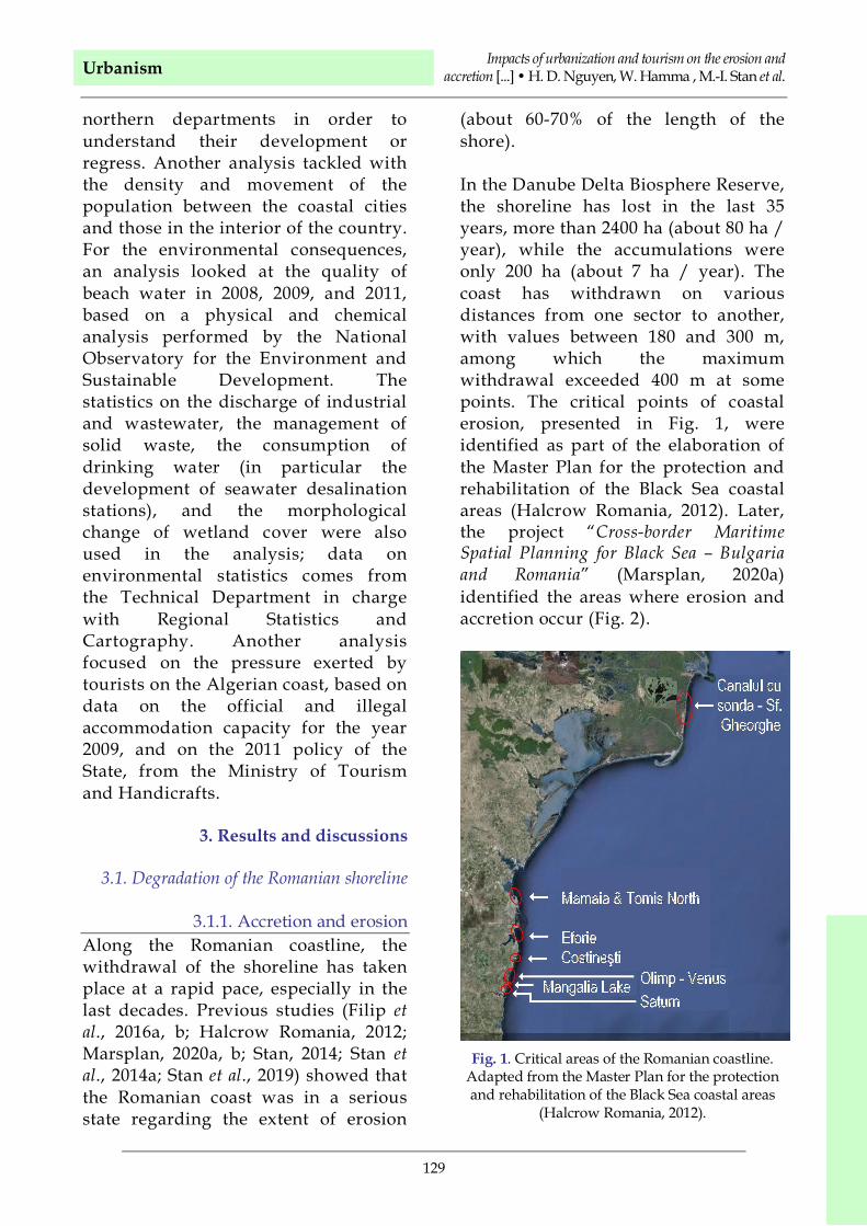
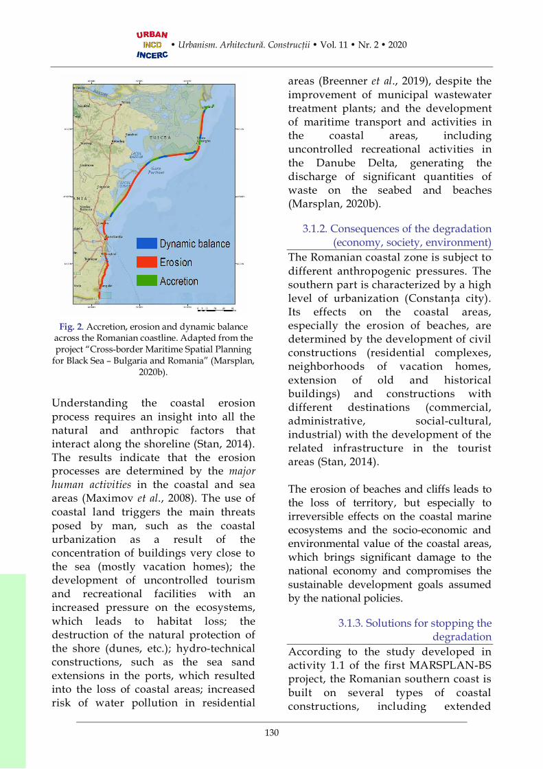
In the Danube Delta Biosphere Reserve,the shoreline has lost in the last 35years, more than 2400 ha (about 80 ha /year), while the accumulations wereonly 200 ha (about 7 ha / year). Thecoast has withdrawn on variousdistances from one sector to another,with values between 180 and 300 m,among which the maximumwithdrawal exceeded 400 m at somepoints. The critical points of coastalerosion, presented in Fig. 1, wereidentified as part of the elaboration ofthe Master Plan for the protection andrehabilitation of the Black Sea coastalareas (Halcrow Romania, 2012). Later,the project “Cross-border MaritimeSpatial Planning for Black Sea – Bulgariaand Romania” (Marsplan, 2020a)identified the areas where erosion andaccretion occur (Fig. 2).
Fig. 1. Critical areas of the Romanian coastline.Adapted from the Master Plan for the protectionand rehabilitation of the Black Sea coastal areas
Fig. 2. Accretion, erosion and dynamic balanceacross the Romanian coastline. Adapted from theproject “Cross-border Maritime Spatial Planning
for Black Sea – Bulgaria and Romania” (Marsplan,2020b).
Understanding the coastal erosionprocess requires an insight into all thenatural and anthropic factors thatinteract along the shoreline (Stan, 2014).The results indicate that the erosionprocesses are determined by the majorhuman activities in the coastal and seaareas (Maximov et al., 2008). The use ofcoastal land triggers the main threatsposed by man, such as the coastalurbanization as a result of theconcentration of buildings very close tothe sea (mostly vacation homes); thedevelopment of uncontrolled tourismand recreational facilities with anincreased pressure on the ecosystems,which leads to habitat loss; thedestruction of the natural protection ofthe shore (dunes, etc.); hydro-technicalconstructions, such as the sea sandextensions in the ports, which resultedinto the loss of coastal areas; increasedrisk of water pollution in residential
areas (Breenner et al., 2019), despite theimprovement of municipal wastewatertreatment plants; and the developmentof maritime transport and activities inthe coastal areas, includinguncontrolled recreational activities inthe Danube Delta, generating thedischarge of significant quantities ofwaste on the seabed and beaches(Marsplan, 2020b).
3.1.2. Consequences of the degradation(economy, society, environment)
The Romanian coastal zone is subject todifferent anthropogenic pressures. Thesouthern part is characterized by a highlevel of urbanization (Constanţa city).Its effects on the coastal areas,especially the erosion of beaches, aredetermined by the development of civilconstructions (residential complexes,neighborhoods of vacation homes,extension of old and historicalbuildings) and constructions withdifferent destinations (commercial,administrative, social-cultural,industrial) with the development of therelated infrastructure in the touristareas (Stan, 2014).
The erosion of beaches and cliffs leads tothe loss of territory, but especially toirreversible effects on the coastal marineecosystems and the socio-economic andenvironmental value of the coastal areas,which brings significant damage to thenational economy and compromises thesustainable development goals assumedby the national policies.
3.1.3. Solutions for stopping thedegradation
According to the study developed inactivity 1.1 of the first MARSPLAN-BSproject, the Romanian southern coast isbuilt on several types of coastalconstructions, including extended
Urbanism Impacts of urbanization and tourism on the erosion andaccretion [...] • H. D. Nguyen, W. Hamma , M.-I. Stan et al.
131
hydro-technical structures designed toprotect the tourist beaches and urbansettlements against the impact inducedby human activities and maritimenavigation works or port extensions(Marsplan, 2020a).
The coastal protection approach consistsof designing and implementing themeasures resulted from a series of “hard”and “soft” structural rehabilitationsolutions introduced by coastal engineers,aimed to provide solutions for theintegrated management of the coastalzone (Văidianu et al., 2020). For thecoastal protection, a large number oftechnical solutions against the coastalerosion are used along the Romanianshoreline: offshore breakwaters, coastaltransversal breakwaters, detachedbreakwaters / jetties, groynes, sea walls,stepped seawall, etc. (Stan and Vintilă,2006, 2016; Stan et al., 2014a, b).
Between 2013 and 2015 the works werecompleted on the southern part of theRomanian Black Sea coast, in five areas,namely Mamaia Sud, Tomis Nord,Tomis Centru, Tomis Sud and EforieNord, and aimed to create a coastalprotection system against erosion. Thisproject allowed for reducing the coastalerosion in the most exposed risky areasof the Black Sea coast by implementingappropriate structural and non-structural prevention measures for theprotection of 7.3 km of beach. In 2018,the financing contract for the project“Reduction of coastal erosion Phase II(2014-2020)” was signed; the project willcarry out works to reduce the coastalerosion for the following sectors: thecoastal areas (between StăvilarPeriboina and Stăvilar Edighiol) andsouthern area of the coastal zone,respectively Mamaia Centru andMamaia Nord, up to the limit of
Năvodari, Agigea, Eforie Center, EforieSud, Costineşti Sud, Mangalia (Olimp,Neptun, Jupiter - Venus, Saturn,Mangalia), 2 Mai, Tomis Port, toConstanţa Port at Balta Mangalia. Thesemeasures are necessary to protect andimprove the quality of the environmentand the life standards along theRomanian Black Sea coast, as well as toincrease the safety in the south coast,seriously threatened by coastalerosion.
3.2. Degradation of the Vietnam shoreline
3.2.1. Erosion and accretionSimilar to other coastal countries, coastalerosion has become an important issue inVietnam, resulting in a degradation ofcoastal ecosystems and an imbalance inthe living conditions of population (Le etal, 2014). In the studies of erosion, there isan ongoing debate on the relativeinfluence of natural and human factors(tourism development and urban growth)on the coastline erosion. Humanactivities, such as the construction of dikenetworks, dams, reservoirs in mountainarea and urban amenities, coastal tourism(Strady et al., 2017; Vu, 2014), extractionof river bed aggregates and replacementof protective mangroves by shrimp farms(Besset et al., 2016; Kustanti, 2019), as wellas the climate change-related effectsincluding sea-level rise and increasedfrequency of storms, typhoons (Do et al.,2012; Yasuhara et al., 2016) are importantdrivers. Some researchers have analyzedthe dynamic of the coastline inrelationship to the natural and humanfactors, such as the study of Le et al.(2014), aimed at evaluating the erosion ofthe Vietnam coastline and determining ofthe causes of erosion. The results showthat the causes include rising sea levels,poor erosion management, over-exploitation of natural resources in the
coastal areas, and mangrovedeforestation. In addition, other works,such as the study of Do et al. (2012) on theRed River Delta from 1930 to 2001,indicate that the dynamic of coastlines isinfluenced by a rate of accretion on theestuaries of about 100 m per year, andeven stronger in the Hai Hau area (NamDinh province). The causes are thetropical conditions that determined theRed River to produce a significantamount of sediments. However, thesediment supply has been very uneven,i.e., increased in the estuaries, causingaccretion in this region. An unevendistribution of sediments causes localerosion on the Red River Delta coast.Erosion is caused by wave-inducedsediment transport and sediment supplydeficit at the mouth of rivers.
The work of Duong et al. (2019) examinedthe evolution of the coastline over 20years in the district of Ngoc Hien (CaMau province) in the southern region,from 1990 to 2010, in relation to themeteorological conditions and humaninterventions using the Land Use Map(Landsat TM) and a questionnaire. Theresults of the analysis of technical andquestionnaire data show that during1990-1995 1675 ha of surface area was lostdue to erosion, while about 795 ha ofsurface area were gained from the seabecause of the accretion. Meteorologicalconditions and human interventionsinteracted to produce these changes.Although the impacts of individualfactors can not be easily quantified, themost important factors driving shorelinechanges are forest area depletion,watercourse dredging, and aquacultureand infrastructure development.
Nguyen et al. (2019) studied the shorelinedynamic during 1966-2014 based onsatellite imagery of Tra Vinh Province,
explaining that the coastline had anaverage accretion rate of about 5 to 10 mper year on the coast, and was erodedwith an average rate of about 5 to 8 m peryear; this is related to the many humanbuildings and the construction of newdike.
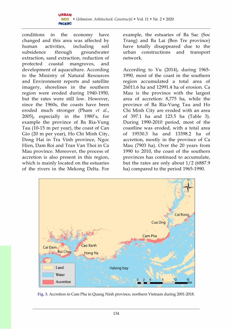
The erosion processes in the northernregion are very complex and depend onthe coastal structure and marineprocesses, and on human activities. Areasmost affected by erosion are Tien Hai inThai Binh and Giao Thuy district in NamDinh province (Do et al., 2012; Nguyen etal., 2013; Le, 2014). In addition, someregions show a more intense accretionprocess, e.g. Ha Long, Cam Pha, YenHung (Quang Ninh province) and theestuaries of the rivers Tra Ly and Ba Lat.From the satellite image analysis, during2001-2018 the average accretion rate inthis region was 18-25 m/year and theerosion rate was 15-18 m/year in theQuang Ninh province.
Table 1 shows the dynamic of thecoastline in the North Vietnam region,mainly related to accretion. Much ofthe coast in this region wasaccumulated because of urbandevelopment, aquaculture etc. in thisperiod. Fig. 3 shows the dynamic of thecoastline of Quang Ninh province,which is related to urbanization andtourism, especially in the cities BaiChay and Cam Pha, which are touristdestinations.
In the coastal areas of Central Vietnam,the erosion and accretion processes arevery complicated, but erosion dominates.According to the results of the KC.09.05project study (Pham et al., 2005) carriedout in the central region, more than 50%of the coast is eroded over a lengthexceeding 1 km, while 10.6% of the coast
Urbanism Impacts of urbanization and tourism on the erosion andaccretion [...] • H. D. Nguyen, W. Hamma , M.-I. Stan et al.
133
has been eroded over more than 200 m(Table 2).
Table 1. Area of erosion and accretion in NorthVietnam (Nguyen et al., 2013; Nguyen, 2015).
Province District Erosion/Accretion (ha)
Surface(ha)
1990-2013Accretion 762.94Mong CaiErosion 2623
Hai Ha Accretion 260.90Van Don Accretion 251.16Cam Pha Accretion 1218Ha Long Accretion 1465.91
QuangNinh
QuangYen Accretion 1160.10
1998-2008KienThuy Accretion 501.10Hai
Phong TienLang Accretion 1452
Accretion 641ThaiThuy Erosion 88
Tien Hai Accretion 1593Thai Binh
Erosion 64.52Accretion 3694.51Giao
Thuy Erosion 256.35Accretion 2122.7
Nam DinhNghiaHung Erosion 37.83
Kim Son Accretion 517.6Ninh BinhNga Son Accretion 139.94
In general, the average erosion rate inthis region is 5-15 m/year with amaximum of 15-30 m/year, e.g. QuangBinh province, Thua Thien Hue, DaNang etc. (Pham et al., 2005). Someregions are eroded more than 100m/year. In addition, the process ofaccretion has occurred in estuaries, suchas the Han Estuary in Da NangProvince, the Gianh Estuary in QuangBinh Province, and the Ba Estuary inPhu Yen Province.
According to a report from the Ministry ofAgriculture and Rural Development (2018),the central region includes 13 provinceswith 1,700 km of coastline that were eroded
88 times with a total length of 120 km alongthe central coast. The province of QuangNgai is affected more, with 27 zonestotaling 35 km in length. 48 areas in theCenter region with a distance of 91.6 kmare considered “erosion hotspots” thatrequire immediate interventions by thegovernment. Consequently, thegovernment has built more than 121protective works including dikes andforests. Despite these, erosion is stilloccurring on the coast.
Table 2. Surface of erosion in Central Vietnamduring 1993-2000 (Pham et al., 2005).
Province Erosion (ha)Thanh Hoa 1019.5Nghe An 1109.2Ha Tinh 382.6Quang Binh 349.3Quang Tri 185.7Thua Thien Hue 709.7Quang Nam 790Quang Ngai 778.8Binh Dinh 600.9Phu Yen 848.4Khanh Hoa 697.9Ninh Thuan 722.4Binh Thuan 674.5
Fig. 4 shows the dynamic of the Da Nangcity coastline; this is a highly urbanizedcity and a tourist destination. For thisreason, Han River estuary has beenaccumulated because of the new seashore. However, the shoreline waserected 7 km in the past because oftyphoons, waves and currents (Le et al.,2014); from the satellite image analysis, theaverage accretion rate in this region was15-25 m/year during 1990-2018, anderosion was 10-15 m/year, although inthe recent years the area has beenrelatively stable.
The Southern region is characterized bya coastal erosion common to manytropical deltas (Marchesiello et al., 2019).Since the mid-twentieth century,
conditions in the economy havechanged and this area was affected byhuman activities, including soilsubsidence through groundwaterextraction, sand extraction, reduction ofprotected coastal mangroves, anddevelopment of aquaculture. Accordingto the Ministry of Natural Resourcesand Environment reports and satelliteimagery, shorelines in the southernregion were eroded during 1940-1950,but the rates were still low. However,since the 1960s, the coasts have beeneroded much stronger (Pham et al.,2005), especially in the 1980’s, forexample the province of Ba Ria-VungTau (10-15 m per year), the coast of CanGio (20 m per year), Ho Chi Minh City,Dong Hai in Tra Vinh province, NgocHien, Dam Roi and Tran Van Thoi in CaMau province. Moreover, the process ofaccretion is also present in this region,which is mainly located on the estuariesof the rivers in the Mekong Delta. For
example, the estuaries of Ba Sac (SocTrang) and Ba Lai (Ben Tre province)have totally disappeared due to theurban constructions and transportnetwork.
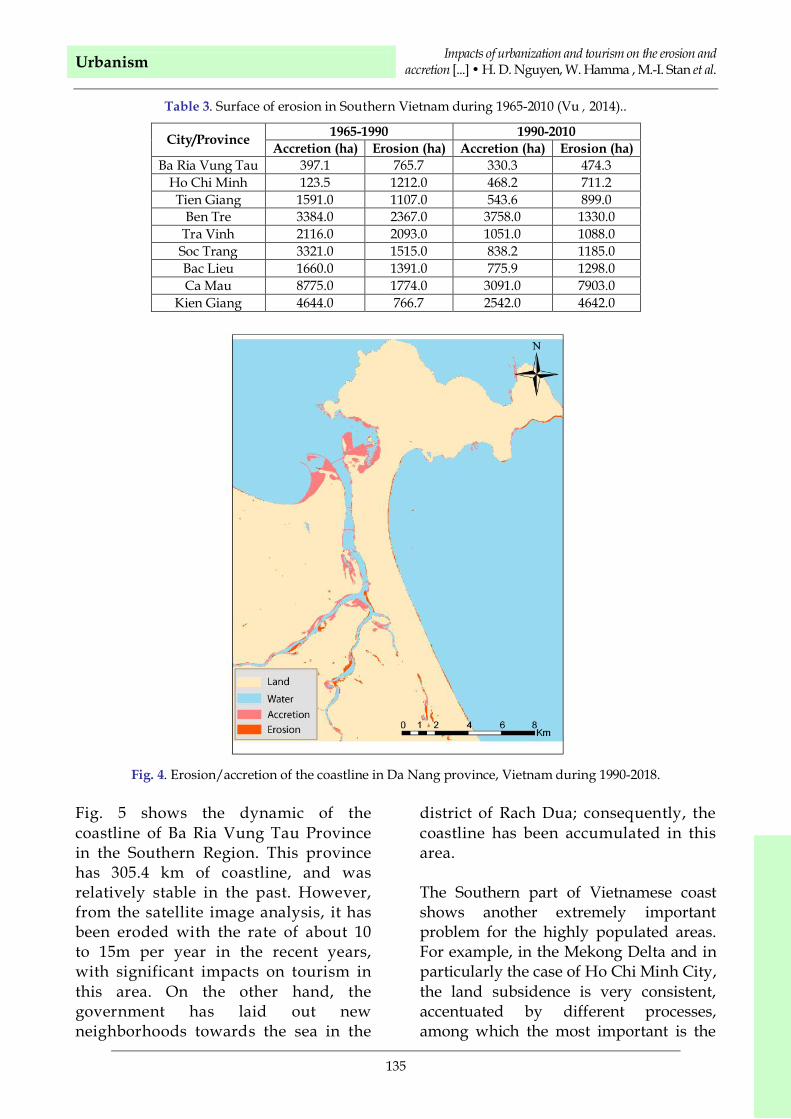
According to Vu (2014), during 1965-1990, most of the coast in the southernregion accumulated a total area of26011.6 ha and 12991.4 ha of erosion. CaMau is the province with the largestarea of accretion: 8,775 ha, while theprovince of Ba Ria-Vung Tau and HoChi Minh City are eroded with an areaof 397.1 ha and 123.5 ha (Table 3).During 1990-2010 period, most of thecoastline was eroded, with a total areaof 19530.3 ha and 13398.2 ha ofaccretion, mostly in the province of CaMau (7903 ha). Over the 20 years from1990 to 2010, the coast of the southernprovinces has continued to accumulate,but the rates are only about 1/2 (6887.9ha) compared to the period 1965-1990.
Fig. 3. Accretion in Cam Pha in Quang Ninh province, northern Vietnam during 2001-2018.
Urbanism Impacts of urbanization and tourism on the erosion andaccretion [...] • H. D. Nguyen, W. Hamma , M.-I. Stan et al.
135
Table 3. Surface of erosion in Southern Vietnam during 1965-2010 (Vu , 2014)..
Ho Chi Minh 123.5 1212.0 468.2 711.2Tien Giang 1591.0 1107.0 543.6 899.0
Ben Tre 3384.0 2367.0 3758.0 1330.0Tra Vinh 2116.0 2093.0 1051.0 1088.0Soc Trang 3321.0 1515.0 838.2 1185.0Bac Lieu 1660.0 1391.0 775.9 1298.0Ca Mau 8775.0 1774.0 3091.0 7903.0
Kien Giang 4644.0 766.7 2542.0 4642.0
Fig. 4. Erosion/accretion of the coastline in Da Nang province, Vietnam during 1990-2018.
Fig. 5 shows the dynamic of thecoastline of Ba Ria Vung Tau Provincein the Southern Region. This provincehas 305.4 km of coastline, and wasrelatively stable in the past. However,from the satellite image analysis, it hasbeen eroded with the rate of about 10to 15m per year in the recent years,with significant impacts on tourism inthis area. On the other hand, thegovernment has laid out newneighborhoods towards the sea in the
district of Rach Dua; consequently, thecoastline has been accumulated in thisarea.
The Southern part of Vietnamese coastshows another extremely importantproblem for the highly populated areas.For example, in the Mekong Delta and inparticularly the case of Ho Chi Minh City,the land subsidence is very consistent,accentuated by different processes,among which the most important is the
3.2.2. Causes of the erosion and accretionof Vietnam coastline
Coastal erosion results from acombination of many factors of bothnatural and human origin, operating atmultiple scales of time and space(Balasuriya, 2018). Winds and storms,coastal currents, changes in the sea levelin the more or less long term are the main“natural” causes of erosion phenomena.Coastal works, drying up of coastalbasins, dams and irrigation works,dredging operations and clearing ofcoastal lands constitute the main humancauses of erosion (Rameli and Jaafar,2015). The causes that affect the nature ofVietnam’s coastline are natural andanthropogenic. However, the analysis ofall causes related to the dynamic of thecoastline is not possible due to the timeand data needed. For these practicalpurposes, the analysis was limited tothree issues that change the shoreline.
The first cause is related to hydrologicalmeteorological factors such as waveactions, currents, typhoons. Every year,many typhoons cause great materialdamage and human victims on theVietnamese Coast (Larson et al., 2014).According to data from the Ministry ofNatural Resources and Environment, thetyphoons have been increasing inintensity and number since 2005, from 14in 2009 to 19 in 2013 (Fig. 6). Typhoonscause many problems challenging humanactivities, causing damages to ecosystemsand land, and eroding the coastal areas,affecting the livable area (Cong et al.,2019). The tides go up during thetyphoon, so the effects are pushed backdeeper into the continent, causing moreand more damage, e.g. the destruction ofinfrastructures and dike. During the
typhoons, the sea level can rise up to 2-3m, e.g. the 1995 hit of Quang Ninhprovince, or the 2013 hit of the centralregion of Vietnam. Overall, typhoonsincreased the erosion level.
The second cause is the flat relief of thecoastal zone. This area is the mostdeveloped and urbanized with economicactivities that yield a high incomecompared to the mountain areas, mainlydue to the shopping centers, services,seaports and tourism. Economic activitiessuch as trade, fishing, and industry yieldmore money, in addition to rice growing.In this global context, urbanization andindustrialization promote economic andpopulation growth. The living conditionsare better than those in the mountainousarea. This is why the economic activitieshave impacts on the coastline.
In addition, human activities affect thecoastline through the pressure ofpopulation, urban and tourism growth inthe lagoon (Tomilina et al., 2016), and alsoconstructions, dams and reservoirs, use ofconstruction materials (sand, gravel,gravel) in rivers and streams, reducingthe amount of water and sedimentsupplied to the coast and modifying thecoastline in the Red River and MekongDeltas, and coastal activities includingmining, construction of civil engineeringworks, and coastal protection. Forexample, in the Cam Pha district inQuang Ninh province, the process ofcoastal erosion is stronger, especiallythrough accretion due to urbandevelopment, tourism and mining. In theThang Nhat commune, Vung Tau city,and Ho Chi Minh City in the south, theinhabitants expanded over the sea todevelop the urban area and build the port– see Fig. 7, presenting the developmentof new neighborhoods over the sea in HoChi Minh and Ba Ria Vung Tau.
Urbanism Impacts of urbanization and tourism on the erosion andaccretion [...] • H. D. Nguyen, W. Hamma , M.-I. Stan et al.
137
Fig. 5. Coastline dynamic in Ba Ria-Vung Tau province, Vietnam during 2008-2018.
Fig. 6. Coastline dynamic in Ba Ria-Vung Tau province, Vietnam during 2008-2018.
A B
Fig. 7. Dynamic of the coastline in Ho Chi Minh city (A) and Ba Ria VungTau province (B), Vietnam: newneighborhoods are built over the sea. Source: (A) – Google Earth (2019); (B) – Construction Department in Ba
Mangroves provide numerousecosystem services, including climateregulation, storm limitation and dikeprotection in the littoral zone (Koh etal., 2018). However, mangroves havebeen subjected to intense exploitationand deforestation around the world.Vietnam is no exception in this regardsince it saw its mangrove forestsshrinking to 155,290 hectares in 2007,with a 50% decrease from 1980 (UNEP,2007). Due to the country’s renewalpolicy, Vietnam is engaged in aprocess of transition anddevelopment, while urbanizationbecomes stronger and coastalaquaculture develops rapidly, allleading to the destruction ofmangroves. The decrease of mangrovearea is related to the growth ofaquaculture due to shrimp farmingrevenues (Tran et al., 2012).
According to Phan et al. (2015), there isa relationship between the width ofmangrove and the status of Vietnamcoastline. This is why there issignificant coastal erosion in somemunicipalities where the surface of themangrove has been reduced, e.g. HaiLinh (Tinh Gia-Thanh Hoa), Nghi Yen(Nghi Loc-Nghe An), Thanh Trach(Quang Trach-Quang Binh), Binh Phu(Binh Son-Quang Nam) (Le, 2001), CanTrach (Duyen Hai-Ho Chi Minh City),Nguyen Huan, and Ngoc Hien (CaMau). For these reasons, in order toreduce the erosion, the Vietnamesegovernment replanted nearly 53,000 haof mangroves in 1990 as a result ofDecision 286/QD-TTG and Decision661/QD-TTG (Van et al., 2015), andNGO projects rehabilitated about14,000 ha of mangroves during 1991-2002 in Quang Ninh, Hai Phong, NinhBinh, Thanh Hoa, Nghe An, Ha Tinh,Thai Binh, and Nam Dinh.
3.2.3. Consequences of the degradation ofVietnam coastline (economy, society,
environment)The coastal areas of Vietnam are denselypopulated and are very importanteconomic regions of the country. Inaddition, there are many low-lying areas,for example, in the Red River Delta andthe Mekong Delta, where the tide isbelow the sea level (Takagi et al., 2015).Rising sea levels increase the amount ofextreme water conditions, whichtranslates into higher waves near thecoast. All these phenomena cause coastalerosion and affect the dike systems,destruct the infrastructure of the coastalzone and cause flooding in the deltas.Vietnam is one of the countries mostaffected by climate changes (Thinh andHens, 2019). According to theGovernment of Vietnam, if the sea levelraised about 75 cm above the averagelevel during 1980-1999, then about 20% ofthe Mekong Delta was flooded by tides(Government of Vietnam, 2011).
Erosion and accretion cause significantequipment, human, and environmentaldamage. Each year, the governmentassigns several budgets to fight againsterosion, by building dikes in the coastalregion where the density of population ishigh. However, every year typhoons hitthe coast, causing the breaking of dikesand great human damages. In September1955, inhabitants died due to a dikebreach during a typhoon. In 2010 thetyphoon that hit Hai Phong province inThanh Hoa caused the dam to breakcausing significant loss to the economy,i.e., a loss of about 650 billion USD.
From an environment perspective,erosion causes the destruction ofmangroves. Sediments can cause waterpollution during the erosion process,with negative impacts on the beaches. In
Urbanism Impacts of urbanization and tourism on the erosion andaccretion [...] • H. D. Nguyen, W. Hamma , M.-I. Stan et al.
139
addition, sediments from coastal erosionlead to the accretion of shippingchannels, e.g., in Haiphong Harbor andHai Thinh Port in the North region. InBach Dang estuary in the Quang NinhProvince, the volume of dredgedsediment for the shipping channel isbetween 3 and 5 millions tons, out ofwhich the volume due by coastal erosionis about 2 million tons.
3.2.4. Solutions for stopping thedegradation for Vietnam coastline
The protection of the coastal zone playsa vital role due to the high populationdensity and the growth of tourism inthis region (Le et al., 2014). Fromexperience in the other country andVietnam also on the prevention oferosion of the coastal zone show that itis a complicated task. This is whyseveral projects have been carried out inVietnam to find the requests to reducecoastline degradation in Vietnam suchas project KC.09.05 on the assessment ofcoastline erosion in the southern regionof Vietnam, or in the project of KC.09.09/ 16-20 on spatial organization, modelestablishment and recommendations forsustainable tourism development in thecoastal areas, sea and islands ofVietnam. In general, the solicitationswere divided by two main measures:Structure and non-structure (Do et al.,2012; Le et al., 2014).
For structural measurements, there areseveral solutions, such as Slopeembankments, Seawall, wave- and wind-breaker (Do et al., 2012; Nguyen, 2019). Inaddition, the Vietnamese governmentalso protects the coast by strengtheningraw materials such as gravel, pebbles,coarse sand or by planting halophilicplants. Depending on specific conditions,these solutions can be combined orcombined with other solutions.
For example, the protection anddevelopment of mangroves, focusing onthe coastal areas of the North and South;plant trees on land; protect coral reefs,focus on the central coast (Pham et al.,2002).
In 2006 and 2009, the Vietnamesegovernment issued Decision no. 58/2006 /QD-TTg and no. 667/2009 / QD -TTGapproving the program of strengthening,protection and modernization of sea dikesin the provinces of Quang Ninh in QuangNam and Quang Ngai in Kien Giang.
For non-structural requests, currently, theVietnamese government has carried outthe construction of a database for themanagement of erosion events or thedevelopment of erosion mapping indetail to the critical region to haveprevention plans and control. The set upa network of periodic monitoring andsurveillance of accretion-erosion to detectand alert timely application solutiondisasters, especially in the context ofclimate change.
3.2.5. Impact of tourism on theenvironment in Vietnam
Tourism has both positive and negativeimpacts on the environment. Tourismdevelopment contributes positively topreserving the environment throughenvironmental management and landuse planning related to the touristactivities. The coast of Vietnam has adiverse ecology (flora and fauna). One ofthe positive impacts on the ecologicalsystem of Vietnam is the preservation ofthe different life forms in the nationalmarine reserves. However, according tothe owners of the hotels, tourism hasalso a negative influence on theenvironment through several impacts,i.e., water pollution, change oflandscapes etc.
The interviews with hotel managersshow that 26% of managers believe thattourism causes environmentaldegradation, including pollution ofmaritime waters, by directlydischarging wastewater into the sea.
According to Cantini et al. (2019), theincrease of the number of tourists leadsto worsening the quality of waterbecause the wastewater treatmentsystem is not sufficient. Wastewaterpollution influences coastal resourcesdue to the lack of suitableenvironmental standards. For example,Con Dao Island in Ba Ria - Vung Tauprovince currently produces around72,000 tons of untreated waste.Moreover, additional 20 tons of wasteis generated every day on the islandand not treated, which directlythreatens the lives of people and thetourist environment. 38% of themanagers said that tourism destroyedthe scenic beauty of the maritime areaby building hotels on the beach. 36%indicated that tourism increased theurbanization, considered one of thereasons for the degradation of thecoastline in Vietnam.
3.3. Degradation of the Algerian shoreline
3.3.1. Accretion and erosionMarine erosion in Algeria is not onlycaused by rising sea levels, storms andsea swells, but also by the excessiveextraction of sand for construction. Thereduction in the solid inflows carried bythe various rivers which lead to the seawhich is due on the one hand to theconstruction of dams upstream of theserivers, and on the other hand toprolonged periods of drought.
During the period from 1989 to 1999 theaccretion varies, on average, between 0.2to 0.35 m / year and the erosion between1.7 to 2.22 m / year (Chemrouk andChabbi, 2016; Atroune et al., 2018). Wecan notice an increase of the accretionduring the second period, 1999-2009,which varies between 0.38 to 0.56 m /year, and of erosion between 1.96 to 2.43m / year (Table 4).
3.3.2. Consequences of the degradation ofAlgerian coastline: economy, society, and
environmentFig. 8 shows that the most affecteddepartments are those with a gulf and
Urbanism Impacts of urbanization and tourism on the erosion andaccretion [...] • H. D. Nguyen, W. Hamma , M.-I. Stan et al.
141
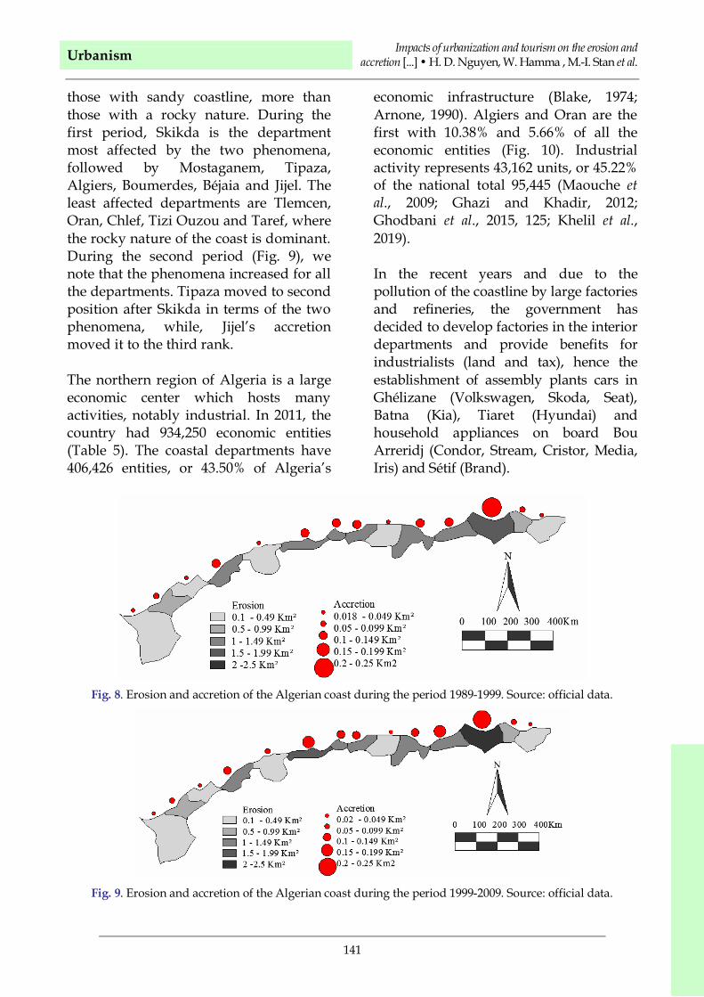
those with sandy coastline, more thanthose with a rocky nature. During thefirst period, Skikda is the departmentmost affected by the two phenomena,followed by Mostaganem, Tipaza,Algiers, Boumerdes, Béjaia and Jijel. Theleast affected departments are Tlemcen,Oran, Chlef, Tizi Ouzou and Taref, wherethe rocky nature of the coast is dominant.During the second period (Fig. 9), wenote that the phenomena increased for allthe departments. Tipaza moved to secondposition after Skikda in terms of the twophenomena, while, Jijel’s accretionmoved it to the third rank.
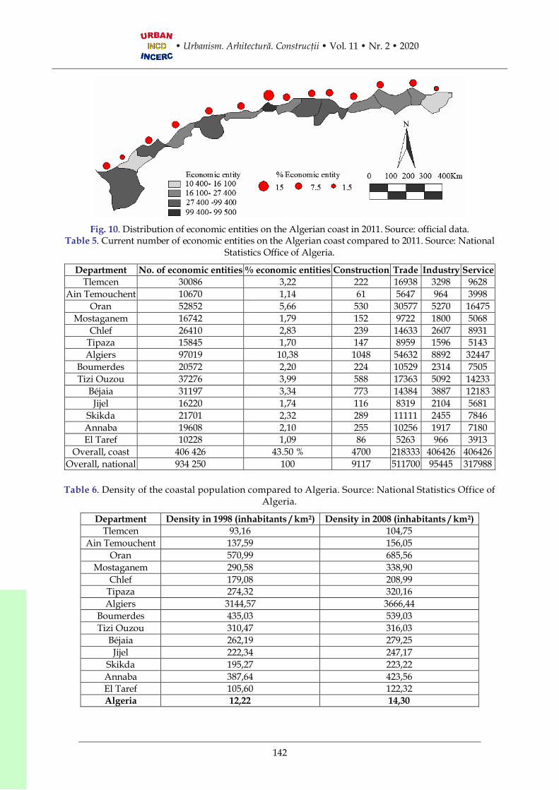
The northern region of Algeria is a largeeconomic center which hosts manyactivities, notably industrial. In 2011, thecountry had 934,250 economic entities(Table 5). The coastal departments have406,426 entities, or 43.50% of Algeria’s
economic infrastructure (Blake, 1974;Arnone, 1990). Algiers and Oran are thefirst with 10.38% and 5.66% of all theeconomic entities (Fig. 10). Industrialactivity represents 43,162 units, or 45.22%of the national total 95,445 (Maouche etal., 2009; Ghazi and Khadir, 2012;Ghodbani et al., 2015, 125; Khelil et al.,2019).
In the recent years and due to thepollution of the coastline by large factoriesand refineries, the government hasdecided to develop factories in the interiordepartments and provide benefits forindustrialists (land and tax), hence theestablishment of assembly plants cars inGhélizane (Volkswagen, Skoda, Seat),Batna (Kia), Tiaret (Hyundai) andhousehold appliances on board BouArreridj (Condor, Stream, Cristor, Media,Iris) and Sétif (Brand).
Fig. 8. Erosion and accretion of the Algerian coast during the period 1989-1999. Source: official data.
Fig. 9. Erosion and accretion of the Algerian coast during the period 1999-2009. Source: official data.
Fig. 10. Distribution of economic entities on the Algerian coast in 2011. Source: official data.Table 5. Current number of economic entities on the Algerian coast compared to 2011. Source: National
Statistics Office of Algeria.
Department No. of economic entities % economic entities Construction Trade Industry ServiceTlemcen 30086 3,22 222 16938 3298 9628
The advance of the sea affected theeconomy by the disappearance of manyagricultural lands located near it. Thisphenomenon is visible in thedepartments which have a gulf, such asSkikda, Béjaia, Boumerdes, Algiers,Tipaza, and Mostaganem. The mostaffected is Bejaia because the waves areapproaching the national road and theland has disappeared over a lineardistance of 35 km.The deterioration of thecoastal landscape, in particular the non-observance of the easement of 300 m fromthe coast line, has reduced the number oftourists from certain places, increased thepollution of the marine environment anddecreased the fishing income, causing alltogether a severe decrease of the localeconomy.
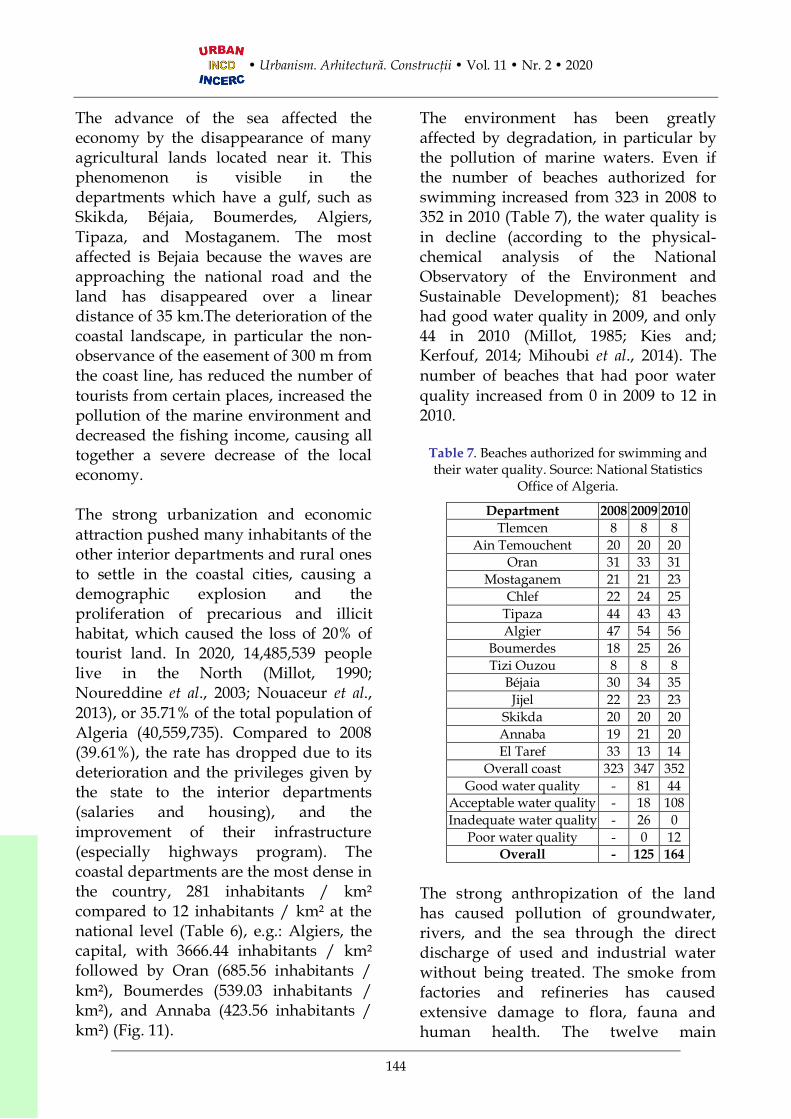
The strong urbanization and economicattraction pushed many inhabitants of theother interior departments and rural onesto settle in the coastal cities, causing ademographic explosion and theproliferation of precarious and illicithabitat, which caused the loss of 20% oftourist land. In 2020, 14,485,539 peoplelive in the North (Millot, 1990;Noureddine et al., 2003; Nouaceur et al.,2013), or 35.71% of the total population ofAlgeria (40,559,735). Compared to 2008(39.61%), the rate has dropped due to itsdeterioration and the privileges given bythe state to the interior departments(salaries and housing), and theimprovement of their infrastructure(especially highways program). Thecoastal departments are the most dense inthe country, 281 inhabitants / km²compared to 12 inhabitants / km² at thenational level (Table 6), e.g.: Algiers, thecapital, with 3666.44 inhabitants / km²followed by Oran (685.56 inhabitants /km²), Boumerdes (539.03 inhabitants /km²), and Annaba (423.56 inhabitants /km²) (Fig. 11).
The environment has been greatlyaffected by degradation, in particular bythe pollution of marine waters. Even ifthe number of beaches authorized forswimming increased from 323 in 2008 to352 in 2010 (Table 7), the water quality isin decline (according to the physical-chemical analysis of the NationalObservatory of the Environment andSustainable Development); 81 beacheshad good water quality in 2009, and only44 in 2010 (Millot, 1985; Kies and;Kerfouf, 2014; Mihoubi et al., 2014). Thenumber of beaches that had poor waterquality increased from 0 in 2009 to 12 in2010.
Table 7. Beaches authorized for swimming andtheir water quality. Source: National Statistics
Office of Algeria.
Department 2008 2009 2010Tlemcen 8 8 8
Ain Temouchent 20 20 20Oran 31 33 31
Mostaganem 21 21 23Chlef 22 24 25
Tipaza 44 43 43Algier 47 54 56
Boumerdes 18 25 26Tizi Ouzou 8 8 8
Béjaia 30 34 35Jijel 22 23 23
Skikda 20 20 20Annaba 19 21 20El Taref 33 13 14
Overall coast 323 347 352Good water quality - 81 44
Acceptable water quality - 18 108Inadequate water quality - 26 0
Poor water quality - 0 12Overall - 125 164
The strong anthropization of the landhas caused pollution of groundwater,rivers, and the sea through the directdischarge of used and industrial waterwithout being treated. The smoke fromfactories and refineries has causedextensive damage to flora, fauna andhuman health. The twelve main
Urbanism Impacts of urbanization and tourism on the erosion andaccretion [...] • H. D. Nguyen, W. Hamma , M.-I. Stan et al.
145
generators of special hazardous wasteare all located in the coastalmunicipalities of Algiers, Bejaia, Skikda,Annaba, Ghazaouet, Arzew and Oran(Figure 12). They alone produce 87% ofwaste at national level, or 282,800 t /year and hold 95% of waste in stock, or1,905,200 t. Of the 136 coastalmunicipalities, 20 have a treatment plantand 116 discharge their wastewater intothe sea (Kacemi, 2011; Ghodbani andBerrahi-Midoun, 2013). With regard tosolid waste, 39 discharge into technicallandfills and 94 into uncontrolledlandfills near the sea. The populationproduces more than 8,684 tons of solidurban waste, evacuated to 380 dumpsiteslocated on the coastal strip.
Table 8. Accommodation offer by type in 2009.Source: Algerian Ministry of Tourism and
Handicrafts.
Youth hotels / hostels Number of bedsUrban 57419Seaside 16551Saharan 10635Thermal 3757Climatic 332
Total 88694
The pressure on ecosystems is alsocaused by the large influx of summervisitors to the coastal areas (Figure 13),in particular the overcrowding ofbeaches and wild tourism (setting uptents, illegal residences etc.), sinceAlgeria has a deficit in the supply ofseaside accommodation. There wereonly 16,551 beds in 2009 (Kacemi, 2009;Hafferssas and Seridji, 2010; Kermani etal., 2016; Hamma and Petrişor, 2018),i.e., 18% of the national capacity (Table8). This shortcoming has promptedinvestors to build cabins and apartmenthotels (several studios) without abuilding permit, in most cases, in orderto rent them illegally. Some people haveeven rented their house or garage.
These constructions have caused adegradation of the natural coastlinelandscape, because they are built in ananarchic manner, without an overallplan.
The accommodation offer is notbalanced on the Algerian coast. Algiershas 18,954 hotel beds more than thethree largest departments all together,i.e., Béjaia, Oran and Annaba, with10,766 beds. With respect to other typesof accommodation than hotels, Béjaiaand Boumerdes are classified propertieswith 16,817 and 15,421 beds (Table 9). Ifwe compare Table 21 and Figure 30, itcan be noticed that the first two citiesthat exceed the 10 million summervisitors, Oran (20 million) and Tipaza(17 million), have a low accommodationcapacity, which confirms that theresidences compensate the deficit moreor less.
In order to compensate theaccommodation deficit, the Ministry ofTourism and Handicrafts has createdtourist areas to allow investors to buildtourist infrastructure as part of anorganized development plan.Unfortunately, the occupancy rate inthese areas is low and in several casesthe land use has been changed to otherfunctions (Table 10).
Moreover, fishing in the shallows, non-compliance with the market sizes of fishspecies, unconventional fishing and theuse of non-selective fishing techniquesand over-exploitation have reduced thefishing resources. The affected speciesare the shrimp (Aristeus antennatus,Parapenaeus longirostris and Penaeuskerathurus) which have diminished theirpopulations, and the monk seal, that hasdisappeared (Ghodbani, 2005; Djouderand Boutiba, 2017).
The excessive consumption of drinkingwater and drought has prompted the stateto build many seawater desalinationplants (Figure 14). The departments of TiziOuzou, Béjaia and Jijel are not affectedbecause they have a high rainfall andsupply the other interior departments.
The uncontrolled urbanization of thecoastline has caused a significantmorphological modification of the land,construction of buildings in the floodzones and on steep slopes, which have
caused important landslides and floods.The greatest disasters occur in coastaldepartments such as Algiers, Béjaia andAnnaba (Ghodbani, 2010; Ghodbani andSemmoud, 2010).
Marine erosion and the illegal andabusive removal of building materials,particularly sand, have reduced thesurface of beaches and sometimes causedtheir disappearance, and, in addition, thedegradation and partial or totaldisappearance of the dune cords.
Table 9. Accommodation offer in the Algerian coast in 2011. Source: Algerian Ministry of Tourism andHandicrafts.
Urbanism Impacts of urbanization and tourism on the erosion andaccretion [...] • H. D. Nguyen, W. Hamma , M.-I. Stan et al.
147
Deforestation had a negative effect onthe environment of the Algerian coast,notably the rise in temperatures and theupsetting of ecosystems. It is caused byfires; nearly 100,000 ha of coastal forestsand scrub have been subject to forestfires over the past decade (2001-2011)(Yelles-Chaouche, 1992; Snoussi andTabet Aoul, 2000; Rabehi et al., 2019).This constitutes almost half of all theforests in the national territory whichwere affected by fires during the sameperiod.
3.3.3. Solutions for stopping thedegradation of Algerian coastline
The fight against degradation involvesmastering urbanization, but alsolimiting the anthropization of coastallands. This can be done by improvingthe urban planning tools (Petrişor andMeiţă, 2017) and involving thestakeholders and citizens in all phasesof planning. Algeria must also put to anend the derogatory urban planning(Hamma and Petrişor, 2018), whichallowed for building sized in general 4floors to be built up illicitly. A compactcity may help preserving the soil.
The preservation and protection of thenatural and cultural resources of theAlgerian coastline involves the creation ofmarine and protected coastal areas(Saadaoui et al., 2018), the construction ofdikes, the construction of seawaterdesalination stations, the monitoring offishing, the protection archaeological,architectural and underwater heritage.Strengthening the impact assessment onthe environment and the cultural heritagewill limit further degradation.
There is a need for improving the humanand material resources of differentnational observatories, in particular thenational coastal police station. This will
improve the collection of information,expertise, monitoring, intervention andmonitoring of each coastal protectionaction.
The fight against pollution must takeplace through the construction of newtechnical landfill centers, waste recyclingcenters and wastewater treatment plants,and also by improving the wastecollection and permanent beachmaintenance.
There is a strong need for establishinggood coastal and maritime governanceand raising the awareness of all actors insociety to protect the coastline.Strengthening the role of NGOs andestablishing coastal preservation laws,along with its enforcement, might alsohelp. There is also a need for promotingsustainable tourism and renewableenergies. Finally, all these require thecreation of a special coastal protectionfund.
4. ConclusionsEach case study has providedsignificant insights. Vietnam is one ofthe countries most affected byclimate change, especially since 2005,when the number of storms hasincreased together with their effects,causing human and economicdamages, and increasing the coastalerosion. Within the framework of the2020 national strategy for disasterprevention and mitigation,strengthening the cooperation withinternational organizations developingclimate change-related programs anddealing with the management ofcoasts and estuaries in order tostrengthen the administrativemanagement capacity to reduce thecoastal change are an absoluterequirement (Rusu, 2019).
In Algeria, climate change caused anincrease of the sea levels, which causedsevere marine erosion, and resulted intothe loss of many beaches andagricultural land. Accretion is very lowon the Algerian coast, because theamount of sediments deposited by themany rivers decreased due to droughtand the diversion of rivers through theconstruction of dams. The economicconsequences of this deteriorationinclude the decrease in agriculturalactivity in certain regions, a decrease offishing revenues and the relocation ofcertain industrial activities to innercities. From a social point of view, somecities suffer from the outcomes of a highpopulation density, especially thosewith a high concentration of economicentities. The environmental quality wasalso affected by the discharge of wasteand industrial water into the sea, thedepositing of solid waste in illegallandfills, the over-consumption ofdrinking water, fires, deforestation,morphological modification of the soil,disappearance of certain marine species,and the encroachment of plant species.These degradations are also caused bythe pressure of tourist activities,especially the construction of illegalresidences.
Although Romania has a very shortcoastline of the Black Sea, thecomplexity of land-sea interactions isvery high due to different natural andanthropic factors, and coastal condition.First of all, any territorial analyst cannotice the opposition between thenorthern and southern parts of theRomanian Black Sea coast with respectto the urbanization and degradation ofcoastal areas. The Northern part isdominated by natural dynamics,especially after 1991, when the DanubeDelta became a Biosphere Reserve.
Despite a very low urbanization(although a century ago Sulina city, forexample, played a European role for thenavigation on Danube), the currentdegradation processes are connected ina large share with the effects of hydro-technical works done along the Danubeand in its hydrographic basin. Themultitude of dams on Danube and itstributaries drastically reduced theamount of sediments, which hadmaintained the equilibrium of land-seainteractions. The alternation betweenlarge eroded beach segments and smallones, where the coastline advances,equally attract the interest of scientistsand planners. Even if the European andRomanian legislation try to protect theDanube Delta (Stan, 2013), the pollutiondue to agriculture and industrialactivities, especially with heavy metals,affects natural fluvial and marineecosystems. The Southern part of theRomanian Black Sea coast is stronglyaffected by urbanization (Petrişor, 2010,2012; Petrişor et al., 2010, 2014, 2020a, b).The construction of the Danube – BlackSea Canal and the increasing role ofConstanta port, serving the entireCentral Europe, accelerated thedemographic increase of the wholeurban system alongside of the sea. Theanthropic activities were amplified byindustrial activities, oil exploitations onthe continental shelf, oil refineries, andmaritime transport. The pollutiongenerated by these activities, especiallyduring the transport and industrialaccidents, poses a real danger for thelocal communities, but especially fortourism during the summer season. Inorder to protect beaches and cliffsagainst erosion, protective dikes havebeen built between Navodari and VamaVeche. The specific infrastructures tofacilitate the transport from the BlackSea to Central Europe, using the
Urbanism Impacts of urbanization and tourism on the erosion andaccretion [...] • H. D. Nguyen, W. Hamma , M.-I. Stan et al.
149
Danube-Black Sea canal and its branch(to Midia refinery) have modified theoriginal configuration of the coastline.This part of Romanian Black Sea coast isthe most attractive area for tourismduring the summer. For instance, thereis a balance of industrial, urban, andtourism activities, but there are signs ofincompatibilities between them, whichimplicitly reduce the sustainability ofcoastal areas. A new administrativeframework can play an important rolein harmonizing these activities, bydefining compatibility limits anddeveloping appropriate physicalinfrastructures. In more detail, thefuture functional Metropolitan area willallow for developing joint projects forall administrative units, which nowoperate independently. Otherwise, localdecisions may accentuate thedegradation of coastal areas due tooverpopulation and increasing diversityof incompatible activities in someareas.
AcknowledgementsThe Romanian case study has beenpartially supported by the EuropeanCommission through the EuropeanMaritime and Fisheries Fund, Cross-border Maritime Spatial Planning forBlack Sea – Bulgaria and Romania(MARSPLAN-BS II), EASME/ EMFF/2018/ 1.2.1.5/ 01/ SI2.806725-MARSPLAN-BS II and the University ofBucharest project UB-2008 “Trans-scaleanalysis of the territorial impact of currentclimate change and globalization”. TheVietnam case study has been supportedby the Vietnam national project“Scientific rationale for spatialorganization, model establishment andrecommendations for sustainable tourismdevelopment in the coastal areas, sea andislands of Vietnam” (grant numberKC.09.09/16-20).
REFERENCES
Aivaz K. A., Vintilă D. F., Stan M.-I., Ioniţiu I.,Ţenea D. D. (2019), Aspects Regarding theCommercial Profitability of the Companiesfrom Localities on the Coastal Area of TulceaCounty, Ovidius University Annals Series:Civil Engineering 21: 115-120.
Allen J.-S., Lu K.-S., Potts T.-D. (1999), A GIS-basedanalysis and prediction of parcel land-usechange in a coastal tourism destination area,Strom Thurmond Institute, Clemson,USA.
Antunes do Carmo J. S. (2018), Climate Change,Adaptation Measures, and Integrated CoastalZone Management: The New ProtectionParadigm for the Portuguese Coastal Zone,Journal of Coastal Research 34(3): 687-703.
Apostol L., Gaceu O. (2011), The climatic-touristicpotential of the Romanian Black Sea coastduring summer, established according to themethod of Besancenot, Mounier and deLavenne, Carpathian Journal of Earth andEnvironmental Sciences 6(1): 199-206.
Arnone R. A., Wiesenburg D. A., Saunders K. D.(1990), The origin and characteristics of theAlgerian Current, Journal of GeophysicalResearch: Oceans 95(2): 1587-1598.
Atroune F., Bouhmadouche M., Hemdane Y.(2018), Assessing Coastal Flood Vulnerabilityand Marine Erosion Risk. Case of the Bay ofAlgiers, in: Kallel A., Ksibi M., Ben DhiaH., Khélifi N. (Eds.), Recent Advances inEnvironmental Science from the Euro-Mediterranean and Surrounding Regions.EMCEI 2017. Advances in Science,Technology & Innovation, IEREKInterdisciplinary Series for SustainableDevelopment, Springer, Cham,Switzerland, pp. 1629-1631.
Ayatac H., Aycim Turer Baskaya F., KurkcuogluE., Celik O., Becerik S. (2018), Alterationswithin the Coastal Urban Environments: Caseof the Coastal Squares of Istanbul Megacity,in: Zhang Y. (Ed.), Sea Level Rise andCoastal Infrastructure, IntechOpen,London, UK, pp. 41-58.
Bai X., Lampis A., Kremer H., McEvoy D. (2015),Coastal zones and urbanization. Summary forDecision-Makers, Technical Report, IHDP,Bonn, Germany.
Baird R. C. (2009), Coastal urbanization: thechallenge of management lag, Managementof Environmental Quality 20(4): 371-382.
Balasuriya A. (2018), Coastal Area Management:Biodiversity and Ecological Sustainability inSri Lankan Perspective, in: Sivaperuman C.,
Velmurugan A., Singh A., Jaisankar I.(Eds.), Biodiversity and Climate ChangeAdaptation in Tropical Islands, AcademicPress, Amsterdam, Netherlands, pp. 701-724.
Besset M., Anthony E. J., Brunier G., Dusouillez P.(2016), Shoreline change of the Mekong Riverdelta along the southern part of the SouthChina Sea coast using satellite image analysis(1973-2014), Geomorphologie 22(2): 137-146.
Blake G. H. (1974), Urbanisation in North Africa: ItsNature and Consequences, in: Dwyer D. J.(Ed.), The City in the Third World, TheGeographical Readings series, Palgrave,London, UK, pp. 67-80.
Boştenaru Dan M. (2006), Impact of natural hazardson urban areas and infrastructure – Preface,Bulletin of Earthquake Engineering 4(2):95-100.
Boştenaru Dan M. (2018), Decision making based onbenefit-costs analysis: Costs of preventiveretrofit versus costs of repair after earthquakehazards, Sustainability 10(5): 1537
Boştenaru Dan M., Armaş I., Goretti A. (2014),Earthquake hazard impact and urbanplanning-an introduction, in: BoştenaruDan M., Armaş I., Goretti A. (Eds.),Earthquake Hazard Impact and UrbanPlanning, Springer, Earth Sciences &Geography - Natural Hazards Series 13,pp. 1-12.
Bowen J. L., Valiela I. (2001), The ecological effects ofurbanization of coastal watersheds: historicalincreases in nitrogen loads and eutrophicationof Waquoit Bay estuaries, Canadian Journalof Fisheries and Aquatic Sciences 58(8):1489-1500.
Brausch J.-M., Connors K.-A,. Brooks B.-W., RandG.-M. (2012), Human pharmaceuticals in theaquatic environment: a review of recenttoxicological studies and considerations fortoxicity testing, Reviews of EnvironmentalContamination and Toxicology 218: 1-99.
Brenner A., Cohen H., Gradus O., Koren O.,Shandalov S., Zinger Y. (2019),Incorporation of hybrid biofilters in water-sensitive urban design, PresentEnvironment and SustainableDevelopment 13(2): 167-177.
Buhociu D. H., Florescu T. C., Crăciun C., Popa A.(2013a), The Environmental and SocialDevelopment of Human Settlements near theDanube, in: Sandu A., Caras A.,International Scientific Conference Traditionand Reform Social Reconstruction of Europe,November 7-8, 2013 - Bucharest (Romania),
Medimond International Proceedings,Bologna, Italy, pp. 75-78.
Buhociu D. H., Rahoveanu A. T., Florescu T. C.,Crăciun C., Popa A (2013b), Ruralwaterfronts, green areas and naturallandscape at the Danube, Journal of Food,Agriculture and Environment 11(3-4):1692-1696.
Cantini F., Castelli G., Foderi C., Salazar G.-A,López de Armentia T., Bresci E andSalbitano F. (2019), Evidence-BasedIntegrated Analysis of EnvironmentalHazards in Southern Bolivia, InternationalJournal of Environmental Research andPublic Health 16(12): 2107.
Chemrouk O., Chabbi N. (2016), Vulnerability ofAlgiers Waterfront and the New UrbanDevelopment Scheme, Procedia Engineering161: 1417-1422.
Chua T.-E. (1993), Essential elements of integratedcoastal zone management, Ocean & CoastalManagement 21(1-3): 81-108.
Cicin-Sain B., Belfiore S. (2005), Linking marineprotected areas to integrated coastal and oceanmanagement: A review of theory and practice,Ocean & Coastal Management 48(11-12):847-868.
Colavitti A. M., Serra S., Usai A. (2018), Planningthe wetlands in a conflictual Era. The SantaGilla & Molentargius compendia cases– study(Sardinia, Italy), Acta TechnicaNapocensis: Civil Engineering &Architecture 61(3): 231-252.
Cong S., Wu X., Zhang Y., Xue B., Wang H. (2019),Evolution of the northern Fujian coast underthe impact of natural and anthropogenicforces, 1976-2017: An analysis of coastalmonitoring and satellite images,Anthropocene Coasts 2(1): 72-86.
Cordes J. J., Yezer A. M. J. (1998), In Harm's Way:Does Federal Spending on BeachEnhancement and Protection InduceExcessive Development in Coastal Areas?,Land Economics 74(1): 128-145.
Diop S., Barusseau J.-P., Descamps C. (2014), Theland/ocean interactions in the coastal zone ofWest and Central Africa, Springer, Cham,Switzerland.
Djouder F., Boutiba M. (2017), Vulnerabilityassessment of coastal areas to sea level risefrom the physical and socioeconomicparameters: case of the Gulf coast of Bejaia,Algeria, Arabian Journal of Geosciences10(299): 17-20.
Do M. D., Mai T. N., Chu, V. N. (2012), An analysisof coastal erosion in the tropical rapidaccretion delta of the Red River, Vietnam,
Urbanism Impacts of urbanization and tourism on the erosion andaccretion [...] • H. D. Nguyen, W. Hamma , M.-I. Stan et al.
151
Journal of Asian Earth Sciences 43(1): 98-109.
Dolana S. (2018), Ecotourism planning in a wetlandof international importance and sustainableterritorial development, Journal of Urbanand Landscape Planning 3: 77-86.
Duarte C. M., Losada I. J., Hendriks I. E.,Mazarrasa I., Marbà N. (2013), The role ofcoastal plant communities for climate changemitigation and adaptation, Nature ClimateChange 3(11): 961-968.
Duong T. T., Dang A. N., Nguyen T. K. O. (2019),Analysis of coastline change in relation tometeorological conditions and humanactivities in Ca Mau cape, Viet Nam, Oceanand Coastal Management 171: 56-65.
Erkens G., Bucx T., Dam R., de Lange G., LambertJ. (2015), Sinking coastal cities, Proceedingsof the International Association ofHydrological Sciences 372: 189–198.
European Environment Agency (2006a), Thechanging faces of Europe's coastal areas,Office for Official Publications of theEuropean Communities, Luxembourg,Luxembourg.
European Environment Agency (2006b), Urbansprawl in Europe - The ignored challenge,Office for Official Publications of theEuropean Communities, Luxembourg,Luxembourg.
Filip C, Stan MI, Vintilă D. F. (2016a),Considerations regarding the expected benefitof rehabilitation works related to Romaniancoastal zone of the Black Sea on regionalsustainable development, Proceedings of the16th International MultidisciplinaryScientific GeoConference SGEM 2016 6(3):523-530.
Filip C., Stan M.-I., Vintilă D. F. (2016b), Multi-criteria analysis of urban development in theRomanian Black Sea coastal zone,Proceedings of the 16th InternationalMultidisciplinary ScientificGeoConference SGEM 2016 6(3):569-576.
Fritz H. M., Blount C. (2007), Role of forests andtrees in protecting coastal areas againstcyclones, in: Braatz S., Fortuna S,Broadhead J., Leslie R. (Eds.), Coastalprotection in the aftermath of the IndianOcean tsunami: What role for forests andtrees? Proceedings of the Regional TechnicalWorkshop, Khao Lak, Thailand 28-31 August2006, Bangkok, Thailand, pp. 37-63.
Gâştescu P. (2005), Protection works of naturalbeaches and the management of artificialbeaches [in Romanian], in: Posea G.,Bogdan O., Zăvoianu I., Buză M.,
Bălteanu D., Niculescu G. (Eds.),Romanian Geography. Romanian Plain,Danube, Dobrogea Plateau, Romanian coast ofBlack Sea and Continental Shelf [inRomanian], Romanian Academy Press,Bucharest, Romania, pp. 798-800.
Ghazi S., Khadir M. T. (2012), Combination ofartificial neural network models for air qualitypredictions for the region of Annaba, Algeria,International Journal of EnvironmentalStudies 69(1): 79-89.
Ghodbani T. (2010), Environment and littoralsettling in West Algeria [in French],Insaniyat 50: 53-60.
Ghodbani T. (2005), Rechgoun, a space to beprotected on the west coast of Algeria,Méditerranée 105: 87-94.
Ghodbani T., Berrahi-Midoun F. (2013),Littoralization in Western Algeria:Multiscalar Approaches to Interactions Men-Areas-Ecosystem, Espace populationssociétés 2013(1-2): 231-243.
Ghodbani T., Milewski A., Bellal S. A. (2015), Afragile seaside ecosystem threatened on thesouthern bank of the Mediterranean [inFrench], Méditerranée 125: 153-164.
Ghodbani T., Semmoud B. (2010), CoastalUrbanization in Algeria, Processes andEnvironment Impacts: The Case of the BayAïn el Turck, Études caribéennes 15(1): 31-44.
Gkoltsiou A., Terkenli T. (2012), Aninterdisciplinary analysis of tourist landscapestructure, Tourismos 7(2): 145-164.
Government of Vietnam (2011), National strategyon climate change,http://www.chinhphu.vn/portal/page/portal/English/strategies/strategiesdetails?categoryId=30&articleId=10051283
Hafferssas A., Seridji R. (2010), Relationshipsbetween the Hydrodynamics and Changes inCopepod Structure on the Algerian Coast,Zoological Studies 49(3): 353-366.
Halcrow Romania (2012), Master Plan "Protectionand rehabilitation of the coastal zone" [inRomanian], http://www.rowater.ro/dadobrogea/Master%20Plan%20privind%20Protecia%20i%20Reabilitarea%20Zonei/Master%20Plan.pdf
Hamma W., Petrişor A.-I. (2018), Urbanization andrisks: case of Bejaia city in Algeria, HumanGeographies 12(1): 97-114.
Hildebrand L. (2013), Assessing and adapting toclimate-change induced sea-level rise on thesouthern coastline of the Gambia, Divisionfor Ocean Affairs and The Law of The Sea,the United Nations, New York, NY, USA.
Hwang J., Lee J. (2019), A strategy for enhancingsenior tourists’ well-being perception:Focusing on the experience economy, Journalof Travel and Tourism Marketing 36(3):314-329.
Isa N. A., Wan Mohd W. M. N., Salleh S. A., GeeOoi M. C., Chan A. (2020), Land coverimpacts towards thermal variation in theKuala Lumpur city, Journal of Urban andRegional Analysis 12(1): 91-111.
Kacemi M. (2011), Protection and Development of theCoastal Areas in Algeria: Legislation andInstruments. The Case of Oran’s CoastalAreas, Études caribéennes, article no. 5959.
Kacemi M. (2009), Protection of the Coastal Areas inAlgeria between Management and Legislation.A Case Study of the Industrial Pole of Arzew(Oran, Algeria), Droit et société 73: 687-701.
Kara B. (2019), Agrarian and wetland areas undermetropolitan threats: Learning from the caseof Inciralti, Izmir (Turkey), Applied Ecologyand Environmental Research 17(6): 15087-15102.
Kermani S., Boutiba M., Guendouz M., SaidGuettouche M., Khelfani D. (2016),Detection and analysis of shoreline changesusing geospatial tools and automaticcomputation: case of jijelian sandy coast (EastAlgeria), Ocean & Coastal Management132: 46-58.
Khelil N., Larid M., Grimes S., Le Berre I., PeuziatI. (2019), Challenges and opportunities inpromoting integrated coastal zonemanagement in Algeria: Demonstration fromthe Algiers coast, Ocean & CoastalManagement 168: 185-196.
Kies F., Kerfouf A. (2014), Impact of the climate changeon the West coast of Algeria: Gulf of Oran,Arzew and Mostaganem, Sustainability, Agri,Food and Environmental Research 2(3): 1-15.
Kitsiou D., Coccossis H., Karydis M. (2002), Multi-dimensional evaluation and ranking of coastalareas using GIS and multiple criteria choicemethods, The Science of the TotalEnvironment 284(1-3): 1-17.
Koh H. L., Teh S. Y., Kh’ng X. Y., Raja Barizan R.S. (2018), Mangrove forests: Protectionagainst and resilience to coastal disturbances,Journal of Tropical Forest Science 30(5):446-460.
Kustanti A. (2019), Institutional management onmangrove forest. A case from Indonesia,International Journal of ConservationScience 10(3): 555-564.
Lai S., Loke L. H. L., Hilton M. J., Bouma T. J.,Todd, P. A. (2015), The effects of
urbanization on coastal habitats and thepotential for ecological engineering: ASingapore case study, Ocean & CoastalManagement 103: 78-85.
Larson M., Hung N. M., Hanson H., Sundström A.,Södervall E. (2014), The Impact of Typhoonson the Vietnamese Coastline: A case study ofHai Hau Beach and Ly Hoa Beach, in: Thao N.D., Takagi H., Esteban M. (Eds.), CoastalDisasters and Climate Change in Vietnam,Engineering and Planning Perspectives,Elsevier, London, UK, pp. 17-42.
Le V. C. (2001), Coastal Erosion Situation and TheirCausing Factors in South Vietnam Region,Sub-Project of KC.09.05 (B) Report,Institute of Geography, Ha Noi, Vietnam.
Le V. C., Nguyen V. C., Shibayama T. (2014),Assessment of Vietnam coastal erosion andrelevant laws and policies, in: Nguyen D. T.,Takagi H., Esteban M. (Eds.), Coastaldisasters and climate change in Vietnam,Elsevier, Amsterdam, pp. 81-106.
Lee S. Y, Dunn R. J. K., Young R. A., Connolly R.M., Dale P. E. R., Dehayr R., Lemckert C.J., McKinnon S., Powell B., Teasdale P. R.,Welsh D. T. (2006), Impact of urbanizationon coastal wetland structure and function,Austral Ecology 31(2): 149-163.
Liquete C., Zulian G., Delgado-Fernandez I., StipsA., Maes J. (2013) Assessment of coastalprotection as an ecosystem service in Europe,Ecological Indicators 30: 205-217.
Manzoor F., Wei L., Asif M., Haq M.-Z., RehmanH. (2019), The Contribution of SustainableTourism to Economic Growth andEmployment in Pakistan, InternationalJournal of Environmental Research andPublic Health 16(19): 3785.
Maouchea S., Morhange C., Meghraoui M. (2009),Large boulder accumulation on the Algeriancoast evidence tsunami events in the westernMediterranean, Marine Geology 262(1): 96-104.
Marchesiello P., Nguyen N. M., Gratiot N., LoiselH., Anthony E. J., San D. C., Nguyen T.,Almer R., Kestenare E. (2019), Erosion ofthe coastal Mekong delta: Assessing naturalagainst man induced processes, ContinentalShelf Research 181: 72-89.
MARSPLAN (2020a), Component 1.1.1 Elaborationof detailed studies for a complete analysis ofthe Romanian and Bulgarian maritime areas.Interim Report [in Romanian],http://www.marsplan.ro/images/documente/results/msp-studies/Study%201.1.1%20FINAL. pdf
Urbanism Impacts of urbanization and tourism on the erosion andaccretion [...] • H. D. Nguyen, W. Hamma , M.-I. Stan et al.
Martínez M. L., Intralawan A., Vázquez G., Pérez-Maqueo O., Sutton P., Landgrave R.(2007), The coasts of our world: Ecological,economic and social importance, EcologicalEconomics 63(2-3): 254-272.
Maximov G., Stănică A., Dan S., Caraivan G.(2008), Study of sedimentation processes onthe South Romanian seaside of Black Sea [inRomanian], Geoecomarina 14s: 83-86.
Mee L. (2012), Between the Devil and the Deep BlueSea: The coastal zone in an Era ofglobalization, Estuarine, Coastal and ShelfScience 96: 1-8.
Mihoubi M. K., Belkessa R, Latreche M. A. (2014),Study of the vulnerability of coastal areas ofthe Algerian Basin with the GIS,International Journal of EnvironmentalSciences and Development 5(6): 522-525.
Millot C. (1985), Some features of the AlgerianCurrent, Journal of Geophysical Research:Oceans 90(4): 7169-7176.
Millot C., Taupier-Letage I., Benzohra M. (1990),The Algerian eddies, Earth-Science Reviews27(3): 203-219.
Mimura N., Nunn P. D. (1998), Trends of BeachErosion and Shoreline Protection in RuralFiji, Journal of Coastal Research 14(1): 37-46.
Mora-Garcia C., Campos R. G. Jr., Seronay R. A.(2020), Perceived ecosystem services towardsthe conservation of Agusan marsh wildlifesanctuary in Mindanao, Philippines,International Journal of ConservationScience 11(1): 199-208.
Müller M. (2007), Adapting to climate change: watermanagement for urban resilience,Environement & Urbanization 19: 99-133.
Mullins P. (1991), Tourism Urbanization,International Journal of Urban andRegional Research 15(3): 326-342.
Newton A., Carruthers T. J. B., Icely J. (2012), Thecoastal syndromes and hotspots on the coast,Estuarine, Coastal and Shelf Science 96:39-47.
Nguyen T. M. L., Nguyen H. N., Huynh M. L., LeH. T., Vo T. H. Q. (2019), Impact of theworks on the change in coastline of Tra Vinhprovince, Journal of Marine Science andTechnology 19(1): 31-40.
Nguyen V. T., Tran D. T., Saito Y., Gouramanis C.(2013), Monitoring coastline change in theRed River Delta using remotely sensed data,
Journal of Marine Science and Technology13(2): 151-160.
Nguyen V. T. (2015), Research on topographicchanges in relation to ecosystems in coastalareas of Quang Ninh province on the basis ofapplication of remote sensing and GIStechnology [in Vietnamese], doctoral thesis,Vietnam National University, Ha Noi,Vietnam.
Nguyen V. T. (2019), coastal erosion, river bankerosion and landslides in the Mekong Delta:Causes, effects and solutions, Geotechnicsfor Sustainable infrastructureDevelopment 62: 957-962.
Nicholls R. J., Wong P. P., Burkett V. R.,Codignotto J., Hay J., McLean R.,Ragoonaden S., Woodroffe C. D. (2007),Coastal systems and low-lying areas, in:Parry M. L., Canziani O. F., Palutikof J. P.,van der Linden P. J., Hanson C. E. (Eds.),Climate change 2007: impacts, adaptation andvulnerability. Contribution of Working GroupII to the fourth assessment report of theIntergovernmental Panel on Climate Change,Cambridge University Press, Cambridge,UK, pp. 315-356.
Nitivattananon V., Srinonil S. (2019), Enhancingcoastal areas governance for sutainabletourism in the context of urbanization andclimate change in eastern Thailand,Advances in Climate Change Research10(1): 47–58.
Nouaceur Z., Laignel B., Turki I. (2013), Climatechanges in Magreb: towards a more humidand warmer Algerian seaside [inFrench], Physio-Géo 7(1): 307-323.
Noureddine A., Benkrid M., Hammadi A.,Boudjenoun R., Menacer M., Khaber A.,Kecir M. (2003), Radioactivity DistributionIn Surface And Core Sediment Of The CentralPart Of The Algerian Coast: An EstimationOf The Recent SedimentationRate, Mediterranean Marine Science 4(2):53-58.
Parravicini V., Rovere A., Vassallo P., Micheli F.,Montefalcone M., Morri C., Paoli C.,Albertelli G., Fabiano M., Bianchi C. N.(2012), Understanding relationships betweenconflicting human uses and coastalecosystems status: A geospatial modelingapproach, Ecological Indicators 19: 253-263.
Pérez-Ruzafa A., Marcos C., Pérez-Ruzafa I. M.,Barcala E., Hegazi M. I., Quispe J. (2007),Detecting changes resulting from humanpressure in a naturally quick-changing andheterogeneous environment: Spatial andtemporal scales of variability in coastal
lagoons, Estuarine, Coastal and ShelfScience 75: 175-188.
Petrişor A.-I. (2010), GIS analysis of wetland cover byNATURA 2000 sites, EnvironmentalEngineering and Management Journal9(2): 269-273.
Petrişor A.-I. (2012), Land cover and land useanalysis of urban growth in Romania,Human Geographies 6(1): 47-51.
Petrişor A.-I. (2016), Assessment of the long-term effectsof global changes within the Romanian naturalprotected areas, International Journal ofConservation Science 7(3): 759-770.
Petrişor A.-I., Grigorovschi M., Meiţă V., Simion-Melinte C. P. (2014), Long-termenvironmental changes analysis usingCORINE data, Environmental Engineeringand Management Journal 13(4): 847-860.
Petrişor A.-I., Ianoş I., Tălângă C. (2010), Landcover and use changes focused on theurbanization processes in Romania,Environmental Engineering andManagement Journal 9(6): 765-771.
Petrişor A.-I., Meiţă V. (2017), Geospatial method forintegrated planning of human habitat inprotected wetlands, Patent application no.RO131910-A0.
Petrişor A.-I., Meiţă V., Petre R. (2016), Difficultiesin achieving social sustainability in abiosphere reserve, International Journal ofConservation Science 7(1): 123-136.
Petrişor A.-I., Hamma W., Nguyen H. D.,Randazzo G., Muzirafuti A., Stan M.-I.,Tran V. T., Aştefănoaiei R., Bui Q.-T.,Vintilă D. F., Truong Q. H., Lixăndroiu C.,Ţenea D. D., Sîrodoev I., Ianoş I. (2020a),Degradation of coastlines under the pressureof urbanization and tourism: evidence on thechange of land systems from Europe, Asia andAfrica, Land 9(8): 275.
Petrişor A.-I., Sîrodoev I., Ianoş I. (2020b), Trendsin the national and regional transitionaldynamics of land cover and use changes inRomania, Remote Sensing 12(2): 230.
Pham H.T., Tran D. H., Bui H. L., Nguyen V. C.(2002), Research on erosion and accretion inestuarine areas along the coast of Vietnam,Marine Science and Technology Journal2(4): 12-26.
Pham H. T., Nguyen V. C., Le V. C., Hoang H. H.,Nguyen T. H., Sam D. X. (2005),Researches, Forecasts and Measures toPrevention of Erosion and Landslide along theCoastline in Vietnam, State Final Report ofProject Code KC.09.05, Institute ofGeography, Ha Noi, Vietnam.
Phan L. K.; van Thiel de Vries J. S. M.; Stive M. J.F. (2015), Coastal mangrove squeeze in theMekong delta, Journal of Coastal Research31(2): 233-243.
Pourebrahim S., Hadipour M., Mokhtar M. B.(2011), Integration of spatial suitabilityanalysis for land use planning in coastalareas; case of Kuala Langat District, Selangor,Malaysia, Landscape and Urban Planning101(1): 84-97.
Pranzini E., Wetzel L., Williams A. T. (2015),Aspects of coastal erosion and protection inEurope, Journal of Coastal Conservation19(4): 445-459.
Rabehi W., Guerfi M., Mahi H., Rojas-Garcia E.(2019), Spatiotemporal Monitoring of CoastalUrbanization Dynamics: Case Study ofAlgiers’ Bay, Algeria, Journal of the IndianSociety of Remote Sensing 47: 1917-1936.
Rameli N. L. F., Jaafar M. (2015), Changes ofCoastline: A Study Case of Carey Island-Morib Coast, Selangor, Malaysia, in: AbdulHamid K., Ono O., Bostamam A., Poh AiLing A. (Eds.), The Malaysia-Japan Modelon Technology Partnership, Springer,Tokyo, vol. 10, pp. 301-309.
Romanescu G., Mihu-Pintilie A., Carboni D.(2018), The city-port of Halmyris: Anintegrated geoarchaeological andenvironmental approach to the last romanbastion on the eastern flank of the Danubianlimes, Present Environment andSustainable Development 12(2): 25-45.
Rusu M. (2019), Programs for prevention andmanagement of natural disasters in theEuropean countries of the larger area of theBlack Sea basin, Present Environment andSustainable Development 13(1): 201-212.
Saadaoui I., Bryant C. R., Rejeb H., Petrişor A.-I.(2018), Biodiversity conservation andstrategies of public awareness. Case study: thenatural landscapes of central Tunisia, PresentEnvironment and SustainableDevelopment 12(2): 263-278.
Salm R. V., Clark J., Siirila E. (2000), Marine andCoastal Protected Areas: A guide for plannersand managers, IUCN, Washington, DC,USA.
Urbanism Impacts of urbanization and tourism on the erosion andaccretion [...] • H. D. Nguyen, W. Hamma , M.-I. Stan et al.
155
Shepard C. C., Crain C. M., Beck M. W. (2011), TheProtective Role of Coastal Marshes: ASystematic Review and Meta-analysis, PLoSONE 6(11): e27374.
Snoussi M., Tabet Aoul E. H. (2000), Integratedcoastal zone management programmenorthwest African region case, Ocean &Coastal Management 43(12): 1033-1045.
Stan M.-I. (2013), European and International LegalRegulation of Environmental ImpactAssessment in the coastal area of Romania,Curentul Juridic 53(2): 111-118.
Stan M.-I. (2014), The influence of coastal erosion onthe development of southern Romanian BlackSea coastline, Journal of Industrial Designand Engineering Graphics 9: 53-56.
Stan M.-I., Aivaz K. A., Ioniţiu I. (2019), Projects toReduce the Coastal Erosion of the RomanianBlack Sea Area, Ovidius University AnnalsSeries: Civil Engineering 21: 109-114.
Stan M.-I., Ţenea D., Vintilă D. (2013), Urbanregeneration in Protected Areas – Solution forSustainable Development of Cities inRomania, Analele Universităţii OvidiusConstanţa Seria Construcţii 15: 189-194.
Stan M.-I., Vintilă D. (2006), Stohastic analysis ofbreakwater’s stability, Analele UniversităţiiOvidius Constanţa Seria Construcţii 1(8):57-60.
Stan M.-I., Vintilă D.-F. (2016), Mitigation of coastalerosion by beach nourishment of RomanianBlack Sea Shore, Analele UniversităţiiOvidius Constanţa Seria Construcţii 18:25-32.
Stan M.-I., Vintilă D. F., Ţenea D. D. (2014a),Engineering solutions for the management ofthe Black Sea coastal zone, Proceedings of the14th International Multidisciplinary ScientificGeoConference SGEM 3(2): 577-584.
Stan M.-I., Vintilă D.-F., Ţenea D. D. (2014b), Theimportance of rehabilitation works tohydrotechnical constructions of port, AnaleleUniversităţii Ovidius Constanţa SeriaConstrucţii 16: 83-90.
Strady E., Dinh Q. T., Némery J., Nguyen T. N.,Guédron S., Nguyen N. S., Denis H.,Nguyen P. D. (2017), Spatial variation andrisk assessment of trace metals in water andsediment of the Mekong Delta, Chemosphere179: 367-378.
Takagi H., Ty T. V., Thao N. D., Esteban M. (2015),Ocean tides and the influence of sea-level riseon floods in urban areas of the Mekong Delta,Journal of Flood Risk Management 8(4):292-300.
Thinh A. N., Hens L. (2019), Human Ecology ofClimate Change Hazards: Concepts,
Literature Review, and Methodology, in:Nguyen A. T., Hens L. (Eds.), HumanEcology of Climate Change Hazards inVietnam, Springer Climate, Cham,Switzerland, pp. 3-36.
Tibbetts J. (2002), Coastal cities: living on the edge,Environmental Health Perspectives110(11): A674-A681.
Tomilina I. I., Grebenyuk L. P., Lobus N. V.,Komov V. T. (2016), Biological effects ofcontaminated bottom sediments of waterbodies in Central and South Vietnam onaquatic organisms, Inland Water Biology9(4): 413-422.
Tran T. T. H.; van Dijk H.; Bush S. R. (2012),Mangrove conservation or shrimp farmer'slivelihood? The devolution of forestmanagement and benefit sharing in theMekong Delta, Vietnam, Ocean CoastalManagement 69: 185-193.
Tundi Agardy M. (1994), Advances in marineconservation: the role of marine protectedareas, Trends in Ecology & Evolution 9(7):267-269.
Turner R. K. (2000), Integrating natural and socio-economic science in coastal management,Journal of Marine Systems 25(3-4): 447-460.
United Nations Environment Program for BienDong (South China Sea) – UNEP (2007), Asuccessful case in wetland resourcemanagement: Xuan Thuy National Park, VietNam, The Regional Training Course onSustainable Use and Management of CoastalWetlands, Mahidol University, Bangkok,Thailand,http://www.unepscs.org/Wetlands_Training/Wetland%20Case%20Studies%20and%20Country%20Reports/43-Management-Wetlands-Xuan-Thuy-Vietnam.pdf
Văidianu N., Tătui F., Ristea M., Stănică A. (2020),Managing coastal protection through multi-scale governance structures in Romania,Marine Policy 112: 103567.
Van T. T., Wilson N., Hoang T. T., Quisthoudt K.,Vo Q. M., Luong X. T., Dahdouh-GuebasaF., Koedam N. (2015), Changes in mangrovevegetation area and character in a war andland use change affected region of Vietnam(Mui Ca Mau) over six decades, ActaOecologica 63: 71-81.
Vasconcelos R., Reis-Santos P., Fonseca V., MaiaA., Ruano M., França S., Vinagre C., CostaM., Cabral H. (2007), Assessinganthropogenic pressures on estuarine fishnurseries along the Portuguese coast: a multi-
metric index and conceptual approach,Science of The Total Environment 374(2-3): 199-215.
Vu V. P. (2014), Coastal change in the southernprovinces under the impact of climate changeand sea level rise [in Vietnamese], VietnamNational University, Ha Noi, Vietnam.
Wilby R.-L., Perry G.-L. (2006), Climate change,biodiversity and the urban environment: acritical review based on London, UK, Progressin Physical Geography 30(1): 73-98.
Wiltshire K. H. (2017), Urbanization of Coastal andShelf Seas, in: Conference proceedings COME2017 Decommissioning of OffshoreGeotechnical, COME - Decommissioning2017, TUHH Hamburg University ofTechnology.
Yasuhara K., Tamura M., Van T. C., Duc D. M.(2016), Geotechnical adaptation to theVietnamese coastal and riverine erosion in the
context of climate change, GeotechnicalEngineering 47(1): 7-14.
Yelles-Chaouche A., Roger J., Déverchere J.,Bracene R., Domzig A., Hébert H.,Kherroubi A. (2009), The 1856 Tsunami ofDjidjelli (Eastern Algeria): Seismotectonics,Modelling and Hazard Implications for theAlgerian Coast, Tsunami Science 166: 283-300.
Yelles-Chaouche A. K. (1991), Coastal Algerianearthquakes. A potential risk of tsunamis inWestern Mediterranean? Preliminaryinvestigations, Science Tsunami Hazards9(1): 47-54.
Zhou D., Shi P., Wu X., Ma J., Yu J. (2014), Effectsof Urbanization Expansion on LandscapePattern and Region Ecological Risk inChinese Coastal City: A Case Study of YantaiCity, The Scientific World Journal 2014:821781.
Received: 12 August 2020 • Revised: 8 September 2020 • Accepted: 18 September 2020
Article distributed under a Creative Commons Attribution-NonCommercial-NoDerivatives 4.0 International License (CC BY-NC-ND)