Neighborhood Planning for Safe Routes to School in Natomas: A Report on Recommendations from Community Design Workshops in North and South Natomas February 2006 Prepared by Alta Planning + Design Local Government Commission Walkable Communities WALKSacramento Prepared for Natomas Unified School District City of Sacramento Partnership for Active Communities
Transcript
Neighborhood Planning forSafe Routes to School in Natomas:
A Report on Recommendations from
Community Design Workshops
in North and South Natomas
February 2006
Prepared by
Alta Planning + DesignLocal Government CommissionWalkable CommunitiesWALKSacramento
Prepared for
Natomas Unified School DistrictCity of SacramentoPartnership for Active Communities
Project Partners
Alta Planning + Design■ www.altaplanning.com
Local Government Commission■ www.lgc.org
Walkable Communities■ www.walkable.org
WALKSacramento■ www.walksacramento.org
Project Supporters
This project was made possible through the support of the Natomas Unified School District, the City of Sacramento, Sacramento Area Council of Governments and California Department of Transportation.
Project Staff■ Dan Burden, Walkable Communities■ Leif Christiansen, Local Government
Commission■ Scott Clark, WALKSacramento■ Anne Geraghty, WALKSacramento■ Brett Hondorp, Alta Planning + Design■ Paul Zykofsky, Local Government
Adherence to the principles found in this report can lead to an overall improvement inneighborhood safety and livability. This report does not constitute a standard, specificationor regulation, and is not intended to be used as a basis for establishing civil liability. This report is not a substitute for sound engineering judgment. The decision to implementany particular measure should be made on the basis of engineering studies of the location.
report editing+design: dave davis
PROJECT PARTNERS
Neighborhood Planning forSafe Routes to School in Natomas:A Report on Recommendations from Community Design Workshops in North and South Natomas
February 2006
Prepared for
Natomas Unified School DistrictCity of SacramentoPartnership for Active Communities
Prepared by
Alta Planning + DesignLocal Government CommissionWalkable CommunitiesWALKSacramento
B. Funding Opportunities . . . . . . . . . . . . . . 37C. Natomas Area and School Maps . . . . . . . . . . 38
Table of Contents
Neighborhood Planning for Safe Routes to School in Natomas • Report
Background
■ Project Description and GoalsIn California, approximately 5,000 childpedestrians are injured each year. Pedestrianaccidents are the second-leading cause of fatalinjuries among 5- to 12-year-olds statewide.
This project, “Neighborhood Planning for SafeRoutes to School in Natomas,” seeks to reduceinjuries and fatalities by increasing the safetyof pedestrians, cyclists and motorists aroundthree schools in the Natomas Unified SchoolDistrict: Natomas Park Elementary, JeffersonElementary and Bannon Creek Elementary.
An additional complementary goal of theproject is to improve accessibility and livabilitywithin the neighborhoods around these schools.
The project is funded through an Environ-mental Justice: Context Sensitive Planninggrant from the California Department ofTransportation. Lead partners include theLocal Government Commission, WalkableCommunities, WALKSacramento, AltaPlanning + Design, and the Sacramento Area Council of Governments.
■ The Charrette ProcessBetween October 20-25, 2005, project partnersheld a series of interactive neighborhoodplanning exercises at each school involvingstudents, parents, teachers and communityleaders. These public events featured “walking
Through public input and analysis of existingconditions and data, the project partnersdeveloped a series of traffic-calming measuresand other context-sensitive design solutionsthat address the infrastructure needs of theseneighborhoods to help create safer routes tothe three schools.
1Neighborhood Planning for Safe Routes to School in Natomas • Report
Pedestrian accidents are thesecond-leading cause of
fatal injuries among 5- to12-year-olds statewide.
■ Benefits of Safer RoutesThe recommendations highlighted in thisreport will have numerous benefits if imple-mented. Most importantly, these recommen-dations will reduce vehicle and pedestrianconflicts along routes to school, ensuringsafer travel and fewer child pedestrian injuries and deaths.
They will also encourage physical activity and reduce obesity among schoolchildren.
A recent Surgeon General report found that78% of children fall short of the recommendedamount of physical activity, thus contributingto unprecedented levels of childhood obesity.The recommended minimum amount of activity can be met, fully or partially, if children can walk and bicycle to school.
Safer routes to school will result in more students and parents choosing to walk orbicycle, thus reducing congestion and traffic
incidents and improving the transportationnetwork.
In today’s automobile-dominated culture, the implications of training a new generation of pedestrians and bicyclists are profound. If children are provided with transportationoptions now, they will be more inclined touse them in the future.
In the meantime, we all benefit from reducedauto emissions and less road congestion. A recent study from the National HighwayTraffic Safety Administration-funded SafeRoutes to School National Model Project inMarin County revealed that at least 25% ofmorning traffic is attributable to parentsdriving their children to school. It is ironicthat parents concerned about their child getting safely to school and who decide todrive them, may contribute significantly tothe risk of walking or biking to school.
2 Neighborhood Planning for Safe Routes to School in Natomas • Report
78% of children fall short of the recommended amount ofphysical activity. The recom-mended minimum amount of
activity can be met, fully or partially, if children can walk and bicycle to school.
■ Connecting with Existing Safe Routes to School Efforts
Prior to the start of this project, variousefforts to promote safer routes to schoolsexisted in Natomas. One of the more prominentprojects has been the Partnership for ActiveCommunities, which was established in 2003with support from a Robert Wood JohnsonFoundation “Active Living by Design” grant.
Building on the success of the SacramentoSafe Routes Partnership led by WALKSacramento,this collaborative group is dedicated to promoting physical activity by creating awalkable and bicycle-friendly environment in Natomas and other Sacramento areas.Comprised of more than 30 organizations, the Partnership has been heavily involved in policy changes, physical improvements,publicity and programs that encouragewalking and bicycling.
School issues have been a priority for thePartnership, and many of its members haveschool affiliations. The Natomas UnifiedSchool District superintendent, a very strongpromoter of a child’s right to get to schoolsafely, serves as the Partnership’s chair.
Parent-run school walking programs havebeen established by some of the Partnership’smost active members at Natomas ParkElementary (Walk to School) and BannonCreek Elementary (Traffic Tamers).
The Partnership’s development and projectreview committee also works with communitymembers and city staff to review developmentprojects with school needs in mind.
The recommendations made in this reportsupport the Partnership’s goal of promotingactive living, and the Partnership is well positioned and motivated to promote theimplementation of these recommendations.
3Neighborhood Planning for Safe Routes to School in Natomas • Report
If implemented, the report’srecommendations will
encourage physical activityand help reduce obesity
among schoolchildren.
Existing Conditions
The following provides an overview of conditions for walking and bicycling safely in the neighborhood around Natomas ParkElementary School and around Bannon Creekand Jefferson Elementary Schools. [See mapson pages 38-39.]
■ Location and Neighborhood
Natomas Park Elementary School is located at the intersection of Crest Drive and NorthBend Drive in the North Natomas neighborhoodin Sacramento. Adjacent land uses are single-family residential. North Natomas CommunityPark is contiguous to the eastern boundary of the school property. The park consists primarily of an open playfield and a smallarea of playground equipment, with a networkof walkways.
Other nearby land uses include major com-mercial shopping centers along the arterialstreets of Del Paso Road and NatomasBoulevard, and Arco Arena located south ofDel Paso Road.
The school’s enrollment area is quite extensive,as the Natomas neighborhoods are growingand not all the area’s planned schools havebeen constructed yet. In addition to theneighborhood surrounding the school, theenrollment area includes a large student
population from the neighborhood west ofNatomas Boulevard. The school also drawsstudents from a large area of multi-familyhousing south of Arena Boulevard. Currently,most students from these outlying areas aredriven to school. Walking to school fromthere would require crossing the high-speed,multi-lane arterials of Natomas Boulevard andDel Paso Road.
■ Current Mode SplitAccording to a 2004 Sacramento Safe RoutesPartnership survey of parents, 59% of the students at Natomas Park Elementary aredriven to school every day, but 26% of students walk at least once a week. For thoseliving within a 1/4-mile of the school, 49%are walking to school every day – one of thehighest walking rates in the school district.
The number one concern cited by parents istraffic safety. Having school crossing guardsand getting cars to slow down were the mostdesired improvements identified in the survey.
■ Local Roadway NetworkBoth Crest Drive and North Bend Drive areresidential streets, but experience high trafficvolumes because they are the major feederstreets into the neighborhood. North BendDrive intersects with Natomas Boulevard justeast of the school. Natomas Boulevard is thenorthern extension of Truxel Road, a majornorth-south, multi-lane arterial in the area.Just south of the school is Del Paso Road, a major east-west multi-lane arterial thatprovides access to I-5.
Both Natomas Boulevard/Truxel Road and DelPaso Road have heavy traffic volumes andhigh speeds, and serve a number of majorcommercial shopping centers. Del Paso Roadcan also be accessed via Gateway Park Circle,which intersects the southeast corner of theschool. Based on observed traffic patternsduring the morning commute period, itappears that many neighborhood residentsuse Crest Drive to North Bend to eitherGateway Park Circle or Natomas Boulevard, toaccess Del Paso Road and get on the freeway.
■ Parking LotThe school has one parking lot, which is accessedoff Crest Drive, between Fenmore Avenue andIves Avenue. The parking lot has two drivewaysthat currently allow for both entry and exit.
■ CrosswalksYellow school crosswalks in the triple-fourpattern are currently striped across CrestDrive in front of the school at two uncon-trolled locations: Fenmore Avenue (south leg)and Ives Avenue (north leg). Both crosswalkslack curb ramps at the school curb landing.Standard parallel school crosswalks arestriped across the stop-controlled, west legsof Fenmore and Ives Avenues. A standard parallel school crosswalk is striped across thestop-controlled, north leg of Crest Drive atNorth Bend Drive, and a triple-four patterncrosswalk is striped across the uncontrolled,east leg of this intersection.
At the all-way, stop-controlled intersection of North Bend Drive and Gateway Park Circle,
4 Neighborhood Planning for Safe Routes to School in Natomas • Report
NATOMAS PARK ELEMENTARY SCHOOL
standard crosswalk striping is lacking entirely.A red pavement treatment has been installedthrough the entire intersection, with thethree crossing locations marked with a slightlydarker shade of red pavement coloration. Asa whole, however, this treatment makes itextremely difficult to distinguish the crossingmarkings from the rest of the pavement.
■ Bus FacilitiesThe school has an off-street bus pull-in arealocated along the southern perimeter of theschool. The entrance to the bus pull-in isdirectly across from North Gateway Circle, andeffectively serves as the northern leg of thisT-intersection. (This bus zone driveway alsoserves as the service entrance to access theschool’s playground areas.) The bus pull-inprovides for one-way circulation in the west-bound direction.
■ Bicycle FacilitiesClass II bike lanes are striped on GatewayPark Circle between Del Paso Road and NorthBend Drive. Just west of the school is theNatomas East Drainage Canal. A Class I bikepath runs along the east side of the drainagecanal. This path crosses North Bend Drive atgrade approximately one block west of CrestDrive.
■ Drop-off/Pick-up OperationsDrop off and pick up at Natomas ParkElementary occurs both in the school parkinglot, and at curbside locations along Crest
Drive and North Bend Drive. The main drop-off/pick-up area is in the school parking lotalong the curb.
Vehicles enter the school parking lot via thesouthern driveway, and queue up along thecurbside. During the peak period, the queuewas observed extending out of the parkinglot onto Crest Drive. After dropping off, parents then exit the parking lot via thenorthern driveway. Currently, exiting vehiclesare permitted to turn either left or right.Heavy traffic along Crest Drive sometimesmakes left turns difficult, and delays occur at the driveway while vehicles wait to makethe left turn movement.
During the afternoon, a similar pick-up procedure is followed. In this case, vehiclesqueue up in two rows along the curb frontagewhile waiting for school dismissal.
Parents also used available curb space alongboth sides of Crest and North Bend along the school frontage for pick-up/drop-off.Although there are no specifically marked
loading zones along the school curb, onstreet parking is generally light offeringplenty of curb space for pick-up/drop-off.Substantial drop-off/pick-up is concentratedin the area near the intersection of CrestDrive and North Bend Drive.
During the morning, this area is heavily congested with non-school related (commuter)trips, and the drop-off activity adds to thecongestion with occasional double parking.
Some parents were observed unloading children on the opposite side of the road andblocking residential driveways. Parents werealso observed blocking the exit to the buspull-out during drop-off/pick up.
Some drop-off/pick-up was observed alongthe curb of the community park on NorthBend Drive, where ample curb space is avail-able. Because the students’ morning line up isin the playground, located immediately adja-cent to the park, conducting drop-off next tothe park does not result in a longer walk forchildren. Because of limited walkways in thepark, children were observed walking throughthe grass to connect directly to the school’sback entrance gate near the playground.
5Neighborhood Planning for Safe Routes to School in Natomas • Report
49% of students who live within a 1/4-mile of the schoolwalk to school every day – one
of the highest walking rates in the school district.
■ Location and NeighborhoodJefferson Elementary School is located at theintersection of Cloudview Drive and PebblewoodDrive. Adjacent land uses are single-familyresidential. Jefferson Park Community Park iscontiguous to the northern boundary of theschool property. It consists primarily of anopen playfield and a small area of playgroundequipment, with a network of walkways.The Bannon Creek Parkway, a north-southgreenway, extends along the eastern boundaryof Jefferson Park.
Bannon Creek Elementary is located south ofJefferson at the intersection of Bannon CreekDrive and Millcreek Drive. Adjacent land usesare also residential. The Bannon Creek Park-way is contiguous to the western boundary of the school, as it extends north towardJefferson School.
Other land uses in the vicinity of both schoolsinclude major commercial shopping centersalong the arterial streets of Truxel Road, eastof the school. The South Natomas CommunityCenter and Park are located east of BannonCreek school, at the intersection of TruxelRoad and Bannon Creek Drive.
Both school’s share a similar enrollment area.Bannon Creek Elementary has a special GATE(Gifted and Talented Education) program,which is the reason for the overlap. Thisenrollment area is bounded by I-80 on thenorth, West El Camino on the South, Northgate
on the east, and I-5 on the west. At bothschools, some students do travel from areassouth of West El Camino and east of TruxelRoad, requiring them to cross these multi-lane high-speed arterials to get to school.Survey data show that most of these studentsin the outlying areas are driven to school.
■ Current Mode SplitAccording to the 2004 survey, 65% of studentsat Bannon Creek are driven every day and 21%walk at least once a week. 62% of students atJefferson are driven every day and 25% walkat least once a week. The survey identifiedtraffic safety issues, particularly car speeds,as parents’ top concern and walk-to-schoolprograms and crossing guards as the mostpreferred solution to this problem.
■ Local Roadway NetworkGiven their proximity, Jefferson and BannonCreek schools are served by the same generalroadway network. Azevedo Drive, a north-south residential collector, extends just westof both schools, and provides primary accessto both schools for many motorists. AzevedoDrive also provides access between two majoreast-west arterials San Juan Road to thenorth, and West El Camino to the south. West El Camino provides direct access onto I-5, located just west of the school area.
Based on observed traffic patterns in thearea, many motorists approach both schoolsusing Azevedo Drive. Because it is also usedheavily by commuters going to or from I-5,there is heavy congestion during the peak
hours. Long queues were observed on AzevedoDrive, particularly at the intersection withPebblewood Drive.
Unfortunately, in 2002, Pebblewood Drive wasthe site of a fatal automobile injury for a 16-year-old girl. Neighbors report that, “streetracing and speeding have long been a problemon [the] street. They are always racing aroundhere, especially at night…spinning doughnutsin the intersections.”
Pebblewood Drive has seen some traffic calmingimprovements over the last year, but parentsstill report traffic concerns around the majorintersections cited above as impediments tosafe walking or biking to school.
■ Parking LotJefferson Elementary has a single parking lot accessed off Pebblewood Drive, east ofLemitar Way. The parking lot has two drive-ways that currently allow for both entry and exit. Bannon Creek Elementary has oneparking lot accessed off Millcreek Drive. The lot has two driveways that currentlyallow for both entry and exit.
■ CrosswalksIn front of Jefferson School, yellow schoolcrosswalks in the standard parallel patternare currently striped at Pebblewood/Lemitarat the north and east legs, and at the eastleg of Cloudview/Lemitar. At Pebblewood/Azevedo, parallel-striped yellow crosswalksare present on the south and east legs. Atthe Bannon Creek Parkway trail crossing ofPebblewood, a yellow, high-visibility triple-
6 Neighborhood Planning for Safe Routes to School in Natomas • Report
BANNON CREEK AND JEFFERSON ELEMENTARY SCHOOLS
four pattern crosswalk has been striped justeast of the trail alignment, at the Pebblewood/Rollingbrook intersection. It should be notedthat during field observations no trail userswere observed using this marked crosswalk;instead they just crossed Pebblewood at theactual trail alignment.
At Bannon Creek Elementary, yellow schoolcrosswalks in the standard parallel patternare striped at Bannon Creek/Millcreek on thewest and south legs, and at Millcreek/RiverCity way on the north and east legs. AtBannon Creek/Azevedo, parallel striped cross-walks are present on the north and east legs.No marked crossing is currently provided atthe Bannon Creek trail crossing of BannonCreek Drive.
South of the school, at the uncontrolledintersection of West El Camino and MillCreekDrive, a triple-four pattern school crosswalkis striped across the west leg, and a standardschool crosswalk across the north leg. Itshould be noted that this intersection hasreceived funding to be upgraded with a trafficsignal and this project is currently underfinal design.
A major barrier to pedestrians and cyclists inthe Bannon Creek/Jefferson neighborhood isthe uncontrolled intersection of West ElCamino and Millcreek Drive one block fromBannon Creek Elementary. Yet, this crossingis the most direct route to the school fromseveral apartment complexes. Many of thechildren living in apartment complexes to thesouth of West El Camino must be bused, orare driven, less than a half-mile to school,
due to the safety concerns associated withnavigating the intersections of West El Caminoand Millcreek Drive or West El Camino andAzevedo Drive. For many parents, this issue is not of proximity or the child’s ability toget to school, but rather potentially fatalpedestrian and vehicular conflicts.
■ Bus FacilitiesAt Jefferson school, bus loading occurs curb-side in a designated area along Lemitar Waybetween Pebblewood and Cloudview. This areais signed as bus loading only.
At Bannon Creek school, bus loading occurscurbside in a designated area along BannonCreek Drive just west of Millcreek Drive. Thisarea is signed as bus loading only.
■ Bicycle FacilitiesThe Bannon Creek parkway bike path extendsalong both schools. This Class I bike pathruns north-south along Bannon Creek withina linear greenway. It extends along the westside of Bannon Creek Elementary, and alongthe east side of Jefferson Elementary.
There are two Parkway crossings that posesignificant risks to students. At Pebblewood,the bike path crosses the road on a blind corner. Following a “Walk and Bike to SchoolDay” event in May 2002, the crosswalk wasrelocated in a effort to improve the situation.However, it still presents an incongruous and confusing crossing even for the savvypedestrian. Due to the width of Pebblewood, high-speed driving, including street racing, is reportedly not uncommon.
Similar visibility, crosswalk design and speed-ing issues exist where the bike path crossesBannon Creek Drive.
■ Drop-off/Pick-up OperationsDrop off and pick up at Jefferson Elementaryoccurs both in the school parking lot, and atcurbside locations along Pebblewood, Lemitarand Cloudview. The main drop-off/pick-uparea is in the school parking lot along theopen curb. Vehicles enter the parking lot viathe eastern driveway, loop around past thehead-in parking spaces, and queue up alongthe curbside. There is very limited curbsidespace within the parking lot, thus much ofthe loading/unloading does not occur at thecurb itself but behind other parked vehicles.
On-street, a key observed loading/unloadingarea is the S-curve along Pebblewood Drive.Most vehicles using this area were comingfrom the east, and would make an immediateU-turn to return in the eastbound direction.
Along the bus zone on Lemitar Way, a numberof vehicles were observed loading/unloadingwithin the bus zone.
At Bannon Creek Elementary, drop-off andpick-up also occurs in the parking lot and at curbside locations on Bannon Creek andMillcreek. Within the parking lot the drop-offcirculation pattern is to enter via the north-ern driveway, loop around to the curb, andexit via the southern driveway. On-street,areas along Bannon Creek Drive, includingthe bus zone, were used for loading/unloading.
7Neighborhood Planning for Safe Routes to School in Natomas • Report
■ Natomas Unified School District Safety Task Force
The Natomas Unified School District (NUSD)has an established Safety Task Force thataddresses a broad range of safety topics,including getting children to and from schoolsafely. This task force meets on the firstTuesday of each month at 4:00 p.m. at theNUSD offices. It is recommended that thissafety task force be expanded to discuss dis-trictwide Safe Routes to School (SR2S) issuesand help to prioritize SR2S improvements.
■ School-based SR2S Task ForceWhile there are active groups conductingSR2S activities at schools within the district(e.g., Traffic Tamers at Bannon Creek andWalking School Bus at Natomas Park), theschools do not have a formal SR2S task force.Establishing one is an important step tobeginning a comprehensive SR2S effort,implementing educational and encouragementefforts, and getting support from neighbors,elected officials, school district and city stafffor engineering improvements.
These meetings can help to identify the“champions” at each school who will be
crucial to push forward with improvements. It is recommended that each school form aSR2S task force. Membership may vary byschool, but potential members include:
■ School administrators and teachers■ Parents■ Neighbors■ Law enforcement officers■ Elected officials■ City transportation department staff
■ Double Fine ZoneThe State of California currently has a pilotprogram in three counties (Ventura, SantaBarbara and Alameda) to establish “DoubleFine Zones” around school zones. Additionalrevenues from the program can be used tofund local traffic-safety programs. The Countyof Sacramento should pursue participating inthis program. It would require the Legislatureto add the county to the pilot program (orexpand the program statewide). NUSD andthe County could assist by sending letters tolegislators to recommend the program.
■ Crosswalk StripingThe City of Sacramento currently does notstripe minor side streets with crosswalksexcept those immediately adjacent to theschool property. The City also has a policy toonly stripe high-visibility markings (thetriple-four pattern) on mid-block locations. It is recommended that the City expand itspolicy to stripe crosswalks at all intersectioncrossings within a 1/4-mile of the school
property line, and that all crosswalk markingswithin the established school zone should bemarked with a high-visibility pattern.
■ Crossing GuardsThe need for crossing guards was a commontheme mentioned by participants at the charrettes at all three schools, and points to the importance of ensuring that roadwaycrossings are safe for children. Many parentspointed to a lack of crossing guards or otheradult supervision as the primary reason theydon’t allow their children to walk to school.
In California, the responsibility for managingand funding crossing guards can fall to theCity, law enforcement or the school district,provided the crossing guards meet approvedguidelines for adult supervision. In manyparts of the U.S., crossing guards are managedand funded through the local police depart-ment; however, the Sacramento PoliceDepartment currently does not have fundingto maintain an adult crossing-guard program.
8 Neighborhood Planning for Safe Routes to School in Natomas • Report
DISTRICTWIDE POLICY AND PROGRAM RECOMMENDATIONS
RecommendedImprovements
In Sacramento, crossing guards are currentlyavailable through the “Kids X-ing” program,managed by the City Department of Parks andRecreation. The program provides trainedadult crossing guards who can be requestedby school districts.
However, funding to pay the guards mustcome from the school district, not the city.The annual cost is at least $8,000 perguard. NUSD stated in meetings that theycurrently do not have the funding availableto pay crossing guards through this program.
It is recommended that NUSD, the City ofSacramento and the Sacramento PoliceDepartment explore a joint partnership tofund crossing guards at schools in theNatomas area.
A portion of funding could also be providedthrough local donations, contributions bylocal homeowners associations or organizationssuch as the North Natomas TransportationManagement Association.
For example, the City of Santa Cruz fundscrossing guard through a four-way partnership,with funding and operational support fromthe City and the school district, additionalfunding from private sources, and volunteerassistance from the community.
If funding for paid adult crossing guards cannot be obtained, the use of trained volunteers may be an option. The schoolshould ensure that volunteer crossing guardsreceive basic safety training from the policedepartment (or go through the “Kids X-ing”training), and that the volunteers are covered by insurance.
■ School Safety PatrolsThe School Safety Patrol Program is a commu-nity safety program that involves the use oftrained student volunteers assisting theirpeers to cross the street safely when travelingto and from school. Caltrans provides specificguidance on the use of school safety patrols.
In general, a student patrol may be establishedat locations where an existing traffic controldevice, police officer or adult crossing guardis present. They may also be used wherethere are adequate crossing gaps in vehicularflow at an uncontrolled crossing and it isdesirable to use student patrols to guide theschool pedestrians.
School safety patrollers are different thancrossing guards in that they do not stop ordirect traffic. The California Education Code,Sections 49300-49307, and the CaliforniaCode of Regulations, Sections 570-576 and
632, authorize the development of schoolsafety patrols and outline rules for imple-menting these programs within the state.
Student safety patrols can be authorized bythe local school board, with school authoritiesresponsible for organizing, instructing andsupervising patrols with assistance from thelocal police.
It is recommended that NUSD explore the useof school safety patrols at appropriate locationsin the vicinity of the schools. Many schoolsafety patrols are run in partnership with the American Automobile Association (AAA),which started the program in 1920.
9Neighborhood Planning for Safe Routes to School in Natomas • Report
A lack of crossing guards wasthe primary reason many parents don’t allow their
children to walk to school.
ENGINEERING RECOMMENDATIONS
■ Gateway Park CircleGateway Park Circle currently has 11-foottravel lanes, and 5-foot bike lanes. Giventhat this segment of Gateway Park is aresidential collector street, 10-foot lanesare more appropriate and will help lowertravel speeds approaching the school.Narrowing the lanes to 10 feet wouldprovide additional width to widen thebike lanes to 6 feet in each direction,providing additional buffer for bicyclists.
■ North Bend Drive/Gateway Park Circle
This all-way, stop-controlled T-intersectionwas developed with a red-colored pavementtreatment through the whole intersection.In lieu of crosswalk striping, a slightlydarker red coloration was used. The pave-ment coloration makes it very difficult to distinguish where the crosswalk areais intended to be, and it appears thatthere is no crosswalk at the intersection.
In the short-term, it is recommendedthat high-visibility crosswalk markingsbe installed on all legs of this intersection.
As a mid-term recommendation, the Cityshould install curb extensions at all
10 Neighborhood Planning for Safe Routes to School in Natomas • Report
NATOMAS PARK ELEMENTARY
11Neighborhood Planning for Safe Routes to School in Natomas • Report
corners to shorten the crossing distance,increase visibility for pedestrians, and reduceturning speeds.
■ Crest Drive/North Bend DriveThis T-intersection is stop controlled only on the Crest Drive (southbound) approach. In the short-term, high-visibility crosswalkstriping is recommended across the northernleg to increase visibility. A curb ramp is alsoneeded where the crosswalk lands on thesouth side of North Bend Drive. As a mid-term recommendation, the City should installcurb extensions at all corners.
■ School Bus Pull-InSome parents were observed blocking the exitto the bus pull-in during the pick-up/drop-off.In the short term, it is important to enforceno-stopping regulations at this location sothat parents do not block this area and causedelays to buses trying to enter or exit.Enforcement can be done by law enforcementor school staff monitoring the area.
■ Crest DriveSeveral short-term improvements are recom-mended for Crest Drive in front of the school.At the existing crosswalks at Fenmore andIves, curb ramps are needed at both locationson the school landing. Also at both locations,formal MUTCD-approved In-Street Yield toPedestrian signs should be installed (MUTCDsign code R1-6).
It is recommended that the signs be installedon a mobile base so that they can beremoved during non-school hours; howeverthe signs should be placed in the center ofthe roadway, not at the side of the road.
As a mid-term recommendation, the Cityshould install curb extensions at all cornersat Crest/Fenmore and Crest/Ives.
■ School Parking LotBoth school parking lot driveways currentlyallow ingress and egress. It is recommendedthat these be reconfigured to an IN ONLYdriveway in the south, and an OUT ONLYdriveway in the north, to facilitate the current pick-up/drop-off south-to-north circulation pattern.
Furthermore, it is recommended that the rowsof angled parking be completely reconfiguredand shifted to the west, so that all parkingstalls are accessed from a single travel lane.This area of long-term parking should be completely separated from the loading areaby a raised median.
In this way, a teacher or visitor who wants topark their car would not interfere with thepick-up/drop-off lanes. Implementing thisconfiguration would also provide additionalwidth for the pick-up/drop-off area; itappears possible to get three parallel lanes in the loading area, so that a multi-lanesupervised pick-up/drop-off procedure can be implemented, if necessary.
■ North Bend/Bike Path CrossingCurrently, the canal bike path crossing ofNorth Bend Drive presents visibility challengesfor motorists. The trail crossing is located onthe east side of the roadway bridge over theEast Canal. The bridge arches slightly as itspans the canal, and the trail crossing islocated below the crest of the bridge.
Eastbound motorists do not have a clearlyvisible sight line to the trail crossing untilthey are cresting the canal bridge and nearlyupon the crossing location, since there is novertical element to the trail crossing marking.The poor visibility is compounded by thepavement markings used to delineate thecrossing.
The City of Sacramento has developed its owntrail crossing striping pattern, which usestwo parallel rows of short, diagonal barsinstead of the solid parallel stripes of a stan-dard crosswalk. Based on field observationsat this location, this trail striping patterndoes not appear to be as visible as the standardhigh-visibility (triple-four) used by the Cityat non-trail locations.
Curb extensions at someintersections can shorten thecrossing distance, increasevisibility for pedestrians,
and reduce turning speeds.
12 Neighborhood Planning for Safe Routes to School in Natomas • Report
13Neighborhood Planning for Safe Routes to School in Natomas • Report
14 Neighborhood Planning for Safe Routes to School in Natomas • Report
15Neighborhood Planning for Safe Routes to School in Natomas • Report
In the short-term, it is recommended thatthe city replace the trail crossing markingwith the standard, triple-four pattern giventhis trail crossing’s proximity to Natomas ParkElementary and the potential use by studentsgoing to and from school.
Also in the short-term, it is recommendedthat an In-Street Yield to Pedestrian sign beinstalled at this location to add a vertical element to the crossing and help to increasevisibility, particularly for eastbound motorists.
In the mid-term, it is recommended that alandscaped median island be constructed inthis location to provide even greater visibilityof the crossing, narrow vehicle travel lanesand provide a refuge point for trail users. By placing a clearly visible median in thislocation, along with landscaping such astrees, a vertical element will be introduced to the crossing that will make this locationmore visible to eastbound traffic along NorthBend Drive.
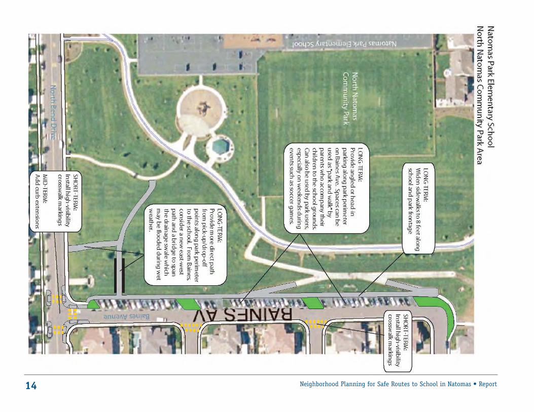
■ North Natomas Community ParkAs noted earlier, there is some pick-up anddrop-off activity along the park frontage, primarily along North Bend Drive. However,these areas are underused in spite of the factthat the park perimeter provides substantialopen curb area that could be used for pick-up
and drop off, and that these areas are not farfrom the school playground where childrenline up in the morning.
For the short-term, it is recommended thatthe school encourage greater use of the curb-side areas of North Bend Drive and BainesAvenue along the park frontage for pick-upand drop-off. This could be accomplishedwith signage designating these areas as official pick-up/drop-off locations.
The school should also consider having astaff monitor at the park, so that parents will be comfortable letting their childrenwalk through the park area to the schoolplayground.
In the long term, the park frontage areaalong Baines Avenue appears to be a suitable location for installing a row of angled orhead-in parking spaces. Given the width ofthe roadway, installing these spaces could beaccomplished with little encroachment intothe park area. These spaces could be used as a park-and-walk area during the dropoff/pick-up period. During other hours, they could be used by park users.
From both North Bend Drive and BainesAvenue, more direct pathways from thesoutheast corner of the park are needed.
The school should encouragegreater use of the curbsideareas of North Bend Drive and Baines Avenue along
the park frontage for pick-up and drop-off.
If these areas are to be encouraged as park-and-walk or alternate drop-off locations,clear direct pathways toward the backentrance gate are needed.
Currently, students being dropped off alongNorth Bend Drive must walk across the grass to have a direct path to the school. During winter months when the grass is wet this isundesirable. Furthermore, in the far southeastcorner there is a large drainage swale thatbecomes inundated during wet weather. Inaddition to providing new pathways, it may be necessary to construct a bridge to span this swale.
■ Bannon Creek Drive/Azevedo Drive The Bannon/Azevedo intersection is an all-way, stop-controlled T-intersection, whichcurrently lacks a crosswalk on the south leg.In the short term, this leg should be stripedwith a new crosswalk, and high-visibility(triple-four) crosswalk striping should beinstalled on all legs. Advance stop lines shouldalso be painted to ensure motorists stop backan appropriate distance from the crosswalk.
In the mid-term, curb extensions should beinstalled at this intersection to shorten thecrossing distance, improve visibility forpedestrians, and slow turning speeds.
In future planning efforts, the City shouldconsider this location for a formal roundabout(in lieu of signalization). No sidewalk extendsfrom this intersection to West El Camino(although there is a parallel pathway nearby).It is recommended that a formal sidewalk beinstalled to fill this gap. Providing a sidewalkwould help to encourage the use of this loca-tion as an alternate pick-up/drop-off site forthe school and for users of the greenway.
■ Bannon Creek Trail The Bannon Creek Trail crossing of BannonCreek Drive currently has no marked crossing.In the short-term, this location should bestriped with a high-visibility (triple-four)school crosswalk. Also in the short term, vegetation located east of the trail should betrimmed to ensure good sight distance forboth motorists and trail users.
16 Neighborhood Planning for Safe Routes to School in Natomas • Report
BANNON CREEK ELEMENTARY
17Neighborhood Planning for Safe Routes to School in Natomas • Report
18 Neighborhood Planning for Safe Routes to School in Natomas • Report
19Neighborhood Planning for Safe Routes to School in Natomas • Report
In the mid-term, a raised crosswalk is recom-mended in this location, so that motoristspeeds are slowed even more at the crossinglocation. The adjacent speed undulationshould be removed when a raised crosswalk is installed. Given the heavy use of this trailas a recreational facility and a school bike/pedestrian route, the City should considerwidening the trail to 12 feet.
■ Bannon Creek Parking LotWithin the school parking lot, in the short-term, the school should continue to implementthe current multi-lane queuing procedure tomaximize the available space for vehicles inthe parking area. It is important for theschool to have continued staff presence during pick-up/drop off to ensure that load-ing and unloading is done as efficiently aspossible. In the mid-term, it is recommended
that both existing school driveways be narrowed to single one-way lanes, with thenorthern driveway designated as ENTER ONLYand the southern driveway as EXIT ONLY. The use of the existing southern overflowparking lot should also be encouraged as apark-and-walk location, for parents who wantto park their vehicle and accompany theirchild to or from the school. Establishing thisas a park-and-walk area frees up curbsidespace for other parents who just want toquickly load/unload.
street for loading/unloading. No private vehicleswould be allowed in the bus pull-out.
■ Bannon Creek Drive/Millcreek Drive
At the intersections along Bannon CreekDrive and Millcreek Drive, all intersectionsshould be striped with high visibility triplefour crosswalk striping in the short term. In the mid-term, curb extensions should beinstalled at these locations to reduce thecrossing distance, improve visibility forpedestrians, and slow turning speeds.
vehicles for loading/unloading. Having privatevehicles block the bus zone can cause delaysto the buses entering or exiting the zone. Toemphasize that this area is only for buses,large BUS ONLY, NO PARKING signs should beerected. The school may also want to workwith the City to implement a painted pave-ment treatment in this area with large, BUSONLY stencils to emphasize this. In the mid-term, an off-street bus pull-out should beinstalled so buses can pull completely off the
To further facilitate the use of the southernlot as a park-and-walk location, and permitanother exit location, it is recommended thata new EXIT ONLY driveway be constructed atthe far south end of the parking lot.
■ Bannon Creek Drive Bus AreaThe existing bus loading zone along BannonCreek Drive was observed being used by private
20 Neighborhood Planning for Safe Routes to School in Natomas • Report
21Neighborhood Planning for Safe Routes to School in Natomas • Report
JEFFERSON ELEMENTARY
■ Pebblewood Drive /Azevedo DriveThe Pebblewood/Azevedo intersection is anall-way, stop controlled T-intersection whichcurrently lacks a crosswalk on the north leg.In the short-term, it is recommended thatthis intersection leg be striped with a newcrosswalk, as this is the logical crossing loca-tion for many children walking from the westside of Azevedo Drive (using the crosswalk onthe south leg requires children to then crossto the north side of Pebblewood Drive to getto the school, putting them in potential con-flict with the high volumes of left-turningvehicles coming off Azevedo Drive).
It is important to note that there are somepotential difficulties with simply repainting acrosswalk across the northern leg at Azevedo/Pebblewood.
The proper crosswalk alignment is directly inline with a residential driveway pad on thewest side of Azevedo Drive. It appears thatthe location of this driveway may have beenthe reason the northern crosswalk was origi-nally removed from this interesection (theold crosswalk stripes have been ground outbut their presence is still visible).
This portion of the driveway does not appearto be part of the original two-car drivewaydeveloped when the house was built, but infact it appears that the concrete pad that was added onto the original driveway.
Because of the rolled curbs along AzevedoDrive, there are no curb cuts to define indi-
vidual driveway limit, and a resident whowidens their driveway pad can effectively rollin and out of the driveway at any point alongtheir property.
The legality of this driveway widening is notclear; further investigation is needed to seewhether this driveway widening violated thecity zoning standards on the amount ofpaved driveway coverage allowable on a single-family residential lot. Regardless, the drivewaywidening did occur and with vehicles pullingin and out of the crosswalk area, at somepoint the crosswalk was removed.
Remedying this situation would require con-structing a formal curb cut in the location ofthe existing driveway prior to restriping thecrosswalk to prevent the residents frompulling in and out of the crosswalk area.
Because there would also need to be an ADAaccessible curb ramp installed, the entire cross-walk would need to be shifted slightly to thenorth of its former alignment. Under this scenario, the owners of the residence wouldhave a formal driveway cut along the widthof their original two-car driveway pad.
Also in the short-term, the remaining legs of the intersection should be marked withhigh-visibility (triple-four) crosswalk striping.Advance stop lines should also be painted to ensure motorists stop back an appropriatedistance from the crosswalk.
In the mid-term, curb extensions should beinstalled at this intersection to shorten thecrossing distance, improve visibility, and slowturning speeds. As with the crosswalk striping
discussed above, installing a curb extensionat the west end of the northern leg wouldhave challenges related to the location of theresidential driveway in relation to the cross-walk landing. It appears that by moving theentire crosswalk slightly to the north, and bylimiting the residential driveway access onlyto the width of the original two-car drivewaypad, a curb extension with ADA curb rampcould be installed in this location.
In future planning efforts, the City shouldconsider this location for a formal roundabout(in lieu of signalization).
■ Bannon Creek Trail/PebblewoodCurrently, there is no marked crosswalk atthe direct crossing of the trail acrossPebblewood Drive; instead a crosswalk hasbeen striped at the nearby intersection ofPebblewood/Rollingbrook. However, duringfield observations, no trail users were seenusing the marked crosswalk; they all crosseddirectly at the trail crossing.
This location also appears to provide thegreatest visibility for both motorists and trail users. Given this, in the short-term, it isrecommended that the marked crosswalk bemoved to the actual trail alignment location.The City should also trim vegetation awayfrom the trail crossing, particularly to theeast, to ensure adequate sight visibility forusers and motorists.
In the mid-term, it is recommended that araised crosswalk be installed. This raisedcrossing would provide the maximum slowingof vehicle speeds at the crossing.
22 Neighborhood Planning for Safe Routes to School in Natomas • Report
23Neighborhood Planning for Safe Routes to School in Natomas • Report
24 Neighborhood Planning for Safe Routes to School in Natomas • Report
■ Pebblewood Drive S-CurveAn excess of pavement width at the Pebble-wood Drive S-curve facilitates high-speed turning movements. This is a critical areaadjacent to the school and a major trail crossing, and efforts should be made to slow travel speeds through these corners.
It is recommended that the curves be reducedin two ways: in the eastbound direction, theexcess pavement could be incorporated intothe greenway area and landscaped. In thewestbound direction, a median could be constructed to provide a separate pick-up/drop-off lane along the school curb frontage.
This area is already used as a drop-off zone;putting in the median would help to formalizethis area and keep pick-up/drop-off activitiesseparate from the regular traffic.
A median should also be installed throughthe northern curve, approaching the trail, tonarrow the travel lanes and slow vehicles asthey approach the curve.
■ Jefferson School Parking LotIn the short term, the school should continueto use cones to narrow the driveway entrancesand force an ENTER ONLY on the east andEXIT ONLY on the west. In the mid-term, thedriveway should be physically narrowed tothis configuration.
The eastern part of the parking lot is alsocurrently underutilized. This area should belandscaped and trees planted, and staffencouraged to park in these spaces. This
would allow the school to remove the currentrow of parking spaces along the playgroundfrontage. By removing the spaces along theplayground, this area could be converted to a curbside pick-up/drop-off lane, and amulti-lane queuing procedure could be putinto effect.
■ Pebblewood, Lemitar and Cloudview
At the intersections along Pebblewood,Lemitar and Cloudview, all intersectionsshould be striped with high-visibility, triplefour crosswalk in the short term. In the mid-term, curb extensions should be installed at these locations to reduce the crossing distance, improve visibility for pedestrians,and slow turning speeds.
■ Cloudview Drive Entrance GateThe school’s back entrance gate on CloudviewDrive is situated next to a large trash dumpster– which does not provide for an aestheticgateway. The school should relocate thedumpster to another location and improvethe aesthetics of this gate to encourage moreparents to use it as a drop-off/pick-up areaand take pressure off the main parking area.
■ Cloudview Drive Bus Area The existing bus loading zone along CloudviewDrive was observed being used by privatevehicles for loading/unloading. Having privatevehicles block the bus zone can cause delaysto buses entering or exiting the zone. To
emphasize that this area is only for buses,large BUS ONLY, NO PARKING signs should beerected.
The school may also want to work with theCity to implement a painted pavement treatment in this area with large, BUS ONLYstencils to emphasize this.
In the mid-term, an off-street bus pull-outshould be installed so that buses can pullcompletely off the street for loading/unloading. No private vehicles would beallowed in the bus pull-out.
■ Cloudview at Jefferson ParkTo promote additional pick-up/drop-off at theschool’s Cloudview gate, it is recommendedthat a bay of angled parking spaces be con-structed along Cloudview Drive on the parkproperty. This would require a minimalencroachment into the park land. These spacesare intended to be used primarily by the pre-school parents in the morning who walk theirchildren to class; during non-school hours,they could also be used by park visitors.
Speed around curves can bereduced by turning excesspavement into landscapedgreenway or by installing
a median to provide a separate lane for picking up
and dropping off children.
25Neighborhood Planning for Safe Routes to School in Natomas • Report
26 Neighborhood Planning for Safe Routes to School in Natomas • Report
27Neighborhood Planning for Safe Routes to School in Natomas • Report
■ Parkway MaintenanceDuring the charrette process, a number ofusers of the Bannon Creek parkway trailnoted that the entire parkway lacked mainte-nance. The need for trash clearing and brushremoval were two common complaints.
Particularly near the roadway crossings,ensuring vegetation trimming and brushremoval is important to ensure clear sightlines and visibility. It is recommended thatthe City Parks and Recreation Departmentundertake a more regular maintenance program along the parkway.
■ Parkway Trail WidthGiven the heavy use of this trail as a recre-ational facility and a school bike/pedestrianroute, the City should consider widening itto 12 feet.
■ SignageAnother common comment noted during thecharrette was the lack of any signage alongthe parkway, and the potential confusion due to multiple trail junctions. In some cases,the trail splits without any clear signage indicating which direction is the through-
route; in other areas, trail users were notsure where they were in relation to the local roadway network because local streetjunctions were not signed.
It is recommended that the City implement asignage program indicating the direction ofthe continuous through-route at trail spurs,and also indicate street names where the trail connects out to the street network.
■ Cedro Circle and Delgado WayThe Bannon Creek Trail currently diverts to a short segment of on-street Class III bikeroute at Cedro Circle/Delgado Way. At thislocation, trail users suddenly go from a two-way, off-street facility, to a shared roadwaysituation. In this situation, southbound userswho remain along the east side of the roadare riding against traffic.
It is recommended that the City convert aportion of the roadway right-of-way to a two-way Class I trail configuration to providecontinuity to the bike path facility.
As a mid-term recommendation, concretedividers could be placed along the easternside of the road to create a separated 10-footwide, two-way bike path. In the long-term,this could be developed as a formal Class Ipath segment with a minimum 5-foot separation from the roadway lane.
BANNON CREEK PARKWAY TRAIL
Particularly near streetcrossings, ensuring
vegetation trimming and brush removal is important to ensure
clear sight lines and visibility.
28 Neighborhood Planning for Safe Routes to School in Natomas • Report
Implementation
An important step in the successful imple-mentation of these recommendations is tohave each stakeholder group – City, school district, school, parents, students, neighbors –prioritize the improvements to address theirspecific concerns. Considering that the priorities of one group may not match thoseof another, it is important for the differentstakeholders to meet and discuss the issuesin order to reach effective and lasting solutions.
It is particularly important for the City andthe Natomas Unified School District to worktogether as the two groups that have thegreatest fiscal ability to make improvements.Working together, the stakeholders may be able to solve problems that could not beresolved separately.
Improvements can be considered short-term,medium-term and long-term. Short-termimprovements are usually problems that canbe handled at a relatively low cost or timecommitment. Long-time improvements maybe considered overly ambitious, but they are very important to prioritize and keep inmind, as opportunities to construct such projects do arise.
A group may also decide that an improvementlisted in this report as long-term may be socritical to safety that it must be completedsooner.
With the costs of the recommended improve-ments as a whole likely to exceed availablefunds, it is important that the parties pursuediverse sources of money. Appendix B providesa list of potential opportunities, includingfederal grants, state programs, school bondsand other resources.
The priorities of one groupmay not match those of
another, so it’s important forthe different stakeholders tomeet and discuss the issues.
Appendix A. Recommendation Matrix
Natomas Area Safe Routes to School CharretteOctober 20-25, 2005
■ Summary of Recommendations
POLICY AND PROGRAM RECOMMENDATIONSThese recommendations are overall policy or program recommendations that apply to all school areas.
29Neighborhood Planning for Safe Routes to School in Natomas • Report
Policy/Program Recommendation Responsibility
School District Safety Task Force Continue existing District-level safety task force to discuss issues of Districtwide concern. School District
School-Based Safety Task Force Recommend forming a school-based Safety Task Force at each school to discuss issues of school area Schoolconcern. It is recommended that each Task Force involve as many community stakeholders as possible. These may include:• School Administration/Teachers• Parents• Neighbors• Law Enforcement • Elected official representative (e.g., councilmembers’ staff)• City transportation department representative
Double Fine Zone In California, three counties (Alameda, Santa Barbara and Ventura) are currently within a Double State Legislature;Fine Zone trial program established by AB 1886. Recommend Sacramento County join Double (County and City ofFine Zone program. Additional fine revenues put toward funding traffic safety, bicycle and Sacramento andpedestrian education programs at schools. Expanding the program to Sacramento County School Districtwould require legislative action. could send letters to
state legislators to recommend program)
Crosswalk Striping in School Zone Establish City transportation department policy that all intersection crossings (including minor Cityside streets) within the established school zone should be marked with a school crosswalk.
High-Visibility Crosswalks Establish City transportation department policy that all crosswalk markings within the school Citywithin School Zone zone should be a high-visibility striping pattern.
30 Neighborhood Planning for Safe Routes to School in Natomas • Report
POLICY AND PROGRAM RECOMMENDATIONS
Policy/Program Recommendation Responsibility
Alternate School Access Locations Permit pedestrian and bicycle ingress/egress from back gates during morning and afternoon hours. School District, Schoolfor Pedestrians and Bicyclists Continue to lock gates during school hours for security. At school district level, ensure that plans for
future new school construction provide for alternative exit entry points and connections into the surrounding neighborhood to encourage walking/bicycling and take pressure off main drop-off/pick-up area at front of school.
School Area Law Enforcement Increased visible enforcement of traffic violations during school drop-off and pick-up periods, and Police Departmentperiodic events such as Pedestrian Stings.
On-Site Staffing Visibility Ensure that school staff (or parent volunteers) assigned to monitor drop-off/pick-up period are Schoolvisible to parents and others. Provide staff with yellow vests, caps or other visible clothing to indicate that they are official pick-up/drop-off monitors.
Crossing Guards – In California, cities and counties may designate local law enforcement agencies, the governing City, School District, Responsibility board of any school district or a county superintendent of schools to recruit and assign adult or Police Department
crossing guards to intersections that meet approved guidelines for adult supervision.
Crossing Guard Program – An adult crossing guard program can be managed and funded in several ways. These include: City, Police Department, Management and Funding • City’s Police Department School District
• City’s Transportation Department• School DistrictFor comparison, most school crossing guard programs in other areas of the U.S. are managed and funded through the local police department.
Crossing Guards – Crossing guards available through existing “Kids X-ing”program within City Department of Parks and School DistrictExisting Program Recreation. The program provides trained adult crossing guards. Funding must be provided by the
School District. The cost for a crossing guard is approximately $8,000-12,000 per year.
Crossing Guards – Use of One method of funding school crossing guards is through the use of fines and forfeitures received Police DepartmentVehicle Fines for Funding under the Penal Code, defined in CVC Sections 42200 and 42201. Fines and forfeitures received by
cities and deposited into a "Traffic Safety Fund" may be used to pay the compensation of school crossing guards who are not regular full-time members of the city’s police department.
Crossing Guards – Alternate Consider funding crossing guards through a partnership of Police, City and School District. A portion School District, City, Funding through Partnership of funding could also be provided through local donations. The City of Santa Cruz funds crossing guards Police Department
through a four-way partnership, with funding and operational support from both the City and School District, additional funding from private sources and volunteer assistance from the community.
Crossing Guards – Volunteers If funding for paid adult crossing guards cannot be obtained, use of volunteers may be an option. School District, The school district should ensure that volunteer crossing guards are covered by insurance and receive Police Departmentbasic traffic-safety training from the police department.
31Neighborhood Planning for Safe Routes to School in Natomas • Report
POLICY AND PROGRAM RECOMMENDATIONS
Policy/Program Recommendation Responsibility
School Safety Patrols Student Safety Patrols can be authorized by the local school board. School authorities shall be School Districtresponsible for organizing, instructing and supervising patrols with the assistance of the local police. The California Education Code, Sections 49300 to 49307, and the California Code of Regulations, Sections 570 to 576 and 632, authorize the development of School Safety Patrols and outline rules for implementing these programs within the state. The MUTCD contains specific guidance on the use of School Safety Patrols. In general, a student patrol may be established at locations where an existing traffic control device, police officer or adult crossing guard is in operation. They may also be used where there are adequate crossing gaps in vehicular flow at an uncontrolled crossing and it is desirableto use student patrols to guide the school pedestrians.
Traffic Tamers Continue existing and successful Traffic Tamers program at Bannon Creek Elementary School. School, School DistrictContinue expanding this student-based program to other schools in this Natomas area.
Walking School Bus Continue existing and successful Natomas Park Walking School Bus program. Encourage school and School, School Districtschool district support of this program through official announcements, backpack mail and assistance with matching potential student walkers with parent “bus driver” leaders.
Educational and Encouragement A variety of educational/encouragement programs exist that could be implemented by individual School, School DistrictPrograms schools or at the School District level. These include basic pedestrian and bicyclist safety education,
as well as incentive programs to reward students who walk or bicycle to school, contests to see which classroom can have the highest walking/biking participation, etc. Refer to existing guidebooks such as the National Highway Traffic Safety Administration (NHTSA) Safe Routes to School Toolkit, or the State of Maryland’s Safe Routes to School Guidebook for details and additional resources.
ENGINEERING RECOMMENDATIONS
The following lists site-specific engineering recommendations, listed by school. For each school, recommendations are further broken into Short-, Mid- and Long-Term, based on factors such as relative cost, need to conduct future traffic and engineering studies, and political feasibility.
NATOMAS PARK ELEMENTARY SCHOOL
Location Recommendation Responsibility
■ Short-TermGateway Park between Restripe roadway to provide a 6-foot bike lane and 10-foot travel lane in both directions. CityDel Paso and North Bend
North Bend/Gateway Park High-visibility crosswalk striping on all legs. City
North Bend at Replace existing “Trail Crossing” striping pattern with standard High Visibility Yellow Canal Trail Crossing School Crossing marking; install In-Street Yield to Pedestrian sign (MUTCD R1-6). City
Crest/Fenmore In-Street Yield to Pedestrian sign at existing uncontrolled crosswalk (MUTCD R1-6). CityCurb ramp needed on school side of crosswalk.
Crest/Ives In-Street Yield to Pedestrian paddle at existing uncontrolled crosswalk. City
Curb ramp needed on school side of crosswalk.
Crest/North Bend High-visibility crosswalk striping across north leg of intersection CityCurb ramp needed on west leg (south end).
School Bus Loading area/ Crosswalk/curb ramps across service driveway to provide a clearly marked route from Schoolservice driveway City terminus of the park pathway across to the bike rack location.
North Bend/Baines Signs to designate the curb areas along park as official pick-up/drop off sites. City/SchoolConsider having school staff at these locations to further encourage parents to usethese locations and to ensure that their children will be monitored as they walk through the park to the school playground.
School Parking Lot Use cones/paint to conduct a double row drop-off/pick-up procedure. Provide adequate Schoolsupervision by school staff to ensure safe and efficient unloading/loading of children. Older-grade children could participate, helping to open car doors to load/unload children.
School Parking Lot Use cones to narrow driveway entrances during pick-up/drop off to provide for IN ONLY on Schoolsouth driveway and OUT ONLY on north driveway.
32 Neighborhood Planning for Safe Routes to School in Natomas • Report
33Neighborhood Planning for Safe Routes to School in Natomas • Report
ENGINEERING RECOMMENDATIONS – NATOMAS PARK ELEMENTARY SCHOOL
Location Recommendation Responsibility
■ Mid-TermNorth Bend/Gateway Park Reduce school driveway width so that crosswalk does not align with driveway. School
Curb extensions.
School Parking Lot Reconfigure to IN ONLY on south driveway and OUT ONLY on north driveway; Schoolconsider making exit driveway a right turn only.
Crest/North Bend Curb extensions. City
Crest/Ives Curb extensions. City
Crest/Fenmore Curb extensions. City
■ Long-TermBaines along Park Boundary Provide angled or head-in parking spaces along the park boundary. This would be intended to serve City
as a park-and-walk area during the drop-off and pick-up period. During other hours, these spaces could be used by park users.
North Natomas Community Park Provide more direct paved path access from logical drop-off/pick-up points along park perimeter Cityinto school. Along North Bend Drive, a more direct diagonal path is from the northwest direction connecting from the curb area to the school’s rear playground gate. From Baines, study a more direct east-west path, as well as a potential bridge structure to span the drainage swale along the park’s east side. These would help facilitate the use of the Baines curb area as a park-and-walk location.
North Natomas Community Future park development along this linear park corridor should include paved pathways that CityPark Future Parcels provide a direct, non-meandering route through the park and toward the school for use by
bicyclists and pedestrians.
North Bend at Construct landscaped median refuge island at crossing to increase visibility and provide City Canal Trail Crossing refuge point at this uncontrolled mid-block location.
School Frontage Widen sidewalks to 8 feet along entire school frontage. City/School
34 Neighborhood Planning for Safe Routes to School in Natomas • Report
ENGINEERING RECOMMENDATIONS – BANNON CREEK ELEMENTARY SCHOOL
Location Recommendation Responsibility■ Short-TermSchool Parking Lot Continue multi-lane queuing procedure already in place. Ensuring school-staff presence School
before and after school will make drop-off and pick-up period more efficient.
Bannon/Azevedo New crosswalk on south leg. City
High-visibility crosswalk striping on all legs.
Advance limit lines on all legs.
Bannon Creek at Trail New high-visibility school crosswalk at trail crossing. City
Install In-Pavement Yield to Pedestrian sign (MUTCD R1-6).
Bannon Creek at Trail Trim vegetation away from crossing location to ensure clear sight distance, Cityparticularly on south side of Bannon Creek immediately west of the trail crossing.
Bannon Creek/Millcreek High-visibility crosswalk striping at all legs. City
Bannon Creek in front of bus zone Pavement coloring to emphasize BUS ZONE NO PARKING. City
Millcreek/River City High-visibility crosswalks at all legs. City
■ Mid-TermBannon Creek/Azevedo Curb extensions, median refuge islands. City
Bannon Creek/Azevedo Extend sidewalk along Azevedo Drive from Bannon Drive to West El Camino. City
Bannon Creek/Azevedo In future planning efforts (such as updates to the Azevedo Master Plan), or citywide signalization Citypriority lists, consider intersection of Pebblewood/Azevedo for a roundabout instead of traffic signal.
Bannon Creek at Trail Crossing Replace speed undulation with raised crosswalk. City
Remove speed undulation.
Bannon Creek Trail Widen trail to 12 feet. City
Bannon Creek/Millcreek Curb extensions at all legs. City
Millcreek/River City Curb extensions at all legs. City
Bannon Creek Parking Lot Install new EXIT ONLY driveway at south end of overflow parking lot. School
Bannon Creek Parking Lot Narrow parking lot driveways; make north driveway ENTER ONLY and south driveway EXIT ONLY. School
Bannon Creek at bus zone Construct off-street bus pullout on school property. School
■ Long-TermBannon/Azevedo Construct roundabout. City
School Frontage Widen sidewalks to 8 feet along entire school frontage. City/School
35Neighborhood Planning for Safe Routes to School in Natomas • Report
ENGINEERING RECOMMENDATIONS – JEFFERSON ELEMENTARY SCHOOL
Location Recommendation Responsibility■ Short-TermPebblewood/Trail Crossing Remove crosswalk in current location; construct high-visibility crosswalk at actual trail City
crossing location.
Install In-Pavement Yield to Pedestrian sign (MUTCD R1-6).
Pebblewood/Trail Crossing Trim vegetation away from trail crossing, particularly to the east of the crossing on Cityboth sides of Pebblewood.
Pebblewood/Lemitar High-visibility crosswalks all legs. City
Lemitar/Cloudview High-visibility crosswalk. City
School Parking Lot Use cones/paint to conduct a double row drop-off/pick-up procedure. Provide adequate Schoolsupervision by school staff to ensure safe and efficient unloading/loading of children. Older-grade children could participate, helping to open car doors to load/unload children.
School Parking Lot Use cones to narrow driveway entrances during pick-up/drop off to provide for IN ONLY Schoolon south driveway and OUT ONLY on north driveway.
Pebblewood/Azevedo Re-paint crosswalk on north leg of intersection; high-visibility crosswalks for all legs; Cityadvance limit lines on all legs.
■ Mid-TermJefferson Parking lot Remove angled parking along playground frontage to provide curb area for drop-off/pick-up. School
Jefferson Parking Lot Install landscaping islands and plant trees in east (overflow) parking area to improve aesthetics, Schoolprovide shade, and encourage use of these spaces by school staff.
Jefferson Parking Lot Reduce east driveway width, designate as ENTER ONLY. School
Jefferson Parking Lot Reduce west driveway width, designate as EXIT ONLY. School
Pebblewood at S-curve Reduce width/radius of southern curve by extending curb area and landscaping. CityContinue to maintain driveway access to residence located along corner.
Pebblewood at S-curve Construct raised island to provide separate drop-off/pick-up area along northern curve. CitySign "NO PARKING DURING, LOADING ONLY" to ensure that no long-term or unattended parking occurs along this curb area.
Pebblewood at Trail Crossing Raised crosswalk. City
Pebblewood/Lemitar Curb extensions. City
Cloudview/Lemitar Curb extensions. City
School Back Entrance Gate Improve aesthetics near dumpster and loading areas to encourage use of this as an official school Schoolentrance/exit during the drop-off/pick-up periods.
Cloudview Bus Area Construct off-street bus pullout area. School
ENGINEERING RECOMMENDATIONS – JEFFERSON ELEMENTARY SCHOOL
Location Recommendation Responsibility
■ Mid-Term [cont’d.]Pebblewood/Azevedo Curb extensions, median islands. City
Pebblewood/Azevedo In future planning efforts (such as updates to the Azevedo Master Plan), or citywide Citysignalization priority lists, consider intersection of Pebblewood/Azevedo for a roundabout instead of traffic signal.
■ Long-TermCloudview near park Provide new angled parking spaces for use by pre-school and for park use. City
School Frontage Widen sidewalks to 8 feet along entire school frontage. City/School
Pebblewood/Azevedo Construct roundabout. City
ENGINEERING RECOMMENDATIONS – BANNON CREEK PARKWAY TRAILLocation Recommendation Responsibility
■ Short-Term Entire Parkway Improved maintenance, brush clearing, particularly near roadway crossings. City
Entire Parkway Signage program – signage indicating direction of continuous through-route at trail spurs Cityor locations where trail diverts briefly on-street; also signage indicating street names wheretrail connects out to neighborhood street network.
■ Mid-Term Cedro Circle, Delgado Way At the location where trail diverts on-street to Cedro Circle and Delgado Way – consider converting City
a portion of the roadway right-of-way to a two-way Class I trail configuration to provide continuity to the bike path facility. As a mid-term recommendation, concrete dividers could be placed along the eastern side of the road to create a separated 10-foot wide, two-way bike path.
Picnic Area Ensure safe and direct pathway connections from Azevedo Drive through picnic toward school Cityback entrance gates. This will provide an alternate drop-off location along Azevedo Drive.
■ Long-Term Entire Parkway Widen trail to 12 feet. City
Cedro Circle, Delgado Way At location where trail diverts on-street to Cedro Circle and Delgado Way – consider converting a Cityportion of the roadway right-of-way to a two-way Class I trail configuration to provide continuity to the bike path facility. As a long-term recommendation, construct separated Class I path with minimum 5-foot, landscaped separation from roadway lanes.
36 Neighborhood Planning for Safe Routes to School in Natomas • Report
37Neighborhood Planning for Safe Routes to School in Natomas • Report
There are a number of funding sources toexplore for school improvements, communityfacilities, and other infrastructure needs inNatomas. This list is not meant to be all-inclusive but rather a selection of fundingsources that show the variety of opportunitiesin Sacramento.
SCHOOL FUNDING
■ School BondsIn addition to providing money to build newschools, school district bond funds may alsobe used to build new infrastructure at existingschools. Including the latter can be a way toenhance a bond so that voters in establishedschool areas are more like to support it. InCalifornia, voters approved an initiative toallow a 55%-majority vote for approval oflocal school bonds.
■ Parcel TaxesLocal parcel taxes provide a way to providesecure, enhanced funding for soft costs,including materials and supplies, school programs, and crossing guard salaries. A parcel tax is a qualified special tax that inCalifornia requires a 55%-majority vote foradoption.
CITY FUNDING
■ Sacramento’s Neighborhood Traffic Management Plan
This program provides education, engineeringand enforcement to improve neighborhoodlivability in Sacramento. The process providesneighborhoods with resources to manage traffic concerns on residential streets. Thegoal is to calm traffic, allowing children andfamilies to feel more secure in their ownneighborhood.
STATE FUNDING
■ California Safe Routes to SchoolEstablished in 1999, the Safe Routes toSchool program makes grants availablethrough the California Department ofTransportation to local government agenciesbased upon the results of a statewide compe-tition. The program’s goal is to reduceinjuries and fatalities to school children andencourage increased walking and bicyclingamong students. It does this primarily byconstructing facilities that enhance safety for pedestrians and bicyclists. The program is scheduled to sunset on January 1, 2008.The California program was the basis for therecently enacted federal Safe Routes toSchools program.
FEDERAL FUNDING
■ SAFETEA-LUThe Safe, Accountable, Flexible, EfficientTransportation Equity Act – A Legacy forUsers (SAFETEA-LU) was passed in 2005.SAFETEA-LU authorizes $286.5 billion overthe next five years (2005-09) for bike andpedestrian safety programs and providesfunding for a National Safe Routes to Schools program.
At the time of this writing, the CaliforniaDepartment of Transportation is determiningguidelines for the program. The approximatefunding amounts available to California are:
■ $11 million for 2005-06■ $15 million for 2006-07■ $19 million for 2007-08■ $23 million for 2008-09
The money can be used for infrastructure,including planning, design and constructionof projects related to improving the ability of students to walk and bike to school. Thisincludes sidewalk improvements, traffic calming and speed-reduction improvements,pedestrian and bicycle crossing improvements,on-street bicycle facilities, off-street bicycleand pedestrian facilities, secure bike parkingand traffic diversion improvements withinapproximately two miles of schools.
Appendix B. Funding Opportunities
The project aims to address pedestrian andbicyle safety issues in Natomas, a rapidlygrowing community within the city ofSacramento. This report focuses on the neighborhoods around three schools in the
Natomas Unified School District – NatomasPark Elementary in North Natomas, andJefferson Elementary and Bannon CreekElementary Schools in South Natomas.
Not less than 10% and not more than 30% of the funds will be used on programs oractivities that encourage walking and bicy-cling to school. These could include publicawareness campaigns and outreach to pressand community leaders, traffic education and enforcement in the vicinity of schools,student sessions on bicycle and pedestriansafety, health and environment, and training,volunteers and managers of safe routes toschool programs.
OTHER FUNDING OPPORTUNITIESThe National Highway Traffic SafetyAdministration web site (www.nhtsa.gov) has a very informative list of safe routes toschools related funding resources, including:
■ Capital funding■ Transportation enhancements■ Metropolitan Planning Organizations
(MPOs)■ Local county and city funding■ Sales tax funding■ Program funding■ Corporations and businesses■ Foundations■ Individuals■ Events■ Parent Teacher Associations (PTAs)
and school districts■ City and county funds■ State Highway Safety Funds,
“402 Funds”
38 Neighborhood Planning for Safe Routes to School in Natomas • Report
Natomas ParkElementary
JeffersonElementary
Bannon CreekElementary
Appendix C. Natomas Area and School Maps
Natomas Park Elementary School Jefferson Elementary School
Bannon Creek Elementary School
39Neighborhood Planning for Safe Routes to School in Natomas • Report