NPS Form 10-900-b (Rev. 01/2009) OMB No. 1024-0018 (Expires 5/31/2012) United States Department of the Interior National Park Service National Register of Historic Places Multiple Property Documentation Form This form is used for documenting property groups relating to one or several historic contexts. See instructions in National Register Bulletin How to Complete the Multiple Property Documentation Form (formerly 16B). Complete each item by entering the requested information. For additional space, use continuation sheets (Form 10-900-a). Use a typewriter, word processor, or computer to complete all items XX New Submission Amended Submission A. Name of Multiple Property Listing Inland Swamp Rice Context, c. 1690-1783 B. Associated Historic Contexts Inland Swamp Rice Field Context, c. 1690-1783 (Berkeley, Charleston, Dorchester Counties) C. Form Prepared by name/title Andrew Agha, Charles F. Philips, Jr., Joshua Fletcher organization Brockington and Associates date 6 June 2011 street & number 498 Wando Park Blvd, Suite 700 telephone 843-881-3128 city or town Mt. Pleasant state SC zip code 29464 e-mail [email protected]; [email protected]; [email protected]D. Certification As the designated authority under the National Historic Preservation Act of 1966, as amended, I hereby certify that this documentation form meets the National Register documentation standards and sets forth requirements for the listing of related properties consistent with the National Register criteria. This submission meets the procedural and professional requirements set forth in 36 CFR 60 and the Secretary of the Interior’s Standards and Guidelines for Archeology and Historic Preservation. (_________ See continuation sheet for additional comments.) Signature and title of certifying official Date State or Federal Agency or Tribal government I hereby certify that this multiple property documentation form has been approved by the National Register as a basis for evaluating related properties for listing in the National Register. Signature of the Keeper Date of Action
Transcript
NPS Form 10-900-b (Rev. 01/2009) OMB No. 1024-0018 (Expires 5/31/2012) United States Department of the Interior National Park Service
National Register of Historic Places Multiple Property Documentation Form This form is used for documenting property groups relating to one or several historic contexts. See instructions in National Register Bulletin How to Complete the Multiple Property Documentation Form (formerly 16B). Complete each item by entering the requested information. For additional space, use continuation sheets (Form 10-900-a). Use a typewriter, word processor, or computer to complete all items XX New Submission Amended Submission A. Name of Multiple Property Listing
Inland Swamp Rice Context, c. 1690-1783
B. Associated Historic Contexts
Inland Swamp Rice Field Context, c. 1690-1783 (Berkeley, Charleston, Dorchester Counties)
C. Form Prepared by
name/title Andrew Agha, Charles F. Philips, Jr., Joshua Fletcher
organization Brockington and Associates date 6 June 2011
street & number 498 Wando Park Blvd, Suite 700 telephone 843-881-3128
D. Certification As the designated authority under the National Historic Preservation Act of 1966, as amended, I hereby certify that this documentation form meets the National Register documentation standards and sets forth requirements for the listing of related properties consistent with the National Register criteria. This submission meets the procedural and professional requirements set forth in 36 CFR 60 and the Secretary of the Interior’s Standards and Guidelines for Archeology and Historic Preservation. (_________ See continuation sheet for additional comments.)
Signature and title of certifying official Date
State or Federal Agency or Tribal government I hereby certify that this multiple property documentation form has been approved by the National Register as a basis for evaluating related properties for listing in the National Register.
Signature of the Keeper Date of Action
NPS Form 10-900-b (Rev. 01/2009) OMB No. 1024-0018 Name of Multiple Property Listing State Table of Contents for Written Narrative Provide the following information on continuation sheets. Cite the letter and title before each section of the narrative. Assign page numbers according to the instructions for continuation sheets in National Register Bulletin How to Complete the Multiple Property Documentation Form (formerly 16B). Fill in page numbers for each section in the space below. Page Numbers E. Statement of Historic Contexts (if more than one historic context is documented, present them in sequential order.)
1-29
F. Associated Property Types (Provide description, significance, and registration requirements.)
30-39
G. Geographical Data
40
H. Summary of Identification and Evaluation Methods (Discuss the methods used in developing the multiple property listing.)
41-44
I. Major Bibliographical References (List major written works and primary location of additional documentation: State Historic Preservation Office, other State agency, Federal agency, local government, university, or other, specifying repository.)
45-50
Appendix A. Figures
Appendix B. Evaluation Criteria
Appendix C. Paleoethnobotanical Results from 38CH2159 (Windsor Hill and Woodlands (Hasfort) Plantations
Paperwork Reduction Act Statement: This information is being collected for applications to the National Register of Historic Places to nominate properties for listing or determine eligibility for listing, to list properties, and to amend existing listings. Response to this request is required to obtain a benefit in accordance with the National Historic Preservation Act, as amended (16 U.S.C.460 et seq.). Estimated Burden Statement: Public reporting burden for this form is estimated to average 18 hours per response including time for reviewing instructions, gathering and maintaining data, and completing and reviewing the form. Direct comments regarding this burden estimate or any aspect of this form to the Chief, Administrative Services Division, National Park Service, PO Box 37127, Washington, DC 20013-7127; and the Office of Management and Budget, Paperwork Reductions Project (1024-0018), Washington, DC 20503.
NPS Form 10-900-a (Rev. 01/2009) OMB No. 1024-0018 (Expires 5/31/2012)
United States Department of the InteriorNational Park Service
National Register of Historic Places Continuation Sheet
Name of Property Inland Swamp Rice Context, c. 1690-1783
County and State Berkeley, Charleston, Dorchester Counties, South Carolina
Inland rice plantation complexes have been studied for decades throughout the South Carolina Lowcountry. However, the agricultural elements of these plantations have not been given the same attention as planter houses, slave villages, or kitchens. Historically, there have been accounts of rice growing in the Lowcountry in the late seventeenth and early eighteenth centuries, and even some allusion to how it is cultivated. No accounts accompany these descriptions of how the fields and their components appeared, how they were constructed, or who did the engineering. We do know that inland rice cultivation was an agricultural practice that was limited by the specific geographical needs required for the proper growth of the crop. Archaeologists have investigated these plantations for the last 30-plus years, excavating various parts of the settlement (i.e., planter house, slave village, barns, kitchens, carriage house, office, formal garden, and cooper/blacksmith shop). However, archaeologists largely have not devoted attention to the rice fields, neither through mapping nor exploratory excavation. Herein lies the essential problem this context addresses: that inland rice fields—the main reason for these plantations—are often ignored and not properly studied in the Carolina archaeological process. The importance of this process is intensified by the fact that the written narrative tells us so little of the long tale of early Carolina rice production.
This context will address inland rice fields by linking multiple layers of historical and recent data to learn how the layout(s) of inland rice fields correspond to the plantation complexes that formerly resided on the high ground nearby. This context will also display the results of our field mapping of select plantations. Mapping inland fields from several contemporary plantations provides a range of variability and commonality in field layout, design, and water control. This context will also provide a list of criteria that will allow researchers to, first, positively identify inland rice systems and, second, properly assess the eligibility of inland rice systems for inclusion on the National Register of Historic Places (NRHP). We believe that these fields are significant enough to stand alone as archaeological sites. This context will provide the evidence and criteria needed to determine what qualifies as an inland rice system and, further, if a field system should be designated as an archaeological resource eligible for the NRHP. Once this context is complete, researchers will be able to study inland rice systems, compare and compile their findings, and thereby increase our understanding of the early rice period of Carolina (circa 1690–1783).
Introduction
In recent years studies have abounded on South Carolina coastal rice plantations and their role in defining Colonial America (Berlin 1998; Clowse 1971; Coclanis 1989; Greene 1993; Littlefield 1991; McCusker and Menard 1985; Price 1984; Smith 2002; Trinkley et al. 2003; Wood 1974). However, a problem has developed. Whereas studies have focused on the introduction of large numbers of slaves, their lives, and their role in developing an opulent wealth culture in eighteenth-century South Carolina, little has been done with the primary means of wealth production-inland swamp rice production. As recently as 2003, archaeologist Michael Trinkley expressed concern when faced with the remains of inland rice embankments during an archaeological survey of Liberty Hall Plantation near Goose
NPS Form 10-900-a (Rev. 01/2009) OMB No. 1024-0018 (Expires 5/31/2012)
United States Department of the InteriorNational Park Service
National Register of Historic Places Continuation Sheet
Name of Property Inland Swamp Rice Context, c. 1690-1783
County and State Berkeley, Charleston, Dorchester Counties, South Carolina
Creek. He stated, “Representative of the process of hydraulic control used on eighteenth century interior swamp rice plantations, such dikes are common to the low country, although there has not been any detailed assessment of their research potential” (Trinkley et al. 2003:12). In the Liberty Hall Plantation report, the authors produced an excellent literary review of the early development of rice in South Carolina (Trinkley et al. 2003:13-41). Rather than duplicating the effort in this historical background, we refer the reader to this resource.
This context addresses the problematic issues that exist concerning the creation of inland rice culture in the Lowcountry of South Carolina. These issues are not resolved in historical studies or through archaeological inquiries. Since the historical narrative provides no exacting information about how fields were constructed or why and if designs were implemented, we believe that the methods and data collected during the preparation of this context statement should be utilized to further researchers’ understanding of inland rice culture. Our work demonstrates that a large amount of intact inland rice features of inland rice systems exist today. Our efforts also show how utilizing the historic record and maps, aerial photographs, and plats allows the researcher to understand how features present in the landscape relate to the larger rice systems that once existed. This context statement provides future researchers with the tools to properly assess inland rice features for the NRHP and will aid in the development and/or management of these potential resources. The following section details the strengths and weaknesses of the historical record, proving the need for archaeological examination.
Problems with inland rice
Closer examination of the historical record on rice cultivation and production in South Carolina reveals that tidal rice production did not make Charleston the opulent queen of the thirteen British American colonies (Edgar 1998:149-154; Meinig 1986:182-83; Taylor 2001:238-243). Nor was it tidal rice production that brought 70,000 enslaved Africans through the port at Charleston in the eighteenth century (Littlefield 1991; Wood 1974). Nineteenth-century narratives often confuse the more visible tidal method of producing rice with the earlier inland method. Clear delineation becomes murky in the narratives. In his 1972 study, geographer-historian Sam B. Hilliard summarized the problem (Hilliard 1972:98):
The most puzzling aspect of the entire Carolina rice complex is the apparent confusion between tidewater and inland swamp rice. Early sources rarely go into detail, and most secondary sources gloss over the early period and jump quickly into long descriptions of tidewater rice, which has received the greatest attention.
Michael Trinkley wrote that in spite of “considerable research into early rice cultivation, there are no accounts of rice technology dating from 1720 through 1760 that would help refine our understanding of inland swamp cultivation and water control” (Trinkley et al. 2003:19). Thus, researchers are left with commentaries by non-eyewitnesses who wrote many decades later.
NPS Form 10-900-a (Rev. 01/2009) OMB No. 1024-0018 (Expires 5/31/2012)
United States Department of the InteriorNational Park Service
National Register of Historic Places Continuation Sheet
Name of Property Inland Swamp Rice Context, c. 1690-1783
County and State Berkeley, Charleston, Dorchester Counties, South Carolina
This study may also contribute to the resolution of a conundrum that perplexes the historical community – the subject of African transference. Although traditional historians tend to give much of the credit for rice development to Europeans, in recent years historians have produced strong evidence for the African contribution in the development of the Carolina rice culture (for example see Peter Wood, Black Majority and Daniel Littlefield, Rice and Slaves). Converse Clowse (1971:126) presented the conventional wisdom regarding the introduction of the swamp field embanking system when he stated that “some imaginative planter” conceived the idea that the area between two high ridges could be dammed by piling up earth at either end and creating a wet rice field. Plantation historian Daniel Littlefield reminded us that Europeans understood that rice grew in flooded fields in the early seventeenth century. Littlefield (1991:104) quotes 1650s English pamphleteer Samuel Hartlib, who argued that since rice “groweth in the Fenny places of Milan, and why may it not grow in our Fens?” Littlefield (1991:104) goes on to note that though the knowledge may not have been widespread, it was “certainly sufficient to enable Englishmen” to cope with Carolina’s swamps.
However, this traditional view of European transference is challenged by a number of historians, notably by Judith Carney in her seminal work, Black Rice. Carney (2001:2) argues for “the primacy of African rice and skills in the crop’s development in the Americas,” and that “a knowledge system long practiced in West Africa was brought with slaves across the Atlantic.” Attempting to find some common ground, eminent historians including David Eltis, Philip Morgan and David Richardson point out that there is far more evidence that wet rice culture was the “creolization of peoples from four continents” (Eltis et al. 2007:23). To which Littlefield (1991:104) also observed that though Europeans may have understood inland swamp culture, the knowledge was not so widespread as to permit them to use the tides, implying potential African transference of later tidal rice production.
Michael Trinkley, as an archaeologist, believes that this argument has masked the real significant issues that need addressing such as, “the role of seed improvement and the role of mechanized processing” (Trinkley et al. 2003:95). All of these perspectives on the early development of wet rice culture in South Carolina merely point to the fact that historians and archaeologists have ignored a primary source of study. In the absence of sufficient archival evidence, a study of the only other remaining features, the physical remnants of the rice fields, may be able to reveal building methods and shed light on these greater debates.
Brief history of inland rice
The story of rice in Carolina dates from the earliest period of the colony when the Proprietors list it as one of the experimental crops. The crop had become established enough by 1694 that the Proprietors accepted it as a means of paying quit rents on the land (Salley 1913:5-6). Also in the 1690s, Scottish settler John Stewart noted that the rice in Carolina grew well in wetlands (Stewart 1931:16). In 1700, John Lawson (1967:81-82), while touring through the still young colony, noted that the rice of “Carolina being esteem’d the best that comes to that Quarter of the World…and thrives best in wild Land, that has never been broken up before.” In 1710, Thomas Nairne’s promotional pamphlet described the production further, writing that rice is “very much sow’d here, not only because it is a vendible Commodity, but thriving best in low moist Lands, it inclines People to improve that Sort of Ground” (Nairne 1710 in Greene 1989: 40).
NPS Form 10-900-a (Rev. 01/2009) OMB No. 1024-0018 (Expires 5/31/2012)
United States Department of the InteriorNational Park Service
National Register of Historic Places Continuation Sheet
Name of Property Inland Swamp Rice Context, c. 1690-1783
County and State Berkeley, Charleston, Dorchester Counties, South Carolina
In 1731 Mark Catesby published his study of the natural world in Carolina. In it, he noted that by the time he was in Carolina (1712-1730), the planters had mastered wet culture, observing that of the two “kinds” of rice, one could be grown “only in water” and the other grown “in wet and tolerably dry land” (Catesby 1731:152). He went on to note that the best rice was subject to water inundation for two months out of the year. However, the best early description of inland swamp rice comes from Governor James Glen’s summation of his years in Carolina (Glen 1761). Though Glen published his work in 1761, he based it upon his observations as Governor from 1743-1756. His comments are important, as they are the most frequently used primary source on the subject. He notes (Glen 1761:6-7):
The Country abounds every where with large Swamps, which, when cleared, opened, and sweetened by Culture, yield plentiful Crops of Rice: along the Banks of our Rivers and Creeks, there are also Swamps and Marshes, fit either for Rice, or, by the Hardness of their Bottoms, for Pasturage.
Dr. George Milligan-Johnston, a contemporary of Glen, wrote in 1763, that the swamps were the “Golden Mines of Carolina, from them all our Rice is produced, consequently they are the Source of infinite Wealth, and will always reward the industrious and persevering Planter” (Milligan-Johnston in Milling 1951:119, 135-36). Glen goes on to explain (Glen 1761:6),
The best land for Rice is a wet, deep, miry, Soil; such as is generally to be found in Cypress Swamps; or a black greasy Mould with a Clay Foundation; but the very best Lands may be meliorated by laying them under Water at proper Season.
William Bartram adds that, in his travels in the early 1770s, “I viewed with pleasure this gentleman’s exemplary improvements in agriculture: particularly in the growth of rice…which stands in the water almost from the time it is sown, until within a few days before it is reaped, when they draw off the water by sluices, which ripens it all at once” (Bartram 1792:11).
Unfortunately, little details about construction and hydrology appear in the eighteenth-century written record. Most modern writers draw upon Robert F. W. Allston’s papers, among which is a treatise he published in 1843 on the introduction and production of rice in Carolina. In it, Allston (1843:8) explains that early experimenters discovered that:
These low grounds being found to agree better with the plant, the inland swamps were cleared for the purpose of extending the culture. In the process of time as the fields became too grassy and stubborn, they were abandoned for new clearings; and so on until at length as discovered the superior adaptation of the tide-lands, and the great facilities for irrigation afforded by their location. For these, the inland plantations were gradually and slowly abandoned, until now, that the great body of land, which little more than a century ago furnished for exportation over 50,000 barrels of Rice, now lies utterly waste.
NPS Form 10-900-a (Rev. 01/2009) OMB No. 1024-0018 (Expires 5/31/2012)
United States Department of the InteriorNational Park Service
National Register of Historic Places Continuation Sheet
Name of Property Inland Swamp Rice Context, c. 1690-1783
County and State Berkeley, Charleston, Dorchester Counties, South Carolina
Duncan Heyward, one of the last commercial rice planters in South Carolina, explained in 1937 the process of using dams to embank and enclose the fields and stop waters from flooding the fields at undesirable seasons. Heyward (1937:11) stated that rice production in South Carolina can be divided into:
two fairly well defined periods…beginning in the latter part of the seventeenth century and continuing until the middle of the eighteenth, rice was grown on inland swamps. During the second period, beginning in the middle of the eighteenth century and continuing until the end of the industry…the planting of rice on inland swamps was gradually abandoned and its cultivation transferred to the extensive and thickly timbered swamps [and marshes] which bordered the fresh-water tidal rivers.
Though Allston and Heyward were experienced rice planters and both came from distinguished rice growing families, neither were writing from first hand experience; rather they described events that had occurred 50 to 100 years before their time. Edmund Ruffin pointed out that by the time of his tour of the coastal area of South Carolina in 1843, the inland swamp lands were long abandoned, observing that, “nearly all the inland swamp lands formerly were under it [rice culture]–but have been thrown out, & are now under water” (Ruffin 1843:64). The South Carolina Historical Society, the South Carolina Department of Archives and History, and the Charleston County Register of Mesne Conveyance Office, just to name three repositories, have numerous late-eighteenth-century plats that note “old rice fields” or “former rice fields” in lowlands and swamps that had grown up or been abandoned.
Summary
While the documents and accounts provide essential proof that rice was first cultivated in inland swamp settings, those authors do not provide the critical information needed to understand how fields were built, who decided on where the features (dams, ditches, etc.) were to be placed/positioned within the watershed, and where the technology came from (Africa, Europe, etc.). The historians interpreting the origins of rice culture in Carolina are also missing the “primary sources” needed to understand the whole story. Archaeologists have been studying inland rice plantations for several decades now and at best have been inconsistent in investigating the adjacent fields and associated features. Thus they have been deprived of an opportunity to learn more about the plantation system and its impact on the enslaved African labor force. The following section briefly describes several archaeological projects where investigators encountered inland rice features and attempted to define their relevance.
NPS Form 10-900-a (Rev. 01/2009) OMB No. 1024-0018 (Expires 5/31/2012)
United States Department of the InteriorNational Park Service
National Register of Historic Places Continuation Sheet
Name of Property Inland Swamp Rice Context, c. 1690-1783
County and State Berkeley, Charleston, Dorchester Counties, South Carolina
Previous Archaeological Investigations at Inland Rice Plantations
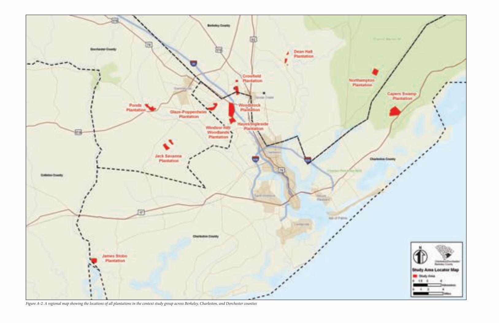
While settlements and slave villages have been excavated and studied for the last 30-plus years, archaeological investigations have focused almost exclusively on the terrestrial components of plantations. Terrestrial components include the settlements of the enslaved the planter, and the overseer; the work yard and associated outbuildings (including wood and iron working shops); storage houses and barns; and occasionally, early mills. Excavations of these locales provide important artifacts that allow the archaeologist to interpret how plantation inhabitants lived day to day and how they situated themselves in the local area. Although plantation archaeology has been quite thorough and informative, very few of these projects studied the inland rice fields in the swamps adjacent to their excavations. Additionally, archaeologists have largely failed to include the inland rice fields as either components of their terrestrial sites, incorporating the structures of labor (the fields) into the larger investigation of the plantation, or as components of inland rice plantations that were equally as important as the terrestrial sites. Below are a few examples of some past archaeological studies. Figure A-1 displays the locations of Crowfield Plantation, the Mazyck plantation in the Wambaw Swamp, and the Mazyck plantation in Goose Creek, which are discussed below.
Crowfield Plantation, located in Goose Creek, South Carolina, was extensively studied in 1987 by Garrow and Associates (Garrow and Elliott 1987). Garrow and Elliott (1987) conducted intensive excavations at the brick ruins of the Crowfield Plantation manor house, along with support structures nearby. Most importantly to our work, they created a very detailed map of nearly every irrigation ditch/dike in a one-by-two-mile area that includes Huckhole Swamp and associated flatlands (Garrow and Elliott 1987:65). Using a then-recent aerial photograph, survey mapping, and historical maps, investigators recorded many linear miles of suspected rice embankments, reservoirs, and field systems. Garrow and Elliott (1987) successfully identified a series of dams that helped to impound water in Huckhole Swamp. They also identified several ornamental ponds that may have acted as emergency water stores for the rice fields during periods of drought. Most amazingly, the investigators identified suspected old rice crop rows within several of the former fields giving evidence for where the crop grew. Despite their extensive mapping, Garrow and Elliott (1987) did not designate the fields an archaeological site nor assess the NRHP eligibility of the fields. However, they did attempt to interpret the hydrologic control used by the enslaved workforce on the field system, one of the earliest attempts to do so. In 1991, New South Associates investigated three sites associated with the Mazyck plantation (1710–1821), located on the Wambaw Swamp in the Francis Marion National Forest (Wheaton et al. 1991). The plantation’s main house (38CH578) and two slave settlements (38CH580 and 38CH581) were investigated by means of test excavations across these three sites not only to gain an interpretation of past life and activity at these plantation components but, also, to assess them for the NRHP. None of the research questions posed by the archaeologists dealt with the relationship between the inland rice fields and the slave settlements they excavated. A 1792 plat shows an area of “old rice fields” which are probably associated with the circa. 1710 settlement of the plantation. There were also swamps located next to the settlement that was excavated. However, the investigators made no mention of investigating the possibility of rice fields in these adjacent swamps. Understanding these fields may have generated different types of research questions and possibly may have spawned different interpretations of these sites.
NPS Form 10-900-a (Rev. 01/2009) OMB No. 1024-0018 (Expires 5/31/2012)
United States Department of the InteriorNational Park Service
National Register of Historic Places Continuation Sheet
Name of Property Inland Swamp Rice Context, c. 1690-1783
County and State Berkeley, Charleston, Dorchester Counties, South Carolina
In 2003, Chicora Research Foundation, Inc. conducted excavations at Liberty Hall Plantation, which was settled between circa1726-1801 (Trinkley et al. 2003:57). Trinkley et al.’s (2003) research showed that the plantation was engaged in inland rice production. While excavating the slave village (38BK1900), investigators recorded two segments of embankments situated quite close to the settlement (Trinkley et al. 2003:59). Authors noted that one of the banks was easy to interpret, being at the head of a small drain that would have backed up water into the swamp adjacent to the slave settlement. The other bank sat near an area believed to be the location of settlement-related structures and appears to have been a control to prevent water from damaging the road below the settlement (Trinkley et al. 2003:67-68). While recording and interpreting the embankments as components of 38BK1900, the archaeological study did not attempt to locate additional embankments and related water control features that would have helped to place these two banks by the settlement into context with the larger field system. No excavations were conducted on these banks.
Although the mitigation of an NRHP-eligible archaeological site is usually conducted in an upland terrestrial setting, we argue that recording the lowland inland fields near sites, especially when interpreted as a part of an inland rice plantation, would aid the archaeologist in understanding the organization of slave labor, which could influence interpretations about culture on the plantation. The archaeological studies listed above represent just a fraction of the projects that have occurred on former inland rice plantations, and while the archaeology is perfectly sound, we stress that knowing how the inland fields were designed, constructed, and utilized would provide further understanding of how these early Carolina plantations were settled and constructed and, most importantly, how they operated as functioning rice plantations.
Both the archival record and archaeological investigations provide little help in explaining the origins, developments, advancements, and subsequent abandonment of the Colonial inland field systems so prevalent on the Lowcountry landscape. As we have demonstrated, the archival record is especially silent on primary sources for construction methodology and origination. Whereas archaeologists have observed these features in the lowlands and swamps of the Lowcountry, they have generally either ignored them or determined that the features, being in wetlands, were beyond their study areas. Although largely vacant from early plantation studies, this context will show that intact inland rice features can be studied through archaeological excavations. It provides an assessment tool that sheds light on the eighteenth-century development of the engineering science of hydrology in South Carolina. This model can be adapted in a useful way to aid landowners, developers, surveyors, state and federal agencies, and historians and archaeologists in identifying, studying, and assessing the NRHP potential of inland rice field systems.
Current Archaeological Investigations
We conducted surveys of eleven plantations in this study. Our purpose was to understand how specific inland rice features operated and functioned on an historic inland rice system. These plantations are located in Berkeley, Charleston, and Dorchester counties, and are displayed on Figure A-2. Whereas some of the plantations had been the subject of previous investigations, many had not. We compiled all available historical and modern images, which aided our field investigations. The features we identified and recorded during our field investigations provide
NPS Form 10-900-a (Rev. 01/2009) OMB No. 1024-0018 (Expires 5/31/2012)
United States Department of the InteriorNational Park Service
National Register of Historic Places Continuation Sheet
Name of Property Inland Swamp Rice Context, c. 1690-1783
County and State Berkeley, Charleston, Dorchester Counties, South Carolina
verification of what is visible through these images and also reveal features that do not appear on the images. Each plantation under study is described below through a brief historical summary and detail of conducted fieldwork.
The studied plantations are grouped by county. We selected Berkeley, Charleston and Dorchester counties because they were the earliest areas of settlement and had substantial lowlands ideally suited for inland rice production. Additionally, we had observed inland rice fields in numerous tracts in these counties, and archival evidence indicated that planters in these areas were some of the first to convert to commercial rice production in the late seventeenth and early eighteenth centuries. We recognized that inland swamp rice planting took place in all the coastal areas of South Carolina and Georgia and parts of North Carolina and Florida. However, we felt that our opportunity to observe the earliest field systems was greatest in these three counties. The systems we have observed in other counties and in adjoining states had nearly all the same features, spatial layout, and geographic locations as the ones surrounding Charleston. This context could be used to assess inland rice field systems in any of these other areas.
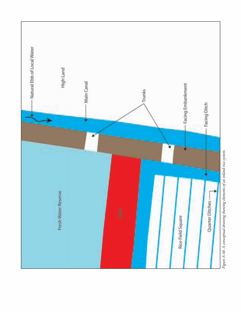
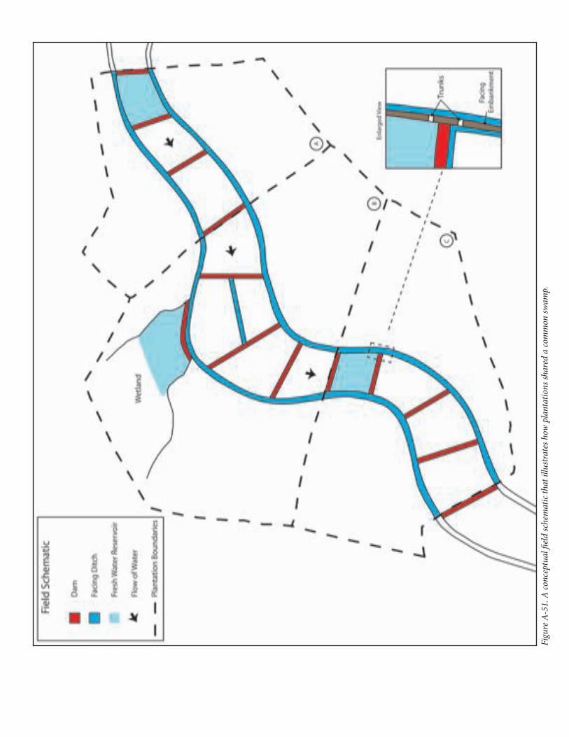
After studying all eleven plantations, we compiled all available information to generate registration requirements for an NRHP-eligible field system. We drew upon Duncan Clinch Heyward’s (1937) descriptions of rice field features. Although written in the early twentieth century, his work provides us with terms, definitions, and functional explanations for not only the physical components of an inland rice system, but also how they all worked together to facilitate the growth of rice. Thus, for our purposes we used the following terms: dams, facing ditches and facing embankments, quarter ditches, trunks, reserves or reservoirs, canals or drains, causeways (roads or avenues), and historic property lines (bank/ditch/dam the line). Each of these terms has a specific definition and role in the development of inland swamp rice and all are defined more thoroughly in Section F.
Berkeley County
Crowfield Plantation. Crowfield Plantation near Goose Creek was one of the area’s larger inland rice plantations. The plantation was acquired by Arthur Middleton, often known in the records as Governor Arthur Middleton, by 1729. He passed it to his son William who built a large brick main house and designed gardens, the ruins of which are a public park. The authors referred to Garrow and Elliott (1987:38-49) and Smith (1988: 329-335) in preparing this section. William, if not his father, built the inland rice fields at Crowfield Plantation. In 1742, Eliza Lucas (Pinckney) visited the plantation and noted the extensive grounds, capital mansion, and acres of gardens and beautiful fields. The Middletons were extensive slave owners and rice planters and it was certainly they who oversaw the inland rice field development in Huckhole Swamp in the 1730s.
In 1753, William Middleton advertised his plantation for sale, noting that the 1,800 acres were good for rice, corn, and indigo. He sold the estate to William Walter, another extensive Colonial Period rice planter, who sold it to William Haggatt in 1770. Prior to the American Revolution, Rawlings Lowndes acquired the tract and leased it to Thomas Middleton, a son of William. In 1784, Lowndes sold it to John Middleton, another son of William, who
NPS Form 10-900-a (Rev. 01/2009) OMB No. 1024-0018 (Expires 5/31/2012)
United States Department of the InteriorNational Park Service
National Register of Historic Places Continuation Sheet
Name of Property Inland Swamp Rice Context, c. 1690-1783
County and State Berkeley, Charleston, Dorchester Counties, South Carolina
died shortly after buying the estate. Crowfield Plantation passed to his son John, Jr., who owned the plantation for more than 50 years. An 1853 plat shows the rice fields as abandoned from some time, though the dikes remain landmarks into the present time. Active commercial rice planting at the plantation likely ceased during the ownership of John Middleton, Jr. In 1840, Henry A. Middleton purchased Crowfield Plantation and the land remained with his descendents into the twentieth century. During his ownership the land was primarily used for the planting of cotton, corn, and forestry products.
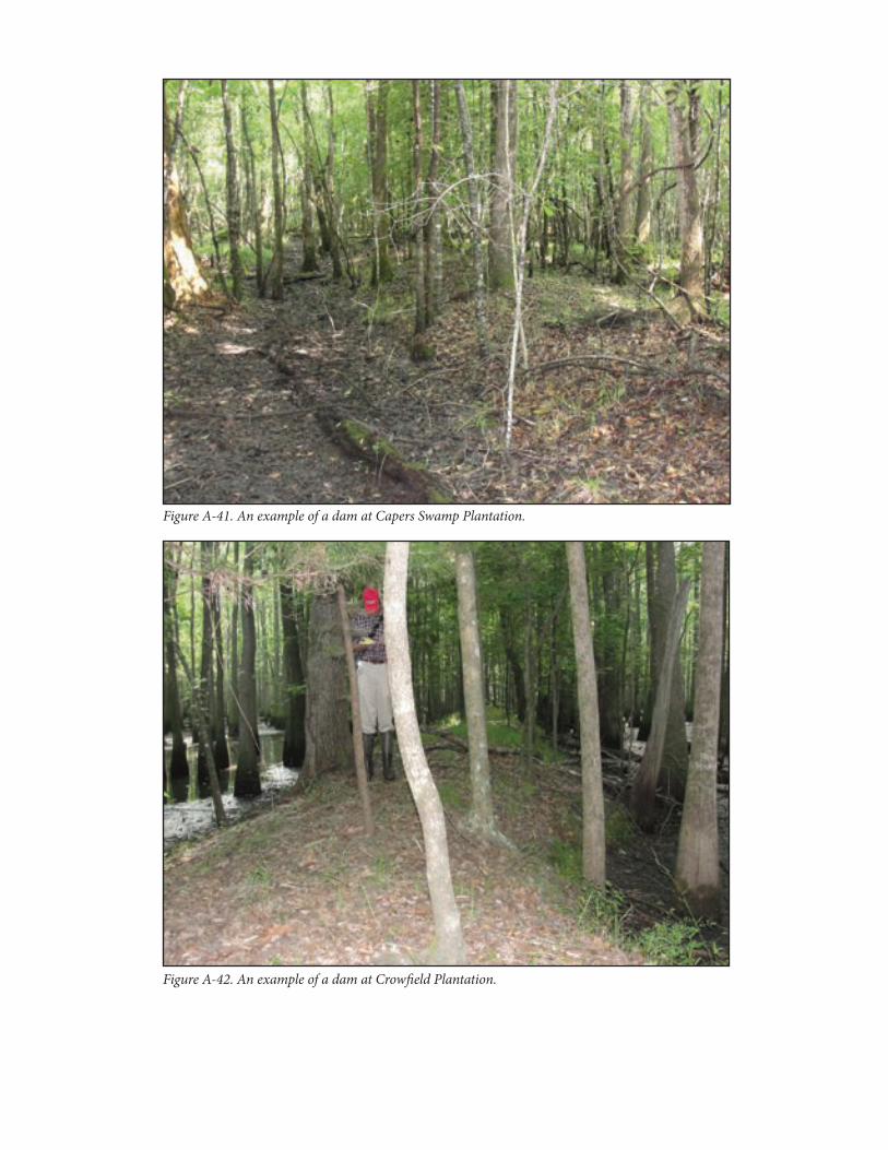
Fieldwork and Features Investigated at Crowfield Plantation
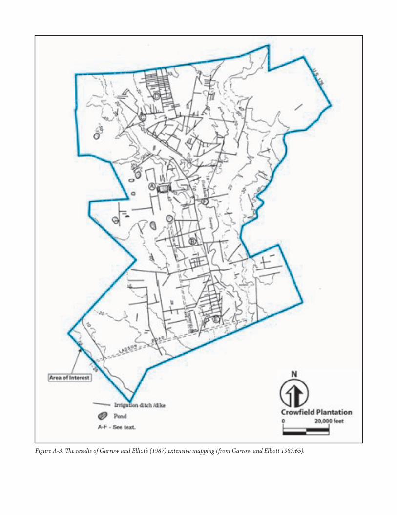
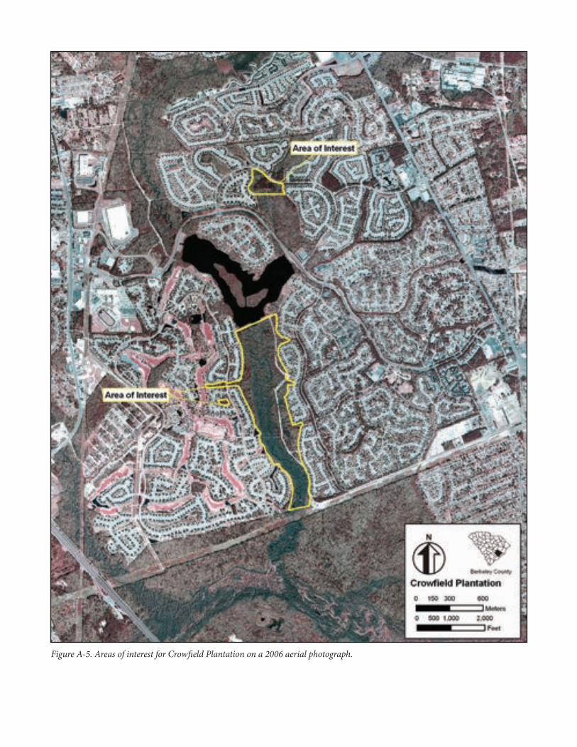
We used a two-pronged approach to our investigations at Crowfield Plantation. Not only were we interested in examining the remnants of inland rice fields, but we were interested in documenting how the modern Crowfield residential development has affected the integrity of the rice field features recorded by Garrow and Elliott (1987). The authors utilized aerial photographs and extensive physical mapping during the survey of the property in order to reconstruct the inland rice landscape (Garrow and Elliott 1987:65). Figure A-3 displays the results of Garrow and Elliott’s (1987) extensive mapping, which is our area of interest. While modern neighborhoods sit on top of the majority of Garrow and Elliott’s (1987) mapped features today, there still remain small interior swamps and stands of trees that fell outside of development impact. Using GIS, we were able to match the modern aerial photo with Garrow and Elliott’s (1987) mapping of the inland rice features for all of Crowfield Plantation. This allowed us to find areas that may contain intact features amidst modern neighborhoods. We refined our study area to the Huckhole Swamp, shown on Figure A-4. Because we know inland rice field complexes are sometimes found adjacent to areas marked as wetlands on quadrangle maps, we took in a few hundred feet of adjoining ground for our study area. Then, using the modern aerial photograph, we refined our investigation area of interest specifically to the undeveloped portions of the neighborhood and Huckhole Swamp (Figure A-5). This allowed us to pinpoint locales that should contain features depicted by Garrow and Elliott (1987) on the modern aerial photograph. This provided us with the quickest ways to investigate any existent remaining features. Our refined areas of interest included a portion of the swamp located south of a modern lake created out of a portion of the old rice fields, and a small patch of swamp adjoining some neighborhoods in the northern reach of Huckhole Swamp. We also were able to pinpoint two small sections of woods that fall inside of neighborhoods and reveal clustering of features.
The two small areas west of Huckhole Swamp showed features consistent with pine ditches used to drain water out of pine stands. The narrow rows seen on the Garrow and Elliott (1987) plan were likely pine ditches, as they occur on ground too high to grow wet-culture rice. It is possible that upland plots existed. However, considering the 1730s development of this tract, wet-culture rice production had moved beyond the experimental phase and into the profitable phase, and doubtlessly the Middletons allocated their labor to the most effective use of their lands in the main swamp. There is no evidence they did otherwise.
We found the northernmost area of interest void of rice field evidence. The narrow features seen on the Garrow and Elliott (1987) plan have faded through time and erosion. No embankments are present. A modern sewer line cuts through this area, providing more access to the swamp and also opportunities for damage and/or erosion.
NPS Form 10-900-a (Rev. 01/2009) OMB No. 1024-0018 (Expires 5/31/2012)
United States Department of the InteriorNational Park Service
National Register of Historic Places Continuation Sheet
Name of Property Inland Swamp Rice Context, c. 1690-1783
County and State Berkeley, Charleston, Dorchester Counties, South Carolina
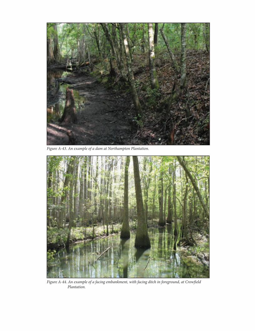
However, our investigations into Huckhole Swamp provided us with an opportunity to examine remains of an organized, inland rice field system. This narrow freshwater swamp, with high ground on either side, was ideal for early inland rice production. Here, we recorded a long facing ditch and facing embankment on the west edge of the swamp (see Figure A-4 for the identified features and organization). A second ditch, on the outside of a second embankment, was also identified, showing the complexity of water control for this swamp. The modern neighborhood abuts much of the western-most facing embankment and facing ditch, and has destroyed a large section of it. We identified three dams that once traversed the width of the swamp. Today, they are broken by a partially destroyed canal down the center of Huckhole Swamp. The canal may represent an improvement to the rice field system at a later date. However, once inland planting ceased and management of the canal ended, waters from upstream broke the line and created massive erosion to all features in the center of the swamp. Thus, the shape and nature of the canal are lost.
The eastern side of the swamp is more restricted than it is shown on the quadrangle map. This is likely due to a service road that rests on a massive berm, built parallel to the swamp and constructed of fill from the swamp (see Figure A-5). Likely, this road incorporated the eastern facing embankment and ditch that defined the east edge of the fields and the swamp. West of this road, in the swamp, we encountered intact features. We recorded a facing ditch and embankment that runs north through the middle of the swamp. This would have subdivided the larger, dammed sections of swamp into smaller fields. We also recorded a triangle feature that, when plotted, falls in the center of the swamp. It is adjacent to the modern service road seen on the aerial. In all, we identified three dams, five facing ditches, and one embankment that is associated with the triangle feature.
Due to modern development, much of the inland system of Crowfield Plantation has been lost. Flooding the upper reaches of Huckhole Swamp has also caused water to impound in the southern end of the swamp. This has created erosion that has destroyed portions of dams, facing ditches, and facing embankments. Additionally, development has destroyed portions of the eastern and westernmost features of the system.
Dean Hall Plantation. Dean Hall Plantation was an inland rice and indigo plantation in the eighteenth century located between the Cooper River and the Back River. Its location on the Cooper River gave the owners excellent opportunities in the late eighteenth century to convert over to the new tidal system of rice planting after the American Revolution. Yet, Dean Hall Plantation contains sizable inland rice fields and was an excellent example of how some tidal rice planters reverted back to a limited inland rice production when tidal fields became unsuitable in the 1840s. The authors referred to Agha et al. (2010) in preparing this section.
Dean Hall Plantation was purchased by Alexander Nisbett, a Scottish Baronet, in 1725. After the collapse of naval store prices and stiffer requirements by the home country, he converted his inland fresh water swamps along Durham Creek into rice fields in the 1730s. His earliest fields were in the southern section of the tract along Chicken Creek that flowed off the Back River. Also, by the mid eighteenth century he had developed fields along Durham Creek, a freshwater tributary of the Cooper River.
Dean Hall Plantation stayed with the Nisbett family until 1821. In the late 1700s, grandsons of the Alexander began overseeing construction of large tidal fields in the salt marsh along the Cooper River. When William Carson
NPS Form 10-900-a (Rev. 01/2009) OMB No. 1024-0018 (Expires 5/31/2012)
United States Department of the InteriorNational Park Service
National Register of Historic Places Continuation Sheet
Name of Property Inland Swamp Rice Context, c. 1690-1783
County and State Berkeley, Charleston, Dorchester Counties, South Carolina
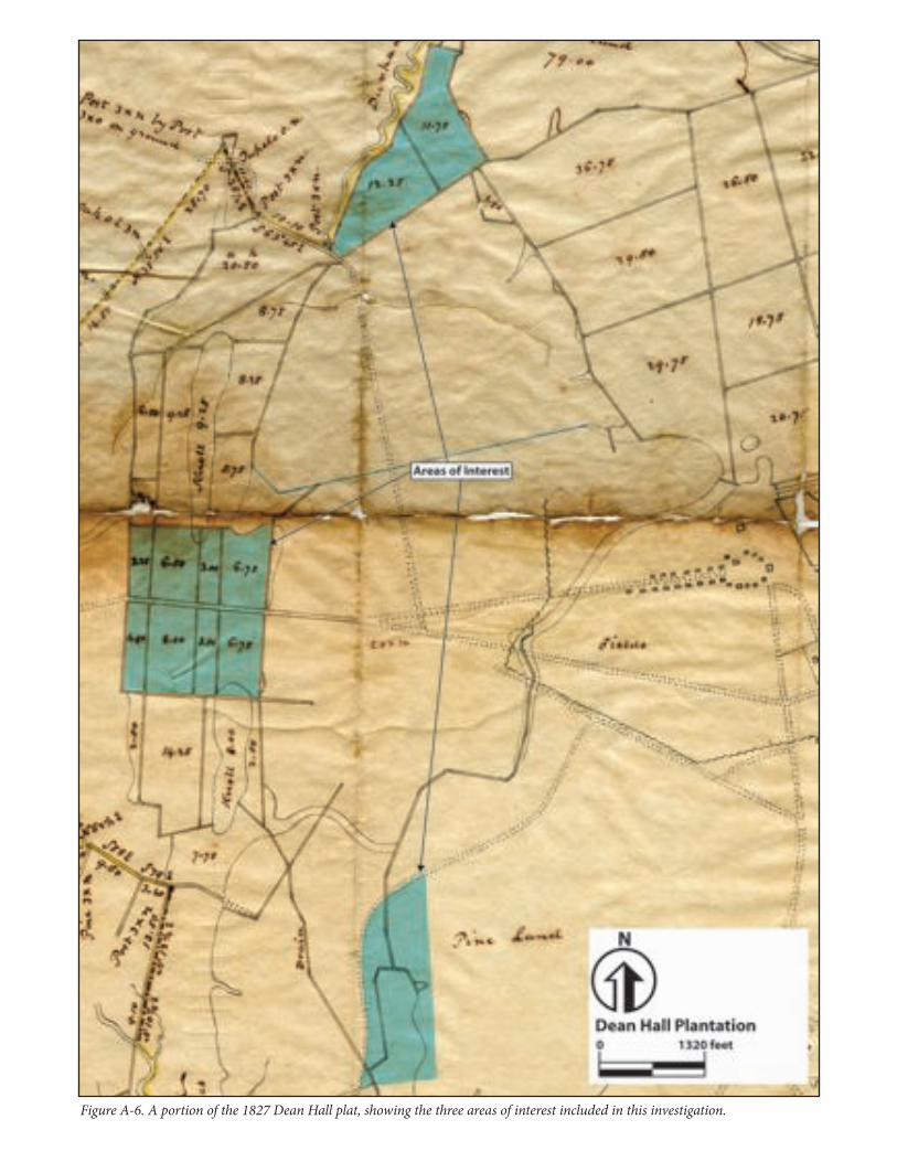
purchased the plantation and the slaves thereon in 1821, he acquired a nearly 100-year-old rice complex complete with a very experienced labor force. He implemented a number of improvements to the property and fields that included new cabins for the slave families and a modernized trunk and drainage system for the rice fields. Although tidal rice was the hallmark of nineteenth century rice cultivation, Carson continued to utilize and expand his inland rice fields. Remains of his improvements can be seen today at Dean Hall Plantation. Figure A-6 displays a portion of the 1827 plat, showing the three areas of interest included in this investigation.
Fieldwork and Features Investigated at Dean Hall Plantation
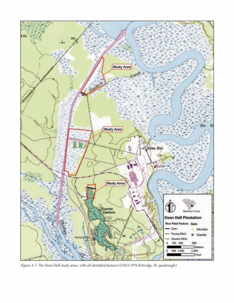
Our investigations focused on the inland fields and freshwater reservoir related to Durham Creek. Figure A-7 displays our study areas on the modern USGS quadrangle map, with all identified features. Nisbett’s inland fields basically destroyed the channel of Durham Creek, replacing it with facing ditches and dams that consumed the creek’s swampy floodplain. In the 1950s, Durham Creek was revived through a canal project that created access from Chicken Creek off of the Back River to the West Branch of the Cooper River (shown in purple on Figure A-7). This canal destroyed a facing ditch that ran through the middle of the fields and broke the dams that crossed the fields. However, it caused no serious damage to the majority of the fields on either side. In the 1970s DuPont Corporation widened a ditch on the north side of the old causeway road that crossed the fields. These are the only known disturbances to the Durham Creek inland fields.
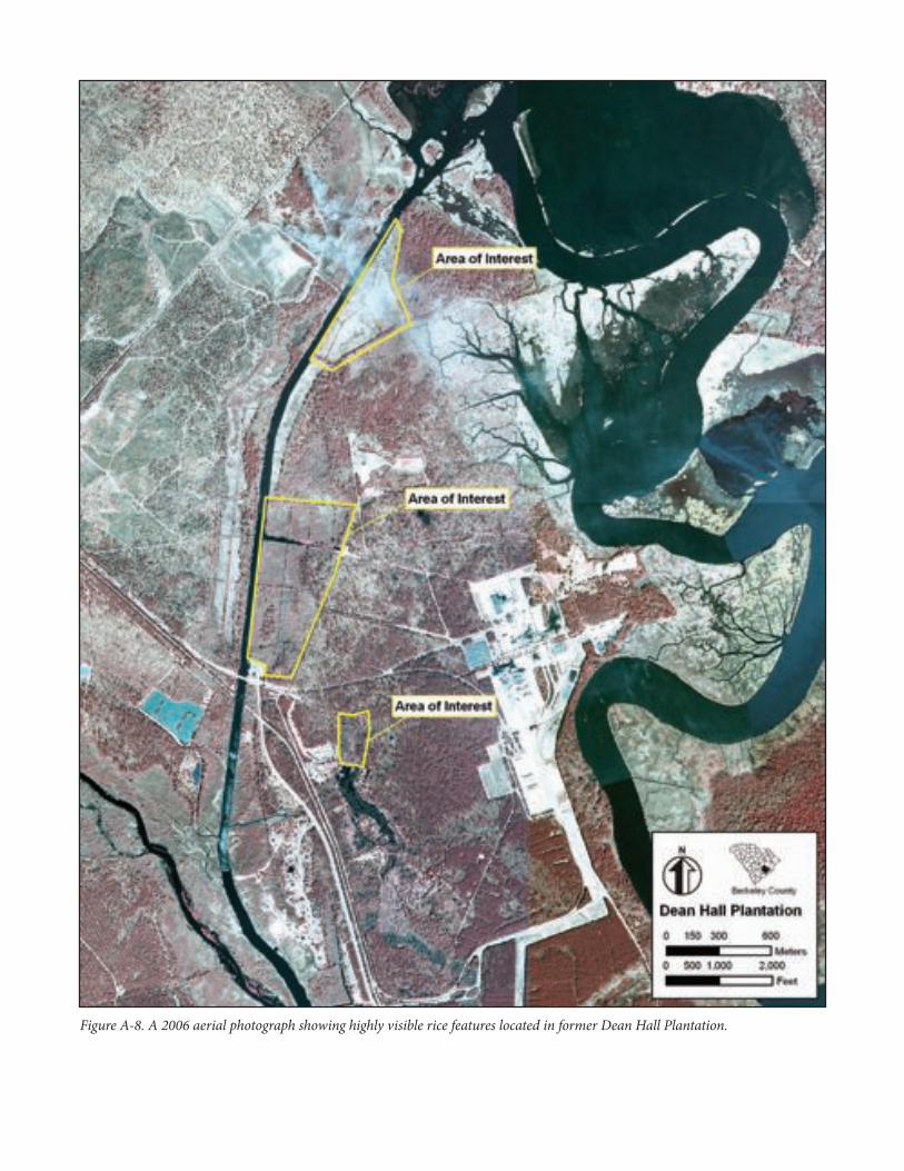
Our study areas focused primarily on the east side of the Durham canal in the centrally located inland rice fields, and on the main dam at the north end of the fields. We also looked at the north lobe of the reservoir that is currently in Cypress Gardens, a Berkeley County park. Our areas of interest, based on refined visibility from modern aerial photographs that match what is shown on the 1827 plat, are identical to our study areas. Figure A-8 displays the aerial photograph showing very visible rice features located in the former Dean Hall Plantation.
The southernmost study area at the north end of the reservoir showed us only the north dam of said reservoir. Today, the northern lobe of the pond is mostly drained. The 1827 and 1837 plats show a canal linking the northern tidal fields on the Cooper River with this reservoir. We attempted to locate remnants of it but were only able to identify a small ditch feature; modern alterations to the landscape over the last 50 years have erased most of the evidence of the canal. We were able to identify the dam on the north side of the reservoir (see Figure A-7).
The central study area was the most informative for our early inland rice field study. Although DuPont altered the area around the sluice they created, they reused the old causeway road that runs along the south of the sluice (see Figure A-7; the sluice is shown in purple). The road now serves as access to a transmission line corridor. Again, although the modern improvements may have altered the original historic features, they are largely preserved due to reuse and maintenance.
Directly south of the old causeway road lie remarkably intact inland rice fields. These fields match Duncan Clinch Heyward’s historical descriptions of field creation and layout (Heyward 1937). Here, we observed dams that traverse the swamp from high ground to high ground, facing ditches and facing embankments running along the
NPS Form 10-900-a (Rev. 01/2009) OMB No. 1024-0018 (Expires 5/31/2012)
United States Department of the InteriorNational Park Service
National Register of Historic Places Continuation Sheet
Name of Property Inland Swamp Rice Context, c. 1690-1783
County and State Berkeley, Charleston, Dorchester Counties, South Carolina
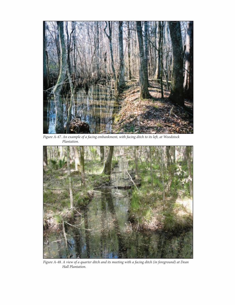
course of the swamp (here, they are oriented north/south), and quarter ditches that separate the fields into “rice paddies” that are all 75 feet apart from each other. The three facing ditches we recorded are still open with moderate silt infilling, and their facing embankments are quite intact. We recorded 13 quarter ditches in two sets between three facing ditches (see Figure A-7). In this layout, we recorded a quarter ditch running north/south roughly 20 feet away from the embankment east of a facing ditch. Additional parallel quarter ditches run 75 feet apart eastwardly. Of all the plantations we visited, these fields are the most intact as they retain all of the original parts of the inland field system. The features we recorded were likely built as early as the 1720s, but were repaired and maintained until the early twentieth century.
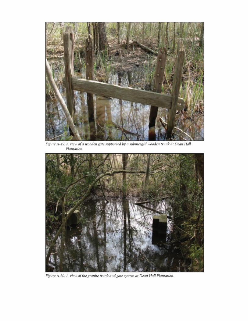
We documented the main dam for the inland fields in the northern area of interest (see Figure A-7). This dam is larger than all others we observed, and continues to hold water in the fields and keeps out any salt intrusions from the Cooper River. This dam has an intact granite and brick trunk and gate system in it. Historical accounts tell us that Carson improved trunks and gates with granite in the mid nineteenth century. We also recorded a facing ditch that shows up clearly on the aerial and the historic plats. Associated with this facing ditch and its related embankment are four intact wooden gates linked to wooden trunks below the waterline of the ditches. Cut nails present in the gates indicate a nineteenth-century construction, again, likely built by Carson. The trunks were not in current operation, but we observed enough above ground features to confirm their likely intact presence inside the embankment. They appeared to have been abandoned many decades earlier.
Dean Hall Plantation, nestled in a modern industrial landscape, contains some of the most intact inland rice fields the authors have witnessed in the last 10 years of field work. A large number of these features date to the first half of the eighteenth century. We believe that Carson did not alter the configuration of the inland fields from the eighteenth century at all. The presence of the granite and wooden gates speak to the perfect balance of industry and preservation enacted by DuPont. Dean Hall Plantation provides the researcher an excellent laboratory for further inland rice investigations.
Northampton Plantation—St. Thomas and St. Denis Parish. Northampton Plantation is located along Northampton Creek in central Berkeley County in the section known historically as St. Thomas and St. Denis Parish. In preparing this section the authors consulted Poplin and Philips (2010). Northampton Plantation was fashioned into a 4,000-acre inland rice plantation by Edward Thomas in the years before and shortly after the Revolutionary War. Most of the plantation was granted to the Benjamin Simons and Jonathan Russ families prior to 1717. Peter Simons, a son of Benjamin, obtained most of the best inland rice land along Northampton Creek and was planting rice there by the time of his death in 1724. Later his daughter married Benjamin Marion, a brother of Francis “Swamp Fox” Marion, and in 1758 the couple made their home on her father’s land. Both Simons and Marion were extensive rice planters. It is possible that the fields investigated in this study were built by Simons in the 1720s. Meanwhile the balance of the rice land that became Northampton Plantation was owned by Jonathan Russ and members of his family. They sold their holdings to Samuel Thomas in 1762. Doubtlessly, the Russ family members built the rice fields on the eastern portion of Northampton Plantation along Northampton Creek and a northern spur called Harleston Dam Creek. Samuel Thomas and his son Edward expanded the fields further after
NPS Form 10-900-a (Rev. 01/2009) OMB No. 1024-0018 (Expires 5/31/2012)
United States Department of the InteriorNational Park Service
National Register of Historic Places Continuation Sheet
Name of Property Inland Swamp Rice Context, c. 1690-1783
County and State Berkeley, Charleston, Dorchester Counties, South Carolina
they acquired the land. By the time of the Revolutionary War, Edward Thomas, who named the tract Northampton, had developed its inland fields with an extensive slave force. In the 1780s he added the Marion plantation to Northampton and by 1790 managed an enslaved force of more than 100 in its rice fields.
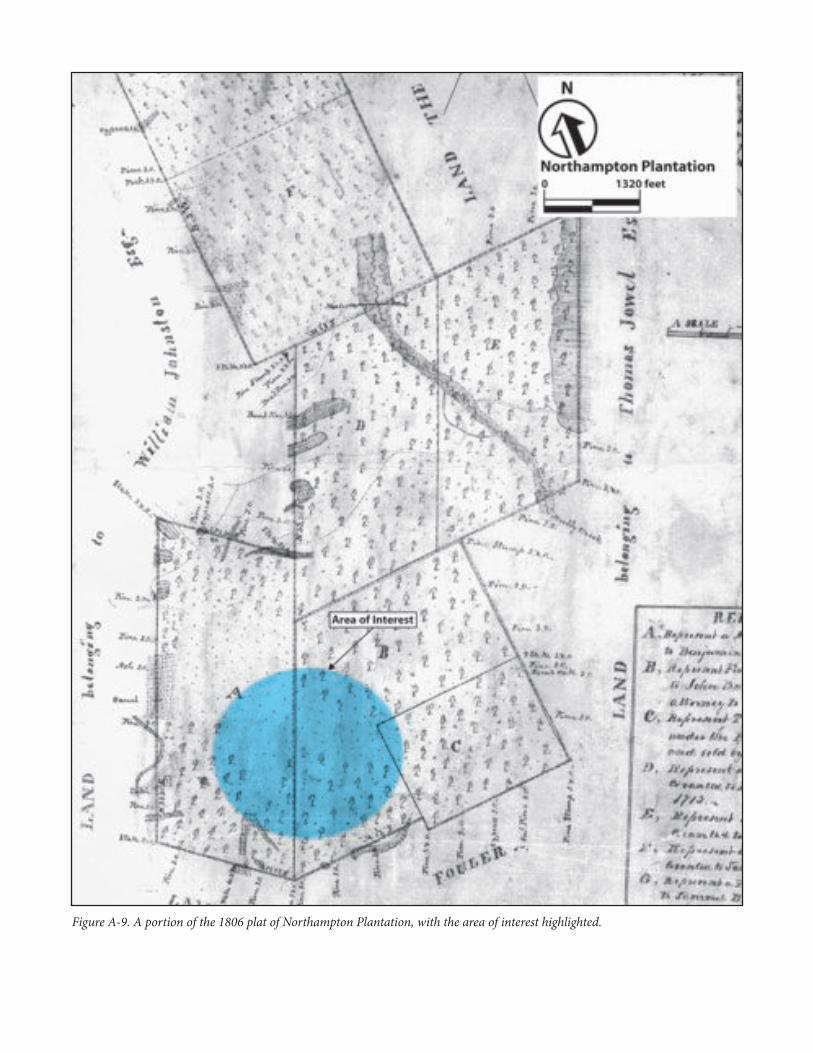
Seeing advantages in tidal rice, in 1794 Thomas sold his inland rice plantation to Lewis Fogartie. A few years later he was forced to foreclose on the mortgage, and he resold the land to one of the grandsons of Benjamin and Esther Marion, Paul James Warley. Warley appears to have made his seat at Northampton Plantation and continued planting rice along the swamps of the creek for 14 years. However, he, too, must have forseen the end of inland rice planting and in 1818 sold his plantation to Thomas McDowell. Apparently, commercial inland rice planting must have ceased for a time at Northampton Plantation as McDowell did not have a workforce on his lands sufficient to maintain extensive rice fields. However, the rice fields continued to have been used, for a later owner, Jonathan Lucas, recorded 50,000 pounds of rice on the plantation in 1850, and his son Henry reported 60,000 pounds ten years later. Since the family owned no other lands in St. Thomas and St. Denis Parish, the authors assume they were enumerating production at Northampton Plantation. Rice production seems to have stopped after the Civil War. Figure A-9 displays an 1806 plat of Northampton Plantation and our area of interest.
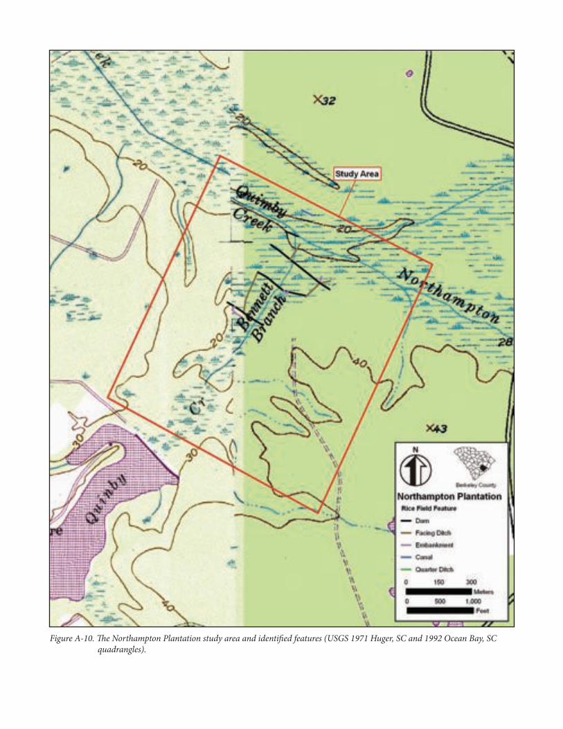
Fieldwork and Features Identified at Northampton Plantation
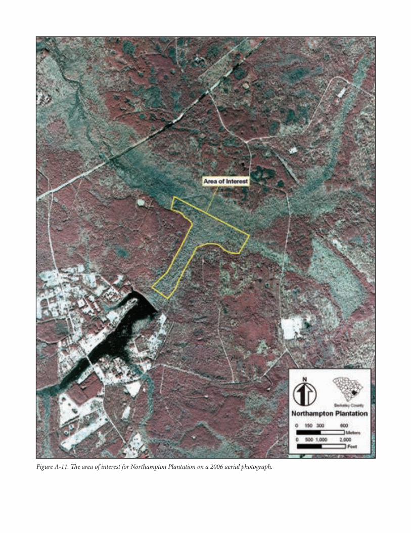
Our study area comprises an area consisting of well defined swamp and adjacent lowlands that we suspected would contain rice field features. Figure A-10 displays the study area on the modern USGS quadrangle map. We refined our area of interest for field inspections to the swamp as it appears on the modern aerial photograph. Figure A-11 displays the area of interest on the modern aerial photograph of the area. We drew our northern line at the main canal that runs through the middle of the swamp containing Quimby and Northampton creeks (they are the same creek but have two names). We believe that this section of swamp was canalized in the 1780s or 1790s to facilitate better hydrology for the planters and provide water transportation to the Cooper River. We inspected the swamp to the southwest below this on Bennett Branch.
We recorded four dams in the Bennett Branch drainage that provide a classic example of how dams worked in rice cultivation (see Figure A-10). The dams traverse the width of the swamp from high ground to high ground. The lowest dam we recorded also seemed to serve a later purpose. An L-shaped dam that connected to the south side of the long dam feature created a channel that appeared to be related to a nineteenth century mill. We located two additional dams spanning the swamp northward toward Quimby Creek. We found three facing ditches with facing embankments that orient to the length of the swamp that facilitated water movement and irrigation. We recorded a triangle feature defined by a dam and a small embankment near the middle of our study area (seen in purple on Figure A-10). We observed one instance of a quarter ditch approximately 30 feet long.
This system is similar to others we observed at other plantations including Capers Swamp, Glaze-Poppenheim, and Jack Savanna. The swamp of Quimby/Northampton Creek was once likely the same kind of system; however, late eighteenth/early nineteenth century canalizing changed the way water flowed through the facing ditches. Due to these later improvements, and the fact that no main canal exists in the Bennett Branch drainage, we believe that the fields we recorded there were likely abandoned prior to Edward Thomas’s addition of Marion Plantation in the 1780s.
NPS Form 10-900-a (Rev. 01/2009) OMB No. 1024-0018 (Expires 5/31/2012)
United States Department of the InteriorNational Park Service
National Register of Historic Places Continuation Sheet
Name of Property Inland Swamp Rice Context, c. 1690-1783
County and State Berkeley, Charleston, Dorchester Counties, South Carolina
Capers Swamp Plantation. We examined Capers Swamp Plantation located along the headwaters of the Wando River. Like that of other extensive lowlands, the headwaters of the Wando River were channelized in the late eighteenth century to help inland rice planters with their water control and transportation. In preparing this section, we consulted Agha and Philips (2008:79-82).
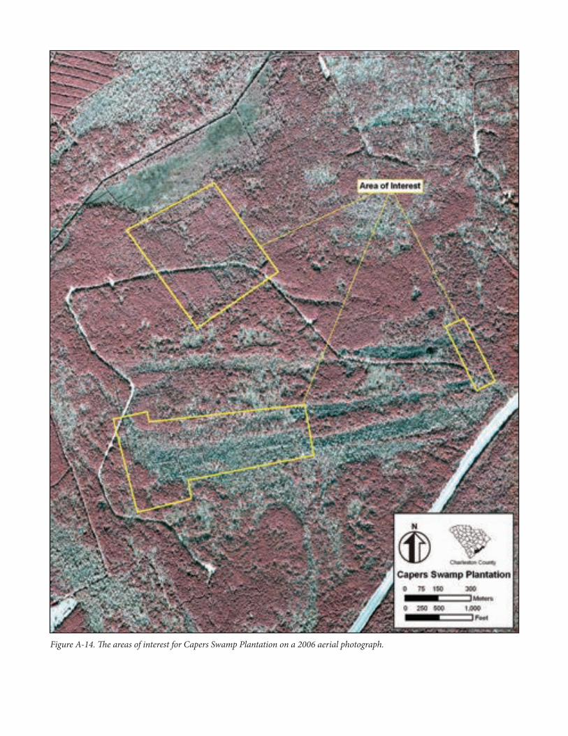
Capers Swamp Plantation was a 780-acre inland rice plantation that was acquired by Richard Capers in the middle eighteenth century and passed to his son Gabriel in 1774. The land stayed with the Capers family for many years and was known as their “Swamp Plantation.” In 1807, executors of Gabriel Capers sold it to Hugh Rose. At the time of the sale the land was surveyed by John Diamond and a plat was produced. The plat makes reference to inland fields along the Wando Canal and older rice fields further to the south. Figure A-12 shows the 1807 Diamond plat of Capers Swamp Plantation and highlights a section labeled as “old rice fields”, which is our primary area of interest for this context.
Fieldwork and Features Investigated at Capers Swamp Plantation
During archaeological survey in 2004, investigators noted several embankments and a very large canal in the northwest portion of the plantation fields. Our current investigations determined the utility of map information prior to physical inspection of the rice field features. The results of our investigations show great promise for utilizing maps to aid physical inspection and discovery of inland rice field features and systems.
Our study area included the entire Capers Swamp Plantation as Diamond drew it on the 1807 plat. The modern USGS quadrangle map shows little to no definition in the expansive wetlands. Figure A-13 displays our study area and identified inland rice features on the modern USGS quadrangle map. The aerial photograph reveals field features that match the 1807 Diamond plat. We used the modern aerial photograph to refine our areas of interest to three locales (Figure A-14). One area in the eastern corner of the study area was investigated because it appeared to be not only a property line for the plantation, but also a dam. The northern area of interest was defined through aerial photography. Several rice field features appear prominently, revealing the typical “window pane” patterning within a section today planted in pines. The third southern area of interest contains some suspected rice features, which are evident on the aerial photograph. Through our investigations, we identified seven dams, 12 facing ditches, and one canal.
We suspected the eastern property line of this section marked by an embankment matched the original boundary line on the 1807 plat and also served as a dam across a hardwood swamp. The aerial photograph shows this feature continuing north for roughly 4,000 feet, consistent with the historic plantation property line. If so, the presence of the dam, more than two centuries later, revealed the level of preservation in this US Forest Service property.
We identified seven facing ditches in the northern area of interest. Since this wetland is expansive and the Wando Canal provided ample drainage and a water source for these fields, there appear to be few dams present. All
NPS Form 10-900-a (Rev. 01/2009) OMB No. 1024-0018 (Expires 5/31/2012)
United States Department of the InteriorNational Park Service
National Register of Historic Places Continuation Sheet
Name of Property Inland Swamp Rice Context, c. 1690-1783
County and State Berkeley, Charleston, Dorchester Counties, South Carolina
facing ditches we identified cut the wetland into individual fields. We believe this area of the swamp was developed late in the inland rice period, likely during Gabriel’s tenure. Doubtlessly, Capers worked his fields in tandem with the Wando Canal.
The southern area of interest fell in mostly hardwood swamp and has seen different management than the pine stands. Several features appeared clearly on the aerial to guide our physical inspection. This area of the plantation is very intact and management has minimized damage and erosion to these features. We identified two dams here: one a “lower” dam that helped control the flow of water on and off of the entire rice system east of it. A second dam was found directly west of this, with three facing ditches running east/west from it (see Figure A-13).
One area not defined by the aerial photograph, but clearly defined by the plat, is the “old rice fields;” this section falls between our two largest areas of interest in a narrow hardwood swamp (see Figures A-12 and A-13). Here, we found an intact and very well preserved field system that may be the oldest fields at Capers Swamp Plantation, dating to the 1740s-1750s. We recorded two long facing ditches and four dams. A canal feature that cuts through higher ground from the north was also recorded. This may have provided water in later decades, as it appears to be interruptive to the system. The three dams in the east half of the inland system meet with a slight bluff that defines the north side of the field. No facing ditch or embankment was seen against this edge of the field, suggesting that high ground was utilized as a natural control for water. The easternmost dam was the last feature identified by the authors. East of this we suspect that there was a reservoir, which may have been in the finger wetland extending east away from this field system, as seen on the USGS quadrangle map (see Figure A-13). Although there is some logging road damage, it is minimal and does not detract from the integrity or understanding of the rice field system. Lastly, the southern facing ditch matches the hard black line on the plat in the middle of the section listed “old rice fields.” Here, our fieldwork provides the detail omitted by the nineteenth-century surveyor.
All inspected rice fields and features are intact. All facing ditches are identifiable and have accompanying embankments that show little erosion or damage. Management by the US Forest Service has caused little or no apparent disturbance to the rice field features. Enough features exist in context to each other to understand how these swamps worked as an inland rice system. The aerial photograph provides not only clear rice features to easily inspect for integrity, but they show tree type differences that hint at areas of earlier fields. Capers Swamp Plantation provides a fine example of a mid-eighteenth century inland rice system, as well as a late eighteenth century modification in the form of a large canal that aided the planter’s expansion, hydrological controls and access to riverine transportation.
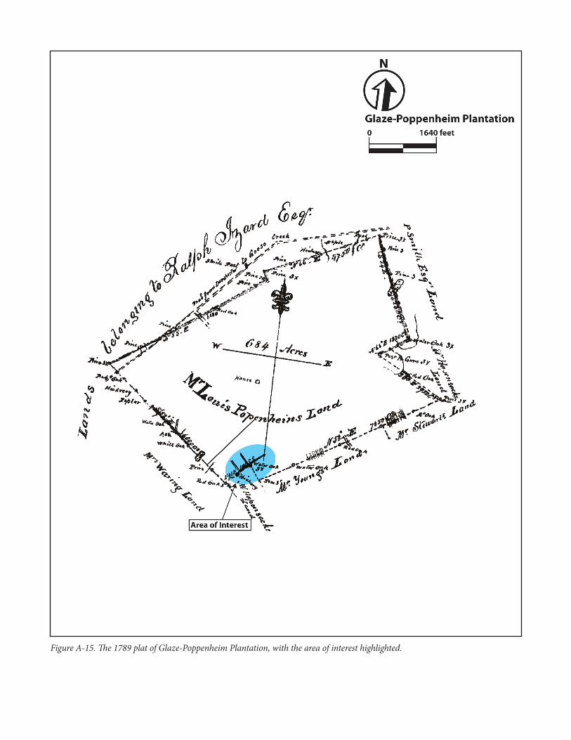
Glaze-Poppenheim Plantation (Charleston and Dorchester counties). In this section, the authors utilized discussion found in Chambliss and Bailey (2005:22-25, 33-37), Philips et al. (2007:30-39), and Smith (1988:300-301). This small inland rice plantation was first settled by a grant to Samuel Sumner in 1701 but acquired by Malachi Glaze in 1723. Although the field system may have dated to Sumner’s ownership it would have been developed by Malachi Glaze. Glaze and his sons were extensive rice planters in the Charleston area throughout the eighteenth century. Modern day Spencer’s Creek is a subsidiary of Eagle Creek in the Ashley River watershed. John Glaze inherited the land from his father and brothers in 1740 and afterward bought Richard Spencer’s land to the north that
NPS Form 10-900-a (Rev. 01/2009) OMB No. 1024-0018 (Expires 5/31/2012)
United States Department of the InteriorNational Park Service
National Register of Historic Places Continuation Sheet
Name of Property Inland Swamp Rice Context, c. 1690-1783
County and State Berkeley, Charleston, Dorchester Counties, South Carolina
included more bottom land of Spencer’s Creek suitable for rice fields. The plantation stayed in the Glaze family until 1778 when John Glaze sold it to John Benfield. Lewis Poppenheim acquired the land in 1789 and added a small tract to it, increasing the size of the property to approximately 700 acres. Poppenheim was likely the last rice planter on the tract. He kept the land for many years and in 1853 John Strohecker acquired the plantation. By this time all commercial rice planting had ceased many years earlier. Figure A-15 displays the 1789 plat of the plantation, with our area of interest highlighted.
Fieldwork and Features Investigated at Glaze-Poppenheim Plantation
The authors first studied this inland field system in 2004 and subsequently revisited it in 2007 and 2010. In 2004, the system appeared to be nearly complete. The study area includes all of the lowland swamp along Spencer Creek and some higher ground that is in swamp. Figure A-16 displays our study area on the modern USGS quadrangle map, with identified features. The modern aerial photograph clearly shows the swampland that was the focus of this study. Figure A-17 displays our area of interest on the modern aerial photograph.
We recorded what we believe is a complete inland rice system. Seven dams were identified. Six portions of facing ditches were also identified. When the system was in use, there were primarily two facing ditches that defined the edge of the swamp and provided water flow from east to west. The easternmost dam was the first feature identified and likely dammed up swampland in the creek to the east, creating a reservoir. The dams in the middle of the system match what we have seen at nearly all of the plantations studied in our group. The two dams at the west end of the field system were the last features identified. This was due to changes in natural drainage brought upon by modern developments that cut off the westernmost portion of the field system (see Figure A-17). A facing ditch and dam were identified southeast of the southern facing ditch that defines the Glaze-Poppenheim Plantation system and linked to it. It appears that these features relate to the plantation south of Glaze-Poppenheim Plantation and their linkage indicates that at one time the two plantations worked in tandem with each other.
This swamp has been affected by modern development. A sewer line for a recent apartment complex and other nearby buildings runs through the middle of the swamp and fields. Nearby construction has also altered the way water ponds and flows through the swamp, further affecting the integrity of the dams and ditches. Glaze-Poppenheim Plantation provides a look at a rice system implemented in the 1720s, if not earlier, and provides us with a view of how future developments can alter and potentially erase such systems.
Hayes/Ingleside Plantation. In preparing this section, we referred to Agha et al. (2008:37-42), Bailey (1997:17-20), and Smith (1988:281-286). At the south end of the Bluehouse Swamp was the Parker Plantation, also referred to as Hayes Plantation. For most of the eighteenth century John Parker (I) and at least two of his descendents, also named John Parker, occupied a 1,100-acre inland rice plantation they called Hayes. Originally granted to the Barker family, Sarah Parker Barker gave her son, John Parker (I) a 600-acre tract where he lived in 1716 that made the nucleus of his Hayes Plantation. He built an extensive system of rice field in the lowlands of Hayes, both east and west of the current railroad line that now crosses the southwest corner of his former lands. Parker added adjoining lands including a tract of excellent rice land he bought in 1755 at auction from the estate of Joseph Hasfort (discussed further below).
NPS Form 10-900-a (Rev. 01/2009) OMB No. 1024-0018 (Expires 5/31/2012)
United States Department of the InteriorNational Park Service
National Register of Historic Places Continuation Sheet
Name of Property Inland Swamp Rice Context, c. 1690-1783
County and State Berkeley, Charleston, Dorchester Counties, South Carolina
By the 1750s, John Parker (II), the son and heir of the first John Parker, was one of the most prominent rice planters in the colony with a sizable slave community and main country seat at Hayes Plantation. Here, at his inland rice plantation, he erected a large brick main house, garden and family cemetery. His extensive ricefields included well-constructed earthworks that were clay-based and later included a canal that subdivided his wetlands. John Parker (II) died intestate and John Parker (III) inherited his father’s extensive plantation. In 1793, John (III) divided his Hayes Plantation into two plantations. The main house and eastern portion he gave to his son John Parker (IV). A plat done at the time shows the extensive rice fields; a portion of this plat is reproduced in Figure A-18. He gave his son Thomas Parker the westernmost section, including the old Hasfort rice fields. Thomas called his plantation Woodlands. The eastern section continued in the ownership of John Parker (IV) until 1849 when he sold it to his son, Francis Parker. Unlike most of the plantations in the region, the Parkers continued to plant inland rice on their fields well into the nineteenth century. Even after the Civil War, when Francis S. Holmes obtained ownership of Hayes Plantation, he experimented with rice in the old fields until the late 1870s. Holmes renamed the plantation Ingleside; this name has been associated with the land since 1871. The main house was damaged by the earthquake of 1886 and burned a number of years later. According to Henry A. M. Smith, who visited the plantation in the late 1870s, all rice planting had ceased. Francis Parker may have been the last planter in the region to grow rice on his inland fields.
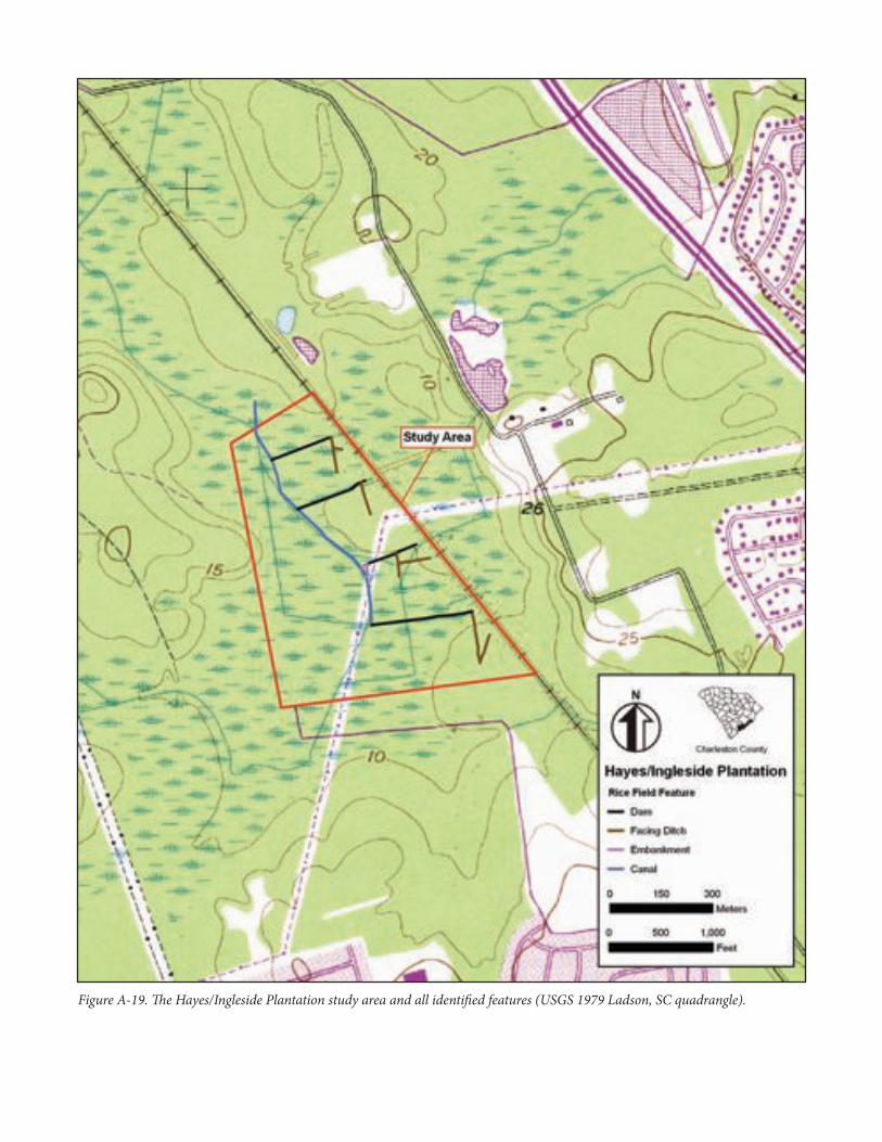
Fieldwork and Features Identified at Hayes/Ingleside Plantation
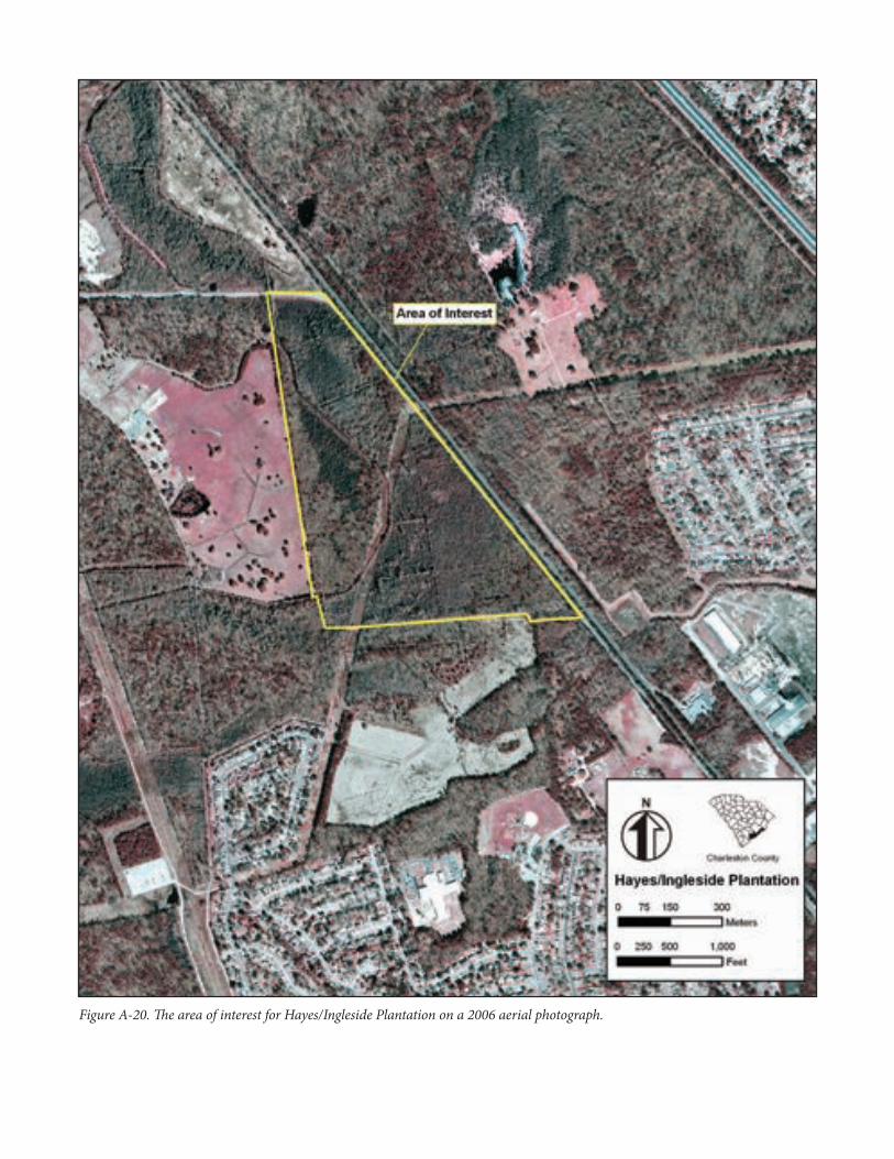
Both the historic plat and modern aerial photographs reveal rice features still present today in this plantation. As a result, our study area and area of interest are virtually the same and encompass the same geographic area. Figure A-19 displays the study area and features identified on the modern USGS quadrangle map. Figure A-20 displays the area of interest on a modern aerial photograph.
We recorded four dams, six facing ditches, and one embankment. We also recorded the main canal that is present on all maps, and links up with the same canal we recorded in Woodstock Plantation (discussed below) to the north. Our access was west of a paved road on a wide berm, and a railroad track also bermed and adjacent to the road. Traversing eastward from the main canal are all four dams. Extending southward from these features are facing ditches that would have moved water further through the fields and provided ample irrigation. West of the canal lies high ground, although the USGS quadrangle map depicts this area largely as wetlands. The 1792 plat shows this area as being “Corn fields”, which means it was high, dry land (see Figure A-18). Against the canal, and at the end of a dam we recorded, is a triangle feature. This is created by two embankment features. Two of the facing ditches have facing ditches that run perpendicular away from them. One facing ditch has a facing ditch coming off of it at an acute angle to the northeast. These features can be seen extending east beyond the railroad and modern road on the aerial photograph (see Figure A-20).
Hayes/Ingleside Plantation provides one of our clearest views of a system that is well organized and intact. Several modern disturbances have cut through many features; however, the features’ integrity and ability to see them across the rice landscape, and understand how they work together, is still present today. Field inspection proved that many features are intact and differences between embankment and ditch sizes are noticeable.
NPS Form 10-900-a (Rev. 01/2009) OMB No. 1024-0018 (Expires 5/31/2012)
United States Department of the InteriorNational Park Service
National Register of Historic Places Continuation Sheet
Name of Property Inland Swamp Rice Context, c. 1690-1783
County and State Berkeley, Charleston, Dorchester Counties, South Carolina
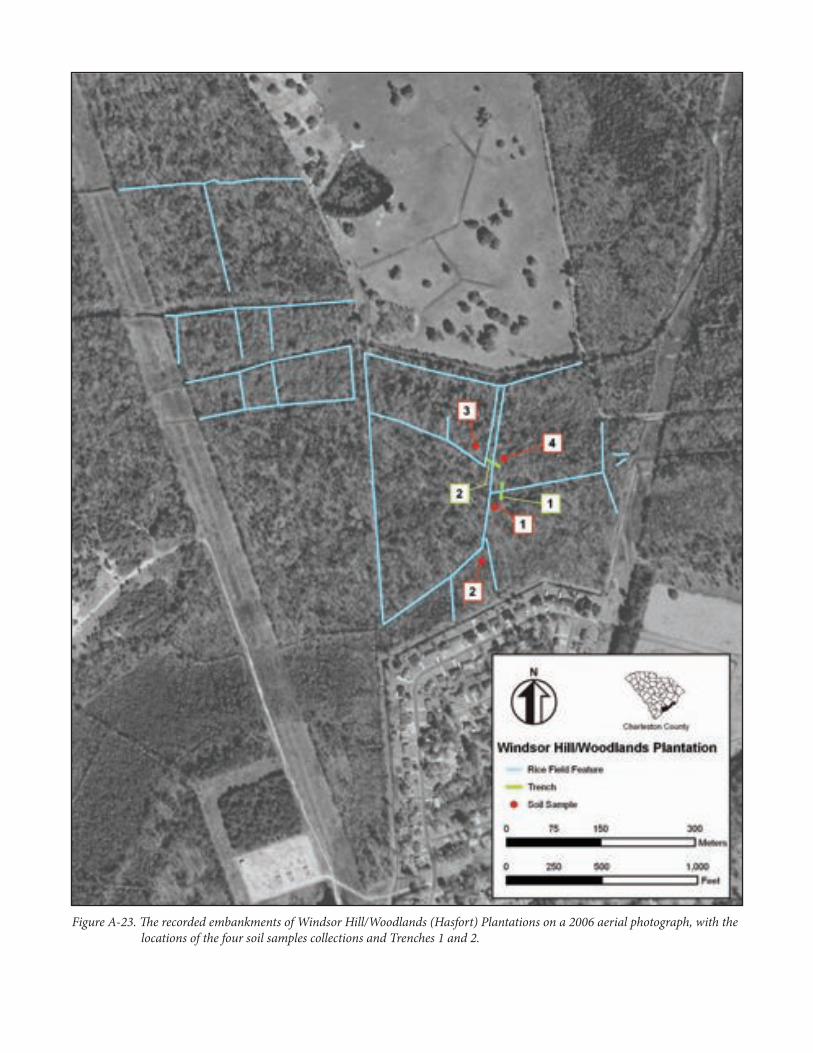
Windsor Hill and Woodlands (Hasfort) Plantations (Dorchester and Charleston counties). This tract involved two distinct historic plantations in the Colonial era: Windsor Hill and Woodlands (Hasfort). Since both have separate histories we will consider each individually. However, both of these are in the area of the Palmetto Commerce Parkway Extension Project, which spurred this inland swamp rice context. Thus, our fieldwork on the two will be summarized in one discussion.
Windsor Hill. In preparing this section, the authors drew primarily on the work of Agha et al. (2008:33-37) and Smith (1988:133-135). Windsor Hill Plantation is one of the more notable sites in this portion of Dorchester County as it once belonged to the son of General William Moultrie of Revolutionary War fame. General Moultrie was buried here at his son’s plantation until his remains were relocated to the St. James Goose Creek Parish Church cemetery in the 1960s. Later, they were moved again to Fort Moultrie on Sullivan’s Island. The plantation was granted to Joseph Child as early as 1701 and was part of an early inland rice plantation, probably initiated by Joseph and continued by his son Benjamin. Evidence indicates that as early as the 1720s, Joseph Child was clearing the lowlands for the construction of an inland rice system. The land continued with direct descendents of Joseph Child until 1837, when it was bought from Eliza Child Moultrie by Dr. Edward Brailsford. By that time, property in the area was prized for its ability to produce cotton and any rice grown may have been more for provision than commercial purposes. The rice fields at Windsor Hill were located in the northeast section of the plantation separated by a causeway that acted as a boundary line between Windsor Hill Plantation and Woodlands (Hasfort) Plantation. The fields examined by the authors included an extensive banking system with check banks in the floodplain of Windsor Swamp. In the early 1900s, the City of Charleston built a large drain through Windsor Hill Plantation and Woodlands (Hasfort) Plantation to move water out of the lowlands down to the Goose Creek Reservoir. This drain disturbed the flow of water but also carefully preserved much of the bank system that might have eroded under continual flooding over the past century.
Woodlands (Hasfort) Plantation. In preparing this section, the authors referred to reports by Agha et al. (2008:37-42) and Smith (1988:281-286). Directly east of Windsor Hill Plantation, and separated by a causeway across the rice fields of the two plantations, is the Woodlands (Hasfort) Plantation. Joseph Hasfort (I) obtained a land grant in this swamp in 1706 for 146 acres. In 1717 Hasfort passed the land to his son, Joseph Hasfort (II). The record is not clear which Joseph initiated rice planting at their plantation in the Bluehouse Swamp. By the 1730s, if not long before, Joseph (II) was planting rice there. Their distinctive tract marks the dividing point in two local watersheds: the Ashley and the Cooper rivers. Water at the Woodlands (Hasfort) Plantation, as part of the Bluehouse Swamp, flows north into Goose Creek and the Cooper River. Water on the Windsor Hill Plantation flows southwest through modern day Coosaw Creek and the Ashley River. The Hasforts erected sizable embankments and ditches at these headwaters to manage their rice fields. When he died in 1749, Joseph (II) willed the land that he called his country seat to his son, Joseph Hasfort (III). Joseph (III) gave a lease to the land to Benjamin Coachman in 1754, and then lost the land in a lawsuit the next year. In 1755, John Parker, his neighbor to the east, bought the land at public auction and added it onto his
NPS Form 10-900-a (Rev. 01/2009) OMB No. 1024-0018 (Expires 5/31/2012)
United States Department of the InteriorNational Park Service
National Register of Historic Places Continuation Sheet
Name of Property Inland Swamp Rice Context, c. 1690-1783
County and State Berkeley, Charleston, Dorchester Counties, South Carolina
Hayes Plantation. Hasfort’s tract, with some of the best rice fields, stayed with the Parker estate for many years. In 1794, John Parker (II) subdivided his extensive Hayes Plantation and gave his son Thomas Parker the westernmost section that included the former Hasfort lands. Thomas Parker called his new rice plantation Woodlands, the name by which it was known well into the twentieth century. Thomas Parker was U.S. District Attorney for South Carolina and took little interest in his rice plantation. Rice planting stopped on the tract by 1821, if not before, when Parker’s widow sold the land.
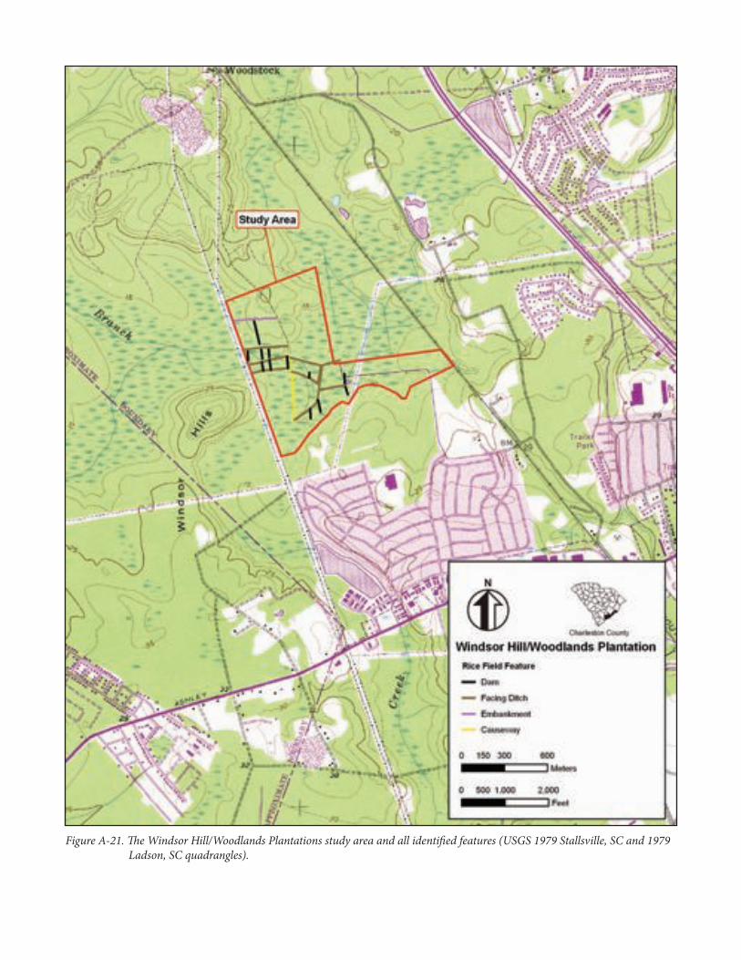
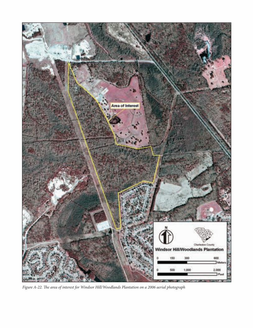
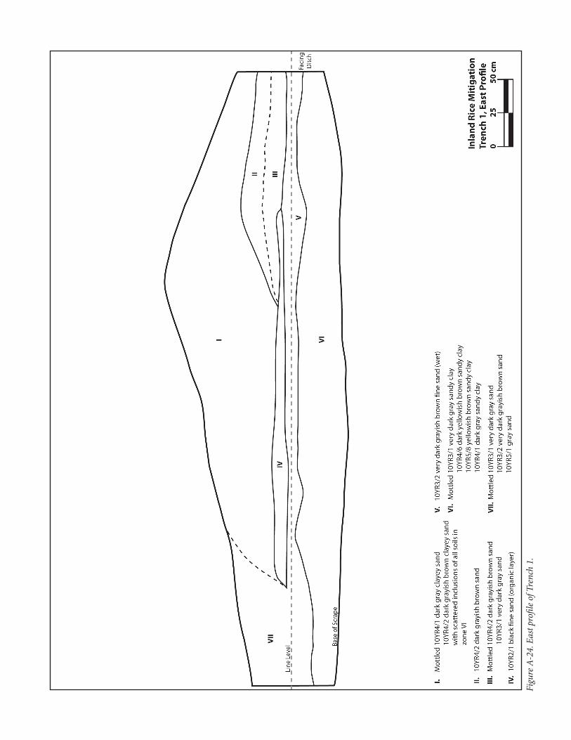
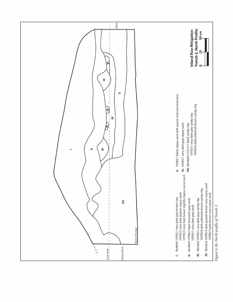
Fieldwork and Features Identified at Windsor Hill/Woodlands Plantations
Fieldwork at Windsor Hill/Woodlands (Hasfort) Plantations occurred in March and June 2007 when the inland rice fields were first identified as site 38CH2159 during a cultural resources survey for a proposed road extension (Agha et al. 2008; Agha and Fletcher 2007). Figure A-21 displays our study area on the modern USGS quadrangle map. Figure A-22 displays the area of interest on a modern aerial photograph. Extensive GPS mapping was carried out to accurately record many features. Our investigations were focused in the area between two transmission line corridors. The discovery of intact inland rice features prompted an assessment that determined the field system eligible for the NRHP. In March 2010, additional fieldwork was conducted in these inland rice fields. Investigators excavated two backhoe trenches through two different embankments to study how they were constructed. Extensive photographic landscape documentation of the rice fields was also conducted. A sample of the landscape photographs is presented in Appendix D. In order to identify intact rice grains from the eighteenth century, investigators collected four soil samples from identified rice fields for ethnobotanical analysis. The features were identified and the results of the fieldwork are described below.
We identified 11 dams, seven facing ditches with facing embankments, and two embankments of unknown function (see Figure A-21). The identification of these features helped us understand how the rice field system in this portion of the Bluehouse Swamp was organized. Systems in this swamp showed a more complicated layout than others in our study group. Here, at the headwaters of the swamp lie Windsor Hill and Woodlands (Hasfort) Plantations. The swamps are a headwaters or natural dividing point for water running in two divergent directions, northward up the swamp to Goose Creek and westward toward the Ashley River. Since these plantations lie at this unique point in the swamp, the utilization of the lowlands for rice cultivation appears different from the traditional, narrower swamp examples seen throughout this context. A historic causeway traverses north-south across a peninsula of high ground that juts into the swamp. The causeway is also the historic property line between Windsor Hill Plantation and Woodlands (Hasfort) Plantation. Although there is an elevation change, it does not appear on the quadrangle. At the northern end of the causeway, a facing ditch extends eastward. This facing ditch and accompanying embankment then turn south for a distance, and then turns west to rejoin with the causeway. Below this point is the slight knoll of high ground, outlined by a facing ditch that creates a “D” shape with the causeway road as its west side (see Figure A-21). Dams extend both north and south from the knoll. Midway in the curve of the “D,” another facing ditch extends east and meets with a dam that runs north/south. On the east side of this dam is an embankment that creates a triangular feature.
NPS Form 10-900-a (Rev. 01/2009) OMB No. 1024-0018 (Expires 5/31/2012)
United States Department of the InteriorNational Park Service
National Register of Historic Places Continuation Sheet
Name of Property Inland Swamp Rice Context, c. 1690-1783
County and State Berkeley, Charleston, Dorchester Counties, South Carolina
West of the northern end of the causeway lies an extensive system of facing ditches with dams crossing through them north/south. This “window pane” appearance was created by facing ditches running along the swamp as it cuts between high ground, and dams that run from high ground to high ground. While the swamp here does not resemble most other swamps in our study group, the features still functioned in the same way: dams connecting high ground to high ground to impound water, and facing ditches providing water to the squares formed by dams. Besides intensive mapping and documentation/recording of the features at Windsor Hill/Woodlands (Hasfort) Plantations, we also conducted excavations to understand the field system better. Two embankments that front facing ditches were chosen. A backhoe was used to cut a section through the embankments, providing us with a large soil profile to record. Figure A-23 displays the recorded embankments of Windsor Hill/Woodlands (Hasfort) Plantations on an aerial photograph, with the locations of the four soil samples collected and the locations of Trenches 1 and 2. By means of Trench 1, we investigated the facing embankment that extends eastward between the slight knoll in the center of the swamp and the easternmost dam encountered. Investigators excavated Trench 2 into the facing embankment (that runs north/south) directly northwest of the previously mentioned facing embankment. The profile in Trench 1, in the east/west facing embankment, was 455 centimeters wide. Due to standing water, we were unable to excavate through the facing ditch on the south side of the cut to include it in the profile drawing. Figure A-24 displays the east profile drawing, and Figure A-25 displays a view of the profile of Trench 1. Zone I, the large soil wedge overlaying the embankment, was comprised of many soils seen in this embankment. It was mostly a 10YR4/1 dark gray clayey sand and a 10YR4/2 dark grayish brown clayey sand mottled together. Clay inclusions (listed in Zone VI) were also found scattered throughout Zone I. Zones II and III appeared to be the same soil deposit, only Zone III was slightly darker. Zone II was a 10YR4/2 dark grayish brown sand, while Zone III was a 10YR4/2 dark grayish brown sand mottled with a 10YR3/1 very dark gray sand. Zone IV, a 10YR2/1 black fine sand, appeared to be an organic layer. The base of Zones III and IV created the appearance of a flat surface, and we interpret this line to be the old ground surface prior to the development of the rice fields here. The excavations of the embankment at James Stobo Plantation also encountered a highly organic, black lens at the old ground surface (Agha 2001). Zone V was a 10YR3/2 very dark grayish brown fine sand that was heavily water logged. This soil was the original soil below old surface. Below Zone V was Zone VI. We interpret this thick soil zone as clay subsoil, as it contained a mottled 10YR3/1 very dark gray sandy clay, a 10YR4/6 dark yellowish brown sandy clay, a 10YR5/8 yellowish brown sandy clay, and a 10YR4/1 dark gray sandy clay. This highly mottled subsoil became thicker and less sandy the further down we excavated, but it was mottled throughout.
When enslaved laborers began to create the facing ditch on the south side of this embankment, they cut through Zone V and deposited it on the surface next to the ditch. As the ditch was dug deeper and larger, Zone VI was encountered and it became fill for the rest of the embankment, seen as Zone I. We imagine this ditch was substantial, as an enormous amount of Zone VI was dug out to create such a large wedge of soil as seen in Zone I. As Zone I was created, it rapidly covered over live plants and debris created from the clearing of the swamps, and this organic material transformed into Zone IV. Zone VII, a highly mottled 10YR3/1 very dark gray sand, a 10YR3/2 very dark grayish brown sand, and a 10YR5/1 gray sand, appears to be erosion runoff or slumping from Zone I. The interface between Zones V and VII was unnoticeable.
NPS Form 10-900-a (Rev. 01/2009) OMB No. 1024-0018 (Expires 5/31/2012)
United States Department of the InteriorNational Park Service
National Register of Historic Places Continuation Sheet
Name of Property Inland Swamp Rice Context, c. 1690-1783
County and State Berkeley, Charleston, Dorchester Counties, South Carolina
Trench 2 was a 390-centimeter-wide profile that was cut through the east facing embankment of a facing ditch. Figure A-26 displays the north profile drawing and Figure A-27 displays a view of the profile of Trench 2. This ditch also has a facing embankment on the west side of it, implying it was a major water transport. Again, high water levels in the ditches on either side of this bank did not allow us to excavate through the ditches to see them in profile. Zone I is a 10YR3/1 very dark gray sandy clay mottled with a 10YR3/2 very dark grayish brown clayey sand, and also a 10YR2/2 very dark brown slightly clayey coarse sand. Zone II is a 10YR6/2 light brownish gray sand mottled with a 10YR3/1 very dark gray sand. Zones III and IV form a mashed together deposit, but are completely different soils. Zone III soils are a 10YR3/1 very dark gray sandy clay mottled with a 10YR3/6 dark yellowish brown sandy clay. Zone IV soils are a 10YR4/2 dark grayish brown very coarse sand mottled with a 10YR6/3 pale brown very coarse sand. The interface of these soils and purpose are discussed later. Below Zone IV lies Zone V, a 10YR2/1 black clayey sand with sparse charcoal inclusions. This zone, and Zone IV above it, are wedged against Zone VII, which is a 2.5Y2.5/1 black sandy clay mottled with a 10YR3/1 very dark gray sandy clay and a 10YR3/6 dark yellowish brown sandy clay. Zone VII is subsoil. Zone VI is similar in position and purpose as Zone III is, and is a 10YR3/1 very dark gray clayey sand.
The construction of this embankment is very different from that seen in Trench 1. While the general techniques behind embankment building are the same, the nature of construction between these banks is radically different. As enslaved African laborers cut into the ground to start excavating the facing ditch, they cut through Zone V, which we interpret as the original ground surface and old soil below. It appears that they threw this soil on top of the old surface, thus piling Zone V on top of Zone V. The charcoal in Zone V, then, is similar to the black organic sand seen in Zone IV from Trench 1. However, the western portion of the Trench 2 profile shows no Zone V in it, and instead, there is a large mound of subsoil clay protruding up into the embankment. Although we inspected it closely, no discernable break or line was present to show a separation between this obvious clay fill mound and subsoil clay below it. We believe that the enslaved laborers scraped away Zone V, their old topsoil, got down to subsoil clay, and then took heavy clay backfill from the ditch and not only piled it on top of Zone VII, but actually physically manipulated it so that it became one with parent subsoil. After documenting this profile, we used a shovel to carve into the wall to look again for an interface; no such line or separation between clays was seen. After creating this clay wedge, it appears that the laborers might have excavated the smaller ditch on the east side of this embankment, and deposited old topsoil into this bank, as seen by the rise of Zone V in the far east side of the profile. Between this rise in Zone V and the clay mound lie Zones IV and III. Zone IV consists of an extremely coarse sand, while Zone III consists of small and large balls of subsoil clay. For some reason, a purposeful bed of very coarse sand was laid down in this space between Zones V and VII, and then clay balls were laid on top. The resulting deposits create an almost level surface between the top of the mounded clay and the top of Zone V. Overlaying these soils is Zone II, which is both a subsoil sand and an organic sand. We believe the pale 10YR6/2 sand did not come from the facing ditch adjacent to this embankment because we did not encounter that sand either above or below the parent clay subsoil at the base of our trench. There was an unknown need for sand to be placed in the embankment at this point. The top most soil, Zone I, is mostly clay from subsoil mixed with the coarse sand seen in Zone IV.
Since the facing ditch to the west of this facing embankment is large, and appears to have served as an important water transport, the clay mound in the bank on the ditch side helped to keep the embankment strong and sound to handle the water moving by it. The well drained sands that lie next to it, and above it, are puzzling. What
NPS Form 10-900-a (Rev. 01/2009) OMB No. 1024-0018 (Expires 5/31/2012)
United States Department of the InteriorNational Park Service
National Register of Historic Places Continuation Sheet
Name of Property Inland Swamp Rice Context, c. 1690-1783
County and State Berkeley, Charleston, Dorchester Counties, South Carolina
was the purpose of very coarse sand in the core of the bank? The cap of Zone I on top of the bank is mostly clay, while the sands below are well drained. More excavation inside inland rice fields needs to be carried out across the Lowcountry so that we can begin to understand the science and technology that went into the construction of embankments. The evidence, and differences, discussed here are proof enough that all embankments are not alike, nor were they all constructed in the same manner.
In addition to the two trenches we excavated and recorded, we collected a total of four soil samples from four different locations of the former rice system at Windsor Hill/Woodlands (Hasfort) Plantations (see Figure A-23). Based on our understanding of the field system, we purposefully selected four locations that fell within interpreted former rice fields. We assumed that periodic burning of rice fields in the past may have carbonized lost rice grains, which we hoped to recover from the soil samples. We collected four soil samples containing between five to ten liters of soil each. These samples were processed through flotation and the light and heavy fractions were sent for analysis to Dr. Kandace Hollenbach at the Archaeological Research Laboratory at the University of Tennessee. The full report is presented in Appendix C. Unfortunately, no rice grains were recovered from the soil samples. Instead, acorn and hickory remains were identified. These seed remains represent either the environment before or after inland rice, which may be useful for future studies. The presence of aster and dock family flora reflects the disturbed nature of the site, which suits the churned soils of the rice fields. After the fields were abandoned, it is possible that these species grew in the fields soon after. The excavations and investigations of the Windsor Hill/Woodlands (Hasfort) Plantations demonstrate the usefulness of incorporating such kinds of studies into inland rice plantation investigations. Studying embankments and their construction will reveal complexities involving engineering and the kind of effort that was involved in building inland rice systems. Collecting soil samples could potentially result in the recovery of rice grains. Different aerobic and anaerobic environments need to be sampled within former inland rice fields, so that conditions can be determined for rice grain preservation.
Woodstock Plantation. In preparing this section, the authors referred to reports prepared by Lansdell et al. (2006:23-38) and Smith (1988:292-296). Woodstock Plantation was a 925-acre inland rice plantation originally formed by Thomas Bulline and his descendents in the late 1600s and early 1700s. Most likely, Thomas Bulline (II) initiated rice planting at his Woodstock country seat along the Bluehouse Swamp in the 1720s. A 1796 plat of Woodstock Plantation shows the outline of the large inland rice plantation fields divided by the swamp. Since no rice fields are well defined on the plat, we included the whole plantation as our area of interest (Figure A-28).
The Bluehouse Swamp is a south to north running lowlands that forms part of the headwaters of Goose Creek in western Berkeley County. The gently sloping east and west sides and the sizable bottom floodplain created perfect swamp conditions for inland rice cultivation. The center of the swamp was channelized, most likely in the late eighteenth century, to allow drainage not only for Woodstock Plantation but also for lower and upper rice fields belonging to other planters. The Bulline family and later the Bee family that married into the Bulline family made their seat at Woodstock and established a family cemetery there. The eighteenth-century wooden main house was leveled in the 1886 Charleston earthquake.
NPS Form 10-900-a (Rev. 01/2009) OMB No. 1024-0018 (Expires 5/31/2012)
United States Department of the InteriorNational Park Service
National Register of Historic Places Continuation Sheet
Name of Property Inland Swamp Rice Context, c. 1690-1783
County and State Berkeley, Charleston, Dorchester Counties, South Carolina
Rice planting continued at Woodstock Plantation into the early decades of the nineteenth century, but by 1834, when it was advertised for sale, the house had been converted into a stop on the new South Carolina Railroad. In the sale advertisement, the use of the land was only mentioned as good for cattle, rice planting having been abandoned some years earlier. Bluehouse Swamp was further channelized by the City of Charleston during construction of the Goose Creek Reservoir in the early 1900s. The ensuing water flow seems to have destroyed much of the hydrological controls thereby inhibiting our understanding of the use of the banks and canals by the planters.
Fieldwork and Features Identified at Woodstock Plantation
Our study area encompasses all of Woodstock Plantation and areas outside. Because the swamp lowlands stretch into the hills and bluffs overlooking the swamp, we decided we needed to include these locales. Figure A-29 displays the study area on the modern USGS quadrangle map, including all recently recorded features. After studying the modern aerial photograph, we limited our area of interest to the course of the Bluehouse Swamp more strictly, and included the gently sloping high ground west of the swamp towards a large transmission line corridor. This transmission line corridor passes through an ornamental pond associated with the old Woodstock Plantation manor house. Figure A-30 displays the area of interest on the modern aerial photograph. Our investigations at Woodstock Plantation began in 2005, where we recorded several features in a small area of swamp (shown in Figure A-29, where the densest features lie over the word “Woodstock”). Recent investigations attempted to locate features above this area, and to see if the few features seen on the historic plat still exist today. We recorded two facing ditches in the northern area of the swamp, and a small portion of the canal that runs through the Bluehouse Swamp. To the south, we identified one long facing ditch and facing embankment that defines the west edge of the swamp, and two dams that run eastward from this feature. We also identified a facing ditch west of this longer one.
Below this area, we identified a dense cluster of features. We found that the inland rice system moves up onto slightly higher ground at the edge of the swamp. Although it is technically outside of the wetlands marked on the quadrangle map, this area may have been utilized very early in the eighteenth century before mastery of the wetter, lower areas was deemed possible. Here, we identified five facing ditches and four dams that run between them. We also mapped in a portion of the later canal. The road that runs across the swamp today gave way to an earlier road, or causeway, that turned northward to the slave settlement found during archaeological investigations (Lansdell et al. 2006). We also identified three ditches that have no accompanying embankments, similar to the ditch found at James Stobo Plantation. The longest ditch we encountered runs from the ornamental pond into swamp below. This suggests that the pond was possibly a reservoir used in times of need.
Lastly, below this dense cluster of features, we identified three additional features. We recorded a portion of the central canal, which matches the canal line seen on the quadrangle map. We also recorded a facing ditch and a dam that extends west from this facing ditch.
NPS Form 10-900-a (Rev. 01/2009) OMB No. 1024-0018 (Expires 5/31/2012)
United States Department of the InteriorNational Park Service
National Register of Historic Places Continuation Sheet
Name of Property Inland Swamp Rice Context, c. 1690-1783
County and State Berkeley, Charleston, Dorchester Counties, South Carolina
These features demonstrate the complexity of inland rice farming and how differing elevations can be utilized for inland rice. Here, we see generally the same types of features as have been recorded throughout this study, only we recorded features that move outside of the traditional swamp setting into a marginal wetland environment. The researcher should be wary of embankments and ditches they encounter during surveys and other archaeological investigations, even if they are not in a traditional swamp. These features may be related to inland rice cultivation or, better yet, to early stages of inland rice experimentation. Although series of canals were created in the northern limits of Woodstock Plantation, these canals have failed and today their original direction and purpose is lost to massive erosion and flooding. As a result, a very large portion of the swamp has been reclaimed by water, and one of the largest inland field systems with untold numbers of features has been lost.
James Stobo Plantation. In preparing this section, the authors looked to Zierden et al. (1999). James Stobo, Esq., began his tenure as an indigo and rice planter at Willtown around 1740, when he purchased a tract of land formerly belonging to local rice planter, John Smelie. Stobo’s tract of 1,200 acres at Willtown was originally improved by Smelie between 1719 and 1727. After Smelie’s death in 1727, his sons retained the property until they reached legal age to sell it. Stobo purchased their tract and all surrounding properties, amassing a large estate that enclosed most of the available land outside of the Willtown limits. Within this land, we suspect he not only grew inland rice, but a prize crop of indigo. Stobo was one of the few early indigo producers noted for producing some of the highest quality indigo in the colony at that time (Edgar 1998:149). Stobo moved from his Willtown plantation in 1767. After his death in 1781, Stobo’s large estate was subdivided by his son, Richard Park Stobo, into several linear lots with each north/south oriented lot containing a portion of the tidal rice fields that lie to the south along the Edisto River. The Stobo manor house, identified and investigated during several archaeological field seasons by The Charleston Museum, was occupied until the early nineteenth century when the house and the lands were abandoned. Figure A-31 displays a 1791 plat of a portion of this plantation, showing the Stobo manor house and tidal fields to the south. This plat does not show inland rice fields or features at all, suggesting that inland rice was abandoned long before 1791. To the west, another plantation tract carved out of Stobo’s 1,200 acre estate shows tidal fields but no inland rice, either. This plantation, called Rock Springs, contains the inland rice complex discussed below.
Fieldwork and Features Identified at James Stobo Plantation
Our study area encompasses much of Stobo’s 1,200 acre estate. This area is shown on the modern USGS quadrangle map in Figure A-32. Our area of interest was defined by the plantation boundary, and is depicted on the aerial photograph in Figure A-33. All fieldwork conducted at this plantation took place between 1999 and 2003. In all, 19 separate features were identified. The James Stobo Plantation contained the most diverse array of feature types in our study group.
The settlement sits on a knoll that was modified in the eighteenth century to provide better drainage. We believe that indigo was grown on this knoll. The feature labeled “knoll edge” on Figure A-32 today is a small eight foot bluff overlooking a lowland swamp. To the north of the knoll is a facing ditch that lines the south edge of a swamp. A facing ditch also runs south from the knoll and lines up with another facing ditch south of it (see Figure A-32).
NPS Form 10-900-a (Rev. 01/2009) OMB No. 1024-0018 (Expires 5/31/2012)
United States Department of the InteriorNational Park Service
National Register of Historic Places Continuation Sheet
Name of Property Inland Swamp Rice Context, c. 1690-1783
County and State Berkeley, Charleston, Dorchester Counties, South Carolina
We believe this easternmost line of facing ditches falls on the eastern plantation boundary shown on the 1791 plat. Between these ditches lies a large dam that runs into an island of high ground in the swamp to the east. Its western edge connects with the modern road today. The modern road was a plantation causeway in the eighteenth century. Remnants of the original causeway still exist as a very low, wide embankment flanked by ditches. An embankment of unknown purpose juts east away from the causeway towards the dam mentioned above (see Figure A-32). Extending westward away from the bottom of the knoll is another very long embankment. To the north of this feature rests another embankment that is the southern property line for the original 500-acre grant of Willtown proper. The long embankment, since it cuts through high ground, was either a property line for an adjoining tract, or possibly a drainage ditch that helped move water towards the causeway road and away from the fields.
Running due west from the original causeway mentioned above is a ditch with no embankment (see Figure A-32). Since the causeway has ditches on both sides of it, it is highly likely that this long, east/west oriented ditch worked as a drain, funneling water into a ditch on the causeway road, southward to the ditch with no embankment. This ditch runs west and turns 90 degrees south into a large freshwater reservoir. This reservoir has a very large, tall embankment on either side that serve as reservoir walls. There is a dam on the north side of the reservoir that the ditch cuts through. There was likely a trunk and gate here in the past that controlled the passage of water into the reservoir. A facing ditch extends north of the ditch along the east edge of a narrow wetland. This wetland, although unexplored in archaeological investigations to date, likely contained inland rice fields. Below the reservoir is a dam and facing ditch. Another facing ditch extends northward, along the west edge of a finger swamp, before terminating into a long dam that cuts across the north edge of the finger swamp.
While this landscape and rice features is confusing, it shows the innovative nature of the 1720s towards perfecting not only rice as a crop, but mastering local geography. While no rice features are seen in the swamp surrounding the knoll upon which the Stobo and Smelie settlements sit, it may have been easier for Smelie to control the swamp on the north edge of the Edisto River tidal flats, even though it was nearly a half mile away from his settlement. Since Stobo utilized his plantation for indigo production, it is unknown if he attempted to grow inland rice in the same fields as his predecessor. Rice was likely grown in the swamp east of the stretch of original, unaltered causeway discovered. This area lies between the causeway marked in yellow and the facing ditch to its east, shown on Figure A-32. Regardless of how this landscape was configured, this study shows the possible ties between the draining of high ground for indigo growing, and how those drains could have fed inland rice fields with much needed fresh water.
Lastly, Agha (1999, 2001) excavated the embankment directly south of the settlement site (shown on Figure A-32 as the longest embankment present). His attempts to first date the embankment grew into an understanding of not only how it was constructed, but how it was repaired in the mid eighteenth century (Agha 1999, 2001). This fieldwork is significant because it shows how complex embankment construction had become by the mid eighteenth century. Subsequent embankment excavations over the last decade have proven to be important in understanding landscape developments and water control.
NPS Form 10-900-a (Rev. 01/2009) OMB No. 1024-0018 (Expires 5/31/2012)
United States Department of the InteriorNational Park Service
National Register of Historic Places Continuation Sheet
Name of Property Inland Swamp Rice Context, c. 1690-1783
County and State Berkeley, Charleston, Dorchester Counties, South Carolina
Jack Savanna Plantation. In preparing this discussion, the authors consulted works by Bailey et al. (2006:98-105) and Smith (1988:139-140). Jack Savanna Plantation is located in southwestern Dorchester County along the Horse Savanna. The Horse Savanna forms a broad band of low or savanna lands stretching northwestward from Rantowles Creek to the lowlands above US Highway 17A. The drainage basin is the Stono River, unlike most of southern Dorchester County that empties into the Ashley River. The lands were recognized early by planters as potential rice lands, which accounts for the land rush that occurred in the area in the first decade of the eighteenth century. The lands of the plantation were first granted to Thomas Hepworth between 1710 and 1711. They were acquired by Ralph Izard in 1731 and developed into a sizable rice plantation shortly thereafter. The land remained in the Izard family until the 1880s. By 1744, if not earlier, Charles Izard, the son of Ralph Izard was building an extensive inland rice system in the savanna lands. The land stayed with his heir, Henry Izard, for several years and at his death, his son Ralph Izard inherited the tract. This Ralph Izard was involved in Revolutionary politics in the 1770s and was one of the wealthiest South Carolinians of his day. He developed Jack Savanna Plantation to its height.
A plat based on a 1773 survey shows the extensive system of dams, facing ditches, and facing embankments that supported the rice culture at Jack Savanna. Figure A-34 displays the plat and our areas of interest. This plat is unique in that it is one of only a handful of pre-Revolutionary War plats that show an actual inland rice system in detail. After the Revolutionary War, inland rice planting at Jack Savanna Plantation, like so many of the others, died out and was certainly gone by the sale of the plantation in 1832. By that time, lands in the former rice section of Dorchester County were valued for their ability to produce cotton and corn and run livestock.
Fieldwork and Features Identified at Jack Savanna Plantation
Our study area includes the two swamps that flank the ridge of land the plantation settlement sat on. Figure A-35 displays these two areas of swamp, with features identified, on the modern USGS quadrangle map. We refined our area of interest to the swamps themselves, as shown on the aerial photograph in Figure A-36. The land has been a managed pine plantation for many decades, with some former rice fields drained sufficiently for silviculture timbering practices.
The western swamp retains features original to the 1773 plat. We recorded two dams here, and identified one additional dam to the northwest using a modern aerial photograph (see Figure A-36). Two long facing ditches were recorded; one on each side of the swamp, with the dams running between them. A shorter third facing ditch was recorded running southeast from the southernmost dam. This one provided further water control for the fields.
The eastern swamp also contains features original to the 1773 plat. We recorded three facing ditches (see Figure A-35). On the north side of the swamp we identified a facing ditch that continues through the middle of the swamp and appears as a blue line on the modern USGS quadrangle map. A second facing ditch we recorded lies on the western edge of this swamp. The third facing ditch lies in the swamp near the southeast edge of our study area.
NPS Form 10-900-a (Rev. 01/2009) OMB No. 1024-0018 (Expires 5/31/2012)
United States Department of the InteriorNational Park Service
National Register of Historic Places Continuation Sheet
Name of Property Inland Swamp Rice Context, c. 1690-1783
County and State Berkeley, Charleston, Dorchester Counties, South Carolina
We recorded four dams in the swamp that lay perpendicular to the above mentioned facing ditches. Though configured differently, these dams worked the same as all dams observed in this study, running from high land to high land and dividing off sections of swamp. We also recorded an embankment and facing ditch that created a small rectangular feature of unknown function. Lastly, two of the dams occur side by side, showing a possible break between plantation properties.
Although the majority of these lands have been managed as pine plantations, the inland swamp fields are relatively intact and retain many original elements of the fields shown in the 1773 plat.
Ponds Plantation. Ponds Plantation was a 1682 grant to Andrew Percival and the location of an early 1715 Yemassee Indian War fortified house. The Percival family heirs kept the property, sometimes called Weston Hall, until 1723 when they sold it to William Donning. The property stayed in the hands of the heirs of William Donning until the 1760s when it was divided between two grandchildren. In preparing this section, we consulted Sipes et al. (2008:36-64) and Smith (1988:226-229). Ponds Plantation is located at the headwaters of the Ashley River, where the river becomes a creek and a large cypress swamp. At the plantation, the river runs dry in droughts. However, three ponds in the creek are spring fed and never run dry, and the largest of them was opposite the Percival Ponds Plantation. Today this large pond is called Schulz Lake. The three ponds are the headwaters of the river and a natural source of fresh water for the plantation and the adjacent rice fields. Near the large pond at a curve in the river is a 60-acre floodplain that was easily converted into an inland rice field system during the Donning’s ownership, if not before. The Donnings and later owners continued to plant rice at the Ponds Plantation along both sides of the swamp. During the ownership of Colonel John Glaze after the Revolutionary War, he had the plantation surveyed. A plat made in 1796 clearly shows a substantial field next to the large pond that makes a natural reservoir for fields to the northeast and the west. Figure A-37 shows the 1796 plat of the Ponds Plantation, with our area of interest noted.
John C. Schultz purchased the plantation from Glaze’s estate in 1818 and it remained in his family until the 1880s. Small level rice production continued on the tract as late as the 1850s, but apparently commercial grade rice production ended with the death of the proprietor in 1833. By 1850 the plantation was used primarily for cotton, livestock and other provision crops.
Fieldwork and Features Identified at Ponds Plantation
Our study area encompassed a very large portion of swamp along the Ashley River, taking in all of Schultz Lake. Figure A-38 displays our study area on the modern USGS quadrangle map, with all identified features. Because the historic plat is so accurate to the landscape today, our area of interest is the same as our study area. Figure A-39 displays our area of interest on a modern aerial photograph.
NPS Form 10-900-a (Rev. 01/2009) OMB No. 1024-0018 (Expires 5/31/2012)
United States Department of the InteriorNational Park Service
National Register of Historic Places Continuation Sheet
Name of Property Inland Swamp Rice Context, c. 1690-1783
County and State Berkeley, Charleston, Dorchester Counties, South Carolina
We recorded a very long and massive facing ditch and accompanying facing embankment that creates a “D” shape. This feature encloses a large floodplain, and is shown on the 1796 plat as “Rice Field” totaling 61 acres (see Figure A-37). This facing ditch has two facing embankments: a very large one on the interior side of the plantation and a smaller bank facing the Ashley River. The larger embankment would have kept water out of the fields in case the Ashley, or Schultz Lake, flooded unexpectedly. Since the facing ditch lies so close to the lake, we believe that the planter(s) could have utilized the lake for water if needed. Or, they could have linked the channel of the Ashley River to the ditch to pull water off of it during high tide. An embankment was recorded at the western end of this field, extending out from this facing ditch towards the southern tip of Schultz Lake (see Figure A-38). A remnant of an internal facing ditch and facing embankment was found extending southeast from the westernmost side of the large field. This facing ditch would have subdivided the large field into smaller sections. Near this facing ditch, we recorded remnants of four additional smaller facing ditches. This large, D-shaped field system is unlike any other field system we recorded. Since there is no ridge of high ground on the southwestern side of the Ashley River, there appears to have been no true dams in this field. Instead, all internal features appear to be facing ditches and facing embankments. At the southern extreme of the field, we recorded a remnant facing ditch and embankment that lines up with another short portion to the north. We also found that the facing ditch on the north edge of the field extends northward into a narrow ravine that meets the large, flat inland rice plain. The 1796 plat displays this ravine as backing up against an embankment feature (see Figure A-37). We interpret this feature as a dam that held back water to create a reservoir. We recorded a large embankment in this spot that we interpreted as a dam, just to the west of the ravine. Today, the modern USGS quadrangle map shows an intermittent branch extending from this ravine, through the north edge of the inland rice field, and out to the Ashley River towards the east. It is possible that this intermittent branch was once a facing ditch that bled overflow water as needed out of the fields and into the Ashley River. As management of this field system ended, backed up water eventually destroyed the dam, leaving only the portion we recorded.
Westward up the swamp, we identified a long facing ditch and quite tall facing embankment that borders the north edge of Schultz Lake. This narrow swamp is mostly void of rice features. One dam was identified, running from the lake to the edge of the high bluff to the northeast. Although this dam appears to have operated as a traditional dam, it does not meet high ground on the west side, but instead, meets the tall embankment that lies against the lake. These features help to show that this narrow swamp between the bluff and the lake was once rice fields as well. However, too few features exist to permit interpretation of the field system organization.
A short distance east from the above mentioned dam, we identified two embankments that create small squares. They are actually built slightly up on the slope of the bluff. These two fields are actually approximately four meters (+/-1 meter for instrument accuracy) higher in elevation than the rice swamp next to Schultz Lake at the bottom of the bluff. These small fields lie roughly 100 feet south of the archaeologically defined seventeenth century Percival settlement (38DR87) (Sipes et al 2008). Due to the extremely small size, proximity to the Percival site, and their upland setting, we believe these small fields were built in the very late seventeenth/very early eighteenth century. These fields, if this early, would have predated profitable rice growing. Instead, they would have served as garden plots managed by the enslaved Africans owned by Percival. If they are indeed of this era, these fields are
NPS Form 10-900-a (Rev. 01/2009) OMB No. 1024-0018 (Expires 5/31/2012)
United States Department of the InteriorNational Park Service
National Register of Historic Places Continuation Sheet
Name of Property Inland Swamp Rice Context, c. 1690-1783
County and State Berkeley, Charleston, Dorchester Counties, South Carolina
some of the earliest documented in this study and some of the oldest recorded in South Carolina. Further research into these fields is needed.
Ponds Plantation exhibits qualities in its inland rice fields that appear to be a transition between inland technology and tidal technology. While the Ashley River is affected by the tide in this area, we are unsure if Schultz Lake served as a natural reservoir, if the ravine to the north of the large enclosed field served as a reservoir, or if the Ashley River’s tides supplied water. While no true dams exist, these fields do not fit Heyward’s descriptions and definitions of inland rice systems and their critical components. Therefore, although Ponds Plantation exhibits what we believe to be Colonial era rice fields, the technology may have been more advanced and possibly post-dated 1770.
Conclusions
The fieldwork and mapping of inland rice features reveal their organization in the swamps of eleven former plantations. These plantations show uniformity in our understanding of historic inland rice system operation and function. While the historical accounts of early inland rice do not shed light into the ways swamps were modified into built environments for wet-rice agriculture, the field mapping of these swamps provides clear examples of how swamps were converted into rice fields and how they functioned. From our map and aerial photograph research, we learned that an accurate plat that shows inland rice features must be field checked; furthermore, a study of the land and swamp must be made in order to understand how the features related to each other. Historic plats do not provide labels for all features and, more often than not, do not show features on the interior of fields (i.e., the plats show major dams and ditches, but do not show quarter ditches, trunk locations or the separation between embankments and ditches). Therefore, historical accounts and detailed historic plats should not be relied on alone for trying to understand how inland rice cultivation worked. A detailed inspection of the swamps is crucial for understanding the origins and evolution of inland rice cultivation.
NPS Form 10-900-a (Rev. 01/2009) OMB No. 1024-0018 (Expires 5/31/2012)
United States Department of the InteriorNational Park Service
National Register of Historic Places Continuation Sheet
Name of Property Inland Swamp Rice Context, c. 1690-1783
County and State Berkeley, Charleston, Dorchester Counties, South Carolina
I. Name of Property Type: Agricultural Features Associated with Colonial Era Inland Rice Cultivation II. Description
Before attempting to identify inland rice features and their related systems, it is crucial that we define the terminology associated with such features. Although the historical record is mute on many of the specifics pertaining to inland swamp reclamation and construction, we do have one reliable twentieth century source. Duncan Clinch Heyward’s (1937) nostalgic narrative on rice cultivation, Seed from Madagascar reveals several historical clues to the ways planters and slaves constructed rice fields out of freshwater inland swamps in coastal South Carolina. Heyward’s descriptions, while drawing upon his grandparent’s stories and knowledge, provide us with a guide for properly naming features. Sam Hilliard (1972) extrapolates on Heyward’s descriptions, as does Richard Porcher (1987), which helps to further define features and, most importantly, their function. Critical elements of an inland rice system are dams, facing ditches, and related facing embankments. Figure A-40 presents a conceptual drawing showing elements of an inland rice system. A discussion of additional elements that may be observed in the field but are not critical to NRHP eligibility follows.
Critical elements of an inland rice system
Dams. The first element of an inland swamp rice field system is the dam. Heyward (1937:12) stated that the reclamation of inland swamps started with creating dams that prevented salt and fresh water overflow into the swamp. While he defined inland planting as occurring near salt water because of elevation and slope needs, his descriptions are, nonetheless, related strictly to an inland setting and serve our purposes here. A primary dam sat at the bottom, or the lowest part, of the fields, and a second dam, called the upper dam, sat at the top of the swamp. The upper dam served to create a reservoir that formed as water drained down the swamp eventually pooling against the upper dam. Heyward (1937:12) later says that, after the two main dams were constructed, that “higher up in the swamp, smaller dams were built.” The sections of land between dams were known as “squares,” which were named by the planter (Heyward 1937:12). Most importantly, “dams extended entirely across the swamp from the highland on one side to the highland on the other” (Heyward 1937:12). Figures A-41 through A-43 display examples of dams at Capers Swamp Plantation (Figure A-41), Crowfield Plantation (Figure A-42), and Northampton Plantation (Figure A-43).
We have employed the term “dam” to mean any embankment identified as crossing through the width of a swamp, joining high ground with high ground. In many cases, the swamps in the Lowcountry of South Carolina tend to be narrow and fall between ridges of high ground. Our fieldwork has proven that banks of this sort exist and are readily common in identifiable field systems. Based on Heyward’s (1937) descriptions and their implied function, the use of the term “dam” should be adopted by researchers identifying inland field systems of the Colonial period.
NPS Form 10-900-a (Rev. 01/2009) OMB No. 1024-0018 (Expires 5/31/2012)
United States Department of the InteriorNational Park Service
National Register of Historic Places Continuation Sheet
Name of Property Inland Swamp Rice Context, c. 1690-1783
County and State Berkeley, Charleston, Dorchester Counties, South Carolina
Facing ditches and facing embankments. The second and third elements of an inland swamp field system are the face ditch and its related face embankment. After dams were set in place, ditching began. Heyward (1937:13) called the ditches that provided water from the reservoir to the fields “face” ditches, which he said ran in both directions (meaning both the width and length of the swamp). These ditches ran on the edges of swamps framing or “facing” the fields or squares. When the facing ditch was excavated, the soils created an embankment. These embankments sat on the inside of the square, with the facing ditch on the outside. Figures A-44 through A-47 present examples of these features at Crowfield Plantation (Figure A-44), Northampton Plantation (Figure A-45), Windsor Hill/Woodlands Plantation (Figure A-46), and Woodstock Plantation (Figure A-47).
The facing embankments also had a ditch on the interior or field side; these were usually smaller than the ditch on the outside of the square. The internal facing ditches and embankments further subdivided the larger square into smaller fields. The primary purpose of facing ditches was to get water into or out from the fields and serve as the method of circulating water around the boundaries of a field.
Additional elements that can be identified
Quarter ditches. Another element of an inland system was the quarter ditch. Inside of each field were “quarter” ditches, which Heyward (1937:13) described as being “the smaller of the ditches [that] ran across the swamp.” Besides being smaller, quarter ditches were designed to run parallel to the dams, while the facing ditches typically were constructed to run in different directions as needed. Quarter ditches also filled the expanse of the field, and facing ditches did not. The primary purpose of quarter ditches was to allow even-flow flooding of the field so as not to damage the crops. Figure A-48 displays a quarter ditch and its meeting with a facing ditch in the foreground at Dean Hall Plantation.
Trunks. An additional element of an inland field is the trunk. The facing embankments joined the dams to create an enclosed field. The dam holding the reservoir would have had a water control structure, or “trunk.” The trunk in the rice field system served different purposes. Trunks in the dams allowed water to flow into the facing ditches. Trunks were also installed in facing ditch embankments. The facing embankment trunk permitted water to flow from the primary facing ditch on the exterior of the field through the embankment into the smaller ditch on the other side, in the interior of the field. As the water began to flood the field, it would have moved downstream, perpendicular to the dams, circled the field, and then overflowed into the smaller quarter ditches. The quarter ditches were oriented against the flow of water and would have helped to capture the water and make sure the field flooded evenly. Thus, a perfect control of the watershed is realized: the fields flooded without damage to the crop, and the trunks closed when the desired depth of water was realized in each field. After the field was flooded and the rice crop needed to have water moved off, the trunks in the fields were opened and the water moved into the exterior facing ditches, to run down through the swamp. Figure A-49 displays a more common wooden gate supported by a wooden trunk below the water at Dean Hall Plantation. Figure A-50 displays a granite trunk and gate system at Dean Hall Plantation.
Typically, inland rice field trunks did not survive into modern times. However, their former locations are usually marked by blown out sections of the embankments. These gaps in embankments tend to be between three
NPS Form 10-900-a (Rev. 01/2009) OMB No. 1024-0018 (Expires 5/31/2012)
United States Department of the InteriorNational Park Service
National Register of Historic Places Continuation Sheet
Name of Property Inland Swamp Rice Context, c. 1690-1783
County and State Berkeley, Charleston, Dorchester Counties, South Carolina
to six feet. The researcher must be careful to note that a section of embankment involving a trunk links exterior facing ditches to interior ones or provides open areas in dams to permit water to flow into the exterior facing ditch.
Reservoirs/Reserves. Heyward (1937) paints a simple picture of the upper dam holding back water as a reservoir. Although our research and fieldwork has shown that natural geography may have allowed some planters (including Alexander Nisbett of Dean Hall Plantation) to construct an exterior reservoir out of a natural pond or small wetland lying above and adjacent to an inland rice swamp, these kinds of settings for exterior reservoirs are extremely rare and should not be considered to be the norm. By and large, Colonial era field designers located their reservoirs inside one of their squares or in a portion of unbanked swamp directly adjacent to their fields. This poses some problems in identifying the reservoir in the inland rice field systems, especially in the absence of a clear plat. A brief discussion follows on our conclusion that, although a critical component of most inland systems, reservoirs may be impossible to identify within a field system.
Plantation boundaries were set where their owners were able to draw them. As land became granted and purchased, eventually all available gaps between plantations were filled, with shared property lines. Thus, a several-miles-long inland swamp could wind across multiple plantations. Figure A-51 displays a conceptual field schematic diagram that illustrates this common scenario. As Figure A-51 demonstrates, it can be difficult in the absence of a period plat for the modern researcher to imagine the “upper” dam and the reservoir on the individual tracts. Figure A-52 shows this problem in a 1795 plat of Oak Forest Plantation, a rice plantation along the Ashley River. In this example, the water moved from north to south through the inland rice system, with two reservoirs located at the north edge of the plat. The last square on the plat against the property line (labeled “25”) fronts the neighboring plantation. This is one historical example of a reservoir set up at the edge of a plantation.
In the case of Jack Savanna Plantation, a Horse Savanna inland rice plantation in modern day Dorchester County, the reservoir was located in the middle of the plantation fields, near higher land. Figure A-53 presents a 1773 plat of Jack Savanna Plantation. Here, the reservoir serves fields to both sides from a slightly higher elevation. This reservoir is positioned in the field system to feed multiple fields from a centrally located point. This same situation is evident at Camp Plantation, located in the Charleston Neck between the Cooper and Ashley rivers. Figure A-54 presents a 1784 plat of Camp Plantation with the clearly noted “Reserve Dam” in the middle of the inland rice system. Both Jack Savanna Plantation and Camp Plantation provide historical evidence of reservoirs located in the middle of an inland rice system.
Since swamps often ran through multiple plantations, frequently dams enclosing one planter’s reservoir located along a boundary line often served to enclose another adjoining planter’s square (see Figure A-51). We interpret this to mean that a former or even a potential rice field square could serve as a reservoir. It serves to reason then that former inland rice fields could also serve as reservoirs, making it difficult to identify specific squares as reservoirs or rice fields. They could have easily been both.
We found an example of this dual use on a 1788 plat of Richmond Plantation, an inland rice plantation in the Cooper River watershed. Figure A-55 presents a portion of the 1788 plat of Richmond Plantation that reveals that the reserve at the time of the survey had been an “old rice field” (South Carolina Historical Society: Smith Plat Collection:3). Considering that nearly all eighteenth-century rice field squares no longer hold water due to
NPS Form 10-900-a (Rev. 01/2009) OMB No. 1024-0018 (Expires 5/31/2012)
United States Department of the InteriorNational Park Service
National Register of Historic Places Continuation Sheet
Name of Property Inland Swamp Rice Context, c. 1690-1783
County and State Berkeley, Charleston, Dorchester Counties, South Carolina
long ago abandonment and modern drainage efforts and considering that early rice fields could, and likely did, become later reservoirs, we conclude that identification of the reservoir, though a critical element of early rice field construction, may not be possible. Thus, we do not list identification of the reservoir as a critical element of the inland rice field system.
This multiple plantation/property swamp system presumably demanded a level of cooperation between plantation managers and begs the question: how did a lower/downstream swamp planter fill his reservoir if the upper/upstream swamp planter controlled the water? The natural flow of water was severely disrupted through inland rice developments. This is where the importance of facing ditches is realized. There were periods in the rice year when water was not allowed on a field, which means that the uppermost reservoir at the head of a swamp had the chance to overflow. The trunks in the reservoir dam upstream would have been opened to bleed water into the facing ditches and run around each planter’s fields through the natural drainage into the local river. It would be at this time that lower planters would fill their reservoirs. The absence of an extensive number of lawsuits indicates that planters negotiated and worked with each other to make sure water was managed properly and each had a sufficient quantity for their crops. Later, this scenario helps explain how water became a problem as the eighteenth century progressed.
Canals/Drains. As each decade passed, more and more planters adapted the swamps in their plantations into inland rice systems. We believe the massive conversion of large, natural watersheds eventually created major water problems. With swamps completely drained and only ditches on their edges to reroute the old flow of natural creeks, heavy rains in the Lowcountry would have created major problems for water movement and natural filtering into the larger streams and rivers. We read about “freshets” in the late eighteenth and nineteenth centuries that decimated whole fields systems (Edelson 2006:103-106). To counter the impact of this flooding, after the Revolutionary War, the state and local planters developed public canals or drains as a water control devise to help the inland plantations avert disaster. Although discussed before the Revolutionary War, afterwards major canal projects were developed to ensure proper hydrological control as well as a means of easier transportation for their rice crops (McCord 1840:475-588). Since we see canals on late-eighteenth- and early-nineteenth-century plats that also show inland rice fields, it appears that the canals were pivotal to the way inland swamp agriculture worked. However, we believe that canals, or drains as they were sometimes called, were instead a later development brought on by increasing water issues and drainage problems and increasing competition from tidal fields (Edelson 2006). Usually, a facing ditch was enlarged into a canal so the field system worked exactly the same as before, but the planter had better control over the increasing freshets. Some examples of these larger projects were the Caw Caw Swamp, the Horse Savanna, and the Wando River drains. All built in the late eighteenth century, these projects had been discussed for decades earlier as planters in these regions battled flooding. Some large planter families such as the Draytons and the Izards controlled large adjoining tracts and were able to construct private canals on their properties, but most had to await public improvements proposed in the new South Carolina Legislature, who were more sensitive than their Colonial counterparts. Later, after cotton expanded into the upstate in the early nineteenth century, freshets became an even larger problem, yet by this time many rice planters had made the jump to tidal rice production and lost concern about the impact of freshwater flooding their fields along the tidal riverbanks.
NPS Form 10-900-a (Rev. 01/2009) OMB No. 1024-0018 (Expires 5/31/2012)
United States Department of the InteriorNational Park Service
National Register of Historic Places Continuation Sheet
Name of Property Inland Swamp Rice Context, c. 1690-1783
County and State Berkeley, Charleston, Dorchester Counties, South Carolina
Because we see features named as “canals” on Post-Revolutionary plats, and many of these features are associated with inland rice fields, we realize that this can be confusing to the researcher and documenter of Colonial era inland rice systems. We acknowledge that inland planters used larger drains called canals, both public and private, but that these were largey later adaptations of the use of facing ditches. Nonetheless, the researcher should still attempt to record and document canal features. Some reveal original Colonial era feature locations and orientations in the landscape. It is the researcher’s job to gain an understanding of a plantation further and its historical development in order to properly identify Colonial features apart from antebellum features.
Eighteenth-century reservoirs within swamps rarely exist today, so we are not recommending that NRHP eligibility assessments include identification of them. Canals, on the other hand, are frequently seen in the swamps in our study area. They appear to be a later development brought on by changes through the eighteenth century. We also do not require that the presence of a canal be pivotal to understanding how an inland rice system worked. We do not believe that the researcher should determine the role of canals that happen to be found within identifiable inland rice systems. However, their presence should not be ignored. If reservoirs are available to be recorded, then they should be included in the study. If canals are available to be recorded, they should also be included, but will not contribute to the eligibility of the system. They will provide further understanding and information important to the historical development and evolution of the plantation.
Causeways (roads or avenues). Naturally, planters and slaves were faced with problems of crossing lowlands to reach parts of the plantation property. They frequently incorporated crossing points over dams and even facing embankments. Often called causeways on eighteenth century plats, they should be identified as a part of the overall inland system (i.e., an upper dam also serves as a historic roadway across the plantation). These old roadbeds provide a critical role in moving both labor and products around the plantation, between plantations and sometimes in getting crops to markets. These features are usually noted on period plats and then observed in the field and frequently maintained to the present time as management roads. The field researcher, however, should be careful to note that the presence of an old roadbed over a wetland is only a clue to potential other features located in the swamp. Figure A-56 displays a view of a causeway road at Windsor Hill/Woodlands Plantation.
Historic property lines (“bank/ditch/dam the line”). Another feature frequently observed in lowlands and mistaken for dams or ditches related to inland rice fields is the historic property line. Like the old causeways mentioned above, planters often marked their lands by using banks and ditches. Construction of these was similar to that of facing ditches and dams and many period plats note “bank the line,” “ditch the line,” or “dam the line.” The field researcher should observe and note these embankments and ditches, but like causeway roads across wetlands, use them as potential clues to the presence of inland fields but not necessarily more than just property lines.
Summary of terms. We suggest researchers adopt the terms “dams,” “facing ditch,” and “facing embankment” for terminology related to Colonial era inland rice fields. Borrowing terms like “drain” and “canal” can imply different kinds of technology and time periods more relevant to the Antebellum era. We also suggest using the term “quarter
NPS Form 10-900-a (Rev. 01/2009) OMB No. 1024-0018 (Expires 5/31/2012)
United States Department of the InteriorNational Park Service
National Register of Historic Places Continuation Sheet
Name of Property Inland Swamp Rice Context, c. 1690-1783
County and State Berkeley, Charleston, Dorchester Counties, South Carolina
ditch” when applicable. Taking Heyward’s (1937) definitions of the terms, which are also employed in later studies (Hilliard 1972, Porcher 1987), and applying them to our field studies and various historic plats, we have found that the terms relate to function and therefore are the best terms to use when naming inland rice features. We have found that other features exist that do not fit the definitions given here. While these other features may have had a role in the inland rice system, we could find no other historical example that further explained or defined these features that are not dams, facing ditches, facing embankments, quarter ditches, or reservoirs.
Too often, facing embankments and dams are the only feature still existing in many fields today. Quarter ditches are the rarest elements seen by the researcher. They seem to have been subject to silt infilling only a few decades after the inland fields became inactive. They are rare and should be included in the study where observed. Facing ditches can usually be seen on opposite sides of their embankments and on either side of dams. Reservoirs should be recorded when observed but their apparent absence does not detract from an eligible field system. Canals should be recorded when seen, but are generally not an element of the Colonial era inland rice systems.
As a swamp is studied, the investigators may not realize what type of feature they are recording at that moment. When GPS points are taken of a given feature and points brought into GIS so they can be overlaid on modern or historic maps, the recorder should be able to identify the feature as a dam, a facing ditch, or a facing embankment. If it does not fall into these labels, it should be called what it is (i.e., ditch, embankment, causeway road, road, canal). These features may help make sense of the water control or create divisions in the landscape that provide other answers. Sometimes, embankments and ditches comprise historic property lines. Old roads and causeways cut through historic swamps and inland rice fields and appear as embankments today. In some cases, causeways and dams were one and the same. These features do not detract from the NRHP eligibility of inland rice systems; in fact, they may help provide more understanding and reveal more information of the plantation under study. We urge the investigators of inland rice swamps to not ignore features that might appear to be unrelated to inland rice. The recording of these features reveals landscape information and is important.
III. Significance Statement
These inland rice system features are important resources which provide information about inland rice culture in Berkeley, Charleston, and Dorchester counties. They qualify under items A, C, and D of the National Register Criteria. This property type should be listed under the AGRICULTURE, ARCHAEOLOGY (Historic Non-Aboriginal), BLACK ETHNIC HERITAGE, EUROPEAN ETHNIC HERITAGE, ENGINEERING, INVENTION, LANDSCAPE ARCHITECTURE, and SOCIAL HISTORY areas of significance. Below is a description of how each National Register criteria applies to inland rice culture.
Under Criterion A, a resource can be eligible for the NRHP if it is associated with events that have made a significant contribution to the broad pattern of history. Historically, inland rice-growing preceded tidal rice-growing – an endeavor that generated far more wealth for tidal planters than for their inland rice ancestors. Scholars have shown that in the eighteenth and nineteenth centuries, rice was the crop that helped to turn the Carolina colony (and later, South Carolina) into an agricultural powerhouse. Inland rice systems have not been studied nearly as much
NPS Form 10-900-a (Rev. 01/2009) OMB No. 1024-0018 (Expires 5/31/2012)
United States Department of the InteriorNational Park Service
National Register of Historic Places Continuation Sheet
Name of Property Inland Swamp Rice Context, c. 1690-1783
County and State Berkeley, Charleston, Dorchester Counties, South Carolina
as tidal rice systems largely due to a lack of primary sources. The physical remnants of the inland rice systems at the plantations studied in this context are a tangible record of the extraordinary amount of skill and labor exerted by the enslaved African population at these plantations. Generally, the layout and design of the inland rice systems are still quite clear and visible. Though dams, facing ditches, facing embankments, and other associated inland features have experienced an unknown amount of erosion and degradation over the passing centuries due to weather and differing methods of land management, these features retain more than enough of their original integrity and form to allow the investigator to visualize what is believed to be the original layout of the fields. Therefore, inland rice systems that retain integrity should be eligible for the NRHP under Criterion A.
Under Criterion B, properties may be eligible for the NRHP if they are associated with the lives of persons significant in our past. The inland rice systems studied in this context belonged to planters who were likely valuable, contributing members of their society. However, the footprint they left on the landscape (their inland rice systems) is not sufficient for eligibility under Criterion B. The property must be illustrative rather than commemorative of a person demonstrably important within a local, state, or national historic context (Townsend et al. 1993:21). If an inland rice system were to be identified that is illustrative of a person important within such contexts, then such a system could be significant under Criterion B. In most cases, however, inland rice systems should not be eligible for the NRHP under Criterion B.
Under Criterion C, resources may be eligible for the NRHP that embody “the distinctive characteristics of a type, period, or method of construction, or that represent the work of a master, or that possess high artistic values, or that represent a significant and distinguishable entity whose components may lack individual distinction…” (Keller and Keller 1994:6). Enslaved Africans living and working at the plantations included in this context created the inland rice systems present at these plantations. These rice fields embody the distinctive characteristics of a type, period, and method of construction. The features as defined in this context that comprise a historic inland rice system are distinctive to the period of inquiry (1690-1783), comprise a specific type of water control through engineering, and are indicative of a particular method of construction. Therefore, identifiable inland rice systems that maintain integrity should be eligible for the NRHP under Criterion C.
Under Criterion D, a resource may be eligible if it has yielded or is likely to yield information important in history. Previous archaeological investigations (of which there are relatively few) have demonstrated that excavations of inland rice features can provide valuable information about the construction and maintenance of these features. Agha (1999, 2001) conducted archaeological investigations to understand the construction and repair techniques of an embankment at the James Stobo plantation at Willtown Bluff. Agha (2001) conclusively showed that limited amounts of fieldwork can produce a very high yield of data relating to the initial construction and maintenance of inland rice fields for the Colonial period. He demonstrated not only that artifacts can be recovered from these earthworks, but also that they can be associated with specific upturned soils, captured during different stages of the dike construction and maintenance. He used in situ artifacts to obtain the interpretive dates. Thus, Agha (2001) was able to date the initial construction of the earthworks to the 1719-to-1740 period and repairs to the 1750-to-1765 period. Similar future investigations of intact elements of inland rice systems may be able to yield information about many aspects of the construction, use, and maintenance of Colonial period inland rice systems.
NPS Form 10-900-a (Rev. 01/2009) OMB No. 1024-0018 (Expires 5/31/2012)
United States Department of the InteriorNational Park Service
National Register of Historic Places Continuation Sheet
Name of Property Inland Swamp Rice Context, c. 1690-1783
County and State Berkeley, Charleston, Dorchester Counties, South Carolina
Additionally, the excavation of specific areas of the inland rice systems may reveal activity areas indicative of the enslaved Africans who worked in the fields every day. The enslaved ate meals, used tools, ported buckets, smoked pipes, and performed other activities during work and during breaks inside of the fields. The embankments throughout fields would have provided ample locations for such activities to take place. Exploratory testing may reveal such locales of artifacts, as Agha (2001) demonstrated, can exist within embankments located over 200 feet from a primary settlement. Lastly, sampling soils from inland rice fields may be used to determine the varieties of rice grown at the plantation. Inland rice farmers did not begin by planting the famous strain of rice known as “Carolina gold.” It is unknown how many strains of rice from all over the world were experimented with in these types of inland rice fields before a strain was identified that would thrive in these conditions (Carney 2001). The soil samples and rice grains retrieved from Colonial fields may help address this issue. Sampling tree cores for dendrochronology may also help to date trees in inland fields, which in turn helps us to date the abandonment of the fields. During the current study, investigators recovered no rice grains from the soil samples taken from site 38CH2159 at Windsor Hill/Woodlands (Hasfort) Plantations. However, different aerobic and anaerobic environments should be sampled further at other plantations to attempt to locate intact rice grains, as well as testing phytoliths. Based on archaeological investigations to date, inland rice systems should be eligible for the NRHP under Criterion D.
IV. Registration Requirements
To qualify for listing, these inland rice features and subsequent systems must have been involved in the cultivation of inland rice. The identified features must exist in a historic freshwater swamp/wetland/lowland for them to be associated with inland rice cultivation. The historic flow of water through the freshwater swamp must be determined, in order to understand how the identified physical elements functioned together to form a system. The features that must be identified are dams, facing ditches, and facing embankments. If any of these features do not exist, or cannot be accurately named by its position in the landscape, the identification of an inland rice system is not possible. Since this context demonstrates that these features held specific functions relative to Colonial era inland rice cultivation and engineering, it is important that future identifiers and recorders of such inland rice systems utilize these terms when attempting to positively identify an historical inland rice system.
Once an inland rice system has been positively identified, the system must retain physical integrity. This context has shown that embankments and ditches that retain enough integrity can be studied through excavations that can reveal construction techniques, repair episodes, and possible activity areas. Even though dams and facing ditches/embankments may be eroded and their integrity diminished to the point of the feature minimally existing, the presence of that feature helps demonstrate the historical integrity of the field system so that the system can be identified. Therefore, a feature can help to show the historical framework of an inland rice system and not retain enough physical integrity to be worthy of further study. Dams, facing ditches, and facing embankments must be intact enough so that they can provide illustrative examples and be studied further in the future. In other words, though time and elements have eroded the critical elements (dams, facing ditches and embankments) and other features, there must be enough observable integrity that the overall system reflects the spatial organization, its components and its historical association with a wetland to be an eligible property.
NPS Form 10-900-a (Rev. 01/2009) OMB No. 1024-0018 (Expires 5/31/2012)
United States Department of the InteriorNational Park Service
National Register of Historic Places Continuation Sheet
Name of Property Inland Swamp Rice Context, c. 1690-1783
County and State Berkeley, Charleston, Dorchester Counties, South Carolina
The presence of an identifiable Colonial era (1670-1783) settlement is important to have in proximity to the identified, intact inland rice system. These settlements can be either identified through historic plat maps or archaeological investigations. The presence of a settlement nearby opens up the potential for research into labor, production, and landscape studies.
The inland rice system must also be able to contribute to a better understanding of the plantation and the plantation’s historical development through time. Once an intact field system is attributed to a plantation, the researcher can then study how neighboring properties developed, how the planter improved upon inland fields, converted them to other uses, or abandoned them for other agricultural pursuits. Plat information can provide evidence for understanding how inland rice plantations also profited from the venture. The inland rice system should also be able to contribute to our understanding of inland rice technology. Since few historical narratives exist on innovation, experimentation, failures, or successes for the time period under question, every identifiable, intact inland rice system provides more information towards our understanding of the process, how it began, was refined, perfected, and mastered. Furthering our knowledge of these topics provides us with better context to understanding if, and how, inland rice technology was adapted to tidal rice technology. Understanding how a plantation utilized its swamps for inland rice reveals not only the technology behind the engineering, but a clearer understanding of the planters who oversaw the conversion of the swamps and the enslaved Africans that created and maintained them during the plantation life span. Studying inland rice systems can also provide information about when they were abandoned, converted to other uses, as well as how the plantation focus changed through time. Lastly, serious investigations into inland rice systems may allow us to see how enslaved Africans utilized their tasks in the fields. Accurate mapping of the fields themselves can be translated into acreage, which can be translated into ¼ acre tasks—the most common measurement of labor in inland rice cultivation. Being able to positively identify an inland rice system and assess it for integrity and research potential, will demonstrate the system’s eligibility for the NRHP. Besides the examples and interpretations offered already, we know that there may be exceptions to what we have defined when new fields are investigated. There are opportunities for features to be present that do not appear to fit into the inland rice system in question or even have a related function at all. Features not fitting the categories of dam, facing ditch, facing embankment, quarter ditch, reservoir, canal, or causeway road may be related to other plantation needs/activities. For instance, embankments that were not rice related may have been property lines or dams converted to use as mill sites. These features can sometimes be recorded while recording inland rice features. Once maps have been constructed, the documenter should be able to readily discern inland rice features from other types of features. Below is a brief discussion of historical processes that can account for discrepancies in the field.
In the eighteenth century, the growth of indigo and inland rice may have worked together in the landscape. The James Stobo Plantation is a possible example of this. Therefore, the different kinds of features in that landscape may account for functions related to indigo production. While indigo features do not contribute to the eligibility of inland rice systems, recording these features may contribute to the plantation’s eligibility. Defining an indigo/inland rice system, however, would be very beneficial to our understanding of eighteenth-century plantation economies and production, and thus would generate important research questions. In the nineteenth century, canal works were common, and some inland rice features were reengineered into canals. Canal documentation can aid in nineteenth-century plantation research.
NPS Form 10-900-a (Rev. 01/2009) OMB No. 1024-0018 (Expires 5/31/2012)
United States Department of the InteriorNational Park Service
National Register of Historic Places Continuation Sheet
Name of Property Inland Swamp Rice Context, c. 1690-1783
County and State Berkeley, Charleston, Dorchester Counties, South Carolina
Postbellum developments, such as phosphate mining and silvaculture, affected the inland rice systems also. Phosphate mining was conducted in low areas, some of which had been previously used for production of rice. For example, we have observed that inland rice embankments were sometimes used for later phosphate mining tram lines and the old rice fields were mined for the mineral. The fields usually reveal the ridged look where the ground disturbing mining took place but they may retain their distinctive character elements, spatial organization, and lowland locale. Thus, despite this intrusive mining, original inland rice features may still be present and identifiable and the researcher should be careful to determine if they retain integrity.
Another destructive industry on inland fields has been modern silvaculture. Paper companies in the coastal plain have drained and planted in historic rice field lowlands, often destroying the field systems. They created large tram or logging truck roads that have the appearance of rice field embankments; in some cases the companies have reused inland rice features. In order to make low areas dry enough for pine tree survival, the companies have deep ditched and canalized old rice fields. These features should also be noted so they can be sorted out from the inland rice features. However, dams, facing ditches, and their embankments are sometimes merely planted on as a part of planted pine forests, the ground retaining its historic look. The investigator of inland rice systems should be alert for these later developments and look to see if they have negatively impacted the Colonial rice systems.
Although most inland fields have been long abandoned since the early 1800s, some were kept in operation through the Civil War and beyond. We found evidence of intact inland fields still being used into the present, especially for waterfowl hunting, livestock penning, and even small-scale rice planting. Naturally, where inland swamp fields are continuing to be managed and in use, archaeological testing could damage embankments or ditches. For the purpose of counting the features associated with inland rice cultivation in this multiple property submission, each individual inland rice system counts as one archaeological site. For example, the section of swamp belonging to an historic plantation, and all dams, facing ditches, and facing embankments that comprise the historical system, counts as one archaeological site.
NPS Form 10-900-a (Rev. 01/2009) OMB No. 1024-0018 (Expires 5/31/2012)
United States Department of the InteriorNational Park Service
National Register of Historic Places Continuation Sheet
Name of Property Inland Swamp Rice Context, c. 1690-1783
County and State Berkeley, Charleston, Dorchester Counties, South Carolina
Former inland rice plantations were investigated in Berkeley, Charleston, and Dorchester counties. Inland swamps are the specific geographical locales of concern.
NPS Form 10-900-a (Rev. 01/2009) OMB No. 1024-0018 (Expires 5/31/2012)
United States Department of the InteriorNational Park Service
National Register of Historic Places Continuation Sheet
Name of Property Inland Swamp Rice Context, c. 1690-1783
County and State Berkeley, Charleston, Dorchester Counties, South Carolina
SECTION H. Summary of Identification and Evaluation Methods
Previous Research and Investigations
Research on inland rice fields by the authors began in 1999 at the James Stobo Plantation located at Willtown Bluff in Charleston County. This work was published in Willtown: An Archaeological and Historical Perspective (Zierden et al. 1999). Andrew Agha, coauthor of this inland rice context, wrote the results of shovel testing and mapping of an embankment near the Stobo settlement site (38CH1659). Subsequent field seasons followed by Agha (2001) that involved further excavations of the embankment under study, detailed in 38CH1659: An Analysis of the Cultural Material and Deposits in an Eighteenth Century Inland Swamp Rice Embankment, held on file at The Charleston Museum.
As part of a larger survey of stands of the Francis Marion National Forest, investigators from Brockington and Associates, Inc., surveyed portions of Compartment 215 in the fall of 2004. This survey included an investigation of the inland rice fields of Capers Swamp Plantation (Agha and Philips 2008). Several embankments and ditches were observed during archaeological survey. This project demonstrated that aerial photographs and historic plats could be studied in tandem to reveal intact features in the landscape.
In the fall of 2004, investigators from Brockington and Associates, Inc., recorded an inland rice system in Charleston County during a cultural resources survey of the Palmetto Commerce Park Tract in Charleston County (Chambliss and Bailey 2005). Investigators recorded the inland rice system related to the Glaze-Poppenheim Plantation, but were unable to investigate the western extent of the field system, as it extended beyond the project tract boundary. Further research into inland rice was carried out by Brockington and Associates, Inc., staff to record this rice field as archaeological site 38CH2065. The site was determined to be potentially eligible for the NRHP.
In January of 2005, investigators from Brockington and Associates, Inc., conducted a cultural resources survey of the Weber Tract in Charleston County (Lansdell et al. 2006). Investigators encountered embankments and ditches extending into portions of the uplands of the tract. Andrew Agha and Charles Philips returned to these features and found they linked with inland rice features along the edge of the Bluehouse Swamp. The section of inland rice fields were designated as archaeological site 38CH2068. The site is part of the NRHP-eligible Woodstock Plantation Historic District.
Between March and September 2005, investigators from Brockington and Associates, Inc., conducted a cultural resources survey of the Shade Tree Tract in Charleston County (Sipes et al. 2006). Archival research indicated that the land was part of the eighteenth-century Fenwick Estate and had a high probability to contain remnants of inland rice fields in the southeastern and northern portions of the tract. A physical investigation by field crews confirmed the presence of banks and ditches similar to those identified in this context in the southeastern portion of the tract. The old rice fields were located along lowlands that drain into the Stono River, about two miles to the east. No archaeological site form was filed at the time since the owner was not seeking development in the wetlands of the tract.
NPS Form 10-900-a (Rev. 01/2009) OMB No. 1024-0018 (Expires 5/31/2012)
United States Department of the InteriorNational Park Service
National Register of Historic Places Continuation Sheet
Name of Property Inland Swamp Rice Context, c. 1690-1783
County and State Berkeley, Charleston, Dorchester Counties, South Carolina
In September of 2005, investigators from Brockington and Associates, Inc., conducted a cultural resources assessment and brief historical background on Gippy Plantation along the Cooper River in Berkeley County (Philips 2005). Archival research and subsequent field investigations revealed the remnants of inland rice fields along Reedy Run, a small creek of the West Branch of the Cooper River, approximately 0.75 miles west of the river. Though the fields were observed, no archaeological site form was completed.
In March of 2006, investigators from Brockington and Associates, Inc., conducted a survey of two tracts along an unnamed creek of the upper Ashley River in Dorchester County (Poplin and Philips 2006). The field investigation of the highland along the edge of an old cypress swamp revealed several sites on the higher area and the presence of an inland rice system in the cypress swamp west of the high land. The swamp was at the head of a small unnamed creek that emptied into the upper reaches of the Ashley River. The investigation into the swamp was done at the discretion of the field crew and was beyond the scope of the owners’ development plans. No archaeological site form was completed.
In May of 2006, investigators from Brockington and Associates, Inc., conducted a cultural resources assessment of a 106-acre tract along the north side of Bees Ferry Road in Charleston County (Philips and Bailey 2006). Archival research indicated that the western lowland portion of the tract bordering a small unnamed creek once belonged to the Verdier Plantation and had a high probability to contain inland rice fields. A physical investigation confirmed that banks, ditches, and a possible reserve similar to ones discussed in this context were located in the lowlands along the creek. No archaeological site form was completed.
In April 2007, investigators from Brockington and Associates, Inc., (Philips et al. 2007) conducted further survey investigations of the inland rice fields previously recorded at the Palmetto Commerce Park Tract (Chambliss and Bailey 2005) during archaeological survey for the Old Fort Drive Extension project. These investigations resulted in the identification of the western, Dorchester County portion of 38CH2065. The inland rice field site number was updated to become site 38CH2065/38DR348.
In June 2007, investigators from Brockington and Associates, Inc., identified the remnants of an inland rice system during the cultural resources survey of the Palmetto Commerce Parkway Extension project (Agha et al. 2008). Investigators conducted extensive mapping of a large portion of these inland rice fields. These fields, designated site 38CH2159, were determined to be eligible for the NRHP. In 2009, a plan for mitigation of possible adverse effects to site 38CH2159 was created by Brockington and Associates, Inc., following consultation with the SCDAH. The plan includes this Inland Rice Context Multiple Property Documentation Form, the creation of an on-site outdoor interpretive panel, professional landscape photographic documentation of inland rice features, excavation of embankments for further study, ethnobotanical analysis of materials recovered from collected soil samples, a video documentary to be used along with a website hosted by Charleston County, and a lecture series based on the inland rice contextual study.
NPS Form 10-900-a (Rev. 01/2009) OMB No. 1024-0018 (Expires 5/31/2012)
United States Department of the InteriorNational Park Service
National Register of Historic Places Continuation Sheet
Name of Property Inland Swamp Rice Context, c. 1690-1783
County and State Berkeley, Charleston, Dorchester Counties, South Carolina
We compared historic and modern maps and aerial photographs together in order to see how visible elements today match with historic views of the plantations in our study group. These images were georeferenced to find commonalities between features visible on the historic maps and on modern aerial photographs. For instance, embankments visible on a modern aerial photograph were geo-referenced in GIS with an historic plat of the former plantation. We were able to quickly note what features matched up exactly, what was different, and what shows up on the aerial photograph and what does not. This work also showed us exact locations of rice growing areas only evident on the historic plat; most of these locales are labeled “old rice field,” which means they were considered “old” at the time the plat was drawn, usually in the late eighteenth/early nineteenth centuries. This information aided our physical field investigations of the plantations. We used a submeter-accurate Trimble GPS unit to map dams, facing ditches, and facing embankments; as well as miscellaneous ditches, canals, roads, and embankments. By comparing the historic images with modern ones, we were able to see differences between lower areas and higher areas in fields, and how the geography influenced the locations of inland rice features. We checked the recorded features for integrity, taking note of erosion, natural/man-made disturbances, vegetation present, and the overall management or current setting of the fields under study. We photographed all recorded features. The GPS points collected were then imported into GIS and compared with the historic and modern images. We made no attempts to map all features within a plantation in our study sample. Instead, we chose a large area based on available plats, and then refined our scope of investigation through modern aerial photographs. When features were visible from both sources, we investigated those places for positive field verification that the features are indeed rice-related. We also looked at swamps that do not show features on the aerial photographs, have a plat that shows no inland rice details, or have no plat at all. When plats were available, we investigated areas marked earlier (i.e., “old rice fields”) than others. This process allowed us to expedite our investigations of features for integrity, and after recording them, name the features according to the historic functions listed in Section F. This information aided the development of the criteria list for assessing inland rice systems for the NRHP, which is included in this context in Appendix B. This criteria list consists of a series of questions that should be addressed by researchers attempting to identify inland rice systems. This list also prompts the researcher to determine if the identified inland rice system can produce research questions that support their NRHP recommendations. The questions in this criteria list are echoed in the Registration Requirements in Section F.
NPS Form 10-900-a (Rev. 01/2009) OMB No. 1024-0018 (Expires 5/31/2012)
United States Department of the InteriorNational Park Service
National Register of Historic Places Continuation Sheet
Name of Property Inland Swamp Rice Context, c. 1690-1783
County and State Berkeley, Charleston, Dorchester Counties, South Carolina
Historic inland rice systems provide new opportunities to ask research questions about plantations. Besides the proper identification of such systems, the development of research questions about inland rice systems provides support for the assessment of eligibility for the NRHP. In other words, an intact inland system may look important, but without the ability of the system to provide research potential, the inland system may not be as important as it initially appears to be. Section E of this context demonstrates the lack of information concerning inland rice fields, their development, evolution, technology, technological advances or failures, and change into tidal rice agriculture. Therefore, the Colonial era inland rice systems can act as a primary source from which researchers can gain an understanding about the Colonial period that might not be possible without intact evidence of this kind of agriculture. Comparisons between mapped inland systems may provide the researcher the ability to see more or less advanced engineering and/or technology. Excavation of intact facing embankments and dams may also reveal construction techniques that could be specific to region, local geography, planters’ backgrounds (German, British, Dutch, French, etc.), or specific decade(s) of the eighteenth century. Research into the enslaved Africans’ backgrounds could be conducted if enough documentation exists for the plantation under study. Such information may shed light on where the enslaved Africans came from in Africa, and if they originated from rice growing regions. These lines of inquiry will help to further our understanding of Colonial engineering, agricultural practices, Colonial technology, and levels of technology transfer from Africa.
The historical development of an inland rice plantation is furthered by a study of its inland rice system. Changes to the boundaries of the plantation can be seen in inland rice swamps, due to embankments/dams that may have fallen on property lines. Also, locations of water sources may have changed through time. New imports of Africans may have also spurred a change in the inland rice technology. The researcher may be limited in the types of questions they can ask, but through careful comparison to other inland rice plantations and their field systems, a better understanding of these topics could be achieved. One interesting and seldom explored facet of Colonial era inland plantations is what the interaction between plantations was like. As discussed in Section F, a single swamp was often managed by multiple plantations, so that the features of the rice field system were “shared” between planters. Careful study of a plantation that falls into this scenario would allow the researcher to explore avenues of inquiry about eighteenth century social relationships, labor management, and development of technology.
NPS Form 10-900-a (Rev. 01/2009) OMB No. 1024-0018 (Expires 5/31/2012)
United States Department of the InteriorNational Park Service
National Register of Historic Places Continuation Sheet
Name of Property Inland Swamp Rice Context, c. 1690-1783
County and State Berkeley, Charleston, Dorchester Counties, South Carolina
Agha, Andrew 1999 African-American Rice Dike Construction. In Willtown: An Archaeological and Historical Perspective.
Archaeological Contributions 27, pp. 275-282. South Carolina Department of Archives and History, Columbia.
2001 38CH1659: An Analysis of the Cultural Material and Deposits in an Eighteenth Century Inland Swamp Rice Embankment, held on file at The Charleston Museum, Charleston, South Carolina.
Agha, Andrew and Joshua N. Fletcher 2007 Addendum Report Regarding Additional Inland Rice Fields within the Supplemental Study Area of the
Palmetto Commerce Parkway Extension Project, Charleston County, South Carolina. Prepared for THE LPA GROUP INCORPORATED, Columbia, South Carolina. Report prepared by Brockington and Associates, Inc., Charleston, South Carolina.
Agha, Andrew and Charles F. Philips, Jr. 2008 Cultural Resources Survey of Part One of the Country Road Environmental Analysis Francis Marion
National Forest Berkeley and Charleston Counties, South Carolina. Report prepared for the USDA Forest Service. Report prepared by Brockington and Associates, Inc., Charleston, South Carolina.
Agha, Andrew, Charles F. Philips, Jr., and Nicole M. Isenbarger 2010 Data Recovery Excavations at Dean Hall Plantation, Berkeley County, South Carolina. Report prepared
for E.I. Nemours DuPont, Moncks Corner, South Carolina. Report prepared by Brockington and Associates, Inc., Charleston, South Carolina.
Agha, Andrew, Charles F. Philips, Jr., Edward Salo, Jason Ellerbee, and Joshua N. Fletcher 2008 Cultural Resources Survey of the Palmetto Commerce Parkway Extension Project, Charleston County,
South Carolina. Prepared for THE LPA GROUP INCORPORATED, Columbia, South Carolina. Report prepared by Brockington and Associates, Inc., Charleston, South Carolina.
Allston, R. F. W. 1843 Memoir of the Introduction and Planting of Rice in South Carolina. Miller and Browne, Charleston,
South Carolina.
Bailey, Ralph, Jr. 1997 Cultural Resources Reconnaissance of the Ingleside Plantation Tract, Charleston County, South
Carolina. Prepared for Albert Weber Manufacturing Company, Summerville, South Carolina. Report prepared by Brockington and Associates, Inc., Charleston, South Carolina.
NPS Form 10-900-a (Rev. 01/2009) OMB No. 1024-0018 (Expires 5/31/2012)
United States Department of the InteriorNational Park Service
National Register of Historic Places Continuation Sheet
Name of Property Inland Swamp Rice Context, c. 1690-1783
County and State Berkeley, Charleston, Dorchester Counties, South Carolina
Bailey, Ralph Jr., David S. Baluha, and Charles F. Philips, Jr. 2006 Cultural Resources Survey and Archaeological Testing of Selected Sites at the Watson Hill Tract,
Dorchester County, South Carolina. Draft Report. Prepared for South Carolina Property Holdings Company, LLC, Wichita, Kansas Report prepared by Brockington and Associates, Inc., Charleston, South Carolina.
Bartram, William 1792 Travels through North and South Carolina, Georgia, East and West Florida. London. A 1980 reprint of
the original edition. University Press of Virginia, Charlottesville.
Berlin, Ira 1998 Many Thousands Gone, The First Two Centuries of Slavery in North America. Harvard University Press,
Cambridge, Massachusetts.
Carney, Judith A. 2001 Black Rice: The African Origins of Rice Cultivation in the Americas. Harvard University Press, Cambridge,
Massachusetts.
Catesby, Mark 1731 Natural History of Carolina, Florida and the Bahamas, London. An original copy is in the College of
Charleston Special Collections Library, Charleston, South Carolina.
Chambliss, Mallory L. Jr. and Ralph Bailey, Jr. 2005 Cultural Resources Survey of the Palmetto Commerce Park Tract, Charleston, South Carolina.
Prepared for Spring Grove Associates, Charleston, South Carolina. Report prepared by Brockington and Associates, Inc., Charleston, South Carolina.
Clowse, Converse D. 1971 Economic Beginnings in Colonial South Carolina, 1670-1730. University of South Carolina Press,
Columbia.
Coclanis, Peter A. 1989 Shadow of a Dream: Economic Life and Death in the South Carolina Low Country, 1670-1920. Oxford
University Press, Oxford, United Kingdom.
Edelson, S. Max 2006 Plantation Enterprise in Colonial South Carolina. Harvard University Press, Cambridge,
Massachusetts.
Edgar, Walter 1998 South Carolina A History. University of South Carolina Press, Columbia.
NPS Form 10-900-a (Rev. 01/2009) OMB No. 1024-0018 (Expires 5/31/2012)
United States Department of the InteriorNational Park Service
National Register of Historic Places Continuation Sheet
Name of Property Inland Swamp Rice Context, c. 1690-1783
County and State Berkeley, Charleston, Dorchester Counties, South Carolina
Eltis, David, Philip Morgan, and David Richardson 2007 Agency and Diaspora in Atlantic History: Reassessing the African Contribution to Rice Cultivation in the
Americas. In The American Historical Review, Vol. 112 (December 2007), pp. 1329-1358.
Garrow, Patrick H., and Daniel T. Elliott 1987 Crowfield Archaeological Survey. Report prepared for Westvaco Development Corporation, Summerville,
South Carolina. Report prepared by Garrow and Associates, Inc., Atlanta, Georgia.
Glen, James 1761 A Description of South Carolina. R. And J. Dodsley, London. Reprinted in 1951 in Colonial South
Carolina, Two Contemporary Descriptions. Edited by Chapman J. Milling, University of South Carolina Press, Columbia.
Greene, Jack P. 1989 Selling a New World: Two Colonial South Carolina Promotional Pamphlets by John Nairne and John
Norris. University of South Carolina Press, Columbia. 1993 Colonial South Carolina and the Caribbean Connection in Colonial America: Essays in Politics and
Social Development, edited by Stanley N. Katz, John M. Murrin, and Douglas Greenberg. McGraw-Hill, Inc., New York.
Heyward, Duncan Clinch 1937 Seed from Madagascar. University of North Carolina, Chapel Hill. Reprinted in 1993, University of
South Carolina, Columbia.
Hilliard, Sam B. 1972 Antebellum Tidewater Rice Culture in South Carolina and Georgia. In North America: Essays on
Geographical Change in Honour and Memory of Andrew Hill Clark, edited by James R. Gibson. University of Toronto Press, Toronto.
Keller, J. Timothy, and Genevieve P. Keller 1994 How to Evaluate and Nominate Designed Historic Landscapes. US Department of the Interior, National
Park Service, Washington, DC.
Lansdell, Brent, Charles F. Philips, Jr. and Ralph Bailey, Jr. 2006 Cultural Resources Survey and Testing of the Weber Research Tract, Charleston County, South
Carolina. Prepared for Weber USA Corporation, Summerville, South Carolina. Report prepared by Brockington and Associates, Inc., Charleston, South Carolina.
Lawson, John 1967 A New Voyage to Carolina. Edited by Hugh Talmege Lefler. University of North Carolina Press, Chapel
Hill.
NPS Form 10-900-a (Rev. 01/2009) OMB No. 1024-0018 (Expires 5/31/2012)
United States Department of the InteriorNational Park Service
National Register of Historic Places Continuation Sheet
Name of Property Inland Swamp Rice Context, c. 1690-1783
County and State Berkeley, Charleston, Dorchester Counties, South Carolina
Littlefield, Daniel C. 1991 Rice and Slaves, Ethnicity and the Slave Trade in Colonial South Carolina. University of Illinois Press,
Urbana.
McCord, David, J. 1840 The Statutes at Large of South Carolina, Vol. 7. A. S. Johnston Company, Columbia. pp. 475-588
McCusker, John J. and Russell R. Menard 1985 The Economy of British America, 1607-1789. University of North Carolina Press, Chapel Hill.
Milling, Chapman J. editor 1951 Colonial South Carolina: Two Contemporary Descriptions by Governor James Glen and Doctor George
Milligen-Johnston. University of South Carolina Press, Columbia.
Meinig, D. W. 1986 The Shaping of America: A Geographical Perspective on 300 Years of History, Vol. I Atlantic America,
1492-1800. Yale University Press, New Haven, Connecticut.
Nairne, Thomas 1710 A Letter from South Carolina. A. Baldwin, London. Reprinted in 1989 in Selling of a New World: Two
Colonial South Carolina Promotional Pamphlets. Edited by Jack P. Greene, University of South Carolina Press, Columbia.
Philips, Charles F. Jr. 2005 Cultural Resources Assessment and Brief Background History of the 797.83 Acre Gippy Plantation Tract
Near the Town of Moncks Corner in Berkeley County, South Carolina. Report prepared by Brockington and Associates, Inc., Charleston, South Carolina.
Philips, Charles F. Jr. and Ralph Bailey, Jr. 2006 Cultural Resources Assessment of the 102.6-acre Bees Landing Tract Charleston, South Carolina.
Report prepared by Brockington and Associates, Inc., Charleston, South Carolina.
Philips, Charles F. Jr., Edward Salo, Andrew Agha, and Joshua N. Fletcher 2007 Intensive Cultural Resources Survey of the Old Fort Drive Extension (S-18-662), Dorchester County,
South Carolina. Prepared for the South Carolina Department of Transportation, Columbia. Report prepared by Brockington and Associates, Inc., Charleston, South Carolina.
NPS Form 10-900-a (Rev. 01/2009) OMB No. 1024-0018 (Expires 5/31/2012)
United States Department of the InteriorNational Park Service
National Register of Historic Places Continuation Sheet
Name of Property Inland Swamp Rice Context, c. 1690-1783
County and State Berkeley, Charleston, Dorchester Counties, South Carolina
Poplin, Eric C. and Charles F. Philips, Jr. 2006 Cultural Resources Reconnaissance and Assessment of the Lamie Tract, Dorchester County, South
Carolina. Prepared for Portrait Homes, North Charleston, South Carolina. Report prepared by Brockington and Associates, Inc., Charleston, South Carolina.
2010 Historical Overview of Northampton Plantation Francis Marion and Sumter National Forests. Francis Marion and Sumter National Forests Cultural Resource Management Report 2010-15.Prepared for the USDA Forest Service. Report prepared by Brockington and Associates, Inc., Charleston, South Carolina.
Porcher, Richard Dwight 1987 Rice Culture in South Carolina: A Brief History, the Role of the Huguenots, and Preservation of its
Legacy. In Transaction of the Huguenot Society of South Carolina, No. 92. Published by Order of the Society, Charleston, South Carolina.
Price, Jacob M. 1984 The Transatlantic Economy. In Colonial British America: Essays in the New History of the Early Modern
Era, edited by Jack P. Greene and J. R. Pole. Johns Hopkins University Press, Baltimore.
Ruffin, Edmund 1843 The Private Diary of Edmund Ruffin, 1843. Reprinted in 1992 in Agriculture, Geology, and Society in
Antebellum South Carolina. Edited by William M. Mathew, University of Georgia Press, Athens.
Salley, A. S. 1913 Introduction of Rice Culture into South Carolina. The State Company, Columbia
Sipes, Eric D., Charles F. Philips, Jr., Jason Ellerbee, and Ralph Bailey, Jr. 2006 Cultural Resources Survey of the Shade Tree Tract, Charleston County, South Carolina. Report
prepared for HLA, Inc., Charleston, South Carolina. Report prepared by Brockington and Associates, Inc., Charleston, South Carolina.
Sipes, Eric D, Charles F. Philips, Jr., Edward Salo, and Laura Tedesco 2008 Cultural Resources Survey and Testing at The Ponds, Dorchester County, South Carolina. Prepared for
Greenwood Development Corporation, Summerville, South Carolina. Report prepared by Brockington and Associates, Inc., Charleston, South Carolina.
Smith, Henry A. M. 1988 Rivers and Regions of Early South Carolina, Articles from the South Carolina Historical (and Genealogical)
Magazine. The Reprint Publishers, Spartanburg.
NPS Form 10-900-a (Rev. 01/2009) OMB No. 1024-0018 (Expires 5/31/2012)
United States Department of the InteriorNational Park Service
National Register of Historic Places Continuation Sheet
Name of Property Inland Swamp Rice Context, c. 1690-1783
County and State Berkeley, Charleston, Dorchester Counties, South Carolina
Smith, Hayden R. 2002 Watersheds of Change: An Environmental History of South Carolina Lowcountry Rice Plantations,
1760-1860. A Masters Thesis prepared for the College of Charleston.
Smith, Henry A. M. N/d Smith Plat Collection. Unpublished eighteenth and nineteenth century land plats traced by the author
located in the Manuscript Collections of the South Carolina Historical Society, Charleston.
Stewart, John 1931 Letters from John Stewart to William Dunlop. Contributed by J. G. Dunlop of London. South Carolina
Historical and Genealogical Magazine, Vol. 32 (January 1931):1-33.
Taylor, Alan 2001 American Colonies, The Settling of North America. Penguin Books, New York.
Townsend, Jan, John H. Sprinkle Jr., and John Knoerl 1993 National Register Bulletin 36: Guidelines for Evaluating and Registering Historical Archaeological Sites
and Districts. US Department of the Interior, National Park Service, Interagency Resources Division, Washington, DC.
Trinkley, Michael, Debi Hacker and Sarah Fick 2003 Liberty Hall: A Small Eighteenth Century Rice Plantation in Goose Creek, Berkeley County, South
Carolina. Chicora Research Foundation, Inc., Research Series 62. Columbia, South Carolina.
Wheaton, Tom R., Jr., Mary Beth Reed, Theresa Hamby, and Leslie Raymer 1991 Archaeological Site Testing of Three Historic Sites, Wambaw District, Francis Marion National Forest.
Prepared for the USDA Forest Service. Francis Marion and Sumter National Forests Cultural Resource Management Report 91-19.
Wood, Peter H. 1974 Black Majority, Negroes in Colonial South Carolina from 1670 through the Stono Rebellion. W. W.
Norton & Company, New York.
Zierden, Martha, Suzanne Linder, and Ronald Anthony 1999 Willtown: An Archaeological and Historical Perspective. Archaeological Contributions 27. The Charleston
Museum, Charleston, South Carolina.
NPS Form 10-900-a (Rev. 01/2009) OMB No. 1024-0018 (Expires 5/31/2012)
United States Department of the InteriorNational Park Service
National Register of Historic Places Continuation Sheet
Name of Property Inland Swamp Rice Context, c. 1690-1783
County and State Berkeley, Charleston, Dorchester Counties, South Carolina
Figure A-1. A regional map showing the locations of Crowfield Plantation, the Mazyck plantation in the Wambaw Swamp, and the Mazyck plantation in Goose Creek.
Figure A-2. A regional map showing the locations of all plantations in the context study group across Berkeley, Charleston, and Dorchester counties
Figure A-3. The results of Garrow and Elliot’s (1987) extensive mapping (from Garrow and Elliott 1987:65).
Figure A-4. The Crowfield Plantation study area in the Huckhole Swamp (USGS 1979 Ladson, SC and 1979 Mount Holly, SC quadrangles).
Figure A-5. Areas of interest for Crowfield Plantation on a 2006 aerial photograph.
Figure A-6. A portion of the 1827 Dean Hall plat, showing the three areas of interest included in this investigation.
Figure A-7. The Dean Hall study areas, with all identified features (USGS 1979 Kittredge, SC quadrangle).
Figure A-8. A 2006 aerial photograph showing highly visible rice features located in former Dean Hall Plantation.
Figure A-9. A portion of the 1806 plat of Northampton Plantation, with the area of interest highlighted.
Figure A-10. The Northampton Plantation study area and identified features (USGS 1971 Huger, SC and 1992 Ocean Bay, SC quadrangles).
Figure A-11. The area of interest for Northampton Plantation on a 2006 aerial photograph.
Figure A-12. The 1807 Diamond plat of Capers Swamp Plantation with a section labeled as “old rice fields” highlighted.
Figure A-13. The Capers Swamp Plantation study area and identified inland rice features (USGS 1992 Seewee Bay, SC quadrangle).
Figure A-14. The areas of interest for Capers Swamp Plantation on a 2006 aerial photograph.
Figure A-15. The 1789 plat of Glaze-Poppenheim Plantation, with the area of interest highlighted.
Figure A-16. The Glaze-Poppenheim Plantation study area, with all identified features (USGS 1979 Stallsville, SC and 1979 Ladson, SC quadrangles).
NPS Form 10-900-a (Rev. 01/2009) OMB No. 1024-0018 (Expires 5/31/2012)
United States Department of the InteriorNational Park Service
National Register of Historic Places Continuation Sheet
Name of Property Inland Swamp Rice Context, c. 1690-1783
County and State Berkeley, Charleston, Dorchester Counties, South Carolina
Figure A-17. The area of interest for Glaze-Poppenheim Plantation on a 2006 aerial photograph.
Figure A-18. The 1792 plat of the Hayes/Ingleside Plantation, showing the area of interest.
Figure A-19. The Hayes/Ingleside Plantation study area and all identified features (USGS 1979 Ladson, SC quadrangle).
Figure A-20. The area of interest for Hayes/Ingleside Plantation on a 2006 aerial photograph.
Figure A-21. The Windsor Hill/Woodlands Plantations study area and all identified features (USGS 1979 Stallsville, SC and 1979 Ladson, SC quadrangles).
Figure A-22. The area of interest for Windsor Hill/Woodlands Plantation on a 2006 aerial photograph.
Figure A-23. The recorded embankments of Windsor Hill/Woodlands (Hasfort) Plantations on a 2006 aerial photograph, with the locations of the four soil samples collections and Trenches 1 and 2.
Figure A-24. East profile of Trench 1.
Figure A-25. View of east profile of Trench 1.
Figure A-26. North profile of Trench 2.
Figure A-27. View of north profile of Trench 2.
Figure A-28. A 1796 plat of Woodstock Plantation, showing the area of interest.
Figure A-29. The Woodstock Plantation study area, including all recently recorded features (USGS 1979 Ladson, SC quadrangle).
Figure A-30. The area of interest for Woodstock Plantation on a 2006 aerial photograph.
Figure A-31. The 1791 plat of a portion of the James Stobo Plantation, showing the Stobo manor house near the top of the map and tidal fields to the south.
Figure A-32. The James Stobo Plantation study area and identified features (USGS 1972 Adams Run, SC and 1960 Fenwick, SC quadrangles).
Figure A-33. The area of interest for James Stobo Plantation on a 2006 aerial photograph.
Figure A-34. The 1773 plat of Jack Savanna Plantation, with the areas of interest highlighted.
Figure A-35. The Jack Savanna Plantation study area, showing all identified features (USGS 1979 Clubhouse Crossroads, SC and 1979 Stallsville, SC quadrangles).
NPS Form 10-900-a (Rev. 01/2009) OMB No. 1024-0018 (Expires 5/31/2012)
United States Department of the InteriorNational Park Service
National Register of Historic Places Continuation Sheet
Name of Property Inland Swamp Rice Context, c. 1690-1783
County and State Berkeley, Charleston, Dorchester Counties, South Carolina
Figure A-36. The areas of interest for Jack Savanna Plantation on a 2006 aerial photograph.
Figure A-37. The 1796 plat of the Ponds Plantation, with the area of interest highlighted.
Figure A-38. The Ponds Plantation study area with all identified features (USGS 1979 Clubhouse Crossroads, SC and 1979 Stallsville, SC quadrangles).
Figure A-39. The area of interest for Ponds Plantation on a 2006 aerial photograph.
Figure A-40. A conceptual drawing showing elements of an inland rice system.
Figure A-41. An example of a dam at Capers Swamp Plantation.
Figure A-42. An example of a dam at Crowfield Plantation.
Figure A-43. An example of a dam at Northampton Plantation.
Figure A-44. An example of a facing embankment, with facing ditch in foreground, at Crowfield Plantation.
Figure A-45. An example of a facing embankment, with facing ditch to its left, at Northampton Plantation.
Figure A-46. An example of a facing embankment, with facing ditch to its right, at Windsor Hill/Woodlands Plantation.
Figure A-47. An example of a facing embankment, with facing ditch to its left, at Woodstock Plantation.
Figure A-48. A view of a quarter ditch and its meeting with a facing ditch (in foreground) at Dean Hall Plantation.
Figure A-49. A view of a wooden gate supported by a submerged wooden trunk at Dean Hall Plantation.
Figure A-50. A view of the granite trunk and gate system at Dean Hall Plantation.
Figure A-51. A conceptual field schematic that illustrates how plantations shared a common swamp.
Figure A-52. A 1795 plat of Oak Forest Plantation, with reservoirs noted.
Figure A-53. A 1773 plat of Jack Savanna Plantation, showing a property line highlighted in blue.
Figure A-54. A 1784 plat of Camp Plantation with the reserve dam in the middle of the inland rice system.
Figure A-55. A 1788 plat of Richmond Plantation that shows the reserve as “reserve old rice field open”.
Figure A-56. A view of a causeway road at Windsor Hill/Woodlands Plantation.
Figu
re A
-1. A
regio
nal m
ap sh
owin
g the
loca
tions
of C
row!
eld P
lant
atio
n, th
e Maz
yck p
lant
atio
n in
the W
amba
w Sw
amp,
and
the M
azyc
k pla
ntat
ion
in G
oose
Cr
eek.
Figure A-2. A regional map showing the locations of all plantations in the context study group across Berkeley, Charleston, and Dorchester counties
Figure A-3. "e results of Garrow and Elliot’s (1987) extensive mapping (from Garrow and Elliott 1987:65).
Figure A-4. "e Crow!eld Plantation study area in the Huckhole Swamp (USGS 1979 Ladson, SC and 1979 Mount Holly, SC quadrangles).
Figure A-5. Areas of interest for Crow!eld Plantation on a 2006 aerial photograph.
Figure A-6. A portion of the 1827 Dean Hall plat, showing the three areas of interest included in this investigation.
Figure A-7. "e Dean Hall study areas, with all identi!ed features (USGS 1979 Kittredge, SC quadrangle).
Figure A-8. A 2006 aerial photograph showing highly visible rice features located in former Dean Hall Plantation.
Figure A-9. A portion of the 1806 plat of Northampton Plantation, with the area of interest highlighted.
Figure A-10. "e Northampton Plantation study area and identi!ed features (USGS 1971 Huger, SC and 1992 Ocean Bay, SC quadrangles).
Figure A-11. "e area of interest for Northampton Plantation on a 2006 aerial photograph.
Figu
re A
-12.
"e 1
807 D
iam
ond
plat
of C
aper
s Swa
mp
Plan
tatio
n wi
th a
secti
on la
beled
as “
old ri
ce !
elds”
high
light
ed
Figure A-13. "e Capers Swamp Plantation study area and identi!ed inland rice features (USGS 1992 Seewee Bay, SC quadrangle).
Figure A-14. "e areas of interest for Capers Swamp Plantation on a 2006 aerial photograph.
Figure A-15. "e 1789 plat of Glaze-Poppenheim Plantation, with the area of interest highlighted.
Figure A-16. "e Glaze-Poppenheim Plantation study area, with all identi!ed features (USGS 1979 Stallsville, SC and 1979 Ladson, SC quadrangles).
Figu
re A
-17.
"e a
rea
of in
teres
t for
Gla
ze-P
oppe
nheim
Pla
ntat
ion
on a
2006
aer
ial p
hoto
grap
h.
Figure A-18. "e 1792 plat of the Hayes/Ingleside Plantation, showing the area of interest.
Figure A-19. "e Hayes/Ingleside Plantation study area and all identi!ed features (USGS 1979 Ladson, SC quadrangle).
Figure A-20. "e area of interest for Hayes/Ingleside Plantation on a 2006 aerial photograph.
Figure A-21. "e Windsor Hill/Woodlands Plantations study area and all identi!ed features (USGS 1979 Stallsville, SC and 1979 Ladson, SC quadrangles).
Figure A-22. "e area of interest for Windsor Hill/Woodlands Plantation on a 2006 aerial photograph
Figure A-23. "e recorded embankments of Windsor Hill/Woodlands (Hasfort) Plantations on a 2006 aerial photograph, with the locations of the four soil samples collections and Trenches 1 and 2.
Figu
re A
-24.
East
pro!
le of
Tre
nch
1.
Figure A-25. View of east pro!le of Trench 1.
Figu
re A
-26.
North
pro!
le of
Tre
nch
2.
Figure A-27. View of north pro!le of Trench 2.
Figu
re A
-28.
A 17
96 pl
at of
Woo
dsto
ck P
lant
atio
n, sh
owin
g the
area
of in
teres
t.
Figure A-29. "e Woodstock Plantation study area, including all recently recorded features (USGS 1979 Ladson, SC quadrangle).
Figure A-30. "e area of interest for Woodstock Plantation on a 2006 aerial photograph.
Figure A-31. "e 1791 plat of a portion of the James Stobo Plantation, showing the Stobo manor house near the top of the map and tidal !elds to the south.
Figure A-32. "e James Stobo Plantation study area and identi!ed features (USGS 1972 Adams Run, SC and 1960 Fenwick, SC quadrangles).
Figure A-33. "e area of interest for James Stobo Plantation on a 2006 aerial photograph.
Figu
re A
-34.
"e 1
773 p
lat o
f Jac
k Sav
anna
Pla
ntat
ion,
with
the a
reas
of in
teres
t high
light
ed.
Figure A-35. "e Jack Savanna Plantation study area, showing all identi!ed features (USGS 1979 Clubhouse Crossroads, SC and 1979 Stallsville, SC quadrangles).
Figure A-36. "e areas of interest for Jack Savanna Plantation on a 2006 aerial photograph.
Figure A-37. "e 1796 plat of the Ponds Plantation, with the area of interest highlighted.
Figure A-38. "e Ponds Plantation study area with all identi!ed features (USGS 1979 Clubhouse Crossroads, SC and 1979 Stallsville, SC quadrangles).
Figu
re A
-39.
"e a
rea
of in
teres
t for
Pon
ds P
lant
atio
n on
a 20
06 ae
rial p
hoto
grap
h.
Figu
re A
-40.
A co
ncep
tual
dra
wing
show
ing e
lemen
ts of
an in
land
rice
syste
m.
Figure A-42. An example of a dam at Crow!eld Plantation.
Figure A-41. An example of a dam at Capers Swamp Plantation.
Figure A-44. An example of a facing embankment, with facing ditch in foreground, at Crow!eld Plantation.
Figure A-43. An example of a dam at Northampton Plantation.
Figure A-46. An example of a facing embankment, with facing ditch to its right, at Windsor Hill/ Woodlands Plantation.
Figure A-45. An example of a facing embankment, with facing ditch to its le#, at Northampton Plantation.
Figure A-48. A view of a quarter ditch and its meeting with a facing ditch (in foreground) at Dean Hall Plantation.
Figure A-47. An example of a facing embankment, with facing ditch to its le#, at Woodstock Plantation.
Figure A-50. A view of the granite trunk and gate system at Dean Hall Plantation.
Figure A-49. A view of a wooden gate supported by a submerged wooden trunk at Dean Hall Plantation.
Figu
re A
-51.
A co
ncep
tual
!eld
sche
mat
ic th
at il
lustr
ates
how
plan
tatio
ns sh
ared
a co
mm
on sw
amp.
Figu
re A
-52.
A 17
95 pl
at of
Oak
For
est P
lant
atio
n, w
ith re
serv
oirs
noted
.
Figure A-53. A 1773 plat of Jack Savanna Plantation, showing a property line highlighted in blue.
Figure A-54. A 1784 plat of Camp Plantation with the reserve dam in the middle of the inland rice system.
Figu
re A
-55.
A 17
88 pl
at of
Rich
mon
d Pl
anta
tion
that
show
s the
rese
rve a
s “re
serv
e old
rice
!eld
open
”.
Figure A-56. A view of a causeway road at Windsor Hill/Woodlands Plantation.
NPS Form 10-900-a (Rev. 01/2009) OMB No. 1024-0018 (Expires 5/31/2012)
United States Department of the InteriorNational Park Service
National Register of Historic Places Continuation Sheet
Name of Property Inland Swamp Rice Context, c. 1690-1783
County and State Berkeley, Charleston, Dorchester Counties, South Carolina
1. Are the features under question in an historic swamp/lowland /wetland? ____ ____
2. Can the historic flow of water be identified? ____ ____
3. Can ALL of the following features be identified: a. dams ____ ____ b. facing ditches ____ ____ c. facing embankments ____ ____
4. Do all of the above features create an historical inland rice system? ____ ____
If questions 1-4 cannot be answered yes, there is not enough evidence to support an inland rice system.
If an inland rice system is present, the following questions are valid:
5. Does the inland field system have physical integrity? ____ ____
6. Is there an identifiable colonial era (1670-1783) settlement near the inland rice system? ____ ____
7. Can the identified inland rice system contribute to a further understanding of the plantation that contains the system, as well as that plantation’s historical development through time? ____ ____
8. Does the inland rice system contribute to our understanding of Inland Rice Technology? ____ ____
NPS Form 10-900-a (Rev. 01/2009) OMB No. 1024-0018 (Expires 5/31/2012)
United States Department of the InteriorNational Park Service
National Register of Historic Places Continuation Sheet
Name of Property Inland Swamp Rice Context, c. 1690-1783
County and State Berkeley, Charleston, Dorchester Counties, South Carolina
Plant Remains from 38CH2159, Charleston County, South CarolinaKandace D. Hollenbach
Introduction
Site 38CH2159 represents an extensive inland rice system located in Charleston County, South Carolina. Brockington and Associates, Inc. identified the site during the cultural resource survey for the proposed Palmetto Commerce Parkway Extension. In February 2010, they conducted additional testing of embankments at the site to gain information about the construction and repair of structural features at inland rice fields. These inland rice complexes, constructed on the marshy lands of the South Carolina Low Country, underwrote the wealthy plantation system of the region between 1690 and 1760 (Carney 2009; Hilliard 1972).
This report details the analysis of plant remains recovered from four floatation samples collected from four different inland rice fields at 38CH2159 (Table 1). As such, they represent contexts directly related to the inland rice fields, rather than the domestic contexts commonly sampled by archaeologists.
Rice is well suited to the inland and tidal swamps and floodplains along coastal South Carolina. Extensive slave labor was used to clear fields, carve drainage ditches, and build embankments and floodgates, as well as maintain this infrastructure, through which the tides would flood and drain the fields (Carney 2009; Fields-Black 2008:179; Proctor 2004). For each fieldworker, approximately five acres of swampland was converted into rice fields, and up to ten acres of higher land was cleared for provisions (Edelson 2009:117). Additional slave labor was required to sow the rice in March or April, weed the fields, and harvest the ripened grains in August or September (Hilliard 1972; Proctor 2004). These practices would not have been novel to many slaves from West Africa, where rice agriculture was developed in upland, inland swamp, and tidal settings (Carney 2009:85). Indeed, African slaves introduced agricultural technologies to plantations along the South Carolina and Georgia coasts that created and improved rice fields in the region (Carney 2009).
Within the coastal area of South Carolina and Georgia, rice was an important cash crop (Carney 2009; Hillard 1972). Low-grade rice was issued to slaves as rations, but higher quality grains were primarily sold. Both Euro-Americans and slaves in the rice-growing areas ate considerable quantities of rice, even largely replacing corn as a mealtime staple (Hilliard 1972:169).
Methodology
The floatation samples were processed by Brockington and Associates, Inc., using a Flote-tech machine fitted with a 1-mm mesh to capture the heavy fraction. Sheer material was used to catch the light fraction (Emily Jateff, personal communication 2007). Both the light and heavy fractions were sent to the Archaeological Research Laboratory (ARL) at the University of Tennessee-Knoxville for analysis.
The samples were analyzed using standard paleoethnobotanical procedures (Pearsall 2000). Once weighed, both the light and heavy fractions were sifted in nested geological sieves. Carbonized plant remains were sorted out of the materials greater than 2.00 mm in size and were identified to the lowest possible taxonomic level. Materials less than 2.00 mm in size were scanned for seeds. In addition, acorn remains were pulled from the 1.40-mm sieve in order to mitigate biases against its preservation. All materials were then counted and weighed. Identifications were made with reference to Martin and Barkley’s (1961) Seed Identification Manual and the PLANTS Database (U.S. Department of Agriculture-Natural Resources Conservation Service 2010), as well as modern comparative specimens housed at the ARL.
In general, uncarbonized plant remains are relatively rare from archaeological sites, even from relatively recent historic contexts (Reitz and Scarry 1985:10). Uncarbonized plant materials are assumed to be modern contaminants that reflect the present-day local habitat. As such, the plant remains discussed here are carbonized unless otherwise noted.
Results
The four floatation samples yielded only 0.51 g of carbonized plant remains, 0.45 g (88 percent) of which is represented by wood (Table 1). The non-wood plant materials include nuts, as well as a variety of miscellaneous taxa (Table 2; see Appendix A.1 for a listing of plant taxa recovered from each sample).
Table 2. Plant Taxa Recovered from 38CH2159.Common Name Taxonomic Name Seasonality Count Weight (g)
NutsAcorn Quercus sp. fall 5 0.01
Hickory Carya sp. fall 2 0.00Hickory cf. Carya sp. cf. fall 1 0.00
MiscellaneousAster seed head cf. Asteraceae cf. 5 0.01
Bud 3 0.01
Bud/seed 2 0.01
Dock cf. Rumex sp. cf. 1 0.00
Gall 5 0.02
Pine cone Pinus sp. 1 0.00
Pitch 2 0.00
Stem 2 0.00
Stem/pine needle 2 0.00
Wax myrtle Myrica sp. 1 0.00
Unidenti!able 1 0.00
Unidenti!able seed 8 0.00
Nuts
Nuts are relatively scarce in the site assemblage. Only five fragments of acorn shell were identified, along with two definitive and one possible fragment of hickory nutshell. Hickory trees were often protected, if not encouraged, by southern farmers, as their nuts provided some variety to autumn and winter diets (Hilliard 1972:89). In contrast, Euro-Americans generally regarded acorns as fodder for livestock (Hilliard 1972:99). It is unlikely that hickory or oak trees would have been kept in the vicinity of rice fields, however, except to serve as markers at the boundaries of the field. Slaves cleared trees from swamps to prepare rice fields, burning limbs and underbrush once the trees had been cut (Edelson 2009:117). They then harvested the trunks of economically valuable trees like cypress, oaks, and cedars, which planters sold to carpenters (Edelson 2009:115).
Miscellaneous Taxa
The miscellaneous plant remains recovered from the site provide a general indication of the local habitat. The presence of a pine cone scale and possible pine needles is not surprising given the predominance of pines in Coastal Plain forests. The wax myrtle seed is also indicative of local tree species. The possible dock and possible Aster family seed heads, along with the unidentifiable seeds, likely reflect the disturbed nature of the site area (Radford et al. 1964).
Discussion and Conclusions
Relatively few carbonized plant remains were recovered from the samples from 38CH2159. As noted above, the samples reflect soils collected directly from interpreted inland rice fields, rather than domestic use and discard of plants. As such, the scarcity of carbonized plant remains in the samples is not entirely surprising. The carbonized plants recovered may represent materials that were burned during the initial clearing of the site in preparation of the inland rice fields. The fact that they represent trees and weedy plants common in the local flora would support such an interpretation.
The lack of rice grains in the samples is not unexpected, given the fact that they are not likely to have been introduced to fire in the field and subsequently preserved. Microbotanical remains, such as phytoliths and pollen grains, that are more likely to be preserved in such contexts may provide better evidence of the cultivation of rice in these fields.
References Cited
Carney, Judith2009 Landscapes of Technology Transfer: Rice Cultivation and African Continuities. In Environmental History and the American South, edited by Paul S. Sutter and Christopher J. Manganiello, pp. 80-105. The University of Georgia Press, Athens.
Edelson, S. Max2009 Clearing Swamps, Harvesting Forests: Trees and the Making of a Plantation Landscape in the Colonial South Carolina Lowcountry. In Environmental History and the American South, edited by Paul S. Sutter and Christopher J. Manganiello, pp. 106-130. The University of Georgia Press, Athens.
Fields-Black, Edda L.2008 Deep Roots: Rice Farmers in West Africa and the African Diaspora. Indiana University Press, Bloomington.
Hilliard, Sam Bowers
1972 Hogmeat and Hoecake: Food Supply in the Old South, 1840-1860. Southern Illinois University Press, Carbondale.
Martin, Alexander C. and William D. Barkley 1961 Seed Identification Manual. University of California, Berkley.
Pearsall, Deborah M.2000 Paleoethnobotany: A Handbook of Procedures, Second Edition. Academic Press, San Diego.
Proctor, Victoria2004 Rice and Indigo in South Carolina. South Carolina Gen Web Project. Electronic document, http://sciway3.net/proctor/state/sc_rice.html, accessed January 22, 2007.
Radford, Albert E., Harry E. Ahles, and C. Ritchie Bell1964 Manual of the Vascular Flora of the Carolinas. University of North Carolina Press, Chapel Hill.
Reitz, Elizabeth J. and C. Margaret Scarry1985 Reconstructing Historic Spanish Subsistence with an Example from Sixteenth Century Spanish Florida. Society for Historical Archaeology, Special Publications Series 3.
U.S. Department of Agriculture – Natural Resources Conservation Service2010 The PLANTS Database. National Plant Data Center, Baton Rouge, Louisiana. Electronic document, http://plants.usda.gov, accessed May 2010.
Appendix
Table A-1. Plant Taxa Recovered from Floatation Samples at 38CH2159.Sample Number Plant Weight (g) Wood Weight (g) Common Name Count Weight (g)