INNOVATIVE MEANS OF COMPLETING THE FORGOTTEN COMPONENT OF RAPID TRANSIT PLANNING: TRANSIT-ORIENTED DEVELOPMENT PLANS AND IMPLEMENTATION STRATEGIES Bill Lambert, Senior Transportation Consultant, UMA Engineering Ltd., Burnaby Geoff Dyer, Principal, T-Six Office for Western Urbanism, Calgary Paper prepared for presentation at the Rapid Transit Planning: A Growth Management Tool Session 2007 Annual Conference of the Transportation Association of Canada Saskatoon, Saskatchewan October 14-17, 2007
Transcript
INNOVATIVE MEANS OF COMPLETING THE FORGOTTEN COMPONENT OF RAPID TRANSIT PLANNING: TRANSIT-ORIENTED DEVELOPMENT PLANS AND
IMPLEMENTATION STRATEGIES
Bill Lambert, Senior Transportation Consultant, UMA Engineering Ltd., Burnaby Geoff Dyer, Principal, T-Six Office for Western Urbanism, Calgary
Paper prepared for presentation
at the Rapid Transit Planning: A Growth Management Tool Session
2007 Annual Conference of the
Transportation Association of Canada Saskatoon, Saskatchewan
October 14-17, 2007
Innovative Means of Completing the Forgotten Component of Rapid Transit Planning: Transit-Oriented Development Plans and Implementation Strategies
i
ABSTRACT
Many municipalities in North America are in the process of initiating the development of or enhancing existing rapid transit systems (Bus Rapid Transit, Light Rail Transit (LRT), and/or Heavy Rail Commuter lines) which will serve to improve the travel times and reliability of transit service to attract new transit ridership. A key target market for new riders for these systems are “choice riders”, those who have access to a car for most of their trips but who prefer using rail-based and designed transit systems which provide more direct and comfortable service, compared to conventional buses.
Many of these same municipalities, however, are not undertaking the preparation of transit-oriented development (TOD) plans and implementation strategies near existing or potential rapid transit station areas well in advance of building these systems or even after they are in operation. These plans and their implementation can deliver the following benefits:
• Generate mixed land use development and an urban design environment near the stations to increase two-way transit ridership
• Create attractive and higher density mixed land use, public realm and open spaces and buildings which are pedestrian and cycling-friendly
• Provide positive urban and integrated urban environments for the benefit of adjacent communities.
This paper will describe an innovative process which was undertaken by the combined team of T/Six urban design/architectural consultants and a transit planning consultant from UMA Engineering, working with City of Calgary staff, to develop a TOD plan, with implementation mechanisms, for the Heritage LRT Station in Calgary. The TOD process took place over a four month period (October, 2006 to January, 2007) and was supported by the City of Calgary. The Heritage LRT Station is located 7.2 kilometres south of the Calgary downtown area on the 14 kilometre southern LRT line, initially opened for operation in May, 1981. The Heritage Station site is 7 acres in size, with 11 different connecting bus routes and a park and ride facility with 560 free surface parking stalls.
At the heart of the TOD plan was an intensive and unique three day charrette-like process: at a site across from the Heritage LRT Station, where planners and urban designers worked together to develop a station TOD plan which included implementation strategies for a 600 metre radius area around the station. This process entailed daily meetings and input into the continuous planning/design process from drop-in or invited representatives from the adjacent communities, station property owners, developers and their consultants, and stakeholder groups who had been asked to participate or who came in attracted by pre-charrette communications.
This paper will also describe the key components of successful TOD planning process and discuss the advantages of undertaking this planning work well in advance of the planning and design of future rapid transit systems.
Innovative Means of Completing the Forgotten Component of Rapid Transit Planning: Transit-Oriented Development Plans and Implementation Strategies
1
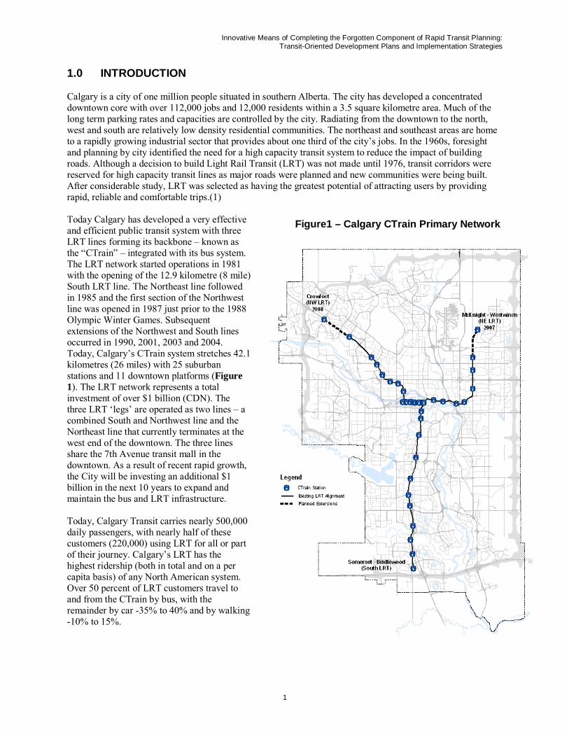
Figure1 – Calgary CTrain Primary Network
1.0 INTRODUCTION
Calgary is a city of one million people situated in southern Alberta. The city has developed a concentrated downtown core with over 112,000 jobs and 12,000 residents within a 3.5 square kilometre area. Much of the long term parking rates and capacities are controlled by the city. Radiating from the downtown to the north, west and south are relatively low density residential communities. The northeast and southeast areas are home to a rapidly growing industrial sector that provides about one third of the city’s jobs. In the 1960s, foresight and planning by city identified the need for a high capacity transit system to reduce the impact of building roads. Although a decision to build Light Rail Transit (LRT) was not made until 1976, transit corridors were reserved for high capacity transit lines as major roads were planned and new communities were being built. After considerable study, LRT was selected as having the greatest potential of attracting users by providing rapid, reliable and comfortable trips.(1)
Today Calgary has developed a very effective and efficient public transit system with three LRT lines forming its backbone – known as the “CTrain” – integrated with its bus system. The LRT network started operations in 1981 with the opening of the 12.9 kilometre (8 mile) South LRT line. The Northeast line followed in 1985 and the first section of the Northwest line was opened in 1987 just prior to the 1988 Olympic Winter Games. Subsequent extensions of the Northwest and South lines occurred in 1990, 2001, 2003 and 2004. Today, Calgary’s CTrain system stretches 42.1 kilometres (26 miles) with 25 suburban stations and 11 downtown platforms (Figure 1). The LRT network represents a total investment of over $1 billion (CDN). The three LRT ‘legs’ are operated as two lines – a combined South and Northwest line and the Northeast line that currently terminates at the west end of the downtown. The three lines share the 7th Avenue transit mall in the downtown. As a result of recent rapid growth, the City will be investing an additional $1 billion in the next 10 years to expand and maintain the bus and LRT infrastructure.
Today, Calgary Transit carries nearly 500,000 daily passengers, with nearly half of these customers (220,000) using LRT for all or part of their journey. Calgary’s LRT has the highest ridership (both in total and on a per capita basis) of any North American system. Over 50 percent of LRT customers travel to and from the CTrain by bus, with the remainder by car -35% to 40% and by walking -10% to 15%.
Innovative Means of Completing the Forgotten Component of Rapid Transit Planning: Transit-Oriented Development Plans and Implementation Strategies
2
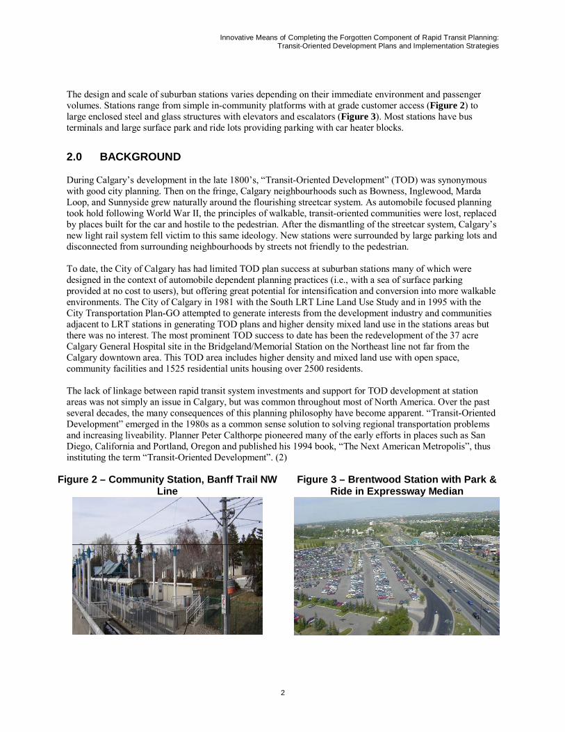
The design and scale of suburban stations varies depending on their immediate environment and passenger volumes. Stations range from simple in-community platforms with at grade customer access (Figure 2) to large enclosed steel and glass structures with elevators and escalators (Figure 3). Most stations have bus terminals and large surface park and ride lots providing parking with car heater blocks.
2.0 BACKGROUND
During Calgary’s development in the late 1800’s, “Transit-Oriented Development” (TOD) was synonymous with good city planning. Then on the fringe, Calgary neighbourhoods such as Bowness, Inglewood, Marda Loop, and Sunnyside grew naturally around the flourishing streetcar system. As automobile focused planning took hold following World War II, the principles of walkable, transit-oriented communities were lost, replaced by places built for the car and hostile to the pedestrian. After the dismantling of the streetcar system, Calgary’s new light rail system fell victim to this same ideology. New stations were surrounded by large parking lots and disconnected from surrounding neighbourhoods by streets not friendly to the pedestrian.
To date, the City of Calgary has had limited TOD plan success at suburban stations many of which were designed in the context of automobile dependent planning practices (i.e., with a sea of surface parking provided at no cost to users), but offering great potential for intensification and conversion into more walkable environments. The City of Calgary in 1981 with the South LRT Line Land Use Study and in 1995 with the City Transportation Plan-GO attempted to generate interests from the development industry and communities adjacent to LRT stations in generating TOD plans and higher density mixed land use in the stations areas but there was no interest. The most prominent TOD success to date has been the redevelopment of the 37 acre Calgary General Hospital site in the Bridgeland/Memorial Station on the Northeast line not far from the Calgary downtown area. This TOD area includes higher density and mixed land use with open space, community facilities and 1525 residential units housing over 2500 residents.
The lack of linkage between rapid transit system investments and support for TOD development at station areas was not simply an issue in Calgary, but was common throughout most of North America. Over the past several decades, the many consequences of this planning philosophy have become apparent. “Transit-Oriented Development” emerged in the 1980s as a common sense solution to solving regional transportation problems and increasing liveability. Planner Peter Calthorpe pioneered many of the early efforts in places such as San Diego, California and Portland, Oregon and published his 1994 book, “The Next American Metropolis”, thus instituting the term “Transit-Oriented Development”. (2)
Figure 2 – Community Station, Banff Trail NW Line
Figure 3 – Brentwood Station with Park & Ride in Expressway Median
Innovative Means of Completing the Forgotten Component of Rapid Transit Planning: Transit-Oriented Development Plans and Implementation Strategies
3
2.1 City of Calgary Transit-Oriented Development Policy Guidelines and Best Practices
TOD Policy Guidelines
To make transit more convenient for people, to encourage all day ridership on the CTrain, to make more efficient use of the extensive land holdings around LRT Stations (mostly in parking) and to increase mobility and public facilities for adjacent communities, Calgary Council adopted TOD Policy Guidelines and TOD Best Practices in 2004 and 2005, respectively. (3 and 4) By 2004, the rapid pace of growth in the Calgary area, the increased importance of transit to the community, and the desire of communities adjacent to LRT stations to improve the station environments, were factors that together increased the support for undertaking the development and implementation of TOD plans.
The Calgary TOD Policy Guidelines provide land use and development polices and design guidelines for the development or redevelopment of properties within a 600 metre radius of the Transit Station areas – an LRT station or Bus Rapid Transit (BRT) stop, prior to the arrival of LRT. There are six planning objectives that the City of Calgary would like TOD station area plans to achieve:
• Ensure transit-supportive land uses • Make each station area a "place" • Increase density around transit stations • Manage parking, bus and vehicular traffic • Create pedestrian-oriented design • Plan in context with the local communities
TOD Best Practices
The Calgary TOD Best Practices provides a summary of the best TOD practices from North American cities and adds the following enhancements to the guidelines above:
Get the Land Uses Right – Encourage transit-supportive uses including a mix of medium to high density residential, offices, high schools and colleges, appropriate retail, restaurants, personal service and civic functions that are high pedestrian generators within 400 to 800 metres of the station to directly promote greater transit peak and off-peak ridership.
Promote Density – Promote development densities that are “as great as possible” within the context of a particular station and surrounding community, that can be phased over time and transition to lower densities to create an appropriate interface with the surrounding communities.
Create Convenient Pedestrian Connections – Promote pedestrian routes between the station and key destinations that are short and direct, have minimal grade changes or stairs, are close to buildings with “eyes on the street” and are separated from automobile traffic conflicts.
Ensure Good Urban Design – Create high quality and friendly streets with benches, trees, landscaping, wide, separate sidewalks and on-street parking. Provide architectural variety: 3-4 storey buildings with ground level entrances and retail shops oriented to sidewalks, and with upper storeys set back to allow sunlight to reach the street and help reduce the sense of scale of the building. Where possible, provide weather protection in the form of awnings, shelters, building projections and colonnades. Ensure stations are well-lit and designed to accommodate “around-the-clock” activity.
Create Compact Development Patterns – Cluster buildings that are grouped together in order to offer a “one-stop” opportunity to conveniently access a variety of destinations on foot and create distinct character areas and create an easily navigable walking environment. Site the building on the property (i.e., place buildings to one side of a parcel, instead of in the centre) to accommodate future intensification and development
Manage Parking – Accommodate the automobile by providing minimum and maximum parking standards, convenient small parking areas and drop-off zones, and charge for parking. However, locate parking areas at
Innovative Means of Completing the Forgotten Component of Rapid Transit Planning: Transit-Oriented Development Plans and Implementation Strategies
4
periphery of the station area and to the rear or sides of buildings, with more parking in structures than on surface lots.
Make Each Station a “Place” – Create the transit station as a destination in its own right, with a collection of unique places in order to attract visitors, serve transit patrons and the local community and act as a gateway to the rest of the city. The station area should include landmarks to create notable places and aid in local wayfinding. Ensure sight lines to and from the station help orient pedestrians to their surroundings. Orient buildings to the street to create a visually interesting and safer pedestrian environment. Provide public open spaces or plazas near the station in order to provide comfortable waiting and drop-off areas for users and act as central activity and gathering points for the local community.
3.0 HERITAGE STATION TOD DEVELOPMENT PROCESS
3.1 Initiation of Heritage LRT Station TOD Process
In the fall of 2006, Calgary Transit hired the combined forces of a T/Six and UMA Engineering consultant team to develop a TOD Plan and Implementation Strategy for the Heritage LRT Station, located 7.2 kilometres south of the Calgary downtown area on the 14 kilometre southern LRT line. (5) In undertaking this project, Calgary Transit had two main objectives: to provide a greater impetus for more TOD development occurring at it suburban LRT stations; and to prepare plan using an efficient and consultative process; and to relocate their Victoria Park transit offices in the station area (6). To accomplish these objectives, the consulting team brought together urban design, architecture, engineering, land use planning, and transit planning and public consultation experience .Both firms have North American and international experience in successfully developing and implementing TOD plans.
The consultants were given a four month timeline to develop the Heritage Station TOD plan and implementation strategy with input from the adjacent station communities, interested stakeholders and the general public. The tight timeline was established for the following reasons: the availability of funds in the 2006 year; the need to start the process for the required transit building; the desire to explore whether the TOD development process could be undertaken in a more timely and efficient manner using an alternative process than undertaken for other stations (i.e., Bridgelands/Memorial Station); and to gain some more political credibility in the TOD planning process by completing an innovative plan for another prominent LRT station.
Calgary Transit recognized that simply placing an office building amongst a sea of surface parking at the Heritage LRT Station was not in line with its TOD policy guidelines and best practices. This was also an opportunity to act as a catalyst for the redevelopment of the entire station area site using these principles and practices. This paper demonstrates both the public process and subsequent design for Heritage Station that places the new Calgary Transit facility within the context of a new walkable, transit-oriented urban centre surrounding the existing station. The paper also highlights the ability to complete comprehensive TOD plans in a timely and unique manner.
3.2 Heritage Station TOD Context
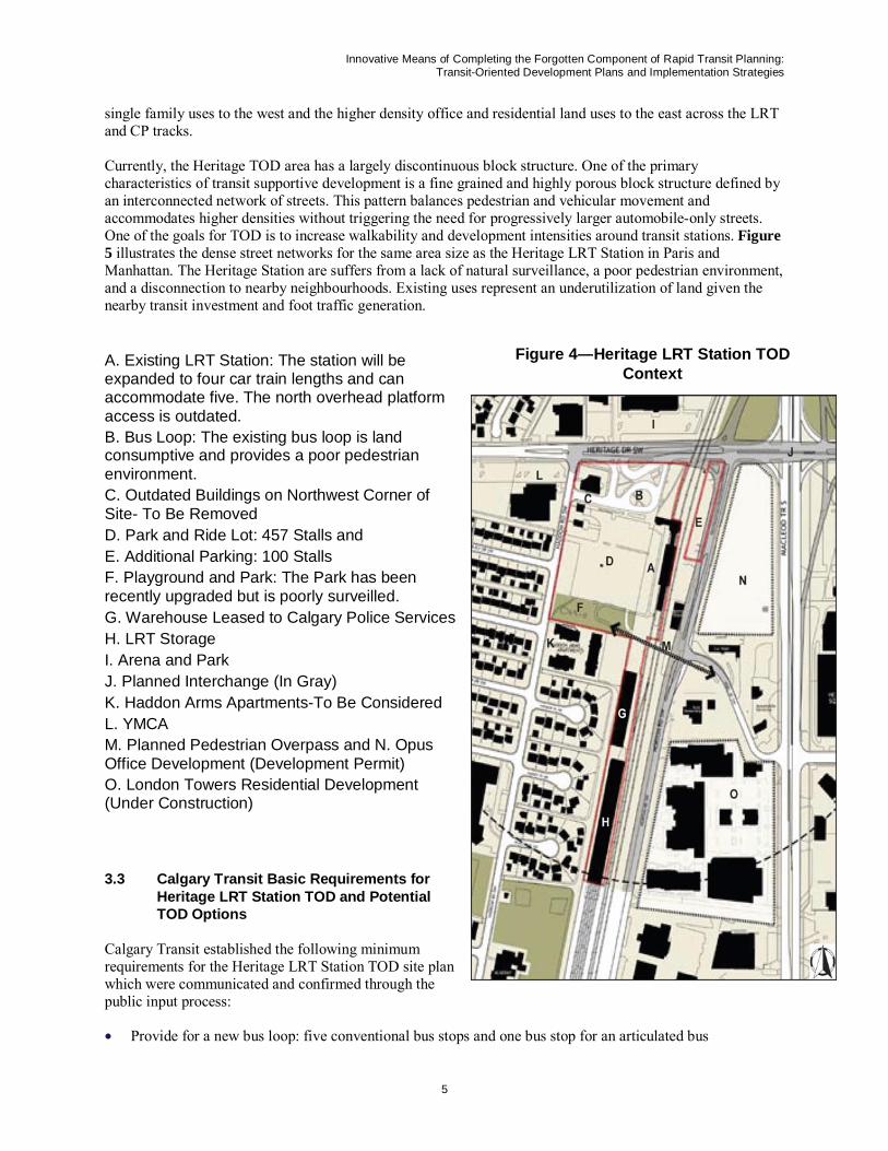
The core TOD planning area for the Heritage LRT Station site consists of a 6.2 acre parcel located west of the LRT station owned by Calgary Transit, and a smaller 0.7 acre parcel located east of the LRT and CP tracks which parallel one another. This core area forms the heart of the larger TOD area and is the subject of this paper. The station is served by eleven bus routes today, has a kiss and ride facility and 560 heated parking stalls. The bounds of the station TOD are defined largely by the approximate 5 to 10 minute linkages for pedestrians’ station access (i.e., 400 to 800 metre radii) (Figure 4).
The community surrounding the Heritage LRT Station was developed from the 1950s-1980s and exhibits the segregated land use, and automobile dominated development patterns typical of that era. The station’s position within the neighbourhood lends itself to forming a modest mixed use centre providing a transition from the
Innovative Means of Completing the Forgotten Component of Rapid Transit Planning: Transit-Oriented Development Plans and Implementation Strategies
5
single family uses to the west and the higher density office and residential land uses to the east across the LRT and CP tracks.
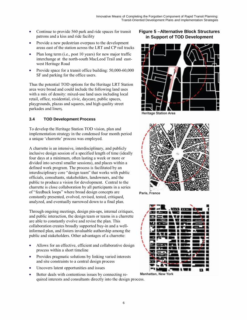
Currently, the Heritage TOD area has a largely discontinuous block structure. One of the primary characteristics of transit supportive development is a fine grained and highly porous block structure defined by an interconnected network of streets. This pattern balances pedestrian and vehicular movement and accommodates higher densities without triggering the need for progressively larger automobile-only streets. One of the goals for TOD is to increase walkability and development intensities around transit stations. Figure 5 illustrates the dense street networks for the same area size as the Heritage LRT Station in Paris and Manhattan. The Heritage Station are suffers from a lack of natural surveillance, a poor pedestrian environment, and a disconnection to nearby neighbourhoods. Existing uses represent an underutilization of land given the nearby transit investment and foot traffic generation.
A. Existing LRT Station: The station will be expanded to four car train lengths and can accommodate five. The north overhead platform access is outdated. B. Bus Loop: The existing bus loop is land consumptive and provides a poor pedestrian environment. C. Outdated Buildings on Northwest Corner of Site- To Be Removed D. Park and Ride Lot: 457 Stalls and E. Additional Parking: 100 Stalls F. Playground and Park: The Park has been recently upgraded but is poorly surveilled. G. Warehouse Leased to Calgary Police Services H. LRT Storage I. Arena and Park J. Planned Interchange (In Gray) K. Haddon Arms Apartments-To Be Considered L. YMCA M. Planned Pedestrian Overpass and N. Opus Office Development (Development Permit) O. London Towers Residential Development (Under Construction)
3.3 Calgary Transit Basic Requirements for Heritage LRT Station TOD and Potential TOD Options
Calgary Transit established the following minimum requirements for the Heritage LRT Station TOD site plan which were communicated and confirmed through the public input process:
• Provide for a new bus loop: five conventional bus stops and one bus stop for an articulated bus
Figure 4—Heritage LRT Station TOD Context
Innovative Means of Completing the Forgotten Component of Rapid Transit Planning: Transit-Oriented Development Plans and Implementation Strategies
6
• Continue to provide 560 park and ride spaces for transit patrons and a kiss and ride facility
• Provide a new pedestrian overpass to the development areas east of the station across the LRT and CP rail tracks
• Plan long term (i.e., post 10 years) for new major traffic interchange at the north-south MacLeod Trail and east-west Heritage Road
• Provide space for a transit office building: 50,000-60,000 SF and parking for the office users.
Thus the potential TOD options for the Heritage LRT Station area were broad and could include the following land uses with a mix of density: mixed-use land uses including local retail, office, residential, civic, daycare, public spaces, playgrounds, plazas and squares, and high quality street parkades and liners.
3.4 TOD Development Process
To develop the Heritage Station TOD vision, plan and implementation strategy in the condensed four month period a unique ‘charrette’ process was employed.
A charrette is an intensive, interdisciplinary, and publicly inclusive design session of a specified length of time (ideally four days at a minimum, often lasting a week or more or divided into several smaller sessions), and places within a defined work program. The process is facilitated by an interdisciplinary core “design team” that works with public officials, consultants, stakeholders, landowners, and the public to produce a vision for development. Central to the charrette is close collaboration by all participants in a series of “feedback loops” where broad design concepts are constantly presented, evolved, revised, tested, critiqued, analyzed, and eventually narrowed down to a final plan.
Through ongoing meetings, design pin-ups, internal critiques, and public interaction, the design team or teams in a charrette are able to constantly evolve and revise the plan. This collaboration creates broadly supported buy-in and a well-informed plan, and fosters invaluable authorship among the public and stakeholders. Other advantages of a charrette:
• Allows for an effective, efficient and collaborative design process within a short timeline
• Provides pragmatic solutions by linking varied interests and site constraints to a central design process
• Uncovers latent opportunities and issues • Better deals with contentious issues by connecting re-
quired interests and consultants directly into the design process.
Figure 5 –Alternative Block Structures in Support of TOD Development
Innovative Means of Completing the Forgotten Component of Rapid Transit Planning: Transit-Oriented Development Plans and Implementation Strategies
7
Due to the tight timeline and a desire to be innovative for this project, the Heritage LRT TOD charrette process was shortened and modified from the process described above. It involved a small professional team of 7-8 planners, designers, and an architect intensively working together over three days to develop ideas, prepare drawings and sketches and analyze alternative TOD plans and options concentrated on the 600 metre station area. This process entailed daily meetings and input into the continuous planning/design process by drop-in or invited representatives from the adjacent communities, station property owners, developers and their consultants, and stakeholder groups who had been asked to participate or who came in attracted by pre-charrette communications. This process was in turn linked to a station area common vision as defined by the public input process during the charrette process. The Heritage LRT Station TOD charrette process had three key phases:
1. Pre-Charrette Outreach: Background data collection and analysis, outreach and notification of all stakeholders, charrette preparation, and the conduct of preliminary feasibility studies.
2. Charrette: A multi-day work session starting with a public meeting to introduce the project and principles, a series of three working days including public pin-ups, and concluding with a public presentation of the charrette results and recommendations.
3. Post-Charrette: The production of a report documenting and refining the results of the charrette and generating a TOD plan and implementation strategy.
Pre-Charrette Outreach
Typically, the pre-charrette phase constitutes the 6-8 weeks prior to a charrette. However, because of strict timelines, the Heritage LRT Station pre-charrette was begun in earnest only 3-4 weeks prior to the charrette with an internal meeting with key city departments. After establishing the charrette date, a flyer was produced by Calgary Transit and emailed to the internal city departments. To ensure adequate public notification, the following measures were taken:
• A flyer mail-out was sent to all residents and landowners within the greater TOD planning area (the secondary TOD planning area)
• A presentation on the Heritage Station TOD development process was made to the Haysboro Community Association, the community adjacent to the station, by City of Calgary and consultant representatives to outline the TOD development process and objectives, indicate how residents could participate and to answer any questions
• A Heritage Station TOD development process flyer was distributed by university students at the station and to local businesses
• Large flyers were posted at the station, at the arena (charrette venue), and at a nearby YMCA • A “brite sign” was placed along Heritage Drive, which is just north of the station • Direct contact (by phone and/or email) was made with all landowners and major business owners adjacent
to the station.
The charrette was preceded by another Open House at the Haysboro Community Hall on Monday, November 20, the first day of the charrette week. The Open House session was used to communicate the City of Calgary and consultant understanding of the scope and site, their approach, the TOD plan development process and how the public could be involved. Following the presentation, informal discussion allowed the collection of initial input on boards and comment sheets.
Charrette
The charrette was held in an arena directly adjacent to Heritage Station from Wednesday, November 22 to Friday, November 24, 2006 This location allowed for direct observation of the subject site and convenient access for the public.
Innovative Means of Completing the Forgotten Component of Rapid Transit Planning: Transit-Oriented Development Plans and Implementation Strategies
8
The charrette itself proceeded as follows:
• November 22nd – Charrette Day 1: The design team generated plan options and concepts, as stakeholder representatives and the general public visited the charrette area throughout the day. A “pin-up” session was conducted at 5 p.m. to informally present the ideas and invite critiques and discussion from the design team and public. The design team continued working into the evening.
• November 23rd – Charrette Day 2: The design team evolved plan options and concepts to arrive at the preferred option. A “pin-up” session was conducted at 5 p.m. to informally present the ideas and invite critiques and discussion from the design team and public. The design team continued working into the evening.
• November 24th – Charrette Day 3: The design team produced final drawings and renderings of the preferred option and prepared a public presentation. At 7:30 p.m. the results of the charrette were presented to the public followed by a discussion period.
Public Attendance and Input
The public and representatives of stakeholder groups were invited to the charrette studio at any time and participants were urged to attend the pin-up sessions each day at 5.00 pm and the Charrette final presentation on November 24. While limited notification time may have affected attendance, extremely cold weather and poor road conditions had a more likely effect on attendance. Regardless, public attendance was reasonable with over 22 recorded attendees at the initial open house, 20 on the closing day, and many drop-in visits during the week.
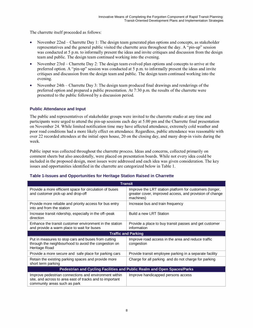
Public input was collected throughout the charrette process. Ideas and concerns, collected primarily on comment sheets but also anecdotally, were placed on presentation boards. While not every idea could be included in the proposed design, most issues were addressed and each idea was given consideration. The key issues and opportunities identified in the charrette are categorized below in Table 1.
Table 1-Issues and Opportunities for Heritage Station Raised in Charrette
Transit Provide a more efficient space for circulation of buses and customer pick-up and drop-off
Improve the LRT station platform for customers (longer, greater cover, improved access, and provision of change machines)
Provide more reliable and priority access for bus entry into and from the station
Increase bus and train frequency
Increase transit ridership, especially in the off–peak direction
Build a new LRT Station
Enhance the transit customer environment in the station and provide a warm place to wait for buses
Provide a place to buy transit passes and get customer information
Traffic and Parking Put in measures to stop cars and buses from cutting through the neighbourhood to avoid the congestion on Heritage Road
Improve road access in the area and reduce traffic congestion
Provide a more secure and safe place for parking cars Provide transit employee parking in a separate facility Retain the existing parking spaces and provide more short term parking
Charge for all parking and do not charge for parking
Pedestrian and Cycling Facilities and Public Realm and Open Spaces/Parks Improve pedestrian connections and environment within site, and across to area east of tracks and to important community areas such as park
Improve handicapped persons access
Innovative Means of Completing the Forgotten Component of Rapid Transit Planning: Transit-Oriented Development Plans and Implementation Strategies
9
Provide a bicycle crossing at Heritage Station along Haddon Road-this is a bicycle route
Provide an underground tunnel or an above ground passageway (i.e., plus 15 access) across the LRT and CP tracks to the east side of the Heritage LRT station and linking to the proposed Opus office development site and London Towers residential development (currently being built)
Improve facilities and access for cyclists Provide neighbourhood maps at the station Provide green space and a place for families Create useful parks Provide a public washroom Create attractive pedestrian facilities, drinking fountains,
benches, etc. Separate transit and vehicular traffic Improve safety and security in station area Provide a pedestrian under/overpass across the LRT and CP tracks to the east of the station to Kingsland
Provide colour and vibrancy
Provide sidewalks along Horton and Hull roads Provide brick and/or cobblestone walkways Strengthen regional pathway connections Incorporate historical/community characteristics and ele-
ments Land Use Changes
Encourage potential redevelopment of this space for housing
Provide specialty stores such as a comic book store
Increase housing choices for community Provide ethnic food options Provide places to eat, have a coffee, shop, and relax Provide an attractive environment in the station and its
area in order to encourage other positive redevelopment in station area and broader community
Place for relocation of 10,000 sq. ft recreational facility Provide a community theatre facility Provide a library Encourage a comprehensive examination of the area
east of the tracks (car wash, bottle depot, etc.) – east of Horton, between OPUS and Heritage Apartments
Provide children’s services and a small public space for children
Provide independently owned shops (rather than chains) in the redeveloped areas in the stations
Implementation Establish a prototype for other station areas Involve community representatives in planning
discussions There was a fear of the unknown of what would potentially happen at the station
Generate profits/returns from site to pay for other transit capital and operational improvements
There was a lack of belief that the city’s would follow-through on the implementation of the TOD plan
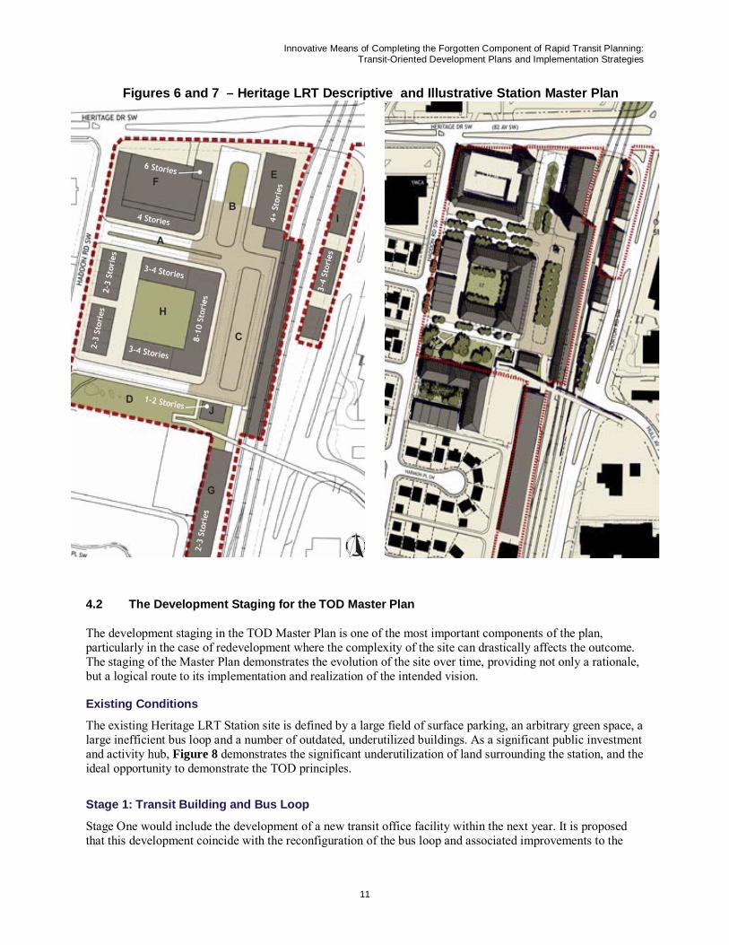
4.0 The Station Area TOD Master Plan
The recommended Station Area TOD Master Plan for the Heritage Station was a result of the charrette design and public input process and in response to the basic station requirements established by Calgary Transit and Calgary’s TOD Design Guidelines. The development of this Master Plan occurred after the development and analysis of four options for the Station TOD Master Plan in the charrette which included the development and examination of many options in terms of the density and layout of development concepts, overall site transportation scenarios, and transit office locations, parking areas, bus loop options and development staging.
The Heritage Station Master Plan respects the intention of the overall vision, and in-depth design study for the area as established through public process (Figures 6 and 7). As well, a pro forma analysis of the Master Plan has been completed.
Innovative Means of Completing the Forgotten Component of Rapid Transit Planning: Transit-Oriented Development Plans and Implementation Strategies
10
4.1 Master Plan Concept
The proposed Master Plan provides an active mixed-use neighbourhood centre organized around four well conceived public spaces: an avenue, a bus loop, a plaza, and a square. Major features include:
A. Public Space 1: A treed avenue serves as the primary access to the centre and is terminated by the station to the east and YMCA site to the west.
B. Public Space 2: A compact bus loop creates a small “bus plaza”
C. Public Space 3: A central plaza creates an interface to the station platform with adjacent retail ground-floor uses and residential uses above. This is the centre’s primary public space.
D. Public Space 4: A neighbourhood square shaped by residential buildings is created from the existing arbitrary green space. The playground is retained and berms removed.
E. Transit Offices: The transit offices overlook the bus loop and LRT operations, and integrate with the transit station entry and central plaza.
F. Municipal Parkade I: Up to 300 park and ride stalls with another 145 underground. The building is lined with office uses to create a pedestrian oriented street face.
G. Municipal Parkade II: Up to 300 spaces within a structure similar to the mass of the existing building.
H. Mixed Use Development Parcel: A mixed use block that includes residential apartment flats, retail, live-work units, and row houses. The centre court may be used for parking, a green court, or a parkade with a green roof.
I. Live/Work Industrial: A compatible building type utilizing leftover space created with the new interchange and interfacing with the railway below. Other uses include a small parkade with a park at ground (interchange ramp) level.
J. Civic Building: A one-two storey building framing the south end of the square.
Innovative Means of Completing the Forgotten Component of Rapid Transit Planning: Transit-Oriented Development Plans and Implementation Strategies
11
Figures 6 and 7 – Heritage LRT Descriptive and Illustrative Station Master Plan
4.2 The Development Staging for the TOD Master Plan
The development staging in the TOD Master Plan is one of the most important components of the plan, particularly in the case of redevelopment where the complexity of the site can drastically affects the outcome. The staging of the Master Plan demonstrates the evolution of the site over time, providing not only a rationale, but a logical route to its implementation and realization of the intended vision.
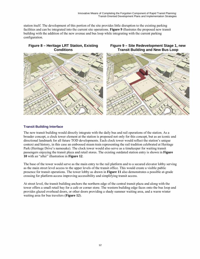
Existing Conditions
The existing Heritage LRT Station site is defined by a large field of surface parking, an arbitrary green space, a large inefficient bus loop and a number of outdated, underutilized buildings. As a significant public investment and activity hub, Figure 8 demonstrates the significant underutilization of land surrounding the station, and the ideal opportunity to demonstrate the TOD principles.
Stage 1: Transit Building and Bus Loop
Stage One would include the development of a new transit office facility within the next year. It is proposed that this development coincide with the reconfiguration of the bus loop and associated improvements to the
Innovative Means of Completing the Forgotten Component of Rapid Transit Planning: Transit-Oriented Development Plans and Implementation Strategies
12
station itself. The development of this portion of the site provides little disruption to the existing parking facilities and can be integrated into the current site operations. Figure 9 illustrates the proposed new transit building with the addition of the new avenue and bus loop while integrating with the current parking configuration.
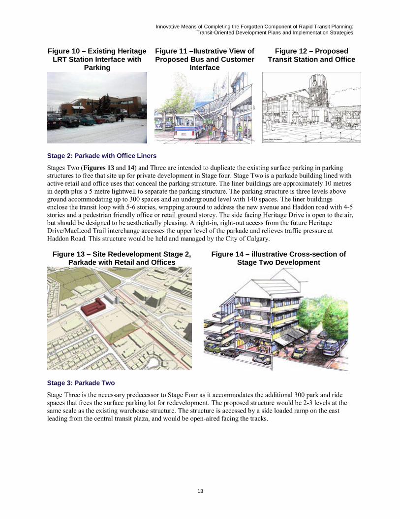
Transit Building Interface
The new transit building would directly integrate with the daily bus and rail operations of the station. As a broader concept, a clock tower element at the station is proposed not only for this concept, but as an iconic and directional landmark for all future TOD developments. Each clock tower would reflect the station’s unique context and history, in this case an embossed steam train representing the rail tradition celebrated at Heritage Park (Heritage Drive’s namesake). The clock tower would also serve as a timekeeper for waiting transit passengers enjoying the transit plaza and retail stores. The existing outdated station entry is shown in Figure 10 with an “after” illustration in Figure 12.
The base of the tower would serve as the main entry to the rail platform and to a secured elevator lobby serving as the main street level access to the upper levels of the transit office. This would create a visible public presence for transit operations. The tower lobby as drawn in Figure 11 also demonstrates a possible at-grade crossing for platform access improving accessibility and simplifying transit access.
At street level, the transit building anchors the northern edge of the central transit plaza and along with the tower offers a small retail bay for a cafe or corner store. The western building edge faces onto the bus loop and provides glazed overhead doors, or other doors providing a shady summer waiting area, and a warm winter waiting area for bus travelers (Figure 12).
Figure 9 – Site Redevelopment Stage 1, new Transit Building and New Bus Loop
Innovative Means of Completing the Forgotten Component of Rapid Transit Planning: Transit-Oriented Development Plans and Implementation Strategies
13
Figure 10 – Existing Heritage LRT Station Interface with
Parking
Figure 11 –IIustrative View of Proposed Bus and Customer
Interface
Figure 12 – Proposed Transit Station and Office
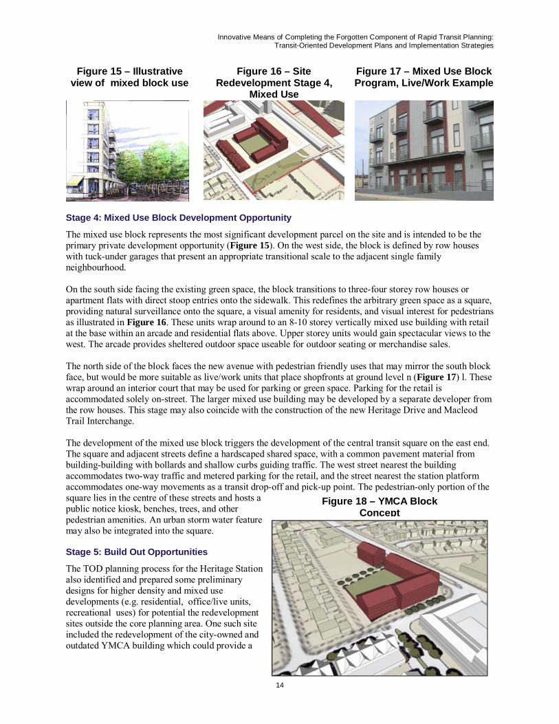
Stage 2: Parkade with Office Liners
Stages Two (Figures 13 and 14) and Three are intended to duplicate the existing surface parking in parking structures to free that site up for private development in Stage four. Stage Two is a parkade building lined with active retail and office uses that conceal the parking structure. The liner buildings are approximately 10 metres in depth plus a 5 metre lightwell to separate the parking structure. The parking structure is three levels above ground accommodating up to 300 spaces and an underground level with 140 spaces. The liner buildings enclose the transit loop with 5-6 stories, wrapping around to address the new avenue and Haddon road with 4-5 stories and a pedestrian friendly office or retail ground storey. The side facing Heritage Drive is open to the air, but should be designed to be aesthetically pleasing. A right-in, right-out access from the future Heritage Drive/MacLeod Trail interchange accesses the upper level of the parkade and relieves traffic pressure at Haddon Road. This structure would be held and managed by the City of Calgary.
Figure 13 – Site Redevelopment Stage 2, Parkade with Retail and Offices
Figure 14 – illustrative Cross-section of Stage Two Development
Stage 3: Parkade Two
Stage Three is the necessary predecessor to Stage Four as it accommodates the additional 300 park and ride spaces that frees the surface parking lot for redevelopment. The proposed structure would be 2-3 levels at the same scale as the existing warehouse structure. The structure is accessed by a side loaded ramp on the east leading from the central transit plaza, and would be open-aired facing the tracks.
Innovative Means of Completing the Forgotten Component of Rapid Transit Planning: Transit-Oriented Development Plans and Implementation Strategies
14
Figure 15 – Illustrative view of mixed block use
Figure 16 – Site Redevelopment Stage 4,
Mixed Use
Figure 17 – Mixed Use Block Program, Live/Work Example
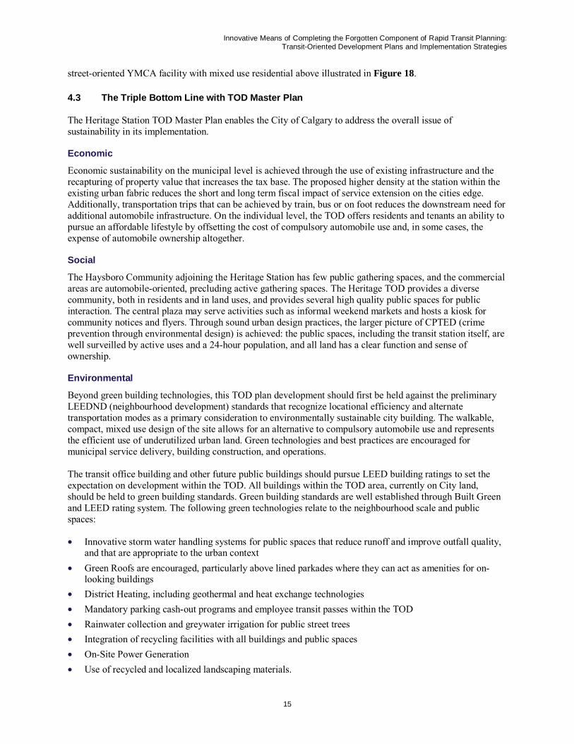
Stage 4: Mixed Use Block Development Opportunity
The mixed use block represents the most significant development parcel on the site and is intended to be the primary private development opportunity (Figure 15). On the west side, the block is defined by row houses with tuck-under garages that present an appropriate transitional scale to the adjacent single family neighbourhood.
On the south side facing the existing green space, the block transitions to three-four storey row houses or apartment flats with direct stoop entries onto the sidewalk. This redefines the arbitrary green space as a square, providing natural surveillance onto the square, a visual amenity for residents, and visual interest for pedestrians as illustrated in Figure 16. These units wrap around to an 8-10 storey vertically mixed use building with retail at the base within an arcade and residential flats above. Upper storey units would gain spectacular views to the west. The arcade provides sheltered outdoor space useable for outdoor seating or merchandise sales.
The north side of the block faces the new avenue with pedestrian friendly uses that may mirror the south block face, but would be more suitable as live/work units that place shopfronts at ground level n (Figure 17) l. These wrap around an interior court that may be used for parking or green space. Parking for the retail is accommodated solely on-street. The larger mixed use building may be developed by a separate developer from the row houses. This stage may also coincide with the construction of the new Heritage Drive and Macleod Trail Interchange.
The development of the mixed use block triggers the development of the central transit square on the east end. The square and adjacent streets define a hardscaped shared space, with a common pavement material from building-building with bollards and shallow curbs guiding traffic. The west street nearest the building accommodates two-way traffic and metered parking for the retail, and the street nearest the station platform accommodates one-way movements as a transit drop-off and pick-up point. The pedestrian-only portion of the square lies in the centre of these streets and hosts a public notice kiosk, benches, trees, and other pedestrian amenities. An urban storm water feature may also be integrated into the square.
Stage 5: Build Out Opportunities
The TOD planning process for the Heritage Station also identified and prepared some preliminary designs for higher density and mixed use developments (e.g. residential, office/live units, recreational uses) for potential the redevelopment sites outside the core planning area. One such site included the redevelopment of the city-owned and outdated YMCA building which could provide a
Figure 18 – YMCA Block Concept
Innovative Means of Completing the Forgotten Component of Rapid Transit Planning: Transit-Oriented Development Plans and Implementation Strategies
15
street-oriented YMCA facility with mixed use residential above illustrated in Figure 18.
4.3 The Triple Bottom Line with TOD Master Plan
The Heritage Station TOD Master Plan enables the City of Calgary to address the overall issue of sustainability in its implementation.
Economic
Economic sustainability on the municipal level is achieved through the use of existing infrastructure and the recapturing of property value that increases the tax base. The proposed higher density at the station within the existing urban fabric reduces the short and long term fiscal impact of service extension on the cities edge. Additionally, transportation trips that can be achieved by train, bus or on foot reduces the downstream need for additional automobile infrastructure. On the individual level, the TOD offers residents and tenants an ability to pursue an affordable lifestyle by offsetting the cost of compulsory automobile use and, in some cases, the expense of automobile ownership altogether.
Social
The Haysboro Community adjoining the Heritage Station has few public gathering spaces, and the commercial areas are automobile-oriented, precluding active gathering spaces. The Heritage TOD provides a diverse community, both in residents and in land uses, and provides several high quality public spaces for public interaction. The central plaza may serve activities such as informal weekend markets and hosts a kiosk for community notices and flyers. Through sound urban design practices, the larger picture of CPTED (crime prevention through environmental design) is achieved: the public spaces, including the transit station itself, are well surveilled by active uses and a 24-hour population, and all land has a clear function and sense of ownership.
Environmental
Beyond green building technologies, this TOD plan development should first be held against the preliminary LEEDND (neighbourhood development) standards that recognize locational efficiency and alternate transportation modes as a primary consideration to environmentally sustainable city building. The walkable, compact, mixed use design of the site allows for an alternative to compulsory automobile use and represents the efficient use of underutilized urban land. Green technologies and best practices are encouraged for municipal service delivery, building construction, and operations.
The transit office building and other future public buildings should pursue LEED building ratings to set the expectation on development within the TOD. All buildings within the TOD area, currently on City land, should be held to green building standards. Green building standards are well established through Built Green and LEED rating system. The following green technologies relate to the neighbourhood scale and public spaces:
• Innovative storm water handling systems for public spaces that reduce runoff and improve outfall quality, and that are appropriate to the urban context
• Green Roofs are encouraged, particularly above lined parkades where they can act as amenities for on-looking buildings
• District Heating, including geothermal and heat exchange technologies • Mandatory parking cash-out programs and employee transit passes within the TOD • Rainwater collection and greywater irrigation for public street trees • Integration of recycling facilities with all buildings and public spaces • On-Site Power Generation • Use of recycled and localized landscaping materials.
Innovative Means of Completing the Forgotten Component of Rapid Transit Planning: Transit-Oriented Development Plans and Implementation Strategies
16
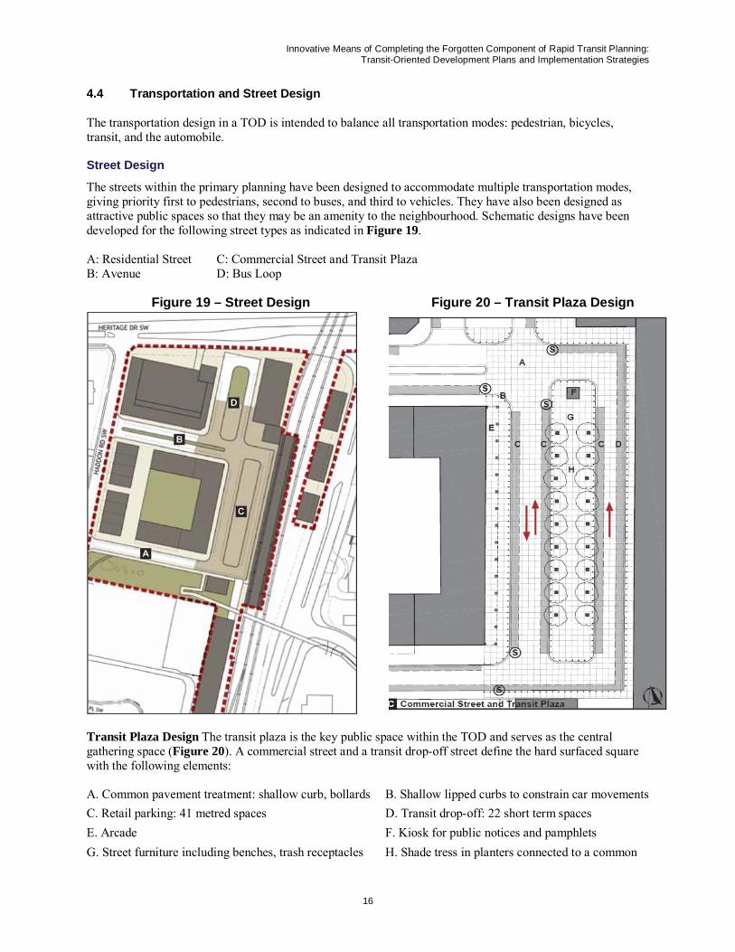
4.4 Transportation and Street Design
The transportation design in a TOD is intended to balance all transportation modes: pedestrian, bicycles, transit, and the automobile.
Street Design
The streets within the primary planning have been designed to accommodate multiple transportation modes, giving priority first to pedestrians, second to buses, and third to vehicles. They have also been designed as attractive public spaces so that they may be an amenity to the neighbourhood. Schematic designs have been developed for the following street types as indicated in Figure 19.
A: Residential Street C: Commercial Street and Transit Plaza B: Avenue D: Bus Loop
Figure 19 – Street Design Figure 20 – Transit Plaza Design
Transit Plaza Design The transit plaza is the key public space within the TOD and serves as the central gathering space (Figure 20). A commercial street and a transit drop-off street define the hard surfaced square with the following elements:
A. Common pavement treatment: shallow curb, bollards B. Shallow lipped curbs to constrain car movements C. Retail parking: 41 metred spaces D. Transit drop-off: 22 short term spaces E. Arcade F. Kiosk for public notices and pamphlets G. Street furniture including benches, trash receptacles H. Shade tress in planters connected to a common
Innovative Means of Completing the Forgotten Component of Rapid Transit Planning: Transit-Oriented Development Plans and Implementation Strategies
17
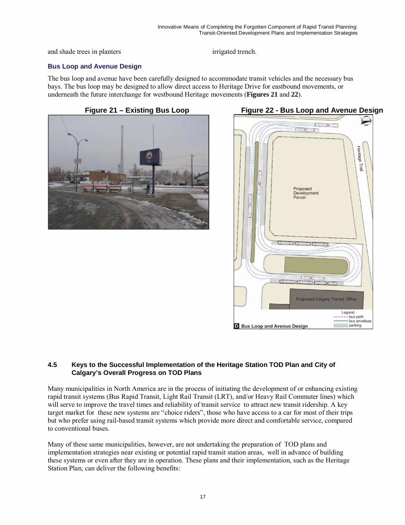
and shade trees in planters irrigated trench. Bus Loop and Avenue Design
The bus loop and avenue have been carefully designed to accommodate transit vehicles and the necessary bus bays. The bus loop may be designed to allow direct access to Heritage Drive for eastbound movements, or underneath the future interchange for westbound Heritage movements (Figures 21 and 22).
Figure 21 – Existing Bus Loop Figure 22 - Bus Loop and Avenue Design
4.5 Keys to the Successful Implementation of the Heritage Station TOD Plan and City of Calgary’s Overall Progress on TOD Plans
Many municipalities in North America are in the process of initiating the development of or enhancing existing rapid transit systems (Bus Rapid Transit, Light Rail Transit (LRT), and/or Heavy Rail Commuter lines) which will serve to improve the travel times and reliability of transit service to attract new transit ridership. A key target market for these new systems are “choice riders”, those who have access to a car for most of their trips but who prefer using rail-based transit systems which provide more direct and comfortable service, compared to conventional buses.
Many of these same municipalities, however, are not undertaking the preparation of TOD plans and implementation strategies near existing or potential rapid transit station areas, well in advance of building these systems or even after they are in operation. These plans and their implementation, such as the Heritage Station Plan, can deliver the following benefits:
Innovative Means of Completing the Forgotten Component of Rapid Transit Planning: Transit-Oriented Development Plans and Implementation Strategies
18
• Generate mixed land use and sustainable development and an urban design environment near the stations to increase all day two-way transit ridership
• Create attractive and higher density mixed land use, new public realm open spaces and community facilities which are pedestrian and cycling- friendly and provide very positive urban and integrated urban environments for the benefit of adjacent communities
• Create attractive destinations in themselves for city-wide use and enjoyment. To successfully prepare and implement TOD plans, the following key strategies were recommended to the City of Calgary and could be employed by other municipalities to assist in the successful development and implementation of TOD plans:
Organization Structure
The municipality should designate a specific staff manager and a relatively small core team of related and senior staff members with diverse disciplines (land use and transportation planners, lawyer, urban de-signer/architect, engineer, market expert and communications expert) who have been given the accountability and responsibility to drive the implementation of each TOD plan , including negotiations and liaison with key development interests, and ensuring that the required key infrastructure, facility station area investments and planning frameworks are prioritized and implemented in the station area. As well, it is important to have good legal support on the TOD development and implementation team early in the process, to begin to develop city responses and approaches to the public-private partnerships that will be required to implement the TOD plans
Approval Process
A key to the successful and timely implementation of each TOD plan will also be to facilitate and expedite the municipal development and infrastructure approval processes. This action is required in order to encourage developers to participate in implementing TOD plans and to reduce their development costs, risks and timelines. Municipalities might consider creating a special staff section to handle development approvals and development industry liaison and its efforts would be focused solely on the implementation of the LRT station TOD development and infrastructure plans.
Municipal Infrastructure Investments
The development and implementation of successful TOD plans have been positively influenced by municipalities actively participating in the implementation of these plans in the following ways:
• Investing in the station areas through infrastructure and operational investments (e.g. creation of improved street grid networks, transit station upgrades, improved transit service connections, pedestrian and sidewalk improvements, provision of cycling routes and storage facilities, and provision of station art forms and landmarks).
• Purchasing additional lands outside of the scope of lands required for the rapid transit station, lines and related facilities, in order to create attractive urban designed and landscaped edges to the transit facilities and in the station areas, and to leverage the implementation of the TOD plan.
• Focusing development in the municipality, to some degree, by encouraging and supporting the development industry to invest in the TOD station areas (i.e., selling or leasing city owned land; providing approved policy documents for these areas; and providing preferential property tax or other financial incentives).
• Investing in public realm open spaces, pedestrian walkways and promenades in the core of the station areas to create improved pedestrian and transit customer environment, and to attract the development industry.
• Moving and relocating city departments and facilities to the station areas to serve as a catalyst for private sector investments in the TOD areas, and providing parking alternatives for employees (i.e., transit passes).
Innovative Means of Completing the Forgotten Component of Rapid Transit Planning: Transit-Oriented Development Plans and Implementation Strategies
19
• For the successful implementation of TOD plans, there needs to be an emphasis placed on creating the “bones” for the TOD station developments. This means making City of Calgary investments to create an optimum street network and supportive environments and facilities for cycling, transit (bus and rapid transit customers) and pedestrian movements in the TOD areas. These “bones” are required for the TOD area in order to create the block faces and mobility improvements in order to attract the desired mixed, high quality and higher density development.
• Closely linking the implementation of the plans to specific city investments identified in annual and longer term operational plans and capital plans and budgets. These linkages should be clearly identified to the public and other stakeholders involved in the TOD.
TOD Parking Policies and Requirements
Municipalities should establish a process and methodology by which it assesses the parking demands and needs (individual spaces or parkades) at individual LRT TOD stations. This will entail conducting a detailed business and policy case for initiating a policy of charging for parking in TOD areas at LRT stations, including completing a pro forma analysis of the potential development costs and staging, revenue streams etc. The implementation of TOD plans provides a window of opportunity for charging for parking and relating these charges to the improved space and security provided for parking.
One should question why there is a need to subsidize transit users by the provision of free parking when this is not done for auto users or airport users. Charging two to three dollars initially for daily parking will not decrease transit ridership at the stations, and can be sold on the basis of the provision of enhanced and more secure parking areas, for example, in parkades with regular foot patrols with dogs (e.g. to safely walk female patrons to their cars) or roaming bicycle patrols; and/ or as well for guaranteeing a transit rider a parking location at the station.
Many successful TOD plans throughout North America, with some maturity after initial implementation, have generated new peak and off-peak ridership increases, and lowered parking needs. There has been a significant reduction found in actual parking needs occurring in the TOD plan areas after the completion for most of the planned developments. These lowered parking costs for the development industry should in turn generate return contributions to the public realm and transit facilities in the station area.
Core of the TOD Area
The TOD plans should first concentrate on creating and implementing the plan for the core area of the LRT station and its immediate environs. This emphasis on the core area of the TOD will assist in creating support for the components of the developed TOD further afield from the station, which can be implemented in subsequent stages of the plan. If the core components of the TOD plan are completed early and with a high quality this will encourage the support of the development industry and the adjacent communities in the implementation of other components of the TOD vision farther afield from the core area of the station.
Staged Implementation and Early Successes
The implementation plan for the TOD should be completed in stages, with the attempt to have the first stage provide high quality improvements. These early stages will help to provide the community, council and development support for the other areas of the TOD plan. Each stage should have clear linkages back to TOD area investments to be made by the City of Calgary and clearly identified in annual and longer term operational and capital plans and budgets for the benefit of the development industry and community representatives.
Enhancement to Transit Services and Transit Customer Environment
A core component of the implementation plan for the TOD plan should be to enhance the transit connections and service into the station and the overall environment and other connections (i.e., auto, pedestrian and cycling) for transit customers by:
Innovative Means of Completing the Forgotten Component of Rapid Transit Planning: Transit-Oriented Development Plans and Implementation Strategies
20
• Enhancing the frequency of peak, mid-day and evening service connections to the station • Assessing whether there could be a rationalization of service between the 11 routes which currently serve
the station, by completing an analysis of their ridership, and an assessment of the markets they serve and the type of service offered on the routes (market research survey)
• Providing the bus entrance and exits and layover areas as outlined in the station plan, which will provide direct entry and exits in and out of the station, and sufficient space for the current service as well as accommodating expansion of that service and the use of articulated buses
• Providing a comfortable and warm waiting area for transit customers in the foyer of the transit building • Displaying real time information in the bus loop and in the transit building showing the bus services which
are currently in the station, and the arrival and departure of the next 2 buses for each route • Providing a kiosk in the LRT station transit building or in a designated space next to the transit building
for buying passes, getting system information, etc. • Providing bus priority traffic signal and queue jump measures for arriving and departing buses • Significantly upgrade the access for transit patrons who have specialized transit needs and who are
mobility challenged • Ensuring all buses accessing the station have bicycle racks and installing easily accessed bicycle lockers in
the station • Clearly designating the “bicycles on the rapid transit service policies” in the station area with easily
identified signage • Providing a self-cleaning washroom and paid facility (e.g. 25 cents) in the station area for transit patrons to
use • Introducing pay parking for transit patrons, and “sell it” to patrons on the basis that a more positive and
safer environment is being provided in the station area for parking of cars, and changes are being implemented for the overall enjoyment and use of patrons in terms of retail facilities and the station itself. This parking charge could be blended into the transit pass systems used by regular patrons, especially when the local transit system moves to a Transit Smart Card.
• Using the opportunity with the future upgrading of station areas to provide bus lanes and transit access for buses.
• Providing improved pedestrian access (i.e., wider and marked crossing).
5.0 Conclusions
The TOD planning process for rapid transit stations can achieve the following benefits:
• Generate plans very efficiently and employ alternative and innovative processes • Produce plans to potentially increase daily rapid transit ridership in peak and off-peak periods • Provide plans to create attractive mixed use and higher development land uses, and public realm and open
spaces which are a significant benefit for the adjacent communities • Generate plans to create a safer and enhanced environment for the transit customer and for pedestrians and
cyclists in the station and surrounding areas.
The paper highlights important components to ensure the success of TOD plans and their implementation, and emphasizes that undertaking TOD plans as soon as possible in the planning process for rapid transit facilities significantly benefits the municipalities involved.
Innovative Means of Completing the Forgotten Component of Rapid Transit Planning: Transit-Oriented Development Plans and Implementation Strategies
21
References
1. Neil McKendrick, Dave Coquhoun, John Hubbell, and Bob Charles, Calgary’s CTrain – Effective Capital Utilization, presented at Joint International Light Rail Transit Conference, St. Louis, April, 2006
2. Calthorpe, Peter, The North American Metropolis; Ecology, Community and Planning, Princeton Architectural Press, 1994
3. City of Calgary, Land Use Planning and Policy, Transit-Oriented Development Policy Guidelines, Adopted by Calgary City Council , December 2004, amended December, 2005
4. City of Calgary, Land Use Planning and Policy, Transit-Oriented Development Best Practices Handbook, 2005
5. T/Six Consultants in combination with UMA Engineering Ltd., Heritage Station: Transit-Oriented Development Station Area Master Plan for the City of Calgary Transit, March, 2007
6. Neil McKendrick, Manager of Transit Planning, City of Calgary, March, 2007 was the City of Calgary’s Project Manager and the guiding force behind this Heritage LRT TOD development process.