39
Survey of Black Abalone (Haliotis cracherodii) on the South Farallon Islands: Summary Report January 2015 Survey

Survey of Black Abalone (Haliotis cracherodii) on the South Farallon Islands: Summary Report
January 2015 Survey

Black Abalone Survey Report
National Oceanic and Atmospheric Administration U.S. Secretary of Commerce Penny Prizker Under Secretary of Commerce for Oceans and Atmosphere and NOAA Administrator Kathryn Sullivan, Ph.D. Acting Assistant Administrator for Ocean Services and Coastal Zone Management, National Ocean Service Russell Callender, Ph.D. Office of National Marine Sanctuaries John A. Armor, Acting Director William J. Douros, West Coast Region Superintendent Maria Brown, Greater Farallones National Marine Sanctuary Superintendent
Cover Photo Black abalone (Haliotis cracherodii) documented on Southeast Farallon Island in 2010. This individual was recorded in 2010, 2011, and 2012 during intertidal monitoring efforts. In 2015, this individual was no longer present. Photo Credit: Gery Cox, Tenera Environmental, Inc. /GFNMS Authors: Jan Roletto, Greater Farallones National Marine Sanctuary Scott Kimura, Tenera Environmental, Inc. Gery Cox, Tenera Environmental, Inc. John Steinbeck, Tenera Environmental, Inc. Suggested Citation Roletto, J., S. Kimura, G. Cox, and J. Steinbeck. 2015. Black abalone survey of the South Farallon Islands: Summary Report. Submitted to NOAA, National Marine Fisheries Service, Office of Protected Resources; U.S. Fish and Wildlife Service; Farallon National Wildlife Refuge; and NOAA, Office of National Marine Sanctuaries, Greater Farallones National Marine Sanctuary.

Black Abalone Survey Report
South Farallon Islands i 15 June 2015
Table of Contents
Acknowledgments ..................................................................................................................................... iii
Executive Summary ................................................................................................................................... 4
Purpose and Background ......................................................................................................................... 6
Methods ....................................................................................................................................................... 8
Habitat Quality Assessment 9
Pinniped Encounters 9
Earlier Sightings of Intertidal Abalone on the Farallon Islands 10
Results ....................................................................................................................................................... 11
Search Effort and Counts 11
Habitat Quality Assessment 12
Pinniped Encounters 14
Earlier Sightings of Intertidal Abalone on the Farallon Islands 14
Discussion ................................................................................................................................................. 16
Black Abalone Assessment 16
Restoration Considerations for Black Abalone on the South Farallon Islands 17
Literature Cited ......................................................................................................................................... 20
Appendix I Previous Abalone Sightings on the South Farallon Islands ........................................... A-1
Appendix II Search Descriptions ........................................................................................................... A-2
Appendix III Segment Characteristics .................................................................................................. A-5

Black Abalone Survey Report
South Farallon Islands ii 15 June 2015
List of Figures
Figure 1. Farallon Islands. ...................................................................................................... 6
Figure 2. Survey team. Front: Scott Kimura, Tenera Environmental, Inc.. .............................. 8
Figure 3. GPS track lines.. ................................................................................................... 11

Black Abalone Survey Report
South Farallon Islands iii 15 June 2015
Acknowledgments
Funding for this survey was provided by the National Marine Fisheries Service, Protected
Resources Division; the U.S. Fish and Wildlife Service (USFWS), Farallon National Wildlife
Refuge; Greater Farallones National Marine Sanctuary (GFNMS); Tenera Environmental,
Inc., and the Greater Farallones Association. Field logistics and transportation was
generously provided by Point Blue Conservation Science, Farallon Patrol and U.S. Coast
Guard.
Many photographers collected and provided images used in this report: Kathy Broughton,
Gery Cox, Vanessa Delnavez, Justin Holl, Rebecca Johnson, Scott Kimura, Jan Roletto,
Jordan Stout, Sage Tezak, and Emily Siegel. We also thank Tim Reed (GFNMS) for
contributing geographic information system data analysis and mapping expertise and Gerry
McChesney for his comments and edits on previous versions.
This work was performed under several permits and authorizations: USFWS Farallon
National Wildlife Refuge Special Use Permit #81640-2015-01, a NOAA marine mammal
Incident Harassment Authorization to J. Roletto, and a permit to Take Protected Species for
Scientific Research and Enhancement Purposes (NMFS Permit #14400) to S. Kimura and G.
Cox.

Black Abalone Survey Report
South Farallon Islands 4 15 June 2015
Executive Summary
In January 2015, the first comprehensive survey for intertidal, endangered black abalone
(Haliotis cracherodii) was completed on the two largest islands of the South Farallon Islands
located 48 km (30 mi) west of San Francisco, California. The primary purpose was to collect
data on the distribution and abundance of black abalone. Another purpose was to provide a
characterization of available habitats for black abalone to evaluate the potential for restoration
efforts to increase the population of black abalone on the islands. This report summarizes the
results of the January 2015 survey and presents recommendations and the feasibility of
restoration of black abalone at the Farallon Islands.
The two South Farallon Islands surveyed were Southeast Farallon Island and Maintop (also
known as West End) Island. These are two of the several islands and emergent pinnacles
forming the Farallon Islands complex. The two islands are separated by a narrow surge
channel (30 m wide). The combined area of both islands is small (44 ha, 0.2 mi2). The
shoreline of both islands is mainly bedrock that slopes steeply into the ocean. There are only a
few small, sand beaches and boulder/cobble fields on the shore.
The survey methods consisted of using two biologists to search available intertidal areas for
abalone. Flashlights were used to illuminate caves, rock cracks and crevices where abalones
tend to occur. Each biologist also carried a GPS unit for documenting the areas
surveyed/searched. Concurrently, two additional biologists recorded data on habitat
characteristics, including condition of algal cover as a food supply.
All areas that were accessible by foot were searched; approximately 3.1 km (1.9 mi) of the
shoreline around both islands. The distance represents 43% of the total shoreline length
surrounding both islands. Other shore areas were too steep and too wave exposed to safely
access. The total intertidal area surveyed was approximately 3.1 ha (7.7 ac, both islands
combined). The total amount of time spent specifically searching for abalone by the two
biologists, combined was 26 hours.
No black abalones were found. Prior information from Blankinship and Keeler (1892),
CSWRCB (1979), and Point Blue Conservation Science unpublished journal, 1991-2011, on
black abalone abundance on the islands, although incomplete, indicates black abalone were
not highly abundant. The only abalone found in the present survey was a single red abalone
(Haliotis rufescens) approximately 150 mm (6 in.) in shell length, in a tidepool on the east
side of Southeast Farallon Island.
The habitat characterization portion of the survey found prevalent rock crevices of potentially
suitable habitat for black abalone, but most were densely colonized with sessile invertebrates
(e.g., mussels, sea urchins, anemones, tunicates, sponges, barnacles, tube worms, hydroids,
bryozoans). Consequently, the habitat value for black abalone in these areas was reduced, due

Black Abalone Survey Report
South Farallon Islands 5 15 June 2015
to sessile invertebrates occupying the available space and the presence of potential
competitors for food resources.
Algal species as food for invertebrates were not abundant. This was due in part to the algae
being naturally low in seasonal abundance during the winter period of the present survey and
reduced drift algae. However, algal cover in many areas was also reduced to a very thin turf
layer from apparent trampling effects from pinnipeds. In addition, kelp species of the
taxonomic order Laminariales, which represent a potential abundant food supply for abalone
on the islands, were not observed, but are known to occur in the summer and fall months. The
exception was the presence of feather boa kelp (Egregia menziesii). Egregia is largely a
spring annual intertidal kelp species, but a few individuals do survive through the winter into
the next year. Egregia individuals were relatively common in all of the areas surveyed, but the
algae were reduced to only a few short fronds, from natural senescence and wave abrasion.
We anticipated there would be many pinnipeds hauled out on shores that needed to be
surveyed for abalone. As such, an Incidental Harassment Authorization was necessary and
acquired beforehand from National Marine Fisheries Service to allow the biologists to
conduct the abalone surveys in the haul-out areas. In total, it was necessary to disturb
approximately 4,306 pinnipeds, in total, mostly California sea lions (4,130), in order to
complete the abalone survey.
Any black abalone recovery efforts and potential for success on the Farallon Islands will be
faced with many challenges, consisting of biological constraints, logistics constraints, and
permit requirements. The findings from the present survey should assume that no black
abalone, or an extremely limited population, exists on the islands. Rock crevices would need
to be cleared of sessile invertebrates and possibly maintained for outplanting individuals and
to provide open spaces for larval recruitment. Algal food supplies could be limiting,
especially seasonally. To avoid disturbance to breeding seabirds, restoration activities would
need to take place from about September to March, pending permit requirements from the
USFWS and the timing of the seabird breeding season. Flushing pinnipeds will also be
necessary; total numbers will depend on where the restoration sites are established and season.
Pinniped and seabird excrement can also be expected to be abundant in the intertidal zone.
Scheduling to access and depart the islands will be fully dependent on wildlife protection
needs, including weather and sea conditions, which can change without notice. This includes
boat and helicopter availability. Scheduling will also need to take into account availability of
housing on the islands.

Black Abalone Survey Report
South Farallon Islands 6 15 June 2015
Purpose and Background
This report summarizes the first comprehensive survey for black abalone (Haliotis
cracherodii). The comprehensive survey was completed on the two largest islands of the
South Farallon Islands from 16–23 January 2015. The islands are part of the Farallon National
Wildlife Refuge, and are located 48 km (30 mi) west of San Francisco, California (Figure 1).
The two islands are separated by a 10 m (33 ft) wide surge channel. The combined area of
both islands is 44 ha (0.2 mi2).
The primary purpose of the survey was to collect data on the distribution and abundance of
black abalone. Another purpose was to provide a characterization of available habitats to
evaluate the potential for restoration efforts to increase the population of black abalone on the
islands. Black abalone is federally listed as an endangered species and current information
was incomplete for assessing the status of the population on the islands. The South Farallon
Islands, above mean high tide, are within the Farallon National Wildlife Refuge. The Refuge
is closed to public access, making the islands protected from human activities, and thus
collectively a potential candidate site for restoring black abalone in a recovery program.
Black abalone is a gastropod (mollusk) that occurs mainly in the intertidal zone, but can occur
to depths of approximately -6 m (-20 ft) mean lower low water (MLLW) (Butler et al. 2009,
VanBlaricom et al. 2009). On 14 January 2009 the National Marine Fisheries Service (NMFS)
listed black abalone as an endangered species under the Endangered Species Act (74 FR 1937;
NMFS 2009). The listing was the result of a significant decline in black abalone abundance in
central and southern California where it was historically in highest abundance (Neuman et al.
2010). The decline, first detected in the late 1970s, has been attributed mainly to withering
syndrome (WS) disease (Friedman and Finley 2003), overfishing, illegal fishing and habitat
destruction. On 27 October 2011, NMFS identified and designated certain shorelines along
Figure 1. Farallon Islands.
Point Reyes
0 400 m
0 0.25 mi
Dead Sea Lion Flat
Drunk UncleIsletShell
Beach
East Landing
Sugarloaf
Saddle Rock
JewelCave
North Landing
Weather Service Peninsula
Pelican Bowl
Fisherman’s Bay
Raven’s Cliff
Low Arch
Blow Hole Peninsula
Mussel Flat
SEAS intertidal site
South Farallon Islands
0 50 km
0 30 mi
North Farallon Islands
San Francisco
Middle FarallonIsland
South Farallon Islands(area of detail)
Maintop Island Southeast FarallonIsland
Data MBARIData SIO, NOAA, U.S. Navy, NGA, GEBCO
Image LandsatData LDEO-Columbia, NSF, NOAA
Data CSUMB SFML, CA OPCData SIO, NOAA, U.S. Navy, NGA, GEBCO

Black Abalone Survey Report
South Farallon Islands 7 15 June 2015
the California coast as black abalone Critical Habitat (NMFS 2011), which includes the
Farallon Islands.
The Farallon Islands is a chain of several islands and emergent rock pinnacles. The lands
above mean high tide are part of the Farallon National Wildlife Refuge, while the waters and
submerged lands from mean high tide and below are part of the Greater Farallones National
Marine Sanctuary (GFNMS). The island complex is part of a granitic submarine ridge
flanking the continental shelf (Hanna 1951). Southeast Farallon Island and Maintop (also
known as West End) Island are the two largest islands of the complex. The shorelines of all of
the islands and emergent pinnacles consist mainly of bedrock that slopes steeply into the
ocean. The bedrock typically has many deep long cracks and crevices, a preferred habitat for
abalone. There are few small sand beaches, most of which have eroded away. While boulder
fields also provide suitable habitat for abalone, boulder (and cobble) fields in the intertidal
zone on the islands are largely absent.
The Farallon Islands, collectively, are recognized as a unique ecosystem, not only for location
but also for the diversity of species representing a broad range of biological communities
(Roletto et al. 2014). For these reasons, the habitats and natural resources of the Farallon
Islands are actively managed for conservation purposes. The waters surrounding the Farallon
Islands are also designated as an Area of Special Biological Significance (ASBS) by the
California State Water Resources Control Board, to ensure water quality at the islands is
maintained. The waters surrounding the Farallon Islands are also included in the California’s
Marine Life Protected Areas network. Both of the South Farallon Islands are within the
Southeast Farallon Island State Marine Reserve, which prohibits the take of any marine
organism.
Protection and conservation of the Farallon Islands’ natural resources continues to be an
overall resource stewardship goal of all the resource agencies involved. Added to the
resource management issues on the Farallon Islands is the listing of black abalone as an
endangered species at the Federal level. The earliest record of black abalone occurring on the
Farallon Islands is from Blankinship and Keeler (1892) and CSWRCB (1979), but with no
abundance or location information. Research of the intertidal habitat on the islands became
more frequent beginning in 1991, and sightings of black abalone that included numbers and
location (and other noteworthy observations) made by scientists on the island began to be
entered into the island’s daily journal. This unpublished document of island field notes
continues to be maintained as a daily journal by Point Blue Conservation Science (formerly
PRBO Conservation Science). The entries of abalone observations were not necessarily from
specific surveys, but rather ancillary or incidental observations. Beginning in 1991,
monitoring of the mid and high intertidal zones was incorporated as part of the Sanctuary
Ecosystem Assessment Surveys (SEAS) intertidal sampling on the islands. The searches
were done in the proximity of six intertidal monitoring sites (Figure 1), but searches for
black abalones (and red abalones) were not conducted on a regular basis.

Black Abalone Survey Report
South Farallon Islands 8 15 June 2015
Methods
Search Effort and Counts
A survey for intertidal black abalone over
large portions of the intertidal zone on
Southeast Farallon Island and Maintop
Island (Figure 1) was completed on 16-23
January 2015. The search effort was
scheduled for January because January (and
February) is when seabirds and pinnipeds
on the shore are least prone to impacts
from human disturbance (Ainley and
Boekelheide 1990).
The daily low tide levels over the sampling
period ranged between +0.03 and -0.37 m
(+0.1 and -1.2 ft) MLLW; this zone
represents the entire width of the exposed
intertidal shoreline where black abalone
were expected to occur. Segments of the
shoreline that were intentionally avoided
were those that could not be safely accessed on foot, due the steepness of the shore, breaking
waves, and areas where harassment of pinnipeds was not authorized.
Most of the intertidal areas that were accessible were steep, and thus the intertidal zone was
narrow (3-5 m wide) in most parts. In a few areas, the intertidal zone was wider (up to
approximately 20 m) near-horizontal rock bench platforms, e.g. Mussel Flat.
The survey team consisted of two biologists from Tenera Environmental, Inc., (Scott Kimura
and Gery Cox) and two biologists from the GFNMS (Jan Roletto and Justin Holl, Figure 2).
The survey protocols used were largely the same as Eckdahl et al. (2012) used for black
abalone surveys in the Point Reyes National Seashore and Golden Gate National Recreation
Area. One difference was that all of the accessible shorelines on the Farallon Islands could be
surveyed, rather than subsampled. Each biologist carried a GPS unit (Garmin GPSmap60 or
Garmin Oregon 550T) for documenting the shoreline areas surveyed by each person. The
GPS coordinates at the beginning and end of each segment were recorded to determine the
search effort for each area.
Figure 3 shows the track lines used to access and return from the shoreline areas surveyed
and the shoreline track lines surveyed for abalone. Direct access to the shoreline was often
limited by the need to avoid pinnipeds and seabirds. As a result, accessing the survey areas
often took two to four times longer than the actual surveys. Access was complicated by the
Figure 2. Survey team: front: Scott Kimura,
Tenera Environmental, Inc., back left to right:
Jan Roletto (GFNMS), Justin Holl, (GFNMS),
and Gery Cox (Tenera Environmental, Inc.).
Black Abalone Survey Report
South Farallon Islands 9 15 June 2015
need to persuade pinnipeds to move off pathways and survey areas. Details on pinnipeds
encountered during the survey are provided below.
Flashlights were used to view into caves, rock crevices and cracks where black abalones were
expected to occur, if present. Crevice areas that could not be seen were examined by hand for
abalone presence. This was done by feeling for respiratory pores that would distinguish
abalone from other organisms or rock bumps that could be mistaken for abalone.1 The
biologists also looked for the presence of “abalone scars” in the rocks, which are cup-like
depressions in the rocks caused by shell abrasion. Abalone scars would indicate that an
abalone had been present.
Data were also collected on the presence/absence of fresh unchipped abalone shells. High
abundances of empty unchipped shells on the shoreline were found on the southern
California Channel Islands and on the southern and central California mainland coast during
the height of the withering syndrome (WS) related mass mortality event (Moore et al.
2002). The presence of empty shells would provide evidence of similar WS-related
mortalities on the Farallon Islands.
If a black abalone was found, its position was to be mapped and recorded using GPS, then its
shell length estimated without touching the individual. The distance to the next closest black
abalone was also to be recorded.
Habitat Quality Assessment
Because all of the shoreline areas were bedrock, and did not include mixed substrates (e.g.
bedrock, boulder, cobble, sand), habitat quality was classified based simply on the relative
frequency occurrence of deep crevice habitats and rock ledges. Based on the availability of
these habitat features, abalone habitats were classified as being good, good-fair, fair, fair-
poor, or poor. Other notable physical and biological characteristics were also recorded for
each shoreline segment (e.g., wave exposure, width, slope, algae, invertebrates).
Attached algal cover as a potential food supply was also recorded, but not included as an
important attribute in ranking habitat quality. This was because abalone largely feed on drift
algae for food, which can come from sources not near them. Consequently, drift algae
presence/absence was also noted.
Pinniped Encounters
Pinnipeds, mainly California sea lions, are ubiquitous on the Farallon Islands shores, and use
shoreline areas as haul-out sites for resting, breeding, molting, and nursing. Concentrations
of as many as 2,000 pinnipeds were expected to occupy shoreline areas where black abalone
surveys were planned to occur. An Incidental Harassment Authorization from National
Marine Fisheries Service was therefore acquired to allow pinnipeds to be gently moved out
1 S. Kimura and G. Cox both hold a permit to take protected species (black abalone) for scientific research and enhancement
purposes (NMFS Permit #14400).

Black Abalone Survey Report
South Farallon Islands 10 15 June 2015
of the abalone survey areas.2 Slow passive methods were used to move the animals off the
haul-out areas and into the ocean.
Earlier Sightings of Intertidal Abalone on the Farallon Islands
Point Blue Conservation Science maintains an island daily journal (i.e. a logbook of counts
both standardized and unusual events) of notable sightings and miscellaneous observations
that highlight biological and notable observations that are typically outside the scope-of-
work for the day. Such sightings and observations are entered into the journal each evening.
The island journal was reviewed for any information on abalone. Entries in the island
journal included abalone documented during SEAS monitoring, as well as when seabird and
pinniped biologists on the island ventured down to the intertidal and observed abalone.
Because the sightings of abalone were rare, sightings were considered noteworthy and
recorded in the island journal. Entries of abalone sightings were found dating back to 1991
to 2015 (Figure 4 and Appendix I) approximately the same timeframe when sanctuary staff
established the SEAS monitoring project. Therefore, it is assumed that abalone entries in the
journal were influenced by the presence of intertidal surveyors. It is unknown if prior to
1991, if abalone sightings would have been entered but there were none observed or if the
island biologists did not consider the sightings as noteworthy.
Most of the earlier sightings and entries were from the Sanctuary Manager at the time
(Edward Ueber, presently retired), which may have included specific searches for abalone,
but could have also included ancillary sightings. Entries over the same time span are also from
other sanctuary staff and scientists, including Point Blue staff and scientists.
Ancillary searches for black and red abalone were made while completing intertidal
community sampling at six sites on the South Farallon Islands (Figure 1). This was done as
part of the SEAS project on the Farallon Islands. The searches, however, were limited to only
the areas immediately surrounding the sampling plots and only as time, tide, and wave
conditions permitted. As such, the date of the searches, the amount of area searched, the time
spent searching, and how many people were involved in the searches were not documented.
When an abalone was found, its location was recorded and its size visually estimated.
2 USFWS Permit #81640-2015-01 and an Incidental Harassment Authorization to J. Roletto.

Black Abalone Survey Report
South Farallon Islands 11 15 June 2015
Results
Search Effort and Counts
Approximately 3.1 km (1.9 mi) representing 43% of the two South Farallon Islands
combined shoreline was surveyed for black abalone (Figure 3). The total search time of both
observers combined was 26 hours. The 26 hours does not include the time spent walking to
and returning from sites or the time spent on the shore doing activities other than searching
for abalone, such as flushing pinnipeds. One shore section on Weather Station Peninsula that
was accessible was not surveyed, due to the presence of a sick California sea lion that the
field team did not want to coerce into the water or disturb. The total amount of intertidal area
surveyed on both islands was approximately 3.1 ha (7.7 ac), based on the assumption that the
widths of the shoreline segments surveyed were on average approximately 10 m (33 ft) wide.
No black abalone were found during the survey efforts. One red abalone (~150 mm, 6 in.
shell length) was found in a tidepool referred to as Queen’s Bath located on Blow Hole
Peninsula (Figure 1). Also, all of the crevices searched were without “abalone scars.”
No fresh empty unchipped abalone shells were found. A few old weathered shells (red
abalone) were found lying loose on the shore, and two old shells (red abalone) were found
wedged into the same rock crevice on Maintop Island near Indian Head.
Figure 3. GPS track lines showing access and egress routes to and from the shore and black
abalone search paths in the intertidal zone. Different colors represent different days

Black Abalone Survey Report
South Farallon Islands 12 15 June 2015
Habitat Quality Assessment
Figure 5 portrays shoreline areas associated with the abalone habitat quality rankings. Most of
the shorelines had potential suitable habitats for black abalone. Shore segment descriptions
are provided in greater detail in Appendices II and III. Even though many of the shoreline
segments had large deep cracks, crevices, and undersides of rock ledges where abalone may
typically occur, much of the rock substrate inside these habitats were colonized with sessile
invertebrates. The colonizing species included barnacles (Chthamalus dalli, Tetraclita
rubescens, Balanus spp.), purple sea urchins (Strongylocentrotrus purpuratus), mussels
(Mytilus californianus), anemones (Anthopleura elegantissima, A. xanthogrammica),
tunicates, sponges, tube worms, hydroids, and bryozoans.
Figure 4. Abalone sightings on the South Farallon Islands (1991-2015) documented in the
island journal, SEAS sampling, and present survey.

Black Abalone Survey Report
South Farallon Islands 13 15 June 2015
Several bat stars (Pateria miniata), six legged stars (Leptasterias hexactis) and ochre stars
(Pisaster spp.), potential predators of abalone, were seen during the survey effort. No sea
stars were seen exhibiting symptoms of wasting syndrome, the disease seen on the mainland
coast and previously on the Farallon Islands having caused high mortality in sea stars.3
Attached and drift algae, as food supplies for abalone, were relatively low in abundance
during the survey. Kelp species were conspicuously absent, a preferred food for abalone. It
is known that the intertidal kelp species (Laminariales) consisting of Alaria marginata,
Postelsia palmaeformis, and Egregia menziesii occur on the Farallon Islands. However, all
three of these kelp species are spring annuals, which are generally absent during winter. An
exception is Egregia (feather boa kelp). Egregia was seen in nearly all of the areas
surveyed, but were not dense in numbers or large in size. Most plants had very few fronds,
which all tended to be short, probably due to wave abrasion and natural senescence. Also,
giant kelp Macrocystis pyrifera and bull kelp Nereocystis luetkeana were not seen, and are
known to have not occurred on the islands in past two decades (Roletto et al. 2014). The
intertidal red algae consisting of mainly Gelidium coulteri/pusillum, Mazzaella flaccida,
3 http://www.eeb.ucsc.edu/pacificrockyintertidal/data-products/sea-star-wasting/
Figure 5. Shoreline habitat quality rankings.

Black Abalone Survey Report
South Farallon Islands 14 15 June 2015
Mastocarpus papillatus, and Endocladia muricata were largely ubiquitous, but often found
short in stature and matted down as thin turf layer in many areas.
Another intertidal characteristic was pinniped excrement covering intertidal rocks over large
areas and saturating tidepools. This was most prevalent on Maintop Island, but nearly all
other areas had some amount of pinniped excrement covering rocks.
Pinniped Encounters
Approximately 4,130 California sea lions (Zalophus californicus), 6 elephant seals (Mirounga
angustirostris), 5 northern fur seals (Callorhinus ursinus), 55 Steller sea lions (Eumetopias
jubatus), and 110 harbor seals (Phoca vitulina) were influenced to move out of intertidal areas
and off access paths in order to conduct our work. No pinnipeds were injured, their behaviors
abruptly modified, or movements suddenly altered during the process. A report detailing the
incidental harassment efforts has been submitted to the National Marine Fisheries Service.4
Also, a short section of shore on Weather Service Peninsula was not surveyed for abalone so
that an injured sea lion would not be disturbed.
Earlier Sightings of Intertidal Abalone on the Farallon Islands
Records of black abalone sightings from Point Blue’s daily island journal indicate that black
abalone were not widespread or highly abundant on the South Farallon Islands in recent
decades. Red abalone appeared to be more common (Figure 4). Up to 15 black abalones,
however, were observed in the area of Weather Service Peninsula to Falcon’s Roost on a
single day in November 1993 (Figure 4 and Appendix I). While this is a relatively high
number of abalone to be observed on a single day, no information was recorded on how the
black abalones were distributed along this approximate 100 m (328 ft) length of shoreline
(i.e., whether they were clumped or widely spread). Follow-up documentation on the black
abalone is largely lacking. Most other sightings of black abalones were of single abalone. A
few were seen more than once.
Two black abalones and seven red abalones were found during the most recent SEAS
intertidal surveys completed by the current investigators in 2011 and 2012, and the same
abalones were specifically searched for in the present (2015) survey by the same
investigators. However, none were found, except for one red abalone in Queen’s Bath.
The following summarizes black abalone resightings:
One black abalone was found in the Low Arch area in 1994-2001, which was next to
SEAS permanent quadrat #18 at 37.6974°N, 123.0045°W. However, it has been
absent since February 2001 (Figure 4).
4 Report to National Marine Fisheries Service, Office of Protected Species, 2 February 2015.

Black Abalone Survey Report
South Farallon Islands 15 15 June 2015
Another black abalone was found in
2010 in the Mussel Flat area at
37.6966°N, 123.0038°W (Figures 4 and
6), and was resighted in 2011 and 2012,
but not found in the present survey
(2015).
Seven red abalones were found in
Queen’s Bath at 37.6982°N,
122.9998°W in February 2011, but only
one was found in the present survey in
2015 (Figure 4).
One black abalone was found near Jewel
Cave at 37.6975°N, 122.9998°W in
2012 (Figure 7), but was not found in
the present survey.
Figure 6. Black abalone on Mussel Flat
February 2010, 2011, 2012; estimated length
was 100 mm. Photo taken February 2010.
Figure 7. Black abalone near Jewel Cave,
February 2012; estimated length was 70 mm.

Black Abalone Survey Report
South Farallon Islands 16 15 June 2015
Discussion
Black Abalone Assessment
The survey for black abalone completed in January 2015 on the two South Farallon Islands was
the most extensive and comprehensive conducted to date on the islands. Approximately 3.1 km
(2 mi) of shoreline was surveyed representing 43% of the distance around both islands.
In January 2015, no black abalones were found and there was one red abalone found in a
tidepool, Queen’s Bath on Blow Hole Peninsula. The absence of any black abalone in the
survey is not surprising, based on the very low numbers recorded from previous surveys on the
islands. A total of 23 black abalones were recorded between 1991 and 2012 (Figure 4 and
Appendix I), 20 as incidental sightings and three were recorded during SEAS monitoring; most
were isolated sightings of one to three individuals. These low numbers suggest that during this
time period densities have not been sufficiently high and ubiquitous for black abalone to be a
reproductively viable population within the last two decades. Adult densities lower than 0.34
abalones per m2 have been associated with recruitment failure (Neuman et al. 2010).
The apparent losses of black abalone on the South Farallon Islands joins four other intertidal
algal species that were once listed as occurring on the islands and are now absent. These
include two rockweed species (Fucus distichus and Silvetia compressa [formerly Pelvetia
fastigiata]), giant kelp Macrocystis pyrifera, and bull kelp Nereocystis luetkeana. All four
algal species and black abalone were listed in previous species inventories of the South
Farallon Islands dating back to the late 19th
century (Blankinship and Keeler 1892). The five
species are also listed in more recent surveys completed in the 1970s by California State
Water Resources Control Board (CSWRCB 1979). However, it is unclear whether the
listings in CSWRCB (1979) are carryovers from the listings in Blankinship and Keeler
(1892) or if they represent confirmed sightings made by scientists updating species lists for
the South Farallon Islands.
Since the beginning of the SEAS monitoring project in 1991, all four of the aforementioned
algal species (F. distichus, S. compressa, M. pyrifera, and N. luetkeana have not been
observed on the South Farallon Islands (Roletto et al. 2014). Also, the Bureau of Ocean
Energy Management (formerly the U.S. Minerals Management Service) included active
searches in the 1980s for Fucus, Silvetia, Macrocystis, and Nereocystis around the shoreline
perimeters of both South Farallon Islands. However, none were found.5
Fucus, Silvetia, Macrocystis, and Nereocystis are ubiquitous along the mainland shoreline.
This gives reason to believe that these four species should have also been found to be
abundant and persistent on the Farallon Islands. However, there are no records that that these
species were ever in high abundance on the islands. Conversely, these species, including black
5 http://tenera.com/services/MMS_GIS.php

Black Abalone Survey Report
South Farallon Islands 17 15 June 2015
abalone could have declined in abundance, due to populations being below the critical levels to
sustain themselves.
One hypothesis for the occurrence and apparent decline in black abalone on the Farallon
Islands is that black abalone originally became established on the islands during an
anomalous event involving transport of larvae from mainland populations. If so, such events
have not reoccurred at sufficient frequencies to help sustain the population on the islands.
Black abalone larval duration is considered to be short, on the order of 5-15 days (Hamm and
Burton 2000). This short life-span duration can limit dispersal distances (Tegner and Butler
1985). Also, studies have found that localized ocean current patterns along the shoreline can
tend to retain larvae within and near the areas where they were spawned (Tegner 1993,
Chambers et al. 2003). Therefore, transport of larvae from the mainland to the islands may be
relatively rare, thus explaining the occurrence of isolated records of abalone.
The low numbers of abalone for the Farallon Islands subsequently represent population
densities too low for successful fertilization to occur (Neuman et al. 2010). Black abalones
reproduce by broadcast spawning; mature males and females need to be within short
distances of each other (0.32 individual/m2) for gamete fertilization to occur (Miner et al.
2006). As such, numbers below critical levels for reproduction may also explain why Fucus,
Silvetia, Macrocystis, and Nereocystis declined in abundance on the islands.
Mass mortalities of black abalone from withering syndrome (WS) have been documented in
populations on the Channel Islands and along mainland shores in central and southern
California (Altstatt et al. 1996). Mortalities are thought to have been exacerbated by warm
water near power plants outfalls and warm water years. However, mass mortalities of similar
nature have not been observed on the Farallon Islands even though the bacterium identified
as being responsible for WS has been detected in black abalone collected from the islands
(J. Moore pers. comm., cited in Butler et al. 2009). The overall decline of the species is due
to overfishing, WS, illegal harvest, and habitat destruction (Neuman et al. 2010).
The most northern documented location of WS-related mortalities in black abalone is near
Point Piedras Blancas in San Luis Obispo County (Butler et al. 2009). Point Piedras Blancas
is located approximately 275 km (171 mi) south of the Farallon Islands. Therefore, it is
unlikely that black abalone on the Farallon Islands were lost due to WS.
Restoration Considerations for Black Abalone on the South Farallon Islands
The islands are closed to the public. They are protected by USFWS above the mean high
tide line and are protected by the National Marine Sanctuary below the mean high line.
As such, overfishing, illegal harvesting, habitat destruction, and poor water quality from
anthropogenic sources are not factors that would affect successful restoration efforts on
the South Farallon Islands.

Black Abalone Survey Report
South Farallon Islands 18 15 June 2015
Permits are required to access the Farallon National Wildlife Refuge (USFWS), and any
disturbance to the seabed (e.g. placement of markers) requires a permit from the Greater
Farallones National Marine Sanctuary.
Factors accounting for the apparent low population levels of black abalone on the
islands may still be present and limit the potential success of restoration efforts.
Any recovery program for black abalone on the islands that includes outplanting mature
abalone for spawning should assume that no extant black abalone will be present or in
close proximity to the outplanted abalone. Having large numbers of abalone in close
proximity is critical for successful fertilization.
Cracks and crevice habitats would need to be cleared of sessile invertebrates, which can
preempt space for abalone recruitment (Miner et al. 2006). The clearings would need to
be maintained for successful larval settlement.
Poor water quality resulting from pinniped and seabird excrement may affect the
suitability of certain areas for abalone. It is not known if pinniped or seabird excrement
can affect abalone, but the present survey found pinniped excrement completely coating
many rocks and flooding many tidepools. This was most prevalent on Maintop Island.
Food supplies, primarily intertidal kelp species Alaria marginata, Postelsia
palmaeformis, and Egregia menziesii could be limited on occasion and perhaps
seasonally (Roletto et al. 2014 and GFNMS, unpublished observations). These species
are seasonal in occurrence (spring-fall). Egregia may be found in the winter, but frond
lengths and numbers become reduced from winter storm wave action and natural
senescence. Intertidal red algae during the survey occurred as a thin turf layer. This
may have been due to being naturally low in seasonal abundance, but in many areas it
was apparent that the algae was thin turf layer from pinniped trampling. Algal cover,
overall, has been reduced on the islands, the cause is suspected to be from pinniped
trampling associated with the increased numbers of pinnipeds hauling out onto the shore
(Roletto et al. 2014). In general, algal biomass was low during the survey.
In drift form, Macrocystis and Nereocystis can be an abundant supply and preferred food
for abalone. However, both of these species have not been observed at the islands since
about the 1980s. During the present survey, there was also a conspicuous lack of any
drift algae on the shores. The absence of the drift algae, however, could have been a
seasonal coincidence.
The present survey found sea stars in the intertidal zone, which are potential predators
on abalone. They were low in abundance. Purple urchins, a competitor for food species,
were also observed in many tidepools around the islands. The presence of these
competitors may not be permanent conditions.
Pinnipeds may likely need to be flushed from intertidal areas in order to gain access to
establish, monitor, and work at restoration sites. The pinniped numbers, however, will
vary depending on location. Pinniped numbers could vary from zero to several thousand,

Black Abalone Survey Report
South Farallon Islands 19 15 June 2015
depending on location and season. Also, the time needed to carefully and slowly flush
pinnipeds from intertidal areas and off transit routes can consume a significant amount
of time that would otherwise be needed for restoration work. Also, work may have to be
curtailed in an area if a pinniped at the site is injured, nursing, or giving birth.
Any successful restoration of black abalone on the Farallon Islands will probably have
little or no larval spillover effect that could result in enhancing the abundance of abalone
on the mainland (i.e. no connectivity), due to limited dispersal capabilities (Tegner and
Butler 1985, Tegner 1993, Hamm and Burton 2000, Chambers et al. 2003).
To avoid disturbance to breeding seabirds, restoration activities will need to take place
roughly from September through March, pending permit requirements from the USFWS
and annual seabird breeding phenology. All work would need to be coordinated with
USFWS and their contracted management institution, Point Blue Conservation Science
for access, locations, and scheduling in order to minimize impacts to pinnipeds and
seabird nesting colonies. The scheduling would also need to take into account housing
availability on the islands.
Access to and from the islands will always be dependent on weather, sea state
conditions, available transportation, and staffing availability.
An abalone recovery program on the Farallon Islands will have with it logistics costs
(boat, helicopter, travel time) that would not be incurred in restoration work on the
mainland.

Black Abalone Survey Report: Appendix II
South Farallon Islands 20 15 June 2015
Literature Cited
Altstatt, J.M., R.F. Ambrose, J.M. Engle, P.L. Haaker, K.D. Lafferty, and P.T. Raimondi. 1996.
Recent declines of black abalone Haliotis cracherodii on the mainland coast of central
California. Marine Ecology Progress Series. 142:185–192.
Ainley, D.G. and R.J. Boekelheide (Eds). 1990. Seabirds of the Farallon Islands. Standford
University Press, Standford CA.
Blankinship, J. W. and C.A. Keeler. 1892. On the natural history of the Farallon Islands. Zoe
3:144–186.
Butler, J. A. DeVogelaere, R. Gustafson, C. Mobley, M. Neuman, D. Richards, S. Rumsey, B.
Taylor, and G. VanBlaricom. 2009. Status Review Report for Black Abalone (Haliotis
cracherodii Leach, 1814). U.S. Department of Commerce, National Oceanic and
Atmospheric Administration, National Marine Fisheries Service, Southwest Region.
January 2009.
California State Water Resources Control Board (CSWRCB). 1979. California marine waters
areas of special biological significance reconnaissance survey report: Farallon Island.
Water Quality Monitoring Report No. 79–13, Sacramento, CA.
Chambers, M.D., H. Hurn, C.S. Friedman, and G.R. VanBlaricom. 2003. Drift card simulation
of larval dispersal from San Nicolas Island, CA, during black abalone spawning season.
Proceeding of the Sixth California Islands Symposium. Ventura, CA. D.K. Garcelon and
K.A. Schwemm, Eds. December 1-3, 2003.
Eckdahl, K., A. Henry, B. Becker, and D. Fong. 2012. 2010-2011 Black Abalone Inventory
for Point Reyes National Seashore and Golden Gate National Recreation Area.
Unpublished Report to NOAA National Marine Fisheries Service, Protected Resources
Division, Point Reyes National Seashore and Golden Gate National Recreation Area.
127pp.
Friedman, C.S. and C.A. Finley. 2003. Anthropogenic introduction of the etiological agent of
withering syndrome into northern California abalone populations via conservation efforts.
Canadian Journal of Fisheries and Aquatic Science 60(11): 1424–1431.
Hamm D.E. and R.S. Burton. 2000. Population genetics of black abalone, Haliotis
cracherodii, along the central California coast. Journal of Experimental Marine Biology
and Ecology 254(2): 235-247
Hanna, G.D. 1951. Geology of the Farallon Islands: California Division of Mines Bulletin
154: 301-310.
Neuman, M., B. Tissot, and G. VanBlaricom. 2010. Overall status and threats assessment of
black abalone (Haliotis cracherodii Leach, 1814) populations in California. Journal of
Shellfish Research, Vol. 29, No. 3, 577–586.
Miner C.M., J.M. Altstatt, P.T. Raimondi, and T.E. Minchinton. 2006. Recruitment failure and
shifts in community structure following mass mortality limit recovery prospects of black
abalone. Marine Ecology Progress Series 327:107-117.

Black Abalone Survey Report: Appendix II
South Farallon Islands 21 15 June 2015
Moore, J.D., C.A. Finley, T.T. Robbins, and C.S. Friedman. 2002. Withering syndrome and
restoration of southern California abalone populations. CalCOFI Rep., Vol. 43, 2002.
National Marine Fisheries Service (NMFS). 2009. Endangered and Threatened Wildlife
and Plants; Endangered Status for Black Abalone. Federal Register 74(9): 1937-1946.
http://www.nmfs.noaa.gov/pr/pdfs/fr/fr74-1937.pdf
National Marine Fisheries Service (NMFS). 2011. Endangered and Threatened Wildlife and
Plants; Final Rulemaking to Designate Critical Habitat for Black Abalone. Federal
Register 746(208): 66806-66844. http://www.nmfs.noaa.gov/pr/pdfs/fr/fr76-66806.pdf
Roletto, J., S. Kimura, N. Cosentino-Manning, R. Berger, and R. Bradley. 2014. Monographs
of the Western North American Naturalist 7: 260–275.
Tegner, M.J. and R.A. Butler. 1985. The survival and mortality of seeded and native red
abalones, Haliotis rufescens, on the Palos Verdes Peninsula. Calif. Fish and Game
71(3):150-163.
Tegner, M.J. 1993. Southern California Abalones: Can stocks be rebuilt using marine harvest
refugia? Canadian Journal of Fisheries and Aquatic Sciences. 50(9): 2010-2018.
VanBlaricom, G., M. Neuman, J. Butler, A. DeVogelaere, R. Gustafson, C. Mobley, D.
Richards, S. Rumsey, and B. Taylor. 2009. Status review report for black abalone
(Haliotis cracherodii Leach, 1814). U.S. Department of Commerce, National Oceanic and
Atmospheric Administration, National Marine Fisheries Service, Long Beach, CA. 135 pp.

Black Abalone Survey Report: Appendix I
South Farallon Islands A-1 15 June 2015
Appendix I
Previous Abalone Sightings on the South Farallon Islands
Summary of past abalone occurrences on the South Farallon Islands from ancillary
sightings. Data are from the Point Blue Conservation Science Farallon Islands Journal,
Invertebrates Section, 1991-2014 and SEAS permit reports (unpublished data). R=red
abalone, Haliotis rufescens; B=black abalone, Haliotis cracherodii; U=Haliotis species
unknown. Underlined numbers are re-sightings. Note that most sightings have been of red
abalone. Search efforts were inconsistent between years and not all areas were searched
every year.
Raven's Cliff
Weather Service Peninsula &
Falcon's Roost
Funky Arch-Low Arch to Mussel Flat
East Landing
Blow Hole Peninsula & Jewel
Cave Fisherman's Bay-
North Landing
R B R B U R B R B R B U R B U
Feb-91 10 2 16 1 6
Jan-92 3
Jan-92 5 1
Feb-92 14
Nov-93 15
Sep-94 1 8
Apr-99 4
Feb-01 1
Apr-02 1
Dec-04 3 4 4
Feb-05 3
Apr-04 2
Feb-10 1 5 1
Feb-11 1 2*
5*
Feb-12 1 1 1
Jan-15 1
* 5 red abalone re-sighted and 2 additional red abalone found
Black Abalone Survey Report: Appendix II
South Farallon Islands A-2 15 June 2015
Appendix II
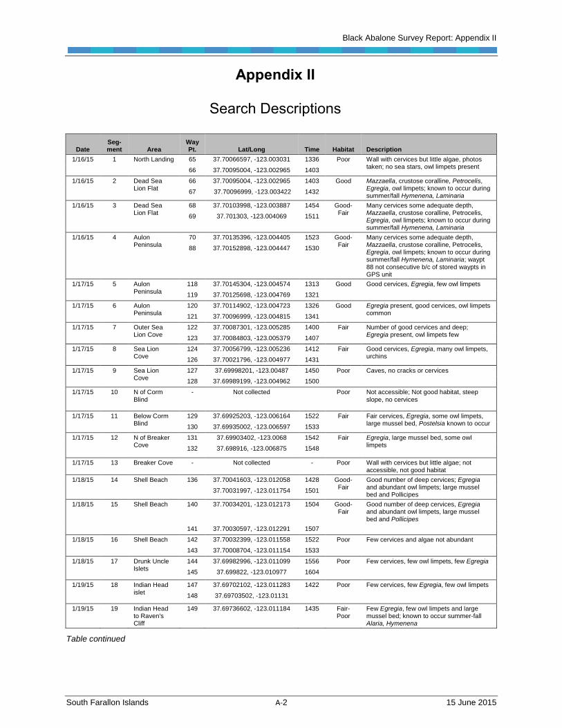
Search Descriptions
Date Seg-ment Area
Way Pt. Lat/Long Time Habitat Description
1/16/15 1 North Landing 65 37.70066597, -123.003031 1336 Poor Wall with cervices but little algae, photos taken; no sea stars, owl limpets present
66 37.70095004, -123.002965 1403
1/16/15 2 Dead Sea Lion Flat
66 37.70095004, -123.002965 1403 Good Mazzaella, crustose coralline, Petrocelis, Egregia, owl limpets; known to occur during summer/fall Hymenena, Laminaria
67 37.70096999, -123.003422 1432
1/16/15 3 Dead Sea Lion Flat
68 37.70103998, -123.003887 1454 Good-Fair
Many cervices some adequate depth, Mazzaella, crustose coralline, Petrocelis, Egregia, owl limpets; known to occur during summer/fall Hymenena, Laminaria
69 37.701303, -123.004069 1511
1/16/15 4 Aulon Peninsula
70 37.70135396, -123.004405 1523 Good-Fair
Many cervices some adequate depth, Mazzaella, crustose coralline, Petrocelis, Egregia, owl limpets; known to occur during summer/fall Hymenena, Laminaria; waypt 88 not consecutive b/c of stored waypts in GPS unit
88 37.70152898, -123.004447 1530
1/17/15 5 Aulon Peninsula
118 37.70145304, -123.004574 1313 Good Good cervices, Egregia, few owl limpets
119 37.70125698, -123.004769 1321
1/17/15 6 Aulon Peninsula
120 37.70114902, -123.004723 1326 Good Egregia present, good cervices, owl limpets common
121 37.70096999, -123.004815 1341
1/17/15 7 Outer Sea Lion Cove
122 37.70087301, -123.005285 1400 Fair Number of good cervices and deep; Egregia present, owl limpets few
123 37.70084803, -123.005379 1407
1/17/15 8 Sea Lion Cove
124 37.70056799, -123.005236 1412 Fair Good cervices, Egregia, many owl limpets, urchins
126 37.70021796, -123.004977 1431
1/17/15 9 Sea Lion Cove
127 37.69998201, -123.00487 1450 Poor Caves, no cracks or cervices
128 37.69989199, -123.004962 1500
1/17/15 10 N of Corm
Blind
- Not collected Poor Not accessible; Not good habitat, steep
slope, no cervices
1/17/15 11 Below Corm Blind
129 37.69925203, -123.006164 1522 Fair Fair cervices, Egregia, some owl limpets, large mussel bed, Postelsia known to occur
130 37.69935002, -123.006597 1533
1/17/15 12 N of Breaker Cove
131 37.69903402, -123.0068 1542 Fair Egregia, large mussel bed, some owl limpets
132 37.698916, -123.006875 1548
1/17/15 13 Breaker Cove - Not collected - Poor Wall with cervices but little algae; not accessible, not good habitat
1/18/15 14 Shell Beach 136 37.70041603, -123.012058 1428 Good-Fair
Good number of deep cervices; Egregia and abundant owl limpets; large mussel bed and Pollicipes
37.70031997, -123.011754 1501
1/18/15 15 Shell Beach 140 37.70034201, -123.012173 1504 Good-Fair
Good number of deep cervices, Egregia and abundant owl limpets, large mussel bed and Pollicipes
141 37.70030597, -123.012291 1507
1/18/15 16 Shell Beach 142 37.70032399, -123.011558 1522 Poor Few cervices and algae not abundant
143 37.70008704, -123.011154 1533
1/18/15 17 Drunk Uncle Islets
144 37.69982996, -123.011099 1556 Poor Few cervices, few owl limpets, few Egregia
145 37.699822, -123.010977 1604
1/19/15 18 Indian Head islet
147 37.69702102, -123.011283 1422 Poor Few cervices, few Egregia, few owl limpets
148 37.69703502, -123.01131
1/19/15 19 Indian Head to Raven's Cliff
149 37.69736602, -123.011184 1435 Fair-Poor
Few Egregia, few owl limpets and large mussel bed; known to occur summer-fall Alaria, Hymenena
Table continued

Black Abalone Survey Report: Appendix II
South Farallon Islands A-3 15 June 2015
Search Descriptions
Date Seg-ment Area
Way Pt. Lat/Long Time Habitat Description
1/19/15 20 Indian Head to Raven's Cliff
153 37.69780003, -123.010569 1524 Fair-Poor
Few cervices, owl limpets, Egregia, large mussel bed; known to occur summer-fall Alaria, Hymenena; area previously found reds and blacks
154 37.69776701, -123.010509 1529
1/19/15 21 Indian Head to Raven's Cliff
154 37.69776701, -123.010509 1529 Fair Adequate cervices, owl limpets, Egregia, large mussel bed; known to occur summer-fall Alaria, Hymenena; area previously found reds and blacks
155 37.69780397, -123.010362 1538
1/19/15 22 Raven's Cliff Monitoring Area
156 37.697851, -123.010341 1545 Fair Adequate cervices, owl limpets, Egregia; previously found reds and blacks
158 37.69781797, -123.009798 1603
1/19/15 23 Jordan Channel SW side
159 37.69804403, -123.008882 1624 Good Excellent number and sizes of cervices, Egregia; many large owl limpets (92-93 mm), many Pollicipes, Alaria known to occur in summer-fall months 160 37.69778696, -123.00917 1645
1/20/15 24 S of East Landing
161 37.69640503, -122.999722 1444 Fair-Poor
Few cervices dense mussel beds, owl limpets common, many urchins; known to occur summer-fall months Mazzaella, Egregia, Alaria, Laminaria
162 37.69613204, -123.000095 1451
1/20/15 25 N of East Landing
164 37.69656798, -122.99978 1501 Fair-Poor
Few cervices dense mussel beds, owl limpets common, many urchins; known to occur summer-fall months Mazzaella, Egregia, Alaria, Laminaria
165 37.69662699, -122.999893 1505
1/20/15 26 Garbage Gulch
166 37.69711901, -123.000239 1515 Fair-Poor
Few cervices dense mussel beds, owl limpets common, many urchins, known to occur summer-fall months Mazzaella, Egregia
167 37.69703301, -122.999999 1523
1/20/15 27 Jewel Cave 168 37.697924, -122.99989 1543 Good Jewel Cave to Blow Hole good cervices, Egregia, owl limpets; known to occur summer/fall Alaria, Hymenena, Laminaria; many urchins not previously there; previously found black in 2012 but not there now
169 37.69715404, -122.999582 1633
1/20/15 28,29 Blow Hole-Queen's Bath-Little Murre Cave
170 37.69788402, -122.999768 1713 Good-Fair (28), Poor (29)
Queens Bath, good cervices, Egregia, owl limpets; known to occur summer-fall Alaria, Hymenena, Laminaria; many new urchins in Queen's Bath; 6 of 7 red abs found 172 37.69891399, -122.999814 1745
1/21/15 30 Mouth of Sea Pigeon Gulch
173 up-
coast to
37.69584303, -123.000539 1434 Fair-Poor
Few cervices, narrow, Egregia few, owl limpets common; known to occur summer-fall Mazzaella, Egregia, Alaria, Laminaria
174 37.69619004, -123.000611 1441
1/21/15 31 Sea Pigeon Gulch to Mussel Flat
173 down coast
to
37.69584303, -123.000539 1448 Fair Some good cervices, Mazzaella, Egregia, large mussel bed and many purple urchins; good for red abalone
175 37.69613899, -123.002946 1557
1/21/15 32 Mussel Flat 176 37.69625198, -123.003212 1600 Good Good cervices, Mazzaella, Egregia, owl limpets; known to occur in summer-fall Alaria, Hymenena; previously found red abalone here
177 37.69617504, -123.003153 1642
1/21/15 33 Mussel Flat 178 37.69602902, -123.003326 1645 Good Good cervices, Mazzaella, Egregia, owl limpets; known to occur in summer-fall Alaria, Hymenena; previously found black abalone here
179 37.69730299, -123.00388 1740
1/22/15 34 E side of Jordan Channel
180 37.69827797, -123.008604 1442 Poor No deep cervices, few Egregia and owl limpets
181 37.69793096, -123.008158 1508
Table continued

Black Abalone Survey Report: Appendix II
South Farallon Islands A-4 15 June 2015
Search Descriptions
Date Seg-ment Area
Way Pt. Lat/Long Time Habitat Description
1/22/15 - Weather Serv. Pen.
37.697822, -123.007087
37.69767699, -123.006613
Skipped this area due to sick Zalophus, no disturbance, no assigned segment number
1/22/15 35 Weather Serv. Pen.
182 37.697822, -123.007087 1527 Poor No deep cervices, few Egregia and owl limpets
183 37.69762401, -123.006776 1541
1/22/15 36 Funky Arch to Low Arch
184 37.69767699, -123.006613 1545 Good Boulder field is one of the few on the island; good cervices, Mazzaella, Egregia; previously found red abalone in this area 185 37.69761002, -123.006407 1555
1/22/15 37 Low Arch 186 37.697694, -123.006268 1601 Poor Few deep cervices, Egregia
189 37.69720199, -123.005272 1742
1/23/15 38 Low Arch Monitoring Area
190 37.69743098, -123.004459 1628 Poor Few deep cervices, black abalone from 2001 near Q18 not found; due to swell height and darkness this area was not searched as well as previous days 191 37.69758102, -123.005181 1700
1/23/15 39 Low Arch Monitoring Area
192 37.69733802, -123.005361 1708 Fair-Poor
Some deep cracks but not a lot, Egregia, few mussels; due to swell height and darkness this area was not searched as well as previous days
193 37.69736501, -123.005093 1714
1/23/15 40 Outer Sewer Gulch
194 37.69743199, -123.004161 1732 Fair-Poor
Some deep cracks but not a lot, Egregia, few mussels; due to swell height and darkness this area was not searched as well as previous days
195 37.69730701, -123.003907 1744

Appendix III Previous Abalone Sightings
South Farallon Islands A-5 15 June 2015
Appendix III
Segment Characteristics
The following is described for each intertidal survey segment below.
Habitat quality: Relative scale of frequency of cervices large enough for adults
Appropriate sized crevices: ‘Yes ‘or ‘No’
Available food resources: ‘Yes’ or ‘No’ based on the relative abundance of algae in the
immediate proximity. Note that this evaluation was a one-time evaluation made in winter
that can change seasonally.
Shore width: <5 m, 5-10 m, >10 m
Shore profile: Flat, Sloped, Steep (>45°)
Wave exposure (relative scale): Protected, Semi-Exposed, High-Exposed
Accessibility: Accessible by foot, but may require strenuous climbing, bouldering or
cable/zip line crossing
Wildlife disturbance potential: ‘High’ or ‘Low’ relative to the presence of marine
mammals or seabirds, which may make access for restoration and monitoring more
difficult year-round or seasonal
Long-term monitoring sites nearby: Presence of nearby Sanctuary Ecosystem
Assessment Surveys (SEAS) intertidal monitoring sites
The segment descriptions below are organized in a clockwise fashion around the islands,
beginning at North Landing on Southeast Farallon Island. The end point of a given segment
being the starting point of the next segment represents a significant change in physical
characteristics of the shore (e.g., shore slope, wave exposure). The segments were assigned
numbers when they were sampled, but the segments were not necessarily sampled in a
clockwise fashion around the islands. Where to begin each day depended on wave
conditions, low tide height, and the time of low tide. As such for example, Segment 10 was
not necessarily next to Segment 11. Overall, the photographs portray the general physical
habitat characteristics associated with the segments.

Appendix III Previous Abalone Sightings
South Farallon Islands A-6 15 June 2015
Southeast Farallon Island
North Landing Area
Segment 3 (Dead Sea Lion Flat) Habitat Quality: Good-fair Appropriate Sized Cervices: Yes Available Food Resources: Yes Shore width: 5-10 m Shore slope: Flat Wave Exposure: Semi-exposed Access: Easy Wildlife disturbance potential: High Nearby long-term monitoring sites: Yes
Southeast Farallon Island
North Landing Area
Segment 2 (Dead Sea Lion Flat) Habitat Quality: Good Appropriate Sized Cervices: Yes Available Food Resources: Yes Shore width: 5-10 m Shore slope: Flat Wave Exposure: Exposed Access: Easy Wildlife disturbance potential: Moderate Nearby long-term monitoring sites: Yes
Southeast Farallon Island North Landing Area
Segment 1 (North Landing) Habitat Quality: Poor Appropriate Sized Cervices: Yes Available Food Resources: No Shore width: <5 m high-low zones Shore slope: Steep Wave Exposure: Semi-exposed Access: Moderate Wildlife disturbance potential: Low Nearby long-term monitoring sites: No
Southeast Farallon Island Blow Hole Peninsula and Jewel Cave Area
Segment 29 (Little Murre Cave) Habitat Quality: Poor Appropriate Sized Cervices: No Available Food Resources: No Shore width: <5 m Shore slope: Steep Wave Exposure: Protected Access: Difficult Wildlife disturbance potential: High Nearby long-term monitoring sites:

Appendix III Previous Abalone Sightings
South Farallon Islands A-7 15 June 2015
Southeast Farallon Island Blow Hole Peninsula and Jewel Cave Area
Segment 28 (Queen’s Bath) Habitat Quality: Good-fair Appropriate Sized Cervices: Yes Available Food Resources: Yes Shore width: 5 m Shore slope: Sloped Wave Exposure: Semi-exposed Access: Easy Wildlife disturbance potential: Moderate Nearby long-term monitoring sites: Yes
Southeast Farallon Island Blow Hole Peninsula and Jewel Cave Area
Segment: 27 (outside Jewel Cave) Habitat Quality: Good Appropriate Sized Cervices: Yes Available Food Resources: Yes Shore width: 5 m Shore slope: Sloped Wave Exposure: Exposed Access: Moderate Wildlife disturbance potential: Moderate Nearby long-term monitoring sites: Yes
Southeast Farallon Island East Landing-Sea Pigeon Gulch Area
Segment 25 (N of East Landing) Habitat Quality: Fair-poor Appropriate Sized Cervices: No Available Food Resources: Yes Shore width: 5-10 m Profile: Sloped Wave Exposure: Semi-exposed Access: Moderate Wildlife disturbance potential: Low Nearby long-term monitoring sites: No
Southeast Farallon Island East Landing-Sea Pigeon Gulch Area
Segment 24 (S of East Landing) Habitat Quality: Fair-poor Appropriate Sized Cervices: No Available Food Resources: Yes Shore width: 5-10 m Profile: Slope Wave Exposure: Exposed Accessibility: Moderate Wildlife disturbance potential: Moderate Nearby long-term monitoring sites: No

Appendix III Previous Abalone Sightings
South Farallon Islands A-8 15 June 2015
Southeast Farallon Island East Landing-Sea Pigeon Gulch Area
Segment: 30 (Sea Pigeon Gulch) Habitat Quality: Fair-poor Appropriate Sized Cervices: No Available Food Resources: Yes Shore width: <5 m Shore profile: Steep Wave Exposure: Semi-exposed Accessibility: Difficult Wildlife disturbance potential: Moderate Nearby long-term monitoring sites: No
Southeast Farallon Island East Landing-Sea Pigeon Gulch Area
Segment: 26 (Garbage Gulch) Habitat Quality: Fair-poor Appropriate Sized Cervices: Yes Available Food Resources: Yes Shore width: 5-10 m Shore profile: Steep Wave Exposure: Semi-exposed Accessibility: Difficult Wildlife disturbance potential: Moderate Nearby long-term monitoring sites: No
Southeast Farallon Island East Landing-Sea Pigeon Gulch Area
Segment: 31 (Sea Pigeon Gulch to Mussel Flat) Habitat Quality: Fair Appropriate Sized Cervices: Yes Available Food Resources: Yes Shore width: <5 m Shore profile: Slope Wave Exposure: Exposed Accessibility: Easy Wildlife disturbance potential: High Nearby long-term monitoring sites: No
Southeast Farallon Island Funky Arch-Low Arch-Mussel flat Area
Segment Number: 32 (Mussel Flat) Habitat Quality Rating: Good Appropriate Sized Cervices: Yes Available Food Resources: Yes Shore width: >10 M Shore profile: Flat Wave Exposure: Protected & Semi-exposed Accessibility: Easy Wildlife disturbance potential: High Nearby long-term monitoring sites: Yes

Appendix III Previous Abalone Sightings
South Farallon Islands A-9 15 June 2015
Southeast Farallon Island Funky Arch-Low Arch-Mussel flat Area
Segment: 33 (Mussel Flat) Habitat Quality: Good Appropriate Sized Cervices: Yes Available Food Resources: Yes Shore width:>10 m Shore profile: Flat Wave Exposure: Protected & Semi-exposed Accessibility: Easy Wildlife disturbance potential: High Nearby long-term monitoring sites: Yes
Southeast Farallon Island Funky Arch-Low Arch-Mussel flat Area
Segment: 40 (outer Sewer Gulch) Habitat Quality: Fair-Poor Appropriate Sized Cervices: Yes Available Food Resources: Yes Shore width: <5 m Shore profile: Steep Wave Exposure: Exposed Accessibility: Easy Wildlife disturbance potential: Moderate Nearby long-term monitoring sites: Yes
Southeast Farallon Island Funky Arch-Low Arch-Mussel flat Area
Segment: 39 (Low Arch Monitoring Area) Habitat Quality: Fair-poor Appropriate Sized Cervices: Yes Available Food Resources: Yes Shore width: <5 m Shore profile: Steep Wave Exposure: Semi-exposed Accessibility: Easy Wildlife disturbance potential: Moderate Nearby long-term monitoring sites: Yes
Southeast Farallon Island Funky Arch-Low Arch-Mussel flat Area
Segment: 37 (Low Arch) Habitat Quality: Poor Appropriate Sized Cervices: No Available Food Resources: Yes Shore width: 5-10 m Shore profile: Slope Wave Exposure: Exposed Accessibility: Moderate Wildlife disturbance potential: Moderate Nearby long-term monitoring sites: Yes

Appendix III Previous Abalone Sightings
South Farallon Islands A-10 15 June 2015
Southeast Farallon Island Funky Arch-Low Arch-Mussel flat Area
Segment: 38 (Low Arch Monitoring Area) Habitat Quality: Poor Appropriate Sized Cervices: Yes Available Food Resources: Yes Shore width: <5 m Shore profile: Slope Wave Exposure: Exposed Accessibility: Easy Wildlife disturbance potential: Moderate Nearby long-term monitoring sites: Yes
Southeast Farallon Island Funky Arch-Low Arch-Mussel flat Area
Segment: 36 (Funky Arch to Low Arch) Habitat Quality: Good Appropriate Sized Cervices: Yes Available Food Resources: Yes Shore width: 5-10 m Shore profile: Slope & Steep Wave Exposure: Semi-exposed Accessibility: Easy Wildlife disturbance potential: Moderate Nearby long-term monitoring sites: Yes
Southeast Farallon Island Weather Service Peninsula-Falcon’s Roost Area
Segment: 35 (Weather Service Peninsula) Habitat Quality: Poor Appropriate Sized Cervices: No Available Food Resources: Yes Shore width: 5-10 m Shore profile: Slope Wave Exposure: Exposed Accessibility: Moderate Wildlife disturbance potential: High Nearby long-term monitoring sites: No
Southeast Farallon Island Weather Service Peninsula-Falcon’s Roost Area
Segment: 34 (E. side Jordan Channel) Habitat Quality: Poor Appropriate Sized Cervices: No Available Food Resources: No Shore width: <5 m Shore profile: Steep Wave Exposure: Exposed Accessibility: Moderate Wildlife disturbance potential: High Nearby long-term monitoring sites: No

Appendix III Previous Abalone Sightings
South Farallon Islands A-11 15 June 2015
Southeast Farallon Island Breaker Cove Area
Segment: 13 (Breaker Cove) Habitat Quality: Poor Appropriate Sized Cervices: No Available Food Resources: No Shore width: <5 m Shore profile: Steep Wave Exposure: Exposed Accessibility: Difficult Wildlife disturbance potential: Low Nearby long-term monitoring sites: No
Southeast Farallon Island Breaker Cove Area
Segment: 12 (N of Breaker Cove) Habitat Quality: Fair Appropriate Sized Cervices: Yes Available Food Resources: Yes Shore width:<5 m Shore profile: Slope Wave Exposure: Semi-exposed Accessibility: Moderate Wildlife disturbance potential: Low Nearby long-term monitoring sites: No
Southeast Farallon Island Breaker Cove Area
Segment: 11 (Below Corm Blind) Habitat Quality: Fair Appropriate Sized Cervices: Yes Available Food Resources: Yes Shore width: <5 m Shore profile: Steep Wave Exposure: Semi-exposed Accessibility: Difficult Wildlife disturbance potential: High Nearby long-term monitoring sites: No
Southeast Farallon Island Sea Lion Cove
Segment: 10 (N of Corm Blind) Habitat Quality: Poor Appropriate Sized Cervices: No Available Food Resources: No Shore width: 5-10 m Shore profile: Steep Wave Exposure: Protected Accessibility: Difficult Wildlife disturbance potential: High Nearby long-term monitoring sites: No

Appendix III Previous Abalone Sightings
South Farallon Islands A-12 15 June 2015
Southeast Farallon Island Sea Lion Cove
Segment: 9 (Sea Lion Cove) Habitat Quality: Poor Appropriate Sized Cervices: No Available Food Resources: No Shore width: 5-10 m Shore profile: Steep Wave Exposure: Protected Accessibility: Difficult Wildlife disturbance potential: High Nearby long-term monitoring sites: No
Southeast Farallon Island Sea Lion Cove
Segment: 8 (Sea Lion Cove) Habitat Quality: Fair Appropriate Sized Cervices: Yes Available Food Resources: Yes Shore width: 5-10 m Shore profile: Slope Wave Exposure: Protected Accessibility: Moderate Wildlife disturbance potential: High Nearby long-term monitoring sites: No
Southeast Farallon Island Sea Lion Cove
Segment: 7 (Outer Sea Lion Cove) Habitat Quality: Fair Appropriate Sized Cervices: Yes Available Food Resources: Yes Shore width: <5 m Shore profile: Steep Wave Exposure: Exposed Accessibility: Moderate Wildlife disturbance potential: High Nearby long-term monitoring sites: No

Appendix III Previous Abalone Sightings
South Farallon Islands A-13 15 June 2015
Southeast Farallon Island Aulon Peninsula
Segment: 5 & 6 (Aulon Peninsula) Habitat Quality: Good Appropriate Sized Cervices: Yes Available Food Resources: Yes Shore width: >5 m Shore profile: Slope Wave Exposure: Exposed Accessibility: Moderate Wildlife disturbance potential: High Nearby long-term monitoring sites: No
Southeast Farallon Island Aulon Peninsula
Segment: 4 (Aulon Peninsula) Habitat Quality: Good-fair Appropriate Sized Cervices: Yes Available Food Resources: Yes Shore width: >5 m Shore profile: Slope Wave Exposure: Semi-exposed Accessibility: Moderate Wildlife disturbance potential: High Nearby long-term monitoring sites: No
Maintop Island Shell Beach Area
Segment: 14 (Shell Beach) Habitat Quality: Good-fair Appropriate Sized Cervices: Yes Available Food Resources: Yes Shore width: >10 m Shore profile: Flat Wave Exposure: Exposed Accessibility: Difficult Wildlife disturbance potential: High Nearby long-term monitoring sites: Yes
Maintop Island Shell Beach Area
Segment: 15 (Shell Beach) Habitat Quality: Good-fair Appropriate Sized Cervices: Yes Available Food Resources: Yes Shore width: >10 m Shore profile: Flat Wave Exposure: Exposed Accessibility: Difficult Wildlife disturbance potential: High Nearby long-term monitoring sites: No

Appendix III Previous Abalone Sightings
South Farallon Islands A-14 15 June 2015
Maintop Island Shell Beach Area
Segment: 16 Habitat Quality: Poor Appropriate Sized Cervices: No Available Food Resources: Yes Shore width: >10 m Shore profile: Flat Wave Exposure: Exposed Accessibility: Difficult Wildlife disturbance potential: High Nearby long-term monitoring sites:
Maintop Island Drunk Uncle Islet
Segment: 17 (Drunk Uncle Islets) Habitat Quality: Poor Appropriate Sized Cervices: No Available Food Resources: Yes Shore width: 5-10 m Shore profile: Steep Wave Exposure: Exposed Accessibility: Difficult Wildlife disturbance potential: High Nearby long-term monitoring sites: Yes
Maintop Island Indian Head-Raven’s Cliff-Little Maintop Area
Segment: 23 (SW side of Jordan Channel) Habitat Quality: Good Appropriate Sized Cervices: Yes Available Food Resources: Yes Shore width: <5 m Shore profile: Slope Wave Exposure: Exposed Accessibility: Difficult Wildlife disturbance potential: High Nearby long-term monitoring sites: Yes
Maintop Island Indian Head-Raven’s Cliff-Little Maintop Area
Segment: 22 (Raven’s Cliff Monitoring Area) Habitat Quality: Fair Appropriate Sized Cervices: Yes Available Food Resources: Yes Shore width: 5-10 m Shore profile: Slope Wave Exposure: Exposed Accessibility: Difficult Wildlife disturbance potential: High Nearby long-term monitoring sites: Yes

Appendix III Previous Abalone Sightings
South Farallon Islands A-15 15 June 2015
Maintop Island Indian Head-Raven’s Cliff-Little Maintop Area
Segment: 21 (Indian Head to Raven’s Cliff) Habitat Quality: Fair Appropriate Sized Cervices: Yes Available Food Resources: Yes Shore width: 5-10 m Shore profile: Flat Wave Exposure: Exposed Accessibility: Difficult Wildlife disturbance potential: High Nearby long-term monitoring sites: Yes
Maintop Island Indian Head-Raven’s Cliff-Little Maintop Area
Segment: 20 (Indian Head to Raven’s Cliff) Habitat Quality: Fair-poor Appropriate Sized Cervices: Yes Available Food Resources: Yes Shore width: 5-10 m Shore profile: Flat Wave Exposure: Exposed Accessibility: Difficult Wildlife disturbance potential: High Nearby long-term monitoring sites: No
Maintop Island Indian Head-Raven’s Cliff-Little Maintop Area
Segment: 19 (Indian Head to Raven’s Cliff) Habitat Quality: Fair-poor Appropriate Sized Cervices: Yes Available Food Resources: Yes Shore width: 5-10 m Shore profile: Flat Wave Exposure: Exposed Accessibility: Difficult Wildlife disturbance potential: Yes Nearby long-term monitoring sites: No Historic presence of abalone: Yes (now many empty red abalone shells, pictured above)
Maintop Island Indian Head-Raven’s Cliff-Little Maintop Area
Segment: 18 (Indian Head Islet) Habitat Quality: Poor Appropriate Sized Cervices: No Available Food Resources: Yes Shore width: <5 m Shore profile: Steep Wave Exposure: Exposed Accessibility: Difficult Wildlife disturbance potential: High Nearby long-term monitoring sites: No

40


