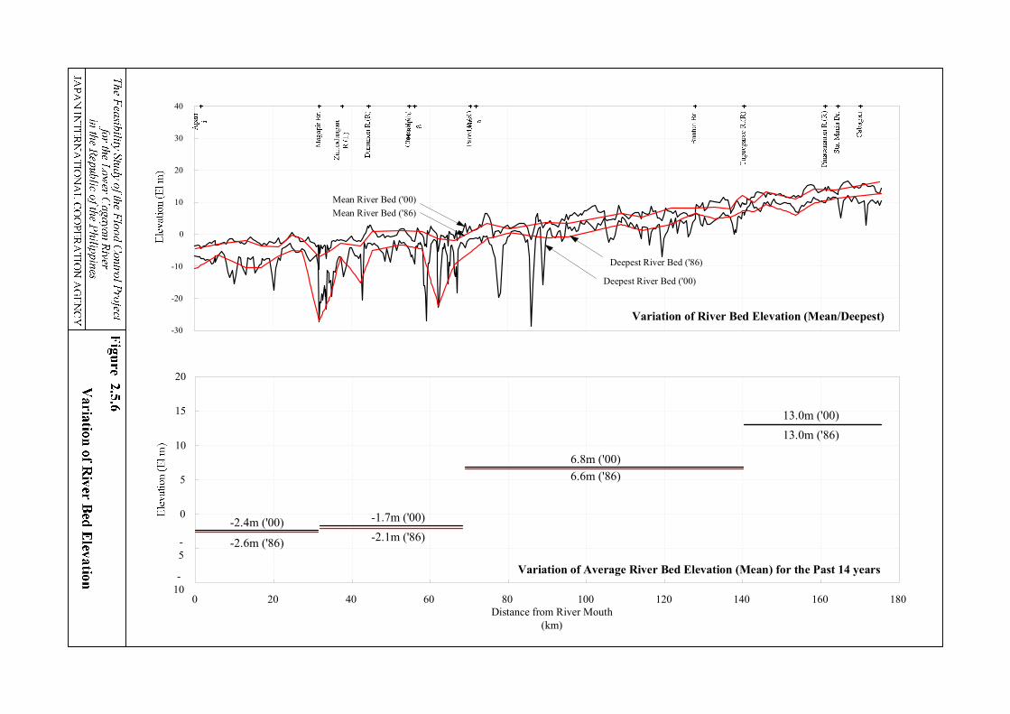
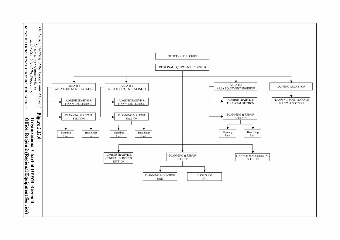
Variation of River Bed Elevation (Mean/Deepest) -30 -20 -10 0 10 20 30 40 Mean River Bed ('00) Mean River Bed ('86) Deepest River Bed ('86) Deepest River Bed ('00) - 10 - 5 0 5 10 15 20 0 20 40 60 80 100 120 140 160 180 Distance from River Mouth (km) -2.4m ('00) -2.6m ('86) -1.7m ('00) -2.1m ('86) 6.8m ('00) 6.6m ('86) 13.0m ('86) 13.0m ('00) Variation of Average River Bed Elevation (Mean) for the Past 14 years
Transcript
Variation of River Bed Elevation (Mean/Deepest)-30
-20
-10
0
10
20
30
40
Mean River Bed ('00)Mean River Bed ('86)
Deepest River Bed ('86)
Deepest River Bed ('00)
-10
-5
0
5
10
15
20
0 20 40 60 80 100 120 140 160 180Distance from River Mouth
(km)
-2.4m ('00)
-2.6m ('86)
-1.7m ('00)-2.1m ('86)
6.8m ('00)6.6m ('86)
13.0m ('86)13.0m ('00)
Variation of Average River Bed Elevation (Mean) for the Past 14 years
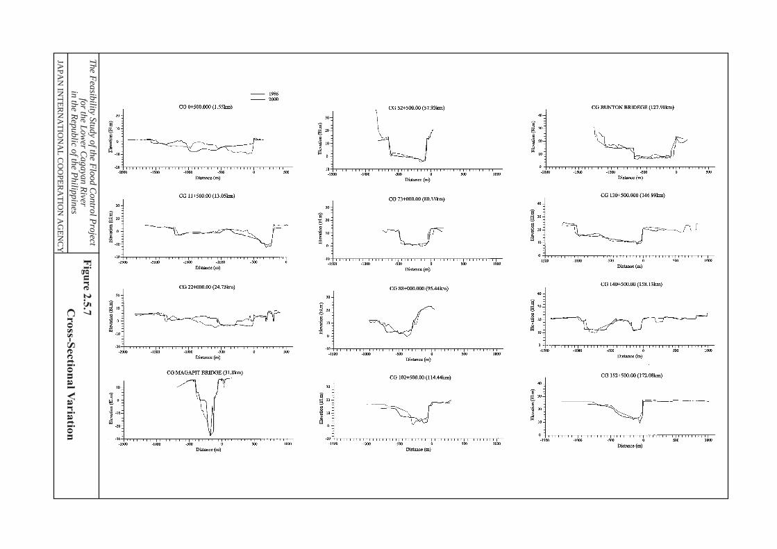
Cross-S
ectio
nal V
aria
tion
The F
easibility Study of the Flood C
ontrol Project
for the Low
er Cagayan R
iverin the R
epublic of the Philippines
JAPA
N IN
TE
RN
AT
ION
AL
CO
OPE
RA
TIO
N A
GE
NC
Y
Fig
ure 2
.5.7
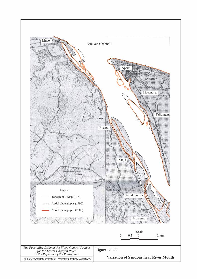
Babuyan Channel
Aparri
Linao
Tallungan
Zanja
Bisagu
Paruddun Sur
Mbangug
Macanaya
The Feasibility Study of the Flood Control Projectfor the Lower Cagayan River
in the Republic of the Philippines
JAPAN INTERNATIONAL COOPERATION AGENCY
Figure 2.5.8
Variation of Sandbar near River Mouth
Scale0 0.5 1 2 km
Legend
Topographic Map (1979)
Aerial photographs (1996)
Aerial photographs (2000)
Nassiping
Alcala
Amulung
Solana
Tuguegarao
Iguig
Enrile
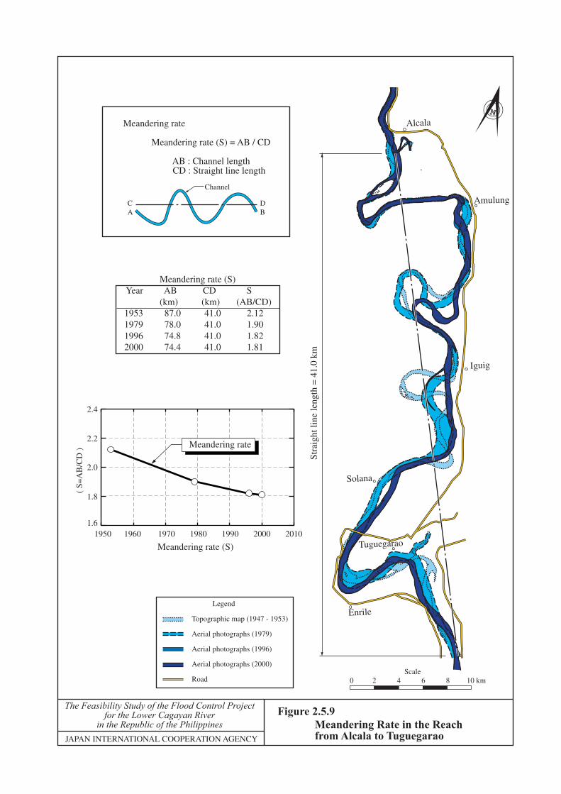
Meandering rate (S) Year AB CD S (km) (km) (AB/CD)1953 87.0 41.0 2.121979 78.0 41.0 1.901996 74.8 41.0 1.822000 74.4 41.0 1.81
Meandering rate
Meandering rate (S) = AB / CD
AB : Channel length CD : Straight line length
CA
Channel
DB
0 10 20 30 40 50 60
0 10 20 30 40 50 60
0.0
0.2
0.4
0.6
0.8
0.0
0.2
0.4
0.6
0.8
1950 1960 1970 1980 1990 2000 2010
Meandering rate (S)
( S=
AB
/CD
)
2.4
2.2
2.0
1.8
1.6
Meandering rate
Stra
ight
line
leng
th =
41.
0 km
Legend
Topographic map (1947 - 1953)
Aerial photographs (1979)
Aerial photographs (1996)
Aerial photographs (2000)
Road
The Feasibility Study of the Flood Control Projectfor the Lower Cagayan River
in the Republic of the PhilippinesJAPAN INTERNATIONAL COOPERATION AGENCY
Figure 2.5.9Meandering Rate in the Reach from Alcala to Tuguegarao
N
0 2 4 6 8 10 kmScale
Aparri
Lal-lo
Magapit Br.Magapit
Gattaran
Nassiping
Tuao
Alcala
Iguig
Amulung
SolanaBuntun Br.
Enrile
Cabagan
Tumauini
Cauayan
Ilagan
Magat Dam
Mallig
Tuguegarao
Echague
Santiago
Pangal Norte
Jones
Babuyan Channel
Dummon R.
Caga
yan
R.
Pared R.
Chico R
.
Tuguegarao R.
Sier
ra M
adre
Mou
ntai
ns
Sier
ra M
adre
Mou
ntai
ns
Pinacanauan R.
Tumauini R.
Caga
yan
R.
Magat R.
Ilaga
n R.
Siffu R.
Mallig
R.
Cord
iller
a M
ount
ains
Mag
at R.
Caga
yan
R.
1011
12
15
13 23
22
26
2524
14
16
19
3231
20
21
35
34
37 49
33
36
2928 27
30
18
17
1
3
45
6
78
9
2
50 73
0 10 20 30 kmScale
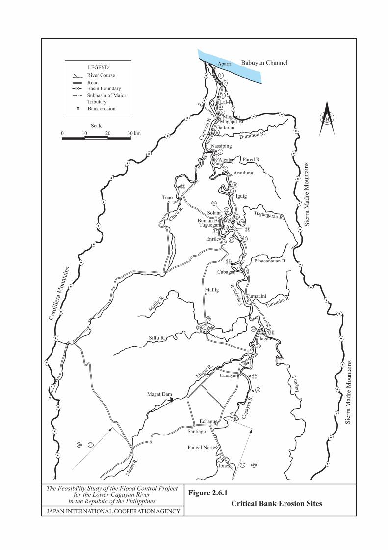
Critical Bank Erosion Sites
N
The Feasibility Study of the Flood Control Projectfor the Lower Cagayan River
in the Republic of the PhilippinesJAPAN INTERNATIONAL COOPERATION AGENCY
Figure 2.6.1
Bank erosion
River CourseRoadBasin BoundarySubbasin of MajorTributary
LEGEND
Inu
nd
atio
n A
rea M
ap
The F
easibility Study of the Flood C
ontrol Project
for the Low
er Cagayan R
iverin the R
epublic of the Philippines
JAPA
N IN
TE
RN
AT
ION
AL
CO
OPE
RA
TIO
N A
GE
NC
Y
Fig
ure 2
.6.2
Babuyan Channel
Dummon R.
Cagayan R
.
Pared R.
Chic
o R
. Tuguegarao R.
SIE
RR
A M
AD
RE
MO
UN
TA
INS
SIE
RR
A M
AD
RE
MO
UN
TA
INS
Pinacanauan R.
Tumauini R.
Cagayan R
.
Mag
at R
.Il
agan R
.
Siffu R.
Mal
lig R
.
CO
RD
ILL
ER
A M
OU
NTA
INS
Addalam R.
Magat R
.
Cagayan R
.
Cagayan R
.
Babuyan Channel
Dummon R.
Cagayan R
.
Pared R.
Chic
o R
. Tuguegarao R.
SIE
RR
A M
AD
RE
MO
UN
TA
INS
SIE
RR
A M
AD
RE
MO
UN
TA
INS
Pinacanauan R.
Tumauini R.
Cagayan R
.
Mag
at R
.
Ilagan R
.
Siffu R.
Mal
lig R
.
CO
RD
ILL
ER
A M
OU
NTA
INS
Addalam R.
Magat R
.
Cagayan R
.
Cagayan R
.
Babuyan Channel
Dummon R.
Cagayan R
.
Pared R.
Chic
o R
. Tuguegarao R.
SIE
RR
A M
AD
RE
MO
UN
TA
INS
SIE
RR
A M
AD
RE
MO
UN
TA
INS
Pinacanauan R.
Tumauini R.
Cagayan R
.
Mag
at R
.
Ilagan R
.
Siffu R.
Mal
lig R
.
CO
RD
ILL
ER
A M
OU
NTA
INS
Addalam R.
Magat R
.
Cagayan R
.
Cagayan R
.
N
River Course
Road
Basin Boundary
Inundation Area
Subbasin of Major
Tributary
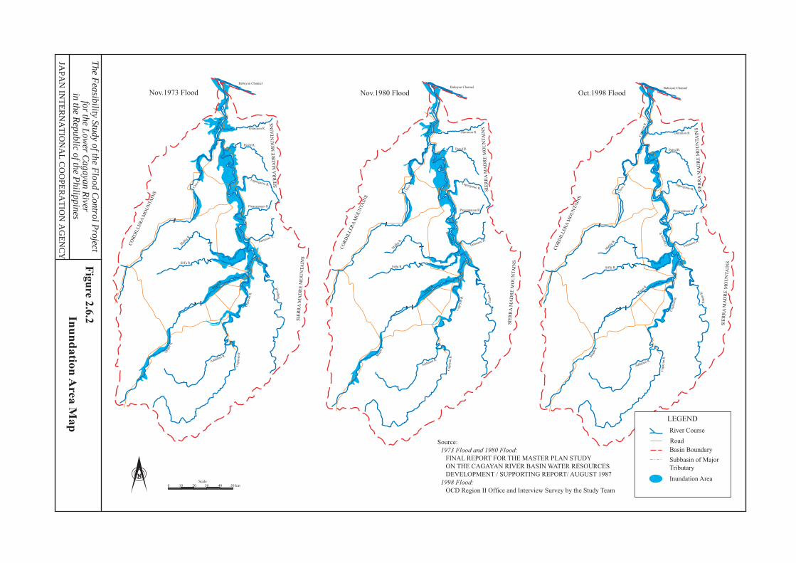
LEGEND
Oct.1998 FloodNov.1980 FloodNov.1973 Flood
Source:
1973 Flood and 1980 Flood:
FINAL REPORT FOR THE MASTER PLAN STUDY
ON THE CAGAYAN RIVER BASIN WATER RESOURCES
DEVELOPMENT / SUPPORTING REPORT/ AUGUST 1987
1998 Flood:
OCD Region II Office and Interview Survey by the Study Team0 10 20 30 40 50 km
Scale
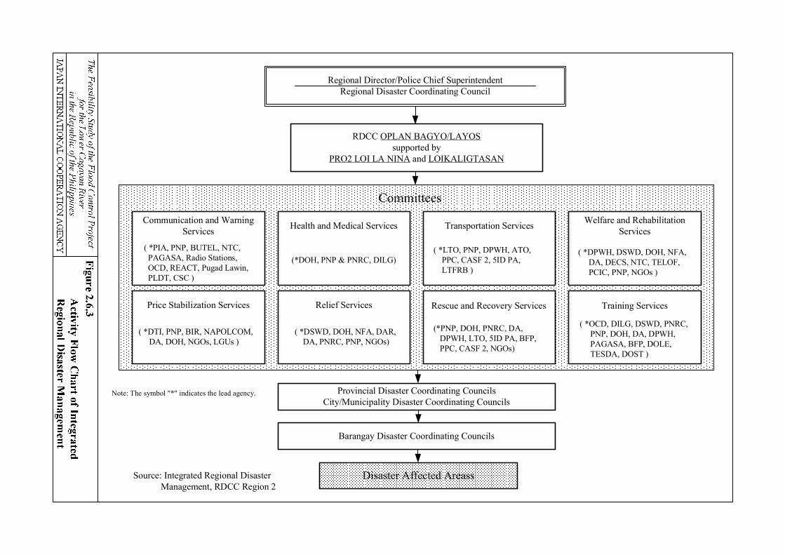
Regional Director/Police Chief SuperintendentRegional Disaster Coordinating Council
( *OCD, DILG, DSWD, PNRC, PNP, DOH, DA, DPWH, PAGASA, BFP, DOLE, TESDA, DOST )
Tumauini
Pared
ChicoRive
ParetRiverPinacanau
an
River
Pa
ng
olBrookRiver
CagayanRive
r
IlaganRive
r
Ca
gayanRiver
r
Casigna
n
River
Ma
ga
tRiver
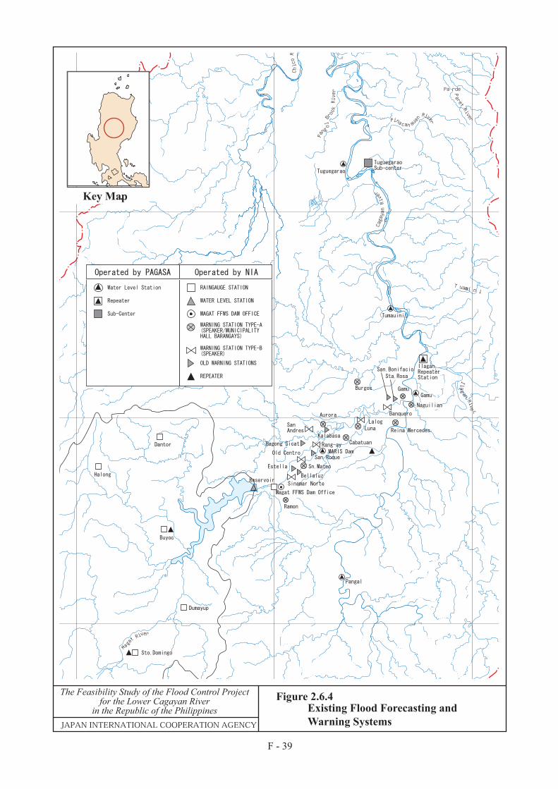
Figure 2.6.4
N
10 0 10 20 30 40 50km
SCALE
122°00'121°00' 121°30'
18°00'
17°30'
17°00'
16°30'
16°00'
Cagayan River
Tumauini
Pared
CagayanRiver
ChicoRive
Pa ret
RiverPina can aua n
River
Pa
ng
olBrookRiver
CagayanRive
er
IlaganRive
r
Ca
gayanRiver
Rapids RiverCagay
anRiver
Cagayan Ri ve
r
Casigna
n
River
Ma
ga
t River
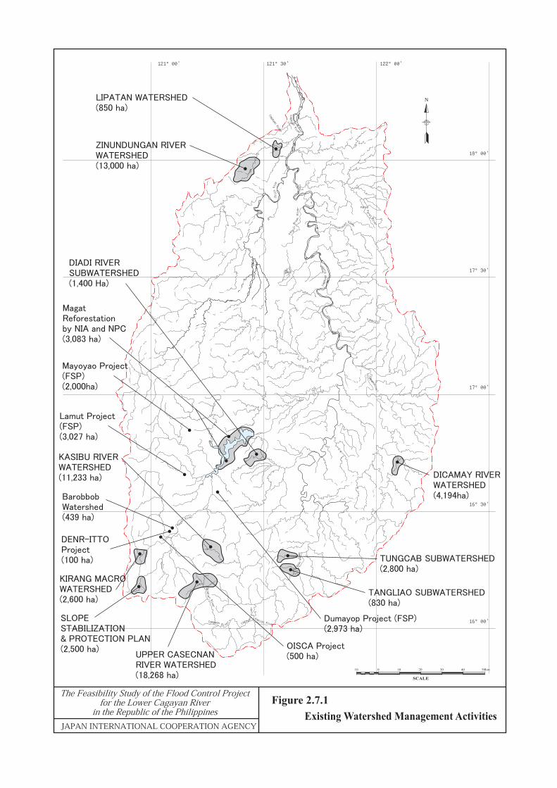
Figure 2.7.1
The Feasibility Study of the Flood Control Projectfor the Lower Cagayan River
in the Republic of the PhilippinesJAPAN INTERNATIONAL COOPERATION AGENCY
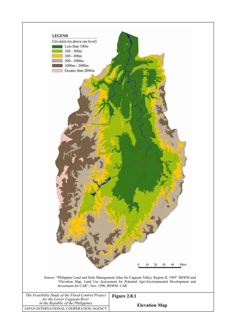
Figure 2.8.1
Elevation Map
Source: “Philippine Land and Soils Management Atlas for Cagayan Valley, Region II, 1995” BSWM and“Elevation Map, Land Use Assessment for Potential Agri-Environmental Development andInvestment for CAR”, Nov. 1990, BSWM. CAR
The Feasibility Study of the Flood Control Projectfor the Lower Cagayan River
in the Republic of the PhilippinesJAPAN INTERNATIONAL COOPERATION AGENCY
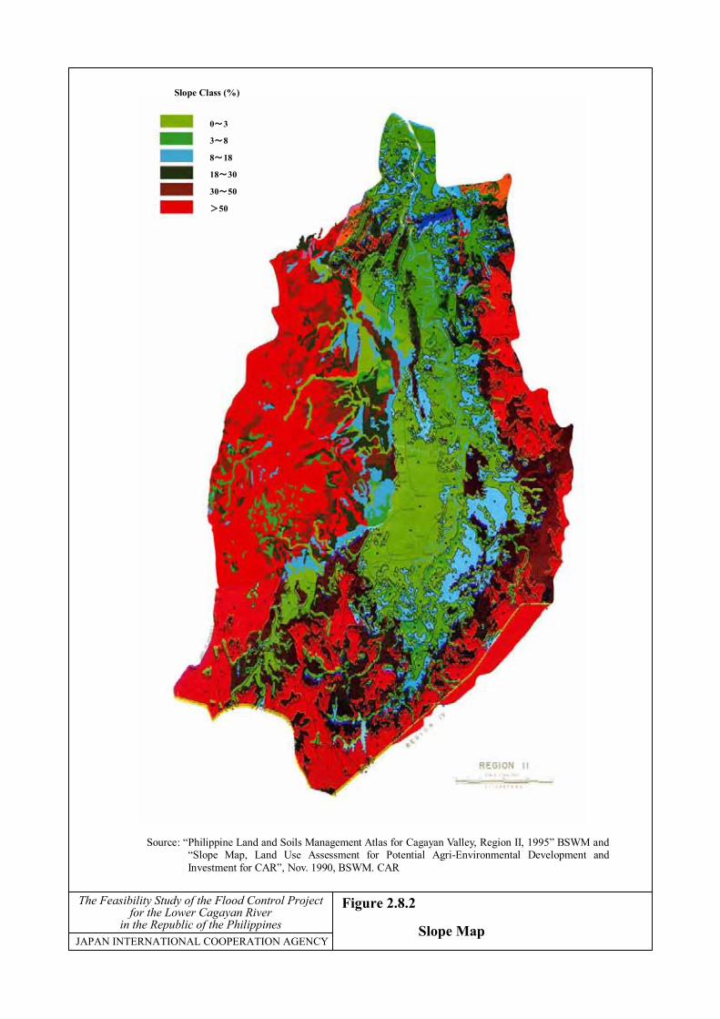
Figure 2.8.2
Slope Map
Source: “Philippine Land and Soils Management Atlas for Cagayan Valley, Region II, 1995” BSWM and“Slope Map, Land Use Assessment for Potential Agri-Environmental Development andInvestment for CAR”, Nov. 1990, BSWM. CAR
0~3
3~8
8~18
18~30
30~50
>50
Slope Class (%)
The Feasibility Study of the Flood Control Projectfor the Lower Cagayan River
in the Republic of the PhilippinesJAPAN INTERNATIONAL COOPERATION AGENCY
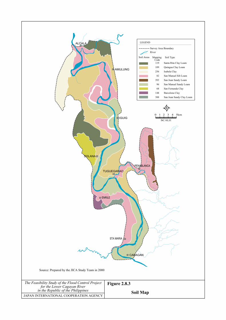
Figure 2.8.3
Soil Map
0 1 2 3 4 5km
SCALE
LEGEND
Survey Area BoundaryRiver
Soil Areas MappingCode
Soil Type
119
109
256
82
393
96
68
148
388
Santa Rita Clay Loam
Quingua Clay Loam
Isabela Clay
San Manuel Silt Loam
San Juan Sandy Loam
San Manuel Sandy Loam
San Fernanda Clay
Barcelona Clay
San Juan Sandy Clay Loam
Source: Prepared by the JICA Study Team in 2000
IGUIG
SOLANA
TUGUEGARAO
ENRILE
STA MARIA
CABAGAN
PENABLANCA
ALCALA
AMULUNG
The Feasibility Study of the Flood Control Projectfor the Lower Cagayan River
in the Republic of the PhilippinesJAPAN INTERNATIONAL COOPERATION AGENCY
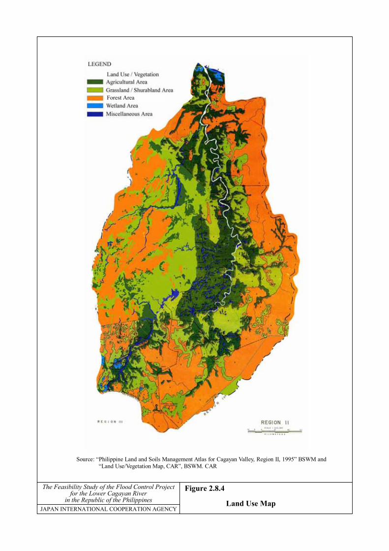
Figure 2.8.4
Land Use Map
Source: “Philippine Land and Soils Management Atlas for Cagayan Valley, Region II, 1995” BSWM and“Land Use/Vegetation Map, CAR”, BSWM. CAR
Forest Area
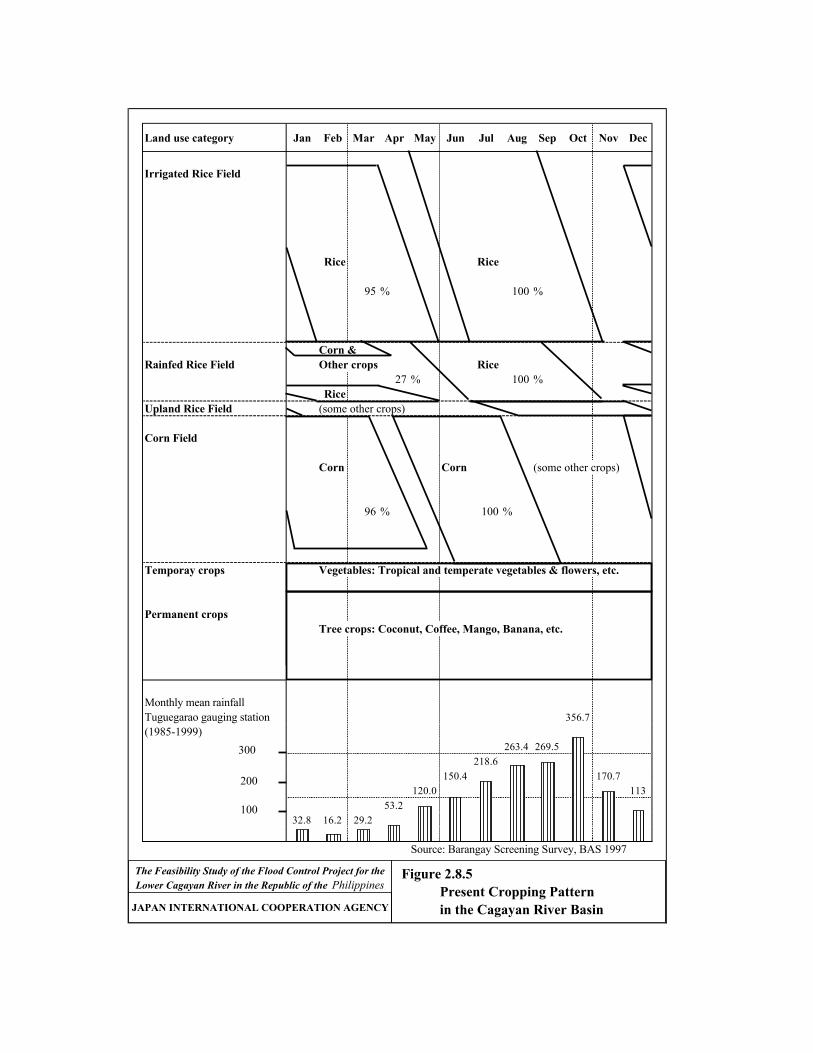
Land use category Jan Feb Mar Apr May Jun Jul Aug Sep Oct Nov Dec
Irrigated Rice Field
Rice Rice
95 % 100 %
Corn &Rainfed Rice Field Other crops Rice
27 % 100 %Rice
Upland Rice Field (some other crops)
Corn Field
Corn Corn (some other crops)
96 % 100 %
Temporay crops Vegetables: Tropical and temperate vegetables & flowers, etc.
Permanent cropsTree crops: Coconut, Coffee, Mango, Banana, etc.
Monthly mean rainfall Tuguegarao gauging station 356.7(1985-1999)
Figure 2.11.4The Feasibility Study of the Flood Control Projectfor the Lower Cagayan River
in the Republic of the Philippines
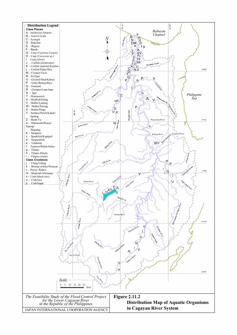
List of Sites
1. The Miraculous Lady of Piat2. Iguig Calvary Hills and the Parish of St. James the Greater3. St. Peter's Cathedral4. Alcala's St. Philomene Church5. St. Hyacinth Ermita church6. St. Pablo Church7. Parish Church of St. Mathias8. St. Dominic Cathedral9. Dupax del Sur Church10. Banaue Rice Terraces11. Kiangan War Memorial12. Archeological Reservation
21
12
3 5
7
abc
k m
e
9
(Recreational Spots)
a. Callo Caves Tourist Zoneb. Jackpot Cavec. Odessa-Tumabali Cave Systemd. Sta. Victoria Cavese. Mt. Pulog National Parkf. Dalton Passg. Salinas Salt Springh. Alayan Cave at Malabing Valleyi. Nagbukel Cavej. Aglipay Cavesk. Governor Rapidsl. Victoria Fallsm. Bisangal Warefall
g
11
Locations of Historical and Cultural Heritagesand Recreational Spots in the Cagayan Valley
(Heritages)
The Feasibility Study of the Flood Control Project
for the Lower Cagayan River
in the Republic of the Philippines JA
PAN
INTERN
ATION
AL C
OO
PERATIO
N A
GEN
CY
Figure 2.12.1 Functional R
elationship for W
ater Related W
orks
POLICY-MAKING
NEDA
Coordination/Regulatory
NWRB
WATER QUALITY& SANITATION
EMB DOHBRK ENS
WATERSHEDMANAGEMENT
FMB BSWMNIA NPC
MWSS
INTEGRATED AREADEVELOPMENT
LLDA RDCBOI
DATA COLLECTION
NWRB NAMRIA BRSMGSB LWUA NIAPAGASA MWSS
RESEARCH
BRSPCAFMRRD
CLOUDSEEDING
OCD PAIBSWM
WATER SUPPLY
DPWH PMO-RWSMWSS DILG
IRRIGATION
NIA DA
HYDRO-POWER
NPC DOENEA OEA
FLOOD CONTROL
DPWH PMO-SWIMPMO-MFCP
PORTS &NAVIGATION
PPA
FISHERIES &RECREATION
BFAR PTA
The Feasibility Study of the Flood Control Project
for the Lower Cagayan River
in the Republic of the Philippines JA
PAN
INTERN
ATION
AL C
OO
PERATIO
N A
GEN
CY
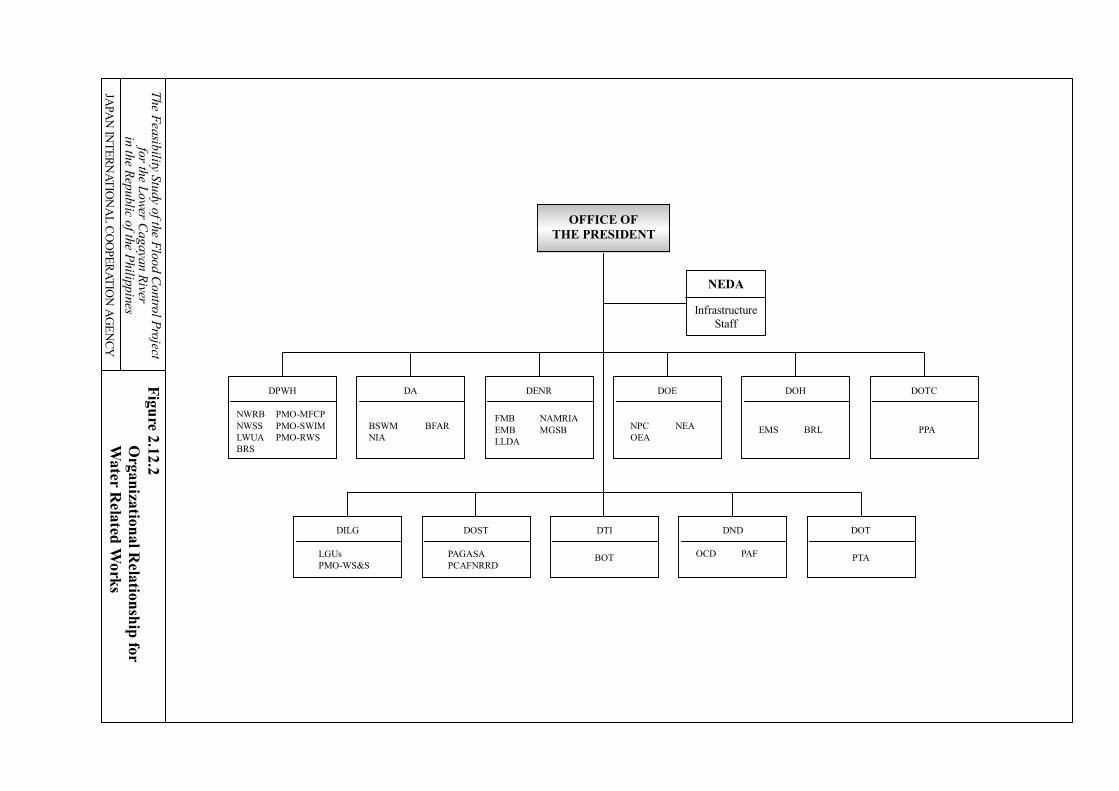
Figure 2.12.2 O
rganizational Relationship for
Water R
elated Works
OFFICE OF
THE PRESIDENT
NEDA Infrastructure
Staff
DPWH
NWRB PMO-MFCP NWSS PMO-SWIM LWUA PMO-RWS BRS
DA
BSWM BFAR NIA
DENR
FMB NAMRIA EMB MGSB LLDA
DOE
NPC NEA OEA
DOH
EMS BRL
DOTC
PPA
DILG
LGUs PMO-WS&S
DOST
PAGASA PCAFNRRD
DTI
BOT
DND
OCD PAF
DOT
PTA
The Feasibility Study of the Flood Control Project
for the Lower Cagayan River
in the Republic of the Philippines JA
PAN
INTERN
ATION
AL C
OO
PERATIO
N A
GEN
CY
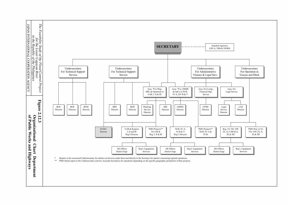
Figure 2.12.3 O
rganizational Chart D
epartment
of Public Works and H
ighways
SECRETARY Attached AgenciesLWUA, TRB & NWRB
UndersecretaryFor Technical Support
Service
BOCDirector
BOEDirector
BOMDirector
Asee. *For Plng.MIS, & Operation in
CAR, I, II & III
Asee. *For AMMS& Opt’n in NCR,IV-A, IIV-B & V
Asee. For Comp.,Financial Mgt.
Service
Asee. ForLegal Service
UndersecretaryFor Technical Support
Service
UndersecretaryFor Administrative
Finance & Legal Serv.
UndersecretaryFor Operation in
Visayas and Mind.
BRSDirector
BODDirector
PlanningServiceDirector
CFMSDirector
LegalServiceDirector
LASDirector
MISDirector
AMMSDirector
ECSECDirector
CAR & RegionsI, II and III
Reg’l Director
PMO Projects**In CAR &
Reg. I, II & III
NCR, IV-A,IV-B & V
Reg’l. Director
PMO Projects**NCR, IV-A &
IV-B
Reg. VI, VII, VIIIIX, X, CARAGA,
XI & XII
PMO Proj. in VI,VII, VIII, IX, X,
XI & XII
DE OfficesDistrict Engr.
Reg’l. EquipmentServices
DE OfficesDistrict Engr.
Reg’l. EquipmentServices
DE OfficesDistrict Engr.
Reg’l. EquipmentServices
* Reports to the concerned Undersecretary for matters on Services under them and directly to the Secretary for matters concerning regional operations.** PMO Heads report to the Undersecretary and two Assistant Secretaries for operations depending on the specific geographic jurisdiction of their projects.
The Feasibility Study of the Flood Control Project
for the Lower Cagayan River
in the Republic of the Philippines JA
PAN
INTERN
ATION
AL C
OO
PERATIO
N A
GEN
CY
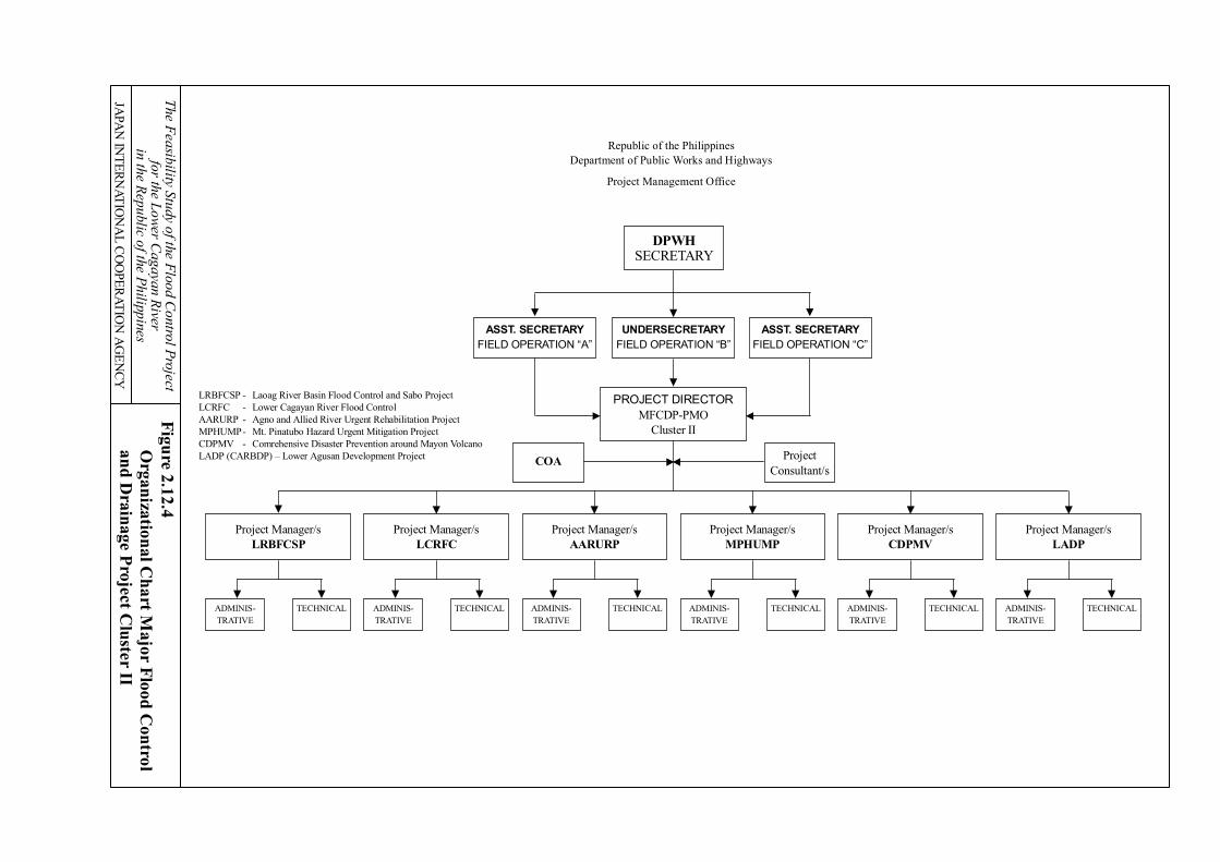
Figure 2.12.4 O
rganizational Chart M
ajor Flood Control
and Drainage Project C
luster II
Republic of the Philippines
Department of Public Works and Highways
Project Management Office
DPWH SECRETARY
Project Manager/s LRBFCSP
ADMINIS- TRATIVE
TECHNICAL
Project Manager/s LCRFC
ADMINIS- TRATIVE
TECHNICAL
Project Manager/s AARURP
ADMINIS- TRATIVE
TECHNICAL
Project Manager/s MPHUMP
ADMINIS- TRATIVE
TECHNICAL
Project Manager/s CDPMV
ADMINIS- TRATIVE
TECHNICAL
Project Manager/s LADP
ADMINIS- TRATIVE
TECHNICAL
PROJECT DIRECTOR MFCDP-PMO
Cluster II
UNDERSECRETARY FIELD OPERATION “B”
ASST. SECRETARY FIELD OPERATION “A”
ASST. SECRETARY FIELD OPERATION “C”
COA Project Consultant/s
LRBFCSP - Laoag River Basin Flood Control and Sabo Project LCRFC - Lower Cagayan River Flood Control AARURP - Agno and Allied River Urgent Rehabilitation Project MPHUMP - Mt. Pinatubo Hazard Urgent Mitigation Project CDPMV - Comrehensive Disaster Prevention around Mayon Volcano LADP (CARBDP) – Lower Agusan Development Project
The Feasibility Study of the Flood Control Project
for the Lower Cagayan River
in the Republic of the Philippines JA
PAN
INTERN
ATION
AL C
OO
PERATIO
N A
GEN
CY
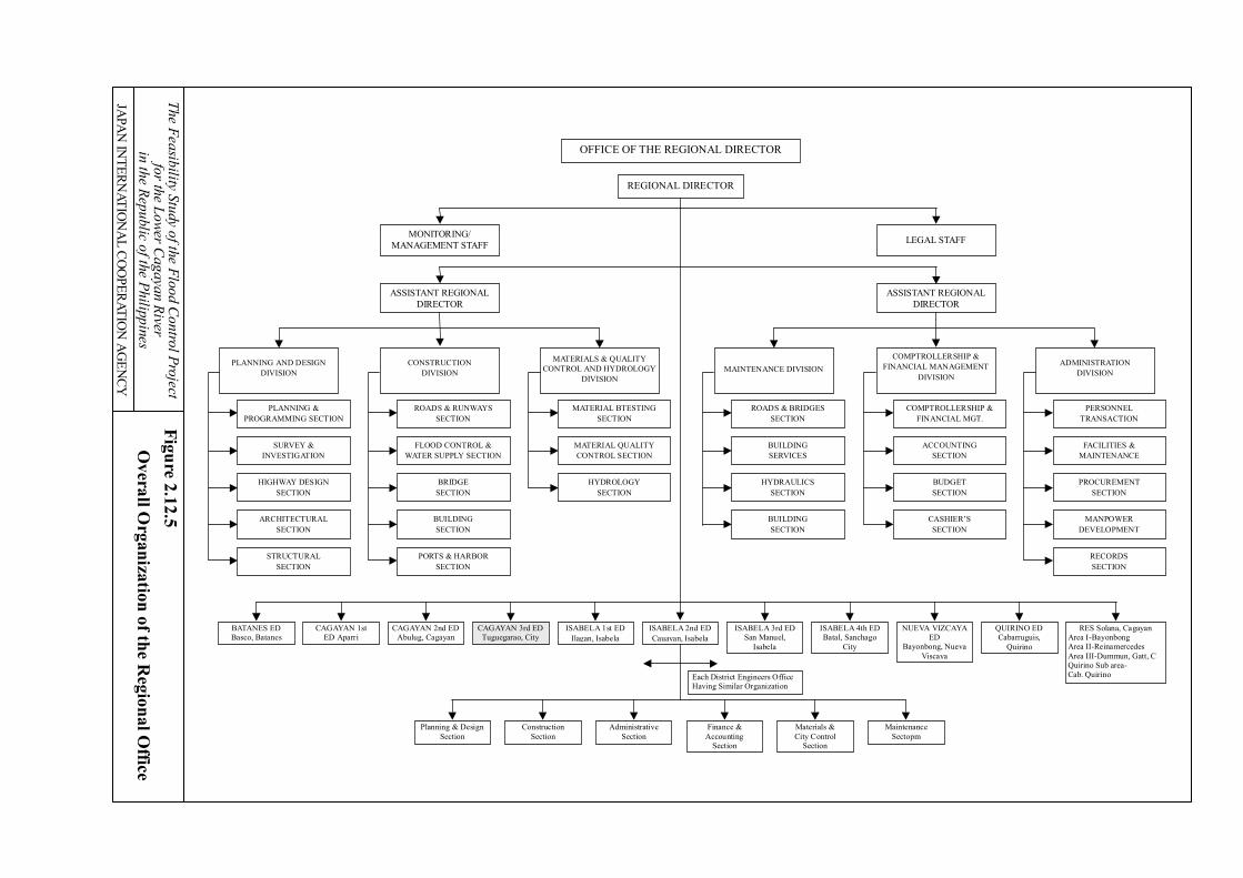
Figure 2.12.5 O
verall Organization of the R
egional Office
OFFICE OF THE REGIONAL DIRECTOR
REGIONAL DIRECTOR
MONITORING/MANAGEMENT STAFF
ASSISTANT REGIONALDIRECTOR
LEGAL STAFF
ASSISTANT REGIONALDIRECTOR
PLANNING AND DESIGNDIVISION
CONSTRUCTIONDIVISION
MATERIALS & QUALITYCONTROL AND HYDROLOGY
DIVISIONMAINTENANCE DIVISION
COMPTROLLERSHIP &FINANCIAL MANAGEMENT
DIVISION
ADMINISTRATIONDIVISION
PLANNING &PROGRAMMING SECTION
SURVEY &INVESTIGATION
HIGHWAY DESIGNSECTION
ARCHITECTURALSECTION
STRUCTURALSECTION
ROADS & RUNWAYSSECTION
FLOOD CONTROL &WATER SUPPLY SECTION
BRIDGESECTION
BUILDINGSECTION
PORTS & HARBORSECTION
MATERIAL BTESTINGSECTION
MATERIAL QUALITYCONTROL SECTION
HYDROLOGYSECTION
ROADS & BRIDGESSECTION
BUILDINGSERVICES
HYDRAULICSSECTION
BUILDINGSECTION
COMPTROLLERSHIP &FINANCIAL MGT.
ACCOUNTINGSECTION
BUDGETSECTION
CASHIER’SSECTION
PERSONNELTRANSACTION
FACILITIES &MAINTENANCE
PROCUREMENTSECTION
MANPOWERDEVELOPMENT
RECORDSSECTION
BATANES EDBasco, Batanes
CAGAYAN 1stED Aparri
CAGAYAN 2nd EDAbulug, Cagayan
CAGAYAN 3rd EDTuguegarao, City
ISABELA 1st EDIlagan, Isabela
ISABELA 2nd EDCauayan, Isabela
ISABELA 3rd EDSan Manuel,
Isabela
ISABELA 4th EDBatal, Sanchago
City
NUEVA VIZCAYAED
Bayonbong, NuevaViscaya
QUIRINO EDCabarruguis,
Quirino
RES Solana, CagayanArea I-BayonbongArea II-ReinamercedesArea III-Dummun, Gatt, CQuirino Sub area-Cab. QuirinoEach District Engineers Office