List of pages in this Trip Kit Trip Kit Index Airport Information For SKBO Terminal Charts For SKBO Revision Letter For Cycle 24-2017 Change Notices Notebook Trip Kit Index Printed on 28 Jan 2018 Page 1 (c) JEPPESEN SANDERSON, INC., 2018, ALL RIGHTS RESERVED j e p JEPPESEN JeppView for Windows
Transcript
List of pages in this Trip Kit
Trip Kit IndexAirport Information For SKBOTerminal Charts For SKBORevision Letter For Cycle 24-2017Change NoticesNotebook
Trip Kit IndexPrinted on 28 Jan 2018Page 1(c) JEPPESEN SANDERSON, INC., 2018, ALL RIGHTS RESERVED
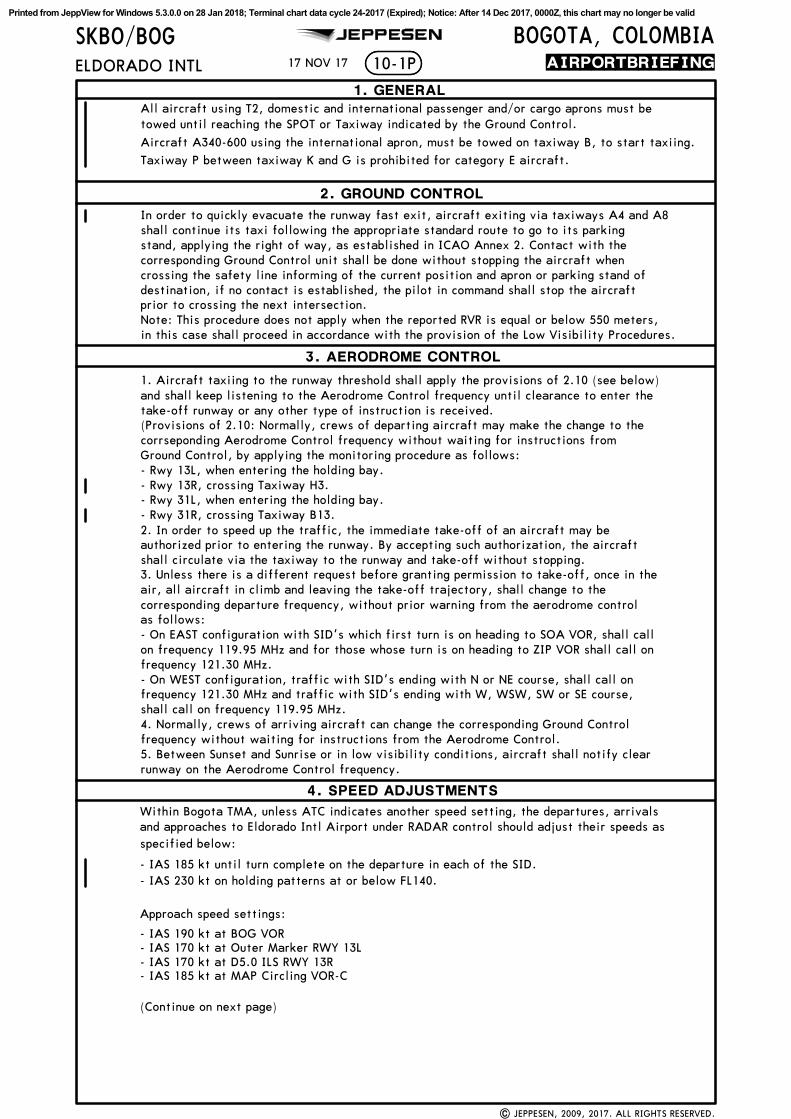
Within Bogota TMA, unless ATC indicates another speed setting, the departures, arrivalsand approaches to Eldorado Intl Airport under RADAR control should adjust their speeds asspecified below:
corresponding Ground Control unit shall be done without stopping the aircraft when
prior to crossing the next intersection.destination, if no contact is established, the pilot in command shall stop the aircraft
Note: This procedure does not apply when the reported RVR is equal or below 550 meters,
stand, applying the right of way, as established in ICAO Annex 2. Contact with the
(Provisions of 2.10: Normally, crews of departing aircraft may make the change to thecorrseponding Aerodrome Control frequency without waiting for instructions fromGround Control, by applying the monitoring procedure as follows:
shall circulate via the taxiway to the runway and take-off without stopping.authorized prior to entering the runway. By accepting such authorization, the aircraft2. In order to speed up the traffic, the immediate take-off of an aircraft may be
air, all aircraft in climb and leaving the take-off trajectory, shall change to thecorresponding departure frequency, without prior warning from the aerodrome controlas follows:- On EAST configuration with SID's which first turn is on heading to SOA VOR, shall call
frequency 121.30 MHz.
frequency 121.30 MHz and traffic with SID's ending with W, WSW, SW or SE course,shall call on frequency 119.95 MHz.
3. Unless there is a different request before granting permission to take-off, once in the
frequency without waiting for instructions from the Aerodrome Control.4. Normally, crews of arriving aircraft can change the corresponding Ground Control
5. Between Sunset and Sunrise or in low visibility conditions, aircraft shall notify clearrunway on the Aerodrome Control frequency.
(Continue on next page)
- Rwy 13L, when entering the holding bay.
- Rwy 31L, when entering the holding bay.
2. GROUND CONTROL
3. AERODROME CONTROL
4. SPEED ADJUSTMENTS
1. GENERAL
crossing the safety line informing of the current position and apron or parking stand of
in this case shall proceed in accordance with the provision of the Low Visibility Procedures.
1. Aircraft taxiing to the runway threshold shall apply the provisions of 2.10 (see below)and shall keep listening to the Aerodrome Control frequency until clearance to enter thetake-off runway or any other type of instruction is received.
on frequency 119.95 MHz and for those whose turn is on heading to ZIP VOR shall call on
- On WEST configuration, traffic with SID's ending with N or NE course, shall call on
17 NOV 17
- Rwy 13R, crossing Taxiway H3.
shall continue its taxi following the appropriate standard route to go to its parking
Taxiway P between taxiway K and G is prohibited for category E aircraft.
- IAS 185 kt until turn complete on the departure in each of the SID.- IAS 230 kt on holding patterns at or below FL140.
Approach speed settings:
- IAS 190 kt at BOG VOR- IAS 170 kt at Outer Marker RWY 13L- IAS 170 kt at D5.0 ILS RWY 13R- IAS 185 kt at MAP Circling VOR-C
In order to quickly evacuate the runway fast exit, aircraft exiting via taxiways A4 and A8
All aircraft using T2, domestic and international passenger and/or cargo aprons must betowed until reaching the SPOT or Taxiway indicated by the Ground Control.
Aircraft A340-600 using the international apron, must be towed on taxiway B, to start taxiing.
- Rwy 31R, crossing Taxiway B13.
Printed from JeppView for Windows 5.3.0.0 on 28 Jan 2018; Terminal chart data cycle 24-2017 (Expired); Notice: After 14 Dec 2017, 0000Z, this chart may no longer be valid
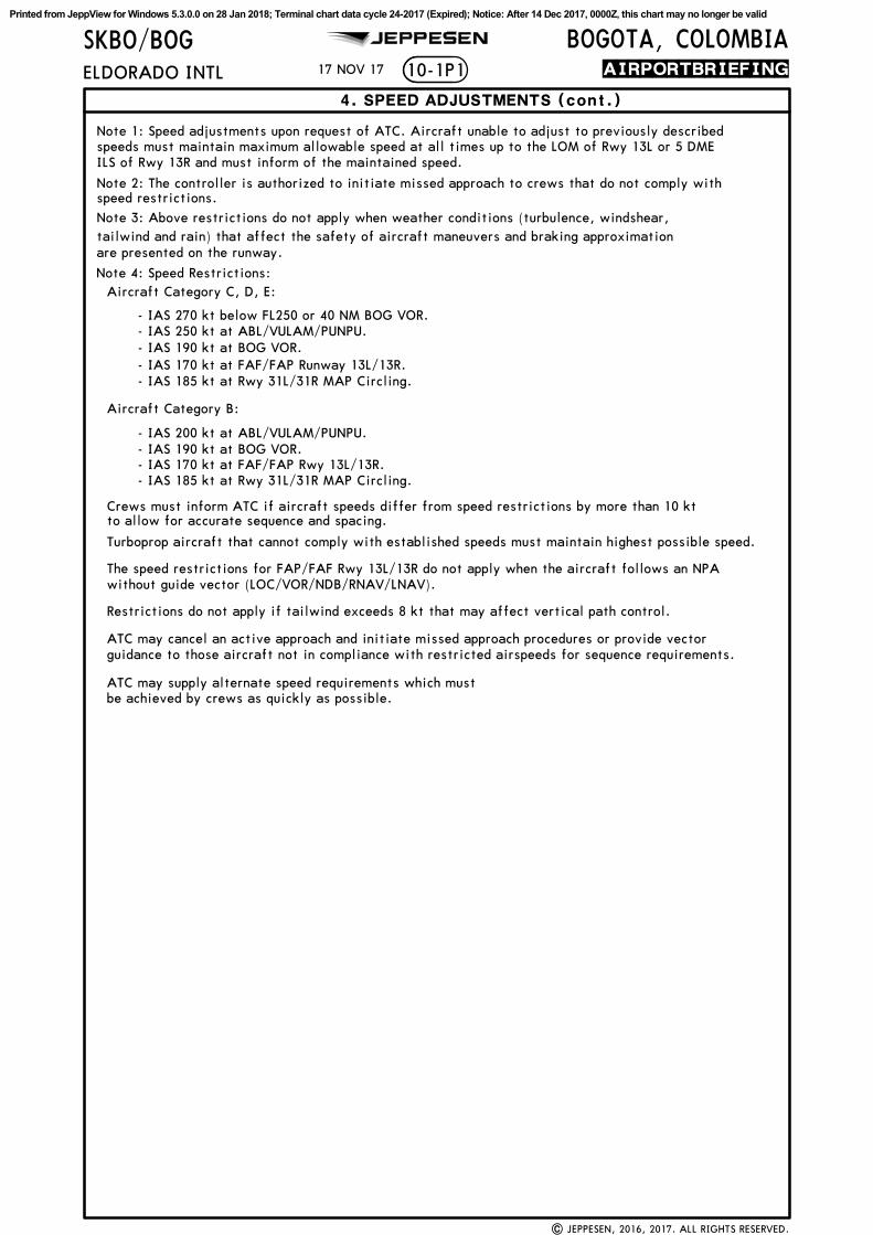
Note 3: Above restrictions do not apply when weather conditions (turbulence, windshear,tailwind and rain) that affect the safety of aircraft maneuvers and braking approximationare presented on the runway.
without guide vector (LOC/VOR/NDB/RNAV/LNAV).The speed restrictions for FAP/FAF Rwy 13L/13R do not apply when the aircraft follows an NPA
Restrictions do not apply if tailwind exceeds 8 kt that may affect vertical path control.
ATC may supply alternate speed requirements which mustbe achieved by crews as quickly as possible.
speeds must maintain maximum allowable speed at all times up to the LOM of Rwy 13L or 5 DME
speed restrictions. Note 2: The controller is authorized to initiate missed approach to crews that do not comply with
Note 1: Speed adjustments upon request of ATC. Aircraft unable to adjust to previously described
ILS of Rwy 13R and must inform of the maintained speed.
- IAS 170 kt at FAF/FAP Runway 13L/13R.- IAS 185 kt at Rwy 31L/31R MAP Circling.
- IAS 185 kt at Rwy 31L/31R MAP Circling.
Turboprop aircraft that cannot comply with established speeds must maintain highest possible speed.
ATC may cancel an active approach and initiate missed approach procedures or provide vectorguidance to those aircraft not in compliance with restricted airspeeds for sequence requirements.
4. SPEED ADJUSTMENTS (cont.)
| JEPPESEN, 2016, 2017. ALL RIGHTS RESERVED.
17 NOV 17
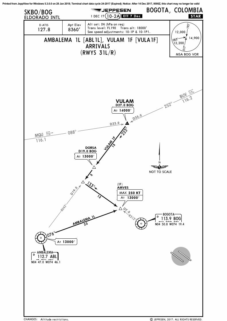
- IAS 270 kt below FL250 or 40 NM BOG VOR.- IAS 250 kt at ABL/VULAM/PUNPU.- IAS 190 kt at BOG VOR.
- IAS 200 kt at ABL/VULAM/PUNPU.- IAS 190 kt at BOG VOR.- IAS 170 kt at FAF/FAP Rwy 13L/13R.
Crews must inform ATC if aircraft speeds differ from speed restrictions by more than 10 kt
Printed from JeppView for Windows 5.3.0.0 on 28 Jan 2018; Terminal chart data cycle 24-2017 (Expired); Notice: After 14 Dec 2017, 0000Z, this chart may no longer be valid
090^
030^
150^
210^
330^
240^
120^
060^
D60
D90
D30
D60
D90
0^
D30
D60
D90
EldoradoIntl
SK(P)-29
SK(P)-30
SK(P)-31
SK(P)-35
12000
10-1RBOGOTA, COLOMBIA
ELDORADO INTL
8360'Apt Elev
SKBO/BOG JEPPESEN
.RADAR.MINIMUM.ALTITUDES.
Trans level: FL190 Trans alt: 18000'
010
2010
3040
50
BOGOTA113.9 BOGBOGD
12000
12000
14000
14000
14000
R-034
R-05
9
R-0
22
D35
D20
D9
D19
D27
15000
R-110
R-134
R-1
65
R-2
03
R-2
00
R-263
R-262
R-258
R-24
5
15000
16000
D62
D52
D46
16000
13000
16000
FL200
14000
R-316
R-301
R-291
R-280
13000
D4D10
03-30
04-00
04-30
05-00
05-30
06-00
06-30
73-3074-0074-3075-0075-30
17341'
Alt Set: IN (hPa on req)
20 OCT 17
| JEPPESEN, 2016, 2017. ALL RIGHTS RESERVED.SOUTHEAST sector revised.
180^
300^
270^
CONTOURINTERVALS
18000
16000
14000
12000
10000
CHANGES:
Printed from JeppView for Windows 5.3.0.0 on 28 Jan 2018; Terminal chart data cycle 24-2017 (Expired); Notice: After 14 Dec 2017, 0000Z, this chart may no longer be valid
D23.0
D16.0
D
CHANGES:
Apt Elev
10-2SKBO/BOG JEPPESEN
.STAR.
| JEPPESEN, 2017. ALL RIGHTS RESERVED.
ELDORADO INTLBOGOTA, COLOMBIA
D-ATIS
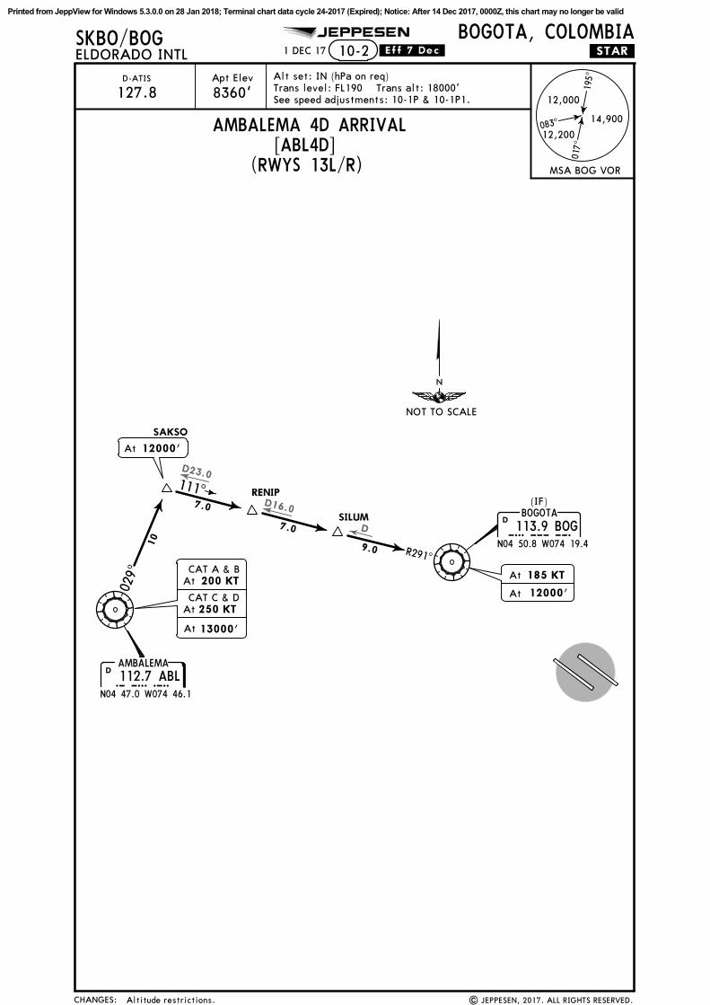
127.8 See speed adjustments: 10-1P & 10-1P1.
AMBALEMA 4D ARRIVAL[ABL4D]
(RWYS 13L/R)
1 DEC 17 .Eff.7.Dec.
8360' 195^
017^
083^14,900
12,200
12,000
MSA BOG VOR
Alt set: IN (hPa on req)Trans level: FL190 Trans alt: 18000'
AMBALEMA112.7 ABLABL
N04 47.0 W074 46.1
D
BOGOTA
113.9 BOGBOGN04 50.8 W074 19.4
D
029^
R291^
10
7.0
7.0
9.0
111^
At 12000'
SAKSO
RENIP
SILUM
(IF)
185 KT
12000'
At
At
At
CAT A & B
CAT C & D
200 KT
250 KT
At
At 13000'
Altitude restrictions.
NOT TO SCALE
Printed from JeppView for Windows 5.3.0.0 on 28 Jan 2018; Terminal chart data cycle 24-2017 (Expired); Notice: After 14 Dec 2017, 0000Z, this chart may no longer be valid
252^
088^
BUV
116.2
Bvu
MQU
116.1
muqD33.0
D35.0
D19
.0
R313^
R043^
D7.0
CHANGES:
Apt Elev
SKBO/BOG JEPPESEN
.STAR.
| JEPPESEN, 2017. ALL RIGHTS RESERVED.
ELDORADO INTLBOGOTA, COLOMBIA
D-ATIS
127.8
ARRIVALS
1 DEC 17 .Eff.7.Dec.
AMBALEMA 1L [ABL1L], VULAM 1F [VULA1F]
10-2A
(RWYS 31L/R)
12
15
5
23
VULA
M 1
F
AMBALEMA 1L
076^
195^
017^
083^14,900
12,200
12,000
MSA BOG VOR
Alt set: IN (hPa on req)Trans level: FL190 Trans alt: 18000'See speed adjustments: 10-1P & 10-1P1.
AMBALEMA112.7 ABLABL
N04 47.0 W074 46.1
D
BOGOTA
113.9 BOGBOGN04 50.8 W074 19.4
D
At 13000'
At 14000'
At 13000'
DORSAD19.0 BOG
(IF)AMVES
VULAMD27.0 BOG
8360'
223^
133^
MAX
At 13000'
250 KT
Altitude restrictions.
NOT TO SCALE
Printed from JeppView for Windows 5.3.0.0 on 28 Jan 2018; Terminal chart data cycle 24-2017 (Expired); Notice: After 14 Dec 2017, 0000Z, this chart may no longer be valid
Printed from JeppView for Windows 5.3.0.0 on 28 Jan 2018; Terminal chart data cycle 24-2017 (Expired); Notice: After 14 Dec 2017, 0000Z, this chart may no longer be valid
CHANGES:
Apt Elev
SKBO/BOG JEPPESEN
| JEPPESEN, 2017. ALL RIGHTS RESERVED.
ELDORADO INTLBOGOTA, COLOMBIA
D-ATIS
127.8 8360'
Alt set: IN (hPa on req)
6 OCT 17 .Eff.12.Oct.
Trans level: FL190 Trans alt: 18000'
(RWYS 31L/R)
292^
047^
157^
17,0
00
13,100352^
15,000
15,900
12
1 15,900within 40 NM
within 50 NMMSA ARP
2 15,000within 15 NM1 15,000
within 20 NM
167^
184^
198^
236^
281^256
^
230^
204^
146^
146^
186^
116^
102^
ISPEM
1W
ISPEM
1S
ATA
NA 1S
8.3
MUGOP 1S17.3
24.3
11.7
10.0
36.3
53.6
26.1
16.7
18.1
15.1
20.0
8.78.7
9.3
8.7
20.0
ISPEM
BO9~1
TEMOB
ILSEVBO951
ATANA
MUGOP
BO93~
BO94~
BO935
BO8~4
PAPET
SUR~1
SUR~2
SUR~3
TOBKI
At
MAX 250 KT
18000'
At 18000'
At or aboveFL230
At or aboveFL230
At or above18000'
At or above18000'
At or aboveFL240
134^ 314^MAX 250 KTMHA 15000
(IAF)AMVES
MAX 250 KT
Between17000' & 15000'
10-2C
056^
MAX 250 KTMHA 18000
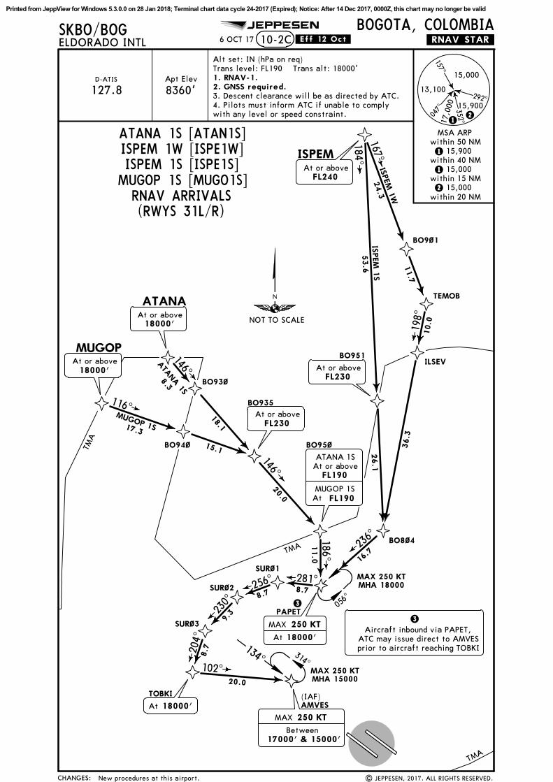
3. Descent clearance will be as directed by ATC.4. Pilots must inform ATC if unable to complywith any level or speed constraint.
ATC may issue direct to AMVESprior to aircraft reaching TOBKI
.RNAV.STAR.
New procedures at this airport.
1. RNAV-1.2. GNSS required.
RNAV ARRIVALS
11.0
BO95~
At or aboveFL190
ATANA 1S
MUGOP 1SFL190At
NOT TO SCALE
Printed from JeppView for Windows 5.3.0.0 on 28 Jan 2018; Terminal chart data cycle 24-2017 (Expired); Notice: After 14 Dec 2017, 0000Z, this chart may no longer be valid
CHANGES:
Apt Elev
SKBO/BOG JEPPESEN
| JEPPESEN, 2017. ALL RIGHTS RESERVED.
ELDORADO INTLBOGOTA, COLOMBIA
D-ATIS
127.8 8360'
Alt set: IN (hPa on req)
6 OCT 17 .Eff.12.Oct.
Trans level: FL190 Trans alt: 18000'
(RWYS 13L/R)
292^
047^
157^
17,0
00
13,100352^
15,000
15,900
12
1 15,900within 40 NM
within 50 NMMSA ARP
2 15,000within 15 NM1 15,000
within 20 NM
167^
184^
198^
236^
281^256
^
230^
204^
146^
146^
186^
116^
102^
ISPEM
1E
ISPEM
1T
ATA
NA 1T
8.3
MUGOP 1T17.3
24.3
11.7
10.0
36.3
53.6
26.1
16.7
18.1
15.1
20.0
8.78.7
9.3
8.7
20.0
ISPEM
BO9~1
TEMOB
ILSEVBO951
ATANA
MUGOP
BO93~
BO94~
BO935
BO8~4
PAPET
SUR~1
SUR~2
SUR~3
TOBKI
At
MAX 250 KT
18000'
At 18000'
At or aboveFL230
At or aboveFL230
At or above18000'
At or above18000'
At or aboveFL240
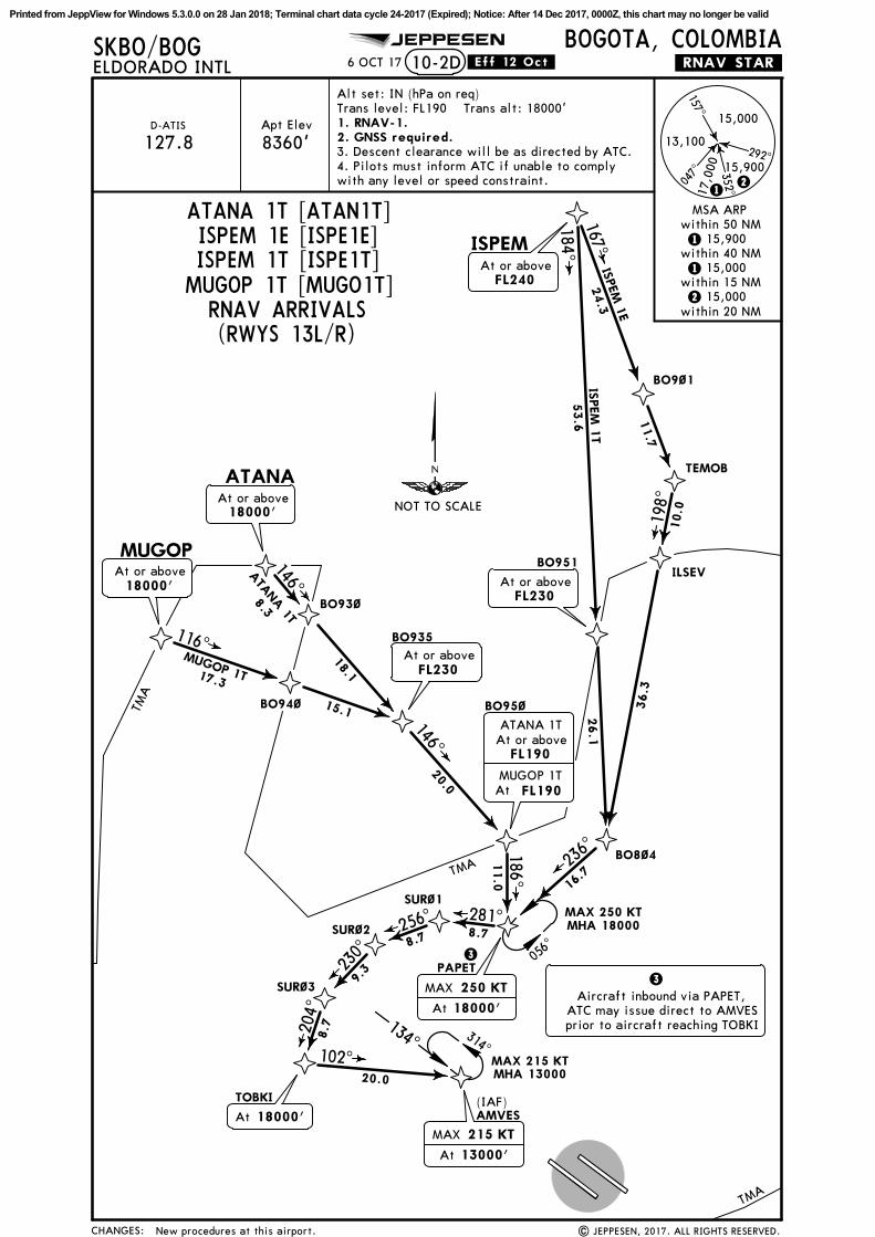
134^ 314^MAX 215 KTMHA 13000
(IAF)AMVES
10-2D
056^
MAX 250 KTMHA 18000
3. Descent clearance will be as directed by ATC.4. Pilots must inform ATC if unable to complywith any level or speed constraint.
ATANA 1T [ATAN1T]ISPEM 1E [ISPE1E]ISPEM 1T [ISPE1T]
MUGOP 1T [MUGO1T]
TMA
TMA
TMA
3
At
MAX 215 KT
13000'
3Aircraft inbound via PAPET,
ATC may issue direct to AMVESprior to aircraft reaching TOBKI
.RNAV.STAR.
New procedures at this airport.
1. RNAV-1.2. GNSS required.
RNAV ARRIVALS
11.0
BO95~
At or aboveFL190
ATANA 1T
MUGOP 1TFL190At
NOT TO SCALE
Printed from JeppView for Windows 5.3.0.0 on 28 Jan 2018; Terminal chart data cycle 24-2017 (Expired); Notice: After 14 Dec 2017, 0000Z, this chart may no longer be valid
Apt Elev
SKBO/BOG JEPPESEN
ELDORADO INTL
D-ATIS
127.8 8360'
Alt set: IN (hPa on req)
6 OCT 17
Trans level: FL190 Trans alt: 18000'
(RWYS 13L/R)
10-2E
3. Descent clearance will be as directed by ATC.4. Pilots must inform ATC if unable to complywith any level or speed constraint.
.Eff.12.Oct.
CHANGES: | JEPPESEN, 2017. ALL RIGHTS RESERVED.
BOGOTA, COLOMBIA
292^
047^
157^
17,0
00
13,100352^
15,000
15,900
12
1 15,900within 40 NM
within 50 NMMSA ARP
2 15,000within 15 NM1 15,000
within 20 NM
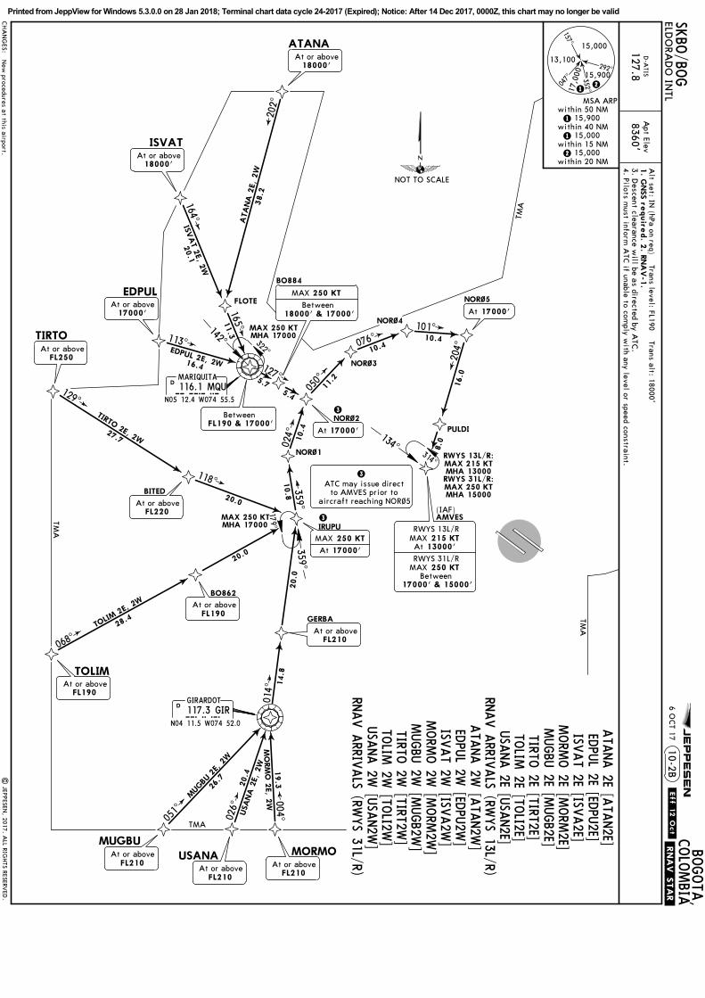
DOPLO 2E [DOPL2E], EGEPI 2E [EGEP2E]ENVAM 2E [ENVA2E], ILSEV 2E [ILSE2E]SIRUG 2E [SIRU2E], VUNEX 2E [VUNE2E]
3Aircraft inbound via PAPET,
ATC may issue direct to AMVESprior to aircraft reaching TOBKI
314^
MAX 215 KTMHA 13000
198^
224^
258^
258^
236^
276^295^
281^256
^
230^
204^
324^
295^
322^
102^
076^
ILSEV 2
E
DOPL
O 2
E
SIRUG 2E
EGEPI 2E
ENVAM 2E
16.1
VUNEX 2E10.8
36.3
31.6
14.5
16.7
19.5
22.4
37.9
8.78.7
8.7
9.3
20.0
10.7
8.0
7.0
29.7
8.0
ILSEVDOPLO
ENVAM
SIRUGBO822
BO8~4
BO824
BO832
PAPET
SUR~1
SUR~2
SUR~3
TOBKI
GUVIM
BO846
BO844
BO842
VUNEX
EGEPI
At or aboveFL220
At or aboveFL220
At or aboveFL220
At or aboveFL220
250 KTMAX
18000'At
At or above18000'
At 18000'
250 KT
18000'At
MAX
At 13000'
MAX 215 KT
At or above18000'
At or above18000'
At or above18000'
295^115^
056^
MAX 250 KTMHA 18000
MAX 250 KTMHA 18000
134^
3
(IAF)AMVES
TMA
TMA
TMA
.RNAV.STAR.
New procedures at this airport.
1. RNAV-1.2. GNSS required.
RNAV ARRIVALS
NOT TO SCALE
Printed from JeppView for Windows 5.3.0.0 on 28 Jan 2018; Terminal chart data cycle 24-2017 (Expired); Notice: After 14 Dec 2017, 0000Z, this chart may no longer be valid
Apt Elev
SKBO/BOG JEPPESEN
ELDORADO INTL
D-ATIS
127.8 8360'
Alt set: IN (hPa on req)
1 DEC 17
Trans level: FL190 Trans alt: 18000'
(RWYS 31L/R)
10-2F
3. Descent clearance will be as directed by ATC.4. Pilots must inform ATC if unable to complywith any level or speed constraint.
ATC may issue direct to AMVESprior to aircraft reaching TOBKI
TMA
.RNAV.STAR.
1. RNAV-1.2. GNSS required.
RNAV ARRIVALS
SIRUG 1SAt or above
At or aboveSIRUG 2W
15000'
18000'
EGEPI 1SAt or above
At or aboveEGEPI 2W
16000'
18000'
.Eff.7.Dec.
None.
NOT TO SCALE
Printed from JeppView for Windows 5.3.0.0 on 28 Jan 2018; Terminal chart data cycle 24-2017 (Expired); Notice: After 14 Dec 2017, 0000Z, this chart may no longer be valid
MQUmuq
116.1
088^
D33.0D35.0
252^
BUVBvu
116.2
R043^
D19.0
D11.0
D
CHANGES:
Apt Elev
SKBO/BOG JEPPESEN
.STAR.
| JEPPESEN, 2017. ALL RIGHTS RESERVED.
ELDORADO INTLBOGOTA, COLOMBIA
D-ATIS
127.8
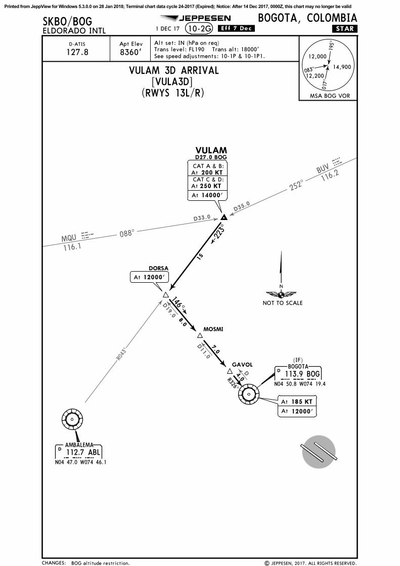
10-2G
[VULA3D](RWYS 13L/R)
195^
017^
083^14,900
12,200
12,000
MSA BOG VOR
Alt set: IN (hPa on req)Trans level: FL190 Trans alt: 18000'See speed adjustments: 10-1P & 10-1P1.
D27.0 BOGVULAM
AMBALEMA112.7 ABLABL
N04 47.0 W074 46.1
D
R326^4.0
7.0
15
BOGOTA
113.9 BOGBOGN04 50.8 W074 19.4
D
(IF)
At 12000'
223^
146^8.0
DORSA
MOSMI
GAVOL
VULAM 3D ARRIVAL
8360'
1 DEC 17 .Eff.7.Dec.
At
At
185 KT
12000'
BOG altitude restriction.
CAT A & B:
CAT C & D: 200 KT
250 KT
At
At
At 14000'
NOT TO SCALE
Printed from JeppView for Windows 5.3.0.0 on 28 Jan 2018; Terminal chart data cycle 24-2017 (Expired); Notice: After 14 Dec 2017, 0000Z, this chart may no longer be valid
Within the Bogota TMA, climb to the highest altitude published. Leaving the TMA, EXPECT higher enroute.
INITIAL CLIMB
296^
262^
242^
R116^
. W.23.
. W.42 .
. W.16.
8.2% V/V (fpm) 623 830 1246 1661 2076 2491
6.7% V/V (fpm) 509 678 1018 1357 1696 2035
Gnd speed-KT 75 100 150 200 250 300
Then 6.7% to SOA VOR.
112.7 ABLAMBALEMA
ABLN04 47.0 W074 46.1
D
113.9 BOGBOGOTA
BOGN04 50.8 W074 19.4
D
RROMEO
N04 40.6 W074 06.2
274 R
108.6 SOASOACHA
SOAN04 36.2 W074 16.4
D
SILEG
KAMIS
KOLMU
MAX 185 KTuntil turn complete
At or above9200'
At or above9200'
SID
AMBALEMA 1A
KAMIS 3A
SILEG 9A
(R 086^ bearing to)
MAX 230 KT
At or above12000'
JETS: Climb to 16000'.
JETS: Climb to 16000'.TURBOPROPS: Climb to 16000'.
TURBOPROPS: Climb to 14000'.
ROUTING
117.3 GIRGIRARDOT
GIRN04 11.5 W074 52.0
D
113.1 IBGIBAGUE
IBGN04 23.9 W075 06.4
D
GEPKI
Due to lack of range of ABL VOR,MAINTAIN navigation guidancefrom SOA VOR to GEPKI, then
intercept ABL VOR signal.
12
18
18
25
34
318^
VASIL
10.0
12000
22
SILEG 9A
AMBALEMA 1A12000
22
12000
9000
5000
KAMIS 3A
R082^
MAINTAIN minimum climb gradient 8.2% to 9200'.
ARSUP
JETS: Climb to 16000'. TURBOPROPS: Climb to 14000'.SID via KAMIS towards OREGA: EXPECT higher before leaving BOGOTA TMA to complywith the MEA or AMA of the following sector.
KAMIS 3A routing text.
NOT TO SCALE
Printed from JeppView for Windows 5.3.0.0 on 28 Jan 2018; Terminal chart data cycle 24-2017 (Expired); Notice: After 14 Dec 2017, 0000Z, this chart may no longer be valid
159^
217^ 166^
D10
.7
D12.5
D13.8
309^
032^
061^
D10.0
D3.0
D4.0
AMBALEMA112.7 ABLABL
N04 47.0 W074 46.1
D
N04 50.8 W074 19.4BOG113.9 BOG
BOGOTAD
At 12000'
R111^
291^
SOACHA108.6 SOASOA
N04 36.2 W074 16.4
D
Between10500' & 11000'
D10.4 SOA
D14.4 BOGD9.4 SOA
At or above8760'
At or above8760'
MAX until turn complete
Minimum bank 25^
NIKSA
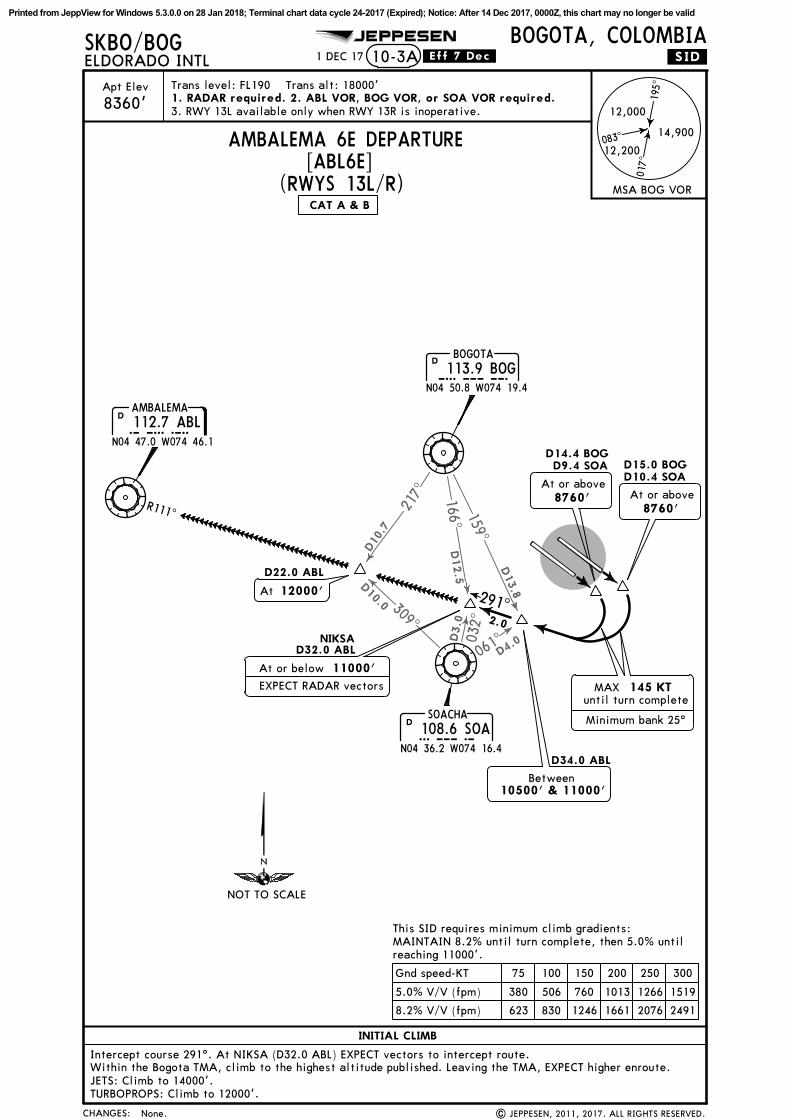
Apt Elev Trans level: FL190 Trans alt: 18000'
SKBO/BOG JEPPESEN
.SID.ELDORADO INTLBOGOTA, COLOMBIA
8360'
1 DEC 17 .Eff.7.Dec.
195^
017^
083^14,900
12,200
12,000
MSA BOG VOR(RWYS 13L/R)
CHANGES:
AMBALEMA 6E DEPARTURE[ABL6E]
CAT A & B
| JEPPESEN, 2011, 2017. ALL RIGHTS RESERVED.
D22.0 ABL
D32.0 ABL
D34.0 ABL
D15.0 BOG
2.0
10-3A
1. RADAR required. 2. ABL VOR, BOG VOR, or SOA VOR required.3. RWY 13L available only when RWY 13R is inoperative.
INITIAL CLIMB
Within the Bogota TMA, climb to the highest altitude published. Leaving the TMA, EXPECT higher enroute.JETS: Climb to 14000'.TURBOPROPS: Climb to 12000'.
EXPECT RADAR vectors
At or below 11000'
145 KT
Intercept course 291^. At NIKSA (D32.0 ABL) EXPECT vectors to intercept route.
8.2% V/V (fpm) 623 830 1246 1661 2076 2491
5.0% V/V (fpm) 380 506 760 1013 1266 1519
Gnd speed-KT 75 100 150 200 250 300
MAINTAIN 8.2% until turn complete, then 5.0% untilreaching 11000'.
This SID requires minimum climb gradients:
None.
NOT TO SCALE
Printed from JeppView for Windows 5.3.0.0 on 28 Jan 2018; Terminal chart data cycle 24-2017 (Expired); Notice: After 14 Dec 2017, 0000Z, this chart may no longer be valid
239^
202^
297^
D15.0
D7.0
D16.0
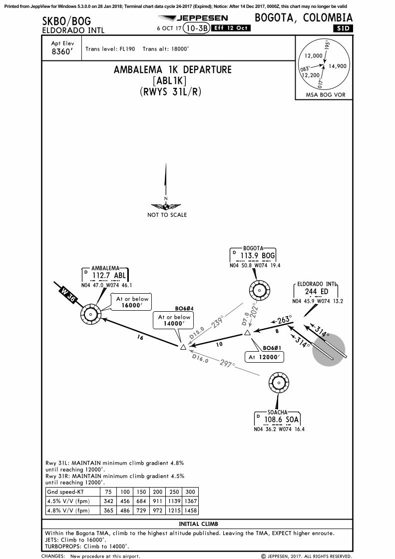
Trans level: FL190 Trans alt: 18000'
CHANGES:
Apt Elev
SKBO/BOG JEPPESEN
.SID.
| JEPPESEN, 2017. ALL RIGHTS RESERVED.
ELDORADO INTLBOGOTA, COLOMBIA
8360'
6 OCT 17 .Eff.12.Oct.
(RWYS 31L/R)
195^
017^
083^14,900
12,200
12,000
MSA BOG VOR
10-3B
AMBALEMA 1K DEPARTURE[ABL1K]
New procedure at this airport.
112.7 ABLAMBALEMA
ABLN04 47.0 W074 46.1
D
113.9 BOGBOGOTA
BOGN04 50.8 W074 19.4
D
108.6 SOASOACHA
SOAN04 36.2 W074 16.4
D
314^314^
263^
8
10
16
EDELDORADO INTL
244 EDN04 45.9 W074 13.2
.W. 36 . At or below16000'
At or below14000'
At 12000'
BO6~4
BO6~1
INITIAL CLIMB
Within the Bogota TMA, climb to the highest altitude published. Leaving the TMA, EXPECT higher enroute.JETS: Climb to 16000'.TURBOPROPS: Climb to 14000'.
4.8% V/V (fpm) 365 486 729 972 1215 1458
4.5% V/V (fpm) 342 456 684 911 1139 1367
Gnd speed-KT 75 100 150 200 250 300
until reaching 12000'.
until reaching 12000'.
Rwy 31L: MAINTAIN minimum climb gradient 4.8%
Rwy 31R: MAINTAIN minimum climb gradient 4.5%
NOT TO SCALE
Printed from JeppView for Windows 5.3.0.0 on 28 Jan 2018; Terminal chart data cycle 24-2017 (Expired); Notice: After 14 Dec 2017, 0000Z, this chart may no longer be valid
CH
AN
GES
:
SKBO
/BOG
Apt
Ele
v
| J
EPPE
SEN
, 20
17.
ALL
RIG
HTS
RES
ERVED
.
JEPPESEN
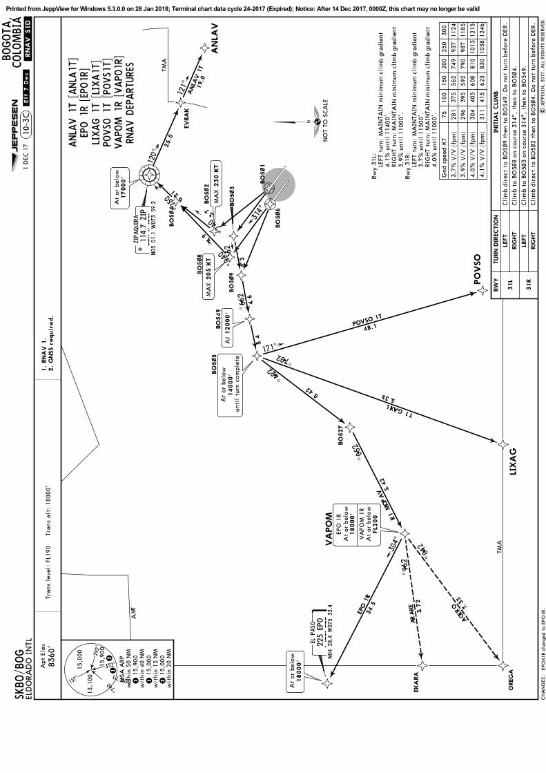
.RNAV.SID
.10
-3C
1.
RNA
V 1
.2.
GNSS r
equir
ed.
8360
'Tr
ans
leve
l: F
L190
T
rans
alt
: 18
000'
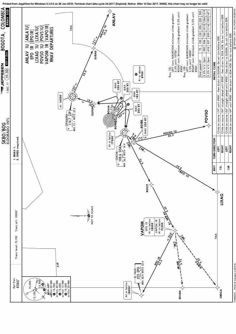
ANLA
V 1
T [ANLA
1T]
LIXAG 1
T [LIX
A1T
]PO
VSO
1T
[POVS1
T]VAPO
M 1
R [VAPO
1R]
RNAV D
EPART
URE
S
ELD
ORA
DO
IN
TL
BOGOTA
,COLO
MBIA
292^
047^
157^
17,00013
,100
352^15,0
00
15,9
00
12
1 1
5,90
0w
ithi
n 40
NM
wit
hin
50 N
MM
SA A
RP
2 1
5,00
0w
ithi
n 15
NM
1 1
5,00
0
wit
hin
20 N
M
RW
YIN
ITIA
L CLI
MB
31L
31R
TURN D
IRECTIO
N
LEFT
LEFT
RIG
HT
RIG
HT
Cli
mb
dire
ct t
o BO
5~9
then
to
BO
549.
Do
not
turn
bef
ore
DER
.
Cli
mb
to B
O5~
3 on
cou
rse
314^
, th
en t
o BO
549.
Cli
mb
to B
O5~
8 on
cou
rse
314^
, th
en t
o BO
5~4.
Cli
mb
dire
ct t
o BO
5~2
then
to
BO
5~4.
Do
not
turn
bef
ore
DER
.
4.1%
V/V
(fp
m)
311
415
623
830
1038
1246
4.0%
V/V
(fp
m)
304
405
608
810
1013
1215
3.9%
V/V
(fp
m)
296
395
592
790
987
1185
3.7%
V/V
(fp
m)
281
375
562
749
937
1124
Gnd
spe
ed-K
T75
100
150
200
250
300
Rwy
31L:
RIG
HT
turn
: M
AIN
TAIN
min
imum
cli
mb
grad
ient
3.9%
unt
il 1
1000
'.
4.1%
unt
il 1
1400
'.LE
FT t
urn:
MA
INTA
IN m
inim
um c
lim
b gr
adie
nt
Rwy
31R:
LEFT
tur
n: M
AIN
TAIN
min
imum
cli
mb
grad
ient
3.7%
unt
il 1
1500
'.RI
GHT
turn
: M
AIN
TAIN
min
imum
cli
mb
grad
ient
4.0%
unt
il 1
1000
'.
049^
047^
052^
120^
121^
314^
266^
224^
171^ 207^
250^
304^
269^
240^
9.4
7.3
3.0
6.4
4.5
12.0
25.0
24.0 53.5
48.1
24
.5
34.5
27
.3
33.7
EPO 1
R
VA
PO
M 1
R
EK
AR
A
OREG
A
LIXAG 1T
POVSO 1T
ANLA
V 1
T19.0
MA
X 2
30 K
TM
AX 2
05 K
T
12000'
At
At
or b
elow
14000'
unti
l tu
rn c
ompl
ete
At
or b
elow
VA
POM
1R
EPO
1R
At
or b
elow
FL2
00
18000'
At
or b
elow
18000'
At
or b
elow
17000'
ZIPAQUIRA
114.7
ZIP
ZIP
N05
01.1
W07
3 59
.2
D
225
EPO
EL P
ASO
EPO
N04
28.4
W07
5 33
.4
EKA
RA
OREG
A
VA
PO
M
BO
5~5
LIXA
G
PO
VSO
BO
549
BO
5~9B
O5~8
BO
5~2
BO
5~3
BO
5~4
EVRA
K
ANLA
V
BO
5~6
BO
5~1
266^
BO
527
TMA
TMA
TMA
1 D
EC 1
7.Eff.7.D
ec.
EPO 1
R [EPO
1R]
EPO
X1R
cha
nged
to
EPO
1R.
NO
T TO
SCA
LE
Printed from JeppView for Windows 5.3.0.0 on 28 Jan 2018; Terminal chart data cycle 24-2017 (Expired); Notice: After 14 Dec 2017, 0000Z, this chart may no longer be valid
CH
AN
GES
:
Apt
Ele
v
| J
EPPE
SEN
, 20
17.
ALL
RIG
HTS
RES
ERVED
.
1.
RNA
V 1
.2.
GNSS r
equir
ed.
8360
'Tr
ans
leve
l: F
L190
T
rans
alt
: 18
000'
ANLA
V 1
U [ANLA
1U]
LIXAG 1
U [LIXA1U
]PO
VSO
1U [PO
VS1
U]
VAPO
M 1
R [VAPO
1R]
RNAV D
EPART
URE
S
292^
047^
157^
17,000
13,1
00
352^15,0
00
15,9
00
12
1 1
5,90
0w
ithi
n 40
NM
wit
hin
50 N
MM
SA A
RP
2 1
5,00
0w
ithi
n 15
NM
1 1
5,00
0
wit
hin
20 N
M
RW
YIN
ITIA
L CLI
MB
13L
13R
TURN D
IRECTIO
N
LEFT
LEFT
RIG
HT
RIG
HT
Rwy
13L:
5.5%
unt
il 1
0700
'.LE
FT t
urn:
MA
INTA
IN m
inim
um c
lim
b gr
adie
nt
Rwy
13R:
LEFT
tur
n: M
AIN
TAIN
min
imum
cli
mb
grad
ient
5.5%
unt
il 1
0800
'.
120^
304^
269^
240^
25.0
24
.5
34.5
27
.3
33.7
EPO 1
R
VA
PO
M 1
R
EK
AR
A
OREG
A
ANLA
V 1
U19.0
At
or b
elow
VA
POM
1R
EPO
1R
At
or b
elow
FL2
00
18000'
At
or b
elow
18000'
ZIPAQUIRA
114.7
ZIP
ZIP
N05
01.1
W07
3 59
.2
D
225
EPO
EL P
ASO
EPO
N04
28.4
W07
5 33
.4
EKA
RA
OREG
A
VA
PO
M
LIXA
G
PO
VSO
ANLA
V
BO
527
TMA
TMA
TMA
SKBO
/BOG
ELD
ORA
DO
IN
TL
JEPPESEN
BOGOTA
, COLO
MBIA
10-3
D
EVRA
K12
1^
134^119^
149^
3
3
MA
X205 K
T
185 K
TM
AX
3A
t or
abo
ve8900'
BO
442
BO
446
GUXUN
16000'
At
At
or b
elow
17000'
205 K
TM
AX
MA
X 2
50 K
T
175^
218^
250^
BO
4~6
026^
10.7
27
.5
46.2LIXAG 1U
POVSO 1U
36.3
108.6
SOA
SOACHA
SOA
N04
36.2
W07
4 16
.4
D
Cli
mb
on c
ours
e 11
9^ u
ntil
890
0',
then
dir
ect
to G
UXUN
. D
o no
t tu
rn b
efor
e D
ER.
Cli
mb
on c
ours
e 13
4^ s
trai
ght
ahea
d un
til
8900
', t
hen
dire
ct t
o SO
A V
OR.
Do
not
turn
bef
ore
DER
.
Cli
mb
on c
ours
e 13
4^ s
trai
ght
ahea
d un
til
8900
', t
hen
dire
ct t
o G
UXUN
. D
o no
t tu
rn b
efor
e D
ER.
Cli
mb
on c
ours
e 14
9^ u
ntil
890
0',
then
dir
ect
to S
OA
VO
R. D
o no
t tu
rn b
efor
e D
ER.
5.5%
V/V
(fp
m)
418
557
835
1114
1392
1671
5.0%
V/V
(fp
m)
380
506
760
1013
1266
1519
Gnd
spe
ed-K
T75
100
150
200
250
300
RIG
HT
turn
: M
inim
um c
lim
b gr
adie
nt 5
.5%
unt
il89
00'.
RIG
HT
turn
: M
inim
um c
lim
b gr
adie
nt 5
.0%
unt
il89
00'.
6.0
.RNAV.SID
.1
DEC
17
.Eff.7.D
ec.
EPO 1
R [EPO
1R]
EPO
X1R
cha
nged
to
EPO
1R.
MA
X205 K
T
233^
NO
T TO
SCA
LE
Printed from JeppView for Windows 5.3.0.0 on 28 Jan 2018; Terminal chart data cycle 24-2017 (Expired); Notice: After 14 Dec 2017, 0000Z, this chart may no longer be valid
219^
053^
127^
073^
D21.0
SOACHA108.6 SOASOA
N04 36.2 W074 16.4
D
ROMEO
N04 40.6 W074 06.2R274 R
LIXAG
.W.22.
KORKI
233^
BOGOTA113.9 BOGBOG
N04 50.8 W074 19.4
D
BOGUS
MAX until turn complete
Minimum bank 20^
(R bearing 086^ to)KOLMU
At or above9200'
At or above9200'
CHANGES:
Apt ElevTrans level: FL190 Trans alt: 18000'
SKBO/BOG JEPPESEN
.SID.ELDORADO INTLBOGOTA, COLOMBIA
8360'
1 DEC 17 .Eff.7.Dec.
195^
017^
083^14,900
12,200
12,000
MSA BOG VOR(RWYS 13L/R)
10-3E
BOGUS 6A DEPARTURE[BOGU6A]
To LIXAGAt or below
16000'
16000'
To SJE VOR or VVC VORAt or above
INITIAL CLIMB
Within the Bogota TMA, climb to the highest altitude published. Leaving the TMA, EXPECT higher enroute.
JETS: Climb to 16000'.TURBOPROPS: Climb to 14000'.
R289^
R321^
67
152
109^141^
113.3 SJESJEN02 31.9 W072 38.4
D
VILLAVICENCIO116.7 VVCVVC
N04 04.0 W073 22.9
D
SAN JOSEDEL GUAVIARE
TRANSITIONS
LIXAG
SJEVVC
31LIXAG
SJE
VVC
| JEPPESEN, 2011, 2017. ALL RIGHTS RESERVED.
185 KT
Trainsition via SJE VOR orVVC VOR EXPECT vectors before
SJC R-321 or VVC R-289BOGUS, otherwise continue via
MAINTAIN minimum climb gradient 8.2% to 9200'.Then 6.7% to KORKI.
JETS: Climb to FL190. TURBOPROPS: Climb to 17000'.
following sector.EXPECT higher before leaving Bogota TMA to comply with the MEA or AMA of the
SJE, VVC transitions text.
NOT TO SCALE
75 100 150 200 250 300
6.7% V/V (fpm)
8.2% V/V (fpm)
509 679 1018 1357 1696 2036
623 830 1246 1661 2076 2491
Gnd speed-KT
Printed from JeppView for Windows 5.3.0.0 on 28 Jan 2018; Terminal chart data cycle 24-2017 (Expired); Notice: After 14 Dec 2017, 0000Z, this chart may no longer be valid
297^
202^
219^
230^
D9.0 D7.0
D7.0
D10.0
CHANGES:
Apt ElevTrans level: FL190 Trans alt: 18000'
SKBO/BOG JEPPESEN
.SID.
| JEPPESEN, 2017. ALL RIGHTS RESERVED.
ELDORADO INTLBOGOTA, COLOMBIA
8360'
1 DEC 17 .Eff.7.Dec.
195^
017^
083^14,900
12,200
12,000
MSA BOG VOR
SILEG 1D [SILE1D] DEPARTURES(RWYS 31L/R)
Within the Bogota TMA, climb to the highest altitude published. Leaving the TMA, EXPECT higher enroute.
INITIAL CLIMB
SID
KAMIS 1C
ROUTING
10-3F
BOGUS 1C [BOGU1C], KAMIS 1C [KAMI1C]
SILEG 1DJETS: Climb to 16000'.TURBOPROPS: Climb to 14000'.
via LIXAGBOGUS 1C
via SJE/VVCBOGUS 1C
R289^
R321^
To LIXAGAt or below
16000'
16000'
To SJE VOR or VVC VORAt or above
113.3 SJESJEN02 31.9 W072 38.4
D
VILLAVICENCIO116.7 VVCVVC
N04 04.0 W073 22.9
D
BOGOTA
113.9 BOGBOGN04 50.8 W074 19.4
D
EDELDORADO INTL
244 EDN04 45.9 W074 13.2
SAN JOSEDEL GUAVIARE
8
33
3 4 6
1320.9
21
31
152
67
SILE
G 1
DKAM
IS 1
C
BO
GUS 1
C
LIXAG
SJE
VVC
.W.22.
108.6 SOASOACHA
SOAN04 36.2 W074 16.4
D
263^
BO6~5
BO6~1
BO6~7
BO6~2
BO6~3D11.0 BOGAt or below
14000'
BO6~6D13.0 SOA
219^
109^141^
314^314^
4.8% V/V (fpm) 365 486 729 972 1215 1458
4.5% V/V (fpm) 342 456 684 911 1139 1367
Gnd speed-KT 75 100 150 200 250 300
Rwy 31R: MAINTAIN minimum climb gradient 4.5% until reaching 12000'.Rwy 31L: MAINTAIN minimum climb gradient 4.8% until reaching 12000'.
Trainsition via SJE VOR orVVC VOR EXPECT vectors before
SJC R-321 or VVC R-289BOGUS, otherwise continue via
LIXAG
At 12000'
At 12000'
JETS: Climb to 16000'. TURBOPROPS: Climb to 14000'.
following sector.EXPECT higher before leaving Bogota TMA to comply with the MEA or AMA of the
JETS: Climb to FL190. TURBOPROPS: Climb to 17000'.EXPECT higher before leaving Bogota TMA to comply with the MEA or AMA of thefollowing sector.
JETS: Climb to 16000'. TURBOPROPS: Climb to 14000'.EXPECT higher before leaving Bogota TMA to comply with the MEA or AMA of thefollowing sector.
Routing text.
At or below14000'
At or below16000'
At or below16000'
SILEG
KAMIS
BOGUS
NOT TO SCALE
Printed from JeppView for Windows 5.3.0.0 on 28 Jan 2018; Terminal chart data cycle 24-2017 (Expired); Notice: After 14 Dec 2017, 0000Z, this chart may no longer be valid
Climb initially to 17000', for higher level EXPECT ATC instructions.
INITIAL CLIMB
CUCUTA
113.3 CUCCUCN07 56.0 W072 30.8
D
119^
025^
206^
032^
052^
027^
049^
162
131
6
10.7
15
30.5
At or above8900'
MAXuntil turn complete
205 KT
MAX 250 KT
17000'At
At or above11500'
210 KT
At or above13600'
MAX
BO712
GUXUN
BO7~3
BO551
BO552
BO7~5
AKROB
KIKAS
CUCUTA
1F
KIKA
S 1C
5.5% V/V (fpm) 418 557 835 1114 1392 1671
Gnd speed-KT 75 100 150 200 250 300
MAINTAIN minimum climb gradient 5.5% to 10700'.
(Overfly)
3. Procedures available from sunset to sunrise.
Procedure operational hours note added.
8360'Apt Elev
At or above14800'
NOT TO SCALE
Printed from JeppView for Windows 5.3.0.0 on 28 Jan 2018; Terminal chart data cycle 24-2017 (Expired); Notice: After 14 Dec 2017, 0000Z, this chart may no longer be valid
SKBO
/BOG
CH
AN
GES
:
Apt
Ele
v
| J
EPPE
SEN
, 20
17.
ALL
RIG
HTS
RES
ERVED
.
JEPPESEN
.RNAV.SID
.10
-3H
1.
RNA
V 1
.2.
GNSS r
equir
ed.
8360
'Tr
ans
leve
l: F
L190
T
rans
alt
: 18
000'
ELD
ORA
DO
IN
TL
BOGOTA
,COLO
MBIA
1 D
EC 1
7
292^
047^
157^
17,00013
,100
352^15,0
00
15,9
00
12
1 1
5,90
0w
ithi
n 40
NM
wit
hin
50 N
MM
SA A
RP
2 1
5,00
0w
ithi
n 15
NM
1 1
5,00
0
wit
hin
20 N
M
108.6
SOA
SOACHA
SOA
N04
36.2
W07
4 16
.4
D
ZIPAQUIRA
114.7
ZIP
ZIP
N05
01.1
W07
3 59
.2
D
BUVIS
116.2 B
UV
BU
VN05
31.9
W07
3 51
.5
D
3
314^
266^266^
262^
286^
279^
333^
274^
218^
354^
106^
018^
057^030^
021^
019^
194^
6.5
3.0
6.4
4.5
12
.0
23.5
11.7
25.9
8.0
6.0
17.5
33.4
21.022.0
27.5
12.0
17.5
14.6
083^3
0.9
17.0
30.0
ANLA
V
AK
RO
B
GIKPU
KOMBO
30.0
VA
SIL
1U
27.3
13.5
VA
SIL
1T
DA
NSA
1R
DANSA
1R
RNAV D
EPART
URE
[DANS1
R](A
LL R
WYS)
VASIL 1T
RNAV D
EPART
URE
[VASI1T
](RWYS 31
L/R)
VASIL 1U
RNAV D
EPART
URE
[VASI1U
](RWYS 13
L/R)
MA
X185 K
T
MA
X205 K
T
MA
X 2
50 K
T
BO
4~6
3A
t or
abo
ve8900'
At
or a
bove
FL2
20
At
12000'
At
or b
elow
16000'
BO
442
BO
446
NIK
DO BO
4~8
BO
5~3
BO
5~6
BO
5~9
BO
549
BO
5~5
BO
537 BO
426
BO
438
BO
44~
VA
SIL
BO
422
DA
NSA
BO
418
ANLA
V
OSUSU
GIK
PU
KO
MBO
AKRO
B
At
or b
elow
14000'
unti
l tu
rn c
ompl
ete
TMA
TMA
TMA
RW
Y
31L
31R
TURN D
IRECTIO
N
LEFT
RIG
HT
INIT
IAL
CLI
MB
13L
13R
RIG
HT
LEFT
Cli
mb
to B
O5~
3 on
cou
rse
314^
, th
en t
o BO
549.
At
or a
bove
16000'
Cli
mb
on c
ours
e 14
9^ u
ntil
890
0',
then
dir
ect
toSO
A V
OR.
Do
not
turn
bef
ore
DER
.
Cli
mb
on c
ours
e 13
4^ s
trai
ght
ahea
d un
til
8900
',th
en d
irec
t to
SO
A V
OR.
Do
not
turn
bef
ore
DER
.
Cli
mb
dire
ct t
o BO
5~9
then
to
BO
549.
Do
not
turn
bef
ore
DER
.
5.5%
V/V
(fp
m)
418
557
835
1114
1392
1671
5.0%
V/V
(fp
m)
380
506
760
1013
1266
1519
4.1%
V/V
(fp
m)
311
415
623
830
1038
1246
3.7%
V/V
(fp
m)
281
375
562
749
937
1124
Gnd
spe
ed-K
T75
100
150
200
250
300
Rwy
13L:
Min
imum
cli
mb
grad
ient
5.5
% u
ntil
890
0'.
Rwy
13R:
Min
imum
cli
mb
grad
ient
5.0
% u
ntil
890
0'.
Rwy
31L:
MA
INTA
IN m
inim
um c
lim
b gr
adie
nt 4
.1%
unti
l 11
400'
.Rw
y 31
R: M
AIN
TAIN
min
imum
cli
mb
grad
ient
3.7
%un
til
1150
0'.
At
or b
elow
16000'
Cro
ssin
g alt
itud
e at
BO
438.
NO
T TO
SCA
LE
134^
149^
233^
Printed from JeppView for Windows 5.3.0.0 on 28 Jan 2018; Terminal chart data cycle 24-2017 (Expired); Notice: After 14 Dec 2017, 0000Z, this chart may no longer be valid
205^
096^D17.0
D27.0
D
CHANGES:
Apt ElevTrans level: FL190 Trans alt: 18000'
SKBO/BOG JEPPESEN
.SID.ELDORADO INTLBOGOTA, COLOMBIA
8360'
6 OCT 17 .Eff.12.Oct.
(RWYS 13L/R)
Within the Bogota TMA, climb to the highest altitude published. Leaving the TMA, EXPECT higher enroute.
INITIAL CLIMB
SID
JETS: Climb to 17000'.
JETS: Climb to FL210.
JETS: Climb to 17000'.TURBOPROPS: Climb to 15000'.
TURBOPROPS: Climb to 17000'.
TURBOPROPS: Climb to 15000'.
ROUTING
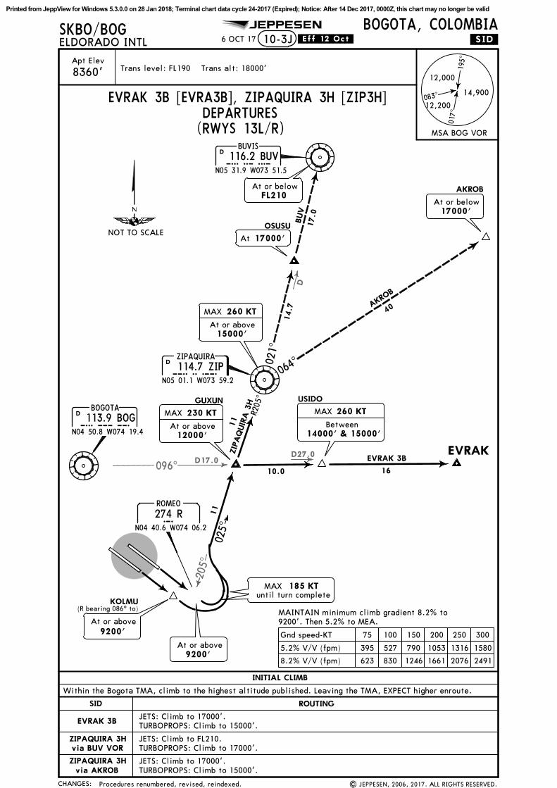
EVRAK 3B
ZIPAQUIRA 3H
ZIPAQUIRA 3H
via BUV VOR
via AKROB
10-3J
195^
017^
083^14,900
12,200
12,000
MSA BOG VOR
EVRAK 3B [EVRA3B], ZIPAQUIRA 3H [ZIP3H]DEPARTURES
025^
11
(R bearing 086^ to)KOLMU
At or above9200'
R205
^02
1^
064^
16
40
14.7
10.0
EVRAK 3B
AKROB
BUV
17.0
11
ZIP
AQ
UIR
A 3
H
MAX 230 KT
At or above12000'
MAX 260 KT
At or above15000'
At 17000'
MAX 260 KT
Between14000' & 15000'
At or belowFL210
At or below17000'
BOGOTA113.9 BOGBOG
N04 50.8 W074 19.4
D
114.7 ZIPZIPAQUIRA
ZIPN05 01.1 W073 59.2
D
BUVIS116.2 BUVBUV
N05 31.9 W073 51.5
D
GUXUN USIDO
OSUSU
AKROB
EVRAK
8.2% V/V (fpm) 623 830 1246 1661 2076 2491
5.2% V/V (fpm) 395 527 790 1053 1316 1580
Gnd speed-KT 75 100 150 200 250 300
MAINTAIN minimum climb gradient 8.2% to9200'. Then 5.2% to MEA.
until turn completeMAX 185 KT
Procedures renumbered, revised, reindexed. | JEPPESEN, 2006, 2017. ALL RIGHTS RESERVED.
NOT TO SCALE
N04 40.6 W074 06.2
ROMEO
R274 R
At or above9200'
Printed from JeppView for Windows 5.3.0.0 on 28 Jan 2018; Terminal chart data cycle 24-2017 (Expired); Notice: After 14 Dec 2017, 0000Z, this chart may no longer be valid
CHANGES:
Apt Elev Trans level: FL190 Trans alt: 18000'
SKBO/BOG JEPPESEN
| JEPPESEN, 2017. ALL RIGHTS RESERVED.
ELDORADO INTLBOGOTA, COLOMBIA
8360'
6 OCT 17 .Eff.12.Oct.
(RWYS 13L/R)
10-3K
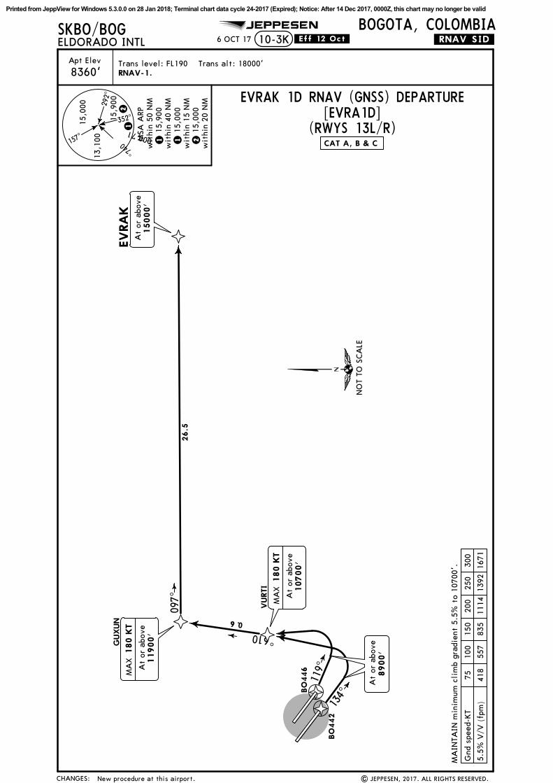
EVRAK 1D RNAV (GNSS) DEPARTURE[EVRA1D]
CAT A, B & C
292^
047^
157^
17,000
13,1
00
352^15,0
00
15,9
00
12
1 1
5,90
0w
ithi
n 40
NM
wit
hin
50 N
MM
SA A
RP
2 1
5,00
0w
ithi
n 15
NM
1 1
5,00
0
wit
hin
20 N
M
New procedure at this airport.
RNAV-1.
119^
134^
016^
097^
6.0
At
or a
bove
8900'
At
or a
bove
11900'
MA
X 1
80 K
T
At
or a
bove
10700'
MA
X 1
80 K
T
At
or a
bove
15000'
VURTI
BO
446
GUXUN
BO
442
EVRA
K
5.5%
V/V
(fp
m)
418
557
835
1114
1392
1671
Gnd
spe
ed-K
T75
100
150
200
250
300
MA
INTA
IN m
inim
um c
lim
b gr
adie
nt 5
.5%
to
1070
0'.
.RNAV.SID.
26.5
NO
T TO
SCA
LE
Printed from JeppView for Windows 5.3.0.0 on 28 Jan 2018; Terminal chart data cycle 24-2017 (Expired); Notice: After 14 Dec 2017, 0000Z, this chart may no longer be valid
CHANGES:
Apt Elev Trans level: FL190 Trans alt: 18000'
SKBO/BOG JEPPESEN
| JEPPESEN, 2017. ALL RIGHTS RESERVED.
ELDORADO INTLBOGOTA, COLOMBIA
8360'
6 OCT 17 .Eff.12.Oct.
(RWYS 13L/R)
10-3L
[OSOV1F]
CAT A, B & C
292^
047^
157^
17,000
13,1
00
352^15,0
00
15,9
00
12
1 1
5,90
0w
ithi
n 40
NM
wit
hin
50 N
MM
SA A
RP
2 1
5,00
0w
ithi
n 15
NM
1 1
5,00
0
wit
hin
20 N
M
New procedure at this airport.
RNAV-1.
119^
134^
At
or a
bove
8900'
At
or a
bove
15000'
BO
446
BO
442
.RNAV.SID.
091^131^
9.9
11.
3
MA
INTA
IN m
inim
um c
lim
b gr
adie
nts:
5.5%
to
1070
0'.
4.0%
to
TOTA
I.
5.5%
V/V
(fp
m)
418
557
835
1114
1392
1671
4.0%
V/V
(fp
m)
304
405
608
810
1013
1215
Gnd
spe
ed-K
T75
100
150
200
250
300
REG
UX
TO
TA
I
OSO
VO
At
or a
bove
11000'
MA
X 1
80 K
T
OSOVO 1F RNAV (GNSS) DEPARTURE
At
or a
bove
13800'
NO
T TO
SCA
LE
Printed from JeppView for Windows 5.3.0.0 on 28 Jan 2018; Terminal chart data cycle 24-2017 (Expired); Notice: After 14 Dec 2017, 0000Z, this chart may no longer be valid
CHANGES:
Apt Elev Trans level: FL190 Trans alt: 18000'
SKBO/BOG JEPPESEN
| JEPPESEN, 2017. ALL RIGHTS RESERVED.
ELDORADO INTLBOGOTA, COLOMBIA
8360'
6 OCT 17 .Eff.12.Oct.
(RWYS 31L/R)
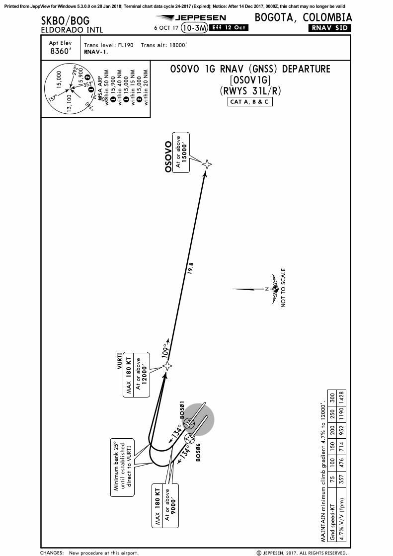
10-3M
[OSOV1G]
CAT A, B & C
292^
047^
157^
17,000
13,1
00
352^15,0
00
15,9
00
12
1 1
5,90
0w
ithi
n 40
NM
wit
hin
50 N
MM
SA A
RP
2 1
5,00
0w
ithi
n 15
NM
1 1
5,00
0
wit
hin
20 N
M
New procedure at this airport.
RNAV-1.
At
or a
bove
15000'
.RNAV.SID.
OSO
VO
134^
134^
109^
19.8
At
or a
bove
9000'
MA
X 1
80 K
T
At
or a
bove
12000'
MA
X 1
80 K
T
BO
5~1
BO
5~6
VURTI
MA
INTA
IN m
inim
um c
lim
b gr
adie
nt 4
.7%
to
1200
0'.
4.7%
V/V
(fp
m)
357
476
714
952
1190
1428
Gnd
spe
ed-K
T75
100
150
200
250
300
OSOVO 1G RNAV (GNSS) DEPARTURE
Min
imum
ban
k 25
^un
til
esta
blis
hed
dire
ct t
o VURT
I
NO
T TO
SCA
LE
Printed from JeppView for Windows 5.3.0.0 on 28 Jan 2018; Terminal chart data cycle 24-2017 (Expired); Notice: After 14 Dec 2017, 0000Z, this chart may no longer be valid
JEPPESEN
CH
AN
GES
:
SKBO
/BOG
Apt
Ele
v
| J
EPPE
SEN
, 20
17.
ALL
RIG
HTS
RES
ERVED
.
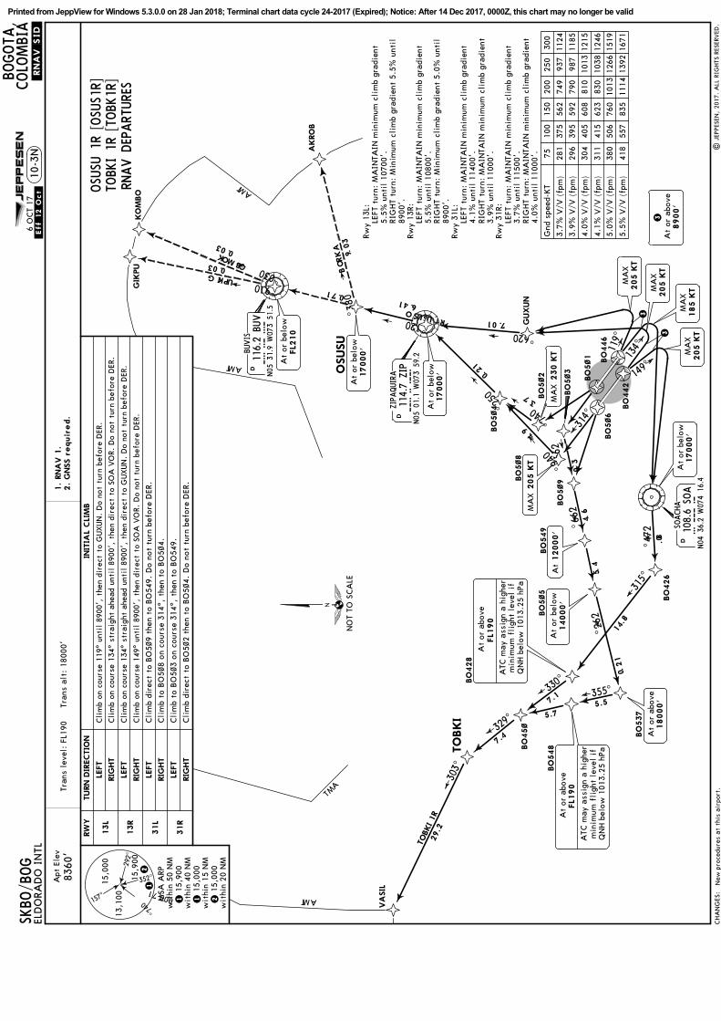
.RNAV.SID
.10
-3N
1.
RNA
V 1
.2.
GNSS r
equir
ed.
8360
'Tr
ans
leve
l: F
L190
T
rans
alt
: 18
000'
ELD
ORA
DO
IN
TL
BOGOTA
,COLO
MBIA
New
pro
cedu
res
at
this
air
port
.
.Eff.12.Oct.
6 O
CT
17
OSU
SU 1
R [OSU
S1R]
292^
047^
157^
17,00013
,100
352^15,0
00
15,9
00
12
1 1
5,90
0w
ithi
n 40
NM
wit
hin
50 N
MM
SA A
RP
2 1
5,00
0w
ithi
n 15
NM
1 1
5,00
0
wit
hin
20 N
M
TOBK
I 1R
[TO
BK1R
]RN
AV D
EPART
URE
S
BO
5~1
BO
5~6
314^
BO
5~3
3.0
MA
X 2
05 K
T
049^
BO
5~8
266^
9.4
047^
7.3
BO
5~2
BO
5~4
052^
12.0
N05
01.1
W07
3 59
.2
ZIPAQUIRA
114.7
ZIP
ZIP
D
BO
5~9
266^6
.4
12000'
At
BO
549
4.5
BO
446
BO
442
149^
134^119^
3
GUXUN
026^
10.7
MA
X205 K
T
185 K
TM
AX
3
SOACHA
108.6
SOA
SOA
N04
36.2
W07
4 16
.4
D
205 K
TM
AX
3A
t or
abo
ve8900'
MA
X 2
30 K
T
116.2 B
UV
BUVIS
BU
VN05
31.9
W07
3 51
.5
D
262^
274^
315^
355^330^
329^
303^
021^
083^
019^
030^30.0
17.0
30
.9
8.0
14.8
12
.0
5.5
5.7
7.1
7.4
29.2
TOBKI 1R
GIKPU
AK
RO
B
KOMBO
30.0
OSUSU 1R
14.6
At
or b
elow
17000'
At
or b
elow
FL2
10
At
or b
elow
17000'
At
or b
elow
14000'
At
or a
bove
FL1
90
ATC
may
ass
ign
a hi
gher
min
imum
fli
ght
leve
l if
QN
H b
elow
101
3.25
hPa
At
or a
bove
FL1
90
ATC
may
ass
ign
a hi
gher
min
imum
fli
ght
leve
l if
QN
H b
elow
101
3.25
hPa
At
or a
bove
18000'
BO
5~5
BO
426
BO
537
BO
548BO
45~
BO
428
VA
SIL
TO
BKI
OSUSU
GIK
PU
KO
MBO
AKRO
B
RW
YIN
ITIA
L CLI
MB
13L
13R
TURN D
IRECTIO
N
LEFT
LEFT
RIG
HT
RIG
HT
31L
31R
LEFT
LEFT
RIG
HT
RIG
HT
Cli
mb
dire
ct t
o BO
5~9
then
to
BO
549.
Do
not
turn
bef
ore
DER
.
Cli
mb
to B
O5~
3 on
cou
rse
314^
, th
en t
o BO
549.
Cli
mb
to B
O5~
8 on
cou
rse
314^
, th
en t
o BO
5~4.
Cli
mb
dire
ct t
o BO
5~2
then
to
BO
5~4.
Do
not
turn
bef
ore
DER
.
Cli
mb
on c
ours
e 11
9^ u
ntil
890
0',
then
dir
ect
to G
UXUN
. D
o no
t tu
rn b
efor
e D
ER.
Cli
mb
on c
ours
e 13
4^ s
trai
ght
ahea
d un
til
8900
', t
hen
dire
ct t
o SO
A V
OR.
Do
not
turn
bef
ore
DER
.
Cli
mb
on c
ours
e 13
4^ s
trai
ght
ahea
d un
til
8900
', t
hen
dire
ct t
o G
UXUN
. D
o no
t tu
rn b
efor
e D
ER.
Cli
mb
on c
ours
e 14
9^ u
ntil
890
0',
then
dir
ect
to S
OA
VO
R. D
o no
t tu
rn b
efor
e D
ER.
5.5%
V/V
(fp
m)
418
557
835
1114
1392
1671
5.0%
V/V
(fp
m)
380
506
760
1013
1266
1519
4.1%
V/V
(fp
m)
311
415
623
830
1038
1246
4.0%
V/V
(fp
m)
304
405
608
810
1013
1215
3.9%
V/V
(fp
m)
296
395
592
790
987
1185
3.7%
V/V
(fp
m)
281
375
562
749
937
1124
Gnd
spe
ed-K
T75
100
150
200
250
300
Rwy
13L:
LEFT
tur
n: M
AIN
TAIN
min
imum
cli
mb
grad
ient
5.5%
unt
il 1
0700
'.RI
GHT
turn
: M
inim
um c
lim
b gr
adie
nt 5
.5%
unt
il89
00'.
Rwy
13R:
LEFT
tur
n: M
AIN
TAIN
min
imum
cli
mb
grad
ient
5.5%
unt
il 1
0800
'.RI
GHT
turn
: M
inim
um c
lim
b gr
adie
nt 5
.0%
unt
il89
00'.
Rwy
31L:
LEFT
tur
n: M
AIN
TAIN
min
imum
cli
mb
grad
ient
4.1%
unt
il 1
1400
'.RI
GHT
turn
: M
AIN
TAIN
min
imum
cli
mb
grad
ient
3.9%
unt
il 1
1000
'.Rw
y 31
R:LE
FT t
urn:
MA
INTA
IN m
inim
um c
lim
b gr
adie
nt3.
7% u
ntil
115
00'.
RIG
HT
turn
: M
AIN
TAIN
min
imum
cli
mb
grad
ient
4.0%
unt
il 1
1000
'.
TMA
TMA
TMA
TMA
At
or b
elow
17000'
MA
X205 K
T
NO
T TO
SCA
LE
Printed from JeppView for Windows 5.3.0.0 on 28 Jan 2018; Terminal chart data cycle 24-2017 (Expired); Notice: After 14 Dec 2017, 0000Z, this chart may no longer be valid
D27.0
096^D11.0
Apt Elev
CHANGES:
Trans level: FL190 Trans alt: 18000'
SKBO/BOG JEPPESEN
.SID.ELDORADO INTLBOGOTA, COLOMBIA
8360'
10-3P
USIDO 2A [USID2A], ZIPAQUIRA 1B [ZIP1B]
6 OCT 17 .Eff.12.Oct.
(RWYS 31L/R)
Within the Bogota TMA, climb to the highest altitude published. Leaving the TMA, EXPECT higher enroute.
INITIAL CLIMB
SID
JETS: Climb to 17000'.
JETS: Climb to FL210.
JETS: Climb to 17000'.TURBOPROPS: Climb to 15000'.
TURBOPROPS: Climb to 17000'.
TURBOPROPS: Climb to 15000'.
ROUTING
USIDO 2A
ZIPAQUIRA 1B
ZIPAQUIRA 1B
via BUV VOR
via AKROB
195^
017^
083^14,900
12,200
12,000
MSA BOG VOR
DEPARTURES
021^
064^
16
14.6
USIDO 2A
AKROB
BUV
17.0
At or belowFL210
BOGOTA113.9 BOGBOG
N04 50.8 W074 19.4
D 114.7 ZIPZIPAQUIRA
ZIPN05 01.1 W073 59.2
D
BUVIS116.2 BUVBUV
N05 31.9 W073 51.5
D
USIDO
OSUSUAKROB
EVRAK
MAINTAIN minimum climb gradient 8.2% to
ED NDB required.
R230^
(ED)
050^
EDELDORADO INTL
244 EDN04 45.9 W074 13.2
MAX 230 KT
Between11000' & 14000'
16.0
ZIPA
QUI
RA 1B
14
At or below17000'
39.9
At or above9200'
At or above9200'
ISESA
TILBU
MAX 185 KT untilintercepting ZIP R-230
MAX 260 KT
Between15000' & 17000'
At 14000'
MAX 260 KT
9200'. Then minimum 6.5% until crossing 11000'.
8.2% V/V (fpm) 623 830 1246 1661 2076 2491
6.5% V/V (fpm) 494 658 987 1316 1646 1975
Gnd speed-KT 75 100 150 200 250 300
New procedures at this airport. | JEPPESEN, 2017. ALL RIGHTS RESERVED.
VARAV
NOT TO SCALE
Printed from JeppView for Windows 5.3.0.0 on 28 Jan 2018; Terminal chart data cycle 24-2017 (Expired); Notice: After 14 Dec 2017, 0000Z, this chart may no longer be valid
073^
D
CHANGES:
Apt ElevTrans level: FL190 Trans alt: 18000'
SKBO/BOG JEPPESEN
.SID.
| JEPPESEN, 2017. ALL RIGHTS RESERVED.
ELDORADO INTLBOGOTA, COLOMBIA
8360'
1 DEC 17 .Eff.7.Dec.
195^
017^
083^14,900
12,200
12,000
MSA BOG VOR(RWYS 13L/R)
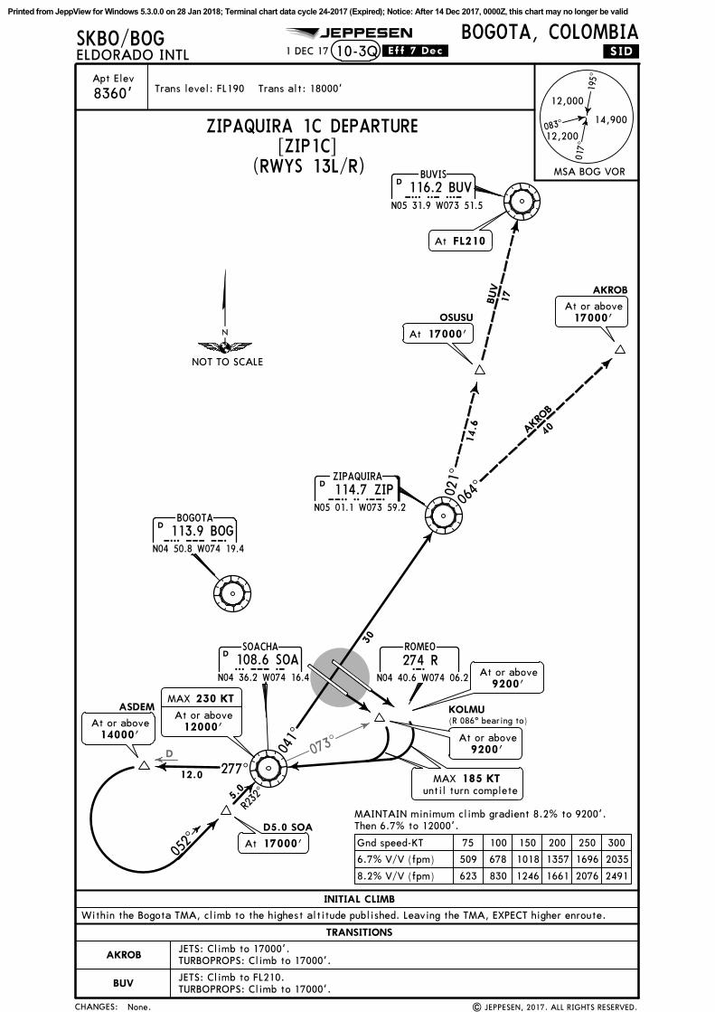
Within the Bogota TMA, climb to the highest altitude published. Leaving the TMA, EXPECT higher enroute.
INITIAL CLIMB
113.9 BOGBOGOTA
BOGN04 50.8 W074 19.4
D
RROMEO
N04 40.6 W074 06.2
274 R108.6 SOASOACHA
SOAN04 36.2 W074 16.4
D
KOLMU(R 086^ bearing to)
JETS: Climb to 17000'.
JETS: Climb to FL210.TURBOPROPS: Climb to 17000'.
TURBOPROPS: Climb to 17000'.
10-3Q
ZIPAQUIRA 1C DEPARTURE[ZIP1C]
TRANSITIONS
AKROB
BUV
MAINTAIN minimum climb gradient 8.2% to 9200'.Then 6.7% to 12000'.
8.2% V/V (fpm) 623 830 1246 1661 2076 2491
6.7% V/V (fpm) 509 678 1018 1357 1696 2035
Gnd speed-KT 75 100 150 200 250 300
At or above9200'
MAX 185 KTuntil turn complete
MAX 230 KT
At or above12000'
17000'At
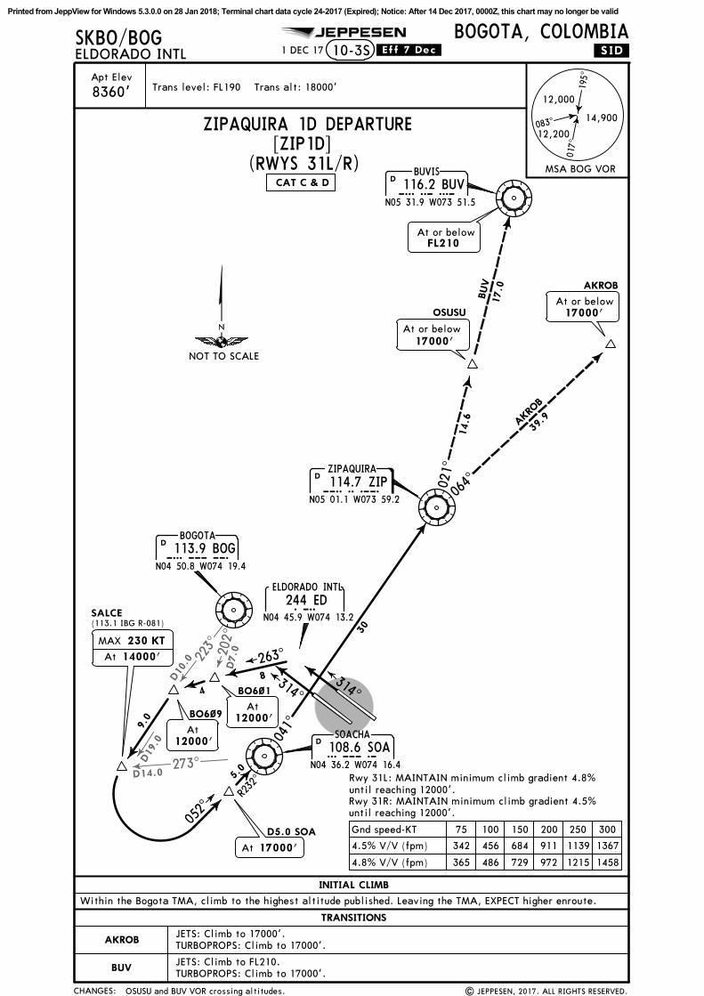
R232^
277^
041^
052^
021^
064^
116.2 BUVBUVIS
BUVN05 31.9 W073 51.5
D
114.7 ZIPZIPAQUIRA
ZIPN05 01.1 W073 59.2
D
12.0
5.0
40
14.6
17
At or above14000'
ASDEM
D5.0 SOA
At FL210
At or above17000'OSUSU
AKROB
30
BUV
AKR
OB
At 17000'
None.
At or above9200'
NOT TO SCALE
Printed from JeppView for Windows 5.3.0.0 on 28 Jan 2018; Terminal chart data cycle 24-2017 (Expired); Notice: After 14 Dec 2017, 0000Z, this chart may no longer be valid
223^ 202^
273^D14.0
D19
.0
D10
.0 D7.0
CHANGES:
Apt ElevTrans level: FL190 Trans alt: 18000'
SKBO/BOG JEPPESEN
.SID.
| JEPPESEN, 2017. ALL RIGHTS RESERVED.
ELDORADO INTLBOGOTA, COLOMBIA
8360'
10-3S
ZIPAQUIRA 1D DEPARTURE
1 DEC 17 .Eff.7.Dec.
195^
017^
083^14,900
12,200
12,000
MSA BOG VOR(RWYS 31L/R)
Within the Bogota TMA, climb to the highest altitude published. Leaving the TMA, EXPECT higher enroute.
Printed from JeppView for Windows 5.3.0.0 on 28 Jan 2018; Terminal chart data cycle 24-2017 (Expired); Notice: After 14 Dec 2017, 0000Z, this chart may no longer be valid
.NOISE.
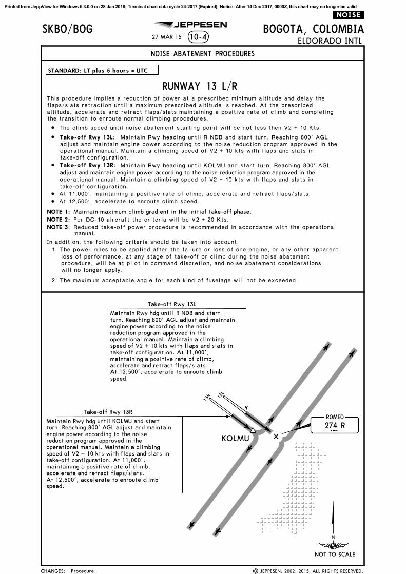
ROMEO
x274 RR
27 MAR 15
JEPPESEN
KOLMU
Maintain Rwy hdg until KOLMU and start
Take-off Rwy 13R
Maintain Rwy hdg until R NDB and start
Take-off Rwy 13L
CHANGES:
10-4 ELDORADO INTL
NOISE ABATEMENT PROCEDURES
STANDARD: LT plus 5 hours = UTC
RUNWAY 13 L/R
13L
13R
BOGOTA, COLOMBIA
NOT TO SCALE
SKBO/BOG
altitude, accelerate and retract flaps/slats maintaining a positive rate of climb and completing
At 12,500', accelerate to enroute climb speed.
NOTE 1:
NOTE 2:
NOTE 3:
At 11,000', maintaining a positive rate of climb, accelerate and retract flaps/slats.
Maintain maximum climb gradient in the initial take-off phase.
The climb speed until noise abatement starting point will be not less then V2 + 10 Kts.
Reduced take-off power procedure is recommended in accordance with the operationalmanual.
In addition, the following criteria should be taken into account:
1. The power rules to be applied after the failure or loss of one engine, or any other apparentloss of performance, at any stage of take-off or climb during the noise abatementprocedure, will be at pilot in command discretion, and noise abatement considerationswill no longer apply.
2. The maximum acceptable angle for each kind of fuselage will not be exceeded.
For DC-10 aircraft the criteria will be V2 + 20 Kts.
This procedure implies a reduction of power at a prescribed minimum altitude and delay theflaps/slats retraction until a maximum prescribed altitude is reached. At the prescribed
the transition to enroute normal climbing procedures.
adjust and maintain engine power according to the noise reduction program approved in the
| JEPPESEN, 2002, 2015. ALL RIGHTS RESERVED.Procedure.
turn. Reaching 800' AGL adjust and maintainengine power according to the noise
accelerate and retract flaps/slats.
reduction program approved in theoperational manual. Maintain a climbingspeed of V2 + 10 kts with flaps and slats intake-off configuration. At 11,000',maintaining a positive rate of climb,
At 12,500', accelerate to enroute climbspeed.
turn. Reaching 800' AGL adjust and maintainengine power according to the noisereduction program approved in theoperational manual. Maintain a climbingspeed of V2 + 10 kts with flaps and slats in
Take-off Rwy 13L: Maintain Rwy heading until R NDB and start turn. Reaching 800' AGLadjust and maintain engine power according to the noise reduction program approved in theoperational manual. Maintain a climbing speed of V2 + 10 kts with flaps and slats intake-off configuration.
Take-off Rwy 13R: Maintain Rwy heading until KOLMU and start turn. Reaching 800' AGL
operational manual. Maintain a climbing speed of V2 + 10 kts with flaps and slats intake-off configuration.
take-off configuration. At 11,000',
accelerate and retract flaps/slats.maintaining a positive rate of climb,
At 12,500', accelerate to enroute climbspeed.
Printed from JeppView for Windows 5.3.0.0 on 28 Jan 2018; Terminal chart data cycle 24-2017 (Expired); Notice: After 14 Dec 2017, 0000Z, this chart may no longer be valid
.NOISE.
x
x
x
27 MAR 15
JEPPESEN
CHANGES:
ELDORADO INTL
NOISE ABATEMENT PROCEDURES
STANDARD: LT plus 5 hours = UTC
RUNWAY 31 L/R
31R
31L
800'AGL
BOGOTA, COLOMBIA
NOT TO SCALE
SKBO/BOG10-4A
altitude, accelerate and retract flaps/slats maintaining a positive rate of climb and completing
At 11,000', maintaining a positive rate of climb, accelerate and retract flaps/slats.At 12,500', accelerate to enroute climb speed.
NOTE 1: Maintain maximum climb gradient in the initial take-off phase.
For DC-10 aircraft the criteria will be V2 + 20 Kts.NOTE 2:
NOTE 3: Reduced take-off power procedure is recommended in accordance with the operationalmanual.
In addition, the following criteria should be taken into account:1. The power rules to be applied after the failure or loss of one engine, or any other apparent
loss of performance, at any stage of take-off or climb during the noise abatementprocedure, will be at pilot in command discretion, and noise abatement considerationswill no longer apply.
2. The maximum acceptable angle for each kind of fuselage will not be exceeded.
The climb speed until noise abatement starting point will not be less then V2 + 10 Kts.
Maintain a climbing speed of V2 + 10 Kts with flaps and slats in take-off configuration.
At 11,000', maintaining a positive rateof climb, accelerate and retractflaps/slats. At 12,500', accelerateto enroute climb speed.
This procedure implies a reduction of power at a prescribed minimum altitude and delay theflaps/slats retraction until a maximum prescribed altitude is reached. At the prescribed
the transition to enroute normal climbing procedures.
flaps and slats in take-off configuration.Maintain climbing speed of V2 + 10 kts with
None. | JEPPESEN, 2004, 2007. ALL RIGHTS RESERVED.
Printed from JeppView for Windows 5.3.0.0 on 28 Jan 2018; Terminal chart data cycle 24-2017 (Expired); Notice: After 14 Dec 2017, 0000Z, this chart may no longer be valid
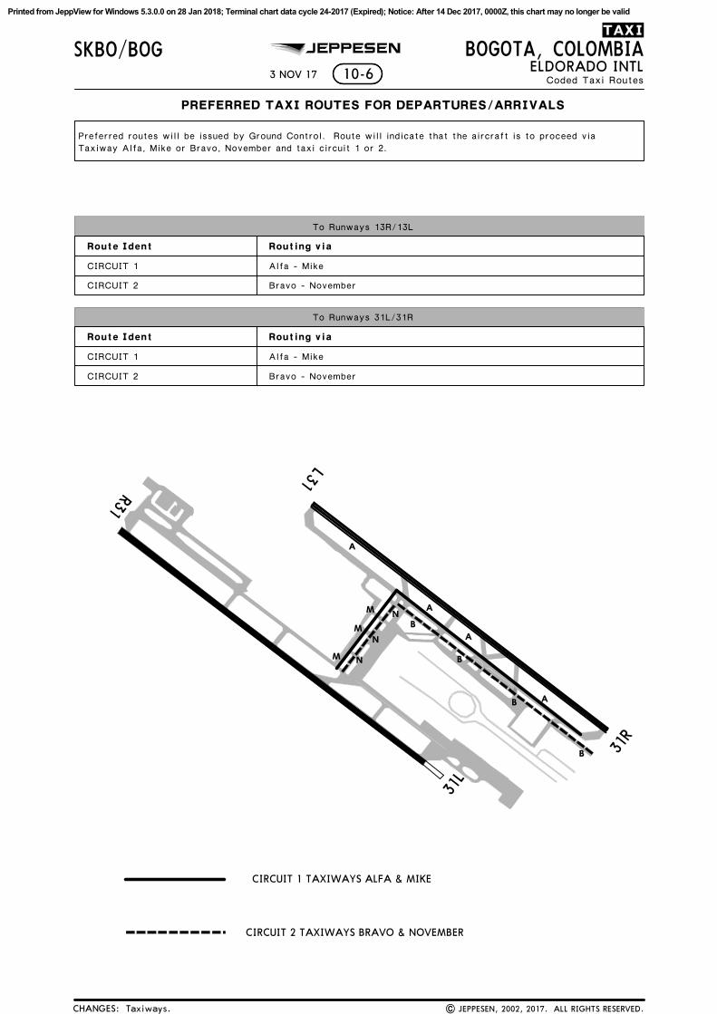
Coded Taxi Routes
TAXI
CHANGES:
Route Ident Routing via
Route Ident Routing via
Bravo - November
10-6 ELDORADO INTL
To Runways 31L/31R
To Runways 13R/13L
M
NM
M N
N
CIRCUIT 1
CIRCUIT 2
CIRCUIT 1
CIRCUIT 2
Bravo - November
PREFERRED TAXI ROUTES FOR DEPARTURES/ARRIVALS
Preferred routes will be issued by Ground Control. Route will indicate that the aircraft is to proceed via
3 NOV 17
BOGOTA, COLOMBIAJEPPESEN
CIRCUIT 1 TAXIWAYS ALFA & MIKE
CIRCUIT 2 TAXIWAYS BRAVO & NOVEMBER
Taxiways.
Taxiway Alfa, Mike or Bravo, November and taxi circuit 1 or 2.
Alfa - Mike
Alfa - Mike
| JEPPESEN, 2002, 2017. ALL RIGHTS RESERVED.
SKBO/BOG
A
A
A
A
B
B
31L
31R
13L
13R
B
B
Printed from JeppView for Windows 5.3.0.0 on 28 Jan 2018; Terminal chart data cycle 24-2017 (Expired); Notice: After 14 Dec 2017, 0000Z, this chart may no longer be valid
BOGOTA, COLOMBIAELDORADO INTL
SKBO/BOG10-8
JEPPESEN
| JEPPESEN, 2017. ALL RIGHTS RESERVED.New temporary chart.
14 JUL 17
OPERATIONAL RESTRICTIONS
It is recommended that ATC instructions are followed.
PHASE 1
From 11:00 UTC of July 20:
-Taxiways of access to general aviation zone 13L, will be renamed B1, B2, B3 and B4.
-Taxiway F will be renamed B.
-Taxiway MIL will be renamed B5.
-Taxiway Z will be renamed B6.
-Taxiway C between A and Y will be renamed B7.
-Taxiway B between A and Y will be renamed B9.
-Taxiway I will be renamed B10.
-Taxiway J between A and apron T2 will be renamed B11.
-Taxiway K will be renamed B12.
-Taxiways B14, B15 and B16 will be installed.
PHASE 2
From 11:00 UTC of July 22:
-Taxiway U will be renamed K3.
-Taxiway V2 will be renamed K1.
-Taxiway V1 will be renamed K2.
-Taxiway T will be renamed K4.
-Taxiway D (Exit Runway 13R/31L, until Taxiway K) will be renamed K5.
-Taxiway M will be renamed K.
-Taxiway P will be renamed K6.
-Taxiway N1 and N2 will be renamed K7 and K8.
-Taxiway Q will be renamed H3.
PHASE 3
From 11:00 UTC of July 28:
-Taxiway D (Exit runway 13L/31R, until Taxiway A) will be renamed A4.
-Taxiway C (Exit runway 13L/31R, until Taxiway A) will be renamed A5.
-Rapid exit taxiway A6 will be installed.
-Taxiway B (Exit runway 13L/31R, until Taxiway A) will be renamed A7.
-Taxiway J (Exit runway 13L/31R, until Taxiway A) will be renamed A8.
PHASE 4
From 11:00 UTC of July 31:
-Taxiway S will be renamed M.
-Taxiway R will be renamed N.
-Taxiway D (between Taxiway K and Taxiway A) will be renamed P.
-Taxiway Y will be renamed C.
-Taxiway W and W1 will be renamed G.
-Taxiway A9 and A10 will be installed.
-Taxiway M1 (between Taxiway K8 and Taxiway J3) will be renamed J.
-Taxiway J1 and J2 will be installed.
-Taxiway M2 will be renamed J3.
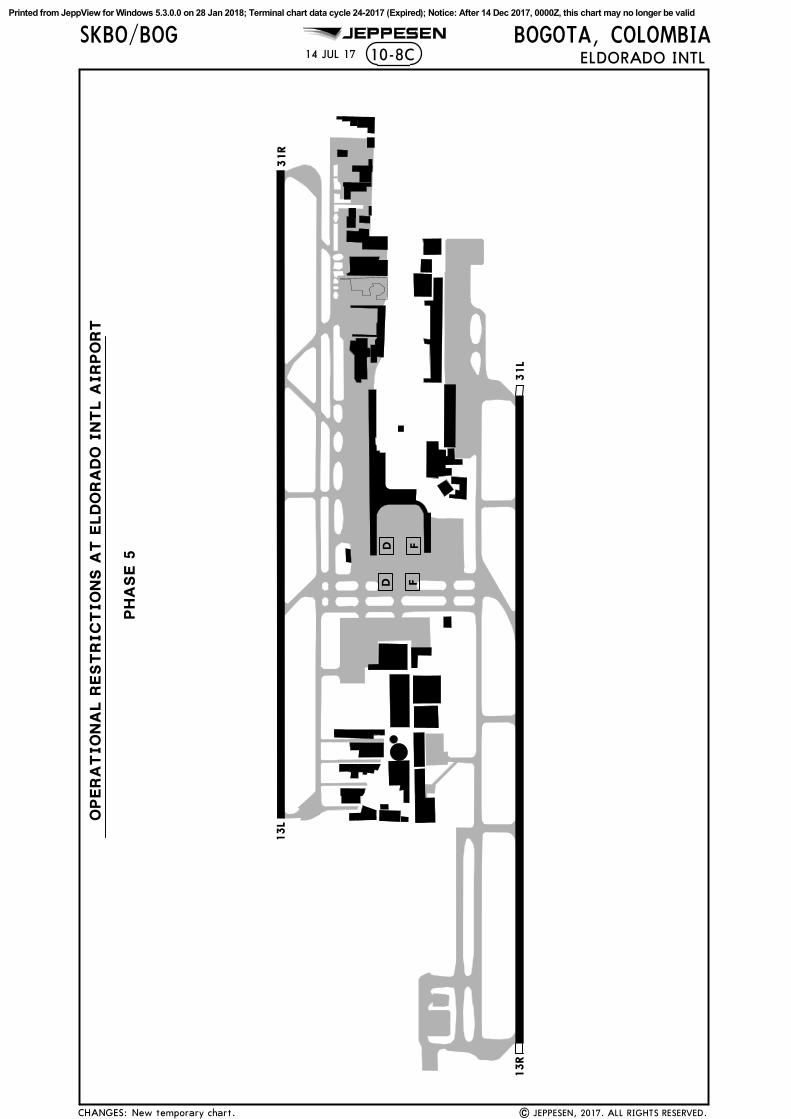
PHASE 5
-Taxiway E1 will be renamed D.
-Taxiway E2 will be renamed F.
From 11:00 UTC of August 06:
El Dorado Intl Airport. The changes will be implemented in 5 phases.
Until August 06, 2017, works will be executed to rename the taxiways in the
markings will be removed in a synchronized manner, in each of the selected taxiways.
During the phases for the implementation of taxiway nomenclature changes, the old
If necessary, guidance services with 'Follow Me" vehicle shall be provided to aircraft.
CHANGES:
Printed from JeppView for Windows 5.3.0.0 on 28 Jan 2018; Terminal chart data cycle 24-2017 (Expired); Notice: After 14 Dec 2017, 0000Z, this chart may no longer be valid
SKBO/BOG JEPPESEN
14 JUL 17
BB6
B7
B9
B10
B11
B12
B14
B15
B16
K
K2
PH
ASE 1
PH
ASE 2
K1
K3
K4
H3
K
K5
K6
K7
K8
KK
31R
31R
13L
13L
13R
13R
31L
31L
B5
B1
B2
B3
B4
10-8A
CHANGES:
BOGOTA, COLOMBIAELDORADO INTL
New temporary chart. | JEPPESEN, 2017. ALL RIGHTS RESERVED.
OPERA
TIO
NA
L R
EST
RIC
TIO
NS A
T E
LD
ORA
DO
IN
TL A
IRPO
RT
Printed from JeppView for Windows 5.3.0.0 on 28 Jan 2018; Terminal chart data cycle 24-2017 (Expired); Notice: After 14 Dec 2017, 0000Z, this chart may no longer be valid
SKBO/BOG JEPPESEN
14 JUL 17
A10
PH
ASE 3
PH
ASE 4
N
A4
A5
A6
A8
A9
MP
C GG
MN
PJ
J1J2
JJ3
31R
31R
13L
13L
13R
13R
31L
31L
A7
10-8B
CHANGES:
BOGOTA, COLOMBIAELDORADO INTL
New temporary chart. | JEPPESEN, 2017. ALL RIGHTS RESERVED.
OPERA
TIO
NA
L R
EST
RIC
TIO
NS A
T E
LD
ORA
DO
IN
TL A
IRPO
RT
Printed from JeppView for Windows 5.3.0.0 on 28 Jan 2018; Terminal chart data cycle 24-2017 (Expired); Notice: After 14 Dec 2017, 0000Z, this chart may no longer be valid
SKBO/BOG JEPPESEN
14 JUL 17
PH
ASE 5
D F
D F
31R
13L
13R
31L
10-8C
CHANGES:
BOGOTA, COLOMBIAELDORADO INTL
New temporary chart. | JEPPESEN, 2017. ALL RIGHTS RESERVED.
OPERA
TIO
NA
L R
EST
RIC
TIO
NS A
T E
LD
ORA
DO
IN
TL A
IRPO
RT
Printed from JeppView for Windows 5.3.0.0 on 28 Jan 2018; Terminal chart data cycle 24-2017 (Expired); Notice: After 14 Dec 2017, 0000Z, this chart may no longer be valid
K8
K6
K5
K4
K3
K1
K
K
K
BM
P
C
E
G
07^W
10-9
B8
H3
JEPPESEN
A
Elev
836
0'
Elev
835
6'
Stop
way
197'
60m
ARP
Elev
835
6'
Elev
835
2'
Stop
way
197'
60m
12,467'38
00m
12,467'38
00m
13L
134^
13R
134^
31R
314^
31L
314^
For
AIR
PORT
BRI
EFIN
Gre
fer
to 1
0-1P
pag
e.
04-41
04-42
04-42
04-43
04-43
74-08
74-08
74-09
74-09
74-10
74-10
J1
A9
MN
K
P
PN
| J
EPPE
SEN
, 20
09,
2017
. A
LL R
IGHTS
RES
ERVED
.
CO
ORD
INA
TES
SPO
T N
O.
E1E2
thr
u E4
E5,
E6
INTERNA
TIO
NA
L CA
RG
O A
PRO
N
E7,
E8,
E8A
E9,
E10
E11
PARK
ING
SPO
T CO
ORD
INA
TES
K Rwy
13R/
31L
K7
K
J
E1E2
E3E4
E5E6
E7
E8E8A
E9
E10
E11
E12
E13
E14 E1
5
E16 E1
7
E19
E18
E25 E2
4E2
3
E22E2
1E20
J3
J3
74-08.2
74-08.3
74-08.4
74-08.5
74-08.4
74-08.3
74-08.2
74-08.1
04-41.4
04-41.5
04-41.4
04-41.2
E14,
E15
, E1
5AE1
5BE1
6
E17,
E18
E19,
E20
E21,
E22
E23
thru
E25
FOR
PARK
ING
PO
SITI
ON
SSE
E 10
-9A
.
N04
41.
7 W
074
08.5
N04
41.
6 W
074
08.5
N04
41.
6 W
074
08.4
N04
41.
5 W
074
08.4
N04
41.
5 W
074
08.3
N04
41.
4 W
074
08.3
N04
41.
4 W
074
08.2
N04
41.
4 W
074
08.1
N04
41.
3 W
074
08.1
N04
41.
4 W
074
08.1
N04
41.
3 W
074
08.1
N04
41.
3 W
074
08.0
N04
41.
2 W
074
08.0
N04
41.
2 W
074
08.1
Twy
G l
imit
ed t
o Cat
D a
ircr
aft.
H2
E12,
E13
G
STO
P BA
R
LEG
END
Twy
E av
aila
ble
for
the
mov
emen
t of
Twy
E an
d av
aila
ble
for
the
mov
emen
t
Twy
E an
d av
aila
ble
for
the
mov
emen
t
E15B
E15A
Twy
P be
twee
n Tw
ys K
and
G p
rohi
bite
d fo
rCat
E a
ircr
aft.
Air
craf
t A
340-
600
that
use
the
int
erna
tion
al d
ock
airc
raft
wit
h w
ings
pan
Cat
E o
r lo
wer
(up
to 2
13'/
65m
win
gspa
n).
of a
ircr
aft
wit
h w
ings
pan
Cat
C o
rlo
wer
(up
to
118'
/36m
win
gspa
n).
of a
ircr
aft
wit
h w
ings
pan
Cat
C o
rlo
wer
(up
to
118'
/36m
win
gspa
n).
FOR
PARK
ING
PO
SITI
ON
SSE
E IN
SET
FOR
'E" P
ARK
ING
STA
ND
S O
N T
HIS
PA
GE
'E'
PARK
ING
PO
SITI
ON
S
H
H1
K2
F
DE
K7
K8
Con
trol
Tow
er
mus
t to
w o
ver
Twy
B t
o in
itia
te t
axii
ng.
and
Stan
d 59
ava
ilab
le t
o ai
rcra
ft w
ith
win
gspa
n of
118'
(36
m)
or l
ess
(Cat
C o
r le
ss).
Twy
P av
aila
ble
to a
ircr
aft
wit
h w
ings
pan
of 1
18'
(36m
) or
les
s (C
at C
or
less
).
Twy
G a
cces
s to
air
craf
t pa
rkin
g av
aila
ble
toai
rcra
ft w
ith
win
gspa
n of
118
' (3
6m)
or l
ess
(Cat
C o
r le
ss).
Twy
J3 a
cces
s to
air
craf
t pa
rkin
g av
aila
ble
toai
rcra
ft w
ith
win
gspa
n of
118
' (3
6m)
or l
ess
(Cat
C o
r le
ss).
and
Puen
te A
ereo
apr
on a
vail
able
to
airc
raft
wit
hw
ings
pan
of 1
18'
(36m
) or
les
s (C
at C
or
less
).
Air
craf
t en
teri
ng a
nd e
xiti
ng p
osit
ions
E18
thru
E25
mus
t be
tow
ed f
rom
/to
Twy
J, l
ater
al t
o pa
rkin
g po
siti
on E
17.
74-08.0
74-08.0
J2
A10
J
J
J1
J2
B5
Twy
D i
nsta
lled
to
the
nort
h se
ctor
of
Twy
F in
stal
led
to t
he s
outh
sec
tor
of
Twy
C a
cces
s to
air
craf
t pa
rkin
g be
twee
n Tw
y B10
and
Twy
C a
cces
s to
air
craf
t pa
rkin
g be
twee
n Tw
y B6
and
Twy
A8
acce
ss t
o ai
rcra
ft p
arki
ng b
etw
een
Twy
B
FED
K
N
Wor
k in
prog
ress
Wor
k in
prog
ress
17 N
OV 1
7
Non
e.
04-41.3
A3
A
A4
A
A
A6
B9
A5
B7
B B6
B
A7
ELD
ORA
DO
IN
TL
127.
8
ELD
ORA
DO
Cle
ara
nce
121.
612
1.8
118.
2511
9.95
Tow
er
BOGOTA
, COLO
MBIA
118.
112
2.75
BO
GO
TA T
erm
inal
Gro
und
CH
AN
GES
:
Apt
Ele
vSK
BO/B
OG
8360'
500
2000
2500 80
060
020
0
Feet
Meters
0 010
00
3000
1000
1500
400
B4
B3
B2
B1
N04
42.
1 W
074
08.8
Nor
thSo
uth
B
Nor
thSo
uth
121.
311
9.65
B13
C
D-A
TIS
Wes
t
A2
A8
B11
B10
B11
B12
C
B16
B14
B15
Rwy
13L/
31R
Rwy
13R/
31L
Printed from JeppView for Windows 5.3.0.0 on 28 Jan 2018; Terminal chart data cycle 24-2017 (Expired); Notice: After 14 Dec 2017, 0000Z, this chart may no longer be valid
ELD
ORA
DO
IN
TL10
-9A
BOGOTA
, COLO
MBIA
SKBO
/BOG
N04
41.
9 W
074
08.3
46 t
hru
48
N04
42.
0 W
074
08.7
2 Rwy
clos
ed b
etw
een
0300
-110
0 UTC
. Take
-off
Alt
erna
te A
irpo
rt F
iled
1St
anda
rdRL
& C
L &
RCLM
RL &
CL
or R
CLM
1W
ith
appr
opri
ate
appr
oval
.
550m
550m
Eng
Eng
Eng
3 &
4
1 2
570'
1600
m
800m
RVR
350m
500m
RVR
350m
500m
1 ho
ur a
lter
nate
(1
Eng
inop
)
2 ho
ur a
lter
nate
(1
Eng
inop
)- 30
00m
RL &
CL
or R
CLM
Stop
Bar
rier
or
Runw
ay P
rote
ctio
n Li
ghts
550m
550m
2 Eng
3 &
4En
g
Take
-off
Alt
erna
te A
irpo
rt F
iled
1RL
& C
L or
RCLM 57
0'-
3000
m
Stan
dard
1600
m
800m
1 ho
ur a
lter
nate
(1
Eng
inop
)
2 ho
ur a
lter
nate
(1
Eng
inop
)
Eng
1
JEPPESEN
GEN
ERA
L
AD
DIT
ION
AL
RUN
WA
Y I
NFO
RMA
TIO
N
148'
45m
13R
31R
13LRW
Y 31L
RVR
RVR
45m
148'
Thre
shol
d
LAN
DIN
G B
EYO
ND
USA
BLE
LEN
GTH
S
WID
THG
lide
Slo
pe
RVR
TAKE-
OFF
CA
UTI
ON
: Bir
ds i
n vi
cini
ty o
f ai
rpor
t.
N04
41.
9 W
074
08.3
| J
EPPE
SEN
, 20
09,
2017
. A
LL R
IGHTS
RES
ERVED
.
HIR
L C
L R
EIL
HIA
LS
TDZ
PA
PI-L
(an
gle
3.0^
)
HIR
L C
L T
DZ
PA
PI-L
(an
gle
3.0^
)
74-08.8
04-41.8
74-08.7
74-08.6
74-08.4
74-08.3
74-08.8
74-08.7
74-08.5
74-08.4
04-42.0
04-42.1
04-42.0
E
N
M
293031 3
233 3
43536
373839
4041
42
4344 4
5 46
47
48 4
9
P
P
B8
N04
41.
8 W
074
08.7
87
103
thru
105
N04
41.
8 W
074
08.7
N04
41.
8 W
074
08.8
101,
102
54
56
57
N04
42.
0 W
074
08.5
N04
42.
1 W
074
08.6
22 t
hru
26
N04
42.
0 W
074
08.4
N04
41.
9 W
074
08.4
40 t
hru
45
N04
41.
8 W
074
08.3
28 t
hru
3637
thr
u 39
28
27
26
25
24
22
50
52
N04
42.
0 W
074
08.6
15 t
hru
19N
04 4
2.1
W07
4 08
.720
50
N04
41.
8 W
074
08.2
Rem
ote
Air
cra
ft S
tands
04-41.9
74-08.2
RWY
13L/
31R
HIR
L H
IALS
TD
Z P
API
(an
gle
3.0^
)
HIR
L T
DZ
PA
PI (
angl
e 3.
0^)
80
20
19
17
15
78
76
74
78
N04
41.
9 W
074
08.8
80,
82N
04 4
1.9
W07
4 08
.783
thr
u 86Sw
ing G
ate
Sta
nds
Inte
rnati
onal
Sta
nds
N04
42.
0 W
074
08.6
27
D
F
E
CA
UTI
ON
: Re
duce
d to
wer
vis
ibil
ity
to a
ircr
aft
stan
ds 1
01 t
hru
107
and
82 t
hru
87.
51
N04
41.
8 W
074
08.3
49
11,4
71'
3496
m
54,
56,
57,
59
59
N04
41.
9 W
074
08.8
P
N04
42.
2 W
074
08.6
D1
CN
106,
107
83
84
85
86
87
107 1
06
105 1
04
103
102
101
73
72
71
13
11
12
51,
52
N04
42.
0 W
074
08.5
12,
13N
04 4
2.0
W07
4 08
.611
71,
72N
04 4
1.9
W07
4 08
.7N
04 4
1.9
W07
4 08
.6
Nati
onal
Sta
nds
73,
74,
76
11,4
30'
3484
m
82
C
N
17 N
OV 1
7
TAKE-
OFF
RUN
AVA
ILA
BLE
1RW
Y 1
3L:
Full
len
gth
Full
len
gth
12,4
67'
twy
A4
int
twy
A5
int
1
(380
0m)
(260
0m)
(190
0m)
8,53
0'6,
234'
3
RWY 3
1R:
Full
len
gth
12,4
67'
twy
A8
int
twy
A5
int
(380
0m)
(265
0m)
(200
0m)
8,69
4'6,
562'
TAKE-
OFF
RUN
AVA
ILA
BLE
RWY 1
3R:
Full
len
gth
Full
len
gth
12,4
67'
twy
K3
int
twy
K4
int
(380
0m)
(250
0m)
(190
0m)
8,20
2'6,
234'
RWY 3
1L:
Full
len
gth
12,4
67'
twy
K5
int
twy
K6
int
(380
0m)
(320
0m)
(250
0m)
8,20
2'10
,499
'
twy
K4
int
(190
0m)
6,23
4'
Inte
rsec
tion
take
off
decl
are
d di
stanc
es a
dded
.
74-08.5
CO
ORDIN
ATES
TAKE-
OFF
Rw
y 1
3R/31L
Rw
y 1
3L/
31R
CH
AN
GES
:
2
B6
B7
A
A5
B
B
B9
K
B
PA
RKIN
G S
TA
ND C
OO
RDIN
ATES
STA
ND N
o.
Air
cra
ft S
tand N
ote
s:
A
G
C
STA
ND N
o.
CO
ORDIN
ATES
B10
3
Air
craf
t en
teri
ng p
arki
ng s
tand
36
mus
t be
tow
ed i
f pa
rkin
g st
ands
34
and
39 a
re o
ccup
ied.
Air
craf
t en
teri
ng p
arki
ng s
tand
59
mus
t be
tow
ed.
Park
ing
stan
d 24
, ai
rcra
ft m
ust
ente
r an
d ex
it t
owed
.
mov
emen
t on
Tw
y G
ent
ranc
e ro
ute
mus
t en
ter
tow
ed;
it i
s pr
ohib
ited
to
add
pow
er t
o co
ntin
ue e
ntry
.A
ircr
aft
ente
ring
sta
nds
of t
he s
outh
apr
on;
posi
tion
s 82
to
87 a
nd 1
01 t
o 10
7, w
hich
for
any
rea
son
stop
Air
craf
t st
ands
87
and
101
mus
t be
tow
ed u
ntil
Tw
y P
to s
tart
tax
i.
Park
ing
stan
d 25
: m
ust
ente
r to
wed
, ai
rcra
ft t
axi
canc
eled
on
Twy
C b
etw
een
Twys
P a
nd B
6 w
hen
in u
se,
susp
ends
par
king
sta
nds
24 a
nd 2
6.
Air
craf
t en
tran
ce b
y Tw
y B10
to
stan
d 56
, tu
rn o
ff e
ngin
e an
d be
tow
ed t
o st
and
56.
Printed from JeppView for Windows 5.3.0.0 on 28 Jan 2018; Terminal chart data cycle 24-2017 (Expired); Notice: After 14 Dec 2017, 0000Z, this chart may no longer be valid
ELDORADO INTLBOGOTA, COLOMBIA
JEPPESENSKBO/BOG17 NOV 17 10-9B
| JEPPESEN, 2007, 2014. ALL RIGHTS RESERVED.
LOW VISIBILITY PROCEDURES
1. FACILITIES DESCRIPTION
in Low Visibility Conditions (LVP).
The purpose of this document is to provide safe operation at the airport while operating
1.1 Runway 13R is equipped with ILS and is approved for CAT II operations as well asLVTO Level I and II. Runway 31L is approved for LVTO Level I and II. Runway 13Lis equipped with ILS and is approved for CAT I operations as well as LVTO Level I
I and II (with taxi restrictions).and II (with taxi restrictions). Runway 31R is approved for LVTO operations Level
1.2 SIGNAL AND GUIDANCE TAXI SYSTEMS:
a. TAXI GUIDANCE SYSTEM: Illuminated position indicators, NO ENTRY labels, mandatory instructions and information labels, taxi holding points, stop bars andrunway protection lights are provided.
markings.b. RUNWAY SIGNALING: Threshold, centerline, touchdown zone, and aiming point
c. TAXIWAY SIGNALING: Center and edge.
2. CRITERIA FOR STARTING, IN FORCE AND ENDING PHASES OF LVP PROCEDURES
2.1 Preparation phase of LVP procedures will begin by the emission of the LVPPRELIMINARY WARNING advice, which will be released when the El Dorado airport
current forecast (TAF), expected for formation and/or presence of mist or fog.
2.2 Given that it may take several hours between the time the preliminary warningis made based on the interpretation of the TAF, until the time that the
a. The reported visibility from the IDEAM (Colombian Institute of Hydrology,Meteorology and Environmental Studies) observer, in the SPECI/METAR
is equal to or lower than 2000m.
b. The TDZ RVR indicator for Runway 13R/13L or 31L/31R indicates a 1000m valuewith a decreasing trend.
c. The IDEAM meteorological observer, crew, or electronic equipment reports
cloud ceiling that are equal to or less than 300 ft.
of SUSPENSION of the LVP procedures which will be issued when:
a. The LVP procedures are affected by a technical issue. A NOTAM will inform of
2.3 The operation phase of the LVP procedures will begin by the emission of LVPPROCEDURES ARE IN FORCE advice when:
a. TDZ RVR indicator of any runway 13R, 13L, 31R, 31L, indicates a value of550m or less.
b. When the IDEAM observer report a meteorological visibility of lower than
800m.
c. LVP procedures will be initiated based on which of the above conditionshappen first.
the failure and duration.
b. It is known or suspected, that an aircraft is under bomb threat or beinghijacked at the El Dorado airport.
c. Landings or take-offs are not expected for two (2) or more hours.
d. Disorientation or doubt exists about the position of an aircraft or vehicle at theairport. In this situation, take-off, approach and taxi procedures will be able toresume ONLY when there is certainty of the aircraft or missing vehicle position.
2.4 The suspension phase of LVP procedures will be carried out by issuing notice
The following related information, complements all the procedures established in theSMGCS Manual of El Dorado airport, and apply to all aerodrome traffic that circulatesthe maneuvering area thereof, including vehicles and persons, while low visibilityconditions remain.
enforcement of the LVP, a notice that PRELIMINARY WARNING CONFIRMED will beissued.
CHANGES: None.
.SMGCS.
Printed from JeppView for Windows 5.3.0.0 on 28 Jan 2018; Terminal chart data cycle 24-2017 (Expired); Notice: After 14 Dec 2017, 0000Z, this chart may no longer be valid
ELDORADO INTLBOGOTA, COLOMBIA
JEPPESENSKBO/BOG17 NOV 17 10-9C
| JEPPESEN, 2007, 2017. ALL RIGHTS RESERVED.
e. When the IDEAM observer reports a visibility or RVR values that are less
3. RUNWAY EXIT DETAILS
3.1 The exits for Runways 13R and 31L are equipped with GREEN/YELLOW lights.
4. HOLDING POINTS USAGE AND MOVEMENT RESTRICTIONS
4.5. During LVP procedures with a reported RVR value at the threshold of the
than CAT II and Take-off level II operations, all take-off and approach
operations will be suspended at the airport.
2.5 The ending phase of the LVP procedures will begin by issuing the announcement
that LVP procedures are CANCELLED. This will be emitted when:
more and a reduction of the same TDZ RVR value is not expected in the next
thirty (30) minutes.
b. When the IDEAM observer reported meteorological visibility is greater than
c. When the equipment supporting LVP, is affected by any degradation and there isno possibility of a prompt solution.
minimums, the visibility conditions of the other runway, as well as that ofd. Despite having equal or lower RVR values for the prescribed LVP procedure
the different taxiways, allows the visualization of traffic from the control tower,
does not affect the SAFETY of the operations.
3.2 Except as otherwise authorized by ATC, aircraft which have landed must
3.3 Pilot in command shall notify "free runway" when exiting the runway and all
lights of the taxiway ahead are GREEN.
4.1 Has established a system of geographic position markings painted on thetaxiways, to determine the aircraft positions.
4.2 During Low Visibility Procedures with a reported threshold RVR value of the
and K7 of runway 31L.
- For the departing traffic, will only use the geographical position marks of EVEN
- For the arriving traffic, will only use the geographical position marks of ODDnumbering (K5, N1, N3 and A7).
4.3 The ground controller SHALL NOT authorize an aircraft to the next intermediate
holding point until the preceding aircraft has been authorized to continue
beyond the assigned geographical position mark and it has reported done.
necessary for the take-off.
4.6. Taxiing to the threshold of the runway in use for departures shall not be
4.4. During LVP Procedures with a reported threshold RVR value used for take-off equal
under the absolute responsibility of the crew to inform whether they areauthorized or not for this type of operation and to adjust to the minimum
and according the aerodrome controller criteria, the cancellation of such procedures
exit Runway 13R by taxiway K5 or K8.
3.4 Aircraft exiting runway 13R via taxiway K5, shall continue taxiing via
taxiway N, stopping at marked position N1.
3.5 Aircraft exiting runway 13R via taxiway K8, shall continue taxiing via
taxiway K, stopping at marked position K5, unless control reports to stop when
entering taxiway K, and then follow the taxi instructions of the FOLLOW ME.
numbering (B2, M4, K6, A8 and A10) and the holding positions K1 of runway 13R,
a. The TDZ RVR indicator of Runway 13R indicates a value of 1000m or
2000m.
runway in use below 550m and up to 350m shall be mandatory the usage of thegeographic marks and runway the holding points, as indicated below:
or greater than 500m, only will be able to operate those operations authorized bythe UAEAC through the operation specifications may carry out take-off LEVEL I,LEVEL II or when the standard take-off minimums are present, remaining
departure runway below 500m up to 350m, only aircraft operators authorizedby UAEAC through OPSPECS have approval to carry out CAT II approaches.
authorized if the reported RVR value at the threshold is below 350m.
CHANGES: LVP sections 3.2, 3.4, 3.5, and 4.2 taxiways and hold positions.
LOW VISIBILITY PROCEDURES (cont.)
.SMGCS.
Printed from JeppView for Windows 5.3.0.0 on 28 Jan 2018; Terminal chart data cycle 24-2017 (Expired); Notice: After 14 Dec 2017, 0000Z, this chart may no longer be valid
ELDORADO INTLBOGOTA, COLOMBIA
JEPPESENSKBO/BOG17 NOV 17 10-9D
| JEPPESEN, 2007, 2014. ALL RIGHTS RESERVED.
5. LVP PROCEDURES DESCRIPTION
5.1 Crews and airlines will be informed about LVP operations by means of:
5.1.1 ATIS information, through manual recordings updated every 30 minutes andautomatic recordings every 10 minutes.
5.1.2 Aeronautical frequencies.
5.1.3 A message emitted through the Automatic Message Handling System (AMHS).
5.2 ATC will guarantee a minimum separation of 15 NM for aircraft approachingRunway 13R. ATC will do this in order to allow preceding aircraft time to exitthe sensitive and critical areas of the Runway 13R localizer (LSA). Thisseparation might be reduced to 12 NM providing that there is no traffic for
10 NM5.3 Intercept the localizer no less than from the touchdown point on the runway.
5.4 For CAT II approach operations only TDZ RVR value will be required (controlRVR), and with a value of 350m or above, MID and ROLL OUT RVRs will be onlyinformative.
5.5 If an aircraft reports that it has started the approach to Runway 13R and the TDZRVR reports a value lower than 350m, the control tower will inform the pilot ofthe new value and he/she will decide whether to continue the approach or startthe missed approach procedure.
5.6 Regardless of any ATC authorization, no crew may initiate an approach or take-offwhen the reported meteorological conditions are lower than those prescribed in theoperation certifications.
5.7 ATC will transmit to the aircraft, as soon as possible, any technical failure
for the purpose of approach, landing or take-off.
5.8 ATC will have to provide landing clearance further than:
a. 1 NM from the threshold in case of ILS CAT I precision approach.
b. 2 NM from the threshold in case of ILS CAT II precision approach.
c. 3 NM
5.9 ATC will declare DETRESFA's phase if:
a. More than 2 minutes have passed since cleared to take-off and the aircraft isnot in radar contact and does not respond to ATC calls.
b. More than 2 minutes have passed since the aircraft notified crossing 4 NM from
c. Request push back and start up to ATC when RVR values are equal to or greaterthan the take-off minimums for which they are certified.
e. Refrain from crossing an activated stop bar unless the corresponding confirmationfrom the Control Tower is received.
f. If runway light guidance (confirmation segment) turns off once the stop bar hasbeen crossed, the crew will stop the aircraft immediately and request additionalinstructions.
take-off at the holding point of Runway 13R.
related to the RVR equipment, radio, electrical or visual aids that are used
from the threshold in case there is no radar service available.
intentions have been communicated, and the aircraft does not respond to ATC calls.Runway 13L or 31R TDZ, landing confirmation or missed approach procedure
4.7. During the enforcement, towing of aircraft between different aprons shallnot be authorized.
4.8 During the enforcement of the LVP the movement of rotary wing aircraft
is restricted; State aircraft with the status of HEAD or STATE are excepted,providing that the necessary conductive measures have been taken to guaranteethe safety of other aircraft.
4.9 Ground control will update the RVR values to taxiing aircraft.
5.10 Because Runway 13L/13R has no runway guard lights and stop bars, undervisibility condition two (2) or three (3) taxiing to the threshold of runway
in use for take-off (13L or 31R) will be restricted to one movement at the time.
5.11 The crews will:
a. Always listen to the corresponding aeronautical frequency.
b. Request control clearance (El Dorado clearance), only when the RVR valuesgiven by ATC are equal to or greater than the take-off minimums for whichthey are certified.
d. Adjust their taxi to comply with the regulation or SLOT (EOBT) assigned by ATC.
CHANGES: None.
LOW VISIBILITY PROCEDURES (cont.)
.SMGCS.
Printed from JeppView for Windows 5.3.0.0 on 28 Jan 2018; Terminal chart data cycle 24-2017 (Expired); Notice: After 14 Dec 2017, 0000Z, this chart may no longer be valid
ELDORADO INTLBOGOTA, COLOMBIA
JEPPESENSKBO/BOG17 NOV 17 10-9E
| JEPPESEN, 2007, 2017. ALL RIGHTS RESERVED.
has been requested to stop.
exists in regard to the aircraft position.
'FOLLOW ME' vehicle.
maneuvering area that may be a risk to the LVP operations.
Control Tower and the visual range from the pilot's cockpit.
6. COMMUNICATIONS FAILURE
An aircraft or vehicle operating in the maneuvering area experiencing a communicationsfailure will proceed as follows:
a. If the aircraft is going to take-off, it will continue following the assigned routeuntil the clearance limit is reached, using EXTREME CAUTION to avoid deviations.Once the clearance limit is reached, the aircraft will hold position and wait thearrival of the 'FOLLOW ME' vehicle, which will guide it to the assigned parkinggate or position.
c. Vehicles experiencing communications failure will hold position and wait for the'FOLLOW ME' vehicle assistance.
7. AFTM MEASURES
All Air Traffic Management measures will be taken from Bogota Control Center FMU,taking into account the following in force regulations:
Fifteen (15) or less arrivals/Fifteen (15) or less departures (per hour), for eachrunway used.
RVR LOWER THAN 550m DEPARTURES - LVTO AND CAT II ARRIVALS
RVR LOWER THAN 550m ONLY DEPARTURES - LVTO
Note:
visibility conditions are lower than 3000m but greater than RVR 400m.
Enough visibility so the pilot can taxi, BUT insufficient to avoid collision withother traffic in taxiways and intersections. It is also insufficient for ATC personnel
greater than 75m.
to control traffic by visual surveillance with this condition. For taxiing purposes
runway used.Eight (8) or less arrivals/Eight (8) or less departures (per hour), for each
Taxi operations on Runways 13L or 13R with reported RVR values lower than
a time when any of the following visibility conditions are present:550m, either for take-off or landing, will be restricted to just one movement at
by visual surveillance.and intersections, BUT insufficient visibility for ATC personnel to control trafficEnough visibility so the pilot can taxi and avoid collisions visually in taxiways
a. VISIBILITY CONDITION TWO (2)
b. VISIBILITY CONDITION THREE (3)
Visibility Condition (2) will be in operation at the El Dorado Airport when
these visibilities will normally be equivalent to an RVR value of 400m, but
g. Establish contact with the Control Tower further than 5 NM from the threshold,even if they have not been transferred by Approach Control.
h. Ask ATC for 'FOLLOW ME' vehicle assistance when the visibility conditions donot allow for a safe taxi.
i. The crews shall report when:
- Notify when airborne.
- Notify once the missed approach procedure is initiated.
- Notify when the final approach point (FAP) is crossed.
- Notify once landed.
- Notify once the runway has been cleared.
- Notify if any issue exists, technical or otherwise, that may affect LVP safety.
- Notify when taxiing through an intermediate taxi holding point, where previously
- Immediately stop taxiing and turn on all exterior lights if in doubt or disorientation
- Immediately stop taxiing and turn on all exterior lights if unable to see the
- Notify ATC about the irregular movement of any vehicle or aircraft into the
- Notify ATC if there is any discrepancy between the RVR values reported by the
b. If the aircraft is landing: it will hold position at the geographic position
gate or parking position.(N1 or K5) and wait for guidance of the 'FOLLOW ME' vehicle to the assigned
RVR 1000m to 550m
Twelve (12) or less (per hour), if there are no arrivals operations.
CHANGES: LVP section 6b positions .
LOW VISIBILITY PROCEDURES (cont.)
.SMGCS.
Printed from JeppView for Windows 5.3.0.0 on 28 Jan 2018; Terminal chart data cycle 24-2017 (Expired); Notice: After 14 Dec 2017, 0000Z, this chart may no longer be valid
ELDORADO INTLBOGOTA, COLOMBIA
JEPPESENSKBO/BOG10-9F
| JEPPESEN, 2007, 2017. ALL RIGHTS RESERVED.
e. Twin engine: Have filed an alternate aerodrome at no more than one (1) hourflight time from El Dorado airport at normal cruising speed in calm air with one (1)engine inoperative.
f. Multi-engine (3 engines or more): Have filed an alternate aerodrome at no more
air with one (1) engine inoperative.
9. LOW VISIBILITY PROCEDURES IN THE MANEUVERING AREA, EXCLUDINGTHE PARKING AREAS
To comply with the El Dorado Surface Movement Guidance Control System (SMGCS),it is necessary to regulate the taxiing, towing and parking maneuvers of the aircraftsafely when the visibility conditions have a value lower than RVR 550m (800m) andabove RVR 350m, with a reported cloud ceiling below 200 ft and above 100 ft.
VISIBILITY CONDITIONS9.1 MOVING OF AIRCRAFT AND VEHICLES IN THE MOVEMENT AREA IN LOW
9.1.1 Moving of vehicles
maneuvering area are subject to the following rules:
a. The 'FOLLOW ME', IP, IM and SEI vehicles, can only enter the maneuvering area(runways and taxiways) with the corresponding ATC (Ground Control or ControlTower) authorization, received via radiotelephone (aeronautical frequency).
b. Maximum speed of the vehicles at all times within the airport is 15 km/hour.
c. Ground support vehicles will only tow three (3) carts at once.
d. The Platform Inspector that is in charge of the parking areas will monitor thatvehicles circulating through those areas follow the rules stated in Section 6.2 ofthe Surface Movement Guidance Control System Manual of El Dorado airport andother complimentary rules.
9.1.2 Towing maneuvers
When the low visibility procedures are in force, movement of vehicles in the
a. Will not be authorized the transfer of aircraft, towed or by their own means,among the different aprons.
b. Except as provided by the service units that manage the platforms, at the Shuttleand CATAM platforms, simultaneous towing will not be authorized for positions inthe same pier or platform.
c. To start up engines for taxiing, all turbofan aircraft (Category C or higher) parkedat the different parking positions and platforms across the El Dorado Internationalairport must be towed to exit its parking position to the assigned SPOT on thetaxiway guiding line.
d. Aircraft towing at the International cargo apron must be assisted by a PlatformInspector (IP), who will guide the towing maneuvers of the exiting aircraft and atthe same time provide guidance to any other aircraft that eventually exits the
When the low visibility procedures are in force, departure taxi maneuvers will besubject to the following rules:
9.1.3 Departure taxi maneuvers
a. Taxi maneuvers will follow the LVP routes and its marked positions as published
When the low visibility procedures are in force, towing maneuvers will be subject tothe following rules:
8. AIRCRAFT OPERATORS
a. In an airport where LVP conditions are established, any operation under suchconditions is subject to be carried out in accordance with the respective crewand aircraft certifications.
b. Regardless of the aircraft classification (twin or multi [three or more engines]engine), CAT II operations and/or take-off minimums below standards must becertified by the Air Safety Office of the Colombian Civil Aviation. Operators areresponsible for having trained crews to carry out above mentioned operations.
c. Aircraft must have an instrument departure procedure (UAEAC approved) in caseof engine failure.
d. Take-off alternate airport visibility requirements at the time of departure mustnot be lower than those needed for landing according to the weather forecast.
17 NOV 17
8.1.1 CLEARANCE FOR OPERATIONS DURING LOW VISIBILITY PROCEDURES
than two (2) hour flight time from El Dorado Airport at normal cruising speed in calm
runway through the taxiway K8.
in the LVP TAXIING charts (GMC) of the El Dorado Airport SMGCS chart andfollowing ATC instructions.
CHANGES: LVP sections 9.1.1, 9.1.2, and 9.1.3.
LOW VISIBILITY PROCEDURES (cont.)
.SMGCS.
Printed from JeppView for Windows 5.3.0.0 on 28 Jan 2018; Terminal chart data cycle 24-2017 (Expired); Notice: After 14 Dec 2017, 0000Z, this chart may no longer be valid
ELDORADO INTLBOGOTA, COLOMBIA
JEPPESENSKBO/BOG
CHANGES:
10-9G
When the low visibility procedures are in force, arrival taxi manuevers will be subject to thefollowing rules:
9.1.4 Arrival taxi maneuvers
f. Upon request from the Ground Controller, the IP (Platform Inspector) managing the
and will coordinate the maneuver in the assigned frequency to the service unitmanaging the apron.
h. Any aircraft arriving to a different apron, other than Domestic or Internationalpassenger aprons, may enter self-propelled and will be the operator's responsibility toavoid any collision with other aircraft, vehicles or obstacles present in the differentaprons.
i. Once the aircraft is parked, will be the operator's responsibility to place the beaconson the wing tips, nose and tail of the aircraft.
a. The application of the LVP procedures in the maneuvering area is responsibility of
c. Crews are responsible to verify at all times the aircraft position, especially atintersections, making sure that taxi is carried out safely.
d. Vehicle drivers are responsible to verify at all times their position, especially in thoseareas where vehicle routes pass behind the aircraft parking positions, making sure thatdriving through is carried out safely.
9.1.5 Service Units responsible
g. Any aircraft arriving to the Shuttle and CATAM apron, may enter self-propelled
the Control Tower, which functions and competencies are indicated in the El DoradoInternational airport LVP Manual.
b. It is competency of the Direction of Operations (Operations Coordinator) of the airport
SMGCS
b. All taxiing aircraft will report their position when reaching a marking on the assignedtaxiway and wait for new clearance to continue, thus ensuring a safe operation.
c. All propeller aircraft exiting from an apron other than the Domestic, International or
or obstacles present in different aprons.
International and Domestic cargo aprons, will be allowed to exit self-propelled and itis the operator's responsibility to avoid any collision with other aircraft, vehicles
d. The Platform Inspector responsible for the taxiways prior request from the El
to those aircraft exiting the International cargo apron and in turn guide those
e. Taxi to the runway in use for take-off will not be authorized if the RVR value isbelow LEVEL II minimums (350m).
f. During LVP procedures, with RVR value below 550m up to 350m reported at therunway in use for take-off, or in Visibility Condition 2, it will be mandatory to usethe marking positions and runway holding points.
a. Landed aircraft must proceed according to paragraph 3 "Runway Exit Details".
b. All arrival taxi maneuvers will follow LVP approved routes and its intermediateholding points as published on El Dorado Airport SMGCS chart and strictlyfollowing ATC instructions.
c. During LVP procedures, with RVR value below 550m up to 350m reported
use the marking positions and runway holding points.at the runway in use for take-off, or in visibility conditions 2, will be mandatory to
d. All taxiing aircraft will report their position when reaching a marking on the assignedtaxiway and wait for new clearance to continue, thus ensuring a safe operation.
e. All aircraft arriving to the Domestic and International apron, will wait for the presenceof a 'FOLLOW ME' vehicle at marked position closest to the assigned parking position.
El Dorado International airport9.1.6 ILS CAT II precision approach and automatic landings training at
No CAT II precision approach and automatic landing will be authorized when the
meteorological phenomena like (DZ, RA, FU, FG, BR) is present.
Aircraft crews wishing to carry out CAT II precision approach and automatic landingstraining, should request the corresponding authorization to the Bogota Control Center,which in turn shall coordinate with El Dorado control Tower.
If the critical and/or sensitive areas of the ILS/GPDME were not protected, aircraftcrew shall be notified, as well as any other situation concerning the approach andlanding practice.
| JEPPESEN, 2011, 2017. ALL RIGHTS RESERVED.
Dorado ground controller will proceed to the cargo apron to provide towing guidance
operator OPAIN S.A. to enforce the LVP procedures and specifically the head of the apron through the CCO and Apron Inspectors.
17 NOV 17
aircraft eventually exiting the runway through taxiway K8.
e. The lighting system in the maneuvering area as well as Runway 13L/31R and 13R/31L
visibility is below 3000m and/or the clouds base is below 800 ft, and/or any
LOW VISIBILITY PROCEDURES (cont.)
guidance to the aircraft entering the apron.apron will proceed to the position mark that is indicated and will provide
LVP sections 9.1.3 paragraph d, 9.1.4 paragraph f.
operations are the responsibility of CODAD.
Printed from JeppView for Windows 5.3.0.0 on 28 Jan 2018; Terminal chart data cycle 24-2017 (Expired); Notice: After 14 Dec 2017, 0000Z, this chart may no longer be valid
SKBO/BOG10-9H
JEPPESEN
BOGOTA, COLOMBIA SMGCS
ELDORADO INTL
23. ADDITIONAL INFORMATION
North-South direction between 1030-1200.South-North direction between 2200-2330.
Tower, exercise CAUTION due to low visibility towards:
without illumination.
October and April.CAUTION: Increase of migratory birds in aerodrome and vicinity between the months of
CAUTION: Movement of flocks of birds during take-off and landing operations:
CAUTION: Antenna located at the following coordinates (N 04:51:36 W 074:15:72)
17 NOV 17
- Aircraft parking positions 82 to 87 and 101 to 107.
CAUTION: Bird concentration in the vicinity of the aerodrome. Implemented bythe National Program of Control and Prevention of Bird Strike.
at 282 feet (86M).CAUTION: Tower located at the following coordinates (N 04:42:22 W 074:09:09)
CHANGES: Additional information.
LOW VISIBILITY PROCEDURES (cont.)
| JEPPESEN, 2014, 2017. ALL RIGHTS RESERVED.
Printed from JeppView for Windows 5.3.0.0 on 28 Jan 2018; Terminal chart data cycle 24-2017 (Expired); Notice: After 14 Dec 2017, 0000Z, this chart may no longer be valid
.SMGCS.
LESS.THAN.RVR.550m.TO.350m
17
16
14
12
10
07
02
33
28
LOW VISIBILITY TAXI CHARTRUNWAY 13R/31L
10-9JJEPPESEN
DEP
ART
URE
SA
RRIV
ALS
STO
P BA
R
POSI
TIO
N M
ARK
ER
SPO
T
RUN
WA
Y H
OLD
PO
INT
for
arri
vals
wit
h lo
w v
isib
ilit
y.
04-42
04-42
04-43
04-43
74-08
74-08
74-09
74-09
74-10
74-10
Runw
ay 1
3R/3
1L
Runw
ay 1
3L/3
1R
K8
K6
K5
K4
K3
K2
K
K
K
PC
E G
H3
A
J
A
KJ1
P
H2
P
G
D
F
MN
K
J3
M
E
K1
H1
H
K7
Taxi
way
s K3,
K4
and
K6
not
auth
oriz
ed
J2
B5
prog
ress
Wor
k in
Wor
k in
prog
ress
C
C
FED
17 NOV 17
K1
1N
K1
K2
K7
K8
7A
10A
8A
4M
3N
1N
6K
2B
12K
A9
A10
A2
A3
ELDORADO INTL
CHANGES:
BOGOTA, COLOMBIASKBO/BOG
8360'Apt Elev
| JEPPESEN, 2007, 2017. ALL RIGHTS RESERVED.
RUN
WA
Y C
ENTE
RLIN
ELI
GHTS
(Uni
dire
ctio
nal)
LEG
END
A
A4
A
A6
B9
A5
B7
B6
BA
8
A9
B8
B10
B12B11
A10
B13
A2
A3
B1
B2
B3
B4
B16
B15
B14
A7
B11
B
B
None.
1
Printed from JeppView for Windows 5.3.0.0 on 28 Jan 2018; Terminal chart data cycle 24-2017 (Expired); Notice: After 14 Dec 2017, 0000Z, this chart may no longer be valid
90009000
9000
9000
9000
1000
0
1000
010000
10000
10000
10000
10000
10000
10000
9000
9000
10000
11000
NOT TO SCALE
089^
LOM
ELDORADO INTL 11-1
127.8 119.65 121.8 122.75South
LOC
111.3IEDR
FinalApch Crs134^ 10000'
Apt Elev 8360'
8356'
MISSED APCH:
GroundNorth
R
274
Alt Set: INCHES (hPa on req) Trans level: FL 190 Trans alt: 18000'
PAPI
BOGOTA, COLOMBIA
onhdg
SKBO/BOG
(1644')
Climb on rwy heading to R NDB, turn LEFT (Max IAS 185
PAPI
MSA BOG VOR
ELDORADO Tower
LOM
05
510
15
118.25118.1
RVR 550m
VIS1200m
22.54.5
D4.5BOG
SouthNorth
119.5South
BRIE
FIN
G S
TRIP
TM
MISSED APCH CLIMBGRADIENT MIM 4.0%
Missed Apch climb gradient mim 4.0%
112.7 ABLabl
JEPPESEN
| JEPPESEN, 2001, 2017. ALL RIGHTS RESERVED.
087^
MHA 12000
267^ NOT TO SCALE
179^27.0
(IAF)
VULAM
D7.9 BOGD5.1 IEDR12000'
North
121.3Central
D7.9 BOGD5.1 IEDR
BOGOTA Approach
080^
260^8000
2
2
BOG VOR
BOGOTA
113.9 BOGBOGD(H)
(IF)
east/southeast due to mountainous terrain 9800' or higher 20 NM from BOG VOR.3. Exercise caution to the1. BOG VOR required. 2. BOG DME or IEDR DME required.
800m
Rwy
MAX 230 KT
Rwy
1
1
1
CAT A/B IAS 200 KTCAT C/D IAS 250 KT
HIALS
[D269E]
D-ATIS
ILS Z or LOC Z Rwy 13L
Kts until end of the turn, 20^ min bank angle) to intercept ZIP VORR-206 to ZIP VOR, cross GUXUN at 12000' or above to ZIP VORholding at 14000'.
12000
AMVES(IAF)
MHA 12000MAX 215KT
133^
313^
13000
13000
133^
7.0
D7.0 BOG12000 IAS 185 KT
IAS 160 KT
ZIPAQUIRA114.7 ZIPZIP
10800'136^
(LOC ONLY)
14000
270^
090^
GUXUN
CAT A,B:
Refer toMinimums
CAT C,D:
2000m 2700m
2200m 2900m
11148'
10126'
10319'
10067'
9098'
8802'
11500'
10600'
10600'
9600'
9020'
10099'
10119'
8951'
10558'
10266'
8934'
[RW13L]
[RW13L]
D5.5
D7.5BOG
IEDR
D5.5
D7.5BOG
IEDR
119.95West
04-40
05-00
74-0074-2074-30
12000
m
[75LOC]
[75LOC]
GS ILSDA(H)
089^
Gnd speed-Kts3.00^
70 90 100 120 140 160372 478 531 637 743 849
MAP at RW13L or
FAF to MAP 5.1 4:22 3:24 3:04 2:33 2:11 1:55
GS
17 NOV 17
None.
NOT TO SCALE
10000'5.0 4.0 3.0 2.0 1.0
9364'9682' 9046' 8728'
MISSEDAPCH FIX
IEDR DMELOC
(GS out) ALTITUDE
7.010636'
10.011590'
6.010318'
8.010954'
9.011272'
116.1MQUQUM088^
206^
R274 RROMEO
195^
017^
083^
C
D
FULL HIALS out
8556'DA(H) (200')
ILSSTRAIGHT-IN LANDING RWY
LOC (GS out)
134^
13L
TCH 54'
05.1
10000'
8356'
10000'134^
134^ 111.3 IEDRI E D RILS DME
CHANGES:
ED244 ED
(IAF)
AB
5.5
GS
AMBALEMA
136^
13.0
PA
NS O
PS
Rwy2.4MDA
8576'DA(H) (220')HIALS out
8920'MDA(H) (564')
134^
12,000
14,90012,200
Until finishingturn
MAX IAS 185KT20^ min bank angle
Printed from JeppView for Windows 5.3.0.0 on 28 Jan 2018; Terminal chart data cycle 24-2017 (Expired); Notice: After 14 Dec 2017, 0000Z, this chart may no longer be valid
9000
9000
900090
00
9000 10
000
1000010000
10000
10000
11000
1200
0
9000
9000 9000
9000
ELDORADO INTL 11-2
127.8 119.65 121.8 122.75South
LOC
111.3IEDR
FinalApch Crs
134^ 13000'
Apt Elev 8360'
8356'
MISSED APCH:
GroundNorth
Alt Set: INCHES (hPa on req) Trans level: FL 190 Trans alt: 18000'
BOGOTA, COLOMBIA
on
SKBO/BOG
(4644')
PAPI
ELDORADO Tower
118.25118.1SouthNorth
119.5South
BRIE
FIN
G S
TRIP
TM
Until finishingturn
JEPPESEN
05
510
15North
121.3CentralBOGOTA Approach
| JEPPESEN, 2011, 2017. ALL RIGHTS RESERVED.
BOGOTA113.9 BOGBOGD
(H)
Rwy
TCH 54'
MAX 185KT
HIALS
D-ATIS
ILS Y or LOC Y Rwy 13L
BO613
Refer toMinimums
Climb to 13000' on the RNAV (GNSS) missed approch track
ATC instructions.
to AMVES via BO69~ (MAX 185KT until end of turn 20^ min bank angle),
1. RNAV-1 2. GNSS required. 3. IEDR or BOG DME required.MSA ARP
12
1
2
15,900 within 40 NM15,000 within 15 NM
15,000 within 20 NM
AMVES
PULDI
LOBEV
BO695
BO613
BO694
BO692
BO69~
134^
314^
MHA 13000MAX 215 KT
044^
359^
312^
312^
204^
4.3
5.7
16.1
6.6
8.0
4.204-40
04-50
05-00
74-0074-2074-30
11148'
10126'
10664'
10319'
10067'
9098'
8802'
10600'
10600'
9600'9020'
9939'
10099'
10227'
11970'
10119'
8777'
8951'
10558'
10266'
8934'D1.4 BOGD14.4 IEDR
BO613D1.4 BOGD14.4 IEDR
MANDATORY
MANDATORY134^
AMVES LOBEV
10830'
10830'
BOG VOR
13000'RNAV(GNSS)
Missed ApchTrack
BO69~PAPI
FULL FULL FULL
CAT A,B:
CAT C:
CAT D:
DA(H)8556' (200')
DA(H)8566' (210')
DA(H) 8576' (220')
Missed Apch climbgradient mim 4.0%
CAT A,B:
CAT C:
CAT D:
Missed Apch climbgradient mim 3.0%
CAT A,B:
CAT C:
CAT D:
Missed Apch climbgradient mim 2.5%
CAT A,B:
CAT C:
CAT D:
Missed Apch climbgradient mim 3.0%
CAT A,B:
CAT C:
CAT D:
Missed Apch climbgradient mim 2.5%
LOC (GS out)ILS
RVR 550mVIS 800m
1200m
DA(H) 8726' (370')
DA(H) 8746' (390')
DA(H) 8816' (460')
1000m
1100m
1400m
1700m
1800m
2100m
DA(H) (550')
DA(H) 8946' (590')
DA(H) 8966' (610')
1800m
2000m
2100m
2500m
2700m
2800m
MDA(H) 8850' (494')
MDA(H) 8880' (524')
MDA(H) 8910' (554')
MDA(H) 8940' (584')
MDA(H)9110' (754')
MDA(H)9140' (784')
1500m
1600m
1800m
2300m
2400m
2500m
1900m
2700m
2900m
2600m
3500m
3600m
[RW13L]
[RW13L]
119.95West
MANDATORY
turn LEFT to BO692, BO694, BO695, PULDI. At AMVES hold or follow
MAX 185 KT min20^ bank angle
D5.4
D7.6BOG
IEDR[76LOC]
D5.4D7.6
BOGIEDR
[76LOC](LOC ONLY)
GS ILSDA(H)
Gnd speed-KtsGS 3.00^
70 90 100 120 140 160372 478 531 637 743 849
MAP at RW13L or FAF to MAP 14.4 12:21 9:36 8:38 7:12 6:10 5:24
8906'
17 NOV 17
Missed apch text.
IEDR DMELOC(GS out) ALTITUDE
7.010636'
5.010000'
10.011590'
3.09364'
2.09046'
4.09682'
6.010318'
8.010954'
9.011272'
1.08728'
C
D
HIALS out
134^
6.8 8356'
13000'134^
CHANGES:
A
B
3.3 7.6
13000'
MDA
STRAIGHT-IN LANDING RWY 13L
134^ 111.3 IEDRI E D RLOC DME
PA
NS O
PS
Rwy2.1
157^
292^
352^
047^
13,100
15,000
15,900
17,000
within 50 NM
MAX 215KT
MAX 230KT
MAX 250KT
MAX 185KT
MANDATORY12000
(IAF/IF)
HIALS out HIALS out HIALS outHIALS out
Printed from JeppView for Windows 5.3.0.0 on 28 Jan 2018; Terminal chart data cycle 24-2017 (Expired); Notice: After 14 Dec 2017, 0000Z, this chart may no longer be valid
071^
116^
9000
9000
9000
9000
900010
000
1000010000
10000
1000
0
11000
11000
11000
9000
9000
1000
0
9000
onhdg
SOAuntil
doMM
IMad
BOGOTA, COLOMBIA
127.8 119.5 118.1
ELDORADO Tower
118.25 121.8North
GroundSouth
122.75
110.7IADOLOC Final
Apch Crs
134^ 10000'
GS ILSDA(H)
Apt Elev 8360'
8352'
MISSED APCH:
Alt Set: INCHES (hPa on req) Trans level: FL 190 Trans alt: 18000'
083^
195^
017^
IMMM
4.5
ad(AD )(DO )DO
134^
05-00
74-0074-2074-30
(1648')
MSA BOG VOR
04-50
04-40
BRIE
FIN
G S
TRIP
TM
11-3
8580'(228')
05
510
1520
PAPI
SOACHA108.6 SOASOAD
North South
119.65South
108.6R-071
14,900'12,200'
12,000'
D7.3 BOGD5.0 IADO
IADO
JEPPESEN
| JEPPESEN, 2003, 2017. ALL RIGHTS RESERVED.
11000
D4.5BOG
NOT TO SCALE
080^
260^
112.7 ABLabl(IAF)
MISSED APCHHOLD
22.5089^
296^
32.0.W-23.
D7.3D5.0 IADO
BOG
D7.3BOG
D5.0IADO
GS 10000'
BOGOTA ApproachNorth
121.3Central
ARRIVAL HOLD
NOT TO SCALE
080^
260^14000
112.7 ABLabl
12000
REIL
PA
NS O
PS
146^
D8.0
8000
BOG VOR
BOG113.9 BOGD
(H)
BOGOTA(IF)
1. BOG VOR required. 2. BOG DME or IADO DME required. 3. Exercise caution tothe east/southeast due to mountainous terrain 9800' or higher 20 NM from BOG VOR.
(H)
IAS 185 Kts
Rwy
Rwy
1
1
CAT A/B IAS 200 KTCAT C/D IAS 250 KT
IAS 160 KT
HIALS
Climb on runway heading until SOA VOR R-071. Then
[8~LOC]
[D269E]
IADO
[8~LOC]
D8.0[RW13R]
[FF13R]
[RW13R]
[FF13R]
D-ATIS
ILS Z or LOC Z Rwy 13R
MISSED APCH CLIMBGRADIENT MIM 4.0%
RIGHT turn to SOA VOR, cross SOA VOR at or above 11000'. InterceptW-23 to ABL VOR holding at 14000'. Minimum climb gradient 4.0%.
MHA 12000MAX 215KT133^
AMVES(IAF)
D7.0 BOG12000
313^
133^
7.0
087^
MHA 12000
267^ NOT TO SCALE
(IAF)
VULAM
MAX 230 KT1
12000
179^27.0
13000
MAX 215KT
11148'
10126'
10664'
9312'
10067'
9098'
8802'
10600'
10600'
9600'
9020'
10099'
10920'10227'
10119'
8777'
8951'
11600'
10558'
8934'
146^
D4.4 BOG
134^
(LOC ONLY)
MDA
D4.4BOG
RVR 550m
VIS1200m
Missed Apch climb gradient mim 4.0%
800m
2000m 2700m
2200m 2900m
119.95West
MAX185KT20^ min bank angle
until finishingturn
089^
Gnd speed-KtsGS 3.00^
70 90 100 120 140 160372 478 531 637 743 849
MAP at RW13R or
FAF to MAP 5.0 4:17 3:20 3:00 2:30 2:09 1:53
1 DEC 17
None.
134^
SKBO/BOGELDORADO INTL
9993'5.0 4.0 3.0 2.0 1.0
9357'9675' 9039' 8721'IADO DMELOC
(GS out) ALTITUDE
7.010629'
10.011583'
6.010311'
8.010947'
9.011265'
116.1MQUQU088^
M
STRAIGHT-IN LANDING RWY 13R
0.4
TCH 51'
0
12000'
8352'
10000'
4.40.20.6
3.0
CHANGES:
134^ 110.7 IADOI A D OILS DME
AMBALEMA
4.4
AMBALEMA
Rwy
13000
10950'
C
D
FULL HIALS out
ILS LOC (GS out)
AB
8580'DA(H) (228')
HIALS out
8920'MDA(H) (568')
Printed from JeppView for Windows 5.3.0.0 on 28 Jan 2018; Terminal chart data cycle 24-2017 (Expired); Notice: After 14 Dec 2017, 0000Z, this chart may no longer be valid
071^
116^
9000
9000
9000
9000
900010
000
1000010000
10000
1000
0
11000
11000
11000
9000
9000
1000
0
9000
onhdg
SOAuntil
GS
BOGOTA, COLOMBIA
127.8 118.25
ELDORADO Tower
118.1 121.8North
GroundSouth
122.75
110.7IADOLOC Final
Apch Crs
134^ 10000'
D7.3 BOGGS
Apt Elev 8360'
8352'
Alt Set: INCHES (hPa on req) Trans level: FL 190 Trans alt: 18000'
083^
195^
017^
(1648')
MSA BOG VOR
11-3A
BRIE
FIN
G S
TRIP
TM0
55
1015
20
CAT II ILS
PAPI
1 2 RVR required, TDZ and MID or Roll Out.
North SouthNorth
121.3South
119.65
108.6R-071
14,900'12,200'
12,000'D5.0 IADO Refer to
Minimums
JEPPESEN
| JEPPESEN, 2003, 2017. ALL RIGHTS RESERVED.
372 478 531 637 743 8493.00^
BOGOTA Approach
D7.3D5.0 IADO
BOG
GS 10000'MM
IM
119.5Central
REIL
PA
NS O
PS
terrain 9800' or higher 20 NM from BOG VOR.
1. Special Aircrew & Acft Certification Required. 2. BOG VOR required. 3. BOGDME or IADO DME required. 4. Exercise caution to the east/southeast due to
Rwy
Rwy
1
2
HIALS
2 Only TDZ RVR required.
[FF13R]146^
BOG VOR
ad do
D-ATISILS Z Rwy 13R CAT II
MISSED APCH: Climb on runway heading until SOA VOR R-071. ThenRIGHT turn to SOA VOR, cross SOA VOR at or above 11000'. InterceptW-23 to ABL VOR holding at 14000'. Minimum climb gradient 4.0%.
MISSED APCH CLIMBGRADIENT MIM 4.0%
IMMM
4.5
ad(AD )
(DO )DO134^
05-00
74-0074-2074-30
04-50
04-40
SOACHA108.6 SOASOAD
11000
D4.5BOG
NOT TO SCALE
080^
260^
112.7 ABLabl(IAF)
MISSED APCHHOLD
22.5
089^
296^
32.0 .W-23.
ARRIVAL HOLD
NOT TO SCALE
080^
260^14000
112.7 ABLabl
12000
146^
8000
BOG113.9 BOGD(H)
BOGOTA(IF)
(H)
IAS 185 Kts
1
1
CAT A/B IAS 200 KTCAT C/D IAS 250 KT
[D269E]
MHA 12000MAX 215KT133^
AMVES(IAF)
D7.0 BOG12000
313^
133^
7.0
087^
MHA 12000
267^ NOT TO SCALE
(IAF)
VULAM
MAX 230 KT1
12000
179^27.0
13000
MAX 215KT
11148'
10126'
10664'
9312'
10067'
9098'
8802'
10600'
10600'
9600'
9020'
10099'
10920'10227'
10119'
8777'
8951'
11600'
10558'
8934'
D8.0 IADOLOC INTCPT
134^
D7.3BOG
D5.0IADO
[FF13R]IAS 160 KT
Missed Apch climb gradient mim 4.0%
1
DA(H) 8492' (140')
Minimums.
MAX185KT20^ min bank angle
until finishingturn
119.95West
089^
D4.4 BOG
1 DEC 17
RA 137'
RA 97'
SKBO/BOGELDORADO INTL
134^
116.1MQU
088^
mqu
STRAIGHT-IN LANDING RWY13R
70 90 100 120 140 160Gnd speed-Kts
TCH 51'
8352'
CHANGES:
CAT II ILS
4.4 0.40.20.6 0
Rwy
DA(H) 8452'(100')
350mRVR
500mRVR
DA(H) 8502'(150')
12000'
10000'
134^ 110.7 IADOI A D OILS DME
AMBALEMA
AMBALEMA
13000
7.3
C
D
AB
400mRVR
CAT A,B:CAT C,D:
RA 147'
Printed from JeppView for Windows 5.3.0.0 on 28 Jan 2018; Terminal chart data cycle 24-2017 (Expired); Notice: After 14 Dec 2017, 0000Z, this chart may no longer be valid
9000
9000
9000
9000
9000
9000
9000
9000
9000
1000010
000
10000
1000
0
1000
0
10000
1000
0
1100
0
11000
9000
1100
0
10000
9000
1000
0
9000
9000
9000
1000
0
1000
0
1100
0
9000
9000
onhdg BOG
untilGS
BOGOTA, COLOMBIA
127.8 118.25
ELDORADO Tower
118.1 121.8North
GroundSouth
122.75
110.7IADOLOC Final
Apch Crs
134^ 10000'
D7.3 BOGGS
Apt Elev 8360'
8352'
MISSED APCH:
Alt Set: INCHES (hPa on req) Trans level: FL 190 Trans alt: 18000'
083^
195^
017^
27.0179^
IMMM
4.5
ad(AD )(DO )DO
134^
(1648')
MSA BOG VOR
11-3B
BRIE
FIN
G S
TRIP
TM0
55
1015
20
DBOGOTA
113.9 BOGBOG(IF)
PAPI
SOACHA108.6 SOASOAD
D7.3 BOG
North SouthNorth
121.3South
119.65
D5.0 IADO
D5.0 IADO
JEPPESEN
11000
D4.5BOG
296^
32.0 .W-23.
22.5 089^
372 478 531 637 743 8493.00^
BOGOTA Approach
087^
267^
D7.3D5.0 IADO
BOG
GS 10000'MM
IM
119.5Central
(IAF)
VULAM
MHA 12000
NOT TO SCALE
NOT TO SCALE
080^
260^
112.7 ABLabl(IAF)
MISSED APCHHOLD
ARRIVAL HOLD
NOT TO SCALE
080^
260^14000
112.7 ABLabl
12000
REIL
PA
NS O
PS
146^
8000
MAX IAS185 Kts
terrain 9800' or higher 20 NM from BOG VOR.
1. Special Aircrew & Acft Certification Required. 2. BOG VOR required. 3. BOGDME or IADO DME required. 4. Exercise caution to the east/southeast due to
(H)
(H)
IAS 185 Kts
Rwy
MAX 230 KT
Rwy
1
1
1
1
CAT A/B IAS 200 KTCAT C/D IAS 250 KT
IAS 160 KT
HIALS
[FF13R]
[FF13R]
146^
BOG VOR
134^ ad do
IADO
D-ATIS
313^
AMVES(IAF)
MAX 215 KTMHA 12000
MAX 215 KT
D7.0 BOG
089^
133^
D4.4BOG
D4.4[CF13R]
BOG
D15.5
| JEPPESEN, 2017. ALL RIGHTS RESERVED.
CAT IIIB ILS CAT IIIA ILS
BOGD15.5
GRADIENT MIM 4.0%MISSED APCH CLIMB
Missed Apch climb gradient mim 4.0%
Climb on rwy heading until D15.5 BOG, then turn RIGHTto SOA VOR (Max IAS 185 Kts until finishing turn), cross SOA VOR at11000' or above. Intercept W-23 to ABL VOR holding and 14000'.
CAT IIIB CAT IIIA
Refer toMinimums
11148'
10126'
10664'
9312'
10067'
9098'
8802'
10600'
10600'
9600'
9020'
10099'
12006'
10920'
10227'
10119' 10336'
8777'
8951'
11600'
04-40
04-50
05-00
74-0074-1074-2074-30
12,000
14,900
12,200
FAIL OPERATIONAL FAIL PASSIVE
DH 50'
1 DEC 17.Eff.7.Dec. ILS X Rwy 13R CAT III
Procedure title.
[CF13R]
[D134C]
[D269E]
SKBO/BOGELDORADO INTL
134^
QUMMQU
116.1088^
STRAIGHT-IN LANDING RWY13R
70 90 100 120 140 160Gnd speed-Kts
TCH 51'
8352'
CHANGES:
134^ 110.7 IADOILS DME
133^
12.54.4 0.4
0.20.6 0
AMBALEMA
AMBALEMA
Rwy
75mRVR 175mRVR
12000'
3.04.4
12000
12000
13000
13000
14000
8800
Printed from JeppView for Windows 5.3.0.0 on 28 Jan 2018; Terminal chart data cycle 24-2017 (Expired); Notice: After 14 Dec 2017, 0000Z, this chart may no longer be valid
9000
9000
90009000
9000
9000
9000
9000
9000
10000
1000
0
9000
9000
UTMAN
134^
BO682
4.4
BO68419.5
16.7
8.0
147^
134^ 110.7 IADOIADO
AMVES
BOGOTA113.9 BOGBOGD
(H)
134^
314^
076^
GUVIM
355^
274^
224^
BO68~
MAX 250 KT
ELDORADO INTL 11-4
127.8 119.65 121.8 122.75South
LOC
110.7IADO
FinalApch Crs
134^ 12000'
Apt Elev 8360'
8352'
MISSED APCH:
GroundNorth
Alt Set: INCHES (hPa on req) Trans level: FL 190 Trans alt: 18000'
BOGOTA, COLOMBIASKBO/BOG
(3648')
ELDORADO Tower
118.25118.1SouthNorth
119.5South
BRIE
FIN
G S
TRIP
TM
JEPPESEN
North
121.3Central
BOGOTA Approach
Rwy
D-ATIS
BO612Refer to
Minimums
MSA ARP
12
05
119.95West
MANDATORY
GS
510
15
on
REIL
| JEPPESEN, 2011, 2017. ALL RIGHTS RESERVED.
TCH 51'
HIALS
BO612D1.3 BOG
D11.3 IADO
MANDATORY
UTMAN
10000'
10000'
BOG VOR
13000'RNAV(GNSS)
Missed ApchTrack
BO68~PAPI
FULL FULL
Missed Apch climbgradient mim 3.0%
Missed Apch climbgradient mim 2.5%
Missed Apch climbgradient mim 2.5%
LOC (GS out)
ILS
1200m
1300m
1300m
1400m
MDA(H) 8732' (380')
1000m 1700m
[RW13R]
D7.3D5.0
BOGIADO
[FF13R](LOC ONLY)
track to AMVES via BO68~ (MAX 185 KT until end of turn 20^ min bankClimb to 13000' on the RNAV (GNSS) missed approch
angle), turn RIGHT to BO682, BO684, GUVIM. At AMVES hold or followATC instructions.
1
2
600m
134^
[RW13R]
D7.3D5.0
[FF13R]
BOGIADO
D1.3 BOGD11.3 IADO
BO612
(IAF/IF)
MHA 13000MAX 215 KT
MAX 215 KT
MAX 185 KT
MAX 185 KT
MAX 230 KT
ILSDA(H)
CAT A,B:
CAT C:CAT D:
CAT A,B:
CAT C:CAT D:
11148'
10126'
9098'
8802'
10600'
9600'
9020'
9939'
10099'
12006'
10227'
10119'
8777'
8951'
11600'
10558'
8934'
9462'
ILS Y or LOC Y Rwy 13R
Gnd speed-KtsGS 3.00^
70 90 100 120 140 160372 478 531 637 743 849
FAF to MAP 11.3 9:41 7:32 6:47 5:39 4:51 4:14
RVR 550mVIS 800m
RVR 600m
RVRVIS 800m
VIS 800m
04-40
04-50
74-2074-30
1. RNAV-1 2. GNSS required. 3. IADO DME or BOG DME required.
MANDATORY
RVR 650mVIS 800m
4.2
AMVES
MAX 185KT min20^ bank angleuntil finishing
turn
BOGD12.3
D12.3BOG
MAP at D12.3 BOG or
1 DEC 17
None.
IADO DMELOC(GS out) ALTITUDE
7.010629'
5.09993'
10.011583'
3.09357'
2.09039'
4.09675'
6.010311'
8.010947'
9.011265'
1.08721'
ILS DME
157^
292^
352^
047^
13,100
15,000
15,900
17,000
within 50 NM
C
D
HIALS out
6.3 8352'
12000' 134^
CHANGES:
A
B
5.0MDA
STRAIGHT-IN LANDING RWY13R
PA
NS O
PS
Rwy4.5
HIALS outHIALS out
15,000 within 15 NM15,900 within 40 NM15,000 within 20 NM
DA(H) 8612'(260')DA(H) 8592'(240')
DA(H) 8572'(220')
8652'8622'8612'
DA(H)
DA(H)
DA(H)
(300')(270')
(260')
13000'
3.4
147^
Printed from JeppView for Windows 5.3.0.0 on 28 Jan 2018; Terminal chart data cycle 24-2017 (Expired); Notice: After 14 Dec 2017, 0000Z, this chart may no longer be valid
9000
9000
90009000
9000
9000
9000
9000
9000
10000
1000
0
9000
9000
UTMAN
134^
BO682
4.4
BO684 19.5
16.7
8.0
134^ 110.7 IADOIADO
AMVES
BOGOTA113.9 BOGBOGD
(H)
134^
314^
076^
GUVIM
355^
274^
224^
BO68~
MAX 250 KT
ELDORADO INTL
127.8 119.65 121.8 122.75South
LOC
110.7IADO
FinalApch Crs
134^ 12000'
Apt Elev 8360'
8352'
MISSED APCH:
GroundNorth
Alt Set: INCHES (hPa on req) Trans level: FL 190 Trans alt: 18000'
BOGOTA, COLOMBIASKBO/BOG
(3648')
ELDORADO Tower
118.25118.1SouthNorth
119.5South
BRIE
FIN
G S
TRIP
TM
JEPPESEN
North
121.3Central
BOGOTA Approach
Rwy
D-ATIS
1 DEC 17
BO612
MSA ARP
12
05
119.95West
MANDATORY
GS
510
15
on
HIALS 13000'RNAV(GNSS)
Missed ApchTrack
BO68~PAPI
track to AMVES via BO68~ (MAX 185 KT until end of turn 20^ min bankClimb to 13000' on the RNAV (GNSS) missed approch
angle), turn RIGHT to BO682, BO684, GUVIM. At AMVES hold or followATC instructions.
15,000 within 15 NM15,900 within 40 NM15,000 within 20 NM
CAT II ILS
D
AB
STRAIGHT-IN LANDING RWY13R
C
400mRVR
RVR 450m
DA(H)8552'(200')
DA(H)8542'(190')
DA(H)8492'(140')
350mRVR
400mRVR
DA(H) 8492'(140')
DA(H) 8472'(120')
DA(H) 8452'(100')
350m
450m
8532'8512'8452'
DA(H)
RVR
RVR
DA(H)
DA(H)
(180')(160')
(100')
11.3 8352'
12000' 134^
Rwy4.5
13000'
3.4
147^
Printed from JeppView for Windows 5.3.0.0 on 28 Jan 2018; Terminal chart data cycle 24-2017 (Expired); Notice: After 14 Dec 2017, 0000Z, this chart may no longer be valid
9000
9000
9000
9000
900090
0010
000
1000
0
10000
1000
0
10000
1000
0
10000
1000010000
11000
11000
1000
090
00
9000
9000
BOGOTA, COLOMBIA
127.8 121.3 118.1ELDORADO Tower
118.25 121.8North
GroundSouth
122.75
MISSED APCH:
Alt Set: INCHES (hPa on req) Trans level: FL 190 Trans alt: 18000'
BRIE
FIN
G S
TRIP
TM
12-1
North South119.65
North South
JEPPESEN
BOGOTA Approach
RNAV (GNSS) Rwy 13L
FinalApch Crs134^
Apt Elev
(4644')RNAV BO613
13000'
Gnd speed-Kts 70 90 100 120 140 160
AMVES372 478 531 637 743 849Descent Angle
AMVES
13000'
13000'
0
8360'8356'
MDA
PAPI PAPI
Mandatory Alt
to RW13L
13000'
119.5Central
| JEPPESEN, 2011, 2017. ALL RIGHTS RESERVED.
PA
NS O
PS
3
MANDATORY
Rwy
3.00^TCH 54'
3.00^HIALS
1. RNP APCH certification.
D-ATIS
20 OCT 17
119.95West
2
1
21
MSA ARP2. CAUTION: In final, Visual Segment Surface (VSS)
penetrated by a tree. 3. Baro-VNAV for non-baro compensated aircraft: MinimumTemperature, -5^C (23^F), Maximum Temperature, 42^C (108^F).
LNAV/VNAVDA(H)
Refer to Minimums
Climb to 13000' on the RNAV (GNSS) missed approach
BO695, PULDI. At AMVES hold or follow ATC instructions.track to AMVES via BO69~ (MAX 185 KT), turn LEFT to BO692, BO694,
STRAIGHT-IN LANDING RWY
Procedure.
LOBEV
134^MANDATORY [63THR]
10420'
4 4FOR LNAV
314^
AMVES
LOBEV
134^
BO613
6.3 NM
RW13L
BO69~
4.2
BO6924.
3
BO694
5.7
BO695
16.1
PULDI6.6
8.0
MAX 215 KT
(IF/IAF)
044^
359^
312^
1 Min134^ 314^
MAX 250 KT
12000'MANDATORY20
4^
3
MAX 185 KT and 20^minimum bank angleuntil end of turn.
MAX 185 KT
MAX 230 KT
312^
MAX 215 KT
MAX 185 KT
FAF to RW13LLNAV/VNAV: MAP at DA. LNAV: MAP at RW13L.
Printed from JeppView for Windows 5.3.0.0 on 28 Jan 2018; Terminal chart data cycle 24-2017 (Expired); Notice: After 14 Dec 2017, 0000Z, this chart may no longer be valid
SK(R)-40
9000
9000
9000
9000
9000
9000
9000
9000
10000
1000
0
10000
1000
0
11000
9000
9000
BOGOTA, COLOMBIA
127.8 121.3 118.1ELDORADO Tower
118.25 121.8North
GroundSouth
122.75
MISSED APCH:
Alt Set: INCHES (hPa on req) Trans level: FL 190 Trans alt: 18000'
BRIE
FIN
G S
TRIP
TM
12-2
North South119.65
North South
JEPPESEN
BOGOTA Approach
RNAV (GNSS) Rwy 13R
FinalApch Crs134^
Apt Elev
(3648')RNAV BO612
12000'
Gnd speed-Kts 70 90 100 120 140 160
AMVES372 478 531 637 743 849Descent Angle
AMVES
12000'13000'
0
8360'8352'
MDA
PAPI
Mandatory Alt
to RW13R
13000'
119.5Central
| JEPPESEN, 2011, 2017. ALL RIGHTS RESERVED.
PA
NS O
PS
3
MANDATORY
Rwy
3.00^TCH 51'
3.00^HIALS
1. RNP APCH certification.
D-ATIS
20 OCT 17
119.95West
2
1
21
MSA ARP2. CAUTION: In final, Visual Segment Surface (VSS)
Temperature, -5^C (23^F), Maximum Temperature, 42^C (108^F).
LNAV/VNAVDA(H)
Refer to Minimums
Climb to 13000' on the RNAV (GNSS) missed approach
BO684, GUVIM. At AMVES hold or follow ATC instructions.
STRAIGHT-IN LANDING RWY
Procedure.
UTMAN
MANDATORY [FF13R]
10000'
1 Min134^ 314^
MAX 185 KT and 20^minimum bank angleuntil end of turn.
FAF to RW13RLNAV/VNAV: MAP at DA. LNAV: MAP at RW13R.
13R
05
510
15
Missed Apchtrack
RNAV
134^
314^ AMVES
UTMAN
BO612134^
RW13R
BO68~4.2
BO682
4.4
BO68419.5
GUVIM
16.7
8.0
track to AMVES via BO68~ (MAX 185 KT), turn RIGHT to BO682,
REIL
penetrated by trees. 3. Baro-VNAV for non-baro compensated aircraft: Minimum
147^134^
11.3 9:41 7:32 6:47 5:39 4:51 4:14
A
B
C
D
1200m
1300m 2000m
1900m
CIRCLE-TO-LANDLNAVLNAV/VNAV
DA(H) (360')
MDA(H) (428')
1600m NOT APPLICABLE
A
B
C
D
C:D:
A, B:
8712'DA(H) (330')8682'DA(H) (320')8672'
C:D:
A, B: 8780'MDA(H) 8790'(438')MDA(H) 8820'(468')
800m
1600m 1600m 2100m
to RW13R[FF13R]
MAX 185 KT
MAX 185 KT
12000'
147^
(IF/IAF)
MAX 215 KT
MAX 250 KT
MAX 215 KT
MAX 230 KT
224^
274^
355^
076^
3
11148'
10126'
10664'
9098'
8802'
10600'
9600'9020'
10099'
12006'
10920' 10227'
10119'
8777'
8951'
11600'
10558'
8934'
9462'
8520'
04-40
04-50
74-1074-2074-30
HIALS out HIALS out
1300013000
MANDATORY
(GNSS)
SKBO/BOGELDORADO INTL
CHANGES:
6.33.4
BO612
11.319.2
RW13R
8352'5.0 Rwy
15,000 within 15 NM15,900 within 40 NM15,000 within 20 NM
Printed from JeppView for Windows 5.3.0.0 on 28 Jan 2018; Terminal chart data cycle 24-2017 (Expired); Notice: After 14 Dec 2017, 0000Z, this chart may no longer be valid
SK(R)-40
9000
9000 9000
9000
9000
9000
9000
10000 1000
0
1000
010
000
11000
11000
9000
9000
BOGOTA, COLOMBIA
MISSED APCH:
Alt Set: INCHES (hPa on req) Trans level: FL 190 Trans alt: 18000'
BRIE
FIN
G S
TRIP
TM
12-3
JEPPESEN
FinalApch Crs MDA(H)
RNAV
AB
C
D
0
PA
NS O
PS
RNAV VISUAL FLIGHT PROCEDURE
4
3
Gnd speed-Kts 70 90 100 120 140 160
MAP at TAITA
BO549
TAITA BO417
10200'
2.5 3.9
8960'314^
314^TAITA
Descent Angle 372 478 531 637 743 849
(1544')9900'(1844')10200'
MDA(H) 9900'(1544')
10200'
procedure.
TCH 50'
3.00^
3.00^
(GNSS) T Rwy 31L
Apt Elev 8360'
Rwy 8356'
If no visual contact at TAITAexecute missed approach procedure.
If you lose visual contact in circuit execute Go Around
RW31L
1.8
trackRVFP12000'
STRAIGHT-IN LANDING RWY31L
5000m
LT Arc
PAPI-L
BO451
| JEPPESEN, 2017. ALL RIGHTS RESERVED.
D-ATIS
127.8 121.3 118.1
ELDORADO Tower
118.25 121.8North
GroundSouth
122.75North South
119.65North South
BOGOTA Approach
119.5Central
119.95West
21
MSA ARP
2
1
1. RNP APCH and RF required.
Minimum Alt
Maintain RVFP track, climbing initial to 12000' to BO549,then expect ATC instructions for higher altitude.
2. CAUTION: Mountainous terrain in E/SE sectors,9800' or above, within 20 NM from BOG VOR. 3. In case of Go Around: Expect ATCinstructions, otherwise follow missed approach instructions above.
LT Arc
on
AMVES
BO412
BO413
BO414
TAITA BO417
BO451
BO79~
RW31L
BO792
BO549BO794BO796
BO798
BOGOTA113.9 BOGBOGD
(H)
314^
314^134^
MAX 250 KTMHA 13000
1.5 Min
(IAF)
MAX 250 KT
Between17000' & 13000'
25.8
9.4160^
3.0306^
160^5.1
5.0
266^
MANDATORY13000'
MANDATORY13000'
MAX 200 KT
8.1
127^
10200'
127^
2.0
MAX 165 KT
3
4
11148'
10126'
9098'
8802'
10600'
9600'
9469'
9020'
10099'
10920'
10119'
8777'
8951'
11100'
10558'
8934'
3.0
6.4
266^3.0
7.1
MANDATORY12000'
04-40
04-50
05-00
74-1074-2074-30
05
510
1520
9587' 8909'
3 NOV 17
None.
SKBO/BOG
ELDORADO INTL
CHANGES:
Rwy 8356'
157^
292^
352^
047^
13,100
15,000
15,900
17,000
within 50 NM
15,000 within 15 NM15,900 within 40 NM15,000 within 20 NM
Printed from JeppView for Windows 5.3.0.0 on 28 Jan 2018; Terminal chart data cycle 24-2017 (Expired); Notice: After 14 Dec 2017, 0000Z, this chart may no longer be valid
SK(R)-409000
9000
9000
9000
9000
900010
000
1000
0
1000
0
10000
1100
0
1100
0
9000
9000
9000
BOGOTA, COLOMBIA
127.8 119.5 118.1
ELDORADO Tower
118.25 121.8North
GroundSouth
122.75
MISSED APCH:
Alt Set: INCHES (hPa on req) Trans level: FL 190 Trans alt: 18000'
BRIE
FIN
G S
TRIP
TM
12-4
North South
119.65South
JEPPESEN
BOGOTA Approach
MDA(H)RNAV
AB
C
D
North
121.3Central
PA
NS O
PS
RNAV VISUAL FLIGHT PROCEDURE
4
34
BO549
TAITA
10200'
1.5 1.0 1.0 3.9 1.8
TAITA
(1540')9900'(1840')10200'
MDA(H) 9900'(1540')
10200' 10200'
(GNSS) T Rwy 31R
Apt Elev 8360'
Rwy 8360'
1. RNP Approach and RF required.
If you lose visual contact in thecircuit execute Go Around maneuver.
10200'
RW31R
8960'
trackRVFP12000'
via
5000m
LT Arc
STRAIGHT-IN LANDING RWY31R
If no visual contact at TAITAexecute missed approach procedure.
2. CAUTION: Mountainous terrain in E and SEsectors at 9800' and above within 20 NM of BOG VOR. 3. In case of Go Around
D-ATIS
| JEPPESEN, 2017. ALL RIGHTS RESERVED.
119.95West
Maintain RVFP track, climbing to 12000' to BO549, thenexpect ATC instructions for higher altitude.
Printed from JeppView for Windows 5.3.0.0 on 28 Jan 2018; Terminal chart data cycle 24-2017 (Expired); Notice: After 14 Dec 2017, 0000Z, this chart may no longer be valid
SK(R)-40
SK(R)-9
9000
9000
90009000
9000
9000
9000
1000
0
1000
0
10000
1100
0
11000
11000
11000
1100
0
1200
0
12000
9000
1000
0
9000
9000
BOGOTA, COLOMBIA
127.8 121.3 118.1
ELDORADO Tower
118.25 121.8North
GroundSouth
122.75North South
119.65North South
JEPPESEN
BOGOTA Approach
119.5Central
D-ATIS
20 OCT 17
ABCD
15000'
5.53.7
Gnd speed-Kts 1601401201009070
BRIE
FIN
G S
TRIP
TM
2.1
PA
NS O
PS
372 478 531 637 743 849
1600m
BO718BO716
022^
TCH 50'
3.00^
3.00^
RNP 0.30
(FAP)
15.2 20.7
12-20 RNAV (RNP) Z Rwy 31L
MAP at DA
STRAIGHT-IN LANDING RWY
0
Glide Path Angle
BO719(IF)
BO718
BO716
BO7~2
BO7~~
RW31L
BO79~3.0
BO792
6.4
BO549
4.9
BO794
3.07.1
MISSED APCH:
RNAV
Alt Set: IN (hPa on req)1. AUTHORIZATION REQUIRED. 2. RF required.
New procedure. | JEPPESEN, 2017. ALL RIGHTS RESERVED.
1700m
1500m
31L
Rwy 8356'
on
MANDATORY
BO719
27.5
314^
RW31L BO7~~BO7~2
AMVES
314^134^
MANDATORY
Refer toMinimums
RT ArcRT Arc
LT Arc
MISSED APCH FIX
MAX 250 KT
287^
107^
2.0
Surface (VSS) penetrated by trees. 4. For uncompensated Baro-VNAV systems procedure
3.07.1
25.7
306^
BO796BO798
not authorized below -5^C (23^F) or above 42^C (108^F).
05
510
1520
track to AMVES. At BO794 continue climb to 15000'.
022^
314^
MADLA(IAF)
MAX 250 KT
MAX 185 KT
266^
MANDATORY266^
04-30
04-40
74-1074-20
6.89.42.1 5.8
9072'9098'
8802'
10600'
12000'
9600'
10034'
9020'
12006'
10031'
11727'
13023'
8951'
10447'
11600'
12855'
13025'11923'
119.95West
Mandatory Alt
MAX 230 KT
MAX 250 KTMHA 15000
MHA16000
287^
track
RNAVRNP
SKBO/BOGELDORADO INTL
CHANGES:
157^
292^
352^
047^
13,100
15,000
15,900
17,000
within 50 NM
15,000 within 15 NM15,900 within 40 NM15,000 within 20 NM
15000'
15000
16000
1200014000
Printed from JeppView for Windows 5.3.0.0 on 28 Jan 2018; Terminal chart data cycle 24-2017 (Expired); Notice: After 14 Dec 2017, 0000Z, this chart may no longer be valid
SK(R)-40
9000
9000
9000
9000
9000
9000
9000
9000
9000
9000
9000
10000
10000
10000
1000
0
1000
0
10000
10000
10000
10000
1100
0
1100
0
1100
0
1100
0
11000
1200
0
1200
0
9000
9000
1000
010
000
1100
0
9000
9000
9000
9000
BOGOTA, COLOMBIAJEPPESEN
20 OCT 17
ABCD
15000'
6.34.3
Gnd speed-Kts 1601401201009070
BRIE
FIN
G S
TRIP
TM
2.1
PA
NS O
PS
372 478 531 637 743 849
1600m
BO7~7
249^
TCH 50'
3.00^
3.00^
RNP 0.30
(FAP)
8.6 20.7
12-21 RNAV (RNP) Y Rwy 31L
MAP at DA
STRAIGHT-IN LANDING RWY
0
Glide Path Angle
MISSED APCH:
RNAV
Alt Set: IN (hPa on req)1. AUTHORIZATION REQUIRED. 2. RF required.
New procedure. | JEPPESEN, 2017. ALL RIGHTS RESERVED.
1700m
1500m
31L
Rwy 8356'
on
MANDATORY
OPLEK
27.0
314^
RW31L BO7~~BO7~1
Refer toMinimums
LT Arc
RT Arc
Surface (VSS) penetrated by trees. 4. For uncompensated Baro-VNAV systems procedure
OPLEK
BO7~7
BO756
BO754
BO7~1314^
BO7~~RW31L
BO79~3.0
BO7926.44.9
BO794
3.0
not authorized below -5^C (23^F) or above 42^C (108^F).
05
510
1520
BO754 BO756
214^
BO549
266^
4.9
266^
266^
MAX 250 KT
MAX 165 KT
249^
249^
069^
MAX 185 KT
249^
2.2 5.8 6.32.1 6.4 14.4
track to AMVES. At BO794 continue climb to 15000'.
MANDATORY
04-40
04-50
05-00
73-5074-0074-10
10664'
10067'
11402'
12631'
12800'
9098'
8802'
10600'
12000'
9600'
10600'
9020'
10733'
12006'
10920'
11727'
10227'
10313'
8777'
8951'
11600'
9994'10266'
8934'
11529'
1
2
214^
127.8 121.3 118.1
ELDORADO Tower
118.25 121.8North
GroundSouth
122.75North South
119.65North South
BOGOTA Approach
119.5Central
D-ATIS
119.95West
Mandatory Alt
7.1
BO796
3.0306^
BO798
25.7
AMVES
314^134^
MANDATORY
MAX 250 KT
MAX 250 KTMHA 15000
MAXIMUM
MISSEDAPCH FIX
(IAF/IF)
MAX 250 KT
MHA15000249^
track
RNAVRNP
SKBO/BOGELDORADO INTL
CHANGES:
157^
292^
352^
047^
13,100
15,000
15,900
17,000
within 50 NM
15000'
14000
12000
10400'
15,000 within 15 NM15,900 within 40 NM15,000 within 20 NM
15000
Printed from JeppView for Windows 5.3.0.0 on 28 Jan 2018; Terminal chart data cycle 24-2017 (Expired); Notice: After 14 Dec 2017, 0000Z, this chart may no longer be valid
SK(R)-9
SK(R)-40
9000
9000
9000
9000
9000
9000
9000
10000
1000
0
10000
1000
0
1000
0
1000
0
1000
0
1100
0
9000
9000
10000
BOGOTA, COLOMBIAJEPPESEN
20 OCT 17
ABCD
15000'
2.63.7
Gnd speed-Kts 1601401201009070
BRIE
FIN
G S
TRIP
TM
2.1
PA
NS O
PS
372 478 531 637 743 849
1600m
BO7~8
160^
TCH 50'
3.00^
3.00^
RNP 0.30
(FAP)
8.2 20.7
12-22 RNAV (RNP) X Rwy 31L
MAP at DA
STRAIGHT-IN LANDING RWY
0
Glide Path Angle
MISSED APCH:
RNAV
Alt Set: IN (hPa on req)1. AUTHORIZATION REQUIRED. 2. RF required.
New procedure. | JEPPESEN, 2017. ALL RIGHTS RESERVED.
1700m
1500m
31L
Rwy 8356'
on
BO71~
23.9
314^
RW31L BO7~~BO7~2
Refer toMinimums
LT ArcLT Arc
Surface (VSS) penetrated by trees. 4. For uncompensated Baro-VNAV systems procedurenot authorized below -5^C (23^F) or above 42^C (108^F).
05
510
1520
BO7~4 BO7~6
022^
BO71~(IF)
BO7~8
BO7~6BO7~4
BO7~2
314^BO7~~
RW31L
BO79~3.0
BO7926.4
BO549
BO794
3.0BO796 7.1
BO7983.0
AMVES(IAF)
25.7
160^17.9
MHA 15000MAX 250 KT
134^314^
15000MANDATORY
MAX 250 KT
17000MAXIMUM
306^ 266^4.9
MAX 215 KT
MAX 185 KT
track to AMVES. At BO794 continue climb to 15000'.
MANDATORY12000
14000
MANDATORY
160^
2.4 9.9 3.22.1 5.8 18.1
1
2
04-30
04-40
74-1074-2074-30
11148'
10126' 10664'
10533'
9098'
8802'
10600'
9600'
9469'
10600'
9020'
10099'
10099'
12006'
10227'
10119'
8777'
8951'
11600'
10558'
8934'
9587'
Mandatory Alt127.8 121.3 118.1
ELDORADO Tower
118.25 121.8North
GroundSouth
122.75North South
119.65North South
BOGOTA Approach
119.5Central
D-ATIS
119.95West
022^
track
RNAVRNP
MAXIMUM
SKBO/BOGELDORADO INTL
CHANGES:
157^
292^
352^
047^
13,100
15,000
15,900
17,000
within 50 NM
15000'
15,000 within 15 NM15,900 within 40 NM15,000 within 20 NM
Printed from JeppView for Windows 5.3.0.0 on 28 Jan 2018; Terminal chart data cycle 24-2017 (Expired); Notice: After 14 Dec 2017, 0000Z, this chart may no longer be valid
SK(R)-40
9000
9000
9000
9000
9000
1000
011000
9000
1100
0
9000
900010
000
11000
1200
0
11000
9000
1200
0 13000
9000
12000
9000
9000
BOGOTA, COLOMBIAJEPPESEN
20 OCT 17
ABCD
15000'
5.52.3
Gnd speed-Kts 1601401201009070
BRIE
FIN
G S
TRIP
TM
1.9
PA
NS O
PS
372 478 531 637 743 849
1500m
BO767BO716
022^
TCH 50'
3.00^
3.00^
RNP 0.30
(FAP)
20.7
12-23 RNAV (RNP) Z Rwy 31R
MAP at DA
STRAIGHT-IN LANDING RWY
0
Glide Path Angle
BO719(IF)
MADLA(IAF)
MISSED APCH:
RNAV
Alt Set: IN (hPa on req)1. AUTHORIZATION REQUIRED. 2. RF required.
within 50 NM15,000 within 15 NM15,900 within 40 NM15,000 within 20 NM
15000'
15000
16000'
9700'
Printed from JeppView for Windows 5.3.0.0 on 28 Jan 2018; Terminal chart data cycle 24-2017 (Expired); Notice: After 14 Dec 2017, 0000Z, this chart may no longer be valid
SK(R)-40
9000
9000
9000
9000
9000
10000
10000
9000
1000
0
9000
1000
011
000
9000
900010
000
10000
9000
10000
1000
0
11000
1100
0
10000
1100
0 1200
0
9000
1000
0
1100
0
12000
1000
010000
1100
0
1200
0
BOGOTA, COLOMBIAJEPPESEN
20 OCT 17
ABCD
15000'
7.63.4
Gnd speed-Kts 1601401201009070
BRIE
FIN
G S
TRIP
TM
1.9
PA
NS O
PS
372 478 531 637 743 849
1500m
BO758BO756
214^TCH 50'3.00^
3.00^
RNP 0.30
(FAP)
20.7
12-24 RNAV (RNP) Y Rwy 31R
MAP at DA
STRAIGHT-IN LANDING RWY
0
Glide Path Angle
MISSED APCH:
RNAV
Alt Set: IN (hPa on req)1. AUTHORIZATION REQUIRED. 2. RF required.
New procedure. | JEPPESEN, 2017. ALL RIGHTS RESERVED.
1400m
31R
Rwy 8360'
on
OPLEK
25.7
314^
RW31R BO75~BO754
Refer toMinimums
LT Arc
Surface (VSS) penetrated by trees. 4. For uncompensated Baro-VNAV systems procedurenot authorized below -5^C (23^F) or above 42^C (108^F).
05
510
1520
314^
MANDATORY
approach track to OPLEK.Climb to 15000' on the RNAV (RNP) missed
5.8 5.01.9 7.3 13.1
BO758
BO756
BO754
BO752
214^
BO75~
RW31RBO78~ 3.0
BO782
7.7
BO784
8.9
BO786
5.3
BO788
4.6
25.3
249^BO752
5.3
RT Arc
2.0
MAX 250 KTOPLEK
MHA 15000MAX 250 KT
069^
249^
249^
MAX 185 KT
MAX 165 KT
MAX 225 KT
064^
038^
04-50
05-00
73-5074-0074-10
10664'
12283'
10067'
11402'
12631'
12800'
9098'
8802'
10600'
10600'
9020'
10867'
10733'
10099'
11727'
10227' 11546'
10395'
10313'
8777'
8951'
9994'
10128'10266'
9587'
11529'
D-ATIS
127.8 121.3 118.1
ELDORADO Tower
118.25 121.8North
GroundSouth
122.75North South
119.65North South
BOGOTA Approach
119.5Central
119.95West
RNAVRNPtrack
Mandatory Alt
(IF/IAF)
SKBO/BOGELDORADO INTL
CHANGES:
157^
292^
352^
047^
13,100
15,000
15,900
17,000
within 50 NM
15,000 within 15 NM15,900 within 40 NM15,000 within 20 NM
15000'10000'
Printed from JeppView for Windows 5.3.0.0 on 28 Jan 2018; Terminal chart data cycle 24-2017 (Expired); Notice: After 14 Dec 2017, 0000Z, this chart may no longer be valid
SK(P)-35
SK(R)-40
9000
9000
9000
900090
00
9000
9000
10000
10000
1000
0
1000
0
1000
0
1000
0
1100
0
11000
9000
9000
BOGOTA, COLOMBIAJEPPESEN
20 OCT 17
ABCD
Gnd speed-Kts 1601401201009070
BRIE
FIN
G S
TRIP
TMPA
NS O
PS
372 478 531 637 743 849
1500m
3.00^
RNP 0.30
12-25 RNAV (RNP) X Rwy 31R
MAP at DA
STRAIGHT-IN LANDING RWY
Glide Path Angle
MISSED APCH:
RNAV
Alt Set: IN (hPa on req)1. AUTHORIZATION REQUIRED. 2. RF required.
New procedure. | JEPPESEN, 2017. ALL RIGHTS RESERVED.
1400m
31R
Rwy 8360'
on
Refer toMinimums
Surface (VSS) penetrated by trees. 4. For uncompensated Baro-VNAV systems procedurenot authorized below -5^C (23^F) or above 42^C (108^F).
05
510
1520
314^
approach track to OPLEK.Climb to 15000' on the RNAV (RNP) missed
BO71~(IF)
BO757
160^
BO7~6BO7~4
BO751
BO75~
RW31R
BO78~3.0
7.7
160^17.9
134^
314^
MHA 15000MAX 250 KT
(IAF)
AMVESMAXIMUM
MAX 250 KT15000
17000
8.9
BO784
064^
MAX 225 KTBO782
5.3
BO786
BO788
4.6
038^
25.3
249^
OPLEKMHA 15000MAX 250 KT
069^
MAX 250 KT
15000'
2.52.31.9
160^
TCH 50'
3.00^
8.2 20.60 23.8
314^
RW31R BO75~BO751
LT ArcLT Arc 022^
MANDATORY
4.0 9.9 3.21.9 4.2 18.1
BO757(FAP)
BO71~BO7~4 BO7~6
MAX 185 KT
MAX 215 KTMAX 165 KT
04-40
04-50
05-00
74-0074-20
11148'10126'
10067'
10533'
9098'
8802'
10600'
12000'
9600'
9469'10600'
9020'
12006'
10920'
11727'
10119'
8777'
8951'
11600'
10558'
8934'
9587'
022^
D-ATIS
127.8 121.3 118.1
ELDORADO Tower
118.25 121.8North
GroundSouth
122.75North South
119.65North South
BOGOTA Approach
119.5Central
119.95West
Mandatory Alt
RNAVRNPtrack
MINIMUM
MINIMUM
SKBO/BOGELDORADO INTL
MISSEDAPCH FIX
NOT TO SCALE
CHANGES:
157^
292^
352^
047^
13,100
15,000
15,900
17,000
within 50 NM
15,000 within 15 NM15,900 within 40 NM15,000 within 20 NM
15000
15000'9700'
Printed from JeppView for Windows 5.3.0.0 on 28 Jan 2018; Terminal chart data cycle 24-2017 (Expired); Notice: After 14 Dec 2017, 0000Z, this chart may no longer be valid
90009000
9000
9000
9000
1000
0
1000
01000010000
10000
10000
10000
10000
9000
9000
10000
11000
MDA(H)
8920'(564')
Apt Elev 8360'
8356'
ELDORADO INTL 13-1
FinalApch Crs
135^ 10000'(1644')
MISSED APCH:
MSA BOG VOR
Minimum Alt
Alt Set: INCHES (hPa on req) Trans level: FL 190 Trans alt: 18000'
274PAPI
BOGOTA, COLOMBIA
onhdg
SKBO/BOG
PAPI R
2000m
2200m
2700m
2900m
BRIE
FIN
G S
TRIP
TM
JEPPESEN
| JEPPESEN, 2006, 2017. ALL RIGHTS RESERVED.
D7.9 BOG
MISSED APCH CLIMBGRADIENT MIM 4.0% VOR Rwy 13L
1. BOG VOR/DME required.
113.9BOGVOR
HIALS
Rwy
Rwy
127.8 119.65 121.8 122.75South
GroundNorth
ELDORADO Tower
118.25118.1SouthNorth
119.5SouthNorth
121.3Central
BOGOTA ApproachD-ATIS
119.95West
NOT TO SCALE
089^22.5
4.5
D4.5BOG
112.7 ABLabl179^27.0
12000'
080^
260^8000
2
2
BOG VOR
1
1
CAT A/B AT 200 KT
[D269E]
AMVES(IAF)
MHA 12000MAX 215KT
133^
313^
13000
13000
133^
7.0
D7.0 BOG12000 AT 185 KT
ZIPAQUIRA114.7 ZIPZIP
14000
270^
090^
GUXUN11148'
10126'
10319'
10067'
9098'
8802'
11500'
10600'
10600'
9600'
9020'
10099'
10119'
8951'
10558'
10266'
8934'D5.5
BOG
D5.5BOG
04-40
05-00
74-0074-2074-30
12000
[55VOR]
089^
Climb on rwy heading to R NDB, then turn LEFT (Max 185KT until end of the turn, 20^ min bank angle) to intercept ZIP VORR-206 to ZIP VOR, cross GUXUN at 12000' or above, to ZIP VOR
D7.9BOG
10800'
D7.9BOG
[FS13L]
RW13L
Gnd speed-KtsDescent Angle 3.00^
70 90 100 120 140 160372 478 531 637 743 849
MAP at RW13L or
FAF to MAP 5.1 4:22 3:24 3:04 2:33 2:11 1:55
3.00^
BOGOTA113.9 BOGBOGD
(H)
(IF)
RW13L
05
510
15
[55VOR]
[FS13L]
NOT APPLICABLE
111.3 IEDRI E D R
holding at 14000'.
160 KT
CAT C/D AT 250 KT
AT
087^
MHA 12000
267^ NOT TO SCALE
(IAF)
VULAM
MAX 230 KT1
12000
sectors at 9800' and above within 20 NM BOG VOR.2. Caution: Mountainous terrain in E and SE
3 NOV 17
GUXUM renamed GUXUN.
NOT TO SCALE
10000'5.0 4.0 3.0 2.0 1.0
9364'9682' 9046' 8728'
MISSEDAPCH FIX
IEDR DME
ALTITUDE
7.010636'
10.011590'
6.010318'
8.010954'
9.011272'
206^
116.1MQU
088^
CIRCLE-TO-LAND
MDA(H)
STRAIGHT-IN LANDING RWY
HIALS out
13L
CHANGES:
017^
083^
195^
AB
C
D
PA
NS O
PS
Missed approach climb gradient minimum 4.0%
12,000
12,20014,900
R274 RROMEO
135^
TCH 64'
0
8356'
10000'
(IAF)
5.5
AMBALEMA
13.0Rwy2.4
MDA
135^
8920'(564')
5.1
AB
C
D
ILS DME
Until finishingturn
20^ min bank angleMAX 185 KT
Printed from JeppView for Windows 5.3.0.0 on 28 Jan 2018; Terminal chart data cycle 24-2017 (Expired); Notice: After 14 Dec 2017, 0000Z, this chart may no longer be valid
071^
116^
9000
9000
9000
9000
900010
000
1000010000
10000
1000
0
11000
11000
11000
9000
9000
1000
0
9000
ELDORADO INTL 13-2
FinalApch Crs
138^
Minimum Alt
10000'(1648')
MDA(H)
8920'(568')
Apt Elev 8360'
MISSED APCH:
MSA BOG VOR
PAPI
SOA
Alt Set: INCHES (hPa on req) Trans level: FL 190 Trans alt: 18000'
BOGOTA, COLOMBIA
onhdg
until
SKBO/BOG
VORBOG
113.9
108.6R-071
2000m
2200m
2700m
2900m
D7.3 BOG
BRIE
FIN
G S
TRIP
TM0
55
1015
20
HIALS
JEPPESEN
| JEPPESEN, 2006, 2017. ALL RIGHTS RESERVED.
REIL
VOR Rwy 13R
1. BOG VOR/DME required.
Rwy
Rwy
4.5
05-00
74-0074-2074-30
04-50
04-40
SOACHA108.6 SOASOAD
11000
D4.5BOG
NOT TO SCALE
080^
260^
112.7 ABLabl(IAF)
MISSED APCHHOLD
22.5089^
296^
32.0 .W-23.
ARRIVAL HOLD
NOT TO SCALE
080^
260^14000
112.7 ABLabl
12000
8000
(H)
1
1
CAT A/B AT 200 KTCAT C/D AT 250 KT
[D269E]
W-23 to ABL VOR holding at 14000'.
MHA 12000MAX 215 KT133^
AMVES(IAF)
D7.0 BOG12000
313^
133^
7.0
179^27.0
13000
11148'
10126'
10664'
9312'
10067'
9098'
8802'
10600'
10600'
9600' 9020'
10099'
10920'10227'
10119'
8777'
8951'
11600'
10558'
8934'
089^
MISSED APCH CLIMBGRADIENT MIM 4.0%
127.8 119.5 118.1
ELDORADO Tower
118.25 121.8North
GroundSouth
122.75North South
119.65South
BOGOTA ApproachNorth
121.3Central
D-ATIS
119.95West
8352'
Climb on runway heading until SOA VOR R-071, then turnRIGHT to SOA VOR, cross SOA VOR at 11000' or above. Intercept
Missed Apch climb gradient mim 4.0%
D11.3BOG
[MA13R]
[FS13R]BOG
D7.3
BOGD4.4
12000'BOG VOR D4.4
BOG
10930'
D7.3BOG
[FS13R]
[MA13R]
D11.3
3.01^
[44VOR]
BOG
MAX 185 KT20^ min bank angle
until finishingturn
AT 185 KT
BOGOTA113.9 BOGBOGD
(H)
AT 160 KT
110.7 IADOI A D O
[44VOR]
NOT APPLICABLE
Gnd speed-KtsDescent Angle 3.01^
70 90 100 120 140 160373 479 532 639 745 852
MAP at D11.3 BOG or
FAF to MAP 4.0 3:26 2:40 2:24 2:00 1:43 1:30
(IF)
087^
MHA 12000
267^
(IAF)
VULAM
MAX 230 KT1
12000
sectors at 9800' and above within 20 NM of BOG VOR.2. Caution: Mountainous terrain in E and SE
3 NOV 17
None.
9993'5.0 4.0 3.0 2.0 1.0
9357'9675' 9039' 8721'IADO DME
ALTITUDE
7.010629'
10.011583'
6.010311'
8.010947'
9.011265'
NOT TOSCALE
116.1MQU
088^
UQM116.2
BUVVUB253^
311^114.7
pzZIP i
CHANGES:
195^
017^
083^
CIRCLE-TO-LAND
MDA(H) 8920'(568')
STRAIGHT-IN LANDING RWY
HIALS out
13R
A
B
C
D
PA
NS O
PS
AMBALEMA
AMBALEMA
13000
14,90012,000
12,200
138^
TCH 52'
08352'
10000'
4.412.3
Rwy2.9MDA
138^
4.0
ILS DME
A
B
C
D
1.0
Printed from JeppView for Windows 5.3.0.0 on 28 Jan 2018; Terminal chart data cycle 24-2017 (Expired); Notice: After 14 Dec 2017, 0000Z, this chart may no longer be valid
313^
9000
9000
10000
10000
10000
10000
10000
11000
9000
11000
10000
9000
10000
0
9000
900010000
10000
0
9000
9000
ELDORADO INTL 13-3
MDA(H)Apt Elev 8360'No FAF Refer to
Minimums
BOGOTA, COLOMBIA
Trans alt: 18000'
SKBO/BOG
Alt Set: INCHES (hPa on req) Trans level: FL 190
BRIE
FIN
G S
TRIP
TM
Chart
Refer toAirport
Lighting -
VORSOA
108.6
6.0
JEPPESEN
083^
195^
017^
MSA BOG VOR
FinalApch Crs
Apt 8360'
LTR-206114.7
ZIP
VOR-D Rwy 31L/31R
-5000m
12,000
12,20014,900
1. BOG, SOA and ZIP VOR/DME required.
094^ UBSEN
(IAF)
D11.0
162
162^162^
D24.0 SOA
SOA
D4.0 SOA
D6.0SOA
BOGOTA113.9 BOGBOGD
(H)
ZIPAQUIRA114.7 ZIPZIP 270^
090^
GUXUN12000
D8.0 SOA
D8.0 SOAD6.0SOA
094^
133^
313^
AMVES
MAX 250 KT
MAX 165 KT
13000
13000
2.0
10200'
SOACHA108.6 SOASOAD
(H)
VARAV
026^05
0^14000
MISSED APCH: Crossing the MAP, turn LEFT to intercept inbound ZIP VORR-206 climb to 14000'. Cross GUXUN 12000' or higher, hold at ZIPVOR at 14000'. Expect final ATC instructions.
127.8 119.65 121.8 122.75South
GroundNorth
ELDORADO Tower
118.25118.1SouthNorth
119.5SouthNorth
121.3Central
BOGOTA ApproachD-ATIS
119.95West
Visual Track
MAP at UBSEN
10500
| JEPPESEN, 2017. ALL RIGHTS RESERVED.
D11.0 ZIP
MAX 185 KT
11148'
10126'
9072' 9098'8802'
10600'
10600'
9600'
9020'
10099'
12006'
10920'
10119'
8777'
8951'
11600'
10558'
8934'
9462'
14000MHA
05
510
1520
10664'
04-40
04-50
05-00
74-0074-1074-2074-30
GUXUN
then turn RIGHT to intercept inbound ZIP VOR R-230 via VARAV at 14000' or lower,
MAXIMUM
1
2procedure.
If you lose visual contact in circuit execute Go Around
If no visual contact at MAP
2
1
MAX 250 KTMHA 13000
SE sectors at 9800' and above within 20 NM of BOG VOR. 3. In case of Go Around2. CAUTION: Mountainous terrain in E and
Procedure: Expect ATC instructions, otherwise maintain Rwy 31 heading to ED NDBto intercept inbound ZIP VOR R-230, climb to cross ED NDB at 10500' or higher,
proceed to hold at ZIP VOR at 14000'. Expect final ATC instructions.
3CAUTION: Traffic departing
execute missed approachprocedure.
3
Rwy 31R/31L may turn LEFT.
3 NOV 17
Altitude restriction removed from SOA VOR, GUXUM renamed GUXUN.
Between17000' & 13000'
1 min 30 sec
MANDATORY
MANDATORY
NOT TO SCALE
MISSEDAPCH FIX
206^
230^
9900' (1540')
CHANGES:
MDA(H)
CIRCLE-TO-LAND
A
B
C
D 205
180
135
MaxKts100
094^
SOA VORUBSEN
PA
NS O
PS
ED244 ED
Printed from JeppView for Windows 5.3.0.0 on 28 Jan 2018; Terminal chart data cycle 24-2017 (Expired); Notice: After 14 Dec 2017, 0000Z, this chart may no longer be valid
Chart changes since cycle 23-2017ADD = added chart, REV = revised chart, DEL = deleted chart.
ACT PROCEDURE IDENT INDEX REV DATE EFF DATE
BOGOTA, (ELDORADO INTL - SKBO)REV AMBALEMA 4D ARR 10-2 01 Dec 2017 07 Dec 2017REV AMBALEMA 1L, VULAM 1F ARR... 10-2A 01 Dec 2017 07 Dec 2017REV 1S, 2W RNAV ARRS 10-2F 01 Dec 2017 07 Dec 2017REV VULAM 3D ARR 10-2G 01 Dec 2017 07 Dec 2017REV AMBALEMA 1A, KAMIS 3A, SI... 10-3 01 Dec 2017 07 Dec 2017REV AMBALEMA 6E DEP 10-3A 01 Dec 2017 07 Dec 2017REV ANLAV,LIXAG &POVSO 1T,EPO... 10-3C 01 Dec 2017 07 Dec 2017REV ANLAV,LIXAG &POVSO 1U,EPO... 10-3D 01 Dec 2017 07 Dec 2017REV BOGUS 6A DEP 10-3E 01 Dec 2017 07 Dec 2017REV BOGUS 1C, KAMIS 1C, SILEG... 10-3F 01 Dec 2017 07 Dec 2017REV DANSA 1R, VASIL 1T, VASIL... 10-3H 01 Dec 2017REV ZIPAQUIRA 1C DEP 10-3Q 01 Dec 2017 07 Dec 2017REV ZIPAQUIRA 1D DEP 10-3S 01 Dec 2017 07 Dec 2017REV ILS Z OR LOC Z RWY 13R 11-3 01 Dec 2017REV ILS Z RWY 13R CAT II 11-3A 01 Dec 2017DEL ILS RWY 13R CAT III 11-3B 01 Dec 2017 07 Dec 2017ADD ILS X RWY 13R CAT III 11-3B 01 Dec 2017 07 Dec 2017REV ILS Y OR LOC Y RWY 13R 11-4 01 Dec 2017REV ILS Y RWY 13R CAT II 11-4A 01 Dec 2017
Revision Letter For Cycle 24-2017Printed on 28 Jan 2018Page 1(c) JEPPESEN SANDERSON, INC., 2018, ALL RIGHTS RESERVED
(10-3H) Add crossing altitude at BO438: At or below 16000'. Chart will be issued 1 DEC 17.
Terminal Chart Change NoticesPage 1 - Printed on 28 Jan 2018Notice: After 14 Dec 2017, 0000Z, this data may no longer be valid(c) JEPPESEN SANDERSON, INC., 2018, ALL RIGHTS RESERVED