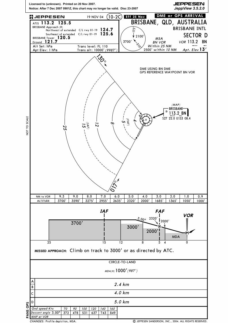
Communications InfoATIS 125.5ATIS 113.2Brisbane Tower 120.5Brisbane Ground Control 121.7Brisbane Clearance Delivery 118.6Brisbane Approach Control 125.6Brisbane Approach Control 124.7Brisbane Approach Control 123.5Brisbane Departure Control 125.6 Out to 30 mi.Brisbane Departure Control 124.7 Out to 30 mi.Brisbane Departure Control 128.3Brisbane Departure Control 123.5Brisbane Radar 125.7
Notebook Info
Licensed to (unknown). Printed on 20 Nov 2007.
Notice: After 7 Dec 2007 0901Z, this chart may no longer be valid. Disc 23-2007
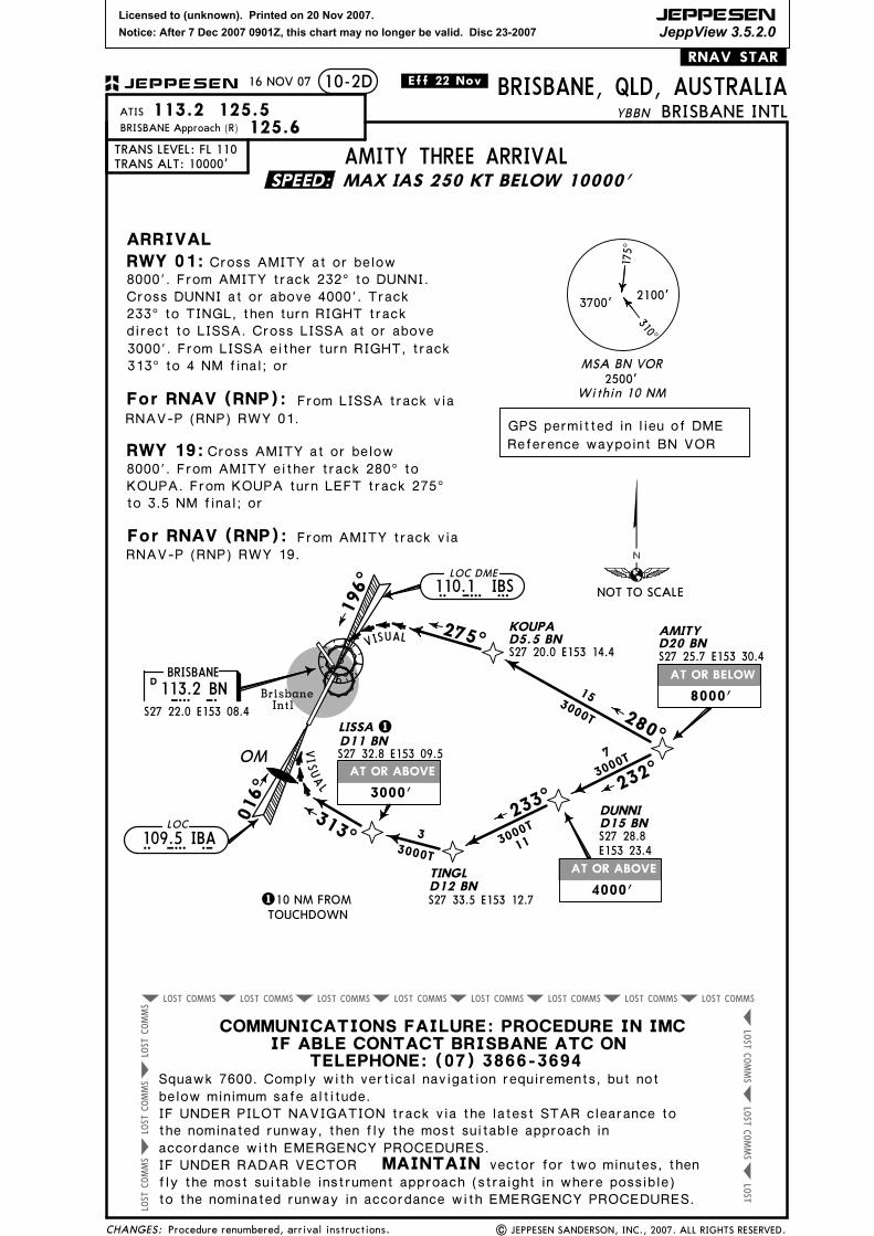
8000'. From AMITY track 232^ to DUNNI.Cross DUNNI at or above 4000'. Track
direct to LISSA. Cross LISSA at or above
S27 33.5 E153 12.7TOUCHDOWN10 NM FROM1
KOUPA
S27 20.0 E153 14.4
IF ABLE CONTACT BRISBANE ATC ONTELEPHONE: (07) 3866-3694
vector for two minutes, then
MAX IAS 250 KT BELOW 10000'
D5.5 BN
233^ to TINGL, then turn RIGHT track
3000'. From LISSA either turn RIGHT, track 313^ to 4 NM final; or
For RNAV (RNP): From LISSA track via
RWY 01 RNAV (RNP) P.
For RNAV (RNP): From AMITY track via
1 JUN 07
RWY 19 RNAV (RNP) P.
KOUPA. From KOUPA turn LEFT track 275^ to 3.5 NM final; or
SPEED:
CHANGES:
BRISBANE INTL
10-2DJEPPESEN
NOT TO SCALE
I B ALOC
109.5 IBA
ARRIVAL
GPS permitted in lieu of DME
Reference waypoint BN VOR
S27 22.0 E153 08.4
113.2 BNB NBRISBANE
D
I B S110.1 IBSLOC DME
BRISBANE, QLD, AUSTRALIA
Cross AMITY at or below
| JEPPESEN SANDERSON, INC., 2007. ALL RIGHTS RESERVED.
3000'
4000'
8000'
Cross AMITY at or below
113.2 125.5ATIS
MAINTAINIF UNDER RADAR VECTOR
COMMUNICATIONS FAILURE: PROCEDURE IN IMC
Squawk 7600. Comply with vertical navigation requirements, but notbelow minimum safe altitude.
fly the most suitable instrument approach (straight in where possible)
IF UNDER PILOT NAVIGATION track via the latest STAR clearance tothe nominated runway, then fly the most suitable approach inaccordance with EMERGENCY PROCEDURES.
8000'. From AMITY track 232^ to DUNNI.Cross DUNNI at or above 4000'. Track
direct to LISSA. Cross LISSA at or above
S27 33.5 E153 12.7TOUCHDOWN10 NM FROM1
KOUPA
S27 20.0 E153 14.4
IF ABLE CONTACT BRISBANE ATC ONTELEPHONE: (07) 3866-3694
vector for two minutes, then
MAX IAS 250 KT BELOW 10000'
D5.5 BN
233^ to TINGL, then turn RIGHT track
3000'. From LISSA either turn RIGHT, track 313^ to 4 NM final; or
For RNAV (RNP): From LISSA track via
RNAV-P (RNP) RWY 01.
For RNAV (RNP): From AMITY track via RNAV-P (RNP) RWY 19.
KOUPA. From KOUPA turn LEFT track 275^ to 3.5 NM final; or
.Eff.22.Nov.16 NOV 07
SPEED:
CHANGES:
BRISBANE INTL
10-2DJEPPESEN
NOT TO SCALE
I B ALOC
109.5 IBA
ARRIVAL
GPS permitted in lieu of DME
Reference waypoint BN VOR
S27 22.0 E153 08.4
113.2 BNB NBRISBANE
D
I B S110.1 IBSLOC DME
BRISBANE, QLD, AUSTRALIA
Cross AMITY at or below
| JEPPESEN SANDERSON, INC., 2007. ALL RIGHTS RESERVED.
3000'
4000'
8000'
Cross AMITY at or below
113.2 125.5ATIS
MAINTAINIF UNDER RADAR VECTOR
COMMUNICATIONS FAILURE: PROCEDURE IN IMC
Squawk 7600. Comply with vertical navigation requirements, but notbelow minimum safe altitude.
fly the most suitable instrument approach (straight in where possible)
IF UNDER PILOT NAVIGATION track via the latest STAR clearance tothe nominated runway, then fly the most suitable approach inaccordance with EMERGENCY PROCEDURES.
IF ABLE CONTACT BRISBANE ATC ONTELEPHONE: (07) 3866-3694
vector for two minutes, then
D20 BNDAYBO
S27 07.3 E152 53.1
S27 25.7 E153 30.4
AMITYD20 BN
FLYNND14 BN
D33 BN
BERTID25 BN
LOGAND14 BN
312^
313^3400T
3400T
10
15
16
3000T
232^
3000T
275^
5.4
117^3000T5.4
162^
24
4300T
S27 31.2 E152 56.5
S27 54.8 E153 17.7
S27 46.9 E153 11.2
S27 36.0 E153 07.0
016^
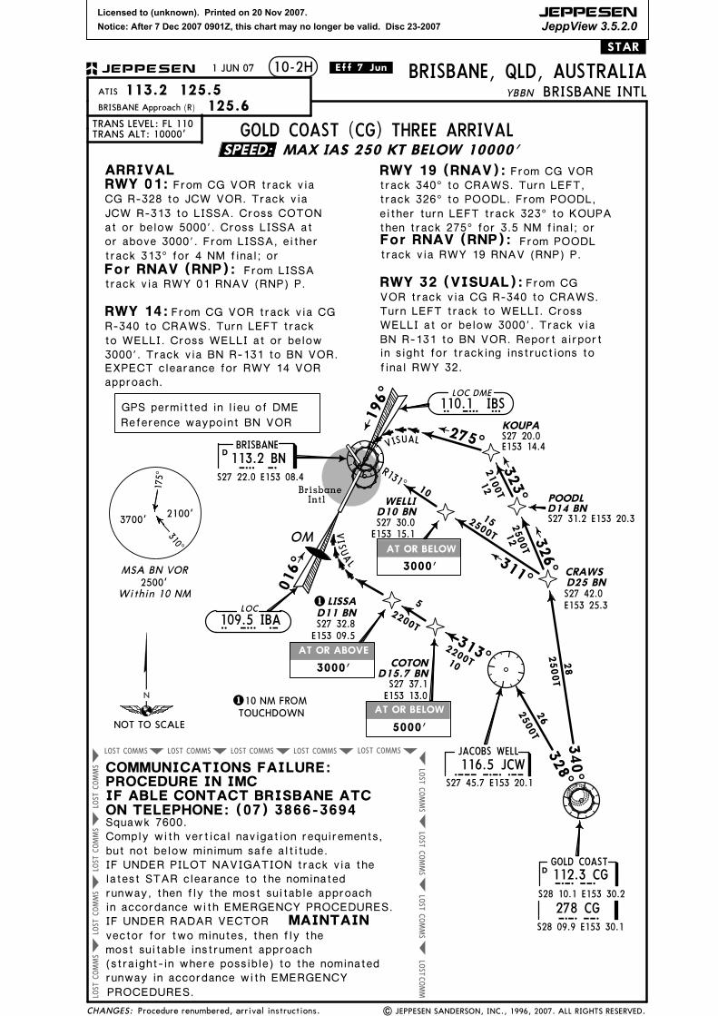
GOLD COAST (C
G)
73000T
DUNNIS27 28.8 E153 23.4
.RNAV.STAR.
BRISBANE113.2 BNBN
S27 22.0 E153 08.4
D
| JEPPESEN SANDERSON, INC., 2005, 2007. ALL RIGHTS RESERVED.DAYBO
AMITY
None.
1 JUN 07
SPEED:
S28 10.1 E153 30.2
112.3 CGD CGGOLD COAST
NOT TO SCALE
BRISBANE INTLBRISBANE, QLD, AUSTRALIA
113.2 125.5ATIS
TRANS LEVEL: FL 110TRANS ALT: 10000'
10-2G
BRISBANE Approach (R) 124.7
JEPPESEN
MAINTAINIF UNDER RADAR VECTOR
COMMUNICATIONS FAILURE: PROCEDURE IN IMC
Squawk 7600. Comply with vertical navigation requirements, but notbelow minimum safe altitude.
fly the most suitable instrument approach (straight in where possible)
EMERGENCY PROCEDURES. to the nominated runway in accordance with
GPS permitted in lieu of DME
Reference waypoint BN VOR
125.6 (NORTH)
(SOUTH)
7000'
8000'
8000'
ARRIVALRWY 01:
LOC
109.5 IBAI B A
3000'
TRANSITIONS
4000'
instrument approach as advised or cleared.
IF UNDER PILOT NAVIGATION track via latest STAR clearance to thenominated runway, then fly the most suitable approach in accordancewith EMERGENCY PROCEDURES.
From GLENN track via
AMITY:From AMITY track 232^ to DUNNI, then LOGAN. Cross DUNNI at or above 4000'
Cross AMITY at or below 8000'.
and LOGAN at or above 3000'. Turn
RIGHT, track 275^ to GLENN, then followarrival instructions.
BLAKA: From BLAKA track 001^ toMOOVI. Turn LEFT, track 312^ to BERTI.
instructions.
Cross BERTI at or below 8000'. Track313^ to GLENN, then follow arrival
DAYBO:From DAYBO track 162^ to FLYNN. TurnLEFT, track 117^ to GLENN, then followarrival instructions.
GOLD COAST (CG): From CG VOR track
instructions.
Cross DAYBO at or below 7000'.
GLENN FOUR ARRIVAL
312^ to MOOVI. Track 312^ to BERTI.Cross BERTI at or below 8000'. Track313^ to GLENN, then follow arrival
Licensed to (unknown). Printed on 20 Nov 2007.
Notice: After 7 Dec 2007 0901Z, this chart may no longer be valid. Disc 23-2007
IF ABLE CONTACT BRISBANE ATC ONTELEPHONE: (07) 3866-3694
vector for two minutes, then
D20 BNDAYBO
S27 07.3 E152 53.1
S27 25.7 E153 30.4
AMITYD20 BN
FLYNND14 BN
D33 BN
BERTID25 BN
LOGAND14 BN
312^
313^3400T
3400T
10
15
16
3000T
232^
3000T
275^
5.4
117^3000T5.4
162^
24
4300T
S27 31.2 E152 56.5
S27 54.8 E153 17.7
S27 46.9 E153 11.2
S27 36.0 E153 07.0
016^
GOLD COAST (C
G)
73000T
DUNNIS27 28.8 E153 23.4
.RNAV.STAR.
BRISBANE113.2 BNBN
S27 22.0 E153 08.4
D
| JEPPESEN SANDERSON, INC., 2005, 2007. ALL RIGHTS RESERVED.DAYBO
AMITY
None.
.Eff.22.Nov.16 NOV 07
SPEED:
S28 10.1 E153 30.2
112.3 CGD CGGOLD COAST
NOT TO SCALE
BRISBANE INTLBRISBANE, QLD, AUSTRALIA
113.2 125.5ATIS
TRANS LEVEL: FL 110TRANS ALT: 10000'
10-2G
BRISBANE Approach (R) 124.7
JEPPESEN
MAINTAINIF UNDER RADAR VECTOR
COMMUNICATIONS FAILURE: PROCEDURE IN IMC
Squawk 7600. Comply with vertical navigation requirements, but notbelow minimum safe altitude.
fly the most suitable instrument approach (straight in where possible)
EMERGENCY PROCEDURES. to the nominated runway in accordance with
GPS permitted in lieu of DME
Reference waypoint BN VOR
125.6 (NORTH)
(SOUTH)
7000'
8000'
8000'
ARRIVALRWY 01:
LOC
109.5 IBAI B A
3000'
TRANSITIONS
4000'
instrument approach as advised or cleared.
IF UNDER PILOT NAVIGATION track via latest STAR clearance to thenominated runway, then fly the most suitable approach in accordancewith EMERGENCY PROCEDURES.
From GLENN track via
AMITY:From AMITY track 232^ to DUNNI, then LOGAN. Cross DUNNI at or above 4000'
Cross AMITY at or below 8000'.
and LOGAN at or above 3000'. Turn
RIGHT, track 275^ to GLENN, then followarrival instructions.
BLAKA: From BLAKA track 001^ toMOOVI. Turn LEFT, track 312^ to BERTI.
instructions.
Cross BERTI at or below 8000'. Track313^ to GLENN, then follow arrival
DAYBO:From DAYBO track 162^ to FLYNN. TurnLEFT, track 117^ to GLENN, then followarrival instructions.
GOLD COAST (CG): From CG VOR track
instructions.
Cross DAYBO at or below 7000'.
GLENN FOUR ARRIVAL
312^ to MOOVI. Track 312^ to BERTI.Cross BERTI at or below 8000'. Track313^ to GLENN, then follow arrival
Licensed to (unknown). Printed on 20 Nov 2007.
Notice: After 7 Dec 2007 0901Z, this chart may no longer be valid. Disc 23-2007
JEPPESEN
JeppView 3.5.2.0
AT OR BELOW
AT OR ABOVE
AT OR BELOW
COMMSLOST COMMSLOST COMMSLOST COMMSLOST COMMSLOST
COMMS
LOST
COMMS
LOST
COMMS
LOST
LOSTCOMM
COMMS
LOST
COMMS
LOST
COMMS
LOST
COMMS
LOST
.STAR.
YBBN
PROCEDURES.
S27 31.2 E153 20.3
POODL
311^
152500T
CRAWS
D14 BN
D25 BN
R131^
340^
OM
JCW116.5 JCWS27 45.7 E153 20.1
JACOBS WELL 328^
313^
52200T
016^
LISSAD11 BN
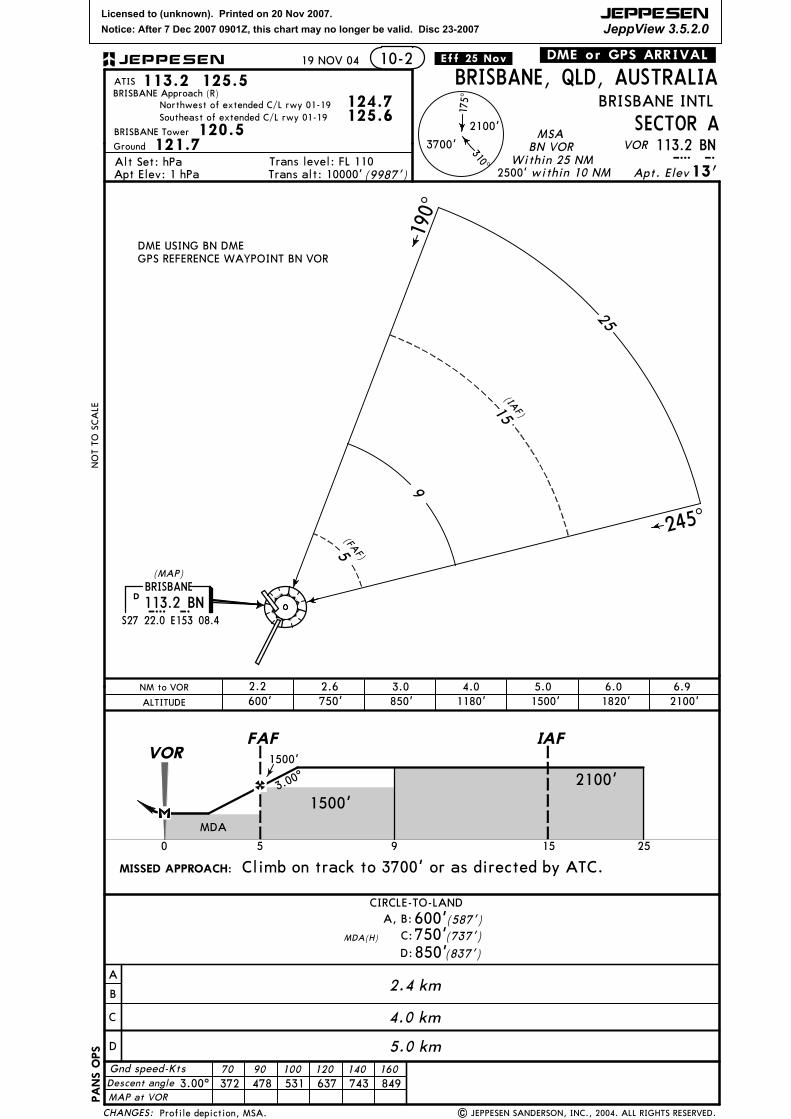
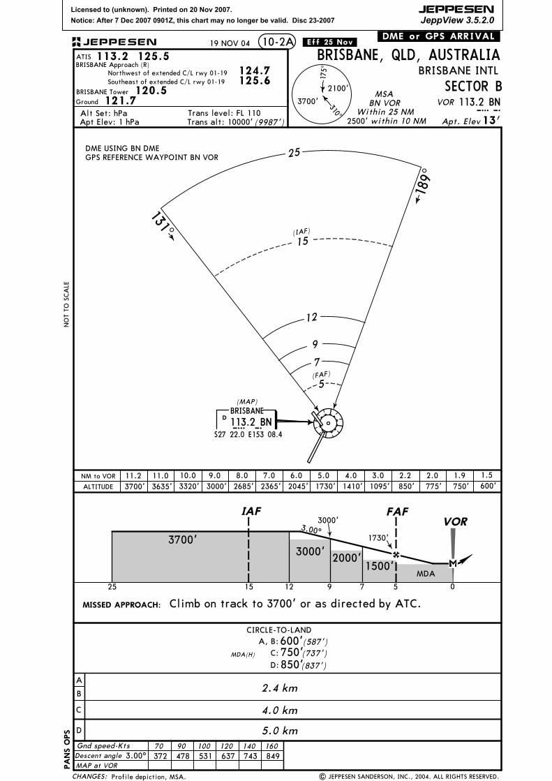
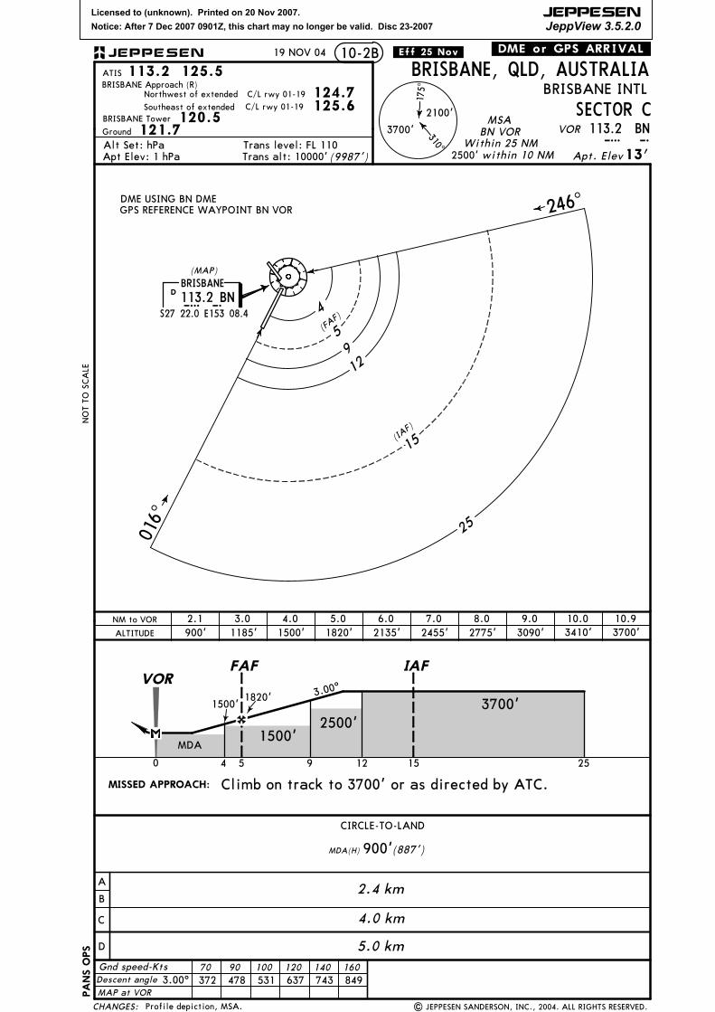
MSA BN VOR
3700'2100'
175^
310^
Within 10 NM2500'
1
RWY 14:
RWY 01:
28
2500T
ON TELEPHONE: (07) 3866-3694IF ABLE CONTACT BRISBANE ATC
MAX IAS 250 KT BELOW 10000'
110 NM FROMTOUCHDOWN
196^
KOUPA
Brisbane
Intl
275^
326^
323^
12
12
RWY 19 (RNAV):
From CGVOR track via CG R-340 to CRAWS.Turn LEFT track to WELLI. Cross
2100T
2500T
RWY 32 (VISUAL):
GOLD COAST
10
2200TCOTON
2500T
26
D15.7 BN
LAUSI
V
VISUALS27 20.0E153 14.4
track 340^ to CRAWS. Turn LEFT,From CG VOR
WELLID10 BNS27 30.0E153 15.1
10
S27 42.0E153 25.3
S27 32.8E153 09.5
S27 37.1E153 13.0
CG R-328 to JCW VOR. Track viaJCW R-313 to LISSA. Cross COTONat or below 5000'. Cross LISSA at
to WELLI. Cross WELLI at or below3000'. Track via BN R-131 to BN VOR.
approach.EXPECT clearance for RWY 14 VOR
track 326^ to POODL. From POODL,
WELLI at or below 3000'. Track viaBN R-131 to BN VOR. Report airport
final RWY 32.
in sight for tracking instructions to
1 JUN 07 .Eff.7.Jun.
or above 3000'. From LISSA, either
For RNAV (RNP):
For RNAV (RNP):
From LISSA track via RWY 01 RNAV (RNP) P.
From POODLtrack via RWY 19 RNAV (RNP) P.track 313^ for 4 NM final; or
then track 275^ for 3.5 NM final; oreither turn LEFT track 323^ to KOUPA
SPEED:
CHANGES:
113.2 125.5ATIS
TRANS LEVEL: FL 110TRANS ALT: 10000'
Squawk 7600.
COMMUNICATIONS FAILURE:PROCEDURE IN IMC
IF UNDER RADAR VECTOR MAINTAIN
BRISBANE INTL
| JEPPESEN SANDERSON, INC., 1996, 2007. ALL RIGHTS RESERVED.
10-2H
BRISBANE Approach (R) 125.6
JEPPESEN
most suitable instrument approach (straight-in where possible) to the nominatedrunway in accordance with EMERGENCY
NOT TO SCALE
I B ALOC
109.5 IBA
5000'
ARRIVALFrom CG VOR track via
latest STAR clearance to the nominated
but not below minimum safe altitude.
runway, then fly the most suitable approachin accordance with EMERGENCY PROCEDURES.
vector for two minutes, then fly the
GPS permitted in lieu of DME
Reference waypoint BN VOR
S27 22.0 E153 08.4
113.2 BNB NBRISBANE
D
I B S110.1 IBSLOC DME
BRISBANE, QLD, AUSTRALIA
R-340 to CRAWS. Turn LEFT track
S28 10.1 E153 30.2
112.3 CGDCG
Comply with vertical navigation requirements,
3000'
S28 09.9 E153 30.1
278 CGCG
From CG VOR track via CG
3000'
IF UNDER PILOT NAVIGATION track via the
Procedure renumbered, arrival instructions.
GOLD COAST (CG) THREE ARRIVAL
Licensed to (unknown). Printed on 20 Nov 2007.
Notice: After 7 Dec 2007 0901Z, this chart may no longer be valid. Disc 23-2007
JEPPESEN
JeppView 3.5.2.0
AT OR BELOW
AT OR ABOVE
AT OR BELOW
COMMSLOST COMMSLOST COMMSLOST COMMSLOST COMMSLOST
COMMS
LOST
COMMS
LOST
COMMS
LOST
LOSTCOMM
COMMS
LOST
COMMS
LOST
COMMS
LOST
COMMS
LOST
.STAR.
YBBN
PROCEDURES.
S27 31.2 E153 20.3
POODL
311^
152500T
CRAWS
D14 BN
D25 BN
R131^
340^
OM
JCW116.5 JCWS27 45.7 E153 20.1
JACOBS WELL 328^
313^
52200T
016^
LISSAD11 BN
MSA BN VOR
3700'2100'
175^
310^
Within 10 NM2500'
1
RWY 14:
RWY 01:
28
2500T
ON TELEPHONE: (07) 3866-3694IF ABLE CONTACT BRISBANE ATC
MAX IAS 250 KT BELOW 10000'
110 NM FROMTOUCHDOWN
196^
KOUPA
Brisbane
Intl
275^
326^
323^
12
12
RWY 19 (RNAV):
From CGVOR track via CG R-340 to CRAWS.Turn LEFT track to WELLI. Cross
2100T
2500T
RWY 32 (VISUAL):
GOLD COAST
10
2200TCOTON
2500T
26
D15.7 BN
LAUSI
V
VISUALS27 20.0E153 14.4
track 340^ to CRAWS. Turn LEFT,From CG VOR
WELLID10 BNS27 30.0E153 15.1
10
S27 42.0E153 25.3
S27 32.8E153 09.5
S27 37.1E153 13.0
CG R-328 to JCW VOR. Track viaJCW R-313 to LISSA. Cross COTONat or below 5000'. Cross LISSA at
to WELLI. Cross WELLI at or below3000'. Track via BN R-131 to BN VOR.
approach.EXPECT clearance for VOR RWY 14
track 326^ to POODL. From POODL,
WELLI at or below 3000'. Track viaBN R-131 to BN VOR. Report airport
final RWY 32.
in sight for tracking instructions to
or above 3000'. From LISSA, either
For RNAV (RNP):
For RNAV (RNP):
From LISSA track via RNAV-P (RNP) RWY 01.
From POODLtrack via RNAV-P (RNP) RWY 19.track 313^ for 4 NM final; or
then track 275^ for 3.5 NM final; oreither turn LEFT track 323^ to KOUPA
16 NOV 07 .Eff.22.Nov.
SPEED:
CHANGES:
113.2 125.5ATIS
TRANS LEVEL: FL 110TRANS ALT: 10000'
Squawk 7600.
COMMUNICATIONS FAILURE:PROCEDURE IN IMC
IF UNDER RADAR VECTOR MAINTAIN
BRISBANE INTL
| JEPPESEN SANDERSON, INC., 1996, 2007. ALL RIGHTS RESERVED.
10-2H
BRISBANE Approach (R) 125.6
JEPPESEN
most suitable instrument approach (straight-in where possible) to the nominatedrunway in accordance with EMERGENCY
NOT TO SCALE
I B ALOC
109.5 IBA
5000'
ARRIVALFrom CG VOR track via
latest STAR clearance to the nominated
but not below minimum safe altitude.
runway, then fly the most suitable approachin accordance with EMERGENCY PROCEDURES.
vector for two minutes, then fly the
GPS permitted in lieu of DME
Reference waypoint BN VOR
S27 22.0 E153 08.4
113.2 BNB NBRISBANE
D
I B S110.1 IBSLOC DME
BRISBANE, QLD, AUSTRALIA
R-340 to CRAWS. Turn LEFT track
S28 10.1 E153 30.2
112.3 CGDCG
Comply with vertical navigation requirements,
3000'
S28 09.9 E153 30.1
278 CGCG
From CG VOR track via CG
3000'
IF UNDER PILOT NAVIGATION track via the
Procedure renumbered, arrival instructions.
GOLD COAST (CG) FOUR ARRIVAL
Licensed to (unknown). Printed on 20 Nov 2007.
Notice: After 7 Dec 2007 0901Z, this chart may no longer be valid. Disc 23-2007
JEPPESEN
JeppView 3.5.2.0
AT OR BELOW
COMMSLOST COMMSLOST COMMSLOST COMMSLOST COMMSLOST
COMMS
LOST
COMMS
LOST
COMMS
LOST
COMMS
LOST
COMMS
LOST
COMMS
LOST
COMMS
LOST
COMMS
LOST
.STAR.
YBBN
RWY 01:
016^
Brisbane
Intl
196^
MALENY
115.9 MLYMLYS26 44.7 E152 45.7
RWY 19:
141^
12
3700T
S26 55.6 E152 52.2
140^
10
3500T S27 04.4 E152 57.5
R320^
20
GAYLA
BURPA
for RWY 19 ILS or VOR/DME approach.
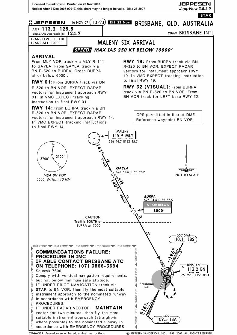
CAUTION:
BURPA at 7000'Traffic SOUTH of
3700'2100'
175^
310^2500'Within 10 NM
MSA BN VOR
MAX IAS 250 KT BELOW 10000'
BRISBANE
113.2 BNBNS27 22.0 E153 08.4
D
RWY 32 (VISUAL):track via BN R-320 to BN VOR. FromBN VOR track for LEFT base RWY 32.
D
D30
.Eff.18.Jan.
From BURPA track via BN
for RWY 01 ILS or VOR/DME approach.
RWY 14:From BURPA track via BN R-320 to BN VOR. EXPECT RADARvectors for instrument approach RWY 14.In VMC EXPECT tracking instructionsto final RWY 14.
From BURPA track via BN
12 JAN 07
Reindexed.
SPEED:
NOT TO SCALE
113.2 125.5ATIS
TRANS LEVEL: FL 110TRANS ALT: 10000'
ARRIVAL
BRISBANE INTL
10-2J
BRISBANE Approach (R) 124.7
JEPPESEN
CHANGES: | JEPPESEN SANDERSON, INC., 1997, 2007. ALL RIGHTS RESERVED.
LOC
109.5 IBAI B A
I B S110.1 IBSLOC DME
From MLY VOR track via MLY R-141
6000'
Squawk 7600.
COMMUNICATIONS FAILURE:PROCEDURE IN IMC
ON TELEPHONE: (07) 3866-3694IF ABLE CONTACT BRISBANE ATC
IF UNDER RADAR VECTOR MAINTAINvector for two minutes, then fly the mostsuitable instrument approach (straight inwhere possible) to the nominated runway inaccordance with EMERGENCY PROCEDURES.
R-320 to BN VOR. EXPECT clearance
IF UNDER PILOT NAVIGATION track viaSTAR to BN VOR, then fly the most suitableinstrument approach to the nominated runwayin accordance with EMERGENCYPROCEDURES.
but not below minimum safe altitude.
MALENY FIVE ARRIVAL
GPS permitted in lieu of DME
Reference waypoint BN VOR
BRISBANE, QLD, AUSTRALIA
From BURPA
to GAYLA. From GAYLA track viaBN R-320 to BURPA. Cross BURPAat or below 6000'.
Comply with vertical navigation requirements,
R-320 to BN VOR. EXPECT clearance
Licensed to (unknown). Printed on 20 Nov 2007.
Notice: After 7 Dec 2007 0901Z, this chart may no longer be valid. Disc 23-2007
JEPPESEN
JeppView 3.5.2.0
AT OR BELOW
COMMSLOST COMMSLOST COMMSLOST COMMSLOST COMMSLOST
COMMS
LOST
COMMS
LOST
COMMS
LOST
COMMS
LOST
COMMS
LOST
COMMS
LOST
COMMS
LOST
COMMS
LOST
.STAR.
YBBN
RWY 01:
016^
Brisbane
Intl
196^
MALENY
115.9 MLYMLYS26 44.7 E152 45.7
RWY 19:
141^
12
3700T
S26 55.6 E152 52.2
140^
10
3500T S27 04.4 E152 57.5
R320^
20
GAYLA
BURPA
CAUTION:
BURPA at 7000'Traffic SOUTH of
3700'2100'
175^
310^2500'Within 10 NM
MSA BN VOR
MAX IAS 250 KT BELOW 10000'
BRISBANE
113.2 BNBNS27 22.0 E153 08.4
D
RWY 32 (VISUAL):track via BN R-320 to BN VOR. FromBN VOR track for LEFT base RWY 32.
D
D30
From BURPA track via BN
RWY 14:From BURPA track via BN R-320 to BN VOR. EXPECT RADARvectors for instrument approach RWY 14.In VMC EXPECT tracking instructionsto final RWY 14.
From BURPA track via BN
16 NOV 07 .Eff.22.Nov.
Procedure renumbered, arrival instructions.
vectors for instrument approach RWY
instruction to final RWY 01.01. In VMC EXPECT tracking
vectors for instrument approach RWY19. In VMC EXPECT tracking instructionto final RWY 19.
SPEED:
NOT TO SCALE
113.2 125.5ATIS
TRANS LEVEL: FL 110TRANS ALT: 10000'
ARRIVAL
BRISBANE INTL
10-2J
BRISBANE Approach (R) 124.7
JEPPESEN
CHANGES: | JEPPESEN SANDERSON, INC., 1997, 2007. ALL RIGHTS RESERVED.
LOC
109.5 IBAI B A
I B S110.1 IBSLOC DME
From MLY VOR track via MLY R-141
6000'
Squawk 7600.
COMMUNICATIONS FAILURE:PROCEDURE IN IMC
ON TELEPHONE: (07) 3866-3694IF ABLE CONTACT BRISBANE ATC
IF UNDER RADAR VECTOR MAINTAINvector for two minutes, then fly the mostsuitable instrument approach (straight-inwhere possible) to the nominated runway inaccordance with EMERGENCY PROCEDURES.
IF UNDER PILOT NAVIGATION track viaSTAR to BN VOR, then fly the most suitableinstrument approach to the nominated runwayin accordance with EMERGENCYPROCEDURES.
but not below minimum safe altitude.
GPS permitted in lieu of DME
Reference waypoint BN VOR
BRISBANE, QLD, AUSTRALIA
From BURPA
to GAYLA. From GAYLA track viaBN R-320 to BURPA. Cross BURPAat or below 6000'.
Comply with vertical navigation requirements,
MALENY SIX ARRIVAL
R-320 to BN VOR. EXPECT RADAR
R-320 to BN VOR. EXPECT RADAR
Licensed to (unknown). Printed on 20 Nov 2007.
Notice: After 7 Dec 2007 0901Z, this chart may no longer be valid. Disc 23-2007
IF ABLE CONTACT BRISBANE ATC ONTELEPHONE: (07) 3866-3694
vector for two minutes, then
| JEPPESEN SANDERSON, INC., 2005, 2007. ALL RIGHTS RESERVED.
112.3 CGCGDGOLD COAST
12 JAN 07
Procedure revised, renumbered, reindexed.
DAYBO
AMITY
GLENN
SPEED:
I B S110.1 IBSLOC DME
8000'
7000'
NOT TO SCALE
BRISBANE INTLBRISBANE, QLD, AUSTRALIA
113.2 125.5ATIS
TRANS LEVEL: FL 110TRANS ALT: 10000'
10-2L
BRISBANE Approach (R) 124.7
JEPPESEN
TRANSITIONS
BLAKA: From BLAKA track 001^ to
track 019^ to LEAKY, then 312^ to BOATS.
GOLD COAST (CG): From CG VOR track340^ to CRAWS, then 339^ to LEAKY.
AMITY:From AMITY track 306^ to LEAKY, then
to SINNK, then follow arrival instructions.312^ to BOATS. Turn LEFT, track 255^
DAYBO:
to SINNK, then follow arrival instructions.
GPS permitted in lieu of DME
Reference waypoint BN VOR
125.6 (NORTH)
(SOUTH)
ARRIVALRWY 19: approach as advised or cleared.
MAINTAINIF UNDER RADAR VECTOR
COMMUNICATIONS FAILURE: PROCEDURE IN IMC
Squawk 7600. Comply with vertical navigation requirements, but notbelow minimum safe altitude.
fly the most suitable instrument approach (straight in where possible)
S28 10.1 E153 30.2
to the nominated runway in accordance with EMERGENCY PROCEDURES.
GLENN: From GLENN track 066^ to LISSA. Cross LISSA at or above 8000'. Turn LEFT,
Turn LEFT, track 255^ to SINNK, thenfollow arrival instructions.
MOOVI, then 002^ to JCW VOR. Turn LEFT,track 349^ to LEAKY, then 312^ to BOATS.Turn LEFT, track 255^ to SINNK. Thenfollow arrival instructions.
Turn LEFT, track 312^ to BOATS, then
Cross AMITY at or below 8000'.
Cross DAYBO at or below 7000'.
From SINNK track via instrument
IF UNDER PILOT NAVIGATION track via the latest STAR clearanceto the nominated runway, then fly the most suitable approach inaccordance with EMERGENCY PROCEDURES.
8000'
At DAYBO track direct to DRAIN, then
track 255^ to SINNK. Then follow arrivalinstructions.
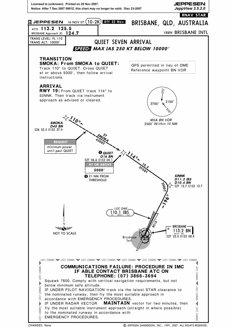
SINNK THREE ARRIVAL
079^ to PLUGG. Turn RIGHT, track 136^
Licensed to (unknown). Printed on 20 Nov 2007.
Notice: After 7 Dec 2007 0901Z, this chart may no longer be valid. Disc 23-2007
JEPPESEN
JeppView 3.5.2.0
AT 600'
AT 600'
THE DEPARTURE END OF
AT 600' BUT NOT
BEFORE BN VOR
AT 600' BUT NOT BEFORE
RUNWAY (BN 2.5 DME)
COMMS
LOST
LOST COMMS COMMSLOST COMMSLOST COMMSLOST COMMSLOST COMMSLOST LOST
COMMS
LOST
CHANGES:
TRANS LEVEL: FL 110TRANS ALT: 10000'
BRISBANE INTL
BRISBANE, QLD, AUSTRALIA
Squawk 7600.
ALL RUNWAYS
Rwy 01:
Rwy 14:
Rwy 32:
Rwy 19:
315^016^
135^
B N113.2 BNBRISBANE
S27 22.0 E153 08.4
D
MINIMUMALTITUDE3000'
Brisbane Intl
MINIMUMALTITUDE
2500'
| JEPPESEN SANDERSON, INC., 1990, 2007. ALL RIGHTS RESERVED.
YBBN
118.6BRISBANE Clearance
Departure (R)
MAX IAS 250 KT BELOW 10000'
Track 016^. At 600' but not before
196^
Track 135^. At 600' turn to assigned
BN VOR turn to assigned heading. When directed,contact Departure for RADAR vectors.
When directed, contact Departure for RADAR vectors.
Track 315^. At 600' turn to assigned heading.When directed, contact Departure for RADAR vectors.
RADAR vectors.
128.3 124.7 125.6
.Eff.30.Aug.
MAINTAIN last assigned vector for two minutes, and CLIMB IFNECESSARY TO MINIMUM SAFE ALTITUDE, to MAINTAIN
ATC route clearance acknowledged.terrain clearance, then proceed in accordance with the latest
BRISBANE ONE DEPARTURE (RADAR)
Noise abatementprocedures apply.
3700'2100'
175^
310^
2500'Within 10 NM
MSA BN VOR
Track 196^. At 600' but not before the
.SID(R).STANDARD INSTRUMENT
DEPARTURE (RADAR)
Gnd speed-Kts 75 100 150 200 250 300
3.3% V/V (fpm) 251 334 501 668 835 1003
24 AUG 07
heading. When directed, contact Departure for
departure end of runway (BN 2.5 DME), turn toassigned heading.
On recognition of communications failure.
10-3
None.
Minimum required climb gradient 3.3%.
SPEED:
NOT TO SCALE
Turn toassigned heading
Turn toassigned heading
Turn toassigned heading
Turn toassigned heading
JEPPESEN
GPS permitted in lieu of DME
Reference waypoint BN VOR
Licensed to (unknown). Printed on 20 Nov 2007.
Notice: After 7 Dec 2007 0901Z, this chart may no longer be valid. Disc 23-2007
JEPPESEN
JeppView 3.5.2.0
MAX IAS 220 KT
AT OR ABOVE
AT OR ABOVE
CHANGES:
BRISBANE INTL
10-3A
BRISBANE Clearance 118.6Departure (R) 128.3
BRISBANE, QLD, AUSTRALIAYBBN
| JEPPESEN SANDERSON, INC., 1996, 2007. ALL RIGHTS RESERVED.
TRANS LEVEL: FL 110TRANS ALT: 10000'
196^
Brisbane
Intl
S27 22.0 E153 08.4
D113.2 BNBRISBANE
B N
Rwy 01: Rwy 19:
For CORAL:For TRIKI:
For CORAL:For TRIKI:
CORALS26 32.9 E153 19.2
014^
360^
016^
S27 17.6 E153 05.7D5 BN
E153 21.2S26 52.3TRIKI
356^ 0
07^
75 100 150 200 250 300
24 AUG 07 .Eff.30.Aug.
2100'310^
3700'
175^
2500'Within 10 NM
MSA BN VOR
Gnd speed-Kts
D7 BNS27 28.2 E153 04.8
CITEE
AMBLE
Track 016^ to VERRY. From VERRY turn LEFT.
Track 356^ to CORAL.Track 007^ to TRIKI.
Track 360^ to CORAL.Track 014^ to TRIKI.
DEBAYD9 BN
S27 12.8 E153 10.4
VERRYD10 BNS27 13.0 E153 13.5
6
41
23
40
22
.RNAV.SID.
MAX IAS 250 KT BELOW 10000'
RUNWAY01/19 NORTH
CORAL FOUR DEPARTURE
DIRECT5
10
4.5
024^
10
NOGRAS27 25.4 E152 59.6
Minimum required climb gradients:
Rwy 19: 10.8% to 3000', then 3.3%.
030^
MAX IAS 220 KT UNTIL PASSING NOGRA
Track 196^ to CITEE. CrossCITEE at or above 3000'. At CITEEturn RIGHT. Track direct to NOGRA.
TRIKI FOUR DEPARTURE
CORAL FOUR
TRIKI FOUR
TRIKI FOUR
CORAL F
OUR
Procedures revised, renumbered.
820 1094 1645 2187 2734 3281
3.3% V/V (fpm) 251 334 501 668 835 1003
10.8% V/V (fpm)
turn RIGHT, track 030^ to DEBAY.From DEBAY turn LEFT.
Rwy 01: 3.3%.
Track 024^ to AMBLE. Cross AMBLEat or above 8000'. From AMBLE
SPEED:
JEPPESEN
NOT TO SCALE
GPS permitted in lieu of DME
Reference waypoint BN VOR
8000'
Until passingNOGRA
3000'
Licensed to (unknown). Printed on 20 Nov 2007.
Notice: After 7 Dec 2007 0901Z, this chart may no longer be valid. Disc 23-2007
JEPPESEN
JeppView 3.5.2.0
AT OR ABOVE
TURN RIGHT
AT OR ABOVEMAX IAS 220 KT
CHANGES:
TRANS LEVEL: FL 110TRANS ALT: 10000'
BRISBANE INTL
BRISBANE, QLD, AUSTRALIA
10-3B
3700'
2100'
175^
310^
| JEPPESEN SANDERSON, INC., 1992, 2007. ALL RIGHTS RESERVED.
Rwy 01:
YBBN
Within 10 NM2500'
Brisbane Intl
S27 22.0 E153 08.4B N113.2 BNBRISBANE
D
016^
MULETS26 25.9E155 44.0
045^
SPRAT
057^E153 39.7S27 11.0D30 BNCOODA
120
120
DEPARTURE
067^
196^
All Rwys
31
MELOWS27 19.7E153 10.6
BRISBANE Clearance 118.6Departure (R) 125.6
128.3
021^
125
074^121
BREAMS27 00.1E155 54.8
FLATYS25 24.8E154 53.2
S26 02.4E155 30.4
For BREAM:
For FLATY:
For MULET:
For SPRAT:
.Eff.30.Aug. .RNAV.SID.
BN01R, and not below 600', turn RIGHT, track 028^ to MELOW. At MELOW turn
For BONEY:
S27 28.2 E153 04.8D7 BNCITEE
S27 17.6 E153 05.7D5 BNAMBLE
BN01RS27 22.3E153 08.2
097^126
BONEYS27 48.5E155 54.5
(RWY 01)
(RWY 19)
Track 016^ to BN01R. From
MSA BN VOR
COODA EIGHT DEPARTURE
5
024^
10
NOGRAS27 25.4 E152 59.6
4.5
3.5
RUNWAY 01/19NORTH-EAST
MAX IAS 250 KT BELOW 10000'
Minimum required climb gradients:
Rwy 19: 10.8% to 3000', then 3.3%.
MAX IAS 220 KT UNTIL PASSING NOGRA
Rwy 19: Track 196^ to CITEE. CrossCITEE at or above 3000'. At CITEEturn RIGHT. Track direct to NOGRA.
RIGHT. Track direct to COODA.
24 AUG 07
Procedure revised, renumbered.
Turn RIGHT, track 067^ to COODA.Cross AMBLE at or above 8000'.
75 100 150 200 250 300Gnd speed-Kts
820 1094 1645 2187 2734 3281
3.3% V/V (fpm) 251 334 501 668 835 1003
10.8% V/V (fpm)
From COODA turn RIGHT.Track 074^ to BREAM, then as cleared.
From COODA turn RIGHT.Track 097^ to BONEY, then as cleared.
From COODA turn LEFT.Track 021^ to FLATY, then as cleared.
From COODA turn LEFT.Track 057^ to MULET, then as cleared.
From COODA turn LEFT.Track 045^ to SPRAT, then as cleared.
Rwy 01: 3.3%.
Turn RIGHT, track 024^ to AMBLE.
27
DIRECT
DIRECT
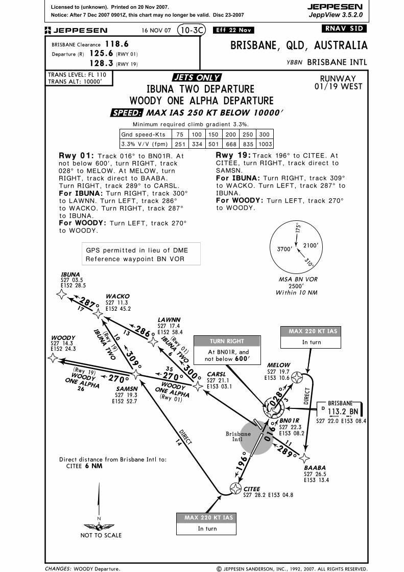
JETS ONLY
SPEED:
028^
NOT TO SCALE
JEPPESEN
GPS permitted in lieu of DME
Reference waypoint BN VOR
8000'
From BN01R, andnot below 600'
3000'Until passing
NOGRA
Licensed to (unknown). Printed on 20 Nov 2007.
Notice: After 7 Dec 2007 0901Z, this chart may no longer be valid. Disc 23-2007
JEPPESEN
JeppView 3.5.2.0
AT OR ABOVE
TURN RIGHT
AT OR ABOVEMAX IAS 220 KT
CHANGES:
TRANS LEVEL: FL 110TRANS ALT: 10000'
BRISBANE INTL
BRISBANE, QLD, AUSTRALIA
10-3B
3700'
2100'
175^
310^
| JEPPESEN SANDERSON, INC., 1992, 2007. ALL RIGHTS RESERVED.
Rwy 01:
YBBN
Within 10 NM2500'
Brisbane Intl
S27 22.0 E153 08.4B N113.2 BNBRISBANE
D
016^
MULETS26 25.9E155 44.0
045^
SPRAT
057^E153 39.7S27 11.0D30 BNCOODA
120
120
DEPARTURE
067^
196^
All Rwys
31
MELOWS27 19.7E153 10.6
BRISBANE Clearance 118.6Departure (R) 125.6
128.3
021^
125
074^121
BREAMS27 00.1E155 54.8
FLATYS25 24.8E154 53.2
S26 02.4E155 30.4
For BREAM:
For FLATY:
For MULET:
For SPRAT:
.Eff.22.Nov. .RNAV.SID.
BN01R, and not below 600', turn RIGHT, track 028^ to MELOW. At MELOW turn
For BONEY:
S27 28.2 E153 04.8D7 BNCITEE
S27 17.6 E153 05.7D5 BNAMBLE
BN01RS27 22.3E153 08.2
097^126
BONEYS27 48.5E155 54.5
(RWY 01)
(RWY 19)
Track 016^ to BN01R. From
MSA BN VOR
COODA EIGHT DEPARTURE
5
024^
10
NOGRAS27 25.4 E152 59.6
4.5
3.5
RUNWAY 01/19NORTH-EAST
MAX IAS 250 KT BELOW 10000'
Minimum required climb gradients:
Rwy 19: 10.8% to 3000', then 3.3%.
MAX IAS 220 KT UNTIL PASSING NOGRA
Rwy 19: Track 196^ to CITEE. CrossCITEE at or above 3000'. At CITEEturn RIGHT. Track direct to NOGRA.
RIGHT. Track direct to COODA.
16 NOV 07
Turn RIGHT, track 067^ to COODA.Cross AMBLE at or above 8000'.
75 100 150 200 250 300Gnd speed-Kts
820 1094 1645 2187 2734 3281
3.3% V/V (fpm) 251 334 501 668 835 1003
10.8% V/V (fpm)
From COODA turn RIGHT.Track 074^ to BREAM, then as cleared.
From COODA turn RIGHT.Track 097^ to BONEY, then as cleared.
From COODA turn LEFT.Track 021^ to FLATY, then as cleared.
From COODA turn LEFT.Track 057^ to MULET, then as cleared.
From COODA turn LEFT.Track 045^ to SPRAT, then as cleared.
Rwy 01: 3.3%.
Turn RIGHT, track 024^ to AMBLE.
27
DIRECT
DIRECT
None.
JETS ONLY
SPEED:
028^
NOT TO SCALE
JEPPESEN
GPS permitted in lieu of DME
Reference waypoint BN VOR
8000'
From BN01R, andnot below 600'
3000'Until passing
NOGRA
Licensed to (unknown). Printed on 20 Nov 2007.
Notice: After 7 Dec 2007 0901Z, this chart may no longer be valid. Disc 23-2007
JEPPESEN
JeppView 3.5.2.0
MAX 220 KT IAS
TURN RIGHT
MAX 220 KT IAS
ROM377 ROMS26 32.6 E148 46.9
S27 22.0 E153 08.4
D113.2 BNBRISBANE
B NROMA
BrisbaneIntl
In turn
310^
3700'2100'
Within 10 NM2500'
MSA BN VOR
CHANGES:
TRANS LEVEL: FL 110TRANS ALT: 10000'
BRISBANE INTL
BRISBANE, QLD, AUSTRALIA
10-3C
| JEPPESEN SANDERSON, INC., 1992, 2007. ALL RIGHTS RESERVED.
YBBN
Minimum required climb gradient 3.3%.
MAX IAS 250 KT BELOW 10000'
75 100 150 200 250 300
3.3% V/V (fpm) 251 334 501 668 835 1003
BRISBANE Clearance 118.6Departure (R) 125.6
128.3
.Eff.30.Aug.
Gnd speed-Kts
Rwy 01:
For ROMA:
Rwy 19:
For IBUNA:For ROMA:
For IBUNA:
S27 03.5E152 28.5
IBUNA
300^
309^
(RWY 01)
(RWY 19)
(Rwy 01)
(Rwy 01)
286^
270^
IBUNA TW
O
Track 016^ to BN01R. At not below 600', turn RIGHT, track 028^ to MELOW. At MELOW, turn RIGHT, track direct to BAABA. Turn RIGHT, track 289^ to CARSL.
Turn RIGHT, track 300^ to LAWNN. Turn LEFT, track 286^ to WACKO. Turn RIGHT, track 287^ to IBUNA.
Turn LEFT, track 270^ to ROM.
Track 196^ to CITEE. At CITEE, turn RIGHT, track direct to SAMSN.
Turn LEFT, track 270^ to ROM.
Turn RIGHT, track 309^ to WACKO. Turn LEFT, track 287^ to IBUNA.
BN01RS27 22.3E153 08.2
016^
3
MELOWS27 19.7E153 10.6
196^
CITEES27 28.2 E153 04.8
In turn
BAABAS27 26.5E153 13.4
289^
11
6
1310
14
225
287^17
WACKOS27 11.3E152 45.2
LAWNNS27 17.4E152 58.4
CARSLS27 21.1E153 03.1ROMA(ROM) THREE
(Rwy 19)
270^
234(Rwy 19)
S27 19.3E152 52.7
SAMSN
.RNAV.SID.
Direct distance from Brisbane Intl to:CITEE 6 NM
175^
IBUNA TW
O
ROMA (ROM)THREE
IBUNA TWO DEPARTUREROMA (ROM) THREE DEPARTURE
RUNWAY01/19 WEST
24 AUG 07
None.
DIRECT
SPEED:
JETS ONLY
028^
NOT TO SCALE
GPS permitted in lieu of DME
Reference waypoint BN VOR
JEPPESEN
not below 600'At BN01R, and
Licensed to (unknown). Printed on 20 Nov 2007.
Notice: After 7 Dec 2007 0901Z, this chart may no longer be valid. Disc 23-2007
JEPPESEN
JeppView 3.5.2.0
MAX 220 KT IAS
TURN RIGHT
MAX 220 KT IAS
S27 22.0 E153 08.4
D113.2 BNBRISBANE
B NBrisbaneIntl
In turn
310^
3700'2100'
Within 10 NM2500'
MSA BN VOR
CHANGES:
TRANS LEVEL: FL 110TRANS ALT: 10000'
BRISBANE INTL
BRISBANE, QLD, AUSTRALIA
10-3C
| JEPPESEN SANDERSON, INC., 1992, 2007. ALL RIGHTS RESERVED.
YBBN
Minimum required climb gradient 3.3%.
75 100 150 200 250 300
3.3% V/V (fpm) 251 334 501 668 835 1003
BRISBANE Clearance 118.6Departure (R) 125.6
128.3
.Eff.22.Nov.
Gnd speed-Kts
Rwy 01:
For WOODY:
Rwy 19:
For IBUNA:
For IBUNA:
S27 03.5E152 28.5
IBUNA
300^
309^
(RWY 01)
(RWY 19)
(Rwy 01)
(Rwy 01)
286^
270^
IBUNA TW
O
Track 016^ to BN01R. At not below 600', turn RIGHT, track 028^ to MELOW. At MELOW, turn RIGHT, track direct to BAABA. Turn RIGHT, track 289^ to CARSL.
Turn RIGHT, track 300^ to LAWNN. Turn LEFT, track 286^ to WACKO. Turn RIGHT, track 287^ to IBUNA.
Turn LEFT, track 270^
Track 196^ to CITEE. At CITEE, turn RIGHT, track direct to SAMSN.
IBUNA.
BN01RS27 22.3E153 08.2
016^
3
MELOWS27 19.7E153 10.6
196^
CITEES27 28.2 E153 04.8
In turn
BAABAS27 26.5E153 13.4
289^
11
6
1310
14
287^17
WACKOS27 11.3E152 45.2
LAWNNS27 17.4E152 58.4
CARSLS27 21.1E153 03.1
(Rwy 19)
270^
(Rwy 19)
S27 19.3E152 52.7
SAMSN
.RNAV.SID.
Direct distance from Brisbane Intl to:CITEE 6 NM
175^
IBUNA TW
O
IBUNA TWO DEPARTUREWOODY ONE ALPHA DEPARTURE
RUNWAY01/19 WEST
16 NOV 07
DIRECT
35
26
S27 14.3E152 24.3
WOODY
WOODYONE ALPHA
WOODYONE ALPHA
to WOODY.
For WOODY: Turn LEFT, track 270^ to WOODY.
to WACKO. Turn LEFT, track 287^ to Turn RIGHT, track 309^
WOODY Departure.
MAX IAS 250 KT BELOW 10000'
DIRECT
SPEED:
JETS ONLY
028^
NOT TO SCALE
GPS permitted in lieu of DME
Reference waypoint BN VOR
JEPPESEN
not below 600'At BN01R, and
Licensed to (unknown). Printed on 20 Nov 2007.
Notice: After 7 Dec 2007 0901Z, this chart may no longer be valid. Disc 23-2007
JEPPESEN
JeppView 3.5.2.0
AT OR ABOVE
TURN RIGHT
MAX 220 KT IAS
TURN LEFT
MAX 220 KT IASAND MIN 25^ BANK
CHANGES:
BRISBANE INTLTRANS LEVEL: FL 110TRANS ALT: 10000'
10-3D
| JEPPESEN SANDERSON, INC., 1992, 2007. ALL RIGHTS RESERVED.
Rwy 01:
1500' or above by 7 DME BN).(To remain in controlled airspace reach
2100'
310^
3700'BRISBANE
113.2 BND
S27 22.0 E153 08.4B N
BRISBANE Clearance 118.6Departure (R) 125.6
BRISBANE, QLD, AUSTRALIAYBBN
190^
LARAVALE117.8 LAVL A V
S28 05.4 E152 55.5
Brisbane Intl
196^
RUNWAY 01/19 SOUTH
Within 10 NM2500'
Minimum required climb gradient 3.3%
For LARAVALE:
For SCOTT:
For WIZZA:For WIZZA:
MSA BN VOR
Rwy 19:
Gnd speed-Kts 75 100 150 200 250 300
3.3% V/V (fpm) 251 334 501 668 835 1003
For LARAVALE:
For SCOTT:
221^ to WIZZA, thence as cleared.
.Eff.15.Mar.
BAABA016^
BN01RS27 22.3E153 08.2
MELOWS27 19.7E153 10.6
In turn
3
.RNAV.SID.9 MAR 07
MAX IAS 250 KT BELOW 10000'
(RNAV)
Track 213^ to MANLI. Cross MANLI at or above 6000'. Track 190^ to LARAVALE, thence as cleared.
Turn LEFT track 119^ to SCOTT, thence as cleared.
Track 016^ to BN01R. From BN01R and not below 600' turn RIGHT track 028^ to MELOW. At MELOW turn RIGHT, track direct to BAABA.
Turn RIGHT track 213^ to MANLI. Cross MANLI at or above 6000'. Track 190^ to SPLIZ. Track
Track 196^ to MEAND. At MEAND, and not below 600', turn LEFT track direct to DADAN. Track 181^ to DENIS. Track 188^ to LILEE.
Track 188^ to LAV, thence as cleared.
Turn LEFT, track 101^ to SCOTT, thence as cleared.
Turn RIGHT, track 213^ to WIZZA, thence as cleared.
213^ 1
19^
101^
221^
213^
188^
181^
40
40
10
30
6
5
44
5.5
S27 26.5E153 13.4
WIZZA
S27 52.1 E153 48.0SCOTT
2
30
MANLIS27 27.8E153 11.9
SCOTT FO
UR
SCOTT FOURWIZZA THREE
WIZZA THREE(Rwy 01)
(Rwy 01)
(Rwy 01)
(Rwy 19)
(Rwy 19)
(Rwy 19)
LARAVALE(LAV) SEVEN
Procedures revised, renumbered.
D3 BNS27 24.6E153 06.8 S27 29.8
E153 09.0
DADAN
DENISS27 33.4E153 08.1
LILEES27 36.9E153 06.7
SPLIZS27 37.0E153 07.9
LARAVALE
(LAV) SEVEN
MEAND
In turn
175^
S27 40.4 E153 02.9
LARAVALE (LAV) SEVEN DEPARTURESCOTT FOUR DEPARTUREWIZZA THREE DEPARTURE
SPEED:
028^
NOT TO SCALE
JEPPESEN
GPS permitted in lieu of DME
Reference waypoint BN VOR
6000'
From BN01R, andnot below 600'
not below 600'At MEAND, and
Licensed to (unknown). Printed on 20 Nov 2007.
Notice: After 7 Dec 2007 0901Z, this chart may no longer be valid. Disc 23-2007
JEPPESEN
JeppView 3.5.2.0
| JEPPESEN SANDERSON, INC., 1999, 2007. ALL RIGHTS RESERVED.
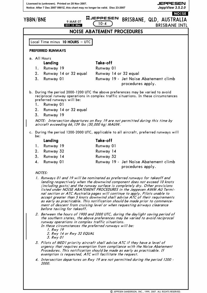
b. During the period 2000-1200 UTC the above preferences may be varied to avoidreciprocal runway operations in complex traffic situations. In these circumstancespreferred runways will be:
NOTE: Intersection departures on Rwy 19 are not permitted during this time byaircraft exceeding 66,139 lbs (30,000 kg) MAUW.
c. During the period 1200-2000 UTC, applicable to all aircraft, preferred runways willbe:
NOTES:1. Runways 01 and 19 will be nominated as preferred runways for takeoff and
landing respectively when the downwind component does not exceed 10 knots(including gusts) and the runway surface is completely dry. Other provisionslisted under NOISE ABATEMENT PROCEDURES in the Jeppesen AWM AU Termi-nal section or ATC Australia pages will continue to apply. Pilots unable toaccept greater than 5 knots downwind shall advise ATC of their requirementsas early as practicable. This notification should be made prior to commence-ment of descent from cruising level or when requesting airways clearancebefore taxiing for takeoff.
2. Between the hours of 1900 and 2000 UTC, during the daylight saving period ofthe southern states, the above preferences may be varied to avoid reciprocalrunway operations in complex traffic situations.In these circumstances the preferred runways will be:
1. Rwy 192. Rwy 14 or Rwy 32 EQUAL3. Rwy 01
3. Pilots of MED1 priority aircraft shall advise ATC if they have a level ofurgency that requires exemption from compliance with the Noise AbatementProcedures. This notification should be made as early as practicable. Ifexemption is requested, ATC will facilitate the request.
4. Intersection departures on Rwy 19 are not permitted during the period 1200 -2000.
Local Time minus 10 HOURS10 HOURS10 HOURS10 HOURS = UTC
Notice: After 7 Dec 2007 0901Z, this chart may no longer be valid. Disc 23-2007
JEPPESEN
JeppView 3.5.2.0
YBBN/BNE JEPPESEN
10-4ABRISBANE, QLD, AUSTRALIA
NOISE ABATEMENT PROCEDURES
.NOISE.
| JEPPESEN SANDERSON, INC., 1999, 2007. ALL RIGHTS RESERVED.
BRISBANE INTL
PREFERRED FLIGHT PATHS
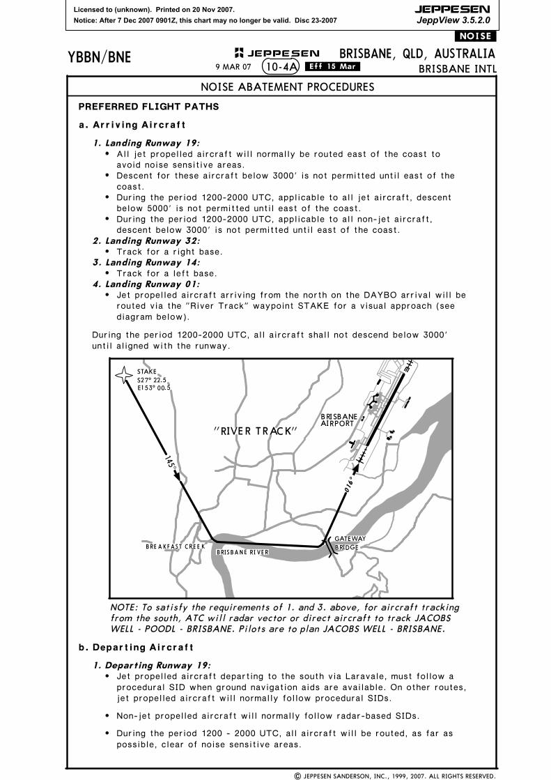
a. Arriving Aircraft
1. Landing Runway 19:All jet propelled aircraft will normally be routed east of the coast to avoid noise sensitive areas.Descent for these aircraft below 3000' is not permitted until east of the coast.During the period 1200-2000 UTC, applicable to all jet aircraft, descent below 5000' is not permitted until east of the coast.During the period 1200-2000 UTC, applicable to all non-jet aircraft, descent below 3000' is not permitted until east of the coast.
2. Landing Runway 32:Track for a right base.
3. Landing Runway 14:Track for a left base.
4. Landing Runway 01:Jet propelled aircraft arriving from the north on the DAYBO arrival will be routed via the "River Track" waypoint STAKE for a visual approach (see diagram below).
NOTE: To satisfy the requirements of 1. and 3. above, for aircraft tracking from the south, ATC will radar vector or direct aircraft to track JACOBS WELL - POODL - BRISBANE. Pilots are to plan JACOBS WELL - BRISBANE.
b. Departing Aircraft
1. Departing Runway 19:Jet propelled aircraft departing to the south via Laravale, must follow a procedural SID when ground navigation aids are available. On other routes, jet propelled aircraft will normally follow procedural SIDs.
BRISBANEAIRPORT
016^
GATEWAYBRIDGE
145^STAKES27^ 22.5E153^ 00.5
RIVER TRACK""
BRE A KFAST C RE E KBRISBA N E RI VE R
During the period 1200-2000 UTC, all aircraft shall not descend below 3000' until aligned with the runway.
9 MAR 07 .Eff.15.Mar.
possible, clear of noise sensitive areas.During the period 1200 - 2000 UTC, all aircraft will be routed, as far as
Non-jet propelled aircraft will normally follow radar-based SIDs.
Licensed to (unknown). Printed on 20 Nov 2007.
Notice: After 7 Dec 2007 0901Z, this chart may no longer be valid. Disc 23-2007
JEPPESEN
JeppView 3.5.2.0
| JEPPESEN SANDERSON, INC., 1999, 2007. ALL RIGHTS RESERVED.
1.1.1.1. Departing Runway 14/32:Departing Runway 14/32:Departing Runway 14/32:Departing Runway 14/32:^ All aircraft will follow radar-based SIDs.
^ Jet propelled aircraft will normally be contained within a sector 360^-120^over water until leaving 5000'.
^ During the period 1200-2000 UTC all aircraft will be contained within a sector360^-120^ over water until leaving 5000'.
2.2.2.2. Departing Runway 01:Departing Runway 01:Departing Runway 01:Departing Runway 01:^ Jet propelled aircraft will normally follow procedural SIDs. Anticipate a
requirement to reach 5000' prior to over flying a residential area.
^ Non-jet propelled aircraft will normally follow radar-based SIDs.
^ During the period 1200-2000 UTC, all aircraft shall expect to be containedwithin a sector 360^-120^ over water until leaving 5000'.
NOTES:1. In the above procedures, the term 'all aircraft ' applies to all jet propelled
aircraft and all other aircraft having two or more engines or having a MTOWexceeding 12,566 lbs (5700 kg).
2. Procedural SIDs issued to jet propelled aircraft all have preferred noiseabatement procedure flight paths.
3. The expectations described above when operating on a Radar SID are to meetNoise Abatement Procedures and are in lieu of nominating specific preferredflight paths.
TRAINING FLIGHTSTRAINING FLIGHTSTRAINING FLIGHTSTRAINING FLIGHTS
a. Circuit training may only be conducted within the period 2000-1200 UTC. Prior ATCapproval required on (07) 3866 3694 or 3866 3512. Restrictions will apply to theperiod 2000-0000.
b. Asymmetric training with an engine shut down is only permitted when a full stoplanding will be made. This procedure shall not be conducted on Rwy 01.
c. Jet and turboprop training and test flights not requiring runway or instrumentapproach procedures shall be flight planned in either.
(i) Low Performance Area (LPA) - within the minor arc between Brisbane VORR030 and R100 from 15 to 30 DME; or
(ii)High Performance Area (HPA) - within the minor arc between Brisbane VORR040 and R090 from 40 to 100 DME.
d. Arriving aircraft may request an instrument approach for training or licencerenewal. The request should be made as early as possible, preferably at flight plan-ning.
e. Instrument approach training available 0000-0700 UTC daily. For other than arrivingaircraft, instrument approach training approval should be sought from ATC on (07)3866 3694.
f. Flight tests should be booked on (07) 3866 3694.
g. RADAR NDB APCH will not be approved in VMC.
h. Within the period 1200-2000 UTC, only the Rwy 19 instrument approach will beapproved. A missed approach from the instrument approach will only be approved ifthe flight is proceeding to Archerfield, or if Rwy 19 is the nominated departure run-way. Otherwise there will be a requirement to land off the approach, and departfrom the duty runway.
i. Aircraft conducting a practice instrument approach can expect to make a landingdue to traffic management requirements. TWR will advise if traffic dispositionallows for a missed approach.
10-4B1 JUN 07.Eff.7.Jun.
Licensed to (unknown). Printed on 20 Nov 2007.
Notice: After 7 Dec 2007 0901Z, this chart may no longer be valid. Disc 23-2007
JEPPESEN
JeppView 3.5.2.0
| JEPPESEN SANDERSON, INC., 2007 ALL RIGHTS RESERVED.
BRISBANE, QLD, AUSTRALIABRISBANE INTL
YBBN/BNE JEPPESEN+
BRISBANE - RUNWAYS 01 AND 19BRISBANE - RUNWAYS 01 AND 19BRISBANE - RUNWAYS 01 AND 19BRISBANE - RUNWAYS 01 AND 19ILS REPLACEMENTILS REPLACEMENTILS REPLACEMENTILS REPLACEMENT
INTRODUCTIONINTRODUCTIONINTRODUCTIONINTRODUCTION
The Instrument Landing System equipment installed on Runways 01 and 19 at Brisbane Airport is to be replaced with new equipment so that a reliable Category One Precision Approach capability can be maintained.
DURATIONDURATIONDURATIONDURATION
The work is scheduled to commence in April 2007 and is anticipated to conclude in November 2007.
Actual times and dates of the work stages will be advised by NOTAM at least 48 hours prior to the commencement of each stage.
The following are the approximate dates for the works stages and the availability of relevant Navigation Aids:30 April - 19 May 200730 April - 19 May 200730 April - 19 May 200730 April - 19 May 2007
RWY 01 GS not AVBL. RWY 01 LOC/DME AND RWY 01 VOR/DME AVBL
20 May - 21 June 200720 May - 21 June 200720 May - 21 June 200720 May - 21 June 2007
RWY 01 ILS not AVBL. RWY 01 VOR/DME AVBL.
27 August - 14 September 200727 August - 14 September 200727 August - 14 September 200727 August - 14 September 2007
RWY 19 GS not AVBL. RWY 19 LOC-Y/DME and RWY 19 LOC-Z/DME and RWY 19 VOR/DME AVBL.
17 September - 25 October 200717 September - 25 October 200717 September - 25 October 200717 September - 25 October 2007
Notice: After 7 Dec 2007 0901Z, this chart may no longer be valid. Disc 23-2007
JEPPESEN
JeppView 3.5.2.0
G1G1
85
84
8382
81
80
79
78
77
75A
76B75B
76A
Gro
und ru
nnin
g of
eng
ines
req
uire
prior
app
rova
l.
Med
ium a
nd hea
vy a
ircr
aft
usin
g Ta
xiway
P req
uiring
to
turn
180
^ mus
t ex
ecut
e max
imum
radi
us tur
ns a
nd rem
ain
from
hig
h st
reng
th e
dge.
Taxi
way
M e
ast of
per
imet
erro
ad des
igna
ted as
apr
ondu
e to
lac
k of
acc
ess ro
ad
to/f
rom m
aint
enan
ce han
gars
.
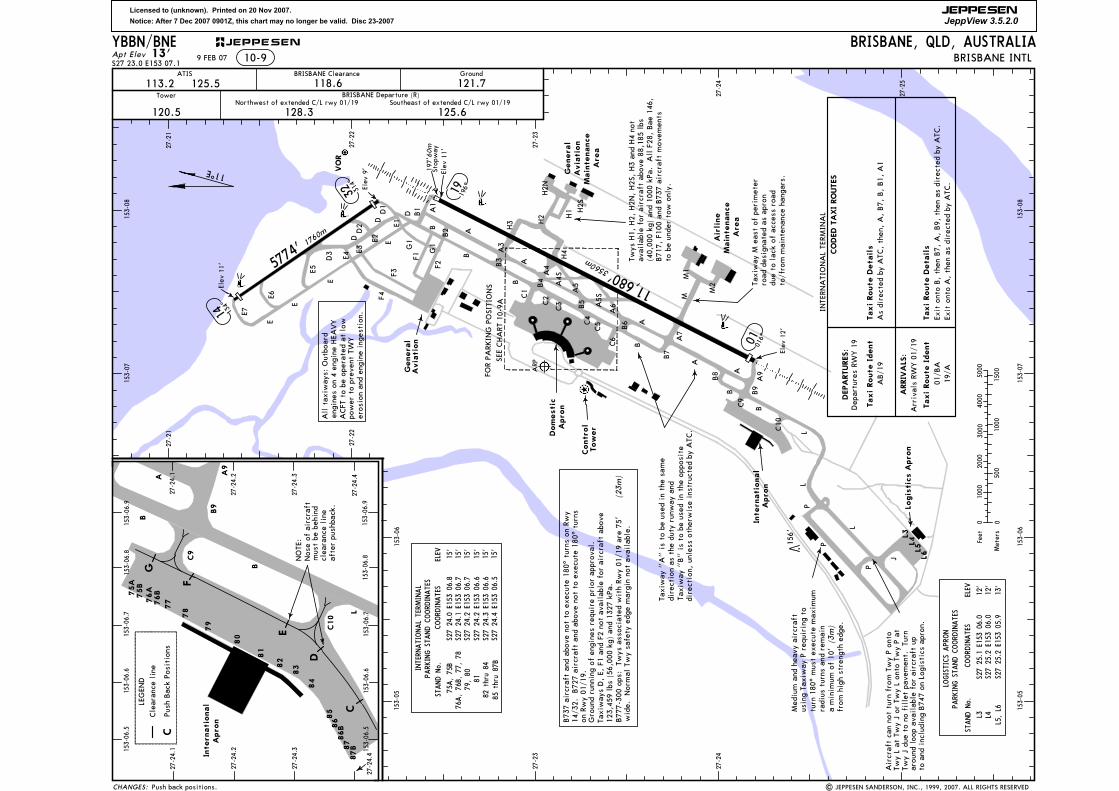
Apt ElevBRISBANE, QLD, AUSTRALIA
BRISBANE INTLS27 23.0 E153 07.1
13' 10-9ATIS BRISBANE Clearance Ground
Tower
120.5
BRISBANE Departure (R)Northwest of extended C/L rwy 01/19 Southeast of extended C/L rwy 01/19
113.2 125.5 118.6 121.7
128.3 125.6
Aircr
aft ca
n no
t tu
rn fro
m Twy P
onto
Twy L at
Twy J or
Twy L on
to Twy P
atTw
y J du
e to
no
fillet
pav
emen
t. Tu
rnar
ound
loo
p av
aila
ble
for ai
rcra
ft up
to a
nd inc
ludi
ng B
747
on Log
istics
apr
on.
wid
e. Nor
mal
Twy sa
fety
edg
e mar
gin no
t av
aila
ble.
B73
7 ai
rcra
ft a
nd a
bove
not
to
exec
ute
180^
tur
ns o
n Rw
y14
/32.
B72
7 ai
rcra
ft a
nd a
bove
not
to
exec
ute
180^
tur
nson
Rwy 01
/19.
Taxi
way
s D, E,
F1
and F2
not
ava
ilab
le for
aircr
aft ab
ove
Twys
H1,
H2,
H2N
, H2S
, H3
and H4
not
avai
labl
e fo
r ai
rcra
ft a
bove
88,
185
lbs
11^E12
3,45
9 lb
s (5
6,00
0 kg
) an
d 13
27 kPa
.
L6L5L4L3
| JEPPESEN SANDERSON, INC., 1999, 2007. ALL RIGHTS RESERVED
Dep
artu
res RW
Y 1
9
Arriv
als RW
Y 0
1/19
Exit o
nto
B, th
en B
7, A
, B9,
the
n as
direc
ted by
ATC
.19
/AEx
it o
nto
A, th
en a
s di
rect
ed by ATC
.
DEPARTURES:
ARRIVALS:
27-21
27-21
27-22
27-22
27-23
27-23
27-24
27-24
27-25
153-05
153-05
153-06
153-06
153-07
153-07
153-08
153-08
86
8786B
87B
YBBN/BNE
(40,
000
kg) an
d 10
00 kPa
. A
ll F28
, Bae
146
,B71
7, F10
0 an
d B73
7 ai
rcra
ft m
ovem
ents
to be
unde
r to
w o
nly.
197'
Stop
way
60m
All tax
iway
s: O
utbo
ard
engi
nes on
4 e
ngin
e HEA
VY
ACFT
to
be o
pera
ted at
low
eros
ion an
d en
gine
ing
estion
.po
wer
to
prev
ent TW
Y
B77
7-30
0 op
s: Tw
ys a
ssoc
iate
d with Rw
y 01
/19
are
75'
(23m)
(3m)
a min
imum
of 10
'
C
D
E
F
G
mus
t be
beh
ind
Nos
e of
aircr
aft
clea
ranc
e line
afte
r pu
shba
ck.
NOTE
:
LEGEN
D
Push
Bac
k Po
sition
s
Cle
aran
ce lin
e
C
9 FEB 07
Push back positions.
Taxi Route Ident
Taxi Route Details
AB/1
9
Taxi Route Ident
Taxi Route Details
CODED TAXI ROUTES
01/B
A
INTE
RNATI
ONAL TE
RMIN
AL
As di
rect
ed by ATC
, th
en, A, B7,
B, B1,
A1
L
PL
L
B B9
B8
A9
A
A7
M
B7
BA
B6
C6
C5C4
B5
A6A5S
C3C2C
1B
B
B
01016^
19196^
Elev
11'
A5A
4S
A4
B4
A
H4
H3 H2 H1
A3
B3
A
A1
B2
B1
F 2
F1
F3
F4
D
ED1
D
DD2
E2
E 3
E4D3
E
E5
E 6
E 7
E
General
Aviation
Domestic
International
156'
Control
Tower
General
Aviation
Maintenance
Area
E 1
P
AR P
11,680'356
0m
Elev
12 '
14 134^
314^
32
5774' 1
760m
FOR
PARK
ING P
OSI
TIONS
153-06.6
153-06.5
S27 24.0 E153 06.8
S27 24.1 E153 06.7
S27 24.2 E153 06.7
S27 24.2 E153 06.6
S27 24.3 E153 06.6
Airline
Maintenance
Area
Taxi
way
"A" is to
be
used
in th
e sa
me
E lev
11 '
Ele v
9'
153-06.8
VOR
M1
M2
H2N
H2S
15'
15'
15'
15'
15'
8182 thru 84
75A, 75B
COORDINATES
STAND No.
27-24.4
27-24.3
27-24.2
C9
C10
B
L
B
B9
C9
C10
B
27-24.1
A
International
A9
E
A
J15'
S27 24.4 E153 06.5
79, 80
153-06.7
153-06.9
153-06.9
153-06.8
153-06.7
153-06.6
153-06.5
27-24.1
27-24.2
27-24.3
27-24.4
ELEV
76A, 76B, 77, 78
CHANGES:
Logistics Apron
P
S27 25.1 E153 06.0
S27 25.2 E153 06.0
12'
12'
COORDINATES
STAND No.
PARKING STAND COORDINATES
ELEV
LOGISTICS APRON
L3 L4
S27 25.2 E153 05.9
13'
L5, L6
PARKING STAND COORDINATES
INTERNATIONAL TERMINAL
85 thru 87B
Apron
Apron
Apron
dire
ctio
n as
the
dut
y ru
nway
and
Taxi
way
"B" is to
be
used
in th
e op
posite
dire
ctio
n, unles
s ot
herw
ise
inst
ruct
ed by ATC
.
5000
1500
1000
1000
500
0 0
Feet
Meters
2000
3000
4000
JEPPESEN
SEE CHART
10-
9 A
Licensed to (unknown). Printed on 20 Nov 2007.
Notice: After 7 Dec 2007 0901Z, this chart may no longer be valid. Disc 23-2007
JEPPESEN
JeppView 3.5.2.0
2
1
10-9A
| JEPPESEN SANDERSON, INC., 1999, 2006. ALL RIGHTS RESERVED
The pilot in command is not to commence Take-off without having obtained the assigned departure heading and should advise ATC if the heading is unacceptable.
1
2
2
NDB procedure not authorized.
YBBN/BNE
LOC DME procedure not authorized.
ILS Rwy 01
ILS-Y Rwy 19
ILS-Z Rwy 1911
9 FEB 07
15
16 17
181920
2122
23
24
25
38
3940
41
4344
454647
49 50
57
RWY
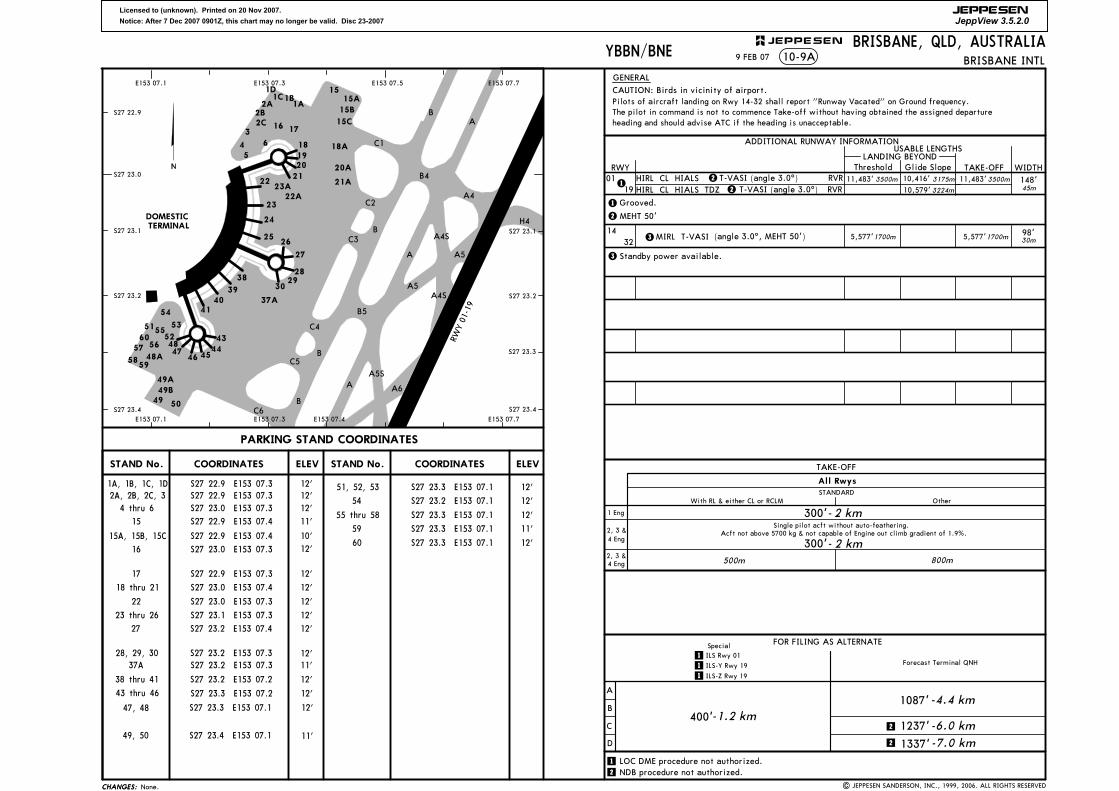
ADDITIONAL RUNWAY INFORMATION
ThresholdLANDING BEYOND
USABLE LENGTHS
WIDTHTAKE-OFFGlide Slope
CHANGES:CHANGES:
GENERAL
B
B
B
B
A
A
A
B4
A4
H4
C1
C2
C3
C4
C5
C6
A6
A5S
A5
A5
A4S
A4S
B5
RWY 01
-19
PARKING STAND COORDINATES
0119
1432
98'30m
148'45m
T-VASI (angle 3.0^) T-VASI (angle 3.0^)
BRISBANE INTL
3500m
BRISBANE, QLD, AUSTRALIA
1
1
Pilots of aircraft landing on Rwy 14-32 shall report "Runway Vacated" on Ground frequency.2A
3
45
6 18A
20A
21A
29
4852
5660
53
54
51
58
55
5948A
49A49B
STAND No. COORDINATES ELEV ELEVSTAND No. COORDINATES
RVRRVR
S27 23.3
E153 07.5
23A22A
4 thru 6 S27 23.0 E153 07.3 12'
S27 22.9 E153 07.4 11'
S27 22.9 E153 07.3 12'
S27 23.0 E153 07.4 12'
S27 23.0 E153 07.3 12'
S27 23.1 E153 07.3 12'
S27 23.2 E153 07.3
S27 23.4 E153 07.1
11'
S27 23.3 E153 07.1 12'
S27 23.2 E153 07.1 12'
S27 23.3 E153 07.1 12'
60 S27 23.3 E153 07.1 12'
12'S27 23.3 E153 07.2
S27 23.3 E153 07.1
11'
12'
FOR FILING AS ALTERNATE
A
B
C
D
400'1087'-4.4 km
1237'
1337'
4 Eng2, 3 &
4 Eng2, 3 &
1 Eng
All Rwys
TAKE-OFF
With RL & either CL or RCLMSTANDARD
Other
Single pilot acft without auto-feathering.
300'-2 km
Acft not above 5700 kg & not capable of Engine out climb gradient of 1.9%.
300'-2 km800m500m
18 thru 21
22
23 thru 26
43 thru 46
47, 48
54
-1.2 km-6.0 km
-7.0 km
S27 23.0 E153 07.3 12'16
17
49, 50
51, 52, 53
59 S27 23.3 E153 07.1 11'
3
3 Standby power available.
3500m 3175m
3224m
11,483' 11,483'10,416'
10,579'
26
27
28
30
12'S27 23.2 E153 07.3
12'S27 23.2 E153 07.238 thru 41
12'S27 23.2 E153 07.427
28, 29, 30
55 thru 58
15A
15B
15C
37A
10'S27 22.9 E153 07.415A, 15B, 15C
37A
E153 07.1
JEPPESEN
TERMINALDOMESTIC
1D
MIRL T-VASI
Grooved.
HIRL CL HIALS HIRL CL HIALS TDZ
15
12'S27 22.9 E153 07.3
12'S27 22.9 E153 07.3
1A, 1B, 1C, 1D
2A, 2B, 2C, 3
2B2C
1C1B1A
(angle 3.0^, MEHT 50')
2 MEHT 50'
22
Forecast Terminal QNH
S27 23.0
S27 22.9
S27 23.1
S27 23.2
S27 23.4
E153 07.3 E153 07.7
S27 23.2
S27 23.1
S27 23.4
Special
CAUTION: Birds in vicinity of airport.
E153 07.7E153 07.4E153 07.3E153 07.1
1700m5,577'1700m5,577'
None.
Licensed to (unknown). Printed on 20 Nov 2007.
Notice: After 7 Dec 2007 0901Z, this chart may no longer be valid. Disc 23-2007
JEPPESEN
JeppView 3.5.2.0
| JEPPESEN SANDERSON, INC., 1999, 2005. ALL RIGHTS RESERVED.
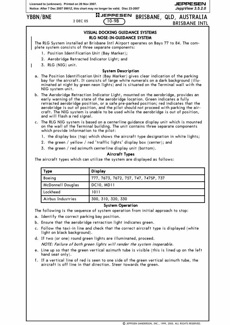
The RLG System installed at Brisbane Intl Airport operates on Bays 77 to 84. The com-plete system consists of three separate components:
1. Position Identification Unit (Bay Marker);
2. Aerobridge Retracted Indicator Light; and
3. RLG (NIG) unit.
System DescriptionSystem DescriptionSystem DescriptionSystem Descriptiona. The Position Identification Unit (Bay Marker) gives clear indication of the parking
bay for the aircraft. It consists of large white numerals on a dark background (illu-minated at night by green neon lights) and is situated on the Terminal wall with theNIG system unit.
b. The Aerobridge Retraction Indicator Light, mounted on the aerobridge, provides anearly warning of the state of the aerobridge location. Green indicates a fullyretracted aerobridge position, or a safe pre-parked position; red indicates that theaerobridge is out of position, and the pilot should not proceed with parking the air-craft. The NIG system is unable to be used while the aerobridge is out of position,and will flash a red signal.
c. The RLG NIG system is based on a centerline guidance display unit which is mountedon the wall of the Terminal building. The unit contains three separate componentswhich provide information to the pilot:
1. the display box (top) which shows the aircraft type designation in white lights;
2. the green / yellow / red 'traffic lights' display box (center); and
3. the green / red azimuth centerline display unit (bottom).
Aircraft TypesAircraft TypesAircraft TypesAircraft TypesThe aircraft types which can utilize the system are displayed as follows:
System OperationSystem OperationSystem OperationSystem OperationThe following is the sequence of system operation from initial approach to stop:
a. Identify the correct parking bay position.
b. Ensure that the aerobridge retraction light indicates green.
c. Follow the taxi-in line and check that the correct aircraft type is displayed (whitelight on black background).
d. If two (or one) round green lights are illuminated, proceed.
NOTE: Failure of both green lights will render the system inoperable.e. Line up so that the green vertical azimuth tube is visible (this is lined up on the left
hand seat only).
f. If a vertical line of red is seen to one side of the green vertical azimuth tube, theaircraft is off line in that direction. Steer towards the green.
TypeTypeTypeType DisplayDisplayDisplayDisplay
Boeing 777, 7673, 7672, 757, 747, 747SP, 737
McDonnell Douglas DC10, MD11
Lockheed 1011
Airbus Industries 300, 310, 320, 330
10-9B2 DEC 05
Licensed to (unknown). Printed on 20 Nov 2007.
Notice: After 7 Dec 2007 0901Z, this chart may no longer be valid. Disc 23-2007
JEPPESEN
JeppView 3.5.2.0
| JEPPESEN SANDERSON, INC., 1999, 2005. ALL RIGHTS RESERVED.
JEPPESENYBBN/BNE10-9C
BRISBANE, QLD, AUSTRALIA
VISUAL DOCKING GUIDANCE SYSTEMS
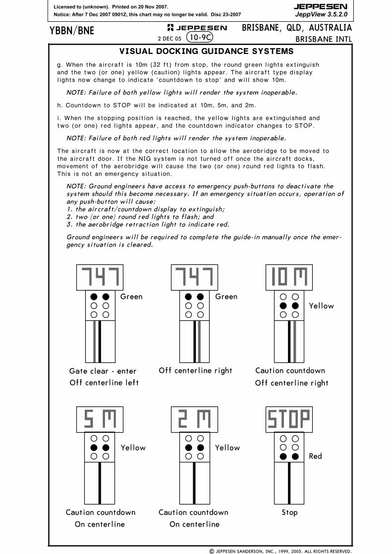
g. When the aircraft is 10m (32 ft) from stop, the round green lights extinguish and the two (or one) yellow (caution) lights appear. The aircraft type display lights now change to indicate 'countdown to stop' and will show 10m.
NOTE: Failure of both yellow lights will render the system inoperable.
h. Countdown to STOP will be indicated at 10m, 5m, and 2m.
i. When the stopping position is reached, the yellow lights are extinguished and two (or one) red lights appear, and the countdown indicator changes to STOP.
NOTE: Failure of both red lights will render the system inoperable.
The aircraft is now at the correct location to allow the aerobridge to be moved to the aircraft door. If the NIG system is not turned off once the aircraft docks, movement of the aerobridge will cause the two (or one) round red lights to flash. This is not an emergency situation.
NOTE: Ground engineers have access to emergency push-buttons to deactivate the system should this become necessary. If an emergency situation occurs, operation of any push-button will cause:1. the aircraft/countdown display to extinguish;2. two (or one) round red lights to flash; and3. the aerobridge retraction light to indicate red.
Ground engineers will be required to complete the guide-in manually once the emer-gency situation is cleared.
Green GreenYellow
RedYellowYellow
Gate clear - enter
Off centerline left
Off centerline right Caution countdown
Off centerline right
Caution countdown Caution countdown
On centerline On centerline
Stop
BRISBANE INTL2 DEC 05
Licensed to (unknown). Printed on 20 Nov 2007.
Notice: After 7 Dec 2007 0901Z, this chart may no longer be valid. Disc 23-2007
JEPPESEN
JeppView 3.5.2.0
| JEPPESEN SANDERSON, INC., 1999, 2005. ALL RIGHTS RESERVED.
BRISBANE, QLD, AUSTRALIABRISBANE INTL
YBBN/BNE JEPPESEN+
VISUAL DOCKING GUIDANCE SYSTEMSVISUAL DOCKING GUIDANCE SYSTEMSVISUAL DOCKING GUIDANCE SYSTEMSVISUAL DOCKING GUIDANCE SYSTEMSSAFEGATE DOCKING GUIDANCE SYSTEM (SAFEGATE DGS)SAFEGATE DOCKING GUIDANCE SYSTEM (SAFEGATE DGS)SAFEGATE DOCKING GUIDANCE SYSTEM (SAFEGATE DGS)SAFEGATE DOCKING GUIDANCE SYSTEM (SAFEGATE DGS)
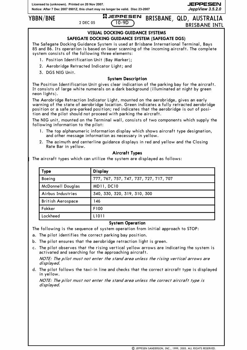
The Safegate Docking Guidance System is used at Brisbane International Terminal, Bays85 and 86. Its operation is based on laser scanning of the incoming aircraft. The completesystem consists of the following three elements:
The Position Identification Unit gives clear indication of the parking bay for the aircraft.It consists of large white numerals on a dark background (illuminated at night by greenneon lights).
The Aerobridge Retraction Indicator Light, mounted on the aerobridge, gives an earlywarning of the state of aerobridge location. Green indicates a fully retracted aerobridgeposition or a safe pre-parked position; red indicates that the aerobridge is out of posi-tion and the pilot should not proceed with parking the aircraft.The NIG unit, mounted on the Terminal wall, consists of two components which supply thefollowing information to the pilot:
1. The top alphanumeric information display which shows aircraft type designation,and other message information as necessary in yellow.
2. The azimuth and centerline guidance displays in red and yellow and the ClosingRate Bar in yellow.
Aircraft TypesAircraft TypesAircraft TypesAircraft TypesThe aircraft types which can utilize the system are displayed as follows:
System OperationSystem OperationSystem OperationSystem OperationThe following is the sequence of system operation from initial approach to STOP:
a. The pilot identifies the correct parking bay position.
b. The pilot ensures that the aerobridge retraction light is green.
c. The pilot observes that the rising vertical yellow arrows are indicating the system isactivated and searching for the approaching aircraft.
NOTE: The pilot must not enter the stand area unless the rising vertical arrows aredisplayed.
d. The pilot follows the taxi-in line and checks that the correct aircraft type is displayedin yellow.
NOTE: The pilot must not enter the stand area unless the correct aircraft type isdisplayed.
TypeTypeTypeType DisplayDisplayDisplayDisplay
Boeing 777, 767, 757, 747, 737, 727, 717, 707
McDonnell Douglas MD11, DC10
Airbus Industries 340, 330, 320, 319, 310, 300
British Aerospace 146
Fokker F100
Lockheed L1011
10-9D2 DEC 05
Licensed to (unknown). Printed on 20 Nov 2007.
Notice: After 7 Dec 2007 0901Z, this chart may no longer be valid. Disc 23-2007
JEPPESEN
JeppView 3.5.2.0
| JEPPESEN SANDERSON, INC., 2005. ALL RIGHTS RESERVED.
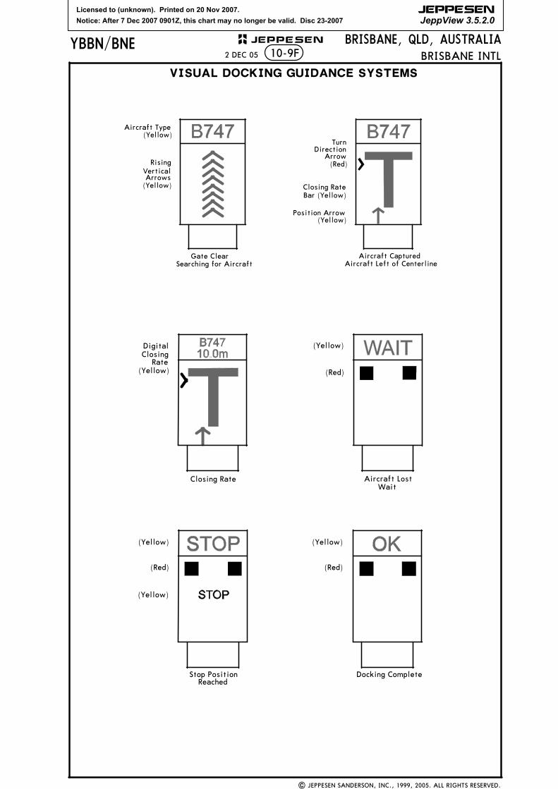
e. On successful capture of the aircraft, the vertical arrows are replaced by the yellowT-shaped Closing Rate Bar.
NOTE: The pilot must not proceed to the bridge unless the arrows have beensuperseded by the Closing Rate Bar.
f. A vertical yellow arrow shows the aircraft position in relation to the centerline.
g. A flashing red arrow indicates the direction to turn to return to the centerline.
NOTE: If the aircraft is approaching faster than the accepted speed, the systemwill show SLOW DOWN as a warning.
h. The display of the yellow digital closing rate countdown will start when the aircraftis 20 meters from the STOP position.
NOTE: If the detected aircraft is lost prior to 12 meters to STOP, the display willshow WAIT. The docking will continue as soon as the system detects the aircraftagain.
i. When the aircraft is 12 meters from the STOP position, the Closing Rate Bar willdecrease in size from the bottom by one row of lights per 0.5 meters closing rate.
NOTE: If the detected aircraft is lost after 12 meters to STOP, the display willshow STOP and ID FAIL. Assistance must then be sought from the ground engi-neers.
j. When the correct STOP position is reached, the display shows STOP and red lightswill be lit.
k. When the aircraft has parked, OK will be displayed.
l. If the aircraft has overshot the position, TOO FAR will be displayed.
m. When ground engineers have placed the chocks at the nosewheel, they will manuallychange the display to CHOCK ON.
n. During heavy rain or fog, the visibility for the docking system might be reduced.When the system is activated and in capture mode, the display will deactivate therising vertical arrows and show DOWN GRADE. This text will be superseded by theClosing Rate Bar once the aircraft is detected.
NOTE: The pilot must not continue the approach to the bridge unless the DOWNGRADE text has been superseded by the Closing Rate Bar.
Ground engineers have access to emergency push-buttons to deactivate the system.When an emergency stop is activated, the display will show STOP. The ground engineerswill then be required to complete the docking manually once the emergency situation iscleared.
10-9E2 DEC 05
Licensed to (unknown). Printed on 20 Nov 2007.
Notice: After 7 Dec 2007 0901Z, this chart may no longer be valid. Disc 23-2007
JEPPESEN
JeppView 3.5.2.0
| JEPPESEN SANDERSON, INC., 1999, 2005. ALL RIGHTS RESERVED.
JEPPESENYBBN/BNE10-9F
BRISBANE, QLD, AUSTRALIA
VISUAL DOCKING GUIDANCE SYSTEMS
BRISBANE INTL
Gate Clear
Aircraft Type(Yellow)
RisingVerticalArrows(Yellow)
TurnDirection
Arrow(Red)
Closing RateBar (Yellow)
Position Arrow
Aircraft Captured
DigitalClosing
Rate(Yellow)
(Yellow)
(Red)
Aircraft LostClosing RateWait
(Yellow)
(Yellow)
(Yellow)
(Red) (Red)
Stop PositionReached
Docking Complete
(Yellow)
Searching for Aircraft Aircraft Left of Centerline
2 DEC 05
Licensed to (unknown). Printed on 20 Nov 2007.
Notice: After 7 Dec 2007 0901Z, this chart may no longer be valid. Disc 23-2007
JEPPESEN
JeppView 3.5.2.0
Archerfield YB(D)-666
YB(D)-675YB(R)-633
187^
YB(D)-672
D12.0
D12.0
D10.0016^
016^
2500
Closed Apt.
4000
MISSED APCH:
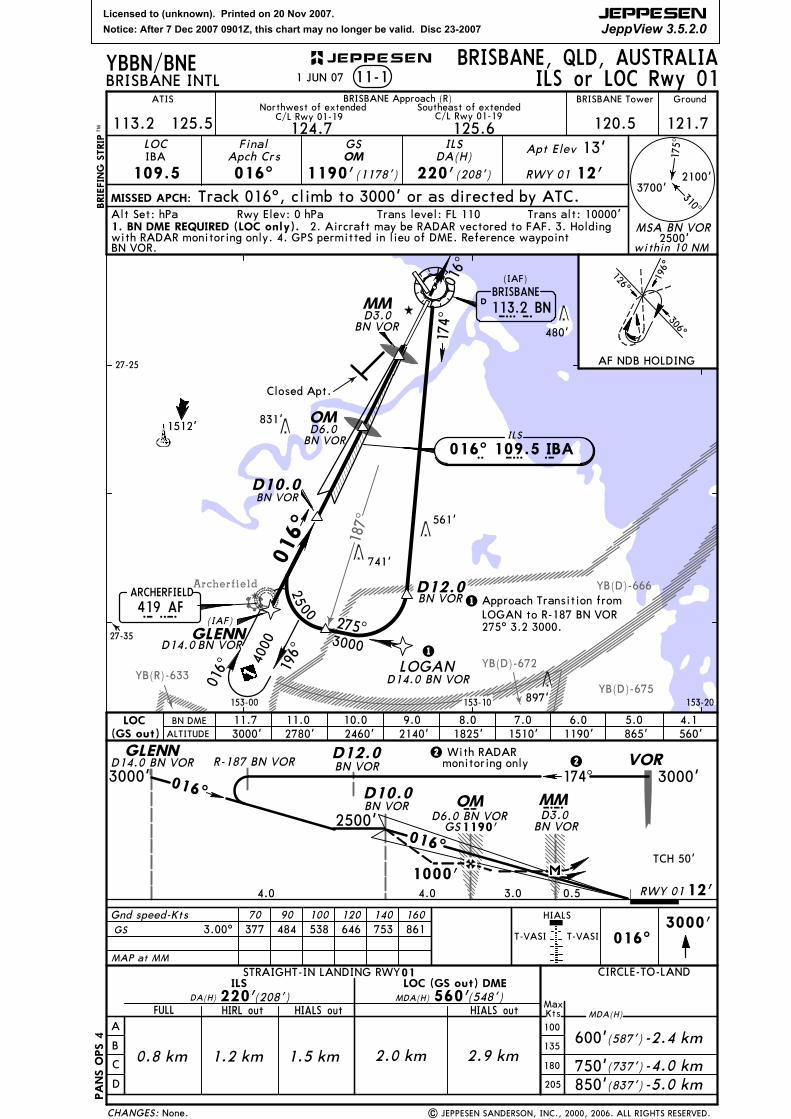
BRISBANE, QLD, AUSTRALIABRISBANE INTL 11-1
ATIS BRISBANE Approach (R) BRISBANE Tower Ground
124.7Northwest of extended
125.6Southeast of extended
120.5LOC
109.5IBA
FinalApch Crs
016^
GSOM
1190'(1178')
ILSDA(H)
220'(208')
Apt Elev 13'
RWY 01 12'
Track 016^, climb to 3000' or as directed by ATC.
113.2 125.5
Gnd speed-Kts 70 90 100 120 140 160
LOGAN
016^ 196^
GLENN
| JEPPESEN SANDERSON, INC., 2000, 2006. ALL RIGHTS RESERVED.