Contraction and extension in northern Borneo driven by subduction rollback Robert Hall ⇑ SE Asia Research Group, Department of Earth Sciences, Royal Holloway University of London, Egham, Surrey TW20 0EX, United Kingdom article info Article history: Available online 22 April 2013 Keywords: Subduction rollback Extension Sabah Palawan abstract During the Paleogene the Proto-South China Sea was subducted beneath northern Borneo. Subduction ended with Early Miocene collision of the Dangerous Grounds/Reed Bank/North Palawan block and the Sabah–Cagayan Arc. Much of northern Borneo then became emergent forming the Top Crocker Unconfor- mity. Later in the Early Miocene subsidence resumed. It is proposed that northward subduction of the Celebes Sea initiated formation of the Sulu Sea backarc basin, followed by subduction rollback to the SE. This formed a volcanic arc, which emerged briefly above sea level and collapsed in the Middle Mio- cene. As rollback continued the Sulu Arc was active during Middle and Late Miocene between Sabah and the Philippines. Rollback drove extension in northern Borneo and Palawan, accompanied by elevation of mountains, crustal melting, and deformation offshore. There were two important extensional episodes. The first at about 16 Ma is marked by the Deep Regional Unconformity, and the second at about 10 Ma produced the Shallow Regional Unconformity. Both episodes caused exhumation of deep crust, probably on low angle detachments, and were followed by granite magmatism. The NW Borneo–Palawan Trough and offshore Sabah fold and thrust belt are often interpreted as features resulting from collision, regional compression or subduction. However, there is no seismicity, dipping slab or volcanicity indicating sub- duction, nor obvious causes of compression. The trough developed after the Middle Miocene and is not the position of the Paleogene trench nor the site of Neogene subduction. Inboard of the trough is a thick sediment wedge composed of an external fold and thrust belt and internal extensional zone with struc- tures broadly parallel to the trough. The trough is interpreted as a flexural response to gravity-driven deformation of the sediment wedge, caused by uplift on land that resulted from extension, with a con- tribution of deep crustal flow. Ó 2013 Elsevier Ltd. All rights reserved. 1. Introduction Northern Borneo is situated relatively far from the subduction boundaries that surround SE Asia, in a region commonly consid- ered part of the Eurasian Plate, or within a SE Asian Plate (McCaf- frey, 1996) or Sundaland Block (Simons et al., 1999) that is moving slowly with respect to Eurasia. It is a region of relatively little seis- micity (Fig. 1), no significant volcanic activity, and apparently low but variable rates of present-day crustal movements relative to Eurasia measured by GPS (Simons et al., 2007). Yet close to the coast of Sabah in northern Borneo is the highest mountain in SE Asia, the 4100 m high Mount Kinabalu, at the northern end of the Crocker Range, which is a Late Miocene granite (Jacobson, 1970; Cottam et al., 2010), and offshore to the northwest of Sabah is a wide fold and thrust belt between the coast and the deep NW Borneo Trough. The trough is south of the oceanic crust of the South China Sea and its extended southern continental margin of Reed Bank and the Dangerous Grounds (Fig. 2). The cause of the northern Borneo offshore fold and thrust belt, and the elevation of the Crocker Range and Mount Kinabalu on land, remain the sub- ject of disagreement and much discussion. Haile (1973) first recognised the role of subduction in the his- tory of northern Borneo, and Hamilton (1979) interpreted the NW Borneo–Palawan Trough as an extinct subduction trench. It is generally agreed that there was subduction of the Proto-South China Sea beneath northern Borneo during the Paleogene. Subduc- tion of the Proto-South China Sea terminated in the Early Miocene after collision of the extended South China continental margin crust/North Palawan block with the active continental margin of Sabah and the Cagayan Arc (Holloway, 1982; Rangin et al., 1990; Tan and Lamy, 1990; Hinz et al., 1991; Hall, 1996; Hutchison et al., 2000; Hall and Wilson, 2000). Oceanic spreading in the South China Sea ceased in the Early or Middle Miocene (Taylor and Hayes, 1983; Briais et al., 1993; Barckhausen and Roeser, 2004). At about the same time there was deformation and uplift of the Crocker Group sediments on Sabah. The exact ages of these events are uncertain but deformation on land in Palawan and Sabah are often 1367-9120/$ - see front matter Ó 2013 Elsevier Ltd. All rights reserved. http://dx.doi.org/10.1016/j.jseaes.2013.04.010 ⇑ Tel.: +44 1784 443592; fax: +44 1784 434716. E-mail address: [email protected]Journal of Asian Earth Sciences 76 (2013) 399–411 Contents lists available at SciVerse ScienceDirect Journal of Asian Earth Sciences journal homepage: www.elsevier.com/locate/jseaes
Transcript
Journal of Asian Earth Sciences 76 (2013) 399–411
Contents lists available at SciVerse ScienceDirect
Robert Hall ⇑SE Asia Research Group, Department of Earth Sciences, Royal Holloway University of London, Egham, Surrey TW20 0EX, United Kingdom
a r t i c l e i n f o a b s t r a c t
Article history:Available online 22 April 2013
Keywords:Subduction rollbackExtensionSabahPalawan
During the Paleogene the Proto-South China Sea was subducted beneath northern Borneo. Subductionended with Early Miocene collision of the Dangerous Grounds/Reed Bank/North Palawan block and theSabah–Cagayan Arc. Much of northern Borneo then became emergent forming the Top Crocker Unconfor-mity. Later in the Early Miocene subsidence resumed. It is proposed that northward subduction of theCelebes Sea initiated formation of the Sulu Sea backarc basin, followed by subduction rollback to theSE. This formed a volcanic arc, which emerged briefly above sea level and collapsed in the Middle Mio-cene. As rollback continued the Sulu Arc was active during Middle and Late Miocene between Sabahand the Philippines. Rollback drove extension in northern Borneo and Palawan, accompanied by elevationof mountains, crustal melting, and deformation offshore. There were two important extensional episodes.The first at about 16 Ma is marked by the Deep Regional Unconformity, and the second at about 10 Maproduced the Shallow Regional Unconformity. Both episodes caused exhumation of deep crust, probablyon low angle detachments, and were followed by granite magmatism. The NW Borneo–Palawan Troughand offshore Sabah fold and thrust belt are often interpreted as features resulting from collision, regionalcompression or subduction. However, there is no seismicity, dipping slab or volcanicity indicating sub-duction, nor obvious causes of compression. The trough developed after the Middle Miocene and is notthe position of the Paleogene trench nor the site of Neogene subduction. Inboard of the trough is a thicksediment wedge composed of an external fold and thrust belt and internal extensional zone with struc-tures broadly parallel to the trough. The trough is interpreted as a flexural response to gravity-drivendeformation of the sediment wedge, caused by uplift on land that resulted from extension, with a con-tribution of deep crustal flow.
� 2013 Elsevier Ltd. All rights reserved.
1. Introduction
Northern Borneo is situated relatively far from the subductionboundaries that surround SE Asia, in a region commonly consid-ered part of the Eurasian Plate, or within a SE Asian Plate (McCaf-frey, 1996) or Sundaland Block (Simons et al., 1999) that is movingslowly with respect to Eurasia. It is a region of relatively little seis-micity (Fig. 1), no significant volcanic activity, and apparently lowbut variable rates of present-day crustal movements relative toEurasia measured by GPS (Simons et al., 2007). Yet close to thecoast of Sabah in northern Borneo is the highest mountain in SEAsia, the 4100 m high Mount Kinabalu, at the northern end ofthe Crocker Range, which is a Late Miocene granite (Jacobson,1970; Cottam et al., 2010), and offshore to the northwest of Sabahis a wide fold and thrust belt between the coast and the deep NWBorneo Trough. The trough is south of the oceanic crust of theSouth China Sea and its extended southern continental margin of
Reed Bank and the Dangerous Grounds (Fig. 2). The cause of thenorthern Borneo offshore fold and thrust belt, and the elevationof the Crocker Range and Mount Kinabalu on land, remain the sub-ject of disagreement and much discussion.
Haile (1973) first recognised the role of subduction in the his-tory of northern Borneo, and Hamilton (1979) interpreted theNW Borneo–Palawan Trough as an extinct subduction trench. Itis generally agreed that there was subduction of the Proto-SouthChina Sea beneath northern Borneo during the Paleogene. Subduc-tion of the Proto-South China Sea terminated in the Early Mioceneafter collision of the extended South China continental margincrust/North Palawan block with the active continental margin ofSabah and the Cagayan Arc (Holloway, 1982; Rangin et al., 1990;Tan and Lamy, 1990; Hinz et al., 1991; Hall, 1996; Hutchisonet al., 2000; Hall and Wilson, 2000). Oceanic spreading in the SouthChina Sea ceased in the Early or Middle Miocene (Taylor and Hayes,1983; Briais et al., 1993; Barckhausen and Roeser, 2004). At aboutthe same time there was deformation and uplift of the CrockerGroup sediments on Sabah. The exact ages of these events areuncertain but deformation on land in Palawan and Sabah are often
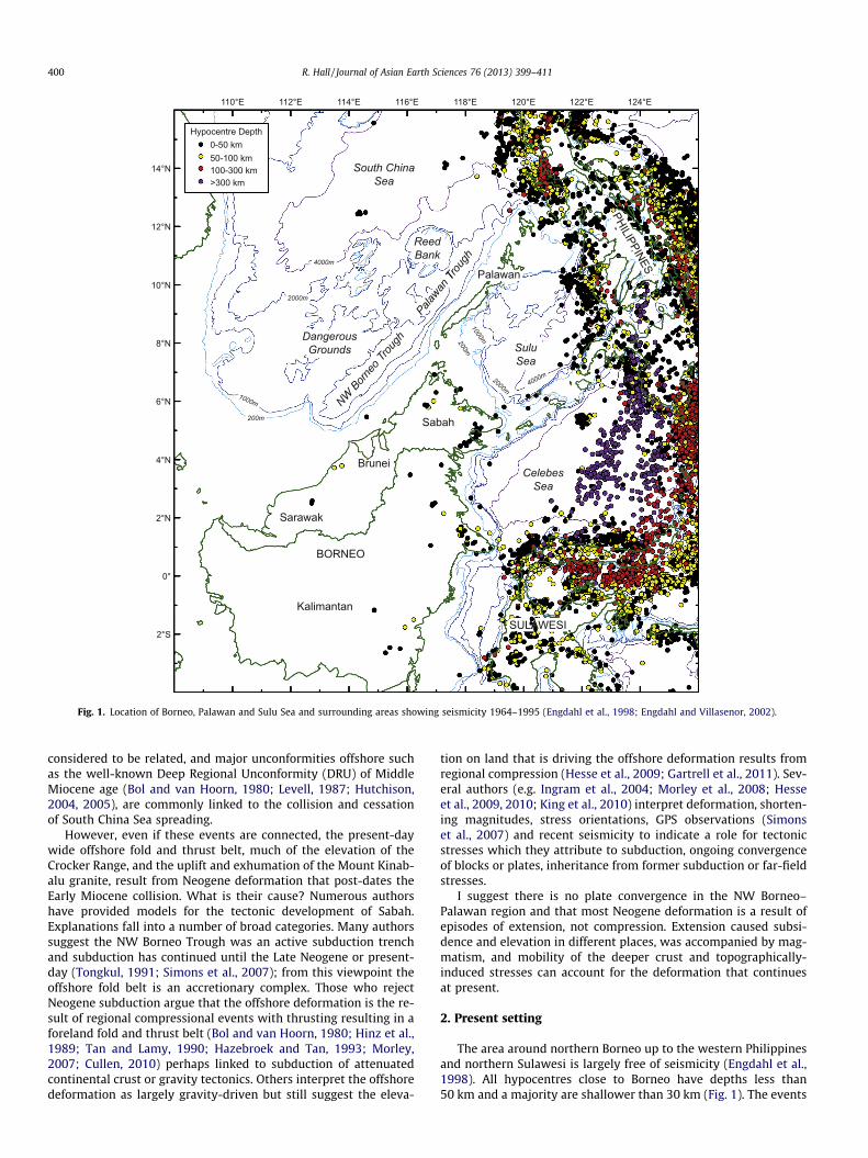
Fig. 1. Location of Borneo, Palawan and Sulu Sea and surrounding areas showing seismicity 1964–1995 (Engdahl et al., 1998; Engdahl and Villasenor, 2002).
400 R. Hall / Journal of Asian Earth Sciences 76 (2013) 399–411
considered to be related, and major unconformities offshore suchas the well-known Deep Regional Unconformity (DRU) of MiddleMiocene age (Bol and van Hoorn, 1980; Levell, 1987; Hutchison,2004, 2005), are commonly linked to the collision and cessationof South China Sea spreading.
However, even if these events are connected, the present-daywide offshore fold and thrust belt, much of the elevation of theCrocker Range, and the uplift and exhumation of the Mount Kinab-alu granite, result from Neogene deformation that post-dates theEarly Miocene collision. What is their cause? Numerous authorshave provided models for the tectonic development of Sabah.Explanations fall into a number of broad categories. Many authorssuggest the NW Borneo Trough was an active subduction trenchand subduction has continued until the Late Neogene or present-day (Tongkul, 1991; Simons et al., 2007); from this viewpoint theoffshore fold belt is an accretionary complex. Those who rejectNeogene subduction argue that the offshore deformation is the re-sult of regional compressional events with thrusting resulting in aforeland fold and thrust belt (Bol and van Hoorn, 1980; Hinz et al.,1989; Tan and Lamy, 1990; Hazebroek and Tan, 1993; Morley,2007; Cullen, 2010) perhaps linked to subduction of attenuatedcontinental crust or gravity tectonics. Others interpret the offshoredeformation as largely gravity-driven but still suggest the eleva-
tion on land that is driving the offshore deformation results fromregional compression (Hesse et al., 2009; Gartrell et al., 2011). Sev-eral authors (e.g. Ingram et al., 2004; Morley et al., 2008; Hesseet al., 2009, 2010; King et al., 2010) interpret deformation, shorten-ing magnitudes, stress orientations, GPS observations (Simonset al., 2007) and recent seismicity to indicate a role for tectonicstresses which they attribute to subduction, ongoing convergenceof blocks or plates, inheritance from former subduction or far-fieldstresses.
I suggest there is no plate convergence in the NW Borneo–Palawan region and that most Neogene deformation is a result ofepisodes of extension, not compression. Extension caused subsi-dence and elevation in different places, was accompanied by mag-matism, and mobility of the deeper crust and topographically-induced stresses can account for the deformation that continuesat present.
2. Present setting
The area around northern Borneo up to the western Philippinesand northern Sulawesi is largely free of seismicity (Engdahl et al.,1998). All hypocentres close to Borneo have depths less than50 km and a majority are shallower than 30 km (Fig. 1). The events
Fig. 2. (A) DEM of the north Borneo–Palawan–Sulu Sea area with satellite gravity-derived bathymetry combined with SRTM topography (Sandwell and Smith, 2009). (B)Principal features of the same area with bathymetry (Gebco, 2003).
R. Hall / Journal of Asian Earth Sciences 76 (2013) 399–411 401
there for which there are moment tensor solutions show an incon-sistent pattern (Simons et al., 2007). In the SE, beneath the CelebesSea and Mangkalihat peninsula, most solutions indicate NE–SWcompression, whereas those further north, mainly beneath thenortheast Sabah coast and the Sulu Sea, suggest predominantlyNW–SE extension and some strike-slip movements.
GPS observations (Simons et al., 2007) indicate active deforma-tion of northern Borneo with small displacements relative to
Sundaland and southern Borneo, suggesting broadly SW-directedmovements up to 8 mm/yr. They must record surface motionsbut there is reason to doubt that the GPS measurements recordthe motions of lithospheric or crustal blocks. Firstly, the motionsare different from those indicated by earthquake solutions. Sec-ondly, the orientation of GPS vectors is different from those ex-pected based on the orientation of structures offshore (e.g.Hazebroek and Tan, 1993; Hutchison, 2005; Hesse et al., 2009;
Central/EasternSabah
Northern Sabah
Western Sabah & Brunei
Ophiolitic basement
Trusmadi Formation
Rajang Group
Crocker Formation
Belait Formation
Setap Shale
MeliganFormation
Temburong Formation
Crocker Formation
Melange
Ophiolitic basement
Rajang Group
Ophiolitic basement
Ophiolitic basement
Labang Formation
Dent/SempornaPeninsula
Kudat Formation
Bongaya Formation
Tanjong Formation
Sandakan Formation
+ + +
KinabaluEmplacement
Central Sabah
Rajang Group
Trusmadi Formation
Ophiolitic basement
Ophiolitic basement
Labang Formation
KalabakanFormation
Tanjong Formation
Kapilit Formation
Central/SouthernSabah
Dent Group
(Volcaniclastic Sediments)
Segama Group
(Igneous Rocks)
Simengaris Formation
Liang Formation
Crocker Formation
Labang Formation
Kulapis Formation
Melange Melange Melange
PLIO
CEN
EM
I O
C E
N E
OLI
GO
CEN
E
PLEISTOCENE
EOC
ENE
PALE
O-
CEN
E
E
L
MES
OZO
ICN
ot to
sca
le
E
L
M
PLU
SRU
DRU
TCU
55
5
10
15
20
25
30
35
50
40
Fig. 3. Simplified stratigraphy of Sabah and Brunei based on Tongkul (1994), Sandal (1996), Noad (1998), Balaguru (2001), Balaguru and Nichols (2004), van Hattum (2005)and van Hattum et al. (2006) and sources therein. Principal unconformities offshore (Bol and van Hoorn, 1980; Levell, 1987; Gartrell et al., 2011) are the PlioceneUnconformity (PLU), Shallow Regional Unconformity (SRU), Deep Regional Unconformity (DRU), and the Top Crocker Unconformity (TCU) of van Hattum (2005) and vanHattum et al. (2006).
402 R. Hall / Journal of Asian Earth Sciences 76 (2013) 399–411
Morley, 2009). Thirdly, almost all the GPS stations are close to thecoast in areas likely to be underlain by weak sedimentary rocks orunconsolidated sediments; thus some of the measurements couldsimply reflect surface movements related to gravity-driven mo-ments for which there is clear evidence offshore (e.g. McGilveryand Cook, 2003; Morley, 2009).
There are no active volcanoes in Sabah. In south Sabah there areremnants of small Quaternary volcanic cones in the Tawau areaand Semporna peninsula (Kirk, 1968), and there are small islandsin Darvel Bay that probably represent Plio–Pleistocene volcaniccentres. These are all close to the southwestern end of the inactiveSulu volcanic arc that links Sabah to Mindanao at the south side ofthe Sulu Sea (Fig. 2). Geochemical evidence suggests that the Plio–Pleistocene volcanic rocks do not record active subduction, but
have an ocean-island basalt (OIB) character that reflects upwellingof OIB melts in the upper mantle into lithospheric thin spots pro-duced during Miocene subduction (Macpherson et al., 2010).
3. Sabah geology and fold and thrust belts
The geology of northern Borneo is described in numerous pa-pers and only a brief summary is given here based on earlier workwhich is well reviewed by Hutchison (2005).
3.1. Pre-Neogene
Sabah has a basement of Mesozoic igneous and metamorphicrocks overlain by a Cenozoic sedimentary cover (Figs. 3 and 4).
Fig. 4. Simplified geological maps of Sabah and Palawan based on Lim and Heng (1985), Almasco et al. (2000), Mines and Geoscience Bureau, Philippines (2011) and Suggate(2011). The location of the section of Fig. 5 is shown.
R. Hall / Journal of Asian Earth Sciences 76 (2013) 399–411 403
The basement includes basic igneous rocks, variably serpentinisedperidotites and Triassic to Cretaceous rocks described as crystallinebasement (Reinhard and Wenk, 1951; Kirk, 1968; Leong, 1974).The latter resemble deformed ophiolitic rocks intruded by arc plu-tonic rocks and have been suggested to represent a Mesozoic intra-oceanic arc (Hall and Wilson, 2000). The peridotites have beeninterpreted as part of a Cretaceous ophiolite (Hutchison, 2005) thatis mainly Middle Jurassic to Early Cretaceous (c. 160–75 Ma) andwas emplaced in the Late Cretaceous or Early Paleogene (New-ton-Smith, 1967; Omang and Barber, 1996). Unusual peridotitesexposed close to Mount Kinabalu have been interpreted to repre-sent sub-continental mantle (Imai and Ozawa, 1991). In Sarawak
(e.g. Tate, 1991; Tate and Hon, 1991) the basement includes iso-lated occurrences of metamorphic rocks that are undated but usu-ally considered to be Carboniferous or older, Permo-Carboniferouslimestones, and volcanic and sedimentary rocks of Triassic andJurassic age.
In southern Sarawak there are widespread terrestrial to mar-ginal marine sedimentary rocks of Late Cretaceous to Eocene age.Elsewhere in Sarawak and Sabah the Mesozoic and older basementrocks are overlain or in faulted contact with a sequence of predom-inantly deep-water turbidites and related deposits of the UpperCretaceous to Eocene Rajang Group. In Sabah deep-water Eoceneto Lower Miocene Trusmadi and Crocker Formations (Collenette,
404 R. Hall / Journal of Asian Earth Sciences 76 (2013) 399–411
1965; van Hattum et al., 2006) were deposited during subductionof the Proto-South China Sea beneath northern Sarawak, Sabahand the Cagayan Arc, southeast of Palawan and were later de-formed as a fold and thrust belt (Taylor and Hayes, 1983; Ranginand Silver, 1991; Tongkul, 1991, 1994; Hall, 1996; Hall and Wilson,2000; Hutchison et al., 2000).
3.2. Neogene
In the Early Miocene the attenuated South China continentalmargin, variously referred to as the North Palawan or DangerousGrounds-Reed Bank Block, collided with northern Borneo and theCagayan Arc, terminating subduction, an event which Hutchison(1996) named the Sabah Orogeny. It deformed and elevated muchof Sabah, and probably Palawan, and produced a major regionalunconformity (Fig. 3), the Top Crocker Unconformity (TCU of vanHattum et al., 2006), now often called the Base Miocene Unconfor-mity (BMU) by oil companies (e.g. Gartrell et al., 2011) and others(Jackson et al., 2009). The TCU is older (Hall et al., 2008) than theDeep Regional Unconformity (DRU) in offshore Sabah (Bol andvan Hoorn, 1980; Levell, 1987) and its approximate equivalent,the Middle Miocene Unconformity (MMU), in offshore Sarawak(Petronas, 1999). Levell (1987) recognised this older unconformityon land in Sarawak and Sabah, and observed it is an angular uncon-formity at the base of the shallow water Meligan Formation, butconsidered the DRU to be more likely related to the end of subduc-tion because it was more extensive, an interpretation advocated bysome later authors (e.g. Clift et al., 2008). I consider the TCU tomark the end of subduction and collision because on land shallowwater deposits rest with a major angular discordance on deformeddeep water rocks, and suggest that offshore this unconformity mayhave been removed by tectonism or erosion associated with theDRU. It is likely that both unconformities are diachronous, but theirapproximate ages are 20–19 Ma for the TCU (Levell, 1987; Balag-uru and Nichols, 2004), and 16–15 Ma for the DRU (Hutchison,2005; Gartrell et al., 2011).
The collision caused emergence of much of Sabah and the pres-ent central highlands of northern Borneo, with folding and thrust-ing of both basement and cover. However, by the end of the EarlyMiocene much of present-day Sabah was below or close to sea le-vel (Noad, 1998; Balaguru et al., 2003; Hall et al., 2008) with prob-ably a low elevated range of hills at the position of the CrockerMountains. Because there are few Neogene rocks in western Sabahthis is uncertain, but in Brunei and Sarawak Neogene rocks are pre-served and the shelf edge moved broadly northwestwards from theMiddle Miocene onwards (e.g. Sandal, 1996; Hazebroek and Tan,1993; Hutchison, 2005; Cullen, 2010), suggesting a gradual riseand widening of the Crocker Mountains during the Middle and LateMiocene. To the west of the shelf edge in offshore Brunei and Sa-bah, and north of the West Baram Line, is a thick Middle Mioceneto Recent deep-water clastic wedge that thins northwards. This isdeformed by folds and thrusts to form a wide and active fold andthrust belt between the coast and the NW Borneo Trough (Tanand Lamy, 1990; Hazebroek and Tan, 1993; Hinz et al., 1989;McGilvery and Cook, 2003; Morley et al., 2003; Ingram et al.,2004; Franke et al., 2008, 2011; Morley and Leong, 2008; Hesseet al., 2009; Gartrell et al., 2011).
To the east of the Crocker Mountains during the Middle andLate Miocene there was subsidence and deposition of a thick suc-cession of fluvio-marine deposits (Noad, 1998; Balaguru et al.,2003; Balaguru and Nichols, 2004) in the Central Sabah Basin(Hutchison, 1992) whose remnants are now found in the circularbasins of eastern Sabah (Tjia et al., 1990; Tongkul, 1993; Clennell,1996; Balaguru et al., 2003; Tongkul and Chang, 2003).
While sediments were being deposited in the Central Sabah Ba-sin and offshore to the west of Sabah in the Middle and Late
Miocene, there was important igneous activity in the region. TheSulu Sea was opening, and the Sulu volcanic arc formed above anorthwest-dipping subduction zone on its south side (Hall andWilson, 2000; Hall, 2002; Chiang, 2002). The Sulu arc can be tracedon land into the Semporna and Dent peninsulas of south Sabah. Inthe centre of the Crocker Mountains the Kinabalu granite was in-truded between 8 and 7 Ma (Cottam et al., 2010). Low temperaturethermochronology (Cottam et al., in press) suggests the granitewas intruded into mountainous terrain indicating that the CrockerRange existed at this time but based on the inferred positions ofthe NW Sabah shelf edge, and the distribution of sedimentary rocksin the circular basins, it must have been much narrower than today(Hall and Nichols, 2002; Morley and Back, 2008).
Sabah became fully emergent only at the end of the Miocene orEarly Pliocene (Collenette, 1965; Balaguru et al., 2003; Tongkul andChang, 2003; Morley and Back, 2008). The glaciated summit pla-teaus and Pleistocene glacial tills (Collenette, 1958) of the Kinabaluarea, and similar deposits near to Mount Tambuyukon, indicatethat the summits of Kinabalu, Tambuyukon and possibly Trusmadi,were significantly higher than other parts of the Crocker Range bythe Pleistocene.
4. Problems
The Neogene to Recent deformation offshore, and the elevationof the present Crocker Mountains has been interpreted mainly interms of convergence and compression. Hamilton’s (1979) sugges-tion that the NW Borneo Trough was a trench has been accepted bymany authors who interpret Neogene subduction to have contin-ued to the present (e.g. Simons et al., 2007; Sapin et al., 2011),implying the offshore fold and thrust belt is an accretionary prismrelated to convergence between the Dangerous Grounds and Sa-bah, even though Hamilton suggested the ‘trench’ was extinct.Hinz et al. (1989) interpreted the offshore fold and thrust belt asreflecting a continent–continent collision, and they inferred regio-nal compression to have induced major thrusting that has contin-ued until today, a commonly held view (e.g. Ingram et al., 2004;Gartrell et al., 2011). In contrast, the fold and thrust belt has beeninterpreted as a mainly gravity-driven phenomenon (e.g. Hazeb-roek and Tan, 1993), analogous to the deep-water fold and thrustbelt of the Niger Delta (cf. Corredor et al., 2005). Hesse et al.(2009) have shown that the amount of contraction in the outboardfold belt is not fully matched by the amount of extension in the in-board region offshore and concluded that there must be a compo-nent of tectonic shortening that increases northwards, and othershave suggested the gravity-driven deformation is ultimately linkedto regional compression (e.g. Morley, 2007; Gartrell et al., 2011).However, there are many problems with regional compressionalhypotheses.
4.1. Sulu Sea spreading
Hutchison (1992) drew attention to the location, age and signif-icance of the Sulu Sea and the importance of extension from thelate Early Miocene. The ocean drilling program (ODP) drilled threeSulu Sea sites and Site 768 in the centre of the SE Sulu basin (Fig. 2)provided the most complete section (Silver et al., 1991). There is abasaltic basement dated at 18.8 Ma, with a thin clay cover inter-preted as deposited below the CCD, suggested to be oceanic crust(Silver and Rangin, 1991). This is overlain by volcanic rocks andvolcaniclastic sediments, interpreted as deposited in a subaerialor shallow marine setting, in turn overlain by brown claystonestypical of pelagic sedimentation below the CCD of late Early toearly Middle Miocene age (Nichols et al., 1990). The site is nowat a water depth of 4385 m. Seismic lines (Rangin, 1989; Rangin
R. Hall / Journal of Asian Earth Sciences 76 (2013) 399–411 405
and Silver, 1991) indicate the entire sequence is cut by extensionalfaults associated with rifting. This sequence indicates extensionhad begun by about 19 Ma, producing oceanic crust, with a volca-nic arc sequence constructed on top of the basement which be-came emergent, and later the entire arc sequence subsided topelagic depths by about 15–14 Ma. Using backstripping anddecompaction techniques for Site 768 Huang et al. (1991) high-lighted high rates of basement subsidence in the Sulu Sea between19–17.7 Ma and 10.7–10 Ma. In passing it is worth noting that theSE basin of the Sulu Sea is often described as oceanic crust, but onlyat Site 768 was basaltic crust encountered at the base of the sec-tion, and this is overlain by a volcanic sequence with arc-like char-acter. At both the other drilled sites in the Sulu Sea, at depthsbetween 2856 and 3645 m, the oldest rocks drilled are probablelate Early Miocene volcaniclastic rocks, considered to have beendeposited at depths no greater than 1000 m (Nichols et al., 1990)and suggested to have been erupted from a subaerial or shallowmarine vent. Middle Miocene faunas in claystones indicate rapidand significant early Middle Miocene subsidence. Thus, the partsof the deep SE Sulu Sea basin that have been drilled appear to bean extended and subsided volcanic arc built on oceanic crust,rather than normal oceanic crust.
Before the ODP drilling Rangin (1989) suggested the Sulu Seawas a backarc basin formed above a northwest-dipping slab dueto subduction of the Celebes Sea and he also drew attention to laterNeogene episodes of extension on Sabah interpreted to be relatedto this subduction. After ODP drilling, Rangin and Silver (1991) pre-ferred a model in which the Sulu Sea formed behind a southeast-dipping slab related to subduction of the Proto-South China Sea.Hutchison (1992) remarked that the arc–trench system of the Suluarc had migrated southeastwards, in what today would be de-scribed as a rollback setting. Geochemical data (Chiang, 2002)and other arguments (Hall and Wilson, 2000) also favour Rangin’s(1989) original suggestion of northward subduction of the CelebesSea to form the Sulu Arc, post-dating collision of the Reed Bankblock with the Cagayan volcanic arc and elevation of Palawan.
4.2. Sediments from Palawan in Early Miocene
Sediment provenance studies also favour collision in Palawan inthe Early Miocene before formation of the Sulu Sea. At the north-ernmost tip of Sabah the Lower Miocene Kudat Formation shallowmarine sandstones rest unconformably on deformed CrockerGroup rocks above the TCU. The Kudat Formation has a lowermember with an unusual heavy mineral assemblage that includesabundant garnet, kyanite and zircon (van Hattum, 2005; van Hat-tum et al., in press). Kyanite is unknown from potential sources onBorneo, but is found on Palawan (Encarnación et al., 1995) and gar-nets are well matched to sources on Palawan (Suggate, 2011; Sug-gate and Hall, in press). Zircons also indicate a Palawanprovenance. In contrast, the upper member of the Kudat Formationsuggests derivation almost entirely from central Borneo. Thesedata indicate elevation of Palawan, interpreted to be the result ofEarly Miocene collision of the North Palawan block, resulting insouth-flowing rivers that carried sediment into shallow marineareas of northern Sabah. The supply of sediment from Palawan toSabah was very short-lived and the termination of this supply issuggested here to mark the beginning of extension leading to for-mation of the Sulu Sea by about 19 Ma.
4.3. Unusual position of Kinabalu, Tambuyukon, Trusmadi
The mountains of western Sabah, the Crocker Range, strikebroadly N to NNE in what is known as the NW Borneo trend (Boland van Hoorn, 1980; Hinz et al., 1989; Hazebroek and Tan,1993). This trend is oblique to the NW Borneo Trough and parallel
to the strike of the Crocker Formation (Tongkul, 1990, 1991) in theEarly Miocene collisional fold and thrust belt. The fold belt changesorientation abruptly through 90� at the position of Mt Kinabaluand its strike in northernmost Sabah is parallel to the E to ESE Sulutrend (Fig. 2).
Normally the highest parts of a mountain range are found at itscentre, but the highest peaks of the Crocker Range, Mounts Kinab-alu, Tambuyukon and Trusmadi (Fig. 4), are close to its northern-most end. The mountain range is thus longitudinally highlyasymmetrical. The highest peaks are less than 150 km from thecoast of the Sulu Sea, and 250 km to the NE water depths exceedtwo kilometres, whereas the mountain belt descends gently tothe SSW over a distance of more than 750 km. These peaks exposerocks from relatively deep in the crust, including low to mediumgrade metamorphic phyllites and schists at Trusmadi, peridotitesat Kinabalu and Tambuyukon, and the well-known granite intru-sion at Kinabalu.
If, however, it is assumed that the NW Sulu Sea basin is an ex-tended part of the mountain belt, and the Palawan segment of themountain range is restored, the longitudinal symmetry is that ex-pected of other mountain belts. This interpretation implies that theextension post-dates the Early Miocene, as expected from the agesof volcanic rocks drilled in the Sulu Sea.
4.4. Movement of shelf edge
In Brunei and offshore Sabah, the position of the shelf edge atdifferent times can be identified (Hazebroek and Tan, 1993; Sandal,1996) showing that it moved seaward during the last 15 millionyears. This indicates that the Crocker Ranges were narrower about15 million years ago, and have widened gradually with time. Rice-Oxley (1991) and Hutchison (2005) show a similar pattern for off-shore Sabah, confirmed by Cullen (2010). In offshore Brunei andNW Sabah Morley et al. (2008) noted that inversion, thrustingand uplift of the present-day onshore area and inner shelf occurredduring the Middle Miocene to Pliocene, while a deepwater fold andthrust belt developed during the latest Miocene to Holocene. Therewas a seaward shift of deformation with time consistent with themovement of the shelf edge. This pattern is apparently consistentwith a developing fold and thrust belt driven by regional compres-sion, but is inconsistent with the history of eastern Sabah.
4.5. Neogene sedimentation in eastern Sabah
After collision in the Early Miocene there was a brief period oferosion (van Hattum et al., 2006, in press; Hall et al., 2008) whichformed the TCU on land and offshore. However, soon after theemergence of much of present-day Sabah, the situation changedagain. Although a narrow band of mountains probably remainedalong the present spine of the Crocker Ranges, the areas to the westand east subsided below sea level and sedimentation resumed.West of the Crocker Ranges there was deposition of thick sedi-ments, initially in what are now deltas and coastal plains of Bruneiand Sabah, and later in offshore areas, by rivers flowing to the westor northwest.
In eastern Sabah there was a wide Central Basin east of theCrocker Range (Hutchison, 1992; Noad, 1998; Balaguru et al.,2003; Tongkul and Chang, 2003; Balaguru and Nichols, 2004). Mostof the lower Middle to Upper Miocene sediment fed into this basinand carried to the Sulu Sea came from the Borneo interior. Riverand shallow marine sediments are now preserved in a number ofstructures described as circular basins, which are deformed rem-nants of the much larger basin supplied by a large river system,flowing broadly northeast, which deposited sand and mud in a riv-er, delta and coastal plain complex. This subsidence providedaccommodation space for the accumulation of several kilometres
406 R. Hall / Journal of Asian Earth Sciences 76 (2013) 399–411
of Neogene sediment, variously estimated on land to be more than6 km (Balaguru and Nichols, 2004), more than 7.5 km (Tongkul andChang, 2003), or more than 18 km (Collenette, 1965), and offshorein the Sandakan Basin to be 15 km thick (Graves and Swauger,1997). It occurred at the same time as extension in the Sulu Sea,and is generally considered to be related to the extension (Hutch-ison, 1992; Tongkul, 1993). Extension and subsidence are difficultto reconcile with suggestions of long-term Neogene regional com-pression in Sabah, sometimes linked to even larger scale regionalcauses such as collision in Sulawesi (e.g. Cullen, 2010).
4.6. Sulu Sea fold and thrust belt
It is now commonly accepted that some of the offshore defor-mation of NW Borneo can be attributed to shallow gravitationalprocesses. Nonetheless, several authors have highlighted differ-ences between the NW Borneo margin and other well-known grav-ity-driven offshore fold and thrust belts such as the Niger Delta(e.g. Morley et al., 2008; Hesse et al., 2009; King et al., 2010) basedon differences in modern stress patterns, and the observation thatin parts of the deepwater fold and thrust belt there is more con-traction than extension in the Neogene sedimentary section. Thishas been used to suggest that there is broadly NW–SE regionalcompression which may be the result of subduction, convergenceof blocks or plates, or far-field stresses, such as India-Asia collisionor deformation in Sulawesi.
Little is published concerning the offshore area to the NE of Sa-bah at the margins of the Sulu Sea, yet on land the structural grainis completely different from west Sabah (Fig. 2), changing from Nto NNE (NW Borneo trend) to E to ESE (Sulu trend) (Bol and vanHoorn, 1980; Hinz et al., 1989; Hazebroek and Tan, 1993; Tongkul,1991, 1994). There is some information offshore from the Sanda-kan basin obtained during hydrocarbon exploration but structuresand stratigraphy are not yet documented in detail; the few pub-lished data show thrusts on one seismic line which includes struc-tures described as toe-of-slope compressional folds (Graves andSwauger, 1997) at the basinward end of a thick sedimentary sec-tion (Wong, 1993). Offshore fold axes and thrusts are apparentlybroadly parallel to the Sulu trend.
The key point is that the Sandakan basin and Sulu Sea marginsare generally ignored in discussion of regional compression yet theorientation of structures appears completely inconsistent with thedirection of stresses required to produce the offshore fold andthrust belt of NW Sabah and Brunei. The suggested microplates(e.g. Simons et al., 2007) based on GPS observations, and the defor-mation history and structural trends in eastern Sabah (Balaguru,2001; Balaguru et al., 2003; Tongkul and Chang, 2003) are similarlyincompatible. The few authors that include the Sulu trend (e.g.Rangin et al., 1990; Tongkul, 1991; Ingram et al., 2004) show thesupposed subduction system bending at right angles round north-ern Borneo, suggesting a major reorientation of regional stresses,or link the NW Borneo Trough to strike-slip faults, implying thatthe apparent continuity of the NW Borneo and Palawan Troughsis coincidental.
4.7. The NW Borneo Trough and Palawan Trough
Hutchison (2010) provided a review of previous interpretationsof the NW Borneo and Palawan Troughs to which he added newinformation based on seismic lines from oil companies and data ac-quired during Malaysian Law of the Sea investigations. On seismiclines perpendicular to the Borneo margin the trough and fold andthrust belt resemble a subduction trench and accretionary com-plex. However, there is no seismicity below or landward of thetrough such as might be associated with a subducting slab,although deformation of the seabed above the fold and thrust belt
indicates active deformation (e.g. McGilvery and Cook, 2003; Mor-ley, 2007, 2009; Clift et al., 2008). Hesse et al. (2009) have shownthat the contraction in the outboard fold belt is largely balancedby extension in the inboard shelf region, but concluded that therewas an excess of shortening in the northern part of their studiedarea, west of Mount Kinabalu, which they interpret to require base-ment-driven compression.
Published seismic studies show evidence of repeated failures ofthe shelf edge and movement into deep water of mass transportcomplexes (e.g. McGilvery and Cook, 2003; Morley and Leong,2008; Morley, 2009) which were then folded. Multiple episodesof folding (Morley et al., 2003; Ingram et al., 2004; Gartrell et al.,2011) indicate contraction of the fold and thrust belt offshorebut do they require regional compression to drive this? Since muchof the contractional deformation recorded in Brunei and offshoremust have occurred while east Sabah was subsiding to form theCentral Basin, now preserved as remnants in the circular basins, re-gional compression is incompatible with regional extension sug-gested above to be the cause of this subsidence.
Hall (2011) suggested the imbalance measured by Hesse et al.(2009) could be accounted for by including extension on landand observed that the deepest part of the trough is immediatelyNW of the highest point on land, Mount Kinabalu. This interpreta-tion suggests a link between rapid and young uplift on land, evi-denced by exhumation of the 7–8 Ma Kinabalu granite nowexposed at 4 km above sea level and the surrounding CrockerRange, and subsidence offshore. From this it follows that the off-shore fold and thrust belt, and major shelf failures producing hugedeep water mass transport complexes, are the result of uplift andextensional faulting on land.
At its SW end the trough ends abruptly at the West Baram Line(Fig. 2). This is not an active fault (cf. Ingram et al., 2004), nor afault active during the Neogene (cf. Clift et al., 2008), as it has noexpression in the Neogene section on seismic lines offshore, noron high resolution SRTM or ASTER imagery of Borneo on whichpost-Eocene structures can be traced along the fold belt on landwithout offset.
The trough is here interpreted as a flexural depression due toloading by the fold and thrust belt onto the thinned continentalcrust of the Dangerous Grounds and is associated with a flexuralbulge in the Dangerous Grounds west of the trough. This interpre-tation is supported by the presence of elevated features within theNW Borneo Trough at water depths up to 3 km which are cappedby carbonates and pinnacle reefs, indicating major subsidence.Some of these are draped by sediments whereas others have nosediment cover and are surrounded by flat lying sediments in thewide trough. Unfortunately, none of these features are dated, butsome features capped by carbonate pinnacles (see Fig. 10 in Hutch-ison, 2010) imply a phase of rapid subsidence from close to sea le-vel to water depths of more than 1.7 km, and the complete absenceof any sedimentary cover suggests this was relatively recent.
The NW Palawan margin has been described in a number ofpublications (Holloway, 1982; Hinz and Schlüter, 1985; Hinzet al., 1985, 1991). Sections from the Sulu Sea to Reed Bank byRangin and Silver (1991) interpret it as a imbricated accretionarythrust zone, with an overthrust ophiolite rooted in the Sulu Seaobducted before collision of the Cagayan arc and the Reed Bankmicrocontinent in the Early–Middle Miocene. However, the south-ern edge of the Palawan Trough is not a thrust front (Hinz et al.,1985), as would be expected for a subduction zone, or by compar-ison with the NW Borneo Trough. The northern continuation of thePalawan Trough is a broad deep water area separating Reed Bankfrom Palawan and the Calamian Islands. Relatively poor qualityvintage seismic lines in this area appear to show a rifted sectionrecording separation of a microcontinental block from South Chinain the Eocene (Hinz et al., 1985, 1991; Morado and Poblete, 1997).
R. Hall / Journal of Asian Earth Sciences 76 (2013) 399–411 407
Recent high quality data (Franke et al., 2011) show there is a com-plex wide continent–ocean transition which was part of the SouthChina Sea continental margin that was hyper-extended before col-lision in Palawan. There is no indication of thrusting at the site ofthe trough. Thrusting is observed only close to Palawan. Industryseismic lines (Forbes et al., 2011) show the rifted sequence isapparently unaffected by younger deformation although there isa thrusted package higher in the section.
4.8. Granite magmatism
Two small granite bodies are known from the axis of the NE–SWoriented elevated region running from Sabah to Palawan. TheCapoas granite of Palawan is dated as 14–13 Ma (Encarnaciónand Mukasa, 1997; Suggate et al., in press) and the Kinabalu gran-ite of Sabah as 8–7 Ma (Cottam et al., 2010). Both contain zirconsthat indicate a contribution to the melt of old continental crustinterpreted in both cases to be South China extended continentalcrust underthrust during the Early Miocene collision (Fig. 4). Enc-arnación and Mukasa (1997) described the Capoas granite as ‘anor-ogenic’ and interpreted it to be the result of partial melting ofSouth China crust in a setting unrelated to subduction or collision.Cottam et al. (2010) argued that the Kinabalu granite cannot be re-lated to subduction. I suggest that both are the products of exten-sional thinning of the crust during the Neogene as explainedbelow.
4.9. Thinned crust beneath the offshore fold belt
Northwest of the Crocker Range is the very thick Neogene sed-iment wedge, including the offshore fold and thrust belt. Milsomet al. (1997) interpreted crustal thinning beneath the NW BorneoTrough, based on gravity data, which they assumed must pre-dateNeogene basin formation. Recent studies based on seismic refrac-tion and gravity data (Fig. 5) show the maximum thinning of con-tinental crust beneath the sediment wedge (Franke et al., 2008; C.Foss, pers. comm., 2008). This is a surprising observation since thecrust would be expected to be relatively thick in this region as a re-sult of thickening during the Early Miocene collision of the Danger-ous Grounds microcontinental block and the Sabah activecontinental margin (e.g. Hall and Wilson, 2000; Hutchison et al.,2000; Morley et al., 2011). If subduction had continued duringthe Neogene with underthrusting of the thinned DangerousGrounds continental crust, this would also lead to thickening, aswould basement involvement in the fold and thrust belt inter-preted by many authors (e.g. Bol and van Hoorn, 1980; Gartrellet al., 2011; Morley et al., 2011; Sapin et al., 2011). I suggest thin-ning observed beneath the thickest part of the Neogene clastic
Fig. 5. Interpreted cross section across Sabah. Thickness of crust and structure from the(2009). Thickness of crust beneath Sabah guided by Holt (1998) but modified to allow fRange are interpreted to have a continental crustal root of South China continental crustduring Middle Miocene extension, into which the Kinabalu granite was intruded after mformer Sabah margin (Cottam et al., 2010).
wedge requires either extensional faulting or crustal flow (Hall,2011; Morley et al., 2011) of the continental crust below the off-shore fold and thrust belt.
5. Alternative explanation
Although the Early Miocene deformation in Sabah is well ex-plained by collision resulting from subduction and convergenceof extended South China Sea continental crust of the DangerousGrounds/Reed Bank/North Palawan block with the NE–SW ori-ented Sabah-Cagayan Arc active margin, the younger fold andthrust belt deformation offshore is much more difficult to reconcilewith such an interpretation. I therefore suggest an interpretation ofthe geology and tectonics in terms of extension (Fig. 5). A possiblescenario is as follows (Fig. 6).
During the Paleogene the Proto-South China Sea was subductedbeneath northern Borneo (Fig. 6A). Subduction ended with EarlyMiocene collision of the Dangerous Grounds/Reed Bank/North Pal-awan block and the Sabah–Cagayan Arc. Collision caused foldingand thrusting of Sabah and Palawan during the Sabah orogeny ofHutchison (1996). This produced the widespread TCU and elevatedmuch of the region of present onshore Sabah and Palawan abovesea level. This unconformity is Early Miocene in age, c. 20 Ma,and is older than the DRU or MMU. In Sabah the collision juxta-posed and probably tectonically intercalated ophiolitic rocks thathad formed parts of the Sabah basement, the Crystalline Basement,some of which may be part of the underthrust South China Seacontinental crust, and deep water sedimentary rocks of the RajangGroup and Crocker Group (Fig. 5). In Palawan, the ophiolites prob-ably include oceanic and arc rocks added to the South China Seacontinental margin in the Late Cretaceous, as well as Eocene oceancrust or serpentinised peridotites of the extended DangerousGrounds/Reed Bank/North Palawan block, and they are interca-lated with pre-Mesozoic granites and Mesozoic sedimentary rocksduring collision with the Cagayan Arc. The Palawan part of the oro-genic belt was much wider than Palawan today (Fig. 6B) and sed-iment from it was transported south to the Kudat Formation ofnorthern Sabah (van Hattum et al., in press; Suggate and Hall, inpress).
Rifting began before 19 Ma, assuming that the oldest rocksdrilled in the Sulu Sea were erupted at an oceanic spreading centrein a backarc basin. This was driven by northwestward subductionof the Celebes Sea, which then formed the proto-Sulu Arc volcanicarc that emerged rapidly above sea level, as indicated by ODP dril-ling. However, by about 15–14 Ma, based on drilling at Site 768,the volcanic rocks were below the CCD. I suggest this marks a per-iod of rapid trench rollback to the SE, identified by Hutchison
foldbelt to the Dangerous Grounds based on Franke et al. (2008) and Hesse et al.or higher density crust in the interpreted section. The highest parts of the Crockerthickened during Early Miocene collision. This became an extensional culminationelting of both deep South China continental crust, and crystalline basement of the
408 R. Hall / Journal of Asian Earth Sciences 76 (2013) 399–411
(1992) as the ‘‘southeastwards migrating arc–trench system of theSulu arc’’ which caused splitting of the original arc, extension of theremnant arc accompanied by subsidence, and migration of the ac-tive Sulu arc to the SE (Fig. 6C), in the manner first proposed byKarig (1971). This implies an interval of rapid trench rollback atabout 16 Ma. I suggest it is this rollback that caused widespreadextension that is marked by the DRU, and its correlative conformityin the Sulu Sea margins, which is therefore not a collision-relatedunconformity.
Extension is suggested to have occurred on low angle detach-ments (which may be observed in Palawan – M.A. Forster, pers.comm., 2011) exhuming the stacked thrust complex of ophiolites,continental basement and Mesozoic sediments, and caused thefirst episode of granite magmatism that formed the Capoas graniteat c. 15 Ma. The Capoas (and Kinabalu) granite are suggested toresemble those of the western Mediterranean, such as those in Elbaand Corsica, which are associated with Tyrrhenian Sea extensionand subduction rollback (e.g. Jolivet et al., 1994, 1998; Danieland Jolivet, 1995; Rossetti et al., 2000; Dini et al., 2002, 2009).
The Palawan extension was much greater than that of Sabahwhere the early extension phase that began before 19 Ma wasmarked by widespread subsidence and deposition of sedimentsin the Central Basin of eastern Sabah (Fig. 5), with crustal thinningbut no oceanic crust formation and limited arc volcanism. Stratig-raphy and K–Ar dating of volcanic rocks on Sabah (Kirk, 1962,1968; Haile et al., 1965; Rangin et al., 1990; Bellon and Rangin,1991; Swauger et al., 1995) indicate arc activity in the Sempornaand Dent peninsulas of Sabah may be as old as Early Mioceneand was certainly widespread in the Middle and Late Miocene. Thisarc activity was at the SW end of the Sulu Arc.
Models of core complexes and low angle-detachments (Davisand Coney, 1979; Lister and Davis, 1989; Arca et al., 2010) showextension is accompanied by both subsidence and uplift in differ-ent parts of the system. The widening of the elevated region inNW Borneo, indicated by the migration of the shelf edge, is sug-gested to reflect uplift related to extension. There could also be acontribution to uplift by deep crustal flow in response to sedimentloading (Morley and Westaway, 2006; Hall, 2011), and by lacco-
A B
Fig. 6. Cartoons showing the development of Sabah, Palawan and the Sulu Sea area as in(A) Before the Early Miocene Proto-South China Sea oceanic crust was subducted belowcrust of the Dangerous Grounds-North Palawan block south of South China Sea oceansubduction and an extensive area of Sabah and the Palawan region became emergent. (Carc south of Palawan. The Palawan mountains collapsed and the arc then split as rollbackSea. Note that most of the Sulu Sea is not oceanic crust but an extended former volcanic
lithic granite intrusions, both ultimately products of extension dri-ven by subduction rollback (Fig. 5).
I suggest there was another phase of extension, presumably cor-related with rollback, at about 11–10 Ma. This is correlated with anincreased rate of basement subsidence at this time recorded byODP drilling at Site 768, and the Intermediate Unconformity (Boland van Hoorn, 1980; Levell, 1987) and/or the Shallow RegionalUnconformity. This phase of extension was also followed by gran-ite magmatism about 2 million years later, this time in the Kinab-alu area. I suggest the laccolith-like form of the Kinabalu intrusion(Cottam et al., 2010) exploited extensional detachments marked inthe Kinabalu and Tambuyukon areas by extensive areas of partiallyserpentinised peridotites (Fig. 5). In this model (Fig. 5) the crustalthickness beneath Kinabalu and Telupid is approximately 5–10 kmless than that estimated by Holt (1998) based on the assumptionthat the ultrabasic rocks in the upper crust are significantly denserthan the average crustal density of 2.67 Mg/m3 he used. In Palawanthis phase of extension may be marked by gravity-driven thrustsheets that have moved northwards into deeper water above theundeformed older rifted section (Holloway, 1982; Hinz et al.,1991; Forbes et al., 2011).
In Sabah it appears that subduction of the Celebes Sea ceased atthe end of the Miocene (Chiang, 2002), and there was a change inthe Pliocene to basaltic magmatism with an ocean island character(Macpherson et al., 2010). This implies a major change in the char-acter of the mantle beneath the region which could mark slabbreak-off or possible delamination of a lithospheric root beneaththe Crocker Range centred on Kinabalu. Either could explain theupper mantle high velocity anomaly below Sabah centred atdepths of about 250 km on some P wave tomographic models(Bijwaard et al., 1998). Slab break-off would explain the absencein P-wave tomographic models of any sign of a slab beneath theSulu arc, and the geochemical character of volcanism. Slab break-off or delamination would also explain the widespread uplift ofthe whole of Sabah since the Early Pliocene. I suggest the Plioceneto Recent uplift of the Crocker Range and the exceptional elevationof Mount Kinabalu is the cause of recent deformation offshore, andthe movements recorded by GPS measurements. These reflect
C
terpreted in this paper based on palaeogeography modified from Hall (2002, 2012).the Sabah–Cagayan Arc. Parts of Palawan were probably emergent within extendedic crust. (WBL – West Baram Line). (B) In the Early Miocene collision terminated) New NW-directed subduction of the Celebes Sea began, which initially formed anproceeded leading to further extension of the upper plate and formation of the Suluarc. The Capoas granite formed shortly after this extensional episode, at 14–13 Ma.
R. Hall / Journal of Asian Earth Sciences 76 (2013) 399–411 409
radial movements of the upper crust, which are largely gravity-dri-ven, away from a centre at the position of Mount Kinabalu.
6. Conclusions
If NW Borneo is considered on its own an explanation for Neo-gene deformation in terms of regional compression seems plausi-ble, but when examined in a wider context is impossible toreconcile with evidence for major extension in the South Pala-wan–Sulu Sea region, and the record of sedimentation in easternSabah. Hypotheses of Neogene subduction from the NW Borneotrough ignore the absence of seismicity and volcanism, and lackof evidence from seismicity and tomography for a subducted slabbeneath the region.
An alternative explanation in which extension played a majorrole can account for many of the discrepancies. The history of re-search shows that there are many regions where the conventionalwisdom of regional compression has been replaced by interpreta-tions involving extensional faulting and core complexes, but evenin well-exposed areas, such as the western United States, it has ta-ken many years of painstaking observations to convince doubters.This will undoubtedly be the case in the rainforest and inaccessiblemountains and valleys of northern Borneo. However, detailed dat-ing of structures and fabrics on land may be possible, and consid-eration of the offshore sedimentation record and links to events onland may provide the evidence needed to test these suggestions. Itis interesting to note that some of these ideas are to be found inCharles Hutchison’s 1992 paper on the Sulu Sea, although I suspectthat he may not have agreed with the way I have reconstructedthem.
Acknowledgements
This work has been supported mainly by the SE Asia ResearchGroup at Royal Holloway, funded by a consortium of oil companies.Financial support has also been provided at times for our work innorthern Borneo by the Royal Society and the London UniversityCentral Research Fund. I have discussed Borneo geology with manypeople over many years and I am especially grateful for insightsfrom Allagu Balaguru, Tony Barber, Tim Breitfeld, Mike Cottam,Marnie Forster, Clive Foss, Charles Hutchison, Gordon Lister, ColinMacpherson, Chris Morley, Wim Spakman, Simon Suggate, FelixTongkul, Marco van Hattum, Theo van Leeuwen and Duncan Witts.I thank Tony Barber and Andrew Cullen for helpful reviews of thismanuscript.
References
Almasco, J.N., Rodolfo, K., Fuller, M., Frost, G., 2000. Paleomagnetism of Palawan,Philippines. Journal of Asian Earth Sciences 18, 369–389.
Arca, M.S., Kapp, P., Johnson, R.A., 2010. Cenozoic crustal extension in southeasternArizona and implications for models of core-complex development.Tectonophysics 488, 174–190.
Balaguru, A., 2001. Tectonic Evolution and Sedimentation of the Southern SabahBasin, Malaysia. PhD Thesis, University of London, 418 pp.
Balaguru, A., Nichols, G.J., 2004. Tertiary stratigraphy and basin evolution, southernSabah (Malaysian Borneo). Journal of Asian Earth Sciences 23, 537–5554.
Balaguru, A., Nichols, G.J., Hall, R., 2003. The origin of the circular basins of Sabah,Malaysia. Geological Society of Malaysia Bulletin 46, 335–351.
Barckhausen, U., Roeser, H.A., 2004. Seafloor spreading anomalies in the SouthChina Sea revisited. In: Clift, P., Wang, P., Kuhnt, W., Hayes, D.E. (Eds.),Continent–Ocean Interactions within the East Asian Marginal Seas, vol. 149.American Geophysical Union Geophysical Monograph, pp. 121–125.
Bellon, H., Rangin, C., 1991. Geochemistry and isotopic dating of the Cenozoicvolcanic arc sequences around the Celebes and Sulu seas. In: Silver, E.A., Rangin,C., von Breymann, M.T., et al. (Eds.), Proceedings of the Ocean Drilling ProgramScientific Results, vol. 124, pp. 321–338.
Bijwaard, H., Spakman, W., Engdahl, E.R., 1998. Closing the gap between regionaland global travel time tomography. Journal of Geophysical Research 103,30055–30078.
Bol, A.J., van Hoorn, B., 1980. Structural style in western Sabah offshore. Bulletin ofthe Geological Society of Malaysia 12, 1–16.
Briais, A., Patriat, P., Tapponnier, P., 1993. Updated interpretation of magneticanomalies and sea floor spreading stages in the South China Sea: implicationsfor the Tertiary tectonics of Southeast Asia. Journal of Geophysical Research 98,6299–6328.
Chiang, K.K., 2002. Geochemistry of the Cenozoic Igneous Rocks of Borneo andTectonic Implications. PhD Thesis, University of London, 364 pp.
Clennell, B., 1996. Far-field and gravity tectonics in Miocene basins of Sabah,Malaysia. In: Hall, R., Blundell, D.J. (Eds.), Tectonic Evolution of SE Asia.Geological Society of London Special Publication, pp. 307–320.
Clift, P., Lee, G.H., Duc, N.A., Barckhausen, U., Long, H.V., Zhen, S., 2008. Seismicreflection evidence for a Dangerous Grounds miniplate: no extrusion origin forthe South China Sea. Tectonics 27. http://dx.doi.org/10.1029/2007TC002216.
Collenette, P., 1958. The Geology and Mineral Resources of the Jesselton–Kinabaluarea, North Borneo, vol. 6. Malaysia Geological Survey Borneo Region, Memoir,194p.
Collenette, P., 1965. The Geology and Mineral Resources of the Pensiangan andUpper Kinabatangan Area, Sabah, vol. 12. Malaysia Geological Survey BorneoRegion, Memoir, 150p.
Corredor, F., Shaw, J.H., Bilotti, F., 2005. Structural styles in the deep-water fold andthrust belts of the Niger Delta. American Association of Petroleum GeologistsBulletin 89, 753–780.
Cottam, M.A., Hall, R., Sperber, C., Armstrong, R., 2010. Pulsed emplacement of theMount Kinabalu Granite, North Borneo. Journal of the Geological Society ofLondon 167, 49–60.
Cottam, M.A., Hall, R., Sperber, C., Kohn, B.P., Forster, M.A., Batt, G.E., in press.Neogene rock uplift and erosion in Northern Borneo: evidence from theKinabalu granite, Mount Kinabalu. Journal of the Geological Society of London.
Cullen, A.B., 2010. Transverse segmentation of the Baram–Balabac Basin, NWBorneo: refining the model of Borneo’s tectonic evolution. PetroleumGeoscience 16, 3–29.
Daniel, J.-M., Jolivet, L., 1995. Detachment faults and pluton emplacement: ElbaIsland (Tyrrhenian Sea). Bulletin de la Société Géologique de France 166, 341–354.
Davis, G.H., Coney, P.J., 1979. Geologic development of the Cordilleran metamorphiccore complexes. Geology 7, 120–124.
Dini, A., Innocenti, F., Rocchi, S., Tonarini, S., Westerman, D.S., 2002. The magmaticevolution of the late Miocene laccolith–pluton–dyke granitic complex of ElbaIsland, Italy. Geological Magazine 139, 257–279.
Dini, A., Rocchi, S., Westerman, D.S.F.F., 2009. The Late Miocene intrusive complex ofElba Island: two centuries of studies from Savi to Innocenti. Acta Vulcanologica21, 169–190.
Encarnación, J., Mukasa, S.B., 1997. Age and geochemistry of an ‘anorogenic’ crustalmelt and implications for I-type granite petrogenesis. Lithos 42, 1–13.
Engdahl, E.R., Villasenor, A., 2002. Global seismicity: 1900–1999. InternationalHandbook of Earthquake and Engineering Seismology, Elsevier 81A, 1–26.
Engdahl, E.R., van der Hilst, R., Buland, R., 1998. Global teleseismic earthquakerelocation with improved travel times and procedures for depth determination.Bulletin of the Seismological Society of America 88, 722–743.
Forbes, M.T., Mapey, C.B., Bacud, J.A., 2011. Structural characterization of offshoresouthwest Palawan. In: SEAPEX Exploration Conference. South East AsiaPetroleum Exploration Society, Singapore, pp. SEC63-1-25.
Franke, D., Barckhausen, U., Heyde, I., Tingay, M., Ramli, N., 2008. Seismic images ofa collision zone offshore NW Sabah/Borneo. Marine and Petroleum Geology 25,606–624.
Franke, D., Barckhausen, U., Baristeas, N., Engels, M., Ladage, S., Lutz, R., Montano, J.,Pellejera, N., Ramos, E.G., Schnabel, M., 2011. The continent–ocean transition atthe southeastern margin of the South China Sea. Marine and Petroleum Geology28, 1187–1204.
Gartrell, A., Torres, J., Hoggmascall, N., 2011. A regional approach to understandingbasin evolution and play systematic in Brunei – unearthing new opportunitiesin a mature basin. In: International Petroleum Technology Conference, Bangkok,Thailand, pp. IPTC 1571, 1–5.
Gebco, 2003. IHO-UNESCO, General Bathymetric Chart of the Oceans, Digital Edition2003. <www.ngdc.noaa.gov/mgg/gebco>.
Graves, J.E., Swauger, D.A., 1997. Petroleum systems of the Sandakan Basin,Philippines. In: Howes, J.V.C., Noble, R.A. (Eds.), Petroleum Systems of SEAsia and Australasia. Indonesian Petroleum Association, Jakarta, pp. 799–813.
Haile, N.S., 1973. The recognition of former subduction zones in Southeast Asia. In:Tarling, D.H., Runcorn, S.K. (Eds.), Implications of Continental Drift to the EarthSciences, vol. 2. Academic Press, London, pp. 885–891.
Haile, N.S., Wong, N.P.Y., Nuttall, C.P., 1965. The Geology and Mineral Resources ofthe Dent Peninsula, Sabah, vol. 16. Malaysia Geological Survey Borneo Region,Memoir, 199p.
Hall, R., 1996. Reconstructing Cenozoic SE Asia. In: Hall, R., Blundell, D.J. (Eds.),Tectonic Evolution of SE Asia, vol. 106. Geological Society of London SpecialPublication, pp. 153–184.
Hall, R., 2002. Cenozoic geological and plate tectonic evolution of SE Asia and theSW Pacific: computer-based reconstructions, model and animations. Journal ofAsian Earth Sciences 20, 353–434.
410 R. Hall / Journal of Asian Earth Sciences 76 (2013) 399–411
Hall, R., 2011. Australia–SE Asia collision: plate tectonics and crustal flow. In: Hall,R., Cottam, M.A., Wilson, M.E.J. (Eds.), The SE Asian Gateway: History andTectonics of the Australia–Asia collision, vol. 355. Geological Society of LondonSpecial Publication, Berlin, pp. 75–109.
Hall, R., 2012. Late Jurassic–Cenozoic reconstructions of the Indonesian region andthe Indian Ocean. Tectonophysics 570–571, 1–41.
Hall, R., Nichols, G.J., 2002. Cenozoic sedimentation and tectonics in Borneo:climatic influences on orogenesis. In: Jones, S.J., Frostick, L. (Eds.), Sediment Fluxto Basins: Causes, Controls and Consequences, vol. 191. Geological SocietyLondon Special Publication, pp. 5–22.
Hall, R., Wilson, M.E.J., 2000. Neogene sutures in eastern Indonesia. Journal of AsianEarth Sciences 18, 787–814.
Hall, R., van Hattum, M.W.A., Spakman, W., 2008. Impact of India–Asia collision onSE Asia: the record in Borneo. Tectonophysics 451, 366–389.
Hamilton, W., 1979. Tectonics of the Indonesian region 1078, U.S. Geological SurveyProfessional Paper, 345 pp.
Hazebroek, H.P., Tan, D.N.K., 1993. Tertiary tectonic evolution of the NW SabahContinental Margin. Bulletin of the Geological Society of Malaysia 33, 195–210.
Hesse, S., Back, S., Franke, D., 2009. The deep-water fold-and-thrust belt offshoreNW Borneo: gravity-driven versus basement-driven shortening. GeologicalSociety of America Bulletin 121, 939–953.
Hesse, S., Back, S., Franke, D., 2010. The structural evolution of folds in a deepwaterfold and thrust belt – a case study from the Sabah continental margin offshoreNW Borneo, SE Asia. Marine and Petroleum Geology 27, 442–454.
Hinz, K., Schlüter, H.U., 1985. Geology of the dangerous grounds, South China Seaand the continental margin off southwest Palawan: results of Sonne CruisesSO23 & SO27. Energy 10, 297–315.
Hinz, K., Kempter, E.H.K., Schlüter, H.U., 1985. The southern Palawan-Balabac Area:an accreted or non-accreted terrane? In: Proceedings 3rd Asian Council onPetroleum (ASCOPE) Conference, Kuala Lumpur, Malaysia, vol. 2, pp. 48–72.
Hinz, K., Frisch, J., Kempter, E.H.K., Manaf Mohammad, A., Meyer, J., Mohamed, D.,Vosberg, H., Weber, J., Benavidez, J., 1989. Thrust tectonics along the continentalmargin of Sabah, Northwest Borneo. Geologische Rundschau 78, 705–730.
Hinz, K., Block, M., Kudrass, H.R., Meyer, H., 1991. Structural elements of the SuluSea, Philippines. Geologisches Jahrbuch, Reihe A 127, 483–506.
Holloway, N.H., 1982. North Palawan block – its relation to Asian mainland and rolein evolution of South China Sea. American Association of Petroleum GeologistsBulletin 66, 1355–1383.
Holt, R.A., 1998. The Gravity Field of Sundaland – Acquisition, Assessment andInterpretation. PhD Thesis, University of London.
Huang, Z., Gradstein, F.M., Louden, K.E., 1991. Subsidence and sedimentationanalysis of marginal basins; Celebes Sea and Sulu Sea, Leg 124, sites 767 and768. In: Silver, E.A., Rangin, C., von Breymann, M.T., et al. (Eds.), Proceedings ofthe Ocean Drilling Program, vol. 124. Scientific Results, pp. 399–408.
Hutchison, C.S., 1992. The Southeast Sulu Sea, a Neogene marginal basin withoutcropping extensions in Sabah. Bulletin of the Geological Society of Malaysia32, 89–108.
Hutchison, C.S., 1996. The ‘Rajang Accretionary Prism’ and ‘Lupar Line’ problem ofBorneo. In: Hall, R., Blundell, D.J. (Eds.), Tectonic Evolution of SE Asia, vol. 106.Geological Society London Special Publication, pp. 247–261.
Hutchison, C.S., 2004. Marginal basin evolution: the southern South China Sea.Marine and Petroleum Geology 21, 1129–1148.
Hutchison, C.S., 2005. Geology of North-West Borneo. Elsevier.Hutchison, C.S., 2010. The North-West Borneo Trough. Marine Geology 271, 32–43.Hutchison, C.S., Bergman, S.C., Swauger, D.A., Graves, J.E., 2000. A Miocene
collisional belt in north Borneo: uplift mechanism and isostatic adjustmentquantified by thermochronology. Journal of the Geological Society of London157, 783–793.
Imai, A., Ozawa, K., 1991. Tectonic implications of the hydrated garnet peridotitesnear Mt Kinabalu, Sabah, East Malaysia. Journal of Southeast Asian EarthSciences 6, 431–446.
Ingram, G.M., Chisholm, T.J., Grant, C.J., Hedlund, C.A., Stuart-Smith, P., Teasdale, J.,2004. Deepwater North West Borneo: hydrocarbon accumulation in an activefold and thrust belt. Marine and Petroleum Geology 21, 879–887.
Jacobson, G. 1970. Gunung Kinabalu Area, Sabah, Malaysia. Geological Survey ofMalaysia, Report 8, 111 pp.
Jolivet, L., Daniel, J.M., Truffert, C., Goffé, B., 1994. Exhumation of deep crustalmetamorphic rocks and crustal extension in arc and back-arc regions. Lithos 33,3–30.
Jolivet, L., Faccenna, C., Goffé, B., Mattei, M., Rossetti, F., Brunet, C., Storti, F.,Funiciello, R., Cadet, J.P., d’Agostino, N., Parra, T., 1998. Midcrustal shear zones inpostorogenic extension: example from the northern Tyrrhenian Sea. Journal ofGeophysical Research 103, 12123–12160.
Karig, D.E., 1971. Origin and development of marginal basins in the Western Pacific.Journal of Geophysical Research 76, 2542–2561.
King, R.C., Tingay, M.R.P., Hillis, R.R., Morley, C.K., Clark, J., 2010. Present-day stressorientations and tectonic provinces of the NW Borneo collisional margin.Journal of Geophysical Research 115, B10415. http://dx.doi.org/10.1029/2009jb006997.
Kirk, H.J.C. 1962. The geology and mineral resources of the Semporna Peninsula,North Borneo, vol. 14. British Territories Borneo Region Geological Survey,Memoir, 178 pp.
Kirk, H.J.C., 1968. The Igneous Rocks of Sarawak and Sabah 5. Geological Survey ofMalaysia, Borneo Region, Bulletin, 210 pp.
Leong, K.M., 1974. The Geology and Mineral Resources of Upper Segama Valley andDarvel Bay, Sabah, vol. 4. Malaysia Geological Survey, Borneo Region, Memoir,354 pp.
Levell, B.K., 1987. The nature and significance of regional unconformities in thehydrocarbon-bearing Neogene sequences offshore west Sabah. GeologicalSociety of Malaysia Bulletin 21, 55–90.
Lim, P.S., Heng, Y.E., 1985. Geological Map of Sabah 1:500,000. Geological Survey ofMalaysia.
Lister, G.S., Davis, G.A., 1989. The origin of metamorphic core complexes anddetachment faults formed during Tertiary continental extension in the northernColorado River region, USA. Journal of Structural Geology 11, 65–94.
Macpherson, C.G., Chiang, K.K., Hall, R., Nowell, G.M., Castillo, P.R., Thirlwall, M.F.,2010. Plio–Pleistocene intra-plate magmatism from the southern Sulu Arc,Semporna peninsula, Sabah, Borneo: Implications for high-Nb basalt insubduction zones. Journal of Volcanology and Geothermal Research 190,25–38.
McCaffrey, R., 1996. Slip partitioning at convergent plate boundaries of SE Asia. In:Hall, R., Blundell, D.J. (Eds.), Tectonic Evolution of SE Asia, vol. 106. GeologicalSociety London Special Publication, pp. 3–18.
McGilvery, T.A., Cook, D.L., 2003. The influence of local gradients on accommodationspace and linked depositional elements across a stepped slope profile, offshoreBrunei. In: Roberts, H.R., Rosen, N.C., Fillon, R.F., Anderson, J.B. (Eds.), ShelfMargin Deltas and Linked Down Slope Petroleum Systems: Global Significanceand Future Exploration Potential. GCSSEPM (Gulf Coast Section of the SEPM),23rd Annual GCSSEPM Foundation Bob F. Perkins Research Conference, pp.387–419.
Milsom, J., Holt, R., Ayub, D.B., Smail, R., 1997. Gravity anomalies and deepstructural controls at the Sabah–Palawan margin, South China Sea. In: Fraser,A.J., Matthews, S.J., Murphy, R.W. (Eds.), Petroleum Geology of SE Asia,Geological Society of London Special Publication, vol. 126. Geological Societyof London, pp. 417–427.
Mines and Geoscience Bureau, Philippines, 2011. Geological Map of NorthernPalawan.
Morado, A.A., Poblete, R.G., 1997. Preliminary thoughts on the crustal boundaries inthe northeastern Palawan area, Philippines. In: Proceedings of the 3rdInternational Conference on Oil and Gas Exploration and Production – Geocon‘97, Makati, Manila, Philippines, pp. 88–119.
Morley, C.K., 2007. Interaction between critical wedge geometry and sedimentsupply in a deep-water fold belt. Geology 35, 139–142.
Morley, C.K., 2009. Growth of folds in a deep-water setting. Geosphere 5, 59–89.Morley, C.K., Back, S., 2008. Estimating hinterland exhumation from late orogenic
basin volume, NW Borneo. Journal of the Geological Society, London 165, 353–366.
Morley, C.K., Leong, L.C., 2008. Evolution of deep-water synkinematic sedimentationin a piggyback basin, determined from three-dimensional seismic reflectiondata. Geosphere 4, 939–962.
Morley, C.K., Westaway, R., 2006. Subsidence in the super-deep Pattani and Malaybasins of Southeast Asia: a coupled model incorporating lower-crustal flow inresponse to post-rift sediment loading. Basin Research 18, 51–84.
Morley, C.K., Back, S., Crevello, P., van Rensbergen, P., Lambiase, J.J., 2003.Characteristics of repeated, detached, Miocene–Pliocene tectonic inversionevents, in a large delta province on an active margin, Brunei Darussalam,Borneo. Journal of Structural Geology 25, 1147–1169.
Morley, C.K., Tingay, M., Hillis, R., King, R., 2008. Relationship between structuralstyle, overpressures, and modern stress, Baram Delta Province, northwestBorneo. Journal of Geophysical Research 113, B09410. http://dx.doi.org/10.1029/2007JB005324.
Morley, C.K., King, R., Hillis, R., Tingay, M., Backe, G., 2011. Deepwater fold andthrust belt classification, tectonics, structure and hydrocarbon prospectivity: areview. Earth-Science Reviews 104, 41–91.
Newton-Smith, J., 1967. Bidu–Bidu Hills Area, Sabah, East Malaysia, vol. 4.Geological Survey of Malaysia, Borneo Region, Bulletin, 109 pp.
Nichols, G.J., Betzler, C., Brass, G., Huang, Z., Linsley, B., Merrill, D., Müller, C.,Nederbragt, A., Pubellier, M., Sajona, F., Scherer, R., Shyu, J., Smith, R., Solidum,R., Spadea, P., Leg, O.D.P., 1990. 124 Scientific Party, depositional history of theSulu Sea from ODP sites 768, 769 and 771. Geophysical Research Letters 17,2065–2068.
Noad, J.J., 1998. The Sedimentary Evolution of the Tertiary of Eastern Sabah,Northern Borneo. PhD Thesis, University of London, 456 pp.
Omang, S.A.K., Barber, A.J., 1996. Origin and tectonic significance of themetamorphic rocks associated with the Darvel Bay Ophiolite, Sabah, Malaysia.In: Hall, R., Blundell, D.J. (Eds.), Tectonic Evolution of SE Asia, vol. 106.Geological Society London Special Publication, pp. 263–279.
Petronas, 1999. The Petroleum Geology and Resources of Malaysia. Petronas, KualaLumpur, Malaysia, 665 pp.
Rangin, C., 1989. The Sulu Sea, a back arc basin setting within a Neogene collisionzone. Tectonophysics 161, 119–141.
Rangin, C., Silver, E.A., 1991. Neogene tectonic evolution of the Celebes Sulu basins;new insights from Leg 124 drilling. In: Silver, E.A., Rangin, C., von Breymann,M.T., et al. (Eds.), Proceedings of the Ocean Drilling Program, vol. 124. ScientificResults, pp. 51–63.
R. Hall / Journal of Asian Earth Sciences 76 (2013) 399–411 411
Reinhard, M., Wenk, E., 1951. Geology of the Colony of North Borneo, vol. 1. Bulletinof the Geological Survey Department of the British Territories in Borneo, 160 pp.
Rice-Oxley, E.D., 1991. Palaeoenvironments of the Lower Miocene to Pliocenesediments in offshore NW Sabah area. Bulletin of the Geological Society ofMalaysia 28, 165–194.
Rossetti, F., Faccenna, C., Acocella, V., Funiciello, R., Jolivet, L., Salvini, F., 2000. PlutonEmplacement in the Northern Tyrrhenian area Italy, vol. 174. GeologicalSociety, London, Special Publications, pp. 55–77.
Sandal, S.T. (Ed.), 1996. The Geology and Hydrocarbon Resources of Negara BruneiDarussalam. Syabas, Bandar Seri Begawan, Brunei Darussalam, 243 pp.
Sandwell, D.T., Smith, W.H.F., 2009. Global marine gravity from retracked Geosatand ERS-1 altimetry: ridge segmentation versus spreading rate. Journal ofGeophysical Research 114, B01411. http://dx.doi.org/10.1029/2008JB006008.
Sapin, F., Pubellier, M., Lahfid, A., Janots, D., Aubourg, C., Ringenbach, J.-C., 2011.Onshore record of the subduction of a crustal salient: example of the NWBorneo Wedge. Terra Nova 23, 232–240.
Silver, E.A., Rangin, C., 1991. Leg 124 tectonic synthesis. In: Silver, E.A., Rangin, C.,von Breymann, M.T., et al. (Eds.), Proceedings of the Ocean Drilling Program, vol.124. Scientific Results, pp. 3–9.
Silver, E.A., Rangin, C., von Breymann, M.T., et al., 1991. Proceedings of the OceanDrilling Program, vol. 124. Scientific Results.
Simons, W.J.F., Ambrosius, B.A.C., Noomen, R., Angermann, D., Wilson, P., Becker, M.,Reinhart, E., Walpersdorf, A., Vigny, C., 1999. Observing plate motions in SEAsia: geodetic results of the GEODYSSEA project. Geophysical Research Letters26, 2081–2084.
Simons, W.J.F., Socquet, A., Vigny, C., Ambrosius, B.A.C., Abu, S.H., Promthong, C.,Subarya Sarsito, D.A., Matheussen, S., Morgan, P., Spakman, W., 2007. A decadeof GPS in Southeast Asia: resolving Sundaland motion and boundaries. Journalof Geophysical Research 112, B06420. http://dx.doi.org/10.1029/2005JB003868.
Suggate, S.M., 2011. Provenance of Neogene Sandstones of Sabah, Northern Borneo.PhD Thesis, Royal Holloway University of London.
Suggate, S.M., Hall, R., in press. Using detrital garnet compositions to determineprovenance: A new compositional database and procedure. In: Scott, R., Smyth,H.S., Morton, A.S., Richardson, N. (Eds.), Sediment Provenance Studies inHydrocarbon Exploration and Production. Geological Society of LondonSpecial Publication.
Suggate, S.M., Cottam, M.A., Sevastjanova, I., Forster, M.A., Hall, R., White, L.T.,Armstrong, R., Carter, A., Mojares, E., in press. South China margin signature forsandstones and granites from Palawan, Philippines. Gondwana Research.
Swauger, D.A., Bergman, S.C., Marillo, A.P., Pagado, E.S., Surat, T., 1995. Tertiarystratigraphy and tectonic framework of Sabah, Malaysia: a field and laboratory
study. In: GEOSEA 95: 8th Regional Conference on Geology, Minerals, andEnergy Resources of SE Asia, Manila, pp. 35–36.
Tan, D.N.K., Lamy, J.M., 1990. Tectonic evolution of the NW Sabah continentalmargin since the Late Eocene. Bulletin of the Geological Society of Malaysia 27,241–260.
Tate, R.B., 1991. Cross-border correlation of geological formations in Sarawak andKalimantan. Bulletin of the Geological Society of Malaysia 28, 63–96.
Tate, R.B., Hon, V., 1991. The oldest rocks in Borneo; a note on the Tuang Formation,West Sarawak and its importance in relation to the presence of a ’’basement’’ inWest Borneo. Warta Geologi, Geological Society of Malaysia Newsletter 17,221–224.
Taylor, B., Hayes, D.E., 1983. Origin and history of the South China Sea Basin. In:Hayes, D.E. (Ed.), The Tectonic and Geologic Evolution of Southeast Asian Seasand Islands, Part 2. American Geophysical Union, vol. 27. GeophysicalMonographs Series, pp. 23–56.
Tjia, H.D., Komoo, I., Lim, P.S., Surat, T., 1990. The Maliau basin, Sabah: geology andtectonic setting. Bulletin of the Geological Society of Malaysia 27, 261–292.
Tongkul, F., 1990. Structural styles and tectonics of Western and Northern Sabah.Bulletin of the Geological Society of Malaysia 27, 227–240.
Tongkul, F., 1991. Tectonic evolution of Sabah, Malaysia. Journal of Southeast AsianEarth Sciences 6, 395–406.
Tongkul, F., 1993. Tectonic control on the development of the Neogene basins inSabah, East Malaysia. Bulletin of the Geological Society of Malaysia 33, 95–103.
Tongkul, F., 1994. The geology of northern Sabah, Malaysia: its relationship to theopening of the South China Sea basin. Bulletin of the Geological Society ofMalaysia 27, 95–103.
Tongkul, F., Chang, F.K., 2003. Structural geology of the Neogene Maliau Basin,Sabah. Bulletin of the Geological Society of Malaysia 47, 51–61.
van Hattum, M.W.A., 2005. Provenance of Cenozoic Sedimentary Rocks of NorthernBorneo. Ph.D. Thesis, University of London, 457 pp.
van Hattum, M.W.A., Hall, R., Pickard, A.L., Nichols, G.J., 2006. SE Asian sedimentsnot from Asia: provenance and geochronology of North Borneo sandstones.Geology 34, 589–592.
van Hattum, M.W.A., Hall, R., Pickard, A.L., Nichols, G.J., in press. Provenance andgeochronology of Cenozoic sandstones of northern Borneo. Journal of AsianEarth Sciences.
Wong, R.H.F., 1993. Sequence stratigraphy of the Middle Miocene–Pliocenesouthern offshore Sandakan part of the South China Sea. Bulletin of theGeological Society of Malaysia 33, 129–142.