Western Kentucky University TopSCHOLAR® Geography/Geology Faculty Publications Geography & Geology August 2002 Karst Aquifers as Atmospheric Carbon Sinks: An Evolving Global Network of Research Sites Chris Groves Western Kentucky University, [email protected]Joe Meiman Joel Despain Liu Zaihua Daoxin Yuan Follow this and additional works at: hp://digitalcommons.wku.edu/geog_fac_pub Part of the Geology Commons , Geomorphology Commons , and the Hydrology Commons is Article is brought to you for free and open access by TopSCHOLAR®. It has been accepted for inclusion in Geography/Geology Faculty Publications by an authorized administrator of TopSCHOLAR®. For more information, please contact [email protected]. Recommended Repository Citation Groves, Chris; Meiman, Joe; Despain, Joel; Zaihua, Liu; and Yuan, Daoxin. (2002). Karst Aquifers as Atmospheric Carbon Sinks: An Evolving Global Network of Research Sites. U.S. Geological Survey Water-Resources Investigations Report 02-4174. Available at: hp://digitalcommons.wku.edu/geog_fac_pub/29
Karst Aquifers as Atmospheric Carbon Sinks: AnEvolving Global Network of Research SitesChris GrovesWestern Kentucky University, [email protected]
Joe Meiman
Joel Despain
Liu Zaihua
Daoxin Yuan
Follow this and additional works at: http://digitalcommons.wku.edu/geog_fac_pub
Part of the Geology Commons, Geomorphology Commons, and the Hydrology Commons
This Article is brought to you for free and open access by TopSCHOLAR®. It has been accepted for inclusion in Geography/Geology FacultyPublications by an authorized administrator of TopSCHOLAR®. For more information, please contact [email protected].
Recommended Repository CitationGroves, Chris; Meiman, Joe; Despain, Joel; Zaihua, Liu; and Yuan, Daoxin. (2002). Karst Aquifers as Atmospheric Carbon Sinks: AnEvolving Global Network of Research Sites. U.S. Geological Survey Water-Resources Investigations Report 02-4174.Available at: http://digitalcommons.wku.edu/geog_fac_pub/29
Karst Aquifers as Atmospheric Carbon Sinks: An Evolving Global Network of Research Sites Chris Groves1, Joe Meiman2, Joel Despain3, Liu Zaihua4, and Yuan Daoxian4 1Hoffman Environmental Research Institute, Department of Geography and Geology, Western Kentucky University, Bowling Green, Kentucky 42101 USA 2Division of Science and Resource Management, Mammoth Cave National Park, Mammoth Cave, Kentucky 42259 USA 3Division of Science and Natural Resources Management, Sequoia and King's Canyon National Parks, Three Rivers, California 93271 USA 4Karst Dynamics Laboratory, Institute of Karst Geology, 50 Qixing Road Guilin, Guangxi, 541004, China Abstract
Karst flow systems formed in carbonate rocks have been recognized as a sink for atmospheric carbon that originates as gaseous carbon dioxide and ends up as dissolved aqueous carbon, primarily as bicarbonate. While measurements of the magnitude of the sink associated with carbonate rock dissolution have assumed that half of the dissolved inorganic carbon leaving a given catchment comes from the mineral and half from the atmosphere, consideration of the kinetics of carbonate mineral dissolution in acid solutions suggests that the ratio is enriched in mineral-source carbon to an extent that depends on the geochemical environment of mineral/fluid contact. After developing a methodology for precise field measurement of both the magnitude of this sink as well as the partitioning of inorganic carbon sources in south central Kentucky, in 2001 we initiated a long-term project to improve understanding and estimates of the sink with a global monitoring network. The first two new stations and methodology are described herein. In addition to the existing Kentucky sites, we are now making high-resolution measurements in the Mineral King Valley, an alpine marble catchment within California's Sierra Nevada, at an elevation from 2,400 to 3,650 m, and at Spring 31 of the Karst Dynamics Laboratory's experimental research site near Guilin, China. This humid-subtropical site drains an area of peak cluster tower karst at an elevation from 150 to 450 m, and is considerably warmer and wetter than south central Kentucky. For relatively remote sites, the importance of data logging equipment redundancy is becoming clear.
INTRODUCTION
Considerable uncertainty exists about detailed mechanisms and rates of some biogeochemical aspects of the global carbon cycle. The global "missing carbon sink", (Siegenthaler and Oeschger, 1978; Joos, 1994; Hesshaimer, et al., 1994), which has remained unsolved through more than a decade of intense scrutiny, highlights this problem. The answer lies in a clearer quantitative description of cycle dynamics. Along with broad-scale "box" cycle models, detailed process/rate studies are required to develop sufficiently precise quantitative evaluation of reservoir dynamics, and to understand how pools with different sizes, residence times, and exchange rates interact. Part of the difficulty has been to
correctly separate and integrate processes and rates associated with short- and long-term carbon cycles, primarily split between those reservoirs and mass-flux terms that would and would not be impacted by human activities, respectively.
Carbonate rock karst aquifer/landscape
systems, composed primarily of primarily limestone and dolomite, cover some 12% of the earth's land surface (Ford and Williams, 1989), and weathering of these rocks on the continents has been recognized as a sink term for atmospheric CO2 (Amiotte Suchet and Probst, 1993, 1995; Berner et al., 1983; Maybeck, 1987; Probst et al., 1994; Liu and Zhao, 2000; Telmer and Veizer, 1999). At the global scale, however, models (Berner and Lasaga, 1989; Berner, 1999)
33
have assumed that the continental weathering sink is offset by the oceanic CO2 source that results from the reprecipitation of that carbon as solid mineral phases, and thus the contribution of carbonate mineral weathering to the overall global carbon cycle has thus not received intense attention.
In addition to the biogeochemical
interactions that impact carbon transport and cycling in other geological settings, in these areas carbon dynamics are further complicated by fluid/rock interactions (Holland et al., 1964; White, 1988; Ford and Williams, 1989; Dreybrodt, 1989; Palmer, 1991). Along with the typically low, ubiquitous atmospheric background levels, sources of carbon dioxide within carbonate karst systems include microbial respiration, oxidation of organic material, and plant root respiration in the soil (Reardon et al., 1979), as well as carbonate mineral precipitation. Atkinson (1977) and Wood and Petraitis (1984) found evidence of CO2 production within the vadose zones of both carbonate and noncarbonate aquifers, presumably by oxidation of organic material washed down from the soil zone. The primary sinks include diffusive loss to the atmosphere, uptake by infiltrating recharge waters, and dissolution of carbonate minerals in CO2-H2O solutions (Reardon et al., 1979; White, 1988).
Measurements of the atmospheric carbon
sink associated with carbonate mineral weathering on the continents (e.g. Amiotte Suchet and Probst, 1993, 1995; Berner et al., 1983; Maybeck, 1987; Probst et al., 1994; Liu and Zhao, 2000; Telmer and Veizer, 1999) have generally assumed that of the total inorganic carbon flux from carbonate mineral dissolution leaving a given catchment, often estimated with bicarbonate, half comes from the mineral and half from the atmosphere. This has been based on consideration of the reaction between calcite (or analogously, dolomite) and carbonic acid
CaCO H CO Ca HCO3 2 32
32+ ⇔ ++ −* (1)
where one mole of product carbon is derived from the mineral and one from the atmosphere,
and where H2CO3* is equal to the sum of
carbonic acid and aqueous carbon dioxide. We define this ratio of inorganic mineral source/atmospheric source carbon as ψ, which in the above case would be unity.
Recent work (Groves and Meiman, 1999, 2000) has shown the possibility of non-unity ψ values based on high resolution monitoring, apparently resulting from the elementary reactions of calcite and dolomite dissolution kinetics in acid solutions (Plummer et al., 1978; Busenberg and Plummer, 1982), suggesting that the details of carbonate mineral dissolution kinetics under varying geochemical environments may influence carbon budgeting. Inorganic carbon leaving the 25 km2 Cave City Basin of the humid-subtropical south central Kentucky karst area, for example, had a ψ value of 1.13.
This research is developing along several
lines. We are developing theoretical models to try to understand the influences on this ratio, and to develop tools by which it will be possible to make improved global estimates of this carbon flux. The goal of this work is to develop quantitative relationships between the magnitude of this flux and existing, or easily measured, regional climate data. Simultaneously, we are refining our methodology and making additional measurements under different climatic and hydrogeologic conditions to both help us understand the nature of these relationships, as well as to have real, high-resolution data to test the models as they evolve.
We are expanding the work beyond
Kentucky (although measurements currently continue at five sites there), and have initiated the development of a global network to make high-resolution measurements of inorganic carbon fluxes and source partitioning. The purpose of this extended abstract is to describe the current status of this network and the methods that we are using to make these measurements. The data are currently being collected at two new sites, a relatively pristine air quality alpine site in California's Sierra Nevada (Mineral King) and at a warm, relatively wet subtropical site in southern China (Guilin)
34
with recharge acidity impacted by coal burning. We expect to report on the progress at these sites at the third U.S.G.S. Karst Interest Group Conference. Mineral King, California
The Mineral King valley is the source of East Fork of the Kaweah River within Sequoia National Park in the Sierra Nevada, California (Figure 1). The glaciated valley floor lies at an elevation of approximately 2,400 m. The valley is covered by scattered stands of coniferous trees and meadows of herbaceous annuals. There are permanent snowfields at higher elevations, but no active glaciers.
Mineral King Valley is bounded by Jurassic
aged plutonic rocks that outcrop on the margins of the watershed. These form the peaks of the Great Western Divide that reach heights of more than 3,800 m to the east of the main valley. Rocks in the central portions of watershed, including the valley floor and adjacent tributaries, are largely of Mesozoic marine origin. These rocks reveal an altered but intact sub marine volcanic center that forms a vertically-dipping, east-facing homocline with extensive local folding and faulting that is sub-parallel to the bedding (Busby–Spera, 1982).
Karst flow systems have developed within
marble outcrops that lie in narrow bands parallel to the valley floor. They are prominent in the White Chief hanging valley, near Timber Gap, along Crystal Creek and in Panorama and Franklin valleys. The marbles are generally white calcite with only minor dolomitization and dark, carbon-rich foliations. Karst has developed in these areas producing dozens of springs, sinking streams, sinkholes and caves in the Mineral King area (Rogers, 1978).
The Mesozoic rocks are largely meta-
volcanic and metamorphosed volcanic sediments. They include meta-rhyolite and meta- andesite, phyllites, schists and quartzite, and also marble.
Along the east side of the Mineral King
Valley is the greater White Chief area karst watershed. The upper end of this drainage begins at 3,642 meters on the granitic, glaciated rocks of Vandever Peak. Runoff builds into a small stream and descends to the north and west to an elevation of approximately 3,050 meters. There the stream encounters the White Chief marble and flows into the large southern entrance of 1,200 m-long Cirque Cave. At low flow the stream emerges at a spring below the cave, flows across the surface for 300 m and enters White Chief Cave. White Chief has 2,000 m of passage, much of it adjacent to the cave stream. The stream resurges again at the lower end of the cave, crosses onto schist and plunges over a 30-meter waterfall. (Rogers, 1978). During low flow conditions the stream flows on the surface for another 400 m and sinks yet again into a shallow cave system that is generally not explorable. Underground, the main creek joins the stream from White Chief Lake, resurges and flows through the White Chief Bogaz. Another 500 m across the surface brings the stream to several sinks heavily mantled by plutonic glacial debris. There the White Chief
Figure 1. Floor of Mineral King Valley, Sequoia National Park. Photo by J. Meiman.
35
stream sinks underground to ultimately reappear at Tufa Falls.
North of White Chief Valley the marble is
mantled by more than 150 m of Tioga stage glacial debris (Tinsley, 1999). Further north, sinks appear in the surface along the valley of Eagle Creek at an elevation 2,700 m. Eagle Creek disappears into a large sink where fractured pieces of marble, but no bedrock crop out. Beyond Eagle Sink the narrow marble band can be followed on the surface for 1.5 km to the Tufa Falls Resurgence. There the marble and this complex hydrology end in the steep, glaciated wall of the main White Chief Valley. The entire water shed drains approximately 7 km2.
Flow at the resurgence varies seasonally
with a peak associated with spring snowmelt, generally in late May, and can exceed 1 m3s-1. Late fall flows from the spring are generally much lower and in dry years may drop below 0.03 m3s-1 (Black, 1994; Schultz, 1996). The site is snow covered for several months each winter, with accumulations that can exceed 10 m. Previous work has shown that stream temperatures range between 2° and 9°C, and pH values between 7.3 and 8.0 (Black, 1994; Schultz, 1996). Tinsley (1999) has demonstrated that the water at the spring originates from Eagle Sink and White Chief Valley. Sodium chloride and fluorescein were used in 1989 to document the connection to the White Chief stream. Transit time to the spring was 3.5 days.
The greater White Chief karst offers an
excellent opportunity to characterize the chemistry of an alpine karst stream. The well-defined watershed, previously mapped geology (Busby-Spera, 1982; Tinsley, 1999), and reasonable winter access to the spring make this the ideal site for this work in the Sierra Nevada.
We installed equipment in the fall of 2001,
and continuous geochemical and flow monitoring began in January, 2002.
Guilin, China
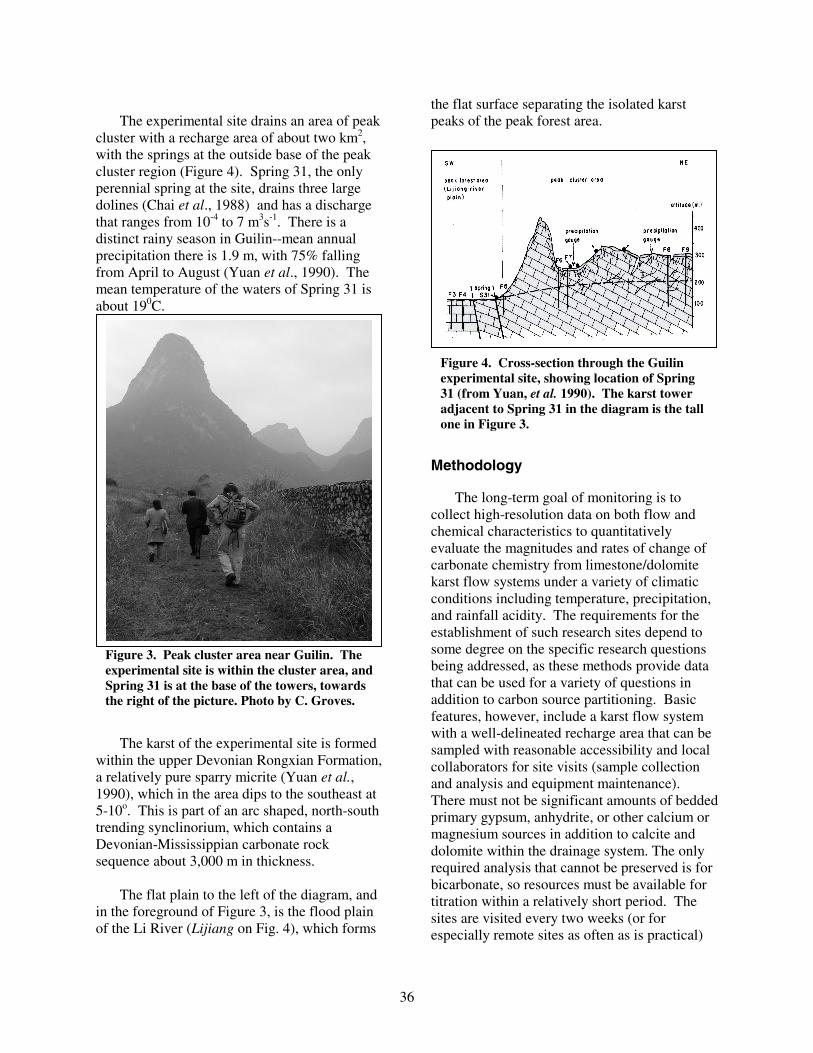
In the 1980's, the Karst Dynamics Laboratory developed the Guilin Karst Hydrogeology Experimental Site close to Yaji Village, near Guilin, China. Guilin, in southern China's Guangxi Province at a latitude of about 24o north, is a well-known tourist city because of the great beauty of its karst landscapes. In early 2002 we installed continuous monitoring equipment at the site's Spring 31 (Figure 2), the largest of four significant springs that occur along a faulted boundary between regions of the two major tower karst landform types in southern China (Drogue, 1986; Yuan et al., 1990, Sweeting, 1995) (Figures 3 and 4). These are fengcong (peak clusters), and fenglin (peak forests). While both have karst towers as a major feature, in this area with heights of up to 300 m, the peak clusters form from groups of peaks joined at their bases, forming enormous dolines between them. In the peak forest areas, in contrast, generally single towers are distinct from one another, separated by a flat floodplain surface.
Figure 2. Spring 31 near Guilin, China, showing flume and rectangular weir, prior to equipment installation. Photo by C. Groves.
36
The experimental site drains an area of peak
cluster with a recharge area of about two km2, with the springs at the outside base of the peak cluster region (Figure 4). Spring 31, the only perennial spring at the site, drains three large dolines (Chai et al., 1988) and has a discharge that ranges from 10-4 to 7 m3s-1. There is a distinct rainy season in Guilin--mean annual precipitation there is 1.9 m, with 75% falling from April to August (Yuan et al., 1990). The mean temperature of the waters of Spring 31 is about 190C.
The karst of the experimental site is formed
within the upper Devonian Rongxian Formation, a relatively pure sparry micrite (Yuan et al., 1990), which in the area dips to the southeast at 5-10o. This is part of an arc shaped, north-south trending synclinorium, which contains a Devonian-Mississippian carbonate rock sequence about 3,000 m in thickness.
The flat plain to the left of the diagram, and
in the foreground of Figure 3, is the flood plain of the Li River (Lijiang on Fig. 4), which forms
the flat surface separating the isolated karst peaks of the peak forest area.
Methodology
The long-term goal of monitoring is to collect high-resolution data on both flow and chemical characteristics to quantitatively evaluate the magnitudes and rates of change of carbonate chemistry from limestone/dolomite karst flow systems under a variety of climatic conditions including temperature, precipitation, and rainfall acidity. The requirements for the establishment of such research sites depend to some degree on the specific research questions being addressed, as these methods provide data that can be used for a variety of questions in addition to carbon source partitioning. Basic features, however, include a karst flow system with a well-delineated recharge area that can be sampled with reasonable accessibility and local collaborators for site visits (sample collection and analysis and equipment maintenance). There must not be significant amounts of bedded primary gypsum, anhydrite, or other calcium or magnesium sources in addition to calcite and dolomite within the drainage system. The only required analysis that cannot be preserved is for bicarbonate, so resources must be available for titration within a relatively short period. The sites are visited every two weeks (or for especially remote sites as often as is practical)
Figure 3. Peak cluster area near Guilin. The experimental site is within the cluster area, and Spring 31 is at the base of the towers, towards the right of the picture. Photo by C. Groves.
Figure 4. Cross-section through the Guilin experimental site, showing location of Spring 31 (from Yuan, et al. 1990). The karst tower adjacent to Spring 31 in the diagram is the tall one in Figure 3.
37
for maintenance and calibration, to download data loggers, and to collect water samples. Probes are checked and cleaned during visits and readings taken with separate meters to check for instrument drift. We have found that that we are able to get very steady readings over this interval, including pH with recent improvements in pH amplification.
Although details of installation vary from
site to site, due to varying hydrologic conditions and the typically remote nature of these sites, we are standardizing the equipment across all sites and typically we use electronic probes at each site to measure temperature, specific conductance, and stage, and pH. Because changes in both flow and chemical conditions in karst flow systems can be very rapid, a Campbell multi-channel data logger queries the probes every thirty seconds, and averages these readings every two minutes.
While discharge measurements are not
required for the carbon source partitioning, they are important for total carbon flux estimations, and comparing between different sites in the network. Discharge estimates within the network are made by a variety of methods, depending on the conditions at each site. In the underground Logsdon and Hawkins Rivers in Kentucky we use two-minute direct velocity (electronic velocity sonde) and stage measurements (pressure transducer) to estimate discharge under open channel conditions, using a relationship between the cross section area of flow and stage (Groves and Meiman, 2000). These measurements are limited, however, by measurement at a single location in the center of the flow cross-section in each stream. To account for the vertical velocity distribution, the velocity at 0.6 flow depth, which has been shown to be close to the mean velocity in the vertical profile, was related to the apparent velocity at the fixed-depth point of measurement assuming a logarithmic velocity distribution (Chow, 1959). In order to correct for longitudinal velocity variations, discharge measurements were made on eight occasions using standard wading-rod gaging techniques and a 0.3 meter longitudinal spacing, and the average ratio between mean and maximum
velocity (assumed at the center of each channel, where the velocity sonde is located) was determined. The vertically corrected apparent velocity in each stream was then multiplied by this ratio.
The Mineral King alpine site is in a surface
pool between two waterfalls along a very steep stream segment, downstream from the emergence of the flow from Tufa Falls, a large karst spring. Because of the geometry of the site and the highly variable flow conditions, particularly with spring snowmelt, neither a weir nor direct velocity sonde measurement are practical. Here we are developing a rating curve with constant stage monitoring and direct measurements using a salt-slug tracer method. The logger has been programmed with a second routine (in addition to the regular data collection mode) that can be implemented during site visits for very high resolution (1 second) conductivity recording, and salt solutions of known volume and concentration are injected upstream. From the salt slug passing the probe (Figure 5), discharge can be calculated.
In Guilin, discharge is calculated with
continuous stage monitoring behind a compound, rectangular weir constructed during the original implementation of the research station (Figure 2).
The data required to determine inorganic carbon source partitioning (Groves and Meiman 2000, 2001) in addition to the pH and temperature from the probes, include calcium, magnesium, and bicarbonate. We currently use ion chromatography and atomic adsorption spectroscopy for ion analyses, and a gran titration for bicarbonate analyses. One additional sample for every ten should be analyzed as a blind duplicate for quality assurance procedures, run for a reasonably complete set of anions and cations for a charge balance check, although in many karst waters these three ions will dominate. Fortunately, the relationship between each of these three and specific conductance is often linear and statistically significant (White, 1988), although the relationship must be established with data from each site. At our Kentucky underground
38
river sites, for example, we have been able to measure such relationships with r2 values exceeding 0.95. For this reason, samples are collected during each visit and measured in the laboratory for these three ions, which gives 26 values (plus duplicates) during a year long sampling campaign, typically over a range of storm and seasonal conditions, which can then be used to develop the relations. The high-resolution specific conductance data can thereafter be used as a proxy for the required ions, and calculations made. The same data can be used to study magnitudes and rates of change of mineral saturation indices, dissolution rates, and carbon dioxide partial pressures.
CONCLUSIONS
The work described here represents the next step in a long-term project to improve the global estimates of, and to better understand, the geological interactions impacting the global carbon cycle. We continue to refine the methods, to a large degree learning from our errors. While we have designed a reasonably robust system for data collection, for example, it has become clear that for remote sites fully redundant data loggers and probes are required.
We have identified a series of additional
locations for potential research sites under a
wider variety of rainfall, temperature, and rain pH conditions in the U.S., Caribbean, and Europe, and currently hope to build the network to a total of twelve sites over the next four years. A fringe benefit of this work is that through detailed, quantitative study of a wide variety of karst environments, and through interactions with our colleagues who have long experience in those areas, we are also learning a great deal about karst hydrogeology and geomorphology. REFERENCES Amiotte Suchet, P. and J.L. Probst, 1993, Modeling
of atmospheric CO2 consumption by chemical weathering of rocks: Application to the Garonne, Congo, and Amazon Basins. Chem. Geol. 107, 205-210.
Amiotte Suchet, P. and J.L. Probst, 1995, A global
model for present day atmospheric/soil CO2
consumption by chemical erosion of continental rocks (GEM-CO2). Tellus 47B, 273-280.
Atkinson, T.C., 1977, Carbon dioxide in the
atmosphere of the unsaturated zone: An important control of groundwater hardness in limestones, J. Hydrol. 35, 111-125.
Berner, R.A. and A.C. Lasaga, 1989, Modeling the
geochemical carbon cycle. Sci. Amer. 260, 74-81.
Berner, R.A., 1999, A new look at the long-term
carbon cycle. GSA Today 9, 1-6. Berner, R.A., A.C. Lasaga, and R.M. Garrels, 1983,
The carbonate-silicate geochemical cycle and its effect on atmospheric CO2. Amer. J. Sci. 283, 641-683.
Black, P.B., 1994, The Hydrogeochemistry of the
Mineral King Area, Sequoia National Park, CA. MS. Thesis, School of Natural Sciences, Fresno State University, 178 p.
Busby-Spera, C.J., 1982, Paleogeographic
Reconstruction of a Submarine Volcanic Center: Geochronology, Volcanology, and Sedimentology of the Mineral King Roof Pendant, Sierra Nevada, California. PhD Dissertation, Department of Geological and Geophysical Sciences, Princeton University, 291 p.
Figure 5. Typical salt slug using second logger program used for discharge calculation, Miner King site.
39
Busenberg, E. and Plummer, L.N., 1982, The kinetics
of dissolution of dolomite in CO2-H2O systems at 1.5 to 65oC and 0 to 1 atm PCO2. Am. J. Sci. 282, 45-78.
Chai, W., A. Dai, D. Yuan, and P. Bidaux, 1988,
Tracing test in karst water-bearing system, using various chemical reagents. Proceedings of the International Association of Hydrogeologists 21st Congress (Guilin) Part 2. Beijing: Geol. Pub. House 902-909
Dreybrodt, W., 1988, Processes in Karst Systems,
New York: Springer-Verlag, 288 p. Drogue, C., Fracturing in the Paleozoic carbonate
formation of southern China (Guanxi fracture area): Interpretation within the tectonic context of eastern Asia. Tectonophysics, 121, pp. 295-302.
Ford, D.C. and P.W. Williams, 1989, Karst Geomorphology and Hydrology, Winchester,
Massachusetts: Unwin Hyman Ltd., 601 p. Groves, C., and J. Meiman, 2000, Regional
atmospheric carbon sink within the south central Kentucky karst, Proceedings of the Eighth Mammoth Cave Science Conference, pp. 131-141.
Groves, C, and J. Meiman, 2001, Inorganic carbon
flux and aquifer evolution in the south central Kentucky karst, U.S. Geological Survey Karst Interest Group Proceedings, Water-Resources Investigations Report, 01-4011, pp. 99-105.
Hesshaimer V., M. Heimann, and I. Levin, 1994,
Radiocarbon evidence for a smaller oceanic carbon dioxide sink than previously believed, Nature 370, 201-203.
Holland, H. D., Kirsipu, T. V., Huebner, J. S., &
Oxburgh, U. M., 1964, On some aspects of the chemical evolution of cave waters, J. Geol. 72, 36-67.
Joos, F., 1994, Imbalance in the budget, Nature 370,
181-182. Liu, Z. & J. Zhao, 2000, Contribution of carbonate
rock weathering to the atmospheric CO2 sink. Env. Geol. 39, 1053-1058.
Meybeck, M., 1987, Global chemical weathering of
surficial rocks estimated from river dissolved load. Amer. J. Sci. 287, 401-428.
Palmer, A.N., 1991, The origin and morphology of
limestone caves, Geol. Soc. Amer. Bull. 103, 1-21. Probst, J.L., J. Mortatti, and Y. Tardy, 1994, Carbon
river fluxes and global weathering CO2 consumption in the Congo and Amazon River basins. Applied Geochem. 3, 1-13.
Reardon, E.J., G.B. Allison, and P. Fritz, 1979,
Seasonal chemical and isotopic variations of soil CO2 at Trout Creek, Ontario, J. Hydrol. 43, 355-371.
Rogers, B., Mineral King Update, California Caver,
Vol. 29, 4-12, 1978. Siegenthaler, U. and H. Oeschger, 1978, Predicting