D. C. Ford Dept of Geography, McMaster University CHAPMAN & HALL London· Glasgow· Weinheim . New York· Tokyo· Melbourne· Madras P. W. Williams Department of Geography, University of Auckland F~J"-/)J(L~rrs ~ ~ Karst Geomorphology and Hydrology r: process and product 1- (JrjJllOlogv I L\: J. T. Hack (cds) !/(}rphologr 'crg (cd.) ulforms . ([I. (eds) ,hrsical sedimentology ;eo/llorpllologv :d. ) ues Ils(cds) uhology :d) I capes I'roach to sedimentology J1l
Transcript
D. C. FordDept of Geography, McMaster University
CHAPMAN & HALL
London· Glasgow· Weinheim . New York· Tokyo· Melbourne· Madras
P. W. WilliamsDepartment of Geography, University of Auckland
F~J"-/)J(L~rrs ~
~
Karst Geomorphologyand Hydrology
r: process and product1-
(JrjJllOlogvI L\: J. T. Hack (cds)
!/(}rphologr
'crg (cd.)
ulforms
. ([I. (eds)
,hrsical sedimentology
;eo/llorpllologv:d. )
uesIls(cds)
uhology:d)
Icapes
I'roach to sedimentologyJ1l
Published by Chapman & Hall, 2-6 Boundary Row, London SEt 8HN, UK
Chapman & Hall, 2-6 Boundary Row, London SE1 8HN, UK
Printed in Great Britain by the University Press, Cambridge
ISBN 0 412 44590 5
Apart from any fair dealing for the purposes of research or private study, or
criticism or review, as permitted under the UK Copyright Designs and Patents
Act, 1988, this publication may not be reproduced, stored, or transmitted, in
any form or by any means, without the prior permission in writing of the
publishers, or in the case of reprographic reproduction only in accordance withthe terms of the licences issued by the Copyright Licensing Agency in the UK,
or in accordance with the terms of licences issued by the appropriateReproduction Rights Organization outside the UK. Enquiries concerning
reproduction outside the terms stated here should be sent to the publishers at theLondon address printed on this page.
The publisher makes no representation, express or implied, with regard to the
accuracy of the information contained in this book and cannot accept any legalresponsibility or liability for any errors or omissions that may be made.
A Catalogue record for this book is available from the British Library
Library of Congress Cataloging-in-Publication Data available
as wcll as for adsorption and ion cxchange is much less in dcnsc,
fractured karst rocks than in porous clastic sedimcnts.
Rapid infiltration into karst rcduces thc opportunity for evaporation, a
mcchanism that is important in the elilllination of highly \'o!:ttilc
organic compounds, such as solvents and many pcsticidcs.
Physical filtration is relativcly ine!Tcctivc in typically thin karst soils :11ll1
through rocks with large secondary voids; thus scdimcnt and micro
organisms arc readily transported into karst aquifers,Transmission of particulate mattcr right through karst syslems is
assisted by the turbulent flow rcgime commonly associated with conduit
aquifers.
Timc-dcpendent elimin:llion mcchanisms (oj' hacteria a IIII viruscs J'or
example) arc curtailed in dkctivcncss hecausc oj' rapid 1I0\\' tl1l'\1lightimes in conduits ami reduced rctardation hy adsorption-dcsorption
processes,
ment of water-horne cont;lI11inanl~ ill k;lrst is rclativclv indkctiH', 11L'CtU~L':
Figure IrA Sclll:lllalic IC'!Hc,c'lltatioll of '1l1","lacc' Ic':'clio!l\ ~il'ill~ li'L' 10":II-I',,,iJi":11101l01infiltratillg wall'l, hOlll (;O/WL'I(l'IS.1).
In laboratory experiments to asscss the survival oj' nine bactcria ill walcrat 10 ± 1°C, Kaddu-Mulind\\'a ('I It!, (1()K3) found that !:',IC!/I'J'isc!,ill c(lIi,
Sallllol/c//(/ lyp!Jilll/lJ'ill/lI, /'.I'CI/tlmll(ll/II,I (/c/'llgil/(1.\'(/ and other pathogcnic or
potential pathogcnic bacteria survivcd up [0 100 days or cven longcr in
sterilized natural ~',roul1(h\"lt 'I' Onlv two bacteria did not survi\'c I() j() lhysFi,,' t 1~) (ii" -n fho:j' tl,,1' II" .1lt..:!111.••.•11\ "ft'r !hn"lllh IPih.f .-,\.1,·111t
lithological types that arc assumcd to rcpresent permeability classes;
piezometric data from which groundwater flow may be inferred; and
surface hydrography with data on sites of water exploitation.
Other special purpose maps arc also frequently used in karst hydrology.especially to convey information on point-to-point connections determined
from water tracing experiments. Fig. 0 ..11 for thc Sinkhole Plain in
Kentucky is such a case, although [hc original h:IS Illuch more detail thancould be shown here,
For karst areas, Paloc & Margat (19K5) cmphasize the importance O!
classifying base flow discharges of springs and surfacc streams. Some symbols
used arc illustrated in Fig. 11.2.
The hydrogeodynalllic approach convcys information concerning:
(a) the constitution of aquifer systems, bascd on the distinction between
and location of the principal rock bodics (taking into account the'
degree to which they arc water-bearing and their possible layering);and
(b) the boundary conditions of aquifers, distinguishing between
(i) the direction of water flow (input, output. or static) and
(ii) flow conditions as opposed to potential conditions.
Karst areas arc susceptible to a greater range of cnvironmental impactproblems than any other terrain, because of the additional set of difficulties
associated with highly developed subterrancan networks and their associated
fragile ecosystems. Unfortunately, in all inhabited karsts, dolines and other
sinkpoints are perceived as being particularly suited for thc dumping of solid
or liquid waste, because it disappears undcrground and 'out of sight is out of
mind!' Yuan's (1983) review of problems of protect ion of karst in China
illustrates the point. The most important of the many impacts encountered is
that arising from watcr pollution.
Karst aquifers arc notoriously ellective in transmitting rather than treating
pollutants. This arises from the unfortunate fact that the relativcly large
capacity for self-treatment found in many groundwater systems is com
paratively poorly developed in karst. The n:lture of subsurface purification
proccsscs is not well known but has becn invcstigatcd by Golwer (1983),
who found it to be composcd of the intcraction of nUlllerous physical,chemic~d and biological reactions (Fig. 11,4), and to he signifieantlv affected
! In II' ',y 01,," .i1 ,·('n·I,', " n 'laturdl
KARST RESOURCES, THEIR EXPLOITATION AND MANAGEMENT
Figure 11.5 Survival of microorganisms in n<llur;1i ground\\'<llcr <II 10 ± l°e. From Kaddu.J\lulindw<I et III. (ISIS]).
I'ROHLEJ\!S OF CONSTRUCTION
Problems of construction on and in karst rocks - expect theunexpected!
(Fig, Y,IYI3). Until recently all donlcstic, industrial allli agricultural diluent
was disposed of underground. J\ cheese factory, for instance, discharged30-50 kl per day of waste into a cave for at least 25 years. A typical pollutedgroundwater sample from the region has a nitrate concentration of300 mg I-I compared to uncontaminated water with only 2 mg I-I (concentrations in drinking water arc usually considered acceptable if they do notexceed 10-15 mg I-I). In spite of the long term eft]uent loading, the lowerpart of the aquifer still remains substantially free of contaminants, showingthe effectiveness of the purification mechanisms noted in Figure] 1.4 in thisrelatively porous diffuse flow aquifer.
In view of the above evidence, it appears paradoxical and alarming thatkarst rocks are being investigated as potential sites for hazardous W,lstcdisposal. Regions with anhydrite and rock salt arc particularly favoured inthese enquiries, the principal argument being that if significant groundwaterflow had affected them, then the anhydrite would already be hydrated togypsum and the highly soluble rock salt would show obvious signs ofsolution, Hence wastes stored within such rocks are not likely to bedispersed by groundwater. However, in the case of nuclear substances, the
, time scale is very long and the rate of advance of solution fronts becomes
relevant. The US Department of Energy (I YH2) and Vierhuff (I YH3) discuss"requirements for mined repositories of nuclear wastes.' Bachman (1<)1)7)
describes site investigations in evaporite karst in New Mexico.
-,Karst processes and landforms pose many different problems for construc-tion and other economic development. Every nation with karst rocks has its
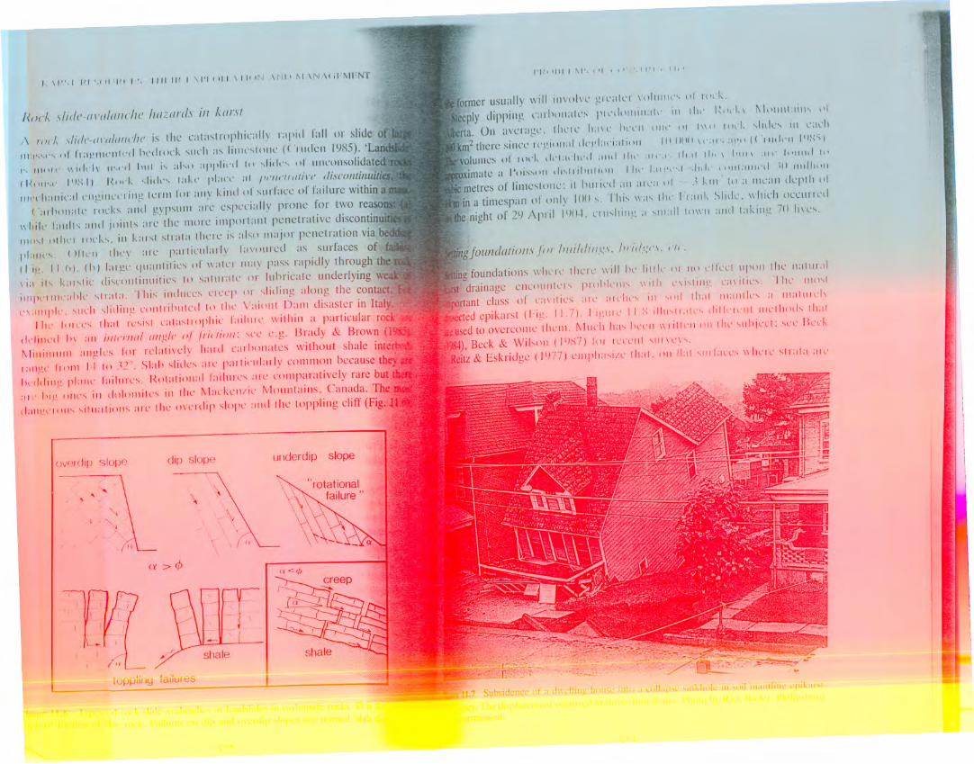
share of embarrassing failures such as collapse of buildings or construction"of reservoirs that never held water (e.g. Fig, 11.7), It is probably true to'write that the global cost of extra preventive measures or of unanticipatedremedial measures in karst terrains now amounts to some thousands ofmillions of dollars (US) each year.
The problems encountered can be classified by the extent of the impact ofconstruction or other development upon karst features already existing ;It asite, There may be no impact, as in the case of construction in the path of apotential landslide, There can be small-- to large-scale impact wherefoundations for bridges, buildings, roads and railways are placed upon karstwithout much effect upon the local water table. Large-scale impact is morecommon if the water table is raised or lowered; this may become extreme inthe construction of dams, tunnels and mines.
- --0 '~.O=---~ B. cereus......•........S.typhimurlum
IOUIi ml-I
aquifers is shorter than this (e.g. see Table 5.7 for the Ilow through times ofsome of the longest karst systems) allli given the neutral buoyancy ofbacteria, then the probability of spreading contaminated water through karst"is high and potentially serious,
Quinlan (IY83) and Quinlan & Ewers (IYH5) describe how sewage,creamery waste, and heavy metal cont,lining diluent from the Horse Cave
area of the Sinkhole Plain in Kentucky (Fig. 0.31) has been spread by akarst distributary system to 56 springs in ]6 areas along an 8 km reach of theGreen River. In spite of that, none of the 23 wells sampled hadcontaminated water, presumably because they arc up gradient from theconduits or have no direct connection to them. This would give a false senseof security concerning the quality of the total groundwater system, if thecondition of discharge through the conduits were not also known, This ledthe authors to stress that reliable monitoring of water quality in karst must
involve springs, not just wells, because they arc places where Ilow convergesat basin outfall points (Quinlan & Ewers IlJH(J). This is a vital message inhighly kC:lrstified fissure aquifers, but becomes of lesser <;ignificanee in moregranular limestones, as the following example shows.
Waterhouse (IY84) successfully mapped nitrate contamination in a
Tertiary limestone aquifer in the Mount Gambier district of South Australia,using data flOm 257 wells. Hydraulic conductivities for the bulk aquifer areconsistefl t with coarse gravels, hydraulic gradients are low, and resultantonllln(h\'·If~,· On'" I\: rl"nHn',ntlp ,nf''''n''r'U11I1'1'O' q~, J r")'lrei"r' f,.... ",Of-
,..•IIIII
I'I~I II II I \ I', t" I I I • I I" , I I, '
.7 c'lb: IU
former usually will ill\oh'l' glcatL'l' lolllll!\'\ 01 101k,
ccply dipping (';lIllllll:IIl'S PII'd\llllill:II\' ill 1111' I~"\'''I ~1"lIl1l.lil\\ ,1\rIa, 011 average, thcle ILIIl' Ill'l'll Ill!\' III 11111Illl'" \lldl'\ III 1';ll'h
III,'('I1;l1lic:rlCII,i2il1l'l'1 illg krill lor all)' killd 01 slIllace 01 failure within a(';IIIHlilate J'()ck\ aIII I gypsum ;lle cspeci;i1ly prone for two reaso
II hik lalllto.; ;IIHI joillts arc the morc important penctrativc discontinu
111<1\1()lhl'l lock" ill kar,t str;Jta thcrc i, al,o IIlajor pcnetration via be,
1,1:1111'\, ()lll'l1 Ihl'l' ;lIl' p;lllinrially la\'oll!'ed as surfaces of f;
(I i,l.!, II,rl), (11) lal ge lju;1I1titie, of lIatel ""IY pass rapidly through theI i:l its k:llstic di,colltillllities to satllratl' or 11Ihricatc underlying w
jll'l'('IIII1';lhk \tl;II;I, This illdllCl'S L'll'Cp or slidillg along the contact
l'\:IIIIPIL', \lIL'h slidillg COlltl ihlllCd to the V;liollt Dam disaster in Ital,1111' I11In', thai Ic,i\t C<11:1,IIOplli(' lailllll' witl1ill a particular ron
(It-Iillcd III all illl(,1'//II/ (Jllg/I' of Jlictioll: \('l' e,g, Brady & Bro\\'n (J
1\1illillllllll allgles 1'01' relativcly l"lrd carhollates without shale int\.'f
The dcvcloptllcllt of closcd dcprc~siolls so rapidly that structures and otherinstall:lIiolls thll':i1"Il,'d h\' /1"'111,':'111101I,,'/,ill I,' I,,' 1'1,>1,'('1,'" IIl1lil Ih,' h"l,',
arc fllll~' ,',II:II!',,',I ,111,1</"""" ,'III, t\ll '''',11 h S',) 111,1\ I", .1,'1111,',1,I',calasl J'{)fJll ic ( t-'i g, I I ,IJ), 111 II ll': e ,\ II L'IIIL', tilL')' fo till wit II i11,I Ie W SL'l'()IId s :II III Ii\ L'S
may be lost. Deve lopme nt is :1tt ri hu tab Ie pri III ari Iy to colla pse of tL'nsi011donlL'~
(archcs) created by sullosion of mantling scdimcnts into undcrlyil1g kar~tcavitics, In very ~andy soils thcre may hc simple funnclling sullo~ioll l\itlHlUtarch fOl'lll'ltion. Setlling ('/I 1/11/1,1'(' I\'ililill :111encircling Lildt 1,1"nl' (ll'l'IIISwherc tlIL're is slL':ldy C()lllpaClion ill~lL'ad of void alld dOlllL' IOllli
ation.
The dcpressions t\ picall~' I :lnt',L' ill dilllL'llsion fllllll - I.() III dialllelL'r alld
0,5 III dcep up to ]()()-::!()() m dialllL'tcr alld I ()-.:)() m dccp. ])cprcssion~ ill tilesmaller h,1If of tilc loud range :Ire numcrically prcdominant in most :lillictL'd
areas, Apall from ()\'CtUSC or pollutioll of aquifers, tilis is pL'J'h:,,)~ the llHlsl
many sample studies, clIidl)' from NOlth 1\lllL'rica,Thc principal UIUSC of suffosion with arcil formatiol1 is IOI\L'J'ing of thl'
watcr tahle, Tilis is n10st 1I:l/anlous wlIcrc it is lowercd frolll a po~iti(lll in
the malltlil1g scdinlcl1ts dccp inll) thL' epikarst lonc or bel1c:lth it (hlllse S.:
Humphrcville IlJ7lJ): in turn, this illlplics tilat Ihc particular karst lIill heshallowly huricd or relict c,g, on till' Iloodplaill ill a poljc or het\\L"'llisolatcd towcrs in :1 towcr karst.
In Alahama thcrc lIavc hecn 17(H) collapscs :l!'(llInd fivc wcllficld cones of
deprcssion in rcccnt dccadcs, In tilc Ukrainc ](H)(J small collapscs occurrcdin 1 km2 about a particular wcll. /\1 coalmillcs in Hunan (Chilla) thcrc ha\'c
been B5(){) collapscs in this ccntury attributcd to drawdown, Evcry nation
with karst can producc similar statistics,A sccond major cause is the focusing of runoff from manmadc
impcrmcable surfaccs such :IS roofs. lIigllways and parking lots, inlo
particular sinkpoints in till' cpikarst. This is doubly d:ll1gerous wherc till'watcr table has becll lowered also, as is ortcn thc casc wherc comprchcnsive
construction is in progrcss, At tilc SIIl,1I1 scale, runoff from a domcslic Illof
may inducc coll,lpsc hcncatil thc d(l\Vll~pOUt c.g, in Florida, wlIL'J'e remedi:daction for a Illodest dwcllillg Cllst $::!() ()()() ill IlJ~::!. Al largL'J' sude, collapsL'
becn ()-I~ such collapscs e:lch Illonth in Florida during reccnt dccadc~; theil
actual tllllllig cOITclate~ poorh \\'Ith :1I1tl'L'edcnt precipitatioll. which makcs
prcdidlon of till'c .llld place \'L'n diffilld',
_1J\tf~
o\(~
I 'Ill :;SUHI GIIOU liNGON r IXED CENTRES
CXC/lV/llION /lililGIlOIJIIN(,
)[~rm(
COMP/le liONBY II/1MMCIlING
C/IISSON WilliII·I'ILC
...••'- --- .. :,.•.. ,.' ""
-. ,.::- ,: -::-:--;/:(\ "~' _. -- ~I , .. ,
H~~V)Q I U ll~
J-igllre II.X Illu,tr<lliolls of tile PliIlCip,i1 I\'I'L" of IOllllil<ll;OIl Iro.:<Il11'L'llhill " soil-malltledK;olsl, IL\sed Ul'0ll li)!llles ill SOIVe/>;(I'JK·I).
1\/",11'1',11111" I 111/11' I \1'11111 \1/1111 \111' ~I \11 \,.1 ~1I111
horizontally bcddcd, thc rock Illass tllust bc 11I:llle continuous bcncath thefoundation to a dcpth cquivalent to (),c) or (),7 of the COIUIllIl spaeing in the
planl1cd structurc, Rctllcdial work should 1!0 dcepel where strata arei Ilel i l1ed or foldcd. and on slopcs.
('avitics cntircly within bcdrock call POSL' d:ll1gers if they are at very
~hallo\l' dcpth or if the planllcd stuctulal load is cOII~ider:lhle. Otherwise,
they :lle gcnerally igllorcd, WalthaIll 1'1(/1. (I()~(,) plovide :111n:1I1Iple of the
problc'1l of high loadil1g, Scverc dilficultics \l'L'IL' elle(IUl1tl'led ill f()otillgs forfour picrs for a tllotorway viaduct ill Belgilllll, il1l'le:l~illg its o\'er:1I1 cost byl.:'i";" ()I1C pic I' had to bc shiftcd 15 III Ollto ~t I ollger lock, A slamlard
'sewage lagoon built on glacial drin in Minnesota; it dumped 70000 m \ of~fflllCllt inlo all lInderl~'ing k:irsl :I\jllikr (Ail'\:lIlder & Bopk II)S I).
Raising I ilL' Willer l:tI,I,' ,"111 ,i1•." ,'1,';11,' ,'plI:II'S" PI ""I'",klll',, 1'1aestroying the cohesion of suscL'!llil>k day soils, IlpIl'l'l'l'l, Iilis i•.
comparatively rare in karst areas, The load or vibration from hl'an'
~quipmcnt can induce small collapses locally, especially beneath it. In
historic times plowhorse teams have dropped; in modcrn times man)'
tractors, haulage trucks, drilling rigs and military tanks have falil'n, Rock
blasting from quarries or foundation cUlting, etc. often caUSl'S collapses ofsmall to intermediate scale.
The solution mining of salt and use of waterflooding to enlwnce recovery
from oil and gas reservoirs is a final cause of subsidence and collapsl',
especially the former. Pressure injection of water into the tops or salt diapir •.has proved to be particularly dangerous .
• It is obviously desirable to detect the cal'ities before they hal'e stoped to
the surface, Thought and money must be devoted to careful exploration
··before designs arc finalized and construction begins in a karst area. At the
reconnaissance scale aerial photography will display already existing dolincs.
Thermal infrared imagery is particularly useful because it may rel'e:i1
patches of vegetation that arc showing drought stress due to arches,-.advancing beneath them: it also indicates sites of focused soil drailwge into
the epikarst.
Surface geophysical techniques arc widely used. Kirk & Werner (19:-\ I). review them. Traditional methods may be divided into three groups - loll'
energy ('hammer') seismology, electrical resistivity and gravimetry. These
yield data for points along a traverse. Electromagnetic conductivity (EM)
and ground penetrating radar (GPR) arc new methods that provide
continuous readings along a traverse, with the result that cavities arc less
likely to be missed. All techniques arc imperfect, however. Use of acombination of them may reduce the error; nevertheless correct identifica
tion of shallow but waterfilled cavities and of any features under deep cover
remain problematic. We endorse Waltham cI ilf. (19~()) when they write
Geophysical exploration of cavernous limestone is very difficult to
interpret. and normally can act only as :In :lid to efficient planning of amore conclusive drilling programme.
Design of exploratory drilling patterns is discussed by Benson & LaFountain (1984) and Newton (19K4). In general, tile cheaper percussion
('.lir'rack') drilIin ..' i•..preferable ~ll core drill ng bec,_use it d~ tech Ct,viti.:s 'IS
I'I~( )1\1 I f\1S;(11 (ClNS; IIU I( "Ill IN
.stabilising lh~ ~I(lpl" ,II a I.lt,~'· ,I,dlll" "Ikll IItll,'\,''''''' 1 111111"'11",,11.11'. IIIthe USA.
Perhaps the most celebratcd L'X:llllpks or L'atastrophir dlllillL' L'llll:\pSL' III
this century arc those of tltL' 1::lr WL'st Iblld b\lldliL'lds ill S'l\ltlt :\11 i,:;\.Brink (1lJH4) gives an entry to the extensive literature on the suhject.Residulllll and (lthL'r IlnL'(l1l'L1Iidall'd ,,'diIlIL'tIIS dL"'pl\' 11111\ :1 t 11l'.,l,.,·d
corridor-and-pinn:ld~ kalst in d(llllilliks that all' ulld~'llaili by !-,llid 11~':ltillg
quartzites. To assist in mining. the water table was lowered into thedolomites (Fig. 11.10). The first collapses camc shortly after and \\'ere lIulv
catastrophic. In the worst incident (Dccember, 1962) a threc-storey crushcr
plant with 2lJ occupants was lost in a few seconds at the West DreifonteinMine. Geophysical exploration for new cavities has proved to hc nearl\'
useless (I3rink. op. cil. p. 125). Arrays of sinlple telescopic hendlillarks
(Fig. 11.lO) have heen set out in hopes of detecting stoping :11"Ches hdol L'they breach the surface. W:tgetler & Day (llJH6) discuss construction
illl/)()rlalli stnl(;ture, such as the pier of a bridgc. HCllsoll & La FountaI(llJ84) question its cost effectiveness beneath lesser structures, based on thl
likelihood of missing cavities when drilling on a fixed pattern. They poinout that 1000 3-cm holes per acre (0.4 ha) are necessary to have a 90
chance of intercepting a cavity that is 2.5 m in diameter or less.
As an example of exploration difficulties, at the sill' for a eommerci
tower building in New Jersey there were J()()O III of seismic traverse, agravimetric survey and 15 drill holes. No cavities were detected and
excavation for foundations began. Problems arose almost immediately, Afurther 80 bore holes and 36 test pits were dug. encountering partly soil;
filled cavities in all but one case. Extensive redesign was necessary.The types of remedial measures used wherc foundations are to be
elllpl<iced arc shown in Figure II.H. In other cireulllstances the best remedyis to restore the fanner natural conditions i.e. return the water table to its
previous elevation and reduce or eliminate sites of focused runoff. This will
not arrest all stoping collapses that were initialed by lhe interference. Filling
of the dolines is the standard treatment once they are revealed, using
whatever material is cheapest in the locality. Costs for lilling or merely
Figure 11.10 Catastrophic dolinc formation ill th<: Far Wcst Ralld gold millillg district. South
<): J :c 14 ·Ii ~ ~..on:p~ ....~: 'n f'f {into jj·:h .. "l. .,illutllll ("\\'~Hj' j thatoL'Cllrs lIJlon dcw,llnin·,. B 1'1'.: d,-,~_n f' (ll<:,(" .l I( ILl II .r" \\'h~r<: ,11 ,.r"l~d (a~lty tS
'()
I'HI IItl I ,'\1', ,II I I \h. " I P 1'\ 11\ \
'There is perhaps no phase or en,l!ineering or construction \\ hich lendsitself less readily to rule-of-thumb or Iwndhook lllcthod~ than docs ((hill)f(1l1mhltion' (TVA l().ltJ, P l)~) 'WI·.l" do:. In[: ,,,ith k..lr~t
dollars. Because or initial rOUJ1lblion prohlems in karst. this was l'xtcmkd to
eight years and 11,:1 million doll:lrs, Two '\'I'd,s :11'\,,1 lillil\~', (\'\'\\'I'nd'\'\
ullexpe<.:ted leakage via holh the foundation ami ahutlllcnl~.
Not only may modern fissures and conduits be llushed and enbr~ed :Jt
accelerated rates, but long-dorm:Jllt relict karst and L'\'l'll lilkd :Jnd
indurated paleokarst may he reactivated. Th6rond (1972) citl's an in ...tance
where rai~ing the watl'!' k\'l'I to 175 III indlll'l'd onl\' 1.11 III '.., I pi k:t1,:I!:L'
down~lream; thi~ inU'eased to an lInaeeepl:lhlc K In's I II'hl'n till' k\'l'I \\'a ...
raised to +85 111. Evidently, sediment-filled wnduits (undetected ill the
exploration) were llushed and n:activated, This emphasizes that <.:onditions
of hydraulic conductivity, et<.:. that are established by even the most detailedinvestigation during tlte ~ite exploration stage. Illay change radiedly as thereservoir fills.
While leakage through dam foundatiolls and abutments is most I'cared it is
quite possible that there may be lateral leakage elsewhere in a reservoir .This is to say that problems with karst can arise where the dam itself is buillon some other rock but there are karst rocks upstream of it. Montjaques
Dam, Spain, was built to inundate a polje, It failed by leaking through
tributary passages and the s<.:heme was abandolled (Thcrollli ILJ72).
Karst problems with dams arc sUlllmarized in some engineering designand construction textbooks. The Tennessee Valley Authority has accumu
lated vast experience of building them, chiefly in comparatively simple
structural and lithologic situations, Thcir main report (TV A 19-1LJ) is still
pertinent and Soderberg (1979) gives a more recent review or the work,Thcrond (1972) and Eraso (in press) discuss European experience, which
generally has been with 1110re complex, mountainous sites.Thcrond (1972) identifies seven different major factors that contribute to
the general problem. These are - type of lithology, type of geologicstructure, extent of rracturing, nature and extent of karstification, physio
graphy, hydrogeologic situation, and the type of dam to be buill. For eachfactor, clearly, there are a number of significantly different conditions. In
Therond's estimation, these together yield a combination or 761jO distinct
situations that could arise at dalll sites on carbonate rocks! It follows that
dam design exploration and <.:onstruction Illust be specific to the particularsite -
t:
E
"• SPRINGS CREATED
BY THE DAM
" SPRINGS EXISTINGBEFORE DAM
.• SPRINGS CREATEDBY LATER EXTENSIONOF THE GROUTING
Fi~IIl'C 11.11 Camarasa hydrockctric dam. Noguera. Spain. The d'1111i, huilt Oil thick-massivedolomites dipping at 17" in the upstream din;ction and with ,Ill aquiclude stratum of marls at
shallow depth bcncath them. Thc dam is a gravity are concrete struclllre 1.)2nl in height and7
Tahle 11.1 Examples of dam grouting costs in the Spanish-speaking countries. From Eraso (inpress) .
Grouting materialApproximale cost(kg m ")
(1IJHOtiS "011;11 s III
I\linillllllll
41·10l'vIollntain karstMaximullJ
3500500
Average3661lJ5
Minimum
3025Othcr faultcd karstMaximulll
3000300
A vera),tc343,~I
Minimull1
II12EpikarstMaximull1
6650
A vcrage2423
I\linilllllill
25Karst hcds altcrnateI\laximulll
170,~Owilh othcrsA vcrage
4442
If dam sitcs with limcstonc or dolomitc must bc uscd, thc preferredlocation will bc whcrc thcrc is a simplc gcologic structurc, thc least karstdcvclopmcnt and fissurc frcqucncy, and whcre therc arc shalcs or someother aquicludc strata at shallow depth so thaI a grout curtain can becxtcnded to thcm cconomically (Fig. 11.11). At thc sitc, all authoritiesagrcc that a large numbcr of exploration borcholcs (with core rctrieval and
downholc tcchnology) is mandatory. Largc cavities should bc mincd into, if
possible. Natural fill should bc rcmovcd from cavcs and replaced with plugsof grout. It is now standard practice to rcmove the epikarst complctely froma ccntre line beneath the dam and its abutments. This may rcquire trenchingto ItJ-20 m or more.
Grout curtains arc csscntially dams built within the rock. Their design anddcnsity arc discusscd by thc authors listed here, and many others. Thenormal praeticc is to placc a main grout curtain beneath thc dam, in theabutmellts and on thc flanks (Fig. 11.11). A cut-off trench and second,
dcnscr curtain may bc placcd upstrcam in thc foundation if thcre arc graveproblems therc. In thc main curtain a first linc of airtrack grout holes will beplaced 011 ccntrcs ncvcr morc than H-I 0 m apart and filled until thcre is backpressurc. A second, offset linc of holes is then placed and filled bctweenthem. Third and fourth lincs may be used until thc spacing reachcs adesirablc minimum that is normally not more than 2 m. Standard grouts arecement or bcntonite (a clay that expands when wetted) and mixturcs of thetwo, mauc up as slurrics with differing proportions of water. Tablc II I citesthe cxrcriencc of Fnso (in press) III d :llImber of diff~'r'ng SIJ.:dtlons in th~
I'IH 11111 ~I', '" , 'IN'.II~I I, ", IN
and grouting at a comparatively simple site. It is an earlh fill dam 3~ III in
height, footed on horizontal limcstones. In preliminary cxploration, 'I-I(l(l IIIof core holes were drilled. In a problelll zone HO III wide, 2) l'1I1 di:IIIICtCIholes were drilled on 50 cm centres for inspection by downhole TV CIIller:!.The cpikarst was Ihcll rCIIlPI','d :""ll!~ :1 "lll·pff trcllrll (I I.' III ill d"I'III.Beneath it IO() Cill gmul hpks II'L'I'l' cillpllll'cd ,In 1...'0l·tll ,'l'llltl'S (i.c.
overlapping), and 12 cm holes were high pressure grouted upstream anddownstream of this line, The main grout curtain was then emplaced, on ~ mcentres and to a depth of 25 nl. All holcs that accepted grout werereinforced by 1-3 further holes. The treatment was successful (Soderberg1979) .
All springs and piezometers must bc monitored carefully as the reservoirfills behind a completed dam. Operators should be preparcd to halt fillingand drain the reservoir as soon as serious problems appear. In extrcme casesthe reservoir /Joor and sides Illay be scaled off e.g. by plastic sheeting.
Experience shows that remedial measures aftcr a dam has been completedand tested arc much more costly than dense grouting during construction.
Dam construction 011 gypsullI and anhydrite
The surest principle herc is to avoid construction on thcse rocks. Theproblems that may be encountered arc considerable (James & Lupton IlJ7H,James & Kirkpatrick 1980). These include the rapid enlargement of existingconduits and the creation of ncw ones, because hydraulic gradients arc
excessive (Fig. 3.19); the settling or collapse of foundations or abutmentswhere gypsum is weakencd by solution; hcave of foundations whereanhydrite is hydrated, and attack by sulphate-rich waters upon concrete inthe dam itself (Eqn 3.60).
In the United States experiencc has been gained in simplc geologic. lowrelief terrains in west Texas and New Mexico, where truly excessive
hydraulic gradients and thc problcms of complex structure can be avoided.At one celebrated site, McMillan Dam, gypsum is present only in theabutments, further reducing the difficultics. No caves were detected whell itwas built in 1893; nevertheless, the rcservoir draincd dry via caves throughthe lefthand abutment within 12 years. Attempts to seal off the leaking area
by a coffcr dam failed because new cavcs developed upstream of it. Between1893 and 1942 it is estimated that 50 x IO(' mJ of dissolution channels were
created (James & Lupton 197~). McMillan Dam is now abandoned, as arcnearby Avalon Dam and Hondo Dam. Dams can be built succcssfully ingypsum terrains where relief i<;low and geology simple (or where there arc
ypsum intcrbeds in carbonate strata), but comprehenSIve grouting ISnp('pc;s;.rv and an impcrm.:;blL: covering over ;,11 gyp:-um oLtcrops is
Dams in mountainous country appear to be especially hazardous. In
California, St Francis Dam was built in 192~ on conglomerate containingclay and a high frequency of gypsum vcinlcts. Shortly after filling anabutment collapsed catastrophically; 400 persons were killed downstream.Collapse was attributed to dissolution of the gypsum which weakened themechanical structure and permitted lubrication of the clay. This is an
instance of failure in a rock that would not be classified as karstic at all,merely having a low proportion of gypsum «5'1<, '1) as fracture filling.
Fllllllels alld IJ/illes ill karst rocks
Tunnels and mine galleries (adits or levels) will be cut through rocks in oneof three hydrogeological conditions; (a) vadose; (b) phreatic but at shallowdepth or where discharge is limited. so that the tunnel serves as a transient drain that permanently draws down the water table along its course
(Fig. 5)';b); (c) phreatic, as a steady state drain Wig. 5.i)a) i.e. permanentlywaterfilled unless steps arc taken to drain it. Long tunnels in mountainouscountry may start in the vadose zone at each end but pass into a transientzone. or even a steady state phreatic zone, in their central parts.
Vadose and transient zone tunnels are cut on a gentle incline to permitthem to drain gravitationally. It was by this means that lead/zinc ore bodieswithin intertluves in the hilly country of Bohemia and Derbyshire weredrained below the natural water tables in the 15th and l()th centuries in
order to mine them. A modern example is the water supply tunnel of thecity of Yalta in the Crimea. It passes through faulted limestone as atransient phreatic drain, and is 7 km in length with a fall of 50 m.
Groundwater discharges were ~ 1000 nr' h -I in the lirst year, declining to~ 350 m J h - J over the next several years. The water enters on faults.Despite the general decline, discharge from some particular faults increasedby a factor of 10 during the first 20 years of operation; evidently these routesarc enlarging rapidly or capturing more of the epikarst drainage.
Where the tunnel or mine is a deep transient drain or is in the
steady-state phreatic zone, gravitational drainage will not suffice. e.g. if thetunnel is below sea level. Three alternative strategies can then be adopted.The first is to pump from the tunnel itself, when necessary. The first steamengines were developed to apply this simple strategy below sea level in thecoastal tin mines of Cornwall, UK. It continues to be the most popularmethod in small mines and some short, shallow tunnels. It is prone to failureif the purnps fail and to disaster (for the miners) if large water-tilled cavitiesarc encountered, causing catastrophic inrushes of water.
The ~econ<.i means is to grotl[ rhe runnel and rhen to pump any residualleakage as necessary It is the essential 'l1ethod for tnlns')ortation tunnels
!'1{(Jllil I\IS (II ( (IN'. II{I I( III IN
catastrophic inrush problem. The lir:--! undersea tunnel was the Se\'C1IIRailway Tunnel. cut in the I~Ws in thick- to massivcly-bl'dded lilllL'stlln,'sbeneath the Severn River estu;lry of Britain. It used the cul-and-sL';i1method. At about I km from shore beneath a saltwater estuary a large
fresh )WI/('/' spring was L'nL'Oll/ltnl'd, It !loodl'd till' tUllllCI. dL'la~'illgcompletion for olle year. It h;IS becn Ileccssa ry to pUlllp till' si tl'continuously ever since. The proposed English Channel Tunnel is to be cuIin massive chalk just below the sea bed. We shall watch its progress \\'ithinterest.
Modern practice is to drill a :I()OO arr;IY of grouting holes forwardhorizontally, then blast out and se:ll a section of tunnel inside this completedgrout curtain. This largely deals with the hazard of cat;lstrophic inrush i.e, ;1
flooded cavity should be firsl encountered hy a narrow bore drill hole thatcan be sealed off quickly. For example. the cooling water intake tunncl forBruce B atomic power sl;ltion. Ont;lrio. was ;1 i) m diallll'tl'r tlllll],'/extending ()Oo m from shore helle;lth Lake Iluroll. It followed ;1 cor;i1li;ullimestone formation just below thc lake hed, Grouting forward procel'ded in
" 20 m sections and the tunnel W:lS cut in i) m sections i.e. thne \\':lS (JO';"
overlap of successive grout curtains. A cavity was encountered th:lt couldnot be grouted because it was too large, It \vas scaled oil ,lIld the tunnel \\';IS
then deflected around it without serious difficulty. but at suhstanti,i1 cxtr;1cost.
Grouting is not feasible in the extracting galleries of a minl'. llerc. a thirdand most elaborate strategy is to dewater the mine zOlle entirely i,c,maintain a cone of depression ahout it for as long as the mine is worked. Agood modern example of the Illethod is provided hy thl' dc\'e1opmellt ofIead/zinc mines at Olkusz. Poland (Wilk in press). The ores are containcd infilled dolines and cavities in a dolomite paleokarst at a depth of :WO to :100 mbelow a plain of Quaternary sediments that is in hydrologic contact with thebedrocks. Potentially. this was a vcry hazardous situation. An area of500 km2 was surveyed about the potential mine. It contained 70 naturalsprings and 600 wells. A further 1700 exploration boreholes were drilled.Piezometers were installed in :100 wells and bores for the conduct of
pumping tests. From the latter it was estimated that :100 x IOf> m' ofgroundwater would have to he pumped to estahlish the cone of depressionfor the mine. The cone was pumped out via vertical wells plus drainage adilSwith high capacity pumps that were cut beneath each extraction level beforeore extraction began. By these means. maximum local inrushes of waterwere held to 1.5 nl" S-I. within the capacity of the pumps.
The first two strategies may have local effects upon the water tahle. Wellsabove rile runnei and springs at some distance frolll it may drv up. I fIeeffects of regIonal dewatering OhVH Ish will be more drast'c. An example of
I\/\HSI HI:<;(lIIIU'I'S. TIII:IH I:XI'I (lITA'II()N ANI) 1\1/\N,\(;J'1\11 NI
•.•: ... tl .•.t· _'" tt .•...-'.•...•...••.
111<11 \N I" 1111111 1\(;\
11.4 lJdmJl hydrolog)' of karst
~I
Flooding. pollution and ground collapsl' al\' thl' Ill;lin prohkllls ;It i\ing 1'1(ltllthe urbanization of karst terrains. It is well known that urhanizalilln
considerably increascs the size or thc IllC;11l;lIlnual flood ill Iwnllal slIrf;Il'l'watersheds. bul has progrcssively ksscr iIlIlIIL'Ill'C \ltt high 11l:lgllillllk. il)ll!~recurrence interval events (DUIlIlL' & Leopold IlJ7t\). Thc dfccls arctransmitted to karst when impervious rocks provide an allogenic input. andto a lesser extent arc also seen in autogenic systems. Case studiesdemonstrating the hydrological impacts of urbanization on karst arcprovided by Betson (I 977). Crawford (1981, 1984a). and White cf (II. (llJ8-1.1986) .
The city of Bowling Green is built upon the Sinkhole Plain of Kentucky.Crawford observes that almost all surface storm water generated thereescapes either to natural sinkholes or to drainage wells, over 4()() of whichhave been drilled. Urban flooding occurs by three mechanisms: (a) bysurface detention when storm flow input into sinkholes is greater than theirdischarge capacity, which Illay be reduced by clogging during building; (b)when the increased and rapidly concentrated runoff volumes typical orurban stormwater so sureharges underground tributary conduits thatbackllooding is produced upstream of constrictions right back to thesurface; and (c) when the trunk conduit (the subterranean Barren River) i\in flood due to rural runoff. as a consequence of which its backwater effecton vadose feeders causes thelll to backflood. so exacerbating the othertendencies. Subsidiary problems arc also associated with these processes.Crawford suggests that increased runoff down drainage wells drilled into thcbottoms of dolines causes increased subsurface erosion, which in turn leads
to collapse of residual soils in about 10% of cases. so presenting anadditional hazard for buildings. A similar problem is identified by White ef
al. (1984) in Pennsylvania, In addition, the quality of urban stormwater ispoor with consequent deleterious impacts on the subterranean ecology, aproblem that can be compounded by the dispersion through karst cavities oftoxic and explosive fumes from chemical spills (Crawford 1984b). Floodingdamage has been alleviated by restricting building in flood-prone areas andby requiring developers to construct floodwater detention basins. Theconcept of a sinkhole 'flood plain' has been adopted for flood insurancepurposes, based on a three hour, 100 year return period rainfall eventassuming no drainage from the bottom of the depressions, i.e. completeponding. Quinlan (l986b) reviews legal aspects of sinkhole development andflooding in karst terrains from the perspective of American law.
In cemrai Pennsylvania, While cr (Ii. (19iS4) conclude that human activities(a) increase hydraulic gradients through the lowerin!! of the natural water
/ a.~W!f}-:; ;; :ffi:;/. ;::;-c %#4/W::~;.Figure 11.12 Drawdown of the karst groundwater tahle ;Il'lHlIld hauxite mines in
southwestern Hungary. Adapted from Boeker (in press),
extent. The water table has been lowered 113 m, requiring 2() x 106 m3 ofwater pumped per metre of drawdown. Most of the pumped water is ofpotable quality; 28'XJ of it is used as drinking water. compensating the wellsand springs that have been dried up (Bocker in press).
The Olk usz mine (Wilk op. cit.) also dried up springs and wells. It wasproposed to replace them with mine water. Ilowever. a paper mill 6 kmnorth of the mine had disposed of highly contaminated waste water into thelocal Quaternary sand aquifer. With the drawdown these contaminants were
drained into part of the mine water, ruining it as a source of supply. Manycollapse dolines developed in the sands. one of them in the mill tailingsI l' 1 I . , ., • ,..,,, _ , " ~ ~ r " . _lit/I'll W1IILlJ. a~ a le~ulL. UI~cmlrgeli ,)\} x JlI m 01 slullge InlO a sector otthe mine. In a mature and complex karst ternun such as this drastc
I\AHSI Hf:SCl( 11(('f:S, TJ II'/H f:XI'I.ortAII( IN ANI) /'II/\N/\( ""/'III'N I
~lrongly Inodilics thc prcviously diffusc pallcln or rainfall inliltration,focusing stormwater runoff [rom paved areas into natural sinkholes, swalesor into the soil. This encourages the generation of suffosion dolincs.Prevention of focusing through planning measures is much less expensivethan engineering solutions but, where point dischargc from p:lved areas isincvitable, the guiding principle should bc to pipe sio/lllwater dircclly to thesubsurfacc bedrock without giving it thc opportunity 10 excavate the soil.
11.5 Industrial exploitation of karst rocks and minenlls
f-imestone and dolomite
Limestone and dolomite are used for a wider range of purposes than anyolher rocks. To begin with the most costly. most stonc sculpture and interiordccorative stonework such as stairs uses the highest quality limestone i.e.with fewest imperfections. The preferred stone is true marble (scction 2.3)bccause of its homogeneous crystalline composition and colour. However,any well textured limestone or dolomite that will take a good polish ismarketed as 'marble' in many nations.
Limestonc blocks arc used for the construction of cntire buildings,normally with cheaper grades of stonc (more porous and friable) plusmarble facings where desired. An early example was thc usc of a gleamingwhite limestone for facing the sandstone masses or pyramids at Giza, Egypt.More signillcant, perhaps, was the fact that limcstonc is the prcdominantlocal rock in Crete and Greece. Cretan palaces or the Minoan age and the//ellenic temples and public buildings of Greece used it almost exclusively(Fig. 11. 13). The Romans followed with their buildings and statuary; atRome itself a locally available lake travertine was especially favouredbecause it was soft and easy to cut. It is comparatively porous and friableand thus the classical buildings of Romc have not worn so well as those ofJ\ thcns,
Classical use set the taste for building throughout much or Westernhistory. /11 a majority of nations the principal palaces. churches, parliamentbuildings, etc. of the 121h to Il)th ccnturics usc limcstonc c.g, St Peter's,Rome and 5t Paul's, London. Entire cities such as lJalh and Venice arc built
of it. Often, the stone was transported considerable distances. Eighteenthand Il)th century buildings in Budapest and Vicnna used' Aurisina marble'from Tricste; see Cucchi & Gerdol (1l)I{S) ror a thorough rcview oflirncstonc nlasonry~ \vith the Auri~;ina a~;an cxa:11plc.
rvlarble is prized in the Oriental cultures. It was u~ed to build the TajInJld. <II1J -whLl<.:as the (·h.:;( "L' ,1I.d J,,'''III~"" :...•in:' I.lIi:. WIth
Figure 11.13 The Parthenon al "'hcns the nos( Lclelmill:d builtJin!! in \\'eskrn <lIThileclun:.••.••••...•• _ I •• ~~ .• 1 •••• , •• t ••••••• r .••I•• ,'''-' HH" " ••, ,.:"tt r.o -, .•••
Ki\I{'i1 I{J'SO!IIH'I'S. '1111'11{ I:XI'I Oil AI f( IN ANI) rll/\N,\( il·rlII·N I'
imp{;rial palac{;s. 'J'{;mpk buiilkrs of th{; W{;sl{;J'JlI kmisphne (Aztec, Inca,Maya, Toltec) used any local stone. In many instances this was limestone,The Mayan structures of the Yucatan Peninsula, for example, are of soft,very permeable Pleistocene limestones that have stood up surprisingly wellto XOO-1200 years of burial in secondary jungle.
At a more hunlble level linl{;stones arc widely used III build dry slonewalls i.e. without C{;lIlent. As lidd or garlkn walls lhes{; arc fealur{;s of rural
landscapes in places as far apart as Galway Bay and Okinawa.Nowadays, the use of whole stone for building is uncommon in Western
countries. Concrete blocks with thin facings of limestone or dolomite have
rq)laced it.Coarsely ground to rubble or gravel sizes, carbonate rocks arc widely used as
flux for smelting iron and as aggregates for roadbeds or concrete. A quarrythat is culting good stone for facings or very pure limestone for cement maycondemn less desirable intervening beds to this application.
Ilistorically, in the European allli Oriental cultures lilllestone was burnedin kilns to produce 'quick lime' (CaO) as a calcium fertilizer. In long settledrural areas the landscapes are dotted with small extraction pits as a
consequence; these are sometimes mapped as dolines! With the availabilityof powerful grinding machinery, pulverized limestone is now replacingburned lime.
Iligh purity limestone is the principal ingredient of Portland cement. It ispulverized and fired at 1400-16500C with proportions of iron compoundsand silica for additional strength. Gypsum thcn is added for quick setting.
Mixed with aggregate such as sand it forms concrcte, which is now theworld's principal building material. In Western countrics modern concreteconsumption averages between 0.1 and 0.5 tonnes per person per year.
GypSllm and anhydrite
Gypsum is used as a whole rock for statuary and interior decorative facings.It is too soft and soluble to be suitable for exterior use in most climates. It is
most prized when it is pure white or pink, lustrous and macrocrystalline,t{;rllled 'alabaster'. As such, it was used in the baths of Minoan palaces, andcan be found as small sculptures in tourist shops everywhere in the world
today.The principal use of gypsulll is as plaster of Paris. With a proportion of silt
or sand added, it is used for interior wall and ceiling plaster work,
lIlouldings, etc. In North America it is most often made up as plaster board,to be cut to size during construction. As noted. pulverized gypsum is also an
important ingredient of ('('ment
IN 11\ I" 1IU \ I I '\ 1'1( 111I\' 1I ( IN
Oil al/d l/afllJ'{/1 t;IIS
Approximately 50'};, of tilL' cunl'nt pwduction and kno",n rC~l'n'L'~ Ill' pll\lloil and natural gas arc coutained ill carbllilatc rocks. NIlI tll ~Il)~~) ~\I\ll
(105 m3 daily 1'1'0111 36 wells at Agha Jari in Iran) arc from limestone; at theother extreme arc tight, normally siliceous, limestones that will not yield atall unless artificially fractured and treated with acid.
There arc three principal types of traps. In li/llestones, traps are chielly
pa1cokast features such as large depressions or marine-freshwater mixingzone caves, sealed by an unconformable cover of less permeable strata.There is increasing recognition of the importance of large depressions such
as poljes and of reservoirs in what are probably sealed epikarst zones. [n tileworld's most productive basin, the Persian Gull'. approximatelv X()% ofcarbonate reservoirs are limestone.
In dolo/llites. the predominant traps arc patches. zones or particular bcd,
of high porosity. These are normally created by secondary dolomitizationduring diagenesis. and have led to great emphasis on facies studies todetermine the most likely sites of vuggy dolomite formation. One typelocale is the upstanding reel'. which will always be targeted during
exploration for oil. In contrast to the Persian Gull'. most carbonate-hostedoil and gas in North America has been found to be in dolomites. Craig
(191{7) gives an excellent account of a I billion barrel oilfield in west Texasthat was a coral island karst subsequently buried and dolnmitized.
The third type of trap is the structural trap, which may be in limestone.dolomite, chalk or even marl. They are especially productive if naturallyfractured. Carbonate caprocks above salt diapirs or anticlines belong in this
category.The world's first drilled oil well (as opposed to a dug well) was in southern
Ontario in 1857. It encountered Silurian dolomites that had subsided andfractured where salt was dissolved beneath them. This trap was scaled tight
by a cover of glacial clay; it can be described as an ancient paleokarstfeature enhanced by Quatern:'lry glacial action. It yielded a prolific flow ofoil when drilled to a depth of a mere <>0 m.
Carbo/late-hosted ores
Approximately half of the world's present production of lead and zinc andthe lion's share of its historic prndl1ct ion comes from carbonate rocks. Theminerals. galena and sphalerite. arc associated with pyrite and marcasite.dnJ \vith macr;:Jcrvsta!!il1L' ("par1'\'J dolt'mitL' plus nlll'(H tll1\lJ'il<' and h,lrite
Therc is little silvcr. ;\s notcd in scction 7,10, IhclL' ;lppL'ill 10 be threedistinct modes of deposition: (a) from cool brines into kalstic tlaps sueh asmixing zone eaves or collapse sinkholes (e,g. Pine Point, Fig. 2.0); (b)from aseending thermal waters into earlier karst traps and (c) from thermalwatcrs into cavities created simultancously; a par;lgenetic modc as atNanisivik Wig, 7.11), Opinion is dividcd concel'/ling Ihe 1L'1;lli"e importanceof thc modcs (Sangster 10k7).
There are a great many deposits ()f iron ores in kalst and paleokarstdepressions. They oeeur ehiefly as the minerals, limonite, siderite, hematite
and goethite. They aceumulated as weathering residua, most often beingtransported from adjoining non-karst rocks richer in iron, and normally arecomponents of more complex, layered fillings. Most deposits are of lowgrade and small in volume, so that few are economic in the modern world.
Ilowever, because they were widespread anu generally easy to work, theywere probably the most important sources of iron before the IndustrialRevolution.
Uauxite is the ore of alumina, concentrated as a weathering residuum ofthe alulllinosilicate minerals. Approximately 10'1., of global production isobtained from karst sites, the balance from laterites. The mineral is named
for Les Baux, Franee, where mining in karst depressions began in the 1860s.Karstic bauxites are still mined widely in southern Europe but majorpn;duction now is in Jamaica and other Caribbean islands, China, Vietnam
and the Pacific islands. Its total exceeds 3 million tonnes per year.Bauxite deposits are red, porous and earthy, interlayered with other
continental sediments. Average composition is 15-50% AI201 plus lesserFe20-" trace minerals, and earth. The oldest known bauxites are from basal
Cambrian strata and the youngest are Quaternary. There is an obviousgeographical association with warm climates. Most deposits appear to havebeen trapped in closed depressions where depression deepening and bauxite
accumulation proceeded simultaneously. Baruossy (10k2) gives a eomprehensive review.
A number of more exotic minerals such as antimony, copper, uraniumand vanadi urn are also known in karst. Some are incorpora ted in depressionfillings while others are probably thermal precipitates in caves and collapsebreccias. None is of major economic importance today,
J J.6 Recreational and scientific values of karst lands
If any geol1lorphologist were asked to nominatc a short list of the greatI()ncf"('apc~ uf the \vorld, the celebrated to\vcr karst of southern China would
certainly rank high upon it. This landscapc has been an cnduring source ofin"Fi:'~l~joll, entrancement and curiosltv fur tl, vcllels . .trtiSI\ lilt! \cjl'nli\,~ of
the present. II is illus(lalL'd PII 111l' IIPIIl l'l)"l'1 (>I lhis I"",", "'l' 1,'111.1111
equally captivated by its beauty and mystery. It would be our first choice ona world heritage list of karst,
The great karsts of China also contain SOIllC of our most implll'tant :-,ill':-'for the study of human evolution, The discovery of 'Peking Man' or 11011/11
eree/lls pekillellsis in thc Iatl' 1()~Os drew Ihc attenli(lIl of ,,'prld 'l'ielll't· tpexcavations in eavc deposits al Zhoukuudian, aboul ·W knl sPllth\l'esl ofBeijing. Modern paleomagnetic work on these cave sediments suggests thcfossil has an age of at least 700000 years (Ren e/ al. 1981). Indeed whetherin karst of the 'Old World' or the 'New', we are constantly reminued of their
immense importance as protected repositories of natural and culturalhistory. Caves are Nature's vaults, containing irreplaceable and uatablerecords of biological, climatic and landscape history. Teeth and mandibles ofthe largest known primate, Gigal//ophi/hiclIs blacki, have also been found inChinese caves, in Guangxi Province. When standing erect, this Orangutanglike creature may have becn about 4 m tall. The world's tallest bird,Dil/omis maxilll liS , the now cxtinct giant Moa, was of comparable hcight.and is represented in Illany cave deposits in New Zealand, sOllletimcsalonside the great extinct cagle lIa/'pagomis, with a wingspan as large ,IS thcCondor. A recent discovery of fragments of Moa flesh preserved in thenatural refrigerator of an alpinc cavc has just permitted investigation of itsDNA structure - and so pussibly opcncd thc duor to its geneticreconstruction. Paleontological discoverics in Europcan caves sincc the Ii)lhand 19th centuries (e.g. see Reliqlliae DilllFial/ae by Buckland 1i)23) ,"sorevealed in their rhinoccros, hyacna. hippopotamus, ctc, somc of our fir,tevidence for environmental change.
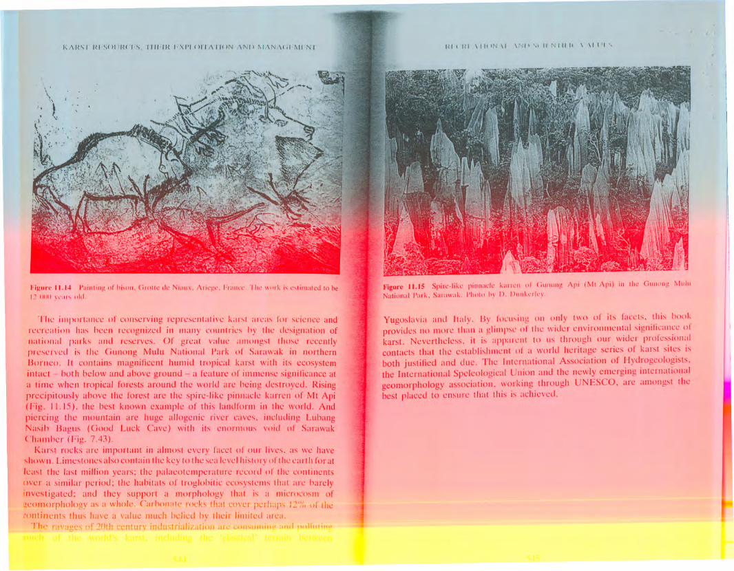
Ancient rock drawings of animals amI hunting scencs provide other elucsto the ecology of past times, as well as being superb examples of thc ;Irtisticability of our forebears. Most famous ;lIl1ongst locations where thesc can heseen are Altamira Cave near Santander in northern Spain, Lascaux Cave in
the Dordogne valley in Francc, and Niaux Cave in the Frcnch Pyrences(Fig. I L 14). Measured on any scale, these are internationally importantsites of cultural heritage, but sadly they face conservation problems of grcatcomplexity, being inadvertently damaged by the very tourists who go toadmire them (Andrieux 10k1, Brunet e/ 01. 10K5, Villar el 01. 10Ko). It was inthese caves that thc intricate and eonllieting dcmands of tourist cavedevelopment and conservation wcrc lirst apprcciated. Less well known hutstill important sites with cave art occur in Africa. Australia and P,lpua NcwGuinea.
There are about 050 tourist caves in thc world (Jlabe 10kl), with those inthe ~castcrn hcnlisphcrc' alone being visited by over !S tlliI!ion tourists :1
year (Maksimovich 1977). The prcssurc that this blings alters theatlJlOsnllL.rc and energy balance of till.. sut tL.r "Il. •.•l wOlld dnd ,,,l ;J.lls ,It
Figurc /1.1" I'aililill!! of hisOll, e'l'Olie de Niallx, Acie,~e, Frallce. Till' \Illlk is cstimated to be12111111\l'aIS old,
The importance of conserving representative k<lrs,t <lre<ls for science and
recreation has been recognized in many countries by the designation of
JJ:ltioJJ:i1 parks and reserves. Of great value :Imongst those recentlypreserved is the Gunong Mulu National /'<lrk of S<lrawak in northern
Borneo. It contains magnificent humid tropical karst with its ecosystem
intact - both below and above ground - a feature of immense significance at
a time when tropical forests around the world arc being destroyed. Rising
precipitously above the forest are the spire-like pinnacle brren of Mt Api
(Fig. 11.15). the best known example of this landform in the world, And
piercing the mountain are huge allogenic river caves. including Lubang
Nasih Baglls (Good Luck Cave) with its enOJ'lllllUs, void of Sarawak
Chamber (Fig, 7.43).
Karst rocks arc important in almost every facet of our lives. <IS we have
s,hown, Li mestones also con t a in t he key to t he sea leve I his! 0 ry of t he e <Irt h for at
least the last millio/l years; the palaeotemperature record of the continents
over a similar period; the habitats of troglobitic ecosystcills that arc barely
investigated; and they support a morphology that is a microcosm of
:!.eol1lorphology as a whole. Carhonate rocks that cover perh:lps 12';() \ll' the
.:ontinents thus have a value much belied by their limited area.
The ravages of 20th ecnturv industrialrzati(n .Ie COlhlllllillP and !)I)II"ti,,,,
1(1(HI \IIIIN \1 \,,11' ',I II NIIII! \ \11'1',
FigUl'c 11.15 Spire-like pilillacle Karrell of e'liCHIII!! Api (I'vIt Api) ill Ille GlI[H1I1!! ~11I11INatilll1:d Park, S:II :,\\':,k. !'IIlllo h\' I). I J'"11-,'[ I,'\'.
Yugoslavia and Italy. By focus,ing on only two of its facets. this book
provides no more tllan a glimpse of the wider environmental signilicance orkarst. Nevertheless. it is apparent to us through our wider professional
contacts that the establishment or a world heritage series of karst sites is
both justified and e1ue. The International Association of Hydrogeologists.
the International Speleological Union and the newly emcrging international
geomorphology association. working through UNESCO, are amongst thebest placed to ensure that this is achieved.