Page 1
KEPLER Deliverable Report
Report on Deliverable D3.2
Deliverable name New and novel observation sensors and techniques
Scheduled delivery month: 11 date: November 2019
Actual delivery month: 13 date: January 2020
Report type Internal report
Lead author Nick Hughes, Norwegian Meteorological Institute - Norwegian Ice Service
Contributing authors
Marcin Pierechod, Norwegian Meteorological Institute - Norwegian Ice Service
Jeremy Wilkinson, British Antarctic survey
Astrid Bracher, Alfred Wegener Institute
Rune Storvold, NORCE
Context of deliverable within Work Package
KEPLER will consult with the developers of observation sensor technologies and platforms to
determine the maturity of the different types of systems and their practicality for Polar Regions
deployments. Examples include: (a) Remote Piloted Airborne Systems (RPAS), (b) off-the-shelf drone
systems, kites, and balloons that have been used with some success to support ship navigation in
ice, and (c) AUVs, wavegliders for oceanographic monitoring.
New sensor technology, or new use of existing technology in Polar Regions, will also be considered,
such as ultra-wideband (UWB) and ground-penetrating radars (GPR) for measuring, e. g., the active
layer depth in permafrost regions (to be soon tested by a team from AWI) or for mapping the
internal structure of glaciers and regions of the ice sheets.
This task will evaluate the most recent developments in technologies such as, e. g., airborne
hyperspectral imaging or tomographic radar, bio-optical sensors on autonomous platforms such as
ITPs or multi-sensor ship towed sledge systems. It will also investigate whether these technologies
are practical for use in an operational context to support Copernicus services either in providing
ground truth or for providing an additional source of validation data, considering both the
technological viewpoint and the operator longevity standpoint. This will be done through KEPLER
1 | Page
Page 2
consortium participant’s contacts, and by online surveys and roundtable discussion at meetings and
conferences.
2 | Page
Page 3
Table of Contents
Contributing authors 1
Context of deliverable within Work Package 1
Table of Contents 3
Overview 4
Part 1: Unmanned Aircraft Systems (UAS) 5
Existing RPAS used for Polar monitoring 5
High Altitude Pseudo Satellites (HAPS) 6
Recommendations for Pan-Arctic UAS operations 8
Part 2: Other Airborne Systems 9
Off-the-shelf drone systems 9
Kites 10
Balloons 10
Part 3: Systems for Oceanographic Monitoring 12
Autonomous Underwater Vehicles (AUVs) 12
Gliders 12
Part 4: New sensor technologies 13
Ultra wideband (UWB) 13
Ground penetrating radars (GPR) 13
Hyperspectral imaging 13
Tomographic radar 14
Bio-optical sensors 14
References 17
3 | Page
Page 4
Overview
This deliverable explores some of the options for expanding Copernicus’ monitoring capabilities in
the Polar Regions over the next phase, 2021-27. There exist a number of systems and technologies
that can supplement the in situ and spaceborne capacities described in D3.1 and D3.3 respectively.
In evaluating the different technological options, we have limited our investigations to those that are
already known to exist and have the potential for routine operational deployment in the current
Copernicus services. This does not consider blue-sky technologies the ongoing research efforts are
unknown and where significant expenditure is needed to bring these to advance the technological
readiness to a state where field deployments are feasible.
4 | Page
Page 5
Part 1: Unmanned Aircraft Systems (UAS)
The use of Unmanned Aircraft Systems (UAS) in the Polar Regions is desirable due to the harsh
climate of these regions and large areas with little or no infrastructure. Currently, these areas are
accessible only by specialised marine vessels or higher risk aviation missions. UAS, including
Remotely Piloted Airborne Systems (RPAS), offer the potential to further scientific data collection
and assist navigation and search-and-rescue (SaR) missions by providing an aerial view that is more
flexible than the limited availability of satellite imaging. UAS can provide additional detailed
information for understanding sea ice, ocean, and atmospheric systems, the processes governing
energy exchange among them, and processes impacting the location and movement of sea ice.
The use of UAS for environmental monitoring, primarily scientific research, has been limited due to
the lack of experience with the rapidly evolving technology, the ability of UAS to comply with
international regulations for flight operations, and the need for operational approval. Pan-Arctic
missions across international Flight Information Regions (FIRs) have been limited and there has yet
to be any attempts to set these up routinely on a basis that can be used for repeat monitoring.
UAS typically fly at low altitude and have the potential to measure environmental parameters in
conditions that would be challenging to manned aircraft. They can operate from limited airport
infrastructures, can be designed to not be dependent on crew schedules or fueling requirements,
and can fly in marginal weather conditions. The lower cost of the systems makes them attractive for
missions from field campaigns where the risk of loss is high. In addition, the use of UAS has been
proposed for communications relay purposes in areas where satellite coverage is poor or expensive.
We discuss here a number of systems that have been utilised in Polar Regions observation missions,
before also introducing systems that could have some use in routine long-term monitoring including
Copernicus.
Existing RPAS used for Polar monitoring
The Global Hawk RQ-4 developed by Northrop Grumman for the U.S. military is a high-altitude RPAS
system with long endurance of up to 33 hours that can carry a variety of sensors including synthetic
aperture radar (SAR). The system is one of the largest UAS systems available, and this allows it to use
a turbofan engine with the power to carry a payload up to 1400 Kg at altitudes up to 18,000 meters.
A variant of the Global Hawk, EuroHawk, was tested with the German military, and a “Polar Hawk”
variant for Arctic monitoring was proposed for the Canadian military.
Global Hawk has been used in one reported Arctic field campaign. In March 2011 the Winter Storms
and Pacific Atmospheric Rivers (WISPAR) used a Global Hawk belonging to NASA to deploy
dropsondes between the North Slope of Alaska and 85°N (Intrieri et al, 2014). This was the first UAS
Arctic dropsonde mission of its kind. During this mission, the Global Hawk transected an unusually
cold polar vortex and documented polar boundary layer variations. These tested design-limits
5 | Page
Page 6
thresholds for fuel and airframe minimum temperature, with ambient temperatures of -76°C being
encountered that were close (within 2°C) of the critical skin temperature for Global Hawk. The
successful deployment demonstrated the capability of the Global Hawk to conduct operations in
harsh, remote regions and highlighted the potential value of Arctic atmospheric dropsonde
observations where routine in situ measurements are practically nonexistent.
In Europe, the Norwegian institute NORCE has led the development of RPAS systems for Polar
scientific monitoring. These include:
● Cryowing Scout (CW Scout) fixed-wing RPAS.
● Marine mammal monitoring (Aniceto et al, 2018).
High Altitude Pseudo Satellites (HAPS)
A number of systems have been proposed to address monitoring and communications issues at mid-
to low-latitudes. High Altitude Pseudo Satellites (HAPS) have the potential to operate for extreme
periods of time, days and months rather than hours, at very high, stratospheric altitude and are the
subject of a programme (HAPS4ESA) by ESA’s Directorates of Telecommunication, Earth Observation
and Navigation, and further studies through its Discovery and Preparation Programme. These are
identifying how HAPS could bring value to satellite communications and Earth Observation (EO) in
terms of performance or cost, highlighting gaps in current HAPS technologies, and planning towards
operational services.
The two main HAPS systems being proposed are by Airbus and Thales Alenia Space. Airbus has
developed the Zephyr, a fixed-wing solar-electric UAS that operates at stratospheric altitudes of
around 21,000 meters. The current production model Zephyr S has a wingspan of 25 meters and
weighs less than 75 Kg. The development model Zephyr T has a wingspan of 33 meters and weighs
140 Kg. After take-off and ascent into the stratosphere, the Zephyr navigates to the desired location,
which may be hundreds or thousands of kilometers away. Zephyr can be controlled from Ground
Control Stations anywhere in the world using beyond line of sight (BLOS) capabilities. The first
operational launch site for Zephyr is at Wyndham, Western Australia.
Whilst the Zephyr has the potential for extended operations at mid- to low-latitudes, its use in higher
polar latitudes would be restricted to summer periods when the sun is above the horizon. The sun
angles of less than 30° are also less than optimal for solar power requirements, with the panels
utilising the flat surfaces on top of the aircraft.
The Zephyr carries the SPIDER (Ship Position and Detection Radar). This operates at X-band and has
a maximum 40 km swath at 0.5x100 meters resolution, together with a 5 km Stripmap mode with
resolution of < 1x1 meters. The senors weighs less than < 5 Kg.
6 | Page
Page 7
The rival to Zephyr is the Stratobus by Thales Alenia Space. Unlike the Zephyr this is a
lighter-than-air, autonomous stratospheric airship. The Stratobus can survey the ground to several
100 km away, and can remain in place at 20,000 meters altitude through an electric propulsion
system. The lighter-than-air design removes the need for a launcher or large runway site.
The Stratobus features a number of innovative technologies that may make it more suitable for polar
deployments. These include a solar concentrator inside the balloon envelope coupled with a
reversible fuel cell to provide nighttime power. The solar panels are placed on the nose allowing
them to be rotated. This, and the propulsion motors maintaining a stationary position, allow the
solar panels to be positioned to always face the Sun.
Stratobus is designed to withstand moderate and stable winds of less than 90 km/h at lower
latitudes. It would therefore have to be deployed at latitudes above those affected by the polar
vortex, where wind speeds can reach 220 km/h. This and the need for solar power would limit its
Polar deployments to summer periods. However, it is estimated that it could handle 5-year missions,
with a few days per year for ground maintenance.
The limited information from the manufacturers on Stratobus suggests that the first Prototype Flight
Model (PFM) will be ready for trials in late 2020 or 2021. The first qualifying flight of a full-size model
would occur in 2022.
Stratobus is part of the project HAPPIEST (High-Altitude Pseudo-Satellites: Proposal of Initiatives to
Enhance Satellite Communication) that is focusing on the use of ‘aerostatic’ HAPS in the form of
stratospheric balloons, which are then able to carry more payload and generate more power than
aerodynamic HAPS.
Other stratospheric balloons for HAPS developers include:
● Zero 2 Infinity (Spain). Development of a service called Elevate to fly payloads to near space
for science, communications, satellite testing, meteorology and marketing purposes.
● Avealto (UK). Ascender series of lighter-than-air, solar-powered vehicles to provide
telecommunication infrastructure.
● Loon (USA). A subsidiary of Alphabet (Google) working on providing Internet access to rural
and remote areas through stratospheric balloons. In July 2019 reported that they had
achieved 1 million hours of stratospheric flight with a fleet of balloons designed to stay aloft
each up to around 200 days.
● Project AlphaLink (Germany). Fixed-wing UAS system with the capability to couple units
together during flight. Intends to be the first to achieve 5 year continuous operation with a
payload of around 450 Kg. The combined units provide greater solar panel area for 24/7
operation. A single unit will allow operations of up to 100 days and a payload of 24 Kgs.
7 | Page
Page 8
The advantage of HAPS systems is that they operate above the air control altitude limit, usually
defined at 20 km. However launch and recovery involve operations below this limit, and so need
coordination with air traffic control. The operation of UAS in non-segregated airspace is not yet
regulated, with “sense and avoid” being the method of avoiding mid-air collisions. Aspects of
International Law relating to the overflight of other countries also need to be investigated.
The future of HAPS will be driven mainly by the evolution of technologies of potential competitors,
such as microsatellites constellations, and the availability of financial resources to overcome the
HAPS technological challenges.
Recommendations for Pan-Arctic UAS operations
AMAP, 2015a make a number of recommendations for mitigating risks to other aircraft operating in
the Arctic:
1. Requirement of an operations and communications plan in accordance with national
regulations and that meets ICAO provisions.
2. Filing of an ICAO flight plan by the operator to the appropriate CAA or ATS unit.
3. A common approach to safety risk assessment based on the ICAO framework.
4. Use of an Automatic Dependent Surveillance-Broadcast (ADS-B) transponder (or future
equivalent).
5. Require that UAS used beyond visual line-of-sight (BVLOS) operation be registered in a
national aircraft registry.
6. Civil UAS operators should provide proof of insurance in Special Drawing Rights (SDR), or
equivalent, in accordance with the EU policy EC785/2004, Article 7.1 table, or national
equivalent.
7. Recommend that CAAs approve UAS operators similar to manned aircraft operators.
8. Ensure that remote pilots are licensed in accordance with national regulations and that is
consistent with ICAO Annex 1, Personnel Licensing.
9. Require CAA-acceptable proof of proficiency of training or competency for the specific UAS.
10. Recommend CAAs establish type certification and airworthiness certification requirements
to enable cross-flight information region (c ross-FIR) operations.
11. Arctic nations can reserve the right to impose additional requirements in their airspace as
needed.
12. Include Arctic UAS operations in Aeronautical Information Publication (AIP) supplements.
13. Recommend charting of UAS coastal launch sites.
14. Require deconfliction plans to be coordinated with Arctic CAAs and the operators approval
authorities.
8 | Page
Page 9
Part 2: Other Airborne Systems
Off-the-shelf drone systems
UAS are cheap, very capable, very portable and can be deployed in the field for research with a
fraction of the risk to human life and financial cost compared to traditional methods and quality data
can be gathered rapidly.
The use of off-the-shelf drones as cheap, expendable aerial observing technology has taken off in the
past 5 years. Today’s drones are sophisticated, readily-available, and have good range and
capabilities. In the Arctic, the Arctic Science Remotely Piloted Aircraft Systems (RPAS) Operators
Handbook (AMAP, 2015a) provides some guidelines to operations. In the Antarctic, the International
Association of Antarctic Tour Operators (IAATO) has prohibited clients from using drones for
non-commercial activities and the Antarctic Treaty Committee of Managers (ATCM) has asked for
input on UAS use.
Ivey and others, 2013 evaluated UAS systems for polar deployments and presents a summary of
required measurements, predominantly atmospheric, and UAS suitability (Fig. 1).
Figure 1: Key observational requirements and UAS suitability.
9 | Page
Page 10
The United States Antarctic Program (USAP) has adopted the Ops Policy Master Draft (2014) is as a
temporary stand in policy for US operating airspace in Antarctica. This requires UAS operators to
comply with Federal Aviation Administration (FAA) requirements within US National Air Space.
Kites
These provide an inexpensive method for aerial photography, and Kite Aerial Photography (KAP)
competes with the rapid advance of other methods of small format aerial photography (SFAP) and
the popularity of unmanned aerial vehicles (UAV) (Marris, 2013) in the field of scientific data
collection (Sander, 2014).
The main drawbacks of these systems is that the low costs necessitates a more labour intensive
approach to deployment. Larger kite systems have been used for supplementary vessel propulsion,
and these have included development of automated systems for management (Maaß, 2013)
Kites are also highly reliant on wind conditions. The issues with their use in deploying iceberg GPS
trackers has been discussed (McGill et al., 2011). Their opinion is that more ships are hostile
environments for kite deployments due to the masts and cabling, and turbulence from the ship’s
superstructure. A kite deployment ideally needs to take place from a location with an unrestricted
360° view of the sky. Targets such as icebergs also need to be downwind, and there is a strong
likelihood that shifting winds around the iceberg would require a change in the ship’s heading,
entangling the kite’s strings in some part of the ship’s superstructure. A tethered balloon would
suffer the same fate.
Kites are therefore more useful from land-based, or on-ice, locations well removed from any
surrounding infrastructure. In the Antarctic, the technique has been used to monitor penguin
populations (Fraser et al., 1999) and for localised atmospheric measurements over leads (Guest,
2007).
Balloons
Radiosondes are widely used in meteorology for atmospheric profiling, and these are the prime
balloon-based measurements in the polar regions. However long-term routine deployment of these
is expensive, requiring a manned coastal or shipboard observing station, the data receiving
equipment, and the consumables (balloons, sondes, helium gas).
10 | Page
Page 11
The use of tethered balloons compared to UAVs is discussed in Ivey et al., 2013 and de Boer et al.,
2016. These were seen as advantageous for polar regions deployments as they negated the risk, for
UAVs or manned aircraft, of flying in clouds likely to result in icing.
11 | Page
Page 12
Part 3: Systems for Oceanographic Monitoring
Autonomous Underwater Vehicles (AUVs)
Autonomous Underwater Vehicle (AUV) technology has been in use in polar regions since the early
2000’s with varying degrees of success. Early experiments included Maridan, Gavia and Autosub
AUV’s and use of these is reviewed in Wadhams and Krogh, 2019. This resulted in a number of
scientific papers, especially in the field of sea ice thickness mapping (Wadhams et al., 2004; Nicholls
et al., 2006; Wadhams and Doble, 2008, Doble et al., 2009).
More recently there has been some successes with WHOI AUV’s on limited area surveys under-ice.
The key limitations of AUV technology are accurate underwater navigation and battery technology.
Whilst navigation can be improved by reference stations or seabed-tracking in shallow waters, fully
inertial navigation is still difficult. Battery technology limits the range of deployments, and the sensor
load.
Wadhams and Krogh, 2019 point to a number of lessons learnt that could contribute to future, more
consistent AUV data gathering:
1. Good communication between the AUV team and the deployment vessel crew.
2. Technology is constantly advancing and improving.
3. Slow-moving vehicles where depth control is by vertical propeller (e.g. WHOI) are not
suitable for use in marginal ice zone (MIZ) conditions where shear currents may occur.
4. A single (Ultra-Short BaseLine (USBL) acoustic tracking system is potentially better, for ease
of deployment, than a multiple transponder system.
5. A low cost AUV-buoy-sonar system will be very valuable in improving the understanding of
the critical processes of ice deformation and summer ice decay, as well as validation of
airborne and satellite altimetry, especially when combined with a surface mapping system
(laser or photogrammetry from an RPAS system).
Gliders
Gliders have become more ubiquitous in polar waters monitoring in the past decade. However, their
use is limited to open water areas. Wavegliders derive additional power from wave energy and
remain on the surface. True gliders have a deployment limited by battery endurance and minimise
power requirements through gliding underwater. The low power requirements of these systems
limit them to basic oceanography sensors and cameras. Gliders can be fully or semi-autonomous.
12 | Page
Page 13
Part 4: New sensor technologies
Ultra wideband (UWB)
This type of radar is widely used for measuring snow thickness on sea ice and internal ice layers. The
concepts and development of systems took place in the 1990’s (Kanagaratnam, 1995), with reliable
instruments being available from the late 2000’s (Gogineni and others, 2003; Holt and others, 2009;
Kanagaratnam and others, 2007; Panzer and others, 2013). A system was also deployed on the NASA
Ice Bridge campaigns (Kwok, 2011).
Lower radar frequencies penetrate the snow cover and are signals are returned from the sea ice /
snow interface. Higher radar frequencies are returned from layers close to the snow surface. The
combination of both provides a measure of snow thickness.
Ground penetrating radars (GPR)
GPR has a longer history of use on freshwater, lake or river ice. Its non-destructive nature, with
excellent depth penetration and ready deployment over large areas has resulted in extensive and
routine application. The use of GPR to study sea-ice is, however, much less common, despite its
potential to provide valuable information related to, for example, regional effects of global warming.
This is because GPR signal propagation in ices with high brine contents is characterized by a lossy
behaviour which reduces radar signal penetration (Mattei and others, 2019). Initial reports on
attempts to use GPR on sea ice were published in the 2000’s (Nyland, 2004; Galley and others,
2009). GPR has been used for helicopter-borne surveys on dedicated campaigns, requiring low
altitude flying (Lalumiere, L., and Prinsenberg, 2009). Use in routine surveys may become feasible
with increasing UAV payloads and endurance.
Hyperspectral imaging
These types of sensors can detect an entire electromagnetic spectrum of information, typically at
optical frequencies. However, the large similarities between many of the frequency bands for sea ice
often reduce the accuracy of the classification methods, and researchers have focused on how to
increase the classification accuracy (Han and others, 2017). This paper introduced an improved
similarity measurement method based on linear prediction (ISMLP) for hyperspectral sea ice
detection.
Satellite deployments include the Compact High Resolution Imaging Spectrometer (CHRIS)
instrument on ESA’s Proba-1 satellite from 2001 onward, the Hyperion instrument on the EO-1
satellite operated by NASA from 2000 to 2017, the Indian HySIS satellite launched in 2018, and the
Italian PRISMA satellite launched in 2019. The German Aerospace Center (DLR) anticipate to launch
the EnMAP (Environmental Mapping and Analysis Program) in 2020.
13 | Page
Page 14
As hyperspectral instruments operate at optical frequencies, their use is limited to cloud-free areas.
The full spectrum of data results in large data volumes so only small areas (100’s of square
kilometers) can be covered, albeit at very high resolution.
Hyperspectral images may provide the potential to estimate the density of new ice types (Liu and
others, 2014).
Tomographic radar
For sea ice and icebergs, this approach involves simultaneous imaging by two synthetic aperture
radar (SAR) satellites. The capability has been available since the launch of the TanDEM-X
(TerraSAR-X add-on for Digital Elevation Measurement) satellite in 2010, and could be provided in a
scenario envisioned for the ROSE-L L-band SAR high priority candidate mission (HPCM) currently
under consideration for Copernicus expansion. The use of two satellites provides a stereographic
imaging from which surface height can be determined. As for hyperspectral imaging, the data
volumes and need for high levels of detail and thus the very high resolution imaging modes of the
SAR limit this approach to small regions.
Bio-optical sensors
Biosensors are defined by the International Union of Pure and Applied Chemistry (IUPAC) as
integrated receptor-transducer devices, which are able to provide selective quantitative or
semi-quantitative analytical information using a biological recognition element. The main advantages
of biosensors over the traditional analytical techniques for the detection of environmental
parameters are their cost cost-effectiveness, fast and portable detection. Biosensors can be divided
based on the type of recognition element used to enzymatic, whole-cell or affinity-based. Enzymatic
biosensors measure the selective inhibition or the catalysis of enzymes by a specific target. Second
class, used frequently for the monitoring of environmental pollutants are whole cells, such as
bacteria, fungi, yeast, plant or animal cells. These sensors detect responses of cells after exposure to
toxins. The toxic response can be either non-specific, such as DNA-cleavage, heat shock and
oxidative stress or specific to a class of environmental pollutants, such as metals, organic compounds
and compounds with biological importance e.g. nitrates, ammonia, antibiotics. The affinity-based
biosensors have recognition elements that can detect individual targets or a group of structurally
related targets with high sensitivity. Detection can rely on antibodies, bacteria-infecting viruses
(phages), nucleic acids (Van Dorst et al., 2010). Biosensors including immunosensors, aptasensors,
genosensors, and enzymatic biosensors have been reported for the detection and monitoring of
various environmental pollutants, e.g. organophosphorus pesticides, toxic heavy metals such as
mercury and uranium, phenol and phenol derivatives, perfluorooctanesulfonic acid (PFOS),
antibiotics, drugs and drug metabolites, small organic molecules including toxins and
endocrine-disrupting chemicals (Justino, Duarte, & Rocha-Santos, 2017)(R. Li, Feng, Pan, & Liu, 2019)
14 | Page
Page 15
A distinct category of affinity-based sensors are molecularly imprinted polymers (MIP). These
chemical sensors are mimicking the target-biological receptor interaction and are due to this
sometimes called “plastic antibodies”. These sensors could be of special interest for the detection of
both organic and inorganic targets in the extreme polar environment. The recognition surfaces of
these sensors are highly stable in a wide temperature and pH range, resistant to biological
degradation, have small footprint, weight and coupled detection system make can be designed to
use a minimal amount of power. One of the major drawbacks of the MIP sensors is the size of the
detectable target. Due to the mass-transfer effect these sensors cannot effectively detect targets
with high molecular weight (S. Li, Cao, Whitcombe, & Piletsky, 2014).
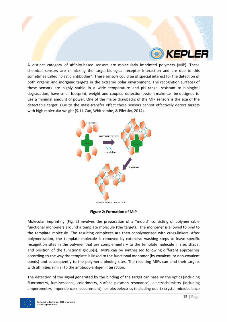
Figure 2: Formation of MIP
Molecular imprinting (Fig. 2) involves the preparation of a “mould” consisting of polymerizable
functional monomers around a template molecule (the target). The monomer is allowed to bind to
the template molecule. The resulting complexes are then copolymerized with cross-linkers. After
polymerization, the template molecule is removed by extensive washing steps to leave specific
recognition sites in the polymer that are complementary to the template molecule in size, shape,
and position of the functional group(s). MIPs can be synthesized following different approaches
according to the way the template is linked to the functional monomer (by covalent, or non-covalent
bonds) and subsequently to the polymeric binding sites. The resulting MIPs can bind their targets
with affinities similar to the antibody-antigen interaction.
The detection of the signal generated by the binding of the target can base on the optics (including
fluorometry, luminescence, colorimetry, surface plasmon resonance), electrochemistry (including
amperometry, impendence measurement) or piezoelectrics (including quartz crystal microbalance
15 | Page
Page 16
measurements). The class of MIPs-based electrochemical biosensors (ECBSs), where the sensing film
is deposited directly on a transducer surface seems to be the most suitable for long-term
deployment due to its built simplicity and sensitivity. These sensors can also take advantage of the
recently developed electroactive nanomaterials, such as carbon nanotubes, noble metal
nanoparticles tubes or rods, nanoporous gold leaves, graphene, etc. MIPs cannot only accumulate on
such electrode templates to enhance the sensitivity of the sensor, but also separate templates from
other, non-target analytes to improve their selectivity (Gui, Jin, Guo, & Wang, 2018).
In spite of a large number of publications and the outstanding results reported in the literature, the
majority of these sensors do not reach the market and remain mere proof-of-concept studies. For
the real commercial application of biomimetic sensors, the open challenges concern mainly: the
miniaturization of the devices, the automation of sensor production, the development of
user-friendly protocols and their applicability and reproducibility in real sample analysis (Moro et al.,
2019).
16 | Page
Page 17
References
AMAP (2015a). Arctic Science Remotely Piloted Aircraft Systems (RPAS) Operator’s Handbook. By: R.
Storvold, C. Sweatte, P. Ruel, M. Wuenneberg, K. Tarr, K-S. Johansen, M. Raustein, T. Hillesøy, T.
Lundgren, M. Sumich. Arctic Monitoring and Assessment Programme, Oslo. 25 pp.
AMAP (2015b). Implementing Scientific Data Collection across the Arctic Oceanic Region Utilizing
Unmanned Aircraft Systems (UAS). By: C. Sweatte, R. Storvold, P. Ruel, M. Wuennenberg, K. Tarr, A.
la Cour-Harbo, B. Feldberg, J. Kivinen, H. Hólm, M. Raustein, E. Jangren, B. Mulac, J. Adler, D. Davis, L.
Cary, S. Lesenkov. Arctic Monitoring and Assessment Programme, Oslo. 5 pp.
de Boer, G., M. D. Ivey, B. Schmid, S. McFarlane, and R. Petty (2016), Unmanned platforms monitor
the Arctic atmosphere, Eos, 97, doi:10.1029/2016EO046441. Published on 22 February 2016.
Doble, M. J., Forrest, A. L., Wadhams, P., & Laval, B. E. (2009). Through-ice AUV deployment:
Operational and technical experience from two seasons of Arctic fieldwork. Cold Regions Science and
Technology, 56(2-3), 90-97.
Fraser, W.R., Carlson, J.C., Duley, P.A., Holm, E.J., and Patterson, D.L. (1999). Using kite-based aerial
photography for conducting Adelie penguin censuses in Antarctica. Waterbirds, 435-440.
Galley, R. J., Trachtenberg, M., Langlois, A., Barber, D. G., & Shafai, L. (2009). Observations of
geophysical and dielectric properties and ground penetrating radar signatures for discrimination of
snow, sea ice and freshwater ice thickness. Cold Regions Science and Technology, 57(1), 29-38.
Gogineni, S., K. Wong, S. Krishnan, P. Kanagaratnam, T. Markus and V. Lytle, "An ultra-wideband
radar for measurements of snow thickness over sea ice," IGARSS 2003. 2003 IEEE International
Geoscience and Remote Sensing Symposium. Proceedings (IEEE Cat. No.03CH37477), Toulouse, 2003,
pp. 2802-2804 vol.4. doi: 10.1109/IGARSS.2003.1294591
Guest, P. S. (2007). Measuring turbulent heat fluxes over leads using kites. Journal of Geophysical
Research: Oceans, 112(C5).
Han, Y., Li, J., Zhang, Y., Hong, Z., & Wang, J. (2017). Sea ice detection based on an improved similarity measurement method using hyperspectral data. Sensors, 17(5), 1124.
Holt, B., Kanagaratnam, P., Gogineni, S. P., Ramasami, V. C., Mahoney, A., & Lytle, V. (2009). Sea ice
thickness measurements by ultrawideband penetrating radar: First results. Cold Regions Science and
Technology, 55(1), 33-46.
Intrieri, J. M., de Boer, G., Shupe, M. D., Spackman, J. R., Wang, J., Neiman, P. J., Wick, G. A., Hock, T.
F., and Hood, R. E. (2014). Global Hawk dropsonde observations of the Arctic atmosphere obtained
17 | Page
Page 18
during the Winter Storms and Pacific Atmospheric Rivers (WISPAR) field campaign, Atmos. Meas.
Tech., 7, 3917–3926, https://doi.org/10.5194/amt-7-3917-2014.
Ivey, M., R. Petty, D. Desilets, J. Verlinde and R. Ellingson (2013). Polar Research with Unmanned
Aircraft and Tethered Balloons. A Report from the Planning and Operational Meeting on Polar
Atmospheric Measurements Related to the U.S. Department of Energy ARM Program Using Small
Unmanned Aircraft Systems and Tethered Balloons, Held July 24-26, 2013, Washington, D.C. Online
at https://www.arm.gov/publications/tech_reports/doe-sc-arm-tr-135.pdf
Kanagaratnam, P. (1995). High-resolution radar backscatter from sea ice and range-gated
step-frequency radar using the FM-CW concept (Master's thesis, University of Kansas, Electrical
Engineering and Computer Science).
Kanagaratnam, P., Markus, T., Lytle, V., Heavey, B., Jansen, P., Prescott, G., & Gogineni, S. P. (2007).
Ultrawideband radar measurements of thickness of snow over sea ice. IEEE Transactions on
Geoscience and Remote Sensing, 45(9), 2715-2724.
Kwok, R., Panzer, B., Leuschen, C., Pang, S., Markus, T., Holt, B., & Gogineni, S. (2011). Airborne
surveys of snow depth over Arctic sea ice. Journal of Geophysical Research: Oceans, 116(C11).
Liu, C., Shao, H., Xie, F., & Wang, J. (2014, November). Sea ice density estimation in the Bohai Sea
using the hyperspectral remote sensing technology. In Multispectral, Hyperspectral, and
Ultraspectral Remote Sensing Technology, Techniques and Applications V (Vol. 9263, p. 92632T).
International Society for Optics and Photonics.
Maaß, J., & Erhard, M. (2013). Software system architecture for control of tethered kites. In Airborne
wind energy (pp. 599-611). Springer, Berlin, Heidelberg.
Marris, E. (2013). Drones in science: Fly, and bring me data. Nature News, 498(7453), 156.
Mattei, E., Cosciotti, B., Paolo, F. D., Lauro, S. E., Beaubien, S. E., Barber, D., & Pettinelli, E. (2019,
January). Ground Penetrating Radar and dielectric property measurements of artificial sea ice. In
Geophysical Research Abstracts (Vol. 21).
McGill, P.R., Reisenbichler, K.R., Etchemendy, S.A., Dawe, T.C., & Hobson, B.W. (2011). Aerial surveys
and tagging of free-drifting icebergs using an unmanned aerial vehicle (UAV). Deep Sea Research Part
II: Topical Studies in Oceanography, 58(11-12), 1318-1326.
Nicholls, K. W., Abrahamsen, E. P., Buck, J. J. H., Dodd, P. A., Goldblatt, C., Griffiths, G., ... & McPhail,
S. D. (2006). Measurements beneath an Antarctic ice shelf using an autonomous underwater vehicle.
Geophysical Research Letters, 33(8).
18 | Page
Page 19
Nyland, D. (2004). Profiles of floating ice in Arctic regions using GPR. The Leading Edge, 23(7),
665-668.
Panzer, B., Gomez-Garcia, D., Leuschen, C. J., Paden, J. D., Rodriguez-Morales, F., Patel, A., ... &
Gogineni, S. (2013). An ultra-wideband, microwave radar for measuring snow thickness on sea ice
and mapping near-surface internal layers in polar firn.
Sander, L. (2014). Kite aerial photography (KAP) as a tool for field teaching. Journal of Geography in
Higher Education, 38(3), 425-430.
Wadhams, P., & Doble, M. J. (2008). Digital terrain mapping of the underside of sea ice from a small
AUV. Geophysical Research Letters, 35(1).
Wadhams, P., Wilkinson, J. P., & Kaletzky, A. (2004). Sidescan sonar imagery of the winter marginal
ice zone obtained from an AUV. Journal of Atmospheric and Oceanic Technology, 21(9), 1462-1470.
Wadhams, P., and Krogh, B. (2019). Operational history and development plans for the use of AUVs
and UAVs to map sea ice topography. Polar Science. https://doi.org/10.1016/j.polar.2019.07.004
Gui, R., Jin, H., Guo, H., & Wang, Z. (2018). Recent advances and future prospects in molecularly
imprinted polymers-based electrochemical biosensors. Biosensors and Bioelectronics, 100, 56–70.
https://doi.org/https://doi.org/10.1016/j.bios.2017.08.058
Justino, C. I. L., Duarte, A. C., & Rocha-Santos, T. A. P. (2017). Recent Progress in Biosensors for
Environmental Monitoring: A Review. Sensors (Basel, Switzerland), 17(12), 2918.
https://doi.org/10.3390/s17122918
Lalumiere, L., and Prinsenberg, S. (2009, January). Integration of a helicopter-based ground
penetrating radar (GPR) with a laser, video and GPS system. In The Nineteenth International
Offshore and Polar Engineering Conference. International Society of Offshore and Polar Engineers.
Li, R., Feng, Y., Pan, G., & Liu, L. (2019). Advances in Molecularly Imprinting Technology for
Bioanalytical Applications. Sensors (Basel, Switzerland), 19(1), 177.
https://doi.org/10.3390/s19010177
Li, S., Cao, S., Whitcombe, M. J., & Piletsky, S. A. (2014). Size matters: Challenges in imprinting
macromolecules. Progress in Polymer Science, 39(1), 145–163.
https://doi.org/10.1016/J.PROGPOLYMSCI.2013.10.002
Moro, G., Cristofori, D., Bottari, F., Cattaruzza, E., De Wael, K., & Moretto, L. M. (2019). Redesigning
an electrochemical MIP sensor for PFOS: Practicalities and pitfalls. Sensors (Switzerland).
https://doi.org/10.3390/s19204433
19 | Page
Page 20
Van Dorst, B., Mehta, J., Bekaert, K., Rouah-Martin, E., De Coen, W., Dubruel, P., Robbens, J. (2010).
Recent advances in recognition elements of food and environmental biosensors: A review.
Biosensors and Bioelectronics. https://doi.org/10.1016/j.bios.2010.07.033
Yitayew, T. G., Ferro-Famil, L., Eltoft, T., & Tebaldini, S. (2016). Tomographic imaging of fjord ice
using a very high resolution ground-based SAR system. IEEE Transactions on Geoscience and Remote
Sensing, 55(2), 698-714.
20 | Page