70


Kings County Planning Agency 1400 West Lacey Blvd, Bldg 6 Hanford, CA 93230
Los Angeles Co Reg Planning Dept 320 West Temple Street Los Angeles, CA 90012
San Bernardino Co Planning Dept 385 North Arrowhead Avenue, 1st Floor San Bernardino, CA 92415-0182
San Luis Obispo Co Planning Dept Planning and Building 976 Osos Street San Luis Obispo, CA 93408
Santa Barbara Co Resource Mgt Dept 123 East Anapamu Street Santa Barbara, CA 93101
Tulare County Planning & Dev Dept 5961 South Mooney Boulevard Visalia, CA 93291
Ventura County RMA Planning Div 800 South Victoria Avenue, L1740 Ventura, CA 93009-1740
U.S. Bureau of Land Management Ridgecrest Field Office 300 South Richmond Road Ridgecrest, CA 93555
China Lake Naval Weapons Center Tim Fox, RLA - Comm Plans & Liaison 429 E Bowen, Building 981 Mail Stop 4001 China Lake, CA 93555
Edwards AFB, Sustainability Office 412 TW/XPO, Bldg 2750, Rm 204-38 195 East Popson Avenue Edwards AFB, CA 93524
U.S. Fish & Wildlife Service 777 East Tahquitz Canyon Way, Suite 208 Palm Springs, CA 92262
Antelope Valley Resource Cons Dist 44811 Date Avenue, #G Lancaster, CA 93534-3136
Environmental Protection Agency Region IX Office 75 Hawthorn Street San Francisco, CA 94105
U.S. Dept of Agriculture/NRCS 5000 California Avenue, Ste 100 Bakersfield, CA 93309-0711
U.S. Army Corps of Engineers P.O. Box 997 Lake Isabella, CA 93240
Southern California Edison Planning Dept. 421 West "J" Street Tehachapi, CA 93561
State Air Resources Board Stationary Resource Division P.O. Box 2815 Sacramento, CA 95812
So. San Joaquin Valley Arch Info Ctr California State University of Bkfd 9001 Stockdale Highway Bakersfield, CA 93311
Caltrans/Dist 6 Planning/Land Bank Bldg. P.O. Box 12616 Fresno, CA 93778
Caltrans/Dist 9 Planning Department 500 South Main Street Bishop, CA 93514
State Clearinghouse Office of Planning and Research 1400 - 10th Street, Room 222 Sacramento, CA 95814
State Dept of Conservation Director's Office 801 "K" Street, MS 24-01 Sacramento, CA 95814-3528
State Dept of Conservation Division of Oil & Gas 4800 Stockdale Highway, Ste 108 Bakersfield, CA 93309
Office of the State Geologist Headquarters 801 "K" Street, MS 12-30 Sacramento, CA 95814
State Dept of Conservation Office of Land Conservation 801 "K" Street, MS 18-01 Sacramento, CA 95814
California State University Bakersfield - Library 9001 Stockdale Highway Bakersfield, CA 93309
California Energy Commission James W. Reed, Jr. 1516 Ninth Street Mail Stop 17 Sacramento, CA 95814
California Fish & Wildlife 1234 East Shaw Avenue Fresno, CA 93710
State Dept of Food & Agriculture 1220 "N" Street Sacramento, CA 95814
Integrated Waste Management P.O. Box 4025, MS #15 Sacramento, CA 95812-4025

State Water Resources Control Board Division of Drinking Water Attn: Jesse Dhaliwal, Sr. Sanitary Eng 4925 Commerce Drive, Suite 120 Bakersfield, CA 93309
Public Utilities Comm Energy Div 505 Van Ness Avenue San Francisco, CA 94102
California Regional Water Quality Control Board/Lahontan Region 15095 Amargosa Road - Bld 2, Suite 210 Victorville, CA 92392
State Lands Commission 100 Howe Avenue, Ste 100-South Sacramento, CA 95825-8202
Kern County Agriculture Department
Kern County Administrative Officer
Kern County Public Works Department/ Building & Development/Floodplain
Kern County Public Works Department/ Building & Development/Survey
Kern County Env Health Services Department
Kern County Fire Dept Brian Marshall, Fire Chief
Kern County Fire Dept Cary Wright, Fire Marshall
Kern County Library/Beale Local History Room
Kern County Library/Beale Andie Apple
Kern County Library Mojave Branch 16916 1/2 Highway 14, Space D2 Mojave, CA 93501
Kern County Museum 3801 Chester Avenue Bakersfield, CA 93301
Kern County Parks & Recreation Supervisor Zack Scrivner 2nd District
Kern County Sheriff's Dept Administration
Kern County Public Works Department/ Building & Development/Development Review
Kern County Public Works Department/Operations & Maintenance/Regulatory Monitoring & Reporting
Kern County Public Works Department/ Building & Development/Code Compliance
Southern Kern Unified School Dist P.O. Box CC Rosamond, CA 93560
Kern High School Dist 5801 Sundale Avenue Bakersfield, CA 93309
Kern County Superintendent of Schools Attention Mary Baker 1300 17th Street Bakersfield, CA 93301
KernCOG 1401 19th Street - Suite 300 Bakersfield, CA 93301
Local Agency Formation Comm/LAFCO 5300 Lennox Avenue, Suite 303 Bakersfield, CA 93309
Kern County Water Agency P.O. Box 58 Bakersfield, CA 93302-0058
East Kern Air Pollution Control District
Antelope Valley-East Kern Water Agency 6500 West Avenue N Palmdale, CA 93551
Adams, Broadwell, Joseph & Cardozo Attention: Janet M. Laurain 601 Gateway Boulevard, Suite 1000 South San Francisco, CA 94080

Kern Audubon Society Attn: Harry Love, President 13500 Powder River Avenue Bakersfield, CA 93314
Los Angeles Audubon 926 Citrus Avenue Los Angeles, CA 90036-4929
Center on Race, Poverty & the Environment Attn: Marissa Alexander 1999 Harrison Street – Suite 650 San Francisco, CA 94612
Center on Race, Poverty & the Environmental/ CA Rural Legal Assistance Foundation 1012 Jefferson Street Delano, CA 93215
Defenders of Wildlife/ Kim Delfino, California Dir 980 - 9th Street, Suite 1730 Sacramento, CA 95814
California Farm Bureau 2300 River Plaza Drive, NRED Sacramento, CA 95833
Mojave Chamber of Commerce P.O. Box 935 Mojave, CA 93502
Native American Heritage Council of Kern County Attn: Gene Albitre 3401 Aslin Street Bakersfield, CA 93312
Beth Boyst Pacific Crest Trail Program Manager 1323 Club Drive Vallejo, CA 94592
Anitra Kass Pacific Crest Trail Association 41860 Saint Annes Bay Drive Bermuda Dunes, CA 92203
Sierra Club/Kern Kaweah Chapter P.O. Box 3357 Bakersfield, CA 93385
Southern California Edison 2244 Walnut Grove, Ave, GO-1 Quad 2C Rosemead, CA 91770
Chumash Council of Bakersfield 2421 "O" Street Bakersfield, CA 93301-2441
David Laughing Horse Robinson P.O. Box 20849 Bakersfield, CA 93390
Kern Valley Indian Council Attn: Robert Robinson, Chairperson P.O. Box 401 Weldon, CA 93283
Kern Valley Indian Council Historic Preservation Office P.O. Box 401 Weldon, CA 93283
Santa Rosa Rancheria Ruben Barrios, Chairperson P.O. Box 8 Lemoore, CA 93245
Tejon Indian Tribe Kathy Morgan, Chairperson 1731 Hasti-acres Drive, Suite 108 Bakersfield, CA 93309
Kitanemuk & Yowlumne Tejon Indians Chairperson 115 Radio Street Bakersfield, CA 93305
Tubatulabals of Kern County Attn: Robert Gomez, Chairperson P.O. Box 226 Lake Isabella, CA 93240
Tule River Indian Tribe Neal Peyron, Chairperson P.O. Box 589 Porterville, CA 93258
Matthew Gorman The Gorman Law Firm 1346 E. Walnut Street, Suite 220 Pasadena, CA 91106
Matthew Gorman The Gorman Law Firm 1346 E. Walnut Street, Suite 220 Pasadena, CA 91106
Eight Bar Ranch Jon and Helen Lantz 11300 Cameron Canyon Road Mojave, CA 93501
Joyce LoBasso P.O. Box 6003 Bakersfield, CA 93386
LIUNA Attn: Danny Zaragoza 2201 "H" Street Bakersfield, CA 93301
Mojave Foundation Attn: Todd Quelet 16922 Airport Boulevard Mojave, CA 93501
Mojave Town Council Bill Deaver, President P.O. Box 1113 Mojave, CA 93502-1113
U.S. Army Attn: Tim Kilgannon, Region 9 Coordinator Office of Strategic Integration 721 - 19th Street, Room 427 Denver, CO 80202
U.S. Air Force Attn: David Bell/AFCEC CZPW Western Regional/Leg Branch 510 Hickman Ave., Bld 250-A Travis AFB, CA 94535-2729

U.S. Army Attn: Philip Crosbie, Chief Strategic Plans, S3, NTC P.O. Box 10172 Fort Irwin, CA 92310
U.S. Marine Corps Attn: Patrick Christman Western Regional Environmental Officer Building 1164/Box 555246 Camp Pendleton, CA 92055-5246
U.S. Navy Attn: Steve Chung Regional Community & Liaison Officer 1220 Pacific Highway San Diego, CA 92132-5190
David Walsh 22941 Banducci Road Tehachapi, CA 93561
Terra-Gen Randy Hoyle, Sr. Vice Pres 11512 El Camino Real, Suite 370 San Diego, CA 92130
Renewal Resources Group Holding Company Rupal Patel 113 South La Brea Avenue, 3rd Floor Los Angeles, CA 90036
Congentrix Sunshine, LLC Rick Neff 9405 Arrowpoint Blvd Charlotte, NC 28273
Fotowatio Renewable Ventures Sean Kiernan 44 Montgomery Street, Suite 2200 San Francisco, CA 94104
EDP Renewables Company 53 SW Yamhill Street Portland, OR 97204
Wind Stream, LLC Albert Davies 1275 - 4th Street, No. 107 Santa Rosa, CA 95404
Darren Kelly, Sr. Business Mgr Terra-Gen Power, LLC 1095 Avenue of the Americas, 25th Floor, Ste A New York, NY 10036-6797
Bill Barnes, Dir of Asset Mgt AES Midwest Wind Gen P.O. Box 2190 Palm Springs, CA 92263-2190
PG&E Steven Ng, Manager Renewal Dev, T&D Intercon 77 Beal Street, Room 5361 San Francisco, CA 94105
Wayne Mayes, Dir Tech Serv Iberdrola Renewables 1125 NW Couch St, Ste 700, 7th Fl Portland, OR 97209
Michael Strickler, Sr Project Mgr Iberdrola Renewables 1125 NW Couch St, Ste 700, 7th Fl Portland, OR 97209
Recurrent Energy Seth Israel 300 California Street, 8th Floor San Francisco, CA 92109
Tehachapi Area Assoc of Realtors Carol Lawhon, Assoc Exe, IOM 803 Tucker Road Tehachapi, CA 93561
Kelly Group Kate Kelly P.O. Box 868 Winters, CA 95694
T.T Case P.O. Box 2416 Tehachapi, CA 93581
Beyond Coal Campaign/Sierra Club Sarah K. Friedman 1417 Calumet Avenue Los Angeles, CA 90026
Robert Burgett 9261 - 60th Street, West Mojave, CA 93501
Structure Cast Larry Turpin, Sales Mgr 8261 McCutchen Road Bakersfield, CA 93311
U.S. Postal Service Address Management Systems 28201 Franklin Parkway Santa Clarita, CA 91383-9321
Inyo County Planning Dept P.O. Drawer "L" Independence, CA 93526
Carl B. Symons Field Manager Bureau of Land Management Ridgecrest Field Office 300 S. Richmond Rd. Ridgecrest, CA 93555
Cedric Perry California Desert District Bureau of Land Management 22835 Calle San Juan De Los Lagos Moreno Valley, CA 92553
Sandra McGinnis California State Office
Bureau of Land Management 2800 Cottage Way, Suite W-1623 Sacramento, CA 95825
Kim Marsden California Desert District Bureau of Land Management 22835 Calle San Juan De Los Lagos Moreno Valley, CA 92553
Adams Broadwell Joseph & Cardozo Cody Elliott 601 Gateway Boulevard Suite 1000 S. San Francisco, CA 942080-7037
Dylan M. Fuge, Attorney Advisor, Division of Land & Water Resources Office of the Solicitor U.S. Department of the Interior 1849 C Street, NW Mail Stop 5530 Washington, DC 20240

Debbie Allen, Administrative Assistant National Park Service, Pacific West Reg Rivers, Trails & Conservation Assistance Program 1111 Jackson Street, Suite 700 Oakland, CA 94607
Beth Boyst, Trail Manager USDA-FS Pacific Southwest Regional Office (Region 5) 1323 Club Dr. Vallejo, CA 94592
Ray Bransfield Renewable Energy Biologist Ventura Fish and Wildlife Office 2493 Portola Road, Suite B Ventura, CA 93003
Lisa Gymer Senior Environmental Scientist California Department of Fish and Wildlife 1234 East Shaw Avenue Fresno, CA 93710
Mary Wuester ,Tribal Chair Lone Pine Paiute-Shoshone Tribe P.O. Box 747 Lone Pine CA 93545
Dale Delgado Jr. Tribal Council Chair Bishop Paiute Tribe 50 Tu Su Lane Bishop CA 93514
Robert Gomez Tribal Council Chair Tubatulabals of Kern Valley P.O. Box 226 Lake Isabella CA 93240
Council Chairman Monache Intertribal Council P.O. Box 168 Kernville CA 93238
Genevieve Jones Tribal Chair Big Pine Paiute Tribe of the Owens Valley P.O. Box 700 Big Pine CA 93513
Bob Robinson Co-Chair and Tribal Historic Preservation Officer Kern Valley Indian Community P.O. Box 401 Weldon CA 93283
Israel Naylor Tribal Council Chair Fort Independence Paiute Tribe P.O. Box 67 Independence CA 93526
Patricia Henry Council Chair Nuui Cunni Interpretative Center P.O. Box 3984 Wofford Heights CA 93285
Pauline Roberts Senior Biologist SWCA 150 South Arroyo Parkway, 2nd Floor Pasadena, CA 91105
Wendy Reed Director Antelope Valley Conservancy PO Box 3133 Quartz Hill, CA 93586-0133
Bruce Palmer Chairperson Desert Tortoise Council 4654 East Avenue S #257B Palmdale, CA 93552
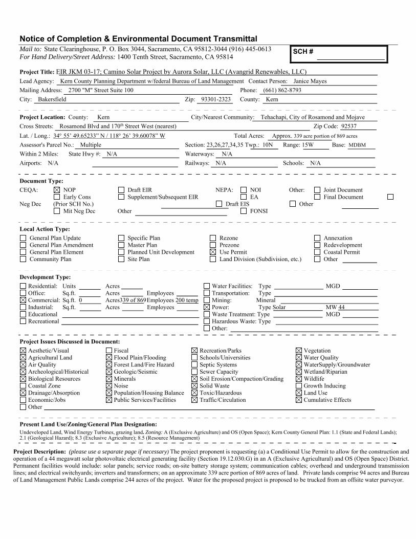
Notice of Completion & Environmental Document Transmittal Mail to: State Clearinghouse, P. O. Box 3044, Sacramento, CA 95812-3044 (916) 445-0613 For Hand Delivery/Street Address: 1400 Tenth Street, Sacramento, CA 95814 Project Title: EIR JKM 03-17; Camino Solar Project by Aurora Solar, LLC (Avangrid Renewables, LLC) Lead Agency: Kern County Planning Department w/federal Bureau of Land Management Contact Person: Janice Mayes
Mailing Address: 2700 "M" Street Suite 100 Phone: (661) 862-8793
City: Bakersfield Zip: 93301-2323 County: Kern
Project Location: County: Kern City/Nearest Community: Tehachapi, City of Rosamond and Mojave
Cross Streets: Rosamond Blvd and 170th Street West (nearest) Zip Code: 92537
Lat. / Long.: 34 55’ 49.65233” N / 118 26’ 39.60078” W Total Acres: Approx. 339 acre portion of 869 acres
Assessor's Parcel No.: Multiple Section: 23,26,27,34,35 Twp.: 10N Range: 15W Base: MDBM
Within 2 Miles: State Hwy #: N/A Waterways: N/A
Airports: N/A Railways: N/A Schools: N/A
Document Type:
CEQA: NOP Draft EIR NEPA: NOI Other: Joint Document Early Cons Supplement/Subsequent EIR EA Final Document Neg Dec (Prior SCH No.) Draft EIS Other Mit Neg Dec Other FONSI
Local Action Type:
General Plan Update Specific Plan Rezone Annexation General Plan Amendment Master Plan Prezone Redevelopment General Plan Element Planned Unit Development Use Permit Coastal Permit Community Plan Site Plan Land Division (Subdivision, etc.) Other
Development Type:
Residential: Units Acres Water Facilities: Type MGD Office: Sq.ft. Acres Employees Transportation: Type Commercial: Sq.ft. 0 Acres339 of 869 Employees 200 temp Mining: Mineral Industrial: Sq.ft. Acres Employees Power: Type Solar MW 44 Educational Waste Treatment: Type MGD Recreational Hazardous Waste: Type
Other:
Project Issues Discussed in Document:
Aesthetic/Visual Fiscal Recreation/Parks Vegetation Agricultural Land Flood Plain/Flooding Schools/Universities Water Quality Air Quality Forest Land/Fire Hazard Septic Systems WaterSupply/Groundwater Archeological/Historical Geologic/Seismic Sewer Capacity Wetland/Riparian Biological Resources Minerals Soil Erosion/Compaction/Grading Wildlife Coastal Zone Noise Solid Waste Growth Inducing Drainage/Absorption Population/Housing Balance Toxic/Hazardous Land Use Economic/Jobs Public Services/Facilities Traffic/Circulation Cumulative Effects Other
Present Land Use/Zoning/General Plan Designation: Undeveloped Land, Wind Energy Turbines, grazing land. Zoning: A (Exclusive Agriculture) and OS (Open Space); Kern County General Plan: 1.1 (State and Federal Lands); 2.1 (Geological Hazard); 8.3 (Exclusive Agriculture); 8.5 (Resource Management)
Project Description: (please use a separate page if necessary) The project proponent is requesting (a) a Conditional Use Permit to allow for the construction and operation of a 44 megawatt solar photovoltaic electrical generating facility (Section 19.12.030.G) in an A (Exclusive Agricultural) and OS (Open Space) District. Permanent facilities would include: solar panels; service roads; on-site battery storage system; communication cables; overhead and underground transmission lines; and electrical switchyards; inverters and transformers; on an approximate 339 acre portion of 869 acres of land. Private lands comprise 94 acres and Bureau of Land Management Public Lands comprise 244 acres of the project. Water for the proposed project is proposed to be trucked from an offsite water purveyor.
SCH #


INITIAL STUDY/NOTICE OF PREPARATION
Camino Solar Project By Aurora Solar, LLC. (a subsidiary of Avangrid Renewables)
Conditional Use Permit 7, Map 216
(PP17125)
CEQA LEAD AGENCY:
Kern County Planning and Natural Resources Department 2700 M Street, Suite 100
Bakersfield, CA 93301-2370
with federal Bureau of Land Management
Contact: Ms. Janice Mayes (661) 862-8793
June 2018

KERN COUNTY PLANNING AND NATURAL RESOURCES DEPARTMENT Camino Solar Project, by Aurora Solar, LLC.
June 2018 i Initial Study/Notice of Preparation
Table of Contents
1. Project Description .................................................................................................................. 1
1.1 Project Location ............................................................................................................. 1 1.2 Environmental Setting .................................................................................................... 3 1.3 Project Description ......................................................................................................... 7 1.4 Project Objectives ........................................................................................................ 14 1.5 Proposed Discretionary Actions/Required Approvals ................................................... 15
2. Kern County Environmental Checklist Form ......................................................................... 17
2.1 Environmental Factors Potentially Affected: ................................................................. 17 2.2 Determination (To be completed by the Lead Agency) ................................................ 17
3. Evaluation of Environmental Impacts .................................................................................... 18
3.1 Aesthetics ..................................................................................................................... 19 3.2 Agriculture and Forest Resources. ............................................................................... 21 3.3 Air Quality. .................................................................................................................... 23 3.4 Biological Resources. ................................................................................................... 26 3.5 Cultural Resources. ...................................................................................................... 28 3.6 Tribal Cultural Resources. ............................................................................................ 29 3.7 Geology and Soils. ....................................................................................................... 30 3.8 Greenhouse Gas Emissions......................................................................................... 33 3.9 Hazards and Hazardous Materials. .............................................................................. 35 3.10 Hydrology and Water Quality. ...................................................................................... 40 3.11 Land Use and Planning. ............................................................................................... 44 3.12 Mineral Resources. ...................................................................................................... 46 3.13 Noise. ........................................................................................................................... 47 3.14 Population and Housing. .............................................................................................. 49 3.15 Public Services. ............................................................................................................ 51 3.16 Recreation. ................................................................................................................... 53 3.17 Transportation/Traffic. .................................................................................................. 54 3.18 Utilities and Service Systems. ...................................................................................... 57 3.19 Mandatory Findings of Significance ............................................................................. 60
Figures 1 Site Vicinity ........................................................................................................................... 2 2 Existing Kern County General Plan Designations ................................................................ 5 3 Existing Kern County Zoning Classifications ........................................................................ 6 4 Project Boundary .................................................................................................................. 9 Tables 1 Project Assessor Parcel Numbers (APNs) ........................................................................... 1 2 Average High and Low Temperature by Month - Mojave ..................................................... 4 3 Proposed Project Site and Surrounding Land Uses ............................................................. 7

KERN COUNTY PLANNING AND NATURAL RESOURCES DEPARTMENT Camino Solar Project, by Aurora Solar, LLC.
June 2018 1 Initial Study/Notice of Preparation
1. Project Description
1.1 Project Location
The proposed Camino Solar Project (proposed project) would develop a photovoltaic (PV) solar facility and associated infrastructure necessary to generate 44 megawatts (MW) of renewable electrical energy and gen-tie lines on 339 acres. The proposed solar facility is located within the approved 189 MW Manzana Wind Power Project area, operated by Manzana Wind, LLC, which, like Aurora Solar, LLC, is also a subsidiary of Avangrid Renewables, LLC. Interconnection to the grid would be through the use of existing interconnection agreements and facilities from the adjacent Manzana and/or Pacific Wind Project site.
The project site is located within Sections 23, 26, 27, 34 and 35 Township 10 North, Range 15 West. The project site is approximately 15 miles west of California State Highway 14 (Antelope Valley Freeway), 12.5 miles south of California State Highway 58 (Blue State Memorial Highway), and 8 miles north of State Route 138 (West Avenue D). The nearest populated areas are the unincorporated community of Mojave 17 miles to the northeast, the unincorporated community of Rosamond 16 miles southeast, and the City of Tehachapi 12 miles to the north. The Rosamond Airport and Airpark are located approximately 13 miles southeast of the project site. The entire site consists of 10 parcels; the Assessor Parcel Numbers (APNs) are summarized in Table 1, Project Assessor Parcel Numbers (APNs). Figure 1, Project Location Map shows the regional location of the proposed project.
Table 1. Project Assessor Parcel Numbers (APNs)
Assessor Parcel No.
Public/ Private Ownership Zoning Designation
Zone Map
Parcel Size (Approx. Acres)
Project Site Acres
476-061-09 Public (BLM) OS 1.1 State or Federal Land 216 359.3 244.4/0
476-052-09 Private A WE 8.3 Extensive Agriculture 216 324.9 51.8/0
476-110-03 Private A WE 8.5 Resource Management 216 45.9 16.3/8.2
476-110-04 Private A WE 8.5 Resource Management 216 45.3 4.9/2.2
476-062-04 Private A 8.3 Extensive Agriculture 216 22.4 0/0.5
476-110-14 Private A and A GH WE
8.3 Extensive Agriculture/2.1 (Seismic Hazard)
216 23.6 0/4.7
476-110-16 Private A GH WE 8.3 Extensive Agriculture/2.1 (Seismic Hazard)
216 20.5 0/1.6
476-110-19 Private A GH WE 8.3 Extensive Agriculture/2.1 (Seismic Hazard)
216 20.6 0/2.0
476-130-11 Private A WE 8.3 Extensive Agriculture 216 4.1 0/2.0
476-130-02 Private A 8.3 Extensive Agriculture 216 2.5 0/0.4
Totals 869.1 339

Mojave
Rosam ond
Lancas te r
Tehachapi
NeenachGorman
Kern CountyLos Angeles County
ØProject Area
UV202
UV184
UV138
UV14
UV58
§̈¦5
0 4
Miles
Figure 1: SITE VICINITY2018IS/NOP
KERN COUNTY PLANNING AND NATURAL RESOURCES DEPARTMENTCAMINO SOLAR PROJECT
AREAOFDETAIL
Los AngelesCounty
Kern County
Santa BarbaraCounty
San LuisObispoCounty
San BernardinoCountyVentura
County
Tulare County Inyo County
Path: U:\GIS\GIS\Projects\209xxx\209595\209595.21_Camino_Solar\03_MXDs_Projects\Fig1_SiteVic_Camino.mxd, JYL 1/11/2018

June 2018 3 Initial Study/Notice of Preparation
1.2 Environmental Setting
The proposed project site is located on a 339 acres portion of approximately 869 acres of undeveloped privately-owned and public lands, including 317 acres for the main project area, and 22 acres for the underground collector line. The proposed project is located within the central-eastern portion of the 189 MW Manzana Wind power Project, which began operations in 2012, which, like Aurora Solar, LLC is a wholly-owned subsidiary of Avangrid Renewables, LLC (formerly known as Iberdrola Renewables, LLC). There are clusters of residences in the vicinity of the southwest portions of the proposed project site. The proposed project would be visible from these residences located outside of the proposed project site.
The proposed project is located in a sparely populated area of the western Mojave Desert with a relatively low density of sensitive plant and animal species. The primary land use of the surrounding area is for renewable wind energy production, recreational off-road vehicle use, hiking and dry land grazing. There is limited grazing of sheep and cattle near the project but actively cultivated crops are not part of the site. There are not any existing structures on the project site. Soil survey maps, compiled by the Natural Resources Conservation Service of the U.S. Department of Agriculture, cite that soils are mapped as Hanford sandy gravelly loam. These soils are generally described as coarse grained soils that are well drained and the fines are typically non-plastic. These types of soils do not exhibit shrink-swell patterns and are not considered expansive soils.
The proposed project site is located within the boundaries of the BLM’s adopted California Desert Conservation Area Plan (CDCA) and the California Desert Renewable Energy Conservation Plan (DRECP). The vegetation communities at the project site are largely dominated by non-native species, limiting the potential habitat quality for native plants and wildlife. Portions of the proposed project site are dominated by native plants that include Joshua Tree Woodlands, Mojave Desert Wash Scrub, Mojavean Juniper Woodland and Scrub, and Non-native Grassland, as classified according to the Manual of California Vegetation, online edition.
The nearest officially designated State scenic highway is the Angeles Crest Highway (SR 2), located approximately 46 miles south of the proposed project site. The proposed project site is not visible from SR 2, and due to its lack of visibility form the nearest state scenic highway, construction of the proposed project and its implementation is not expected to have an impact on scenic resources within a state scenic highway. The Pacific Crest Trail, which is designated as a National Scenic Trail, is located one mile west of the western border of the proposed project site and northwest and north of the northern border of the proposed project site. Visitors to this trail may be negatively affected by the visibility of the solar panels and other infrastructure present on the proposed project site.
The proposed project site is located within Flood Zone X as designated by the Flood Insurance Rate Map (FIRM) (06029C3625E) as issued by the Federal Emergency Management Agency (FEMA). Flood Zone X is an identified area determined to be outside the 500-year floodplain and classified as being within the 1% and 0.2% annual chance of flooding. State-designated Alquist-Priolo Earthquake Fault Zones have not been identified on the proposed project site; however, the area is considered to be seismically active with the nearest active fault being Cottonwood Fault, which runs northwest to southeast near the southern edge of the site. The project area historically receives an annual precipitation (rainfall) average of 6.7 inches per year. Table 2, Average High and Low Temperature by Month-Mojave, below, shows the average high and low temperatures in Mojave by month.

June 2018 4 Initial Study/Notice of Preparation
Table 2: Average High and Low Temperature by Month – Mojave
Jan Feb Mar Apr May Jun Jul Aug Sept Oct Nov Dec
Avg. High 57 60 66 71 80 89 96 96 88 78 65 56
Avg. Low 33 37 41 46 56 64 70 67 61 50 40 33
U.S. Climate Data 2017
Potentially jurisdictional waters have been delineated at the site for mapped linear drainage features. All drainage features were assumed to be the jurisdiction waters of both the California Department of Fish and Wildlife (CDFW) and the Regional Water Quality Control Board. However, all four drainage features found at the site are ephemeral streams that convey water only intermittently. Wetlands or riparian areas were not observed that would extend CDFW’s jurisdiction beyond the limits of the streambeds and banks. The U.S. Army Corps of Engineers has previously determined that the entire Antelope Valley watershed, excluding Lake Palmdale and its tributaries are not subject to its jurisdiction. The proposed project has been designed to avoid all of the potentially jurisdictional waters present.
The proposed project site is not located within an area that is designated by the California Department of Conservation (CDC) as Prime Farmland, Farmland of Statewide Importance, or Unique Farmland. Lands within the proposed project boundary or in the vicinity are not subject to a Williamson Act Land Use contract.
The proposed project would be served by the Kern County Sheriff’s Office for law enforcement and public safety. The closest Sheriff station is the Rosamond Substation, located approximately 17 miles southeast from the proposed project site, at 1379 Sierra Hwy in the City of Rosamond. The Kern County Fire Department (KCFD) provides fire protection and emergency medical and rescue services for the proposed project area. The closest KCFD fire station is Station #15, located approximately 14 miles southeast of the proposed project site at 2980 Desert Street in the community of Rosamond. The closest school to the proposed project site is Tropico Middle School, located approximately 13 miles southeast of the proposed project site in the community of Rosamond.
The proposed project site is not located within the boundaries of an Airport Influence Area as identified in the Kern County Airport Land Use Compatibility Plan (ALUCP).
The proposed project site is located within the boundaries of the Kern County Specific Plan, and parcels are designated 1.1 (State or Federal Land); 8.3 (Extensive Agriculture); 8.5 (Resource Management); and 2.1 (Seismic Hazard) and are located within the OS (Open Space); A WE (Exclusive Agriculture, Wind Energy); A GH WE (Exclusive Agriculture, Geological Hazard, Wind Energy); and A (Exclusive Agriculture) Zone Districts. The existing land use designations are listed in Table 3, Proposed Project Site and Surrounding Land Uses, below and depicted in Figure 2, Existing Kern County General Plan Designations. The entire proposed project site is also subject to the provisions of the Kern County Zoning Ordinance and is zoned as specified in Table 1, Project Assessor Parcel Numbers (APNs), above and depicted in Figure 3, Existing Kern County Zoning Classifications, below.

8.4
1.18.3
1.18.5
8.3
8.3/2.1
8.3/2.18.3
8.3
8.5
8.3
CHAMPAGNE AV
0 1,600
Feet
Figure 2: EXISTING KERN COUNTYGENERAL PLAN DESIGNATIONS
2018IS/NOP
KERN COUNTY PLANNING AND NATURAL RESOURCES DEPARTMENTCAMINO SOLAR PROJECT
Path: U:\GIS\GIS\Projects\209xxx\209595\209595.21_Camino_Solar\03_MXDs_Projects\Fig2_Ex_GP_Camino.mxd, JYL 2/8/2018
Project AreaExisting Kern County General Plan Designations1.1: State or Federal Land8.3/2.1: Extensive Agriculture (Min. 20 Acre Parcel Size)8.3: Extensive Agriculture (Min. 20 Acre Parcel Size)8.4: Mineral and Petroleum (Min. 5 Acre Parcel Size)8.5: Resource Management (Min. 20 Acre Parcel Size)

A WE A WE A WE A WE A
A WE
A WE
A WEA
A WE
OS
A
A WE
OS
A WE OS
A
A
A WE
A
A
A
A
A WE A
A
A
A WE
A WE
A WE
A
A WE
A
A GH WE
A WE
A WE
A
A GH WE
A
A WE
A
A GH WE
A
A
A
A GH WE
A
A
A WEA GH
A WE
AA WE
A
A WE
A
A
A
A
A WE
A
A
A
A GH
A
A WE
A
A GH A WE
A
A WE
A WE
A WE
A GH
A WE
A GH WE
PL RSA GH
A GH
A WE
A GH
A WE
A WE
A GH
A WE
A GH
PL RS MH
A
A
A GH WE
A
A GH
A WE
PL RS GH PL RSA WE
A WE
A GH WE
A WE
A GH WE
Figure 3: EXISTING KERN COUNTYZONING CLASSIFICATIONS
2018IS/NOP
KERN COUNTY PLANNING AND NATURAL RESOURCES DEPARTMENTCAMINO SOLAR PROJECT
Path: U:\GIS\GIS\Projects\209xxx\209595\209595.21_Camino_Solar\03_MXDs_Projects\Fig3_Ex_Zoning_Camino.mxd, JYL 2/7/2018
Project AreaExisting Kern County Zoning ClassificationsA GH WE: Exclusive Agriculture, Geologic Hazard Combining, Wind Energy CombiningA GH: Exclusive Agriculture, Geologic Hazard CombiningA WE: Exclusive Agriculture, Wind Energy CombiningA: Exclusive AgricultureOS: Open SpacePL RS GH: Platted Lands, Residential Suburban Combining, Geologic Hazard CombiningPL RS MH: Platted Lands, Residential Suburban Combining, Mobile Home CombiningPL RS: Platted Lands, Residential Suburban Combining
0 1,600
Feet
June 2018 7 Initial Study/Notice of Preparation
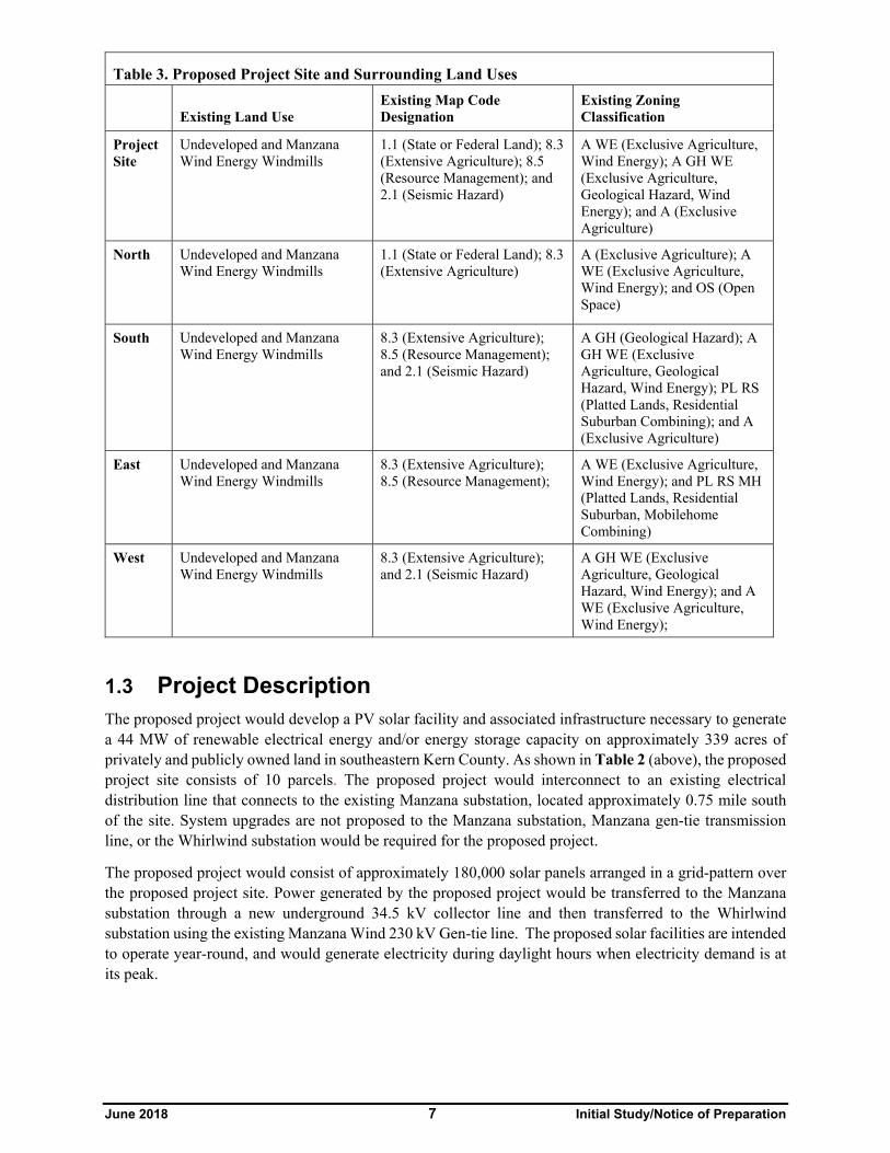
Table 3. Proposed Project Site and Surrounding Land Uses
Existing Land Use Existing Map Code Designation
Existing Zoning Classification
Project Site
Undeveloped and Manzana Wind Energy Windmills
1.1 (State or Federal Land); 8.3 (Extensive Agriculture); 8.5 (Resource Management); and 2.1 (Seismic Hazard)
A WE (Exclusive Agriculture, Wind Energy); A GH WE (Exclusive Agriculture, Geological Hazard, Wind Energy); and A (Exclusive Agriculture)
North Undeveloped and Manzana Wind Energy Windmills
1.1 (State or Federal Land); 8.3 (Extensive Agriculture)
A (Exclusive Agriculture); A WE (Exclusive Agriculture, Wind Energy); and OS (Open Space)
South Undeveloped and Manzana Wind Energy Windmills
8.3 (Extensive Agriculture); 8.5 (Resource Management); and 2.1 (Seismic Hazard)
A GH (Geological Hazard); A GH WE (Exclusive Agriculture, Geological Hazard, Wind Energy); PL RS (Platted Lands, Residential Suburban Combining); and A (Exclusive Agriculture)
East Undeveloped and Manzana Wind Energy Windmills
8.3 (Extensive Agriculture); 8.5 (Resource Management);
A WE (Exclusive Agriculture, Wind Energy); and PL RS MH (Platted Lands, Residential Suburban, Mobilehome Combining)
West Undeveloped and Manzana Wind Energy Windmills
8.3 (Extensive Agriculture); and 2.1 (Seismic Hazard)
A GH WE (Exclusive Agriculture, Geological Hazard, Wind Energy); and A WE (Exclusive Agriculture, Wind Energy);
1.3 Project Description The proposed project would develop a PV solar facility and associated infrastructure necessary to generate a 44 MW of renewable electrical energy and/or energy storage capacity on approximately 339 acres of privately and publicly owned land in southeastern Kern County. As shown in Table 2 (above), the proposed project site consists of 10 parcels. The proposed project would interconnect to an existing electrical distribution line that connects to the existing Manzana substation, located approximately 0.75 mile south of the site. System upgrades are not proposed to the Manzana substation, Manzana gen-tie transmission line, or the Whirlwind substation would be required for the proposed project.
The proposed project would consist of approximately 180,000 solar panels arranged in a grid-pattern over the proposed project site. Power generated by the proposed project would be transferred to the Manzana substation through a new underground 34.5 kV collector line and then transferred to the Whirlwind substation using the existing Manzana Wind 230 kV Gen-tie line. The proposed solar facilities are intended to operate year-round, and would generate electricity during daylight hours when electricity demand is at its peak.

June 2018 8 Initial Study/Notice of Preparation
The combined proposed project facilities would cover approximately 339 acres and would include the following components:
Installation of up to a combined 44 MW of solar high-efficiency PV modules, covered by glass, and mounted on galvanized metal poles embedded into the ground and connected to single axis tracking systems;
Single axis tracking system consisting of drive motors, drive arms, and hydraulic systems that allow for rotation of solar panels from east to west, tracking the suns position over the course of the day;
Underground voltage collections systems throughout the proposed project; including an underground 34.5 kV Gen-tie line south to the Manzana Wind Substation;
Medium voltage inverters and step-up transformers;
Onsite access roads
Site security would consist of 6-foot high chain link fence, with 1 foot of three-strand smooth wire at the top, installed around the perimeter of the facility. Security cameras may also be installed at the site and monitored at an off-site location.
Concrete pads sized and installed to accommodate the associated equipment (inverters, transformers, etc.)
Battery Energy Storage
One onsite underground electrical generation tie line (34.5 kV) from the proposed project transformer(s) to the existing Manzana Wind Substation.
THE EIR/EA PROCESS
The proposed project is located on land administered by Kern County and the federal Bureau of Land Management (BLM). The project proponent requires various authorizations and permits from Kern County and the BLM to construct and operate the proposed project. In order to consider issuance of these authorizations and permits, and based on the proposed project’s potential environmental impacts, Kern County and BLM will prepare a joint Environmental Information Report/Environmental Assessment (EIR/EA). The County will prepare the EIR pursuant to CEQA requirements and the BLM will prepare an EA pursuant to the requirements of the federal land policy and management act (FLPMA) and NEPA. Based on these requirements, the joint EIR/EA will be prepared under the direction of both agencies to satisfy the permitting and decision-making requirements of each agency prior to project approval. CEQA and NEPA also require that the EIR/EA development process include public notice of the proposed project to address concerns that the public has identified regarding the proposed project during a process referred to as public scoping. The issuance of this NOP/Initial Study (IS) commences the EIR scoping process pur-suant to CEQA requirements.
The analysis of the proposed project will result in the publication of a draft EIR/EA and a final EIR/EA. A comment period of a minimum of 45 days will be allocated for the review of the draft EIR/EA. A notice of availability of the draft EIR/EA will be sent to the State Clearinghouse by Kern County and BLM will publish a separate notice for the EA pursuant to NEPA requirements. Kern County and the BLM will consider all comments on the draft EIR/EA and the document will be revised to address comments, with the assistance of a County Consultant, before a final EIR/EA is issued. The final EIR/EA will include responses to the comments received on the draft EIR/EA.

170T
h St W
155T
h Stre
et W
est
170T
HST
REET
WES
T 160T
HST
REET
WES
T
165T
HST
REET
WES
T
FAVORITO AV
FIRMAMENT AV
CHAMPAGNE AV
HAMILTON RD
172N
D ST
REET
WES
T
Project AreaRoad
0 3,000
Feet
Figure 4: PROJECT BOUNDARY2018IS/NOP
KERN COUNTY PLANNING AND NATURAL RESOURCES DEPARTMENTCAMINO SOLAR PROJECT
Path: U:\GIS\GIS\Projects\209xxx\209595\209595.21_Camino_Solar\03_MXDs_Projects\Fig4_ProjBound_Camino_roads.mxd, JYL 2/5/2018
UV58
UV14
UV58
Rosamond Blvd
Bakersfield
!̂
PROJECTLOCATION
KERN CO.LOS ANGELES CO.§̈¦5

June 2018 10 Initial Study/Notice of Preparation
Project Facilities
Solar PV Panels
Solar energy would be captured by PV panels, of which an estimated 180,000 individual panels would be installed onsite. The layout of the solar panels would be arranged in rows on a central single-axis tracking system that adjusts tilt and solar collection. As the solar modules tilt throughout the day, the height of their top edges would shift accordingly between 4 and 7 feet in height.
Solar Trackers
A solar tracking mechanism is used to maximize the solar energy conversion efficiency by keeping the modules perpendicular to the sun's energy rays throughout the day. This completed assembly of PV modules mounted on a framework structure is called a "tracker" as it tracks the sun from east to west.
The central axis of the tracking structure would be oriented north to south and would rotate the PV modules east to west to limit self-shading between rows. Module layout and spacing is optimized to balance energy production versus peak capacity and would depend on the sun angles and shading caused by the horizon surrounding the proposed project site. The rows of PV modules would be arranged in arrays depending on site conditions but would typically be made up of 30 rows with 88 PV modules in each row. The spacing between the rows of trackers is dependent on site-specific features and would be identified in the final design. The final configuration would allow for sufficient clearance for maintenance vehicles and panel access.
Electrical Collector System and Inverters
The AC-DC electrical collection system includes all cables and combiners that collect electricity from the panels, delivers it to the inverters, collects it from the inverters, and ultimately delivers it to the project switching station(s) via a step-up transformer that would increase the output voltage from the inverter 315 Volts to the desired substation feed voltage 34.5 kV. Inner DC cables would be buried in trenches about 36 inches deep and medium voltage cables would be buried in trenches about 48 inches deep. A buried 34.5 kV collector line would run between transformers associated with each array. The inverter and transformer for each array would be installed on a shared concrete pad. All transformers would use only non-polychlorinated biphenyl (non-PCB) oils.
Energy Storage System
The proposed project includes the use of on-site battery storage located on a 13 acres portion of the 94 acres of private land parcels.
Generation‐Tie Line and Interconnection to the Statewide Grid
The proposed project would use the existing transmission lines, substation, and site access roads on private land associated with the Manzana Wind Power Project. A new underground 34.5 kV collector line would be constructed on private land between the Camino Solar site and the Manzana substation. From the Manzana substation, energy would be transferred to the Whirlwind Substation using the existing Manzana Wind 230 kV generation tie line.
System upgrades are not proposed or required to the Manzana substation, Manzana gen-tie transmission line, or the Whirlwind substation as part of this project.
Operation and Maintenance Facilities
The proposed project would not include O&M buildings. The proposed project would share the existing facilities that support the operations of the existing Manzana and/or Pacific Wind Projects.

June 2018 11 Initial Study/Notice of Preparation
Onsite Meteorological Station
The proposed project would not include an onsite solar meteorological station.
Onsite Telecommunications Towers
The project would not include any onsite telecommunication or microwave towers.
Site Access and Security
During operation, the proposed project would use the existing access roads on private land associated with the adjacent wind projects to access the site. The primary access route to the proposed project would be from State Route 14 by way of Rosamond Boulevard from the east and then following 170th Street West, northward from the intersection with Rosamond Boulevard to reach access roads previously entitled for the Manzana, Pacific Wind, and Catalina projects. Within the proposed project area, perimeter access roads would be constructed around each solar field. These permanent access roads would be about 20 feet wide and provide access to each inverter in a north-south direction. All road improvements would be completed per Caltrans and/or County code and regulations. All new roads within the site would avoid streambed crossings. Final access road alignments would depend upon the final placement of the solar arrays and site conditions. The proposed project area is crossed by an existing unimproved road that provides north-south access to a residence and a calcite mine located on private land north of the project. The project proponent would maintain this access by constructing a new road around the eastern edge of the proposed project boundary. The rerouted road would be constructed to match the width and surface type of the existing road.
Chain-link security fencing would be installed around the site perimeter and other areas requiring controlled access, in order to restrict public access during construction and operations. The security fence would be approximately 6 feet high, topped with approximately 1 foot of three-strand smooth wire mounted on 45 degree extension arms. The fence posts would be set in concrete. Additional security may be provided through the use security cameras installed at the site and monitored at an off-site location. Controlled access gates would be located at the entrances to the facility. Site access gates would be a wing or rolling type. Access through the main gate would be controlled to prevent unaccompanied visitors from accessing the facility. All facility personnel, contractors, agency personnel, and visitors would be logged in and out of the facility at the main office during normal business hours.
Construction Activities
The construction activities for the proposed project are not proposed to be phased and fall into three main categories: (1) site preparation, including surveying staking and installation of erosion control measures, road construction, geotechnical studies, and site grading; (2) system installation, including trenching and installation of underground electrical system in solar field assembling array foundations and installing solar array fields and constructing the collector line between the solar field and the Manzana substation; and (3) testing commissioning and cleanup, including restoring temporarily disturbed areas in accordance with the approved revegetation plan. The entire process is estimated to take up to approximately 6 months. Site grading and earthwork is anticipated to begin during the second quarter of 2019, with operations beginning in the first quarter of 2020.
Construction Workers, Hours
Construction would primarily occur during daylight hours, Monday through Friday or Saturday, between 7:00 a.m. and 10:00 p.m., for the duration of construction. Additional hours may be necessary to facilitate any deficiencies in the schedule or to complete critical construction activities. Any construction work performed outside of the normal work schedule would be coordinated with the appropriate agencies and would conform to the Kern County Noise Ordinance (Chapter 8.36).

June 2018 12 Initial Study/Notice of Preparation
The onsite construction workforce for the proposed project is expected reach a peak of up to 200 individuals, consisting of laborers, craftsmen, supervisory personnel, support personnel, and construction management personnel, with a daily average of 100 workers. It is anticipated that the construction workforce would commute to the site each day from local communities. Construction staff not drawn from the local labor pool would stay in local hotels in Inyokern, Ridgecrest, or other local communities. During construction, workers would park in the staging area at the existing Manzana operations and maintenance yard.
Site Grading and Earthwork
Beginning work on the proposed project would involve preparing the land for installation of arrays, energy storage facility, related infrastructure, access roads. Prior to initial construction mobilization, preconstruction surveys would be performed and sediment and erosion controls would be installed in accordance with an approved Storm Water Pollution Prevention Plan (SWPPP). Stabilized construction entrances and exits would be installed at driveways to mitigate tracking of sediment onto adjacent public roadways.
Site preparation would involve the removal and proper disposal or possible relocation of existing vegetation and debris that would unduly interfere with project construction or the health and safety of onsite personnel. Dust minimizing techniques would be employed, such as maintaining natural vegetation where possible, application of water, and application of dust suppressants. Conventional grading would be minimized to the maximum extent possible to reduce unnecessary soil movement that may result in dust. Soil movement from grading would be balanced on the site, and it is anticipated that no import or export of soils would occur.
Trenching would be required for placement of underground electrical lines, and may include the use of trenchers, backhoes, excavators, haul vehicles, compaction equipment and water trucks. After preparation of the site, the pads for structures, equipment enclosures and equipment vaults would be prepared per geotechnical engineer recommendations.
Solar Array Assembly
Erection of the solar arrays would include support structures and associated electrical equipment. First, steel piles would be driven into the soil using pneumatic techniques, similar to a hydraulic rock hammer attachment on the boom of a rubber-tired backhoe excavator. The piles are typically spaced approximately 10-20 feet apart. Once the piles have been installed, the horizontal array support structures would be installed. The final design of the horizontal array support structures may vary, depending on the final selection of the PV technology. Once the support structures are installed, workers would begin to install the solar PV modules. Solar array assembly and installation would require trenching machines and excavators, compactors, concrete trucks and pumpers, vibrators, forklifts, boom trucks, graders, pile drivers, drilling machines, and cranes.
Concrete may be required for portions of the footings, and pads for the medium voltage transformers, inverters. Concrete may also be required for pile foundation support depending on the proposed mounting system chosen for installation and whether or not obstructions are encountered when trying to drive piles. Final concrete specifications would be determined during detailed design engineering. Concrete would be purchased from an offsite supplier and trucked to the project site.
During this work, there would be multiple crews working on the site with vehicles, including special vehicles for transporting the modules and other equipment. As the solar arrays are installed, the solar switchyard would be constructed and the electrical collection systems would be installed. Within the solar fields, the electrical wiring would be installed in underground trenches. Collection trenches would likely be mechanically excavated.

June 2018 13 Initial Study/Notice of Preparation
The electrical wiring would connect to the appropriate electrical terminations and the circuits would be checked and electrical service would be verified. Additionally, if a tracker system is utilized, the motors would be checked and control logic verified. Once all of the individual systems have been tested, the overall proposed project would be ready for testing under fully integrated conditions.
Electrical Interconnection to Transmission Owner Infrastructure
The proposed project would connect to the adjacent Manzana and/or Pacific Wind Projects, as there is sufficient capacity within both interconnection agreements to accommodate the proposed project.
Construction Water Use
Initial construction water usage would be in support of site preparation and grading activities. During earthwork for grading of access road foundations, equipment pads and project components, the main use of water would be for compaction and dust control. Smaller quantities would be required for preparation of the concrete required for foundations and other minor uses. Subsequent to the earthwork activities, water usage would be used for dust suppression and normal construction water requirements that are associated with construction of the building, internal access roads, and solar arrays. Approximate water use during the 6-month construction period is estimated at 200 acre-feet. Water will be provided from wells on lands within the Manzana Wind Power Project site or delivery by tanker truck. During construction potable water would be supplied to workers from the existing Manzana O&M building.
Operations Water Use
Aurora Solar, LLC is currently negotiating to obtain water for operations from property about 1.7 miles south of the proposed project site. It is estimated that operational water use would be 0.27 acre feet of water annually. Other water sources would be from wells on lands within the Manzana Wind Power Project site or delivery by tanker truck.
Project Operation and Maintenance
The proposed project would include maintenance personnel that are expected to visit the proposed project site several times per year for routine maintenance; the PV modules may be cleaned up to nine times per year, but will be cleaned only on an as-needed basis, depending on site events and soiling rates. Proposed project traffic volumes are expected to be minimal during facility operations.
The PV panel surfaces may be washed seasonally to increase the average optical transmittance of the flat panel surface. Panel washing is expected to be completed up to nine times per year for a total of .27 acre-foot of water per year. Water used for panel cleaning is not anticipated to require disposal due to the extremely high evaporation rate at the site.
Long-term operational water demand is proposed to be supplied from an existing well on the California Portland Cement Company property about 1.7 miles south from the proposed project. Other water sources may also be used including water delivery by tanker truck, or development of wells on nearby private lands within the Manzana Wind Power Project.
The facility's regular maintenance program would be largely conducted onsite during daytime hours as a safety precaution. Equipment repairs would typically take place in the early morning or evening when the plant is producing the least amount of energy. Key program elements include:
Responding to plant failures and emergencies in a timely manner;
Creating an optimized cleaning schedule to be more responsive to location and type of installation;
Maintaining an inventory of spare parts to facilitate timely repairs to maintain plant output; and
Maintenance of ground cover under solar panels to a maximum height of 6 inches.
June 2018 14 Initial Study/Notice of Preparation
Prudent security measures would be taken to ensure the safety of the public and facility. The proposed project would be fenced along all borders with locking gates at the specified points of ingress and egress. As proposed, the fence is anticipated to be 7 feet high, including 6 feet of fencing and 1 foot of three-strand smooth wire at the top.
The project site would produce a small amount of waste associated with maintenance activities. PV solar system wastes typically include broken and rusted metal, defective or malfunctioning modules, electrical materials, and empty containers and other miscellaneous solid materials, including typical household refuse generated by workers. These materials would be collected and delivered back to the manufacturer for recycling. Trash would be disposed of by a local waste hauler service.
Project Decommissioning
The project proponent expects to sell the renewable energy produced by the project under the terms of a long-term Power Purchase Agreement (PPA) or directly into the wholesale market. The life of the solar facility is anticipated to be up to 30 years; however, the project proponent may, at its discretion, choose to extend the life of the facility, update technology and re-commission, or decommission and remove the system and its components. If and when a decommissioning event occurs, the solar site could then be converted to other uses in accordance with applicable land use regulations in effect at that time.
It is anticipated that during decommissioning, project structures would be removed from the site. Above-ground equipment that would be removed would include module posts and support structures, onsite transmission poles that are not shared with third parties and the overhead collection system within the proposed project site, inverters, transformers, electrical wiring, equipment on the inverter pads, and related equipment and concrete pads. Underground equipment will also be removed upon decommissioning and lands will be restored to their approximated contour prior to project construction. Proposed project roads would be restored to their pre-construction condition unless the landowner elects to retain the improved roads for access throughout that landowner's property. The area would be thoroughly cleaned and all debris removed. As discussed above, most materials would be recycled to the extent feasible, with minimal disposal to occur in landfills in compliance with all applicable laws.
A collection and recycling program would be executed to promote recycling of project components and minimize disposal of project components in landfills. All decommissioning and restoration activities would adhere to the requirements of the appropriate governing authorities and in accordance with all applicable federal, State, and County regulations.
Relationship of the Proposed Project to Other Solar Projects
The proposed project is being developed independently of other approved or proposed solar projects in the County. If approved, the Camino Solar Project facilities, would be subject to their own use permits, conditions of approval, interconnection agreements, and power purchase agreements. The County understands that the Camino Solar Project facilities would be built and operated independently of any other solar project, and, if approved, would not depend on any other solar project for economic viability. The proposed project will involve constructing a new gen-tie line to deliver energy to the Whirlwind Substation. Aurora solar, through its affiliation with Avangrid Renewables, maintains an existing interconnection agreement for the Whirlwind Substation, which would be used for the proposed project.
1.4 Project Objectives The project proponent has defined the following objectives for the proposed project:
Provide a new source of renewable energy to assist the State of California in Achieving the RPS for 2020;
Generate approximately 44 MW of electricity at a cost that is competitive on the renewal market;

June 2018 15 Initial Study/Notice of Preparation
Locate the proposed project in Kern County on private and federal BLM Lands near an existing electric distribution system;
Minimize the potential impact on the environment by:
o Maximize the use of existing infrastructure (transmission lines and roads);
o Minimize the potential impacts on threatened and endangered species; and
o Reduce the emission of greenhouse gases from the generation of electricity.
1.5 Proposed Discretionary Actions/Required Approvals The Kern County Planning and Natural Resources Department as the Lead Agency (per CEQA Guidelines Section 15052) and the U.S. Bureau of Land Management (BLM), as the federal Lead Agency (NEPA) for the proposed project, has discretionary responsibility for the Camino Solar Project. The proposed project is owned by Aurora Solar, LLC (Avangrid Renewables). To implement this project, the project proponent may need to obtain the following discretionary and ministerial permits/approvals:
Federal
Bureau of Land Management (BLM)
o Approval of all Conditions and Mitigation Measures applied to the project.
U.S. Fish and Wildlife Service (USFWS)
State
California Department of Fish and Wildlife (CDFW)
Regional Water Quality Control Board – Lahontan (RWQCB)
State Water Resources Control Board (SWRCB)
California Public Utilities Commission (CPUC)
California Department of Transportation (Caltrans)
Local
Kern County Board of Supervisors/Kern County Planning Commission
Certification of Final Environmental Impact Report (EIR)
Adoption of Mitigation Monitoring Program
Adoption of 15091 and 15093 Findings and Statement of Overriding Considerations
Approval of Kern County Conditional Use Permit 7, Map 216
Kern County Planning and Natural Resources Department
Approval of all Conditions and Mitigation Measures applied to the proposed project.
Kern County Public Works – Building and Development – Roads, Flood Plain & Survey
Approval of Kern County Grading Permits
Approval of Kern County Building Permits
June 2018 16 Initial Study/Notice of Preparation
Approval of Kern County Access Road Design and Encroachment Permits
Kern County Fire Department
Fire Safety Plan
Eastern Kern Air Pollution Control District (EKAPCD)
Fugitive Dust Control Plan
Any other permits as required
The preceding are potentially required and do not necessarily represent a comprehensive list of all possible discretionary permits/approval required. Other additional permits or approvals from responsible agencies may be required for the proposed project.
2. Kern County Environmental Checklist Form
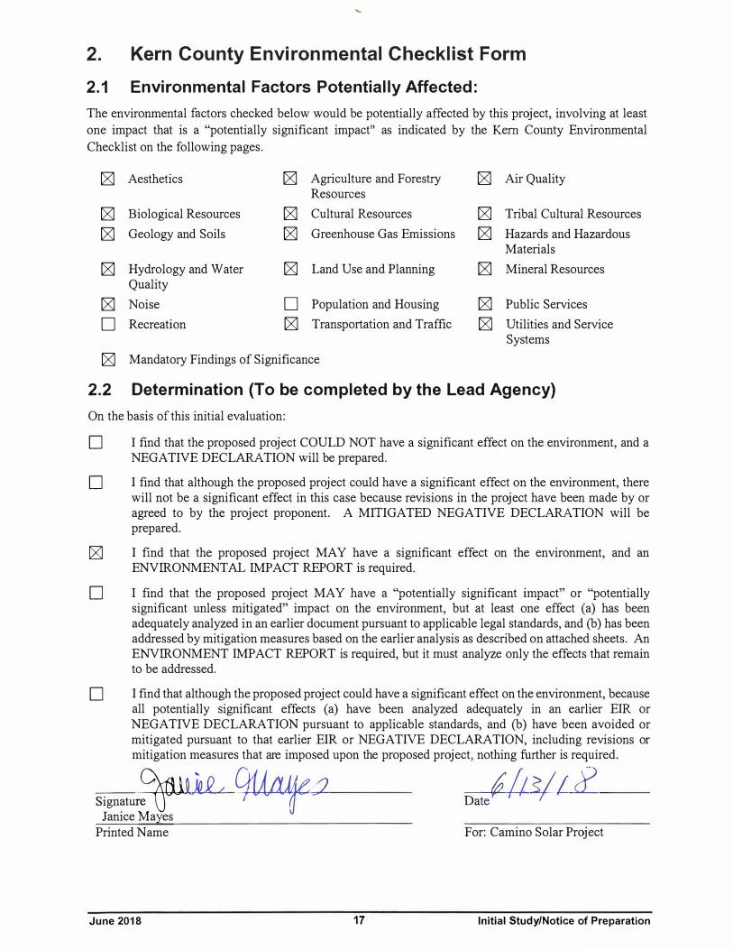
2.1 Environmental Factors Potentially Affected:
The environmental factors checked below would be potentially affected by this project, involving at least one impact that is a "potentially significant impact" as indicated by the Kern County Environmental Checklist on the following pages.
IZl Aesthetics IZl Agriculture and Forestry IZl Air Quality Resources
IZl Biological Resources IZl Cultural Resources IZl Tribal Cultural Resources
IZl Geology and Soils IZl Greenhouse Gas Emissions IZl Hazards and Hazardous Materials
IZl Hydrology and Water IZl Land Use and Planning IZl Mineral Resources Quality
IZl Noise □ Population and Housing IZl Public Services
□ Recreation IZl Transportation and Traffic IZl Utilities and Service Systems
IZl Mandatory Findings of Significance
2.2 Determination (To be completed by the Lead Agency)
On the basis of this initial evaluation:
D I find that the proposed project COULD NOT have a significant effect on the environment, and a NEGATIVE DECLARATION will be prepared.
D I find that although the proposed project could have a significant effect on the environment, there will not be a significant effect in this case because revisions in the project have been made by or agreed to by the project proponent. A MITIGATED NEGATIVE DECLARATION will be prepared.
IZ] I find that the proposed project MAY have a significant effect on the environment, and an ENVIRONMENTAL IMPACT REPORT is required.
D I find that the proposed project MAY have a "potentially significant impact" or "potentially significant unless mitigated" impact on the environment, but at least one effect (a) has been adequately analyzed in an earlier document pursuant to applicable legal standards, and (b) has been addressed by mitigation measures based on the earlier analysis as described on attached sheets. An ENVIRONMENT IMPACT REPORT is required, but it must analyze only the effects that remain to be addressed.
D I find that although the proposed project could have a significant effect on the environment, because all potentially significant effects (a) have been analyzed adequately in an earlier EIR or NEGATIVE DECLARATION pursuant to applicable standards, and (b) have been avoided or mitigated pursuant to that earlier EIR or NEGATIVE DECLARATION, including revisions or mitigation measures that are imposed upon the proposed project, nothing further is required.
Signatu:ir1 i k_Q L 9Uaf _1 Dai/J 1/f cf
Janice Mayes Printed Name For: Camino Solar Project
June 2018 17 Initial Study/Notice of Preparation

June 2018 18 Initial Study/Notice of Preparation
3. Evaluation of Environmental Impacts (1) A brief explanation is required for all answers except “No Impact” answers that are adequately
supported by the information sources a lead agency cites in the parentheses following each question. A “No Impact” answer is adequately supported if the referenced information sources show that the impact simply does not apply to projects like the one involved (e.g., the project falls outside a fault rupture zone). A “No Impact” answer should be explained where it is based on project-specific factors as well as general standards (e.g., the project will not expose sensitive receptors to pollutants, based on a project-specific screening analysis).
(2) All answers must take account of the whole action involved, including offsite as well as onsite, cumulative as well as project-level, indirect as well as direct, and construction as well as operational impacts.
(3) Once the lead agency has determined that a particular physical impact may occur, then the checklist answers must indicate whether the impact is potentially significant, less than significant with mitigation, or less than significant. “Potentially Significant Impact” is appropriate if there is substantial evidence that an effect may be significant. If there are one or more “Potentially Significant Impact” entries when the determination is made, an EIR is required.
(4) “Negative Declaration: Less Than Significant With Mitigation Incorporated” applies where the incorporation of mitigation measures has reduced an effect from “Potentially Significant Impact” to a “Less Than Significant Impact.” The lead agency must describe the mitigation measure and briefly explain how they reduce the effect to a less than significant level (mitigation measures from Section XVII, “Earlier Analyses,” may be cross-referenced).
(5) Earlier analyses may be used where, pursuant to the tiering, program EIR, or other CEQA process, an effect has been adequately analyzed in an earlier EIR or Negative Declaration, Section 15063(c)(3)(D). In this case, a brief discussion should identify the following:
(a) Earlier Analysis Used. Identify and state where they are available for review.
(b) Impacts Adequately Addressed. Identify which effects from the above checklist where within the scope of and adequately analyzed in an earlier document pursuant to applicable legal standards, and state whether such effects were addressed by mitigation measures based on the earlier analysis.
(c) Mitigation Measures. For effects that are “Less Than Significant With Mitigation Measures Incorporated,” describe the mitigation measures which were incorporated or refined from the earlier document and the extent to which they address site-specific conditions for the project.
(6) Lead agencies are encouraged to incorporate into the checklist references to information sources for potential impacts (e.g., general plans, zoning ordinances). Reference to a previously prepared or outside document should, where appropriate, include a reference to the page or pages where the statement is substantiated.
(7) Supporting Information Sources: A source list should be attached, and other sources used or individuals contacted should be cited in the discussion.
(8) This is only a suggested form, and lead agencies are free to use different formats; however, lead agencies should normally address the questions from this checklist that are relevant to a project's environmental effects in whatever format is selected.
(9) The explanation of each issue should identify:
(a) The significance criteria or threshold, if any, used to evaluate each question; and
(b) The mitigation measure identified, if any, to reduce the impact to a less-than-significant level.

June 2018 19 Initial Study/Notice of Preparation
Discussion:
(a) Potentially Significant Impact. The proposed project site is located in a largely uninhabited, rural area of Kern County. The aesthetic features of the existing visual environment in the proposed project boundaries include the southeastern base of the Tehachapi Mountains, characterized by terrain that gradually slopes form northwest to southeast. There are clusters of residences in the vicinity of the southwest portions of the proposed project site. The proposed project would be visible from these residences located outside of the proposed project site. It is expected that implementation of the proposed project would alter the scenic view in the proposed project area, therefore, project impacts to scenic vista or scenic view would be potentially significant, and will be further evaluated in the EIR.
(b) No Impact. According to the California Department of Transportation (Caltrans) California Scenic Highway Mapping System, the closest eligible scenic highway is Angeles Crest Highway (SR 2), which is approximately 46 miles south of the project site. Because of this distance, the PV solar facilities would not be visible from SR 2. Therefore, project impacts to scenic resources within a State scenic highway would not occur, and will not be evaluated in the EIR.
(c) Potentially Significant Impact. The project site is in a rural area. There are clusters of residences in the vicinity of the southwest portions of the proposed project site. The proposed project would be visible from these residences located outside of the proposed project site. Surrounding land uses include undeveloped properties, residences, grazing, and wind energy farms. The Rosamond Airport is located approximately 13 miles southeast of the proposed project site and the Mojave Airport is located approximately 14 miles east of the proposed project site. Placement of PV solar panels and associated structures on the proposed project site would alter the character of the area. Changes to the
Potentially Significant
Impact
Potentially Significant
Impact Unless
Mitigated
Less Than Significant
Impact No
Impact
3.1 Aesthetics Would the project:
a. Have a substantial adverse effect on a scenic
vista?
b. Substantially damage scenic resources, including, but not limited to, trees, rock outcroppings, and historic buildings within a state scenic highway?
c. Substantially degrade the existing visual character or quality of the site and its surroundings?
d. Create a new source of substantial light or glare which would adversely affect day or nighttime views in the area?

June 2018 20 Initial Study/Notice of Preparation
visual quality and character of the proposed project site would be potentially significant, and impacts will be further evaluated in the EIR.
(d) No Impact. There are clusters of residences in the vicinity of the southwest portions of the proposed project site. The proposed project would be visible from these residences located outside of the proposed project site. The Rosamond Airport is located approximately 13 miles southeast of the proposed project site and the Mojave Airport is located approximately 14 miles east of the proposed project site. The PV modules are designed to absorb sunlight to maximize electrical output; therefore, they would not create significant reflective surfaces or the potential for glint/glare during the day. No permanent lighting is proposed at the solar facilities. Temporary lighting may be used during construction but would be designed to provide the minimum illumination needed to achieve work objectives, and would be directed downward and shielded to focus illumination on the desired areas only and minimize light trespass. Therefore, no further analysis of the specific lighting and effects of nighttime light and glare from the proposed project will be provided in the EIR.

June 2018 21 Initial Study/Notice of Preparation
Potentially Significant
Impact
Potentially Significant
Impact Unless
Mitigated
Less Than Significant
Impact No
Impact
3.2 Agriculture and Forest Resources. In determining whether impacts to agricultural resources are significant environmental effects, lead agencies may refer to the California Agricultural Land Evaluation and Site Assessment Model (1997) prepared by the California Department of Conservation as an optional model to use in assessing impacts on agriculture and farmland. In determining whether impacts to forest resources, including timberland, are significant environmental effects, lead agencies may refer to information compiled by the California Department of Forestry and Fire Protection regarding the state’s inventory of forest land, including the Forest and Range Assessment Project and the Forest Legacy Assessment project; and forest carbon measurement methodology provided in Forest Protocols adopted by the California Air Resources Board. Would the project:
a. Convert Prime Farmland, Unique Farmland, or
Farmland of Statewide Importance (Farmland), as shown on the maps prepared pursuant to the Farmland Mapping and Monitoring Program of the California Resources Agency, to nonagricul-tural use?
b. Conflict with existing zoning for agricultural use, or Williamson Act contract?
c. Conflict with existing zoning for, or cause rezoning of, forest land (as defined in Public Resources Code section 12220(g)), timberland (as defined by Public Resources Code Section 4526), or timberland zoned Timberland Productions (as defined in Government Code section 51104(g))?
d. Result in the loss of forest land or conversion of forest land to non-forest use?
e. Involve other changes in the existing environment which, due to their location or nature, could result in conversion of Farmland to non-agricultural use or conversion of forest land to non-forest use?
f. Result in the cancellation of an open space contract made pursuant to the California Land Conservation Act of 1965 or Farmland Security Zone Contract for any parcel of 100 or more acres (Section 15206(b)(3) Public Resources Code?

June 2018 22 Initial Study/Notice of Preparation
Discussion:
(a) No Impact. There is no designated Prime Farmland, Unique Farmland, or Farmland of Statewide Importance within the proposed project area. The California Department of Conservation’s (CDC) Farmland Mapping and Monitoring Program designates the private portion of the proposed project site as G, grazing land, and the Federal (BLM) portion of the proposed project site as NV natural vegetation. As such, the proposed project site is not considered to be prime, unique, or important farmland. Therefore, construction and/or operation of the proposed project would not result in the conversion of designated Farmland to a nonagricultural use; therefore, this issue will not be further evaluated in the EIR.
(b) No Impact. None of the parcels included as part of the proposed project or property in the vicinity of the project are subject to a Williamson Act Land Use contract. The Kern County zone classifications for the proposed project sites are A (Exclusive Agriculture); A WE (Exclusive Agriculture, Wind Energy) A WE GH (Exclusive Agriculture, Wind Energy, Geological Hazard) and OP (Open Space). The existing zoning is consistent with the Kern County General Plan land use designations of 8.3 (Extensive Agriculture); 8.5 (Resource Management); 2.1 (Geological Hazard); and 1.1 (State or Federal Land). According to the Kern County Zoning Ordinance, a commercial solar facility is a compatible use in the A district. The construction and operation of a solar energy generating facility on the site would require the approval of a CUP (Kern County Ordinance 19.12.030.G). The proposed discretionary actions are consistent with the Kern County Zoning Ordinance regulations for agricultural and resource management uses. Therefore, the potential for conflicts with Williamson Act Land Use contract are not anticipated and are considered to have no impact, therefore no further analysis is warranted in the EIR.
(c)-(d) No Impact. There is no land in the vicinity of the proposed project site that is zoned as forest land, timberland, or lands zoned for timberland production. Therefore, there would be no impacts related to loss of forest land or timberland, or the conversion of forest land to non-forest use and further analysis is not warranted in the EIR.
(e) Potentially Significant Impact. The proposed project site is comprised of undeveloped land, wind energy production, and grazing land uses. The loss of grazing land would create a loss of farmland, therefore, would be potentially significant impacts related to farmland, and further analysis is warranted in the EIR.
(f) No Impact. As noted in response (b), above, the proposed project site is not under a Williamson Act Contract and implementation of the project would not result in the cancellation of an open space contract made pursuant to the California Land Conservation Act of 1965 or Farmland Security Zone Contract for any parcel of 100 or more acres (Public Resources Code Section 15206(b)(3)). Therefore, no impacts are anticipated, and no further discussion is warranted in the EIR.
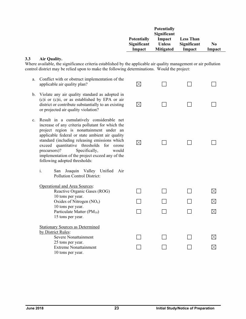
June 2018 23 Initial Study/Notice of Preparation
Potentially Significant
Impact
Potentially Significant
Impact Unless
Mitigated
Less Than Significant
Impact No
Impact
3.3 Air Quality. Where available, the significance criteria established by the applicable air quality management or air pollution control district may be relied upon to make the following determinations. Would the project:
a. Conflict with or obstruct implementation of the
applicable air quality plan?
b. Violate any air quality standard as adopted in (c)i or (c)ii, or as established by EPA or air district or contribute substantially to an existing or projected air quality violation?
c. Result in a cumulatively considerable net increase of any criteria pollutant for which the project region is nonattainment under an applicable federal or state ambient air quality standard (including releasing emissions which exceed quantitative thresholds for ozone precursors)? Specifically, would implementation of the project exceed any of the following adopted thresholds:
i. San Joaquin Valley Unified Air Pollution Control District:
Operational and Area Sources:
Reactive Organic Gases (ROG) 10 tons per year.
Oxides of Nitrogen (NOx) 10 tons per year.
Particulate Matter (PM10) 15 tons per year.
Stationary Sources as Determined by District Rules:
Severe Nonattainment 25 tons per year.
Extreme Nonattainment 10 tons per year.

June 2018 24 Initial Study/Notice of Preparation
Potentially Significant
Impact
Potentially Significant
Impact Unless
Mitigated
Less Than Significant
Impact No
Impact ii. Eastern Kern Air Pollution Control
District:
Operational and Area Sources:
Reactive Organic Gases (ROG) 25 tons per year.
Oxides of nitrogen (NOx) 25 tons per year.
Particulate Matter (PM10) 15 tons per year.
Stationary Sources as Determined by District Rules:
25 tons per year.
d. Expose sensitive receptors to substantial pollutant concentrations?
e. Create objectionable odors affecting a substantial number of people?
Discussion:
(a) Potentially Significant Impact. The proposed project site is located entirely within the jurisdiction of the Eastern Kern Air Pollution Control District (EKAPCD), in the Mojave Desert Air Basin (MDAB). EKAPCD is designated as a nonattainment area for both the State and federal ozone standards and the state particulate matter (PM10) standard. Project construction would generate emissions of reactive organic gases (ROG) and oxides of nitrogen (NOX), both of which are known as ozone precursors, and PM10 that could result in significant impacts to air quality in the area. EKAPCD’s most recently adopted air quality management plan as its Ozone Air Quality Attainment Plan (AQAP). As the project would generate emissions of ozone precursors (along with PM10) during construction, the project could potentially conflict with EKAPCD’s Ozone AQAP. Thus, further analysis of the project’s air quality impacts is warranted to determine whether the project would conflict with or obstruct implementation of EKAPCD’s applicable air quality plan for attainment and, if so, to determine the reasonable and feasible mitigation measures that could be imposed. These issues will be evaluated in the EIR.
(b) Potentially Significant Impact. The proposed project encompasses a 44 MW solar facility on 339 acres of ten parcels which total 869 acres. The proposed project would interconnect to an existing electrical distribution line through the Manzana Substation approximately 0.75 miles south of the site. Project operational emissions are anticipated to be minimal. However, the short-term construction emissions generated at the proposed project site could significantly contribute to an existing or projected air quality violation of criteria pollutant (ROG, NOx, PM10, and PM2.5) standards established by EKAPCD, requiring the consideration of mitigation measures. The sources of construction emissions at the proposed project site would include off-road heavy equipment (e.g., graders, loaders, backhoes, dozers, etc.) used during the various construction phases for the proposed project and on-
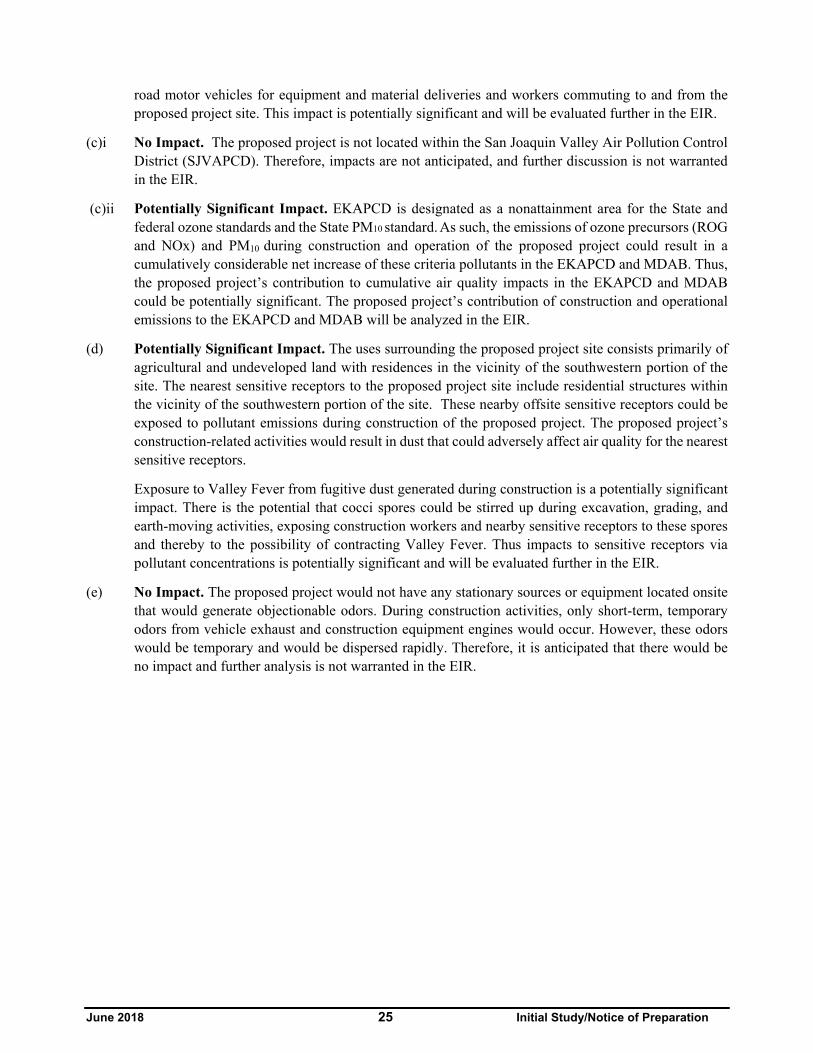
June 2018 25 Initial Study/Notice of Preparation
road motor vehicles for equipment and material deliveries and workers commuting to and from the proposed project site. This impact is potentially significant and will be evaluated further in the EIR.
(c)i No Impact. The proposed project is not located within the San Joaquin Valley Air Pollution Control District (SJVAPCD). Therefore, impacts are not anticipated, and further discussion is not warranted in the EIR.
(c)ii Potentially Significant Impact. EKAPCD is designated as a nonattainment area for the State and federal ozone standards and the State PM10 standard. As such, the emissions of ozone precursors (ROG and NOx) and PM10 during construction and operation of the proposed project could result in a cumulatively considerable net increase of these criteria pollutants in the EKAPCD and MDAB. Thus, the proposed project’s contribution to cumulative air quality impacts in the EKAPCD and MDAB could be potentially significant. The proposed project’s contribution of construction and operational emissions to the EKAPCD and MDAB will be analyzed in the EIR.
(d) Potentially Significant Impact. The uses surrounding the proposed project site consists primarily of agricultural and undeveloped land with residences in the vicinity of the southwestern portion of the site. The nearest sensitive receptors to the proposed project site include residential structures within the vicinity of the southwestern portion of the site. These nearby offsite sensitive receptors could be exposed to pollutant emissions during construction of the proposed project. The proposed project’s construction-related activities would result in dust that could adversely affect air quality for the nearest sensitive receptors.
Exposure to Valley Fever from fugitive dust generated during construction is a potentially significant impact. There is the potential that cocci spores could be stirred up during excavation, grading, and earth-moving activities, exposing construction workers and nearby sensitive receptors to these spores and thereby to the possibility of contracting Valley Fever. Thus impacts to sensitive receptors via pollutant concentrations is potentially significant and will be evaluated further in the EIR.
(e) No Impact. The proposed project would not have any stationary sources or equipment located onsite that would generate objectionable odors. During construction activities, only short-term, temporary odors from vehicle exhaust and construction equipment engines would occur. However, these odors would be temporary and would be dispersed rapidly. Therefore, it is anticipated that there would be no impact and further analysis is not warranted in the EIR.

June 2018 26 Initial Study/Notice of Preparation
Potentially Significant
Impact
Potentially Significant
Impact Unless
Mitigated
Less Than Significant
Impact No
Impact
3.4 Biological Resources. Would the project:
a. Have a substantial adverse effect, either directly or through habitat modifications, on any species identified as a candidate, sensitive, or special-status species in local or regional plans, policies, or regulations or by the California Department of Fish and Wildlife or U.S. Fish and Wildlife Service?
b. Have a substantial adverse effect on any riparian habitat or other sensitive natural community identified in local or regional plans, policies, regulations, or by the California Department of Fish and Wildlife or U.S. Fish and Wildlife Service?
c. Have a substantial adverse effect on federally protected wetlands as defined by Section 404 of the Clean Water Act (including, but not limited to, marsh, vernal pool, coastal, etc.) through direct removal, filling, hydrological interruption, or other means?
d. Interfere substantially with the movement of any native resident or migratory fish or wildlife species or with established native resident or migratory wildlife corridors, or impede the use of native wildlife nursery sites?
e. Conflict with any local policies or ordinances protecting biological resources, such as a tree preservation policy or ordinance?
f. Conflict with the provisions of an adopted Habitat Conservation Plan, Natural Community Conservation Plan or other approved local, regional, or state habitat conservation plan?
Discussion:
(a) Potentially Significant Impact. The project is located at the extreme western edge of species listed as threatened or endangered under the federal Endangered Species Act 9ESA) and/or the California ESA, including the desert tortoise (Gopherus agassizii) and Swainson’s hawk (Buteo swainsoni). It is

June 2018 27 Initial Study/Notice of Preparation
outside the generally accepted range of the Mojave Ground squirrel (Xerospermophilus mohavensis), although within the CDFW mapped range for this species. None of these species have been observed at the project site to date, or are expected to occur. The project site is comprised of non-native grasslands, scrub and Joshua Tree Woodlands with a minimal level of human disturbance. The proposed project site may contain sensitive or special-status species plants at the site and a survey for rare plants is being completed to provide updated information. The proposed project’s potential to have a substantial adverse effect, either directly or through habitat modifications, on any candidate, sensitive, or special-status species in local or regional plans or regulations by the California Department of Fish and Wildlife (CDFW) or United States Fish and Wildlife Service (USFWS) will be evaluated in the EIR.
(b) Potentially Significant Impact. The proposed project site is undeveloped and three-quarters of the site is comprised of Non-native Grasslands. Although portions of the proposed project site are also dominated by native plants including Joshua Tree Woodlands, Mojave Desert Wash Scrub, Mojavean Juniper Woodland and Scrub, it is anticipated that avoidance or mitigation of important plant species will be implemented. The site does not appear to support any riparian habitat or other sensitive natural communities as may be defined by local or regional plans, policies, or regulations. Field surveys to evaluate potential project-related impacts to sensitive natural communities will be completed for the proposed project, and the results, as well as possible mitigation measures, included in the EIR.
(c) No Impact. The proposed project site is in the Mojave Desert region of Kern County. It contains potentially jurisdictional waters at the site and four linear drainage features have previously been mapped in December 2015. All drainage features are assumed to be the jurisdiction waters of both CDFW and the Regional Water Quality Control Board. All four drainage features are ephemeral streams that convey water only intermittently. No wetlands were identified, nor were any riparian habitats observed that would extend CDFW’s jurisdiction beyond the limits of the streambeds and banks. The U.S. Army Corps of Engineers has previously determined that the entire Antelope valley watershed, excluding Lake Palmdale and its tributaries, are not subject to its jurisdiction. Drainages at the proposed project therefore would not be subject to federal jurisdiction. As noted above, the proposed project site may contain potentially jurisdictional waters of the State; however, no federally protected waters would be affected by the project. Further analysis of this issue is not warranted in the EIR.
(d) Potentially Significant Impact. The proposed project site and surrounding areas may be used for migration or dispersal by some avian species, however, the site does not provide nesting habitat for any listed birds. Project construction and operation could remove foraging habitat. This impact may be potentially significant and will be evaluated in the EIR.
(e) Potentially Significant Impact. There is local policy/ordinance protecting biological resources. The site has Joshua Tree Woodlands, which will need to be avoided in citing the proposed project. While there would not be potentially significant impacts, further analysis is warranted in the EIR.
(f) Potentially Significant Impact. The proposed project site is not located within a local or regional habitat conservation plan boundary; however, the site is located within the State habitat conservation plan boundary of the State of California Desert Conservation Area Plan (CDCA). Therefore, there would be potentially significant impacts and further analysis is warranted in the EIR.

June 2018 28 Initial Study/Notice of Preparation
Potentially Significant
Impact
Potentially Significant
Impact Unless
Mitigated
Less Than Significant
Impact No
Impact
3.5 Cultural Resources. Would the project:
a. Cause a substantial adverse change in the
significance of a historical resource as defined in CEQA Guidelines §15064.5?
b. Cause a substantial adverse change in the significance of a tribal cultural resource as defined in Public Resources Code 21074
c. Cause a substantial adverse change in the
significance of an archaeological resource pursuant to CEQA Guidelines §15064.5?
d. Directly or indirectly destroy a unique paleontological resource or site or unique geologic feature?
e. Disturb any human remains, including those interred outside of formal cemeteries?
Discussion:
(a) - (c) Less Than Significant Impact. The proposed project site consists of undeveloped grazing land and wind energy production. Development of the project would require some ground disturbance for grading, installation of the solar arrays, gen-tie line, and placement of underground electrical, which could impact archaeological resources. A cultural resources survey will be conducted for the project. While impacts are determined to be less than significant at this time, further evaluation in the EIR is warranted to identify potential impacts to historical, archaeological resources and tribal cultural resources and to formulate avoidance or mitigation measures, if applicable.
(d) Less Than Significant Impact. Kern County is rich in paleontological resources. If paleontologically sensitive formations are located under the project, ground disturbance could result in potentially significant impacts to paleontological resources. Thus, a paleontological study for the project will be performed. While impacts are determined to be less than significant at this time, further evaluation in the EIR is warranted to identify potential impacts and to formulate avoidance or mitigation measures, if applicable.
(e) Less Than Significant Impact. There is no evidence that the project site is located within an area likely to contain human remains and discovery of human remains during earthmoving activities is not anticipated. Therefore, impacts would be less than significant. However, the potential for human remains to be encountered will be further analyzed in the EIR.

June 2018 29 Initial Study/Notice of Preparation
Potentially Significant
Impact
Potentially Significant
Impact Unless
Mitigated
Less Than Significant
Impact No
Impact
3.6 Tribal Cultural Resources. Would the project:
a. Cause a substantial adverse change in the significance of a tribal cultural resource, defined in Public Resources Code section 21074 as either a site, feature, place, cultural landscape that is geographically defined in terms of the size and scope of the landscape, sacred place, or object with cultural value to a California Native American tribe, and that is:
i. Listed or eligible for listing in the California Register of Historical Resources, or in a local register of historical resources as defined in Public Resources Code section 5020.1(k), or
ii. A resource determined by the lead agency in its discretion and supported by substantial evidence, to be significant pursuant to criteria set forth in subdivision (c) of Public Resources Code Section 52024.1. In applying the criteria set forth in subdivision (c) of Public Resources Code Section 52024.1, the lead agency shall consider the significance of the resource to a California Native American Tribe.
Discussion:
(a)(i–ii) Less Than Significant. Cultural resources studies of the proposed project site have been conducted on most parcels. The BLM parcel had a full Class III survey conducted to allow project elements and the surveys documented prehistoric sites, historic sites, and rock features of indeterminable age within one mile of the site. No cultural resources were identified within the site. The privately-held lands received pedestrian field surveys and there are no cultural resources known to occur on these proposed project sites. The potential for impacts on tribal cultural resources is considered less than significant.
Tribal outreach has been undertaken by County of Kern via the AB 52 notifications and by the BLM for the proposed project. Sacred resources have not been identified and tribal concerns at the site have not been raised to date. However, the potential for locating tribal cultural resources will be evaluated further in EIR/EA.

June 2018 30 Initial Study/Notice of Preparation
Potentially Significant
Impact
Potentially Significant
Impact Unless
Mitigated
Less Than Significant
Impact No
Impact
3.7 Geology and Soils. Would the project:
a. Expose people or structures to potential
substantial adverse effects, including the risk of loss, injury, or death involving:
i) Rupture of a known earthquake fault, as delineated on the most recent Alquist-Priolo Earthquake Fault Zoning Map issued by the State Geologist for the area or based on other substantial evidence of a known fault? Refer to Division of Mines and Geology Special Publication 42.
ii) Strong seismic ground shaking?
iii) Seismic-related ground failure, including liquefaction?
iv) Landslides?
b. Result in substantial soil erosion or the loss of topsoil?
c. Be located on a geologic unit or soil that is unstable, or that would become unstable as a result of the project, and potentially result in on- or offsite landslide, lateral spreading, subsidence, liquefaction or collapse?
d. Be located on expansive soil, as defined in Table 18-1-B of the Uniform Building Code (1994), creating substantial risks to life or property?
e. Have soils incapable of adequately supporting the use of septic tanks or alternative waste water disposal systems where sewers are not available for the disposal of waste water?
Discussion:
(a) (i)Less Than Significant Impact. The Antelope Valley region is considered to be seismically active due to its proximity to the San Andreas and Garlock faults. The nearest fault to the proposed project is the Cottonwood fault, which runs northwest to southeast near the southern

June 2018 31 Initial Study/Notice of Preparation
edge of the site. Due to the distance from the nearest active fault to the proposed project site, the potential for surface fault rupture at the project site is considered negligible.
In addition, construction of the proposed project would be subject to all applicable ordinances of the Kern County Building Code (Chapter 17.08). Kern County has adopted the California Building Code (CBC), 2016 Edition (CCR Title 24) effective January 1, 2017, which imposes substantially the same requirements as the International Building Code (IBC), 2015 Edition, with some modifications and amendments. Adherence to all applicable regulations would mitigate any potential impacts associated with the proposed project. As a result, project related impacts from surface rupture of a known earthquake fault would be less than significant; however, further analysis in the EIR is warranted.
(ii) Less Than Significant Impact. Due to the location of active faults in the region, strong seismic ground shaking could occur at the proposed project site, resulting in damage to structures that are not properly designed to withstand strong ground shaking. The proposed project would include the construction of a field of solar PV panels, transmission lines, and other associated infrastructure. Should strong seismic ground shaking occur at the project site, damage to the PV modules and other associated infrastructure could result. However, construction of the proposed project would be subject to all applicable ordinances of the Kern County Building Code (Chapter 17.08), and IBC and CBC earthquake construction standards, including those relating to soil characteristics. Adherence to all applicable regulations would mitigate any potential impacts associated with seismic ground shaking at the project site. Although, the proposed project site would potentially be subject to moderate to strong ground shaking from regional earthquakes, the project would not expose substantial numbers of people to adverse impacts as a result. Potential impacts for this issue area are anticipated to be less than significant; nevertheless, further analysis in the EIR is warranted.
(iii) No Impact. Seismically induced liquefaction occurs when loose, water-saturated sediments of relatively low density are subjected to cyclic shaking that causes soils to lose strength or stiffness, because of increased pore water pressure. Liquefaction generally occurs when the depth to groundwater is less than 50 feet. Based on review of available groundwater data in the site vicinity, groundwater in the area is more than 50 feet below ground surface. Thus, the potential for liquefaction at the surface is low. Furthermore, the proposed project site is not located within a current, mapped California Liquefaction Hazard Zone. Structures constructed as part of the proposed project would be required by State law to be constructed in accordance with all applicable International Building Code (IBC) and California Building Code (CBC) earthquake construction standards, including those relating to soil characteristics. Adherence to all applicable regulations would avoid any potential impacts to structures resulting from liquefaction at the proposed project site. Potential impacts for this issue area would not be anticipated, and no further analysis is warranted in the EIR.
(iv) No Impact. The proposed project site is located at the base of the Tehachapi Mountains and is characterized by terrain that gradually slopes from northwest to southeast, but does not contain any steep slopes, and the likelihood of landslides is very low. Therefore, impacts related to landslides are not anticipated to occur or pose a hazard to the project or surrounding area and further analysis of this issue is not warranted in the EIR.

June 2018 32 Initial Study/Notice of Preparation
(b) Potentially Significant Impact. Removal of vegetation and would be required for installation of solar arrays at the project site, and trenching would be required for the installation of underground cables and circuits. As a result, project construction would have the potential to result in erosion, sedimentation, and discharge of construction debris from the site. Vegetation clearing and grading activities, for example, could lead to exposed or stockpiled soils susceptible to peak stormwater runoff flows and wind forces. The compaction of soils by heavy equipment may reduce the infiltration capacity of soils (exposed during construction) and increase runoff or erosion potential. The presence of large amounts of raw materials for construction, including aggregate base course material, may lead to stormwater runoff contamination. However, the project proponent would be required to obtain a Kern County NPDES permit because the proposed project would disturb more than 1 acre of soil. As required, a SWPPP would be developed to specify best management practices (BMPs) to prevent construction pollutants, including erosion of soils (such as topsoil), from moving offsite. Impacts are anticipated to be potentially significant even with implementation of the required permits and best management practices, impacts related to soil erosion or the loss of topsoil will be evaluated in the EIR.
(c) No Impact. The proposed project is not expected to result in substantial adverse effects due to landslide, lateral spreading, subsidence, liquefaction, and/or collapse, therefore the impacts will not be further evaluated in the EIR.
(d) Less Than Significant Impact. Expansive soils are fine-grained soils (generally high plasticity clays) that can undergo a significant increase in volume with an increase in water content and a significant decrease in volume with a decrease in water content. Soils at the site are mapped as Hanford sandy gravelly loam. These soils are generally described as coarse grained soils that are well drained and the fines are typically non-plastic. These types of soils do not exhibit shrink-swell patterns and are not considered expansive soils. Nevertheless, the proposed project would be designed to comply with applicable building codes and structural improvement requirements to withstand the effects of expansive soils. The implementation of Kern County Building Code requirements, as applicable, would minimize the potential impact of expansive soils. Impacts related to expansive soils would be less than significant and no further analysis is warranted in the EIR.
(e) No Impact. The proposed project includes construction of solar facilities that will not require any permanent employees onsite. Although maintenance workers would visit the project site sporadically throughout the year for routine maintenance of the facility, the project site will not include septic systems or wastewater disposal facilities for these employees. The proposed project would share the existing facilities that support the operations of the Manzana and/or Pacific Wind projects. Therefore, there would be no impact and no further evaluation in the EIR is warranted.
June 2018 33 Initial Study/Notice of Preparation
Potentially Significant
Impact
Potentially Significant
Impact Unless
Mitigated
Less Than Significant
Impact No
Impact
3.8 Greenhouse Gas Emissions. Would the project:
a. Generate greenhouse gas emissions, either
directly or indirectly, that may have a significant impact on the environment?
b. Conflict with an applicable plan, policy or regulation adopted for the purpose of reducing the emissions of greenhouse gases?
Discussion:
(a) Less Than Significant Impact. Greenhouse gas (GHG) emissions emitted by human activity are implicated in global climate change or global warming. The principal GHGs are CO2, methane (CH4), NOX, ozone, water vapor, and fluorinated gases. The temporary construction activities associated with the proposed project, which would involve operation of heavy off-road equipment, on-road trucks (for deliveries and hauling), and construction worker commute trips, would generate GHGs. However, as a solar facility, the proposed project is expected to displace traditional sources of electricity production that involves combustion energy sources (e.g., burning coal, fuel oil, or natural gas). As such, the provision of solar energy by the proposed project would produce GHG-free electricity that is anticipated to offset GHGs that would otherwise be generated by traditional sources of electricity. Overall, given the long-term GHG offsets provided by operation of the proposed project, impacts associated with GHGs from implementation of the project is anticipated to be less than significant. Nonetheless, the potential impacts associated with GHG emissions generated during construction of the proposed project and the potential GHG offsets resulting from operation of the proposed project will be further evaluated in the EIR.
(b) Less Than Significant Impact. California has passed several bills and the governor has signed at least three executive orders regarding GHGs. Assembly Bill (AB) 32 (the Global Warming Solutions Act) was passed by the California legislature on August 31, 2006 that require the State’s global warming emissions to be reduced to 1990 levels by 2020. The reduction will be accomplished through an enforceable statewide cap on GHG emissions that was phased in starting in 2012.
In 2002, California established its Renewable Portfolio Standards (RPS) Program, with the goal of increasing the percentage of renewable energy in the state’s electricity mix to 20 percent renewable energy by 2017. In 2006, under SB 107, the RPS Program codified the 20 percent goal. The RPS Program requires electric utilities and providers to increase procurement from eligible renewable energy resources by at least one percent of their retail sales annually until they reach 20 percent by 2017. On November 17, 2008, the governor signed Executive Order S-14-08, requiring California utilities to reach the 33 percent renewable goal by 2020. On October 7, 2015, the governor signed SB 350 that establishes goals requiring California utilities to reach 50 percent renewable energy by 2030. The proposed project is intended to: (1) reduce importation of power from fossil fuel power plants; and (2) contribute to a reduction in GHGs. The proposed project would not conflict with an applicable

June 2018 34 Initial Study/Notice of Preparation
plan, policy or regulation adopted for the purpose of reducing the emissions of greenhouse gases and would therefore have less than significant impacts. Nevertheless, the proposed project’s consistency with the California Air Resources Board’s (CARB) Climate Change Scoping Plan will be assessed in the EIR to determine whether the project is consistent with the goals of AB 32.
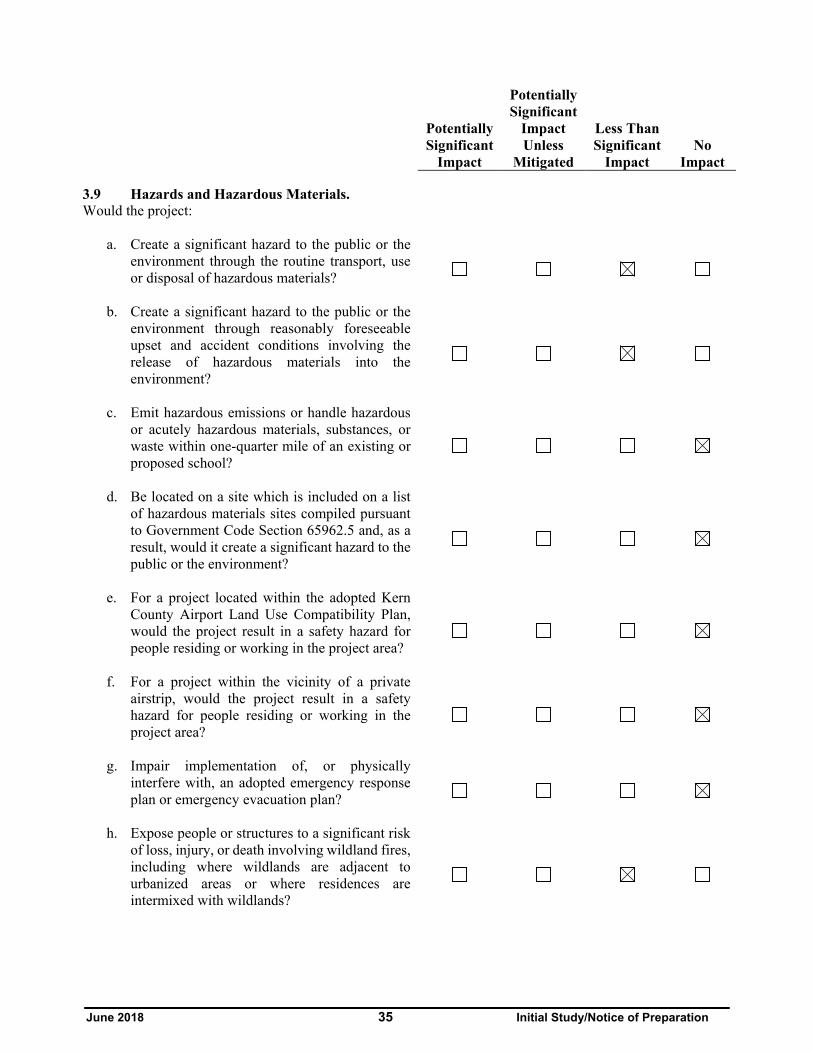
June 2018 35 Initial Study/Notice of Preparation
Potentially Significant
Impact
Potentially Significant
Impact Unless
Mitigated
Less Than Significant
Impact No
Impact
3.9 Hazards and Hazardous Materials. Would the project:
a. Create a significant hazard to the public or the
environment through the routine transport, use or disposal of hazardous materials?
b. Create a significant hazard to the public or the environment through reasonably foreseeable upset and accident conditions involving the release of hazardous materials into the environment?
c. Emit hazardous emissions or handle hazardous or acutely hazardous materials, substances, or waste within one-quarter mile of an existing or proposed school?
d. Be located on a site which is included on a list of hazardous materials sites compiled pursuant to Government Code Section 65962.5 and, as a result, would it create a significant hazard to the public or the environment?
e. For a project located within the adopted Kern County Airport Land Use Compatibility Plan, would the project result in a safety hazard for people residing or working in the project area?
f. For a project within the vicinity of a private airstrip, would the project result in a safety hazard for people residing or working in the project area?
g. Impair implementation of, or physically interfere with, an adopted emergency response plan or emergency evacuation plan?
h. Expose people or structures to a significant risk of loss, injury, or death involving wildland fires, including where wildlands are adjacent to urbanized areas or where residences are intermixed with wildlands?

June 2018 36 Initial Study/Notice of Preparation
Potentially Significant
Impact
Potentially Significant
Impact Unless
Mitigated
Less Than Significant
Impact No
Impact i. Would implementation of the project generate
vectors (flies, mosquitoes, rodents, etc.) or have a component that includes agricultural waste? Specifically, would the project exceed the following qualitative threshold: The presence of domestic flies, mosquitoes, cockroaches, rodents, and/or any other vectors associated with the project is significant when the applicable enforcement agency determines that any of the vectors:
i. Occur as immature stages and adults in numbers considerably in excess of those found in the surrounding environment; and
ii. Are associated with design, layout, and management of project operations; and
iii. Disseminate widely from the property; and
iv. Cause detrimental effects on the public health or wellbeing of the majority of the surrounding population.
Discussion:
(a) Less Than Significant Impact. The proposed project would not involve the routine transport, use, or disposal of hazardous materials as defined by the Hazardous Materials Transportation Uniform Safety Act and is not expected to create a significant hazard to the public or the environment. During construction, the proposed project would include the transport of general construction materials (i.e., concrete, wood, metal, fuel, etc.) as well as materials necessary to construct the proposed PV arrays. Project-related infrastructure would not emit hazardous materials, or be constructed of acutely hazardous materials or substances that could adversely impact the public or onsite workers. The majority of wastes to be generated during construction of the proposed project would also be non-hazardous, and would consist of cardboard, wood pallets, copper wire, scrap steel, common trash, and wood wire spools. However, the proposed project could generate small quantities of hazardous waste during project construction, including waste paint, spent construction solvents, waste cleaners, waste oil, oily rags, waste batteries, and spent welding materials. Although field equipment used during construction activities could contain various hazardous materials (i.e., hydraulic oil, diesel fuel, grease, lubricants, solvents, adhesives, paints, etc.), these materials are not considered to be acutely hazardous and would be used in accordance with the manufacturer’s specifications and all applicable regulations. In addition, although it is unlikely that large quantities will be stored on site, hazardous fuels and lubricants used on field equipment would be subject to a Material Disposal and Solid Waste

June 2018 37 Initial Study/Notice of Preparation
Management Plan, and a Spill Prevention Containment and Countermeasure (SPCC) Plan, as required. Impacts resulting from the transport, use or disposal of hazardous materials during construction of the proposed project would be less than significant; however, the EIR will include an evaluation of potential hazardous materials impacts.
The proposed project would be subject to all local, State, and federal laws pertaining to the use of hazardous materials onsite and would be subject to review by the Kern County Environmental Health Services Division/Hazardous Materials Section. Through the review process, the proposed project would be required to submit hazardous materials business plan, which would include a complete list of all materials used onsite, an explanation of how the materials would be transported, and a discussion on the chemical forms in which the materials would be used in order to maintain safety and prevent possible environmental contamination or worker exposure. During construction of the proposed project, Material Safety Data Sheets (MSDS) for all applicable materials present at the site would be made readily available to onsite personnel. During construction of the facilities, non-hazardous construction debris would be generated and disposed of in approved facilities. Therefore, construction of the proposed project would not create a significant hazard to the public or the environment through the routine transport, use, or disposal of hazardous materials.
The PV panels may include solid materials that are considered hazardous, such as cadmium telluride. While in operation, the solar panels are solid and non-leachable; however, broken panels could result in a slight hazard. To dispose of properly, the proposed project would use the manufacturer’s collection and recycling program to ensure the proper collection and recycling of PV panels, as needed. While it is anticipated that transport and disposal of such panels would result in a less than significant hazard, this issue will be considered in the EIR.
Concern over electromagnetic field (EMF) exposure generally pertains to human-made sources of electromagnetism and the degree to which they may have adverse biological effects or interfere with other electromagnetic systems. Commonly known human-made sources of EMF are electrical systems, such as electronics and telecommunications, as well as electric motors and other electrically powered devices. Radiation from these sources is invisible, non-ionizing, and of low frequency. Generally, in most environments, the levels of such radiation when added to natural background sources are low. Electric voltage (electric field) and electric current (magnetic field) from transmission lines create EMFs, dangers associated with high-voltage electrical transmission lines (including EMF hazards), though anticipated to be less than significant, will be discussed in the EIR as well.
Dust palliatives and herbicides, if used, may be transported to and stored at the proposed project site. These materials would be stored in appropriate containers that would prevent their accidental release at the site. There are no designated routes for the transport of hazardous materials located within or adjacent to the proposed project site; however, SR 14 is a designated route for the transport of hazardous materials. SR 14 is located approximately 15 miles east of the proposed project site. This roadway is equipped to handle the transport of hazardous materials and SR 14 would provide regional access to the site. Because operation of the proposed project would not involve the routine use of materials defined as hazardous, operation of the proposed project would not create a significant hazard to the public or the environment through the routine transport, use, or disposal of hazardous materials during either construction or operation. Nevertheless, this impact will be analyzed further in the EIR.

June 2018 38 Initial Study/Notice of Preparation
(b) Less Than Significant Impact. The proposed project site is not located within or near a Department of Oil, Gas and Geothermal Resources (DOGGR) identified oil field. Additionally, the site contains no known active or abandoned oil wells and there are no known active or abandoned oil wells in the site’s immediate vicinity.
Construction and operation of the proposed project may include the accidental release of hazardous materials, such as cleaning fluids and petroleum products including lubricants, fuels, and solvents. Electrical transformer equipment that would be installed as part of the proposed project would utilize FR3 coolants, derived from mineral oils, which rapidly biodegrade and are non-toxic. The proposed project would be subject to all local, State, and federal laws pertaining to the use of hazardous materials onsite and would be subject to review by the Kern County Environmental Health Services Division/Hazardous Materials Section. Through the review process, the project proponent would be required to submit a hazardous materials business plan, which would include a complete list of all materials used onsite, how the materials would be transported, and in what form they would be used. This would be recorded to maintain safety and prevent possible environmental contamination or worker exposure. This would also include submission of Materials Safety Data Sheets (MSDS) for all applicable materials present at the site. The MSDS would be made readily available to onsite personnel. It is anticipated that adherence to regulations and standard protocols during foreseeable upset and accident conditions involving the release of hazardous materials into the environment would avoid significant impacts. However, potential impacts will be evaluated further in the EIR.
(c) No Impact. The proposed project site is located within the unincorporated area of Kern County and the closest school to the proposed project site is Tropico Middle School, located approximately 13 miles southeast of the proposed project site in the community of Rosamond. No new schools are proposed in the vicinity of the proposed project site. The proposed project consists of solar energy generation facilities that involve using PV panels to generate electricity. Project-related infrastructure would not emit hazardous materials or involve handling hazardous or acutely hazardous materials, substances, or waste within a quarter mile of an existing or proposed school, and no further analysis is warranted in the EIR.
(d) No Impact. A search was completed for the subject parcels in the Environmental Protection Agency’s (CalEPA) Cortese List and the proposed project site is not identified in their hazardous materials database. No impacts are anticipated, and further analysis is not warranted in the EIR.
(e) No Impact. The proposed project is not located within a Kern County Airport Land Use Compatibility Plan (ALUCP). The proposed project area is located within 13 miles of the Rosamond Airport and Skypark, within 14 miles of the Mojave Airport, and within 10 miles of the Mountain Valley Airport. Therefore, the proposed project would not result in a safety hazard for people residing or working in the project area and this impact will not be evaluated in the EIR.
(f) No Impact. The proposed project site is not located within 2 miles of a private airstrip or heliport. The closest private airstrip is the Mountain Valley Airport located approximately 10 miles north of the proposed project site. Therefore, there are no anticipated safety hazards related to proximity to a private airstrip or heliport. No significant impacts are anticipated and no further analysis of this issue is warranted in the EIR.
(g) No Impact. The proposed project would not physically impede the existing emergency response plan, emergency vehicle access, or personnel access to the proposed project site. The proposed project site is located in an area with several alternative access roads allowing access in the event of an emergency. Primary access to the proposed project site is from State Route 14, by way of Rosamond Boulevard
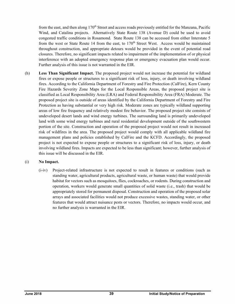
June 2018 39 Initial Study/Notice of Preparation
from the east, and then along 170th Street and access roads previously entitled for the Manzana, Pacific Wind, and Catalina projects. Alternatively State Route 138 (Avenue D) could be used to avoid congested traffic conditions in Rosamond. State Route 138 can be accessed from either Interstate 5 from the west or State Route 14 from the east, to 170th Street West. Access would be maintained throughout construction, and appropriate detours would be provided in the event of potential road closures. Therefore, no significant impacts related to impairment of the implementation of or physical interference with an adopted emergency response plan or emergency evacuation plan would occur. Further analysis of this issue is not warranted in the EIR.
(h) Less Than Significant Impact. The proposed project would not increase the potential for wildland fires or expose people or structures to a significant risk of loss, injury, or death involving wildland fires. According to the California Department of Forestry and Fire Protection (CalFire), Kern County Fire Hazards Severity Zone Maps for the Local Responsible Areas, the proposed project site is classified as Local Responsibility Area (LRA) and Federal Responsibility Area (FRA) Moderate. The proposed project site is outside of areas identified by the California Department of Forestry and Fire Protection as having substantial or very high risk. Moderate zones are typically wildland supporting areas of low fire frequency and relatively modest fire behavior. The proposed project site consists of undeveloped desert lands and wind energy turbines. The surrounding land is primarily undeveloped land with some wind energy turbines and rural residential development outside of the southwestern portion of the site. Construction and operation of the proposed project would not result in increased risk of wildfires in the area. The proposed project would comply with all applicable wildland fire management plans and policies established by CalFire and the KCFD. Accordingly, the proposed project is not expected to expose people or structures to a significant risk of loss, injury, or death involving wildland fires. Impacts are expected to be less than significant; however, further analysis of this issue will be discussed in the EIR.
(i) No Impact.
(i-iv) Project-related infrastructure is not expected to result in features or conditions (such as standing water, agricultural products, agricultural waste, or human waste) that would provide habitat for vectors such as mosquitoes, flies, cockroaches, or rodents. During construction and operation, workers would generate small quantities of solid waste (i.e., trash) that would be appropriately stored for permanent disposal. Construction and operation of the proposed solar arrays and associated facilities would not produce excessive wastes, standing water, or other features that would attract nuisance pests or vectors. Therefore, no impacts would occur, and no further analysis is warranted in the EIR.
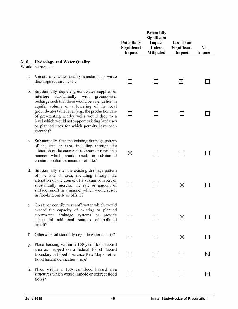
June 2018 40 Initial Study/Notice of Preparation
Potentially Significant
Impact
Potentially Significant
Impact Unless
Mitigated
Less Than Significant
Impact No
Impact
3.10 Hydrology and Water Quality. Would the project:
a. Violate any water quality standards or waste
discharge requirements?
b. Substantially deplete groundwater supplies or interfere substantially with groundwater recharge such that there would be a net deficit in aquifer volume or a lowering of the local groundwater table level (e.g., the production rate of pre-existing nearby wells would drop to a level which would not support existing land uses or planned uses for which permits have been granted)?
c. Substantially alter the existing drainage pattern of the site or area, including through the alteration of the course of a stream or river, in a manner which would result in substantial erosion or siltation onsite or offsite?
d. Substantially alter the existing drainage pattern of the site or area, including through the alteration of the course of a stream or river, or substantially increase the rate or amount of surface runoff in a manner which would result in flooding onsite or offsite?
e. Create or contribute runoff water which would exceed the capacity of existing or planned stormwater drainage systems or provide substantial additional sources of polluted runoff?
f. Otherwise substantially degrade water quality?
g. Place housing within a 100-year flood hazard area as mapped on a federal Flood Hazard Boundary or Flood Insurance Rate Map or other flood hazard delineation map?
h. Place within a 100-year flood hazard area structures which would impede or redirect flood flows?
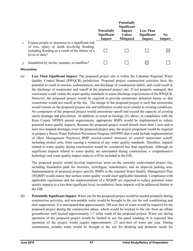
June 2018 41 Initial Study/Notice of Preparation
Potentially Significant
Impact
Potentially Significant
Impact Unless
Mitigated
Less Than Significant
Impact No
Impact i. Expose people or structures to a significant risk
of loss, injury or death involving flooding, including flooding as a result of the failure of a levee or dam?
j. Inundation by seiche, tsunami, or mudflow?
Discussion:
(a) Less Than Significant Impact. The proposed project site is within the Lahontan Regional Water Quality Control Board (RWQCB) jurisdiction. Proposed project construction activities have the potential to result in erosion, sedimentation, and discharge of construction debris, and could result in the discharge of wastewater and runoff at the proposed project site. If not properly managed, this wastewater could violate the water quality standards or waste discharge requirements of the RWQCB. However, the proposed project would be required to provide stormwater detention basins so that wastewater would not runoff at the site. The design of the proposed project is such that stormwater would remain on the proposed project site and infiltration would occur similar to existing conditions. No component of the proposed project would concentrate runoff and exceed the capacity of existing onsite drainage and percolation. In addition, as noted in Geology (b), above, in compliance with the Kern County NPDES permit requirements, appropriate BMPs would be implemented to reduce potential water quality impacts. Because the proposed project would disturb more than 1 acre and at least two mapped drainages cross the proposed project area, the project proponent would be required to prepare a Storm Water Pollution Prevention Program (SWPPP) that would include implementation of (Best Management Practices) BMP erosion-control measures to control stormwater runoff, including eroded soils, from causing a violation of any water quality standards. Therefore, impacts related to water quality during construction would be considered less than significant. Although no significant impacts related to water quality are anticipated during construction, a comprehensive hydrology and water quality impact analysis will be included in the EIR.
The proposed project would develop impervious areas on the currently undeveloped project site, including foundation pads for inverters, switchgear, transformers, and an unpaved parking area. Implementation of proposed project specific BMPs in the required Water Quality Management Plan (WQMP) would ensure that surface water quality would meet applicable standards. Compliance with applicable regulations and the implementation of a WQMP are expected to reduce potential water quality impacts to a less than significant level; nevertheless, these impacts will be addressed further in the EIR.
(b) Potentially Significant Impact. Water use for the proposed project would be needed primarily during construction activities, and non-potable water would be brought to the site for soil conditioning and dust suppression. It is anticipated that approximately 200 acre-feet of water would be required for the proposed project during the construction phase, which would be trucked to the site from an offsite groundwater well located approximately 1.7 miles south of the proposed project. Water use during operation of the proposed project would be limited to use for panel washing. It is expected that operation of the project would require approximately .27 acre-foot of water per year. During construction, potable water would be brought to the site for drinking and domestic needs for

June 2018 42 Initial Study/Notice of Preparation
construction workers. Impacts related to local groundwater supplies may occur and will be further analyzed in the EIR.
(c) Potentially Significant Impact. Construction of the concrete pads for the switchyard, inverters, and transformers, etc., as well as foundational supports for panel installation, soil compaction, and any grading may alter the existing drainage pattern of the site. As noted in item (a), above, a SWPPP and WQMP would be prepared for the proposed project and the appropriate permits would be obtained from the Lahontan RWQCB. A hydrology study will be prepared for the proposed project in accordance with Kern County requirements, and potential impacts to existing drainage patterns and flooding conditions, as well as the potential for increased erosion or siltation, will be analyzed in the EIR.
(d) Less Than Significant Impact. There are no streams or rivers that traverse the proposed project site, and therefore, the proposed project would not result in an increase in the rate or amount of surface runoff that would cause the course alteration of a stream or river.
Construction and operational activities associated with the proposed project could result in an increase in the rate or amount of surface runoff, however, it is anticipated that most of the stormwater would infiltrate into the onsite soils similar to existing conditions. Although the proposed project site is located within a Flood Zone X (outside the 500 year flood zone) with minimal flood hazard, it is in a predominantly rural area and the proposed project is anticipated to result in less than significant impact in regards to flooding onsite or offsite. However, alterations of drainage patterns will be further evaluated in the EIR.
(e) Less Than Significant Impact. During construction and following installation of the solar arrays and other associated proposed project infrastructure, the majority of the site would remain as pervious surface. The design of the proposed project is such that stormwater would remain on the proposed project site and infiltration would occur similar to existing conditions. No component of the proposed project would concentrate runoff and exceed the capacity of existing onsite drainage and percolation. Similarly, no component of the proposed project is anticipated to generate a substantial source of polluted runoff. The construction period SWPPP and the operational period WQMP would provide proper control and treatment, if necessary, of any stormwater prior to discharge. With adherence to site-specific BMPs, potential pollutants would be minimized to the extent practicable and should not exceed numeric thresholds for water quality protection. Impacts would be less than significant. Nevertheless, this impact will be discussed further in the EIR.
(f) Less Than Significant Impact. Project construction activities (such as grading) could potentially degrade water quality through erosion and subsequent sedimentation of drainage pathways. Additionally, accidental release of potentially harmful materials, such as engine oil, diesel fuel, and cement slurry could degrade the water quality of any possible nearby ephemeral streams or drainage features. As mentioned above, implementation of a SWPPP would include BMPs during construction and a WQMP would provide BMPs for operation, which would reduce the impact of project activities on surrounding water quality. Therefore, construction and operation of the proposed project would not substantially degrade water quality and impacts would be less than significant. Nevertheless, potential impacts to water quality will be evaluated further in the EIR.

June 2018 43 Initial Study/Notice of Preparation
(g) No Impact. The site is located within the Flood Hazard Zone X as identified by FEMA, which is defined as areas outside the 500 year flood zone with minimal flood chances. As detailed hydraulic analyses have not been performed, no Base Flood Elevations (BFEs) or flood depths are shown. The proposed project does not include construction of housing. As a result, no impacts would occur and no further analysis is warranted in the EIR.
(h) No Impact. The proposed project is located within Flood Zone X as designated by FEMA. Flood Zone X indicates areas outside of the 500 year flood zone with minimal flood chances. As noted above in item (g) detailed hydraulic analyses have not been performed and no Base Flood Elevations (BFEs) or flood depths are shown. The proposed project would be reviewed by the Kern County Public Works Department for adherence to all floodplain management standards if deemed necessary. Because the proposed project and its structures will not be built within a 100 year flood hazard area, impacts are not anticipated and further analysis is not required in the EIR.
(i) No Impact. As noted above in item (h), the proposed project is located within Flood Zone X as designated by FEMA. Flood Zone X indicates areas outside of the 500 year flood zone with minimal flood chances. The proposed project is located within a minimal flood hazard area and would not expose people or structures to a significant risk of loss, injury or death involving flooding, including flooding as a result of the failure of a levee or dam. Isabella Lake Dam is located more than 35 miles west, and the proposed project site is located outside of the Isabella flood inundation zone. Therefore, the proposed project would not expose people or structures to a significant risk of loss, injury, or death due to flooding from failure of a levee or dam and no impact is anticipated. Further analysis related to failure of a levee or dam is not warranted in the EIR.
(j) Less Than significant. The proposed project site is not located near an ocean or enclosed body of water, and therefore would not be subject to inundation by seiche or tsunami. Mudflows are a type of mass wasting or landslide, where earth and surface materials are rapidly transported downhill under the force of gravity, and are often triggered by heavy rainfall and soil that is not able to sufficiently drain or absorb water and the super-saturation results in soil and rock materials to become unstable and slide away. Due to the topography of the proposed project site and surrounding area, located at the southeastern base of the Tehachapi Mountains with terrain that gradually slopes from northwest to southeast, the potential to be inundated by mudflow is considered remote but possible. Therefore, there would be no impacts for seiche or tsunami, however, impacts for mudflow are considered to be less than significant and further analysis is warranted in the EIR for possible impacts of mudflow.

June 2018 44 Initial Study/Notice of Preparation
Potentially Significant
Impact
Potentially Significant
Impact Unless
Mitigated
Less Than Significant
Impact No
Impact
3.11 Land Use and Planning. Would the project:
a. Physically divide an established community?
b. Conflict with any applicable land use plan, policy, or regulation of an agency with jurisdiction over the project (including, but not limited to the general plan, specific plan, local coastal program, or zoning ordinance) adopted for the purpose of avoiding or mitigating an environmental effect?
c. Conflict with any applicable habitat conservation plan or natural community conservation plan?
Discussion:
(a) No Impact. The proposed project would be constructed on undeveloped desert lands used primarily for wind energy generation and as grazing land. There are no residences or other structures on the proposed project site. The proposed project site is located within the unincorporated area of Kern County. The nearest populated areas are the community of Mojave 17 miles to the northeast; the unincorporated community of Rosamond 16 miles southeast; and the City of Tehachapi, 12 miles to the north. There is a small cluster of residential development to the southwest of the proposed project site, however, the proposed project would not physically divide or restrict access to any community, as the proposed project site is located in a generally undeveloped and unincorporated area of Kern County, with little residential development in the vicinity of the area. Therefore, impacts related to the physical division of an established community would not occur, and this issue will not be discussed further in the EIR.
(b) Potentially Significant Impact. The proposed project is located within the Kern County General Plan area shown in Figure 3. The proposed project sites have a land use designation of 1.1 (State or Federal Land); 8.3 (Extensive Agriculture); 8.5 (Resource Management) and 2.1 (Geological Hazard). According to the Kern County Zoning Ordinance Section 19.12.030 G, solar energy electrical generators are permitted within the A (Exclusive Agriculture) Zone District with approval of a CUP. The project proponent is requesting a CUP to allow for the construction and operation of a 44 MW solar facility within the A (Exclusive Agriculture) and OS (Open Space) Zoning Districts.
The property’s zoning classifications are consistent with its Specific Plan designations. The proposed project is consistent with current Kern County General Plan, and Kern County Zoning Ordinance land use designations applicable to the proposed project site, which allow solar development by conditional use permit on the portions of the project site proposed for development. Although it is anticipated that the impacts would be less than significant, this will be analyzed further in the EIR. Therefore, with approval of the requested CUP, the proposed project would not have the potential to conflict with any

June 2018 45 Initial Study/Notice of Preparation
applicable land use plan, policy, or regulation of an agency with jurisdiction over the proposed project adopted for the purpose of avoiding or mitigating an environmental effect.
The CEQA Lead Agency notes that with the implementation of numerous renewable energy projects, cumulative effects of utility-sized solar power generation facilities, there is the potential for outside factors – such as the development of newer technology, changes in state or national policy that encourages the construction of such facilities, or other economic factors – to result in the abandonment of such facilities by the project proponent. Discussion of potential impacts associated with the abandonment of solar facilities will be discussed in the EIR. Additionally, the military has identified potential conflicts of users of the radio frequency spectrum located both on and off military installations as an area to be reviewed for compatibility issues. Operations of unmanned radio-controlled aircraft flights can have electronic interference from other sources of radio signals from telemetry equipment associated with the solar facility. Although the proposed project would be consistent with the Kern County General Plan and Kern County Zoning Ordinance, the OS (Open Space) portion of the proposed project site; is under the jurisdiction of the BLM (Federal Bureau of Land Management); is identified as a Development Focus Area; and parcels are set aside for streamlining Renewable Energy Projects; therefore, the BLM portion of the site will be further discussed in the EIR.
(c) Potentially Significant Impact. The proposed project site is located within the boundaries of the adopted California Desert Conservation Area Plan (CDCA), therefore, impacts from the project as proposed could potentially be significant to the adopted CDCA and further analysis of this issue is warranted in the EIR.

June 2018 46 Initial Study/Notice of Preparation
Potentially Significant
Impact
Potentially Significant
Impact Unless
Mitigated
Less Than Significant
Impact No
Impact
3.12 Mineral Resources. Would the project:
a. Result in the loss of availability of a known
mineral resource that would be of value to the region and the residents of the state?
b. Result in the loss of availability of a locally-important mineral resource recovery site delineated on a local general plan, specific plan or other land use plan?
Discussion:
(a) No Impact. The proposed project is not located within any designated mineral resources area or DOGGR identified oil field. Since construction and operation of the proposed project is not anticipated to result in the loss of availability of a known mineral resource that would be of value to the region and residents of the State, the proposed project would have no impact. Therefore, this issue will not be further analyzed in the EIR.
(b) Less Than Significant Impact. The proposed project site does not contain locally important mineral resources recovery sites delineated in the Kern County General Plan. According to the Kern County General Plan, the area is undeveloped and used for wind energy production and grazing land. Land within the plan boundaries has value as agricultural land, wind energy land, and grazing/rangeland. Should mineral resources be discovered in the proposed project area, mitigation will be proposed in the EIR, to provide goals, policies and standards of development that will address the possible loss of mineral resources and/or their recovery. Less than significant impacts are anticipated, however, this issue will be addressed further in the EIR.

June 2018 47 Initial Study/Notice of Preparation
Potentially Significant
Impact
Potentially Significant
Impact Unless
Mitigated
Less Than Significant
Impact No
Impact
3.13 Noise. Would the project result in:
a. Exposure of persons to, or generate, noise levels
in excess of standards established in the local general plan or noise ordinance or applicable standards of other agencies?
b. Exposure of persons to, or generate, excessive groundborne vibration or groundborne noise levels?
c. A substantial permanent increase in ambient noise levels in the project vicinity above levels existing without the project?
d. A substantial temporary or periodic increase in ambient noise levels in the project vicinity above levels existing without the project?
e. For a project located within the Kern County Airport Land Use Compatibility Plan, would the project expose people residing or working in the project area to excessive noise levels?
f. For a project within the vicinity of a private airstrip, would the project expose people residing or working in the project area to excessive noise levels?
Discussion:
(a) Less than Significant Impact. Land uses determined to be “sensitive” to noise as defined by the Kern County General Plan include residential areas, schools, convalescent and acute care hospitals, parks and recreational areas, and churches. The Kern County General Plan Noise Element sets a 65 dBA (A-weighted decibels) Ldn limit on exterior noise levels for stationary sources (i.e., non-transportation) at sensitive receptors. The closest offsite noise sensitive receptors to the proposed project site are residences located in the vicinity of the southwestern portion of the proposed project site. Noise generated by the proposed project would occur primarily during the construction phase, as the long-term operation of the solar facility would be relatively quiet. There would not be any substantial noise-generating equipment located at the proposed project site. The project proponent would be required to adhere to the provisions outlined in the Noise Control Ordinance in the Kern County Ordinance Code Section 8.36.020 and the Kern County General Plan Noise Element. Although noise levels generated during project construction are anticipated to be temporary in nature and less than significant, this impact will be analyzed in the EIR.

June 2018 48 Initial Study/Notice of Preparation
(b) Less Than Significant Impact. Ground borne vibration and ground borne noise could originate from the operation of heavy off-road equipment during the construction phase of the proposed project. Erection of the solar arrays would include support structures that may potentially need to be driven into the soil using pneumatic techniques. As such, the installation of these support structures may cause localized vibration. However, significant vibration typically associated with activities such as blasting, would not be an activity associated with the proposed project. Given the localized nature of vibration impacts and the rapid attenuation of vibration levels over short distances, the vibration impacts associated with the proposed project during construction are anticipated to be less than significant. Nevertheless, this impact will be further analyzed in the EIR.
(c) Less Than Significant Impact. Due to the quiet nature of solar facilities, it is unlikely that long-term noise generated by the proposed project will exceed existing ambient noise levels. Traffic on the proposed project access roads would be for routine maintenance activities and would primarily consist of personal vehicles, and would only occur several times per year. Therefore, the majority of operations would not produce noise discernible above ambient conditions. Although general maintenance activities would be conducted, they would be subject to applicable Kern County Noise Control Ordinance requirements and comply with the Kern County General Plan Noise Element, which would minimize impacts to receptors. Although impacts are anticipated to be less than significant, this issue will be evaluated further in the EIR.
(d) Potentially Significant Impact. Heavy equipment used during construction would cause a temporary or periodic increase in ambient noise levels and be considered a potentially significant impact. Therefore, the potential for the proposed project’s construction activities to result in a substantial temporary or periodic increase in ambient noise levels at the nearest offsite sensitive receptors will be further evaluated in the EIR. Project-related construction noise levels will be quantified and evaluated in the EIR.
(e) No Impact. The proposed project is not located within a Kern County Airport Land Use Compatibility Plan (ALUCP). The proposed project area is located within 13 miles of the Rosamond Airport and Skypark, within 14 miles of the Mojave Airport, and within 10 miles of the Mountain Valley Airport. The proposed project would temporarily expose the construction workers for the proposed project to excessive noise levels but not workers in local airports. The proposed project would not include the development of new residences and would not expose new residents or airport workers to excessive noise and would therefore have no impacts. Therefore, impacts will not be evaluated further in the EIR.
(f) No Impact. As noted above, the nearest private airstrip is the Mountain Valley Airport, which is 10 miles north of the proposed project site. Due to its distance from the proposed project site, there would be no significant impact resulting from people residing or working in the vicinity of the private airstrip being exposed to excessive noise levels from the proposed project. Impacts are not expected and further analysis is not warranted in the EIR.

June 2018 49 Initial Study/Notice of Preparation
Potentially Significant
Impact
Potentially Significant
Impact Unless
Mitigated
Less Than Significant
Impact No
Impact
3.14 Population and Housing. Would the proposed project:
a. Induce substantial population growth in an area,
either directly (for example, by proposing new homes and businesses) or indirectly (for example, through extension of roads or other infrastructure)?
b. Displace substantial numbers of existing housing, necessitating the construction of replacement housing elsewhere?
c. Displace substantial numbers of people, necessitating the construction of replacement housing elsewhere?
Discussion:
(a) No Impact. Although the proposed project would provide new employment, long-term employment opportunities would be minimal. The proposed project would not include the construction of O&M buildings, so regular permanent employees would not be required. Maintenance personnel are expected to visit the proposed project site several times per year for routine maintenance and PV modules may be cleaned up to nine times a year. Temporary employment is expected to last up to 6 months during construction of the proposed project. The average daily workforce is expected to consist of 100 construction, supervisory, support, and construction management personnel, with a peak workforce of 200 individuals for short periods of time. Construction workers are expected to travel to the site from various local communities, and the majority would likely come from the existing labor pool as construction workers travel from site to site as needed. The number of workers anticipated to relocate to the area is not expected to be substantial. If temporary housing should be necessary, it is expected that accommodations would be available in the nearby hotels in the community of Mojave, Ridgecrest and City of Tehachapi or other local communities and cities. Therefore, the proposed project would not directly or indirectly induce the development of any new housing or businesses. This issue will not be discussed further in the EIR.
Typically, established local thresholds of significance for housing and population growth pursuant to the State CEQA Guidelines, Section 15064.7, include effects that would induce substantial growth or concentration of a population beyond County projections, alter the location, distribution, density, or growth rate of the population beyond that projected in the General Plan Housing Element, result in a substantial increase in demand for additional housing, or create a development that significantly reduces the ability of the County to meet housing objectives set forth in the General Plan Housing Element. The effects of the proposed project in relation to these local thresholds are minimal. No impacts would occur, and further analysis of this is not warranted in the EIR.

June 2018 50 Initial Study/Notice of Preparation
Although the proposed project would produce additional electricity, it is intended to meet the demand for energy that is already projected based on growth in communities around California. As such, the generation of electricity by the proposed project would be considered growth-accommodating, rather than growth-inducing. In addition, State law requires utility companies to produce a certain percentage of electricity from green or renewable sources. Solar electricity is considered a renewable product and would help the utility companies meet this new State law. The proposed project’s electricity would replace electricity generated by fossil fuel-burning facilities, thereby contributing to California’s renewable energy goals, and would not contribute to induced growth. Significant impacts related to population growth are not expected from the proposed project, and further analysis of this issue is not warranted in the EIR.
(b-c) No Impact. The proposed project site is mostly undeveloped with some wind energy production and grazing land use. There are no existing houses located within the proposed project site, and no households would be required to be relocated as a result of the proposed project. Further, there are currently no persons residing on the proposed project site. Therefore, impact to displacement of existing housing would not occur and this issue will not be discussed further in the EIR.

June 2018 51 Initial Study/Notice of Preparation
Potentially Significant
Impact
Potentially Significant
Impact Unless
Mitigated
Less Than Significant
Impact No
Impact
3.15 Public Services. Would the project:
a. Result in substantial adverse physical impacts
associated with the provision of new or physically altered governmental facilities, need for new or physically altered governmental facilities, the construction of which could cause significant environmental impacts, in order to maintain acceptable service ratios, response times, or to other performance objectives for any of the public services:
i) Fire protection?
ii) Police protection?
iii) Schools?
iv) Parks?
v) Other public facilities?
Discussion:
(a) (i) Potentially Significant. Fire Protection: Fire suppression and emergency medical services are provided by the Kern County Fire Department (KCFD). The proposed project site is served by Fire Station #15, located approximately 14 miles southeast of the project site at 2980 Desert Street in the community of Rosamond. Adherence to all applicable regulations would reduce wildfire ignitions and prevent the spread of wildfires. However, proposed project construction and operation activities may result in increased need for fire-fighting personnel and facilities. Given the location of the proposed project site in the rural environment and KCFD’s obligation to respond to all structure fires in their jurisdiction, fire-fighting capacity in the proposed project area could result in potential impacts on fire services from construction and operation of the solar facilities. This will be evaluated in the EIR.
(ii) Potentially Significant. Police Protection. Police protection services are provided by the Kern County Sheriff’s Office. The primary Sheriff Substation that would serve the proposed project area is the Rosamond Substation, located approximately 17 miles southeast from the proposed project site, at 1379 Sierra Hwy in the City of Rosamond. Although the potential is low, the proposed project may attract vandals or other security risks, and construction activities would result in increases in traffic volumes along surrounding roads, which could increase demand on law enforcement services. Access would be limited to the proposed project site during construction and operation, thereby minimizing the need for police services;

June 2018 52 Initial Study/Notice of Preparation
nonetheless, the proposed project’s impacts on sheriff services are potentially significant and will be evaluated in the EIR.
(iii) No Impact. Schools: During the approximate 6-month construction period of the proposed project, an average of 100 daily construction workers and a peak workforce of 200 workers could be required. It is expected that most of these workers would live in the region and would commute to the proposed project site from where their children are already enrolled in school. Even if these workers came from out of the area, they would likely return to their out-of-town residences once the facilities were built and would not take their children out of their current schooling situation. Therefore, substantial temporary increases in population that would adversely affect local school populations are not expected. Additionally, operation of the proposed project would not require any permanent employees. Maintenance personnel would be expected to visit the proposed project site several times per year for routine maintenance. However, these employees would likely commute to the proposed project site from their permanent residences, and would not take their children out of their schooling situation. However, even if the maintenance employees were hired from out of the area and had to relocate to eastern Kern County, the addition of these families to this area would not result in a substantial increase in the number users of local schools. Significant impacts would not occur and further analysis of this issue is not warranted in the EIR.
(iv) No Impact. Parks and Other Public Facilities: The proposed project would require an average of 100 daily workers and a peak workforce of 200 workers during the up to 6-month construction period. It is expected that most of these workers would live in the region and would commute to the proposed project site. The temporary workers during construction would not result in a substantial additional demand for park facilities, nor would they adversely affect local public facilities, such as post office, courthouse, and library services. Operation of the proposed project would not require any permanent onsite employees for maintenance and monitoring activities. Maintenance personnel would be expected to visit the proposed project site several times per year for routine maintenance, but they would likely be drawn from the local labor force and would commute from their permanent residences to the proposed project site during those times. However, even if the maintenance employees were hired from out of the area and had to relocate to eastern Kern County, the addition of these families to this area would not result in a substantial increase in the number users of local parks. As a result, significant impacts to parks or other public services are not anticipated to occur, and further analysis of this issue is not warranted in the EIR.
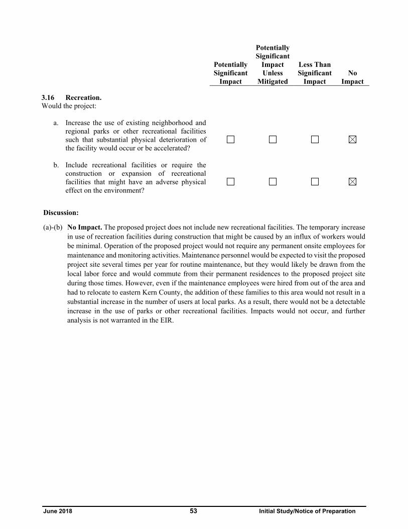
June 2018 53 Initial Study/Notice of Preparation
Potentially Significant
Impact
Potentially Significant
Impact Unless
Mitigated
Less Than Significant
Impact No
Impact
3.16 Recreation. Would the project:
a. Increase the use of existing neighborhood and
regional parks or other recreational facilities such that substantial physical deterioration of the facility would occur or be accelerated?
b. Include recreational facilities or require the construction or expansion of recreational facilities that might have an adverse physical effect on the environment?
Discussion:
(a)-(b) No Impact. The proposed project does not include new recreational facilities. The temporary increase in use of recreation facilities during construction that might be caused by an influx of workers would be minimal. Operation of the proposed project would not require any permanent onsite employees for maintenance and monitoring activities. Maintenance personnel would be expected to visit the proposed project site several times per year for routine maintenance, but they would likely be drawn from the local labor force and would commute from their permanent residences to the proposed project site during those times. However, even if the maintenance employees were hired from out of the area and had to relocate to eastern Kern County, the addition of these families to this area would not result in a substantial increase in the number of users at local parks. As a result, there would not be a detectable increase in the use of parks or other recreational facilities. Impacts would not occur, and further analysis is not warranted in the EIR.

June 2018 54 Initial Study/Notice of Preparation
Potentially Significant
Impact
Potentially Significant
Impact Unless
Mitigated
Less Than Significant
Impact No
Impact
3.17 Transportation/Traffic. Would the project:
a. Conflict with an applicable plan, ordinance, or
policy establishing measures of effectiveness for the performance of the circulation system, including but not limited to intersections, streets, highways and freeways, pedestrian and bicycle paths, and mass transit?
b. Conflict with an applicable congestion management program, including, but not limited to, level of service (LOS) standards and travel demand measures, or other standards established by the county congestion management agency for designated roads or highways?
i. Metropolitan Bakersfield General Plan LOS "C"
ii. Kern County General Plan LOS "D"
c. Result in a change in air traffic patterns, including either an increase in traffic levels or a change in location that results in substantial safety risks?
d. Substantially increase hazards due to a design
feature (e.g., sharp curves or dangerous intersections) or incompatible uses (e.g., farm equipment)?
e. Result in inadequate emergency access?
f. Conflict with adopted policies, plans, or
programs regarding public transit, bicycle, or pedestrian facilities, or otherwise decrease the performance or safety of such facilities?
Discussion:
(a) Potentially Significant Impact. Construction activities associated with the proposed project could potentially affect traffic volumes on nearby roadways. During construction of the proposed project, there would be an average daily construction workforce of 100 employees, with a peak construction

June 2018 55 Initial Study/Notice of Preparation
workforce of 200 employees during the approximate 6-month construction period. Project operations would not require any permanent full-time staff onsite. Maintenance personnel would be expected to visit the proposed project site several times per year for routine maintenance and PV modules may be cleaned up to nine times a year. This trip generation would not result in a substantial increase in traffic along existing roadways or congestion at intersections. Nonetheless, this impact will be analyzed further in the EIR.
(b) (i) No Impact. The proposed project site is not located in or near the metropolitan Bakersfield area. Therefore, no further analysis of this topic will be included in the EIR.
(ii) Less Than Significant Impact. Construction of the proposed project would generate construction trips and may require roadway lane closures, which could temporarily increase the daily traffic volumes on local roadways and intersections. Operation of the proposed project would also generate trips on local roadways. The potential impacts of these conditions on LOS of area roadways will be evaluated in the EIR.
(c) No Impact. The nearest airport to the proposed project site is the Mountain Valley Airport, a private use airport, located 10 miles north of the proposed project site. It is not anticipated that the proposed project will interfere with airspace, as the site is not listed in an Airport Land Use Compatibility Map Zone. The proposed project is outside the NAWS China Lake North Range sphere of influence. The proposed project would not interfere with airspace at the Mountain Valley Airport, as the non-reflective surfaces used for the solar arrays would have about half the reflectance of standard residential and commercial glass. The proposed project would not result in an increase in air traffic levels or a change in location of air traffic patterns that would result in substantial safety risks, because air traffic patterns would not be affected (i.e., the only mode of transport affected by the proposed project is automobile/truck operations). Therefore, there would be no impacts related to a change in air traffic patterns and further analysis of this issue is not warranted in the EIR.
(d) No Impact. Roadway modifications are not needed or proposed as part of the proposed project. The project proposes access from State Route 14 by way of Rosamond Boulevard from the east, and then along 170th Street West and access roads previously entitled for the Manzana, Pacific Wind, and Catalina projects, however, trucks transporting solar panel components and other construction materials could use State Route 138 (Avenue D) as an alternative route to avoid congested traffic conditions in Rosamond. The facilities would be surrounded by boundary fences and would require little maintenance upon full build-out.
Additionally, the proposed project would not include the development of sharp curves, dangerous intersections or other hazardous design features. Therefore, the proposed project would not substantially increase hazards due to a design feature or incompatible uses. Impacts would not be noted and further analysis is not warranted in the EIR.
(e) Less Than Significant Impact. As described in item (a) above, construction of the proposed project would generate traffic trips, which could temporarily increase the daily traffic volumes on local roadways and intersections. However, the proposed project would not physically impede the existing emergency response plans, emergency vehicle access, or personnel access to the site. The proposed project site and vicinity are accessible via existing roads, with an alternative access road allowing easy access in the event of an emergency. Therefore, adverse impacts related to impairment of the implementation of or physical interference with an adopted emergency response plan or emergency evacuation plan are not anticipated. Impacts would be less than significant and further analysis is not warranted in the EIR.
June 2018 56 Initial Study/Notice of Preparation
(f) No Impact. Operation of the proposed project would not require any permanent onsite employees for maintenance and monitoring activities. Maintenance personnel would be expected to visit the proposed project site several times per year for routine maintenance, but they would likely be drawn from the local labor force and would commute from their permanent residences to the proposed project site during those times. Due to the rural nature of the proposed project area, bicycle traffic is limited and few bus stops exist on the roadways likely to be used during construction and operation. The proposed project would not house residents or employees and therefore would not have characteristics that could influence alternative means of transportation. The proposed project would not conflict with adopted policies, plans, or programs supporting alternative transportation. Impacts would not be noted and additional analysis is not warranted in the EIR.

June 2018 57 Initial Study/Notice of Preparation
Potentially Significant
Impact
Potentially Significant
Impact Unless
Mitigated
Less Than Significant
Impact No
Impact
3.18 Utilities and Service Systems. Would the project:
a. Exceed wastewater treatment requirements of
the applicable Regional Water Quality Control Board?
b. Require or result in the construction of new water or wastewater treatment facilities or expansion of existing facilities, the construction of which could cause significant environmental effects?
c. Require or result in the construction of new stormwater drainage facilities or expansion of existing facilities, the construction of which could cause significant environmental effects?
d. Have sufficient water supplies available to serve the project from existing entitlements and resources, or would new or expanded entitlements be needed?
e. Result in a determination by the wastewater
treatment provider which serves or may serve the project that it has adequate capacity to serve the project’s projected demand in addition to the provider’s existing commitments?
f. Be served by a landfill with sufficient permitted
capacity to accommodate the project’s solid waste disposal needs?
g. Comply with federal, state, and local statutes and
regulations related to solid waste?
Discussion:
(a) No Impact. The proposed project would generate a minimal volume of wastewater. The average construction workforce for the proposed project site is 100 workers (expected to peak at 200 individuals). Wastewater generated during construction would be contained within portable toilet facilities. The Kern County Environmental Health Services Division is responsible for monitoring the use of portable toilet facilities, and a condition of approval would require the project proponent to provide documentation of a portable toilet pumping contract.

June 2018 58 Initial Study/Notice of Preparation
As proposed, the project would not include O&M buildings, and no permanent onsite staff would be required. Maintenance personnel would be expected to visit the proposed project site several times a year for routine maintenance. Therefore, the proposed project would not exceed wastewater treatment requirements of the Lahontan RWQCB. There would not be expected impacts that would exceed wastewater treatment requirements of the applicable Regional Water Quality Control Board and no further analysis is warranted in the EIR.
(b) No Impact. The proposed project would not require new water or wastewater disposal systems to be constructed, as no permanent operation or maintenance staff would be required onsite. Potable water would be brought to the site for drinking and other domestic needs during construction. Water for panel washing would be brought in by trucks. The proposed project is not proposing construction of any new or expanded water or wastewater treatment facilities, therefore no further analysis is warranted in the EIR.
(c) Less Than Significant Impact. The proposed project would create additional impervious surfaces on the proposed project site and may require imported water for dust suppression during construction and panel washing. These changes would not substantially increase the amount of stormwater runoff. The proposed project site does not rely on constructed stormwater drainage systems. The pattern and concentration of runoff could be altered by proposed project activities, such as grading of the site and roads. However, the proposed project must comply with the Lahontan RWQCB and NPDES requirements with approval of a SWPPP and a WQMP that include BMPs for runoff control. Additionally, a drainage plan would be required to be approved by the Kern County Public Works Department-Building & Development-Floodplain Division prior to issuance of building permits. With adherence to all applicable regulations, the proposed project would not require or result in the construction of new stormwater drainage facilities or expansion of existing facilities, the construction of which could cause significant environmental effects. Although impacts would be less than significant, this issue will be further considered in the EIR.
(d) Less Than Significant Impact. Water for construction and panel washing would be trucked in and potable water would be brought to the site for drinking and domestic needs during construction. Construction of the proposed project would require approximately 200 acre-feet of water. It is expected that operation of the proposed project would require approximately .27 acre-foot of water per year. The proposed project is not anticipated to impact water supplies and no new or expanded entitlements would be required. Although impacts are expected to be less than significant, further analysis is warranted in the EIR.
(e) No Impact. Wastewater services for the proposed project area are not provided by a Community Service District (CSD). As noted in (a) and (b) above, the proposed project is not expected to generate a significant amount of wastewater. Wastewater produced during construction would be collected in portable toilet facilities and disposed of at an approved facility. No toilet facilities will be available for routine maintenance personnel on-site. The O&M Building facilities for the Manzana Wind Project would be available for the personnel that would provide routine maintenance and PV module cleaning several times a year. Therefore, wastewater would not be generated from the proposed project, impact would not be noted and further analysis is not warranted in the EIR.
(f) Less Than Significant Impact. Solid waste generated within the proposed project area would be transported to the Kern County operated Mojave-Rosamond Sanitary Landfill located at 400 Silver Queen Road near the community of Mojave. The proposed project is not expected to generate a substantial amount of waste that would exceed the capacity of local landfills. Materials brought to the

June 2018 59 Initial Study/Notice of Preparation
proposed project site would be used to construct facilities, and few residual materials are expected. Non-hazardous construction refuse and solid waste would be either collected and recycled or disposed of at a local Class III landfill, while any hazardous waste generated during construction would be disposed of at an approved location. The closest Class III municipal landfill owned by the County of Kern and operated by the Kern County Waste Management Department is located at the Mojave-Rosamond Sanitary Landfill. It is not anticipated that the amount of solid waste generated by the proposed project would exceed the capacity of local landfills. Impacts are anticipated to be less than significant; however, further analysis of this issue will be included in the EIR.
(g) Less Than Significant Impact. The proposed project would generate solid waste during construction and operation, thus requiring the consideration of waste reduction and recycling measures. The 1989 California Integrated Waste Management Act (AB 939) requires Kern County to attain specific waste diversion goals. In addition, the California Solid Waste Reuse and Recycling Access Act of 1991, as amended, requires expanded or new development projects to incorporate storage areas for recycling bins into the proposed project design. The proposed project would comply with the 1989 California Integrated Waste Management Act and the 1991 California Solid Waste Reuse and Recycling Access Act of 1991, as amended. Therefore, impacts are anticipated to be less than significant but will be further analyzed in the EIR.

June 2018 60 Initial Study/Notice of Preparation
Potentially Significant
Impact
Potentially Significant
Impact Unless
Mitigated
Less Than Significant
Impact No
Impact
3.19 Mandatory Findings of Significance a. Does the project have the potential to degrade
the quality of the environment, substantially reduce the habitat of a fish or wildlife species, cause a fish or wildlife population to drop below self-sustaining levels, threaten to eliminate a plant or animal community, substantially reduce the number or restrict the range of a rare or endangered plant or animal, or eliminate important examples of the major periods of California history or prehistory?
b. Does the project have impacts that are
individually limited, but cumulatively considerable? (“Cumulatively considerable” means that the incremental effects of a project are significant when viewed in connection with the effects of past projects, the effects of other current projects, and the effects of probable future projects)?
c. Does the project have environmental effects
which would cause substantial adverse effects on human beings, either directly or indirectly?
Discussion:
(a) Potentially Significant Impact. The EIR’s biological and cultural resources sections will discuss specific impacts from the proposed project on plants and wildlife, and historical resources. The document will also evaluate the proposed project’s contribution to cumulative resource impacts and propose mitigation that is designed to reduce the impacts to less-than-significant levels, where feasible.
(b) Potentially Significant Impact. The proposed project has the potential to cumulatively contribute to aesthetics, air quality, biological resources, cultural resources, greenhouse gas emissions, and traffic impacts. The EIR will evaluate the proposed project’s contribution to cumulative impacts in these and other resource areas.
(c) Potentially Significant Impact. Although there may be significant air quality impacts during construction, the long-term air quality impacts could be beneficial if fossil fuel use is reduced. The short-term cumulative contribution to air quality impacts from the proposed project will be evaluated in the EIR.


