Government of Western Australia Department of Water s e i r e S n o i t c e t o r P e c r u o s e R r e t a W REPORT NO. 75 November 2007 Kirup Dam Catchment Area Drinking Water Source Protection Plan
Transcript
Government of Western AustraliaDepartment of Water
seireS noitcetorP ecruoseR retaW
REPORT NO. 75 November 2007
Kirup Dam Catchment AreaDrinking Water Source Protection Plan
i
Kirup Dam Catchment Area Drinking Water Source Protection Plan
Kirup and Mullalyup Town Water Supply
Department of Water
Water Resource Protection Series
Report 75
November 2007
Kirup Dam Catchment Area Drinking Water Source Protection Plan Water Resource Protection, Report No. 75
ii Department of Water
Department of Water 168 St Georges Terrace Perth Western Australia 6000 Telephone +61 8 6364 7600 Facsimile +61 8 6364 7601 http://www.water.wa.gov.au
This work is copyright. You may download, display, print and reproduce this material in unaltered form only (retaining this notice) for your personal, non-commercial use or use within your organisation. Apart from any use as permitted under the Copyright Act 1968, all other rights are reserved. Requests and inquiries concerning reproduction and rights should be addressed to the Department of Water.
National Library of Australia Cataloguing-in-Publication
November 2007
ISSN 1326-7442 (pub) ISSN 1835-3924 (pdf)
ISBN [978-1-921094-85-9] (pbk) ISBN [978-1-921094-86-6] (pdf)
Acknowledgements
The Department of Water would like to thank the following for their contribution to this publication: Clint Roberts (Environmental Officer, Department of Water) - report preparation and photographs, Stephen Watson (Program Manager, Department of Water) and Nigel Mantle (A/Branch Manager) - supervision, Julian Woodward (NRMO, South West Region, Department of Water) and Aaron Campbell (Catchment Co-ordinator, South West Region, Water Corporation) - report liaison, Melanie Webb (GIS officer, Department of Water) - drafting.
For more information about this report, contact the Department of Water officers listed above, Water Source Protection or send your query to [email protected].
Water Resource Protection Report No. 75 Kirup Dam Catchment Area Drinking Water Source Protection Plan
1.4 Future water supply requirements ..................................................................................... 2 1.5 Protection and allocation ................................................................................................... 3
1.5.1 Existing water source protection.............................................................................................3 1.5.2 Current allocation license .......................................................................................................3
2 Water quality monitoring and contamination risks................................................... 6
2.1 Microbiological contaminants ............................................................................................ 6 2.2 Health related characteristics ............................................................................................ 6 2.3 Aesthetic characteristics .................................................................................................... 7
3 Land use and contamination................................................................................... 8
3.1 Potential water quality risks ............................................................................................... 8 3.2 State forest......................................................................................................................... 8 3.3 Private land ........................................................................................................................ 8
References and further reading................................................................................. 41
Appendices
Appendix A Water quality.......................................................................................... 31
Kirup Dam Catchment Area Drinking Water Source Protection Plan Water Resource Protection, Report No. 75
iv Department of Water
Appendix B Photographs .......................................................................................... 34
Figures
Figure 1 Kirup Dam Catchment Area locality map .......................................................4 Figure 2 Kirup Dam Catchment Area ...........................................................................5 Figure 3 Land use and activities in the Kirup Dam Catchment Area ..........................10 Figure 4 Protection classifications and Reservoir Protection Zone for Kirup Dam
Table 1 Land use, potential water quality risks and recommended strategies ...........11
Water Resource Protection Report No. 75 Kirup Dam Catchment Area Drinking Water Source Protection Plan
v
Preface
The Department of Water has prepared this Drinking Water Source Protection Plan to assess the risks to water quality within the Kirup Dam Catchment Area and recommend management strategies to avoid, minimise or manage those risks. The department is committed to protecting drinking water sources to meet public health requirements and ensure the supply of ‘safe, good quality drinking water’ to consumers.
The Australian Drinking Water Guidelines recommend a risk based multiple barrier approach to protect public drinking water sources. Catchment protection is the ‘first barrier’, with subsequent barriers implemented at the water storage, treatment and distribution stages of a water supply system. Catchment protection requires an understanding of the catchment, the hazards and hazardous events that can compromise drinking water quality, and development of preventative strategies and operational controls to ensure the safest possible water supply.
This plan details the location and boundary of the drinking water catchment, providing potable water to the towns of Kirup and Mullalyup. It discusses existing and future usage of the water source, describes the water supply system, identifies risks and recommends management approaches to address the risks and maximise protection of the Kirup Dam Catchment Area.
This plan should be used to guide State and Local Government land use planning decisions. It should be recognised in the Donnybrook-Balingup Town Planning Scheme, consistent with the Western Australian Planning Commission’s Statement of Planning Policy No. 2.7 - Public Drinking Water Source Policy. Other stakeholders should use this document as a guide for protecting the quality of drinking water in the Kirup Dam Catchment Area.
The stages involved in preparing a Drinking Water Source Protection Plan are:
Stages in development of a plan Comment
1 Prepare Drinking Water Source Protection Assessment
Prepared following catchment survey and preliminary information gathering.
2 Conduct stakeholder consultation Advice sought from key stakeholders using the assessment as a tool for information and discussion.
3 Prepare Draft Drinking Water Source Protection Plan
Draft plan developed taking into account input from stakeholders and any additional advice received.
4 Release Draft Drinking Water Source Protection Plan
Draft plan released for a six week public consultation period.
5 Publish approved Drinking Water Source Protection Plan
Final plan published after considering advice received in submissions. Includes recommendations on how to protect water quality.
Kirup Dam Catchment Area Drinking Water Source Protection Plan Water Resource Protection, Report No. 75
vi Department of Water
Summary
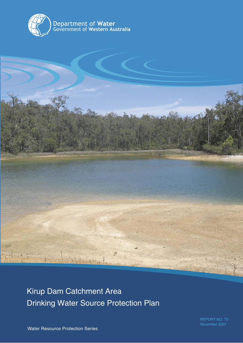
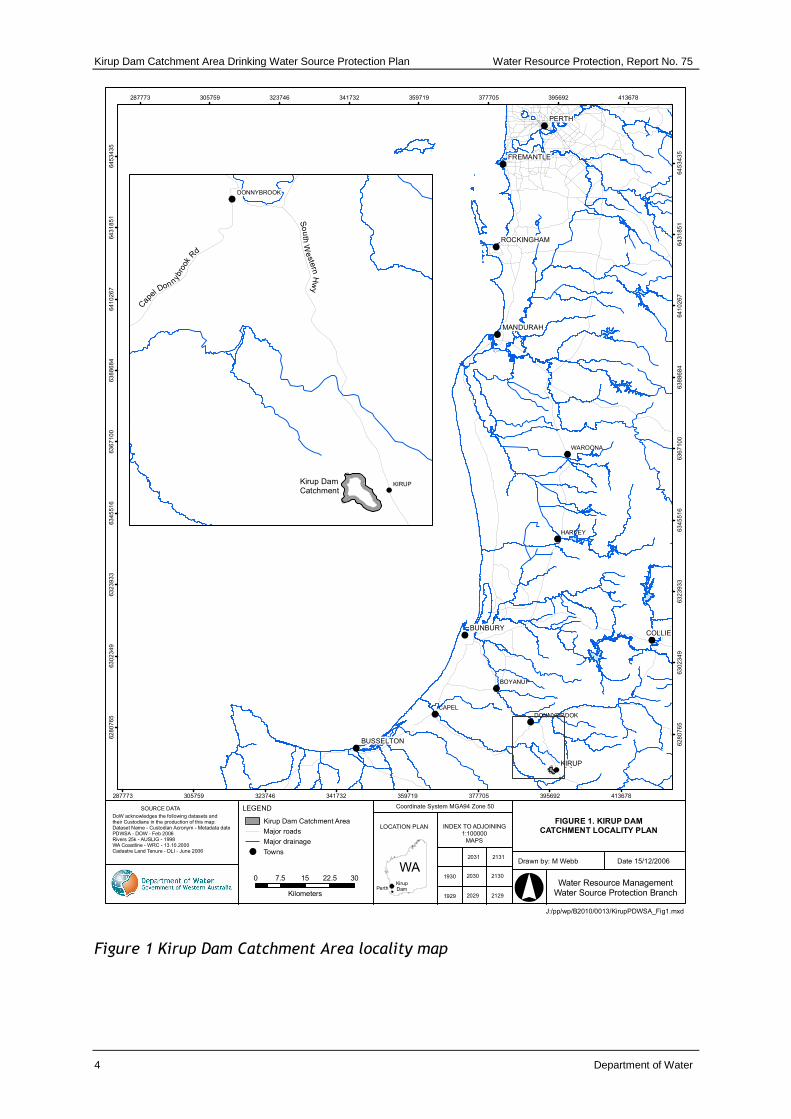
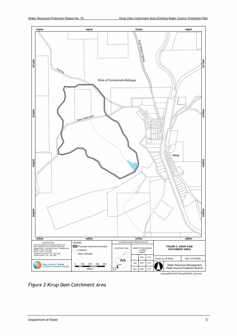
Kirup Dam is located in the Donnybrook-Balingup Shire, on the upper reaches of the Capel River, in the south west corner of Western Australia, approximately 228 kilometres (km) south of Perth and 53 km south-east of Bunbury (refer to Figure 1). It is operated by the Water Corporation to supply public drinking water to the towns of Kirup and Mullalyup.
State forest covers over 87% of the Kirup Dam Catchment Area (refer to Figure 2 and 3), with only one parcel of private land approximately 1.13 km upstream of the Dam. The state forest is vested in the Conservation Commission of Western Australia and managed by the Department of Environment and Conservation on its behalf. The Department of Environment and Conservation protect the catchment from logging, additionally the catchment is proposed to become a forest conservation area.
The risks to water quality associated with activities in the Kirup Dam Catchment Area include pathogen, turbidity, pesticide and nutrient contamination. Pathogens pose the most significant risk to public health. Pathogens may enter a reservoir through activities involving direct and indirect contact with the reservoir or its tributaries.
Recreational activities in this catchment occur as a result of its proximity to the town, activities include fishing, swimming, camping and vehicle use (e.g.4WD and motorbikes).
The Kirup Dam Catchment Area should be proclaimed under the Country Areas Water Supply Act 1947 for the purpose of protecting this public drinking water source from contamination. This will also trigger legally enforceable by–laws that will help protect the quality of water in this catchment.
It is recommended that state forest in the catchment is managed for priority 1 source protection (P1), and private land managed for priority 2 source protection (P2) (refer to Figure 4). A reservoir protection zone (RPZ) will be established for this catchment area. Within this zone, public access will be limited to maximise the protection of this source.
Water Resource Protection Report No. 75 Kirup Dam Catchment Area Drinking Water Source Protection Plan
Department of Water 1
1 Drinking water source overview
1.1 Existing water supply system
Kirup Dam is operated by the Water Corporation to supply public drinking water to the towns of Kirup and Mullalyup.
Kirup is a small ex-timber mill settlement located on the South Western Highway between Donnybrook and Balingup. The town services surrounding farming and timber activities and has a population of between 150 and 200. Mullalyup is a small residential settlement located 7 km south of Kirup along the South Western Highway. It has a population of approximately 80.
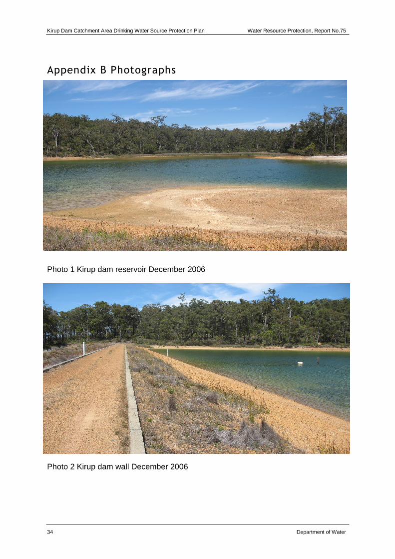
Kirup Dam was constructed in 1966 and consists of an earth fill wall (refer to photo 2 in Appendix B) and an open lined chute spillway. The Kirup Dam reservoir covers an area of 2.6 hectares (ha) and has a storage capacity of 59.7 Megalitres (ML) (refer to photos in Appendix B).
Water for Kirup is pumped from Kirup Dam to a 225 Kilolitre (kL) ground service tank in the Kirup town site and supplied to consumers under gravity. Water for Mullalyup is pumped from Kirup Dam to an 80kL break-pressure tank located 3.5 km from the town and is supplied to consumers under gravity.
1.2 Water treatment
Water from Kirup Dam is chlorinated and then pumped directly to the Kirup town site for storage and supply. Water supplied to Mullalyup is chlorinated prior to storage 3.5 km north of the town. Chlorination provides a disinfection barrier against possible microbiological contamination.
It should be recognised that although treatment and disinfection is an essential barrier to ensure a safe, good quality drinking water-supply, catchment protection is fundamentally the ‘first barrier’. This approach is endorsed by the Australian Drinking Water Guidelines (ADWG) (NHMRC & NRMMC, 2004) and reflects a risk based, ‘catchment to consumer’ multiple barrier approach for the provision of safe drinking water to consumers. The combination of catchment protection and treatment delivers a safer drinking water source that either protection barrier can achieve individually.
Kirup Dam Catchment Area Drinking Water Source Protection Plan Water Resource Protection, Report No. 75
2 Department of Water
1.3 Catchment details
1.3.1 Physiography
The Kirup Dam Catchment Area (KDCA) is located within the Darling Plateau which consists of an undulating, dissected peneplain. Soils are predominantly gravels with occasional block laterite outcrops and some elevated areas of sands and sandy loams with heavier alluvials in deeper valleys.
The catchment is moderately sloped and covered predominately in the natural vegetation of tall forests consisting of marri and jarrah with wandoo over dolerite dykes (refer to photo 1 and 2 in Appendix B).
1.3.2 Climate
The Kirup area has a temperate climate, characterised by warm dry summers with cool wet winters. Average temperatures range from 17-35 degrees Celsius (ºC) in February and from 8-18 ºC in July.
Average annual rainfall for the period 1975 to 2002 at Kirup Dam has been estimated at 945 millimetres.
1.3.3 Hydrology
The KDCA, has an area of 1.77 km2 with an elevation of 240 metres (m) Australian Height Datum (AHD) at the reservoir (full supply level) rising to 280 m AHD at the head of the catchment.
Mean annual flow to the reservoir for the period 1975 to 2002 is estimated at 100 ML (Water Corporation, unpublished).
1.4 Future water supply requirements
The Water Corporation is currently investigating new water sources to meet the needs of Kirup, Mullalyup, Bridgetown, Balingup, Boyup Brook, Greenbushes and Hester. The new integrated water supply scheme is proposed to incorporate a combination of surface water and groundwater sources. The Water Corporation has undertaken community consultation regarding the new scheme since 2005 and will continue community consultation during its development.
Notwithstanding the progress of the above potential new water sources, the Department of Water will continue to develop the Kirup Dam Catchment Area Drinking Water Source Protection Plan. This will ensure the current source of drinking water is protected until such time as the new source is in place. When a new source of drinking water is established, the status of the KDCA will be reviewed. This may lead to the catchment area being de-proclaimed, which would mean this Drinking Water Source Protection Plan would no longer be required.
Water Resource Protection Report No. 75 Kirup Dam Catchment Area Drinking Water Source Protection Plan
Department of Water 3
1.5 Protection and allocation
1.5.1 Existing water source protection
The KDCA is not currently proclaimed under the Country Areas Water Supply Act 1947. However Water Corporation actively conducts catchment preventative strategies as part of its existing water source protection measures for the KDCA. Preventative strategies include:
• Water Corporation surveillance of Kirup Dam and its catchment
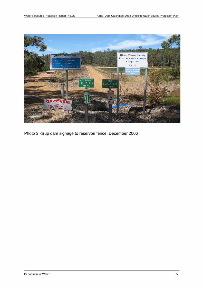
• signage, gates and fencing to the Kirup Dam reservoir
• water quality monitoring of the Kirup Dam reservoir and primary stream.
1.5.2 Current allocation license
Water resource use and conservation in Western Australia is administered by the Department of Water in accordance with the Rights in Water and Irrigation Act 1914. Under the Act, the right to use and control surface and groundwater is vested with the Crown. This act requires licensing of surface water abstraction within proclaimed surface water areas. The Water Corporation is licensed to draw 40 000 kL per year from Kirup Dam for public water supply purposes. The current number of services supplied by the scheme is 89 (Kirup 61 and Mullalyup 28). Abstraction from 2002 to 2007 for Kirup and Mullalyup was 30 000 kL per year.
Kirup Dam Catchment Area Drinking Water Source Protection Plan Water Resource Protection, Report No. 75
4 Department of Water
Figure 1 Kirup Dam Catchment Area locality map
PERTH
COLLIEBUNBURY
MANDURAH
FREMANTLE
BUSSELTON
ROCKINGHAM
CAPEL
HARVEY
WAROONA
BOYANUP
DONNYBROOK
KIRUP
287773
287773
305759
305759
323746
323746
341732
341732
359719
359719
377705
377705
395692
395692
413678
413678
62
80
76
5
62
80
76
5
63
02
34
9
63
02
34
9
63
23
93
3
63
23
93
3
63
45
51
6
63
45
51
6
63
67
10
0
63
67
10
0
63
88
68
4
63
88
68
4
64
10
26
7
64
10
26
7
64
31
85
1
64
31
85
1
64
53
43
5
64
53
43
5
J:/pp/wp/B2010/0013/KirupPDWSA_Fig1.mxd
FIGURE 1. KIRUP DAMCATCHMENT LOCALITY PLAN
Drawn by: M Webb Date 15/12/2006
Water Resource ManagementWater Source Protection Branch
INDEX TO ADJOINING1:100000
MAPS
LOCATION PLAN
WA
SOURCE DATA
DoW acknowledges the following datasets and their Custodians in the production of this map:Dataset Name - Custodian Acronym - Metadata datePDWSA - DOW - Feb 2006Rivers 25k - AUSLIG - 1998WA Coastline - WRC - 13.10.2000Cadastre Land Tenure - DLI - June 2006
2031 2131
2030 2130
2029 2129
KirupDamPerth
LEGEND Coordinate System MGA94 Zone 50
0 7.5 15 22.5 30
Kilometers
1930
1929
Kirup Dam Catchment Area
Major roads
Major drainage
Towns
DONNYBROOK
KIRUPKirup DamCatchment
Cap
el Donn
ybro
ok R
d
Sou
th W
este
rn H
wy
Water Resource Protection Report No. 75 Kirup Dam Catchment Area Drinking Water Source Protection Plan
Department of Water 5
Figure 2 Kirup Dam Catchment Area
Kirup
Shire of Donnybrook-Balingup
395000
395000
396000
396000
397000
397000
398000
398000
6268
000
6268
000
6269
000
6269
000
6270
000
6270
000
6271
000
6271
000
J:/pp/wp/B2010/0013/KirupPDWSA_Fig2.mxd
FIGURE 2. KIRUP DAMCATCHMENT AREA
Drawn by: M Webb Date 19/12/2006
Water Resource ManagementWater Source Protection Branch
INDEX TO ADJOINING1:100000
MAPS
LOCATION PLAN
WA
SOURCE DATA
DoW acknowledges the following datasets and their Custodians in the production of this map:Dataset Name - Custodian Acronym - Metadata datePDWSA - DOW - Feb 2006Rivers - DOW - June 2006Cadastre Land Tenure - DLI - Dec 2006LGA Boundaries - DLI - Dec 2006
2031 2131
2030 2130
2029 2129KirupDam
Perth
LEGEND Coordinate System MGA94 Zone 50
0 150 300 450 600
Meters
1930
1929
Proposed catchment boundary
Cadastre
Major drainage
Ryall Rd
South
Weste
rn H
igh
way
Upper Capel Road
Kirup Dam Catchment Area Drinking Water Source Protection Plan Water Resource Protection, Report No. 75
6 Department of Water
2 Water quality monitoring and contamination risks
A wide range of chemical, physical and microbiological properties can impact on water quality and therefore affect the provision of safe, good quality, aesthetically acceptable drinking water to consumers.
The Water Corporation regularly monitors the untreated raw water quality from the KDCA for microbiological contamination, health related chemicals and aesthetic characteristics in accordance with the Australian Drinking Water Guidelines (NHMRC & ARMCANZ, 2004). The results from monitoring are then reviewed by an intergovernmental committee, chaired by the Department of Health, called the Advisory Committee for the Purity of Water.
‘Aesthetic’, health and microbiological water quality data for the KDCA review period (from January 2002 to June 2007) are presented in Appendix A. New water quality data has been provided by the Water Corporation, which updates the data provided in the Draft Kirup Dam Catchment Area DWSPP.
For more information on water quality, see the Water Corporation’s most recent Drinking Water Quality Annual Report at www.watercorporation.com.au > Water > Water Quality > Downloads > most recent Annual Report.
2.1 Microbiological contaminants
Pathogens are types of micro-organisms that are capable of causing disease. These include bacteria (such as Escherichia coli), protozoa (such as Cryptosporidium and Giardia) and viruses. In drinking-water supplies, the pathogens that can cause illness, such as stomach upset, diarrhoea and even death, are mostly found in the faeces of humans and domestic animals.
The Town Water Supply (TWS) for Kirup and for the locality of Mullalyup have complied with the ADWG, having no non-compliant microbiological samples in the reticulation within the reviewed period of January 2002 to June 2007.
2.2 Health related characteristics
Land use activities within the catchment can directly influence the effectiveness of water treatment. For example, off road driving and driving on unauthorised tracks contributes to erosion and the uprooting of vegetation.
Soil erosion results in the mobilisation of soil particles, which are then released into the air and tributaries, increasing the turbidity of the main water body. Pathogens can adsorb onto these soil particles and may be shielded from the effects of disinfection.
Water Resource Protection Report No. 75 Kirup Dam Catchment Area Drinking Water Source Protection Plan
Department of Water 7
Increased turbidity also impacts upon other environmental constituents, i.e. smothering riparian vegetation and reducing light transfer within the water column which affects plant growth.
A number of chemicals (organic and inorganic) are of concern in drinking water from a health perspective because they are potentially toxic to humans. Chemicals usually occur in drinking water sources due to human activity and may result from natural leaching from mineral deposits or from different land uses (NHMRC & NRMMC, 2004b)
Pesticides include agricultural chemicals such as insecticides, herbicides, nematicides (used to control nematodes (or worms)), rodenticides and miticides (used to control mites). Contamination of a drinking water source by pesticides may occur as a result of accidental spills, incorrect or over use and leakage from storage areas. In such cases, prompt action is required to notify relevant authorities and clean up the spill.
Nutrients (such as nitrogen) can enter drinking-water supplies from leaching of fertiliser, septic tanks, and from faeces of domesticated animals (such as cattle grazing on the land). Nitrate and Nitrite (ions of Nitrogen) can be toxic to humans at high levels, with infants less than three months old being most susceptible (NHMRC & NRMMC, 2004).
Hydrocarbons (fuels, oils, solvents) are potentially toxic to humans, and harmful by-products may be formed when they are combined with chlorine in water treatment processes. Hydrocarbon contamination can occur in water supplies from pollution events from vehicle accidents, refuelling and leakage from storage areas.
2.3 Aesthetic characteristics
Impurities in drinking water can affect the aesthetic qualities of water, which include appearance, taste, smell and ‘feel’. Such impurities are not necessarily hazardous to human health, for example water that is cloudy and has a distinctive colour may not be harmful (NHMRC & NRMMC, 2004b).
Iron and dissolved organic matter can affect the colour and appearance of water and salinity can affect the taste. The ADWG have set limits on water quality characteristics to meet aesthetic requirements of consumers.
Some properties such as pH can contribute to the corrosion and encrustation of pipes. The ADWG also sets out aesthetic guidelines for these types of water quality parameters.
Kirup Dam Catchment Area Drinking Water Source Protection Plan Water Resource Protection, Report No. 75
8 Department of Water
3 Land use and contamination
3.1 Potential water quality risks
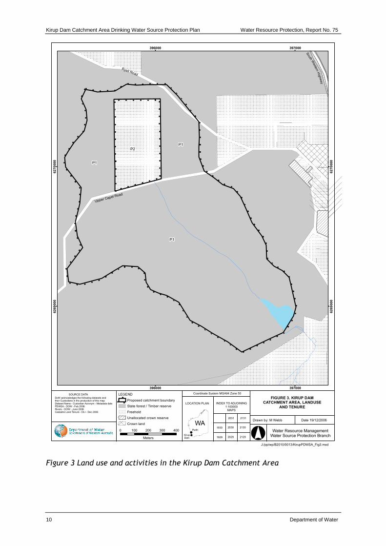
The risks to water quality associated with activities in the catchment include pathogen contamination, turbidity, pesticide and nutrient contamination. Pathogens pose the most significant risk to public health. Each land use within the KDCA, has been assessed for the level of risk the activity poses to water quality and in turn public health. Risks associated with existing land uses and recommendations regarding water source protection specific to those risks are listed in Table 1.
Pathogen contamination of a drinking water source is influenced by the existence of pathogen carriers (i.e. humans and animals, such as dogs or cattle) and the opportunity for their subsequent transfer to the water source, the ability of the pathogen to survive in the water source and the concentration level required to cause illness. Preventing the introduction of pathogens into the water source is the most effective barrier when avoiding risks to public health.
3.2 State forest
State forest covers over 87% of the KDCA (refer to Figure 3). The state forest is vested in the Conservation Commission of Western Australia and managed by the Department of Environment and Conservation (DEC) on its behalf and is protected from logging. It is proposed to become a forest conservation area. Land-use activities within the KDCA, that can pose a risk to water quality include recreational activities such as bushwalking, hunting, fishing, marroning and swimming. Other land use activities that are considered a risk to water quality include unregulated off-road vehicle use, feral animals and fires (both fire management and wildfires).
State forest land use activity within the catchment area will be addressed further in the implementation strategy to be prepared following publication of this report. The implementation strategy will address land use activities within the P1 source protection area and RPZ for the KDCA.
3.3 Private land
The private land borders the Upper Capel Road, which is a sealed rural access road that passes through the catchment, the parcel of cleared rural private land, representing approximately 13% of the catchment, is located 1.13 km (approximately) upstream of the reservoir (refer to Figure 3).
The property is under development for organic horticultural purposes, and contains a variety of orchards, vegetable and herb propagation which may pose a risk to water quality.
Water Resource Protection Report No. 75 Kirup Dam Catchment Area Drinking Water Source Protection Plan
Department of Water 9
Recommendations contained in this report require any intensification of horticulture to be conducted in accordance with the Department of Water’s, Water Quality Protection Note (WQPN): Nutrient and irrigation management plans, and other WQPNs and guidelines relevant to the intensification of land use.
Information on Water Quality Protection Notes can be found on the Internet via the department’s homepage www.water.wa.gov.au > select > Water Quality > Publications > Water Quality Protection Notes.
Kirup Dam Catchment Area Drinking Water Source Protection Plan Water Resource Protection, Report No. 75
10 Department of Water
Figure 3 Land use and activities in the Kirup Dam Catchment Area
396000
396000
397000
397000
6269
000
6269
000
6270
000
6270
000
J:/pp/wp/B2010/0013/KirupPDWSA_Fig3.mxd
FIGURE 3. KIRUP DAMCATCHMENT AREA, LANDUSE
AND TENURE
Drawn by: M Webb Date 19/12/2006
Water Resource ManagementWater Source Protection Branch
INDEX TO ADJOINING1:100000
MAPS
LOCATION PLAN
WA
SOURCE DATA
DoW acknowledges the following datasets and their Custodians in the production of this map:Dataset Name - Custodian Acronym - Metadata datePDWSA - DOW - Feb 2006Rivers - DOW - June 2006Cadastre Land Tenure - DLI - Dec 2006
2031 2131
2030 2130
2029 2129KirupDam
Perth
LEGEND Coordinate System MGA94 Zone 50
0 100 200 300 400
Meters
1930
1929
Proposed catchment boundary
State forest / Timber reserve
Freehold
Unallocated crown reserve
Crown land
Upper Capel Road
South
Weste
rn H
ighw
ay
Ryall Road
P2
P1
P1
P1
Water Resource Protection, Report No.75 Kirup Dam Catchment Area Drinking Water Source Protection Plan
Department of Water 11
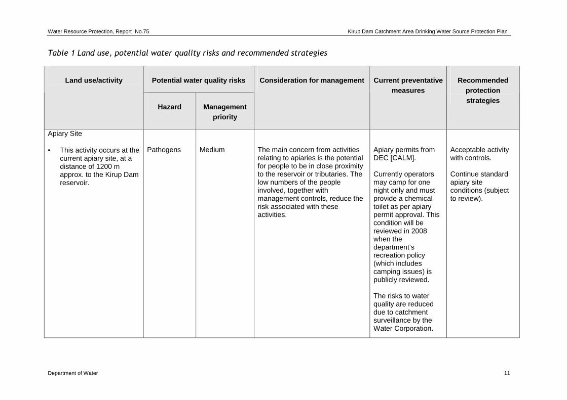
Table 1 Land use, potential water quality risks and recommended strategies
Potential water quality risks Land use/activity
Hazard Management priority
Consideration for management Current preventative measures
Recommended protection strategies
Apiary Site • This activity occurs at the
current apiary site, at a distance of 1200 m approx. to the Kirup Dam reservoir.
Pathogens
Medium
The main concern from activities relating to apiaries is the potential for people to be in close proximity to the reservoir or tributaries. The low numbers of the people involved, together with management controls, reduce the risk associated with these activities.
Apiary permits from DEC [CALM]. Currently operators may camp for one night only and must provide a chemical toilet as per apiary permit approval. This condition will be reviewed in 2008 when the department’s recreation policy (which includes camping issues) is publicly reviewed. The risks to water quality are reduced due to catchment surveillance by the Water Corporation.
Acceptable activity with controls. Continue standard apiary site conditions (subject to review).
Kirup Dam Catchment Area Drinking Water Source Protection Plan Water Resource Protection, Report No.75
12 Department of Water
Potential water quality risks Land use/activity
Hazard Management priority
Consideration for management Current preventative measures
Recommended protection strategies
Bushwalking
Pathogens
High
Some bushwalking occurs in the catchment. Bushwalking should only occur on the established tracks outside of the RPZ.
Water quality monitoring. Water Corporation, DEC surveillance.
Acceptable activity with controls. Acceptable within the RPZ, when bushwalking is kept to constructed non- gazetted roads that do not cross the primary (feeder) stream for Kirup Dam. Clear signage to alert walkers of RPZ boundary and prohibited activities in the RPZ.
Water Resource Protection, Report No.75 Kirup Dam Catchment Area Drinking Water Source Protection Plan
Department of Water 13
Potential water quality risks Land use/activity
Hazard Management priority
Consideration for management Current preventative measures
Recommended protection strategies
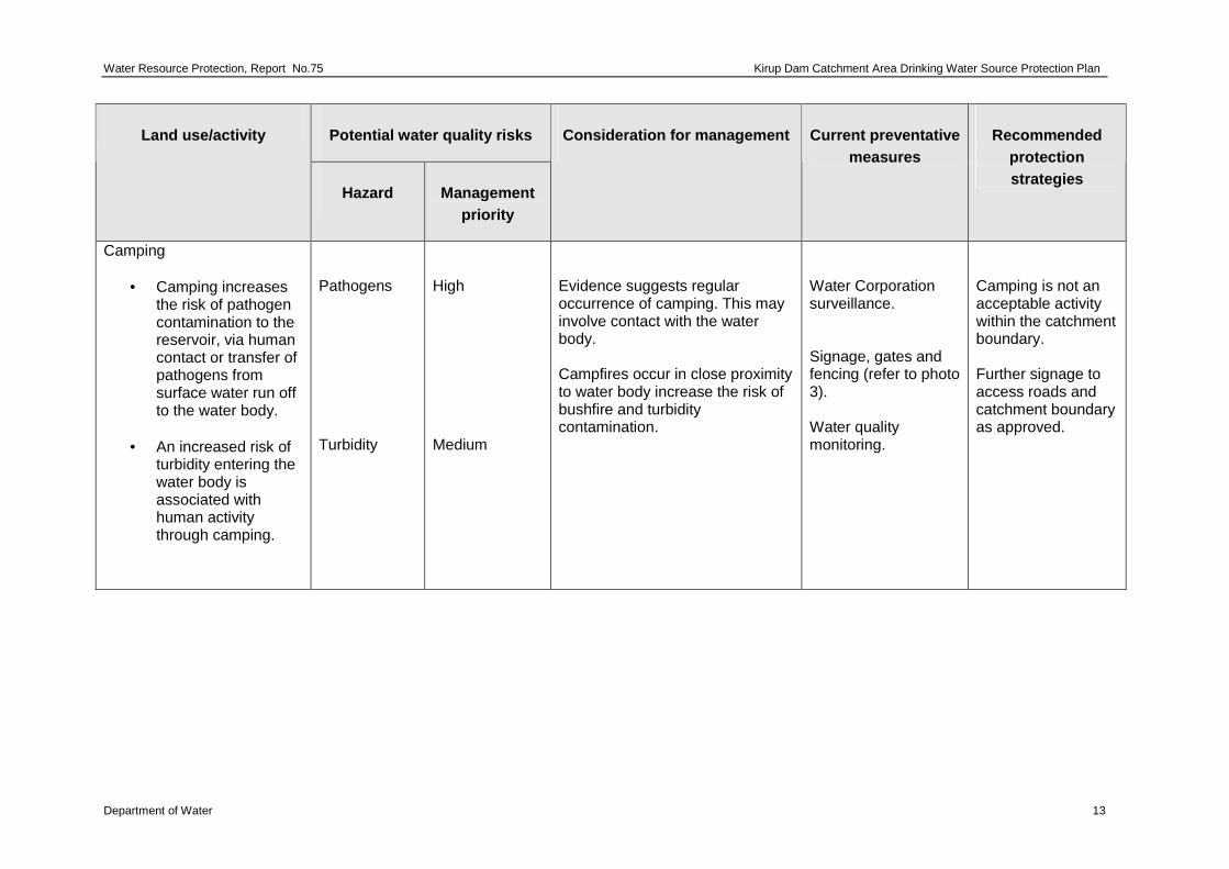
Camping
• Camping increases the risk of pathogen contamination to the reservoir, via human contact or transfer of pathogens from surface water run off to the water body.
• An increased risk of
turbidity entering the water body is associated with human activity through camping.
Pathogens Turbidity
High Medium
Evidence suggests regular occurrence of camping. This may involve contact with the water body. Campfires occur in close proximity to water body increase the risk of bushfire and turbidity contamination.
Water Corporation surveillance. Signage, gates and fencing (refer to photo 3). Water quality monitoring.
Camping is not an acceptable activity within the catchment boundary. Further signage to access roads and catchment boundary as approved.
Kirup Dam Catchment Area Drinking Water Source Protection Plan Water Resource Protection, Report No.75
14 Department of Water
Potential water quality risks Land use/activity
Hazard Management priority
Consideration for management Current preventative measures
Recommended protection strategies
Feral animals (introduced, e.g. pigs)
• Animal excreta and contact with the water body.
• Turbidity can be
caused by fauna activity within the reservoir. Feral pigs may wallow and forage causing erosion, increasing the risk of turbidity.
Pathogens Turbidity
High Medium
There is past evidence of pig activity in the area. DEC manages the population and movement of pigs through a trapping program, when pig activity is reported. A baiting program is currently active 3 km south of the KDCA for feral cats and foxes.
Water quality monitoring. Fencing surrounding reservoir dam. Water Corporation, DEC surveillance.
Continue feral pig control program managed by DEC. Maintain Kirup Dam reservoir fence.
Water Resource Protection, Report No.75 Kirup Dam Catchment Area Drinking Water Source Protection Plan
Department of Water 15
Potential water quality risks Land use/activity
Hazard Management priority
Consideration for management Current preventative measures
Recommended protection strategies
Fire management
• Fuel reduction burning/wild fire.
• Fire breaks,
• Water points,
Turbidity Pesticides Turbidity
High Medium Medium
DEC (CALM) is responsible for fire management in the KDCA with water quality considered in fire management operations. The main risk to water quality is an increase in turbidity from fuel reduction burning and the construction and maintenance of fire breaks. This is particularly true in areas close to the reservoir or tributaries with steep slopes.
DEC fire management. Water quality monitoring. Water Corporation surveillance and post event management.
Acceptable activity with best management practices. Establish specific guidelines for water quality protection and prescribed burning. Ensure the above guidelines are incorporated into the prescribed burning methods.
Kirup Dam Catchment Area Drinking Water Source Protection Plan Water Resource Protection, Report No.75
16 Department of Water
Potential water quality risks Land use/activity
Hazard Management priority
Consideration for management Current preventative measures
Recommended protection strategies
Fishing and marroning
• Human activity and the use of baits.
• Erosion of dam
banks.
Pathogens Turbidity
High Medium
Evidence suggests regular occurrence of fishing and marroning. All drinking water dams managed by the Water Corporation are closed to fishing. The Fisheries Department of Western Australia can give additional advice on dams which are closed for fishing. These activities involve direct contact with the water, which significantly reduces the effectiveness of detention time as a barrier. Fencing and signage is used to discourage access to the reservoir.
Detention time Water Corporation surveillance. Signage, gates and fencing (refer to photo 3). Water quality monitoring.
Fishing and marroning in the reservoir or tributaries is not acceptable in the catchment area. Further signage to access roads and catchment boundary. In conjunction with land managers and the appropriate authorities, prohibit illegal marroning and fishing.
Water Resource Protection, Report No.75 Kirup Dam Catchment Area Drinking Water Source Protection Plan
Department of Water 17
Potential water quality risks Land use/activity
Hazard Management priority
Consideration for management Current preventative measures
Recommended protection strategies
Hunting
• Animal excreta and human activity.
• Erosion from vehicle
use.
Pathogens Turbidity
High Medium
Some hunting occurs in the catchment due to the proximity to Kirup town site.
Water quality monitoring. Water Corporation, DEC surveillance.
Hunting is not acceptable within the catchment boundary. Further signage to access roads and catchment boundary as approved. In conjunction with land managers and appropriate authorities, prohibit illegal access to the CA.
Kirup Dam Catchment Area Drinking Water Source Protection Plan Water Resource Protection, Report No.75
18 Department of Water
Potential water quality risks Land use/activity
Hazard Management priority
Consideration for management Current preventative measures
Recommended protection strategies
Off-road vehicles
• Erosion,
Turbidity
Medium
Off-road vehicle use is currently low. Evidence of four wheel and off road motor bike activity is has been observed by the Water Corporation and Department of Water officers.
Water quality monitoring. Water Corporation surveillance.
Unauthorised -vehicle use is not an acceptable activity within the catchment boundary and RPZ. Further signage to access roads and catchment boundary as approved. In conjunction with land managers and appropriate authorities, prohibit unauthorised access.
Water Resource Protection, Report No.75 Kirup Dam Catchment Area Drinking Water Source Protection Plan
Department of Water 19
Potential water quality risks Land use/activity
Hazard Management priority
Consideration for management Current preventative measures
Recommended protection strategies
Roads
• Fuel and chemical spills
• Erosion and stormwater run off
• Litter
• Weed control
• Direct contact with
roads which cross the Primary stream
Hydrocarbons and chemicals. Turbidity Pathogens Herbicides Pathogens Hydrocarbons Turbidity
High Low High Medium High High High
Upper Capel Rd, a sealed rural access road bisects the catchment passing 1km from the reservoir. The reservoir access road is unsealed and runs along the edge of the catchment. Crown land (state forest) non gazetted constructed access roads are unsealed and run around the reservoir fence, including other parts of Sate forest within the catchment area. Roads are managed by the Donnybrook–Balingup Shire, the DoH Public Service Circular No. 88 (PSC 88) Use of Herbicides in Water catchment areas proving guidance on approved herbicides for use in PDWSAs. Brush-off, a non approved herbicide is currently being used. Two non-gazetted constructed access roads cross the Capel River (feeder stream) upstream of Kirup Dam.
DoH, PSC 88. Water quality monitoring. HAZMAT emergency response requirements. The Department of Health (DoH) PSC 88 and state -wide policy No 2: Pesticide use in Public Drinking Water Source Areas, should be considered by the Water Corporation and associated contractors.
The use of non gazetted roads within the RPZ is not an acceptable activity except for state forest management purposes. Closure of the Capel River crossing roads, should be implemented. Further signage to access roads and catchment boundary as approved. In conjunction with land managers and appropriate authorities, prohibit unauthorised access.
Kirup Dam Catchment Area Drinking Water Source Protection Plan Water Resource Protection, Report No.75
20 Department of Water
Potential water quality risks Land use/activity
Hazard Management priority
Consideration for management Current preventative measures
Recommended protection strategies
Swimming
• Human contact with the water body.
Pathogens
High
Human or animal contact with water involves an immediate threat to water quality due to the potential for cryptosporidium and giardia contamination. Chlorination alone does not provide sufficient protection against cryptosporidium. The Kirup Dam is used occasionally for swimming during summer. Low fencing (1.2m approx.) surrounding the reservoir and signage deters unauthorised access.
Detention time, Water Corporation surveillance, signage, gates and fencing (refer to photo 3 in Appendix A). Water quality monitoring.
Swimming in the reservoir or tributaries is not acceptable. Further signage to access roads and catchment boundary as approved. In conjunction with land managers and the appropriate authorities prohibit illegal swimming.
Water Resource Protection, Report No.75 Kirup Dam Catchment Area Drinking Water Source Protection Plan
Department of Water 21
Potential water quality risks Land use/activity
Hazard Management priority
Consideration for management Current preventative measures
Recommended protection strategies
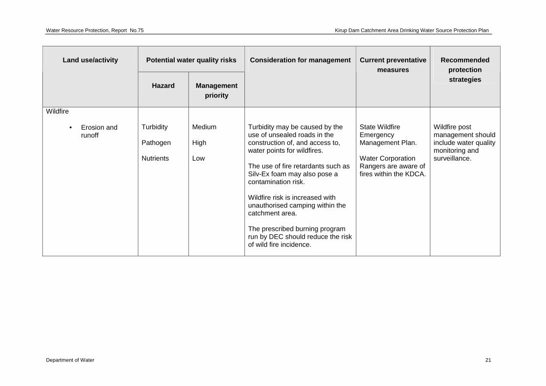
Wildfire
• Erosion and runoff
Turbidity Pathogen Nutrients
Medium High Low
Turbidity may be caused by the use of unsealed roads in the construction of, and access to, water points for wildfires. The use of fire retardants such as Silv-Ex foam may also pose a contamination risk. Wildfire risk is increased with unauthorised camping within the catchment area. The prescribed burning program run by DEC should reduce the risk of wild fire incidence.
State Wildfire Emergency Management Plan. Water Corporation Rangers are aware of fires within the KDCA.
Wildfire post management should include water quality monitoring and surveillance.
Kirup Dam Catchment Area Drinking Water Source Protection Plan Water Resource Protection, Report No.75
22 Department of Water
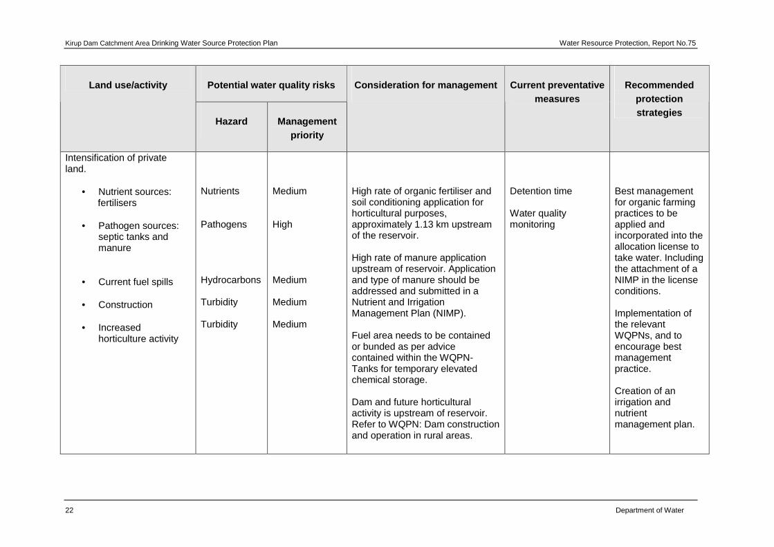
Potential water quality risks Land use/activity
Hazard Management priority
Consideration for management Current preventative measures
High rate of organic fertiliser and soil conditioning application for horticultural purposes, approximately 1.13 km upstream of the reservoir. High rate of manure application upstream of reservoir. Application and type of manure should be addressed and submitted in a Nutrient and Irrigation Management Plan (NIMP). Fuel area needs to be contained or bunded as per advice contained within the WQPN- Tanks for temporary elevated chemical storage. Dam and future horticultural activity is upstream of reservoir. Refer to WQPN: Dam construction and operation in rural areas.
Detention time Water quality monitoring
Best management for organic farming practices to be applied and incorporated into the allocation license to take water. Including the attachment of a NIMP in the license conditions. Implementation of the relevant WQPNs, and to encourage best management practice. Creation of an irrigation and nutrient management plan.
Water Resource Protection Report No.75 Kirup Dam Catchment Area Drinking Water Source Protection Plan
Department of Water 23
4 Catchment protection strategy
4.1 Protection objectives
The objective of this plan is to protect the KDCA in the interest of providing safe drinking water. In addition, this plan aims to balance water quality protection, social needs and expectations of land owners as much as possible.
Drinking water catchments are proclaimed areas where stormwater run-off, seepage or infiltration is stored above ground, then extracted to supply the community with drinking water. Surface water resources are highly vulnerable to contamination by a range of land uses.
Where catchments remain covered with native vegetation, with little human activity occurring, the risk of contamination is low. However, contamination risks increase with human activity/development.
A ‘catchment to consumer’ multiple barrier risk-based management approach is used to protect drinking water quality in Western Australia, consistent with the ADWG 2004.
Catchment management for the protection of water quality is considered the first important barrier. The preparation of this Drinking Water Source Protection Plan forms part of the ‘multiple barrier’ approach, for the protection of public drinking water sources from potential contamination.
The protection of Public Drinking Water Source Areas (PDWSA) by the Department of Water is consistent with government policy and involves these key elements:
• the proclamation of the PDWSA boundary
• the determination of ‘priority areas and a protection zone’ within the PDWSA
• the application of non legislative guidance, and legislative controls through the Country Areas Water Supply Act 1947.
4.2 Proclaimed area
Proclaiming the KDCA ensures that the Country Areas Water Supply by-laws (1947) apply, and allows the Department of Water to better manage potentially contaminating land uses.
Kirup Dam Catchment Area Drinking Water Source Protection Plan Water Resource Protection, Report No.75
24 Department of Water
4.3 Protection areas
The protection of PDWSA relies on statutory measures available in water resource management and land use planning legislation. The department’s policy for the protection of PDWSA includes three risk management based priority areas. These priority source protection areas are determined through the DWSPP process. The department’s Water Quality Protection Note: Land Use Compatibility in Public Drinking Water Source Areas outlines activities that are acceptable, compatible with conditions or incompatible with the different priority areas and additionally provides more information on how priorities are determined.
4.3.1 Priority 1 source protection area
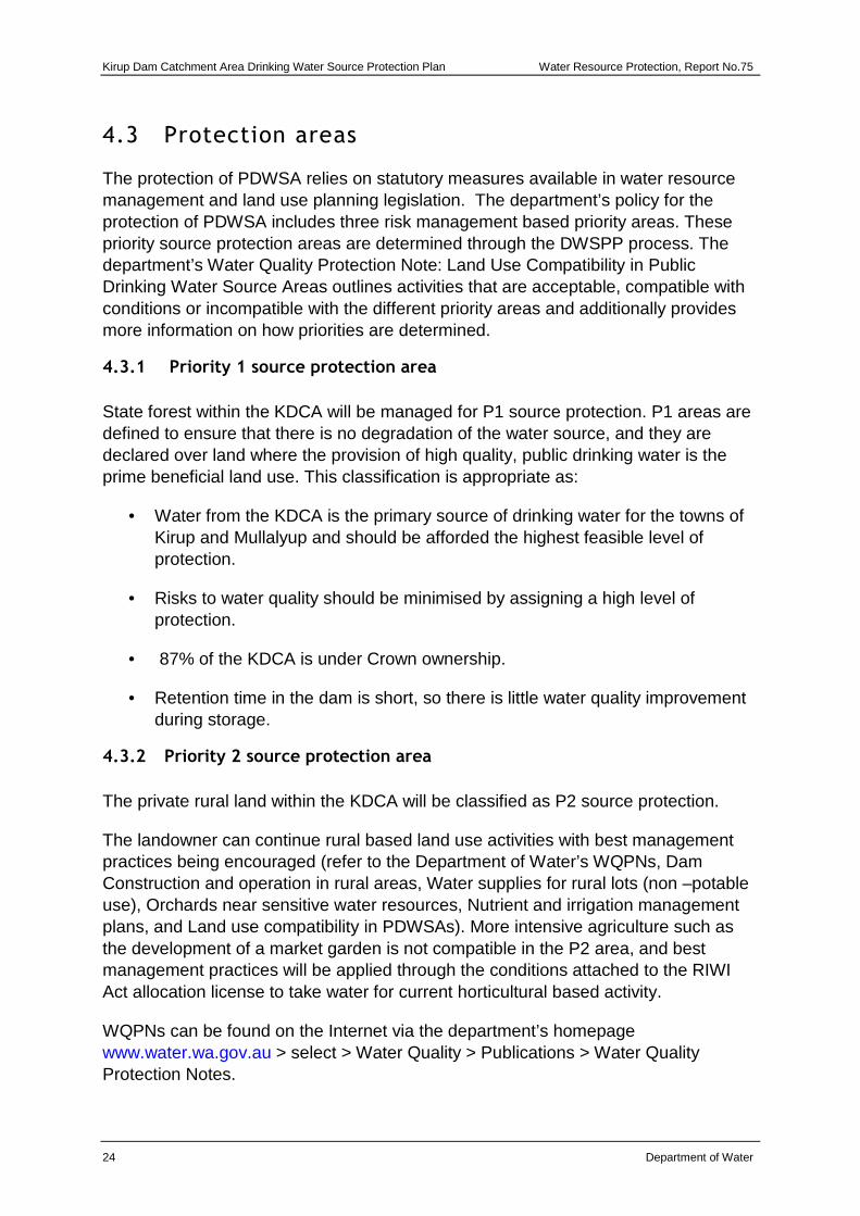
State forest within the KDCA will be managed for P1 source protection. P1 areas are defined to ensure that there is no degradation of the water source, and they are declared over land where the provision of high quality, public drinking water is the prime beneficial land use. This classification is appropriate as:
• Water from the KDCA is the primary source of drinking water for the towns of Kirup and Mullalyup and should be afforded the highest feasible level of protection.
• Risks to water quality should be minimised by assigning a high level of protection.
• 87% of the KDCA is under Crown ownership.
• Retention time in the dam is short, so there is little water quality improvement during storage.
4.3.2 Priority 2 source protection area
The private rural land within the KDCA will be classified as P2 source protection.
The landowner can continue rural based land use activities with best management practices being encouraged (refer to the Department of Water’s WQPNs, Dam Construction and operation in rural areas, Water supplies for rural lots (non –potable use), Orchards near sensitive water resources, Nutrient and irrigation management plans, and Land use compatibility in PDWSAs). More intensive agriculture such as the development of a market garden is not compatible in the P2 area, and best management practices will be applied through the conditions attached to the RIWI Act allocation license to take water for current horticultural based activity.
WQPNs can be found on the Internet via the department’s homepage www.water.wa.gov.au > select > Water Quality > Publications > Water Quality Protection Notes.
Water Resource Protection Report No.75 Kirup Dam Catchment Area Drinking Water Source Protection Plan
Department of Water 25
4.4 Protection zones
In order to protect the reservoir from immediate risks to water quality including human contact, the Department of Water will be establishing a RPZ. This zone is a key barrier in the multiple barrier ‘catchment to consumer’ risk based approach to drinking water source protection in accordance with the ADWG.
The RPZ (refer to Figure 4), is contained within the catchment boundary and extends to Upper Capel Rd which bisects the catchment. The RPZ aims to restrict access to land use activities that are considered to be incompatible activities with regard to the protection of public drinking water source areas.
Kirup Dam Catchment Area Drinking Water Source Protection Plan Water Resource Protection, Report No.75
26 Department of Water
Figure 4 Protection classifications and Reservoir Protection Zone for the Kirup Dam
Catchment Area
396000
396000
397000
397000
6269
000
6269
000
6270
000
6270
000
J:/pp/wp/B2010/0013/KirupPDWSA_Fig4.mxd
FIGURE 4. KIRUP DAMCATCHMENT AREA
RESERVOIR PROTECTION ZONE AND PRIORITY CLASSIFICATION
Drawn by: M Webb Date 19/12/2006
Water Resource ManagementWater Source Protection Branch
INDEX TO ADJOINING1:100000
MAPS
LOCATION PLAN
WA
SOURCE DATA
DoW acknowledges the following datasets and their Custodians in the production of this map:Dataset Name - Custodian Acronym - Metadata datePDWSA - DOW - Feb 2006Rivers - DOW - June 2006Cadastre Land Tenure - DLI - Dec 2006
2031 2131
2030 2130
2029 2129KirupDam
Perth
LEGEND Coordinate System MGA94 Zone 50
0 100 200 300 400
Meters
1930
1929
Proposed catchment boundary
Reservoir Protection Zone
Priority 1
Priority 2
Upper Capel Road
South
Weste
rn H
ighw
ay
Ryall Road
P2
P1
P1
P2
P1P1
Water Resource Protection Report No.75 Kirup Dam Catchment Area Drinking Water Source Protection Plan
Department of Water 27
4.5 Land use planning
It is recognised under the State Planning Strategy (Western Australian Planning Commission, 1997) that the establishment of appropriate protection mechanisms in statutory land use planning processes is necessary to secure the long-term protection of drinking water sources. As outlined in Statement of Planning Policy No.2.7: Public Drinking Water Source Policy (Western Australian Planning Commission, 2003), it is therefore appropriate that the KDCA, RPZ and priority areas be recognised in the Shire of Donnybrook-Balingup’s Town Planning Scheme. Proposals for land uses and activities that are not supported by the department’s Land Use Compatibility Table or consistent with relevant published WQPN should be referred to the Department of Water for advice.
There are opportunities to significantly reduce risks from land use to water quality by carefully considering design and management practices. The adoption of best management practices for land uses will continue to be encouraged to help the protection of water quality. On private land, the Department of Water aims to work with landowners to achieve best management practices for water quality protection through the provision of management advice.
There are guidelines available for many land uses in the form of industry codes of practice, environmental guidelines or WQPNs. These have been developed in consultation with stakeholders such as industry groups, producers, State Government agencies and technical advisers.
Education and awareness (e.g. signage and information material) is a key mechanism for water quality protection, especially for those people visiting the area who are unfamiliar with the KDCA. A brochure will be produced once this plan is endorsed, describing the KDCA, its location and the main threats to water quality protection. This brochure will be made available to the community and will serve to inform people in simple terms about this drinking water source and its protection.
Kirup Dam Catchment Area Drinking Water Source Protection Plan Water Resource Protection, Report No.75
28 Department of Water
4.6 Emergency response
Escape of chemicals during unforeseen incidents and use of chemicals during emergency responses can result in water contamination. The Shire of Donnybrook–Balingup’s Local Emergency Management Advisory Committee (LEMAC) through the South-West Emergency Management District should be familiar with the location and purpose of the KDCA.
A locality plan should be provided to the fire and rescue services headquarters for the Hazardous Materials Emergency Advisory Team (HAZMAT). The advisory plan should include the proximity of Upper Capel Road with regard to the KDCA, and possible contamination risks upstream of the dam. The Water Corporation should have an advisory role to any HAZMAT incident in the KDCA.
Personnel who deal with WESTPLAN – HAZMAT (Western Australian Plan for Hazardous Materials) incidents within the area, should have access to a map of the KDCA. These personnel should receive training to ensure an adequate understanding of the potential impacts of spills on the water resource.
4.7 Surveillance and by-law enforcement
The quality of Public Drinking Water Source Areas within country areas of the State is protected under the Country Areas Water Supply Act 1947. Declaration of these areas allows existing by-laws to be applied to protect water quality.
The Department of Water considers by-law enforcement, through on-ground surveillance of land-use activities in PDWSA as an important water quality protection mechanism. Surveillance also improves the general level of awareness regarding the need to protect water quality. Proclamation of the KDCA will enable by-law enforcement to be undertaken.
Signs are erected (with prior approval) to educate the public and provide advice concerning activities that are prohibited or regulated. This plan recommends delegation of surveillance and by-law enforcement to the Water Corporation.
4.8 Recommended protection strategies
Table 1 identifies the potential water quality risks associated with existing land uses in the KDCA and recommends protection strategies to minimise these risks.
The success of these recommended protection strategies can be partly assessed by analysing the Capel River stream flow, which is the primary stream for the Kirup Dam reservoir. There are currently a number of Water Corporation monitoring sites in the KDCA where collection of this data is already occurring. The ongoing operation of these monitoring sites will provide a valuable source of water quality data for future assessment.
Water Resource Protection Report No.75 Kirup Dam Catchment Area Drinking Water Source Protection Plan
Department of Water 29
Following publication of the final Kirup Dam Catchment Area DWSPP, an implementation strategy will be developed with key stakeholders. The strategy will describe timeframes for the recommended protection strategies, and identify stakeholders responsible for their implementation.
Kirup Dam Catchment Area Drinking Water Source Protection Plan Water Resource Protection, Report No.75
30 Department of Water
5 Recommendations 1 The boundary of the KDCA should be proclaimed under the Country Areas Water
Supply Act of 1947. (Department of Water ).
2 Implement the recommended protection strategies as detailed in Table 1: Land use, potential water quality risks and recommended strategies of this plan (Applicable stakeholders ).
3 Prepare an implementation strategy for this plan describing responsible stakeholders and timeframes for the recommended protection strategies (Department of Water and applicable stakeholders ).
4 The Shire of Donnybrook–Balingup Town Planning Scheme should incorporate this plan and reflect the identified KDCA boundary and the Priority 1and 2 source protection areas, and reservoir protection zone (Shire of Donnybrook–Balingup ).
5 All development proposals within the KDCA that are inconsistent with Water Quality Protection Note – Land use compatibility in public drinking water source areas or Statement of Planning Policy No.2.7 – Public drinking water source policy should be referred to the Department of Water for advice and recommendations (Department for Planning and Infrastructure, Shire of Donnybrook–Balingup, DEC, and landowner ).
6 Incidents covered by WESTPLAN – HAZMAT in the KDCA should be addressed through the following:
• The Kirup LEMAC need to be familiar with the location and purpose of the KDCA.
• The locality plan for the KDCA is provided to the fire and rescue headquarters for the HAZMAT Emergency Advisory Team.
• The Water Corporation provides an advisory role during incidents in the KDCA.
• Personnel dealing with WESTPLAN – HAZMAT incidents in the area have ready access to a locality map of the KDCA and education to understand the potential impacts of spills on drinking water quality. (Department of Water, Water Corporation )
7 The existing surveillance program should be maintained to identify any incompatible land uses or potential threats within the KDCA. The Department of Water should delegate responsibility for the surveillance and enforcement to the Water Corporation (Water Corporation ).
8 Signs should be erected along the boundary of the KDCA to define the location and promote awareness of the need to protect drinking water quality. Signs should include an emergency contact telephone number (Water Corporation ).
Water Resource Protection Report No.75 Kirup Dam Catchment Area Drinking Water Source Protection Plan
Department of Water 31
Appendices
Appendix A Water quality
The Water Corporation has monitored the raw (source) water quality from Kirup Dam in accordance with the Australian Drinking Water Guidelines (ADWG) and interpretations agreed to with the Department of Health. The raw water is regularly monitored for:
a. Aesthetic parameters– (non-health related).
b. Health parameters.
c. Microbiological contaminants.
Following is data representative of the quality of raw water in Kirup Dam. In the absence of specific guidelines for raw water quality, the results have been compared with ADWG values set for drinking water, which defines the quality requirements at the customers tap. Results that exceed ADWG have been shaded in yellow to give an indication of potential raw-water quality issues associated with this source.
It is important to appreciate that the raw water data presented in this report does not represent the quality of drinking water distributed to the public. Barriers such as storage and water treatment, to name a few, exist downstream of the raw water to ensure it meets the requirements of ADWG. For more information on the quality of drinking water supplied to Kirup and Mullalyup refer to the most recent Water Corporation Drinking Water Quality Annual Report at; http://www.watercorporation.com.au/W/waterquality_annualreport.cfm?uid=2377-9937-9579-7091.
Kirup Dam Catchment Area Drinking Water Source Protection Plan Water Resource Protection, Report No.75
32 Department of Water
Aesthetic related characteristics
Aesthetic parameters
Aesthetic water quality analyses for raw water from Kirup Dam are summarised in Table 2.
The values are taken from ongoing monitoring for the period January 2002 to June 2007. All values are in milligrams per litre (mg/L) unless stated otherwise. Any water quality parameters that have been detected are reported, those that have on occasion exceeded the ADWG are shaded in yellow.
Table 2 Aesthetic related detections for Kirup Dam
Kirup Dam Parameter Units ADWG Aesthetic Guideline Value*
pH measured in laboratory NO UNIT 6.5 - 8.5 5.7 - 7.44 6.74 * An aesthetic guideline value is the concentration or measure of a water quality characteristic that is associated
with good quality water † Water-quality data observed from two sampling occasions
Health related characteristics
Health parameters
Raw water from Kirup Dam is analysed for health related chemicals including inorganics, heavy metals, industrial hydrocarbons and pesticides. Health related water quality parameters that have been measured at detectable levels in the source between January 2002 and June 2007are summarised in Table 3. Any parameters that have on occasion exceeded the ADWG are shaded in yellow.
Water Resource Protection Report No.75 Kirup Dam Catchment Area Drinking Water Source Protection Plan
Department of Water 33
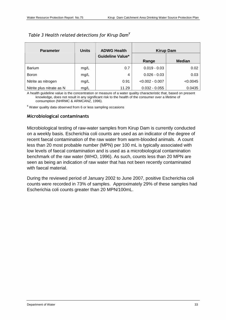
Table 3 Health related detections for Kirup Dam¥
Kirup Dam Parameter Units ADWG Health Guideline Value*
Range Median
Barium mg/L 0.7 0.019 - 0.03 0.02
Boron mg/L 4 0.026 - 0.03 0.03
Nitrite as nitrogen mg/L 0.91 <0.002 - 0.007 <0.0045
Nitrite plus nitrate as N mg/L 11.29 0.032 - 0.055 0.0435 A health guideline value is the concentration or measure of a water quality characteristic that, based on present
knowledge, does not result in any significant risk to the health of the consumer over a lifetime of consumption (NHRMC & ARMCANZ, 1996).
¥ Water quality data observed from 6 or less sampling occasions
Microbiological contaminants
Microbiological testing of raw-water samples from Kirup Dam is currently conducted on a weekly basis. Escherichia coli counts are used as an indicator of the degree of recent faecal contamination of the raw water from warm-blooded animals. A count less than 20 most probable number (MPN) per 100 mL is typically associated with low levels of faecal contamination and is used as a microbiological contamination benchmark of the raw water (WHO, 1996). As such, counts less than 20 MPN are seen as being an indication of raw water that has not been recently contaminated with faecal material.
During the reviewed period of January 2002 to June 2007, positive Escherichia coli counts were recorded in 73% of samples. Approximately 29% of these samples had Escherichia coli counts greater than 20 MPN/100mL.
Kirup Dam Catchment Area Drinking Water Source Protection Plan Water Resource Protection, Report No.75
34 Department of Water
Appendix B Photographs
Photo 1 Kirup dam reservoir December 2006
Photo 2 Kirup dam wall December 2006
Water Resource Protection Report No.75 Kirup Dam Catchment Area Drinking Water Source Protection Plan
Department of Water 35
Photo 3 Kirup dam signage to reservoir fence. December 2006
Kirup Dam Catchment Area Drinking Water Source Protection Plan Water Resource Protection, Report No.75
36 Department of Water
Glossary
Adsorb Accumulate on the surface.
ADWG The Australian Drinking Water Guidelines, outlining guideline criteria for the quality of drinking water in Australia.
Aesthetic guideline
The Australian Drinking Water Guideline value which is the concentration of measure of a water quality characteristic that is associated with acceptability of water to the consumer e.g. appearance, taste and odour (NHMRC & NRMMC, 2004).
AHD Australian Height Datum is the height of land in metres above mean sea level. For example this is +0.026 m at Fremantle.
Allocation The quantity of water permitted to be abstracted by a license, usually specified in kilolitres per annum (kL/a).
Anisotropic Having different properties in different directions.
ANZECC Australian and New Zealand Environment Conservation Council.
ARMCANZ Agriculture and Resource Management Council of Australia and New Zealand.
Augment To increase the available water within a storage dam by pumping back water from a secondary storage/reservoir dam.
Catchment The area of land which intercepts rainfall and contributes the collected water to surface water (streams, rivers, wetlands) or groundwater.
CFU Colony forming units is a measure of pathogen contamination in water.
Diffuse source
Pollution originating from a widespread area e.g. urban stormwater runoff, agricultural infiltration.
Effluent The liquid, solid or gaseous wastes discharged by a process, treated or untreated.
EC Electrical conductivity estimates the amount of total dissolved solids (TDS), or the total amount of dissolved ions in a solution
Water Resource Protection Report No.75 Kirup Dam Catchment Area Drinking Water Source Protection Plan
Department of Water 37
(water) corrected to 25o Celsius. Measurement units include milliSiemens per metre and microSiemens per centimetre.
GL Gigalitre (1 000 000 000 litres) or 1 million kilolitres
ha Hectare (a measure of area)
HAZMAT Hazardous Materials
Health guideline
The Australian Drinking Water Guideline value which is the concentration of measure of a water quality characteristic that, based on present knowledge, does not result in any significant risk to the health of the consumer over a lifetime of consumption (NHMRC & NRMMC 2004).
Hydrocarbons
A class of compounds containing only hydrogen and carbon, such as methane CH4, ethylene, C2H4, acetylene, C2H2 and benzene, C6H6. Fossil fuels such as crude oil, petroleum and natural gas all contain hydrocarbons.
Hydrogeology The study of groundwater, especially relating to the distribution of aquifers, groundwater flow and groundwater quality.
kL Kilolitre (1000 litres) or 1 cubic metre
km Kilometre (1000 metres)
km2 Square kilometre (a measure of area) = 1 million square metres
Leaching/ leachate
The process by which materials such as organic matter and mineral salts are washed out of a layer of soil or dumped material by being dissolved or suspended in percolating rainwater. The material washed out is known as leachate. Leachate can pollute groundwater and waterways.
LEMC Local Emergency Management Committee
m Metres
mg/L Milligram per litre (0.001 grams per litre) as a measurement of a total dissolved solid in a solution.
ML Megalitre (1 000 000 litres)
mm Millimetre
MPN Most probable number (a measure of microbiological contamination).
Kirup Dam Catchment Area Drinking Water Source Protection Plan Water Resource Protection, Report No.75
38 Department of Water
mSv Millisievert is a measure of annual radiological dose, with a natural dose equivalent to 2mSv/yr.
mS/m
MilliSiemens per metre, is a measure of electrical conductivity of a solution or soil and water mix that provides a measurement of salinity.
NHMRC National Health and Medical Research Council.
NTU Nephelometric turbidity units are a measure of turbidity in water.
Nutrient load The amount of nutrient reaching the waterway over a given timeframe (usually per year) from its catchment area.
Nutrients
Minerals dissolved in water, particularly inorganic compounds of nitrogen (nitrate and ammonia) and phosphorous (phosphate) which provide nutrition (food) for plant growth. Total nutrient levels include the inorganic forms of an element plus any bound in organic molecules.
Pathogen
A disease producing organism that can cause sickness and sometimes death through the consumption of water contaminated by pathogens, including bacteria (such as Escherichia coli), protozoa (such as cryptosporidium and giardia) and viruses).
Pesticides
Collective name for a variety of insecticides, fungicides, herbicides, algicides, fumigants and rodenticides used to kill organisms.
pH A logarithmic scale for expressing the acidity or alkalinity of a solution. A pH below 7 indicates an acidic solution and above 7 indicates an alkaline solution.
Point source pollution
Pollution originating from a specific localised source, e.g. sewage or effluent discharge, industrial waste discharge.
Pollution
Water pollution occurs when waste products or other substances, e.g. effluent, litter, refuse, sewage or contaminated runoff, change the physical, chemical biological or thermal properties of the water, adversely affecting water quality, living species and beneficial uses.
Water Resource Protection Report No.75 Kirup Dam Catchment Area Drinking Water Source Protection Plan
Department of Water 39
Public Drinking Water Source Area (PDWSA)
Includes all underground water pollution control areas, catchment areas and water reserves constituted under the Metropolitan Water Supply Sewerage and Drainage Act 1909 and the Country Areas Water Supply Act 1947.
Reservoir A reservoir, dam, tank, pond or lake that forms part of any public water supply works.
Reservoir Protection Zone (RPZ)
A reservoir protection zone is a buffer measured from the high water mark of a drinking water reservoir, and inclusive of the reservoir (usually two km). This is referred to as a ‘Prohibited Zone’ under the Metropolitan Water Supply, Sewerage and Drainage Act By-laws 1981.
Run of the river scheme
A scheme that takes water from a flowing river. Water is taken directly from the source and there is no detention time (storage).
Run-off Water that flows over the surface from a catchment area, including streams.
Scheme supply
Water diverted from a source or sources by a water authority of private company and supplied via a distribution network to customers for urban, industrial or irrigation use.
Storage reservoir
A major reservoir of water created in a river valley by building a dam.
Stormwater Rainwater which has run off the ground surface, roads, paved areas etc. and is usually carried away by drains.
TCU True colour units (a measure of degree of colour in water)
TDS Total dissolved salts, a measurement of ions in solution, such as salts in water.
TFSS Total Filterable Solids by summation.
Treatment Application of techniques such as settlement, filtration and chlorination to render water suitable for specific purposes including drinking and discharge to the environment.
Turbidity
The cloudiness or haziness of water caused by the presence of fine suspended matter.
Kirup Dam Catchment Area Drinking Water Source Protection Plan Water Resource Protection, Report No.75
40 Department of Water
Wastewater Water that has been used for some purpose and would normally be treated and discarded. Wastewater usually contains significant quantities of pollutant.
Water quality The physical, chemical and biological measures of water.
Water Reserve An area proclaimed under the Country Areas Water Supply Act 1947 or the Metropolitan Water Supply Sewerage and Drainage Act 1909 for the purposes of protecting a drinking water supply.
WESTPLAN HAZMAT
Western Australian Plan for Hazardous Materials.
Water Resource Protection Report No.75 Kirup Dam Catchment Area Drinking Water Source Protection Plan
Department of Water 41
References and further reading
Agriculture and Resource Management Council of Australia and New Zealand (ARMCANZ) & Australian and New Zealand Environment and Conservation Council (ANZECC) 1996, Draft Rural Land Uses and Water Quality – A Community Resource Document, ARMCANZ & ANZECC, Canberra.
Department of Health 2007, Use of Herbicides in Water Catchment Areas, Circular No: PSC 88, February 2007, Department of Health, Perth.
Department of Water Various dates, Water Quality Protection Notes: Various titles, Department of Water, Perth, available <www.water.wa.gov.au> Water Quality > Publications > Water Quality Protection Notes.
Geldreich E.E. 1996, Pathogenic Agents in Freshwater Resources, Hydrological Processes, Volume 10, pp 315-333, 1996.
Government of Western Australia 1914, Rights in Water and Irrigation Act, Reprinted under the Reprints Act 1984 as at 4 July 2006, available <http://www.slp.wa.gov.au/statutes/swans.nsf>.
Government of Western Australia 1947, Country Areas Water Supply Act, reprinted under the Reprints Act 1984 as at 7 April 2006, available <http://www.slp.wa.gov.au/statutes/swans.nsf>.
Hrudey, SE & Hrudey, EJ 2004, Safe Drinking Water – Lessons from Recent Outbreaks in Affluent Nations, IWA Publishing, London.
National Health and Medical Research Council (NHMRC) & Natural Resource Management Ministerial Council (NRMMC) 2004, National Water Quality Management Strategy: Australian Drinking Water Guidelines, Australian Government, Canberra, available <www.nhmrc.gov.au/publications/synopses/eh19syn.htm>.
NHMRC & NRMMC 2004b, Water Made Clear – A consumer guide to accompany the Australian Drinking Water Guidelines 2004, Australian Government, Canberra.
State Emergency Management Committee 2005, Policy Statement No.7 Western Australian Emergency Management Arrangements, Government of Western Australia, Perth.
Water and Rivers Commission 2000, Statewide Policy No.2 – Pesticide Use in Public Drinking Water Source Areas, Water and Rivers Commission, Perth, available <www.water.wa.gov.au> > Policies > Statewide Policies.
Kirup Dam Catchment Area Drinking Water Source Protection Plan Water Resource Protection, Report No.75
42 Department of Water
Water and Rivers Commission 2003, Statewide Policy No.13 – Policy and Guidelines for Recreation within Public Drinking Water Source Areas on Crown Land, Water and Rivers Commission, Perth, available <www.water.wa.gov.au> > Policies > Statewide Policies.
Water Corporation 2006, SG097 Source Protection Operations Manual, Water Corporation, Perth.
Western Australian Planning Commission 1997, State Planning Strategy, State Government of Western Australia, Perth, available <www.wapc.wa.gov.au/Publications/52.aspx>.
Western Australian Planning Commission 2003, Statement of Planning Policy No. 2.7 – Public Drinking Water Source Policy, Government Gazette WA, 10 June 2003, pp. 2077-82, Government of Western Australia, Perth, available <www.wapc.wa.gov.au/Publications/149.aspx>.
Western Australian Planning Commission 2006, State Planning Policy No. 2.9 - Water Resources, Government Gazette WA, 19 December 2006, pp. 5707-22 Government of Western Australia, Perth, available <http://www.wapc.wa.gov.au/Publications/1281.aspx>.
World Health Organisation 1996, Guidelines for Drinking-Water Quality – Volume 2 – Health Criteria and Other Supporting Information, 2nd edn, World Health Organisation, Geneva, available <www.who.int/water_sanitation_health/dwq/en/2edvol2p1.pdf>.
Government of Western AustraliaDepartment of Water
seireS noitcetorP ecruoseR retaW
REPORT NO. 75July 2007
Kirup Dam Catchment AreaDrinking Water Source Protection Plan