Department of Geo-information Processing RIMapperWMS RIMapperWMS An SVG Client built in OGC An SVG Client built in OGC Web Mapping Service layers Web Mapping Service layers Barend Köbben International Institute for Geo-information Science and Earth Observation (ITC)
Transcript
Department of Geo-information Processing
RIMapperWMSRIMapperWMSAn SVG Client built in OGC An SVG Client built in OGC
Web Mapping Service layersWeb Mapping Service layers
Barend Köbben
International Institute for Geo-information Science and Earth Observation (ITC)
Department of Geo-information Processing
OverviewOverview
• Why SVG for a Web Mapping Service?• Why a built-in GUI?• Past: Predecessor projects• Present
PrinciplesTechnicalities
• Future: Outlook
Department of Geo-information Processing
What is a Web Mapping Service?What is a Web Mapping Service?
A web service interface specification by the Open Geospatial Consortium (OGC)OGC delivers spatial interface specifications for Open Web Services (OWS) & related Encodings:
Geographic Markup Language (GML) Web Catalog ServiceWeb Feature ServiceWeb Coverage ServiceWeb Mapping ServiceWeb Mapping ServiceStyled Layer DescriptorWeb Map Context Document
Department of Geo-information Processing
What is a Web Mapping Service?What is a Web Mapping Service?
“Standardized interface for the creation of super-imposed map-like views of geographic
information”
• Delivers map graphics from standardised URL requests
• WMS is actually the most mature and widest adopted OWS specification (numerous open source, as well as commercial solutions)
Department of Geo-information Processing
Why Scalable Vector Graphics for a WMS?Why Scalable Vector Graphics for a WMS?
SVG is XML-based vector graphicsHigh quality (carto)graphics & attribute infolow-bandwidth well suited for mobile applications
Many WMS exist, some with (limited) SVG All treat SVG as ‘static graphics format’ onlySVG also can hold attribute dataSVG also can provide animationSVG also can provide application logic
Can support built-in Graphical User Interface (GUI)
Department of Geo-information Processing
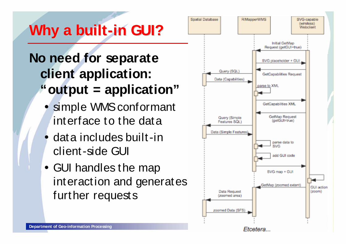
Why a builtWhy a built--in GUI?in GUI?
No need for separate client application:“output = application”
simple WMS conformant interface to the datadata includes built-in client-side GUIGUI handles the map interaction and generates further requests
Java servlets to deliver SVG output (=application)
XML2SVGXML2SVG
makeSVGmakeSVG
parseXMLparseXML
Department of Geo-information Processing
Wireless CampusLBSWireless CampusLBS
co-operation between ITC & University of Twenteto set up infrastructureinfrastructure necessary for Campus Location Based Services, pilot at SVGopen2005SVGopen2005
Europe’s largest uniform hotspot 140 ha campus (covered in- and outdoors)+ Enschede city centre (outdoors)650+ individual access points
testbed for wireless and mobile applications
Department of Geo-information Processing
location manage client n
location manage client n
location manage client …
location manage client …
location managerclient 1
location managerclient 1
MySQL
geoDB(APs, geodata)
fixed infrastructure
FLAVOUR prototype: architectureFLAVOUR prototype: architectureFriendly LocationFriendly Location--aware conference Assistant with priVacy Observant architectUReaware conference Assistant with priVacy Observant architectURe
Location Managersprovide client with locationregister with:
GUI client veryvery limited, need to make GUI more complete (layer switcher, attribute info, etc…) and more flexible (support more User Agents & SVG 1.2)
getGUI=false supported , but not yet output of formats other than SVG (PNG, GIF, etc…)most OGC Compliance Tests pass, but no full compliance (ao. PNG or GIF output needed)
Free, open source (creative commons license)
Department of Geo-information Processing
OutlookOutlookImmediate plans:
extending to Queryable WMS compliance already possible to see attributes (client-side) add server-side support: GetFeatureInfo interface
WMS setup application for Databaseadding transcoding to other formats (PNG, GIF,…)performance & useability testing
and further…?WMS 1.3.0 support (depends on Proj4 library)Styled Layer Descriptor & Web Map Context…?
Department of Geo-information Processing
Thank you for your attention!Thank you for your attention!