Cathy Connor University Alaska Southeast Introductory Physical Geology Lab Roadside Engineering Geology Around Auke Bay -Student Consultant Scenario FINAL LAB Due 04/21-22/06 (40 points) In this Lab we will explore shoreline and glacial features, the structural geology of Gravina Belt rocks, and the structural integrity of the early Holocene Gastineau Formation at each of six sites around Auke Bay, in the City and Borough of Juneau, Alaska. Background It is the 100 th Anniversary of the San Francisco April 18, 1906 Earthquake. At that time San Francisco, with a population of 400,000 people, was the 8 th largest city in the U.S. The quake struck without warning at 5:12 am, its epicenter on the San Andreas fault offshore of western SF and southwest of the future site of the Golden Gate Bridge (not yet erected). Three thousand people were killed and 225,000 made homeless. The earthquake was recorded on 6 local seismometers and 90 stations around the world, the beginnings of the global seismic network. Modern analyses suggest that the Moment Magnitude M w of this earthquake was 7.7-7.9 although the Richter scale magnitude, developed for local earthquakes on high frequency seismometers, was 8.3 A seismogram recorded in the State Museum in Albany, New York was featured on the front page of the New York Times. Fires broke out within minutes of the ground shaking. A firestorm lasting for 3 days destroyed 28,000 buildings damaging up to 85% of the city. (from Zoback, 2006, GSA Today, handed out in class) Purpose of this Lab Your have been hired as a geologist for the City and Borough of Juneau to produce a report on the suitability of 6 housing sites, located on both bedrock and unconsolidated sediment in several locations around the Auke Bay area. With Juneau’s ever-expanding population, city planners are looking for new locations to build houses. At each of the sites we visit, you will be asked to evaluate the “ground” in terms of its mass-wasting potential, slope and seismic stability, drainage, bedrock type, bedrock structure, soil type and stability, and any other geologic, hydrologic, or climatic hazards you can envision for each site. Grading For this lab you will be evaluated on the basis of 1) Your field notes (turn 04/21-22/06 with your report) 50% 2) Your completed, typed, and professionally written report to the CBJ, "your employer" 50%
Transcript
Cathy Connor University Alaska Southeast Introductory Physical Geology Lab Roadside Engineering Geology Around Auke Bay -Student Consultant Scenario FINAL LAB Due 04/21-22/06 (40 points) In this Lab we will explore shoreline and glacial features, the structural geology of Gravina Belt rocks, and the structural integrity of the early Holocene Gastineau Formation at each of six sites around Auke Bay, in the City and Borough of Juneau, Alaska. Background It is the 100th Anniversary of the San Francisco April 18, 1906 Earthquake. At that time San Francisco, with a population of 400,000 people, was the 8th largest city in the U.S. The quake struck without warning at 5:12 am, its epicenter on the San Andreas fault offshore of western SF and southwest of the future site of the Golden Gate Bridge (not yet erected). Three thousand people were killed and 225,000 made homeless. The earthquake was recorded on 6 local seismometers and 90 stations around the world, the beginnings of the global seismic network. Modern analyses suggest that the Moment Magnitude Mw of this earthquake was 7.7-7.9 although the Richter scale magnitude, developed for local earthquakes on high frequency seismometers, was 8.3 A seismogram recorded in the State Museum in Albany, New York was featured on the front page of the New York Times. Fires broke out within minutes of the ground shaking. A firestorm lasting for 3 days destroyed 28,000 buildings damaging up to 85% of the city. (from Zoback, 2006, GSA Today, handed out in class) Purpose of this Lab Your have been hired as a geologist for the City and Borough of Juneau to produce a report on the suitability of 6 housing sites, located on both bedrock and unconsolidated sediment in several locations around the Auke Bay area. With Juneau’s ever-expanding population, city planners are looking for new locations to build houses. At each of the sites we visit, you will be asked to evaluate the “ground” in terms of its mass-wasting potential, slope and seismic stability, drainage, bedrock type, bedrock structure, soil type and stability, and any other geologic, hydrologic, or climatic hazards you can envision for each site. Grading For this lab you will be evaluated on the basis of 1) Your field notes (turn 04/21-22/06 with your report) 50% 2) Your completed, typed, and professionally written report to the CBJ, "your employer" 50%
Be certain to take good field notes that include information such as: 1. Description of location of each site, (mark location on the 1:25,000 scale map),
identify geologic age of and type. of bedrock, make neat tables of data you collect, include sketches of sites and geomorphology of the landscape of the sites, note important landmarks or points of interest. Observe existing structures located on these sites and note any evidence of ongoing problems such as creep, mass wasting, etc.
2. Carefully answer all of the questions below for each site in your field notebook. The
CBJ is interested in a general geologic report. Their engineers will want to know rock type, slope steepness, aspect (direction site facing), soil conditions, geologic hazards, active geologic processes, and general landscape description for each site you visit.
3. Collect structural data from outcrops. Plot the strike and dip data directly onto your
map at each stop where such data is collected and make a data table in your notebook of the information you collect so that you can include it in your final report.
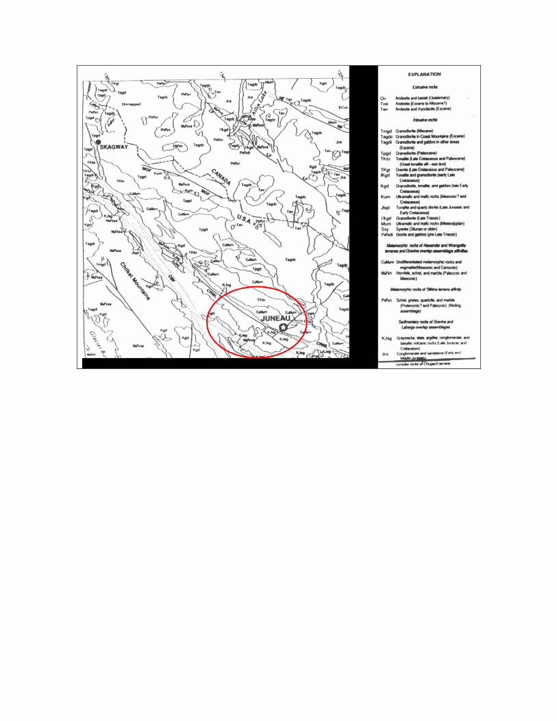
Trip Log Stop 1 Smuggler’s Cove South end of Fritz Cove Road at Smuggler's Cove. Park at turn around and walk down to beach (trail is on left side of guard-rail as you face the water). We will be measuring the attitude (strike and dip) of the Late Jurassic and Cretaceous sedimentary marine rocks on the beach. These rocks were shed off a Baja California-sized landmass that was tectonically added to the southeastern Alaskan coastline. At that time, between about 90 and 50 million years ago, our coastline featured an active convergent plate margin with a subduction zone. See ancillary materials at the end for information about taking strike and dips, apparent dip measurements, Gravina Belt geology, turbidite deposits, and other useful information. Step 1. Locate yourself on the topographic map provided. Describe the types of rock you see exposed here. Step 2. Use your compass to measure the strike and dip of the bedding planes at three different points along the outcrop and record your answers below. 1. Strike=_______ Dip=______ 2. Strike=_______ Dip=______ 3. Strike=_______ Dip=______
Plot one of your strike and dip readings on the topo map at your location for this stop. Note that joint planes also occur in the rocks at this outcrop. Measure the strike and dip of one of the joint planes. 4. Strike=________ Dip=______ 5. Do you see any fossils in this rock? What is evidence in the rocks that reveals the environment of deposition? 6. What is the stratigraphic thickness of this outcrop? Use hand level to measure vertical elevation above sea level, tape to measure sea level to outcrop top distance. Sketch a profile of the geomorphic features on the prominent point forming the western edge of Smuggler’s Cove. Does it have any distinctive features? Suggest some of the dynamic earth processes you have learned about in GEOLOGY 104 that may have caused such features. Are such processes still active today? Stop 2. Fox Farm Road Outcrop Leave cars parked and walk up Fritz Cove road to Fox Farm Road. Wander down to outcrop on north side of road. Look over the rocks exposed in this relatively new subdivision. 7. Locate position on the map. 8. Measure the strike and dip of the rocks at this location and record them below. Plot them on your map. Strike=______ Dip=________ Is the dip direction parallel with the road or are you measuring an apparent dip? 9. Which is older the graywacke sandstone or the quartz veins? Why? What is the orange mineral around the quartz veins? What other mineral can be found with the quartz veins? Note Eagle's Nest in big tree behind house. What regulations does the U.S. Fish and Wildlife Service have regarding building near active bald eagle nests? What additional costs might be created for homeowners building on bedrock? What long term savings might they benefit from? Stop 3. Climber's Cliff Drive about a quarter of a mile northward along Fritz Cove Road and park just south of prominent cliffs along eastside of roadway.
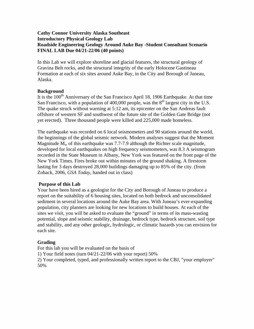
10. What rock type is this at the climber's cliff? How did it form? What type of mass movement occurs along this stretch of road? Could this rock have been deposited in the same environment as the rock at Site #1? Explain. Can you measure the strike and dip of the bedding in this rock? Explain. What precautions did the road engineers take when building Fritz Cove Road along this stretch? Stop 4. Beach Exposure along Fritz Cove Road, NOTE THIS IS PRIVATE PROPERTY AND WE HAVE PERMISSION TO VISIT TODAY ONLY. DO NOT RETURN WITH ALL OF YOUR FRIENDS AND RELATIONS TO VISIT THIS SITE. FUTURE GEOLOGY 104 STUDENTS ARE DEPENDING ON YOU! Park alongside the road and avoid blocking driveway or garage. Walk down to beach, slowly and carefully. The beach trail is on right hand side of driveway. The trail is very steep and often covered with spruce needles, descend carefully. Rocks along trail are quite capable of cutting your hand open if you fall on them...ask my brother! 11. Locate site on the map. 12. What rock type occurs as bedrock in the bank underneath the trees? 13. Measure the strike and dip of the foliation or cleavage planes of this rock. Strike=_____ Dip=_____. Plot your measurement on your map. Is this house sited directly atop bedrock? What impacts did Typhoon Tom have on this site during the Fall of 1996? 14. Note the wavecut terrace at north end of cove. How did this form? 15. Scrutinize the petroglyph created by Aukwan people. Study the photo below thought to have been taken by S. R. Capps, USGS unknown date. Are all of these carvings still present? By what methods could you determine the age of these carvings made in Cretaceous rock?
16. Visit the unusual outcrop past petroglyph. Describe the geologic events that occurred here? Name the two rock types ________ and________. Which is older? ___Explain. What mineral occurs as large phenocrysts in the upper rock type? ______ Is this mineral commonly found in this rock? How could you determine the age of these rocks? Stop 5 Auke Bay Elementary School Park in school parking lot and walk up the hill on right hand side, by new kindergarten room with large bay window. Follow the creek upstream to waterfall area 17. How old are the sediments, through which the creek is eroding its channel? 18. In what depositional environment did these sediments form? What evidence suggests this? 19. What is our present elevation above sea level? Explain the presence of marine sediments in the creek at this elevation. 20. What future economic resource might form in these area? 21. Visit grassy slope behind covered playground and experiment with human-induced shock waves. What form of mass movement could be induced by seismic waves at this site? 22. Look at stratigraphic sections created from engineering studies of the Auke Bay School site. Why did this turn out to be a very expensive school site for the CBJ? Stop 6 UAS Recreation Center Road Follow the Back Loop Road to the Back Entrance to UAS Campus. Turn left into the new UAS Recreation Center and park by uphill outcrop.
22. Locate site on the map. . 23. Measure strike and dip of rocks at this location and plot on map. Strike=______ Dip=________ 24. What types of rock do you see at this exposure? Do these rocks appear to be the same as those we saw along Fritz Cove Road? 25. Are the uppermost glacial erratics, glaciomarine sediments, and modern soil sitting on a wave cut platform? Explain. What information can you learn from this outcrop to help you answer the question? What other data might be helpful? 26. Have your strike and dip measurements remained consistent from the end of the Mendenhall Peninsula to the UAS Campus? Explain. 27. Make a sketch map showing the direction of regional tectonic stresses that may have been applied to southeast Alaska during the last Cretaceous that would account for the strikes and dips you have measured this morning. TO TURN IN: As a geologic engineering contractor you will now use the notes, maps, sketches and data you have collected today to produce a geologic report for the City and Borough of Juneau. Photos of the outcrops will be available on the web if you would like to include them. Add any additional information you think is important and PERTINENT. Report must be typed and must include 1. One Page Cover Memo to CBJ summarizing the results of your work and your
recommendations. This should be the first page of your report. 2. Introduction/Purpose Section 3. Methods 4. Description of site visits and data collected (include maps with locations and strike
and dip plots, data tables and any photos you might want to include.) 5. Discussion of site suitability/hazards 6. Summary, recommendations to CBJ, and conclusions 7. References 8. Your field notebook must also be turned in Turn this work in by Friday or Saturday April 21-22, 2006, The following ancillary materials should be helpful. References are at the end.
References Cited
• Compton, R. R. 1962, Manual Of Field Geology. John Wiley and Sons. 378 pages.
• Dames and Moore Engineering, 1967, Unpublished Report Site Plan and Details of Auke Bay Elementary School for the Greater Juneau Borough.
• Gehrels, G., 2000, Reconnaissance Geology and U-Pb Geochronology of the west flank of the Coast range Mountains between Juneau and Skagway. In:Tectonics of the Coast range Mountains Southeast Alaska and British Columbia. Geological Society of America Special paper 343.
• Karl and others, 1999 Geological Transect Skagway to Atlin Lake Canadian Journal of Earth Science Vol 28.
• Maier, Judith and Auke Bay 5th Graders, 1991-ish, Stories of Old Auke Bay.. Available in Juneau Douglas City Museum. Interview with Lillian Petershoare.