L L A A N N D D C C L L E E A A R R I I N N G G I I N N T T H H E E N N O O R R T T H H E E R R N N T T E E R R R R I I T T O O R R Y Y E.J. E.J. E.J. E.J. Hosking Hosking Hosking Hosking Report No. 24/2002 Report No. 24/2002 Report No. 24/2002 Report No. 24/2002 Conservation & Natural Resources Group Conservation & Natural Resources Group Conservation & Natural Resources Group Conservation & Natural Resources Group Dept. of Infrastructure, Planning and Dept. of Infrastructure, Planning and Dept. of Infrastructure, Planning and Dept. of Infrastructure, Planning and Environment Environment Environment Environment
Northern Territory Department of Infrastructure, Planning & Environment
This report may be cited as:
Hosking, E.J. 2002. Land Clearing in the Northern Territory. Report No. 24/2002 Department of Infrastructure, Planning and Environment, Darwin
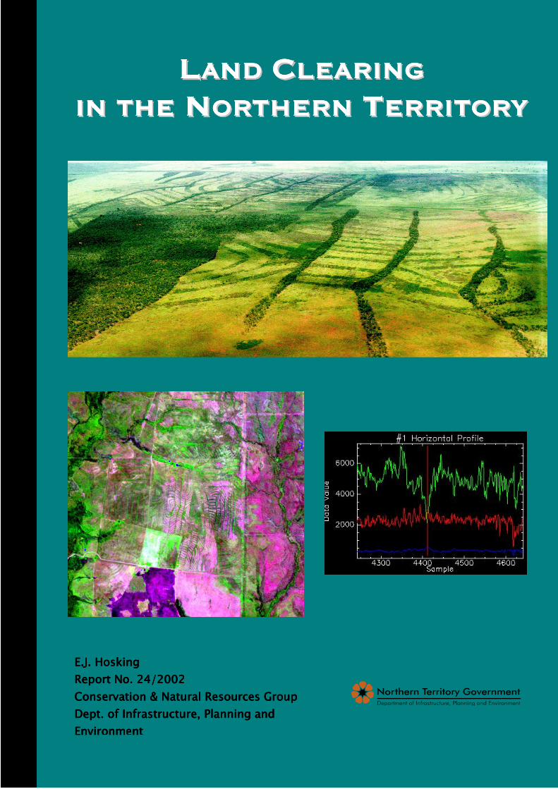
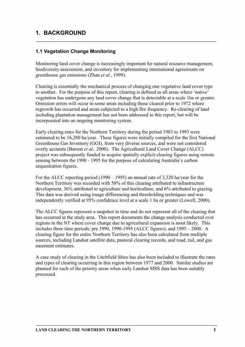
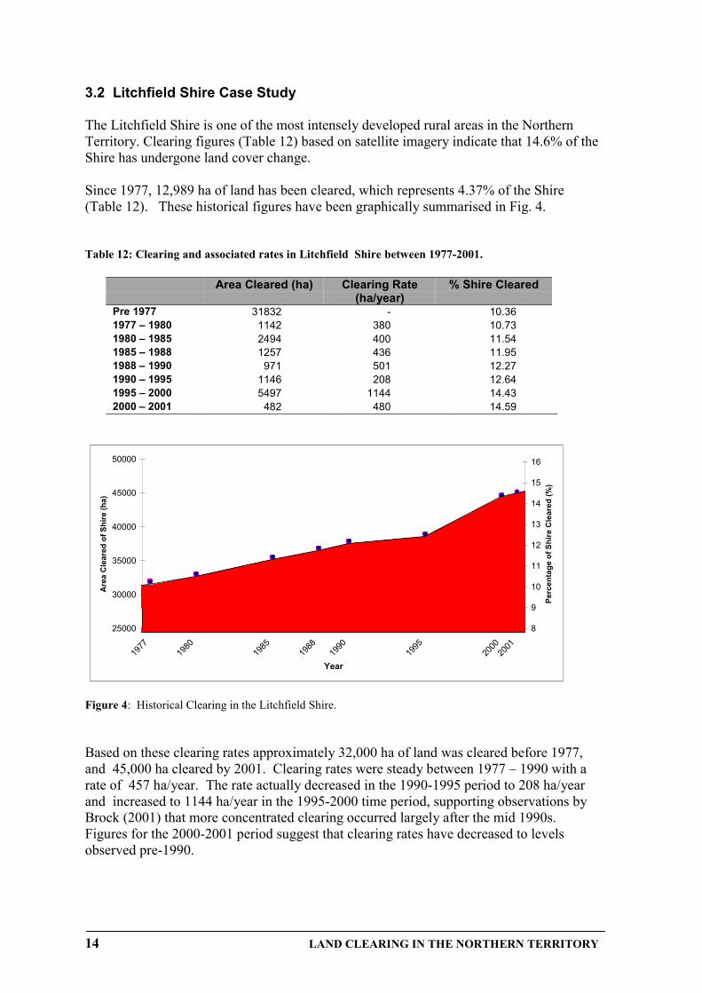
Front Cover. Top : Aerial photograph of clearing on Tipperary Station. Bottom Left: LandsatTM satellite image of clearing on Tipperary Station. Bottom Right: Horizontal profile ofclearing in different image bands.
LAND CLEARING IN THE NORTHERN TERRITORY i
EXECUTIVE SUMMARY
Monitoring land is integral to management and enforcement activities associated with landclearing practices. For the purpose of this report, clearing is defined as all areas where‘native’ vegetation has undergone any land cover change that is detectable at a scale 1haor greater.
503,727 ha or 0.37% of the NT was estimated as having been cleared, based on multiplesources including: Landsat satellite data, historical pastoral reports and estimations ofroad, rail, and gas pipeline easements.
Specific figures and break-down of clearing by tenure type have been generated usingLandsat data for: Darwin, Palmerston, East Arm Region, Coomalie Shire, Litchfield Shire,Mary River Catchment, Daly Basin (biogeographic region), Tiwi Islands, and the Ti-TreeCatchment. In a more comprehensive assessment, historical satellite data has been used tocalculate figures for Litchfield Shire since 1977.
Most clearing has occurred in the Daly Basin and Litchfield Shire. A brief summary ofthe statistics for these two regions are:
The Daly Basin• 193,655 ha or 9.3% of the region cleared;• 63% of clearing has occurred on Pastoral Lease Tenures, 29% on Freehold
land, with the remaining 8% distributed between all other tenures.• Majority of Pastoral Lease clearing occurred prior to 1990, on Tipperary
Station.
Litchfield Shire• 44,820 ha or 14.59% of the Shire cleared• 68% of clearing has occurred on Freehold land, 11% on Vacant Crown Land,
and 7% on unclassified tenure that is generally attributed to infrastructuredevelopment, 5% on Crown Lease Term Tenure, 5% on Pastoral Lease Tenure,and the remaining 4% distributed between all other tenures.
• Clearing rates of 380-500 ha/year have been calculated. Exceptions are foundin the 1990-1995 time period, with a low of 208 ha/year and 1995-2000 timeperiod where the rate peaked at 1144 ha/year.
• Increased clearing between 1995-2000 is directly correlated with horticulturalproductivity for the same time period where production increased from $21.4to $55.7 million in the Darwin region.
Future directions of clearing assessment will include the finalisation of detailed clearingfigures across the Northern Territory. Reporting will be broadly based on biogeographicregions and areas where future agricultural development is most likely to occur.
Further refinement of clearing assessment techniques will include the investigation ofrapid assessment technique using MODIS satellite data.
ii LAND CLEARING THE NORTHERN TERRITORY
CONTENTS
EXECUTIVE SUMMARY.......................................................................................... i
LIST OF FIGURES.................................................................................................. ii
LIST OF TABLES .................................................................................................. iii
ACRONYMS........................................................................................................... iv
1.1 Vegetation Monitoring...................................................................................................11.2 Historical clearing in the Northern Territory...................................................................21.3 Current Clearing regulations.........................................................................................3
3.1 Land Clearing in the Northern Territory........................................................................63.2 Litchfield Case Study.................................................................................................14
APPENDIX I Historical clearing ......................................................................... 19
APPENDIX II Land Administration Tenure Types ............................................ 21
APPENDIX III Interim Biogeographic Regions of the Northern Territory ...... 23
LAND CLEARING IN THE NORTHERN TERRITORY iii
LIST OF FIGURES
Figure 1: Typical spectral reflectances for soil, green vegetation, and water in relation tothe red-NIR space Findings............................................................................ 5
Figure 2: Regional distribution of clearing by Land Tenure Type ................................................... 7
Figure 3: Distribution of Land Tenure Types in the Northern Territory .......................................... 8
Figure 4: Historical Clearing in Litchfield Shire ............................................................................ 14
Figure 5: Distribution of clearing in Litchfield Shire by tenure type between1977 and 2000............................................................................................................... 15
Figure 6: Increase of clearing and horticultural production in the Litchfield Shire1985-2001 ..................................................................................................................... 15
LIST OF TABLES
Table 1: Clearing in the Northern Territory................................................................................ 6
Table 2: Comparative Clearing by Region for three time periods: Pre 1990,1990-1995, & 1995-2000................................................................................................. 9
Table 3: Clearing in the Litchfield Shire to 2001. ...................................................................... 9
Table 4: Clearing in the Daly Basin to 2001 ............................................................................. 10
Table 5: Clearing in Coomalie Shire to 2000 ........................................................................... 10
Table 6: Clearing in the Mary River Catchment to 2000 ........................................................ 11
Table 7: Clearing in the Tiwi Islands to 2000 ........................................................................... 11
Table 8: Clearing in the Darwin Region to 2000 ...................................................................... 12
Table 9: Clearing in the Palmerston Region to 2000 .............................................................. 12
Table 10: Clearing in the East Arm Port Development Region to 2000...............................13
Table 11: Clearing in Ti-Tree Catchment to 2000 ...............................................................13
Table 12: Clearing and associated rates in Litchfield Shire 1977-2000 .................................. 14
iv LAND CLEARING THE NORTHERN TERRITORY
ACRONYMS
ADC Agricultural Development CorporationADMA Agricultural Development and Marketing AuthorityAGO Australian Greenhouse OfficeALCC Agricultural Land Cover ChangeCSIRO Commonwealth Scientific & Industrial Research OrganisationDCA Development Consent AuthorityDIPE Department of Infrastructure, planning & EnvironmentDPI&F Department of Primary Industry & FisheriesGPS Global Positioning SystemGGI Greenhouse Gas InventoryIBRA Interim Biogeogrpahic Regionalisation of AustraliaILZ Intensive Landuse ZoneLandsat ETM Landsat Enhanced Thematic MapperLandsat MSS Landsat Multi-Spectral ScannerLandsat TM Landsat Thematic Mapperµm Micro metreMODIS Moderate Resolution Imaging ScannerNIR Near InfraredNT Northern TerritoryNTG Northern Territory GovernmentQDNR Queensland Department of Natural ResourcesTLC Tipperary Land Corporation
LAND CLEARING THE NORTHERN TERRITORY 1
1. BACKGROUND
1.1 Vegetation Change Monitoring
Monitoring land cover change is increasingly important for natural resource management,biodiversity assessment, and inventory for implementing international agreements ongreenhouse gas emissions (Zhan et al., 1999).
Clearing is essentially the mechanical process of changing one vegetative land cover typeto another. For the purpose of this report, clearing is defined as all areas where ‘native’vegetation has undergone any land cover change that is detectable at a scale 1ha or greater.Omission errors will occur in some areas including those cleared prior to 1972 whereregrowth has occurred and areas subjected to a high fire frequency. Re-clearing of landincluding plantation management has not been addressed in this report, but will beincorporated into an ongoing monitoring system.
Early clearing rates for the Northern Territory during the period 1983 to 1993 wereestimated to be 16,280 ha/year. These figures were initially compiled for the first NationalGreenhouse Gas Inventory (GGI), from very diverse sources, and were not consideredoverly accurate (Barson et al., 2000). The Agricultural Land Cover Change (ALCC)project was subsequently funded to acquire spatially explicit clearing figures using remotesensing between the 1990 - 1995 for the purpose of calculating Australia’s carbonsequestration figures.
For the ALCC reporting period (1990 – 1995) an annual rate of 3,320 ha/year for theNorthern Territory was recorded with 58% of this clearing attributed to infrastructuredevelopment, 36% attributed to agriculture and horticulture, and 6% attributed to grazing.This data was derived using image differencing and thresholding techniques and wasindependently verified at 95% confidence level at a scale 1 ha or greater (Lowell, 2000).
The ALCC figures represent a snapshot in time and do not represent all of the clearing thathas occurred in the study area. This report documents the change analysis conducted overregions in the NT where cover change due to agricultural expansion is most likely. Thisincludes three time periods; pre 1990, 1990-1995 (ALCC figures), and 1995 – 2000. Aclearing figure for the entire Northern Territory has also been calculated from multiplesources, including Landsat satellite data, pastoral clearing records, and road, rail, and gaseasement estimates.
A case study of clearing in the Litchfield Shire has also been included to illustrate the ratesand types of clearing occurring in this region between 1977 and 2000. Similar studies areplanned for each of the priority areas when early Landsat MSS data has been suitablyprocessed.
2 LAND CLEARING THE NORTHERN TERRITORY
1.2 Historical clearing in the Northern Territory
The issue of land clearing was considered one of the biggest costs for land cultivation andsubsequent agricultural development in the Northern Territory (Dept of Territories, 1960).Early attempts at agriculture in the semi-arid tropics were constrained by failure toadequately assess the implications of climate, topography, and hydrology (Bauer, 1985).Sugar cane was the first agricultural commodity attempted, with options taken out overapproximately 40,500 ha along the Daly River, Adelaide River and Cox Peninsula in 1879(Bauer, 1964). Grand development plans resulted in two small plantations established in1881-82 along the Daly River and the Cox Peninsula. Only a small nursery crop was everplanted with the Daly River producing nothing and the Cox Peninsula plantation onlyproducing 5 tonnes (Bauer, 1985 1964).
It wasn’t until the 1950s that rice was trialed on the Adelaide River floodplains at HumptyDoo and Beatrice Hill by the Commonwealth Scientific & Industries ResearchOrganisation (CSIRO) at Humpty Doo (Mollah, 1982). Early optimism led to theformation of Territory Rice Limited, an American-Australian syndicate that was given theexclusive rights to develop the sub-coastal plains under the Rice Development AgreementOrdinance in 1956 (Mollah, 1982). Although some clearing of woody vegetation wasrequired for these ventures, they led to a significant change in land use. The maximumarea ever planted to rice was about 2000 ha in the 1958 and 1959 seasons (Fisher, 1977).
The perceived success of the rice trials and the need for future direction of agriculturalindustry in the Territory led to the Commonwealth government commissioning a report in1959, to inquire into the prospects of agriculture in the Northern Territory, commonlyknown as ‘The Forster Report’ (Dept of Territories, 1960). Outcomes of this reportconcluded that rice growing on the sub-coastal plains and the use of improved pasture was‘economic’, but for any worthwhile progress, government assistance would be required.Other recommendations included setting up pilot farms and large scale clearing trials inthe Katherine, Daly River and Darwin regions (Dept of Territories, 1960) with a stronginterest in the expansion of agricultural activities on Tippera soils (Mollah, 1980).
However, commercial rice production had all but died by the early 1960s, with operationsof Territory Rice Limited ceasing in 1963 (Fisher, 1977). At the same time expandingbeef markets into Japan (Mollah, 1980), and America (Bauer, 1985; Sturtz, 2000) saw apush for improved pastures for stock feed.
In 1967 the first large-scale clearing project occurred in the Northern Territory onTipperary station by the Tipperary Land Corporation (TLC) and at the time was believedto be the one of the biggest single agricultural projects in the world (NT News,24/07/1967). The scheme planned for 79,000 ha to be cleared over 5 years, however, poormanagement, seasons and trying to do too much too soon eventually sent the Texan-basedcompany broke (Mollah, 1980). Not learning from these mistakes, the AgriculturalDevelopment Corporation (ADC) undertook a similar feat in the early 1970s on WillerooStation. An estimated 48,600 ha was recorded as cleared, with only 16,000 ha ever beingfarmed (Fisher, 1977).
With self Government in 1978, the NT launched the Agricultural Development andMarketing Authority (ADMA) in 1981/82. This Authority assisted private croppingdevelopments (Sturtz, 2000) that helped establish the NT horticultural industry, andresulted in further clearing on Tipperary station in 1988/89 and development of theDouglas Daly research farms.
LAND CLEARING THE NORTHERN TERRITORY 3
1.3 Current Clearing Controls
Current clearing controls exist under the Pastoral Land Act 1992 and the Planning Act1999.
Pastoral land represents 46.4% of the Territory (Fig. 3). Under the Pastoral Land Act1992, a formal written approval is required by the Pastoral Land Board prior to anyclearing (not including for infrastructure). Applications to clear land need to outline thereason for clearing, total area to be cleared, location, timing, method, and erosion controlmeasures.
Under the Litchfield Shire Area Plan 1992, 50% of any freehold portion can be clearedwithout any formal approval process. Under this control plan clearing in excess of 50%requires the approval of the Development Consent Authority (DCA), which includes publicappeal process.
On 4 December 2002, the Interim Development Control Order No. 12 was declared andnow requires consent for clearing on all freehold land, outside of the existing control planareas on land 2 hectares or greater in size. Under the new Native Vegetation ClearingControls landholders can only have a total of 1 hectare of native vegetation cleared withoutconsent. The new controls apply to approximately 620,000km2 of land (or about half of theNT). It is envisaged that following a 2-year public consultation period they will becombined within the NT Planning Scheme which will further introduce clearing controls tozoned land throughout the Northern Territory.
4 LAND CLEARING THE NORTHERN TERRITORY
2. METHODS
2.1 Data Acquisition
Data was compiled from multiple sources to estimate a figure for total clearing in theNorthern Territory. Data sources include Landsat TM and ETM satellite data, historicalpastoral reports and estimations of road, rail, and gas pipeline easements. Specific figuresand the break down of clearing by Tenure Type (Appendix II) have been generated forusing 2000 Landsat ETM data for:
• Darwin• Palmerston• East Arm Region• Coomalie Shire• Litchfield Shire• Mary River Catchment• Daly Basin (biogeographic region)• Tiwi Islands• Ti-Tree Catchment
Satellite data has been used to generate the majority of these estimates as it allows anunbiased, cost effective, repeatable method of determining land cover change at a scale of1 ha or greater. Similar studies include the Statewide Landcover and Tree Study (SLATS)(Danaher, et al., 1998; QDNR, 1999) in Queensland, and national projects such as theALCC project (Barson et al., 2000), and the Australian Greenhouse Office (AGO) project(Furby, 2001).
A case study giving an historical perspective of clearing in the Litchfield Shire wasundertaken using Landsat MSS data for 1977, 1980, 1985 and 1988 and Landsat TM/ETMdata for 1990, 1995, 2000 and 2001.
2.2 Satellite Image Analysis
Pre-ProcessingTo ensure geometric and radiometric accuracy so that historical imagery is comparable,two stages of pre-processing are required: rectification and calibration.
Geometric corrections were used to make sure that clearing identified is spatially accurateand allows for temporal comparison of data. Each image was rectified to a base imageusing 50 – 70 controls points and resampled using cubic convolution for superior accuracy(Homer, et al., 2002).
Radiometric calibration was used to ensure consistency of ‘like-value’ digital countsthrough time. This means that areas are comparable over time so if change occurs it is‘real change’ and not caused by sensor irregularities. This relates to cloud andatmospheric effects along with sensor variation contributing towards attenuation in thevalue of surface reflection recorded by the sensors (Furby and Campbell, 2001).
LAND CLEARING THE NORTHERN TERRITORY 5
Change DetectionVegetation reflects strongly in the Red (0.63 – 0.69 µm)-Near Infrared (0.769-0.9 µm)(NIR) space of the electromagnetic spectrum (Fig. 1). Changes in the strength of thisresponse vary with different amounts and types of vegetative cover. This means that for aspecific region and time of the year, the various cover types have characteristic responsesin the red-NIR space (Huete et al., 1999; Zhan et al., 1999). Stratification is used to limitthe effects of difference in the spectral reflectance between and within the satellite data toseparate patterns of physiographic and phenologic influences (Homer et al., 2002) such aschanges in lithology and biogeographic regions.
Figure 1: Typical spectral reflectances for soil, green vegetation, and water in relation to the red-NIR space [Adapted from Harrison and Jupp, 1989]
Land cover change due to clearing was identified by isolating where significant changes inthe red-NIR space occurred from one year to the next. The change threshold variesbetween different strata due to types of vegetation present and underlying soil colour andtexture. Ideally images from the same time of the year are used to limit seasonal influence,however this is not always possible. In these cases thresholds were adjusted to account forseasonal disparity.
Baseline AssessmentLandsat MSS data is available from 1972 in select areas of Australia, while good coverageacross the continent didn’t occur until the early 1980s. This means that clearing figuressince European settlement can not be obtained by change detection techniques. Thisbaseline figure has been derived by visually assessing and digitising the image data usingmultiple image datasets.
Accuracy AssessmentThe clearing dataset has been field checked by experienced image analysts and fieldofficers using historical photography and global positioning systems (GPS). Accuracy at ascale of 1ha is estimated for these regions. More detailed accuracy estimates will beattached to each region as the temporal clearing assessments have been finalised.
Red – NIR space
Wavelength (µµµµm)
Ref
lect
ance
(%)
SoilVegetationWater
6 LAND CLEARING THE NORTHERN TERRITORY
3. RESULTS
3.1 Land Clearing in the Northern Territory
Land clearing estimates for the Northern Territory are presented in Table 1. Adjustmentshave been made to ensure that no overlap has occurred from multiple data sources.
Table 1: Clearing in the Northern Territory
Source/Region Area Cleared (ha)PASTORAL RECORDS (1992) * 102394LANDSAT TM REGIONAL FIGURES**Darwin 6841.32Palmerston 2292.84Coomalie Shire 17044.29Port Zone 1096.99Litchfield Shire 43674.90Ti-Tree 11175.31Tiwi Islands 10925.78Mary River Catchment 19533.29Daly Basin (Landsat) 190773.16Daly Basin (estimate since 2000) 600BRS Data (1990-1995)*** 9570ROADS #Federal 10680Rural 10400Local 48000RAILWAY ## 9940GAS PIPELINE ### 5400URBAN +Alice Springs 2408.43Tennant Creek 290Jabiru 286.66Nhulumbuy ++ 400Total Clearing (ha) 503726.99% of Total Area (134620000) 0.37
* Based on Pastoral Clearing records prior to the commencement of the Pastoral Land Act in 1992.** Figures based on Landsat TM 2000 imagery. Other dates have been used for verification of historical clearing.*** Data derived from the ALCC project for 1990-1995.# Road estimates, Federal 2570km x 40m corridor; Rural 2600km x 40m corridor; Local 16000km x 30m corridor.## Rail Corridor estimated at 1420km with an average width of 70m.## # Gas Pipeline easement estimated at 1800km with an average width of 30m.+ Town areas derived from Landsat data not included in the regional figures.++ Based on DIPE records that 50-60% of the town lease is built on.
Land clearing has been estimated at less than 0.5% of the total area of the NorthernTerritory, with the Daly Basin and the Litchfield Shire being the areas of most intenseactivity. These areas are also considered the most likely for future agriculturaldevelopment. The distribution of clearing in each region by land tenure type (AppendixII) is illustrated in Figure 2 and listed in Tables 2 – 12. The majority of clearing hasoccurred on freehold land. Exceptions are the Daly Basin, where the clearing at TipperaryStation, a pastoral lease accounts for the single biggest area of clearing; the Mary River,where a large area is under Crown Lease tenure; and the Tiwi Islands and Ti-Tree
LAND CLEARING THE NORTHERN TERRITORY 7
Fig. 2: Regional distribution of clearing by land tenure types.
Tiwi Islands
100%
0%0%0%0%0%
Coomalie Shire
91%
3%
1%
5%
Daly Basin
29%
63%
1%
4%
3%
Litchfield Shire
68%4%
11%
6%
11%
Mary River Catchment
5%
40%
0%
49%
6%
Palmerston
49%
19%
11%
21%
Darwin
68%
6%
7%
19%
Ti-Tree Catchment
42%
46%
5%7%
8 LAND CLEARING THE NORTHERN TERRITORY
While the majority of clearing has occurred on general freehold it represents only afraction of the land mass (Fig 3). The largest tenure type is pastoral (46.4%) followed byAboriginal Freehold (44.02%).
Figure 3: Distribution of land tenure types in the Northern Territory.
44%
46.4%
5.4%
4.2%
Aboriginal Freehold PastoralVacantOther
9
Tabl
e 2:
Com
para
tive
Cle
arin
g by
Reg
ion
for
thre
e tim
e pe
riod
s: P
re 1
990,
199
0-19
95,
1995
-200
0
Reg
ion
Tota
l Are
aC
LEAR
ING
PR
E 90
CLE
ARIN
G 9
0-95
CLE
ARIN
G 9
5-00
TOTA
L C
LEAR
ING
Area
(ha)
% R
egio
nAr
ea (h
a)%
Reg
ion
Area
(ha)
% R
egio
nAr
ea (h
a)%
Reg
ion
Litc
hfie
ld30
7255
.93
3769
5.73
12.2
711
46.2
80.
3754
96.5
01.
7944
338.
5114
.43
Dar
win
1407
0.50
6721
.65
47.7
718
.14
0.13
119.
670.
8568
59.4
648
.75
Palm
erst
on56
20.7
216
88.5
530
.04
N/A
N/A
604.
3010
.75
2292
.84
40.7
9Po
rt R
egio
n68
85.3
489
9.77
13.0
755
.47
0.81
197.
222.
8611
52.4
616
.74
Tiw
i Isl
ands
7498
51.6
310
668.
871.
4224
1.50
0.03
256.
910.
0311
167.
291.
49M
ary
Riv
er80
8522
.44
1570
0.30
1.94
1180
.19
0.15
3832
.99
0.47
2071
3.48
2.56
Coo
mal
ie S
hire
1508
19.5
415
465.
4710
.25
343.
170.
2315
78.8
21.
0517
387.
4611
.53
Dal
y B
asin
2256
436.
2517
7031
.87
7.85
3771
.71
0.17
1285
1.40
0.57
1936
54.9
88.
58
Tabl
e 3:
Cle
arin
g in
Litc
hfie
ld S
hire
to 2
001.
Tenu
re
A
rea
of S
hire
C
lear
ing
C
lear
ing
Tota
l Are
a C
lear
edha
%
ha
%
%B
uild
ing
Leas
e (B
L)2.
350.
001.
1497
740.
000.
00C
row
n Le
ase
Perp
etua
l (C
LP)
3131
6.27
10.1
920
96.1
934.
680.
68C
row
n Le
ase
Term
(CLT
)18
22.5
50.
5967
4.61
21.
510.
22Fr
eeho
ld (F
)10
5036
.37
34.1
930
363.
0867
.74
9.88
Gov
t Set
Asi
de (G
)76
03.9
92.
4761
3.11
461.
370.
20M
isc
Leas
e (M
L)39
.77
0.01
39.7
7041
0.09
0.01
Mis
c Li
cenc
e (M
LIC
)50
8.16
0.17
385.
1305
0.86
0.13
Not
Cla
ssifi
ed (N
C) *
2494
2.40
8.12
3201
.525
7.14
1.04
Occ
upat
iona
l Lic
ence
(OL)
911.
860.
3023
7.43
060.
530.
08Pe
rpet
ual P
asto
ral L
ease
(PPL
)75
615.
5724
.61
2005
.85
4.48
0.65
Res
erve
(RES
)12
615.
424.
1193
.799
880.
210.
03Sp
ecia
l Pur
pose
Lea
se (S
PL)
2264
.07
0.74
131.
0158
0.29
0.04
Vaca
nt C
row
n La
nd (V
)44
577.
1714
.51
4977
.532
11.1
11.
62TO
TAL
3072
55.9
310
0.00
4482
0.20
100.
0014
.59
10
Tabl
e 4:
Cle
arin
g in
the
Dal
y B
asin
to 2
001
Tenu
re
Ar
ea o
f D
aly
Bas
in
C
lear
ing
Cle
arin
g
T
otal
Are
a C
lear
edha
%
ha
%
%B
uild
ing
Leas
e (B
L)1.
320.
001.
470.
000.
00C
row
n Le
ase
Perp
etur
al (C
LP)
2603
80.1
512
.45
4967
.01
2.55
0.24
Cro
wn
Leas
e Te
rm (C
LT)
9847
5.82
4.71
2168
.67
1.11
0.10
Free
hold
(F)
4986
75.6
023
.84
5581
7.65
28.6
92.
67G
ovt.
Set A
side
(G)
60.7
60.
0050
.73
0.03
0.00
Not
Cla
ssifi
ed (N
C) *
9416
.90
0.45
4969
.89
2.55
0.24
Occ
upat
iona
l Lic
ence
(OL)
41.3
50.
0011
.39
0.01
0.00
Past
oral
Lea
se (P
L)52
7068
.97
25.1
930
480.
3115
.67
1.46
Perp
etua
l Pas
tora
l Lea
se (P
PL)
5557
70.2
826
.57
9465
3.13
48.6
54.
52R
eser
ve (R
ES)
1374
.06
0.07
106.
210.
050.
01Sp
ecia
l Pur
pose
Lea
se (S
PL)
1624
.09
0.08
52.9
50.
030.
00Va
cant
Cro
wn
Land
(V)
1392
21.1
46.
6512
65.4
60.
650.
06TO
TAL
2092
110.
4410
0.00
1945
44.8
710
0.00
9.30
Tabl
e 5:
Cle
arin
g in
Coo
mal
ie S
hire
to 2
000.
Tenu
re
Are
a of
Shi
re
Cle
arin
g
Cle
arin
gTo
tal A
rea
Cle
ared
ha%
ha
%
%B
uild
ing
Leas
e (B
L)0.
040.
000.
040.
000.
00C
row
n Le
ase
Perp
etua
l (C
LP)
2365
5.53
15.6
821
9.22
1.26
0.15
Cro
wn
Leas
e Te
rm (C
LT)
282.
820.
1916
.66
0.10
0.01
Free
hold
(F)
1169
51.5
277
.54
1570
2.40
90.3
110
.41
Gov
t Set
Asi
de (G
)25
7.76
0.17
87.5
40.
500.
06N
ot C
lass
ified
(NC
) *23
70.8
41.
5779
5.46
4.57
0.53
Perp
etua
l Pas
tora
l Lea
se (P
PL)
4189
.15
2.78
39.6
10.
230.
03R
eser
ve (R
ES)
22.0
30.
010.
150.
000.
00R
ight
To
Free
hold
Titl
e (R
TFT)
1.36
0.00
1.36
0.01
0.00
Spec
ial P
urpo
se L
ease
(SPL
)19
.56
0.01
9.90
0.06
0.01
Vaca
nt C
row
n La
nd (V
)30
68.9
22.
0351
5.14
2.96
0.34
TOTA
L15
0819
.54
100.
0017
387.
4610
0.00
11.5
3
11
Tabl
e 6:
Cle
arin
g in
the
Mar
y R
iver
Cat
chm
ent t
o 20
00.
Tenu
re
Are
a of
Cat
chm
ent
Cle
arin
g
Cle
arin
gTo
tal A
rea
Cle
ared
ha%
ha
%
%
Cro
wn
Leas
e Pe
rpet
ual (
CLP
)24
1644
.02
29.8
910
070.
6248
.62
1.25
Cro
wn
Leas
e Te
rm (C
LT)
436.
780.
0556
.46
0.27
0.01
Free
hold
(F)
2902
4.44
3.59
1005
.08
4.85
0.12
Gov
t Set
Asi
de (G
)1.
860.
000.
000.
000.
00N
ot C
lass
ified
(NC
) *37
76.3
30.
4712
40.1
75.
990.
15Pa
stor
al L
ease
(PL)
1032
79.4
012
.77
1747
.47
8.44
0.22
Perp
etua
l Pas
tora
l Lea
se (P
PL)
3137
83.0
838
.81
6511
.17
31.4
30.
81R
ight
To
Free
hold
Titl
e (R
TFT)
1165
14.9
314
.41
77.7
90.
380.
01Va
cant
Cro
wn
Land
(V)
61.5
90.
014.
720.
020.
00TO
TAL
8085
22.4
410
0.00
2071
3.48
100.
002.
56
Tabl
e 7:
Cle
arin
g in
the
Tiw
i Isla
nds t
o 20
00.
Tenu
re
Area
of
Isla
nds
C
lear
ing
Cle
arin
gTo
tal A
rea
Cle
ared
ha%
h
a
%
%
Free
hold
(F)
7467
89.1
599
.59
1115
4.82
99.8
91.
49N
ot C
lass
ified
(NC
) *24
80.5
30.
3311
.84
0.11
0.00
Spec
ial L
ease
(SPL
)0.
520.
000.
520.
000.
00Va
cant
Cro
wn
Land
(V)
581.
430.
080.
110.
000.
00TO
TAL
7498
51.6
310
0.00
1116
7.29
100.
001.
49
12
Tabl
e 8:
Cle
arin
g in
the
Dar
win
Reg
ion
to 2
000.
Tenu
re
A
rea
of R
egio
n
Cle
arin
g
C
lear
ing
Tota
l Are
a C
lear
edha
%
ha
%
%
Bui
ldin
g Le
ase
(BL)
1.89
0.01
1.89
0.03
0.01
Cro
wn
Leas
e Pe
rpet
ual (
CLP
)65
1.67
4.63
396.
285.
782.
82C
row
n Le
ase
Term
(CLT
)68
.21
0.48
67.4
40.
980.
48D
arw
in T
own
Area
Lea
se (D
TAL)
0.68
0.00
0.51
0.01
0.00
Free
hold
(F)
7996
.19
56.8
347
06.6
968
.62
33.4
5G
ovt S
et A
side
(G)
179.
631.
2814
0.38
2.05
1.00
Not
Cla
ssifi
ed (N
C) *
2888
.83
20.5
310
25.7
614
.95
7.29
Occ
upat
iona
l Lic
ence
(OL)
7.19
0.05
6.44
0.09
0.05
Res
erve
(RES
)11
73.3
08.
3496
.52
1.41
0.69
Spec
ial L
ease
(SPL
)9.
800.
077.
090.
100.
05Va
cant
Cro
wn
Land
(V)
1093
.10
7.77
410.
475.
982.
92TO
TAL
1407
0.50
100.
0068
59.4
610
0.00
48.7
5
Tabl
e 9:
Cle
arin
g in
the
Palm
erst
on R
egio
n to
200
0.
Tenu
re
Area
of
Reg
ion
C
lear
ing
Cle
arin
gTo
tal A
rea
Cle
ared
ha%
h
a
%
%C
row
n Le
ase
Perp
etua
l (C
LP)
29.0
10.
5229
.02
1.27
0.52
Cro
wn
Leas
e Te
rm (C
LT)
340.
646.
0623
1.88
10.1
14.
13Fr
eeho
ld (F
)13
28.4
223
.63
1107
.79
48.3
119
.71
Gov
t Set
Asi
de (G
)56
.44
1.00
56.1
02.
451.
00N
ot C
lass
ified
(NC
) *16
77.6
829
.85
411.
3017
.94
7.32
Occ
upat
iona
l Lic
ence
(OL)
2.50
0.04
1.59
0.07
0.03
Res
erve
(RES
)2.
910.
052.
910.
130.
05Sp
ecia
l Lea
se (S
PL)
8.49
0.15
8.23
0.36
0.15
Vaca
nt C
row
n La
nd (V
)21
74.6
438
.69
444.
0419
.37
7.90
TOTA
L56
20.7
210
0.00
2292
.84
100.
0040
.79
13
Tabl
e 10
: C
lear
ing
in th
e Ea
st A
rm P
ort D
evel
opm
ent R
egio
n to
200
0.
Tenu
re
Area
of
Reg
ion
C
lear
ing
Cle
arin
gTo
tal A
rea
Cle
ared
ha%
ha
%
%
Cro
wn
Leas
e Pe
rpet
ual (
CLP
)90
.34
1.31
38.4
63.
340.
56C
row
n Le
ase
Term
(CLT
)15
9.11
2.31
57.4
64.
990.
83Fr
eeho
ld (F
)10
10.3
914
.67
248.
3821
.55
3.61
Gov
t Set
Asi
de (G
)34
6.77
5.04
319.
0827
.69
4.63
Lice
nce
to O
ccup
y (L
OC
)3.
040.
042.
700.
230.
04N
ot C
lass
ified
(NC
) *45
09.8
965
.50
144.
7912
.56
2.10
Res
erve
(RES
)17
2.65
2.51
69.5
56.
041.
01Va
cant
Cro
wn
Land
(V)
593.
158.
6127
2.04
23.6
13.
95TO
TAL
6885
.34
100.
0011
52.4
610
0.00
16.7
4
Tenu
re 1
1: C
lear
ing
in th
e Ti
-Tre
e C
atch
men
t to
2000
Tenu
re
Are
a of
Cat
chm
ent
C
lear
ing
Cle
arin
gTo
tal A
rea
Cle
ared
ha%
ha
%
%
Cro
wn
Leas
e Pe
rpet
ual (
CLP
)16
.38
0.00
7.98
0.07
0.00
Cro
wn
Leas
e Te
rm (C
LT)
675.
140.
073.
170.
030.
00Fr
eeho
ld (F
)27
4245
.17
27.4
747
34.4
442
.37
0.47
Gov
t Set
Asi
de (G
)22
.02
0.00
16.4
50.
150.
00N
ot C
lass
ified
(NC
) *27
11.6
00.
2777
0.40
6.89
0.08
Past
oral
Lea
se (P
L)16
913.
651.
690.
000.
000.
00Pe
rpet
ual P
asto
ral L
ease
(PPL
)68
9075
.93
69.0
250
39.0
745
.09
0.50
Res
erve
(RES
)0.
330.
000.
330.
000.
00Va
cant
Cro
wn
Land
(V)
1468
8.61
1.47
603.
475.
400.
06TO
TAL
9983
48.8
310
0.00
1117
5.31
100.
001.
12
14 LAND CLEARING IN THE NORTHERN TERRITORY
3.2 Litchfield Shire Case Study
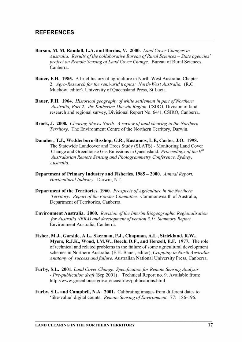
The Litchfield Shire is one of the most intensely developed rural areas in the NorthernTerritory. Clearing figures (Table 12) based on satellite imagery indicate that 14.6% of theShire has undergone land cover change.
Since 1977, 12,989 ha of land has been cleared, which represents 4.37% of the Shire(Table 12). These historical figures have been graphically summarised in Fig. 4.
Table 12: Clearing and associated rates in Litchfield Shire between 1977-2001.
Figure 4: Historical Clearing in the Litchfield Shire.
Based on these clearing rates approximately 32,000 ha of land was cleared before 1977,and 45,000 ha cleared by 2001. Clearing rates were steady between 1977 – 1990 with arate of 457 ha/year. The rate actually decreased in the 1990-1995 period to 208 ha/yearand increased to 1144 ha/year in the 1995-2000 time period, supporting observations byBrock (2001) that more concentrated clearing occurred largely after the mid 1990s.Figures for the 2000-2001 period suggest that clearing rates have decreased to levelsobserved pre-1990.
25000
30000
35000
40000
45000
50000
1977
1980
1985
1988
1990
1995
2000
2001
Year
Are
a C
lear
ed o
f Shi
re (h
a)
8
9
10
11
12
13
14
15
16
Perc
enta
ge o
f Shi
re C
lear
ed (%
)
_______________________________________________________________________________________LAND CLEARING IN THE NORTHERN TERRITORY 15
The distribution of clearing against tenure types is shown in Figure 5. Freehold land isconsistently the tenure type under the greatest clearing pressure. The rise in the 95-00period coincides with increased horticultural development, particularly mangoes.
Figure 5: Distribution of clearing in Litchfield Shire between 1977-2000.
A strong correlation exists between land clearing since 1985 and horticultural production(Fig. 6). For every 1% (307 ha) cleared productivity has increased by $28,000,000. Aclearing increase of 5,728 in the 1995-2000 time period corresponds to horticulturalproduction doubling from $21.4 M to $55.7 M (DPI&F, 1985 –2000).
Figure 6: Increase of clearing and horticultural production in the Litchfield Shire, 1985-2000.
0100200300400500600700800900
1000
Freehold Pastoral CLP & CLT VacantCrow n Land
All otherTenures
Tenure Type
Rat
e of
Cle
arin
g (h
a/ye
ar)
77-80
80-85
85-88
88-90
90-95
95-00
00-01
R2 = 0.9908
0
10
20
30
40
50
60
35000 37000 39000 41000 43000 45000
Area Cleared (ha)
Valu
e ($
M)
1985
2000
1995
19901988
16 LAND CLEARING IN THE NORTHERN TERRITORY
4. FUTURE DIRECTIONS
While the main objective of this document is to outline the amount of clearing that hasoccurred across the Northern Territory, the future direction is to develop a comprehensivesemi-automated monitoring system.
Future aims are to:
• Finalise detailed baseline clearing assessment across the Northern Territory.• Analyse time trend data across the Northern Territory.• Develop annual reporting processes based on the Interim Biogeographic
Regionalisation of Australia (IBRA) (Appendx III).• Investigate the use of the Moderate Resolution Imaging Scanner (MODIS), a new
generation satellite sensor for rapid, inter-annual assessment of land cover change.
Historical Landsat Satellite Data is currently being acquired for 1972, 1977, 1980, 1985,1988, 1989, 1991, 1992, 1995 and 1998, where it is available. This data will be used toanalyse regional land clearing trends and confirm total clearing figures.
_______________________________________________________________________________________LAND CLEARING IN THE NORTHERN TERRITORY 17
REFERENCES
Barson, M. M, Randall, L.A. and Bordas, V. 2000. Land Cover Changes inAustralia. Results of the collaborative Bureau of Rural Sciences – State agencies’project on Remote Sensing of Land Cover Change. Bureau of Rural Sciences,Canberra.
Bauer, F.H. 1985. A brief history of agriculture in North-West Australia. Chapter2. Agro-Research for the semi-arid tropics: North-West Australia. (R.C.Muchow, editor). University of Queensland Press, St Lucia.
Bauer, F.H. 1964. Historical geography of white settlement in part of NorthernAustralia, Part 2: the Katherine-Darwin Region. CSIRO, Division of land
research and regional survey, Divisional Report No. 64/1. CSIRO, Canberra.
Brock, J. 2000. Clearing Moves North. A review of land clearing in the NorthernTerritory. The Environment Centre of the Northern Territory, Darwin.
Danaher, T.J., Wedderburn-Bisshop, G.R., Kastamos, L.E, Carter, J.O. 1998.The Statewide Landcover and Trees Study (SLATS) - Monitoring Land Cover Change and Greenhouse Gas Emissions in Queensland: Proceedings of the 9th
Australasian Remote Sensing and Photogrammetry Conference, Sydney,Australia.
Department of Primary Industry and Fisheries. 1985 – 2000. Annual Report:Horticultural Industry. Darwin, NT.
Department of the Territories. 1960. Prospects of Agriculture in the NorthernTerritory: Report of the Forster Committee. Commonwealth of Australia,
Department of Territories, Canberra.
Environment Australia. 2000. Revision of the Interim Biogeographic Regionalisation for Australia (IBRA) and development of version 5.1: Summary Report.Environment Australia, Canberra.
Fisher, M.J., Garside, A.L., Skerman, P.J., Chapman, A.L., Strickland, R.W.,Myers, R.J.K., Wood, I.M.W., Beech, D.F., and Henzell, E.F. 1977. The roleof technical and related problems in the failure of some agricultural developmentschemes in Northern Australia. (F.H. Bauer, editor), Cropping in North Australia:Anatomy of success and failure. Australian National University Press, Canberra.
Furby, S.L. 2001. Land Cover Change: Specification for Remote Sensing Analysis- Pre-publication draft (Sep 2001) . Technical Report no. 9. Available from:http://www.greenhouse.gov.au/ncas/files/publications.html
Furby, S.L. and Campbell, N.A. 2001. Calibrating images from different dates to‘like-value’ digital counts. Remote Sensing of Environment. 77: 186-196.
18 LAND CLEARING IN THE NORTHERN TERRITORY
Harrison, B.A. and Jupp, D.L.B. 1989. Introduction to remotely sensed data.CSIRO Publications, Melboune.
Homer, C., Huang, C., Yang, L. and Wylie, B. 2002. Development of a circa2000 landcover database for the United States. ASPRS Proceedings, April, 2002.Washington D.C. http://landcover.usgs.gov
Huete, A., Justice, C. and van Leeuwen, W. 1999. MODIS Vegetation Index(MOD13) Algorithm Theoretical Basis Document: Version 3.
Lowell, K. 2000. Report on the Remote Sensing of Agricultural Land Cover Change1990-1995 Independent Reliability Assessment Consultancy. Report prepared forthe Bureau of Rural Sciences. Canberra.
Mollah, W.S. 1980. The Tipperary Story: An attempt at large-scale grainsorghum development in the Northern Territory, (Bauer, J.B, and Mollah, W.S.)Two North Australian cropping studies. North Australian Research Bulletin No. 7.The Australian National University, Canberra.
Mollah, W.S. 1982. Humpty Doo: Rice in the Northern Territory. The AustralianNational University, Canberra.
Northern Territory Government. 2001. Litchfield Area Plan 1992. Darwin, NT.
Northern Territory Government. 2002. Land Clearing Guidelines: Broadacre Developments, Linear Developments, Subdivision. Darwin, NT.
Northern Territory News. 1967. Tipperary – Biggest Agricultural Project Attempted inAustralia : $Multi-Mill. Land plans in balance. NT News, Monday July 24,Darwin. Page 1 & 5.
Pastoral Land Board of the Northern Territroy. 1993. Guidelines for clearing Pastoral Land. Pastoral Land Board of the Northern Territory, Darwin.
Queensland Department of Natural Resources. 1999. Land cover change inQueensland 1991-1995. Indooroopilly, Queensland.
Sturtz, J. 2000. Northern Territory – Report. Agricultural land use andmanagement information (R. Swift, and J. Skjemstad, editors). National CarbonAccounting System Technical Report No. 13. Australian Greehouse Office,Canberra.
Zhan, X., DeFries, R., Hansen, M., Townshend, J., DiMiceli, C., Sohlberg, R.and Huang, C. 1999. MODIS Enhanced Land Cover Change Product AlgorithmTheoretical Basis Document (ATBD). University of Maryland.
_______________________________________________________________________________________LAND CLEARING IN THE NORTHERN TERRITORY 19
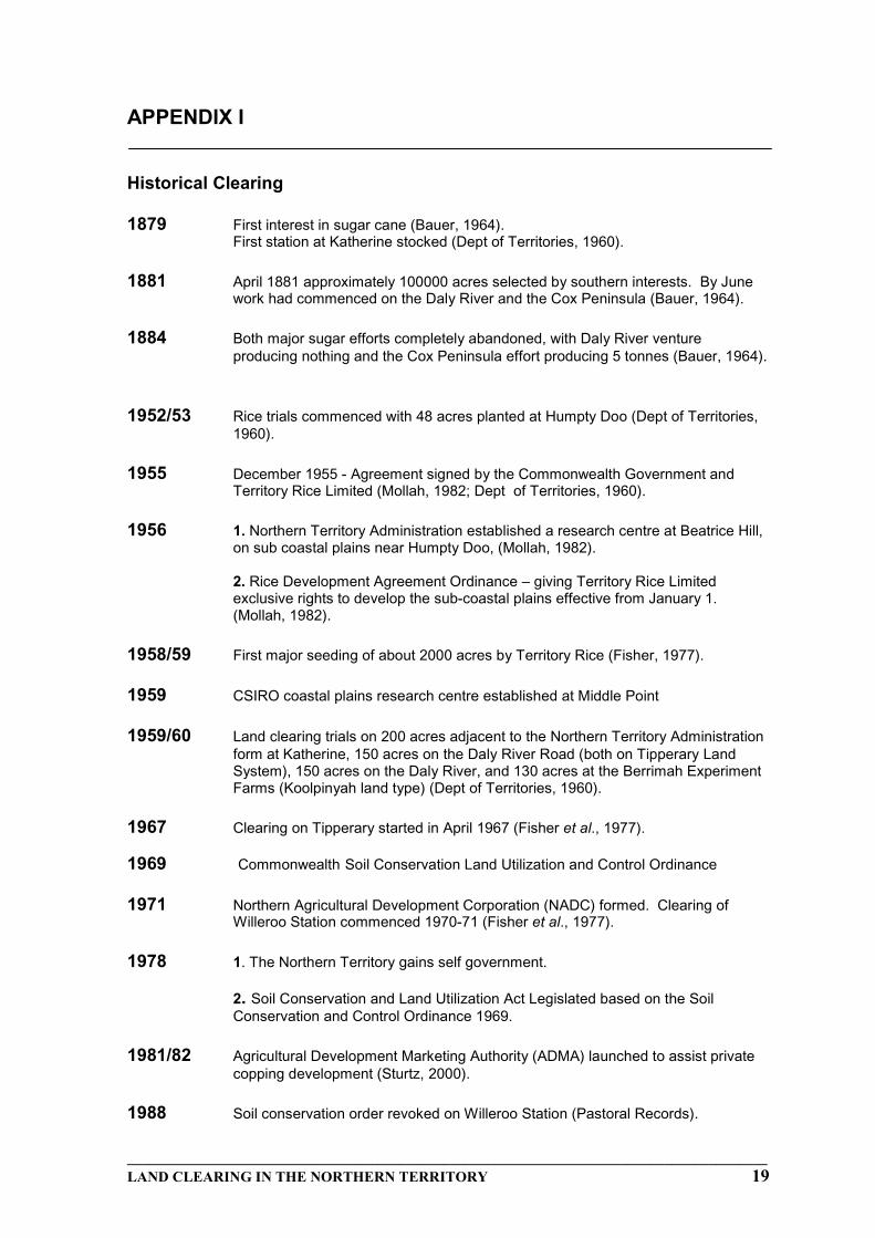
APPENDIX I
Historical Clearing
1879 First interest in sugar cane (Bauer, 1964).First station at Katherine stocked (Dept of Territories, 1960).
1881 April 1881 approximately 100000 acres selected by southern interests. By Junework had commenced on the Daly River and the Cox Peninsula (Bauer, 1964).
1884 Both major sugar efforts completely abandoned, with Daly River ventureproducing nothing and the Cox Peninsula effort producing 5 tonnes (Bauer, 1964).
1952/53 Rice trials commenced with 48 acres planted at Humpty Doo (Dept of Territories,1960).
1955 December 1955 - Agreement signed by the Commonwealth Government andTerritory Rice Limited (Mollah, 1982; Dept of Territories, 1960).
1956 1. Northern Territory Administration established a research centre at Beatrice Hill,on sub coastal plains near Humpty Doo, (Mollah, 1982).
2. Rice Development Agreement Ordinance – giving Territory Rice Limitedexclusive rights to develop the sub-coastal plains effective from January 1.(Mollah, 1982).
1958/59 First major seeding of about 2000 acres by Territory Rice (Fisher, 1977).
1959 CSIRO coastal plains research centre established at Middle Point
1959/60 Land clearing trials on 200 acres adjacent to the Northern Territory Administrationform at Katherine, 150 acres on the Daly River Road (both on Tipperary LandSystem), 150 acres on the Daly River, and 130 acres at the Berrimah ExperimentFarms (Koolpinyah land type) (Dept of Territories, 1960).
1967 Clearing on Tipperary started in April 1967 (Fisher et al., 1977).
1969 Commonwealth Soil Conservation Land Utilization and Control Ordinance
1971 Northern Agricultural Development Corporation (NADC) formed. Clearing ofWilleroo Station commenced 1970-71 (Fisher et al., 1977).
1978 1. The Northern Territory gains self government.
2. Soil Conservation and Land Utilization Act Legislated based on the Soil Conservation and Control Ordinance 1969.
1981/82 Agricultural Development Marketing Authority (ADMA) launched to assist privatecopping development (Sturtz, 2000).
1988 Soil conservation order revoked on Willeroo Station (Pastoral Records).
20 LAND CLEARING IN THE NORTHERN TERRITORY
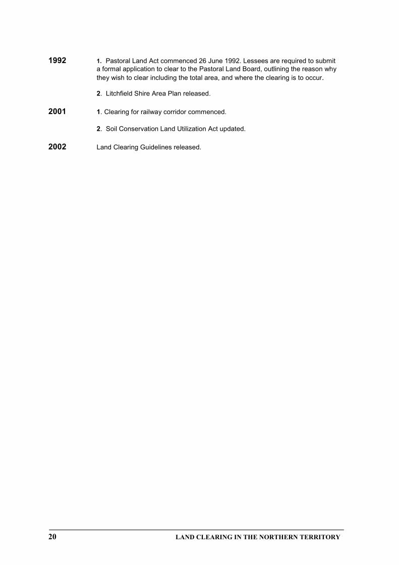
1992 1. Pastoral Land Act commenced 26 June 1992. Lessees are required to submita formal application to clear to the Pastoral Land Board, outlining the reason whythey wish to clear including the total area, and where the clearing is to occur.
2. Litchfield Shire Area Plan released.
2001 1. Clearing for railway corridor commenced.
2. Soil Conservation Land Utilization Act updated.
2002 Land Clearing Guidelines released.
_______________________________________________________________________________________LAND CLEARING IN THE NORTHERN TERRITORY 21
APPENDIX II
Land Administration and Information System (LAIS) Tenure Types
Code Tenure Type Purpose
BL Building Lease Temporary Occupation of Govt buildings
CLP *Crown Lease Perpetual Perpetual Lease for specific purposes such as horticulture etc.
CLT *Crown Lease Term Two to Five year lease for developmentpurposes convertible to Freehold / CLP on
completion of development covenants
F * Freehold Fee Simple (Torrens) registered title
FCL * Fish Culture Lease Term Lease for specified purpose
FFL * Fish Farming Lease Similar to above
G Government NT Government usage - no registered tenure
LOC Licence to occupy Short term occupation of Crown land
ML Miscellaneous Lease Term Lease up to 30 yrs for miscellaneous purposes
MLIC Miscellaneous Licence Temporary use of Crown land for timbergathering
MIN Mineral Lease Some ‘registered’ historical tenements only
OL Occupation Licence Occupation of Crown Land under yearlyrenewable licence for Grazing / Horticulture / water
bores etc.
PCL * Pearl Culture Lease Term Lease for Pearl Farming
PL * Pastoral Lease Term Lease (generally 50 years) for Pastoral Purposes
PPL * Perpetual Pastoral Lease Perpetual Lease for Pastoral Purposes
RES Reserve Proclaimed Reserve (Cemetery, Historic,Recreation etc.)
22 LAND CLEARING IN THE NORTHERN TERRITORY
RTFT Right to Freehold Title Land subject to acquisition of Fee Simple (Freehold) interest by the Commonwealth of Australia under the NT Self Govt Act but for which no freehold title has been issued
SPL * Special Purpose Lease Term Lease (generally 10 to 30 years) issued to Sporting Clubs, Scout Groups etc.
V Vacant Crown Land Un-alienated Crown Land with no registered title
NOTES: Tenure Types prefixed * infer exclusive permanent land ownership (in the caseof Freehold) or exclusive occupation (under the terms of the Lease) for Leasehold land.
‘Freehold’ land includes titles issued by the Northern Territory Government (‘NTFreehold’) limited to a maximum of 150 km2 per holding, and titles issued by theCommonwealth Government under the Aboriginal Land Rights (NT) Act(‘Commonwealth’ or ‘Aboriginal Freehold’) unlimited in size.
Freehold titles issued by the NT Government as a result of negotiated Land Claimsettlement are issued in the name of Aboriginal Corporations, and for large tracts of landcontain blocks of titles not exceeding 150 km2 per title.
Tenure for Freehold or Leasehold land is referred to as ‘registered’ tenure, ie. formallyregistered with the Land Titles Office.
MINING tenures such as Exploration Licence, Mineral Lease, Extractive Mineral Lease,Mineral Claim etc. are issued and recorded by the Department of Mines & Energy andapart from some historical tenements do not appear in LAIS.
_______________________________________________________________________________________LAND CLEARING IN THE NORTHERN TERRITORY 23
APPENDIX III
Interim Biogeographic Regions of the Northern Territory(Environment Australia, 2000)


![[Policy / Procedure Name] - Northern Territory · Web viewSolicitor for the Northern Territory, established pursuant to section 8 of the Law Officers Act Territory The Northern Territory](https://static.documents.pub/doc/80x56/5ea78c467b3fdb564b4bf7dc/policy-procedure-name-northern-territory-web-view-solicitor-for-the-northern.jpg)


