Las Pampas Project (Previously Pampa Buenos Aires JV & Pampa Sur) Region II, Chile NI 43-101 Technical Report Prepared For Iron Creek Capital Corp. Suite 501, 543 Granville Street Vancouver, B.C. V6C 1X8 Canada Prepared By: Ian R. Gendall, B.Sc. (Hons.), M.Sc. (Pr. Sci. Nat.) President & CEO GENCO MANAGEMENT INC. 15612, 34 Avenue British Columbia V3S 0G4 Canada Effective date: September 25, 2014 Signature date: October 31, 2014
Transcript
Las Pampas Project
(Previously Pampa Buenos Aires JV & Pampa Sur)
Region II, Chile
NI 43-101 Technical Report
Prepared For Iron Creek Capital Corp.
Suite 501, 543 Granville Street Vancouver, B.C. V6C 1X8
Canada
Prepared By: Ian R. Gendall, B.Sc. (Hons.), M.Sc. (Pr. Sci. Nat.) President & CEO GENCO MANAGEMENT INC. 15612, 34 Avenue British Columbia V3S 0G4 Canada Effective date: September 25, 2014 Signature date: October 31, 2014
IRON CREEK CAPITAL CORP. LAS PAMPAS PROJECT, CHILE
2
Date and Signature Page The effective date of this NI 43-101 Technical Report for the “Las Pampas Project (Previously Pampa Buenos Aires JV & Pampa Sur), Region II, Chile” is September 25, 2014. “Ian R. Gendall” Ian R. Gendall, B.Sc. (Hons.), M.Sc., Pr. Sci. Nat. October 31, 2014
IRON CREEK CAPITAL CORP. LAS PAMPAS PROJECT, CHILE
3
Table of Contents
Date and Signature Page ....................................................................................................................... 2
6. History .............................................................................................................................................. 38
6.1 Previous Exploration Work ...................................................................................................... 38
7. Geological Setting, Mineralization, Alteration and Modelling ............................................ 39
9.3.3 Induced Polarization (IP) and Resistivity Surveys at Cerro Blanco - September 2006 .................................................................................................................................... 99
10.2.1 STRUCTURAL TARGETS RELATED TO THE DOMINADOR FAULT ZONE (DFZ) ........................................................................................................................................... 128
10.2.1.1 Target H ................................................................................................................... 128
10.2.1.2 Target F ................................................................................................................... 133
10.2.1.3 Target BC ................................................................................................................ 136
10.2.1.4 Targets A, DE, G and J ......................................................................................... 138
10.2.2 TARGETS UNRELATED TO THE DOMINADOR FAULT ZONE (DFZ) .............. 139
10.2.2.1 Target M (Cerro Blanco) ........................................................................................ 139
20. Certificate of Author ................................................................................................................ 193
Appendix A ............................................................................................................................................ 195
I. Geochemical Graphs for Original RC Drilling in 2008 and 2011. .................................... 196
II. Copy of Results for Pulp Check Analyses of Select Holes. ............................................. 203
III. Graphs of Check Pulps of Original Samples, 2014 ............................................................. 208
IRON CREEK CAPITAL CORP. LAS PAMPAS PROJECT, CHILE
8
List of Figures
Figure 1: Las Pampas Project Location and Access Roads. ............................................................ 24
Figure 2: Las Pampas Project Land Tenure, Pampa Buenos Aires Area. ...................................... 34
Figure 3: Las Pampas Project Land Tenure, Pampa Sur Area ......................................................... 35
Figure 4: Geologic Tectonic Framework, Paleocene Belt, Northern Chile with Location of Las Pampas Project. ....................................................................................................................................... 41
Figure 5: Las Pampas Project Geology and Key Areas. .................................................................... 44
Figure 6: Cerro Buenos Aires Geological Map .................................................................................... 46
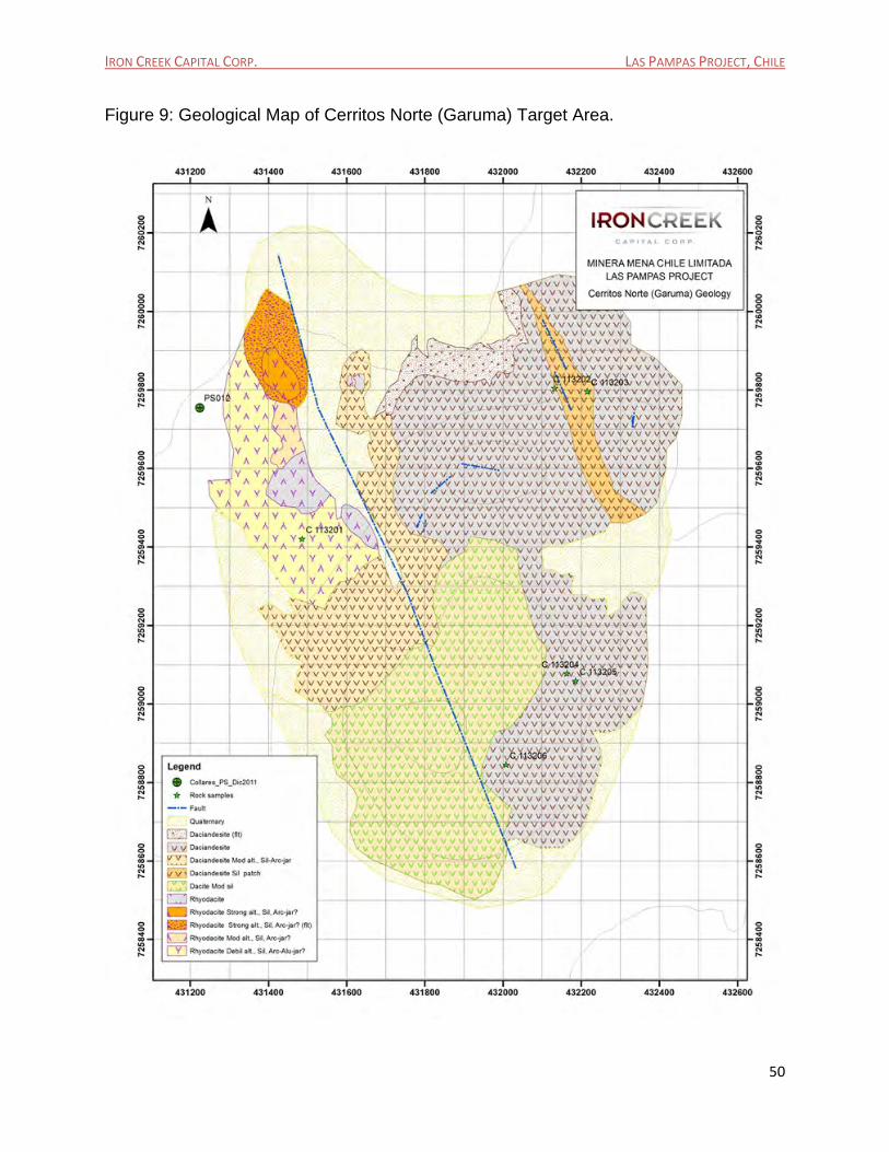
Figure 9: Geological Map of Cerritos Norte (Garuma) Target Area. ................................................ 50
Figure 10: Geological Map of Cerritos Sur Target Area. .................................................................... 52
Figure 11: Schematic Geological Map of Target H Area. .................................................................. 54
Figure 12: El Peñon Geologic Model .................................................................................................... 62
Figure 13: Total Colluvial/Soil Geochemical Survey lines Completed at Las Pampas Project. ... 68
Figure 14: Surface pH Distribution, Las Pampas. ............................................................................... 77
Figure 15: Surface Silver Geochemistry at Las Pampas. .................................................................. 81
Figure 16: Surface Arsenic Geochemistry at Las Pampas. ............................................................... 83
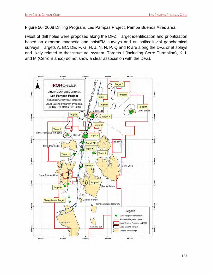
Figure 17: Surface Antimony Geochemistry at Las Pampas. ........................................................... 84
Figure 18: Trace Elements Distribution Model at El Peñon Low Sulphidation Gold/Silver Deposits. .................................................................................................................................................... 86
Figure 19: Controlled Source Audio-frequency Magnetotellurics (CSAMT) Reconnaissance 2011 Program and IP Line over Cerro Blanco (2006): Geology and lines location map. ....................... 88
Figure 20: Geophysical Surveys Completed and Planned at Las Pampas Project. ...................... 89
Figure 21: Reduced to pole ground magnetic image of Las Pampas. ............................................. 91
Figure 22: Analytical Signal upward continued 50m magnetic image of Las Pampas. ................. 92
IRON CREEK CAPITAL CORP. LAS PAMPAS PROJECT, CHILE
9
Figure 23: Las Pampas Generalized Geology and Main Interpreted Features from Magnetics Data (Beale & Morris.2012). ................................................................................................................... 94
Figure 24: Las Pampas Generalized Geology and Main Interpreted Features from HoistEM Data – 100m Depth Slice (Beale & Morris, 2012). ........................................................................................ 95
Figure 25: Resistivity Depth Slice Image at 50m for Las Pampas property. ................................... 97
Figure 26: Resistivity Depth Slice Image at 100m for Las Pampas property. ................................ 98
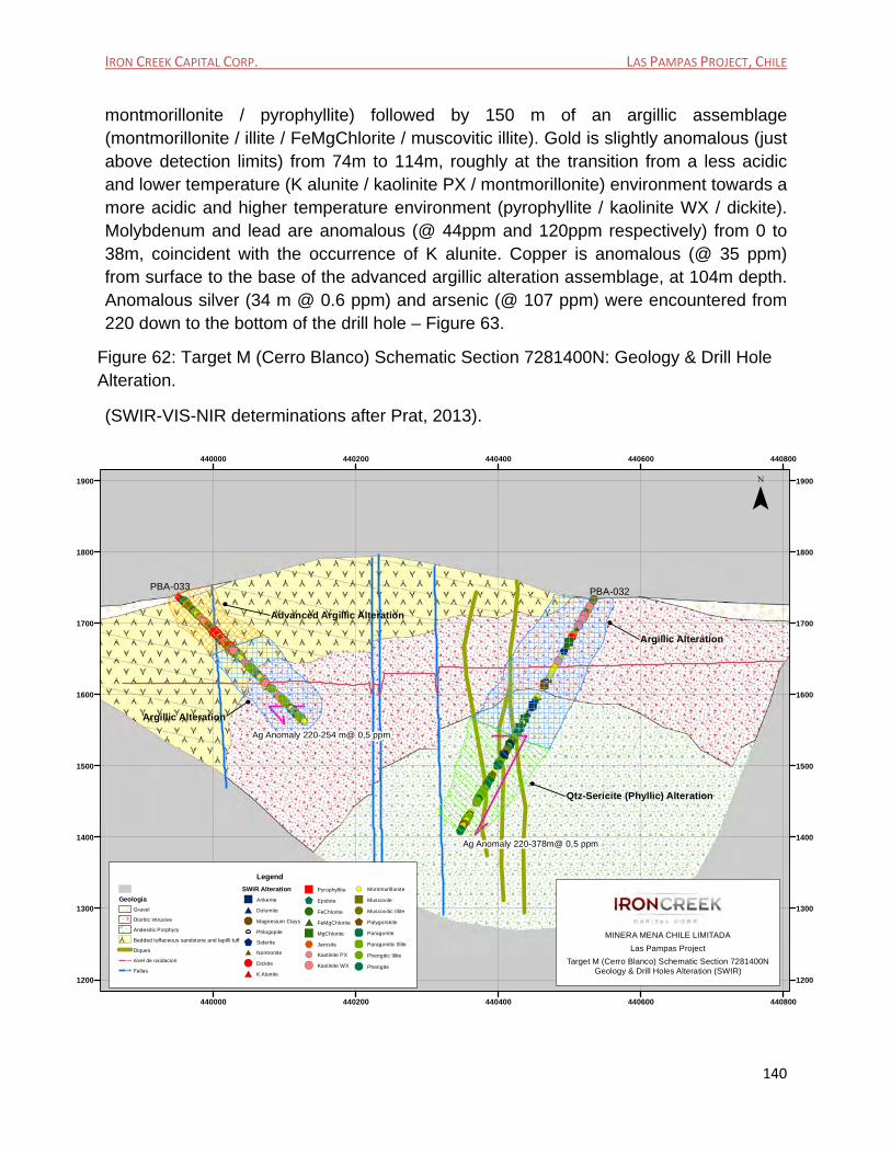
Figure 27: Inverted Chargeability and Resistivity Sections, IP Line 7281400N, Cerro Blanco Target area. ............................................................................................................................................. 100
Figure 28: Static corrected smooth model inversion results and geologic section looking north for line 9980 at El Peñon, Orito Sur vein. (Region II, Chile – from Ellis & Robbins, 1998). ........ 101
Figure 29: Sliced CSAMT Plan Map with depth slice at -200m at Las Pampas ........................... 102
Figure 31: Static corrected smooth model inversion sections looking north for line 7255000N (426625E – 429175E) ........................................................................................................................... 105
Figure 32: Static corrected smooth model inversion sections looking north for line 7255000N (429175E – 431725E) ........................................................................................................................... 105
Figure 33: Static corrected smooth model inversion sections looking north for line 7255000N (431725E – 434275E) ........................................................................................................................... 106
Figure 34: Static corrected smooth model inversion sections looking north for line 7257300N (425825E – 427025E). .......................................................................................................................... 107
Figure 35: Static corrected smooth model inversion sections looking north for line 7257300N (427175E – 428425E). .......................................................................................................................... 108
Figure 36: Static corrected smooth model inversion sections looking north for line 7259750N (426475E – 427725E). .......................................................................................................................... 109
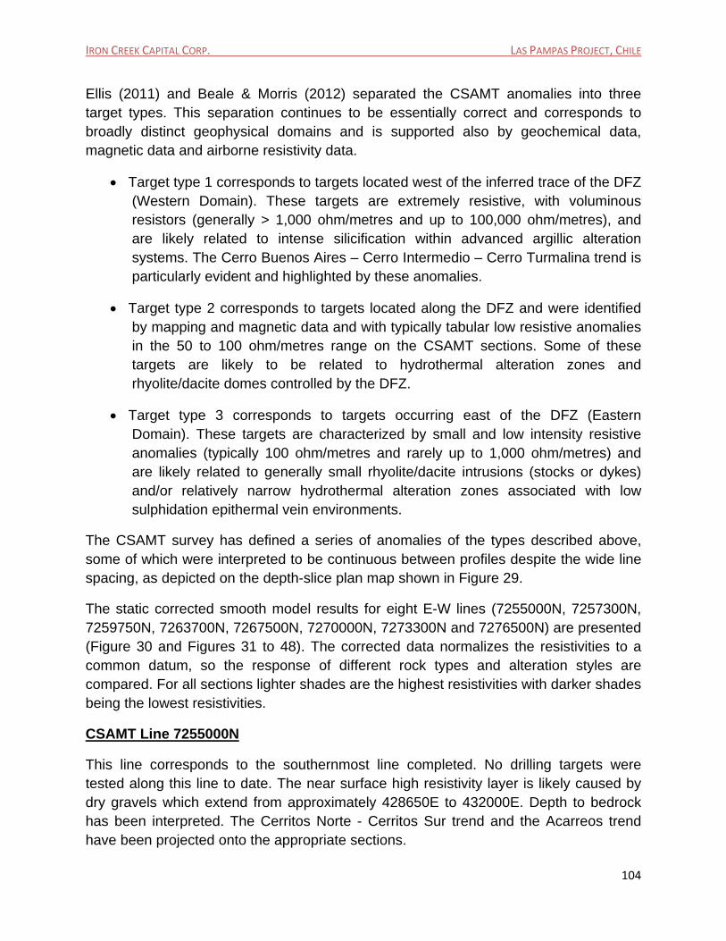
Figure 37: Static corrected smooth model inversion sections looking north for line 7259750N (427325E – 428575E). .......................................................................................................................... 110
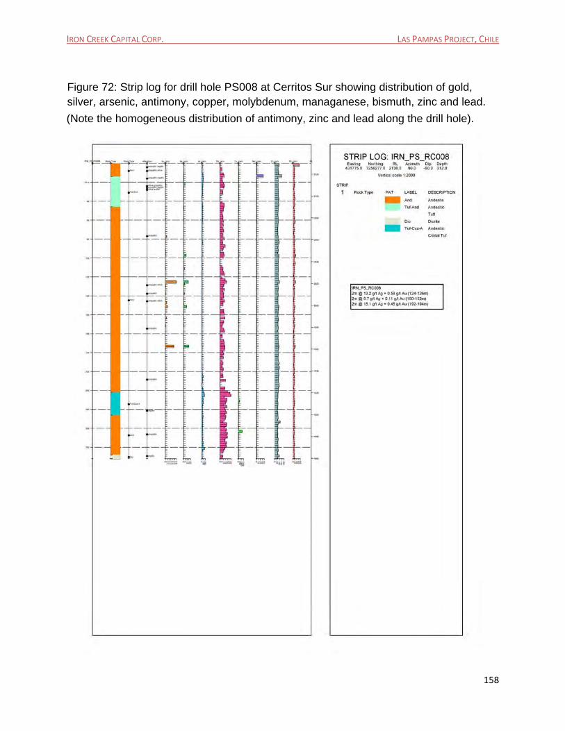
Figure 38: Static corrected smooth model inversion sections looking north for line 7259750N (430675E – 431925E). .......................................................................................................................... 111
Figure 39: Static corrected smooth model inversion sections looking north for line 7263700N (424825E – 426075E). .......................................................................................................................... 112
IRON CREEK CAPITAL CORP. LAS PAMPAS PROJECT, CHILE
10
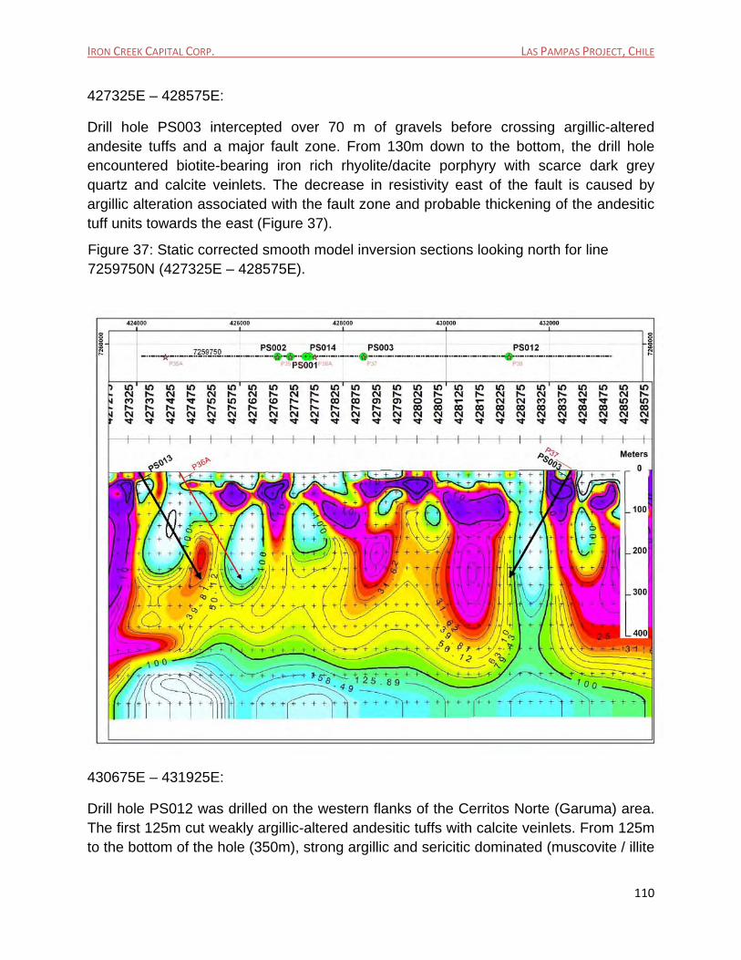
Figure 40: Static corrected smooth model inversion sections looking north for line 7263700N (431575E – 432775E). .......................................................................................................................... 113
Figure 41: Static corrected smooth model inversion sections looking north for line 7267500N (424775E – 429975E) ........................................................................................................................... 114
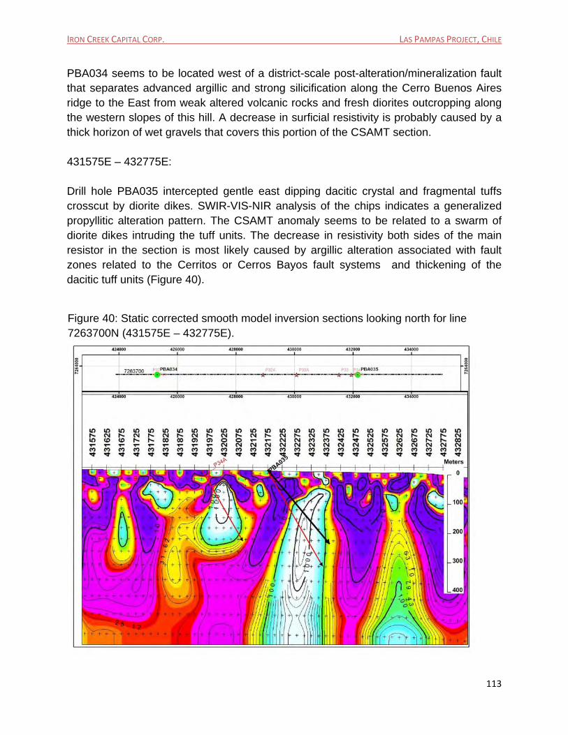
Figure 42: Static corrected smooth model inversion sections looking north for line 7267500N (428275E – 430525E) ........................................................................................................................... 115
Figure 43: Static corrected smooth model inversion sections looking north for line 7267500N (433175E – 434375E). .......................................................................................................................... 116
Figure 44: Static corrected smooth model inversion sections looking north for line 7270000N (424475E - 425725E). .......................................................................................................................... 117
Figure 45: Static corrected smooth model inversion sections looking north for line 7270000N (428725E - 431175E). ........................................................................................................................... 118
Figure 46: Static corrected smooth model inversion sections looking north for line 7273300N (424875E – 426075E). .......................................................................................................................... 119
Figure 47: Static corrected smooth model inversion sections looking north for line 7273300N (433475E – 434675E). .......................................................................................................................... 120
Figure 48: Static corrected smooth model inversion sections looking north for line 7276500N. (425125E – 426325E). .......................................................................................................................... 122
Figure 63: Target M (Cerro Blanco): Strip log for drill hole PBA032 (Section 7281400N) showing distribution of gold, silver, copper, arsenic, antimony, molybdenum, zinc, lead and manganese. .................................................................................................................................................................. 141
Figure 64: Target M (Cerro Blanco): Strip log for drill hole PBA033 (Section 7281400N) showing distribution of gold, silver, copper, arsenic, antimony, molybdenum, zinc, lead, manganese and bismuth. ................................................................................................................................................... 142
IRON CREEK CAPITAL CORP. LAS PAMPAS PROJECT, CHILE
12
Figure 72: Strip log for drill hole PS008 at Cerritos Sur showing distribution of gold, silver, arsenic, antimony, copper, molybdenum, managanese, bismuth, zinc and lead. ........................ 158
Figure 73: Strip log for drill hole PS009 at Cerritos Sur showing distribution of gold, silver, arsenic, antimony, copper, molybdenum, manganese, bismuth, zinc and lead. .......................... 159
Figure 74: Strip log for drill hole PS010 at Cerritos Sur showing distribution of gold, silver, arsenic, antimony, copper, molybdenum, manganese, bismuth, zinc and lead. .......................... 160
Figure 75: PS012 Schematic Geological Section 7259750N (Cerritos Norte) showing distribution of alteration patterns. (From Prat, 2013). ........................................................................................... 162
Figure 76: Strip log for PS012 at Cerritos Norte showing distribution of gold, silver, arsenic, antimony, copper, molybdenum, zinc and lead. ................................................................................ 163
Figure 77: PS012 (IRN_PS_RC012) Silver v/s Arsenic Geochemistry along Drill Hole Section at Cerritos Norte.......................................................................................................................................... 164
Figure 78: Strip log for PBA035 at Southern Cerros Bayos, showing distribution of gold, silver, arsenic, antimony, copper, molybdenum, zinc and lead. ................................................................. 165
Figure 81: Location of Reverse Circulation Drill Hole – PS012 at Cerritos Norte. ....................... 178
Figure 82: Location of Reverse Circulation Drill Hole – PBA034 at Cerro Buenos Aires ........... 178
Figure 83: Kinross - Antofagasta storage facility for Las Pampas drill chips. ............................... 179
Figure 84: RC drill chips for Las Pampas Project at the Kinross - Antofagasta storage facility. 179
Figure 85: Las Pampas North In-Holdings. ........................................................................................ 180
Figure 86: Las Pampas South In-Holdings. ....................................................................................... 181
Figure 87: 2014 Trench dug by Kinross in the “Jarosita” target area of Pampa Sur. ................. 182
Figure 88: 2014 Trench dug by Kinross in the Cerritos Sur target area. ....................................... 183
IRON CREEK CAPITAL CORP. LAS PAMPAS PROJECT, CHILE
13
List of Tables
Table 1: Las Pampas Exploitation Concessions. ............................................................................... 28
Table 2: Las Pampas Exploration Concessions (continues to page 33). ........................................ 29
Table 3: Cerro Buenos Aires Selected Rock Sample Assays. .......................................................... 70
Table 4: Cerro Buenos Aires Silica Flux Quarry - Selected Elements from semi-continuous channel sampling. .................................................................................................................................... 70
Table 5: Cerro Turmalina Selected Rock Sample Assays. ................................................................ 71
Table 6: Cerro Blanco Selected Rock Sample Assays. ..................................................................... 71
Table 7: Selected Samples from Cerros Bayos Sinter. ...................................................................... 72
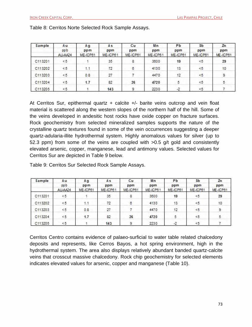
Table 8: Cerritos Norte Selected Rock Sample Assays. .................................................................... 73
Table 9: Cerritos Sur Selected Rock Sample Assays. ....................................................................... 73
Table 10: Cerritos Centro Selected Rock Sample Assays. ............................................................... 74
Table 11: Acarreos Selected Rock Sample Assays. .......................................................................... 74
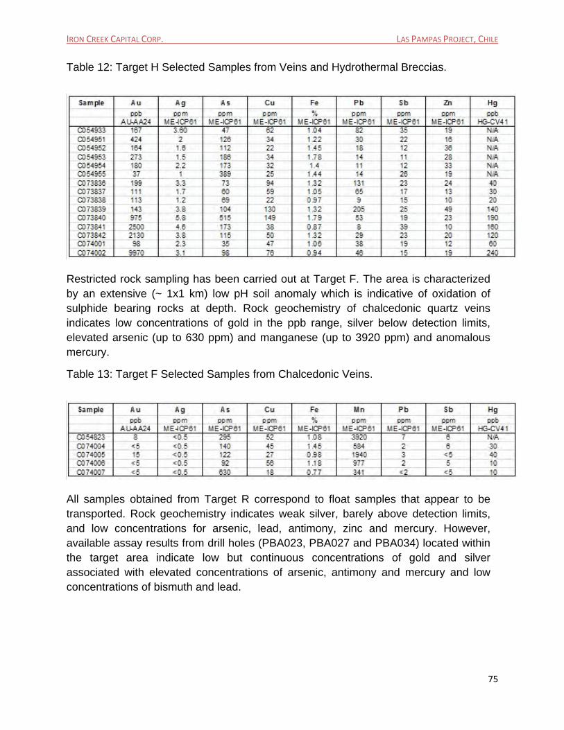
Table 12: Target H Selected Samples from Veins and Hydrothermal Breccias. ............................ 75
Table 13: Target F Selected Samples from Chalcedonic Veins. ...................................................... 75
Table 14: Target R Selected Assays from Float Samples. ................................................................ 76
Table 15: Las Pampas Project, 2008 Exploration Drilling Program, Summary of Results (Updated September 2014). ................................................................................................................. 127
Table 16: Las Pampas Project, 2011 Drilling Program, Summary of Results, Pampa Buenos Aires Area (Revised as of September 2014). .................................................................................... 148
Table 17: Las Pampas Project, 2011 Drilling Program, Summary of Results, Pampa Sur Area (Revised as of September 2014). ........................................................................................................ 149
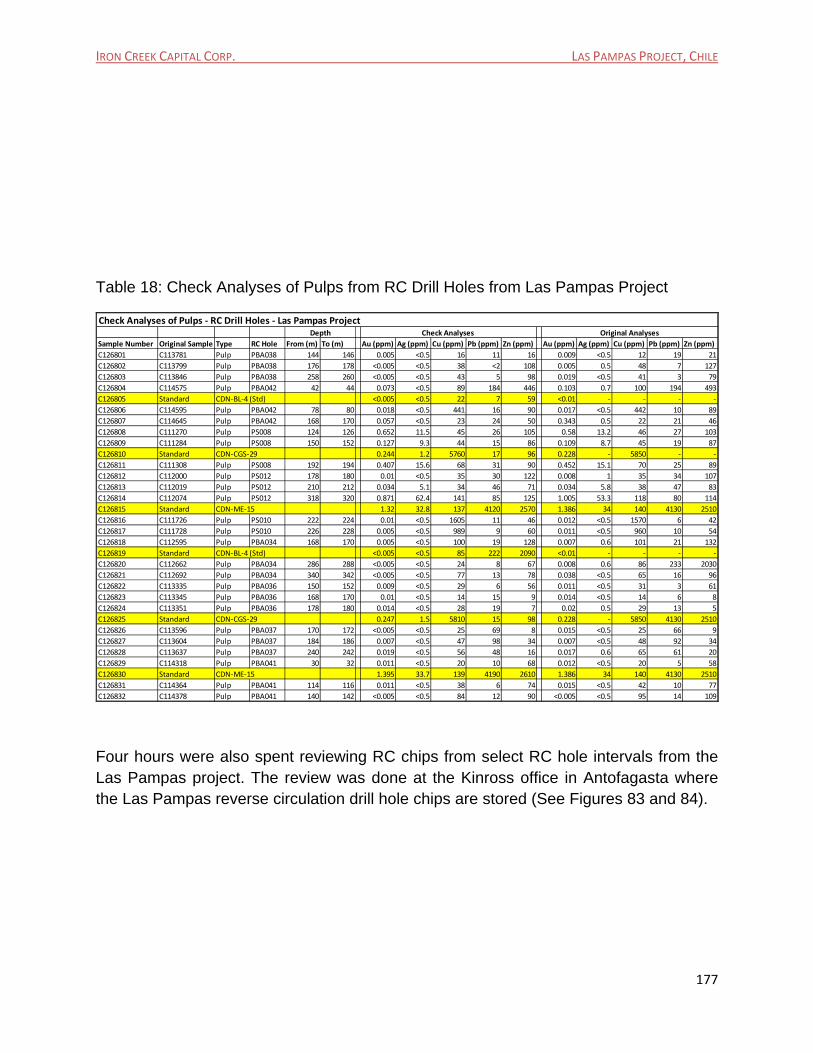
Table 18: Check Analyses of Pulps from RC Drill Holes from Las Pampas Project .................... 177
Table 19: Cost Estimate for Exploration Program on Las Pampas Project. ................................. 188
IRON CREEK CAPITAL CORP. LAS PAMPAS PROJECT, CHILE
14
1. Executive Summary
1.1 Scope of Report
In September 2014, Iron Creek Capital Corp. (“Iron Creek”) a TSX Venture listed company entered into an agreement with Ian Gendall of Genco Management Inc. (“Genco”) to prepare the following Canadian National Instrument 43-101 Technical Report on its Las Pampas Exploration Project, located in Region II of Northern Chile. The effective date of the report is September 25, 2014.
This report describes all exploration activities that have been carried out by Iron Creek through its Chilean subsidiary Minera Mena Chile Limitada, and its historic joint venture partner Andina Minerals Inc. within the Las Pampas (Pampa Buenos Aires and Pampa Sur) project from July 2006 until December 2013.
1.2 Property Location
The Las Pampas Property covers an area of 50,650 hectares and is located in the Region II of northern Chile, approximately 135km SE of the port city of Antofagasta (Figure 1). The property is centered at 7,270,000N and 430,000E UTM coordinates (PSAD 56, UTM Zone 19).
1.3 Ownership Iron Creek through its 100 % owned subsidiary SCM Pampa Buenos Aires owns or has the right to acquire 100% of the 192 blocks of exploration and exploitation concessions of approximately 50,650 hectares of the Las Pampas project located in Region II of northern Chile. The Pampa Buenos Aires area of the Las Pampas project consists of 22 blocks of exploitation concessions and 115 blocks of exploration concessions totaling 34,350 Ha, which, are 100% owned by SCM Pampa Buenos Aires, a wholly owned subsidiary of Iron Creek Capital Corp. The Pampa Sur area of the Las Pampas property consists of 2 exploitation concessions (in process) and 53 blocks of exploration concessions totaling 16,300 Ha which are 100% owned by SCM Pampa Buenos Aires, a wholly owned subsidiary of Iron Creek Capital Corp.
On September 19, and at the time of writing this report, a merger between Polar Star Mining Corporation (TSX: PSR: "Polar Star") and Iron Creek Capital Corp. (TSX-V: IRN: "Iron Creek") was announced and a 30 day due diligence period was underway.
IRON CREEK CAPITAL CORP. LAS PAMPAS PROJECT, CHILE
15
Subsequently on October 29, 2014 - Polar Star Mining Corporation (TSX: PSR: "Polar Star") and Iron Creek Capital Corp. (TSX-V: IRN: "Iron Creek") announced that they have entered into a definitive arrangement agreement dated October 28, 2014 (the "Arrangement Agreement") to combine the two companies pursuant to a statutory plan of arrangement (the "Transaction"), which will result in Iron Creek acquiring, indirectly through a wholly-owned subsidiary, all of the issued and outstanding common shares of Polar Star (the "Polar Star Shares").
The combined companies will re-brand under a new name ("Newco") and will control approximately 300,000 hectares of highly prospective exploration ground in northern Chile focused on copper, gold and silver.
1.4 Regional Geological Setting The Las Pampas project is located entirely within the Palaeocene to early Eocene volcanic belt of Northern Chile, a large and diffuse volcanic field which underlies much of the Atacama Desert Region in the Central Depression of the Andean pre-Cordillera of northern Chile. The belt extends almost continuously to the south for about 600 km until the northern half of the Coquimbo region and is bounded to the west by the Coastal Cordillera and to the east by the Domeyko Cordillera (Figure 4).
Large hydrothermal alteration zones, including hot spring assemblages, epithermal precious metal deposits, and porphyry copper deposits associated with coeval extrusive rocks, are known in this volcanic environment.
1.5 Local Geology
The Las Pampas Project is underlain by a gently eastward dipping, moderately thick volcanic package made up of felsic, intermediate and mafic lava flows, domes, ash-flow tuffs, rhyolitic and dacitic ignimbrites, and andesitic porphyries.
The structural grain of the area is dominated by the generalized NNE-SSW trending Dominador Fault Zone (DFZ). This fault system crosscuts the Pampa Buenos Aires property where it is defined by the available aeromagnetic and resistivity data. The DFZ divides the geology and hydrothermal alteration of the property into two domains.
The western domain is characterized by late Cretaceous trachytic lavas, rhyolitic welded ash-flow tuffs, and andesitic breccias, and by Palaeocene felsic to intermediate lava flows, rhyolitic dome complexes and associated ash-flow tuffs and volcaniclastic rocks. The eastern domain is made up of Palaeocene to early Eocene felsic to intermediate/basic volcanic rocks, lake deposits, ash-flow tuffs and felsic domes. These two geological domains, separated by the DFZ, also correspond to major differences in hydrothermal alteration styles. Quartz-alunite (advanced argillic epithermal) type systems are mainly present in the western domain (Cerro Buenos Aires – Cerro
IRON CREEK CAPITAL CORP. LAS PAMPAS PROJECT, CHILE
16
Turmalina trend) while quartz-adularia-illite (low-sulphidation epithermal) type systems characterize the eastern domain (Cerros Bayos – Cerritos trend, Acarreos areas and Target H and Target F areas amongst others). A third domain, in the northeast of the property – at Cerro Blanco, is also characterized by a quartz-alunite (advanced argillic epithermal) type environment.
The local geology has been built up based on reconnaissance and detailed mapping of positive topographic features that stand out of the extensive gravel-filled pampas that cover most of the property. Several key target areas have been recognized by Iron Creek as a result of their exploration efforts to date and are indicated on Figure 5.
1.6 Previous Exploration Before Iron Creek was involved in the exploration of the Pampa Buenos Aires and Pampa Sur areas of the Las Pampas Project, the region was subject to several exploration campaigns by various companies from the mid 1980’s.
According to Iron Creek, in the mid-eighties – early nineties (?), Anglo American (Empresa Minera Mantos Blancos) carried out reconnaissance geological mapping, rock sampling traverses and eight inclined reverse circulation drill holes within the Cerro Buenos Aires area, looking for concealed porphyry environments at relatively shallow depths beneath the silica capping on the Cerro Buenos Aires hill. Results from this exploration effort are unknown.
It is also reported by Iron Creek that during the mid-nineties (?), Rio Algom (now BHP Billiton Plc.) drilled 20 vertical RC holes following an approximately 2x2 km irregular grid at the southern end of Pampa Buenos Aires, Pampa Sur and neighboring areas. It appears that the target or targets were Spence-type porphyry copper deposits under the gravel cover. Again, results from this exploration work are unknown.
From 2001 to 2003 the Pampa Buenos Aires concessions were subject to regional exploration by Newmont. The work included HeliMag and HoistEM surveys. All Newmont data were made available to Andina Minerals (Iron Creeks JV partner) and later-to Iron Creek once the original option agreement between Andina Minerals and Minera Mena was signed in 2006.
Iron Creek and its historic JV partner’s exploration activities on the property have been focused on the identification of three possible target types: 1) low-sulphidation (quartz-adularia-illite) epithermal gold/silver veins such as those discovered at El Peñon and Fortuna Mines to the north; 2) high-sulphidation (quartz-alunite) epithermal gold-silver deposits such as those discovered at Guanaco Mine to the south; and 3) buried porphyry copper systems such as those discovered at Spence and Sierra Gorda to the north.
IRON CREEK CAPITAL CORP. LAS PAMPAS PROJECT, CHILE
17
Exploration activities carried out by Iron Creek and its JV partners from 2006 to 2012 have included regional electromagnetic surveys, ground magnetic surveys, an induced polarization survey line, widely spaced lines of Controlled Source Audio-Frequency Magnetotellurics, colluvial/soil (talus fines) sampling and pH measurements over the majority of the area and 2 campaigns of reverse circulation drilling totalling 33 RC holes (8,032m) in 2008 and 23 RC holes (6,532m) in 2011. In addition hydrothermal alteration determinations of both soils, rock samples and reverse circulation drilling chips have been done by in-house SWIR-VIS-NIR spectroscopy using the TerraSpec instrument. Geophysical interpretations of collected data have been completed by external consultants.
1.7 Project Status
The project is currently under a 4 year option and royalty agreement with Kinross Gold whereby Kinross are the operators. Kinross has the option to earn an undivided 60% interest in the concessions by funding and incurring an aggregate of US$5 million in exploration expenditures over 4 years from the date of the definitive option and royalty agreement signed on April 14, 2014 including a minimum of US$500,000 in the first year.
After the exercise of the Initial Option, Kinross will have the exclusive additional option, exercisable at its sole discretion, to acquire an additional undivided 15% interest in the concessions (to 75% interest in total) by funding and incurring an additional US$20 million in exploration expenditures over the 5 year period after the exercise of the initial option, or by completing a Canadian National Instrument 43-101 compliant bankable feasibility study with respect to the concessions over the same time period.
1.8 Mineralization and Alteration
The Las Pampas Project constitutes an attractive exploration target for epithermal gold-silver and possibly deep, hypogene porphyry copper mineralization. The property is typically covered by alluvial gravels and colluvial / talus deposits, with scarce outcropping Paleocene age rocks. From work done on Las Pampas there are indications that mineralization and alteration observed both on surface and in drill chips are related to three types of deposit models which include:
1. High sulphidation-type (quartz-alunite) deposits e.g. Guanaco Mine 2. Low sulphidation-type (quartz-adularia-illite) deposits e.g. El Peñon 3. Porphyry copper-type deposits e.g. Spence.
IRON CREEK CAPITAL CORP. LAS PAMPAS PROJECT, CHILE
18
To date no economic gold, silver or copper mineralization has been encountered in any of the reconnaissance drilling; however numerous targets and areas of interest based on mapping, geochemical and geophysical programs have yet to be tested on the property.
1.9 Conclusions and Recommendations It is concluded that:
The exploration programs from 2006 to 2012 were well planned and executed and supply sufficient information to expand the exploration efforts to target areas not already drilled by the widely spaced reconnaissance reverse circulation drill programs in 2008 and 2011.
Sampling, sample preparation and assaying of samples have been carried out in accordance with current industry standards and practices and there are no concerns with regards to the validity of the results. These results are suitable to plan further exploration on the Las Pampas project.
Iron Creek’s sampling, assaying and analyses includes quality assurance and quality control procedures which meet current industry standards.
In light of all exploration work done to date, a systematic ranking of targets is needed to better focus the exploration effort and target further drilling. Extensive gravel cover at Las Pampas remains the biggest challenge for further exploration on the property. Soil/colluvial (talus fines) sampling, alteration and geological mapping combined with CSAMT and magnetic data, coupled with knowledge of reconnaissance drilling over targets identified from this work have highlighted that vectoring to improve target drilling is important for continued exploration of the three deposit types that current exploration has indicted to be possible on the property. These include a) High sulphidation-type (quartz-alunite) targets b) Low sulphidation-type (quartz-adularia-illite) targets similar to El Peñon and c) Porphyry copper-type deposits. A review of the Au, Ag, As, Sb, Bi, Cu, Mo, Zn and Pb geochemistry of drill holes supports the fact that there is a characteristic set of elemental associations associated with the different structural and geological domains at Las Pampas. The Pampa Sur property, in particular around Cerritos Sur (PS008, PS009, PS010 and PS011) and Cerritos Norte (PS012), has an Au, Ag, Sb +/- As signature which is more pronounced than other areas. This RC geochemistry in combination with the soil/colluvial (talus fines) geochemistry as noted by the strong > 8 km long NW trending arsenic and antimony anomaly in this area could represent a long and almost continuous belt of
IRON CREEK CAPITAL CORP. LAS PAMPAS PROJECT, CHILE
19
mineralized structures of low sulphidation type – an idea strongly supported by surface geology and limited drilling results to date. It is within the Cerritos Norte and Cerritos Sur areas that recent trenching by Kinross has been focused including an area known as “Jarosita” a further 5km to the south. An area with a stronger affinity for copper porphyry targeting would be around Cerro Blanco where there is the strongest elemental association of Cu, Mo, Zn, Pb and Bi as seen from RC drilling of 2 holes. This area as seen in the field by the author and confirmed by prior field observations made both by Iron Creek and a field visit by consultant Tosdal in September 2013 suggests this target represents an eroded lithocap with the potential for a porphyry copper (+/- molybdenum/gold) system at depth or within the vicinity of Cerro Blanco. In support of the geochemistry and field observations is a strong magnetic high associated with Cerro Blanco surrounded by a magnetic low which may represent destruction of magnetite and paramagnetic mafic silicate minerals, or possibly the presence of non-magnetic volcano-sedimentary rocks. Within the Cerro Buenos Aires - Cerro Intermedio - Cerro Turmalina Trend a review of all RC sample geochemistry highlights an As, Ag, +/- Au, +/- Sb, Cu, Mo, Pb and Zn association. This observation coupled with the strong resistive anomalies (> 10,000ohm/m), together with SWIR-VIS-NIR observations of quartz-alunite-jarosite alteration at Cerro Buenos Aires is more likely to represent the upper high sulphidation type system of the epithermal environment. Reconnaissance drilling to date has not successfully intersected significant Au and Ag mineralization however this does not discount the fact that a buried epithermal or porphyry system exists along this trend. Further review of geophysical magnetic and CSAMT data coupled with geochemical anomalies seen in soil/colluvial (talus fines) across the gravels between the outcrops along this 15km+ trend may assist in vectoring towards targets for future drilling at depth. It is recommended that:
1. A review of elemental associations within the geochemical database of both soil/colluvial (talus fines) and drill samples be carried out to determine whether any further vectoring towards geochemical targets can be identified.
2. Infill soil/colluvial (talus fines) sampling should be carried out in the following areas:
a. The southernmost tip of Cerro Buenos Aires between coordinates 424500E and 426400E and between 7264700N and 7266200N (~ 520
IRON CREEK CAPITAL CORP. LAS PAMPAS PROJECT, CHILE
20
samples). This survey will complete towards the south the 100 x 50m talus fines grid already acquired over the Cerro Buenos Aires lithocap,
b. A gravel-filled area between Cerritos Norte and Cerritos Centro, totalling about 425 samples between coordinates 429200E and 431000E and between 7260600N and 7261800N
c. The eastern half of Cerro 1868, where a strong 1 km wide x 4 km long, N-S trending Ag, As and Sb anomalies occurs along its eastern slopes (based on 1km apart soil/colluvial existing lines). The proposed 200 x 25m soil / colluvial geochemical survey totals about 1,500 samples, between coordinates 434000E and 436500E and between 7273000N and 7276000N.
3. Extension of the magnetic survey (~10 x 10 km) in the southern and south-eastern parts of the project. Magnetic data is a key tool to aid in the recognition of linear features, possible fault structures, geologic contacts, and the location of magnetic and non-magnetic bodies. Magnetic lows may represent either rhyolitic/dacitic intrusions, or areas of hydrothermal magnetite destruction. The acquisition of magnetic data would have an approximate cost of US$ 100,000.
4. Detailed mapping traverses and possible trenching in the entire Acarreos area
are recommended. Reported float occurrences of chalcedony, often banded and cut by quart/calcite veins with a strong As and Sb in coil/colluvial anomaly, need to be followed up.
5. Back-hoe trenching of outcropping and sub-cropping quartz/calcite veins in the Pampa Sur area (note: this is currently being undertaken by the Kinross JV partner).
6. Acquisition of additional CSAMT data over Cerritos Norte area. To date, results
from drill hole PS012 correspond to the best precious metal intercepts on the project. This hole is located immediately west of, and on the margins of, a small hill where a dacite dome sub-crops, and may have cut the enriched silver envelope of an epithermal quartz vein. Localised, detailed CSAMT surveying may be useful to trace possible structures and veins beneath gravel cover and/or barren rock.
7. Continued alteration mapping of soil and rock samples with the in-house Terra- Spec instrument to assist in the vectoring towards possible drill targets.
8. Drilling of a fence of 4 x 300 m inclined holes (1200 m) across the Cerritos Sur to Cerritos Norte anomalous As-Sb trend to follow-up on the results obtained in drill holes PS012, PS008, PS009 and PS010. This should only be done once
IRON CREEK CAPITAL CORP. LAS PAMPAS PROJECT, CHILE
21
trenching and, additional CSAMT data has been acquired, and additional infill soil/colluvial data has been collected and specific drill targets can be identified. This target would be for El Piñon-type Au-Ag rich veins.
9. Drilling of two deep holes of approximately 600 m each on the Cerro Blanco target to test for a porphyry copper system at depth. Siting of these holes should be based on further review of the data over this area in addition to determining the possible depth of gravels bordering the target area.
10. Drilling of two deep holes of approximately 600 m each on the Cerro Buenos Aires – Cerro Intermedio – Cerro Turmalina trend for a porphyry copper-molybdenum target may be warranted pending a review of the geophysical and geochemical data combined with further follow-up ground checking in this area.
11. Further follow-up work on targets previously highlighted by Davidson et. al. 2012, in the previous targeting program should be re-evaluated in light of all the reconnaissance drilling completed to date before targeting further drilling.
For all the above a budget of $893,000.00 is proposed for a two phase follow-up exploration program for a period of 12 months. Phase 1: a budget of $408,000.00 is proposed for a soil/colluvial (talus fines) survey, geophysics, and geology and trenching. Phase 2: a budget of $485,000 for drilling of 2400 m (~8 RC holes) is proposed. It is also further recommended that the current QA-QC program be maintained. In addition specific recommendations to improve this are:
Use of a coarse quartz or granite blank to be inserted in the sample stream. A fine grained sample blank should continue to be used. Check analyses (preparation of a second pulp from coarse reject) should also be
carried out at a secondary laboratory on a regular basis. Sample dispatch sheet should be prepared for signature of samples being
transported from site to laboratory with time of receipt of samples at both localities recorded. This information should be filed with Chain of Custody documentation for each sample batch.
2. Introduction and Terms of Reference
2.1 Introduction
In mid-September 2014 Ian R. Gendall CEO and President of Genco Management Inc. (“Genco”) was asked by Iron Creek Capital Corp. (“Iron Creek”) a TSX Venture listed company to visit the Las Pampas Project, review the exploration work done to date including surface geochemical sampling, reverse circulation drilling, geophysical
IRON CREEK CAPITAL CORP. LAS PAMPAS PROJECT, CHILE
22
programs and mapping of surface outcrops to assess the exploration potential and prepare a NI 43-101 Technical Report on the exploration stage of the project.
This report describes all exploration activities that have been carried out by Iron Creek Capital Corp., through its Chilean subsidiary Minera Mena Chile Limitada, and its historic joint venture partner Andina Minerals Inc. within the Las Pampas (Pampa Buenos Aires and Pampa Sur properties) project from July 2006 until December 2012. Up to February 2013, the Pampa Buenos Aires portion of the project area was a 50/50 joint venture between Andina Minerals Inc. and Iron Creek, with Iron Creek being the operator. Subsequent to Hochschild Mining Plc. completing a corporate takeover of Andina Minerals Inc. in February 2013, Iron Creek was able to acquire the 50% interest in the Pampa Buenos Aires property that it did not previously own in April 2013, and consequently consolidate a 100% interest in the Pampa Buenos Aires property. Together with the contiguous and wholly owned Pampa Sur property, Iron Creek now controls 100% of the 50,650 hectares along the Paleocene magmatic arc of northern Chile, along strike and to the south of Yamana’s El Peñon and Fortuna gold-silver mines.
The Pampa Buenos Aires portion of the project area encompasses 34,350 hectares of highly prospective ground located approximately 110 kilometers NE of Taltal and 15 kilometers SW of Yamana Gold’s El Peñon and Fortuna gold-silver mines (Figure 1). The Pampa Buenos Aires portion of the Las Pampas Project is subject to a 2% NSR royalty in favour of Hochschild Mining PLC, as well as a 2% NSR royalty, capped at $5M in favour of Rusoro Mining Ltd. The Pampa Sur portion of the project area is located immediately south of the Pampa Buenos Aires property and covers an area of 16,300 hectares. The Pampa Sur portion of the Las Pampas Project is not subject to any royalty.
In August 2013 Iron Creek signed a non-binding letter agreement (LOI) with Kinross Minera Chile Limitada, a wholly owned subsidiary of Kinross Gold Corp. (TSX-TO: K: "Kinross"), whereby Kinross would have the sole and exclusive option and right to acquire up to a 75% undivided interest in Iron Creek's Las Pampas mining concessions in northern Chile (see news release dated August 8, 2013). This LOI was ratified and a definitive option and royalty agreement was subsequently signed with Kinross in April 2014 (see news release dated April 14, 2014).
Kinross has the exclusive initial option, exercisable at its sole discretion, to earn an undivided 60% interest in the concessions by funding and incurring an aggregate of US$5 million in exploration expenditures over 4 years from the date of the definitive option and royalty agreement, including a minimum of US$500,000 in the first year.
IRON CREEK CAPITAL CORP. LAS PAMPAS PROJECT, CHILE
23
After the exercise of the Initial Option, Kinross will have the exclusive additional option, exercisable at its sole discretion, to acquire an additional undivided 15% interest in the concessions (to 75% interest in total) by funding and incurring an additional US$20 million in exploration expenditures over the 5 year period after the exercise of the initial option, or by completing a Canadian National Instrument 43-101 compliant bankable feasibility study with respect to the concessions over the same time period.
Kinross will be operator of the concessions during the option periods. Kinross may extend the additional option period by intervals of one year up to a maximum of 4 years by incurring a minimum of US$1 million in expenditures during each additional year. Kinross may also pay Iron Creek cash in lieu of expenditures during the initial and additional option periods.
Depending on Kinross' decisions and actions at the end of the initial option period, or at the end of the additional option period, Iron Creek, at its own election, can contribute to the subsequent joint venture at the 40% or 25% levels respectively, or convert its interest to a pre-determined NSR royalty, a portion of which may be purchased by Kinross for a pre-determined price at any time.
An Initial Option Period of four years will allow Kinross to earn a 60% interest in the Las Pampas Properties by spending $5 million. Kinross then has an Additional Option Period lasting five years during which it can earn an additional 15% (to 75% in total) by either spending a total of $20 million or completing a Canadian NI 43-101 compliant bankable feasibility study on the property. Iron Creek has the option of participating in the project with either a 40% or 25% interest in the properties, depending on Kinross' actions and decisions during the Initial and Additional Option Periods respectively, or converting its interest to a NSR Royalty.
On September 19, and at the time of writing this report, a merger between Polar Star Mining Corporation (TSX: PSR: "Polar Star") and Iron Creek Capital Corp. (TSX-V: IRN: "Iron Creek") was announced and a 30 day due diligence period was underway.
Subsequently on October 29, 2014 - Polar Star Mining Corporation (TSX: PSR: "Polar Star") and Iron Creek Capital Corp. (TSX-V: IRN: "Iron Creek") announced that they have entered into a definitive arrangement agreement dated October 28, 2014 (the "Arrangement Agreement") to combine the two companies pursuant to a statutory plan of arrangement (the "Transaction"), which will result in Iron Creek acquiring, indirectly through a wholly-owned subsidiary, all of the issued and outstanding common shares of Polar Star (the "Polar Star Shares").
The combined companies will re-brand under a new name ("Newco") and will control approximately 300,000 hectares of highly prospective exploration ground in northern Chile focused on copper, gold and silver. The Las Pampas Project constitutes an
IRON CREEK CAPITAL CORP. LAS PAMPAS PROJECT, CHILE
24
attractive exploration target for epithermal gold-silver and possibly deep, hypogene porphyry copper mineralization. The property is typically covered by alluvial gravels and colluvial / talus deposits, with scarce outcropping Paleocene age rocks. The property is very easily accessed 12 months of the year and is reached by taking the Pan-American Highway and driving south-southeast from Antofagasta for 135 Km or driving north from the Agua Verde fuel station for 90 Km until reaching the Cerro Buenos Aires hill, a prominent topographic feature located immediately east of the highway.
Figure 1: Las Pampas Project Location and Access Roads.
IRON CREEK CAPITAL CORP. LAS PAMPAS PROJECT, CHILE
25
2.2 Terms of Reference
This report is prepared on behalf of Iron Creek Capital Corporation who commissioned the author to provide a Technical Report as defined in Canadian Securities Administrators’ National Instrument 43-101, Standards of Disclosure for Mineral Projects, and in compliance with Form 43-101F1 (Technical Report) and Companion Policy 43-101CP.
2.3 Work Program
The work program involved the following:
a. A review of internal technical reports and information on the geological mapping, geophysical program interpretations of time domain electromagnetic and aeromagnetic surveys, induced polarization (IP) and resistivity surveys, controlled source audio-frequency magnetotellurics (CSAMT) survey, float mapping, geochemical pH and colluvial, soil and talus surveys, short-wave infrared, visible and near-infrared (SWIR-VIS-NIR spectroscopy) alteration studies (using the TerraSpec line of mineral analyzers) on RC drill chips, rocks and soils sampling campaigns and RC drilling from 2006 to 2010. The review of this information was done from September 16 to 20, 2014 in the Iron Creek and its Chilean subsidiary Minera Mena Chile Limitada office in Santiago, Chile.
b. A field visit to the project area from September 22 to 24 to view surface rock outcrops, validate RC drill hole locations and check storage of bulk pulps and drill chips from RC drill programs at Antofagasta.
The site visit was made by Genco’s CEO and President, Ian R. Gendall a Qualified Person (according to NI 43-101 criteria) and he was accompanied by John Davidson, Exploration Manager for Minera Mena/Iron Creek in Chile.
2.4 Basis of the Technical Report
The report is based on information collected by Ian R. Gendall during the site visit and on additional information provided by Iron Creek and its subsidiary Minera Mena Chile Limitada.
The information contained herein is based on information which is deemed to be reliable.
This technical report is based on the following sources of information:
A review of historical sources of information and work programs conducted between 2006 and 2013.
Internal reports by Iron Creek, joint venture partners, geological and geophysical consultants on the Las Pampas project areas.
IRON CREEK CAPITAL CORP. LAS PAMPAS PROJECT, CHILE
26
A detailed compilation of exploration done on the project compiled and provided to the author by Dr. John Davidson, Exploration Manager for Minera Mena Chile Ltda.
Personal inspection of the project area.
2.5 Units and Currency
All measurements and units used in this Technical Report are metric, with the following abbreviations: tonnes (t). million tonnes (Mt), metre (m), millimetres (mm), kilometre (km), hectare (ha), gramme (g), kilogram (kg), gram per tonne (g/t), parts per billion (ppb), parts per million (ppm) degree centigrade (0C), and percent (%). Datum used on maps and plans is Provisional South American Datum 1956 (PSAD 56). Units of currency are expressed in US dollars unless stated otherwise. The currency used in Chile is the Chilean Peso. The exchange rate as of September 2014 is US$ 1.00 is equal to approximately 505 Chilean Pesos.
2.6 Qualifications
This technical report was prepared by Ian R. Gendall B.Sc. Hons., M.Sc., Pr. Sci. Nat (Reg. No. 400144/90) CEO and President of Genco Management Inc. an independent private management and Services Company providing project management services to companies.
2.7 Acknowledgements
The author wishes to acknowledge assistance, discussions, support and collaboration provided by Iron Creek and the 100% owned Minera Mena Chile Ltda. subsidiary for the preparation of this report.
3. Reliance on Other Experts
This report was prepared using the reports, documents and technical data listed in the References section (Chapter 19) at the end of this report.
The author has not independently verified the legal title, status or ownership of the Property or underlying option and/or joint venture agreements, exploration rights, royalty payments and concession boundaries and is relying on public documents and information provided by Iron Creek for the descriptions of title and status of Property agreements.
IRON CREEK CAPITAL CORP. LAS PAMPAS PROJECT, CHILE
27
The author reserves the right, but is not obliged, to revise this report and conclusions if additional information becomes known to the author subsequent to the date of this report.
4. Property Description and Location 4.1 Location The Las Pampas Property covers an area of 50,650 hectares and is located in the Region II of northern Chile, approximately 135km SE of the port city of Antofagasta (Figure 1). The property is centered at 7,270,000N and 430,000E UTM coordinates (PSAD 56, UTM Zone 19).
4.2 Land Tenure Iron Creek through its 100 % owned subsidiary SCM Pampa Buenos Aires owns or has the right to acquire 100% of the 192 blocks of exploration and exploitation concessions of approximately 50,650 hectares located in Region II of northern Chile. Surface rights over the Las Pampas project are owned by the Chilean Government. The Pampa Buenos Aires area of the Las Pampas project consists of 22 blocks of exploitation concessions and 115 blocks of exploration concessions totaling 34,350 Ha, which, are 100% owned by SCM Pampa Buenos Aires, a wholly owned subsidiary of Iron Creek Capital Corp. The Pampa Sur area of the Las Pampas property consists of 2 exploitation concessions (in process) and 53 blocks of exploration concessions totaling 13,700 Ha which are 100% owned by, SCM Pampa Buenos Aires a wholly owned subsidiary of Iron Creek Capital Corp. A property map for the Las Pampas project is shown in Figures 2 & 3 and all mineral concessions are listed in Tables 1 & 2. The Las Pampas Property totals 50,650 hectares.
IRON CREEK CAPITAL CORP. LAS PAMPAS PROJECT, CHILE
28
Table 1: Las Pampas Exploitation Concessions.
Exploitation ConcessionsNumber National ID Name Total (Ha) Registrar Date Published Status
1 02201‐6665‐1 EMILIA SEGUNDA 61 1/20 200 Antofagasta 14/07/2008 GRANTED
2 02201‐6666‐K EMILIA SEGUNDA 63 1/20 200 Antofagasta 14/07/2008 GRANTED
IRON CREEK CAPITAL CORP. LAS PAMPAS PROJECT, CHILE
32
Number National ID Name Total (Ha) Registrar Date Published Granted
116 02202K664‐4 PAMPA SUR II 1 300 Taltal 08/10/2012 03/05/2013
117 02202K665‐2 PAMPA SUR II 2 300 Taltal 08/10/2012 03/05/2013
118 02202K666‐0 PAMPA SUR II 3 200 Taltal 08/10/2012 03/05/2013
119 02202K667‐9 PAMPA SUR II 4 300 Taltal 08/10/2012 03/05/2013
120 02202K668‐7 PAMPA SUR II 5 300 Taltal 08/10/2012 03/05/2013
121 02202K669‐5 PAMPA SUR II 6 300 Taltal 08/10/2012 03/05/2013
122 02202K670‐9 PAMPA SUR II 7 300 Taltal 08/10/2012 03/05/2013
123 02202K671‐7 PAMPA SUR II 8 300 Taltal 08/10/2012 03/05/2013
124 02202K672‐5 PAMPA SUR II 9 300 Taltal 08/10/2012 04/05/2013
125 02202K673‐3 PAMPA SUR II 10 300 Taltal 08/10/2012 03/05/2013
126 02202K674‐1 PAMPA SUR II 11 300 Taltal 08/10/2012 03/05/2013
127 02202K675‐K PAMPA SUR II 12 300 Taltal 08/10/2012 03/05/2013
128 02202K676‐8 PAMPA SUR II 13 300 Taltal 08/10/2012 03/05/2013
129 02202K677‐6 PAMPA SUR II 14 300 Taltal 08/10/2012 03/05/2013
130 02202K678‐4 PAMPA SUR II 15 300 Taltal 08/10/2012 04/05/2013
131 02202K679‐2 PAMPA SUR II 16 200 Taltal 08/10/2012 05/05/2013
132 02202K680‐6 PAMPA SUR II 29 300 Taltal 08/10/2012 06/05/2013
133 02202K681‐4 PAMPA SUR II 30 300 Taltal 08/10/2012 03/05/2013
134 02202K682‐2 PAMPA SUR II 31 300 Taltal 08/10/2012 03/05/2013
135 02202K683‐0 PAMPA SUR II 32 300 Taltal 08/10/2012 03/05/2013
136 02202K684‐9 PAMPA SUR II 33 300 Taltal 08/10/2012 03/05/2013
137 02202K685‐7 PAMPA SUR II 34 300 Taltal 08/10/2012 03/05/2013
138 02202K686‐5 PAMPA SUR II 35 300 Taltal 08/10/2012 03/05/2013
139 02202K687‐3 PAMPA SUR II 36 300 Taltal 08/10/2012 03/05/2013
140 02202K688‐1 PAMPA SUR II 37 300 Taltal 08/10/2012 03/05/2013
Exploration Concessions (continued)
IRON CREEK CAPITAL CORP. LAS PAMPAS PROJECT, CHILE
33
Number National ID Name Total (Ha) Registrar Date Published Granted
141 02202K689‐K PAMPA SUR II 38 300 Taltal 08/10/2012 03/05/2013
142 02202K690‐3 PAMPA SUR II 39 300 Taltal 08/10/2012 03/05/2013
143 02202K691‐1 PAMPA SUR II 40 300 Taltal 08/10/2012 03/05/2013
144 02202K692‐K PAMPA SUR II 41 300 Taltal 08/10/2012 03/05/2013
145 02202K693‐8 PAMPA SUR II 42 300 Taltal 08/10/2012 03/05/2013
146 02202K694‐6 PAMPA SUR II 43 300 Taltal 08/10/2012 03/05/2013
147 02202K695‐4 PAMPA SUR II 44 300 Taltal 08/10/2012 04/05/2013
148 02202K696‐2 PAMPA SUR II 45 300 Taltal 08/10/2012 05/05/2013
149 02202M338‐7 PAMPA SUR II 46 300 Taltal 07/10/2013 19/05/2014
150 02202M339‐5 PAMPA SUR II 47 300 Taltal 07/10/2013 19/05/2014
151 02202M340‐9 PAMPA SUR II 48 300 Taltal 07/10/2013 19/05/2014
152 02202M341‐7 PAMPA SUR II 49 300 Taltal 07/10/2013 19/05/2014
153 02202M342‐5 PAMPA SUR II 50 300 Taltal 07/10/2013 19/05/2014
154 02202M343‐3 PAMPA SUR II 51 300 Taltal 07/10/2013 19/05/2014
155 02202K858‐2 PAMPA SUR 52 300 Taltal 10/12/2012 In Process
156 02202K859‐0 PAMPA SUR 53 300 Taltal 10/12/2012 In Process
157 02202‐N445‐1 PAMPA SUR SEGUNDA 17 300 Taltal 24/03/2014 In Process
158 02202‐N446‐K PAMPA SUR SEGUNDA 18 300 Taltal 24/03/2014 In Process
159 02202‐N447‐8 PAMPA SUR SEGUNDA 19 300 Taltal 24/03/2014 In Process
160 02202‐N448‐6 PAMPA SUR SEGUNDA 20 300 Taltal 24/03/2014 In Process
161 02202‐N449‐4 PAMPA SUR SEGUNDA 21 300 Taltal 24/03/2014 In Process
162 02202‐N450‐8 PAMPA SUR SEGUNDA 22 300 Taltal 24/03/2014 In Process
163 02202‐N451‐6 PAMPA SUR SEGUNDA 23 300 Taltal 24/03/2014 In Process
164 02202‐N452‐4 PAMPA SUR SEGUNDA 24 300 Taltal 24/03/2014 In Process
165 02202‐N453‐2 PAMPA SUR SEGUNDA 25 300 Taltal 24/03/2014 In Process
166 02202‐N454‐0 PAMPA SUR SEGUNDA 26 300 Taltal 24/03/2014 In Process
167 02202‐N455‐9 PAMPA SUR SEGUNDA 27 300 Taltal 24/03/2014 In Process
168 02202‐N456‐7 PAMPA SUR SEGUNDA 28 300 Taltal 24/03/2014 In Process
Pampa Sur Exploration Blocks (Ha) 15,700
TOTAL EXPLORATION HECTARES 44,900
Exploration Concessions (continued)
IRON CREEK CAPITAL CORP. LAS PAMPAS PROJECT, CHILE
34
Figure 2: Las Pampas Project Land Tenure, Pampa Buenos Aires Area.
IRON CREEK CAPITAL CORP. LAS PAMPAS PROJECT, CHILE
35
Figure 3: Las Pampas Project Land Tenure, Pampa Sur Area
IRON CREEK CAPITAL CORP. LAS PAMPAS PROJECT, CHILE
36
4.3 Mineral Rights in Chile
In accordance with Chilean mining legislation, there are two types of mining concessions in Chile; exploration concessions and exploitation concessions. The principal characteristics of each are the following:
Exploration Concessions – the titleholder of an exploration concession has the right to carry out all types of mining exploration activities within the area of the concession. Exploration concessions can overlap or be granted over the same area of land however, the rights granted by an exploration concession can only be exercised by the titleholder with the earliest dated exploration concession over a particular area.
For each exploration concession which cannot be smaller than 100 ha’s or bigger than 5000 ha’s, the titleholder must pay a current annual fee of approximately US$1.40 per hectare to the Chilean Treasury and exploration concessions have durations of two years. At the end of this period, they may be renewed as an exploration concession for two further years in which case at least 50% of the surface area must be renounced, or (ii) be converted, totally or partially, into exploitation concessions.
A titleholder with the earliest dated exploration concession has a preferential right to an exploitation concession in the area covered by the exploration concession, over any third parties with a later dated exploration concession for that area or without an exploration concession at all and must oppose any applications made by third parties for exploitation concessions within the area for the exploration concession to remain valid.
Exploitation Concessions– The titleholder of an exploitation concession is granted the right to explore and exploit the minerals located within the area of the concession and to take ownership of the minerals that are extracted. Exploitation concessions cannot overlap or be granted over the same area of land.
Exploitation Concessions are of indefinite duration and an annual fee is payable to the Chilean Treasury in relation to each exploitation concession of approximately US$7.10 per hectare.
Where a titleholder of an exploration concession has applied to convert the exploration concession into an exploitation concession, the application for the exploitation concession and the exploitation concession itself is back dated to the date of the exploration concession.
A titleholder to an exploitation concession must apply to annul or cancel any exploitation concessions which overlap with the area covered by its exploitation concession within a certain time period in order for the exploitation concession to remain current; otherwise, the overlapping claim holder can challenge the ownership of the mining property.
IRON CREEK CAPITAL CORP. LAS PAMPAS PROJECT, CHILE
37
4.4 Environmental
To the extent known and information reviewed on the property by the author there are no environmental liabilities to which the property is subject.
4.5 Permitting
Permits for the 2008 and 2011 drill campaigns conducted by Iron Creek were obtained. No permitting for rock, soil/colluvial sampling or geophysical work conducted by Iron Creek was required under the current regulations and to the best of my knowledge there was, and is, no significant risk related to permitting that may affect access, title or the right or ability to perform work on the property.
5. Accessibility, Climate, Local Resources, Infrastructure and Physiography
5.1 Accessibility
Access to the Las Pampas property from Antofagasta on the Pacific coast is via 135 km of paved road to the locality of Cerro Buenos Aires, an isolated hill located in the vicinity of the Pan-American Highway, which links Antofagasta with Taltal to the south. Antofagasta is a major service centre for the copper and gold mining industry of northern Chile and is the base for Compañía Minera Escondida and many other mining companies. Access to the property from Taltal is via 180 Km of paved road to Cerro Buenos Aires (Figure 1).
At Cerro Buenos Aires, the property can be reached directly from the Pan-American Highway by following numerous four-wheel drive vehicle trails that head east from the highway. Water, fuel and restricted truck assistance is given at La Negra (Antofagasta) and Agua Verde (Taltal) fuel stations, located some 120 km north and 110km south of the property area respectively.
The property is cross-cut by a network of dirt roads and four-wheel drive vehicle trails built by Iron Creek and previous exploration companies, making access to all the main target areas and other showings easy and expeditious.
5.2 Climate
The Las Pampas Project lies at an average altitude of 2,000 m above sea level within the Atacama Desert of northern Chile, and the climate is typically windy and dry with warm days and cool nights. Rare rainfall and occasional snow storms may occur during the winter months of July and August causing minor disruption due to mud flows and wash-outs. Normally, the property is easily accessible for 12 months of the year.
IRON CREEK CAPITAL CORP. LAS PAMPAS PROJECT, CHILE
38
Estimated precipitation rates in the Las Pampas region range from 25 to 100 mm/y and annual evaporation rates range from 1,800 to 2,500 mm/y.
5.3 Local Resources and Infrastructure
A large capacity electric power transmission line follows the Pan-American Highway at Agua Verde and power for a potential mining project could be derived from there. Agua Verde hosts abundant water resources, and nearby wells provide potable water for the town of Taltal. Due to the paucity of precipitation, aquifer recharge in the Agua Verde area is via summer rains and snow melt from the Andean Cordillera that lies to the east.
Water resources are scarce within the properties, although water has been encountered in some drill holes within the post-mineral gravel cover. Industrial water for drilling purposes as well as potable water can be obtained at Agua Verde or from Antofagasta.
5.4 Physiography
Relatively smooth and flat alluvial gravel filled “pampas” of probably mid-Tertiary age, together with more recent mud-flows, are punctuated by a series of low hills that are typically covered by colluvial or talus deposits. The Cerro Buenos Aires hill is the largest topographic feature rising approximately 300m above the surrounding pampas.
6. History
6.1 Previous Exploration Work
Before Iron Creek was involved in the exploration of the Pampa Buenos Aires and Pampa Sur areas of the Las Pampas Project, the region was subject to several exploration campaigns by various companies from the mid 1980’s. Various phases of work to which Iron Creek have knowledge of includes geological mapping, geophysical surveys (airborne magnetometry and hoistEM surveys) and two phases of drilling. Unfortunately most of these older exploration data sets have not been possible to obtain.
According to Iron Creek in the mid-eighties – early nineties (?), Anglo American (Empresa Minera Mantos Blancos) carried out reconnaissance geological mapping, rock sampling traverses and eight inclined reverse circulation drill holes within the Cerro Buenos Aires area, looking for concealed porphyry environments at relatively shallow depths beneath the silica capping on the Buenos Aires hill. Results from this exploration effort are unknown and it is estimated from rejects on abandoned drill pads that the eight inclined RC holes were between 250 300 m for a total of approximately 2, 200 m. This has not been confirmed by the author.
IRON CREEK CAPITAL CORP. LAS PAMPAS PROJECT, CHILE
39
It is also reported by Iron Creek that during the mid-nineties (?), Rio Algom (now BHP Billiton Plc.) drilled 20 vertical RC holes following an approximately 2x2 km irregular grid at the southern end of Pampa Buenos Aires, Pampa Sur and neighboring areas. It appears that the target or targets were Spence-type porphyry copper deposits under the gravel cover. Again, results from this exploration work are unknown. and it is estimated from rejects on abandoned drill pads that the 20 RC holes were approximately 175 m in length for a total of approximately 3, 500 m. This has not been confirmed by the author.
From 2001 to 2003 the Pampa Buenos Aires concessions were subject to regional exploration by Newmont. The work included HeliMag and HoistEM surveys. All Newmont data were made available to Andina Minerals and later-to Iron Creek once the original option agreement between Andina Minerals and Minera Mena was signed in 2006.
A total of approximately 1,425 line kilometres of HeliEM and HeliMag was flown with east-west lines spaced 250 m apart. No reports on the HeliEM and HeliMag results by Newmont were available however data from these surveys were made available to Iron Creek in August 2006. Interpretations of the historic Newmont HeliMag data by Ellis, 2006 and the re-interpretation by Beale & Morris, 2012 have resulted in the recognition of several important magnetic features, such as linears and the locations of magnetic and non-magnetic bodies. According to these authors, some areas of magnetic lows may represent either rhyolitic/dacitic intrusions, or areas of hydrothermal magnetite destruction. The magnetic data also indicated two main domains separated by the inferred trace of the Dominador Fault Zone (DFZ). Reprocessing of the digital geophysical data acquired by Newmont in 2003 using their proprietary (HoistEM) time domain electromagnetic system over the northern half of the Las Pampas property (formerly Pampa Buenos Aires property) was not possible by Iron Creek due to the lack of raw data files to allow-re-gridding. However, several model resistivity grids at depths of 25m, 50m, 100m, 150m, 200m, and 300m slices were included in the Newmont data and used to interpret principal HoistEM features by Beale & Morris, 2012. The airborne HoistEM data, like the magnetics, indicate two main domains separated by the inferred trace of the Dominador Fault Zone (DFZ).
7. Geological Setting, Mineralization, Alteration and Modelling
7.1 Regional Geological Setting
The Las Pampas project is located entirely within the Palaeocene to early Eocene volcanic belt of Northern Chile, a large and diffuse volcanic field which underlies much of the Atacama Desert Region in the Central Depression of the Andean pre-Cordillera of northern Chile. The belt extends almost continuously to the south for about 600 km until
IRON CREEK CAPITAL CORP. LAS PAMPAS PROJECT, CHILE
40
the northern half of the Coquimbo region and is bounded to the west by the Coastal Cordillera and to the east by the Domeyko Cordillera (Figure 4). The geology of the Paleocene belt is dominated by 72 to 40 Ma calc-alkaline to sub-alkaline bimodal volcanic rocks that range from basaltic andesite to rhyolite, and by sub-volcanic porphyritic intrusions and granitoid stocks (Marinovic et. al., 1995). This bimodal volcanic suite is of high potassium affinity and probably developed in relation to intra-arc extensional tectonics, collapse calderas and rhyolitic dome fields. Large hydrothermal alteration zones, including hot spring assemblages, epithermal precious metal deposits, and porphyry copper deposits associated with coeval extrusive rocks, are known in this volcanic environment.
Volcanic rocks locally accumulated in northeast trending, trans-tensional basins that experienced both subsidence and inversion, and which were partly controlled by Paleocene aged, reactivated late Cretaceous basin-bounding faults (Cornejo et al., 2003). These fault systems are currently represented by the Dominador, El Arbol, and Sierra El Cobre fault systems along the western margin and the Domeyko fault system along the eastern margin (Figure 4).
The Dominador Fault Zone (DFZ) constitutes a major structural feature in the vicinity of the project, which acted as an east-verging reverse fault system during the mid-and late Cretaceous (KT compressive phase, Cornejo et al, 2003), and which was reactivated with normal behaviour and some dextral (?) strike-slip component during extensional phases of the late Paleocene / early Eocene.
The western margin of the basin is characterized by the presence of uplifted blocks of pre-Paleocene rocks while the eastern margin corresponds to the uplifted Domeyko Cordillera, where younger porphyry copper deposits and intrusions characteristic of deeper environments occur, hosted by pre-Paleocene rocks.
IRON CREEK CAPITAL CORP. LAS PAMPAS PROJECT, CHILE
41
Figure 4: Geologic Tectonic Framework, Paleocene Belt, Northern Chile with Location of Las Pampas Project.
IRON CREEK CAPITAL CORP. LAS PAMPAS PROJECT, CHILE
42
7.2 Regional Mineralization
The Paleocene belt, between the localities of Sierra Gorda (22º 55’ s.l.) to the north and Sierra Overa (26º s.l.) to the south, is host to several precious metal epithermal deposits and prospects, including El Peñon and Fortuna gold-silver vein deposits and other significant precious metal deposits at San Cristobal, Faride, El Soldado, Cachinal de la Sierra, El Guanaco and Amancaya. Many of these precious metal deposits and prospects are located at NNW-SSE trending extensional fractures, related to bends or “jogs” in the strike of the DFZ.
At Sierra Gorda, exposures of felsic to intermediate sub-volcanic and intrusive rocks are associated with Paleocene porphyry Cu-Mo deposits at Spence, and further north at Cerro Colorado and Mocha. The distribution of volcanic and intrusive rocks, and the occurrences of porphyry copper deposits, appears to indicate uplift and erosion to relatively deep levels of the northernmost portion of the Paleocene belt.
The Lomas Bayas low-grade porphyry copper deposit approximately 120km to the north is an upper Cretaceous-Palaeocene deposit which consists of granite to dacite porphyries intruded into Late Cretaceous volcanic arc and back-arc sediments. Mineralization is centered around a hydrothermally altered core.
7.3 Local Geology
The Las Pampas Project is underlain by a gently eastward dipping, moderately thick volcanic package made up of felsic, intermediate and mafic lava flows, domes, ash-flow tuffs, rhyolitic and dacitic ignimbrites, and andesitic porphyries. Volcaniclastic rocks are largely derived from dome complexes, whereas others correspond to lacustrine lake deposits. Fine-grained clastic rocks interlayered with coarser grained rocks probably represent reworked tuffaceous sequences, which contain inter-bedded horizons of lapilli tuffs and epiclastic sandstone.
The structural grain of the area is dominated by the generalized NNE-SSW trending Dominador Fault Zone (DFZ). This fault system crosscuts the Pampa Buenos Aires property where it is defined by the available aeromagnetic and resistivity data. Within the Pampa Sur property there is little evidence for the presence of the DFZ, with the exception of the northwest corner of the property, where it appears to link into a series of curved structures associated with the “flying saucer” magnetic anomaly.
The DFZ divides the geology and hydrothermal alteration of the property into two domains. The western domain is characterized by late Cretaceous trachytic lavas, rhyolitic welded ash-flow tuffs, and andesitic breccia’s, and by Palaeocene felsic to intermediate lava flows, rhyolitic dome complexes and associated ash-flow tuffs and volcaniclastic rocks. The eastern domain is made up of Palaeocene to early Eocene
IRON CREEK CAPITAL CORP. LAS PAMPAS PROJECT, CHILE
43
felsic to intermediate/basic volcanic rocks, lake deposits, ash-flow tuffs and felsic domes. These two geological domains, separated by the DFZ, also correspond to major differences in hydrothermal alteration styles. Quartz-alunite (advanced argillic epithermal) type systems are mainly present in the western domain (Cerro Buenos Aires – Cerro Turmalina trend) while quartz-adularia-illite (low-sulphidation epithermal) type systems characterize the eastern domain (Cerros Bayos – Cerritos trend, Acarreos areas and Target H and Target F areas amongst others). A third domain, in the northeast of the property – at Cerro Blanco, is also characterized by a quartz-alunite (advanced argillic epithermal) type environment.
A dominant northerly to north-north easterly fault fabric crosses the southern half of the Pampa Buenos Aires property and most of the Pampa Sur property with the exception of its NW corner. North-west trending and, to a lesser extent, north-east trending faults have been mapped in the scarce outcropping rocks on the property (Acarreos Norte & Sur, Cerros Bayos, Cerritos Norte), and further to the southeast, outside of the Pampa Sur property, within the El Soldado caldera area (Espinoza et. al., 2012 and Iron Creek field work). The fault fabric is also evident in the available geophysical data (Beale & Morris, 2012).
The local geology has been built up based on reconnaissance and detailed mapping of positive topographic features that stand out of the extensive gravel-filled pampas that cover most of the property. Several key target areas have been recognized by Iron Creek as a result of their exploration efforts to date and are indicated on Figure 5.
The principal domains include:
i) The Cerro Buenos Aires – Cerro Intermedio – Cerro Turmalina trend located to the west of the DFZ (quartz-alunite system)
ii) Cerro Blanco located in the northeast portion of the property (quartz-alunite system)
iii) Cerros Bayos – Cerritos Norte – Cerritos Sur Trend & Cerritos Centro located to the east of the DFZ (quartz-adularia-illite system)
iv) Acarreos area located to the south of the DFZ (quartz-adularia-illite system) where it bends towards the southwest and becomes geophysically indistinct.
v) Other targets such as Target H, Target F and Cerro 1868 located along or to the east of the DFZ (quartz-adularia-illite systems).
IRON CREEK CAPITAL CORP. LAS PAMPAS PROJECT, CHILE
44
Figure 5: Las Pampas Project Geology and Key Areas.
IRON CREEK CAPITAL CORP. LAS PAMPAS PROJECT, CHILE
45
7.3.1 Geology of the Principal Target Areas
7.3.1.1 Cerro Buenos Aires
Cerro Buenos Aires is a dominant hill of approximately 1890m rising some 300m above the surrounding pampas and is located along the western boundary of the property. Cerro Buenos Aires is the southernmost of three hills that constitute the Cerro Buenos Aires – Cerro Intermedio – Cerro Turmalina trend (Davidson et. al., 2013).
Recent mapping (Tosdal, 2013) interprets the hydrothermally altered rocks at Cerro Buenos Aires to comprise a Paleocene (60-58Ma) dome field complex surrounded by volcaniclastic rocks that have shed off older domes. Post-mineral andesite (diorite) porphyry intrudes along the north-western slopes of the hill explaining an associated prominent magnetic high. The volcanic sequence dips gently eastward, consistent with all rocks within the Las Pampas property (Davidson et. al., 2013).
A generalized stratigraphic traverse from west to east across the hill by Iron Creek geologists has shown pumice-bearing tuff and conglomerate on the west, a zone of volcanic breccia’s, conglomerate, and minor fine-grained horizons that dominates the topographic ridge and western slopes. Volcaniclastic sandstone dominates the eastern slopes. The clastic sequence thins to the south, where it eventually disappears. Locally, the eastern side of the ridge is characterized by east-dipping flow banded dacite and quartz-feldspar porphyry (dacite), with varying amounts of rounded quartz-eyes, which overlie or intrude the breccia horizons. The quartz-phenocryst poor rocks are most common in the northern parts of the hill whereas quartz-phenocryst rich rocks are more common in the southern parts of the hill (Figure 6) (Davidson et. al., 2013).
7.3.1.2 Cerro Intermedio
Cerro Intermedio, located to the north of Cerro Buenos Aires and separated by approximately 2.5 km of gravel-filled pampas, presents similar hydrothermal alteration patterns to those observed at Cerro Buenos Aires in the form of silicification, but to a lesser extent. Reconnaissance mapping completed by Iron Creek geologists reveals a middle Paleocene dacite dome intruding a thick package of east-dipping volcaniclastic rocks. Pervasive silicification is restricted to the western summit of the hill, associated with the dacite dome. Sparse, late chalcedony and quartz veins are also present east of the silicified dome, striking NE and N and with steep dips. Post-mineral andesite (diorite) porphyry intrudes along the eastern slopes of the hill explaining an associated prominent magnetic high. Limited drill testing to date has shown anomalous precious metals and pathfinder elements associated with the hydrothermal alteration (Davidson et. al., 2013).
IRON CREEK CAPITAL CORP. LAS PAMPAS PROJECT, CHILE
46
Figure 6: Cerro Buenos Aires Geological Map
IRON CREEK CAPITAL CORP. LAS PAMPAS PROJECT, CHILE
47
7.3.1.3 Cerro Turmalina (Chiquitin)
Cerro Turmalina (or Chiquitin according to the official Sernageomin topographic maps), located north of Cerro Intermedio and separated by about 1.5 km of gravel-filled pampas, corresponds to a small isolated hill located at the northernmost end of the Cerro Buenos Aires trend. It is underlain by hydrothermally altered hornblende-plagioclase diorite porphyry that is locally silicified and then cut by tourmaline veins, rosettes and cemented breccia’s, possibly representing a small lithocap environment. The outcropping diorite porphyry is associated with a prominent magnetic high. The hydrothermal alteration cut by limited drilling is highly anomalous in precious metals and pathfinder elements (Davidson et. al., 2013).
7.3.1.4 Cerro Blanco
Cerro Blanco (also known previously as Target M) corresponds to an isolated hill with a smaller adjoining semi-elliptical ridge located in the northeastern corner of the property. The area does not appear to be related to, or directly affected by, the Dominador fault Zone, which runs 8 km to the west (Davidson et. al., 2013).
A geological traverse across the hill from west to east (Tosdal, 2013) revealed that finely bedded clastic rocks interlayered with coarser grained volcaniclastic rocks underlie the northern 75% of the hill (Figure 7). Previous mapping by Iron Creek did not properly identify these rock types due to a strong overprinting of quartz-alunite alteration. The volcaniclastic sequence dips moderately southeastward and appears to represent a reworked tuffaceous sequence containing inter-bedded horizons of lapilli tuff and epiclastic sandstone. On the eastern and southeastern parts of the hill, feldspar porphyry has intruded the volcaniclastic sequence. This same porphyritic intrusive rock was encountered in drilling completed by Iron Creek on the eastern slopes of Cerro Blanco, and appears to underlie most of the hill (Davidson et. al., 2013).
Cerro Blanco corresponds to an eroded lithocap developed and located above a sub-volcanic intrusive environment, which is represented by scattered intrusive- rocks that outcrop on its eastern and southeastern slopes, as well as post-mineral, unaltered fine grained basaltic dikes (Davidson et. al., 2013).
7.3.1.5 Cerros Bayos
Cerros Bayos is the northernmost of several isolated hills that stands out of the gravel plains in the central and southeastern parts of the property, and constitutes part of the Cerros Bayos – Cerritos Norte – Cerritos Sur trend together with other sub-parallel zones at Cerritos Centro (2 km south of Cerros Bayos) and Acarreos (to the southwest) (Davidson et. al., 2013).
IRON CREEK CAPITAL CORP. LAS PAMPAS PROJECT, CHILE
48
Figure 7: Cerro Blanco Geological Sketch.
A gently eastward dipping volcanic sequence outcrops at Cerros Bayos. The area is largely underlain by basaltic andesites, fragmental rhyolite tuffs, volcanic sandstones, iron stained lacustrine deposits and sinters. The volcanic package is intruded by rhyolite domes along its western margin and is truncated by north-east and north trending fault systems (Figure 8). Volcanic rocks extending from Cerros Bayos towards the south along the trend appear to be progressively older, suggesting a northward plunge to the volcanic stratigraphy of Paleocene rocks (Davidson et. al., 2013).
7.3.1.6 Cerritos Norte
Cerritos Norte (also known as Garuma) is mostly underlain by mid-Paleocene andesitic flows that dip gently to the east, and which are intruded by a rhyolite dome at the northwest end of the hill that is pervasively altered to clay-goethite (Figure 9). Together with Cerritos Sur, it forms the most continuous row of hills standing out of the surrounding pampas south of Cerros Bayos. The consistent dip direction and
IRON CREEK CAPITAL CORP. LAS PAMPAS PROJECT, CHILE
49
Figure 8: Geological Map of Cerritos Bayos Target Area.
IRON CREEK CAPITAL CORP. LAS PAMPAS PROJECT, CHILE
50
Figure 9: Geological Map of Cerritos Norte (Garuma) Target Area.
IRON CREEK CAPITAL CORP. LAS PAMPAS PROJECT, CHILE
51
topographic profile suggests the existence of a (range) fault system lying along the western flanks of Cerritos Norte and Cerritos Sur. This assumption is also based on a significant physical property contrast along the same trend visible in available CSAMT survey data (Ellis, 2011), which places a high resistivity zone east of a NS trending line joining the western slopes of Cerritos Norte and Cerritos Sur (Davidson et. al., 2013).
Cerritos Norte is crosscut by a set of NNW – SSE bearing faults that follow the dominant northerly to north-north-westerly fault fabric that crosses the southern half of the Pampa Buenos Aires property and most of the eastern and south-eastern half of the Pampa Sur property. Locally, crystalline quartz and calcite veins bordered by clay alteration minerals associated with these NNW – SSE faults have developed. Elsewhere, porphyritic andesite host rocks to these veins are relatively fresh. Scattered banded quartz veins and hydrothermal breccia float blocks occur along the slopes of the altered rhyolite dome at the northern end of the hill, before being obscured by gravels to the west. One exploration drill hole tested the rhyolite dome area with highly anomalous precious metals and pathfinder elements (Davidson et. al., 2013).
7.3.1.7 Cerritos Sur
Cerritos Sur is entirely underlain by gently east-dipping andesitic volcanic rocks (Figure 10). It corresponds to the south-easternmost positive topographic feature that stands out of the gravels within the property. Hydrothermal alteration is of epithermal quartz-adularia-illite type, with typical epithermal quartz + calcite +/- barite vein float material scattered along the western slopes of the northern half of the hill. Chalcedonic and crystalline quartz veins in outcrop have developed within the andesitic host rocks, and are characterized by Cu-oxides on fracture surfaces. The presence of veins in outcrop at Cerritos Sur is entirely consistent with the assumption that a slight northward plunge of the geology and hydrothermal systems occur. Furthermore, the presence of crystalline quartz in those veins suggests that these areas are hotter and thus deeper within the quartz-adularia-illite system. The Cerritos Norte to Cerritos Sur trend is also characterized by a prominent As and Sb in colluvium / soil anomaly, which supports the interpretation of the outcropping, mineralized rocks. Limited drill testing at Cerritos Sur cut narrow structures anomalous in gold and silver (Davidson et. al., 2013).
7.3.1.8 Cerritos Centro
Cerritos Centro corresponds to a narrow, N-S hill with an easterly-dipping sequence of volcaniclastic rocks and altered volcanic breccia’s, located about 2 km from the south-western tip of Cerros Bayos. The group of elongated low hills are crosscut by a parallel system of north-west trending, banded chalcedonic +/- calcite (barite?) veins cutting massive chalcedony that may represent a replacement of primary rocks. Chalcedonic float with a wide range of colours showing delicate botryoidal textures reminiscent of silica gel coating palaeo-surfaces together with chalcedony replacing segmented rod-
IRON CREEK CAPITAL CORP. LAS PAMPAS PROJECT, CHILE
52
like shapes that resemble fossil reeds also occur. Cerritos Centro has evidence of palaeo-surficial to water table related chalcedony deposits and represents, as at Cerros Bayos, a hot spring environment, high in the hydrothermal system (Davidson et. al., 2013).
Figure 10: Geological Map of Cerritos Sur Target Area.
IRON CREEK CAPITAL CORP. LAS PAMPAS PROJECT, CHILE
53
7.3.1.9 Acarreos
The Acarreos area occupies the southwest quadrant of the property and is underlain by middle Palaeocene aged volcanic sequences (Figure 5). Its morphology is similar to that of the Cerritos trend to the east, suggesting that the Acarreos area is also flanked by north to north-west striking faults along its eastern border. The fault or (fault zone?) is not necessarily part of the DFZ and probably lies in the alluvial valley east of the Acarreos hills. The area consists of a gently east-dipping package of basaltic lavas, volcanic breccias, bedded tuffaceous sandstones and lapilli tuffs, rhyolite ignimbrite and fluviatile deposits. The Acarreos area is characterized by the occurrence of a semi-continuous north-south trending zone of chalcedony float displaying a wide range of colours and textures over about 2 - 3 km. The float occurrences are located along the eastern margin of the Acarreos and are associated with strong As and Sb in colluvium / soil anomalies. Most of the chalcedony is massive, often banded, and in some cases cut by banded quartz/calcite veins. It is not known whether the chalcedony formed as a replacement or represents a palaeo-surface deposit such as a sinter or hot spring lake. The area was explored by reverse circulation drilling in November 2011, with negative results. (Davidson et. al., 2013).
7.3.1.10 Target H
Target H area is located close to the northern boundary of the property and is reported by Iron Creek geologists to be underlain by a crystal-rich rhyolite dome (or dome field?) on the west side of the Dominador Fault Zone (DFZ) that intrudes dacite tuffs and interlayered volcaniclastic rocks that have probably been shed off older domes. The volcanic sequence dips eastward, consistent with all rocks within the project area (Figure 11). A quartz-calcite vein sub-crop at Target H were also mapped by Iron Creek (Davidson et. al., 2013).
7.3.1.11 Target F
The target is underlain by rhyolite porphyry which is intruding a gently east-dipping package of andesite lava flows, dacite tuffs, rhyolite tuffs and volcaniclastic rocks (Figure 5). The rhyolite dome is truncated along its western flank by the DFZ. Fe-oxides are widespread at the summit of Target F.
7.3.1.12 Target R (“Flying Saucer” Magnetic Anomaly)
Target R is a large area (4x4 km) mostly covered by gravels that extends between the southern tip of Cerro Buenos Aires in the north and the Acarreos area in the south. The target is located along a western splay off the DFZ where this structural feature bends towards the southwest, in an area where the DFZ begins to become geophysically indistinct. Subsurface geology based on the available drilling indicates that the target area is underlain by pervasively altered (montmorillonite / Na alunite / paragonitic illite /
IRON CREEK CAPITAL CORP. LAS PAMPAS PROJECT, CHILE
54
muscovite) volcaniclastic rocks and hydrothermal breccia’s intruded by quartz-feldspar porphyry similar to the rocks that outcrop at the south end of the Cerro Buenos Aires ridge. The altered rocks are intruded by a small (post-mineral?) diorite plug (Davidson et. al., 2013).
Figure 11: Schematic Geological Map of Target H Area.
IRON CREEK CAPITAL CORP. LAS PAMPAS PROJECT, CHILE
55
7.3.1.13 Target BC
Target BC corresponds to a totally blind gravel covered structural target. It is located over the inferred trace of the DFZ and approximately where the NNW bearing Cerros Bayos faults intersect the DFZ.
7.3.1.14 Cerro 1868
Cerro 1868 is a prominent hill rising some 200m above the surrounding pampas and is located along the eastern boundary of the property. Reconnaissance mapping of the area identified a rhyolite dome intruding gently eastward dipping volcanic and volcaniclastic rocks. The outcropping dome is crosscut in parts by sheeted gray quartz veinlets and is surrounded by flow-banded rhyolite (FBR) and flow-banded rhyolite breccias, typical of probably more than one intrusive/extrusive event.
7.3.2 Mineralization and Alteration of the Principal Target Areas
7.3.2.1 Cerro Buenos Aires
Cerro Buenos Aires represents a high level of exposure of a moderately eroded Palaeocene hydrothermal system and the hydrothermal alteration is represented by widespread and pervasive silica-argillic alteration and patches of strong silica and hematite. The intensity of the hydrothermal alteration increases towards the central and southern parts of the hill, where higher temperature advanced argillic alteration assemblages (pyrophyllite) are mapped (Tosdal, 2013). Hydrothermal alteration is zoned, with a core of advanced argillic alteration coinciding with the Cerro Buenos Aires ridge surrounded by argillic alteration at the slopes of the hill. The rocks are altered to advanced argillic assemblages, which masks primary sedimentological features and phenocrysts in the volcanic rocks. Quartz is the dominant alteration mineral. SWIR-VIS-NIR analyses completed by Iron Creek on rocks and soils (talus fines) indicate the presence of alunite, pyrophyllite, dickite, kaolinite, and illite-smectite clays. Throughout the area, mafic phenocrysts have been totally removed by hydrothermal alteration and a broad zone where the rocks have been replaced by more than 80% silica forms a silicified, Fe-oxide (haematitic) rich cap on the ridge. Within this silicified cap, the intensity of pervasive silicification increases southward towards an abandoned silica-flux pit area located on the southern part of the hill. The area of complete silicification probably represents the area of maximum alteration by acidic hydrothermal fluids (Davidson et. al., 2013).
Limited drill testing to date on the target has shown anomalous precious metals and pathfinder elements associated with this hydrothermal alteration package and mineralization.
IRON CREEK CAPITAL CORP. LAS PAMPAS PROJECT, CHILE
56
7.3.2.2 Cerro Intermedio
Cerro Intermedio has a similar but less intense hydrothermal alteration patterns to those observed at Cerro Buenos Aires. Silicification is predominant, but to a lesser extent.
7.3.2.3 Cerro Turmalina (Chiquitin)
Cerro Turmalina is underlain by hydrothermally altered hornblende-plagioclase diorite porphyry that is locally silicified and cut by tourmaline veins, tourmaline rosettes and cemented breccias, possibly representing a small lithocap environment. The hydrothermal alteration cut by limited drilling of two RC holes within this target viz., IRN-PBA041 and IRN-PBA042 is anomalous in pathfinder elements such as arsenic (~50ppm) and antimony (~50ppm) with hole IRN-PBA042 also having anomalous silver (~3ppm), anomalous copper (~70ppm) and lead (~100ppm).
7.3.2.4 Cerro Blanco
Hydrothermal alteration at Cerro Blanco is zoned on a broad scale within the volcanoclastic rock package mapped by Tosdal, 2013. Quartz-alunite is conspicuous in the northwestern half of the hill, and quartz has been added to the volcaniclastic sequences outcropping there to varying extents. Areas of intense quartz addition with abundant clays in the form of illite or kaolinite characterize the central parts of the hill (Davidson et. al., 2013).
Although surface outcrops are affected by supergene oxidation and leaching giving rise to abundant supergene clays, hematite/jarosite, and supergene alunite and gypsum (which developed restricted poddy-like gypcretes), hydrothermal alteration at Cerro Blanco is clearly dominated by silicification together with a western advanced argillic assemblage of alunite + pyrophyllite + kaolinite +/- dickite, and a more sericite-dominated eastern alteration assemblage. This would place the current erosional levels at about the base of the lithocap to a porphyry system. This interpretation is strengthened by the identification of “wormy” quartz veining within a pyrophyllite +/- kaolinite matrix in outcrop, which has been described in several localities (e.g. Yanacocha and Tantahuatay - northern Peru, Gustafson et. al., 2004) as being a transitional texture between the porphyry and epithermal environments.
Cerro Blanco corresponds to an eroded lithocap developed and located above a sub-volcanic intrusive environment, which is represented by scattered intrusive- rocks that outcrop on its eastern and southeastern slopes, as well as post-mineral, unaltered fine grained basaltic dikes.
7.3.2.5 Cerros Bayos
Epithermal quartz-adularia-illite type alteration is characteristic of the Cerros Bayos area, with clay minerals and goethite being the only visible hydrothermal alteration
IRON CREEK CAPITAL CORP. LAS PAMPAS PROJECT, CHILE
57
minerals at surface. Widespread chalcedony float blocks associated with iron-oxides and clays in finely bedded lacustrine horizons are common for at least 3 kilometres along an approximate N-S trend. Some of these chalcedony occurrences correspond to banded quartz-calcite veins cutting massive chalcedony that represent a replacement of primary banded rocks. Other occurrences have tubular banded textures that suggest they may represent “exhumed “throats” of hydrothermal vents, or possibly chalcedony replacement of stromatolitic algae or segmented rod-like shapes that resemble fossil reeds that are common in hot spring fed lakes (Davidson et. al., 2013). All these features clearly place the Cerros Bayos area in a hot spring environment characterized by the presence of palaeo-surficial to water table related chalcedony deposits. The occurrences of high level manifestations at Cerros Bayos also suggest that there is potential for quartz-adularia-illite type veins (up-flow zones) beneath the post-mineral fragmental tuff units that cap the ridge (Davidson et. al., 2013).
7.3.2.6 Cerritos Norte
Cerritos Norte consists of mid-Paleocene andesitic flows that dip gently to the east, and which are intruded by a rhyolite dome at the northwest end of the hill that is pervasively altered to clay-goethite (Figure 9).
7.3.2.7 Cerritos Sur
Hydrothermal alteration is of epithermal quartz-adularia-illite type, with typical epithermal quartz + calcite +/- barite vein float material scattered along the western slopes of the northern half of the hill. Chalcedonic and crystalline quartz veins in outcrop have developed within the andesitic host rocks, and are characterized by Cu-oxides on fracture surfaces. The presence of veins in outcrop at Cerritos Sur is entirely consistent with the assumption that a slight northward plunge of the geology and hydrothermal systems occur. Furthermore, the presence of crystalline quartz in those veins suggests that these areas are hotter and thus deeper within the quartz-adularia-illite system. The Cerritos Norte to Cerritos Sur trend is also characterized by a prominent As and Sb in colluvium / soil anomaly, which supports the interpretation of the outcropping, mineralized rocks. Limited drill testing at Cerritos Sur cut narrow structures anomalous in gold and silver (Davidson et. al., 2013).
7.3.2.8 Cerritos Centro
The group of elongated low hills are crosscut by a parallel system of north-west trending, banded chalcedonic +/- calcite (barite?) veins cutting massive chalcedony that may represent a replacement of primary rocks. Chalcedonic float with a wide range of colours showing delicate botryoidal textures reminiscent of silica gel coating palaeo-surfaces together with chalcedony replacing segmented rod-like shapes that resemble fossil reeds also occur. Cerritos Centro has evidence of palaeo-surficial to water table
IRON CREEK CAPITAL CORP. LAS PAMPAS PROJECT, CHILE
58
related chalcedony deposits and represents, as at Cerros Bayos, a hot spring environment, high in the hydrothermal system.
7.3.2.9 Acarreos
The Acarreos area is characterized by the occurrence of a semi-continuous north-south trending zone of chalcedony float displaying a wide range of colours and textures over about 2 - 3 km. The float occurrences are located along the eastern margin of the Acarreos and are associated with strong As and Sb in colluvium / soil anomalies. Most of the chalcedony is massive, often banded, and in some cases cut by banded quartz/calcite veins. It is not known whether the chalcedony formed as a replacement or represents a palaeo-surface deposit such as a sinter or hot spring lake.
7.3.2.10 Target H
A quartz-calcite vein sub-crops at Target H. The vein was identified during float mapping in 2006 – 2007 along the main trace of the DFZ and subsequently explored by RC drilling in August and October of 2008. Some of the float material distributed along 800m of strike length assayed up to 10 g/t Au. However, erratic and low-grade intercepts were encountered during the exploration drilling carried out in 2008.
7.3.2.11 Target F
Fe-oxides are widespread at the summit of Target F and were discovered during the construction of a drilling pad. Haematite coats fracture surfaces, staining the otherwise grey dacite rock to red-brown colours. Areas of goethite on the ridge crest probably represent areas more recently exposed to weathering. A fence of three holes completed at Target F encountered wide zones of haematite which match the > 1 km wide low pH anomaly delineated at surface. Drilling also intersected low-temperature quartz veinlets with anomalous silver and associated trace elements (Davidson et. al., 2013)
7.3.2.12 Target R
Subsurface geology based on the available drilling indicates that the target area is underlain by pervasively altered (montmorillonite / Na alunite / paragonitic illite / muscovite) volcaniclastic rocks and hydrothermal breccias intruded by quartz-feldspar porphyry. The altered rocks are intruded by a small diorite plug.
A strong, ring-shaped, approximately 1 km diameter magnetic high corresponds to the central diorite plug, with a surrounding donut-shape of magnetic lows possibly corresponding to either rhyolitic-dacitic intrusions or areas of hydrothermal magnetite destruction. Very limited exploration drilling has been done in the area, and has yielded low-tenor anomalous geochemical values.
IRON CREEK CAPITAL CORP. LAS PAMPAS PROJECT, CHILE
59
7.3.2.13 Target BC
Subsurface geology based on the drilling of two scissor drill holes confirmed gravel cover thickness ranging between 82 to 104m. Beneath the gravels argillically altered lithic and rhyolite tuffs were encountered with pinkish quartz veinlets down to a depth of approximately 148m. Beyond this depth argillic alteration (montmorillonite) and a higher temperature kaolinite was recorded using SWIR-VIS-NIR spectroscopy.
7.3.2.14 Cerro 1868
Cerro 1868 corresponds to a silicified and hydrothermally altered rhyolite dome located along the eastern boundary of the property and rising some 200m above the surrounding pampas. The outcropping dome is crosscut in parts by sheeted gray quartz veinlets and is surrounded by flow-banded rhyolite (FBR) and flow-banded rhyolite breccias, typical of probably more than one intrusive/extrusive event. Alteration and mineralization at depth on this target is unknown as it has yet to be drill tested.
8. Deposit Types
The principal deposit types bordering the Las Pampas project and which are located in the Palaeocene to early Eocene volcanic belt of northern Chile include:
1. High sulphidation-type (quartz-alunite) deposits e.g. Guanaco Mine 2. Low sulphidation-type (quartz-adularia-illite) deposits e.g. El Peñon 3. Porphyry copper-type deposits e.g. Spence
8.1 High Sulphidation-Type (quartz-alunite)
The El Guanaco gold (copper) deposit is located within the Paleocene metallogenic belt of Northern Chile, and shows similarities to the targets and mineralized occurrences at Las Pampas. A brief description of this old gold mine taken from Cass, 2007 is included. The El Guanaco high sulphidation enargite-gold epithermal deposit is located 100 km ENE from the port of Taltal in the II Region of Antofagasta. The area of interest is centered in a prominent hill (Cerro La Estrella). The El Guanaco deposits correspond to a series of N80E trending structurally controlled veins and strongly silicified, elongated ore- shoots hosted by Paleocene welded rhyolite ash flow tuffs, lapilli tuffs and dacite breccia tuffs intruded by pre-mineral pyroxene-bearing andesite porphyries. The deposits are genetically related to the latest stages of 55 to 48 Ma dacite dome
IRON CREEK CAPITAL CORP. LAS PAMPAS PROJECT, CHILE
60
complexes emplaced along the collapsed 61 Ma Paleocene age Cachinal caldera (Puig A. et al. 1988). The El Guanaco district has been intermittently mined since its discovery in 1878. The deposit was dormant from the fifties until the early nineties, when Amax Gold Inc. carried out an open pit operation between 1991 and 1997. Average gold grades from vein material are 4 g/t Au, although in the early stages of mining, material grading 4 to 5 ounces gold were not uncommon (Llaumet, 1979). Hydrothermal alteration extends over the entire area and consists of strong silicification of the host tuffs as massive and gray to pinky colored vuggy silica (microcrystalline quartz, tridimite, cristobalite, chalcedony and opal). Around veins and ore-shoots, a wide and irregularly-distributed advanced argillic alteration zone (quartz, alunite, kaolinite, dickite, pyrophyllite, halloysite) occurs. Weak propylitization develops as chlorite haloes around silicified and advanced argillic alteration zones. A late Paleocene – early Eocene for the epithermal mineralization is indicated by K-Ar dates in alunite, which occurs mainly as infill structures and as irregular envelopes of stockworks, hydrothermal breccias and disseminations. Mineralization within the enriched leached zone down to 70 m depth is composed of traces of native gold associated to dusty hematite-goethite, barite, hematite and alunite and traces of Cu oxides. Within this zone, gold grades between 50 to 180 g/t have been reported. A supergene enrichment zone follows the leached zone between 70 and 120-130 m depth. Ore mineralogy is mainly represented by enargite–chalcopyrite partially replaced by chalcosite-covellite. The primary sulphide zone is poorly known and develops below 130 m depth. Enargite and pyrite are the main ore minerals, with minor amounts of chalcopyrite and luzonite exsolved in enargite. The information on the El Guanaco deposit was sourced from reports referenced and has not been independently verified by the author and is not necessarily indicative of the mineralization on the Las Pampas property
8.2 Low Sulphidation-Type (quartz-adularia-sericite - El Peñon Model)
Mineralization at Yamana Gold's El Peñon deposit is associated with a low-sulphidation (adularia-sericite type) epithermal vein system that is spatially and temporally related to a rhyolite dome complex. Comparable to other LS systems (e.g. Sleeper, Northern Nevada), dacite and rhyolite domes are considered to be the best potential host rocks for epithermal quartz veins as they are relatively competent and brittle rocks, allowing
IRON CREEK CAPITAL CORP. LAS PAMPAS PROJECT, CHILE
61
for the development of through-going structures (Figure 12). N-S normal faults or faults intersections are the dominant controls on mineralization. At El Peñon, the rhyolitic dome complex consists of a composite of multiple pulses of intrusive and possibly extrusive rhyolite. The dome complex is laterally extensive (minimum 3 x 5 km), and the general shape consists of an upper surface which is broadly convex. The main body consists of near horizontal rhyolite layers (up to 200 m thick) that are locally separated by intercalated volcanic rocks. The dome complex consists of multiple phases or pulses of rhyolite. Each rhyolite pulse can contain all lithologic types (flow-banded, spherulitic, sanidine, and breccia or fragmental rhyolite). Each lithologic package is important, particularly the spherulitic rhyolite, in defining the chilled margin of each rhyolite pulse. The spherulite bodies represent zones of devitrification of an originally glassy chilled margin. The spherulite zones usually occur some distance from the contact, which may be controlled by the presence of nucleation sites such as feldspar phenocrysts (Davidson et. al. 2013). For exploration purposes, the recognition of dome complexes and related lithologies seems to be crucial. Within the Las Pampas project, several areas have been identified and targeted. The Las Pampas project is located along trend and approximately 35km southwest of Yamana Gold's highly productive El Peñon and Fortuna gold-silver mines (published proven and probable mineral reserves of 10.47Mt @ 5.83 g/t Au + 191.5g/t Ag - 1.96M oz Au + 64.5M oz Ag ** (**As of December 31, 2013 - see Yamana Gold website http://www.yamana.com/Operations/ReservesAndResources/default.aspx) The information on the deposits mentioned in this item 8.2, was sourced from reports referenced and has not been independently verified by the author and is not necessarily indicative of the mineralization on the Las Pampas property.
IRON CREEK CAPITAL CORP. LAS PAMPAS PROJECT, CHILE
62
Figure 12: El Peñon Geologic Model
(Note multiple extrusive/intrusive rhyolite domes host to near horizontal intercalated volcanics, characteristic lithologic types (flow banded rhyolite, spherulitic, sanidine, and breccia or fragmental rhyolite), zoned hydrothermal alteration and hematite & arsenic anomalies capping mineralized veins and breccias).
(Taken from Davidson, et. al., 2013)
8.3 Porphyry Copper-Type
Porphyry copper systems are defined as large volumes of hyrdrothermally altered rocks (10 - > 100km3) centered on porphyry copper stocks that may also contain skarn, carbonate-replacement, sediment-hosted, and high- and intermediate-sulphidation epithermal and precious metal mineralization (Sillitoe, 2010). The deeper parts of porphyry copper systems may contain porphyry Cu ± Mo ± Au deposits of various sizes
IRON CREEK CAPITAL CORP. LAS PAMPAS PROJECT, CHILE
63
from a few million metric tons to 10 billion metric tons. In general primary porphyry copper deposits have average grades of 0.5 to 1.5 % Cu, 0.01 to 0.04 % Mo, and 0 to 1.5 g/t Au with a few “Au-only” porphyry deposits with gold grades of 1.5 g/t Au but little copper (Sillitoe, 2010).
Alteration generally display a broad-scale central to outward and upward zoning pattern of sodic-calcic, potassic, chlorite-sericite, sericite, and advanced argillic. The advanced argillic or upper and shallower parts of the porphyry system constitute the lithocap which may have areal coverage of up to 100 km2 and thicknesses of > 1 km and more extensive than the underlying porphyry. Many lithocaps are vertically zoned from quartz-pyrophyllite at depth to quartz-alunite and vuggy silica due to extreme base leaching in the shallower levels of these porphyry systems (Sillitoe, 2010).
Mineralization in porphyry systems is generally zoned from Cu ± Mo ± Au near potasically altered cores to Zn- Pb- Ag ± Mn halos spatially associated with propylitic alteration that reflect lower temperature, hydrothermal conditions. The main geochemical difference between the Cu-Au zones in porphyry copper deposits and those of the overlying lithocaps is the elevated As (± Sb) in the latter (Sillitoe, 2010).
Potential for porphyry copper-type targets exist at Las Pampas and comparative examples for exploration would include known porphyry copper deposits in the area such as Spence and Lomas Bayas. At Las Pampas targets such as Cerro Blanco which has evidence for an eroded lithocap as was seen in the field and confirmed by Tosdal, 2013 is suggestive that a deeper porphyry copper system may exist at depth. Whether such a porphyry copper system would be economic or not is currently unknown, however further exploration to target such systems is plausible at Las Pampas.
9. Exploration
9.1 Summary
Iron Creek and its historic JV partner’s exploration activities on the property have been focused on the identification of three possible target types: 1) low-sulphidation (quartz-adularia-illite) epithermal gold/silver veins such as those discovered at El Peñon and Fortuna Mines to the north; 2) high-sulphidation (quartz-alunite) epithermal gold-silver deposits such as those discovered at Guanaco Mine to the south; and 3) buried porphyry copper systems such as those discovered at Spence and Sierra Gorda to the north.
To achieve these goals, the following programs have been completed from 2006 up to August 2014 at Las Pampas:
IRON CREEK CAPITAL CORP. LAS PAMPAS PROJECT, CHILE
64
(Note: PBA means the Pampa Buenos Aires portion of the project, and PS means the Pampa Sur portion of the project).
Geological mapping, float mapping and sampling during various campaigns from 2006 to 2010.
Revision and interpretation of time domain electromagnetic and aeromagnetic surveys (~ 1,400 line km) acquired by Newmont in 2001-2003 within the PBA property (August 2006).
Induced polarization (IP) and resistivity survey line at Cerro Blanco (5, 4 km length – September 2006).
300 line Km ATV supported geochemical pH and colluvial / soil sampling survey (~ 12,000 samples), focused on PBA structural targets along the Dominador Fault Zone, from 2006 to 2007.
76 line Km ATV supported geochemical pH and colluvial / soil sampling survey (~ 3,900 samples) over the western half of the PS property, from late 2007 until May 2008.
920 line Km of ground magnetic surveys with a line spacing of 50m over the western half of the PS property (February – May 2008).
Definition of seventeen PBA target areas to be drill tested (early 2008).
Over 8,000m (33 holes) of exploration RC drilling within the Pampa Buenos Aires portion of the Las Pampas project focused on ten of the seventeen identified targets (July – November 2008).
Reconnaissance geochemical pH and colluvial / soil sampling surveys with widely spaced E-W lines (1 km), over the eastern post-mineral covered portion of the PS property (1,715 samples – May – June 2009).
Infilling of geochemical anomalies detected from previous surveys over the eastern half of the PS property with shorter 200m spaced E-W lines (1,560 samples – early 2010).
Reconnaissance geochemical pH and colluvial / soil sampling surveys with widely spaced E-W lines (1km), over the entire post-mineral covered portion of the PBA property (1,250 samples – July to October 2010).
Soil and talus geochemical sampling programme on a 50 m x 100 m grid over the Cerro Buenos Aires target area (1,480 samples – October to December 2010).
IRON CREEK CAPITAL CORP. LAS PAMPAS PROJECT, CHILE
65
81 line Km of reconnaissance CSAMT surveys along E-W oriented widely spaced lines (PBA ~55 km; PS ~26 km – May to June 2011).
6,532m (23 holes) of exploration RC drilling focused on geological, geophysical and geochemical targets (November to December 2011).
Detailed mapping (1/5,000 scale) of Cerritos Norte, Cerritos Sur and Acarreos areas during April and May 2012.
Review and re-processing of all geophysical data sets (September 2012).
Infill geochemical pH and colluvial / soil sampling survey (~ 4,000 samples) within PS property (June 2012 – 75% results pending from recent analysis done by Kinross).
Integrate all geological, geochemical and geophysical data into Century data base, during 2012.
TerraSpec (SWIR-VIS_NIR spectroscopy) alteration studies of RC drill chips, rocks and soils (early 2013).
Re-logging of all drill holes completed to date in the Las Pampas Project (early 2013).
A geological review of the Project area by Dr. R Tosdal (early 2013).
Geological mapping of the Cerros Bayos area by Kinross in 2014.
A review of the geochemical data together with structural mapping of the area and some interpretation of geophysical datasets by consultants for Kinross in 2014.
Trenching observed by author recently completed by Kinross on targets in the Pampa Sur area. No data was available from this more recent field work.
9.2 Geochemical Programs
Systematic colluvial / soil (talus fines) geochemical surveys of Las Pampas property have been completed in several phases from 2006 through 2012, parallel to the development of float mapping and sampling in much of the area (Figure 13).
Soil samples were taken at 25, 50 or 200 m stations along the lines. Positioning was controlled by handheld GPS. The samples were collected at an average of 10 cm to 20 cm depth. A ziploc 15 x 15 cm plastic bag was filled with -10 mesh sieved 500g material. A description of the sampling site was summarized in sample books. The
IRON CREEK CAPITAL CORP. LAS PAMPAS PROJECT, CHILE
66
sample was labelled and then sent to Minera Menas in-house laboratory for pH determination using portable pH meters with automatic temperature corrections over 5g material. After pH determinations, the sample was sent to ALS Chemex Chemical Laboratories. All colluvial & soil (talus fines) samples have been prepared by PREP-41 and analyzed at ALS Chemex Chemical Laboratories, following an aqua regia digestion and ICP-MS and ICP-AES by ME-MS41 protocols laboratory for ICP MS analysis.
A description of the sampling site was summarized in sample books.
A moderate number of rock specimens have been collected, and together with the float samples were prepared by PREP-31B and analyzed at ALS Chemex Chemical Laboratories, using Au-AA24 (fire assay-50g) and four acid digestions and ICP-AES by ME-MS61 protocols. Rock, float and colluvial / soil geochemistry results for relevant anomalous elements have been plotted on a series of 1/50,000 scale maps.
The first geochemical sampling phase within the Pampa Buenos Aires property license, between August 2006 and June 2007, consisted of approximately 300 line km of an ATV supported program along 200m spaced east-west lines, with samples every 25m and totalling 9,740 samples. The survey was designed to test thirteen structural targets thought to have potential for epithermal vein mineralization, and a further four targets thought to be related to possible multiple magnetite-rich intrusive events with potential for porphyry style of mineralization. The second geochemical sampling phase, between October 2007 and May 2008, consisted of approximately 76 line km of an ATV supported program along 200 m spaced east-west lines, with samples every 25 m and totalling 3,900 samples. This covered the northern portion of the western half of the Pampa Sur property license and was designed to test southward extensions of linear features and structures within and south of the Cerro Buenos Aires area (Figure 5).
By the end of the second quarter of 2009, Iron Creek resumed the geochemical colluvial / soil sampling at Pampa Sur. A systematic third phase sampling program was then designed over the eastern half of the Pampa Sur property license. This third sampling phase consisted of approximately 40 line km completed along nine 1 km spaced east-west lines with sampling every 25m and totalling 1,715 samples. Geochemical anomalies detected by this survey were then in-filled with shorter 200 meter spaced east-west lines in some areas, totalling an additional 1,560 samples.
During the third quarter of 2010, a wide spaced “district-scale” fourth phase colluvial / soil geochemical sampling program was carried out on the Pampa Buenos Aires license. The objective of the survey was to identify broad geochemical anomalies over the entire Pampa Buenos Aires property. This fourth sampling phase consisted of approximately 165 line km completed along twenty-four 1 km spaced east-west lines with sampling every 200 m and totalling 1,250 samples.
IRON CREEK CAPITAL CORP. LAS PAMPAS PROJECT, CHILE
67
From October through December 2010, a detailed soil (talus fines) geochemical sampling survey was completed across the Cerro Buenos Aires area. The objective of the survey was to characterize geochemical patterns of the widespread and pervasive hydrothermal alteration that crops out along the Cerro Buenos Aires ridge. The survey consisted of thirty-six 100m spaced east-west lines with samples taken every 50 m and totalled 1,480 samples. The area covered totalled approximately 7 square kilometres. A small portion of the southernmost end of the ridge was not sampled and deserves additional geochemical survey work.
In June 2012, an infill geochemical pH & ICP colluvial / soil survey program was completed over a broad area on the eastern half of the property, between Cerritos Norte and Cerritos Sur, and along the eastern half of the Acarreos area (Figure 8). The program consisted of approximately 92 line km along 200m spaced east-west lines, with samples every 25 m totalling 4,000 samples. Only partial (25%) results from this program are available as 75% of the samples were stored and only recently analysed by Kinross during 2014. These results were not available at the time of writing this report.
IRON CREEK CAPITAL CORP. LAS PAMPAS PROJECT, CHILE
68
Figure 13: Total Colluvial/Soil Geochemical Survey lines Completed at Las Pampas Project.
(Red dots represent 2012 infill sampling programs (~4,000 samples), black dots represent 2006 - 2010 sampling programs (~19,650 samples). Three new infill soil/colluvial sampling areas recommended by Iron Creek in 2013 (~ 2,500 samples).
IRON CREEK CAPITAL CORP. LAS PAMPAS PROJECT, CHILE
69
9.2.1 Surface Rock Sampling
No systematic surface rock sampling along channels or back-hoe trenches has been carried out at Las Pampas. Most of the surface rock samples correspond to grab samples from extensive float blocks that occur along linear trends mainly at Acarreos, Cerritos Sur, Cerritos Norte, Cerros Bayos and Target H areas. Isolated non-continuous chip sampling has also been completed at the Cerro Buenos Aires lithocap following geological traverses along its edges, and along one of the benches of the abandoned flux quarry located on the southern end of the hill. A total of about 300 rock samples have been obtained. Rock samples were analysed at ALS Chemex Chemical laboratories following four acid digestion and ICP-AES protocol (ME-ICP61). Some samples, but not all, also had cold-fusion Hg analyses (Hg-CV41) carried out.
The Cerro Buenos Aires – Cerro Intermedio – Cerro Turmalina trend is located west of the DFZ. The trend is characterized by silicification and advanced argillic (quartz-alunite) alteration assemblages and has potential for containing epithermal, high sulphidation precious metals as well as deep, hypogene porphyry copper deposits.
At Cerro Buenos Aires, about 80 rock samples have been obtained, most of them belonging to the extensive silicified lithocap that crowns the hill. A selected suite of samples are depicted in Table 3. Rock chip geochemistry indicates elevated concentrations of As, Hg and Sb values located along NNW, NW and NE trending fracture systems that crosscut the Paleocene aged dome complex. Pervasive hematite and/or goethite coats silicified rocks suggesting the former widespread presence of pyrite. Sparse late chalcedony and quartz veins associated with the generalized fracture system that cuts the hill assayed low values for gold and silver, near detection levels. Base metals and some indicators of the high sulphidation environment (Bi, Cu, Pb and Zn) are anomalous. , A semi-continuous channel sample along one of the benches of the abandoned silica flux quarry at Cerro Buenos Aires did not give anomalous assay results (Table 4), with the exception of mercury (up to 710 ppb, cold vapor Hg assays). Low Pb values and elevated Sr have been obtained at the silica quarry area and could be considered to represent the hottest parts in the Cerro Buenos Aires lithocap environment (following Chang et al., 2011). This assumption would identify the vicinity of the flux pit as a valid drilling target for precious metals.
Restricted rock sampling at Cerro Intermedio revealed anomalous arsenic and lower antimony values, as well as some iron and copper but not to the same level as those from Cerro Buenos Aires. The hydrothermal system appears to be less well developed at Cerro Intermedio and it does not have significant hydrous Fe-oxides at surface when compared with those present at the southern half of Cerro Buenos Aires.
IRON CREEK CAPITAL CORP. LAS PAMPAS PROJECT, CHILE
70
The small silicified lithocap developed in diorite porphyry at Cerro Turmalina (Chiquitin) displays highly anomalous arsenic and lesser antimony geochemistry. The tourmaline occurrence outcropping on the eastern portion of the hill clearly postdates the lithocap and represents a second-stage of hydrothermal activity.
Table 3: Cerro Buenos Aires Selected Rock Sample Assays.
Table 4: Cerro Buenos Aires Silica Flux Quarry - Selected Elements from semi-continuouschannel sampling.
IRON CREEK CAPITAL CORP. LAS PAMPAS PROJECT, CHILE
71
Cerro Blanco (Quartz-Alunite System)
Cerro Blanco is located in the northeast portion of the property, and is geochemically distinct from the rest of the Las Pampas property. It displays particularly highly anomalous arsenic rock geochemistry (up to 844 ppm) as well as copper, manganese, molybdenum, lead and erratic values of bismuth, but no significant values of antimony and an overall lack of significant or consistent precious metal values. This suite of anomalous pathfinder elements is in agreement with the presence of quartz-alunite or advanced argillic alteration assemblages that represent an eroded lithocap environment formed above and lateral to a degassing shallow intrusive complex (Tosdal, 2013).
Table 5: Cerro Turmalina Selected Rock Sample Assays.
Table 6: Cerro Blanco Selected Rock Sample Assays.
IRON CREEK CAPITAL CORP. LAS PAMPAS PROJECT, CHILE
72
Cerros Bayos - Cerritos Norte – Cerritos Sur & Cerritos Centro & Acarreos & Other Target Areas (Quartz-Adularia-Illite Systems)
These areas are located east and south-southeast of the Dominador Fault Zone and represent potential epithermal quartz-adularia-illite systems, which are superimposed on the Paleocene volcanic and volcaniclastic rocks. Distinct levels within the epithermal systems, ranging from surficial sinter or hot spring fed lake environments to deeper and hotter veins are evident from mapping.
At Cerros Bayos mapping has demonstrated the widespread occurrence of chalcedony float, associated with iron clays and lacustrine beds for at least 3 km in an approximate N-S direction. Rock chip geochemistry for the chalcedonic occurrences indicates weak values for gold and silver just above the detection limits coupled with moderate arsenic and mercury concentrations. Selected rock specimens are depicted below.
Limited rock sampling has been completed at Cerritos Norte (Table 8). Fresh andesite porphyry and a hydrothermally altered rhyolite dome is host to crystalline quartz and calcite veins bordered by clay alteration minerals and banded quartz veins and hydrothermal breccias floats. Rock chip geochemistry for a few selected samples indicates consistent elevated arsenic and manganese and anomalous > 1ppm silver values coupled to <5ppb gold and low antimony values.
Table 7: Selected Samples from Cerros Bayos Sinter.
IRON CREEK CAPITAL CORP. LAS PAMPAS PROJECT, CHILE
73
At Cerritos Sur, epithermal quartz + calcite +/- barite veins outcrop and vein float material is scattered along the western slopes of the northern half of the hill. Some of the veins developed in andesitic host rocks have oxide copper on fracture surfaces. Rock geochemistry from selected mineralized samples supports the nature of the crystalline quartz textures found in some of the vein occurrences suggesting a deeper quartz-adularia-illite hydrothermal system. Highly anomalous values for silver (up to 52.3 ppm) from some of the veins are coupled with >0.5 g/t gold and consistently elevated arsenic, copper, manganese, lead and antimony values. Selected values for Cerritos Sur are depicted in Table 9 below.
Cerritos Centro contains evidence of palaeo-surficial to water table related chalcedony deposits and represents, like Cerros Bayos, a hot spring environment, high in the hydrothermal system. The area also displays relatively abundant banded quartz-calcite veins that crosscut massive chalcedony. Rock chip geochemistry for selected elements indicates elevated values for arsenic, copper and manganese (Table 10).
Table 8: Cerritos Norte Selected Rock Sample Assays.
Table 9: Cerritos Sur Selected Rock Sample Assays.
IRON CREEK CAPITAL CORP. LAS PAMPAS PROJECT, CHILE
74
With the exception of a few old abandoned manganese workings located along its westernmost margins, the Acarreos area is characterized by a semi-continuous north-south trend of chalcedony float displaying a wide range of colours and textures over about 2 - 3 km. Rock geochemistry of the float indicates gold values below detection limits and low silver concentrations with elevated arsenic and antimony. The outcropping manganese vein occurrences assay > 10 % Mn, accompanied by a suite of anomalous gold, silver, arsenic, lead and antimony.
At Target H, quartz-adularia-illite type sub-cropping veins and hydrothermal breccia float was sampled over about 800m of strike. Geochemical values indicate a gold bearing system, with grades up to 10 g/t Au. These gold grades are associated with weak concentrations of silver (2-5 ppm) and elevated arsenic (up to 515 ppm), antimony (up to 39 ppm) and mercury (up to 240 ppb). Base metals and iron show lower concentrations, however well in excess of average crustal abundance.
Table 10: Cerritos Centro Selected Rock Sample Assays.
Table 11: Acarreos Selected Rock Sample Assays.
IRON CREEK CAPITAL CORP. LAS PAMPAS PROJECT, CHILE
75
Restricted rock sampling has been carried out at Target F. The area is characterized by an extensive (~ 1x1 km) low pH soil anomaly which is indicative of oxidation of sulphide bearing rocks at depth. Rock geochemistry of chalcedonic quartz veins indicates low concentrations of gold in the ppb range, silver below detection limits, elevated arsenic (up to 630 ppm) and manganese (up to 3920 ppm) and anomalous mercury.
All samples obtained from Target R correspond to float samples that appear to be transported. Rock geochemistry indicates weak silver, barely above detection limits, and low concentrations for arsenic, lead, antimony, zinc and mercury. However, available assay results from drill holes (PBA023, PBA027 and PBA034) located within the target area indicate low but continuous concentrations of gold and silver associated with elevated concentrations of arsenic, antimony and mercury and low concentrations of bismuth and lead.
Table 12: Target H Selected Samples from Veins and Hydrothermal Breccias.
Table 13: Target F Selected Samples from Chalcedonic Veins.
IRON CREEK CAPITAL CORP. LAS PAMPAS PROJECT, CHILE
To date, a total of 23,645 colluvial & soil (talus fines) samples have been taken at Las Pampas. pH analyses of all samples were carried out by Iron Creek, at Minera Mena’s in-house laboratory, using portable pH meters with automatic temperature corrections. Available pH results (as for October 31, 2012) are depicted in Figure 14.
All samples collected during successive geochemical survey programs from 2006 until 2012 have been classified as either soil samples (or possibly talus fines – mostly over topographic highs), colluvial samples (taken over the lower slopes of hills or over flat pampas) or drainage samples (obtained in shallow channels that cut across the pampas). This classification helps to better define and locate anomalies at surface, especially those anomalies that may have resulted from transported samples along drainages.
The maps that follow use only soil and colluvial samples collected from 2006 until 2012 (i.e. no drainage samples). It should be noted that sample lines in some areas are widely spaced (1 km), and that interpolation between these widely spaced samples is somewhat conjectural (see Figure 13) for location and extension of geochemical lines). Some infill samples remain to be assayed (June 2012 survey), and these will eventually help to improve confidence in the geochemical anomalies, especially along the Cerritos Norte – Cerritos Sur trend, and at Acarreos. Drainage samples are treated separately due to the complexities involved in their dispersion patterns and statistical analysis.
Table 14: Target R Selected Assays from Float Samples.
IRON CREEK CAPITAL CORP. LAS PAMPAS PROJECT, CHILE
77
Figure 14: Surface pH Distribution, Las Pampas.
(Purple, red and orange colors represent very low acid pH values (2-3), light yellow and green colors correspond to low to moderate pH values (4-5), and blue colors correspond to high alkaline pH values (6-8).)
IRON CREEK CAPITAL CORP. LAS PAMPAS PROJECT, CHILE
The pH survey completed at Las Pampas clearly highlights two main domains roughly separated by the Dominador Fault Zone (Figure 14). A western domain where soil and colluvial pH anomalies are stronger (very low pH, acidic soils) over a considerable width and an eastern domain characterized by weaker and narrower pH anomalies. This interesting feature also coincides with the existence of two general hydrothermal alteration systems superimposed on the Paleocene volcanic and volcaniclastic rocks that underlie Las Pampas. Quartz-alunite or advanced argillic alteration assemblages give broader and more strongly acidic soil anomalies, and reflect the high sulphidation systems that underlie the Cerro Buenos Aires – Cerro Intermedio – Cerro Turmalina trend. Cerro Turmalina it-self do not displays pH low values indicating low contents of sulfides of the underlying diorite. In contrast, the quartz-adularia-illite dominated alteration assemblages produce weaker and narrower acidic soil anomalies due to the relative lack of widespread disseminated sulphide-bearing rocks underlying Cerros Bayos, the Cerritos trend, and Acarreos areas. (This difference is also reflected in geophysical data, particularly calculated resistivities from the available EM data sets, where high resistivities reflect the strong silicification that affects rocks underlying the Cerro Buenos Aires - Cerro Intermedio – Cerro Turmalina trend).
Low pH (highly acidic) zones coincide with widespread magnetic lows at Target R (Flying Saucer magnetic anomaly), and available drilling results from PBA027 completed in September 2008 indicate that these magnetic lows, when coupled with pH lows, represent wide zones of advanced argillic alteration associated with fine disseminated pyrite. Crucially, most of the drill sample intercepts from PBA027 assay (low-tenor) detectable gold. These and other pH lows, particularly along trend to the north at Cerro Buenos Aires, constitute potential follow-up drilling targets, particularly if combined with geochemical and geophysical anomalies.
The northeast quadrant of Las Pampas property displays a marked pH high anomaly (strongly alkaline soils). This feature is probably a reflection of the abundant calcareous float blocks found across a 5 Km wide NW trending drainage system visible on the ground, and also corresponds to a major NW trending geophysical and geochemical boundary that separates the northeast quadrant and the Cerro Blanco target area from the rest of the property. Nevertheless, the advanced argillic alteration assemblage at cerro Blanco itself is characterized by minor pH anomaly lows.
More subtle, linear N-S and NNW-SSE trending low pH anomalies are present within the southeastern part of Las Pampas property, from Cerritos Centro towards Cerritos Sur. These linear pH anomalies coincide with a series of linear magnetic features interpreted from the ground magnetic survey.
IRON CREEK CAPITAL CORP. LAS PAMPAS PROJECT, CHILE
79
The narrow N-S trending low pH anomaly located along the western slopes of Cerritos Sur, and which extends to the north towards Cerritos Norte and continues into Cerros Bayos, is of particular interest. This low pH anomaly probably results from the oxidation of sulphide-bearing veins, some of which are outcropping along the western slopes of Cerritos Sur and Cerritos Norte targets, and coincides with important geochemical anomalies and anomalous drill results.
The DFZ itself is characterized by a moderate, linear N-S trending low pH anomaly along its trace, which appears to match a narrow, magnetic low anomaly. This approximately 200m wide by 18 Km long corridor probably represents the existence of felsic domes aligned along the fault zone, and/or strong argillic altered pyrite bearing rocks controlled by the fault zone underneath the gravels.
A 1 km wide, low pH anomaly characterizes Target F, also located close to or along the trace of the DFZ. This particular feature probably reflects the oxidation of sulphide bearing rocks (a rhyo-dacite dome?) under the target area.
Several pH lows coincide with circular features that are apparent from various processed magnetic products, and that seem to link into the main inferred strand of the DFZ. These areas may constitute follow-up drilling targets, particularly where NNW-SSE cross-cutting structures intersect the trace of the DFZ.
The surface geochemistry for silver, arsenic, antimony, copper, molybdenum, lead and zinc at Las Pampas is depicted in the following district scale maps (Figures 15, 16 and 17). Surface geochemistry for Cerro Buenos Aires is presented on more detailed scale maps, built from a detailed soil survey completed over the Cerro Buenos Aires lithocap. Note that cold vapor (Hg-CV41) mercury analyses were not carried out on any of the colluvial/soil samples. Mercury analyses present in the colluvial/soil database obtained by the ICP ME-MS41 method should be treated with caution, although high values (> 0.01 ppm) are likely to reflect the real presence of Hg in the sample media (Davidson et. al., 2013).
Within the Las Pampas property, strong silver anomalies (highlighted in purple colours in Figure 15) are distributed in the following areas:
Cerros Bayos – Cerritos Norte – Cerritos Sur trend, (referred to hereafter as Cerritos Trend).
Eastern slopes of Cerro 1868.
IRON CREEK CAPITAL CORP. LAS PAMPAS PROJECT, CHILE
80
Several zones along the DFZ.
The southern half of Cerro Buenos Aires.
A gravel covered area south of Cerro Intermedio.
Scattered silver anomalies located immediately east of Acarreos.
Scattered silver anomalies within Target R (Flying Saucer area).
The extensive silver anomalies situated on both sides of Cerro Blanco seem to be related to a major northwest trending drainage system.
Along the Cerritos Trend, strongly anomalous silver values occur in the Cerritos Sur – Cerritos Norte area and the southern tip of the Cerros Bayos area. Chalcedonic quartz-vein float blocks on the slopes of Cerritos Sur assayed up to 22.4 g/t Ag. Further mapping of that area revealed the presence of multiple small, sub parallel quartz/calcite veins at surface, with a series of small diggings located along them. The highest silver in soil anomaly extends for about 2 km between geochemical survey lines 7255500N and 7257500N. Some downslope movement of the anomalies towards the pampas to the west from the Cerritos Sur hill has almost certainly occurred (Figure 16).
A weaker N-S trending silver anomaly is also evident immediately east of Cerritos Norte and Cerritos Sur. This anomaly is accompanied by a Cu in soil anomaly that likely reflects the oxide Cu seen in Cerritos Sur outcrops.
Paleocene aged volcanic and volcaniclastic rocks are intruded by a rhyolite dome at Cerro 1868. A strong, 1km wide x 4km long, N-S trending silver anomaly occurs along the eastern slopes of the hill. This anomaly seems to have been derived from undetected mineralized structures within and along the eastern slopes of the hill. The area deserves further detailed mapping and sampling.
Spotty (at the scale of the map here presented) silver anomalies are also present along the trace of the Dominador fault Zone.
Of particular interest are three anomalous areas that align over about 5 km along the eastern side of Acarreos with a north-easterly trend.
Other scattered silver anomalies occur in the vicinity of the southern half of the “flying saucer” anomaly and appear to be aligned with circular features that are apparent from various processed magnetic products and that seem to link into the main inferred strand of the DFZ.
Results from the soil and colluvial geochemical programs completed at Las Pampas reveal largely coincident arsenic and antimony geochemical anomalies.
IRON CREEK CAPITAL CORP. LAS PAMPAS PROJECT, CHILE
81
Figure 15: Surface Silver Geochemistry at Las Pampas.
(Red and purple colours represent soil anomalies from 1.5 ppm to up to 3.06 ppm Ag. Orange and yellow colours represent anomalies from 0.5 to 1.5 ppm Ag. Green, light blue and dark blue colours represent anomalies less than 0.5 ppm Ag, mostly in the 100 ppb range. Thick dashed white line represents the interpreted trace of the DFZ, until an area where this structural feature begins to become geophysically indistinct and bends towards the southwest.)
IRON CREEK CAPITAL CORP. LAS PAMPAS PROJECT, CHILE
82
Outstanding anomalies (in the 1,500 ppm range) occur along the Cerro Buenos Aires – Cerro Intermedio – Cerro Turmalina trend, along the Cerritos – Cerros Bayos trend and at Acarreos. Scattered anomalies for both pathfinder elements, As and Sb, are also present around the eastern slopes of Cerro 1868, roughly coincident with the silver distribution.
At Cerro Buenos Aires, a detailed soil (talus fines) geochemical survey was carried out over the lithocap that covers the ridge. A strong As anomaly (> 1200 ppm) is centred over nearly complete silicified rocks in the vicinity of the silica flux pit area, and extends further north for about 1-2 km. However, a strong Sb anomaly (> 12 ppm) is mostly restricted to the southern half of the hill. Cerro Intermedio also shows a strong As soil anomaly (> 1200 ppm) but weaker Sb soil values (< 7 ppm), whilst Cerro Turmalina has As anomalies (>1200 ppm) and Sb anomalies (>12 ppm). These strongly anomalous pathfinder values coincide with the area of silicification and probably represent the area of maximum alteration by acidic hydrothermal fluids. In the Cerro Buenos Aires case, they could indicate the hottest parts of the lithocap with potential for precious metal enrichment and deposition within an epithermal environment (Davidson et. al., 2013).
A consistent and continuous As and Sb anomaly occupies the southeastern quadrant of the property, and extends for more than 8 km from Cerritos Sur towards the Cerros Bayos area. Between Cerritos Sur and Cerritos Norte, these largely coincident arsenic and antimony geochemical anomalies seem to indicate a possible en-echelon N-S pattern. Spotty arsenic anomalies, along with silver, overlap the areas of known sinter float at Cerros Bayos. The anomalous soil distribution likely reflects As and Ag rock geochemistry values found in the float blocks.
IRON CREEK CAPITAL CORP. LAS PAMPAS PROJECT, CHILE
83
Figure 16: Surface Arsenic Geochemistry at Las Pampas.
(Red and purple colours represent soil anomalies from 1200 ppm to up to 2460 ppm As. Orange and yellow colours represent anomalies from 700 to 1200 ppm As. Green, light blue and dark blue colours represent arsenic less than 700 ppm As, mostly in the 170 ppm As. Thick dashed white line represents the possible trace of the DFZ.)
IRON CREEK CAPITAL CORP. LAS PAMPAS PROJECT, CHILE
84
Figure 17: Surface Antimony Geochemistry at Las Pampas.
(Red and purple colours represent soil anomalies from 12 ppm to up to 21.6 ppm Sb. Orange and yellow colours represent anomalies from 7 to 12 ppm Sb. Green, light blue and dark blue colours represent antimony values less than 7 ppm Sb, mostly in the 2 ppm Sb range. Thick dashed white line represents the possible trace of the DFZ.)
IRON CREEK CAPITAL CORP. LAS PAMPAS PROJECT, CHILE
85
A generalized trace element geochemical model for the El Peñon low sulphidation gold/silver deposits, in relation to the mineralized structures (Gonzalez, 2001) is shown in Figure 18. Silver values form a wide envelope around and above the mineralized structures (up to 20 g/t at surface). antimony (13 ppm to 1%), molybdenum (8 ppm to 1%) and mercury (358 ppm to 1%) have a strong correlation with the mineralized structures, especially antimony that matches and is restricted to the geometry of the veins. Arsenic values are generally less than 200 ppm and form an up to 150m thick horizon above the veins and the hydrothermal breccias envelope. The arsenic “cap” could be explained as supergene oxidation of silver sulphosalts as it correlates with a haematitic cap, which parallels current erosion surfaces. Lead (up to 1000 ppm) forms a wide halo around gold and silver mineralization due to its presence in silver sulphosalts and halides.
This distribution of trace elements, especially arsenic and antimony, could be used as an exploration tool and could explain the markedly linear surface distributions of As & Sb found at Las Pampas.
Base metal geochemical distribution in Las Pampas supports the trace elements distribution models for two distinct epithermal hydrothermal systems identified in the property. Along the Cerro Buenos Aires trend and at Cerro Blanco (quartz – alunite systems) moderate values of Cu and Mo match the extension of the outcropping lithocaps, whilst Pb and Zn distribute as a generalized wide halo around them. Along the Cerritos and Acarreos trends (quartz-adularia-illite systems), Cu, Pb and Zn distribute as linear anomalies roughly following As and Sb anomalies. Mo values are very low or non-existent.
9.3 Geophysical Programs
The Pampa Buenos Aires portion of Las Pampas project was the focus of airborne geophysical exploration by Newmont in 2003. The work included airborne magnetometry and HoistEM surveys. All Newmont inherited data become available to Iron Creek in 2006 and has been used during all exploration phases. In September 2006 (Argali, 2006), Iron Creek conducted a limited induced polarization (IP) and resistivity survey (one line) at the Cerro Blanco target in the Pampa Buenos Aires property. The primary objective of the IP survey was to identify chargeability anomalies indicative of porphyry copper mineralization.
During February and May of 2008, Argali Geofisica Chile E.I.R.L. conducted ground magnetic surveys at the Pampa Sur property. The ground magnetic surveys were designed with a line spacing of 50m, and readings were obtained as continuous profiles on E-W lines. A total of 920 line km of data were acquired covering the north-western quadrant of the Pampa Sur property.
IRON CREEK CAPITAL CORP. LAS PAMPAS PROJECT, CHILE
86
Figure 18: Trace Elements Distribution Model at El Peñon Low Sulphidation Gold/Silver Deposits.
(Note the wide arsenic cap over the LS veins, as well as the generalized >100m wide anomalous silver (~ 2 ppm) envelope around the ore-grade gold/silver mineralized structure. (Compiled from Gonzalez, 2001).)
IRON CREEK CAPITAL CORP. LAS PAMPAS PROJECT, CHILE
87
The magnetic data were used to identify bodies with anomalously high- or low-susceptibility, and to perform a lineament analysis and structural interpretation in order to help identify prospective drill targets. This allowed for the extension of the geochemical survey program already completed in the western half of the property, to the south, up to coordinate 7257000N. Later, the survey was extended further to the southern boundary of the property at coordinate 7255000N.
To follow-up the extensive surface colluvial and soil geochemical anomalies defined by the different geochemical programs, and to help define the normally resistive features that may host epithermal quartz veins beneath the extensive post-mineral gravel cover, a reconnaissance Controlled Source Audio-Frequency Magnetotellurics (CSAMT) survey totalling ~ 81 line km was completed along eight east-west oriented survey lines in May and June 2011 (Figure 19) across the Las Pampas property (Zonge Ingenieria y Geofisica (Chile) S.A., 2011). The CSAMT survey defined a series of relatively high resistivity anomalies, some of which are interpreted to be continuous between profiles despite the wide line spacing averaging 2.5 km. Some of the best CSAMT high resistivity anomalies coincide with strong surface colluvial and soil geochemical anomalies, suggesting that they may reflect silicified zones or structural features related to potentially mineralized veins at depth.
The coverage of all geophysical surveys completed to date within the property is depicted in Figure 20.
Three interpretations of the geophysical data have been completed:
2008 (Airborne and Ground Magnetics, IP & HoistEM) – by Ellis R. (2008a and 2008b).
2011 (CSAMT) - by Ellis R. (2011).
2012 (All Available Geophysical Surveys) - by Beale T & Morris R. (2012).
9.3.1 Airborne and Ground Magnetics
Both the interpretation by Ellis in 2006 and 2008a/b and the re-interpretation by Beale & Morris in 2012 of available geophysical data resulted in the recognition of several important magnetic features, such as linears and the locations of magnetic and non-magnetic bodies. According to these authors, some areas of magnetic lows may represent either rhyolitic/dacitic intrusions, or areas of hydrothermal magnetite destruction.
Levelling of the airborne and ground magnetic data for the combined Pampa Buenos Aires and Pampa Sur properties has resulted in several geophysical products that have been useful to aid in the understanding of subsurface geology, structural trends and the
IRON CREEK CAPITAL CORP. LAS PAMPAS PROJECT, CHILE
88
Figure 19: Controlled Source Audio-frequency Magnetotellurics (CSAMT) Reconnaissance 2011 Program and IP Line over Cerro Blanco (2006): Geology and lines location map.
IRON CREEK CAPITAL CORP. LAS PAMPAS PROJECT, CHILE
89
Figure 20: Geophysical Surveys Completed and Planned at Las Pampas Project.
IRON CREEK CAPITAL CORP. LAS PAMPAS PROJECT, CHILE
90
prospectivity of some of the target areas within the property. Some of these features might be directly related to different styles of mineralization, and are discussed below.
The analytical signal of total field and reduced to pole maps is depicted in Figures 21 and 22. Three main domains characterized by their distinct magnetic textures are clearly distinguished:
Northeastern domain (where Cerro Blanco is located), that seems to be truncated to the south-west by a NW trending boundary. This boundary is also reflected in district geochemistry, and corresponds to a major drainage channel.
An eastern and south-eastern domain located east of the DFZ that includes the dome of Cerro 1868, Cerros Bayos and the Cerritos trend; and
A western domain which includes the Flying Saucer area and the Cerro Buenos Aires – Cerro Intermedio – Cerro Turmalina trend.
The northeastern domain is characterized by a significant magnetic body, revealed by a strong dipole anomaly in the total field data. The analytical signal data and upward continued analytical data show that the magnetic body is about 4 km in diameter, and extends to depth. The magnetic body is surrounded by a donut-shaped “moat” of low magnetic anomalies, which may represent areas of hydrolytic alteration that would have destroyed magnetite and paramagnetic mafic silicate minerals, or possibly non-magnetic volcano-sedimentary rocks. The magnetic body partially corresponds to the Cerro Blanco topographic high, which is surrounded by post-mineral gravels. From the surface geology, Cerro Blanco corresponds to a quartz-alunite system and represents the roots of an eroded lithocap over a possible deep porphyry Cu + Au + Mo target. The magnetic anomaly may represent a dioritic (porphyry?) intrusion and/or prograde hydrothermal alteration of a buried porphyry centre.
The eastern and south-eastern domain is located east of the DFZ. It corresponds to a large area of anomalism which is underlain by gently eastward dipping volcanic and volcaniclastic rocks. Most of the magnetic features likely correspond to these volcanic rocks, particularly the more mafic andesitic and basaltic-andesitic rocks, with minor areas of relative magnetic lows, which may represent either rhyolitic or dacitic volcanics or intrusions, or areas of hydrothermal magnetite destruction. As is known from the El Peñon low-sulphidation gold-silver deposits and other dome-related precious metals deposits, rhyolite and dacite are the best host rocks (brittle rheology) for the development of through-going vein structures.
IRON CREEK CAPITAL CORP. LAS PAMPAS PROJECT, CHILE
91
Figure 21: Reduced to pole ground magnetic image of Las Pampas.
(Thick dashed white line represents the possible trace of the DFZ. Circular and sub-circular features likely represent splays off the DFZ. Labelled drill holes are discussed in text.)
IRON CREEK CAPITAL CORP. LAS PAMPAS PROJECT, CHILE
92
Figure 22: Analytical Signal upward continued 50m magnetic image of Las Pampas.
(Reds are high magnetics and blues are low magnetics. Thick dashed white line represents the possible trace of the DFZ. Labelled drill holes are discussed in text.)
IRON CREEK CAPITAL CORP. LAS PAMPAS PROJECT, CHILE
93
Despite the restricted magnetic data available for the southern portion of the property, at the southernmost tip of the eastern domain, a series of north-north-westerly trending magnetic linears are a recognizable structural fabric approximately located where the
trace of the Dominador Fault system begins to diminish its geophysical signature and bends towards the southwest. These interpreted magnetic features may correspond to hidden expressions of a branching fault array that appears to form a linkage or relay zone between the DFZ and the Cerritos trend.
One area of particular interest in terms of potential hydrothermal magnetite destruction occurs immediately to the northwest of Cerritos Norte. This magnetic low feature lies directly along the trend of important surface arsenic and antimony geochemical anomalies.
The western domain is characterized by three dominant features (Figures 21 & 22):
1) A significant magnetic high centred on Cerro Turmalina, very similar to the one described for Cerro Blanco and corresponding to a mapped dioritic intrusion at surface
2) A large magnetic low centred on Cerro Buenos Aires, which seems likely to be a combination of the rhyolite/dacite dome complex field centred on the hill, and a large zone of hydrothermal magnetite destruction related to the large zone of silicification with associated argillic and advanced argillic alteration
3) A strong, ring-shaped magnetic high approximately 1 km in diameter observed at Target R (dubbed the flying saucer anomaly), to the south of Cerro Buenos Aires.
For further details dealing with the reinterpretation of available geophysics data, the reader is directed to an internal Iron Creek file note by Beale & Morris (2012). Interpretation overlays by these authors are attached below in Figures 23 and 24.
IRON CREEK CAPITAL CORP. LAS PAMPAS PROJECT, CHILE
94
Figure 23: Las Pampas Generalized Geology and Main Interpreted Features from Magnetics Data (Beale & Morris.2012).
IRON CREEK CAPITAL CORP. LAS PAMPAS PROJECT, CHILE
95
Figure 24: Las Pampas Generalized Geology and Main Interpreted Features from HoistEM Data – 100m Depth Slice (Beale & Morris, 2012).
IRON CREEK CAPITAL CORP. LAS PAMPAS PROJECT, CHILE
96
9.3.2 Airborne HoistEM
Reprocessing of the digital geophysical data acquired by Newmont in 2003 using their proprietary (HoistEM) time domain electromagnetic system over the northern half of the Las Pampas property (formerly Pampa Buenos Aires property) was not possible by iron Creek due to the lack of raw data files to allow-re-gridding. However, several model resistivity grids at depths of 25m, 50m, 100m, 150m, 200m, and 300m slices were included in the Newmont data and used to interpret principal HoistEM features. It is assumed that these grids were layered inversion models processed by Newmont 1D smooth inversion proprietary modelling software. High amplitude transient voltages indicate secondary current flow in the rocks and low resistivity.
The airborne HoistEM data, like the magnetics, indicate two main domains separated by the inferred trace of the Dominador Fault Zone (DFZ).
In the western domain, to the west of the DFZ, several wide and depth-persistent resistive features mostly coincide with broad areas of intense silicification at surface, interpreted to be related to an extensive north-south trending belt of advanced argillic alteration with potential for high-sulphidation precious metals and/or deep porphyry mineralization between Cerro Buenos Aires and Cerro Turmalina (Chiquitin). This interpretation is supported by outcropping geology and by limited drill hole data.
The eastern domain, to the east of the DFZ, is characterized by minor high resistivity anomalies and broad conductive anomalies related to rocks with high porosity, clay rich volcanic rocks, hydrothermal alteration, and clay-rich gravels. Some of the resistive anomalies correspond to subtle linear features that coincide with mapped faults and magnetic linears, and which may indicate silicified structures such as feeders or quartz veins and their halos. Other resistive highs within the eastern domain match outcrops of silicified volcaniclastic rocks and rhyolite and dacite domes. Linear resistive features that characterized the eastern domain are potential follow-up drilling targets.
IRON CREEK CAPITAL CORP. LAS PAMPAS PROJECT, CHILE
97
(Purple, blue and green responses identify low resistivity related to more conductive rocks such as those with high porosity, clay rich volcanic rocks, hydrothermally altered rocks, and clay-rich gravels. Yellow and red responses identify high resistivity or low conductivity volcanic or intrusive rocks or possibly zones of silicification or dry alluvial gravel).
Figure 25: Resistivity Depth Slice Image at 50m for Las Pampas property.
IRON CREEK CAPITAL CORP. LAS PAMPAS PROJECT, CHILE
98
AA A AAA
A A
A
A
A
A A
AA
AA
AA
AAAA
AAA
AAA
A
AA
AAA
AA
AA
AAA
AAAA
AA Cerro Blanco
Cerro 1868
Cerro 2053
Cerros Bayos
Cerritos Centro
Cerritos Norte(Garuma)
Flying Saucer
Cerro Buenos Aires
Cerro Intermedio
Cerro Turmalina(Chiquitin)
Target F
Target H
DF
Z
PS-014PS-013 PS-012PS-003PS-002
PS-001
PBA-042PBA-041
PBA-040PBA-039
PBA-038
PBA-037
PBA-036
PBA-035PBA-034
PBA-033
PBA-032
PBA-031PBA-030
PBA-029
PBA-028
PBA-027PBA-026PBA-025
PBA-024PBA-023
PBA-022PBA-021
PBA-020PBA-019
PBA-018
PBA-017PBA-016
PBA-015
PBA-014PBA-012
PBA-011
PBA-010PBA-009
PBA-004PBA-003
PBA-002PBA-001
425000
425000
430000
430000
435000
435000
440000
440000
726
0000
726
0000
72
6500
0
72
6500
0
727
0000
727
0000
72
7500
0
72
7500
0
728
0000
728
0000
7285
000
7285
000
Legend
A Drill Holes
Interpreted Trace Of Dominador Fault Zone
LandTenem_Pampas_Jul2013
Outline of Outcrops
MINERA MENA CHILE LIMITADA
100m Depth Slice of Calculated Resistivity
Las Pampas Project2003 HoistEM Survey
Line Spacing 200m
¯
(Purple, blue and green responses identify low resistivity related to more conductive rocks. Yellow and red responses identify high resistivity or low conductivity volcanic or intrusive rocks or possibly zones of silicification or dry alluvial gravel).
Figure 26: Resistivity Depth Slice Image at 100m for Las Pampas property.
IRON CREEK CAPITAL CORP. LAS PAMPAS PROJECT, CHILE
99
9.3.3 Induced Polarization (IP) and Resistivity Surveys at Cerro Blanco - September 2006
During September 2006, Argali Geofisica E.I.R.L. (Argali) was asked to conduct a limited induced polarization (IP) and resistivity survey consisting of one line at the Cerro Blanco target area. The primary objective of the IP survey was to identify chargeability anomalies indicative of porphyry copper mineralization.
The IP survey was conducted with a combination of arrays (multi-array). Current electrodes were positioned approximately 900m apart and receiver electrodes were spaced 300m apart along one line 5.4 km in length crossing the main altered outcrops and peripheral pampas. Contact impedances at Cerro Blanco are very high due to extremely arid conditions and shallow layers of caliche. However, during the survey, an unusual rainfall occurred. The contact impedances were temporarily lowered, and the survey was hastened in order to take advantage of the lower contact impedances. Although current was successfully transmitted into the ground, it should be noted that a combination of caliche layers and water-filled gravels may have reduced the effectiveness of the survey in penetrating bedrock at depth, except over the specific topographic high of Cerro Blanco itself.
The resistivity data show a shallow resistive layer that is likely related to near-surface dry resistive gravels and caliche above the water table. A conductive zone underlying the resistive layer likely represents water-laden conductive alluvial cover. Higher resistivities at depth are probably indicative of basement rocks, although the water-laden conductive alluvial cover may have restricted current penetration into the bedrock. Estimated depth to the basement varies from less than 100 m on the flanks of Cerro Blanco to as much as 400 m at the western end of the line. A break in the deep resistive zone under Cerro Blanco likely simply reflects the continuity of bedrock, and consequently current penetration, from surface to depth in the area of outcrop.
IP data acquisition in caliche and water-laden conductive alluvial cover environments such as those on the flanks of Cerro Blanco is difficult and the data are not as reliable as data acquired in other environments. Consequently, the inversion models should be considered as approximate (Figure 27) and it is unlikely that the chargeability profile at Cerro Blanco is reflecting real chargeable (or non-chargeable) features at depth.
Due to these considerations, the restricted IP line completed at Cerro Blanco should not be taken as a reliable test for the presence of disseminated sulphides beneath the pampas.
Other evidence suggests the Cerro Blanco target has potential for possible porphyry Cu + Mo + Au mineralization at depth. This assumption is supported by the magnetics data, as well as by geological and alteration mapping and the available surface geochemistry.
IRON CREEK CAPITAL CORP. LAS PAMPAS PROJECT, CHILE
100
Figure 27: Inverted Chargeability and Resistivity Sections, IP Line 7281400N, Cerro Blanco Target area.
Controlled source audio-magnetotellurics (CSAMT) is a grounded electrical geophysical method used to measure surface electric and magnetic fields at frequencies in the range of 1.0 Hz to 10,000Hz. The transmitter source is either a grounded dipole or a horizontal loop. The electric field measurements are particularly sensitive to narrow and near-vertical resistivity contrasts, which makes CSAMT surveys theoretically ideal for delineating vein targets such as those at El Peñon (Figure 28). CSAMT survey measurements are also indicative of the porosity of rocks; therefore low resistivities could be caused by zones of strongly tectonized (brecciated) quartz veins, otherwise characterized by high resistivities. However, anecdotal evidence from El Peñon suggests that no single geophysical technique is consistent at picking up mineralized structures. At El Peñon, VLF data (i.e. very low frequency electromagnetic) suggested that the Quebrada Orito structure continued to the south into Orito Sur. CSAMT was then extensively used to trace the zone under alluvium and identify high resistivities caused by the vein and associated silicification (Davidson et. al., 2013)
IRON CREEK CAPITAL CORP. LAS PAMPAS PROJECT, CHILE
101
Figure 28: Static corrected smooth model inversion results and geologic section looking north for line 9980 at El Peñon, Orito Sur vein. (Region II, Chile – from Ellis & Robbins, 1998).
(Note that the CSAMT resistor in the section is a modest anomaly contrast, typically less than 500 ohm meters. With some rare exceptions, this is normally the case for all El Peñon veins).
IRON CREEK CAPITAL CORP. LAS PAMPAS PROJECT, CHILE
102
Figure 29: Sliced CSAMT Plan Map with depth slice at -200m at Las Pampas
IRON CREEK CAPITAL CORP. LAS PAMPAS PROJECT, CHILE
103
The CSAMT survey program at Las Pampas totalling 81 line km was designed with widely spaced lines between 2.5 km and 3 km with the intention that one or possibly two lines might cross silicification that could be related to mineralized veins, following the El Peñon model, but on a reconnaissance scale. Follow-up drilling on any of the CSAMT targets that identified silicification would be considered a confirmation of the target warranting additional fence drilling to evaluate the area for possible mineralized quartz veins. The extension of the CSAMT survey completed over Las Pampas project area is depicted in Figure 30.
Figure 30: Las Pampas Project: Geology, CSAMT Survey Lines Locations.
IRON CREEK CAPITAL CORP. LAS PAMPAS PROJECT, CHILE
104
Ellis (2011) and Beale & Morris (2012) separated the CSAMT anomalies into three target types. This separation continues to be essentially correct and corresponds to broadly distinct geophysical domains and is supported also by geochemical data, magnetic data and airborne resistivity data.
Target type 1 corresponds to targets located west of the inferred trace of the DFZ (Western Domain). These targets are extremely resistive, with voluminous resistors (generally > 1,000 ohm/metres and up to 100,000 ohm/metres), and are likely related to intense silicification within advanced argillic alteration systems. The Cerro Buenos Aires – Cerro Intermedio – Cerro Turmalina trend is particularly evident and highlighted by these anomalies.
Target type 2 corresponds to targets located along the DFZ and were identified by mapping and magnetic data and with typically tabular low resistive anomalies in the 50 to 100 ohm/metres range on the CSAMT sections. Some of these targets are likely to be related to hydrothermal alteration zones and rhyolite/dacite domes controlled by the DFZ.
Target type 3 corresponds to targets occurring east of the DFZ (Eastern Domain). These targets are characterized by small and low intensity resistive anomalies (typically 100 ohm/metres and rarely up to 1,000 ohm/metres) and are likely related to generally small rhyolite/dacite intrusions (stocks or dykes) and/or relatively narrow hydrothermal alteration zones associated with low sulphidation epithermal vein environments.
The CSAMT survey has defined a series of anomalies of the types described above, some of which were interpreted to be continuous between profiles despite the wide line spacing, as depicted on the depth-slice plan map shown in Figure 29.
The static corrected smooth model results for eight E-W lines (7255000N, 7257300N, 7259750N, 7263700N, 7267500N, 7270000N, 7273300N and 7276500N) are presented (Figure 30 and Figures 31 to 48). The corrected data normalizes the resistivities to a common datum, so the response of different rock types and alteration styles are compared. For all sections lighter shades are the highest resistivities with darker shades being the lowest resistivities.
CSAMT Line 7255000N
This line corresponds to the southernmost line completed. No drilling targets were tested along this line to date. The near surface high resistivity layer is likely caused by dry gravels which extend from approximately 428650E to 432000E. Depth to bedrock has been interpreted. The Cerritos Norte - Cerritos Sur trend and the Acarreos trend have been projected onto the appropriate sections.
IRON CREEK CAPITAL CORP. LAS PAMPAS PROJECT, CHILE
105
426625E – 429175E:
The western most portion of the 7255000N section has crossed a gently easterly dipping outcropping pile of tuffs and lavas flows, dominated by weak argillic alteration. A decrease in resistivity along this portion of the whole section is also probably due to thickening of the tuff units (Figure 31).
429175E – 431725E:
The high resistivity layer identified in the CSAMT data is very probably caused by a thick horizon of dry gravels that cover this portion of the CSAMT section. Inverted mushroom-shaped resistors probably correspond to isolated buried rhyolite-dacitic intrusive bodies (Figure 32).
Figure 31: Static corrected smooth model inversion sections looking north for line7255000N (426625E – 429175E)
Figure 32: Static corrected smooth model inversion sections looking north for line 7255000N (429175E – 431725E)
IRON CREEK CAPITAL CORP. LAS PAMPAS PROJECT, CHILE
106
431725E – 434275E:
The group of high resistivity dome shaped anomalies is interpreted to reflect broad areas of silicification and alteration possibly related to hydrothermal systems and veins outcropping within the Cerritos Sur area and possibly related rhyo-dacitic dome complexes. The Cerritos Norte - Cerritos Sur trend has been projected onto this portion of the CSAMT 7255000N section (Figure 33).
This 8.4 km long line is located 2.3 km north of the previous line 7255000N (Figure 30), and includes the Acarreos and Cerritos Sur areas. Nine geophysical targets were originally selected by Iron Creek to be drill tested along this line (P39A, P39, P40, P40, P41, P42, P43, P44 and P45). Finally drilling was concentrated on two major trends as can be seen in the attached CSAMT plan maps – the Acarreos Trend and the Cerritos Trend. These trends were interpreted by iron Creek to be continuous between CSAMT lines despite the relatively wide line separations.
425825E – 427025E:
Drill hole PS004 cut a weakly to moderately silicified crystal rich dacite, with minor scattered quartz/calcite veinlets and no anomalous precious metals or other pathfinder elements. Towards the bottom of the drill hole, arsenic and antimony values increased associated with a dacite tuff (Figure 34).
Figure 33: Static corrected smooth model inversion sections looking north for line 7255000N (431725E – 434275E)
IRON CREEK CAPITAL CORP. LAS PAMPAS PROJECT, CHILE
107
(Red lines represent proposed drill holes, thick black lines correspond to completed drill holes).
427175E – 428425E:
Drill hole PS005 cut 300m of moderately silicified and strongly oxidized rhyolite tuff with scattered quartz/calcite veinlets. Iron Creek reported that some of the quartz veinlets present banded coloform textures with anomalous arsenic and antimony values possibly associated with increase in quartz veining between 60 and 80 m.
Drill holes PS006 and PS007 corresponded to two short scissor holes completed in an area of banded quartz vein float blocks at surface. Both holes were reported by Iron Creek to have intersected strong haematite stained, gently easterly dipping dacite and rhyolite crystal and fragmental tuffs. Besides scattered quartz/calcite veinlets along the
Figure 34: Static corrected smooth model inversion sections looking north for line 7257300N (425825E – 427025E).
IRON CREEK CAPITAL CORP. LAS PAMPAS PROJECT, CHILE
108
hole, no chalcedonic banded quartz veins, similar to the specimens found as float at surface, were cut by these two drill holes (Figure 35).
CSAMT Line 7259750N
This 9.15 km long line is located 2.45 km north of line 7257300N (Figure 30), and includes the Acarreos Norte and Cerritos Norte (Garuma) areas. Six geophysical targets were selected to be drill tested along this line (P35, P35A, P36, P36A, P37 and P38). Most of the drilling completed along this line was concentrated on the Acarreos Trend on the western half of the property (4 drill holes), while only one drill hole (PS012) was completed in the Cerritos Norte area.
Figure 35: Static corrected smooth model inversion sections looking north for line 7257300N (427175E – 428425E).
IRON CREEK CAPITAL CORP. LAS PAMPAS PROJECT, CHILE
109
426475E – 427725E:
Drill holes PS001, PS002 and PS014 cut several hundred meters of weak to moderate argillic-altered stratified oxidized dacitic and andesitic tuffs and oxidized crystal rich dacite/rhyolite tuffs. The decrease in resistivity around these three holes is probably caused by argillic alteration and fault zones (Figure 36).
Drill hole PS013 cut 100m of argillic-altered dacite tuff followed by 100 m of silicified rhyo-dacite crystal rich tuffs with minor scattered quartz/hematite/jarosite veinlets. After crossing a fault zone the hole entered a propylitic-altered fine grain andesite down to the bottom of the hole. The near surface high resistivity layer east of PS013 is caused by dry gravels.
Figure 36: Static corrected smooth model inversion sections looking north for line 7259750N (426475E – 427725E).
IRON CREEK CAPITAL CORP. LAS PAMPAS PROJECT, CHILE
110
427325E – 428575E:
Drill hole PS003 intercepted over 70 m of gravels before crossing argillic-altered andesite tuffs and a major fault zone. From 130m down to the bottom, the drill hole encountered biotite-bearing iron rich rhyolite/dacite porphyry with scarce dark grey quartz and calcite veinlets. The decrease in resistivity east of the fault is caused by argillic alteration associated with the fault zone and probable thickening of the andesitic tuff units towards the east (Figure 37).
430675E – 431925E:
Drill hole PS012 was drilled on the western flanks of the Cerritos Norte (Garuma) area. The first 125m cut weakly argillic-altered andesitic tuffs with calcite veinlets. From 125m to the bottom of the hole (350m), strong argillic and sericitic dominated (muscovite / illite
Figure 37: Static corrected smooth model inversion sections looking north for line 7259750N (427325E – 428575E).
IRON CREEK CAPITAL CORP. LAS PAMPAS PROJECT, CHILE
111
/ crystalline kaolinite) alteration patterns were encountered within andesitic to dacitic porphyry, associated with abundant quartz veinlets and hydrothermal breccia stringers. This is linked to high resistivities in the CSAMT section (>1,000 ohm/metres). The hole cut multiple broad zones of anomalous silver and gold mineralization associated with this alteration pattern, which may represent the silver-enriched halo or envelope of possible gold-rich quartz veins similar, for example, to the nearby Cerro Martillo area at Yamana’s El Peñon gold/silver mine (Figure 38) (Davidson et. al., 2013).
Figure 38: Static corrected smooth model inversion sections looking north for line 7259750N (430675E – 431925E).
IRON CREEK CAPITAL CORP. LAS PAMPAS PROJECT, CHILE
112
CSAMT Line 7263700N
This 11.2 km long line is located 4 km north of line 7259750N (Figure 30), and includes the Flying Saucer and the Cerros Bayos areas. Seven geophysical targets were initially selected to be drill tested along this line (P31, P32, P32A, P33, P33A, P34 and P34A). Drilling was finally done only in two areas: one hole (PBA034) tested the southern end of the Cerros Buenos Aires trend within the flying saucer target area and one hole (PBA035) tested the southern end of the Cerros Bayos target area.
424825E – 426075E: Drill hole PBA034 intercepted moderate argillic-altered andesite lava flows until the bottom of the hole (350m) after crossing 102m of gravel fill with no anomalous precious metals or other pathfinder elements. SWIR-VIS-NIR determinations of RC chips along the hole indicate a generalized moderate argillic alteration pattern, with the first 90m characterized by a major occurrence of montmorillonite>>kaolinite and scarce picks of Na alunite / pyrophyllite / dickite. This acidic environment identifies the Flying Saucer area as part of the Cerro Buenos Aires – Cerro Intermedio – Cerro Turmalina (Chiquitin) advanced argillic alteration trend (Figure 39)
Figure 39: Static corrected smooth model inversion sections lookingnorth for line 7263700N (424825E – 426075E).
IRON CREEK CAPITAL CORP. LAS PAMPAS PROJECT, CHILE
113
PBA034 seems to be located west of a district-scale post-alteration/mineralization fault that separates advanced argillic and strong silicification along the Cerro Buenos Aires ridge to the East from weak altered volcanic rocks and fresh diorites outcropping along the western slopes of this hill. A decrease in surficial resistivity is probably caused by a thick horizon of wet gravels that covers this portion of the CSAMT section. 431575E – 432775E: Drill hole PBA035 intercepted gentle east dipping dacitic crystal and fragmental tuffs crosscut by diorite dikes. SWIR-VIS-NIR analysis of the chips indicates a generalized propyllitic alteration pattern. The CSAMT anomaly seems to be related to a swarm of diorite dikes intruding the tuff units. The decrease in resistivity both sides of the main resistor in the section is most likely caused by argillic alteration associated with fault zones related to the Cerritos or Cerros Bayos fault systems and thickening of the dacitic tuff units (Figure 40).
Figure 40: Static corrected smooth model inversion sections looking north for line 7263700N (431575E – 432775E).
IRON CREEK CAPITAL CORP. LAS PAMPAS PROJECT, CHILE
114
CSAMT Line 7267500N
This 12 km long CSAMT line is located 3.8 km north of the previous line 7263700N (Figure 30) and runs from Cerro Buenos Aires through Cerros Bayos and to the western slopes of Cerro 2053. Thirteen geophysical targets were initially selected to be drill tested along this line (P18, P19, P20, P21, P22, P23, P24, P25, P26, P27, P28, P29 and P30). Of the proposed drill sites, three RC holes were completed, the most important one being PBA036, located on the western slopes of the Cerro Buenos Aires hill. A second drill hole (PBA039) tested a resistor close to the Dominador Fault Zone and a third one a CSAMT anomaly on the western slopes of Cerro 2053. 424775E – 429975E (Cerro Buenos Aires CSAMT Section): Drill hole PBA036 corresponds to the longest RC hole drilled at Las Pampas (420m). It was sited at the base of the Cerro Buenos Aires lithocap which dominates the ridge and programmed to partially test a wide (>1.2 km) and extremely highly resistive (>> 10,000 ohm metres) CSAMT anomaly. The CSAMT anomaly illustrated in this section corresponds to Target type 1 of Ellis (2011) and Beale & Morris (2012). These targets developed voluminous resistors up to 100,000 ohm/metres, and are related to intense silicification within zones of advanced argillic alteration, with typical quartz-alunite alteration. The strong decrease in resistivities in the CSAMT section is caused by argillic alteration related to mapped fault zones (Figure 41).
Figure 41: Static corrected smooth model inversion sections looking north for line7267500N (424775E – 429975E)
IRON CREEK CAPITAL CORP. LAS PAMPAS PROJECT, CHILE
115
Drill hole PBA036 intercepted 420m of dacite porphyry which is host to a complete suite of advanced argillic alteration minerals (quartz / alunite / kaolinite / dickite / pyrophyllite) determined by SWIR-VIS-NIR analysis. The original texture of the dacite porphyry has been totally obliterated by strong acidic leaching, coupled to quartz-alunite veins and pyrite veinlets and disseminations. Arsenic is anomalous throughout the drill hole and from 240m down to the bottom of the drill hole silver is systematically anomalous (up to 1 ppm Ag). Further details in the strip logs are included in the section on drilling in this report. 428275E – 430525E: Drill hole PBA039 was planned to test a moderate to low resistive CSAMT anomaly located east of the inferred trace of the DFZ. The drill hole intercepted an east dipping volcanic package of alternating andesite flows and flow banded rhyolite crystal and fragmental tuffs. Long intervals of the flow banded rhyolite (FBR) tuff are devitrified and crosscut by scarce hydrothermal micro-breccias. SWIR-VIS-NIR analysis of the chips indicates a generalized argillic alteration pattern, dominated by montmorillonite and kaolinite. It is proposed that a rhyolite dome could be present within the same section, immediately east of the DFZ and west of drill hole PBA039. FBR, hydrothermal micro-breccias and devitrified tuffs are proximal indicators of a possible rhyolite dome associated with the 1000 ohm/metre resistor as identified in the CSAMT section. The decrease in resistivity is very probably caused by argillic alteration and thickening of the FBR tuffs units both sides of the possible dome.
Figure 42: Static corrected smooth model inversion sections looking north for line 7267500N (428275E – 430525E)
IRON CREEK CAPITAL CORP. LAS PAMPAS PROJECT, CHILE
116
433175E – 434375E: Drill hole PBA040 cut an east dipping volcanic package of alternating basaltic to andesite magnetite bearing flows, and dacitic to andesitic crystal and fragmental tuffs, with no anomalous precious metal or other pathfinder elements. These lithologies reflect the volcanic stratigraphy of the nearby Cerro 2053. SWIR-VIS-NIR analysis of drill hole chips indicate a propylitic alteration pattern, dominated by montmorillonite and carbonates. The decrease in resistivity east from the drill hole is probably caused by thickening of the andesitic tuff units towards de east. The near surface high resistivity layer is caused by dry gravels (Figure 43).
CSAMT Line 7270000N
This 10.5 km long CSAMT line is located 2.5 km north of previous line 7267500N (Figure 30) from the northern tip of Cerro Buenos Aires until the western slopes of Cerro
Figure 43: Static corrected smooth model inversion sections looking north for line 7267500N (433175E – 434375E).
IRON CREEK CAPITAL CORP. LAS PAMPAS PROJECT, CHILE
117
2053. Five geophysical targets were initially selected to be drill tested along this line (P13, P14, P15, P16 and P17). Of these, one RC hole (PBA037) was completed on the eastern slopes of the northern part of Cerro Buenos Aires.
424475E – 425725E: The CSAMT anomaly illustrated in this section represents the northern extension of the Cerro Buenos Aires lithocap. From the collar down to 32m, drill hole PBA037 cut just the easternmost fringe of the lithocap, composed of strongly silicified dacite porphyry. SWIR-VIS-NIR analyses of the chips along this interval indicate an advanced argillic alteration assemblage (quartz / alunite / dickite / kaolinite). After crossing a low resistivity interval of argillic altered (montmorillonite/paragonitic illite/kaolinite) andesitic tuffs and volcaniclastic rocks, the drill hole entered a moderate resistive CSAMT anomaly of > 1,000 ohm/m. SWIR-VIS-NIR analysis of chips revealed advanced argillic alteration patterns (pyrophyllite / dickite / high temperature kaolinite). This interval represents the core of the CSAMT anomaly tested by drill hole PBA037 and probably corresponds to an acidic feeder typical of quartz-alunite systems. The bottom of the hole terminated in argillic altered andesitic tuffs. Both the lithocap and the feeder have anomalous gold, silver, arsenic and antimony (Figure 44)
Figure 44: Static corrected smooth model inversion sections looking north for line7270000N (424475E - 425725E).
IRON CREEK CAPITAL CORP. LAS PAMPAS PROJECT, CHILE
118
On the western side of the section, Minera Mantos Blancos completed one RC drill hole (DTH-BA05) in the 1990s (?). Unfortunately, results from that drill hole are unavailable. There, the decrease in resistivity is caused by a mapped fault and its associated argillic alteration. 428725E – 431175E: This section illustrates CSAMT target type 3, occurring east of the DFZ. The approximate location of the DFZ, identified by mapping and HoistEM and magnetic data, is shown on the section. The type 3 targets are characterized by small and low intensity resistivity anomalies and may be related to rhyolite/dacite stocks or dikes (e.g. geophysical target P15), and/or hydrothermal alteration zones associated with low sulphidation epithermal vein environments or hot springs target types (Cerros Bayos target area). The decrease in resistivity is caused by argillic alteration associated with the DFZ and to mapped faults controlling the location of the Cerros Bayos target area (and related hot spring occurrences). No drilling has been completed on this CSAMT section (Figure 45).
Figure 45: Static corrected smooth model inversion sections looking north for line 7270000N(428725E - 431175E).
IRON CREEK CAPITAL CORP. LAS PAMPAS PROJECT, CHILE
119
CSAMT LINE 7273300N
This 12.6 km long CSAMT line is located 3.3 km north of previous line 7270000N (Figure 30) and extends from the western slopes of Cerro Intermedio to the eastern slopes of Cerro 1868. Eight geophysical targets were initially selected to be drill tested along this line (P5, P6, P7, P8, P9, P10, P11 and P12). Of these, one RC hole (PBA038) was completed on the western slopes of Cerro Intermedio.
424875E – 426075E (Cerro Intermedio CSAMT Section): Drill hole PBA038 cut silicified dacite porphyry, dacitic tuffs and volcaniclastic rocks, crosscut by andesite dikes. Portions of the original texture of the dacite along the drill hole have been obliterated by acidic leaching, together with quartz-alunite and pyrite veinlets and disseminations. SWIR-VIS-NIR analyses of all drill hole chips indicate an advanced argillic pattern of alteration (quartz / alunite / dickite / kaolinite) localized at the core of the CSAMT anomaly tested by PBQA038, flanked by argillic alteration (montmorillonite / carbonate). Late andesitic dikes are weak argillic to propylitic altered (Figure 46).
Figure 46: Static corrected smooth model inversion sections looking north for line7273300N (424875E – 426075E).
IRON CREEK CAPITAL CORP. LAS PAMPAS PROJECT, CHILE
120
Overall, the alteration observed at Cerro Intermedio appears to be less pervasive when compared to the central part of Cerro Buenos Aires, although patterns are similar. A few intervals along the drill hole are weakly anomalous (just over detection limits) in gold, silver, arsenic and antimony. Further details are included in the strip logs in the drilling section to this report. 433475E – 434675E (Cerro 1868 Rhyolite Dome CSAMT Section): Cerro 1868 corresponds to a silicified and hydrothermally altered rhyolite dome located at the end of CSAMT line 7273300N. The CSAMT section reveals an 800m wide zone with several discrete, narrow, low intensity resistivity anomalies (~100 ohm/m), separated by less resistive or non-resistive argillic (illite?) altered rocks. This scenario suggests a combination of hydrothermal alteration surrounding potential low-sulphidation precious metal quartz veins. The existence of sheeted gray quartz veinlets within the silicified rhyolite dome, and silver, arsenic and antimony soil anomalies associated with low temperature quartz-vein float materials along the eastern slopes of the hill supports this hypothesis. The area has not been drill tested (Figure 47).
Figure 47: Static corrected smooth model inversion sections looking north for line 7273300N (433475E – 434675E).
IRON CREEK CAPITAL CORP. LAS PAMPAS PROJECT, CHILE
121
CSAMT LINE 7276500N This 8.4 km CSAMT line corresponds to the northernmost line completed at Las Pampas project and is located 3.2 km north of previous line 7273300N. It extends from Cerro Turmalina (Chiquitin) in the west to further east of Target F. Four geophysical targets were initially selected to be drill tested along this line (P1, P2, P3 and P4). Of these, two RC drill holes (PBA041 and PBA042) were completed at Cerro Turmalina. 425125E – 426325E (Cerro Turmalina Section): Cerro Turmalina (Chiquitin) corresponds to the northern tip of the Cerro Buenos Aires – Cerro Intermedio – Cerro Turmalina trend, which is characterized by an almost continuous 10 km long CSAMT resistivity anomaly that correspond to Target type 1 of Ellis (2011) and Beale & Morris (2012). Cerro Turmalina has a small lithocap developed in a diorite porphyry intrusion. These targets developed voluminous resistors up to 100,000 ohm/metres, and are related to intense silicification within zones of advanced argillic alteration, typical of quartz-alunite systems. The strong decrease in resistivities west of the CSAMT section is caused by argillic alteration related to a district-scale fault zone that delimits the advanced argillic alteration trend to the west. Drill hole PBA041 cut 330m of silicified diorite with textural variations along the hole. Ferrous tourmaline post-dates the lithocap. It occurs as veinlets, rosettes and disseminations and constitutes the main mineral until 58m depth, and then clearly diminishes down to the bottom of the hole where it is not observed. Magnetite of probably hydrothermal origin predominates along the drill hole and is widespread as veinlets and disseminations. Quartz/calcite/ pyrite veinlets are also common. A strong silicification is present, with magnesium chlorite and montmorillonite/gypsum as frequently associated minerals towards the bottom of the drill hole. Unlike Cerro Buenos Aires, the CSAMT anomaly at Cerro Turmalina is related to the porphyry intrusion and not to an advanced argillic alteration pattern. Gold is weakly anomalous (just above detection limits) over the first 46 m of the drill hole as well as arsenic (up to 717 ppm), probably associated with the occurrence of tourmaline. The decrease in resistivity west of the section is caused by argillic alteration associated with a mapped fault zone. Drill hole PBA042 was collared 270 m south of the section and inclined to the east. It cut 60m of weakly silicified volcanic rock followed by 128 m of silicified diorite porphyry. The last 48m of the drill hole has strong silica alteration coupled with an increase in tourmaline content. SWIR-VIS-NIR analysis of the chips revealed Fe tourmaline/Fe Mg chlorite as the main minerals and scarce montmorillonite and low temperature kaolinite as secondary minerals. Gold is systematically anomalous (up to 0.35 ppm), with high arsenic and antimony values (up to 2670 ppm and 187 ppm respectively) down to the
IRON CREEK CAPITAL CORP. LAS PAMPAS PROJECT, CHILE
122
bottom of the hole. As in previous drill hole PBA041, the increase in resistivity in the CSAMT section is caused by an increase in silica and tourmaline content of the diorite porphyry (Figure 48).
10. Drilling
10.1 Exploration Target Identification
In early 2008, targeting at Las Pampas was done using favourable geology, float mapping & sampling, and surface geochemical sampling programmes, coupled with the identification of structural intersections inferred and interpreted from available airborne magnetic surveys of northwest and southwest trending inflections and offsets along the Dominador Fault Zone (DFZ). These structural intersections were considered important for the emplacement of rhyolite domes and associated quartz veins, the latter usually
Figure 48: Static corrected smooth model inversion sections looking north for line7276500N. (425125E – 426325E).
IRON CREEK CAPITAL CORP. LAS PAMPAS PROJECT, CHILE
123
being related to mineralization within the Palaeocene Belt in northern Chile. The best example in Northern Chile supporting these assumptions is the El Peñon gold – silver deposit that has served as a successful exploration model. These targets formed the basis for the 2008 reconnaissance drilling exploration program (Figure 49 - Davidson et. al., 2013). The continuing acquisition of multiple sets of surface geochemical data as well as the CSAMT data (in June 2011) permitted their incorporation as valuable tools into the targeting process. Apart from favourable geology and structures, the geochemical anomalies in soils, together with results from the CSAMT geophysical survey defined a series of well-defined anomalies that were interpreted to reflect broad areas of hydrothermal alteration and silicification, possibly hosted in dacite or rhyolite domes, and possibly related to epithermal systems below surface. These anomalies formed the basis for the 2011 drilling exploration program (Figure 49 - Davidson et. al., 2013).
10.2 2008 Drilling Campaign
The first reconnaissance drilling program completed by Iron Creek at Las Pampas project was carried out on the Pampa Buenos Aires portion of the property, between late July 2008 and early November 2008. A total of 8,032 metres distributed in 33 RC drill holes were completed. Seventeen target areas were selected based on surface exploration of the property carried out in 2006 and 2007 (Figure 50). Drilling priorities were supported by soil and colluvial geochemical surveys. Of the 17 targets, 13 corresponded to structural targets related to the Dominador Fault Zone (DFZ) and four to possible magnetite rich intrusive events with potential for porphyry style mineralization, as identified by the airborne magnetic and resistivity data previously acquired by Newmont in 2003. The reconnaissance RC drilling programme was completed in November 2008, but only tested 10 of the 17 targets. The objective of the 2008 drilling campaign, with the exception of Target M (Cerro Blanco) was to find silicified structures and/or alteration zones related to possible precious metal veins at depth. Sections and strip logs have been compiled for all the drill holes and only the best drill hole results are discussed below. Best results from the drilling campaign are depicted in Figure 51 and Table 15.
IRON CREEK CAPITAL CORP. LAS PAMPAS PROJECT, CHILE
IRON CREEK CAPITAL CORP. LAS PAMPAS PROJECT, CHILE
125
Figure 50: 2008 Drilling Program, Las Pampas Project, Pampa Buenos Aires area.
(Most of drill holes were proposed along the DFZ. Target identification and prioritization based on airborne magnetic and hoistEM surveys and on soil/colluvial geochemical surveys. Targets A, BC, DE, F, G, H, J, N, N, P, Q and R are along the DFZ or at splays and likely related to that structural system. Targets I (including Cerro Turmalina), K, L and M (Cerro Blanco) do not show a clear association with the DFZ).
IRON CREEK CAPITAL CORP. LAS PAMPAS PROJECT, CHILE
126
Figure 51: Drill Hole Locations and Best Drill Intercepts, Las Pampas Project, 2008 Campaign.
(Light brown polygons represent outcropping areas over the gravel dominated covered flat areas).
IRON CREEK CAPITAL CORP. LAS PAMPAS PROJECT, CHILE
127
Table 15: Las Pampas Project, 2008 Exploration Drilling Program, Summary of Results (Updated September 2014).
RC HOLE Pad EASTING NORTHING LOCATION AZIM / INCL Depth Overburden REMARKS / POSSIBLE MINERALIZED ZONES / RESULTSTARGET (m) (m)
PBA001 BC1 429000 7272600 BC 90 / -60 250 82 No Results of Interest
PBA002 BC2 429200 7272600 BC 270/- 60 250 74 No Results of Interest
PBA003 J1 427350 7271730 J 90/- 60 250 34 No Results of Interest
PBA004 J2 427520 7171730 J 270/-60 178 42 No Results of Interest
PBA005 H2 431632 7280499 H 270/- 60 220 0 No Results of Interest
TOTAL Meters 8,032 Las Pampas Project (Pampa Buenos Aires Area)
REVERSE CIRCULATION DRILLING 2008 PROGRAM
All reverse circulation drill sampling was done at 2 m intervals and thicknesses reported in the mineralized intervals in Table 15 and Figure 51 refer to down hole thicknesses and true thicknesses are unknown.
IRON CREEK CAPITAL CORP. LAS PAMPAS PROJECT, CHILE
128
10.2.1 STRUCTURAL TARGETS RELATED TO THE DOMINADOR FAULT ZONE (DFZ)
10.2.1.1 Target H
Ten RC drill holes were drilled across the interpreted NW trending structural feature mapped as the Dominador Fault Zone (DFZ). The ten holes were all inclined at between 45 to 60 degrees in both an east-west and west-east direction (Figure 52). Drill holes cut wide (up to 60 ppb Au over 18 metres in PBA014) and narrow (up to 250 ppb Au over 2m in PBA008) zones of anomalous gold values that are interpreted to be related to hair-line quartz/calcite veinlets (Davidson et. al., 2013). Banded quartz veinlets from float material at the surface assayed up to 10 g/t Au. The geometry of the interpreted vein system/structure is complicated by a swarm of secondary splays related to the DFZ. In detail, the structure system shows a narrow argillic (kaolinite/illite/sericite) halo and abundant hematite and lesser jarosite alteration. A SWIR-VIS-NIR analysis of drill hole chips from Target H indicates that the hotter part of the (epithermal) system is located towards the south-southeast of the area drilled. Airborne resistivity maps from this area also indicate that the rhyolite dome extends southwards and south-westwards under the gravels. Anomalous gold and silver intervals from most of the holes drilled at Target H show a positive correlation with classical epithermal pathfinder elements such as arsenic, antimony and mercury as illustrated in the PBA013-014-030-031 strip logs and section with geology, alteration and distribution for 8 major elements that are attached below in Figures 52, 53, 54 and 55.
IRON CREEK CAPITAL CORP. LAS PAMPAS PROJECT, CHILE
129
Figure 52: Geological Sketch of Target H Area.
(Drill Hole Locations, Float Sample Gold Values and Summary of Alteration Minerals along holes as determined by SWIR-VIS-NIR (From Prat, 2013)).
IRON CREEK CAPITAL CORP. LAS PAMPAS PROJECT, CHILE
130
(Drill hole trace elements geochemistry along this section indicates a very strong positive correlation between both elements. The same positive correlations are observed between gold, silver, arsenic, antimony and mercury in all drill holes completed at Target H. PBA013 and PBA030 have been projected onto section. PBA030 is off the target and was lost due to bad drilling conditions).
IRON CREEK CAPITAL CORP. LAS PAMPAS PROJECT, CHILE
131
(As explained in the text, note the positive correlation of gold and silver and pathfinder elements and the homogeneous distribution of copper and zinc values. The H vein system was cut between 140m and 156m).
Figure 54: Target H: Strip log for drill hole PBA014 (Section 7279900N) showing distribution of gold, silver, copper, arsenic, antimony, mercury, molybdenum, manganese zinc and lead.
IRON CREEK CAPITAL CORP. LAS PAMPAS PROJECT, CHILE
132
(Again, note the positive correlation of gold and silver and pathfinder elements and the homogeneous distribution of copper and zinc values. The H vein system (wide interval with multiple gold-bearing veinlets) was intercepted between 272m and 332m (EOH). Mineralization is open at depth).
Figure 55: Target H: Strip log for drill hole PBA031 (Section 7279900N) showing distribution of gold, silver, copper, arsenic, antimony, mercury, zinc and lead.
IRON CREEK CAPITAL CORP. LAS PAMPAS PROJECT, CHILE
133
10.2.1.2 Target F
One east-west fence of three holes was completed at Target F (Figure 56). Drill holes PBA009 and PBA011, see Figures 56, 57, 58 and 59. encountered wide zones of green-yellow clays (montmorillonite & lesser magnesium clays identified by SWIR-VIS-NIR), scattered copper oxides and possibly copper-arsenic minerals, both hosted in a crystal-rich rhyolite representing a possible dome-like feature east of the DFZ. PBA010 is host to weak argillic-altered rhyolite and dacite tuffs and volcaniclastic sandstones, and cut 100 ppm Cu in the last 100 four metres of the drill hole. The fence of three holes encountered wide zones of hematite which match the extensive (>1 km) low pH anomaly at surface. Drilling also cut low-temperature quartz veinlets with anomalous silver and associated trace elements which may represent the upper levels of an epithermal system (Davidson et. al., 2013) (SWIR-VIS-NIR determinations by Prat, 2013).
Figure 56: Target F Schematic Geological Section 7275600N & Summary of Alteration Minerals along Drill holes
IRON CREEK CAPITAL CORP. LAS PAMPAS PROJECT, CHILE
134
(Anomalous silver, arsenic, antimony and mercury encountered at 206 m corresponds to a zone of stringers and veinlets which probably correlate with widespread chalcedonic veinlets found at surface).
Figure 57: Target F: Strip log for drill hole PBA009 (Section 7279900N) showing distribution of gold, silver, copper, arsenic, antimony, mercury, zinc and lead.
IRON CREEK CAPITAL CORP. LAS PAMPAS PROJECT, CHILE
135
(Note anomalous antimony over the first 38 m hosted within a dacite flow, and the homogeneous distribution of anomalous copper and moderate values of zinc. Mercury is anomalous between 158 and 188 m depth and associated with low values of arsenic (< 59 ppm) and antimony (< 22 ppm)).
Figure 58: Target F: Strip log for drill hole PBA010 (Section 7279900N) showing distribution of gold, silver, copper, arsenic, antimony, molybdenum, zinc and lead.
IRON CREEK CAPITAL CORP. LAS PAMPAS PROJECT, CHILE
136
(Note long intercept of anomalous mercury that matches antimony and 18 m of highly anomalous arsenic between 92 and 110 m. It appears that drill hole PBA011 cut quick-silver stringers associated with south-southeast trending splays of the DFZ. Copper increases from 108 m down to the bottom of the hole).
10.2.1.3 Target BC
Target BC corresponds to a gravel covered target. It is located over the inferred trace of the DFZ and approximately where the NNW bearing Cerros Bayos faults intersect the DFZ. Two scissors drill holes were completed at Target BC, both located west of the inferred trace of the DFZ. PBA001 cut 168 m of weathered and argillic-altered lithic crystal rich rhyolitic tuffs after crossing 82 m of gravel fill. From 82 m to 148 m the drill hole encountered 66m of pinkish quartz veinlets in a clay-rich (montmorillonite altered) rhyolitic tuff. PBA002 cut 104m of gravel fill and weathered and strongly oxidized rhyolitic tuffs, and 146 m of argillic-altered lithic tuff. From 106 m to 148 m this drill hole also encountered 42 m of pinkish quartz veinlets in a clay-rich (montmorillonite altered)
Figure 59: Target F: Strip log for drill hole PBA011 (Section 7279900N) showing distribution of gold, silver, copper, arsenic, antimony, mercury, zinc and lead.
IRON CREEK CAPITAL CORP. LAS PAMPAS PROJECT, CHILE
137
rhyolitic tuff. SWIR-VIS-NIR analyses of the chips from both drill holes indicate a generalized argillic alteration pattern (montmorillonite>>palygorskite) for the first half of both holes below the gravel fill, followed by argillic alteration assemblage of montmorillonite and high temperature kaolinite as the second alteration mineral. No anomalous precious metals were detected. However, drilling encountered surprisingly strongly anomalous mercury values (up to 8.65 ppm Hg), in some cases coupled with elevated manganese (four times background), antimony (up to 47 ppm) and arsenic (up to 202 ppm – see Figures 59 and 60). These alteration patterns and associated trace elements may represent the upper levels or the distal halo of a low sulphidation epithermal system. (Anomalous values of As, Sb, Hg & Mn match the presence of high temperature kaolinite from 140 m down to the bottom of the holes).
Figure 60: Target BC: Strip Log for drill hole PBA001 showing distribution of gold, silver, copper, arsenic, antimony, molybdenum, mercury, manganese, bismuth, zinc and lead.
IRON CREEK CAPITAL CORP. LAS PAMPAS PROJECT, CHILE
138
(Anomalous values of As, Sb, Hg & Mn match the presence of high temperature kaolinite from 140 m down to the bottom of the holes).
10.2.1.4 Targets A, DE, G and J
Targets A, DE, G and J are all located along the DFZ or related to splays of the DFZ. Drilling encountered anomalous mercury values (up to 0.44 ppm Hg), in some cases coupled to elevated manganese (up to 1205 ppm), antimony (up to 303 ppm) and arsenic (139 ppm). Low precious metal anomalies (just above detection limits) were obtained from these targets, with the exception of drill hole PBA019 (at Target A) which cut 2m @ 52 ppm Ag. SWIR-VIS-NIR analyses of chips from all drill holes belonging to
Figure 61: Target BC: Strip Log for drill hole PBA002 showing distribution of gold, silver, copper, arsenic, antimony, molybdenum, mercury, manganese, bismuth, zinc and lead.
IRON CREEK CAPITAL CORP. LAS PAMPAS PROJECT, CHILE
139
these targets indicates an argillic alteration pattern (montmorillonite / magnesium clays) probably associated with the DFZ.
10.2.2 TARGETS UNRELATED TO THE DOMINADOR FAULT ZONE (DFZ)
10.2.2.1 Target M (Cerro Blanco)
Target M corresponds to a possible magnetite rich intrusive target with potential for a high-sulphidation state porphyry style of mineralization that has no direct structural relationship with the Dominador Fault Zone (DFZ), and lies about 8 km to the west. Cerro Blanco itself corresponds to a quartz-alunite system and represents the roots of an eroded lithocap environment formed above or lateral to a degassing shallow intrusive complex that could have potential for hosting a deep, hypogene porphyry copper deposit (Tosdal, 2013). Based on geology, soil and colluvial geochemistry and IP (chargeability/conductivity) data, two exploration drill holes were programmed and completed in October - November 2008 – Figure 61. Drill Hole PBA032, was collared on the eastern slopes of the hill. The drill hole cut textural variations of a feldspar porphyry with a good oxidation profile, made up of 112m of clays and jarosite/hematite together with a sulphide profile down to the bottom of the hole, characterized by a wide spaced magnetite+quartz+pyrite stockwork. SWIR-VIS-NIR analyses of chips from this hole indicate 228m of an argillic alteration assemblage (montmorillonite / kaolinite / Illite / FeMgChlorite / carbonate) followed by 150m down to the bottom of the hole of a sericitic alteration assemblage (muscovite / muscovitic illite / montmorillonite / FeMgChlorite / carbonate). Geochemistry of the drill hole indicates a near surface leached cap of weakly supergene enriched gold (0 – 24 m @ 16 ppb) and clays with abundant haematite and anomalous copper (@ 140 ppm), zinc (0 – 54 m @ 408 ppm) and lead (0 – 54 m @ 106 ppm – Figure 62). The drill hole also encountered significant intersections of Sb well above any crustal abundance from 48m down to the bottom of the hole (378 m). Anomalous molybdenum averaging 17 ppm was encountered the whole length of the drill hole. Anomalous silver (156m @ 0.6 ppm) was cut from 222 m down to the bottom of the hole associated with the occurrence of sericite (muscovite) alteration. Drill hole PBA033 was collared on the western slopes of the hill. It cut a strongly altered package (162 m) of finely bedded clastic rocks interlayered with coarser grained volcaniclastic rocks and 92 m of diorite porphyry. SWIR-VIS-NIR analysis of drill chips indicates 104m of an advanced argillic assemblage (Qz / alunite / kaolinite / illite /
IRON CREEK CAPITAL CORP. LAS PAMPAS PROJECT, CHILE
montmorillonite / pyrophyllite) followed by 150 m of an argillic assemblage (montmorillonite / illite / FeMgChlorite / muscovitic illite). Gold is slightly anomalous (just above detection limits) from 74m to 114m, roughly at the transition from a less acidic and lower temperature (K alunite / kaolinite PX / montmorillonite) environment towards a more acidic and higher temperature environment (pyrophyllite / kaolinite WX / dickite). Molybdenum and lead are anomalous (@ 44ppm and 120ppm respectively) from 0 to 38m, coincident with the occurrence of K alunite. Copper is anomalous (@ 35 ppm) from surface to the base of the advanced argillic alteration assemblage, at 104m depth. Anomalous silver (34 m @ 0.6 ppm) and arsenic (@ 107 ppm) were encountered from 220 down to the bottom of the drill hole – Figure 63. (SWIR-VIS-NIR determinations after Prat, 2013).
IRON CREEK CAPITAL CORP. LAS PAMPAS PROJECT, CHILE
141
(Note weakly anomalous gold, copper, zinc and lead within the near surface leached lithocap (~0-50m). Also note anomalous molybdenum and copper the whole length of the drill hole and anomalous silver from 222m down to the bottom of the hole associated to the occurrence of sericite alteration).
Figure 63: Target M (Cerro Blanco): Strip log for drill hole PBA032 (Section 7281400N) showing distribution of gold, silver, copper, arsenic, antimony, molybdenum, zinc, lead and manganese.
IRON CREEK CAPITAL CORP. LAS PAMPAS PROJECT, CHILE
142
(Note anomalous molybdenum and lead from 0 to 38 m and anomalous copper from surface down to the base of the advanced alteration assemblage, at 104 m depth). Based on geology and on the restricted drilling completed to date at target M (Cerro Blanco), together with the alteration assemblages found both at surface and in the subsurface, it appears that there is no obvious potential for epithermal type precious metals mineralization. The presence of pyrophyllite/dickite and wormy quartz veining in outcrop would place the current erosional levels at about the base of the lithocap to a porphyry system. The potential is most likely associated with such a porphyry system, which according to hydrothermal alteration patterns would probably be located at depth.
Figure 64: Target M (Cerro Blanco): Strip log for drill hole PBA033 (Section 7281400N) showing distribution of gold, silver, copper, arsenic, antimony, molybdenum, zinc, lead, manganese and bismuth.
IRON CREEK CAPITAL CORP. LAS PAMPAS PROJECT, CHILE
143
10.2.2.2 Target Q
Target Q is located immediately west of the main sinter occurrences at Cerros Bayos. Two holes were completed here (PBA021 and PBA 022). These drill holes cut a gently eastward dipping volcanic package made up of fine grained dacitic to andesitic flows and fragmental rhyolitic tuffs with scattered chalcedonic quartz veinlets. These holes were designed to test the subsurface beneath a trail of abundant quartz vein float blocks located west of the PBA021 collar and not to cut the chalcedony floats blocks and geyserites that characterize the Cerros Bayos sinter, which extend immediately east of the PBA022 collar (see Figure 51, for location). A SWIR-VIS-NIR analysis of chips from both holes indicates an argillic alteration pattern (montmorillonite / magnesium clays / palygorskite / nontronite / carbonate). Gold is barely anomalous over the first 56 m of PBA022, whilst silver is just above detection limits the whole length of both drill holes, coupled with spotty high arsenic values (up to 297 ppm), which occur at the contact between the dacite/andesite flows and fragmental rhyolite tuffs.
10.2.2.3 Target R (“Flying Saucer” Magnetic Anomaly)
Two drill holes (PBA023 and PBA024 – Figure 65) were completed at the northern border of this large target area, and three (PBA 025, PBA026 and PBA027) were completed 3 km to the south around a prominent, ring-shaped magnetic high, related to a magnetic body located beneath the alluvial/colluvial pampas. PBA023 and PBA024 are located west of the inferred trace of the DFZ (Western Domain, quartz-alunite system) and at the southernmost extension of the Cerro Buenos Aires lithocap trend. Drill hole PBA023 cut 14m of colluvial deposits followed by an advanced argillic altered, eastward dipping thick package of volcaniclastic sandstone, flow-banded dacite, volcanic breccia and fragmental tuff. The drill hole encountered significant As anomalies (~50 ppm), combined with Sb (~0.5 ppm) over the same intervals. Gold is barely anomalous from 96m down to the bottom of the drill hole (154 m @ >10 ppb). Mercury is also anomalous (132 m @ 0.2 ppm Hg) over the top half of the drill hole. SWIR-VIS-NIR analyses of all drill chips from PBA023 indicate an argillic alteration pattern (montmorillonite / quartz / Na Alunite / paragonitic illite) over the top 54m, followed by an higher temperature argillic altered assemblage (montmorillonite / muscovite / paragonitic illite) of volcaniclastic rocks down to the bottom of the hole. PBA023 appears to have cut the southernmost fringe of the Cerro Buenos Aires lithocap, with the intensity of hydrothermal alteration diminishing southwards.
IRON CREEK CAPITAL CORP. LAS PAMPAS PROJECT, CHILE
144
!!!!!!!!!!!
""
!!!!!!!!!!
!!!!
!!
%""
#
!!!!!!!!
$$
"
$
!!!!!!!!!!%%%%%!!%#%%%%%#%%%#%%#%#%!%#%
%
%%
PBA024 Projected (900m North of Section) PBA023 Projected (1.300m North of Section)
SWIR Alteration, CSAMT & GeologyDrill Holes PBA023 y PBA024
Drill hole PBA024 shows a weaker alteration pattern when compared to the previous hole located towards the east in the same target area. It encountered volcaniclastic rocks and quartz-feldspar porphyry probably similar to the rocks that outcrop at the south end of the Cerro Buenos Aires ridge. According to SWIR-VIS-NIR analyses of chips from this drill hole, scattered advanced argillic intervals (high temperature kaolinite / muscovite / dickite) were cut possibly related to structures. These advanced argillic patches are immersed in a more widespread assemblage of argillic alteration dominated by montmorillonite. PBA024 is weakly anomalous in gold (< 10ppb) from 120 m down to the bottom of the drill hole, associated with modest arsenic and antimony values. Mercury values are erratic and just above the detection limits. Drill hole PBA025 cut an argillic altered and bleached diorite porphyry, at the edge of the magnetic high. SWIR-VIS-NIR analyses of chips from the drill hole indicate an argillic alteration pattern (montmorillonite / palygorskite / gypsum / FeChlorite / paragonitic illite) until 200m depth, followed by a sericitic alteration assemblage (muscovitic illite/montmorillonite). The hole did not encounter any anomalous gold or silver values, however Hg is consistently weakly anomalous all along the drill hole and Zn increases with depth.
IRON CREEK CAPITAL CORP. LAS PAMPAS PROJECT, CHILE
145
Drill hole PBA026 cut 206m of diorite (andesite) porphyry. SWIR-VIS-NIR analyses of chips from this hole indicate an argillic alteration assemblage (montmorillonite / nontronite / magnesium clays / FeChlorite / palygorskite). Au and Hg are consistently anomalous but just above detection limits (5 ppb and 10 ppb respectively). Zinc averages 206 m >100 ppm. Drill hole PBA027 was placed 400 m north of the PBA025 - PBA026 fence. It cut pervasively altered diorite porphyry crosscut by a swarm of andesite dikes and faults beneath 56m of gravels. SWIR-VIS-NIR analyses of the chips indicate an advanced argillic alteration assemblage (Na alunite / kaolinite / dickite / pyrophyllite / montmorillonite) for the whole length of the drill hole. Gold is intermittently anomalous just over detection limits (5 ppb) from 172m down to the bottom of the hole. Arsenic and antimony values increase towards the bottom of the hole, while mercury is highly anomalous (averaging 650 ppb) along the whole length of the hole (Figure 66). The “flying saucer” target lies immediately south of the Cerro Buenos Aires trend and may represent a continuation of it, or a completely separate target. However, the occurrence of advanced argillic alteration patterns in PBA027 places the target area into a high sulphidation (“acidic”) environment, which is characteristic of the western domain in Las Pampas project (quartz-alunite systems). Strongly crystalline kaolinite alteration in deeper parts of this drill hole may indicate a hotter acidic environment, more likely linked to a porphyry or intrusive environment than to a low sulphidation epithermal environment.
IRON CREEK CAPITAL CORP. LAS PAMPAS PROJECT, CHILE
146
(Note long intercept of anomalous mercury that matches a long intercept of antimony between 172 m and the bottom of the hole).
10.3 2011 Drilling Campaign
A total of 6,532m (23 drill holes) of reconnaissance reverse circulation drilling (Figure 49) was completed within the Las Pampas property in November and December 2011 to test some of the best CSAMT anomalies obtained during the survey performed in May and June 2011, and which were partially coincident with surface geochemical anomalies.
At Pampa Sur, the drill campaign tested 3 widely separated areas of geological, geochemical and geophysical anomalies (Cerritos Norte, Cerritos Sur, and Acarreos).
Figure 66: Target R: Strip log for drill hole PBA027 (“Flying Saucer” Target) showing distribution of gold, silver, copper, arsenic, antimony, mercury, zinc and lead.
IRON CREEK CAPITAL CORP. LAS PAMPAS PROJECT, CHILE
147
At Pampa Buenos Aires, most of the drilling was focused on strong (> 10,000 ohm/m) and wide (up to 2 km) resistors that characterize the Cerro Buenos Aires – Cerro Intermedio – Cerro Turmalina (Chiquitin) quartz- alunite trend (six drill holes). Three drill holes tested narrow (~ 200-300 m) and low resistors (< 1,000 ohm/m) which were thought to characterize quartz-adularia-illite systems within the eastern half of the Pampa Buenos Aires area.
Sampling was done at 2 m intervals and blanks, duplicates and standard samples were introduced as quality control for sample preparation and assays by the laboratory. The processes are those presented by ALS Chemex’s description of analytical methods (www.alschemex.com).
Results for the two campaigns of reconnaissance RC drilling are summarized in Tables 16 and 17 and Figures 67 to 74 below. Thicknesses reported in the mineralized intervals refer to down hole thicknesses and true thicknesses are unknown.
The best drill holes results are discussed below, with previously described key areas (see page 38) grouped in three main trends: The Acarreos, Cerritos and Cerro Buenos Aires – Cerro Turmalina trends.
IRON CREEK CAPITAL CORP. LAS PAMPAS PROJECT, CHILE
148
Table 16: Las Pampas Project, 2011 Drilling Program, Summary of Results, Pampa Buenos Aires Area (Revised as of September 2014).
RC HOLE East (x56) North (y56)Location &
TargetAz / Dip Depth (m)
Overburden (m) REMARKS / POSSIBLE MINERALIZED ZONES / RESULTS
PBA034 425301 7263705
Flying Saucer Target - Co. Buenos Aires Trend
90/-50 350 102 Anomalous gold in following intervals : 136m @ 8ppb Au (106-142m); 24m@ 8ppb Au (164-198m); 14m @ 6ppb Au (238-252m); 18m @ 7ppb Au (280-298m); 14m @ 28 ppb Au (336-350m)
Anomalous gold in the ppb range (from detection levels up to 31 ppb Au). Intercepts of interest included: 24-46m @ 7ppb Au; 146-226m @ 9ppb Au; 238-372m @ 7ppb Au and 0.5ppm Ag; 380-420m @ 4ppb Au and 0.4ppm Ag).
PBA037 425523 7270002
Co. Buenos Aires - Co. Turmalina Trend
270/ -50 270 02m @ 6.6ppm Ag (4 - 6m); 1m @ 1ppm Ag (212 - 214m); 1m @ 1ppm Ag (224 - 226m); 1m @ 1ppm Ag (250 - 252m)
PBA038 425100 7273300
Cerro Intermedio - Co. Buenos Aires Trend
90/-50 350 2Discontinuous anomalous gold and silver values (up to 26 ppb Au & 0.9 ppm Ag) from collar down to the bottom of the hole.
PBA039 428949 7267503 DFZ East 90/-55 318 12 No Results of Interest.
PBA040 433751 7267503Cerro 2053 West Slopes
270/-60 350 0 No Results of Interest.
PBA041 425748 7276497Co. Turmalina - Co. Buenos Aires Trend
270/-65 350 20Detectable gold & silver (ppb) 20 - 32m, inmediately under gravels. From 32m down to the bottom of the hole no results of interest.
PBA042 425541 7276241Co. Turmalina - Co. Buenos Aires Trend
90/-50 188 4
Anomalous gold intercepts: 14m @ 14 ppb Au (6-20m); 4m @145 ppb Au (28 - 32m) including 2m @ 254 ppb Au; 12m @ 29 ppb Au (40-52m); 6m @ 125 ppb Au (166-172m) including 2m @ 343 ppb Au; 14m @ 8 ppb Au (174-188m).
TOTAL Meters 2,926 Las Pampas Project (Pampa Buenos Aires Area)
REVERSE CIRCULATION DRILLING 2011
IRON CREEK CAPITAL CORP. LAS PAMPAS PROJECT, CHILE
149
Table 17: Las Pampas Project, 2011 Drilling Program, Summary of Results, Pampa Sur Area (Revised as of September 2014).
RC HOLE East (x56) North (y56)Location &
TargetAz / Dip
E.O.H Depth (m)
Overburden (m)
REMARKS / POSSIBLE MINERALIZED ZONES / RESULTS
PS001 426974 7259755Acarreos Norte
90/-60 380 4 No Results of Interest
PS002 426727 7259753Acarreos Norte
90/-60 246 0 No Results of Interest.
PS003 428398 7259754Acarreos Norte
270/-60 300 68 No Results of Interest
PS004 426674 7257303 Acarreos Sur 90/ -65 250 4 No Results of Interest
PS005 428024 7257306 Acarreos Sur 270/-55 320 22 2m @2 g/t Ag + 0.218 g/t Au (152 - 154m)
PS006 427424 7257302 Acarreos Sur 90/-55 150 0 No Results of Interest.
PS007 427521 7257304Accarreos Sur
270/-60 160 0 No Results of Interest.
PS008 431775 7256277 Cerritos Sur 90/-60/-65 312 02m @ 13.2 g/t Ag + 0.58 g/t Au (124 - 126m); 2m @ 8.7 g/t Ag + 0.11 g/t Au (150 - 152m); 2m @ 15.1 g/t Ag + 0.45 g/t Au (192 - 194m)
PS009 431645 7256275 Cerritos Sur 90/-60 138 0 2m @ 2.1 g/t Ag + o.21 g/t Au (126 - 128m)
PS010 432189 7256136 Cerritos Sur 270/-60 250 0 2m @ 18.3 g/t Ag +0.21 g/t Au (114 - 116m)
PS011 431815 7256796 Cerritos Sur 135/-45 150 0 2m @ 2.1 g/t Ag + 0.15 g/t Au (102 - 104m)
PS012 431224 7259755 Cerritos Norte 90/-60 350 8
26m @ 8.5 g/t Ag (192 - 218m) including 12m @ 14.9 g/t Ag (198 - 210m); 56m @ 2.1 g/t Ag (222 - 278m); 46m @ 6.6 g/t Ag + 0.09 g/t Au (304 - 350m) including 2m @ 53.3 g/t Ag + 1.01 g/t Au (310 - 312m)
PS013 427349 7259756Acarreos Norte
90/-60 300 24 No Results of Interest
PS014 427274 7259757Acarreos Norte
270/-60 300 32 No Results of Interest
TOTAL Meters 3,606 Las Pampas Project (Pampa Sur Area)
REVERSE CIRCULATION DRILLING 2011
IRON CREEK CAPITAL CORP. LAS PAMPAS PROJECT, CHILE
150
10.3.1 Acarreos Target
Two east-west fences of five holes (Northern Fence or Acarreos Norte) and four holes (Southern Fence or Acarreos Sur) respectively were completed along two CSAMT geophysical profile lines (2.5 km apart) targeting geophysical anomalies and quartz vein float trends. Neither fence of holes intersected quartz vein material in the sub-surface or significant silver or gold values. It appears that the CSAMT geophysical anomalies are caused by a number of crystal rich rhyolite or dacite tuffs, devoid of any significant mineralized structures. It should be noted that the principal surface geochemical anomalies are all located to the west of the drill holes. Along the northern fence, drill holes PS001, PS002, PS014 and PS013 cut several hundred meters of weak to moderate argillic-altered stratified dacitic and andesitic crystal rich tuffs. Alteration mineralogy after SWIR-VIS-NIR analyses of drill hole chips indicates a argillic pattern (montmorillonite / magnesium clays / palygorskite / nontronite / carbonate). All the holes encountered significant intervals (20 to 34 m long) of anomalous Sb (up to 47 ppm in PS002) combined with lead and zinc, which are homogenously distributed along the holes. PS003 is located along the same CSAMT line, about 1 km east from PS013 in the drainage facing the Acarreos lowlands. It cut over 70m of gravels before crossing argillic-altered andesite tuffs and a major fault zone. From 130m down to the bottom of the hole encountered biotite-bearing iron-rich rhyolite/dacite porphyry with scarce dark grey quartz and calcite veinlets. SWIR-VIS-NIR analyses of drill chips indicate an argillic alteration assemblage (montmorillonite / phengitic illite).
IRON CREEK CAPITAL CORP. LAS PAMPAS PROJECT, CHILE
151
Drill hole trace element geochemistry along the above section, Figure 67, is dominated by very homogenous and continuous anomalous values of zinc and lead along the drill hole, coupled with up to 45 ppm antimony and mainly below detection limits of arsenic. The Acarreos area could correspond to an uplifted and eroded block of Paleocene age volcanic rocks. This assumption is supported by absolute K-Ar ages (Espinoza et al, 2012), by the alkaline characteristic (based on surface pH distribution) of soils and colluvial materials at Acarreos and by the occurrence of water level chalcedonic/opaline horizons intercalated in gentle east dipping volcaniclastic sequences likely represented by extensive float blocks found at surface.
IRON CREEK CAPITAL CORP. LAS PAMPAS PROJECT, CHILE
152
(As in previous strip logs, note the homogeneous distribution of antimony, zinc and lead along the drill hole).
Figure 68: Strip log for drill hole PS001 at Acarreos (Northern Fence) showing distribution of gold, silver, arsenic, antimony, copper, molybdenum, manganese, bismuth, zinc and lead.
IRON CREEK CAPITAL CORP. LAS PAMPAS PROJECT, CHILE
153
At the southern fence, drill holes PS004, PS005, PS006 and PS007 cut an east dipping weakly argillic-altered volcanic package of alternating crystal rich dacite and rhyolite tuffs. SWIR-VIS-NIR analyses of chips from all the holes indicate a generalized argillic alteration pattern, with a preponderance of montmorillonite over palygorskite and magnesium clays. Drill hole PS004 cut a weakly to moderately silicified crystal rich dacite, with minor scattered quartz/calcite veinlets and no anomalous precious metals or other pathfinder elements. From 220 to 250 m (EOH) arsenic (@ 125.5 ppm over 30 m) and antimony (@ 15.6 ppm over 30m) values increased associated with haematite and quartz/calcite veinlets in a dacite tuff. SWIR-VIS-NIR analyses of chips from this hole indicate a generalized argillic alteration assemblage (montmorillonite / palygorskite / Mg Clays). Drill holes PS006 and PS007 correspond to two short scissor holes completed in an area of abundant banded chalcedonic quartz float blocks at surface. Both cut strong haematite stained, gently easterly dipping moderately welded dacite and rhyolite crystal rich and fragmental tuffs. Besides scattered quartz/calcite veinlets along the holes, no chalcedonic banded quartz specimens, similar to the specimens found as float at surface, were cut by these two drill holes. No silver, gold or base metals were encountered in the hole. Anomalous arsenic occurs over 2 to 4m intervals (up to 325 and 408 ppm As on drill holes PS006 and PS007 respectively). Drill hole PS005 cut rhyolite tuffs and crystal rich dacite and fragmental tuffs underneath 22m of gravel fill. High arsenic values averaging 224 ppm and up to 1095 ppm was encountered between 36 and 90m depth together with anomalous antimony of 19 ppm from 58 to 84m in PS005. These anomalous values are associated, with an increment of quartz/calcite/haematite veinlets along such intervals. SWIR-VIS-NIR analyses of drill chips from drill hole PS005 indicate an argillic alteration assemblage (montmorillonite / palygorskite / magnesium clays / MgChlorite). Magnesium clays increase towards the bottom of the hole.
.
IRON CREEK CAPITAL CORP. LAS PAMPAS PROJECT, CHILE
154
Drill holes PS006 and PS007 targeted an abundant and widespread chalcedonic / opaline quartz float field existing at surface. Although neither PS006 nor PS007 intersected such material in the sub-surface or silver or gold values, the existing float material is proposed by Iron Creek to be sourced from somewhere close by.
Figure 69: PS005, PS006, PS007 (IRN_PS_RC005, IRN_PS_RC006 & IRN_PS_RC007) Silver v/s Antimony Geochemistry along Drill Holes at Acarreos, Southern Fence.
IRON CREEK CAPITAL CORP. LAS PAMPAS PROJECT, CHILE
155
(As in previous strip logs, note the homogeneous distribution of high values of antimony, zinc and lead along the drill hole).
Figure 70: Strip log for drill hole PS005 at Acarreos (Southern Fence) showing distribution of gold, silver, arsenic, antimony, copper, molybdenum, manganese, bismuth, zinc and lead.
IRON CREEK CAPITAL CORP. LAS PAMPAS PROJECT, CHILE
156
10.3.2 Cerritos Sur Target (part of quartz-adularia-illite system – Cerritos Trend)
At Cerritos Sur, significant silver and gold anomalies were cut over short lengths in four holes, PS008, PS009, PS010 and PS011. These included the following Cerritos Sur does not have CSAMT coverage, and no resistivity anomalies could be targeted, therefore all the drilling corresponds to geological targets. The drill intercepts shown on Figure 71 and the attached strip logs that follow are likely related to numerous down-dip extensions of low temperature quartz/calcite veins and hydrothermal breccias bodies found at surface, which are hosted by a gently east dipping sequence of andesites.
Drill intercepts at Cerritos Sur are also generally associated with elevated values of copper, lead, zinc, and especially antimony, likely giving rise to the soil geochemical anomalies found at surface. Field mapping and rock sampling of the structures found at surface also indicate that they are base-metal biased and probably deeper in the epithermal system, which supports the trace element geochemical signatures shown in the attached strip logs. PS008 cut an alternating package of fine grained weakly argillic-altered andesite and andesite tuffs from collar down to the bottom of the hole. Long intervals of banded quartz /calcite/hematite veinlets are frequent along the drill hole. SWIR-VIS-NIR analyses of drill hole chips indicate a generalized argillic alteration pattern (montmorillonite / palygorskite / nontronite / carbonate) with several short intervals of a argillic and propylitic (FeMgChlorite / palygorskite / siderite / ankerite / riebeckite) signature. Best silver and gold intercepts (up to 15.1g/t Ag and 0.58 g/t Au – Table 17) are associated with the occurrence of quartz/calcite veinlets. Antimony is anomalous the whole length of the hole and increases over the last 70m down to the bottom (up to 30 ppm Sb, averaging 15.8 ppm). PS009 was collared 130m west of PS008. This hole cut argillic-altered andesite tuffs and fine grained andesites after been lost at 138m depth, before reaching the drill target. SWIR-VIS-NIR analyses of drill hole chips indicate similar alteration patterns as PS008. Antimony is anomalous the whole length of the drill hole (138m @ 9.5 ppm Sb). Anomalous silver and low tenor gold values are also associated with the occurrence of quartz/calcite veinlets. PS010 cut 250 m of an argillic-altered alternating package of andesites and andesitic tuffs. SWIR-VIS-NIR analyses of chips from this hole indicate an argillic assemblage (montmorillonite / phengite / muscovitic illite / phengitic illite / nontronite / palygorskite).
IRON CREEK CAPITAL CORP. LAS PAMPAS PROJECT, CHILE
157
!
!
!
!!
$!#!!!!#*"!!
!!!!!!!!!!$!#!!!!!!!#!!!!!!$!!!!
!!!!!!!!!!
$!
$$!
!
!!!!!!!
")$!$
!
!#
!!$
#
"!!
"
$
#!!!!!
!!!!!!!!!!!!!!!!!$$$$!
$$"!
!#
#
#
$
!!&
!
&!!!
!!!!
!
!&!&!(!#!!
$#!!!$$$$
!$!!!!!!$!!!
!
$&!!!!
!
!$
$
!$!
!"
!
$
"!!"!&!!!!!!!!!!#*#*!!
!!!!!!
#*!(#*
&$$$
!!
!!!
PS008
PS009PS010
PS011
431700
431700
431800
431800
431900
431900
432000
432000
432100
432100
432200
432200
1800 1800
1900 1900
2000 2000
2100 2100
Legend
SWIR Alteration
! Calcite
" Ankerite
# Dolomite
& Magnesium Clays
Phlogopite
$ Siderite
# Nontronite
! Dickite
# K Alunite
" Pyrophyllite
$ Epidote
!( FeChlorite
#* FeMgChlorite
") MgChlorite
% Jarosite
!( Kaolinite PX
!( Kaolinite WX
! Montmorillonite
" Muscovite
! Muscovitic Illite
$ Palygorskite
’ Paragonite
’ Paragonitic Illite
& Phengitic Illite
& Phengite
Structures
Qtz Veins
! ! Hem Qtz Veins
Carbonate Veins
Hematite Vein
Faults
Geochemical Anomalies
Au ppm
Ag ppm
Litology
Andesite
Andesitic Tuff
Las Pampas ProjectMINERA MENA CHILE LIMITADA
7256275N Section - Cerritos Sur AreaGeology, Alteration & Mineralization
The occurrence of phengite, muscovite and illite points towards a hotter hydrothermal environment in PS010 when compared with PS008 and PS009 drill holes, which are located on the western slopes of Cerritos Sur. Long intervals flooded with quartz + calcite + hematite veinlets are anomalous in silver and gold (up to 18.3 ppm Ag and 0.36 ppm Au) from surface down to 200 m depth, and copper and molybdenum (up to 1580 ppm Cu and 97 ppm Mo) between 222 and 230 m. PS011 cut argillic-altered andesites and andesitic tuffs. The hole was programmed to intercept a silver vein outcropping in an abandoned old working. No anomalous values were encountered apart from 2m @ 2.1 g/t Ag and 0.15 g/t Au, between 102 and 104m. SWIR-VIS-NIR analyses of drill chips indicated an alteration assemblage similar to previous holes in the area (montmorillonite / phengitic illite / FeMgChlorite), with FeMgChlorite increasing towards the bottom of the hole.
IRON CREEK CAPITAL CORP. LAS PAMPAS PROJECT, CHILE
158
(Note the homogeneous distribution of antimony, zinc and lead along the drill hole).
Figure 72: Strip log for drill hole PS008 at Cerritos Sur showing distribution of gold, silver, arsenic, antimony, copper, molybdenum, managanese, bismuth, zinc and lead.
IRON CREEK CAPITAL CORP. LAS PAMPAS PROJECT, CHILE
159
As in the previous strip log, note the homogeneous distribution of high values of antimony, zinc and lead along the drill hole.
Figure 73: Strip log for drill hole PS009 at Cerritos Sur showing distribution of gold, silver, arsenic, antimony, copper, molybdenum, manganese, bismuth, zinc and lead.
IRON CREEK CAPITAL CORP. LAS PAMPAS PROJECT, CHILE
160
(Note the high copper and molybdenum values obtained between 222 and 230 m down dip. Also to note is the homogeneous distribution of high values of antimony, zinc and lead along the drill hole).
Figure 74: Strip log for drill hole PS010 at Cerritos Sur showing distribution of gold, silver, arsenic, antimony, copper, molybdenum, manganese, bismuth, zinc and lead.
IRON CREEK CAPITAL CORP. LAS PAMPAS PROJECT, CHILE
161
10.3.3 Cerritos Norte Target
At Cerritos Norte, drill hole PS012 (IRN-PS-RC012) targeted a CSAMT resistivity anomaly (see Figure 38) associated with a broad, northwest-southeast trending colluvial geochemical anomaly of arsenic and antimony defined by widely spaced sample lines (see Figures 16 & 17). The area is characterized by post-mineral colluvium and gravel cover that obscures the underlying bedrock, but occurs immediately west of, and on the margins of, a small hill where a dacite dome sub-crops. The drill hole was collared to test the best CSAMT anomaly and is located to the east of the peak of the geochemical anomaly. All anomalous precious metals values obtained from hole PS012 (IRN-PS-RC012) are associated with zones of argillic dominated alteration assemblages with abundant quartz veinlets hosted in a rhyo-dacitic dome. The long intervals of silver and minor gold values (see Table 17) are linked to broad, but low tenor antimony (<20 ppm ) and arsenic (<136 ppm) anomalies, which likely contribute to the surface colluvial geochemical anomaly. SWIR-VIS-NIR analyses indicate a zoned pattern made up of a barren propylitic halo (magnesium clays / montmorillonite / FeMgChlorite) from 0 to 140m and a precious metal bearing argillic alteration assemblage from 140 m down to the bottom of the hole. The argillic interval of the drill hole has a core of high temperature kaolinite and minor montmorillonite between 180 and 278 m surrounded by an envelope of muscovitic illite (sericite) / montmorillonite / phengitic illite / FeMgChlorite from 140 and 178m and from 280m down to the bottom of the hole. According to Davidson et. al., 2013, PS012 appears to have cut, at least from 192 m down to the bottom of the hole, the silver enriched halo to an epithermal quartz vein typical of, for example, the nearby Cerro Martillo area at Yamana’s El Penon gold/silver mine (see Figure 19, Trace element distribution model for El Peñon deposit). PS012 geological section 7259750N with the distribution of alteration patterns along the hole and the strip log for geology and alteration, and distribution for 8 major elements is illustrated on Figures 75 & 76 below.
IRON CREEK CAPITAL CORP. LAS PAMPAS PROJECT, CHILE
IRON CREEK CAPITAL CORP. LAS PAMPAS PROJECT, CHILE
163
Figure 76: Strip log for PS012 at Cerritos Norte showing distribution of gold, silver, arsenic, antimony, copper, molybdenum, zinc and lead.
IRON CREEK CAPITAL CORP. LAS PAMPAS PROJECT, CHILE
164
(Note that anomalous silver values occur systematically from 192 m down to the bottom of the hole).
Figure 77: PS012 (IRN_PS_RC012) Silver v/s Arsenic Geochemistry along Drill Hole Section at Cerritos Norte.
IRON CREEK CAPITAL CORP. LAS PAMPAS PROJECT, CHILE
165
10.3.4 Southern Cerro Bayos Target
One hole was completed during December 2011 at the southern half of Cerro Bayos. Drill hole PS035 targeted a CSAMT resistivity anomaly along line 7263700N. PBA035 cut gentle east dipping dacitic crystal rich and fragmental tuffs crosscut by diorite dikes. SWIR-VIS-NIR analyses of the chips indicate a generalized argillic alteration pattern (montmorillonite / palygorskite / nontronite / magnesium clays). The hole did not encounter any anomalous gold or silver values or indicator/pathfinder elements (Figure 78).
Figure 78: Strip log for PBA035 at Southern Cerros Bayos, showing distribution of gold, silver, arsenic, antimony, copper, molybdenum, zinc and lead.
IRON CREEK CAPITAL CORP. LAS PAMPAS PROJECT, CHILE
166
10.3.5 Northern Cerro Bayos and Cerro 2053 Targets
Two holes were completed during the 2011 drilling campaign immediately north of Cerros Bayos along CSAMT line 7267500N at the northernmost extension of the Cerritos Trend. Drill hole PBA039 was planned to test a moderate to low resistive CSAMT anomaly located east of the inferred trace of the DFZ. The hole cut an east dipping volcanic package of alternating andesite flows and flow banded rhyolite crystal and fragmental tuffs. Long intervals of the flow banded rhyolite (FBR) tuff are devitrified and crosscut by scarce hydrothermal micro-breccias, which usually within the Paleocene Belt correspond to proximal indicators of a nearby rhyolite dome (Davidson et. al., 2013). SWIR-VIS-NIR analyses of the chips indicate a generalized argillic alteration pattern (montmorillonite / palygorskite / nontronite / kaolinite WX & PX / magnesium clays). The hole encountered no significant gold or silver values. However, moderate arsenic and strong antimony soil/colluvial anomalies extend west of PBA039 collar (Figures 16 & 17), coincident with a possible buried hydrothermally altered rhyolite dome (see Figure 42 - CSAMT Section 7267500N, 428275E – 430525E). Drill hole PBA040 was collared at the western slopes of Cerro 2053. It cut an east dipping volcanic package of basalts and andesites and dacitic to andesitic crystal and fragmental tuffs. SWIR-VIS-NIR analyses of drill chips revealed a weak argillic-altered package of basic volcanic rocks, with predominance of montmorillonite over palygorskite, nontronite, magnesium clays and minor carbonates. The hole did not encounter any anomalous gold or silver values or indicator/pathfinder elements.
IRON CREEK CAPITAL CORP. LAS PAMPAS PROJECT, CHILE
167
10.3.6 Target R (Flying Saucer - part of quartz-alunite system)
Target R (Flying Saucer) corresponds to a buried target located at the southern end of Cerro Buenos Aires. The acidic environment encountered by drilling within this target identifies the area as part of the Cerro Buenos Aires – Cerro Intermedio – Cerro Turmalina advanced argillic alteration trend. Drill hole PBA034 cut advanced argillic-altered and argillic-altered volcaniclastic rocks and hydrothermal breccias intruded by quartz-feldspar porphyry until the bottom of the hole (350m), after crossing 102m of gravel fill. SWIR-VIS-NIR determinations of RC drill chips indicate two main assemblages of alteration minerals. From 102 m to 192 m an advanced argillic alteration pattern predominates (montmorillonite / kaolinite / Na alunite / dickite / pyrophyllite / muscovitic illite / paragonitic illite). From 192m down to the bottom of the hole, a generalized argillic alteration is present (montmorillonite / palygorskite / carbonate / muscovite). Detectable gold (> 5ppb) is found from 102 m down to the bottom of the hole (up to 73 ppb, with 14m @ 28 ppb between 336 and 350 m). Manganese and zinc are highly anomalous the whole length of the hole (248m @ 1,155 ppm Mn and @ 136 ppm Zn). Zinc increases over the last 94 m of the hole averaging 202 ppm from 256m to 350m depth. This increment coincides with the occurrence of muscovite besides montmorillonite/paragonite/palygorskite within the generalized argillic assemblage, shifting to a more “sericitic” (and higher temperature) character of the alteration.
10.3.7 Cerro Buenos Aires Target (part of quartz-alunite system)
Two RC holes were completed at the base of the Cerro Buenos Aires lithocap which dominates the ridge. The first one (PBA036) tested a portion of a wide (>1.2 km) and extremely resistive (>> 10,000 ohm/m) CSAMT anomaly along line 7267500N. The second hole (PBA037) was spotted on the northern tip of the hill along CSAMT line 7270000N, at the northeastern-most fringe of the Buenos Aires lithocap. Drill hole PBA036 cut 420m of dacite porphyry which is part of a dome field complex and is host to a complete suite of advanced argillic alteration minerals (quartz / alunite / kaolinite / dickite / pyrophyllite) determined by SWIR-VIS-NIR analysis. The original texture of the dacite porphyry (or dacite porphyries?) has been totally obliterated by strong acidic leaching, coupled to quartz-alunite veins and pyrite veinlets and disseminations.
IRON CREEK CAPITAL CORP. LAS PAMPAS PROJECT, CHILE
The hole has long intervals with detectable gold (4 to 9 ppb). Silver is systematically anomalous (0.4 to 0.5 ppm) from 238 m to the end of the hole. Copper and arsenic are
IRON CREEK CAPITAL CORP. LAS PAMPAS PROJECT, CHILE
169
anomalous throughout the drill hole (420 m @ 84 ppm Cu and 43.5 ppm As respectively) including 40 m @ 304 ppm (258 – 298m) and 2m @ 0.1% Cu (272 – 274m). Bismuth is anomalous from 190 to 362 m (172m @ 7.3 ppm). Molybdenum is moderately anomalous from 322 m down to the bottom of the hole (98m @ 14.4 ppm). Drill hole PBA037 was located on the east side of the northern tip of Cerro Buenos Aires ridge. From the collar down to 32 m, drill hole PBA037 cut strongly silicified dacite porphyry. SWIR-VIS-NIR analyses of the chips along this interval indicate an advanced argillic alteration assemblage (quartz / alunite / dickite / kaolinite) that corresponds with the alteration patterns characterizing the Cerro Buenos Aires lithocap (PBA036). From 32 m down to 168 m, the drill hole cut an interval of argillic-altered (montmorillonite / paragonitic illite / kaolinite / muscovitic illite / FeMgChlorite) andesitic tuffs and volcaniclastic rocks. After crossing this argillic interval, the drill hole cut another advanced argillic altered package of volcaniclastic rocks from 168 to 242 m (pyrophyllite/dickite/high temperature kaolinite/muscovitic illite).This interval represents the core of the CSAMT anomaly (see Figure 44) tested by drill hole PBA037 and probably corresponds to an acidic feeder typical of quartz-alunite systems. From 242 m down to the bottom of the hole, PBA037 cut argillic to propylitic-altered (montmorillonite / FeMgChlorite / epidote / carbonate) andesitic tuffs. Gold is homogenously anomalous (>5 ppb) over the first 34m, coinciding with the lithocap. The argillic-chloritic altered tuffaceous rocks are not anomalous in gold values. Silver has scattered anomalies throughout the drill hole (up to 6.6 ppm Ag). Copper is anomalous (up to 116 ppm) from 32m down to the bottom of the hole (238 m @ 69 ppm Cu). Antimony is anomalous (up to 26 ppm) within the silicified lithocap (0 to 32m) and from 70 m down to the bottom of the hole (200 m @ 9.8 ppm Sb), matching best silver intercepts.
10.3.8 Cerro Intermedio Target (part of quartz-alunite system)
One hole was completed at the western slopes of Cerro Intermedio. PBA038 cut silicified dacite porphyry, dacitic tuffs and volcaniclastic rocks, crosscut by andesite dikes. Portions of the original texture of the dacite along the drill hole have been partially obliterated by acid leaching, together with quartz-alunite and pyrite veinlets and disseminations. SWIR-VIS-NIR analyses of all drill hole chips indicate zoned alteration patterns with argillic halos around advanced argillic alteration. After crossing 14m of caliche and transported rubble material, the drill hole cut 48m of argillic-altered dacitic tuffs and volcaniclastic rocks. SWIR-VIS-NIR analyses of chips from this interval indicate an argillic assemblage (montmorillonite/nontronite/kaolinite/siderite). From 62 m
IRON CREEK CAPITAL CORP. LAS PAMPAS PROJECT, CHILE
IRON CREEK CAPITAL CORP. LAS PAMPAS PROJECT, CHILE
171
down to 162 m the drill hole encountered advanced argillic-altered silicified dacite porphyry (quartz/alunite/kaolinite/dickite/montmorillonite). This interval coincides with the core of the western CSAMT anomaly occurring at Cerro Intermedio (see CSAMT section, Figure 80). From 162m to 220m, drill hole PBA038 cut weak argillic to argillic- altered felsic tuffs and andesitic volcaniclastic rocks. SWIR-VIS-NIR analyses of drill chips from this interval indicate a transition between an assemblage of montmorillonite/ calcite/palygorskite towards a hotter assemblage of argillic alteration minerals (kaolinite/muscovitic illite/dickite/montmorillonite). After crossing several fault zones in this latter interval, the drill hole cut from 220 to 266 m, a weak argillic to chloritic-altered package of andesites. SWIR-VIS-NIR analyses of drill chips identified montmorillonite / carbonate / epidote / FeMgChlorite / FeChlorite as main alteration minerals. The andesitic rocks probably correspond to dikes. From 266 m down to the bottom of the hole, drill hole PBA038 cut argillic-altered silicified dacite tuffs. SWIR-VIS-NIR analyses of drill chips indicate an argillic alteration pattern (muscovitic illite / kaolinite / dickite / montmorillonite). Silicification and muscovite increase towards the bottom of the hole, indicating a more “sericitic” character of the generalized argillic alteration. Overall, the alteration observed at Cerro Intermedio appears to be less pervasive when compared to the central part of Cerro Buenos Aires, which has similar resistivity patterns. A few intervals along the drill hole are weakly anomalous in gold, silver, arsenic, antimony and molybdenum. Discontinuous low tenors of gold and silver occur throughout the drill hole, increasing towards the bottom of the hole (up to 26 ppb Au and up to 0.9 ppm Ag). Antimony and arsenic are continuously anomalous between 62 m and 162 m depth coinciding with the occurrence of quartz/alunite alteration, and deeper down the hole, between 280 and 318 m, where a more “sericitic character” to the general argillic alteration occurs. Molybdenum is moderately anomalous within the quartz/alunite altered interval and strongly anomalous (18 m @ 15 ppm Mo) at 300m depth associated with the appearance of argillic-sericitic alteration assemblages. The occurrence of gold, silver, arsenic, antimony, and molybdenum associated with such alteration patterns is worth of further investigation of a porphyry system at depth.
10.3.9 Cerro Turmalina (part of quartz-alunite system)
Cerro Turmalina corresponds to the northern tip of the Cerro Buenos Aires – Cerro Intermedio – Cerro Turmalina trend. It has a small lithocap developed within a diorite intrusion, which is responsible for the CSAMT high resistivity anomaly. Two holes were completed at Cerro Turmalina, one in the northern slopes (PBA041) and a second one in the western slopes (PBA042). Drill hole PBA041 cut 330 m of silicified diorite with textural variations along the hole. Ferrous tourmaline post-dates the lithocap. It occurs as veinlets, rosettes and disseminations and constitutes the main mineral until 58 m depth, and then diminishes
IRON CREEK CAPITAL CORP. LAS PAMPAS PROJECT, CHILE
172
down to the bottom of the hole. Magnetite predominates along the hole and is widespread as veinlets and disseminations. Quartz / calcite / pyrite veinlets are also common. Strong silicification is present, with magnesium chlorite and montmorillonite / gypsum / palygorskite / hornblende as frequently associated minerals towards the bottom of the hole. The hole ends in chloritic alteration (FeMgChlorite/MgChlorite). Gold is weakly anomalous (just above 5ppb detection limits) over the first 30 m of the drill hole. Arsenic is strongly anomalous (up to 717 ppm) just below 20 m of gravels down to 48 m depth and from 238 m to the bottom of the hole. Drill hole PBA042 was collared 270 m south of the PBA041 section. It cut 24 m of weakly silicified volcanic rock followed by 164 m of silicified diorite porphyry intruded by quartz-tourmaline breccias. The last 50 m of the drill hole has strong silica alteration coupled with an increase in tourmaline content. SWIR-VIS-NIR analyses of the drill holes chips revealed Fe tourmaline/FeMgChlorite as the main minerals and scarce montmorillonite and low temperature kaolinite as secondary minerals. Several intervals with anomalous gold (up to 0.35 ppm), silver (up to 2.9 ppm), antimony (up to 152 ppm), lead (up to 2240 ppm) and zinc (up to 2870 ppm) are associated with zones of dense quartz veining and with a generalized argillic alteration pattern (montmorillonite / nontronite / kaolinite / FeMgChlorite / magnesium clays / muscovite). High arsenic and antimony values (up to 2670 ppm and 187 ppm respectively) were encountered from the collar down to the bottom of the hole, likely giving rise to the soil geochemical anomalies found at surface. The hole was lost at 188m depth.
11. Sample Preparation, Analyses and Security
Historical data sets and information related to sample collection from RC drilling and analyses for the Las Pampas property prior to Iron Creek’s involvement from 2006 to present were not possible to obtain and are not discussed further. No diamond drilling has been carried out on the property to date. A review of the soil/colluviul, rock and RC drilling sampling procedures, analyses and security of the sampling programs done by Minera Mena and Iron Creek and the JV from 2006 to 2013 are further discussed below.
IRON CREEK CAPITAL CORP. LAS PAMPAS PROJECT, CHILE
173
11.1 Soil Sampling
The soil/colluvial (talus fines) program crossing the Las Pampas project was carried out at various density of line spacings from widely spaced lines of 1km. 300 to 200m, and to grids of 100 x 50 m by Iron Creek (see Figure 13 for density of sample lines). To date, a total of 23,645 colluvial & soil (talus fines) samples have been taken at Las Pampas. Soil samples were taken at 25, 50 or 200 m stations along the lines. Positioning was controlled by handheld GPS. The samples were collected at an average of 10 cm to 20 cm depth. A ziploc 15 x 15 cm plastic bag was filled with -10 mesh sieved 500g material. A description of the sampling site was summarized in sample books. Sample collection was done by geological technicians and qualified geologists and care was taken to ensure there was no contamination of samples. The samples were labeled, bagged and sealed on site and sent to Minera Menas in-house laboratory by truck approximately 81 km north of Santiago, Chile for pH determination using portable pH meters with automatic temperature corrections over 5g material. After pH determinations, the samples were sent by Minera Mena’s truck to ALS Chemex Chemical Laboratory in La Serena, Chile for preparation and analyses. All colluvial & soil (talus fines) samples have been prepared by PREP-41 and analyzed following an aqua regia digestion and ICP-MS and ICP-AES by ME-MS41 protocols for ICP MS analysis.
Blanks, duplicates and standard samples were introduced as quality control for sample analysis by ALS Chemex. Laboratory in La Serena. No external standards or blank material was inserted by Iron Creek in the sample batches.
The ALS Chemex Laboratory in La Serena, Chile is an independent laboratory and is ISO 17025:2005 accredited.
11.2 Rock Sampling
No systematic surface rock sampling along channels or back-hoe trenches has been carried out at Las Pampas. Most of the surface rock samples correspond to grab samples from extensive float blocks that occur along linear trends mainly at Acarreos, Cerritos Sur, Cerritos Norte, Cerros Bayos and Target H areas. Isolated non-continuous chip sampling has also been completed at the Cerro Buenos Aires lithocap following geological traverses along its edges, and along one of the benches of the abandoned flux quarry located on the southern end of the hill. A total of about 300 rock samples have been obtained. The rock samples were collected in approximately 2-3 kg quantities as pebble and/or cobble-sized chips. When veins and structures were
IRON CREEK CAPITAL CORP. LAS PAMPAS PROJECT, CHILE
174
sampled, chips were taken across the entire width of the vein and the veins or mineralized structures. Sample collection was done by geological technicians and qualified geologists and care was taken to ensure there was no contamination of samples. Rock samples were labeled and bagged on site and the samples were then sent by Minera Mena’s truck for preparation at ALS Chemex Chemical laboratories in Antofagasta or La Serena and analyses done at ALS Chemex laboratory in La Serena. Analyses were done following four acid digestion and ICP-AES protocol (ME-ICP61). Some samples, but not all, also had cold-fusion Hg analyses (Hg-CV41) carried out. Blanks, duplicates and standard samples were introduced as quality control for sample analysis by ALS Chemex. Laboratory in La Serena. No external standards or blank material was inserted by Iron Creek in the sample batches. The ALS Chemex Laboratories in La Serena and Antofagasta, Chile are independent laboratories with the former having ISO 17025:2005 accreditation and the latter ISO 9001:2008 accreditation. Every sample was positioned by handheld GPS, described and recorded into a field booklet with target identification. This information was later uploaded into a general database where laboratory certificate and assay results were included.
11.3 Reverse Circulation Drilling
RC cuttings were sampled every 2 m intervals and two (A & B) samples were separated from the splitter at the rig weighing approximately 5-8 kgs each. Sample A was sent to ALS Chemex laboratory in Antofagasta or La Serena by secure truck. The additional 5-8kg duplicate sample split (Sample B) was left at the drill pad until assays results from sample “A” were received. The 2008 and 2011 RC drilling was carried out by Terraservice S.A, a well reputed and experienced drilling Company in Chile. For the 2008 drilling program 2m samples were analyzed for Au, Ag and Cu by following four acid digestion and ICP-AES protocol (ME-ICP61). On return of the results further 6 m composites for Holes PBA001 to PBA033 (Pampa Buenos Aires holes) were prepared from pulps stored at the Laboratory and analyzed by the same four acid digestion and ICP-AES protocol (ME-ICP61) for an additional 34 elements. Blanks, duplicates and standard samples were introduced as quality control for sample preparation and assays both by Minera Mena/Iron Creek and ALS Chemex. Laboratory.
IRON CREEK CAPITAL CORP. LAS PAMPAS PROJECT, CHILE
175
The processes are those presented by ALS Chemex’s description of analytical methods (www.alschemex.com). Internal quality control assay data for ALS Chemex, consisted of duplicate ME-ICP41 assays at a rate of one in every twenty samples. A spot review of QA/QC certificates from ALS Chemex for the 2008 and 2011 drilling campaign did not reveal any significant errors. In house standards and blanks were included into the sample batches sent to ALS Chemex for the drilling done at Las Pampas. This included approximately 5% field duplicates, 8% standard reference material from CDN Resource Laboratories Ltd. and 3% blank standard from CDN Resource Laboratories Ltd. A review of the QA/QC document prepared by independent consultant on the two drilling campaigns has not highlighted any significant errors or concerns with regards to the program. The ALS Chemex Laboaratories in La Serena and Antofagasta, Chile are independent laboratories with the former having ISO 17025:2005 accreditation and the latter ISO 9001:2008 accreditation.
11.4 Security No specific reference was made in internal reports reviewed to sample security and transportation of soil and rock samples or what procedures were in place to ensure a “chain of custody”. However it is reported that drill samples (split “A” of 5-6 kg) were picked up at site (from drill pads) by an ALS Chemex truck and sent directly to the Laboratory in Antofagasta. Split “B” duplicates of 5-6 kg remained at the pad and served as duplicates if further sample material was needed for analyses or check assays Sample storage of bulk pulps from the drill programs was observed to be within acceptable standards of security at a secure office location of Kinross in Antofagasta. It is the author’s opinion that security for all sampling programs was adequate. Analytical procedures were of excellent quality and the sample results are considered to be representative and there is no reason for not accepting the accuracy and reliability of the data.
12 Data Verification
The historical data made available included all internal technical reports and information on the geological mapping, geophysical program interpretations of time domain electromagnetic and aeromagnetic surveys, induced polarization (IP) and resistivity
IRON CREEK CAPITAL CORP. LAS PAMPAS PROJECT, CHILE
176
surveys, controlled source audio-frequency magnetotellurics (CSAMT) survey, float mapping, geochemical pH and colluvial, soil and talus surveys, short-wave infrared, visible and near-infrared (SWIR-VIS-NIR spectroscopy) alteration studies (using the TerraSpec line of mineral analyzers) on RC drill chips, rocks and soils sampling campaigns and RC drilling from 2006 to 2010. Drilling data supplied by Iron Creek, including original sample certificates from ALS Chemex laboratory and Iron Creek databases were reviewed and spot checks were performed to confirm data from laboratory certificates were accurately stored in the Iron Creek database files. A review of all original geochemical data for the drill intervals and drill holes mentioned in Tables 15, 16 and 17 were checked (approximately 10% of samples). No errors were detected in the spot check. Internal and external quality control data prepared for the drilling campaigns are also available and an external report on the Pampas Buenos Aires and Pampa Sur QA/QC program by Sandra Galí, 2012 confirmed that no significant issues were identified with the data that would impact on the validity of results. In addition a total of 26 pulps from the 2011 drill program from Pampa Buenos Aires and Pampa Sur were sent by the author together with 6 standard samples for check re-analysis to ALS Chemex Laboratory in Santiago. Results received from the re-analysis confirmed no significant difference and the 6 QA/QC samples were all within the limits of the prescribed standard sheet of analyses. Gold, silver, copper, lead and zinc results for the re-analyses are tabulated below in Table 18 and comparison graphs for original and check analyses for the same elements shown in Appendix 1 together with original copy of ALS Chemex results of check analyses received. Field verification of RC drill holes was made and co-ordinates for 10 drill locations were checked and confirmed as correct (see Figures 81 and 82 for drill hole photographs for PS012 and PBA034).
IRON CREEK CAPITAL CORP. LAS PAMPAS PROJECT, CHILE
177
Table 18: Check Analyses of Pulps from RC Drill Holes from Las Pampas Project
Sample Number Original Sample Type RC Hole From (m) To (m) Au (ppm) Ag (ppm) Cu (ppm) Pb (ppm) Zn (ppm) Au (ppm) Ag (ppm) Cu (ppm) Pb (ppm) Zn (ppm)
Check Analyses of Pulps ‐ RC Drill Holes ‐ Las Pampas Project
Four hours were also spent reviewing RC chips from select RC hole intervals from the Las Pampas project. The review was done at the Kinross office in Antofagasta where the Las Pampas reverse circulation drill hole chips are stored (See Figures 83 and 84).
IRON CREEK CAPITAL CORP. LAS PAMPAS PROJECT, CHILE
178
Figure 81: Location of Reverse Circulation Drill Hole – PS012 at Cerritos Norte.
Figure 82: Location of Reverse Circulation Drill Hole – PBA034 at Cerro Buenos Aires
IRON CREEK CAPITAL CORP. LAS PAMPAS PROJECT, CHILE
179
Figure 83: Kinross - Antofagasta storage facility for Las Pampas drill chips.
Figure 84: RC drill chips for Las Pampas Project at the Kinross - Antofagasta storage facility
IRON CREEK CAPITAL CORP. LAS PAMPAS PROJECT, CHILE
180
13 Mineral Processing and Metallurgical Testing
No metallurgical testwork has been conducted on the Las Pampas project.
14 Mineral Resource and Mineral Reserve Estimates There are no current mineral resources or mineral reserves for targets drilled on the Las Pampas project.
15 Adjacent Properties
Within the Las Pampas project area there are a few in-holdings belonging to J. Simunovic and Soquimich. These areas maybe deserving of follow-up exploration efforts depending whether a reasonable deal can be negotiated with Mr Simunovic. These in-holdings are depicted in Figures 85 and 86 below. Figure 85: Las Pampas North In-Holdings.
IRON CREEK CAPITAL CORP. LAS PAMPAS PROJECT, CHILE
181
Figure 86: Las Pampas South In-Holdings.
IRON CREEK CAPITAL CORP. LAS PAMPAS PROJECT, CHILE
182
16 Other Relevant Data and Information Geological and geochemical Information from the recent 2014 exploration activities by Kinross which have included trenching in the Pampa Sur area as observed during the field visit (Figures 87 and 88 below) were not available at the time of writing. This information will need to be incorporated into the database and may impact the interpretation and planning of further exploration in Pampa Sur portion of the Las Pampas Project.
Figure 87: 2014 Trench dug by Kinross in the “Jarosita” target area of Pampa Sur.
IRON CREEK CAPITAL CORP. LAS PAMPAS PROJECT, CHILE
183
Figure 88: 2014 Trench dug by Kinross in the Cerritos Sur target area.
17 Interpretation and Conclusions
The author has reviewed results from the extensive geochemical, geophysical and two reconnaissance drill programs reported in this report and visited the property to confirm geology and mineralization and validate RC drilling done by Iron Creek. In addition the storage site of drill chips and bulk pulps in Antofagasta was visited and select intervals of drill chips reviewed to confirm observations reported. Further pulp check samples were taken to confirm analyses of 26 samples taken from 9 holes in the 2011 drill campaign. From this review the author concludes that:
IRON CREEK CAPITAL CORP. LAS PAMPAS PROJECT, CHILE
184
The exploration programs from 2006 to 2012 were well planned and executed and supply sufficient information to expand the exploration efforts to target areas not already drilled by the widely spaced reconnaissance reverse circulation drill programs in 2008 and 2011.
Sampling, sample preparation and assaying of samples have been carried out in accordance with current industry standards and practices and there are no concerns with regards to the validity of the results. These results are suitable to plan further exploration on the Las Pampas project.
Iron Creek’s sampling, assaying and analyses includes quality assurance and quality control procedures which meet current industry standards.
Soil/colluvial (talus fines) sampling, alteration and geological mapping combined with CSAMT and magnetic data, coupled with knowledge of reconnaissance drilling over targets identified from this work have highlighted that vectoring to improve target drilling is important for continued exploration of the three deposit types that current exploration has indicted to be possible on the property. These include a) High sulphidation-type (quartz-alunite) targets b) Low sulphidation-type (quartz-adularia-illite) targets similar to El Peñon and c) Porphyry copper-type deposits. A review of the Au, Ag, As, Sb, Bi, Cu, Mo, Zn and Pb geochemistry of drill holes supports the fact that there is a characteristic set of elemental associations associated with the different structural and geological domains at Las Pampas. The Pampa Sur property, in particular around Cerritos Sur (PS008, PS009, PS010 and PS011) and Cerritos Norte (PS012), has an Au, Ag, Sb +/- As signature which is more pronounced than other areas. This RC geochemistry in combination with the soil/colluvial (talus fines) geochemistry as noted by the strong > 8 km long NW trending arsenic and antimony anomaly in this area could represent a long and almost continuous belt of mineralized structures of low sulphidation type – an idea strongly supported by surface geology and limited drilling results to date. It is within the Cerritos Norte and Cerritos Sur areas that recent trenching by Kinross has been focused including an area known as “Jarosita” a further 5km to the south. An area with a stronger affinity for copper porphyry targeting would be around Cerro Blanco where there is the strongest elemental association of Cu, Mo, Zn, Pb and Bi as seen from RC drilling of 2 holes. This area as seen in the field by the author and confirmed by prior field observations made both by Iron Creek and a field visit by consultant Tosdal in September 2013 suggests this target represents an eroded lithocap with the potential for a porphyry copper (+/- molybdenum/gold) system at depth or within the vicinity of Cerro Blanco. In support of the geochemistry and field
IRON CREEK CAPITAL CORP. LAS PAMPAS PROJECT, CHILE
185
observations is a strong magnetic high associated with Cerro Blanco surrounded by a magnetic low which may represent destruction of magnetite and paramagnetic mafic silicate minerals, or possibly non-magnetic volcano-sedimentary rocks. Within the Cerro Buenos Aires - Cerro Intermedio - Cerro Turmalina Trend a review of all RC sample geochemistry highlights an As, Ag, +/- Au, +/- Sb, Cu, Mo, Pb and Zn association. This observation coupled with the strong resistive anomalies (> 10,000ohm/m), together with SWIR-VIS-NIR observations of quartz-alunite-jaroste alteration at Cerro Buenos Aires is more likely to represent the upper high sulphidation type system of the epithermal environment. Reconnaissance drilling to date has not successfully intersected significant Au and Ag mineralization however this does not discount the fact that a buried epithermal or porphyry system exists along this trend. Further review of geophysical magnetic and CSAMT data coupled with geochemical anomalies seen in soil/colluvial (talus fines) across the gravels between the outcrops along this 15km+ trend may assist in vectoring towards targets for future drilling at depth. To the west and south of Cerro Intermedio there is a well-developed magnetic low which is seen in Figure 22 and deserves further review to consider this being a target for possible porphyry copper-type at depth. Soil/colluvial geochemical and geophysical anomalies identified from programs conducted on the Las Pampas project may not be an indication that an economic deposit may be encountered at depth. The mapping, drilling, soil/colluvial geochemical and geophysical data should be used as a means to rank best possible targets for follow-up drilling on the property. The biggest challenge for further exploration on the Las Pampas project is the extensive gravel cover and the depth to targets beneath such cover. Due to the extensive size of the project (approximately 506 km2), and untested geochemical and geophysical targets, continued exploration is warranted to discover any hidden high sulphidation, low sulphidation or porphyry copper-type deposit that may occur on the property. In light of all exploration work done to date, a systematic ranking of targets is needed to better focus the exploration effort and target further drilling. Due to the inherent risks in exploration and drilling, the success and economic viability of exploration programs cannot be determined at this early stage on Las Pampas.
18 Recommendations
In view of the information available and based on the results to date, the following additional work is recommended:
IRON CREEK CAPITAL CORP. LAS PAMPAS PROJECT, CHILE
186
1. A review of elemental associations within the geochemical database of both soil/colluvial (talus fines) and drill samples be carried out to determine whether any further vectoring towards geochemical targets can be identified.
2. Infill soil/colluvial (talus fines) sampling should be carried out in the following areas:
a. The southernmost tip of Cerro Buenos Aires between coordinates 424500E and 426400E and between 7264700N and 7266200N (~ 520 samples). This survey will complete towards the south the 100 x 50m talus fines grid already acquired over the Cerro Buenos Aires lithocap,
b. A gravel-filled area between Cerritos Norte and Cerritos Centro, totalling about 425 samples between coordinates 429200E and 431000E and between 7260600N and 7261800N
c. The eastern half of Cerro 1868, where a strong 1 km wide x 4 km long, N-S trending Ag, As and Sb anomalies occurs along its eastern slopes (based on 1km apart soil/colluvial existing lines). The proposed 200 x 25 m soil / colluvial geochemical survey totals about 1,500 samples, between coordinates 434000E and 436500E and between 7273000N and 7276000N.
3. Extension of the magnetic survey (~10 x 10 km) in the southern and south-eastern parts of the project. Magnetic data is a key tool to aid in the recognition of linear features, possible fault structures, geologic contacts, and the location of magnetic and non-magnetic bodies. Magnetic lows may represent either rhyolitic/dacitic intrusions, or areas of hydrothermal magnetite destruction. The acquisition of magnetic data would have an approximate cost of US$ 80,000.
4. Detailed mapping traverses and possible trenching in the entire Acarreos area
are recommended. Reported float occurrences of chalcedony, often banded and cut by quart/calcite veins with a strong As and Sb in soil/colluvial anomaly needs to be followed up.
5. Back-hoe trenching of outcropping and sub-cropping quartz/calcite veins in the Pampa Sur area (note: this is currently being undertaken by the Kinross JV partner).
6. Acquisition of additional CSAMT data over the Cerritos Norte area. To date,
results from drill hole PS012 correspond to the best precious metal intercepts on the project. This hole is located immediately west of, and on the margins of, a small hill where a dacite dome sub-crops, and may have cut the enriched silver envelope of an epithermal quartz vein. Localised, detailed CSAMT surveying
IRON CREEK CAPITAL CORP. LAS PAMPAS PROJECT, CHILE
187
may be useful to trace possible structures and veins beneath gravel cover and/or barren rock.
7. Acquisition of additional CSAMT data over the southern area of Cerro Blanco and extending to Target H. Evidence for the eroded lithocap at Cerro Blanco together with anomalous copper, molybdenum, lead and zinc makes this a porphyry-type target at depth which deserves further follow-up exploration.
8. Continued alteration mapping of soil and rock samples with the in-house Terra- Spec instrument to assist in the vectoring towards possible drill targets.
9. Drilling of a fence of 4 x 300 m inclined holes (1200 m) across the Cerritos Sur to Cerritos Norte anomalous As-Sb trend to follow-up on the results obtained in drill holes PS012, PS008, PS009 and PS010. This should only be done once trenching and, additional CSAMT data has been acquired and additional infill soil/colluvial data has been collected and specific drill targets can be identified. This target would be for El Piñon-type Au-Ag rich veins.
10. Drilling of two deep holes of approximately 600 m each on the Cerro Blanco target to test for a porphyry copper system at depth. Siting of these holes should be based on further review of the data over this area in addition to determining the possible depth of gravels bordering the target area.
Drilling of two deep holes of approximately 600m each on the Cerro Buenos Aires – Cerro Intermedio – Cerro Turmalina trend for a porphyry copper-molybdenum target may be warranted pending a review of the geophysical and geochemical data combined with further follow-up ground checking in this area. The proposed exploration budget for the work recommended is indicated in Table 19 below:
IRON CREEK CAPITAL CORP. LAS PAMPAS PROJECT, CHILE
188
Table 19: Cost Estimate for Exploration Program on Las Pampas Project.
Acquisition of additional CSAMT data (~20,000m) $60,000.00
Management and Personnel $40,000.00
Logistics/Vehicles/Camp $40,000.00
Land Payments $100,000.00
Total Phase 1 $408,000.00
Phase 2Management and Personnel $40,000.00
Drilling & Assays (2400m) $405,000.00
Logistics/Vehicles/Camp $40,000.00
Total Phase 2 $485,000.00
Total $893,000.00
One Year for Phase 1 and 2
The total cost of stage 1 and 2 exploration programs is estimated at $893,000.00. Positive results from the Phase 1 exploration program leading to confirmation of soil/colluvial geochemical anomalies, quartz or chalcedonic vein material, and hydrothermally altered rocks in trenches which are along structural trends or associated with geophysical targets identified from magnetic and/or CSAMT data be evaluated and interpreted so as to determine the potential size of the target for further follow-up work. Advancing to Phase 2 of the exploration program should be contingent on getting positive results from Phase 1 and having targets ranked for the proposed drilling. It is also further recommended that the current QA-QC program be maintained. In addition specific recommendations to improve this are:
Use a coarse quartz or granite blank to be inserted in the sample stream.
IRON CREEK CAPITAL CORP. LAS PAMPAS PROJECT, CHILE
189
A fine grained sample blank should continue to be used. Check analyses (preparation of a second pulp from coarse reject) should also be
carried out at a secondary laboratory on a regular basis. Sample dispatch sheet should be prepared for signature of samples being
transported from site to laboratory with time of receipt of samples at both localities recorded. This information should be filed with Chain of Custody documentation for each sample batch.
IRON CREEK CAPITAL CORP. LAS PAMPAS PROJECT, CHILE
190
19 References
Argali Geofisica E.I.R.L., 2006. Report on the Induced Polarization & Resistivity Survey conducted at the Cerro Blanco Project, Region II, Chile: Unpublished report to Minera Mena Chile Limitada, 12p. Argali Geofisica E.I.R.L., 2008a. Report on Ground Magnetic Surveys conducted at the Pampa Sur Project, Region II, Chile: Unpublished report to Iron Creek Capital Corporation, 23p.
Argali Geofisica E.I.R.L., 2008b. Report on Ground Magnetic Surveys (Phase 2) conducted at the Pampa Sur Project, Region II, Chile: Unpublished report to Iron Creek Capital Corporation 21p.
Beale, T., and Morris, R., 2012. Pampa Buenos Aires & Pampa Sur Projects: Geophysics Interpretation: File Note, Iron Creek Capital Corporation, 41 p.
Chang, Z., Hedenquist, J.W., White, N.C., Cooke, D.R., Roach, M., Deyel, C.L., Garcia, Jr., Gemmel, J.B., McKnight, S., and Cuison, A.L., 2011. Exploration tools for linked porphyry and epithermal deposits: Examples from the Mankayan intrusion-centered Cu-Au district, Luzon, Philippines: Economic Geology, v. 106, p.1365-1398.
Cass, D., 2007. The Vaquillas Property, Eocene-Oligocene Porphry Copper Belt, Antofagasta Region, Northern Chile. NI 43-101 Technical Report prepared for Iron Creek Capital Corporation, 100p.
Cornejo, P., Matthews, S., and Perez de Arce, C., 2003. The ”K-T” compressive deformation event in northern Chile (24-27 S.): Congreso Geologico Chileno, 10th, Concepcion, 2003, CD-ROM, 11p.
Davidson, J., Prat, M., and Beale, T. 2013. Las Pampas Exploration Report (Previously Pampa Buenos Aires JV and Pampa Sur). Unpublished internal report for Iron Creek Capital Corporation, 168p.
Ellis, R., 2006. Review of Geophysical Data, Pampa Buenos Aires Project, Region II, Chile: Unpublished report to Minera Mena Chile Limitada, 13p.
Ellis, R., 2008a. Review of Ground Magnetic Survey, Pampa Sur Project, Cerro Buenos Aires District, Region II, Chile: Unpublished report to Minera Mena Chile Limitada, 9p.
Ellis, R., 2008b. Review of Ground Magnetic Survey, Pampa Sur Project, Cerro Buenos Aires District, Region II, Chile (Phase 2 Addendum): Unpublished report to Minera Mena Chile Limitada, 8p.
IRON CREEK CAPITAL CORP. LAS PAMPAS PROJECT, CHILE
191
Ellis, R., 2011. Review of Controlled Source Audio-Frequency Magnetotelluric Survey, Pampa Sur and Pampa Buenos Aires Projects, Cerro Buenos Aires District, Region II, Chile: Unpublished report to Iron Creek Capital Corporation, Santiago, 10p.
Ellis R., and Robbins C., 1998. Geophysics at the El Peñon Gold-Silver Deposits, Northern Chile: Northwest Mining Association 102nd Annual Meeting, Spokane, Washington, 13p.
Espinoza, F., Matthews, S. and Cornejo, P., 2012. Carta Los Vientos, Región de Antofagasta: Sernageomin, Carta Geológica de Chile, Serie Geología Básica No. 138. 1 Mapa 1:100.000. Santiago.
Gonzalez L.E., 2001. Estudio de inclusiones fluidas y distribución de elementos traza en el yacimiento aurífero El Peñón, Región de Antofagasta. Memoria de Titulo, Universidad de Chile, Facultad de Ciencias Físicas y Matemáticas, Departamento de Geología. 134p.
Gustafson, L. B., Vidal, C. E., Pinto, R. & Noble, D., 2004. Porphyry-epithermal transition, Cajamarca region, Northern Peru. In: Sillitoe, R. H., Perelló, J. & Vidal, C. E. (eds.) Andean Metallogeny: New discoveries, concepts and updates. Special Publication of the Society of Economic Geologists, No. 11, p. 279-299.
Marinovic, N.; Smoje, I.; Maksaev, V.; Hervé, M.; Mpodozis, C., 1995. Hoja Aguas Blancas, Región de Antofagasta. Servicio Nacional de Geología y Minería, Carta Geológica de Chile 70: 142 p. 1 mapa escala 1:250.000. Santiago.
Prat, M., 2013. Determinación de Patrones de Alteración por TSP en el Proyecto Las Pampas, Region II, Chile: Internal Technical Report, Iron Creek Capital Corporation. 35p.
Sillitoe, R.H., 2010. Porphyry Copper Systems. Economic Geology, v 105, p. 3-41.
Tosdal, R., 2013. Geologic observation and exploration concepts for the Pampa Buenos Aires and Pampa Sur projects of Iron Creek Capital: Unpublished report to Iron Creek Capital Corporation, 33p.
Zonge Ingenieria y Geofisica (Chile) S.A., 2011. Report for a Controlled Source Audio-Frequency Magneto-Telluric Survey at the Pampa Buenos Aires Project, II region, Chile: Unpublished report to SCM Pampa Buenos Aires, 23p.
IRON CREEK CAPITAL CORP. LAS PAMPAS PROJECT, CHILE
192
Zonge Ingenieria y Geofisica (Chile) S.A., 2011. Report for a Controlled Source Audio-Frequency Magneto-Telluric Survey at the Pampa Sur Project, II Region, Chile: Unpublished report to Minera Mena Chile LImitada, 23p.
IRON CREEK CAPITAL CORP. LAS PAMPAS PROJECT, CHILE
193
20. Certificate of Author
I, Ian Gendall, CEO and President of Genco Management Inc., with an office at 15612, 34 Avenue, Surrey, V3S 0G4, British Columbia, Canada, was retained by Iron Creek Capital Corp. to prepare this NI 43-101 Technical Report entitled “ L a s P a m p a s P r o j e c t ( P r e v i o u s l y P a m p a B u e n o s A i r e s J V & P a m p a S u r ) R e g i o n I I , C h i l e ” d a t e d S e p t e m b e r 2 5 , 2 0 1 4 . 1. I was educated in South Africa and have the following degrees:
a. B.Sc. Geology Honours (1986), from Rhodes University, Eastern Cape, South Africa.
b. M.Sc. Exploration Geology (1993) from Rhodes University, Eastern Cape, South Africa.
2. I have 25 years ’ exper ience p rac t i s ing as a geo log is t in the mineral exploration and mining industry and have worked on precious and base metal projects in South Africa, Argentina, Mexico, Ecuador, Peru, Bolivia, Brazil, Chile and Canada.
3. I am a member of the South Af r ican Counc i l fo r Natura l
Sc ien t i f i c Pro fess ions w i th Reg is t ra t ion Number 400144/90 .
4. I have read the definition of “Qualified Person” set out in National Instrument 43-101 (NI 43-101) and certify that by reason of my education, affiliation with a professional association and past work experience, I fulfill the requirements of a “Qualified Person” as set out in the Instrument.
5. I personally visited the Las Las Pampas project and storage facility of RC chips and bulk pulps in Antofagasta on the 22 to 24 September 2014.
6. I am responsible for all sections of the Technical Report. 7. As of this date of this Certificate, I am not aware of any material fact or
material change with respect to the subject of this technical report that is not reflected in this report, the omission of which would render this report misleading.
8. I am independent of Iron Creek Capital Corporation in accordance with the
application of Section 1.5 of National Instrument 43-101. I have no prior
IRON CREEK CAPITAL CORP. LAS PAMPAS PROJECT, CHILE
194
involvement with the Property that is the subject of this report. I have read NI 43-101 and NI 43-101F1 and this report has been prepared in compliance with that instrument and form.
9. I consent to the filing of the report with any stock exchange and other
regulatory authority and any publication by them, including electronic publication in the company files on their websites accessible by the public.
Dated in Vancouver this 31st day of October, 2014. Seal and Signature “Ian R Gendall, B.Sc. (Hons.), M.Sc., Pr. Sci. Nat. (Reg. No. 400144/90)”.
IRON CREEK CAPITAL CORP. LAS PAMPAS PROJECT, CHILE
195
Appendix A
IRON CREEK CAPITAL CORP. LAS PAMPAS PROJECT, CHILE
196
I. Geochemical Graphs for Original RC Drilling in 2008 and 2011.
IRON CREEK CAPITAL CORP. LAS PAMPAS PROJECT, CHILE
197
IRON CREEK CAPITAL CORP. LAS PAMPAS PROJECT, CHILE
198
IRON CREEK CAPITAL CORP. LAS PAMPAS PROJECT, CHILE
199
IRON CREEK CAPITAL CORP. LAS PAMPAS PROJECT, CHILE
200
IRON CREEK CAPITAL CORP. LAS PAMPAS PROJECT, CHILE
201
IRON CREEK CAPITAL CORP. LAS PAMPAS PROJECT, CHILE
202
IRON CREEK CAPITAL CORP. LAS PAMPAS PROJECT, CHILE
203
II. Copy of Results for Pulp Check Analyses of Select Holes.
IRON CREEK CAPITAL CORP. LAS PAMPAS PROJECT, CHILE
204
IRON CREEK CAPITAL CORP. LAS PAMPAS PROJECT, CHILE
205
IRON CREEK CAPITAL CORP. LAS PAMPAS PROJECT, CHILE
206
IRON CREEK CAPITAL CORP. LAS PAMPAS PROJECT, CHILE
207
IRON CREEK CAPITAL CORP. LAS PAMPAS PROJECT, CHILE
208
III. Graphs of Check Pulps of Original Samples, 2014
IRON CREEK CAPITAL CORP. LAS PAMPAS PROJECT, CHILE
209
IRON CREEK CAPITAL CORP. LAS PAMPAS PROJECT, CHILE