Lecture 02. Introduction of Remote Sensing Concept of Remote Sensing Picture of Remote Sensing Content of Remote Sensing Classification of Remote Sensing Passive Remote Sensing Active Remote Sensing Comparison of Remote Sensing Summary
Transcript
Lecture 02. Introductionof Remote Sensing
Concept of Remote Sensing
Picture of Remote Sensing
Content of Remote Sensing
Classification of Remote Sensing
Passive Remote Sensing
Active Remote Sensing
Comparison of Remote Sensing
Summary
Concept of Remote Sensing
Remote Sensing is the science andtechnology of obtaining information aboutan object without having the sensor indirect physical-contact with the object.
Remote sensing is opposite to in situ
methods that obtain information locally.
Concept of Remote Sensing
The Nature of Remote Sensing is one kind ofmeasurements.
Measurements are to obtain or acquireinformation of an object using experimentalmethods.
There must be some interaction betweenthe object and the instruments in order toacquire the information of the object.
The interaction can be direct (local) orremote.
Concept of Remote Sensing Without direct physical contact between the
sensor and the object, some remote interactionmust be introduced to carry away the objectinformation so that the information can beacquired by the sensor remotely.
The interaction between radiation and theobject is the most common interaction used inmodern remote sensing.
The radiation includes electromagnetic radiationand acoustic waves.
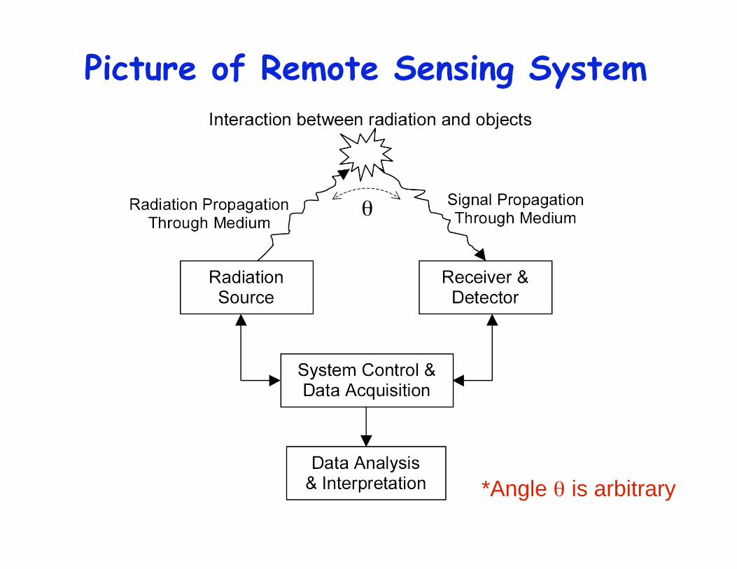
Picture of Remote Sensing System
*Angle is arbitrary
Concept of Remote Sensing During the interaction, radiation properties are
modified by the object, therefore, containing theinformation of the object. Through recording andanalyzing the modifications of the radiation, theobject information can be retrieved.
An example: the wind measurements
= 2 1 = (r k 1•
r v 1
r k 2 •
r v 2)
Radiation
Detector
r k 1
r k 2
r v 1
r v 2
particles
Radiation isscattered
by particles
Modification: Doppler Shift
Content of Remote Sensing Remote Sensing contains many aspects, not only the
instrumentation and data acquisition, but also the dataprocessing, analysis, and interpretation.
data processing, information retrieval, error analysis
4. GeoScience Study:
data analysis and interpretation.
Content of Remote SensingData
Acquisition
DataProcessing
DataInterpretation
InformationProduct
PrincipleInvestigation
InstrumentDesign
InstrumentDevelopment
InstrumentTest/Calibration
Measurementsand/or
Observations
Remote Sensing Applications Atmospheric Research
Environmental Research and Industry
Space Research and Industry
Solid-Earth Research and Industry
Ocean Research and Industry
Space Exploration
Astronomy Exploration
Industry, Defense, Military
and many more …
Advantages of Remote Sensing
Reaching inaccessible/difficult regions to makereliable measurements
Avoiding hazardous to reach regions
Fast and inexpensive probing of large volumes
Minimal disturbance of measured processes
…
Classification of Remote Sensing
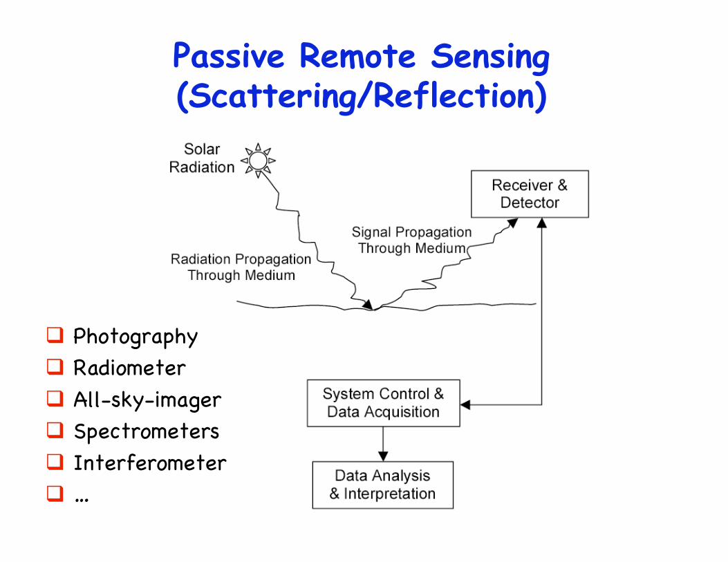
Passive Remote Sensing: no self-generated radiation is used in the sensing,but using naturally occurring radiation, suchas sunlight or nightglow emission.
Active Remote Sensing: self-generatedradiation sources are used, such as laserlight, radio- and micro-wave, acoustic wave.
Depending on whether a human-generatedradiation source is used in the sensing process
Classification of Remote Sensing
Optical Remote Sensing: probing anddetecting in optical frequency range
Radio Remote Sensing: probing anddetecting in radio and microwave frequency
Acoustic Remote Sensing: probing anddetecting in acoustic frequency range
All include passive and active remote sensing
Depending on the frequency of radiation used inthe probing and detection
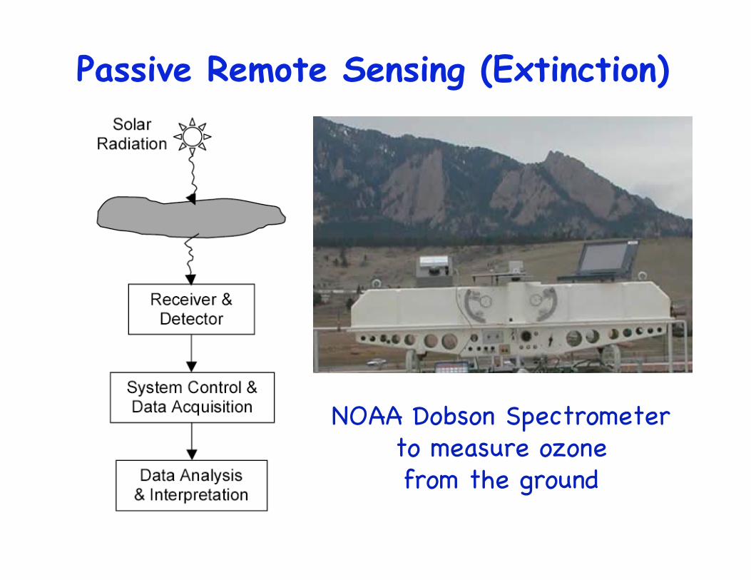
NOAA Dobson Spectrometerto measure ozonefrom the ground
Dobson Spectrometer (Extinction)
305 nmStrong Absorption
by ozone
325 nmNo Absorption
by ozone
D. S.
R =I325 I305
I305NO3
O3
The ratio between the two lightintensity is a measure of the totalamount of ozone in the light pathfrom the sun to the observing D.S.
Active Remote Sensing
Active Remote SensingFrom Biological Sonar
To SODAR, RADAR, LIDAR
Based on the Same Principle Radiation is transmitted into environment,backscattered by the objects, and then
detected and analyzed by receivers.
SODAR: Sound Detection And Ranging
RADAR: Radiowave Detection And Ranging
LIDAR: Light Detection And Ranging
How does sodar,radar & lidar work?
Transmitter
Receiver R=V t /2
Where t = t1 - t0, i.e., the time of flight
For radar and lidar, V = c, i.e., the light speed
For sodar, V = the sound speed
t0
t1
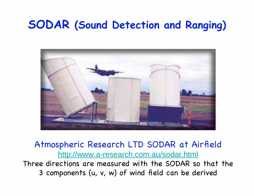
SODAR (Sound Detection and Ranging)
Desert Research Institute Doppler SODARhttp://www.dri.edu/Projects/Radar/SODAR/
SODAR (Sound Detection and Ranging)
Atmospheric Research LTD SODAR at Airfieldhttp://www.a-research.com.au/sodar.html
Three directions are measured with the SODAR so that the3 components (u, v, w) of wind field can be derived
SODAR Sound wave or acoustic wave is used in the
sensing. This is real mechanical sound wave, i.e.,longitudinal wave, produced by compressing theatmosphere medium. It is not electromagnetic waveat the sound frequency.
The speed used is the speed of sound (340 m/s).
SODAR works better in the air with moremoisture, rather than the dry air. Usually, it goesup to several hundred meters.
SODAR & SONAR SONAR is Sound Navigation Ranging, used under
water, for the ocean detection, like submarine.
SODAR is usually referred to the sounddetection and ranging in the atmosphere. We use itfor general description of SODAR and SONAR.
SONAR works better under water.
RADAR (Radiowave Detection and Ranging)
Electromagnetic waves in the radio frequencyand microwave frequency range are used in thesensing.
The speed used is the light speed (3 108 m/s).
Recommend --ASEN5245. Radar and Remote Sensing
Taught by Prof. Jeff Thayer
NEXRAD Weather Radar System
South Pole Meteor Scatter Radar
Arecibo Incoherent Scatter Radar
Millstone Incoherent Scatter Radar
Jicamarca Incoherent Scatter Radar
Sondrestrom Incoherent Scatter Radar
AMISR - Advanced ModularIncoherent Scatter Radar
Resolute Bay, Canada and Poker Flat, Alaska
Incoherent Scatter RADAR Map
LIDAR (Light Detection and Ranging)
Electromagnetic waves in the optical frequencyrange are used in the sensing.
More commonly, we say light, especially laserlight, is used in the sensing.
The speed used is the light speed (3 108 m/s).
Light Detection And Ranging (LIDAR)
Mie Scattering From Aerosols
Rayleigh Scattering From Air Molecules
ResonantFluorescence
From Metal Atoms
RayleighScattering
Na Fluorescence
30 km
75 km
120 km
Ground
Range Determined From Time-of-Flight: R = c · t / 2
Hardware of SODAR,RADAR, LIDAR
LightElectromagneticWaves
AcousticEnergy
TransmittedEnergy
Opticaltelescope +
Photondetector
AntennaHeadphoneReceiver
LaserElectronic circuit+ Antenna
Electric-acousticconverter
Transmitter
LIDARRADARSODAR
Comparison of Remote Sensing
SODARSound
GPS Radio
OccultationRADARPassive
Radiometer
Passive
RadiometerRadio
DIALLIDARDobson
Spectrometer
HALOE
occultation
Airglow Imager
Bomem
Spectrometer
Fabry-Perot
Interferometer
Aerial / Space
Photography
UARS satellite
TIMED/SABER
AIM satellite
Optical
ExtinctionScatteringExtinctionEmissionScattering
ActivePassive
Advantages of Active Remote Sensing
independence of natural radiation sourcesand time of day;
reduced sensitivity to background light; high intensity of stimulating signal; control of stimulating signal; knowledge of stimulating signal; capable of line integral, line average, line
profile, 2-D coverage, 3-D coverage, 3-Dspectrum – all as a function of time


![[REMOTE SENSING] 3-PM Remote Sensing](https://static.documents.pub/doc/80x56/61f2bbb282fa78206228d9e2/remote-sensing-3-pm-remote-sensing.jpg)


