Center for Hydrometeorology and Remote Sensing, University of California, Irvine Ensuring Water in a Changing World The Abdus Salam ICTP Summer School on: Climate Impact Modeling for Developing Countries: Water, Agriculture & Health Trieste, Italy: Sept. 5 th – 16 th 2011 Lecture I Hydrological modeling requirements for Water Resources Applications - Model Issues Soroosh Sorooshian Center for Hydrometeorology and Remote Sensing University of California Irvine
Transcript
Center for Hydrometeorology and Remote Sensing, University of California, Irvine
Ensuring Water in a Changing World
The Abdus Salam ICTP Summer School on: Climate Impact Modeling for Developing Countries: Water, Agriculture & Health Trieste, Italy: Sept. 5th – 16th 2011
Lecture I Hydrological modeling requirements for Water
Resources Applications - Model Issues Soroosh Sorooshian
Center for Hydrometeorology and Remote Sensing University of California Irvine
Center for Hydrometeorology and Remote Sensing, University of California, Irvine
University of California Irvine (UCI) and Arizona (UA)
and many more …
CHRS & Affiliates: A truly International Team
Center for Hydrometeorology and Remote Sensing, University of California, Irvine
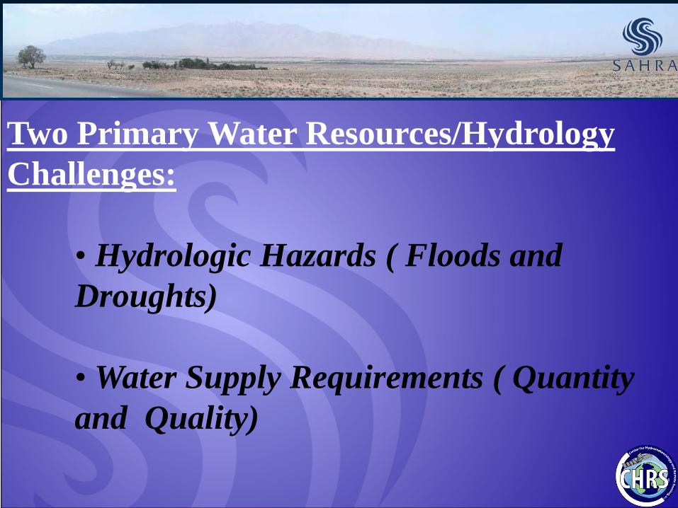
Two Primary Water Resources/Hydrology Challenges:
• Hydrologic Hazards ( Floods and Droughts) • Water Supply Requirements ( Quantity and Quality)
Center for Hydrometeorology and Remote Sensing, University of California, Irvine
Hydrologic Forecasting Needs: Flash Floods
Center for Hydrometeorology and Remote Sensing, University of California, Irvine
Droughts: The Other hydrologic Extreme
Center for Hydrometeorology and Remote Sensing, University of California, Irvine
Two Primary Water Resources/Hydrology Challenges:
• Hydrologic Hazards ( Floods and Droughts) • Water Supply Requirements ( Quantity and Quality)
Center for Hydrometeorology and Remote Sensing, University of California, Irvine
Projected Regions of Water Stress
Center for Hydrometeorology and Remote Sensing, University of California, Irvine
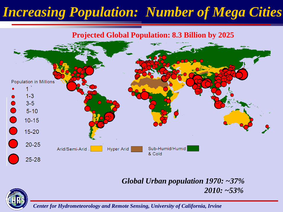
Increasing Population: Number of Mega Cities
Global Urban population 1970: ~37% 2010: ~53%
Projected Global Population: 8.3 Billion by 2025
Center for Hydrometeorology and Remote Sensing, University of California, Irvine
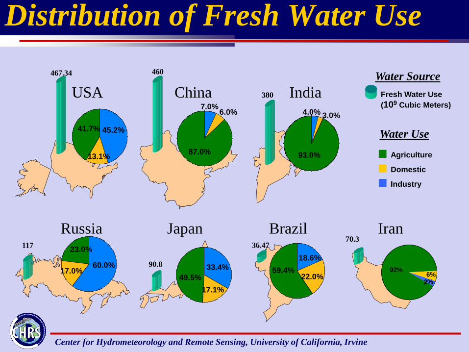
Distribution of Fresh Water Use
90.8 33.4%
17.1% 49.5%
460
7.0% 6.0%
87.0%
36.47 18.6%
22.0% 59.4%
117
60.0% 17.0%
23.0%
467.34
45.2%
13.1%
41.7%
380
4.0% 3.0%
93.0% Agriculture
Industry
Domestic
Fresh Water Use (109 Cubic Meters)
Water Source
Water Use
USA China India
Russia Japan Brazil
92% 6%
2%
70.3 Iran
Center for Hydrometeorology and Remote Sensing, University of California, Irvine
Primary Solution To Meet Hydrologic Extremes and Water Resources Needs
Engineering Approach: Control, Store, Pump and Transfer
Center for Hydrometeorology and Remote Sensing, University of California, Irvine
Hoover Dam
A Century of Water Resources Development: Engineering success
Central Arizona Project Aqueduct
Center for Hydrometeorology and Remote Sensing, University of California, Irvine
1800 1900
1950
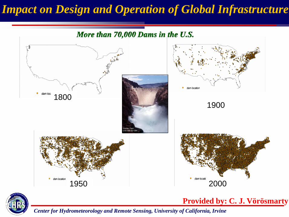
Impact on Design and Operation of Global Infrastructure
2000
More than 70,000 Dams in the U.S.
Provided by: C. J. Vörösmarty
Center for Hydrometeorology and Remote Sensing, University of California, Irvine
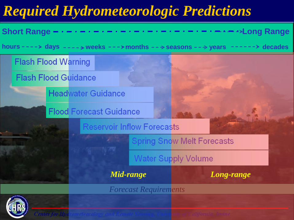
Short Range Long Range
hours days weeks months seasons years decades
Required Hydrometeorologic Predictions
Forecast Requirements
Short-range Mid-range Long-range
Center for Hydrometeorology and Remote Sensing, University of California, Irvine
Short Range Long Range
hours days weeks months seasons years decades
Required Hydrometeorologic Predictions
Forecast Requirements
Mid-range Long-range
Center for Hydrometeorology and Remote Sensing, University of California, Irvine
A Key Consideration:
The Link Between Climate and Hydrology
Center for Hydrometeorology and Remote Sensing, University of California, Irvine
Global Warming And Hydrologic Cycle Connection
Heating
Temperature Evaporation
Water Holding Capacity
Atmospheric Moisture
Temperature oF Satu
rate
d Va
por P
ress
ure
t t+20
Green House Effect
Rain Intensity
Drought Flood
Flood Drought
Created by: Gi-Hyeon Park
Center for Hydrometeorology and Remote Sensing, University of California, Irvine
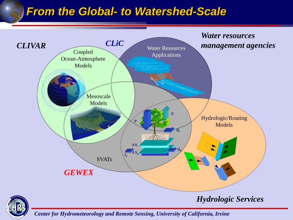
P
E
Qs
∆ Ss
∆ Sg Qg
Ig
Coupled Ocean-Atmosphere
Models
Mesoscale Models
SVATs
Hydrologic/Routing Models
Water Resources Applications
GEWEX
CLIVAR
Hydrologic Services
Water resources management agencies
From the Global- to Watershed-Scale
CLiC
Center for Hydrometeorology and Remote Sensing, University of California, Irvine
Hydroclimate Science and Hydrologic/Water Resources Engineering
Hydrologic/Hydraulic Routing, Water Resources Models
SCIENCE ENGINEERING
Hydrologic/Hydraulic and Water Resources Engineering
Hydroclimate Science
P
E
Qs
∆ Ss
∆ Sg Qg
Ig
Mesoscale Models
SVATs
GCMs
Center for Hydrometeorology and Remote Sensing, University of California, Irvine
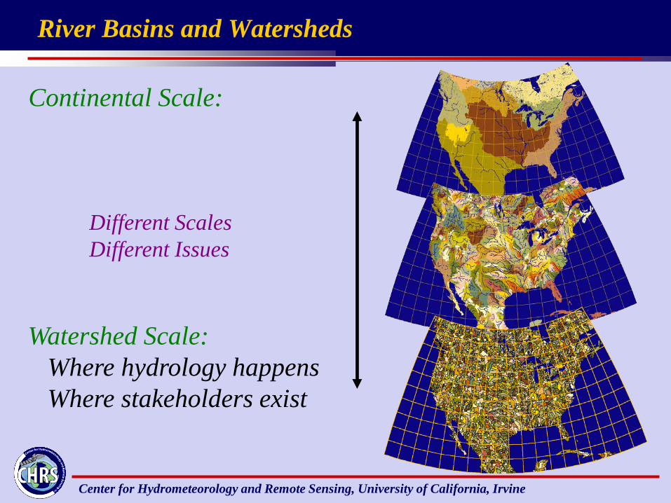
River Basins and Watersheds
Continental Scale:
Watershed Scale: Where hydrology happens Where stakeholders exist
Different Scales Different Issues
Center for Hydrometeorology and Remote Sensing, University of California, Irvine
Short Range Long Range
hours days weeks months seasons years decades
Climate-Scale approaches to addressing hydrologic extremes
Forecast Requirements
Long-range
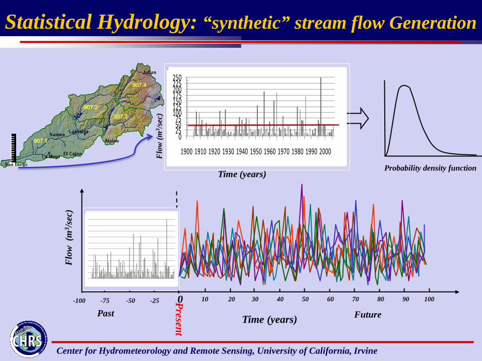
•Use of climate models: down-scaling and ensemble schemes •Traditional statistical hydrology methods:
Center for Hydrometeorology and Remote Sensing, University of California, Irvine
Prec
ipita
tion
p
redi
ctio
n
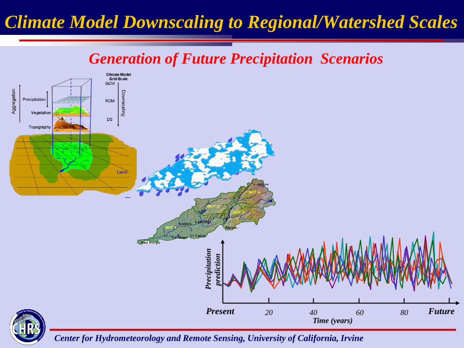
Time (years) Present Future 20 40 60 80
Climate Model Downscaling to Regional/Watershed Scales
Generation of Future Precipitation Scenarios
Center for Hydrometeorology and Remote Sensing, University of California, Irvine
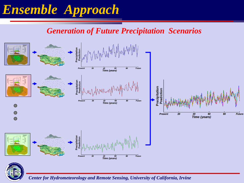
Ensemble Approach Generation of Future Precipitation Scenarios
Center for Hydrometeorology and Remote Sensing, University of California, Irvine
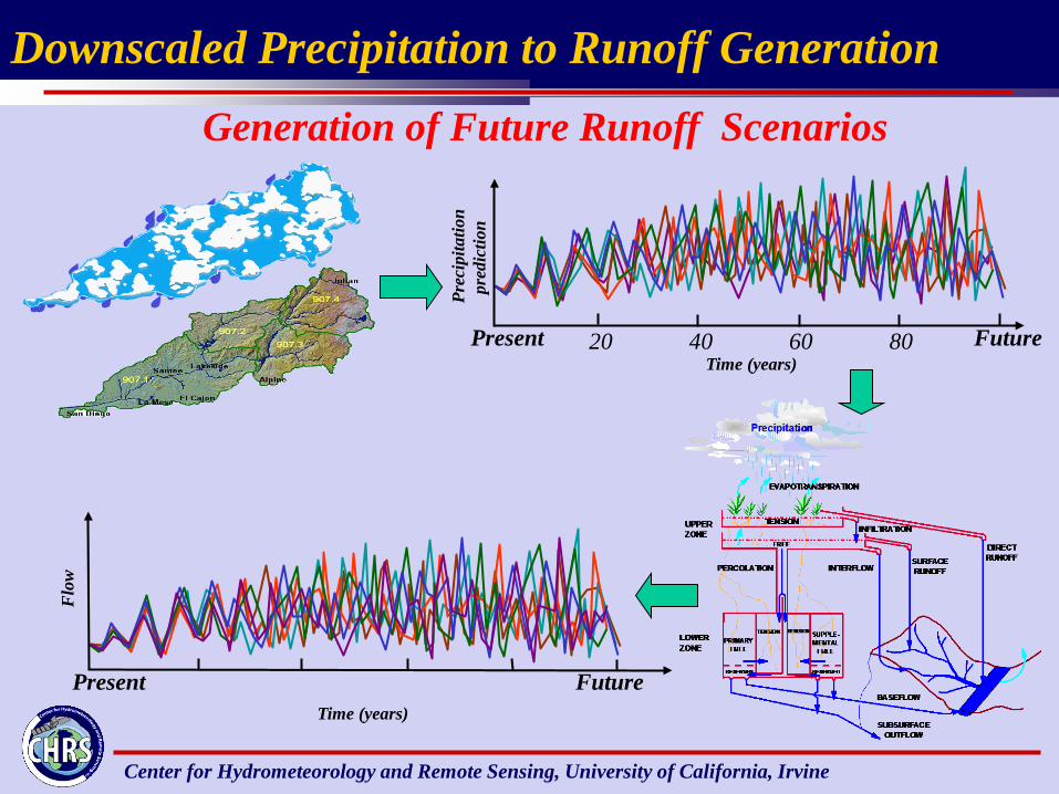
Present Future 20 40 60 80 Time (years)
Prec
ipita
tion
p
redi
ctio
n
Present Future Time (years)
Flo
w
Generation of Future Runoff Scenarios
Downscaled Precipitation to Runoff Generation
Center for Hydrometeorology and Remote Sensing, University of California, Irvine
1 0.5 0.2 0.1 0.05 0.02 0.01 0.005 0.002 0.001 Probability of Exceedance