5
Gyro-Stabilized Camera Mount Leica PAV30

Gyro-Stabilized Camera Mount
Leica PAV30

Leica PAV30
2
High Quality Aerial PhotographyThe Leica PAV30 gyro-stabilized mount has been developed by Leica Geosystems’ aerialcamera engineers for compensation of angular aircraft movements to improve the qualityof aerial photography and survey flight efficiency.
The PAV30 replaces existing mounts and is fully integrated into the Leica Geosystemscamera concept. No aircraft modification is required.
The PAV30 continues Leica Geosystems’ tradition of solutions for precise information fromimagery by people who make a difference. Leica Geosystems is committed to excellencein design, combining high performance with long-term reliability.
User Benefits• Perfectly integrated system
• Superior image quality
• Automatic vertical photography
• Less stress on the flight crew
• More efficient survey flights
• Extended flying hours
• Direct interchange with existing mounts
• Standard output interface for recording attitude angles
The Leica PAV30 gyro-stabilized mountis the perfect complement to the LeicaRC30 aerial camera system.
RC30
PAV30

Smearing in the image plane due to pitch or roll movements for exposure time 1/200sec.
Turbulent Stabilized
~ 10° / s ~ 0.3° / s
center corner center corner
SAG f = 88mm 77µ 222µ 2µ 7µ
UAG f = 153mm 134µ 209µ 4µ 6µ
NAT f = 303mm 264µ 299µ 8µ 9µ
Optional Interface to Aircraft Navigation SystemsThe PAV30 is unique in its ability to accept drift correction angles from an aircraftnavigation system. Drift corrections are received via Leica ASCOT accepting ARINC 429signals. ASCOT is sold separately — please visit www.gis.leica-geosystems.com for moreinformation.
Direct Interchange with Existing MountsWith the PAV30 mount, no costly aircraft modification is required. The PAV30 fits directly inthe camera hole designed for PAV11, PAV11-A and PAV20 camera mounts.
Turbulent Stabilized
~ 10° / s ~ 0.3° / s
center corner center corner
0µ 132µ 0µ 8µ
3
Features
Superior Image QualityThe PAV30 automatically corrects for angular motions, even in turbulent flight conditions.The outcome is a far better image quality
Automatic Vertical PhotographyWith the PAV30 gyro-stabilized mount, the aspirations of camera operators andphotogrammetrists have become reality.
• Perfect vertical photography, even in turbulent conditions
• Automatically stored verticality means reduced operator stress
• Simplified aerotriangulation
Extended Flying HoursCombining an FMC aerial camera with the PAV30 gyro-stabilized mount permits the use oflonger exposure times, as required under low light conditions or when using high resolution films.
Efficient FlightsRelieves the camera operator of tedious tasks such as:
• Initialization
• Leveling along flight lines
• Coninuous drift adjustment
Angular Motion Compensation
Smearing in the image plane due to drift movements forexposure time 1/200sec.
All lens cones(independentof focal length)
WITH WITHOUT
Leica PAV30 PosOp
4
12
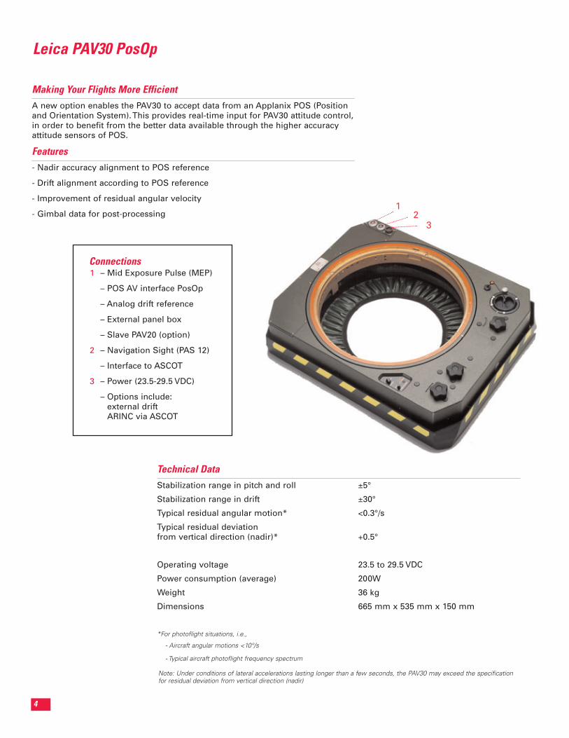
Technical DataStabilization range in pitch and roll ±5°
Stabilization range in drift ±30°
Typical residual angular motion* <0.3°/s
Typical residual deviationfrom vertical direction (nadir)* +0.5°
Operating voltage 23.5 to 29.5 VDC
Power consumption (average) 200W
Weight 36 kg
Dimensions 665 mm x 535 mm x 150 mm
*For photoflight situations, i.e.,
- Aircraft angular motions <10°/s
- Typical aircraft photoflight frequency spectrum
– Mid Exposure Pulse (MEP)
– POS AV interface PosOp
– Analog drift reference
– External panel box
– Slave PAV20 (option)
– Navigation Sight (PAS 12)
– Interface to ASCOT
– Power (23.5-29.5 VDC)
– Options include: external drift ARINC via ASCOT
1
2
3
Connections
3
Note: Under conditions of lateral accelerations lasting longer than a few seconds, the PAV30 may exceed the specificationfor residual deviation from vertical direction (nadir)
Making Your Flights More EfficientA new option enables the PAV30 to accept data from an Applanix POS (Positionand Orientation System). This provides real-time input for PAV30 attitude control,in order to benefit from the better data available through the higher accuracyattitude sensors of POS.
Features- Nadir accuracy alignment to POS reference
- Drift alignment according to POS reference
- Improvement of residual angular velocity
- Gimbal data for post-processing

Copyright © 2001-2002 Leica Geosystems. All rights reserved. Other brand names and trademarks are properties of
their respective owners. Images courtesy of Skyview Aerial Photo, Inc., the City of San Diego and Control/Photo,
U.S.A. Part No. PAV30 cc 10/02
Leica GeosystemsGIS & Mapping Division
2801 Buford HighwayAtlanta, Georgia 30329, USA
Phone +1 404 248 9000 Fax +1 404 248 9400
gis.leica-geosystems.com
Information subject to change without notice.


