13
AUGUST 2016 North Carolina Division of Coastal Management North Carolina Division of Marine Fisheries LIVING SHORELINE STRATEGY ACCOMPLISHMENTS REPORT
AUGUST 2016
North Carolina Division of Coastal Management
North Carolina Division of Marine Fisheries
LIVING SHORELINE STRATEGY
ACCOMPLISHMENTS REPORT

1
Table of Contents
INTRODUCTION ............................................................................................................................................... 2
PROGRESS ON SHORT-TERM ACTIONS ............................................................................................................. 3
1. GENERAL PERMIT ................................................................................................................................................ 3 2. PROPERTY OWNER OUTREACH ............................................................................................................................... 3 3. REPRINT WEIGHING YOUR OPTIONS GUIDE ............................................................................................................... 4 4. PROPERTY OWNER, CONTRACTOR, LANDSCAPING PROFESSIONAL, AND REALTOR TRAINING ............................................. 4 5. INFORMATIONAL SIGNAGE .................................................................................................................................... 6 6. LEVERAGE GRANT RESOURCES ............................................................................................................................... 6
PROGRESS ON LONG-TERM ACTIONS .............................................................................................................. 8
1. DATA COLLECTION ............................................................................................................................................... 8 2. MARSH SILLS RESEARCH ........................................................................................................................................ 9
a. Re-evaluation of CICEET sampling sites……………………………………………………………………………………………..9 b. Monitor the Rachel Carson Reserve demonstration site.......................................................................... 9 c. Conduct sill pre- and post-storm monitoring ............................................................................................ 9
3. CERTIFICATION PROGRAM FOR CONTRACTORS........................................................................................................ 10 4. PARTNER WITH MILITARY AND OTHER PUBLIC INSTITUTIONS ..................................................................................... 11
CONCLUSION ................................................................................................................................................. 11
2
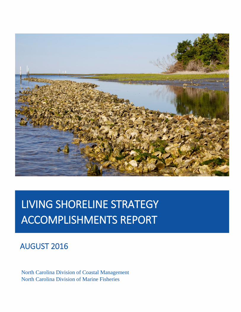
Introduction
In February 2014, the North Carolina Division of Coastal Management (DCM) and the North Carolina
Division of Marine Fisheries (DMF) published the Living Shoreline Strategy to address outreach, public
awareness, research, financial incentives, and short and long-term implementation actions needed to
advance the use of living shorelines in the state. DCM and its North Carolina Coastal Reserve and
National Estuarine Research Reserve (Reserve), and DMF are working with partners to map estuarine
shorelines, evaluate impacts of various stabilization methods on marshes and the ecosystem services
they provide, assess the resilience of shoreline stabilization methods to large storms, and examine how
the data generated from these projects may be used to inform estuarine shoreline stabilization policies
for the state. These projects, which have provided significant information about estuarine shorelines
and stabilization methodologies, are summarized in the Living Shoreline Strategy.
This Living Shoreline Strategy Accomplishments Report is designed to serve as a supplementary
document to the Living Shoreline Strategy. This report includes information about progress made on
short and long-term actions identified in the Living Shoreline Strategy from February 2014 through
December 2015.
Living Shoreline Strategy https://deq.nc.gov/about/divisions/coastal-management/coastal-management-estuarine-shorelines/stabilization
Short-Term Actions
General Permit
Property Owner Outreach
Reprint Weighing Your Options Booklet
Property Owner, Contractor, Landscaping, Professional, and Realtor Training
Informational Signage
Leverage Grant Resources
Long-Term Actions
Data Collection, GIS Analysis, and Product Development
Marsh Sills Research
Certification Program for Contractors
Partner with the Military and other Public Institutions

3
Progress on Short-Term Actions
1. General Permit
While application of the riprap marsh sill General Permit (15A NCAC 7H .2700) is currently somewhat
limited, DCM will continue to coordinate with the U.S. Army Corps of Engineers (USACE) and other
federal and state agencies to review the specific conditions of the state General Permit and identify
opportunities to further reduce permit processing timelines at the state and federal levels (Living
Shoreline Strategy 2014).
Proposed rule amendments for the General Permit for construction of riprap sills (15 NCAC 7H .2700)
are ready for adoption by the N.C. Coastal Resources Commission and include removing DMF and N.C.
Division of Water Resources coordination requirements, conditions pertaining to fill for wetland
plantings, and other redundant and unnecessary conditions. The USACE is currently in the process of
developing a Nationwide Permit for Living Shorelines and DCM staff will coordinate with the USACE and
other organizations to identify opportunities to align the riprap sill General Permit with the proposed
USACE Nationwide Permit for efficiency and consistency. Additional rule amendments may be also
proposed as a result of these coordination meetings.
2. Property Owner Outreach
DCM field representatives will continue to distribute information about living shorelines to property
owners, marine contractors, or consultants during site visits if a living shoreline may be appropriate.
DCM will also provide continued training for staff utilizing information from research and other studies
or observations (Living Shoreline Strategy 2014).
DCM field representatives provide information regarding living shorelines to homeowners and
contractors during site visits when appropriate. Field staff are now able to direct property owners to
estuarine shoreline information on the DCM website, which offers various resources for homeowners
concerning estuarine shoreline stabilization techniques, including living shorelines. DCM staff have also
attended and presented at Reserve Coastal Training Program (CTP) living shoreline workshops to stay
up-to-date on the latest research and regulatory updates. Information presented during the CTP living
shoreline workshops is detailed in Short-Term Action 4.
The DCM website is updated routinely to include the latest living shoreline research and regulatory
information, as well as various estuarine shoreline stabilization options and characteristics dictating
what methods work best based on shoreline features. In addition, property owners are informed
through social media posts on the Reserve Facebook and Twitter pages. Posts include information about
the benefits of living shorelines and links to additional resources, like the Weighing Your Options guide.
Updates on the latest living shoreline research by DCM and the Reserve is promoted through the
Reserve website, newsletter, and social media pages, and the DCM CAMAgram quarterly newsletter.
In an effort to ensure that DCM staff are kept informed of new living shoreline research and educational resources, the CTP will organize and facilitate a DCM staff training, scheduled for fall 2016.
4
Estuarine shoreline information is located on DCM website at:
http://deq.nc.gov/about/divisions/coastal-management/coastal-management-estuarine-shorelines
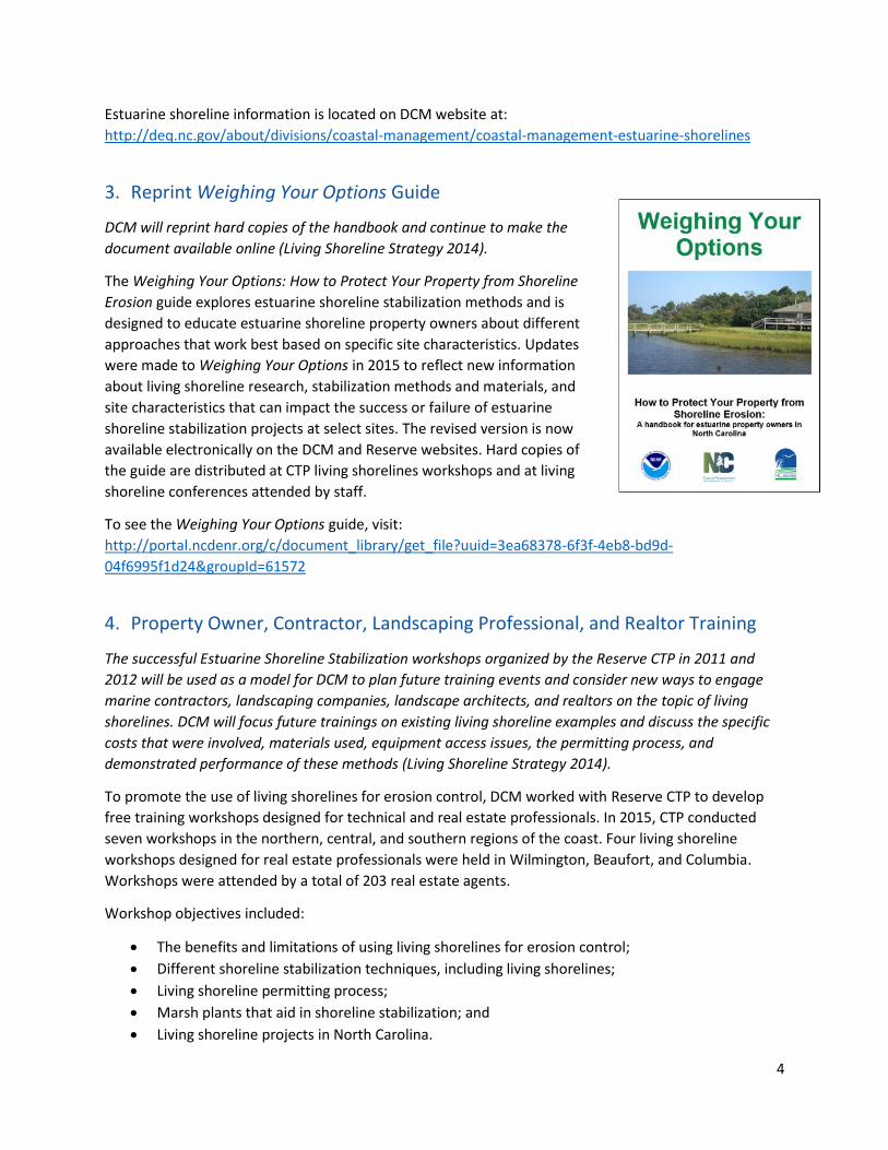
3. Reprint Weighing Your Options Guide
DCM will reprint hard copies of the handbook and continue to make the
document available online (Living Shoreline Strategy 2014).
The Weighing Your Options: How to Protect Your Property from Shoreline
Erosion guide explores estuarine shoreline stabilization methods and is
designed to educate estuarine shoreline property owners about different
approaches that work best based on specific site characteristics. Updates
were made to Weighing Your Options in 2015 to reflect new information
about living shoreline research, stabilization methods and materials, and
site characteristics that can impact the success or failure of estuarine
shoreline stabilization projects at select sites. The revised version is now
available electronically on the DCM and Reserve websites. Hard copies of
the guide are distributed at CTP living shorelines workshops and at living
shoreline conferences attended by staff.
To see the Weighing Your Options guide, visit:
http://portal.ncdenr.org/c/document_library/get_file?uuid=3ea68378-6f3f-4eb8-bd9d-
04f6995f1d24&groupId=61572
4. Property Owner, Contractor, Landscaping Professional, and Realtor Training
The successful Estuarine Shoreline Stabilization workshops organized by the Reserve CTP in 2011 and
2012 will be used as a model for DCM to plan future training events and consider new ways to engage
marine contractors, landscaping companies, landscape architects, and realtors on the topic of living
shorelines. DCM will focus future trainings on existing living shoreline examples and discuss the specific
costs that were involved, materials used, equipment access issues, the permitting process, and
demonstrated performance of these methods (Living Shoreline Strategy 2014).
To promote the use of living shorelines for erosion control, DCM worked with Reserve CTP to develop
free training workshops designed for technical and real estate professionals. In 2015, CTP conducted
seven workshops in the northern, central, and southern regions of the coast. Four living shoreline
workshops designed for real estate professionals were held in Wilmington, Beaufort, and Columbia.
Workshops were attended by a total of 203 real estate agents.
Workshop objectives included:
The benefits and limitations of using living shorelines for erosion control;
Different shoreline stabilization techniques, including living shorelines;
Living shoreline permitting process;
Marsh plants that aid in shoreline stabilization; and
Living shoreline projects in North Carolina.

5
Eighty-five percent of real estate workshop participants stated that they intend to apply the knowledge
and skills gained through the workshops in their work or future decisions.
“I learned the benefits of using a living shoreline, the permits that are needed, and also the costs
involved with installing a living shoreline. I'm sure I'll be able to help my clients who are looking
at waterfront property in the future with the knowledge I have gained from this workshop.”
- Testimonial from a real estate agent who attended the Beaufort workshop on May 5, 2015.
Three living shoreline technical workshops were offered to decision-makers in Wilmington, Beaufort,
and Columbia. A total of 162 people participated in these workshops, including landscape architects,
engineers, and marine contractors.
Workshop objectives included:
The benefits and limitations of using living shorelines for erosion control;
Living shorelines design standards based on site conditions;
Living shoreline projects in North Carolina and beyond;
Best practices for living shoreline construction and use of marsh plants and oyster shell;
The permitting process for living shorelines; and
Business perspectives of building living shorelines.
Eighty percent of the technical workshop participants stated that they intend to apply the knowledge
and skills gained through the workshops in their work or future decisions.
“I benefited the most by listening to the science behind why living shorelines are effective, and
also from having the state regulatory folks speak about the current status of permits and what is
being done to speed up permitting.”
- Testimonial from a participant at the Columbia workshop on December 2, 2015.
The workshop material was presented by representatives from DCM, N.C. Coastal Federation, N.C. Sea
Grant, NOAA’s National Centers for Coastal Ocean Science, and other experts in their respective fields.
As an incentive for participants to attend these workshops, continuing education credits were provided
to real estate agents, American Institute of Certified Planners, engineers, landscape architects, and
Certified Floodplain Managers. The Albemarle-Pamlico National Estuary Partnership provided funds for
the Columbia real estate and technical workshops.
DCM contracted with UNC Coastal Studies Institute to record the technical living shoreline workshops in
Beaufort and Columbia. These videos were distributed to the CTP contact list and will be used in future
outreach efforts. Audiences who have yet to attend a workshop are encouraged to watch these
recordings and use them as an educational resource to increase their knowledge of the use of living
shorelines for erosion control. Recordings of living shoreline workshop presentations are available on the
Reserve YouTube page at:
https://www.youtube.com/playlist?list=PLGoCDUDTs3xXzC3BqywVKlx9KY4aSkIMZ
Increased engagement of marine contractors is important for promoting the adoption of living
shorelines by property owners, as they tend to be the first contacted by property owners interested in
stabilizing their shoreline. This audience has been underrepresented at past outreach and training
activities. DCM will edit existing workshop recordings to a 45-minute or less video for use at future
6
events designed specifically for marine contractors.
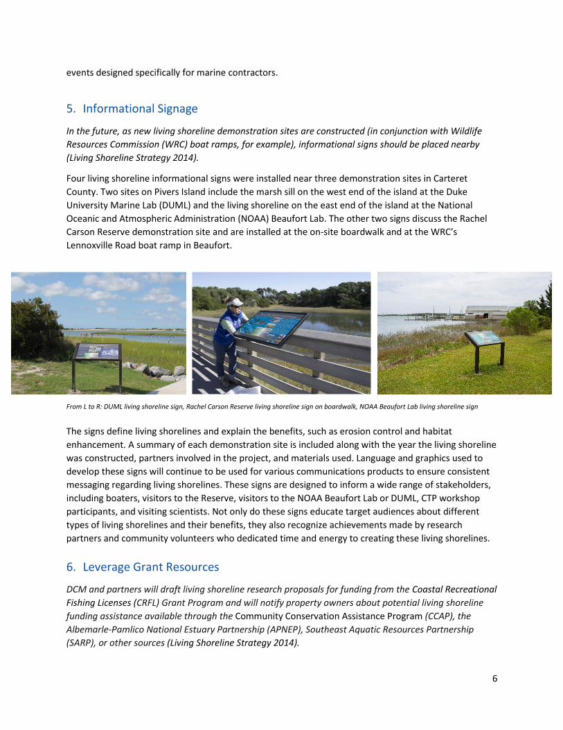
5. Informational Signage
In the future, as new living shoreline demonstration sites are constructed (in conjunction with Wildlife
Resources Commission (WRC) boat ramps, for example), informational signs should be placed nearby
(Living Shoreline Strategy 2014).
Four living shoreline informational signs were installed near three demonstration sites in Carteret
County. Two sites on Pivers Island include the marsh sill on the west end of the island at the Duke
University Marine Lab (DUML) and the living shoreline on the east end of the island at the National
Oceanic and Atmospheric Administration (NOAA) Beaufort Lab. The other two signs discuss the Rachel
Carson Reserve demonstration site and are installed at the on-site boardwalk and at the WRC’s
Lennoxville Road boat ramp in Beaufort.
From L to R: DUML living shoreline sign, Rachel Carson Reserve living shoreline sign on boardwalk, NOAA Beaufort Lab living shoreline sign
The signs define living shorelines and explain the benefits, such as erosion control and habitat
enhancement. A summary of each demonstration site is included along with the year the living shoreline
was constructed, partners involved in the project, and materials used. Language and graphics used to
develop these signs will continue to be used for various communications products to ensure consistent
messaging regarding living shorelines. These signs are designed to inform a wide range of stakeholders,
including boaters, visitors to the Reserve, visitors to the NOAA Beaufort Lab or DUML, CTP workshop
participants, and visiting scientists. Not only do these signs educate target audiences about different
types of living shorelines and their benefits, they also recognize achievements made by research
partners and community volunteers who dedicated time and energy to creating these living shorelines.
6. Leverage Grant Resources
DCM and partners will draft living shoreline research proposals for funding from the Coastal Recreational
Fishing Licenses (CRFL) Grant Program and will notify property owners about potential living shoreline
funding assistance available through the Community Conservation Assistance Program (CCAP), the
Albemarle-Pamlico National Estuary Partnership (APNEP), Southeast Aquatic Resources Partnership
(SARP), or other sources (Living Shoreline Strategy 2014).

7
The Community Conservation Assistance Program, or CCAP, is a voluntary, incentive-based program
designed to improve water quality through the installation of various best management practices
(BMPs) on urban, suburban and rural lands not directly involved with agriculture production.
Streambank and shoreline protection is a category of BMP according to CCAP standards, thus allowing
landowners the opportunity to apply for CCAP funding if they plan to create a living shoreline. Eligible
landowners may include homeowners, businesses, schools, parks and publicly owned lands. Information
about CCAP funding assistance is available on the DCM website and is also provided to living shoreline
workshop participants. Updates regarding funding assistance will continue to be added to the DCM
website as resources become available.
Each year DMF uses a portion of revenue from sales of N.C. Coastal Recreational Fishing Licenses (CRFL) to fund projects that are designed to manage, protect, restore, develop, cultivate and enhance the marine resources of the state. A priority need listed in the CRFL Request for Proposals under habitat restoration is: “Encourage public/private partnerships to create living shorelines in visible locations to promote the shoreline stabilization technique that provides fish habitat.” Local or state government can apply for funding to accomplish this.
In 2013, CRFL grants were awarded to two projects proposed by partners at UNC-Chapel Hill’s Institute of Marine Sciences (UNC IMS), one involving a survey to help target outreach regarding living shorelines, the other to produce educational materials and videos on fish use of habitat structure, such as that found in living shorelines. These include:
1. “Incorporating Stakeholder Knowledge of the Status and Value of Coastal Habitats” ‐ $30,365 This is a multi‐year grant to use a series of socioeconomic surveys of N.C. residents to collect ecologically relevant data on the perceived health of and threats to coastal habitats and fisheries.
2. “There’s Something Fishy about Salt Marsh, Oyster Reef, and Seagrass Habitat” ‐ $50,121 This is a multi‐year grant to target habitat education strategies that are important to improve the public’s understanding of the fish-habitat relationship and foster environmental stewardship.
In 2015, CRFL grants were awarded to two living shoreline-related research projects proposed by
partners at UNC IMS. These include:
1. “Quantifying Fish Enhancement and Erosion Protection Provided by Marsh Sills: A Living
Shoreline Alternative to Bulkheads and Revetments” - $89,908
This is a two-year grant to provide a comprehensive evaluation of the recreational fish
habitat services and erosion protection provided by marsh sills in comparison to
revetments, bulkheads, and naturally occurring marshes.
2. “Enhancing the Quality of Fish Habitat and Quantity of Oysters by Refining Reef-Restoration
Techniques” - $106,937
This is a three-year grant to provide important guidelines for intertidal and subtidal reef
restoration that will maximize the quality of the fish habitat.

8
Progress on Long-Term Actions
1. Data Collection, GIS Analysis, and Product Development
DCM will continue analyzing its existing estuarine shoreline mapping inventory and will consider adding
such data attributes as bank height, nearshore depth, fetch, and locations of buildings. DCM will also
continue to improve online access to estuarine shoreline data and explore development of a geospatial
model that matches appropriate shoreline stabilization methods with shoreline type (Living Shoreline
Strategy 2014).
The estuarine shoreline mapping program (ESMP) analysis report was updated based on 2012 imagery
to delineate the shoreline and structures. The imagery is high resolution 6‐inch pixel width, true color
orthophotographs. This imagery provided a snapshot of the entire coast within the same year and
yielded the most accurate inventory of shoreline type and structures to date. Additional updates in the
latest analysis include refinements to shoreline delineation methodology, polyline structure delineation,
and polygon structure delineation. These refinements increased the accuracy and functionality of the
estuarine shoreline mapping analysis for the 20 coastal counties. Full program reports and analyses are
available at: http://deq.nc.gov/about/divisions/coastal-management/coastal-management-estuarine-
shorelines/stabilization/estuarine-shoreline-mapping-project.
Estuarine shoreline mapped for the coast of North Carolina

9
2. Marsh Sills Research
DCM and N.C. National Estuarine Research Reserve staff will pursue research projects and funding to evaluate storm impacts on marsh sills, the effects of marsh sills on adjacent property, the feasibility of using oyster shell as a construction material for marsh sills, the short and long-term costs of marsh sills compared to other alternatives, and the effectiveness of existing sheetpile sills (Living Shoreline Strategy 2014).
a. Impact of bulkheads on marsh vegetation DCM, Reserve and NOAA staff completed a 5-year monitoring program in 2014 to assess the impact of bulkheads on marsh vegetation. The research team revisited sites that were initially monitored in 2009 as part of the Cooperative Institute for Coastal and Estuarine Environmental Technology-funded project entitled “Sustainable Estuarine Shoreline Stabilization: Research, Education, and Public Policy in North Carolina.” The same monitoring protocols were used to assess change in the amount of marsh vegetation and the elevation of sediment supporting marsh vegetation. The data are being analyzed to evaluate changes among sites from 2009 to 2014. In the future, staff plan to use historical and current aerial imagery to evaluate decadal changes in the width of marshes associated with bulkheads, an important indicator of many marsh ecosystem services.
b. Effectiveness of living shorelines in high-energy environments In May 2015, the oyster sill living shoreline demonstration site at the Rachel Carson Reserve was replanted with 3,000 saltmarsh cordgrass plants with help from 17 volunteers. Reserve staff monitored survival of vegetation along permanent transects at weekly intervals for one month. The Reserve Research Coordinator is continuing to explore long-term monitoring options for the living shoreline demonstration site at the Rachel Carson Reserve.
c. Resilience of sill vs. bulkhead to large storm
events
In addition to comparing fish use and ecosystem services, the 2015 CRFL-funded project “Quantifying
Fish Enhancement and Erosion Protection Provided by Marsh Sills: A Living Shoreline Alternative to
Living shoreline demonstration site at the Rachel Carson Reserve NOAA researcher informs a volunteer about living shorelines during the
planting at the living shoreline demonstration site at the Rachel Carson
Reserve

10
Bulkheads and Revetments” also assessed the effectiveness and durability of sills during storm events.
The study involves investigating the erosion protection provided by marsh sills as compared to
bulkheads during large storm events, such as hurricanes. In 2015, Reserve staff worked with partners at
UNC IMS to survey sills and bulkheads located throughout the state to obtain pre-storm baseline data.
Shoreline condition surveys were taken at
sills, bulkheads, and reference natural
marshes in the northern, central, and
southern regions of the coast. Surveys include
vegetation and elevation data and visual
observations noting landward erosion,
structural damage without breach, breach,
and collapse. The same protocols will be used
following any major storm in the same year.
The results will provide an evaluation of the
erosion protection provided by marsh sills in
comparison to bulkheads, with natural, non-
stabilized marshes serving as a control.
Results will be used to educate coastal
residents of the resilience of different shoreline stabilization techniques to large storms.
The pre-storm protocol will be repeated in 2016 and both years of pre-storm data will be analyzed to
quantify normal inter-annual rates of erosion and change in abundance of marsh vegetation associated
with bulkhead, sills, and natural marshes.
3. Certification Program for Contractors
DCM will work to develop workshops, according to certain standards, that could provide engineering Continuing Education credits to eligible participants as well as certification or other official acknowledgement for attendees (Living Shoreline Strategy 2014). CTP living shoreline workshops offer continuing education credits to real estate agents, American Institute of Certified Planners, engineers, landscape architects, and Certified Floodplain Managers. In an effort to reach more contractors, DCM is considering a certification program for marine contractors and a draft protocol was developed based on feedback from the Living Shoreline Workshop Advisory Committee, feedback sessions at the spring 2015 living shoreline workshops, and analysis of other environmentally-based certification programs. DCM continues to investigate the utility of this program and research legal considerations. Additional efforts to reach marine contractors include the development of a 45-minute video to use at future training events, as described previously in Short-Term Action 4.
UNC IMS and Reserve researchers use a laser level to measure marsh elevation
11
4. Partner with Military and other Public Institutions
DENR will partner with the military and other public institutions along the coast to increase the number
of living shoreline demonstration sites (Living Shoreline Strategy 2014).
No significant progress at this time.
Conclusion
Living shorelines are important for reducing coastal erosion, improving habitat for marine organisms,
and protecting North Carolina’s coastal communities from storms and flooding. DCM and DMF have
accomplished the following activities as part of the Living Shoreline Strategy from February 2014
through December 2015:
Streamlined the riprap sill General Permit;
Improved communications strategies, outreach initiatives, and resources regarding estuarine
shorelines and stabilization options;
Trained 365 professionals through CTP living shoreline workshops;
Installed educational signage and developed templates for future use;
Continued commitment to provide financial incentives to property owners interested in
installing living shorelines;
Enhanced estuarine shoreline mapping inventory; and
Implemented research projects designed to advance understanding of the success of
estuarine shoreline stabilization techniques, impacts to ecosystems, and storm interactions.
Because of the benefits that living shorelines provide and to build on work accomplished to date, DCM
and DMF will continue to promote living shorelines as viable methods for estuarine shoreline
stabilization. Both agencies will work with federal, state, and academic partners to pursue living
shoreline research projects and ensure project results are incorporated into living shoreline design,
construction, permitting, and outreach in North Carolina. Short and long-term actions implemented by
the state will be modified as new research and resources become available. Additionally, the 2016
Coastal Habitat Protection Plan (CHPP) identifies living shorelines as a priority issue and will be a focus
for implementation in the next five years for DCM, DMF, and CHPP partners. CHPP implementation
activities will complement work completed under the Living Shoreline Strategy.
12


