} I 29.74: N 42/ J/ 2 Clemson University llll 3 1604 019 773 730 FROM MARSH TO FARM: THE LANDSCAPE TRANSFORMATION OF COASTAL NEW JERSEY fUBLIC I NT* DEPOSITS ITEM MAi - .«o U.S. Department of the Interior National Park Service Cultural Resources HABS/HAER CLEMSON f£ARY
Transcript
} I 29.74: N 42/ J/
2
Clemson University
llll
3 1604 019 773 730
FROM MARSH TO FARM:
THE LANDSCAPE TRANSFORMATIONOF COASTAL NEW JERSEY
fUBLIC INT*
DEPOSITS ITEM
MAi - .«o
U.S. Department of the Interior
National Park ServiceCultural Resources
HABS/HAER
CLEMSONf£ARY
Digitized by the Internet Archive
in 2012 with funding from
LYRASIS Members and Sloan Foundation
http://archive.org/details/frommarshtofarmlOOsebo
FROM MARSH TO FARM:
THE LANDSCAPE TRANSFORMATIONOF COASTAL NEW JERSEY
By
KIMBERLY R. SEBOLD
Historic American Buildings Survey/Historic American Engineering Record
New Jersey Coastal Heritage Trail
National Park Service
U.S. Department of the Interior
Washington, D.C. 20013-7127
1992
Cover photograph: View of salt-hay harvest, n.d. Gibson's Private Collection.
Library of Congress Cataloging-in-Publ icat ion Data
Sebold, Kimberly R. , 1966-
From marsh to farm : the landscape transformation of coastal New
Jersey / by Kimberly R. Sebold.
p . cm .
Includes bibliographical references.1. Drainage—New Jersey
—
History. 2. Agriculture—New Jersey--History. 3. Reclamation of land—New Jersey—History. I. Title.TC977.N5S43 1992631. 6'2' 09749— dc20 92-28179
CIP
CONTENTS
Chapter Page
ACKNOWLEDGEMENTS v
LIST OF ILLUSTRATIONS vii
1. INTRODUCTION 1
2. THE BIOLOGY OF SALT MARSHES 13
3. BANKING/DIKING PROCEDURES 21
4. ECONOMICS OF LAND RECLAMATION 29
5. SALT-HAY FARMING 41
6. MEADOW COMPANIES 57
7. CRANBERRIES 67
8. CONCLUSION 87
SOURCES CONSULTED 89
ACKNOWLEDGEMENTS
The documentation in this publication was undertaken by the Historic American Buildings Survey
(HABS) in conjunction with the New Jersey Coastal Heritage Trail (NJCHT) as an outgrowth of
Historic Themes and Resources Within the New Jersey Coastal Heritage Trail . Southern New Jersey
and the Delaware Bay: Cape May. Cumberland, and Salem Counties . Work took place during the
winter 1990/spring 1991 at the request of NJCHT Project Director Janet Wolf, through the efforts of
Robert J. Kapsch, chief of HABS/HAER, a division of the National Park Service (NPS). Project
leader was Sara Amy Leach, HABS historian; project historian Kimberly R. Sebold (University of
Delaware) conducted all substantive research and writing. The sources of all illustrations are so
identified. The NJCHT in its entirety falls under the jurisdiction of the NPS-North Atlantic Regional
Office, Gerald D. Patton, director.
Special thanks go to: Sergeant First Class Chuck Liber, Staff Sergeant Arlin Bachman, Sergeant
Chester Riland, Sergeant Tom Pennal, and officers Mike Matulewicz, Floyd Pennal, John Seel, Jim
Sherrard, Fred Hickman, Bill Stolinski, Tim Stranahan, Stan Symanski, Ed Peard, Tom Reeves, and
Paul Lokey of the New Jersey State Police, Marine Law Enforcement Bureau, Bivalve Station; Noel
Kemm and Janet Sheridan for performing tours to identify extant examples of local land reclamation
projects; Janice and Jeanette Burcham, Edward and Lehma Gibson, George Campbell, Owen Carney,
Jr., Dr. Patrick Slavin, and Daniel Hancock for granting permission to observe their work in
progress, explaining the processes that occurred, relaying local history and sharing historic
photographs and documents; Ed Abbott Jr., Jackie Abbott, Elizabeth Abbott, Bill Gehring, Bill Biggs
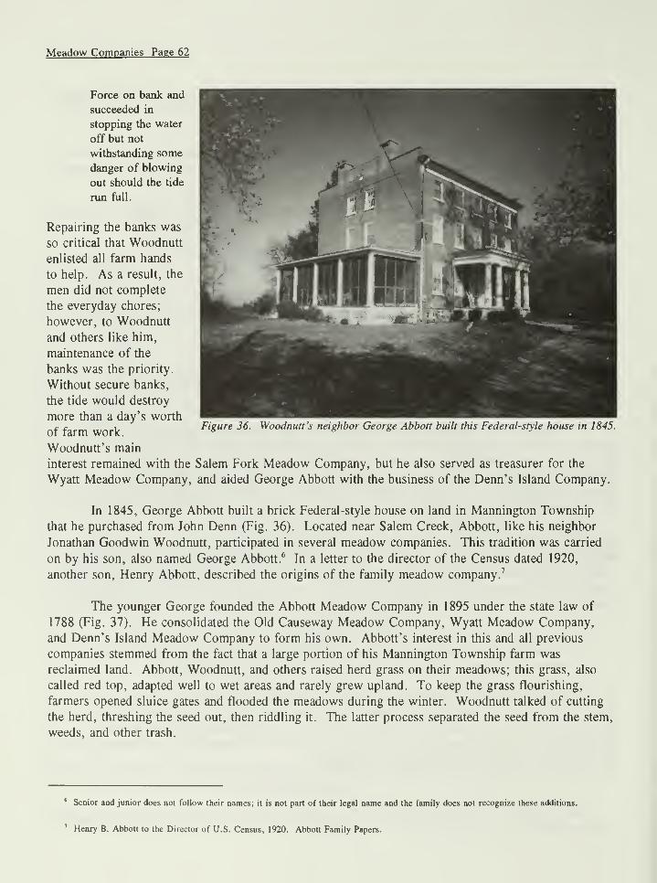
and Dale Wettstein for lending items from their private collections; George Abbott, Emmaline
Abbott, Sherman Ayres, Martin Taylor, Robert Taylor, Henry Taylor, LaDonna Gibson Angelo, Phil
Marucci, Art Handson, Loretta King, Joe Smith, Fred Schlender, Marjorie Crompton, Russ Minch,
Mary Lack, Pat Witt, James Steelman, Henry Hayes, and Cecil Collins for sharing information; Alice
Boggs, Kurt Harker, and Robert Butcher of the Salem County Historical Society for providing
research assistance; Paula Dardaris, Susan Petrilick, and Robin Taylor for assisting in the exploration,
photography, and measuring of various sites; Dr. David Smith (University of Maine), David Grettler
(University of Delaware), Jim Jones (University of Delaware), Betsy Carpenter (Pinelands
Commission), Robert Burnett (New Jersey Historical Society), and David Cohen (New Jersey
Historical Commission) for establishing contacts, offering ideas, and answering questions; and all of
the residents of South Jersey who showed interest, gave encouragement, and realized the historical
significance of land reclamation.
The institutional repositories and their staffs that provided material and assistance include:
Rutgers University, Special Collections and Archives; University of Delaware, Morris Library and
Special Collections; National Agricultural Library, U.S. Department of Agriculture; New Jersey State
Library and Archives, Trenton; Salem County Courthouse; Cumberland County Courthouse; Salem
County Historical Society; Atlantic County Historical Society; Ocean County Historical Society; and
Cumberland County Library.
LIST OF ILLUSTRATIONS
Location of wetlands that could be drained for crop production. Economics .
Map of Zuider Zee project, Holland. Land Drainage .
"Map of the Providence of New York," detail of engraving by Claude Joseph
Sauthier, 1776. Historic Urban Plans.
Aerial view of marshland that has been reclaimed along the Maurice River.
Sebold.
Farms such as the Burcham Farm, seen in an aerial view, were once commonalong the Maurice River. Sebold.
Map of the Atlantic coastal region of Canada. The Acadians or French
settlers of this region reclaimed the marshlands in this area. Acadia .
The salt marsh areas of New Jersey. New Jersey Salt Marsh .
"Daily Tides: Heartbeat of a Marsh" illustrates the different elevations that
occur in tidal marshes. National Geographic Society.
Spartina patens is one type of grass cut for salt hay. New Jersey Salt
Marsh .
Spartina alterniflora grows closer to the edge of the marsh and helps control
coastal erosion. Delaware Estuary .
Juncus gerardi or black grass is another type of grass cut for salt hay. NewJersey Salt Marsh .
Banks were constructed by the New York Iron Dike and Land Reclamation
Company on the Newark Meadows between the Hackensack and Passaic
Rivers. Pictorial Guide .
Figure 13. Enough men were hired to ensure the bank was stable before the following
high tide. Pictorial Guide .
Figure 14. Workers of the New York Iron Dike and Land Reclamation Company drove
iron plates into the bank to protect them from muskrats. Pictorial Guide .
Figure 15. Ditches were also dug to allow water to drain off of the reclaimed land.
Pictorial Guide.
vn
Figure 1.
Figure 2.
Figure 3.
Figure 4.
Figure 5.
Figure 6.
Figure 7.
Figure 8.
Figure 9.
Figure 10.
Figure 11.
Figure 12.
Figure 16. Drainage ditches, such as this one, take the water off of Edward and Lehma
Gibson's salt hay meadows. Sebold.
Figure 17. Details of a concrete automatic sluice gate taken from a 1907 USDA Bulletin.
Reclamation of Tide Lands .
Figure 18. Modern example of a clapper valve sluice gate. Sebold.
Figure 19. Example of the supports that surround a modern clapper valve sluice gate.
Sebold.
Figure 20. Today, the Greenwich Meadow Company still maintains banks along the
Cohansey River. Historical Atlas .
Figure 21. Map of Maurice River Township. Historical Atlas .
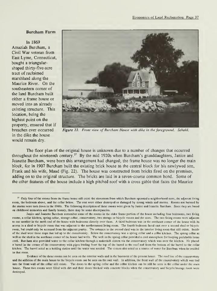
Figure 22. Front view of Burcham House with dike in the foreground. Sebold.
Figure 23. Top and side view of the Burcham's dike. Sebold.
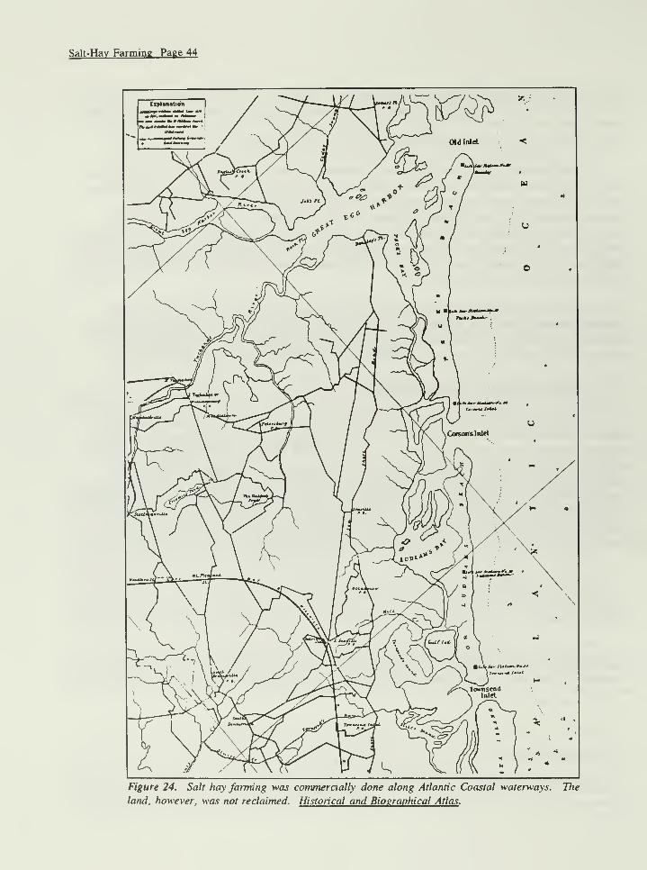
Figure 24. Salt hay farming was commercially done along Atlantic Coastal waterways.
The land, however, was not reclaimed. Historical and Biographical Atlas .
Figure 25. Until the 1950s, salt hay was loaded onto wagons via pitchfork. Gibson's
Private Collection.
Figure 26. Shoes such as these were worn by horses that worked on the meadows. Early
Industries .
Figure 27. Hay was unloaded from wagons via a swingboom and grapple hook. Gibson's
Private Collection.
Figure 28. Austin Berry raking salt hay in the 1940s. Notice the dual rear tires on the
tractor. Gibson's Private Collection.
Figure 29. During the 1950s, balers were introduced to the salt hay industry. Gibson's
Private Collection.
Figure 30. Skids are placed underneath modern equipment to prevent them from sinking
below their axles if a soft spot is encountered. Sebold.
Figure 31. Chris Angelo, the Gibson's grandson, drives an automatic bale wagon on the
marsh to collect the bales of hay. Sebold.
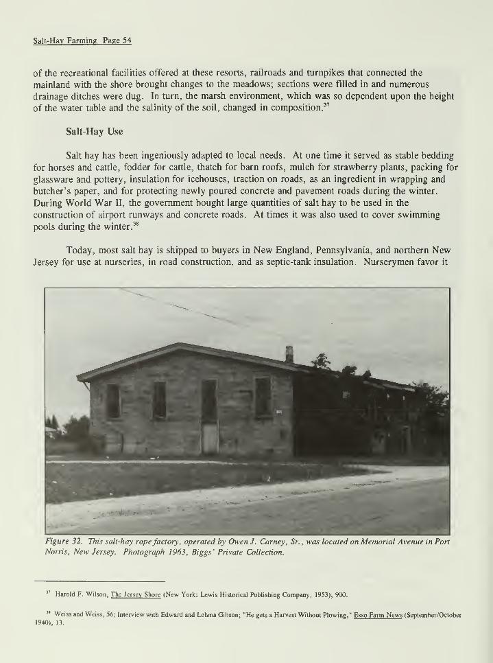
Figure 32. This salt-hay rope factory, operated by Owen J. Carney, Sr., was located on
Memorial Avenue in Port Norris, New Jersey. Biggs' Private Collection.
vin
Figure 33. Owen J. Carney, Sr. (left) and Austin Berry (right) discuss Carney's spools of
salt-hay rope. Gibson's Private Collection.
Figure 34. Survey maps were one component of the meadow companies that existed in
South Jersey. Salem County Historical Society.
Figure 35. The proximity of the Woodnutt, Abbott, and Newell farms to each other, just
north of Clayville, is illustrated on this 1876 map of Mannington Township.
Combination Atlas .
Figure 36. Woodnutt's neighbor George Abbott built this Federal -style house in 1845.
Figure 37. Abbott's son, George, formed the Abbott Meadow Company in the late
nineteenth century. Salem County Historical Society.
Figure 38. Cranberries were so popular that poems were published in local newspapers.
Author and paper are unknown. Courtesy of Elizabeth Carpenter.
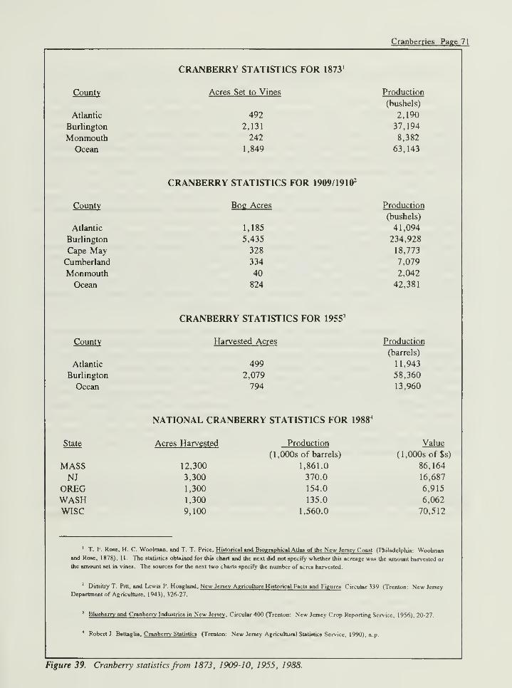
Figure 39. Cranberry statistics from 1873, 1909-10, 1955, 1988.
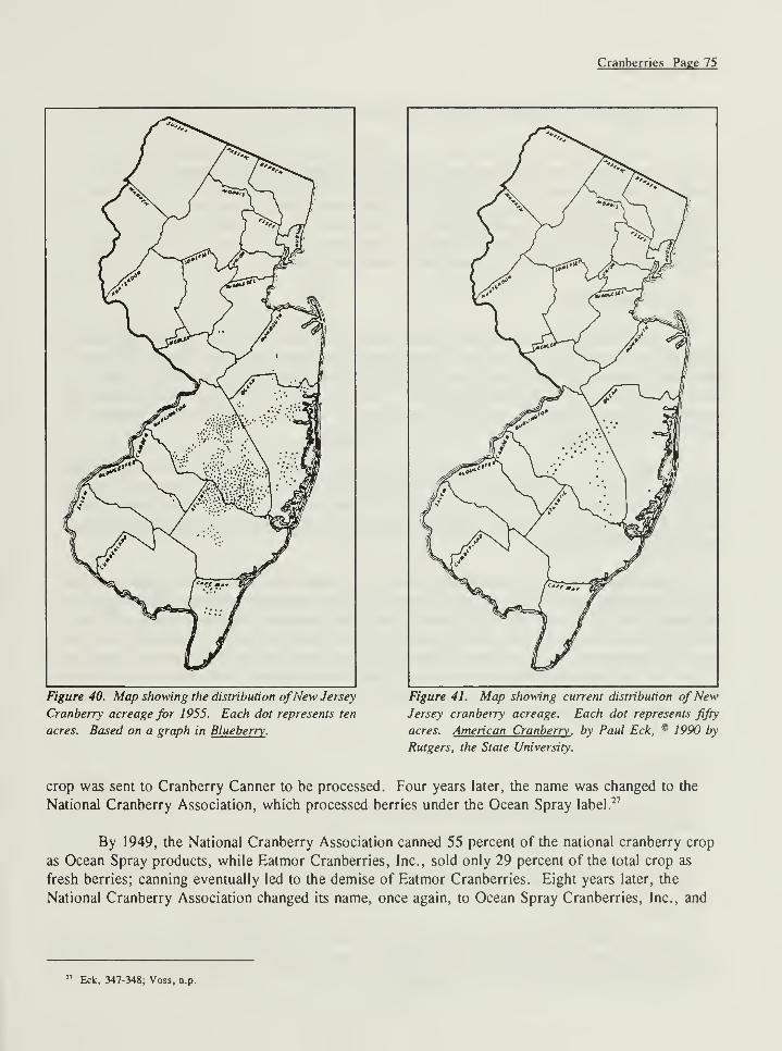
Figure 40. Map showing the distribution of New Jersey Cranberry acreage for 1955.
Each dot represents ten acres. Based on graph in Blueberry .
Figure 41. Map showing current distribution of New Jersey cranberry acreage. Each dot
represents fifty acres. American Cranberry .
Figure 42. This drawing illustrates the layout of the cranberry bogs and reservoir.
Cranberry Growing .
Figure 43. Cross-section of a bank or dam. Cranberry Growing .
Figure 44. Illustration of the correct and incorrect method of setting a trunk and receiver.
American Cranberry .
Figure 45. This 1877 lithograph depicts migrant workers harvesting cranberries in Ocean
County. Pictorial Guide .
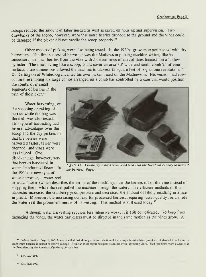
Figure 46. Cranberry scoops were used well into the twentieth century to harvest the
berries. Pages .
Figure 47. Workers harvesting cranberries near Chatsworth. Sebold.
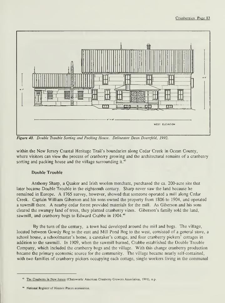
Figure 48. Double Trouble Sorting and Packing House. Delineator Dean Doerfeld,
1992.
Figure 49. Hayden Cranberry Separator. Delineator Dean Doerfeld, 1992.
IX
Chapter 1:
INTRODUCTION
Land reclamation, whether clearing woodlands for open pasture, irrigating to provide water to
normally dry areas, or draining surplus water from wetlands to make sowable fields, has played an
important role in the development of the United States from its early settlement to the present.
Farmers along the Atlantic Coast, and to a lesser degree along the Gulf of Mexico, practiced
extensively the last form of reclamation, the transformation of wetlands, until the end of the
nineteenth century.1
In many cases, the wetlands include both fresh and salt tidal marshes. Up until
the middle of the twentieth century, the main purpose for reclaiming the marshes was to increase the
agricultural potential of an area (Fig. 1).
Today, land reclamation in New Jersey and other coastal states in general is a common means
of acquiring land for community development, despite the resultant destruction of the natural
environment. Unfortunately, the land cannot revert back to its natural condition on its own. Land
reclamation for agricultural purposes, however, is almost extinct today. Far less detrimental, this
process requires that marshlands be drained and blocked off from tidal inundation and allows the land
to revert back to its natural condition when not maintained.
Ironically, while contemporary land reclamation invites urban development complete with
homes, shopping plazas, business districts, and parking lots, reclamation for agricultural purposes
Figure 1. Location of wetlands that could be drained for crop production. Economics .
1 One of the main components in the reclaiming of tidal marshes is a bank or dike located on the edge of the marsh. As a result, "banking" and
"diking" can be substituted for "reclamation" or "reclaiming."
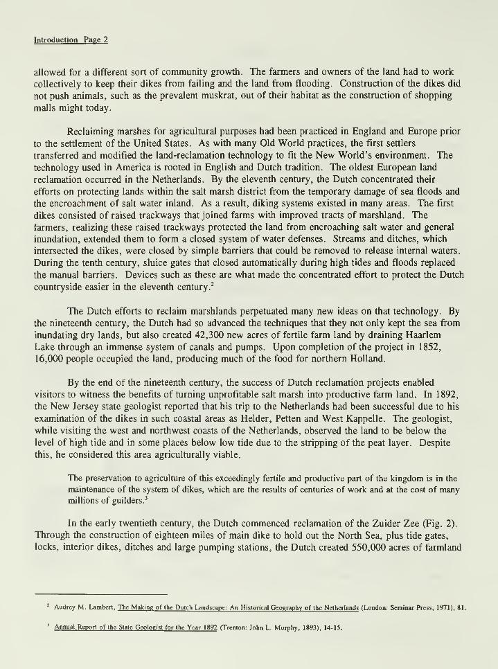
Introduction Page 2
allowed for a different sort of community growth. The farmers and owners of the land had to work
collectively to keep their dikes from failing and the land from flooding. Construction of the dikes did
not push animals, such as the prevalent muskrat, out of their habitat as the construction of shopping
malls might today.
Reclaiming marshes for agricultural purposes had been practiced in England and Europe prior
to the settlement of the United States. As with many Old World practices, the first settlers
transferred and modified the land-reclamation technology to fit the New World's environment. The
technology used in America is rooted in English and Dutch tradition. The oldest European land
reclamation occurred in the Netherlands. By the eleventh century, the Dutch concentrated their
efforts on protecting lands within the salt marsh district from the temporary damage of sea floods and
the encroachment of salt water inland. As a result, diking systems existed in many areas. The first
dikes consisted of raised trackways that joined farms with improved tracts of marshland. The
farmers, realizing these raised trackways protected the land from encroaching salt water and general
inundation, extended them to form a closed system of water defenses. Streams and ditches, which
intersected the dikes, were closed by simple barriers that could be removed to release internal waters.
During the tenth century, sluice gates that closed automatically during high tides and floods replaced
the manual barriers. Devices such as these are what made the concentrated effort to protect the Dutch
countryside easier in the eleventh century.2
The Dutch efforts to reclaim marshlands perpetuated many new ideas on that technology. By
the nineteenth century, the Dutch had so advanced the techniques that they not only kept the sea from
inundating dry lands, but also created 42,300 new acres of fertile farm land by draining Haarlem
Lake through an immense system of canals and pumps. Upon completion of the project in 1852,
16,000 people occupied the land, producing much of the food for northern Holland.
By the end of the nineteenth century, the success of Dutch reclamation projects enabled
visitors to witness the benefits of turning unprofitable salt marsh into productive farm land. In 1892,
the New Jersey state geologist reported that his trip to the Netherlands had been successful due to his
examination of the dikes in such coastal areas as Helder, Petten and West Kappelle. The geologist,
while visiting the west and northwest coasts of the Netherlands, observed the land to be below the
level of high tide and in some places below low tide due to the stripping of the peat layer. Despite
this, he considered this area agriculturally viable.
The preservation to agriculture of this exceedingly fertile and productive part of the kingdom is in the
maintenance of the system of dikes, which are the results of centuries of work and at the cost of manymillions of guilders.
3
In the early twentieth century, the Dutch commenced reclamation of the Zuider Zee (Fig. 2).
Through the construction of eighteen miles of main dike to hold out the North Sea, plus tide gates,
locks, interior dikes, ditches and large pumping stations, the Dutch created 550,000 acres of farmland
2 Audrey M. Lambert, The Making of the Dutch Landscape: An Historical Geography of the Netherlands (London: Seminar Press, 1971), 81.
' Annual Report of the State Geologist for the Year 1892 (Trenton: John L. Murphy, 1893), 14-15.
Introduction Page 3
tfarlin$en
^TUIIPER ^EEPROJECTHOLLAND
to support approximately 300,000
people.4
Although not as intense as those
in the Netherlands, land-reclamation
projects prospered in England as early
as 1543 with the draining of the
Wapping Marsh near the Vale of
London; it continued well into the
eighteenth century. The farmers
throughout England were familiar with
the procedures of draining and banking
at various levels. Fens or low, flooded
grounds known variously as marshes,
moors, or mosses, were a commoncomponent of the English landscape.
Tracts of marsh that were drained
include areas of the counties Kent and
Norfolk, and both shores of the HumberRiver and its tributaries.
5
The biggest and most successful
reclamation project of the Old World,
however, was the draining of the fens.
The fens occupied the southeastern
quarter of Lincolnshire, the north half
of Cambridgeshire, and portions of the
counties of Norfolk, Suffolk,
Huntingdon, and Northampton. Farmers reclaimed more than 700,000 acres of tidal and overflowed
peaty lands by building levees, ditches, and pumping plants. This project took almost two centuries
to complete with most of the work done by 1660.
The continued efforts to reclaim land in England and the Netherlands promoted the application
of this technology in the New World. In marshy areas occupied by Dutch or English colonists,
evidence of land reclamation exists either through physical remains of the tradition, or through
colonial documentation. Land reclamation was practiced as early as 1675 along the Delaware Bay in
the colony of New Castle. In 1664, the British gained control of New Castle and other strategic
points along the Delaware from the Dutch and placed their rule over the Dutch and Swedish settlers
in the area. The English allowed several of the Dutch magistrates in New Castle to continue in their
roles.6
Figure 2. Map ofZuider Zee project, Holland. Land Drainage .
* W. L. Powers and T. A. H. Teeter, Land Drainage (New York: John Wiley & Sons, 1932), 4-6; Lambert, 306-307.
5Facts Concerning the Reclamation of Swamp and Marsh Lands by Means of an Iron Dike (New York: Iron Dike and Land Reclamation
Company, 1867), 7.
C. A. Weslager, The Swedes and Dutch at New Castle (Wilmington: Middle Atlantic Press, 1987), 179.
Introduction Page 4
In June 1675, the Dutch magistrates of New Castle, upon Governor Edmund Andros's
request, appointed four impartial men to survey the marshland on the north side of New Castle as a
potential site for possible highway construction. The surveyors reported that the marsh was
worthless. The magistrates then decided that the highway would only become a reality if a dike with
sluices were built on the marsh. They ordered all the male inhabitants of the district of New Castle
to construct a dike 10' wide at the bottom, 5' high and 3' wide at the top with several strong sluices.
Under orders from Andros, the magistrates appointed three Dutchmen-Martin Gerritsen, Pieter de
Wit and Hendrick Sybrants-to oversee the work. Andros backed his decision as to the nationality of
the overseers with the comment that "there are few here who have the knowledge of such work,
especially among those living in New Castle" (Fig. 3).7
As permanent settlements increased in the colonies, more reclamation projects occurred and
more settlers commented on the value of the marshes in their private accounts. In the late
seventeenth century, Jasper Danckaerts, a Dutchman who traveled throughout New York and NewJersey, commented in his journal that the Dutch governor diked and cultivated a piece of marsh along
the Delaware River near the settlement on Burlington Island. On that particular tract the governor
had gathered more grain than from any other cleared upland.8
arniyaa Bauh
Figure 3. "Map of the Providence ofNew York, " detail ofengraving by Claude Joseph Sauthier, 1776. Historic Urban
Plans.
7Charles T. Gehring, ed., New York Historical Manuscripts: Dutch vol. 20-21: Delaware Papers (Baltimore: Genealogical Publishing Co., Inc.,
1977), 86; David Steven Cohen, forthcoming entry in The Encyclopedia of North American Colonies , see "Technology, Dutch," TMs.
David Steven Cohen, The Dutch-American Farm (New York: New York University Press, 1992), 71-72; Cohen, "Technology, Dutch."
Introduction Page 5
Another historic account which reflected the value of the marshes was related through Adraien
van der Donck, a seventeenth-century resident of New Netherlands who occupied the office of sheriff
in Rensselaerswyck and Westchester County. He commented that the health of the cattle brought
from Holland declined until they were fed salt hay and given salt and brackish water. Reclamation
projects and utilization of the marsh environment were so widespread along the Atlantic seaboard that
laws were enacted to aid the owners.9
During the mid eighteenth century, Peter Kalm, a Swedish naturalist, wrote:
Dykes were made along all rivers here to confine their water; therefore when the tide was highest, the
water in the rivers was much higher than the meadows; in the dykes were gates through which the
water can be drawn from, or led into the meadows; they sometimes placed on the outward side of the
wall, so that the water in the meadows forced it open, but the river water shut it.10
Even after the Revolutionary War the draining of the marshes continued apace.
By the nineteenth century, agriculturalists wrote frequently in farm journals, spreading their
knowledge of the procedure and results of their experimentation. After the Civil War, the
reclamation of tidal marshes grew as a topic of concern for agriculturalists and geologists alike.
These scientists saw it as a way to decrease crowding in cities, to rid the world of the mosquito and
disease-infested wetlands, and to increase the amount of fertile farmland. In 1895 New Jersey state
geologist John C. Smock reported that:
Malarial epidemics no longer occur in this valley [Pequest Valley] whereas formerly they were
common through the warmer seasons. The general healthfulness is as marked now as were the former
unhealthy conditions due to sluggish streams, pools of standing water and decaying vegetation. The
improvement here is suggestive of the benefits of drainage generally."
Articles in agricultural journals, state agricultural reports, and U.S. Department of Agriculture
bulletins further exemplified this trend.
In 1885, D. M. Nesbit of the U.S. Department of Agriculture issued a special report the Tide
Marshes of the United States . Although Nesbit credited early Swedish, English, Scottish and Dutch
settlers with bringing reclamation technology to the New World, he acknowledged that the procedures
for it in general agriculture had been modified so that they were uniquely American.
When our marshes shall be wrested from the tides, our political, social, and industrial conditions will
warrant as well as demand the conquest, and its methods will be American. 12
' Cohen, The Dutch-American Farm , 120. For a more descriptive account of life in the New Netherlands see A Description of the NewNetherlands by Adriaen van der Donck, edited by Thomas F. O'Donnell and Journal of Jasper Danckaerts. 1679-1680 , edited by Bartlctt Burleigh
James and J. Franklin Jameson.
10 Cohen, "Technology, Dutch."
11 Annual Report of the State Geologist for the Year 1895 (Trenton: John L. Murphy, 1896), xxiii.
° D. M. Nesbit, Tide Marshes of the United Slates , USDA Special Report 7 (Washington, DC: GPO, 1885), 5.
Introduction Page 6
In the report, Nesbit attempted to gain support for more extensive reclamation projects
throughout the United States. He did so by sending inquiries to every coastal state asking for
information on agricultural-related reclamation projects and for opinions upon the success of the
various projects. Though statistics were not included in most of the reports, the extent of U.S.
reclamation prior to 1885 is apparent.
Dividing the coastal areas into five regions-north Atlantic, south Atlantic, Gulf, Pacific, and
Delaware Bay and Chesapeake Bay--Nesbit summarized the marsh conditions and areas where most of
the reclamation occurred. Along the north Atlantic coast, landowners divided marshes into small lots
and bequeathed them to the next generation. The farmers in New England depended on the marshes
for the production of salt hay, which grew in large quantities and sustained the livestock through long
winters. By the end of the nineteenth century, most of the land that had been reclaimed for salt hay
had returned to its natural state due to the increased costs of production and the lack of cooperation
among the farmers to maintain the dikes.13
In 1885 the largest tracts of reclaimed land in New England were located in Maine, along the
Machias and Middle rivers, and in Massachusetts along the Green Harbor River. Land along the
Machias River had been diked since the beginning of the nineteenth century, at least; along the
Middle River, 400 acres had been reclaimed in 1869-70. Although troubled by opposition, the
improved land along the Green Harbor River near Marshfield, Massachusetts, in Plymouth County
included 1,412 acres. Some of the people involved with Green Harbor insisted that the dike
obstructed the harbor by allowing silt to deposit at its mouth, thus creating a sand bar. The owners
of the marsh in 1885 continued to keep the land diked despite sabotage attempts.14
Maine farmers reclaimed on a large scale: 120 acres in Sagadahoc County in 1882; more
than 700 acres in Cumberland County, especially in the area of Scarborough; 150 acres in the area of
Ogunguit; and another sixty acres in 1872 along the Little River Marsh in Old Orchard, York
County. Within New England, smaller-scale projects existed not only in Maine and Massachusetts
but also in Rhode Island, Connecticut, and New York. The following list illustrates the amount of
land reclaimed in these states. Massachusetts: Essex County, 250 acres near Salisbury and Newberry;
Norfolk County, 60 acres; Barnstable County, 60 acres. New Hampshire: Rockingham County,
approximately 40 acres near Hampton Falls which failed. Maine: Knox County, 9 acres along Saint
George River. Rhode Island: Bristol County, 4 acres. Connecticut: New London County, unknownamount along the Connecticut River; Middlesex County, 7 acres; and Fairfield County, 5 acres (most
attempts in Connecticut failed due to various reasons, including what seems to be an intrusion by a
joint grass with a woody stalk, possibly phragmites).15
In New York state, at the time of Nesbit' s report, landowners attempted several projects in
Richmond and Queens counties. In Richmond County, a state law allowed for the formation of the
Marsh Land Drainage Company in the early 1880s. The state dissolved the company several years
later because the reclamation project interfered with the navigation along Flushing Marsh Creek. The
" Nesbit, 17-18.
14Nesbit, 112-120, 124-125.
15Nesbit, 120-133; Nesbit listed New York with New England in his report.
Introduction Page 7
state declared the original legislation unconstitutional.16
Along the Delaware Bay and Chesapeake Bay regions-which included New Jersey,
Pennsylvania, Delaware, Maryland, and Virginia-most reclamation occurred in New Jersey and
Delaware. In Delaware's northernmost New Castle County, Dutch and Swedish settlers improved the
marshes as early as the seventeenth century; by 1885, reclaimed lands accounted for 10,000 out of
15,000 acres of marsh. In Kent County, embanked land totaled 5,000 acres, and in Sussex County,
3,000 acres. All this improved land was located along the Delaware Bay and its tributaries.17
The extent of reclaimed land in Pennsylvania, Maryland, and Virginia was minor compared to
that of Delaware. In Pennsylvania, the marshes that had been improved were located below
Philadelphia at the mouth of the Schuylkill along the Delaware River. In Maryland and Virginia,
despite huge tracts of marshland, landowners made few improvements. Nesbit surmised that the
farmers in these two states "have done nothing worthy of note toward reclaiming them excepting in a
few instances on James River."18
In Cecil County, Maryland, a farmer reclaimed ten acres along the Sassafras River, only for
the banks to be destroyed by muskrats in the 1870s. A similar situation occurred along the Mattaponi
River in King and Queen County, Virginia. A more successful banking operation was developed
along the James River in 1870. By 1885, these 250 acres had been let go due to lack of cooperation
among the owners and problems with muskrats. Several smaller projects, ranging from one to 100
acres, were located in Surry and Chesterfield counties. In the latter, 100 acres had been reclaimed in
1815 and continued in such a manner until the dikes became a casualty of the Civil War. 19
Similar situations ensued in North Carolina, South Carolina, Georgia, and Florida so that the
dikes that had once held back the tides were breached and failed. The marshes here were primarily
inland, along rivers that were far enough from the ocean to prevent them from being affected by
storm tides or from being heavily influenced by salt water; in areas where some salt water infiltration
occurred, farmers inundated the reclaimed land with fresh water from local tributaries.
Prior to the Civil War, growers in the southeastern area of the United States grew primarily
rice and received the highest capital returns of any agricultural lands in the area. During the war,
landowners abandoned thousands of acres, while armies and neglect destroyed the dikes and ditching
systems, and the land returned to its original condition. Yet, perhaps the most limiting factor to
repairing the war-time damage was the racial attitude of many white southerners. In a letter to
Nesbit, S. E. Barnwell of Georgetown County, South Carolina, conveyed this point. Barnwell wrote:
The lands [in Georgetown County] are admirably fitted for the use of improved machinery, but the
want of skilled labor is needed. The negroes are well-behaved and willing to work in their own
" Nesbit, 134-135.
"Nesbit, 141-142; Facts concerning New Jersey will be discussed at the end of the chapter.
"Nesbit, 20.
"Nesbit, 150-162.
Introduction Page 8
slothful way, but cannot be counted on in an emergency, and the reputation of the country for health
(unjustly so) keeps whites away. 20
South Carolina and Georgia both suffered great losses in the war. Prior to 1861, reclaimed
land prevailed in Georgetown, Berkeley, and Colleton counties in South Carolina, and Mcintosh and
Glynn counties in Georgia. During or after the war, the amount of improved land in Georgetown
County decreased from 46,000 acres to 10,000 acres, while Glynn County farmers abandoned 500
acres of good cotton-growing land after sixty years of use due to the drop in cotton prices. In some
areas of North Carolina, the use of diked land also decreased because of the discovery that rice could
be grown cheaper upland.21
Despite the fact that large portions of reclaimed land became a casualty of war, some areas
were sustained for the production of rice. In North Carolina, farmers in New Hanover and
Brunswick counties maintained small tracts of improved land. In Liberty County, Georgia, 130 acres
that had been diked in 1835 along the Riceboro River remained free from tidal inundation, while 400
acres in Camden County continued to yield sixty to seventy bushels of cotton per acre.22
The marshlands in Florida did not suffer so much from the Civil War as they did from tidal
action, which was insufficient for natural drainage, and from competition from inland swamps for the
use of rice cultivation. In Nassau County prior to 1860, however, approximately 400 acres were
diked and drained for rice and an additional 200 for other crops along Saint Mary's River. By 1885,
only half of the latter tract of land still grew vegetables; the rest had returned to wetlands.23
The federal government donated most of the tidal marshlands along the Gulf Coast to the
states, including Florida, Louisiana, Mississippi, Alabama, and Texas. The government thought the
land would be better developed under state ownership, but by the late nineteenth century, they had
sold most of it to railroads and other corporations. Only in Louisiana did any major reclamation
attempts occur.24
In 1878, the New Orleans-based Louisiana Land Reclamation Company commencedoperations under a charter from the state legislature. The company's first job involved reclaiming
13,000 acres of land in Terre Bonne Parish; rice, jute and vegetables grew easily on the land. Thecompany also worked in Saint Mary's Parish, where it reclaimed an unknown amount of land east of
the Atchafalaya River. (West of the Atchafalaya River, private owners reclaimed 100 acres and
proposed 100 more, according to Nesbit's report.) The reclamation company also planned to dike
100,000 acres of land in southwest Louisiana. Unfortunately, the project was unrealized because of
the demise of a number of levees on the Mississippi River, which flooded the Atchafalaya River and
20Nesbit, 167.
21Nesbit, 162-171.
22Nesbit, 173-174.
23Nesbit, 173-179.
24Nesbit, 22-23.
Introduction Page 9
25made it financially impossible for the company to carry out its plans.
Along the Pacific coast, the most successful reclamation enterprise occurred in a section
known as "the delta," which links the Sacramento and San Joaquin rivers in San Joaquin County.
Within that area, reclamation advocates improved 1 1,000 acres in the Union Island area. They also
planned to reclaim an additional 20,000 acres by 1887, but the success of this project is
undocumented. 26
Other reclamation projects in California included unknown amounts of land in Napa and
Sonoma counties, as well as 3,000 acres to 4,000 acres of fresh marsh in Contra Costa County, and
100 acres in Alameda County. In 1861, numerous small landowners banked 14,000 acres on
Sherman Island in Sacramento County. The project failed because some of the owners would not pay
the taxes needed to maintain the land.27
Farmers in Oregon and Washington (in 1885, Washington Territory) also diked in portions of
their land. In Oregon more than 400 acres had been improved in Clatsop County, and forty acres in
Douglas County, while in Washington Territory an unknown amount of reclaimed land existed in
Kitsap and Whatcom counties.28
Nesbit's report indicates that, despite the projects in other states, New Jersey's Delaware Bay
and its tributaries contained some of the more prominent reclamation projects nationwide. Nesbit
credited such lands along the Maurice River in Cumberland County, New Jersey, as the most fertile
of its kind in the United States and exemplary-from which other parts of the country could learn.
The superiority of diked land over poor upland is nowhere better illustrated than along the Maurice
River, in New Jersey. There the banked meadows, some of which have been in cultivation, without
manure, for generations, are wonderfully fertile, and the upland immediately adjoining is only able to
produce scrub oak and stunted pine, to which it is mainly given up.29
Despite its fertility, problems with maintaining the reclaimed land still occurred along the
Maurice River (Fig. 4). Nesbit concluded, however, that with the amount of marshes already banked and
the remains of old banking projects still intact, little effort would be required to fix the breaches in the
neglected banks. The Cohansey River in Cumberland County, the northwest portion of Cape MayCounty along the Delaware Bay, and much of the marshlands in Salem County had also been
reclaimed. 30
Along the Atlantic coast in New Jersey, landowners either believed the land could not be
15Nesbit, 180-192.
*Nesbit, 195-200.
r Nesbit, 200-206.
aNesbit, 206-220.
BNesbit, 10.
MNesbit, 137-139.
Introduction Page 10
improved or neglected the improvements that had been made. This was especially true in Ocean
County, where the marsh was sometimes lower than the low-water mark, which indicated the need for
pumping instead of
natural drainage; in
places with adequate
natural drainage, the
banks were let go
because of a losing
battle against muskrats
and nature. The
muskrat population also
curtailed the projects in
Atlantic County. 31
New Jersey's
Atlantic coast
discouraged large-scale
reclamation projects
because of its
geography. Unlike the
Delaware Bay coast,
which consists of one
continuous marsh that
extends upland from one
to five miles, the
Atlantic coast is lined
with beaches or sand bars that are separated from the mainland by bays and inlets measuring from
one to seven miles wide. As a result, few marshes exist directly on the coast; instead they can be
found along Barnegat, Egg Harbor and Great bays, and the Mullica, Bass, Great Egg Harbor, and
Tuckahoe rivers. Even so, the marshes are interrupted by various creeks and streams.32
Although more extensive attempts to reclaim both salt and fresh tidal marshes had occurred
elsewhere in the United States-especially along the southern Atlantic coast--the Civil War disrupted
them. In other coastal areas, skeptical and uncooperative landowners as well as money shortages
hindered many reclamation projects. Even the diking projects along the Maurice River suffered from
the lack of cooperation; one of Nesbit's correspondents, Daniel Harris, refers to diking projects along
the Maurice that failed prior to 1885.
The owners of our tide marshes are satisfied with the success and profit that have attended reclamation.
The diked marshes yield from sixty to 100 bushels of shelled corn per acre, without manure. The main
trouble is that many owners fail to keep their portions of the bank and their sluices in good repair, and
in consequence the land fails to produce as it otherwise would. 33
Figure 4. Aerial view of marshland, which had been reclaimed, along the Maurice
River. Sebold.
11Nesbit, 136-139.
12 John B. Smith, The New Jersey Salt Marsh and its Improvement , New Jersey Agricultural Experiment Stations Bulletin 207 (Washington,
D.C.:GPO, 1907), 5-6.
" Nesbit, 139.
Introduction Page 1
1
Figure 5. Farms such as the Burcham Farm, seen here in an aerial view, were once common along the Maurice
River. Sebold.
From the late nineteenth to the mid twentieth century, a lack of cooperation among marsh
owners, as well as new government regulations about land use, destroyed many reclamation projects,
and few examples remain. Nevertheless, the Delaware Bay region was historically committed to land
reclamation for improved agricultural production. Within this area, land reclamation projects
continued along the New Jersey side of the bay and its tributaries well into the twentieth century.
Today, this tradition is extant in the Burcham Farm, which is located along what Nesbit called the
most fertile reclaimed area in the United States, the Maurice River in Cumberland County, NewJersey (Fig. 5). Salt hay farmers also continue to reclaim marshlands in South Jersey along the
Delaware Bay and its tributaries.
The following chapters offer a detailed history of land reclamation in New Jersey, beginning
with a general overview of the biology of tidal wetlands, and specifically salt marshes. This is
followed by a look at the technological means and procedures of how land was actually reclaimed.
Chapter four discusses the economics of reclamation, including an in-depth look at projects in Salem,
Cumberland, and Cape May counties. This includes a history of the Burcham Farm. The next
chapter looks at salt-hay farming both historically and currently. Chapter six looks at the legal
aspects of reclaiming land and the resultant meadow companies, while chapter seven refers to
cranberry farmers and how they utilize fresh-water marshes and swamps to create cranberry bogs.
Chapter 2:
THE BIOLOGY OF SALT MARSHES
Salt marshes began to appear in the United States approximately 50,000 years ago with the
retreat of the Laurentide Glacier, which stretched across northern Canada to the northern United
States. As the climate grew warmer, the glacier began to melt and the water eroded the bases of
many forests, forming streams and rivers. Moreover, the water carried with it a new soil that
contained a mixture of rock flour and sand; it began to settle, mixing with the mud of manyuncovered areas, and the amalgam created a fertile environment where vegetation could take seed.
1
Torrential rains, along with the melting of once-sheltered ice patches in the north, caused the
level of the sea to rise. As the heavy ice disappeared, the land rose up. Marsh development began
once the glacier ceased melting and the land finished its rapid rebound. At this point, plants as well
as the climate and sea level began to alter the face of the earth. Birds began to settle along the
shorelines, carrying with them the seeds of different plants. Where the birds came to rest seeds were
deposited, and soon salt marsh vegetation including Spartina alterniflora and Spartina patens
germinated. In some areas the fledgling marsh was drowned by the sea, while elsewhere its growth
continued as rivers and streams brought in sediment from the recently exposed earth. Plant roots
bound this sediment into a firm peat, which in turn grew and increased the level and size of the
marshes. Once the marsh reached the high-water level and above, S. patens established itself
prominently in the higher areas of the marsh. 2
These grasses, along with the increased number of animals moving into the marsh, caused
decomposing organic matter to continually form a layer of peat. The new layers formed fast enough
to keep the marsh rising at the same level as the sea, while compressing preceding layers. As the
layers were crushed under the weight of the new peat, the marsh expanded outward, encroaching
upon the edges of solid land. Fresh-water plants were replaced by marsh grasses that could better
withstand the high salinity of bay and ocean waters. This process continued as the marsh expanded
and storms blew saltwater inland, killing fresh-water plants. As a result, with no barrier between the
saltwater and the land, the sea continued to encroach, and Spartina grasses flourished in conjunction
with the marshes. Despite the fact that the marsh is well established, gradual and continual changes
still occur that alter both the environment and landscape. Salt marshes expand according to the rate
of plant growth and the supply of sediment as they adjust to changes in sea level.3
The effects of the glacier age varied according to the location of the marshes, falling into two
categories, glaciated and unglaciated. The area between the St. Lawrence River south to the northern
edge of New Jersey is part of the glaciated coast. The marshes that existed here were destroyed by
the glacier as it moved south; once the glacier melted, the marshes were re-established but smaller in
size. No such significant areas are found until the Bay of Fundy, which includes fifty square miles of
salt marsh (Fig. 6). A portion of this marsh, near the Tantramar River, has been diked since the
early seventeenth century. Large masses of marsh along the Eastern Seaboard do not reoccur until
1 John Teal and Mildred Teal, Life and Death of the Salt Marsh (New York: Ballantine Books, 1969), 8-9.
2 Teal and Teal ,11.
JTeal and Teal, 9-11, 82.
The Biology of Salt Marshes Page 14
-44?-
Figure 6. Map of the Atlantic coastal region of Canada. The Acadians or French settlers of this region reclaimed the
marshlands in this area. Acadia .
New Hampshire and they only encompass twenty square miles. These marshes continue sporadically
along the coast in Massachusetts, Rhode Island, Connecticut, and down into New York.4
The unglaciated coast runs from southern New Jersey to Florida. The only major break in
the marshes along here is the Chesapeake Bay; marshes are frequent along the eastern side of the bay
but not the west. The most abundant example runs from Albemarle Sound in North Carolina to the
northern coast of Florida. Most of the grass found in these southerly marshes consist of S.
alterniflora and a coarse black rush called Juncus roemericanus.5
The marsh through here is intact because it was never covered by ice. Without the pressure
from the glaciers, the soils and sands of the marshes were not scraped away, nor was its bedrock
exposed. Moreover, the rivers carried great amounts of sediment that helped feed and extend the
marshes. In the Delaware Bay region there are approximately 350 square miles of salt marsh; the
New Jersey side consists more of S. paten, the Delaware side of S. alterniflora (Fig. 7).6
4Teal and Teal, 53-68.
JTeal and Teal, 69-78.
6 Teal and Teal, 69.
The Biology of Salt Marshes Page 15
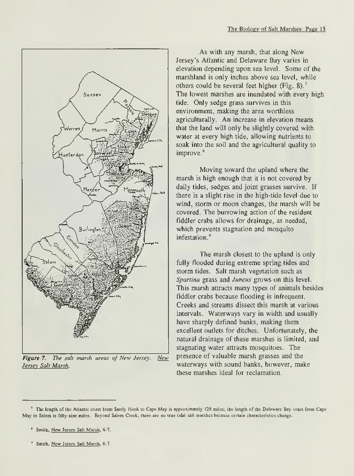
»i"i
Figure 7. The salt marsh areas of New Jersey.
Jersey Salt Marsh .
New
As with any marsh, that along NewJersey's Atlantic and Delaware Bay varies in
elevation depending upon sea level. Some of the
marshland is only inches above sea level, while
others could be several feet higher (Fig. 8).7
The lowest marshes are inundated with every high
tide. Only sedge grass survives in this
environment, making the area worthless
agriculturally. An increase in elevation means
that the land will only be slightly covered with
water at every high tide, allowing nutrients to
soak into the soil and the agricultural quality to
improve.8
Moving toward the upland where the
marsh is high enough that it is not covered by
daily tides, sedges and joint grasses survive. If
there is a slight rise in the high-tide level due to
wind, storm or moon changes, the marsh will be
covered. The burrowing action of the resident
fiddler crabs allows for drainage, as needed,
which prevents stagnation and mosquito
infestation.9
The marsh closest to the upland is only
fully flooded during extreme spring tides and
storm tides. Salt marsh vegetation such as
Spartina grass and Juncus grows on this level.
This marsh attracts many types of animals besides
fiddler crabs because flooding is infrequent.
Creeks and streams dissect this marsh at various
intervals. Waterways vary in width and usually
have sharply defined banks, making them
excellent outlets for ditches. Unfortunately, the
natural drainage of these marshes is limited, and
stagnating water attracts mosquitoes. The
presence of valuable marsh grasses and the
waterways with sound banks, however, make
these marshes ideal for reclamation.
7 The length of the Atlantic coast from Sandy Hook to Cape May is approximately 128 miles; the length of the Delaware Bay coast from Cape
May to Salem is fifty-nine miles. Beyond Salem Creek, there are no true tidal salt marshes because certain characteristics change.
* Smith, New Jersey Salt Marsh . 6-7.
Smith, New Jersey Salt Marsh , 6-7.
The Biology of Salt Marshes Page 16
Figure 8. "Daily Tides: Heartbeat of a Marsh " illustrates the different elevations that occur in tidal marshes.
Painting by William H. Bond, ® National Geographic Society.
The Biology of Salt Marshes Page 17
Figure 9. Spartina patens is one type of grass cut for
salt hay. New Jersey Salt Marsh .
Once reclaimed, the improved drainage decreases the
stagnate mosquito breeding grounds.10
Spartina grass, especially S. patens, is perhaps
the most important feature in the higher-level salt
marsh (Fig. 9). In addition to its roots holding the
soil together, the dead grass decays and becomes part
of the peat that helps the marsh expand. S.
alterniflora is a big, coarse grass that can grow up to
10' tall with leaves 1/2" wide at the base (Fig. 10). S. alterniflora grows near creeks and the outer
edges of the marsh; thus, it is found in both the second and third types of marshes, those exposed to
tidal currents more often than S. patens. S. patens is a fine, small grass that grows to be no more
than 2' tall. It is often the most valuable grass, and the one used as salt hay. Because of its location
in the marsh, the previous years' growth is not washed away by the tide as often as that of S.
alterniflora. Instead, the dead grass creates a protective covering that keeps the soil moist and
fertile.11
Figure 10. Spartina alterniflora grows closer to the
edge of the marsh and helps control coastal erosion.
Tom Behrens, HABS.
10 Smith, New Jersey Salt Marsh . 7-8.
11Teal and Teal, 84-86.
The Biology of Salt Marshes Page 18
Both S. alterniflora and S. patens have adapted to a lack of oxygen in the soil and the high
salinity of the surrounding environment. The process of osmosis within its cells has much to do with
the fact that the plant can survive a salt-marsh environment. The solution in the cells has adjusted by
increasing the amount of salt in its internal water; the amount of salt within the cell is a higher
concentration than that found in water absorbed from the air. As a result, salt-marsh plants
selectively absorb sodium chloride from the moisture in the air to keep the cells from exploding and
the plants from wilting.
Though Spartina grass has little competition, other marsh grasses exist. Many of these, as
well as the Spartina grass, are referred to generically as "marsh grass," "salt hay," and "salt grass."
The Latin and Greek names associated with the prominent grasses include Distichlis, Juncus, and
Salicornia. The different species within these genera include Distichlis spicata, Juncus gerardi, Juncus
roemerianus, Puccinellia phryganodes , Avicennia nitida, and Rhizophora mangle (Fig. 11). Other
genera with several different species present in the marsh
include Iva, Sabatia, Salicornia, Atriplex, Suaeda, Salsola, and
Chenopodiaceae. n
Living among the salt-marsh grasses are many types
of animals, characterized by their ability to dig down into
tidal flats and marsh-creek banks. The ability to burrow
allows them to seek shelter in a relatively stable environment.
The animals who live here year-round include razor clams,
quahogs, clam worms, soft-shelled clams, lugworms, and
burrowing shrimp, to name a few. Other creatures associated
with marsh life are various shorebirds, such as rail-birds and
ospreys; ducks, including wood-ducks and teals; reptiles, such
as snapping and diamond-back turtles; mammals, including
raccoons and muskrats; and insects, such as mosquitoes and
greenhead flies.13 Like indigenous vegetation, these animals
have adapted to conditions specific to the salt marsh: changes
in temperature and salinity, and periods of exposure and lack
Figure 11. Juncus gerardi or black grass isof oxygen at low tide.
14
another type ofgrass cutfor salt hay. NewJersey Salt Marsh . Despite their ability to adapt to salinity and water
conditions, marsh environments are fragile and are adversely
affected by fluctuations caused by human intervention and natural conditions. According to Ralph
Tiner's Wetlands of New Jersey , human actions that destroy this fragile environment include
discharging hazardous materials, and infilling dredged soil for roads, highways and other commercial
ventures. In addition, dredging and stream channelization for navigation channels, digging of
a Teal and Teal, 102- 1 12. For descriptions of the various species as well as their similarities and differences see Chapter 8 of Teal and Teal's
Life and Death of the Salt Marsh , or Chapter 7 of The Delaware Estuary: Rediscovering a Forgotten Resource . The common names for Distichlis
spicata and Juncus gerardi are salt grass and black grass. More familiar names for Iva, Sabatia, Salicornia, Atriplex, Suaeda, Salsola, and
Chenopodiaceae are marsh elder, sea pinks, saltwort or glasswort, orache or spearscale, sea blithe, saltwort, and pigweeds or lamb's quarters.
13 Teal and Teal, 122-132.
14 Teal and Teal, 122-132.
The Biology of Salt Marshes Page 19
drainage ditches for crop and timber production and mosquito control, and mining of the soil for sand
and gravel have negative effects. Tiner includes the building of dikes, dams and levees for flood
control, cranberry production, water supply, and storm protection as being threatening to wetlands.
While this is true, in the case of land reclamation for agricultural purposes, the land can be returned
to wetlands once the dikes, dams or levees are removed. He adds that "marsh creation and
restoration of previously altered wetlands can also be beneficial." However, marshes that have been
filled, polluted, or damaged are permanently lost. In addition to human activity, wetlands are also
damaged by the natural rise of sea level, droughts, storms, erosion, and muskrats and other
burrowing animals.15
u Ralph W. Tiner, Jr., Wetlands of New Jersey (Newton Corner: U.S. Fish and Wildlife Service, National Wetlands Inventory, 1985), 7, 21,
95-96.
Chapter 3:
BANKING/DIKING PROCEDURES
During the eighteenth, nineteenth, and twentieth centuries, American farmers relied upon
American and English almanacs, agricultural journals, and handbooks to guide their agribusiness.
This literature, especially the journals and handbooks, covered topics from animal husbandry to plant
physiology to crop harvesting and land reclamation. No matter what the subject, the literature
advised them on the outcome of farming experiments conducted by peers throughout the United
States. One topic of special concern in such nineteenth-century periodicals as the New England
Farmer , the American Farmer , and the Country Gentleman was land reclamation. Many farmers
from New England and the mid-Atlantic states relayed their experiences through this medium. In
1826, Robert Gibbons Johnson, a resident of Salem, New Jersey, and a landowner, submitted his
ideas on draining and diking the marshes to the American Farmer .
Johnson was not the first to record the procedures involved in reclaiming marshland. As
early as 1650, English Captain Walter Bligh, an advocate of drainage trenches, wrote a book on
draining the fens in England. A century later, Joseph Elkington of Warwickshire experimented with
the tapping of underground springs. In the nineteenth century many more texts were published that
discussed how and why marshes were drained. These included W. Marshall's On the Landed
Property of England: An Elementary and Practical Treatise (London, 1804); William Smith's
Observation on the Utility, Form and Management of Water Meadows and the Draining and Irrigating
of Peat Bogs (Norwich, 1806); George Stephens' The Practical Land Drainer (London, 1834); B.
Munn's Practical Land Drainer: A Treatise on Draining Land (New York, 1856); Henry F. French's
Farm Drainage (New York, 1860); and George Waring's Draining for Profit and Health (New York,
1867). These books stressed that draining the marshes was an economic endeavor that would increase
profits and make useless land operational. The main principle behind land reclamation, as described
by Marshall, appeared rudimentary.
The theory of this valuable operation is beautifully simple. The outward waters having been resisted by
a line of embankment and having receded, those that have collected internally are enabled, by their ownweight to open a valve, which is placed in the foot of the bank, and effect their escape: thus securing
the embanked lands from inundation; tho beset in every side with water. 1
The actual work and details for success, however, were not so basic. Building the bank along
a river or seacoast was the most expensive and difficult task. The size, materials, and form of
construction differed with each individual case, though three guidelines were common wherever the
operation was implemented.
First and most important, the placement of the bank in the proper location meant being aware
of areas where the bank would receive the least exposure to the immediate action of the waves. The
position of the banks also depended upon the topography of the land. Banks constructed near rivers
and running through flat land had to be "carried up on one slope, from the level of the surface of the
lowest water in the river to such a height as may be found necessary for the protection of the land."
Those constructed near rivers that run through hilly land were set away from the river; these waters
W. Marshall, On the Landed Property of England: An Elemcniary and Practical Treatise . (London: G. & W. Nicol, 1804), 32.
Banking/Diking Procedures Page 22
flowed with a faster current and did more damage to the banks. Setting the bank away from rivers
not only protected it from the currents, but also allowed for enough room between the bank and the
river to make repairs (Fig. 12).2
Second, the height and strength of the bank needed to be proportional to the depth and
weight of the water it was to hold back. Also important to the form of the bank was the outer face,
or the facade that received the most exposure to river or sea. Its strength, durability, and firmness all
depended upon this section of the bank; therefore, the outer face always sloped with a degree of
flatness aimed at preventing resistance and taking off the weight of the water. Moreover, the line of
embankment had to be smooth, without acute angles, to ensure the least possible resistance from the
current.3
In areas not overly exposed to wave and wind action, landowners built their banks at least 18'
higher than the highest flood level. In areas near the sea where the banks were subject to these
forces, the height depended upon the level of the highest spring tides. If the bank was too low, the
ocean spray could erode it and destroy the crops with its salinity (Fig. 13).4
Figure 12. Banks were constructed by the New York Iron Dike and Land Reclamation Company on the Newark
Meadows between the Hackensack and Passaic Rivers. Pictorial Guide.
2 George Stephens, The Practical Land Drainer (London: T. Cadell, 1834), 142.
1 Marshall, 32-33.
4Stephens, 143-144.
Banking/Diking Procedures Page 23
The bank's sturdiness depended upon the width of its base. The stability of the base, in turn,
depended upon the slope of the bank exposed to the river. Builders determined the length of the
slope by the speed of the river's current. After constructing the bank, the exposed area was covered
with turf or seeded with grass. The roots of the grass helped prevent erosion, especially during
floods. Furthermore, the foot of the bank was covered with stones at the low-water mark to prevent
minor floods from undermining the base.5
The final guideline dealt with the type of materials used to build the bank. Mud and sod from
nearby was the cheapest and most available material; however, if the bank was located where strong
currents and wind eroded it more readily than usual, the builders reinforced it with pilings, timber,
and masonry. Some farmers experimented with other methods of reinforcements such as iron plates.6
Farmers worked hard to protect their dikes from the intrusion of marsh animals, especially the
muskrats that burrowed into the banks to make their home. The holes not only threatened the
stability of the bank, but allowed water to seep into the drained area. George Waring offered the
following solution:
It should be a cardinal rule with all who are engaged in the construction of such works, never to allow
two bodies of water [i.e. the river and the ditch], one on each side of the bank to be nearer than 25
yards of each other, and 50 yards would be better. Muskrats do not bore through a bank, as is often
Figure 13. Enough men were hired to ensure the bank was stable before the following high tide.
Pictorial Guide.
5 Stephens, 144-147.
* Marshall, 33-34.
Banking/Diking Procedures Page 24
supposed, to make a passage from one body of water to another but they delight in any elevated mound
in which they can make their homes above the water level and have its entrance beneath the surface, so
that their land enemies can not invade them. When they enter for this purpose, only from one side of
the dyke, they will do no harm, but if another colony is, at the same time boring in from the other
side, there is great danger that their burrows will connect, and thus form a channel for the admission of
water, and destroy the work. 7
Another means of assailing the muskrat population was to install a wall of cast-iron plates
riveted together to create a barrier that ran from the top of the bank to the low-water mark, which the
muskrats and other burrowing animals could not penetrate. These plates, however, had three
drawbacks. If not driven past the permeable soil and into the clay strata below, the plates allowed the
infiltration of water. Second, the iron was easily corroded by the action of the salt water, and once
weakened the muskrats could bore through the plates. Finally, the plates were expensive.8
The New York Iron Dike and Land Reclamation Company, promoters of the iron-plate
method, discussed the need to protect banks from anything that burrowed such as muskrats, crabs,
and crawfish (Fig. 14). The company claimed that all dikes/banks needed a core, or spinal column,
that would protect the structure from invasion. The lack of such a feature led to the demise of the
reclaimed Newark Meadows in northern New Jersey. The company promoted a series of cast-iron
plates riveted together and driven into the bank, which it insisted was the most economical and least
labor-intensive means of protection. Other cores-which were built out of dry sand, puddled clay,
and masonry-needed a foundation as well as heavy construction to be effective. With the plates, all
the laborer had to do was drive them into the bank, without prior excavation or other forms of
preparation. Moreover, once in place, the plates would not sink or settle unequally. The company
also claimed the plates could last as long as 100 years before oxidation destroyed them, and up to 500
years if they were made of ore rather than iron. Unfortunately, the claims were false.9
Successful completion of the banks depended upon hiring enough men to finish the job
between low and high tides; if the tide rose before the workers had stabilized the banks, it could
destroy what work had been done. The best time of the year to build the bank was prior to spring,
when tides rose to the highest level with heavy seasonal rains.10
Upon completion of the embankments, workers dug drains to allow the water in the marsh to
escape (Fig. 15). Planning the location of the drains, especially the discharge on the outside of the
embankment, was the most important step. The mouth of the drain on the outside of the embankment
had to be as low as possible so it would not become obstructed with debris from the current. Whenreclaiming an area near the sea or a wide estuary, drainage advocates recommended installing two
7George Waring, Jr., Draining for Profit and Health (New York: Orange Judd & Co., 1867), 199-200.
• Waring, 200-201.
9Facts Concerning The Reclamation of Swamp and Marsh Lands , 12-19.
10 Waring, 191.
Banking/Diking Procedures Page 25
Figure 14. Workers of the New York Iron Dike and Land Reclamation Company drove iron plates into the bank to
protect them from muskrats. Pictorial Guide .
Figure 15. Ditches were also dug to allow water to drain off of the reclaimed land. Pictorial Guide .
floodgates in case the action of the waves opened the outer one. The second, or inner, floodgate
should be inside the bank in calmer water to arrest persistent flood waters (Fig. 16).u
The construction of floodgates, or sluice gates, varied according to the land owners'
preference. The most widely used was the common, or clapper, valve; hinging at the top, it swings
" Marshall, 34.
Banking/Diking Procedures Page 26
outward, and falls into a rabbetted frame. Some builders made the floodgate from seasoned wood,
which fell neatly into the frame with enough room to swell (Figs. 17-19).n
In tidal areas
where the water level
between tides was
relatively uniform,
landowners relied upon
machinery to drain the
land. In some areas,
large wheels furnished
with scoops and
powered by sails like a
windmill, discharged
water from the ditches.
In other areas, steam
powered the drainage
operation; however, this
latter type of power was
more costly.13
i» \
a3fe:
^ii^ifcfeMAfeFigure 16. Drainage ditches such as this one take the water offofEdward and Lehma
Gibson 's salt-hay meadows. Sebold.
New Jersey
farmers such as Robert
Gibbons Johnson used
many of the principles
found in agricultural handbooks and journals. In Johnson's American Farmer article, he explained
that the first steps toward reclaiming a wild marsh was to stake out the site for the bank, yielding
space for a buffer zone between the bank and the waterway to guard against stormy waters and to
allow for the gathering of mud to repair the banks. He also emphasized that sod cut from the ditches
should be placed on top of the bank; once in place, the sod rooted and helped hold the bank
together.14
Johnson's suggestions for the dimensions of the banks varied according to circumstances.
Where the marsh was high and had a firm mud bottom, Johnson recommended banks have a 12' base
and be 6' high. If these measurements did not please readers, he suggested that the base should
always be double the width to the height; the side slopes should be at or near a 50-degree angle; the
width of the top of the bank should be about one-sixth that of the base. In places where rising tides,
12 Marshall, 35-36.
13 William Smith, Observation on the Utility, Form and Management of Water Meadows and the Draining and Irrigating of Peat Bogs (Norwich:
John Harding, 1806), 90.
14Robert Gibbon Johnson, "On Reclaiming Marsh Land," American Farmer 8 (1 September 1826): 185-87.
Banking/Diking Procedures Page 27
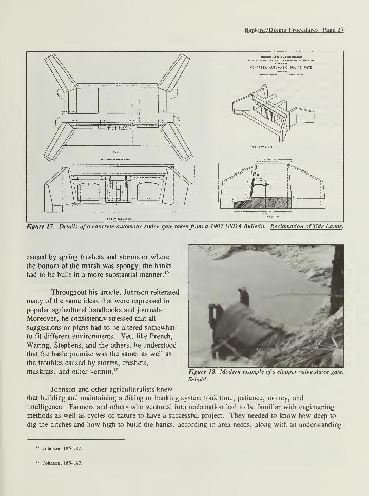
CONCRETE AUTOMATIC SLUICE CATE
Figure 17. Details of a concrete automatic sluice gate takenfrom a 1907 USDA Bulletin. Reclamation of Tide Lands .
caused by spring freshets and storms or where
the bottom of the marsh was spongy, the banks
had to be built in a more substantial manner. 15
Throughout his article, Johnson reiterated
many of the same ideas that were expressed in
popular agricultural handbooks and journals.
Moreover, he consistently stressed that all
suggestions or plans had to be altered somewhat
to fit different environments. Yet, like French,
Waring, Stephens, and the others, he understood
that the basic premise was the same, as well as
the troubles caused by storms, freshets,
muskratS, and Other vermin.16
Figure 18. Modern example ofa clapper valve sluice gate.
Sebold.
Johnson and other agriculturalists knew
that building and maintaining a diking or banking system took time, patience, money, and
intelligence. Farmers and others who ventured into reclamation had to be familiar with engineering
methods as well as cycles of nature to have a successful project. They needed to know how deep to
dig the ditches and how high to build the banks, according to area needs, along with an understanding
u Johnson, 185-187.
" Johnson, 185-187.
Banking/Diking Procedures Page 28
for low tides and other natural
phenomena. To many farmers along the
coast, this knowledge appears to have
been second nature. Although
somewhat altered due to new
technology, the few farmers who still
drain the marshes along New Jersey's
Delaware Bay know the environment
and how to manipulate it.
Figure 19. Example of the supports that surround a modern
clapper valve sluice gate. Sebold.
Chapter 4:
ECONOMICS OF LAND RECLAMATION
Since the seventeenth century, farmers have depended on the various resources of the salt
marshes for sustenance. The marshes provided numerous economic opportunities that included
trapping muskrats and selling their skin and meat. Shellfish and fish are still harvested from there;
and many species of birds that travel in the flyway over the marshes are hunted either independently
or with a sporting club. Perhaps the most important resource of the marsh is the land itself, once
reclaimed.
Surveyor Thomas Budd recognized the agricultural potential of the marshes along the
Delaware Bay as early as 1685. He described the land along the bay as "big rich fat marsh land" that
could be banked and drained to allow sowing with corn and hay seed. The mosquito-infested marshes
could then be turned into pasture for cattle and meadow as rich as that along the Thames River. 1
In 1789, Jedediah Morse's American Universal Geography also illustrated the value of the
marshes along the Delaware Bay. Morse expounded:
There are large bodies of salt marsh along the lower part of the Delaware river and bay, which afford a
plentiful pasture for cattle in summer, and hay in winter. Along the sea coast the inhabitants subsist
principally by feeding cattle on the salt meadows, and by the fish of various kinds.2
Nineteenth-century authors continued the tradition set by Budd and Morse. In the Gazetteer
of the State of New Jersey , published in 1834, Thomas Gordon wrote:
Adjacent to the Delaware Bay and sea coast, are wide tracts of salt meadow, some of which have been
reclaimed by embankment; and the rest afford abundance of coarse hay, free in many places to all whoseek it, and valuable in the maintenance of stock and making manures. The climate is so mild, near
the coast, that herds of cattle subsist, through the winter, upon these meadows, and in neighboring
thickets, without expense to the proprietors.3
Economic Reports
By the middle of the nineteenth century, with the increase in the population and agricultural
technology and the decrease in available land, agricultural reformers realized the benefits of land
reclamation. State geologists, farmers, and later agents for the U.S. Department of Agriculture wrote
extensive articles and reports on the economic aspects of land reclamation along New Jersey's
Delaware Bay and its tributaries.4
1 Harry B. Weiss and Grace M. Weiss, Early Industries of New Jersey (Trenton: New Jersey Agricultural Society, 1965), 49.
2 Weiss and Weiss, 49.
5 Weiss and Weiss, 49.
4 The amount of land reclamation done along New Jersey's Atlantic Coast was minuscule. In fact, neither slate nor federal reports mention
reclamation projects on the Atlantic side. D. M. Nesbit of the U.S.D.A. stated that "the marshes (in Ocean County) being, as a rule, at or near the
level of mean high water, are not at a sufficient elevation to admit of thorough drainage through sluices, and can be perfectly reclaimed only by the
Economics of Land Reclamation Page 30
One of the first reports on New Jersey appeared in 1857 when the state geologist's office
published the Geology of the County of Cape May, State of New Jersey , which described the
marshland along the Delaware Bay. The county had 58,824 acres of marsh, of which 1,918 acres
were improved through reclamation and 17,223 acres were used as meadow. The report encouraged
reclamation because once landowners shut off the tidal waters using banks and sluices, the marshes
would become fresh and capable of improvement for cultivation. The state geologist asserted that
unimproved salt marsh could be made profitable by improving it just enough to grow salt hay; all
one had to do was dig ditches and open salt holes to allow the flow of the tide to escape. Moreover,
buyers in the cities used salt hay as litter and packing material.5
By 1857, land reclamation was well known throughout Salem and Cumberland counties. The
state geologist detailed its benefits to these two jurisdictions as a means of encouraging farmers in
Cape May County. The report continued as follows:
In Salem County great value is attached to such meadows, on account of their heavy crops of hay and
grass seed; in the latter article of which, the Census Report of 1850, under the head of clover and other
grass seeds, sets down to this county 53,875 bushels—a quantity greater than any of the other states
produced, except New York and Pennsylvania. In Cumberland County, enormous crops have been
raised on some of the banked meadows of Maurice River: 100 bushels of oats, ninety of corn, forty-
five of wheat and 3 or 4 tons of hay to the acre are reported.6
Almost a decade later, state geologist George Cook in his annual report acknowledged that
banking and draining the tidal marshes in southern New Jersey had become quite a venture and should
be expanded. Cook explained that salt-marsh farmers improved their property by ditching, clearing
off coarse hassocks, and opening ponds and salt holes to tidal action; landowners shut out the tides by
building embankments and draining the land via sluices. Once drained to the low-water mark, the
agricultural and general value of the land increased. Cook asserted that meadows throughout West
Jersey had been reclaimed since early settlement, citing Alloways Creek in Salem County which had
been banked since 1700 as the earliest example. Because of their cooperative nature, landowners in
Salem County continued to successfully drain tracts of marshlands.
The general size of the banks in Salem County were approximately 4' above the meadow
surface, 8' wide at the bottom, and 3' across the top. Farmers made the banks larger and stronger in
areas where the wind and tide posed a threat. Cook used the banks at Finn's Point as a model of an
extra strong barrier because it was 10' high, 12' wide across the top, 30' wide at the bottom and
extended for two to three miles along the shoreline. A stone facing protected the bank, and together
they contain ca. 1,200 acres. Cook says that the size of the banks in Cumberland County differed.
Along Cohansey Creek they ranged from 3' to 7' high, built directly on the surface of the meadow(Fig. 20). Many farmers left one rod, or 16-1/2' of meadow between the waterway and the bank to
act as a guard or shore, which protected the banks from extremely high tides and gave the workers an
area to make repairs.7
use of pumping machinery."
3 Geology of The County of Cape May. State of New Jersey (Trenton: Office of the True American, 1857), 91, 94.
6 Geology of Cape May , 92.
7Annual Report of the State Geologist for the Year 1866 (Trenton: Office of the State Gazette, 1867), 17-18.
Essex and Union, 9,000 acres; Middlesex, 4,000 acres; and Monmouth, 2,000 acres. Cook further
explained that only 20,000 acres had been reclaimed land, and the majority was located in
Cumberland and Salem counties.18
15 Annual Report for the Year 1866 . 19.
14 Annual Report for the Year 1866 . 20-21.
13 Upland crops could not be grown on improved marshes immediately after diking because of the saline content of the marshes. As a result,
farmers allowed the marshes to mellow for several years, which meant allowing the soil to rid itself of all salt content.
16 Annual Report for the Year 1866 , 21.
17 Annual Report for the Year 1866 , 20-21.
" Annual Report for the Year 1866 , 21-22.
Economics of Land Reclamation Page 34
MA3» -o.r
ixyifAVirriat.iG'mi idtfjetM
a k • *
Figure 21. Map of Maurice River Township. Historical Atlas .
Economics of Land Reclamation Page 35
In the following year's report, the state geologist surmised there were 295,476 acres of tidal
marsh in New Jersey. Out of that figure, 20,000 acres that had been deemed relatively worthless~at
$1 to $20 per acre~in their natural condition, were reclaimed at a cost of $5 to $20 an acre,
increasing their value to between $100 and $300 per acre.19
In 1 882 the benefits of reclaiming salt marsh in Southern New Jersey was noted again in the
Annual Report of the State Geologist . Cook discussed the increase in truck farming as well as the
increasing amount of black grass on the marshes. Black grass took the place of much of the salt-
meadow grass because it was so rich in nutrients.
It is propagated by seeds, or by transplanting small sods from which the roots and seeds spread rapidly,
crowding out other grasses. The hay made from this grass is a satisfactory substitute for clover or
timothy and can be grown from year to year without cultivation or manuring. 20
In 1892 Cook set a broader background for his promotion of land reclamation in New Jersey
upon reporting from a visit to the Netherlands. Cook concluded that New Jersey did not need to take
such extreme reclamation measures as this small nation, since New Jersey marshlands did not need
protection from the sea except where its erosive effects were extreme. The use of jetties and woodbulkheads, however, could be as beneficial to New Jerseyans as it was to the Dutch. Again, Cookreiterated the increased value of the marshes if farmers would reclaim it: the value of farm land
would rise 10 percent, and crop yields would increase 20 percent.
The development of the natural resources of the state should include the marshes as a leading element
in the production of wealth and the attention of capitalists and of the citizens of the state should be
directed to them by the survey. 21
In 1894 Cornelius Clarkson Vermeule, assistant state geologist, submitted a report on the
water supply, water power, flow of streams, and attendant phenomena in New Jersey. According to
Vermeule, much of the tidal marsh along Salem Creek had been embanked and cultivated since 1700.
Of the 31,780 acres of marsh in Salem County, about one-half or 15,225 acres had been drained;
most of it was located along Salem Creek. The meadows were only slightly above the level of high
tide, he continued, and the tide rose and fell 6'. A sluice gate drained the meadow and no pumping
was necessary.22
Vermeule went on to describe reclamation projects on the Maurice River; the tidal portion of
the river flowed through a belt of tide marsh about a mile wide, and considerable areas had been
embanked and cultivated.
We are informed that this improvement was very profitable, and that the possession of a proper amount
" Documents of the Ninety-Second Legislature of the State of New Jersey (Jersey City: John H. Lyon, 1868), 11.
20 Annual Report of the State Geologist for the year 1882 (Trenton: John L. Murphy, 1883), 94.
21 Annual Report for the Year 1892 , 17.
22 Cornelius Clarkson Vermeule, Report on Water-Supply, Water-Power, the Flow of Streams and Attendant Phenomena (Trenton: John L.
Murphy, 1894), 260-261.
Economics of Land Reclamation Page 36
of improved meadow would add from 50 percent to 100 percent to the value of neighboring farms, as
they afford excellent grazing, enabling the farmers to keep cattle, which it is almost impossible to do
profitably on the uplands.23
This land produced an average of fifty-five bushels of wheat per acre. Corn, hay, oats, strawberries,
late potatoes, and tomatoes grew on a few of the more mellow meadows. Moreover, the reclaimed
land yielded 3 tons or more of hay and 100 bushels of corn a year. By the end of the nineteenth
century, the value of these meadows in good condition ranged from $100 and $150 per acre. In
addition to producing substantial grain and hay crops, reclaimed farmland along a seventeen-mile
stretch on the Maurice River that began below Millville and continued to Port Norris was the site of
some of the most productive dairy farms in the area.24
Between 1880 and 1910 a gradual shift occurred in southern New Jersey, especially in Cape
May and Cumberland counties. The production of general farm crops such as corn, wheat, and other
grains declined and were replaced with truck crops like vegetables and fruits. In Cape May the
acreage devoted to corn production decreased from 4,996 to 4,090, hay acreage decreased from 4,302
to 3,587, and wheat from 1,543 acres to none. In contrast, the acreage devoted to Irish potatoes
increased from 442 acres to 847 acres, and sweet potatoes from 301 acres to 445 acres. By 1909
grains and hay made up only 22.6 percent of the value of agricultural products; vegetables, 29.4
percent; dairy and animal products, 14.6 percent; poultry and eggs, 18.8 percent; and fruits, nuts and
other crops, 14.5 percent.25
During the last decade of the nineteenth century, Cook and others remarked on the effects of
the Depression on local farmers, who no longer had the money to maintain their fragile mud banks.
Moreover, some speculative projects that did not yield the anticipated incomes led to the neglect of
some South Jersey reclamation projects. By the middle of the twentieth century, most of the farms
along the Maurice River had returned to their natural state. Several factors contributed to the decline:
the lack of cooperation among the farmers to maintain the banks, the expense of maintenance, the
failure of individual farmers, the nationwide poverty introduced by the Great Depression followed by
the upheaval of World War II, and the conservationists' efforts to preserve marshland.
Ultimately the Depression and World War II marked the end of land reclamation practices
along the Maurice River. Children left the farms looking for a better future. Additionally, the cost
of maintaining dikes became an expense that most could not afford. Moreover, with the increasing
need for factory workers, a larger number of people relocated from rural to urban settings. Today
one dike farm remains on the Maurice River, the Burcham Farm. 26
23 Vermeule, 271.
24 C.C. Engle, L.L. Lee, and H. Miller, Soil Survey of the Millville Area, New Jersey , USDA Bulletin 22 (Washington, D.C.: GPO, 1921), 43.
25 Engle etal., 43.
26 Engle et al., 13; Annual Report for the Year 1892 . 17-19.
Economics of Land Reclamation Page 37
Burcham Farm
In 1869
Amaziah Burcham, a
Civil War veteran from
East Lyme, Connecticut,
bought a triangular-
shaped thirty-five-acre
tract of reclaimed
marshland along the
Maurice River. On the
southeastern corner of
the land Burcham built
either a frame house or
moved into an already
existing structure. This
location, being the
highest point on the
property, ensured that if
breaches ever occurred
in the dike the house
would remain dry.
Figure 22. Front view ofBurcham House with dike in the foreground. Sebold.
The floor plan of the original house is unknown due to a number of changes that occurred
throughout the nineteenth century.27 By the mid 1920s when Burcham's granddaughters, Janice and
Jeanette Burcham, were born this arrangement had changed; the frame house was no longer the main
block, for in 1907 Burcham built the existing brick house as the central block for his newlywed son,
Frank and his wife, Maud (Fig. 22). The house was constructed from bricks fired on the premises,
adding on to the original structure. The bricks are laid in a seven-course common bond. Some of
the other features of the house include a high pitched roof with a cross gable that faces the Maurice
21 Only four of the rooms from the frame house still exist: the storeroom from which Burcham operated a neighborhood store, the adjacent living
room, the bedroom above, and the cellar below. The rest were either destroyed or damaged by strong winds and storms. Rooms not harmed by
the storms were torn down in the 1960s. The following description of these rooms were given by Janice and Jeanette Burcham. Since they are based
on childhood memories and family history, there may be some discrepancies.
Janice and Jeanette Burcham remember some of the rooms in the older frame portion of the house including four bedrooms, two living
rooms, a cellar kitchen, spring cellar, storage cellar, conservatory, two storage or bicycle rooms and the store. The two living rooms were adjacent
to one another in the north end of the house with bedrooms directly over them. A third bedroom was in the northeast corner of the house with its
access in a shed or bicycle room that was adjacent to the northernmost living room. The fourth bedroom faced east over a second shed or bicycle
room, but could only be accessed from the adjacent pantry. The entrance to the second shed was in the interior living room that still exists. Inside
of the shed were three steps that led up to the conservatory. Below the conservatory was a spring cellar and a cellar kitchen. The spring cellar as
well as the shed in the northeast corner of the house had wells. The well in the spring cellar provided a cool atmosphere for keeping perishable items
cool. Burcham also provided water to the cellar kitchen through a makeshift cistern via the conservatory which was over the kitchen. He placed
a barrel in the corner of the conservatory with pipes leading from the top of the barrel to the roof and from the bottom of the barrel to the cellar
kitchen. The barrel acted as a holding station until the water was needed. The cistern also acted as a source of water for Burcham when he resided
in that room.
Evidence of the these rooms can be seen on the exterior walls and in the basement of the present house. The roof line of the conservatory
and the addition of the main house to the bicycle room can be seen on the east wall. In addition, the front wall of the conservatory which was tied
into the front wall of the cellar still exists. The doors to the spring cellar and the cellar kitchen can be still be seen in the cellar under the main
house. These two rooms were filled with dirt and their doors blocked with concrete blocks when the conservatory and bicycle/storage room were
destroyed.
Economics of Land Reclamation Page 38
River, an L-shaped porch that wraps around the front, supported by turned supports, and three
exterior chimneys, one on the east gable and two on each side of the north gable.
The landscape consists, however, of more than just a lO'-high, mile-long dike and the
vernacular Gothic Revival Burcham house (Fig. 23). Located on the west side of the house is a
windmill and a two-story bank barn constructed of modern concrete block. The original brick barn
burned in 1940. Frank Burcham replaced it with another brick barn, which Hurricane Hazel
destroyed in 1954. A modern pigpen and chicken coop are located to the north of the house along
with a small pigeon shed made of brickbats or broken bricks fired on the premises. Like the house,
these buildings are located on the raised knoll.28
Despite its picturesque location, Burcham was attracted to this tract for economic reasons.
The land, which lies just north of Menatico Creek, contained deposits of Cape May clay, a gritty,
loamy and sandy clay type which was ideal for making bricks and drain tiles. As a result, Burcham
established his South Jersey Brick and Drain Tile Works on the property. Besides using the bricks
for building the 1907 house, Burcham also took advantage of his factory by laying drain tiles in the
fields to direct the flow
of runoff to the holding
pond and drainage ditch
at the center of the
property, and then out
the sluice gate.29
Until its demise
during World War II,
the brick and tile works
was the main economic
thrust of the family
enterprise; farming was
a secondary venture that
supplied Burcham's
family, employees, and
animals with food.
Periodically, Burcham
relieved a man of his
brickyard duties to work
in the garden and care
for the animals.30
Figure 23. Top and side view of the Burcham 's dike. Leach.
* Frank Burcham bought a windcharger from Sears, Roebuck and Company in Ihe early twentieth century and placed it on the roof of barn.
The windcharger was moved to the windmill's present location when fire damaged the barn in 1940. The windcharger charged twenty-four batteries
that were located in the house's cellar. The voltage produced was too weak to operate major appliances, but enough to operate a radio and lights.
In 1950, electricity was installed in the house, eliminating the dependency on the windcharger.
29Heinrich Ries and Henry B. Kummel, The Clays and Clay Industry of New Jersey (Trenton: MacCrellish and Quigley, 1904), 348; Interview
with Janice Burcham and Jeanette Burcham, Millville, New Jersey, 26 September 1991.
According to Janice and Jeanette Burcham, Amaziah Burcham depended primarily on seasonal help from Philadelphia. The men worked from
the last frost in the spring to the first frost in the fall. Unmarried men resided with Burcham and his family while married men and their families
lived in three tenant homes located on the northeastern end of the property. These tenant homes no longer exist.
Economics of Land Reclamation Page 39
Burcham sold his bricks mostly to customers who lived in the Millville area. He and his
men loaded them onto barges that were pulled by horses walking along the dikes on the Maurice
River. At the time, all marshland from the Burcham farm north to Millville was reclaimed. In 1913
when Burcham's son, Frank, took over the business, he transported the bricks to Millville via truck.
Frank Burcham continued to run the brick factory, along with five employees, until World War II
when the government declared the business non-essential to the war effort. The younger Burcham
and his employees went to work in defense plants, and the factory closed.31
Frank Burcham continued to raise crops to provide for his family after World War II. In
1948 he died, followed by his wife, Maud, three years later. In 1951 their twin daughters, Janice and
Jeanette Burcham, inherited the farm. Jeanette, a school teacher and transportation lawyer, returned
to the farm and with her uncle, George Haesler, continued to maintain the dike and work the land.
Janice, a U.S. Navy nurse, also helped on the farm whenever her leave permitted; in 1975 she retired
from the navy and returned to the farm permanently. 32
Prior to the late 1960s and early 1970s, the Burchams used mud from the river as well as
broken brickbats, when the brick factory operated, to maintain the dike. The Burchams, as well as
other farmers in the area, hired a muddigger, usually a man who owned a barge equipped with a
crane that had a clam scoop on it, to retrieve the mud and repair the dikes. All the farmers along the
river were notified when the muddigger would arrive, so he could complete repairs to everyone's
banks at the same time. The farmers shared the cost as well as helped one another make repairs
during emergencies. The dikes connected these people not only by land but also by the need to
survive.33
In 1972, while repairing breaches made by Hurricane Agnes, the New Jersey Department of
Environmental Protection notified the Burcham sisters that they were no longer able to use the mudfrom the river to repair their banks as it was considered state property. As a result, the twins had to
look for other material to maintain the dike. Today they use concrete without reinforcement rods,
and crushed oyster and clam shells. With the change in materials, the sisters built the first road, the
present-day loop, on top of the dike to allow repairs to be made from the land. Previously, the dike
had been repaired from the river side and no road was required.34
By the 1950s, when Janice and Jeanette took over the property, all the farmers along the
Maurice River-except the neighboring farmer-had allowed their dikes to fall into disrepair. The
farm to the east of the Burchams existed until the middle of the 1950s when its owner allowed the
dike to fail, fearing that the Burchams would do the same: he would have been unable to afford to
maintain his dike independently. As a result, the sisters had to raise their access road 3' and extend
their dike eastward to act as a barrier between their dry land and the renewed marshland. With the
resubmergence of that site, the Burchams became the only extant dike farm on the Maurice River.35
" Interview with Janice and Jeanette Burcham.
J2 Interview with Janice and Jeanette Burcham.
n Interview with Janice and Jeanette Burcham.
M Interview with Janice and Jeanette Burcham.
" Interview with Janice and Jeanette Burcham.
Economics of Land Reclamation Page 40
The Burchams have strong reasons for maintaining their dike. If the dike were to fail, the
house would sit on an island. For other farm families like the Griccos, the Ores, the Mellors, the
Kings, and the Clunns (Amaziah Burcham's in-laws), all of whom farmed reclaimed land along the
Maurice River, maintaining the dikes was not essential; only farm land was lost because their
dwelling and access to it sat upland. For the Burcham sisters, however, maintaining their dikes is
essential for preserving the entire homestead. 36
M Interview with Janice and Jeanette Burcham.
Chapter 5:
SALT-HAY FARMING
Though the Burcham farm is the last reclamation project of its type along the Maurice River,
there is still some reclaimed land devoted to the production of salt hay along the Delaware Bay. In
fact, the production of salt hay has become the current primary agricultural reason for preserving the
reclaimed salt marsh. The Wetlands Act of 1970 bars the reclamation of new tracts of marshland, but
does allow farmers to maintain what is already used for salt-hay production.
Salt hay grows naturally on all salt marshes along the Atlantic Seaboard including NewJersey's Delaware Bay and Atlantic Coast. Salt hay is a generic term for three different types of
marsh grasses that grow at different elevations. The first is black grass (Juncus gerardi), a rush that
grows on higher meadows and is cut by July before it becomes oily and black. Rosemary (Distichlis
spicata) has a partially hollow stem and is found at slightly lower elevations, while yellow salt
(Spartina patens) grows on even lower elevations still, and is considered the best type of grass for salt
hay due to its finer qualities.1
Early Dutch and English settlers knew the value of this grass and harvested it as well as let
their cattle graze on it. Jasper Danckaerts, a seventeenth-century Dutch traveler, described the salt-
marsh meadows in New York and New Jersey as being mowed for hay even though at times it
suffered tidal inundations. He observed that cattle preferred this salt marsh hay over fresh hay or
grass. Adriaen van der Donck, a seventeenth-century resident of the New Netherlands, also
commented on how sick cattle improved in health once set out on the marshes to graze.
Even in the late nineteenth century, New Jersey commentators such as the Reverend Allen H.
Brown discussed the vastness of the marshes along the Delaware Bay and the Atlantic Coast and the
opportunities they provided.
The salt marshes or salt prairies of the coast may be reckoned among the natural privileges, as they
produce annually, without cultivation, large crops of natural grasses. The arable land comes down to
the sea in the northern portion of Monmouth County, and again at Cape May; but in the long interval
the sea breaks upon a succession of low sandy beaches. Between these long narrow islands, and the
mainland, which is commonly called "The Shore," are salt meadows extending for miles, yet broken
and interrupted by bays and thoroughfares. More than 155,000 acres of salt marsh are distributed
along the coast from Sandy Hook to the point of Cape May, including also the marshes on the
Delaware Bay side of that county. As of old, so now, they furnish good natural pastures for cattle and
sheep all the year round, and are highly esteemed by the farmers whose lands border on them, as they
constitute also an unfailing source of hay for winter use and a surplus of exportation. 2
Farmers along the Delaware Bay accessed the salt hay meadows easily because shore lines
were protected from tidal inundations by mud banks or dikes. Reclamation allowed the hay to be cut
year-round. Along the Atlantic Coast, however, the marshes were never reclaimed and farmers
1
Rita Zorn Moonsammy, David Steven Cohen, and Lorraine E. Williams, Pinelands Folklife (New Brunswick: Rutgers University Press, 1987),
143-144.
2 Moonsammy et al., 143.
Salt-Hay Farming Page 42
waited for extremely low tides or for the meadows to freeze before attempting to cut the hay. Art
Handson, who continues to harvest hay along the Atlantic Coast, explained:
We start in January vhen its frozen and then in March and April before the spring rains we duck out
and harvest pretty decently. Of course, the thing to do is to go as fast as you can and have things
ready and just pull in off the meadow and unload whenever you get a chance. Just get it in. I've
worked snow. In the winter time you don't have to worry so much about drying.3
In addition to using nature to provide appropriate harvest times, farmers in the shore areas
dug drainage ditches to eliminate mosquito-breeding places and increase the marsh's productive power
by allowing better grades of salt hay such as black grass to grow. D. M. Nesbit in his report, Tide
Marshes of the United States , gave reasons why reclamation projects were not as successful along the
Atlantic Coast.
In the northern part they [the marshes] are exposed to such storm tides as will for a long time preclude
general reclamation. Farther south they are protected by sand beaches, which are separated by bays
and lagoons from the mainland. Here the tidal action is generally small, and more or less the drainage
of water must be lifted by machinery if they are reclaimed.4
Today only a handful of farmers along the Delaware Bay and several along the Atlantic Coast
take advantage of this natural crop. The modern techniques used to harvest the hay, as well as the
farmers' memories of past procedures, add an interesting chapter to New Jersey's agricultural history.
Salt Hay Farmers — Then and Now
Despite mechanization, many of the principles behind the modern harvest of salt hay are the
same as they were during the colonial period. In some instances, the principles have been handed
down to members of each generation. In the case of Ed and Lehma Gibson, salt-hay farmers in Port
Norris, the business was passed to them by Lehma's father, Austin Berry, who inherited it from his
father, Learning Berry. Salt-hay cutting has been in the Campbell family for several generations:
George Campbell of Eldora inherited his meadows from his father, Stewart Campbell. Both the
Gibsons and Campbell cut several thousand acres a year. Today, other Delaware Bay commercial
farmers include Clarence Berry and his son, Dean, of Port Norris; Franklin Garrison of Dividing
Creek; Michael Coombs, Preston Durham and Wayne Durham of Fairton; Marshall Hand of Goshen;
and Ezra Cox of Heislerville. Most hay is harvested from marshes directly on the Delaware Bay and
its tributaries, the Cohansey River, Sluice Creek, East Creek, and Goshen Creek.
In the late nineteenth and early twentieth centuries, salt-hay farmers along the Delaware Bay
included Frank P. Sowers and Samuel S. Powell of Salem; John Pancoast Sr., Hancock's Bridge;
' Interview with Edward and Lehma Gibson, Port Norris, New Jersey, 29 May 1991; Interview with Art Handson, Joe Smith, and Loretta King,
English Creek, New Jersey, 7 October 1991; In the Geology of Cape May County. State of New Jersey , the state geologist reported that 1 1 ,227 tons
of salt hay had been cut in Cape May County in 1857. In 1921 according to the Soil Survey of the Millville Area , between 10,000 and 12,000 acres
of salt hay were cut each year along the Maurice River. The better grades of hay, which were usually cut before the first frost, brought between
$5 to $6 a ton locally and $8 to $10 a ton at more distant markets.
4Nesbit, 18.
Salt-Hay Farming Page 43
John P. Shimp Sr., Samuel K. Shimp, and John Shimp, Woodstown; Jack H. Wheeler and Wilmer
Ludlam, Goshen; and Alvin Hand, Eldora. These men cut along the Delaware Bay, Cohansey River,
Sluice Creek, and Goshen Creek, as well as Salem River, Maurice River, Alloways Creek, Hope
Creek, Cedar Creek, Florida Creek, Dividing Creek, and West Creek.5
The prominent Atlantic coast salt-hay farmers of this period included Frank Carter, Bertram
Carter, Elton Carter, Sadoc Estlow, the Cranmer family, the Jablonsik Brothers of Barnegat, Edwin
Sooy of Weekstown, the Farrington family of Cheesequake; Charles Mott of Tuckerton; Issac
Steelman of Northfield; and Jay Lee of English Creek.6 These and other farmers harvested the
marshes along such coastal bays, rivers and creeks as Barnegat Bay, Egg Harbor Bay, Mullica River,
Forked River, Tuckerton River, Little Egg River, Great Egg River, Goose Creek, and English Creek.
Smaller tributaries of these rivers, as well as various sounds and inlets, also contained marsh
meadows that produced salt hay (Fig. 24).7
Currently, Art Handson is the biggest salt-hay farmer, cutting only several hundred acres
along the Atlantic Coast. He obtains his hay from marshes located along English Creek, a tributary
of the Great Egg River. His neighbors Norman King and Don Nickles also dabble in the business
when time and conditions permit. These men cut only a fraction of what was once harvested.8
Salt Hay Harvest — Past and Present
Today, salt hay farmers-whether mowing reclaimed or unreclaimed marshes-follow the
tradition of their parents and grandparents who began the salt hay harvest in late June or early July
and continued well into the winter months, or until all the hay was cut.9 The best grades were cut
before the first frost. Prior to mechanization, some farmers stacked portions of the crop in the
meadow and waited for the marsh to freeze before safely bringing the horses and sleds or wagons out
onto the meadow to retrieve the hay. The swampier parts of the meadow were cut in the winter time,
too. In late March or early April, depending upon the dryness of the marsh, farmers burned the
meadows, which helped produce a clearer and brighter grass. Burning also prevented tracts of
meadow that had not been cut for several years from becoming boggy. Today, farmers rarely burn
3 Weiss and Weiss, 64-65; The number of farmers who cut salt hay for their personal use is unknown, but local historians comment frequently
on how every farmer in the study area, especially in Salem County, rented or owned meadows for the sole purpose of cutting the salt hay to be used
for bedding and fodder.
' It should be noted that when Lizzie Ray Steelman Force (1895-1987), a resident of Somers Point, was a child she helped her father cut salt
hay along English Creek and on the southern side of the Great Egg River at Cedar Hummocks. In an interview, conducted by members of the Atlantic
County Historical Society, Force described the use of a scow to transport her, her father, a horse and the machinery across the Great Egg River to
the meadows. At the end of the day everything including the salt hay was loaded onto the scow and taken back across the river. Her father sold the
hay in Atlantic City, possibly to stables, for $8 a load.; It should also be noted that Issac Steelman (no relation to Lizzie Ray Steelman Force) cut
hay for his livestock and for commercial use.
7Interview with Art Handson; Interview with James Steelman, Mays Landing, New Jersey, 7 October 1991.
* Interview with Art Handson.
9Since there is no need to sow any crop, harvesting is the main component in salt hay fanning. Salt hay grows naturally on the marshes and
replenishes itself annually. Fanners did perform certain steps to aid nature in producing a better crop of hay. Atlantic Coast farmers followed the
same harvesting methods as the Delaware Bay farmers, but the length of their seasons depended upon tides in the summer and freezing weather in
the winter.
Salt-Hay Farming Page 44
Explanation
Figure 24. Salt hay farming was commercially done along Atlantic Coastal waterways. The
land, however, was not reclaimed. Historical and Biographical Atlas .
Salt-Hay Farming Page 45
the meadow, but it is still considered a means of producing a better crop and controlling the growth
of phragmites , a worthless marsh plant that chokes out the salt hay.10
In addition to burning the meadow grasses, farmers along the Delaware Bay opened sluice
gates during the spring to allow the tide to come onto the meadow; the tidal waters infused the salt
hay with salt and nutrients. When June
came they closed the sluice boxes. This
procedure is still common to some extent
when the weather is very hot and dry.
Farmers caution, however, that water left
on the meadow too long will scorch the
hay.11
Although the technology involved in
salt-hay farming has changed over the
centuries, one factor remains constant: it is
a labor-intensive effort that requires
teamwork and cooperation. Until the
1920s, most of the work done on a salt-hay
meadow was by hand and horses, including
the cutting, loading, and baling processes
(Fig. 25). Local farmers worked together
to harvest the hay and share the work.
Campbell recalled that during the winter the
smaller farmers would help his father,
Stewart Campbell, harvest hay while in the
summer months unemployed oyster shuckers
replaced the farmers. His father always
hired eight to ten men during the harvest
Figure 25. Until the 1950s, salt hay was loaded onto wagons via season. Campbell explained:
pitchfork. Gibson's Private Collection.
In the summer we hired blacks from
Port Norris who shucked the other time and then in the winter we hired small local farmers. In the
spring the blacks went back up the bay and the farmers back to their farms and this was our slow
season anyway. When the oyster business died the blacks went into the factories and we lost our
help.12
Once cut, farmers put the hay into piles over two parallel poles that could be picked up by two men
10Interview with George Campbell, Eldora, New Jersey, 25 June 1991; interview with Henry Hayes, Port Norris, New Jersey, 23 July 1991;
Gibson related the dangers of burning the meadow. When burning the meadows, farmers waited until a northwest wind had settled in and then started
the fire; it was up to the wind to push the fire to the bay in order for the fire to extinguish itself. Once when Gibson was burning his meadows just
south of Berrytown and southwest of Port Norris, the wind shifted and the fire turned toward Port Norris. Gibson commented on how the wind picked
the fire up, formed a tornado-type cloud, and dropped it in another part of the meadow. The local fire companies had to help stop the fire.
11 Interview with Edward and Lehma Gibson; Interview with George Campbell; Interview with Henry Hayes.
12 Interview with George Campbell.
Salt-Hay Farming Page 46
and carried to a haystack or scow. If left at the edge of the meadow, workers piled the hay so the
outer layers acted like a thatched roof and protected the inner mass from rain or snow. 13
Campbell further explained the way he and his father stored the hay: "We would bring the
hay out of the meadow all summer and put it in big stacks (bents) put one up and then move and put
another one up until you got eight or ten and then you called that a stack," he said. "There was
always a fire space between the stacks."14
Henry Hayes, a resident of Port Norris and an employee of Stewart and George Campbell as
well as Learning and Austin Berry, added to Campbell's description of the harvesting process.15
Hayes explained that harvesting salt hay was a twelve-hour-a-day job that started at 6 A.M. and ended
at 6 P.M.; his first employers paid him $1 a day with a bonus at Christmas. Hayes's season with the
salt-hay farmers began in the middle of June and lasted into October, when he went to work in the
shucking houses or on an oyster boat. If the bay froze and the oyster schooners could not get out, he
returned to help whichever salt-hay farmer had a job for him.
Preparing the horses for work marked the beginning of Hayes's day. At the meadow they
either pulled mowing machines or wagons; at the time, the mower was the only piece of machinery
used in the field. The hardest part of working with horses, according to Hayes, was making sure the
meadow had a "good bottom," or was solid ground.
It would be about eighteen head of us out there doing that sort of work and the main thing was finding
good bottom to keep the horses up because a lot of the bottom you could not walk across at that time.
It wasn't ditched off like it is now. They had a little old piece of road down there and use horses.
They didn't have to have nothing heavy on it and built it out of mud. They took the mud out of the
ditch, piled it on it and then they put a little sand on it. A lot of times they put poles under the mudfor support.
16
13 Betsy H. Woodman, "Salt-Hay Farming and Fishing in Salisbury, Massachusetts." Essex Institute Historical Collection (July 1983). According
to Woodman, after the hay was cut it sat several days to dry. Then it was hand raked into windrows, or long rows that paralleled the drainage ditches.
Once this occurred, the hay was raked with loafer rakes, rakes with 5' wood handles and elongated teeth that measured more than a foot and were
spaced 3" inches a part, into haycocks or hay mounds of 100 to 150 pounds. Two willow-wood poles approximately 9-10' with pointed ends were
then laid parallel and slid under the haycock; this allowed the haycock to be carried in a litter fashion to a hay staddle. A staddle was a group of
wood poles placed in the marsh which provided an open surface where the air could circulate under the stack of hay; this kept the hay dry and well
elevated above the marsh and high tides.
To make a stack of hay, five single haycocks were poled to the staddles and placed in a circle around its diameter. Another cock was
then dumped in the middle to form the bottom; after that more cocks were brought to the staddle where a stacker would then begin to build a stack
with the cocks brought to him. It was the stacker's job to make sure the hay was tightly packed, well shaped, and level. The first layer was leveled
out and the successive layers were placed so the stack would be larger in diameter by several feet than the supporting staddle underneath it. At the
end, the stack tapered in conically to finish off the top. This top kept the rain and snow off the inner hay. Further waterproofing was accomplished
by covering the stack with a layer of thatch or cord grass. Tarred rope was then thrown over the stack and its free ends were weighted down with
bricks or stones.
Woodman's description of this New England process is similar to that which occurred in New Jersey.
14 Interview with George Campbell.
u Hayes, originally from Durham, North Carolina, was 17 when he arrived in the Port Norris area. He immediately began working for a local
oyster house gathering shells in a wheelbarrow and dumping them outside; they would later be put on an oyster schooner and returned to the beds.
Over the years Hayes worked for many Bivalve oyster houses, and continued shucking until about 1985. On the off season he worked for area salt
hay farmers; perhaps the two largest were Learning Berry and Stewart Campbell and their descendants.
" Interview with Henry Hayes.
Salt-Hay Farming Page 47
Horses wore special footwear: wood, leather, or iron mud-boots strapped or buckled to their
hoofs that kept them from sinking (Fig. 26).
These mud-boots—serving in the manner of snow shoes—were made in various forms and with different
methods of attachment. Three or four layers of heavy sole leather, copper riveted, were cut to fit the
iron shoes already on the horse and had uppers that came up on the front and sides of a hoof. Heavy
straps and buckles held the boot on the foot. Similar boots and rounded wooden ones with leather
uppers were used on the meadows near Hancock's Bridge.17
Some horses wore regular horse
shoes with an iron loop on the side
that bent slightly upward so as not
to interfere with their step. Oxen,
wearing half a regular shoe, also
worked the meadows. 18
Unfortunately for the
horses, sinking into the marsh was
only one problem. Greenhead flies
and mosquitoes constantly molested
the animals. George Campbell said:
I used to feel sorry for the
horses in the summer, for I
saw blood run down their legs
from greenheads and
mosquitoes. We had leather straps with a series of many strings hanging from them so when the horse
shivered his skin it would brush off the flies and mosquitoes. We would also tie burlap bags under
their bellies saturated with pine tar. If the bugs were real bad we would take burlap bags, make hoods
with just their nose and eyes cut out. Sores were treated with pine tar."
Barring any problems with the horses, each man continued with his assigned duty; pitching
the hay on a wagon after it had been cut, raking it into windrows for drying, and raking it again into
bunches. Horses provided the power and movement for all implements until the 1930s.20
Three to four men worked on a wagon, one in it while the other three pitched up the hay.
The horses then pulled the wagons upland where the hay was stacked. By the 1930s, hay was no
longer stacked by hand, as described by Betsy Woodman. Instead, farmers employed several types of
mechanical stackers, including a swing boom attached to a mast guided by ropes or cables; a derrick
with a revolving center mast with a boom attached; a tilting mast supported by guy ropes, but mobile
enough to swing alternately over a load of hay and a stack; and a carrier running on a cable supported
Figure 26. Shoes such as these were worn by horses that worked on the
meadows. Early Industries.
" Weiss and Weiss, 58-59.
" Weiss and Weiss, 57-66.
" George R. Campbell, Sr., "Salt Hay Farming in Pinelands Saltwater Marshes," paper presented at the Third Annual Pinclands Short Course,
sponsored by the New Jersey Pinelands Commission, New Brunswick, New Jersey, March 1992.
w Interview with Henry Hayes; Frank N. G. Kranich, Farm Equipment for Mechanical Power (New York: Macmillan Company, 1923), 107-109.
Salt-Hay Farming Page 48
by masts (Fig. 27).21
While working for
Stewart Campbell, Hayes
recalled using a swinging-boom
stacker to unload the hay from
hay or oyster scows and load it
onto a truck. He and the others
took hay-filled wagons to the
meadow banks and loaded it on
to oyster scows located on
Slaughter Creek. A yawl boat
then towed the scow up to the
Dividing Creek Bridge where
there was a swing boom made
from a telephone pole. The
boom, which had a grapple fork
at the end, swung over the creek
and lifted the hay; the boomwould swing back with the hay
and deposit it on to a truck.
The Berry operation used
similar equipment. 22
Figure 27. Hay was unloaded from wagons via a swingboom and grapple
hook. Gibson 's Private Collection.Some hay scows, or
gundalows, are described in
New Jersey historical accounts.
Most were made of 2" wide white cedar planks nailed together with 4-1/2" square-cut nails; the
bottoms were made of Jersey pitch pine. Others were described as being 33' long, 12' wide, and 3'
high from deck to bottom. Many hay scows were still in operation in the 1930s. Before
motorization, the scows were pushed by two men on board using 15' cedar poles, or were towed up
the creek by one man walking along the bank and the other following with a pole to keep the craft
from running ashore. Yawl boats were used once the process was mechanized, though by 1950 most
had disappeared.23
Hayes also remembered loading hay onto scows at Florida and Ware creeks. He disliked this
method of transportation because it required leaving the bayside around 4 P.M. and not arriving to
the Dividing Creek Bridge until 11 P.M. Removing hay from the meadow by wagon, to trucks, then
to railroad cars in Port Norris or Dividing Creek took less time; Learning and Austin Berry often
used this method.
21J. Brownlee Davidson, Agricultural Machinery (New York: John Wiley and Sons, 1931), 230-231.
22 Interview with Henry Hayes.
23 Weiss and Weiss, 60-61; Robert J. Sim, Pages from the Past of Rural New Jersey (Trenton: New Jersey Agricultural Society, 1949), 97.
Salt-Hay Farming Page 49
Similarly, Charlie Weber, one of the last traditional salt-hay farmers along the Atlantic coast,
used hay scows to transport himself and his horses to and from the meadows along the Mullica and
Wading rivers. Well into the 1940s, Weber mowed many of his own acres as well as those he
rented. In an interview with Henry Charlton Beck, Weber commented:
I use to mow hundreds of acres. Once on the medders there'd be places with a mile long to mow. It
took a good pair of horses to make a round in forty-five minutes. I used to cut from the mouth of the
river to Goose Creek Cove—they wasn't always my own medders, you know. I rented some of them.
They used to be bid off at auction sales. Many of the renters never paid. But I paid—and sometimes I
got them all.24
Weber also relied upon horses and horse-drawn machinery to harvest his hay. The only
modernization he adopted was his son's clamming garvey in the mid 1940s, and this was only used
because his sons, Charlie Jr. and Ed, were helping him. Beck best described Weber:
First sight of Charlie's barge coming up the river makes you wonder what it is. Chances are you
would never see it going down empty, for that voyage down the Mullica around the bend and up the
Wading River is made very early in the morning, long before the first streak of dawn. At first you
would see only what would appear to be a heaped-up, squarish stack of hay, surrounded by water and
moving steadily nearer. Not until much later would you make out the garvey and hear the drone of the
six-cylinder Dodge engine Charlie, Jr., installed years ago.25
Unlike the salt hay farmers along the Delaware Bay, Weber used his barge and his son's
garvey out of necessity. He could not access the meadows or transport his loose hay by any other
means. Small creeks interrupted many of the marshes, making a straight path over them impossible.
In some cases, farmers built bridges over streams and laid corduroy roads, which were logs placed on
the meadow side by side and perpendicular to the watercourses.26
Not all hay was shipped loose like that mowed by Charlie Weber or handled by Henry Hayes.
Stationary balers, or bale presses, compressed the loose hay into a firm unit. LaDonna Gibson
Angelo, granddaughter of Austin Berry, described the process of using a stationary baler. The balers
operated off a tractor-powered belt. The workers deposited enough hay to form two bales, they
inserted a dividing board into the baler and wrapped wire around the bales. Hayes also used
stationary balers, though his were powered by a locally made Hettinger engine that was popularly
used to power oyster dredges.27
Once the bales were made, workers weighed and tagged them. Lehma Gibson described howher mother would take the tags off the bales as they were loaded on a truck en route to market,
adding them up to determine the cost of each load of salt hay.
By the late 1940s, tractors had replaced horses except where the ground was extremely soft.
Campbell described it as a "big event in our lives" when he bought his first International F-12 with
M Henry Charlton Beck, Jersey Genesis: The Story of the Mullica River (New Brunswick: Rutgers University Press, 1963), 108.
25 Beck, 103.
26 Smith, New Jersey Salt Marsh , 18.
27Interview with Henry Hayes; Interview with LaDonna Gibson Angelo, Port Norris, New Jersey, 16 July 1991.
Salt-Hay Farming Page 50
Figure 28. Austin Berry raking salt hay in the 1940s. Notice the dual rear tires on the tractor. Gibson 's Private
Collection.
Figure 29. During the 1950s, balers were introduced to the salt-hay industry. Gibson 's Private Collection.
steel wheels. The Farmall A tractor replaced most of Stewart Campbell's horses because it was light
enough to stay suspended on most meadows. By the 1940s, Austin Berry was fitting his tractors with
dual rear wheels to keep them from sinking (Fig. 28).
Campbell and Berry, however, used wagons with wood wheels until the 1950s. Some wheels
had an extended rim, measuring 6" wide so as not to sink. The transformation to tires in the 1950s,
along with a decrease in the weight of automatic balers, allowed the Berrys and Campbells to fully
Figure 30. Skids are placed underneath of modern equipment to prevent them from
sinking below their axles if a soft spot is encountered. Sebold.
equipment with the exception of tractors with dual wheels and flotation tires,
loads his hay with a fork lift onto tractor-trailers to be taken to the buyers.
Salt-Hay Farming Page 5
1
mechanize their
operations (Fig. 29).
Berry's son-in-law,
Edward Gibson,
modified much of his
machinery by building
sled runners or skids
under the body to
prevent them from
sinking (Fig. 30).28
Today, Gibson
and Campbell use a
variety of upland
equipment, including
tractors, propelled
mowers (that mow and
rake simultaneously),
hay balers, and wagons
with automatic loaders
(Fig. 31). The farmers
build supporting skids
on all of the upland
Moreover, Gibson now
The invention of new types of heavy machinery to dig ditches and build banks brought
changes to the salt-hay industry, as well. Currently, farmers employ cranes to keep the ditches
cleared and the banks reinforced. Landowners also construct more reliable roads through the
meadows to support the heavy cranes. When working along the bank, the operator drives the crane
atop wood mats that keep it from sinking into the soft marsh. This way, farmers have increased the
number of ditches within their salt meadows, and the meadows are drier and capable of supporting
heavier machinery. Hayes commented several times how he knew of various meadows where at one
time men and horses could not safely walk, but now they are so dry that trucks and tractors can drive
across them without worry.29
Prior to cranes, muddiggers operated dredging machines that dug ditches and built up the
banks; these machines consisted of a barge equipped with a crane that had a clam scoop on the end.
In the Salem area, large machines worked for months at a time repairing the banks along Salem
Creek. Some of the smaller dredging machines were powered by steam or gasoline engines. William
K. Harris and his brother Lewis, of Harmersville, operated a small dredging machine. William built
the gasoline-powered device in his basement, then placed it on a scow. When the dredge could not
float it was moved by rollers along planks. The brothers gained nicknames for their roles: "Greasy
M Campbell, "Salt Hay Fanning," n.p.
29Interview with Henry Hayes.
Salt-Hay Farming Page 52
Figure 31. Chris Angelo, the Gibson 's grandson, drives an automatic bale wagon on the marsh to collect the bales of
hay. Sebold.
Bill" was the engineer and "Muddy Lew" operated the bucket. William eventually sold the operation
to his brother who continued working until 1940.30
George Harbeson, another Salem County resident, inherited a small steam-powered dredging
machine from his father. Harbeson modified it several times, including the replacement of an upright
boiler with a second-hand horizontal locomotive boiler. He used it primarily in Salem County,
although Harbeson occasionally traveled to Maryland, too. In 1964, when working in Elsinboro on
Money Island Ditch, the dredge was vandalized so severely that it was no longer operational.31
Muddiggers and their machines also operated in Cumberland County. Ed and Lehma Gibson,
as well as Janice and Jeanette Burcham, had on separate occasions hired a dredging operation that
worked out of the Del Bay Shipyard in Leesburg. The Gibsons referred to the dredge operator as
"Muddigger Lou," whose dredging machine sank in the Delaware Bay several years ago and was
never recovered.32
Problems Encountered by Salt Hay Farmers
The control of phragmites communis is the biggest problem that salt hay farmers face today.
w Thomas H. Bowen, "Mudslinging once was free, private enterprise," Today's Sunbeam (30 September 1986), A-3.
" Bowen, A-3.
!
It is unclear whether Muddigger Lou and Muddy Lew are one and the same, but it seems unlikely since Muddigger Lou lived in the Leesburg
vicinity and Muddy Lew lived in Harmcrsville.
Salt-Hay Farming Page 53
Phragmites, a common marsh grass, can grow between 4" and 13' tall but it has no value. The grass
adapts to all conditions, even marshes with high salinity or that have been treated with herbicides. In
the latter, phragmites is the first species to return. The grass has a complex root system that is
difficult to kill; moreover, new plants take root when the mother plant is broken off. Today,
phragmites not only kills the vista of the meadows, which at one time were unbroken, but also the
meadow grass itself.33
Age-old problems such as muskrats, fiddler crabs, horseshoe crabs, and storms continue to
disrupt salt-hay farming today, because they harm the protective banks that keep tidewaters off the
meadow. Muskrats and fiddler crabs burrow into the banks, for instance, and cause breaches. Hayes
commented on his experience repairing the banks.
A lot of time, the muskrats dug it out [the bank] and undermined it. We had to go down when the tide
came through and dig the muskrat hole out and put the dirt back in. A lot of times we'd put chicken
wire in the holes. The muskrat would come back and wouldn't be able to dig through.34
Along the Atlantic coast farmers watched for muskrat holes, which could cause a horse to break a leg
if the animal stepped into it.
Fiddler crabs and horseshoe crabs also undermine the support system of the man-made banks
by cutting away at natural stream banks. As the banks erode, the creeks widen, making it harder for
salt-hay farmers to get across. Campbell described such a problem at Dennis Creek.
When I first came down here we went across and hayed down toward Dennis. At that time I put
telephone poles across it and made a bridge, but today the creek has widened and I cannot get across.
What has done a lot of it is the king crabs. They crawl along . . . claw and cave the banks, widening
our creeks out. It's phenomenal. Muskrats also do a number, but all along here the crabs are caving
the creeks in. West Creek is three times as wide as it was when I first came here. It's not any deeper.
It's getting shallower because the water fans out. It's tremendous what they do.35
Horseshoe crabs also plague the farm equipment. When the banks break or the sluice gates
are open, the crabs float into the meadow by the thousands and die there. After the water recedes,
the crabs begin to decompose, creating a noxious smell as well as a hazard to the equipment. The
shells can pierce tires or jam a hay baler. Farmers simply avoid those areas of the meadows where
the crabs accumulate.36
Farmers along the Atlantic coast experienced some problems not common along the Delaware
Bay. Access to hay growing on marshes that were not reclaimed was limited, thus restricting farmers
to those areas which were not frequently flooded and were at higher elevations. Additionally, the
development of the shoreline into beach resorts hurt salt-hay farmers. As more people became aware
" Interview with Ed and Lehma Gibson; Interview with George Campbell.
M Interview with Henry Hayes.
" Interview with George Campbell.
* Interview with George Campbell.
Salt-Hay Farming Page 54
of the recreational facilities offered at these resorts, railroads and turnpikes that connected the
mainland with the shore brought changes to the meadows; sections were filled in and numerous
drainage ditches were dug. In turn, the marsh environment, which was so dependent upon the height
of the water table and the salinity of the soil, changed in composition.37
Salt-Hay Use
Salt hay has been ingeniously adapted to local needs. At one time it served as stable bedding
for horses and cattle, fodder for cattle, thatch for barn roofs, mulch for strawberry plants, packing for
glassware and pottery, insulation for icehouses, traction on roads, as an ingredient in wrapping and
butcher's paper, and for protecting newly poured concrete and pavement roads during the winter.
During World War II, the government bought large quantities of salt hay to be used in the
construction of airport runways and concrete roads. At times it was also used to cover swimming
pools during the winter.38
Today, most salt hay is shipped to buyers in New England, Pennsylvania, and northern NewJersey for use at nurseries, in road construction, and as septic-tank insulation. Nurserymen favor it
Figure 32. This salt-hay ropefactory, operated by Owen J. Carney, Sr. , was located on Memorial Avenue in Port
Norris, New Jersey. Photograph 1963, Biggs' Private Collection.
" Harold F. Wilson, The Jersey Shore (New York: Lewis Historical Publishing Company, 1953), 900.
18 Weiss and Weiss, 56; Interview with Edward and Lehma Gibson; "He gets a Harvest Without Plowing," Esso Farm News (September/October
1940), 13.
Salt-Hay Farming Page 55
as a mulch because the seeds cannot adapt to upland conditions, making it virtually weedless.
Hay was also used, and still is to a lesser extent, to make salt-hay rope which, like the harvest
of salt hay in general, has become a South Jersey tradition. Owen "Jack" Carney, Jr., a Port Norris
resident, learned to make salt-hay rope from his father who established a rope factory in Port Norris
in 1907 for a Philadelphia iron-foundry supply firm (Fig. 32). Located on Memorial Avenue next to
the baseball field, there were always thirty-five or forty stacks of hay outside of the factory awaiting
processing. The building included both a storage area for finished rope as well as the work area.
Carney's father managed approximately ten men; three made the rope, one hauled the hay
from the Berry's salt-hay meadows, and the others brought the hay inside and shook it out for the
rope makers. Most of the rope was
used to help form cast-iron pipe. The
hay rope, about 1" thick, was wrapped
around the iron pipe mold or core bar,
then covered with a mixture of clay and
molasses; the rope and clay mixture that
formed the inside of the pipe was placed
in an oven to harden. Afterward, the
core and mold (the outside of the pipe)
were placed vertically into a casting pit,
and molten iron was poured into it.
When the hot iron hit the clay-and-hay
mixture, the hay disintegrated while
succeeding in keeping the mold, clay,
and iron from becoming one mass. The
core bar and mold were then removed
and the clay knocked loose from the
interior with hammers (Fig. 33).39
By 1930 newer methods of
spinning molds by centrifugal force
replaced the need for salt-hay core rope.
However, the rope factory remained in
business to supply the Philadelphia firm
with hay for special castings. The hay
let castings vent properly so bubbles,
caused by escaping gases, would not
form. The Port Norris Rope Factory
continued to operate until the 1960s
when Carney's brother Gilbert died.J Figure 33. Owen J. Carney, Sr. (left) ana Austin Berry (tight)
Carney moved several Of the rope- discuss Carney's spools of salt-hay rope. Gibson's Private
spinning machines, which work much Collection.
" Interview with Owen J. Carney Jr., Port Norris, New Jersey, 21 November 1991.
Salt-Hay Farming Page 56
like a spinning wheel, to a shed in his backyard where he continued making rope in his spare time.40
Today, Carney continues to provide rope to Canadian Foundry Supply Ltd. and the Johnstown
Corporation. It takes approximately one hour to spin a 450' spool of rope 1" in diameter. The
diameter of the rope depends on how much hay he feeds to the machine and how fast the machine is
spinning. Smaller diameter rope requires finer hay and a quicker pace; the speed is controlled by a
belt-driven, step pulley powered by a five-horsepower electric motor that turns the 500-pound
machine. Carney buys his hay loose from the Gibsons because the baling process breaks the hay. It
is also harder to separate the hay strands by their size and width after being baled. To ensure that
Carney gets the longest and most desirable hay, he marks off his lot of hay with red flags. He then
takes his wagon-made of boards from the Atlantic City boardwaIk--and loads it. When making his
selection, he looks for long, soft, clean hay of which the best is usually near the drainage ditches.41
During the eighteenth, nineteenth and twentieth centuries, salt hay was not the only crop
grown on reclaimed land. Many farmers planted regular upland crops. These growers, however,
risked the fields being inundated by salty or brackish water, which killed the upland crops and
damage salt hay. As a result, some farmers worked together and formed meadow companies, to
ensure that the banks remained intact for successful harvest of crops-whether salt hay, clover, corn,
or potatoes. With time and changing technology however, these traditions are dwindling.
40Interview with Owen Carney, Jr.; Maria LoBiondo, "Making Rope: It's Not a Living, But He Likes It," Millville Daily , 24 June 1983, 8.
41Interview with Owen J. Carney, Jr.
Chapter 6:
MEADOW COMPANIES
Land reclamation historically has been deemed a community activity. Traditionally, no single
person could afford the expense of draining the land, nor could an individual farmer afford to buy a
waterway and the surrounding property. In many instances, land drainage could not be contained
within one area. When a property owner upstream altered the water course, he affected neighbors
downstream, and in many cases neighbors had to cut ditches through their land for the whole
procedure to work correctly. Moreover, access to an adjacent property was needed to undertake
necessary repairs on the banks or dikes. In 1860, land-reclamation advocate Henry French observed:
If we may lawfully compel a person to fence his land, to exclude the cattle of other persons, or, if he
neglect to fence, subject him to their depredations, without indemnity, as is done in many States; or if
we may compel him to contribute to the erection of division fences, of a given height, though he has no
animal in the world to be shut in or out of his field, there would seem to be equal reason, in
compelling him to dig half a division ditch for the benefit of himself and neighbor. 1
During the late seventeenth, eighteenth, nineteenth, and twentieth centuries, farmers in Salem,
Cumberland and Cape May counties financed their reclamation projects by joining local meadowcompanies. Memberships in these collectives eased such burdens as the high cost of building and
maintaining the dikes, the lack of enough hired help to do the work, and the constant watch for
breaches. With taxation proportional to the amount of marshland owned, members could rely upon
managers and other elected officials to assist with these problems (Fig. 34).
In November 1788, the New Jersey state legislature established a law that allowed owners
and/or renters, called possessors, of tidal marshes to improve their property through reclamation or
maintain land that had already been reclaimed.2 This regulation appears to have been an extension of
a similar law that was enacted by the colonial legislature in the early eighteenth century, permitting
area farmers to incorporate as meadow companies. The law required meadow company members to
meet annually to discuss business and elect officers. Additionally, it defined the duties of the officers
as well as the rights of the members. During the nineteenth and twentieth centuries, several
amendments were made to the 1788 law, but the officers' duties and members' rights remained
virtually unaltered. These amendments were enacted in 1806, 1829, 1839, 1849, 1878, 1903, 1926,
and 1957.
The officers of a meadow company consisted of managers, clerks, and assessors. The
number of managers varied according to the legislation of each company; as many as three could be
elected. Charged with overseeing the construction and maintenance of the dike, the members allowed
managers to employ and at times pay workers. They were also given specific instructions that earth
used to repair the banks was to come from the end of the bank in an area least detrimental to the
1 Henry French, Farm Drainage (New York: C. M. Saxton, 1860), 346.
2 Research reveals that it was possible for a meadow company to reclaim the property of a marshland owner who did not or could not afford
to participate in the collective; the company could then rent the land to pay for maintenance and taxes. It should also be noted that the owners of
reclaimed marshlands sometimes rented out the rights to use the land to hunt as well as to cut salt hay.
Meadow Companies Page 58
owner or possessor of that
particular tract of marsh.
Additionally, managers
checked the banks for negligence,
oversaw the immediate restoration
of any banks, billed negligent
owners for extra expenses, and
sued the owners if the bills and
taxes were not paid. In order to
recover any unpaid monies, the
managers occasionally worked in
conjunction with the treasurer to
rent the property. At every
annual meeting the managers had
to turn their records over to the
incoming managers as well as give
financial and status reports.
The assessors acted as a
check on the managers' power,
allowing him to assess the amount
of money needed to complete the
bank construction and
maintenance; by the nineteenth
century, the office of assessor had
been virtually eliminated with the
duties divided among other
officers and commissioners.
Working with the other
officers, the collector or treasurer
collected funds from the company
members to pay for the expense of
building and maintaining the bank;
the amount was proportional to
the acreage each member owned,
as determined by the assessor.
The collector also paid workmenhired by the manager, and co-
authored an annual financial
report. The act of incorporation also gave instructions as to the replacement of officers and length of
terms.
fry
-/87*
?2£rz*^z_
Figure 34. Survey maps were one component ofthe meadow companies that
existed in South Jersey. Salem County Historical Society.
To ensure that the officers-especially the managers—did not overstep their authority, almost
all meadow-company legislation included a clause that allowed members to choose two or three
outsiders to act as arbitrators. Most early legislation insisted that arbitrators or commissioners settle
Meadow Companies Page 59
disputes such as those dealing with bank maintenance. If a marsh owner believed that he donated too
much mud or soil without proper compensation, he could ask the commissioners to speak to the
assessor on his behalf. If the assessor agreed, the treasurer paid the plaintiff for damages.
Additionally, the commissioners, working with the mangers who hired surveyors to assess the amount
of land owned by each member, assessed the properties to make sure the owners paid an equal
share.3
The power of the meadow companies, however, did not lay just with its officers. Every
meadow company member had the right to call meetings, elect officers, challenge decisions, and
make sure all work and debts were distributed fairly. Not only did all members pay taxes based on
the amount of land they owned, they were allotted a number of votes accordingly. One vote was
given for every so many acres owned; the set number depended upon the meadow company by-laws.
Under the 1788 law meadow companies flourished in South Jersey, especially during the
nineteenth and twentieth centuries. Salem County, with the largest amount of reclaimed marshland in
the area, also had the most and oldest meadow companies. In 1883, seventy-one meadow companies
existed as follows: Mannington Township, 18; Lower Penns Neck Township, 17; Lower Alloways
Creek Township, 14; Elsinboro Township, 8; Upper Penns Neck (Carney's Point) Township, 8;
Salem City, 5; and Upper Alloways Creek Township, l.4
Jonathan Goodwin Woodnutt, a prominent Quaker farmer and resident of Mannington
Township in Salem County, participated in several meadow companies either as a member or an
officer. His dealings with these companies, as well as his efforts to maintain his banks, are recorded
in a diary which he kept from 1848 until 1871 when he turned the property over to his son, Joseph.
Woodnutt's farm was in the southwestern part of Mannington Township just below the farm of
another wealthy Quaker, George Abbott. The interaction between Woodnutt and Abbott, as well as
neighboring farmers, exemplifies the need for collective land-reclamation projects. Moreover,
Woodnutt's diary indicates the intensive labor required to keep the land in good working order.
In March 1849, Woodnutt began embanking a portion of his property. In reference to this
project, he remarked that George Abbott walked with him around the meadows and agreed that the
banks should be built as soon as possible. Woodnutt then made appointments with Robert Newell and
John Sinnickson to visit the meadows so they could assess the situation (Fig. 35). Rain canceled
Sinnickson's visit, but Newell, along with Woodnutt and his father, proceeded in laying out the
position of the bank. By the middle of April Woodnutt had hired a full force of men to construct it.
His diary entries illustrate the process:
April 14, 1849 . . . Seventeen men on bank. George Abbott let me have $50 on account expenses of
bank and gave me authority to pay the hands. He is to advance 1/3 of the cost as it may be necessary.
Paid away to the men about $80. Very low water.
5This description of the different duties is a simplistic overview. Over the years, certain duties and offices were eliminated while others were
added. Furthermore, by the nineteenth-century collectors were called treasurers, and assessors were called arbitrators, or commissioners. More
precise information can be found within the respective acts of incorporation located at the Trenton State Library.
4 Thomas Cushing and Charles E. Sheppard, History of the Counties of Gloucester, Salem, and Cumberland in New Jersey (Philadelphia: Everts
and Peck, 1883), 330-31; The number of meadow companies located in Cumberland and Cape May counties is unknown. Closer examination of each
county's records could reveal an accurate number.
Meadow Companies Page 60
«T^ R Pj,^
TOIfTTSHIP
Figure 35. The proximity of the Woodnutt, Abbott, and Newell farms to each other just north ofClayville is illustrated
on this 1876 map of Mannington Township. Combination Atlas.
Meadow Companies Page 61
April 17. . . Twenty-one men on bank. Boys hauling up bottoms of rush heaps from meadow, making
compost. Self went to Salem in afternoon, engaged McCulloch to write advertisements for taking in
meadows.
April 30 . . . Went to Salem to get Anna and Rebecca Denn's names to the paper to take in meadow.
Paid the men on bank about $125 this week. Hired Jeddy Butcher to cut down trees for the stopping
[sluice gate], also for 1/2 month at $10 per month with privilege of going sooner if he wishes.
May 4 . . . Turned cattle on meadow for first. Boys finished balks by noon. Succeeded in raising one
end of sluice by heavy crew.
May 14 . . . Four gangs on the bank. George Abbott brought home some more barrows and sent more
plank down for the purpose of driving two more sluices.
June 5 . . . Six gangs on bank. Part of stopping blew out last night but we succeeded in mending it.
Stopped off the water today but did not get the bank finished, several places not high enough. Self
went to Salem to engage commissioners for bank.
June 27 . . . Paid away up to this time for work done on bank $1,424.
July 18 . . . Self went to Salem in afternoon, received $1,000 of Garrison, Rumsey and Wistar for note
against them, paid B. Griscom and John Sinnickson commissioners. s
It appears from Woodnutt's descriptions that he was, perhaps, the manager of a meadowcompany, possibly the Salem Fork Meadow Company. Many of his activities verify this. Not only
did Woodnutt employ the men needed to build the bank, he also received money from George Abbott,
perhaps the treasurer, to pay the men. He made sure the local newspapers advertised the reclamation
project and he sought out the commissioners to check on the work being done. Finally, he described
all the maintenance to be done.
The diary entries reveal the nature of the work. Natural elements-in the form of muskrats,
high tides, violent winds or erosion-kept Woodnutt and his men busy. In February 1850, he wrote,
"Brother Thomas and self took walk around the bank with our guns but did not see a muskrat. Boys
digging out muskrat holes on the bank." In November 1861 he described, perhaps, one of the worst
natural failures of the banks.
November 2 . . . Edward Hays and self on Fork bank, a/c very full tide so high we did but little good.
Our bank broke and the meadow soon became filled with water. We brought the cattle off the
meadow. Wind east, very high and may be said the fullest tide for 15 years.
Entries such as that of November 2 were always followed by a description of the many
necessary repairs. Two days later, Woodnutt wrote that a work force was sent down to the bank and
took mud and lumber to repair the sluice gate via a scow. By the following day, the men had
plugged many of the small breaches. Two days later, however, Woodnutt felt that the repairs had not
been entirely completed to his satisfaction. He wrote:
5 Helen H. Thompson, ed., "Jonathan Goodwin Woodnutt, Diary of a Quaker Fanner," series of articles in the Salem INcw Jerscvl Standard
and Jerseyman (1940-41), n.p.
Meadow Companies Page 62
Force on bank and
succeeded in
stopping the water
off but not
withstanding some
danger of blowing
out should the tide
run full.
Repairing the banks was
so critical that Woodnutt
enlisted all farm hands
to help. As a result, the
men did not complete
the everyday chores;
however, to Woodnutt
and others like him,
maintenance of the
banks was the priority.
Without secure banks,
the tide would destroy
more than a day's worth
of farm work.
Woodnutt's main
interest remained with the Salem Fork Meadow Company, but he also served as treasurer for the
Wyatt Meadow Company, and aided George Abbott with the business of the Denn's Island Company.
In 1845, George Abbott built a brick Federal-style house on land in Mannington Township
that he purchased from John Denn (Fig. 36). Located near Salem Creek, Abbott, like his neighbor
Jonathan Goodwin Woodnutt, participated in several meadow companies. This tradition was carried
on by his son, also named George Abbott.6
In a letter to the director of the Census dated 1920,
another son, Henry Abbott, described the origins of the family meadow company. 7
The younger George founded the Abbott Meadow Company in 1895 under the state law of
1788 (Fig. 37). He consolidated the Old Causeway Meadow Company, Wyatt Meadow Company,
and Denn's Island Meadow Company to form his own. Abbott's interest in this and all previous
companies stemmed from the fact that a large portion of his Mannington Township farm was
reclaimed land. Abbott, Woodnutt, and others raised herd grass on their meadows; this grass, also
called red top, adapted well to wet areas and rarely grew upland. To keep the grass flourishing,
farmers opened sluice gates and flooded the meadows during the winter. Woodnutt talked of cutting
the herd, threshing the seed out, then riddling it. The latter process separated the seed from the stem,
weeds, and other trash.
Figure 36. Woodnutt 's neighbor George Abbott built this Federal-style house in 1845.
6 Senior and junior does not follow their names; it is not part of their legal name and the family does not recognize these additions.
7 Henry B. Abbott to the Director of U.S. Census, 1920. Abbott Family Papers.
Meadow Companies Page 63
Figure 37. Abbott's son, George, formed the Abbott Meadow Company in the late
nineteenth century. Salem County Historical Society.
Workers then placed the
seed into bags to be sold
locally or shipped to
Philadelphia; the seed
was used for cattle
feed.8
One motive
behind Abbott's creation
of the Abbott MeadowCompany was to give
the farm extra acreage
to grow crops and the
dairy cattle more pasture
to graze. By the time
he consolidated the
surrounding companies,
he had already been in
the dairy business for
nineteen years. Abbott
experimented with ways
to ship milk, and
devised a means of
keeping the milk cooler
longer, thus allowing it
to travel to farther
markets. His method
consisted of cooling the
milk in long concrete
troughs fitted with
paddles that stirred and
aerated it. When the
milk's temperature
decreased, Abbott placed
it in milk cans that were
insulated with wool
Army blankets.
Vacationers in Atlantic
City and Cape Mayconsidered Abbott's
milk a treat because of
its fresh quality. Orders
from the resort towns
grew so large that he
Edward Abbott, Sr., "History of Abbott's Dairy," Salem County Historical Society Newsletter 31 (September 1986), 5-7.
Meadow Companies Page 64
had to add his neighbors' milk supply to his own, and thus Abbott's Dairy was founded in 1876.9
In 1876, Abbott's business boomed after he supplied milk to the Centennial Exposition in
Philadelphia. Its unsurpassed quality was noted at the fair, according to large sales. As a result,
Abbott moved the business there, and by the turn of the century had established corporate offices in
Philadelphia with branch offices in Delaware, Maryland, and New Jersey.10
Abbott's Dairy thrived in the mid-Atlantic United States well into the twentieth century; in
1960 it merged with Fairmount Foods of Omaha, Nebraska. Today, Tide Mill Farm, where the dairy
first started, remains the property of the founder's great great grandson, George Abbott and his son,
James E. Abbott.11
Like much of the marsh in Salem County, that surrounding Tide Mill Farm has returned to
wetlands. Many of the farms along the Salem Creek lost their battle against nature during World WarI. At the time, muskrat pelts were more valuable than the herd seed, salt hay, and other crops grown
there. As a result, some of the farmers broke their banks and allowed the meadows to flood.12
For the farmers who wanted to preserve their reclaimed land, it was only a matter of time
before they could no longer afford to do so. When some of the banks broke, the path of the water
changed and eroded those that were left. This, along with the construction by DuPont, Inc., of a damand canal between the Delaware and Salem rivers in the northern portion of Lower Penn's Neck
Township to power their powder works, ended the meadow companies on both sides of the Salem
River; the watershed from the commercial projects was too much for the banks to withstand.13
The demise of other meadow companies in Salem, Cumberland, and Cape May counties came
from the lack of cooperation among the farmers as well as a lack of funds. During their time,
however, meadow companies were numerous. In Salem County, meadow companies reclaimed
marshland along the Salem River, Oldman's Creek, Stow Creek, Baulger Creek, Alloways Creek,
Mad Horse Creek, Hope Creek, and Fenwick Creek. Some of the old banks that protected the City
of Salem from the tides can still be seen in Fenwick Creek.
In Cumberland County meadow companies utilized land along the Cohansey and Maurice
rivers, Oronocon Creek, Ogdens Creek, Cedar Creek, Stow Creek, and Nantuxent Creek. Similarly,
in Cape May County they improved land along Will's Creek, East Creek, Dennis Creek, Cedar
Swamp Creek, West Creek, Goshen Creek and Sluice Creek. Today only a handful of active
meadow companies exist. In Salem County there is the West Branch of Stow Creek MeadowCompany, Silver Lake Meadow Company, and the Town Bank Meadow Company. In Cumberland
' Abbott, Sr., 5-7.
10Abbott, Sr., 5-7.
" Diane Miller, "He watched family business grow," Today's Sunbeam , 15 August 1984, n.p.
12 Interview with Charlie Weiser, Pennsville, New Jersey, 29 August 1991; John Cunningham, Garden State (New Brunswick: Rutgers University
Press, 1955), 194-97.
" Interview with Charlie Weiser.
Meadow Companies Page 65
County there is the Greenwich Bank Company. Established in 1806, the banks of this company,
when intact, protected the meadows on the northwest side of Greenwich from inundation by the tidal
waters of the Cohansey River. Unfortunately, the bank broke in 1989, flooding the meadows and, on
occasional high tides, the adjoining roads. Repairs will be made, however, with funding by the state
and local governments. 14
Like so many nineteenth-century institutions, meadow companies could not compete with the
industrialization and mechanization of the twentieth century. With the increased use of gas-powered
vehicles and farming equipment, the need for horses and cattle diminished. As a result, crops
harvested from the marshlands were no longer needed. In rare instances where the meadow banks
protected roads as well as farmland, the meadow companies have continued to exist. More often, the
state or county will maintain banks that protect roadways while ignoring the adjacent farmland.
14 Interview with Daniel Hancock, Greenwich, New Jersey, 20 October 1991; Telephone interview with Corinne Davis, 4 November 1991. More
meadow companies may still exist, but how active they are is not known.
Chapter 7:
CRANBERRIES
The manipulation of New Jersey's environment and landscape goes beyond the reclamation of
tidal marshes. During the nineteenth century, when the cranberry was domesticated, many
entrepreneurs cleared marshes and fresh-water swamps, built dikes and dug ditches within the
Pinelands to create cranberry bogs. Until the middle of the twentieth century, farmers harvested
cranberries in Atlantic, Burlington, Cape May, Cumberland, Monmouth and Ocean counties with
some located on the boundary of the New Jersey Coastal Heritage Trail. Today, however, the
majority of cranberry bogs in New Jersey are located outside of the New Jersey Coastal Heritage
Trail, primarily in the western region of Burlington County. Only a few remain in Atlantic and
Ocean counties.
Reclamation, whether tidal-marsh for general agricultural crops, or fresh-water swamp for
cranberry bogs, all required similar elements and were based upon many of the same principles.
Cranberry growers had to know the composition of their land to avoid overly swampy areas that
could not be thoroughly drained, and areas more prone to frost. Moreover, prior to modern
technological advantages, the growers had to be attuned to weather conditions in order to predict if a
frost would occur the following morning, and thus flood the bogs the previous night. They also
developed their own types of harvesting machines, recruited their own labor, and marketed their
product. In many ways, cranberry growers had to be more than just good farmers; they also had to
be shrewd businessmen.
Similar to the salt-hay industry and other agricultural endeavors which utilized the marshes,
the history of cranberry production in New Jersey marks the development of another important crop.
As with the reclamation of tidal marshes, cranberry bogs required the control and use of local water
supplies. However, cranberry bogs utilized fresh water instead of salt or brackish water. Today,
cranberry growers still follow many of the same principles used by nineteenth and early twentieth-
century growers.
Early History
The American cranberry, a native North American plant, belongs to the same botanical family
as blueberries, huckleberries, and snowberries, and is related to the European cranberry, which grows
in both Europe and Asia. The American variety, however, is bigger and ranges in color from light
yellow to very dark red, while its shapes include bell, bugle, or cherry. Native Americans depended
upon wild cranberries as a source of food. The berries were cooked with maple sugar to make a
sweet sauce, or were ground into a pulp, mixed with dry meat or fish, shaped into cakes, and dried in
the sun. This mixture, called pemmican, helped Indians to maintain a balanced diet during the
In addition to understanding the nutritional value of cranberries, Indians also realized their
medicinal value. Mixed with cornmeal, they became an effective way to treat blood poisoning and
were used as a poultice for wounds. European sea captains bought cranberries as a way to prevent
Paul Eck, The American Cranberry (New Brunswick: Rutgers University Press, 1990), 1-2.
Cranberries Page 68
scurvy on long voyages. The juice of the wild berries were used as a dye for rugs and blankets.
Moreover, they were a valuable trade item. They were also presented to the white settlers as signs of
peace. In 1680, a resident of West Jersey wrote his brother in England:
We have a great store of very wild fruits such as cranberries. [They are] much like cherries for color
and bigness, [and] may be kept till the fruit come in again; an excellent sauce is made of them for
venison, turkey and other great fowl, and they are better to make tarts than either gooseberries or
cherries. We have them brought to our houses by Indians in great plenty.2
Folklore tells that the Europeans named them "craneberries" because, prior to blooming into a
mature flower, the fruit's stem, calyx, and petals resemble the neck, head, and bill of a crane. Other
reasons for the moniker derives from the fact that the berries were food for cranes along the NewEngland and New Jersey coasts. Thomas Budd, on the other hand, in Good Order Established in
Pennsylvania and New Jersey in America , calls them "cramberries" and included them as a natural
resource of the area. As time passed, the accepted spelling became cranberry.3
Cranberry Industry
Today's cranberry industry began in 1810 in Dennis on Cape Cod, Massachusetts, when
Henry Hall, after observing that natural berries thrived better in areas subject to being covered by
wind-blown sand, decided to transplant berries and sod into a bog that he had drained and sanded.
His plants burgeoned and produced a good crop of berries. By 1820, Hall was shipping surplus
berries to New York, and eleven years later, the cultivation of cranberries had become a profitable
enterprise in northern Massachusetts. Furthermore, Augustus Leland, a cranberry farmer from the
Boston area, experimented with winter flooding to control cranberry worms and protect the crop from
frost. He also began sanding the plants when the bogs froze.4
With these Massachusetts experiments as precedent, Benjamin Thomas of Pemberton in
Burlington County, first tried to domesticate the cranberries in New Jersey in 1835. His efforts
succeeded and he sold the berries to a very receptive audience. New Jerseyans had been consuming
wild cranberries since early settlement. In 1789, the New Jersey state legislature passed a statue
forbidding anyone to pick the berries before October 10. Violators paid a 10 shilling fine.5
In 1845 in Cassville, Jackson Township, Ocean County, John "Old Peg Leg" Webb improved
his crop by controlling the amount of water in the bogs. He received an insurmountable price of $50
a barrel for his berries in Philadelphia that year. Webb, however, is more famous for finding a wayto sort cranberries. Supposedly, because he had one leg, Webb was unable to carry the berries
downstairs and maneuver himself at the same time. Instead, he let the berries roll down the stairs,
and he noticed that the good berries bounced while the bad berries stayed where they fell. D. T.
Staniford of New Brunswick, New Jersey, later used this bounce technique to develop the first
2 Wilson, 734-735.
' Eck, 3-4; Lucian Fosdick, The Cranberry industry (Union Hill: Dispatch Printing Co., 1914), 210.
4Eck, 4.
5 Eck, 5.
Cranberries Page 69
cranberry separator, a type still used to sort soft berries from sound fruit.6
By the middle of the nineteenth century, the cranberry business had a stronghold in NewJersey especially in the Pinelands in such isolated locales as Ongs Hat, Double Trouble, Mount
Misery, Oriental, Calico, Friendship, Penny Pot, and Hog Wallow. There, Barclay White, J. A.
Fenwick, D. H. Shreve and Theodore Budd-the founding fathers of the New Jersey cranberry
industry-moved New Jersey's cranberry business out of the experimental stage and into a commercial
industry. The main problem these men faced was finding a way to keep the fruit from rotting before
it was picked. Joseph J. White, writing in Cranberry Culture (1870), relayed some of Barclay
White's ideas:
Such has been my experience in the cultivation of the cranberry, and unless I can find a remedy for this
rotting of the berry, I must abandon the business as unprofitable. If this can be avoided, there is an
excellent opportunity here to cultivate them extensively and profitably. They begin to rot about the
commencement of their ripening or coloring, on the side touching the ground, presenting the
appearance of having been scalded. I have thought it might be owing to the hot sun shining on them
after rain, scalding the part touching the earth. Possibly, when the vines become thicker, shading the
ground more thoroughly, it may be corrected.7
White was correct in his assumptions. However, he and the other pioneers relied upon a method of
trial and error for finding the best means of growing cranberries profitably.8
By 1860, cranberry fever had hit New Jersey and the economic success of the first growers in
the region prompted other residents as well as land speculators from Buffalo, Chicago, and New York
to start in the business. The cranberry industry also provided opportunities to those who lost jobs due
to a decline in the cordwood and charcoal trade. The vastness of the Pinelands allowed growers to
expand and create large bogs without worrying about the lack of land. Speculators bought worthless
marshes and swamps in the area and sold them for $100 an acre.9
By 1866, residents of Ocean County, the second-largest cranberry-producing county in NewJersey, had invested approximately $1 million into the business.
10Worthless land at Manchester,
Bricksburg, Toms River, and along the shore had been turned into productive cranberry bogs. In
1868 a local newspaper reported:
The people of Ocean County are going into the cranberry business this spring with a vigor and
enthusiasm that completely overshadows all former efforts in that line. Vast swamps are being cleared
6 Eck, 5; Wilson, 735.
7Joseph J. White, Cranberry Culture (New York: Orange Judd & Company, 1870), 22-23.
* It should be noted that there are family ties among the cranberry fathers. Barclay White and Joseph White are father and son while Joseph
White married J. A. Fenwick's daughter. Fenwick's plantation became one of the largest cranberry plantations in Burlington County and is known
as Whitesbog. Theodore Budd's descendants are still in the cranberry business as well as some of the other growers who started in the late nineteenth
century. The Hog Wallow cranberry bogs near Chatsworth have been in William Haines' family since prior to the Civil War.
' Eck, 8-10; Wilson, 734-736.
10 Throughout the nineteenth century and today, Burlington County has remained the largest producer of cranberries in New Jersey.
Cranberries Page 70
TO THE CRANBERRY
Let the others praise in fervent ways
The plump Thanksgiving bird,
And let them sing of leg and wing,
With old Pegasus spurred
Until his speed is great indeed
And all is blithe and merry,
But let me sing that splendid thing,
The succulent cranberry.
O humble fruit, we've long been mute
Upon thy many charms!
With nipping zest, you do your best
To ward dyspepsia's harms,
Both sour and sweet, you sauce the meat
Your flavor does not vary.
Retiring, coy, yet full of joy -
O marvelous cranberry!
About you hangs a taste that tangs,
The food that would be harsh,
Your plump skin's filled with dew, distilled
Above the sun kissed marsh.
No grape, I'll say, of old Tokay
Or from Oporto airy
Drips with a wine as rich as thine,
O excellent cranberry!
Of ruby hue, a jewel, too,
To grace the festal board.
With lavish heart you give your part-
Give all your spicy hoard.
When eager lipped we've sat and sipped
The juice that views with sherry.
Ah, of the feast you're not the least,
Mellifluous cranberry!
So let them praise in lilting ways
The turkey and the pie.
But let me sing that splendid thing
That makes the heart beat high.
I would not waste one shade of taste,
I'd drain the dictionary
To find more ways to sing the praise
Of thee, O rare Cranberry!
and the prospect is that thousands of acres will
be planted. There is no doubt that there is
money in it."
With the coming of the Camden and
Atlantic Railroad and the West Jersey Railroad, the
cranberry industry prospered even more. In 1881,
the Camden and Atlantic transported 25,016 bushels
of cranberries to Philadelphia, while the West
Jersey transported 9,257 bushels. By the end of the
nineteenth century, commercial production had
increased, especially in the shore areas south of
Monmouth County (Fig 38.).12
In 1909, the cranberry industry reached a
new height with 9,000 acres of land being (Fig. 39)
harvested. More than 4,500 acres were located in
Burlington County, 1,200 acres were in Atlantic
County, and 800 acres in Ocean County. Thepressures and turmoil of World War I, however, led
to a decrease in the amount of acres harvested. In
1919, cranberries grew only on 7,000 acres. Aquick recovery soon occurred, with 11,000 acres
harvested in the 1920s~6,000 acres were in
Burlington County, approximately 2,000 in Atlantic,
1 ,400 in Ocean and a few hundred acres each in six
other counties. In 1926, growers harvested 210,000
barrels of cranberries weighing 96 pounds a
piece.13
This surge survived the Depression only to
be subdued by World War II. By 1940 the number
of acres harvested had decreased to 5,000. Ten
years later only 4,000 acres survived due to a
shortage of labor, increase in wages, and changes in
land use dictated by the expansion of the blueberry
industry.14
Figure 38. Cranberries were so popular that poems
were published in local newspapers. Author and
paper are unknown. Courtesy of Elizabeth
Carpenter.
11 Wilson, 734.
n Wilson, 741.
13 Henry G. Schmidt, Agriculture in New Jersey: A Three Hundred-Year History (New Brunswick: Rutgers University Press, 1973), 264-65.
14Eck, 264-65.
Cranberries Page 71
County
Atlantic
Burlington
MonmouthOcean
County
Atlantic
Burlington
Cape MayCumberland
MonmouthOcean
County
Atlantic
Burlington
Ocean
State
MASSNJ
OREGWASHwise
CRANBERRY STATISTICS FOR 1873 1
Acres Set to Vines
492
2,131
242
1,849
CRANBERRY STATISTICS FOR 1909/19102
Bog Acres
1,185
5,435
328
334
40
824
CRANBERRY STATISTICS FOR 1955 3
Harvested Acres
499
2,079
794
NATIONAL CRANBERRY STATISTICS FOR 19884
Production
(bushels)
2,190
37,194
8,382
63,143
Production
(bushels)
41,094
234,928
18,773
7,079
2,042
42,381
Production
(barrels)
11,943
58,360
13,960
Acres Harvested Production
(1,000s of barrels)
Value
(1,000s of $s)
12,300 1,861.0 86,164
3,300 370.0 16,687
1,300 154.0 6,915
1,300 135.0 6,062
9,100 1,560.0 70,512
' T. F. Rose. H. C. Woolman. and T. T. Price. Historical and Biographical Atlas of the New Jersey Coast (Philadelphia: Woolmanand Rose. 1878), 1 1 . The statistics obtained for this chart and the next did not specify whether this acreage was the amount harvested or
the amount set in vines. The sources for the next two charts specify the number of acres harvested.
2 Dimitry T. Pitt, and l^ewis P. Hoagland, New Jersey Agriculture Historical Facts and Figures Circular 339 (Trenton: New Jersey
Department of Agriculture. 1943). 326-27.
5 Blueberry and Cranberry Industries in New Jersey . Circular 400 (Trenton: New Jersey Crop Reporting Service. 1956). 20-27
4 Robert J. Battaglia, Cranberry Statistics (Trenton: New Jersey Agricultural Statistics Service. 1990). n. p.
Besides facing a decline in production, cranberry growers faced a more formidable enemy in
the blunt-nosed leafhopper. This insect transmitted a virus-like organism onto the cranberry plants,
which then deformed the cranberry flower and hindered fruit development. Through the cooperative
efforts of cranberry growers and scientists from the Cranberry and Blueberry Research Laboratory, a
substation of Rutgers University's Agricultural Experiment Station, the blunt-nosed leafhopper and
false blossom were controlled. However, it took almost thirty years to do so. From 1918 to early
1950s, the disease almost eliminated New Jersey's cranberry industry.15
The three men credited with finding the vector of the false blossom disease are Ray Wilcox,
Charles Beckwith, and Charlie Doehlert. Beckwith and Doehlert were employees of the Rutgers
Agricultural Extension Service while Wilcox was a plant pathologist for the U.S. Department of
Agriculture. These men worked together at the Cranberry and Blueberry Research Laboratory from
its beginning in 1918. The laboratory opened under Beckwith's direction, and Doehlert acted as its
director from 1944 to 1960. The lab gave cranberry and blueberry growers a chance to work with
and seek advice from such plant pathologists, horticulturists, and entomologists as Fred Chandler,
Raymond Wilcox, Robert Filmer, Phil Marucci, Eugene Varney, Alan Strech and William
Tomlinson, Jr. In addition to finding cures for blueberry and cranberry plant diseases, the scientists
experimented with controlling insects and using bees for pollination.16
These men created a bond with the cranberry growers that allowed each to help the other. In
return for doing research on the bogs, the scientists shared their information with the growers.
Doehlert was especially noted for making regular visits, with county extension agents, to the
cranberry bogs and blueberry fields. When growers had urgent problems, they could obtain
immediate help by calling the laboratory. Phil Marucci, director of the lab from 1960 to 1984,
compared the scientists at the lab to firemen, "when a problem cropped up we were there to work on
it." In less urgent cases, growers could make appointments with the scientists. Moreover, when the
scientists needed construction work done for experiments, the cranberry and blueberry growers would
lend a hand. The relationship that Beckwith, Doehlert, and Marucci established among growers and
the scientists allowed the Cranberry and Blueberry Research Laboratory to grow and the cranberry
and blueberry industries to prosper.17
When the lab first opened, it was located in Whitesbog and focused only on cranberry
problems. However, with the increased production of blueberries in the area, the lab expanded its
scope. In 1927, the lab was moved to Pemberton where it served cranberry and blueberry growers
for thirty-nine years. Its present location in Chatsworth was dedicated in 1966. Today, the federal
uPhil Marucci, "Memories of Charley Doehlert," Cranberries (August 1989), 14-17.
16 Telephone interview with Phil Marucci, 10 June 1992; Eck, 13-14; Marucci also noted that the false blossom disease flourished until after
World War II. At that time, DDT was introduced as an insecticide against the blunt nose leafhopper. The number of insects was reduced dramatically
along with false blossom disease. Today, both are non-existent in New Jersey.
17Marucci, 14.
Cranberries Page 73
government recognizes the facility as the National Center for Vaccinium Research. In addition, the
lab has the only existing cranberry-breeding program in the country.18
Marketing
In 1869, with the cranberry industry on the rise, Theodore Budd, with the help of Fenwick,
Joseph White and other prominent growers, organized the first cranberry-growers association in the
United States. The group met at Vincentown, New Jersey, and two years later the American
Cranberry Growers Association was organized.19 The group marketed the cranberry crop,
developed foreign trade, and established committees to discuss crop improvements. Moreover, to
ensure that all member growers received its benefits, corresponding secretaries were set up in Ocean,
Burlington, Atlantic, Monmouth, Middlesex, Camden, and Cape May counties.20
Within the first year, members of the group were shipping berries in standardized barrels and
boxes. Certain box and barrel manufacturers put the brand of the association and the mark of the
manufacturer on the package. In 1874 the association formed a foreign trade committee to market the
berries in England. Two years later the group's duties were taken over by the Fruit Growers Trade
Company of New Jersey. The English did not buy cranberries as the committee had hoped. The
committee's work, along with that of the Growers' Association in general, however, was the
groundwork for the establishment of the American Cranberry Exchange. 21
In 1893, Andrew J. Rider, a member of the American Cranberry Association, a resident of
Hammonton, and the founder of Rider College, continued the association's efforts to market the berry
in England. In fall 1893, he sailed to Europe on a British ocean liner with a crate of cranberries. Hepersuaded the chef to serve the berries as a sauce to the passengers. He also gave bouquets of
cranberries to passengers. Upon his arrival to England, he discovered that the English had prepared
cranberries by boiling them alone in water, usually in a metal saucepan. All of these factors led to a
bitter-tasting sauce instead of the sweet concoction Americans ate. To prevent such misuses of the
berry, Rider compiled and distributed cranberry cookbooks.22
Rider's greatest promotion of cranberries came when he presented them to the Prince of
Wales, later Edward VII. The Prince then informed Rider that Queen Victoria would enjoy a crate as
" Eck, 15; Interview with Marucci; The Agricultural Experiment Stations in Wisconsin, Oregon, Washington, and Massachusetts also have
branches that deal with the problems of cranberries. The research done by scientists in these stations also aided the experiments at the Cranberry
and Blueberry Research Laboratory and vice versa. Today the laboratory focuses more on the problems of blueberries, although cranberry production
is still important.
" Eck in American Cranberry refers to this group as the American Cranberry Growers' Association, established in 1871. Carl Raymond
Woodward, in The Development of Agriculture in New Jersey , refers to the group as the New Jersey Cranberry Growers' Association, founded in
1873. The discrepancy is unclear, but I will follow Eck's information. Many of the more prominent cranberry-growing families such as the Whites
and Haines have been members of the Association for several generations. Another distinguished member of the Association was Andrew J. Rider,
founder of Rider College in Trenton.
20 Eck, 1 1; Carl Raymond Woodward, The Development of Agriculture in New Jersey: 1640-1880 (New Brunswick: Rutgers University Press,
1927), 242.
21 Woodward, 242.
22 Wilson, 740-741.
Cranberries Page 74
well. Supposedly the Queen's taste for cranberries opened the door for a foreign cranberry market.
In 1894, England imported 5,000 barrels of cranberries and Rider was named the "cranberry king" of
South Jersey.23
Once the cranberry industry was well established abroad and at home, the need for a
cooperative marketing organization soon developed. Their production encompassed a wide
geographic area that included New Jersey, Massachusetts, and Wisconsin, but cranberries were a
perishable crop, with sales restricted to a short period of time. As a result, the Grower's Cranberry
Company was established in 1895, by growers in both New Jersey and Massachusetts, to deal with
the selling of fresh cranberries. The sales office, located in Philadelphia, developed marketing
techniques, dealt with huge volumes, found buyers, and gave the profits to the growers (minus a 5
percent commission). Prior to this, growers found their own buyers or placed the crop on
consignment.24
In 1907, the Wisconsin Cranberry Sales Company, the New England Cranberry Company,
and the New Jersey Cranberry Sales Company merged to form the National Fruit Exchange with a
headquarters in New York City. Four years later the Grower's Cranberry Company joined with the
National Fruit Exchange, whose name was changed to the American Cranberry Exchange. The
exchange acted as a central selling agent for its members and marketed 75 percent of Wisconsin's
total, fresh cranberry crop and 65 percent of the crops from New Jersey and Massachusetts. The rest
of the fresh cranberries were sold either by individual owners or other marketing companies. The
exchange also developed advertising techniques such as the Eatmor trade name. The name became so
popular that in 1953 the group became Eatmor Cranberries, Inc.25
By the 1930s, with the introduction of mass-production canning techniques, cranberries
became available year-round. The canning of cranberries began in the early twentieth century. In
1917, Elizabeth Lee of New Egypt in Ocean County cooked some of her bruised berries with sugar
and other ingredients, and made a jelly-like sauce. She marketed the sauce in a Philadelphia
department store as "Bog Sweet," and it was such a success that she formed the Cranberry Products
Company and produced it in great quantities.26
Lee, however, learned that she was not the first with such an idea; Marcus Urann, a
Massachusetts cranberry grower, had started the Ocean Spray Preserving Company-which also
produced cranberry sauce--in 1912. With ideas from Lee, Urann turned the Ocean Spray Preserving
Company into Cranberry Canners, Inc. He then purchased cranberries from anyone who would sell
them, and his business grew. World War II spurred Cranberry Canners' growth even more because
of the increased military demand for canned goods. By 1942, 44 percent of the national cranberry
23 Wilson, 741.
24Eck, 345-346.
25 Eck, 346-347.
26 Dorothy Voss, ed., "She Gave Us Cranberry Sauce," New Jersey Bell Newsletter , n.d.
Cranberries Page 75
y^^ivJ *^^w
/ /^^/ / /Wvy / I ''•^^
yS^. / *2K^Y—\ \( '*\
[ A \ /
\ i> J^Ln/J J I 1**^ *L"« J ( *ry1 \ *—^ 5}
\ /& \ Z-sr-H"1/ I r^fl A ; /^ *<^/i^j^>1^ > 1
^yXV~"V^<^o* V' .••• •• ;-:^9l>^ *&ife.- :•?
''::«S
^>\ •^'•ivX-V;' \ £1IT> V . :
v ••.* .A flJ|/ \ ;:\ •:;¥%
tf&r V v^->^'£:$?$&M ;:';'' JwV. /^SU?"'"5ii".
:•: 1 •' '\&n
if*111 V v_ ^\ /^3iii£&f •••' JIF
fjfv ^-^-\ ylty£Sto$s[jjMj
/\]\ '
:
''
:
.
:
:- //*.* ^> >w ^^
#-ir 1 5Fr\* ^*^w^jttr
^^a /"v -. f^
/^^s.
/*#*\ /
C X 1
*^vT\
^Y /?/—>- */i
F
^\_j^"^^_
,/fV v
41
Jt\ ^c#
i
Figure 40. Map showing the distribution ofNew Jersey
Cranberry acreage for 1955. Each dot represents ten
acres. Based on a graph in Blueberry .
Figure 41. Map showing current distribution of NewJersey cranberry acreage. Each dot represents fifty
acres. American Cranberry, by Paul Eck, ® 1990 by
Rutgers, the State University.
crop was sent to Cranberry Canner to be processed. Four years later, the name was changed to the
National Cranberry Association, which processed berries under the Ocean Spray label.27
By 1949, the National Cranberry Association canned 55 percent of the national cranberry crop
as Ocean Spray products, while Eatmor Cranberries, Inc., sold only 29 percent of the total crop as
fresh berries; canning eventually led to the demise of Eatmor Cranberries. Eight years later, the
National Cranberry Association changed its name, once again, to Ocean Spray Cranberries, Inc., and
Eck, 347-348; Voss, n.p.
Cranberries Page 76
moved its headquarters to Middleboro, Massachusetts (Figs. 40, 41)28
Today, Ocean Spray is one of the most successful cooperatives in the United States and
continues to process 80 percent of the total cranberries harvested. Approximately 700 cranberry
growers nationwide belong to Ocean Spray. Out of these, approximately forty farmers are from NewJersey, the majority being located in Burlington County, west of Route 9. The Ocean Spray
Cooperative is managed by cranberry growers. To own stock in the company, one must be a
cranberry grower. Membership in the cooperative improves marketing potential, allows product
research activities, and helps match production to consumer demand. 29
Cranberry Bogs
The essential elements-past and present-needed for creating a proper cranberry bog included
plenty of fresh water and a low, moist soil consisting of peat, muck, mold, and decayed vegetation.
New Jersey cranberry farmers found these elements along the waterways and adjacent swamps or
fresh-water marshes in and around the Pinelands. Similar to farmers who farmed tidal wetlands, the
cranberry growers transformed agriculturally worthless land into fertile bogs with great economic
potential through reclamation.30
Upon locating a viable tract of marshland or swamp, cranberry growers cleared it of all brush
and trees. The surface of the bog then underwent turfing; farmers used a turfing axe and cut the turf,
or first layer of grass and sod, into strips 12" x 18".31 They then used a hook to pull up the strips
of turf and turn them upside down to dry. Once dried, the cranberry growers used turfing hoes to
level the surface of the bog.32
Drainage ditches were also a major structural component in cranberry bogs. Farmers utilized
as many ditches as demanded by the size of the bog. A ditch was cut around the perimeter to cut off
any underground water sources and to prevent upland flora from encroaching on the bogs. Bigger
bogs required a central ditch that was 4' wide and 18" deep through its center. Smaller cross ditches
were 3' wide and deep enough to ensure proper drainage. Farmers spread any excess soil from these
ditches over the bog to help smooth rough areas or increase the height of low areas. After the dikes
and reservoirs were made, but prior to planting of the cranberry vines, workers improved the bogs'
surface with a layer of sand or gravel.33
28Eck, 348.
29 John F. Mariani, "Cranberries," USA Weekend (22 November 1985), 10.
50 Fosdick, 211; many of the same principles and thoughts are still used today.
51 Turfing is the removal of the top layer of the soil to a depth ranging from 2" to 4".
nFosdick, 211-212.
M Fosdick, 212; Today, the dimensions of the ditches vary slightly from those used in the late nineteenth and early twentieth century. According
to Eck, the main supply channel, which carries the water from the reservoir to the bog, measures 5' to 8' wide and 2' deep. The ditch located around
the perimeter of the bog is about 3' wide and 2' deep. Smaller cross ditches, which measure 18" to 24" wide at the top, 10" wide at the bottom,
and 18" deep, extended into the main bog area from the periphery ditches.
Cranberries Page 77
FOREST
FIRE LINE - PLOWED EACH SPWNq
BURNED OVER EACH WINTEF
BOG&
BURNED OVER EACH WINTER
FOREST
Figure 42. This drawing illustrates the layout of the cranberry bogs and reservoir. Cranberry Growing.
Once the growers turfed the bogs and dug ditches, local waterways were impounded or wells
were dug to create reservoirs which were located upstream from the cranberry bogs (Fig. 42).
Earthen dikes were then built to hold in the reservoir's water. The growers also built dikes around
the perimeter of the bog itself. The bank, or dike, was built of earth, sand, and turf; its dimensions
depended upon water pressure as well as the exposure of the reservoir or bog to the elements.
Similar to the construction of tidal-marsh banks, farmers built stronger cranberry-bog dikes in areas
more susceptible to wind and erosion. Additionally, farmers also had to keep their dikes protected
from being undermined by
muskrats (Fig. 43).
-Afyx &.'
fJ•*: '•-••• '* /•/. .'.•'* i.>;
,. 1*"
S&/x/ '*
2' 7rss>cA t> Scrx*.
Figure 43. Cross-section of a bank or dam. Cranberry Growing .
Figure 44. These illustrations show the correct and incorrect method of
setting a trunk and receiver. American Cranberry.
which extends above the water
level, is treated with creosote to
keep it from decaying (Fig. 44).
At the outlet end, a short
uptake serves to cut down on
the velocity of the water
coming through the trunk,
thereby reducing the potential
for scouring, and insures that
the trunk remains full of water.
Water flow is also controlled
by flashboards positioned
across the receiver sill. At the
end of the bog, a similar
covered trunk is fitted across
the dike to control the flow of
water leaving the bog. This
control gate is used when it is
desired to raise the water table
in the bog.34
The passing of the water
from the reservoir to the first bog
and then to the rest depends upon gravity once the flashboards are removed. Because of this, water
was neither wasted nor contaminated. Moreover, the water was used by a number of cranberry
growers who worked together and utilized the same reservoirs. When the owner of the bogs at the
beginning of the chain finished with the water, he released it to his neighbor. Currently, growers
estimate that for every acre of cranberry bog that has to be flooded, one acre of reservoir is needed,
assuming there is a forty-eight- to seventy-two-hour recharge rate. For winter flooding, at least
300,000 gallons of water is needed for every acre of bog. The size of the bogs varied. Presently,
modern bogs, which range between two and four acres each, are smaller than the nineteenth-century
bogs that could encompass as much as fifty acres. As more became known about cranberry culture,
growers decided that smaller bogs were easier to maintain and harvest. Today, cranberry growers
follow the same steps as their ancestors in creating a new bog and manual labor is still required even
though they utilize modern machinery such as backhoes and bulldozers.35
Harvest
Despite the use of modern technology, modern cranberry farmers follow the methods for
harvesting that their fathers and grandfathers found to be the most beneficial. In the fall, growers
flooded the bogs to assist in the harvest, and during the winter to keep the roots from freezing. Prior
to the use of irrigation systems, the flooding also protected against frost and drought. Flooding also
decreased the number of insects that fed on the cranberry vines in the spring. The harvesting of
MEck, 175.
" Eck, 175-76; Interview with Dr. Patrick Slavin, Chatsworth, New Jersey, 2 October 1991; Interview with Marucci.
Cranberries Page 79
A i
Cranberries Page 80
cranberries, whether in the nineteenth century or today, begins in late September and lasts
approximately six weeks. The key to picking the berries in the past was hiring myriad workers,
usually Italian families from Philadelphia.36
Until the turn of the century, everybody in the family
could be used because the picking was done by hand. A foreman watched between eight and twelve
pickers, and assigned them in groups of four or five to a strip one rod wide. The foreman made sure
that no berries were dropped or overlooked. He also gave each picker a tag with a number on it for
every bushel picked. A fast picker could average between two and four bushels in five to six hours.
In the 1920s, workers made 40 cents a bushel (Fig. 45).37
At the end of the day the number on the first tag handed out was subtracted from the number
on the last so that the foremen and growers would know how many boxes were picked. This ensured
that the fruit was being picked fast enough; every grower estimated how many bushels per day had to
be picked prior to the harvest. This allowed him to hire enough workers so that the fruit could be
harvested in the allotted amount of time. If the berries were not picked fast enough they could be
subject to frost. The pickers were also paid in local conscript or legal tender. After the harvest, the
women and children remained to weed the bogs before winter flooding.38
The pickers usually lived in makeshift buildings near the cranberry bogs. The descriptions of
the bunkhouses or barracks varied. One was described as being 16' x 40' with a partition through the
center and a chimney on the end. At each end there were two tiers of four bunks separated by
matched board partitions. Each bunk was 4' wide and held two people. The men occupied one end
of the structure, and the women the other. Arranged in such a fashion, the houses could hold
between sixty and seventy-five men, women, and children. In Wilson's Jersey Shore , the barracks
were described as such:
A typical one was about 40' long, 20' wide, and two stories high. On each floor was a hallway about
6' feet wide running the length of the house, with small rooms on each side about 6' x 8' and about
6-'/$' high. A window about 2' square was in each room, and one wooden bunk. There were nineteen
rooms to a barrack. Each room was occupied by one family, whether it consisted of one member or
six. Here the family had to keep all its possessions, food, clothes, and cooking utensils. All of the
cooking and washing was done outside.39
With the invention of the cranberry scoop~a heavy wood box with steel teeth which combed
through the vines-at the turn of the century, the use of families to harvest the berries began to
decline; the weight of the box deemed it a tool to be handled only by men (Fig. 46). An ordinary
laborer could pick six to twelve bushels a day while an expert could do as many as twenty. The
* During the twentieth century, other ethnic groups joined the labor force needed for cranberry production, including Portuguese, Jamaicans,
and Puerto Ricans.
" Wilson, 738, 881; Federal Writers Project, Stories of New Jersey: Its Significant Places. People and Activities (New York: M. Barrows,
1938), 258-59.
" Federal Writers Project, 252.
" Wilson, 880.
Cranberries Page 81
scoops reduced the amount of labor needed as well as saved on housing and supervision. Twodrawbacks of the scoop, however, were that more berries dropped to the ground and the vines could
be damaged if the picker did not handle the scoop properly.40
Other modes of picking were also being tested. In the 1920s, growers experimented with dry
harvesters. The first successful harvester was the Mathewson picking machine which, like its
successors, stripped berries from the vine with fourteen rows of curved tines located on a hollow
cylinder. The tines, acting like a scoop, could cover an area 30' wide and could comb 2" of vine
surface; these dimensions allowed the machine to harvest 15 square feet of bog in one revolution. T.
D. Darlington of Whitesbog invented his own picker based on the Mathewson. His version had rows
of tines resembling six large combs arranged on a comb bar controlled by a cam that would position
the combs over small
segments of berries in the
path of the picker.41
Water harvesting, or
the scooping or raking of
berries while the bog was
flooded, was also tested.
This type of harvesting had
several advantages over the
scoop and the dry pickers in
that the berries were
harvested faster, fewer were
dropped, and vines were
less injured. Onedisadvantage, however, was
that berries harvested in
water deteriorated faster. In
the 1960s, a new type of
water harvester, a water reel
or water beater (which describes the action of the machine), beat the berries off of the vine instead of
stripping them, while the reel pulled the machine through the water. The efficient methods of this
harvester increased the cranberry yield per acre and decreased the amount of labor, resulting in a rise
in profit. Moreover, the increasing demand for processed berries, requiring lesser-quality fruit, made
the water reel the prominent means of harvesting. This method is still used today.42
Although water harvesting requires less intensive work, it is still complicated. To keep from
damaging the vines, the water harvesters must be directed in the same motion as the vines grow. A
Figure 46. Cranberry scoops were used well into the twentieth century to harvest
the berries. Pases .
40Federal Writers Project, 263; Marucci added that although the introduction of the scoop alleviated labor problems, it also led to a decline in
cranberries because it caused excessive damage. Even the most expert scoopers could not avoid uprooting vines. Such problems were discussed in
the Procedures of the American Cranberry Association .
41 Eck, 293-294.
42 Eck, 298-299.
Cranberries Page 82
lead man, familiar with
the layout of the bog,
leads workers in a
counterclockwise
direction (Fig. 47).
Workers overlap each
other's path so that
while each worker goes
around the bog once,
the bog has been gone
over twice. With
stakes that mark the
pattern of the bog, the
workers begin
harvesting on the
outside and work their
way inward. The
stakes also help the lead
man keep the proper
direction so harvestersFigure 47. Workers harvesting cranberries near Chatsworth. Sebold. ... ,,* *
neither cross over the
growing path nor pick
against the grain. If picked against the grain, vines tangle in the machine, causing damage to the root
systems.43
The Industry Today
The Pinelands of New Jersey produce the third-largest quantity of cranberries in the nation.
Changes, however, in the amount of acreage and number of growers began in the 1930s and
continued until after World War II. During the Depression, the amount of utilized acreage fell off
due to poor prices, bad management, and the false blossom disease. As a result, growers looked for
other ways to utilize their land. Elizabeth White, a cranberry grower with C. F. Coville, used bogs
to experiment with the hybridization of blueberries. Their experiments produced plants used in the
cultivated-blueberry industry. By the 1950s, blueberries had displaced cranberries in many areas, and
postwar urbanization pressures resulted in the transformation of cranberry yards into housing
developments. 44
While there are fewer cranberry bogs and growers today than in the nineteenth and early
twentieth centuries, modern technology allows more berries to grow on each bog than ever before.
Today forty-five growers produce approximately 370,000 barrels of cranberries a year on 3,300 acres
of bogs. These growers also maintain approximately 15,000 additional acres of non-cranberry-
producing natural wetlands and 10,000 acres of related uplands. In comparison, in 1955, 129
growers utilizing 3,611 acres produced only 87,549 barrels. Most cranberry bogs are privately
owned and, thus, are inaccessible to the public. One exception is Double Trouble State Park, just
43 William S. Haines, Jr., "Cranberry Growing in New Jersey's Pinelands," a paper presented at the Third Annual Pinelands Short Course,
sponsored by the New Jersey Pinelands Commission, New Brunswick, New Jersey, March 1992.
Eck, 25-26.
Cranberries Page 83
WEST ELEVATION
Figure 48. Double Trouble Sorting and Packing House. Delineator Dean Doerrfeld, 1992.
within the New Jersey Coastal Heritage Trail's boundaries along Cedar Creek in Ocean County,
where visitors can view the process of cranberry growing and the architectural remains of a cranberry
sorting and packing house and the village surrounding it.45
Double Trouble
Anthony Sharp, a Quaker and Irish woolen merchant, purchased the ca. 200-acre site that
later became Double Trouble in the eighteenth century. Sharp never saw the land because he
remained in Europe. A 1765 survey, however, showed that someone operated a mill along Cedar
Creek. Captain William Giberson and his sons owned the property from 1806 to 1904, and operated
a sawmill there. A nearby cedar forest provided materials for the mill. As Giberson and his sons
cleared the swampy land of trees, they planted cranberry vines. Giberson's family sold the land,
sawmill, and cranberry bogs to Edward Crabbe in 1904.46
By the turn of the century, a town had developed around the mill and bogs. The village,
located between Gowdy Bog to the east and Mill Pond Bog to the west, consisted of a general store, a
school house, a schoolmaster's home, a caretaker's cottage, and four cranberry pickers' cottages in
addition to the sawmill. In 1909, when the sawmill burned, Crabbe established the Double Trouble
Company, which included the cranberry bogs and the village. With this change cranberry production
became the primary economic source for the community. The village became nearly self-contained,
with two families of cranberry pickers occupying each cottage, single workers living in the communal
45 The Cranberry in New Jersey (Chatsworth: American Cranberry Growers Association, 1991), n.p.
* National Register of Historic Places nomination.
Cranberries Page 84
house, children attending the local school, and workers purchasing goods in the general store.47
Crabbe reduced the dependency on surrounding towns even more in 1916 when he built a
three-story, five-bay, pitched roof, frame cranberry packing and sorting house (Fig. 48). He later
added a one-story, four-bay, frame building to the front of the structure. In 1929, he installed three
Hayden separators on the first floor of the sorting house. The separator's conveyor belt took the
berries to the second floor where ten to fifteen women sat and picked out the rubble from among the
good berries. The belt then took the berries to packing machines, and from there to trucks
(Fig. 49).48
In 1964, the state of New Jersey bought the 2,000-acre property and leased the cranberry
bogs to a private farmer who continued to work them until 1973. Recently, however, Fred Mann and
Jack Traino restored the cranberry bogs. It is currently a state park where visitors can view the
current cranberry-growing process. The village also offers an insight into the day-to-day techniques
f=^&.; ^
sc»le r-rI 2 J
KEY-
CENTERLINE OfSHAFT
Figure 49. Hayden Cranberry Separator. Delineator Dean Doerrfeld, 1992.
47National Register nomination.
National Register nomination; a Hayden separator consists of conveyor belts, bins, and rollers to facilitate manual sorting.
Cranberries Page 85
used by late nineteenth and early twentieth-century cranberry growers and workers.49
Cranberry growers, like farmers who deal with reclaimed marshland, realize the potential
and importance of America's wetlands. Cranberry wetlands are an important Pineland resource.
They help with such hydraulic functions as flood control, groundwater re-charge, and retention of
storm-water runoff. Moreover, the 25,000 acres of related non-producing wetland and upland
acreage facilitate various species of indigenous flora and fauna. Among them are mallards, wood
ducks, great blue heron, ospreys, egrets, swans, bald eagles, bass, pike, trout, red-bellied turtles, red
fox, mink, and deer. As a result, cranberry growers are managing and preserving wetlands as well as
part of America's cultural heritage.50
49Elizabeth Carpenter, "Cranberry restored in historic Double Trouble," Cranberries: The National Cranberry Magazine 47 (March 1983): 9-11;
Local folklore perpetuates the events behind the naming of the town. Supposedly, the local preacher who was charged with maintaining the banks
around the bogs discovered two breaches caused by muskrats within a week and exclaimed, "Here's double trouble!"
50 The Cranberry in New Jersey (Chatsworth: American Cranberry Growers Association, 1991), n.p.
Chapter 8:
CONCLUSION
During the eighteenth and nineteenth centuries, land reclamation held a prominent role in the
development of agriculture along the Atlantic seaboard. In many nineteenth-century agricultural
journals and reports, agriculturalists and geologists promoted land reclamation over the promises of
unlimited arable land attainable through westward expansion. Moreover, it offered a solution to
growing cities that were bordered by mosquito-infested marshes. Citing the marshlands along the
Hackensack River between Jersey City and Newark, the state geologist wrote:
The prejudicial effect of the proximity of these marshlands upon the healthfulness of the cities on their
borders and on the salubrity of the adjacent country districts is the strong argument for their drainage
and improvement. They are not only insalubrious, but also comparatively non-productive in an
agricultural point of view. The possibilities of these meadows when drained and the sanitary
advantages of their reclamation, aside from the aesthetic setting, make a strong impression upon all
who have seen the rich and beautiful polders of Holland. 1
Nesbit, in his 1885 USDA report, mentioned that the day was rapidly approaching when
cheap land would no longer be available and land reclamation would be an enticing option to high-
priced land. At the time, however, he acknowledged that many farmers balked for fear of failure and
lack of money. Despite the fact reclamation succeeded from New England to the mid-Atlantic and
southern states, few projects realized their full potential; many growers in southern states lost dikes as
casualties of the Civil War, while in parts of New England they were deemed a deterrent to
navigation. Nesbit saw the most successful projects in Delaware and New Jersey. Delaware had
more diked land in proportion to its area, while New Jersey boasted the most fertile reclaimed land in
the nation.
By the middle of the twentieth century, much of the reclaimed land in New Jersey, as well as
in other states, had reverted back to its natural condition. Land had not "run out," as predicted by
Nesbit. Moreover, the need for extra land to graze livestock or to grow fodder disappeared as
automobiles and motorized farm equipment replaced horses and oxen.
Changes within South Jersey also led to a decrease in the amount of reclaimed land. Glass
manufacturers that had once used salt hay as a packing material found new options. At the same
time, the number of area glass factories decreased due to their inability to compete with modern,
automated plants elsewhere. The invention of refrigeration-in the home as well as for rail and truck
transportation-led to the demise of icehouses, and inadvertently to a drop-off in the demand for the
salt hay that had served as insulation. Today, surviving salt-hay farmers depend on construction
companies and nurseries as their primary buyers.
Employment shifts in American society and industry led to a decline not only in the amount
of reclaimed land in the South Jersey area but also in the number of farms. For many, factory jobs
offered better benefits and more free time than farming. Improved farming technology throughout the
United States and the availability of government loans to obtain it meant that one man could produce
Annual Report of the Stale Geologist for the Year 1895 (Trenton: John L. Murphy, 1896), xxvii.
Conclusion Page 88
more on his farm than several might have done a century before. Farming followed the steps of big
business in many ways, leading to fewer farms and a disintegration of the community-oriented
society.
The community that developed among the farmers who participated in meadow companies or
who worked less formally together to protect their land, began to erode with the Depression and
continued to disintegrate during World War II. Money was unavailable to sustain the dikes, and
many children left the farm for urban areas in search of work. More children, and former farmers
themselves worked in defense factories during the war years. Frank Burcham, for instance, closed
his brick factory because it was considered non-essential to the war effort; he went to work at
Dorchester Industries making mine sweepers.
The disappearance of a community feeling was escalated by these events, but the lack of
cooperation among participants was the prime reason reclamation projects in many states failed,
according to the reports of George Cook, New Jersey state geologist, and D. M. Nesbit, USDAagent. Land reclamation for agricultural purchases was truly a community activity.
Today, salt-hay farmers join together when their livelihood is threatened by outside forces.
When the New Jersey State legislature enacted the Wetlands Act of 1970, they collectively urged
legislators to include a clause allowing them to maintain their dikes and preserve their businesses.
Locally, members of the Greenwich Meadow Company worked with the township, county, and state
to find ways of repairing their banks. The Burchams, however, no longer have a community in
which to work. Every day is a struggle for them to maintain their triangular peninsula. The struggle
against nature is intense enough, but the battle against administrators and environmental regulations is
even more difficult.
Perhaps through education, a new "community" could be formed; a "community" in which
people work with the Burchams and the salt-hay farmers to save a piece of America's heritage. If the
ideas behind the reclamation of the Burcham Farm and the salt-hay meadows are not given their
proper historical value, they will disappear along with a way of life that is several centuries old.
Currently, South Jersey appears to be a frontrunner in such projects because it still has extant
examples along the Delaware Bay, as well as the Cohansey and Maurice rivers. These reclamation
projects represent not only a piece of South Jersey's heritage but of the United States' as well. Manyeighteenth-, nineteenth-, and twentieth-century farmers depended upon reclaimed land for grazing
cattle, cutting salt hay, and growing corn, tomatoes, wheat, potatoes and other upland crops.
SOURCES CONSULTED
Primary Sources
Abbott, Henry. Letter to the Director of the Census, 1920. Abbott Family Papers.
Combination Atlas Map of Salem and Gloucester Counties, New Jersey . Philadelphia: Everts and
Stewart, 1876.
Cushing, Thomas, and Sheppard, Charles E. History of the Counties of Gloucester. Salem, and
Cumberland in New Jersey . Philadelphia: Everts and Peck, 1883.
Facts Concerning the Reclamation of Swamp and Marsh Lands by Means of an Iron Dike . NewYork: Iron Dike and Land Reclamation Company, 1867.
Federal Writers Project. Stories of New Jersey: Its Significant Places, People and Activities . NewYork: M. Barrows, 1938.
Fosdick, Lucian. The Cranberry Industry . Union Hill: Dispatch Printing Co., 1914.
French, Henry. Farm Drainage . New York: C. M. Saxton, 1860.
Historical Atlas of Cumberland County, New Jersey . Philadelphia: Everts Publishing Co., 1876.
Johnson, Robert Gibbon. "On Reclaiming Marsh Land." American Farmer 8 (1 September 1826):
185-87.
Kranich, Frank N. G. Farm Equipment for Mechanical Power New York: Macmillan Co., 1923.
Marshall, W. On the Landed Property of England: An Elementary and Practical Treatise . London: G.
& W. Nicol, 1804.
Powers, W. L., and T. A. H. Teeter. Land Drainage . New York: John Wiley and Sons, 1932.
Ries, Heinrich, and Henry B. Kummel. The Clays and Clay Industry of New Jersey . Trenton:
MacCrellish and Quigley, 1904.
Rose, T. F., H. C. Woolman, and T. T. Price. Historical and Biographical Atlas of the New Jersey
Coast . Philadelphia: Woolman and Rose, 1878.
Smith, William. Observation on the Utility. Form and Management of Water Meadows and the
Draining and Irrigating of Peat Bogs . Norwich: John Harding, 1806.
Stephens, George. The Practical Land Drainer . London: T. Cadell, 1834.
Vermeule, Cornelius Clarkson. Report on Water-Supply. Water-Power. the Flow of Streams and
Attendant Phenomena . Trenton: John L. Murphy, 1894.
Sources Consulted Page 90
Waring, George, Jr. Draining for Profit and Health . New York: Orange Judd & Co., 1867.
White, Joseph J. Cranberry Culture . New York: Orange Judd & Co., 1870.
Woodward, Carl Raymond. The Development of Agriculture in New Jersey: 1640-1880 . NewBrunswick: Rutgers University Press, 1927.
Interviews
Angelo, LaDonna Gibson. Port Norris, New Jersey. Interview. 16 July 1991.
Burcham, Janice, and Jeanette Burcham. Millville, New Jersey. Interview. 26 September 1991.
Campbell, George. Eldora, New Jersey. Interview. 25 June 1991.
Carney, Jr., Owen J. Port Norris, New Jersey. Interview. 21 November 1991.
Collins, Cecil. Barnegat, New Jersey. Interview. 8 October 1991.
Gibson, Edward, and Lehma Gibson. Port Norris, New Jersey. Interview. 29 May 1991.
Hancock, Daniel. Greenwich, New Jersey. Interview. 20 October 1991.
Handson, Art, Joe Smith, and Loretta King. English Creek, New Jersey. Interviews. 7 October
1991.
Hayes, Henry. Port Norris, New Jersey. Interview. 23 July 1991.
King, Loretta, and Betty Sheridan. Transcribed interview with Lizzie Ray Steelman Force. Atlantic
County Historical Society.
Marucci, Phil. Telephone Interview. 10 June 1992.
Steelman, James. Mays Landing, New Jersey. Interview. 7 October 1991.
Weiser, Charlie. Pennsville, New Jersey. Interview. 29 August 1991.
Secondary Sources
Abbott, Jr., Edward. "History of Abbott's Dairy." Salem County Historical Society Newsletter
31 (September 1986): 5-7.
Battaglia, Robert J. Cranberry Statistics . Trenton: New Jersey Agricultural Statistician Service, 1990.
Beck, Henry Charlton. Jersey Genesis: The Story of the Mullica River . New Brunswick: Rutgers
University Press, 1963.
Sources Consulted Page 91
Bowen, Thomas H. "Mudslinging once was free, private enterprise." Today's Sunbeam . 30
September 1986, A-3.
Bryant, Tracy L., and Jonathan R. Pennock, eds. The Delaware Estuary: Rediscovering a Forgotten
Resource . Newark: University of Delaware, 1988.
Burnett, Robert B., ed. Pictorial Guide to Victorian New Jersey . Newark: New Jersey Historical
Society, 1986.
Campbell, George R., Sr. "Salt Hay Farming in Pinelands Saltwater Marshes." Paper presented at the
Third Annual Pinelands Short Course, sponsored by the New Jersey Pinelands Commission.
Clark, Andrew Hill. Acadia: The Geography of Early Nova Scotia to 1760 . Madison: University of
Wisconsin Press, 1968.
Cohen, David Steven. The Dutch-American Farm . New York: New York University Press, 1992.
Cohen, David Steven. Typed Manuscript. Forthcoming entry in The Encyclopedia of North
American Colonies , see "Technology, Dutch."
Cranberry in New Jersey . Chatsworth: American Cranberry Growers Association, 1991.
Cunningham, John. Garden State . New Brunswick: Rutgers University Press, 1955.
Davidson, J. Brownlee. Agricultural Machinery . New York: John Wiley and Sons, 1931.
Eck, Paul. The American Cranberry . New Brunswick: Rutgers University Press, 1990.
Gehring, Charles T., ed. New York Historical Manuscripts: Dutch . Vol. 20-21: Delaware Papers .
Baltimore: Genealogical Publishing Co., 1977.
Grettler, David J. "The Landscape of Reform: Society, Environment, and Agricultural Reform in
Central Delaware, 1790-1840." Ph.D. dissertation, University of Delaware, 1990.
Haines, William S., Jr. "Cranberry Growing in New Jersey's Pinelands." Paper presented at the Third
Annual Pinelands Short Course, sponsored by the New Jersey Pinelands Commission. NewBrunswick, New Jersey, March 1992.
"He Gets A Harvest Without Plowing." Esso Farm News (1940 September/October): 13.
Lambert, Audrey M. The Making of the Dutch Landscape: An Historical Geography of the
Netherlands . London: Seminar Press, 1971.
Sources Consulted Page 92
LoBiondo, Maria. "Making Rope: It's Not a Living, But He Likes It." The Millville Daily . 24 June
1983, 8.
Mariani, John F. "Cranberries." USA Weekend . 22 November 1985, 10.
Marucci, Phil. "Memories of Charley Doehlert." Cranberries (August 1989): 14-17.
Miller, Diane. "He watched family business grow." Today's Sunbeam . 15 August 1984, n.p.
Moonsammy, Rita Z., David C. Cohen, and Lorraine E. Williams, eds. Pinelands Folklife . NewBrunswick: Rutgers University Press, 1987.
Schmidt, Henry G. Agriculture in New Jersey: A Three Hundred-Year History . New Brunswick:
Rutgers University Press, 1973.
Sim, Robert J. Pages from the Past of Rural New Jersey . Trenton: New Jersey Agricultural
Society, 1949.
Smith, David C, Victor Konrad, Helen Koulouris, Edward Hawes, and Harold W. Borns, Jr. "Salt
Marshes as a Factor in the Agriculture of Northeastern North America." Agricultural History 63
(Spring 1989): 270-91.
Teal, John, and Teal, Mildred. Life and Death of the Salt Marsh . New York: Ballantine Books, 1969.
Teele, Ray P. Economics of Land Reclamation in the United States . Chicago: A. W. Shaw, 1927.
Thompson, Helen H., ed. "Jonathan Goodwin Woodnutt, Diary of a Quaker Farmer." Series published
in the Salem [New Jersey! Standard and Jerseyman . 1940-41. Salem County Historical Society.
Voss, Dorothy, ed. "She Gave Us Cranberry Sauce." New Jersey Bell Newsletter , n.d.
Weiss, Harry B., and Grace M. Weiss. Early Industries of New Jersey . Trenton: New Jersey
Agricultural Society, 1965.
Weslager, C. A. The Swedes and Dutch at New Castle . Wilmington: Middle Atlantic Press, 1987.
Wilson, Harold F. The Jersey Shore . Vols. 1-3. New York: Lewis Historical Publishing Co., 1953.
Woodman, Betsy H. "Salt Hay Farming and Fishing in Salisbury, Massachusetts." Essex Institute
Historical Collection (July 1983): 34-43.
Government Documents
Acts of the 81st Legislature of the State of New Jersey . New Brunswick: A. R. Speer, 1857.
Acts of the 82nd Legislature of the State of New Jersey . Morristown: Louis C. Vogt, 1858.
Sources Consulted Page 93
Acts of the 84th Legislature of the State of New Jersey . Paterson: Andrew Mead, 1860.
Acts of the 87th Legislature of the State of New Jersey . Newark: E. N. Fuller, 1863.
Acts of the 83rd Legislature of the State of New Jersey . Freehold: Tunis & Stout, 1859.
Acts of the 54th General Assembly of the State of New Jersey . Trenton: Joseph Justice, 1830.
Acts of the 52nd General Assembly of the State of New Jersey . Trenton: William Prall, 1827.
Acts of the 44th General Assembly of the State of New Jersey . Trenton: Joseph Justice, 1820.
Acts of the 42nd General Assembly of the State of New Jersey . Trenton: Justice & Cox, 1818.
Acts of the 46th General Assembly of the State of New Jersey . Trenton: Joseph Justice, 1822.
Acts of the 43rd General Assembly of the State of New Jersey . Trenton: Joseph Justice, 1819.
Acts of the 92nd Legislature of the State of New Jersey . New Brunswick: A. R. Speer, 1868.
Acts of the 97th Legislature of the State of New Jersey . Morristown: Vance & Stiles, 1873.
Acts of the 140th Legislature of the State of New Jersey . Trenton: MacCrellish & Quigley, 1916.
Acts of the 144th Legislature of the State of New Jersey . Trenton: MacCrellish & Quigley, 1920.
Acts of the 153rd Legislature of the State of New Jersey . Trenton: MacCrellish & Quigley, 1929.
Acts of the 138th Legislature of the State of New Jersey . Trenton: Dispatch Printing, 1914.
Acts of the 131st Legislature of the State of New Jersey . Trenton: MacCrellish & Quigley, 1907.
Acts of the 134th Legislature of the State of New Jersey . Trenton: MacCrellish & Quigley, 1908.
Acts of the 139th Legislature of the State of New Jersey . Trenton: MacCrellish & Quigley, 1915.
Acts of the 132nd Legislature of the State of New Jersey . Trenton: MacCrellish & Quigley, 1908.
Acts of the 137th Legislature of the State of New Jersey . Union Hill: Dispatch Printing, 1913.
Acts of the Second Special Session of the 127th Legislature of the State of New Jersey . Trenton:
MacCrellish & Quigley, 1903.
Acts of the 73rd Legislature of the State of New Jersey . Trenton: Phillips & Boswell, 1849.
Acts of the 37th General Assembly of the State of New Jersey . Trenton: George Sherman, 1813.
Sources Consulted Page 94
Acts of the 28th General Assembly of the State of New Jersey . Trenton: Blackwell & Wilson, 1803.
Acts of the 27th General Assembly of the State of New Jersey . Trenton: Sherman & Mershon, 1802.
Annual Report of the State Geologist for the Year 1866 . Trenton: Office of State Gazette, 1867.
Annual Report of the State Geologist for the Year 1882 . Trenton: John L. Murphy, 1883.
Annual Report of the State Geologist for the Year 1892 . Trenton: John L. Murphy, 1893.
Annual Report of the State Geologist for the Year 1895 . Trenton: John L. Murphy, 1896.
Beckwith, Charles S. Cranberry Growing in New Jersey . Circular 246. New Brunswick: NewJersey Agricultural Experiment Station, 1931.
Blueberry and Cranberry Industries in New Jersey . Circular 400. Trenton: New Jersey Crop
Reporting Service, 1956.
Bush, Bernard. Laws of the Royal Colony of New Jersey. 1760-1790 . Trenton: New Jersey State
Library, 1982.
Documents of the 92nd Legislature of the State of New Jersey . Jersey City: John H. Lyon, 1868.
Engle, C. C, Lee, L. L., and Miller, H. A., Soil Survey of the Millville Area. New Jersey . USDABureau of Soils Bulletin 22. Washington, D.C.: GPO, 1921.
Geology of the County of Cape May. State of New Jersey . Trenton: The True American, 1857.
Lee, L. L.; Engle, C. C; and Seltzer, William. Soil Survey of the Chatsworth Area. New Jersey .
USDA Bureau of Soils. Washington, D.C.: GPO, 1923.
Nesbit, D. M. Tide Marshes of the United States . USDA Special Report No. 7. Washington, D.C.:
GPO, 1885.
Pitt, Dimitry; and Hoagland, Lewis. New Jersey Agriculture Historical Facts and Figures . NewBrunswick: New Jersey Department of Agriculture, 1943.
Smith, John B. The New Jersey Salt Marsh and its Improvement . New Jersey Agricultural Experiment
Station Bulletin No. 207. Washington, D.C.: GPO, 1907.
U.S. Department of the Interior. Fish and Wildlife Service. National Wetlands Inventory, Newton
Corner, MA. 1985. Wetlands of New Jersey . Report prepared by R. W. Tiner, Jr.
U.S. Department of the Interior. National Park Service, National Register of Historic Places.
Registration Form. "Double Trouble, Ocean County, New Jersey," 1978.
Sources Consulted Page 95
Wetlands Act of 1970 . Chapter 272, Laws of 1970. N.J.S.A. 13:9A-1 et seq.
Wright, J. O. Reclamation of Tide Lands . Office of Experiment Stations. Washington, D.C.: