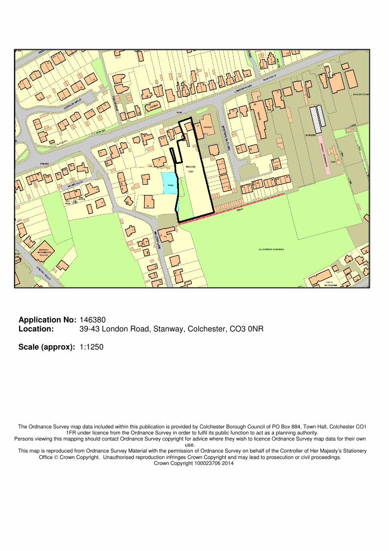
Application No: 146380 Location: 39-43 London Road, Stanway, Colchester, CO3 0NR Scale (approx): 1:1250 The Ordnance Survey map data included within this publication is provided by Colchester Borough Council of PO Box 884, Town Hall, Colchester CO1 1FR under licence from the Ordnance Survey in order to fulfil its public function to act as a planning authority. Persons viewing this mapping should contact Ordnance Survey copyright for advice where they wish to licence Ordnance Survey map data for their own use. This map is reproduced from Ordnance Survey Material with the permission of Ordnance Survey on behalf of the Controller of Her Majesty’s Stationery Office Crown Copyright. Unauthorised reproduction infringes Crown Copyright and may lead to prosecution or civil proceedings. Crown Copyright 100023706 2014
The Ordnance Survey map data included within this publication is provided by Colchester Borough Council of PO Box 884, Town Hall, Colchester CO1 1FR under licence from the Ordnance Survey in order to fulfil its public function to act as a planning authority.
Persons viewing this mapping should contact Ordnance Survey copyright for advice where they wish to licence Ordnance Survey map data for their own use.
This map is reproduced from Ordnance Survey Material with the permission of Ordnance Survey on behalf of the Controller of Her Majesty’s Stationery
Office Crown Copyright. Unauthorised reproduction infringes Crown Copyright and may lead to prosecution or civil proceedings. Crown Copyright 100023706 2014
DC0901MW eV3
7.4 Case Officer: Mark Russell MINOR Site: 39-43 London Road, Stanway, Colchester, CO3 0NR Application No: 146380 Date Received: 25 November 2014 Agent: Mr Peter Le Grys Applicant: Beech Hill Property Development Development: Ward: Stanway Summary of Recommendation: Conditional Approval
1.0 Reason for Referral to the Planning Committee 1.1 This application is referred to the Planning Committee because it has been called in by
Councillor Lesley Scott-Boutell on the grounds of overdevelopment and impact on residential amenity.
2.0 Synopsis 2.1 This report describes a proposed development of nine dwellings (in the place of one)
and looks at objections which have been raised relating to, amongst other things, claimed overdevelopment, impact on a pond and wildlife, loss of privacy and Highway impact.
2.2 It is explained that all of these matters can be dealt with by condition or are not
reasons for refusal. However, it is explained that amendments to the layout and design were sought to improve the impact on the street-scene, and that the scheme is acceptable and approval is recommended.
3.0 Site Description and Context 3.1 The development site comprises the existing bungalow at 39 London Road, Stanway, together with its large garden which contains several trees. 3.2 The pattern of development is very varied in the vicinity. The London Road frontage
has mainly two storey houses dating from the early 20th century, next to the to-be demolished bungalow is the Texaco petrol station, further back and next to the site is a well-established pond with some properties to the south and east and the charming older properties of Millers Lane beyond these. To the south of the site are allotments and the car park to the ‘Live and Let Live’ public house, to the west are the bungalows of Montbretia Close.
Demolition of one dwelling and construct one house and eight bungalows
DC0901MW eV3
4.0 Description of the Proposal 4.1 The proposal is to demolish the existing 39 London Road (a bungalow) and replace it
with a two-storey dwelling. It is also proposed to erect eight bungalows (1 x 2 bedroom, 7 x 3 bedroom) in the existing garden of that house.
5.0 Land Use Allocation 5.1 Predominantly residential. Potentially Contaminated Land, Landfill Site. 6.0 Relevant Planning History 6.1 140587 - Demolition of one dwelling and construct ten dwellings (nine dwellings net). Refuse - 25/04/2014 7.0 Principal Policies 7.1 Planning law requires that applications for planning permission must be determined in
accordance with the development plan, unless material considerations indicate otherwise. The National planning Policy Framework (NPPF) must also be taken into account in planning decisions and sets out the Government’s planning policies are to be applied. The NPPF makes clear that the purpose of the planning system is to contribute to the achievement of sustainable development. There are three dimensions to sustainable development: economic, social and environmental.
7.2 Continuing the themes of the NPPF, the adopted Colchester Borough Core Strategy
(adopted 2008, amended 2014) adds detail through local strategic policies. Particular to this application, the following policies are most relevant:
SD1 - Sustainable Development Locations H1 - Housing Delivery H2 - Housing Density H3 - Housing Diversity UR2 - Built Design and Character TA4 - Roads and Traffic TA5 - Parking ENV1 - Environment ER1 - Energy, Resources, Waste, Water and Recycling
7.3 In addition, the following are relevant adopted Colchester Borough Development
Policies (adopted 2010, amended 2014):
DP1 Design and Amenity DP12 Dwelling Standards DP13 Dwelling Alterations, Extensions and Replacement Dwellings DP14 Historic Environment Assets DP15 Retention of Open Space and Indoor Sports Facilities DP16 Private Amenity Space and Open Space Provision for New Residential Development DP17 Accessibility and Access DP18 Transport Infrastructure Proposals
DC0901MW eV3
DP19 Parking Standards DP20 Flood Risk and Management of Surface Water Drainage DP21 Nature Conservation and Protected Lanes DP25 Renewable Energy
7.4 Further to the above, the adopted Site Allocations (adopted 2010, amended 2014)
policies set out below should also be taken into account in the decision making process:
n/a
7.5 Regard should also be given to the following adopted Supplementary Planning
Guidance/Documents:
Backland and Infill Vehicle Parking Standards Sustainable Construction Open Space, Sport and Recreation The Essex Design Guide External Materials in New Developments Stanway Parish Plan and Design Statement (2011)
8.0 Consultations 8.1 The Highway Authority has not objected subject to the provision of vision splays,
parking and turning, no loose materials and other matters described in the conditions at the end of this report.
8.2 Environmental Control (Contaminated Land): “This is an acceptable Desk Study for
Environmental Protection purposes and, based on the information provided, it would appear that the site can be made suitable for the proposed use: we would therefore recommend that these additional risk assessments (including having regard to, but not limited by, all of the points listed above – i.e. asbestos, ground contamination from oil, a nearby historic waste pit, possible lead/arsenic from pesticides etc.) could be dealt with by way of condition, if you were minded to recommend approval.”
In addition to the details reported above, the full text of all consultation responses is available to view on the Council’s website. 9.0 Parish Council Response 9.1 Stanway Parish Council has responded as follows:
Stanway Parish Council OBJECTS to this proposal due to the increase in traffic, lack of parking, the density and design of the development which is overbearing and not in keeping with the area. Loss of privacy, loss of wildlife habitat, and potential flooding issues on the London Road. There is also the issue of the crossover from the development exiting onto London Road adjacent to a busy petrol station. The exit from the petrol station already creates problems with traffic leaving and accessing, so this will be increased by placing a new access road within such a short distance of this busy exit.
DC0901MW eV3
9.2 On reconsultation, with an amended set of drawings, Stanway Parish Council repeated its position:
After discussion it was RESOLVED that Stanway Parish Council strongly OBJECTS to this proposal due to increase in traffic, lack of parking, the density and design of the development which is overbearing and not in keeping with the area. Loss of privacy, loss of wildlife habitat including Greater Crested Newts which are known to be in the pond, and potential flooding issues on the London Road. Also the incidents of parking on the London Road obscures the proposed visibility splays.
10.0 Representations 10.1 Seven letters of objection were received from neighbouring and nearby properties.
These covered the following points:
• Overdevelopment
• Impact on the pond and wildlife
• Flood risk
• Extra traffic
• Pollution
• Difficulty of access for emergency vehicles
• Loss of part of the pond
• Pollution to the pond
• Loss of privacy
• Too close to Montbretia Close
• Inadequate parking/turning space
• Noise and disturbance
• Loss of trees
• Loss of light
• Design out of keeping
• The applicants have no right of access from the pub car park
• There is no nearby bus access
10.2 Two letters of support were received, stating that the proposal was more appropriate than the previous application and that this was the type of accommodation that older people wanted. It was disputed that there would be an increase in traffic which would give rise to any significant concerns.
10.3 An amended set of drawings was submitted, showing various changes suggested by
your Officer (detailed in the main report section). On receipt of this a reconsultation took place. Six objections were received, partly from the same parties as before (although three new parties objected). The objections largely repeated the previous points made, but some other points were raised:
• It is unacceptable to turn the bungalows in to two storey dwellings
• The Planning Officer has twice met with the developers, but not the residents
OFFICER COMMENT – The objector has been misinformed on this last point. Your Officer has not met with the developers, but did alert the current occupier of the house that he needed access to the rear garden.
DC0901MW eV3
The full text of all of the representations received is available to view on the Council’s website. 11.0 Parking Provision 11.1 The drawings show the requisite number of parking spaces, i.e. 225% parking for 9
plots = 20.25, or more logically 20 spaces. This is in the format of two spaces per unit plus two for visitors. Discounted in this calculation is provision for 41 London Road which is a like-for-like replacement (see below).
11.2 In terms of dimensions of garages those for units 3 and 4 comply with standards
(internal dimensions of in excess of 3 metres x 7 metres). The garage shown for unit 9 is deficient, but is not required for parking provision as plot 9 already has two spaces.
11.3 Regarding the parking spaces, those relating to plot 1 needed to be a little wider.
They needed to be 2.9m + 0.5m space to the side due to the structure/obstacle in the way of the opening door (in this case the refuse sack store wall and the boundary fence to Plot 1). This was achievable by moving the boundary to Plot 1 a little to the north. Plot 3 similarly needed to have its boundary fence moved in by 300mm. The arrangement at Plot 6 did not work as only 2.9 metres existed to the boundary. This was capable of remedy by the plot boundary being moved 500mm north at the point where the parking space was proposed. The visitor parking next to Plot 2 needed to be a little wider, which required the planting belt to be thinner at that point.
11.4 All of these issues were remedied with the resubmitted drawings, and therefore it is
confirmed that all matters relating to parking provision are satisfied. 11.5 The amended drawings have also shown that 41 London Road is to be provided two
parking spaces to the rear (just off of the access road) with the visitor spaces there reduced to one (a second being provided at the rear of the site). Therefore, the question regarding parking to the front (which appears to be informal, but which, it is believed, may have been accrued as right overtime) is not an issue. The issue initially arose as number 41 notionally has parking to the side of it (although it appears it has not been used for a long time) which would be lost to the development – hence, alternative provision was required.
12.0 Open Space Provisions 12.1 n/a 13.0 Air Quality 13.1 The site is outside of any Air Quality Management Area and will not generate
significant impacts upon the zones. 14.0 Development Team and Planning Obligations 14.1 This application is not classed as a “Major” application and therefore there was no
requirement for it to be considered by the Development Team and it is considered that no Planning Obligations should be sought via Section 106 (S106) of the Town and Country Planning Act 1990.
DC0901MW eV3
15.0 Report Principle 15.1 Members will be aware that the site is within the settlement limit of
Colchester/Stanway and is within a predominantly residential area. Therefore the principle of residential development cannot be resisted.
Layout 15.2 The layout is a logical one for this site which is a long, backland site that widens
slightly at the southern end. The space between the new Plot 1 and the existing 41 London Road gives a view on to the planted belt which then opens up into a longer view down towards Plot 7.
15.3 As initially arranged, the terminal vista was disappointing – namely a view of parked
cars. However, the application has now been amended, with Plot 7 and its parking being flipped so that the view is now of the gabled front section of that plot.
Design 15.4 The design for the house on to London Road is a standard red brick two over two style
which fits in with the majority of the two-storey dwellings in the area. Regarding the bungalows, these are largely shown with their short axis on to the road and with a subservient projecting front section. All materials are brick and slate, but with some concrete tiles.
15.5 Elevational improvements have been provided showing an uplifted scheme with
ornamental barge-boards, quoins and a finial which give the scheme a higher quality of appearance. This has necessitated a steeper pitch and thus lifting up of the roofs.
Highway Issues 15.6 The Highway Authority has not objected to the proposal. It has requested vision
splays which are easily achieved on this road and has requested other items which are also easily achieved. A Type 3 turning head exists to allow emergency vehicles and refuse freighters to enter and leave the site in a forward gear. A further vehicular turning head is also offered at the south-western end of the site.
15.7 Objections have been made suggesting that the proximity to the Texaco garage
makes the situation dangerous. However, this is an existing situation for numbers 39, 41 and others. There is an area to the front of those properties comprising a footway and some “no man’s land” which is thought to belong to the Highway Authority, although a right to use it for the parking of vehicles and potentially the right to even own it appears to have occurred overtime. Combined, these measure about six metres in depth which gives ample vision for motorists emerging and allows the 2.4 metres x 70 metres vision splays east and west to be provided.
DC0901MW eV3
Residential Amenity 15.8 Apart from the front plot, all of the proposed buildings are single storey, as such there
is no identifiable concern about overlooking or loss of light/outlook. 15.9 Nevertheless, the issue of lost privacy has been raised by one party (10 Millers Lane).
However, this property is in excess of 25 metres from the development site, nearly 30 metres from the nearest new house, and it must be remembered that the new house is single storey. A simple condition relating to boundary treatment (a close-boarded fence of 1.8 metres) will prevent any potential loss of privacy. This would also apply to number 8, which is 45 metres away from the nearest dwelling. Number 47 London Road already has at least one boundary fence between it and the site.
15.10 The increase in roof height, brought about by the steeper pitch, means that it will be
more likely that roof space will be used in the dwellings. Simple use (storage and so on) requires no permission, but insertion of rooflights can be controlled by the Local Planning Authority. As such, permitted development rights will be removed for the insertion of windows above ground floor. Each case would then be looked at on its merits.
15.11 The proposed eastern boundary has now been bolstered with planting to a depth of
about two metres. This means that the passing of motor vehicles should cause limited disturbance to the properties of Montbretia Close.
Amenity space 15.12 Complies with standards – a minimum of 60m2 for the three-bedroom properties and
50m2 for the two-bedroom property. The latter is marginal (55m2), but is balanced by the fact that three properties have well in excess of 100m2. On the whole this is usable space, although it is accepted that Plot 3 has two sections of approximately 11.5 x 5 metres and another chunk off this measuring 4 metres x 9 metres. It must be remembered, however, that the first section almost complies with the entire minimum on its own. Plot 9 also has two identifiable “chunks”, one of which thins to just under four metres in width and is not usable at its northern end due to trees. However, it must be recalled that this garden measures 161m2, which is more than two-and-a-half times the required minimum.
15.13 In context, these gardens are small when compared to some neighbouring properties,
for example 43 London Road which measures about 300m2, or 400m2 at 47a. However, a more representative context of this bungalow development is Montbretia Close. Here the neighbouring bungalows’ gardens (numbers 3-9) cover a range of about 75 to 100m2 which is comparable to the application site.
The pond 15.14 This has been raised as a concern by several parties, both in terms of the issue of
water run off and also habitat. 15.15 As the area is not in floodzone 2 or 3 (the nearest such site being over a mile away at
Cymbeline Meadows and Hillyfields to the east) and is less than one hectare, it does not require a Flood Risk Assessment.
DC0901MW eV3
15.16 The pond is said to receive water run off from London Road and from Millers Lane and
drawings have been provided by objectors which show a pipeline running from London Road under number 45, through the grounds of 47a London Road and 8 Millers Lane into the pond. The fear raised is that the new hard surfacing of the development will add to run-off and the pond will not be able to cope. It has also been claimed that the development site is partially on the pond and the smaller body of water will be unable to cope with the extra demand.
15.17 Regarding the latter, measurements have been taken on site, they show the drawings
to be sufficiently accurate. If, indeed, it appears that the pond is to be diminished in any way in order to provide larger gardens (for Plots 4, 5, 6 and 9), then this matter is easily dealt with by a condition stating that the pond shall not be filled in.
15.18 Regarding the former, if there is a problem of flood (which has been claimed by
several parties and there is no reason to dispute this) then it must be acknowledged that this is an existing problem irrespective of any development. However, it is therefore crucial to ensure that the development does not add to this problem. Therefore, a condition has been proposed which will ensure that a drainage strategy shall be submitted and that this strategy should demonstrate that the surface water run-off rates in the 1 in 1 year, 1 in 30 year and 1 in 100 year rainfall events including climate change will not exceed the run-off from the undeveloped site. This being the case, the development would not add to the existing problem and the issue can, therefore, be removed from consideration.
Ecology 15.19 In terms of ecology, on both the pond and the site generally, concerns have been
raised about a loss of habitat. A Phase 1 habitat survey has been commissioned and given the distance to the nearest designated site, the lack of rare plant species, no concerns over invertebrates and reptiles, bats, badgers, otters etc. limited concern over amphibians (particularly Great Crested Newts), whilst it is not held that these are likely to be affected, an informative is included at the end of this report advising the applicants what they should do if they find any of these protected creatures.
15.20 Bird boxes are advised (and will be provided by condition) as are deadwood piles for
stag beetles. 15.21 Regarding the issue over lost trees. It is accepted that there are several of these, and
these will have to be removed and a hard streetscape will be in their place. However, these are predominantly fruit trees of little intrinsic value. The ecology report acknowledges this and a condition will be attached stating that all trees shown on the submitted drawings shall be retained.
16.0 Conclusion 16.1 The application is a vast improvement on the previous, refused, application for ten
two-storey dwellings and has been further improved in terms of design and layout during the course of this application. Issues surrounding the pond have been dealt with, spatial standards in terms of amenity space and parking have been complied with and the Highway Authority does not object.
DC0901MW eV3
16.2 For the above reasons, approval is recommended. 17.0 Recommendation 17.1 APPROVE subject to the following conditions 18.0 Positivity Statement 18.1 WA2 - Application Approved Following Revisions
The Local Planning Authority has acted positively and proactively in determining this application by identifying matters of concern within the application (as originally submitted) and negotiating, with the Applicant, acceptable amendments to the proposal to address those concerns. As a result, the Local Planning Authority has been able to grant planning permission for an acceptable proposal, in accordance with the presumption in favour of sustainable development, as set out within the National Planning Policy Framework.
19.0 Conditions
1 - Time Limit for Full Permissions
The development hereby permitted shall be begun before the expiration of three years from the date of this permission. Reason: To comply with the requirements of Section 91 of the Town and Country Planning Act 1990, as amended by the Planning and Compulsory Purchase Act 2004.
2 - *Development to Accord With Approved Plans
The development hereby approved shall comply in all respects with the amended drawings 1129.10D, 1129.11A, 1129.12A, 1129.13A and 1129.11A in addition to the initially submitted drawing 1129-15. Reason: For the avoidance of doubt as to the scope of this permission and In the interests of proper Planning.
3 - Removal of PD for All Residential Extensions & Outbuildings
Notwithstanding the provisions of Classes A, B, C, D and E of Part 1 Schedule 2 of the Town and Country Planning (General Permitted Development) Order 1995 (or the equivalent provisions of any order revoking and re-enacting that Order), no extensions, ancillary buildings or structures shall be erected unless otherwise subsequently approved, in writing, by the Local Planning Authority. Reason: In the interest of visual amenity and to ensure the development avoids an overdeveloped or cluttered appearance.
4 - Non-Standard Condition/Reason
No new windows shall be inserted above ground floor level of any of the dwellings hereby approved without the submission of a Planning application to the Local Planning Authority. Reason: In the interests of residential amenity in terms of privacy as these matters would require closer consideration.
DC0901MW eV3
5 - Materials to be Agreed
No works shall take place until precise details of the manufacturer and types and colours of the external facing and roofing materials to be used in construction have been submitted to and approved, in writing, by the Local Planning Authority. Such materials as may be approved shall be those used in the development. Reason: In order to ensure that suitable materials are used on the development as there are insufficient details within the submitted planning application.
6 - Non-Standard Condition/Reason
Prior to the commencement of development, details of the provision, siting, design and materials of screen walls and fences shall have been submitted to and agreed, in writing, by the Local Planning Authority. This shall include further details of the proposed boundary treatment to plots 4, 5, 6 and 9 where these units border the pond and shall be offset so as to allow space for wildlife mitigation including, but not restricted to, the provision of wood piles for stag beetles. The approved screen walls and fences shall then be erected prior to the first occupation of the dwelling to which they relate and shall thereafter be retained in the approved form. Reason: There are insufficient details within the submitted application to ensure that the boundary treatments are satisfactory in relation to amenities and the surrounding context and it is desirable to offer landscape mitigation in the vicinity of the pond.
7 -Non-Standard Condition/Reason
Prior to the first occupation of the development hereby permitted, the parking shall have been laid out within the site in accordance with the approved plan 1129.10D. The approved parking spaces shall thereafter be maintained free from obstruction and available for parking use at all times. Reason: To ensure that there is satisfactory parking provision at the site at the time when the development becomes occupied.
8 - Tree or Shrub Planting
No works shall take place until details of tree and/or shrub planting and an implementation timetable have been submitted to and approved, in writing, by the Local Planning Authority. This planting shall be maintained for at least five years following contractual practical completion of the approved development. In the event that trees and/or plants die, are removed, destroyed, or in the opinion of the Local Planning Authority fail to thrive or are otherwise defective during such a period, they shall be replaced during the first planting season thereafter to specifications agreed in writing with the Local Planning Authority. Reason: To ensure an appropriate visual amenity in the local area.
9 - Non-Standard Condition/Reason
All trees shown as being retained on the submitted drawings (initial layout drawing retained 1129-10 rev C and resubmitted 1129-10 rev D) shall be retained at all times and shall have been safeguarded behind protective fencing to a standard that will have previously been submitted to and agreed, in writing, by the Local Planning Authority (see BS 5837). All agreed protective fencing shall thereafter be maintained during the course of all works on site and no access, works or placement of materials or soil shall take place within the protected area(s) without prior written consent from the Local Planning Authority. Reason: To safeguard existing trees, shrubs and other natural features within and adjoining the site in the interest of amenity.
DC0901MW eV3
10 - Non-Standard Condition/Reason
Notwithstanding the details of the drawings hereby approved NO HEDGE shall be removed at the southern edge of the site where it borders the allotment. Reason: In the interests of visual amenity as this forms an important visual barrier between the site and the allotments and its retention is highly desirable.
11 - Tree and Natural Feature Protection: Entire Site
No burning or storage of materials shall take place where damage could be caused to any tree, shrub or other natural feature to be retained on the site or on adjoining land (see BS 5837). Reason: To protect the health of trees, shrubs and other natural features to be retained in the interest of amenity.
12 - Non-Standard Condition/Reason
The garages provided at Plots 3 and 4 shall be retained at all times for the parking of cars. Reason: To ensure that nuisance is not caused by the parking of motor vehicles on the road.
13 - Contaminated Land Part 1 of 4 (Site Characterisation)
No works shall take place until an investigation and risk assessment, in addition to any assessment provided with the planning application, has been completed in accordance with a scheme to assess the nature and extent of any contamination on the site, whether or not it originates on the site. The contents of the scheme are subject to the approval, in writing, of the Local Planning Authority. The investigation and risk assessment must be undertaken by competent persons and a written report of the findings must be produced. The written report is subject to the approval in writing of the Local Planning Authority. The report of the findings must include:
(i) a survey of the extent, scale and nature of contamination, including contamination by soil gas and asbestos;
(ii) an assessment of the potential risks to: • human health, • property (existing or proposed) including buildings, crops, livestock, pets, woodland and service lines and pipes, • adjoining land, • groundwaters and surface waters, • ecological systems, • archaeological sites and ancient monuments; (iii) an appraisal of remedial options, and proposal of the preferred option(s). This must be conducted in accordance with DEFRA and the Environment Agency’s ‘Model Procedures for the Management of Land Contamination, CLR 11’ and the Essex Contaminated Land Consortium’s ‘Land Affected by Contamination: Technical Guidance for Applicants and Developers’.
Reason: To ensure that risks from land contamination to the future users of the land and neighbouring land are minimised, together with those to controlled waters, property and ecological systems, and to ensure that the development can be carried out safely without unacceptable risks to workers, neighbours and other offsite receptors
DC0901MW eV3
14 - Contaminated Land Part 2 of 4 (Submission of Remediation Scheme)
No works shall take place until a detailed remediation scheme to bring the site to a condition suitable for the intended use by removing unacceptable risks to human health, buildings and other property and the natural and historical environment has been prepared and then submitted to and agreed, in writing, by the Local Planning Authority. The scheme must include all works to be undertaken, proposed remediation objectives and remediation criteria, timetable of works and site management procedures. The scheme must ensure that the site will not qualify as contaminated land under Part 2A of the Environmental Protection Act 1990 in relation to the intended use of the land after remediation. Reason: To ensure that risks from land contamination to the future users of the land and neighbouring land are minimised, together with those to controlled waters, property and ecological systems, and to ensure that the development can be carried out safely without unacceptable risks to workers, neighbours and other offsite receptors
15 - Contaminated Land Pt. 3 of 4 (Implementation of Approved Remediation)
No works shall take place other than that required to carry out remediation, the approved remediation scheme must be carried out in accordance with the details approved. The Local Planning Authority must be given two weeks written notification of commencement of the remediation scheme works. Following completion of measures identified in the approved remediation scheme, a verification/validation report that demonstrates the effectiveness of the remediation carried out must be produced, and is subject to the approval in writing of the Local Planning Authority. Reason: To ensure that risks from land contamination to the future users of the land and neighbouring land are minimised, together with those to controlled waters, property and ecological systems, and to ensure that the development can be carried out safely without unacceptable risks to workers, neighbours and other offsite receptors.
16 - Contaminated Land Part 4 of 4 (Reporting of Unexpected Contamination)
In the event that contamination is found at any time when carrying out the approved development that was not previously identified it must be reported in writing immediately to the Local Planning Authority. An investigation and risk assessment must be undertaken in accordance with the requirements of condition 13, and where remediation is necessary a remediation scheme must be prepared in accordance with the requirements of condition 14, which is subject to the approval in writing of the Local Planning Authority. Following completion of measures identified in the approved remediation scheme a verification report must be prepared, which is subject to the approval in writing of the Local Planning Authority in accordance with condition 15. Reason: To ensure that risks from land contamination to the future users of the land and neighbouring land are minimised, together with those to controlled waters, property and ecological systems, and to ensure that the development can be carried out safely without unacceptable risks to workers, neighbours and other offsite receptors.
DC0901MW eV3
17 - *Validation Certificate
Prior to the first OCCUPATION/USE of the development, the developer shall submit to the Local Planning Authority a signed certificate to confirm that the remediation works have been completed in accordance with the documents and plans detailed in Condition 16. Reason: To ensure that risks from land contamination to the future users of the land and neighbouring land are minimised, together with those to controlled waters, property and ecological systems, and to ensure that the development can be carried out safely without unacceptable risks to workers, neighbours and other offsite receptors.
18 - Non-Standard Condition/Reason
Prior to the commencement of development, full details of all hard surfacing materials to the satisfaction of the local planning authority. Such details shall be implemented as such prior to the occupation of the dwellings hereby approved and shall be retained at all times. Reason: In the interests of visual amenity.
19 - Refuse and Recycling As Shown
Prior to the first occupation of the development, the refuse and recycling storage facilities as shown on the approved plans shall have been provided and made available to serve the development. Such facilities shall thereafter be retained to the satisfaction of the Local Planning Authority at all times. Reason: To ensure that adequate facilities are provided for refuse and recycling storage and collection.
20 - Non-Standard Condition/Reason
Prior to the occupation of any of the dwellings hereby approved, the developer shall provide bird boxes in a manner to be agreed (including timing of provision) by the local planning authority. Such boxes shall be installed and shall be retained at all times. Reason: In the interests of ecological mitigation as there will be displacement of birds as trees and other habitat are removed.
21 - Non-Standard Condition/Reason
No development shall take place until a surface water drainage scheme for the site, based on sustainable drainage principles and an assessment of the hydrological and hydro geological context of the development, has been submitted to and approved in writing by the local planning authority in consultation with the Environment Agency. The drainage strategy should demonstrate the surface water run-off rates in the 1 in 1 year, 1 in 30 year and 1 in 100 year rainfall events including climate change will not exceed the run-off from the undeveloped site following the corresponding rainfall event. No dwelling shall be occupied until all the works necessary in respect of that phase have been implemented in accordance with the approved details. Reason: To prevent environmental and amenity problems arising from flooding.
DC0901MW eV3
22 - Non-Standard Condition/Reason
Prior to occupation of the development, the access at its centre line shall be provided with a clear to ground visibility splay with dimensions of 2.4 metres by 70 metres to the east and 2.4 metres by 70 metres to the west, as measured from and along the nearside edge of the carriageway. Such vehicular visibility splays shall be provided before the access is first used by vehicular traffic and retained free of any obstruction at all times. Reason: To provide adequate inter- visibility between vehicles using the access and those in the existing public highway in the interest of highway safety.
23 - Non-Standard Condition/Reason
Prior to occupation of the development the vehicular parking and turning facilities, as shown on the submitted plan shall be constructed, surfaced and maintained free from obstruction within the site at all times for that sole purpose. Reason: To ensure that vehicles can enter and leave the highway in a forward gear in the interest of highway safety.
24 - Non-Standard Condition/Reason
No unbound material shall be used in the surface treatment of the vehicular access within 6 metres of the highway boundary. Reason: To avoid displacement of loose material onto the highway in the interests of highway safety.
25 - Non-Standard Condition/Reason
The carriageway(s) of the proposed estate road(s) shall be constructed up to and including at least road base level, prior to the commencement of the erection of any dwelling intended to take access from that road(s). The carriageways and footways shall be constructed up to and including base course surfacing to ensure that each dwelling prior to occupation has a properly consolidated and surfaced carriageway and footway, between the dwelling and the existing highway. Until final surfacing is completed, the footway base course shall be provided in a manner to avoid any upstands to gullies, covers, kerbs or other such obstructions within or bordering the footway. The carriageways, footways and footpaths in front of each dwelling shall be completed with final surfacing within twelve months (or three months in the case of a shared surface road or a mews) from the occupation of such dwelling. Reason: To ensure roads/footways are constructed to an appropriate standard in the interests of highway safety.
26 - Non-Standard Condition/Reason
Any vehicular hardstanding shall have minimum dimensions of 2.9 metres x 5.5 metres for each individual parking space (with an additional 500mm if next to an obstacle such as a building or wall), retained in perpetuity. Reason: To ensure adequate space for parking off the highway is provided in the interest of highway safety in accordance with Policy DM8 of the Development Management Policies as adopted as County Council Supplementary Guidance in February 2011.
DC0901MW eV3
20.0 Informatives
(1) ZT0 – Advisory Note on Construction & Demolition The developer is referred to the attached advisory note Advisory Notes for the Control of Pollution during Construction & Demolition Works for the avoidance of pollution during the demolition and construction works. Should the applicant require any further guidance they should contact Environmental Control prior to the commencement of the works.
(2) All works affecting the highway should be carried out by prior arrangement with, and to the requirements and satisfaction of, the Highway Authority and application for the necessary works should be made by initially telephoning 08456 037631.
(3) PLEASE NOTE that this permission contains a condition precedent that requires details to be agreed and/or activity to be undertaken either before you commence the development or before you occupy the development. This is of critical importance. If you do not comply with the condition precedent you may invalidate this permission. Please pay particular attention to these requirements.
(4) All housing developments in Essex which would result in the creation of a new street (more than five dwelling units communally served by a single all-purpose access) will be subject to The Advance Payments Code, Highways Act, 1980. The Developer will be served with an appropriate Notice within 6 weeks of building regulations approval being granted and prior to the commencement of any development must provide guaranteed deposits which will ensure that the new street is constructed in accordance with acceptable specification sufficient to ensure future maintenance as a public highway.
(5) Should the applicant wish to provide information packs to the new dwellings, Essex County Council as Highway Authority can assist in the production of appropriate material as packs of information are available for purchase by the developer. Contact the Sustainable Travel Planning team on 01245 436135 or email [email protected] for more information.
(6) Highway Works - All work within or affecting the highway is to be laid out and constructed by prior arrangement with, and to the requirements and satisfaction of, the Highway Authority, details to be agreed before the commencement of works. The applicants should be advised to contact the Development Management Team by email at [email protected] or by post to: Essex Highways, Colchester Highways Depot, 910 The Crescent, Colchester, CO4 9QQ.
(7) The Highway Authority cannot accept any liability for costs associated with a developer’s improvement. This includes design check safety audits, site supervision, commuted sums for maintenance and any potential claims under Part 1 and Part 2 of the Land Compensation Act 1973. To protect the Highway Authority against such compensation claims a cash deposit or bond may be required.
(8) Site Workers - Steps should be taken to ensure that the Developer provides sufficient turning and off loading facilities for delivery vehicles, within the limits of the site together with an adequate parking area for those employed in developing the site.
DC0901MW eV3
(9) The applicant is advised that in the unlikely event that any great crested newts are discovered on site during works, all works must cease and an ecologist be contacted for further advice.
(10 The applicant is advised that all wild mammals receive protection under the Wild Mammals (Protection) Act 1996 and it is a criminal offence to inflict unnecessary suffering on any of these animals. If any animal burrows are found during works, careful excavation of animals from their burrows before works commence should be sufficient to avoid an offence.