Low-Cost, Automated Ground Station for LEO Mission Support Doug Firestone*, Robert Atkin, Carl Hooks Tiger Innovations LLC. Reston, VA 20191, USA Christoph R. Englert, David E. Siskind Naval Research Laboratory, Space Science Division, Washington, DC 20375, USA Paul A. Bernhardt, Carl L. Siefring Naval Research Laboratory, Plasma Physics Division, Washington, DC 20375, USA Patricia A Klein Naval Research Laboratory, Spacecraft Engineering Department,, Washington, DC 20375, USA *Corresponding author: [email protected], 12355 Sunrise Valley Drive Suite 45, Reston, VA 20191, phone: 703-391-0060 x106
Transcript
Low-Cost, Automated Ground Station for LEO Mission Support
Doug Firestone*, Robert Atkin, Carl Hooks Tiger Innovations LLC. Reston, VA 20191, USA
Christoph R. Englert, David E. Siskind Naval Research Laboratory, Space Science Division, Washington, DC 20375, USA
Paul A. Bernhardt, Carl L. Siefring Naval Research Laboratory, Plasma Physics Division, Washington, DC 20375, USA
Patricia A Klein Naval Research Laboratory, Spacecraft Engineering Department,, Washington, DC 20375, USA
*Corresponding author: [email protected], 12355 Sunrise Valley Drive
Suite 45, Reston, VA 20191, phone: 703-391-0060 x106
ABSTRACT
The STPSat-1 spacecraft is a low Earth orbit (LEO), small satellite (total mass: 156 kg) built by
AeroAstro Inc. for the US Air Force Space Test Program. It carries two payloads: The Spatial
Heterodyne Imager for Mesospheric Radicals (SHIMMER) and the Scintillation and
Tomography Receiver in Space (CITRIS). The satellite bus and its payloads were designed for a
13 month mission. After the successful completion of the one year nominal mission, the payload
teams desired to continue satellite operations for at least an additional year to achieve additional
scientific objectives. To meet this new mission goal within the available, but limited funding,
Tiger Innovations successfully designed, built, and integrated an automated ground system
solution for a low cost mission extension. Automating a LEO ground station presents a number
of unique challenges, including equipment setup, health and safety monitoring, payload
interfaces, and anomaly reporting and resolution. The successful STPSat-1 mission extension
serves as a powerful demonstration of the tools and procedures necessary to operate comparable
future missions in the same manner. Moreover, the entire development cycle from concept to
on-orbit commanding was accomplished in less than 6 weeks. Such aggressive schedules are
particularly important for operationally responsive space missions.
1. INTRODUCTION
The STPSat-1 (Space Test Program Satellite-1) spacecraft is a low Earth orbit (LEO) small
satellite (total mass: 156 kg) built by AeroAstro Inc. for the US Air Force Space Test Program.
The vehicle launched in March 2007 as part of the STP-1 Atlas-V launch on board the EELV
ESPA ring [1]. The primary payload, the Spatial Heterodyne Imager for Mesospheric Radicals
(SHIMMER), is a high-resolution ultraviolet spectrometer based on the novel optical technique
known as Spatial Heterodyne Spectroscopy (SHS) [2]. SHS facilitates the design of low mass,
low power, high throughput spectrometers for space-based remote sensing. The main SHIMMER
objectives for the nominal mission were the demonstration of SHS for long term UV remote
sensing of the atmosphere and the measurement of vertical hydroxyl (OH) profiles in the
mesosphere [3]. The secondary experiment, the Computerized Ionospheric Tomography
Receiver in Space (CITRIS), investigates irregularities that affect propagation of satellite-to-
ground links for GPS (Global Positioning System) and communications [4]. Both payloads were
provided by the Naval Research Laboratory (NRL).
The STPSat-1 mission was designed for 13 months of on-orbit operations at which time the
vehicle would be turned off. After meeting the nominal mission objectives for the first year of
operations, the NRL payload teams explored several options to extend the satellite operations for
an additional year in order to gather additional scientific data. To stay within the constraints of
the available funding for the mission extension, a new operations approach that could be
developed quickly enough to meet a six week transition deadline and that could drastically
reduce cost, was needed. Tiger Innovations proposed the development of an automated ground
station and operations approach using the Tiger Innovations StreamLINK ground control system
coupled with existing ground station resources at the NRL’s Blossom Point satellite tracking
facility. The most significant cost reductions are achieved by integrating StreamLINK with the
Blossom Point ground system and elimination of much of the staffing requirements by fully
automating virtually all normal STPSat-1 operations activities.
Figure 1: SGCS Equipment Rack
1.1 StreamLINK Ground Control System
Tiger Innovations’ StreamLINK is a highly capable spacecraft ground control software package
for use during simulation, I&T, and on-orbit operations. The StreamLINK system is modular,
and is easily adaptable and extensible. StreamLINK uses database-driven commanding,
telemetry de-commutation and display, and automation via the Tcl scripting language. For the
STPSat-1 mission extension program, StreamLINK was integrated into a small mobile
equipment rack (16U, 19” rack) that allows it to interface with the host facility and performs
frame synchronization and command formatting functions. Tiger Innovations’ StreamLINK
Ground Control System (SGCS) has been used on multiple programs including HXS, HENEX,
STPSat-1 and STP-SIV (STPSat-2).
1.2 Blossom Point Satellite Tracking and Command Station
The Blossom Point Satellite Tracking and Command Station (BPSTCS) is a fully automated
command and control facility capable of supporting multiple satellites concurrently. The system
currently supports 13 spacecraft in a wide variety of orbits 24 hours a day, 7 days a week, taking
approximately 186 contacts per day. The BPSTCS is manned eight hours per day, five days a
week and operates with a high degree of automation. STPSat-1 is operated solely from Blossom
Point, which supports approximately five STPSat-1 contacts per day. During normal operations,
STPSat-1 support is limited to approximately one man hour per week, with engineering staff
available to support anomaly resolution as needed. The software system is based on the
Common Ground Architecture (CGA) developed by NRL to support all aspects of the satellite
development lifecycle from box level testing through operations. The Automated Ground
Operations software (AGO) allows the system to run automatically without any operators
required.
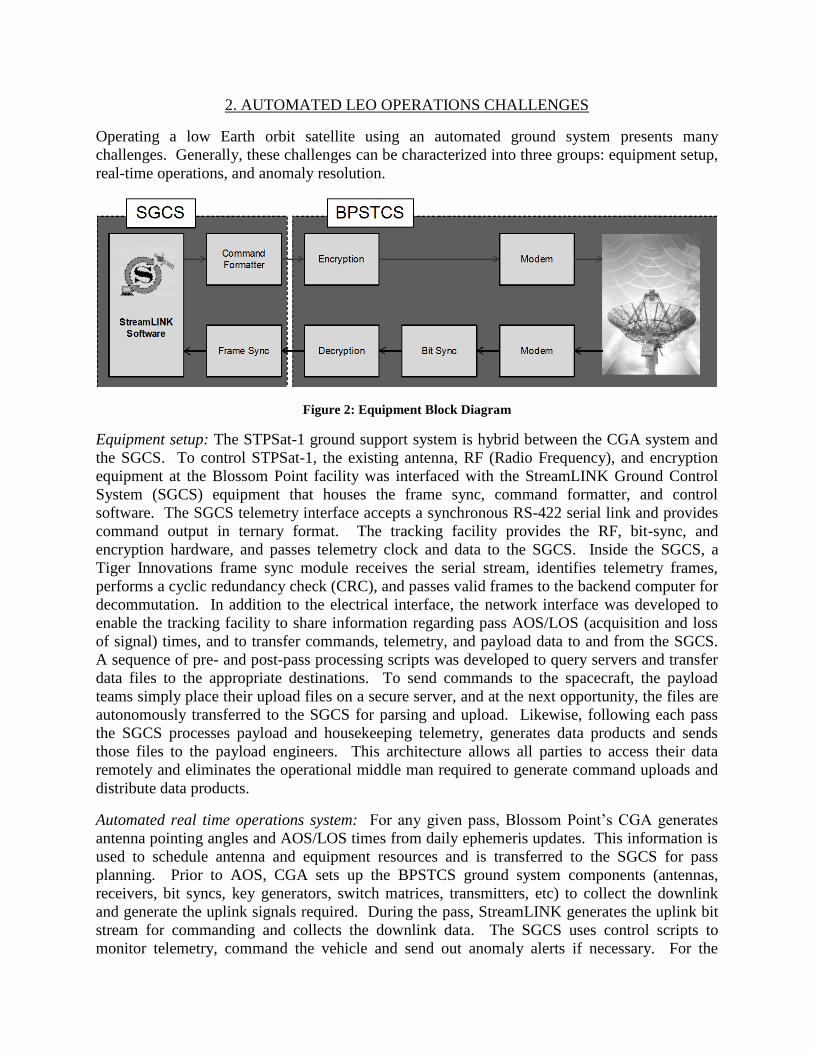
2. AUTOMATED LEO OPERATIONS CHALLENGES
Operating a low Earth orbit satellite using an automated ground system presents many
challenges. Generally, these challenges can be characterized into three groups: equipment setup,
real-time operations, and anomaly resolution.
Figure 2: Equipment Block Diagram
Equipment setup: The STPSat-1 ground support system is hybrid between the CGA system and
the SGCS. To control STPSat-1, the existing antenna, RF (Radio Frequency), and encryption
equipment at the Blossom Point facility was interfaced with the StreamLINK Ground Control
System (SGCS) equipment that houses the frame sync, command formatter, and control
software. The SGCS telemetry interface accepts a synchronous RS-422 serial link and provides
command output in ternary format. The tracking facility provides the RF, bit-sync, and
encryption hardware, and passes telemetry clock and data to the SGCS. Inside the SGCS, a
Tiger Innovations frame sync module receives the serial stream, identifies telemetry frames,
performs a cyclic redundancy check (CRC), and passes valid frames to the backend computer for
decommutation. In addition to the electrical interface, the network interface was developed to
enable the tracking facility to share information regarding pass AOS/LOS (acquisition and loss
of signal) times, and to transfer commands, telemetry, and payload data to and from the SGCS.
A sequence of pre- and post-pass processing scripts was developed to query servers and transfer
data files to the appropriate destinations. To send commands to the spacecraft, the payload
teams simply place their upload files on a secure server, and at the next opportunity, the files are
autonomously transferred to the SGCS for parsing and upload. Likewise, following each pass
the SGCS processes payload and housekeeping telemetry, generates data products and sends
those files to the payload engineers. This architecture allows all parties to access their data
remotely and eliminates the operational middle man required to generate command uploads and
distribute data products.
Automated real time operations system: For any given pass, Blossom Point’s CGA generates
antenna pointing angles and AOS/LOS times from daily ephemeris updates. This information is
used to schedule antenna and equipment resources and is transferred to the SGCS for pass
planning. Prior to AOS, CGA sets up the BPSTCS ground system components (antennas,
receivers, bit syncs, key generators, switch matrices, transmitters, etc) to collect the downlink
and generate the uplink signals required. During the pass, StreamLINK generates the uplink bit
stream for commanding and collects the downlink data. The SGCS uses control scripts to
monitor telemetry, command the vehicle and send out anomaly alerts if necessary. For the
STPSat-1 mission, the main script waits for AOS, ensures the uplink and downlink are set up
properly, and then begins normal pass operations. This includes scheduling the flight transmitter
on-time, running a critical health check, uploading payload and engineering commands, and
downloading stored data. The critical health check monitors a large set of telemetry that
effectively characterizes the overall health of the spacecraft. Alerts are generated for out of limit
points and in certain cases, autonomous recovery operations are triggered. Following the critical
health check, command uploads are sent to the vehicle. Each command is sent individually and
verified as received prior to sending the next command. If a given command file cannot be fully
uploaded in one pass it is carried over to the following passes. While commands are uploaded,
stored state of health and payload data is received. For each received data type, the SGCS
monitors data quality and sequence numbers and requests retransmission of missing data to
ensure the payload engineers receive all science data. Finally, after LOS, the SGCS processes
the state of health and payload data, generates plots, and sends out emails to all interested parties
regarding the pass status. Data products are then transferred via FTP from the SGCS to NRL
within 15 minutes. This pass Concept of Operations allows for all interested parties to monitor as
much or as little of each pass as desired. All data is received on the ground without requiring a
person in the loop, thus significantly reducing the recurring costs.
On-orbit anomalies: Dealing with on-orbit anomalies without operators in the loop to make
anomaly assessments and send commands is arguably the most difficult challenge. First, the
anomalies from the first year of operations, and even further back, from integration and test
(I&T), were characterized and evaluated, based on severity, likelihood of occurring, and
standardization of a response. The two anomalies that are most likely to occur elicited a standard
response. They were a GPS receiver anomaly and a processor anomaly. Both anomalies are due
to radiation effects that were likely to increase in frequency the longer the mission exceeded its
design life. In both cases, a specific telemetry state identifies the anomaly and was easily
incorporated into the critical health check. The response to each anomaly is the execution of a
sub-script that examines additional telemetry to identify the proper command uploads, and
autonomously fixes the problem. In addition to well characterized and rather benign anomalies
like these, there are anomalies that have a standard response but are severe enough that a review
by an engineer is required. Furthermore, new anomalies that require individual analysis cannot
be ruled out. In these cases, the SGCS script sends emails and text messages to the proper
engineering group and continues to downlink data to gather information on the anomaly.
Spacecraft safehold is the best example of an anomaly that has a generally standard response but
requires an engineering review. STPSat-1 has a power positive tumble safehold state that is
triggered by an under voltage, however, there are many possible causes for the under voltage
condition. After the engineering team is alerted by the SGCS, telemetry review and analysis
determines if it is safe to begin recovery from safehold, and if so, the automated recovery process
is initiated and the vehicle can return to normal operations in a matter of hours. This minimizes
the cost of conducting a safehold recovery procedure while ensuring a detailed understanding of
the anomaly cause and that it is ready to return to normal ops.
The last piece of the anomaly resolution concept for the STPSat-1 mission is the recognition and
acceptance by all parties that anomaly response times are generally longer compared to
operations concepts that use a fully staffed 24/7 ground station and a global ground station
network. The trade-off in this case is the drastically reduced operations cost which over the
course of a mission may easily outweigh slightly increased payload downtime. In STPSat-1’s
case, the alternative was the satellite end-of-life and thus no data at all.
3. SHIMMER AND CITRIS RESULTS MADE POSSIBLE BY THE MISSION EXTENSION
The greatly reduced operations cost allowed the extension of the STPSat-1 mission which
contributed significantly to the science accomplished by its two payloads. For this mission, the
increased time on orbit facilitated scientific results that were not possible to achieve with only
the nominal mission. The following sections summarize those results.
3.1.SHIMMER extended mission results
The main science objective of the extended SHIMMER mission is the measurement of mid-
latitude mesospheric clouds at latitudes up to 58° north and 58° south, which are the most
poleward latitudes that are sampled by SHIMMER in the boreal and austral summer,
respectively. These clouds are extensions of the more persistent Polar Mesopsheric Cloud (PMC)
layer, which forms each summer. Between about 50°-60 latitude PMCs can be observed by the
naked eye from the ground during twilight when the lower atmosphere is dark and the upper
atmosphere is still sunlit. They are thus known more popularly as noctilucent clouds (NLC). At
even lower latitudes (equatorward of 50°), their occurrence is considered by some as a novelty
[4] and even as a harbinger of long-term change [6]. Indeed the mid-latitude region is precisely
where the societal and scientific interest was galvanized by reports in the last decade of increases
in cloud occurrence and brightness. In response to this interest, NASA selected the Aeronomy of
Ice in the Mesosphere (AIM) small explorer which was launched in April of 2007 and is devoted
to the study of PMCs [7]. Initial results from AIM reveal spectacular images of PMCs with
intricate patterns that suggest heretofore unexplored dynamics in the mesopause region.
However, there are two important limitations to AIM’s coverage of mesospheric clouds that are
addressed by SHIMMER.
One major strength of SHIMMER relative to AIM, is its ability to measure the dimmer clouds
that form at non-polar latitudes (40°-60°). The only AIM instrument which observes at these
latitudes is the Cloud Imaging and Particle Size (CIPS) imager, which because it views clouds in
the nadir, not the limb like SHIMMER, is not very sensitive to the dimmer clouds occurring in
this latitude region.
The second strength of SHIMMER is its ability to measure the diurnal variations in mesospheric
clouds. The importance of diurnal variations in mesospheric clouds was not fully appreciated
when AIM was proposed in 2001 but evidence is now clear that local time variations are
important in governing the distribution of PMCs [8] and their extension to mid-latitudes [9].
AIM, and all other NASA and NOAA mesospheric cloud sounders before it (SBUV, SME,
SNOE), are in sun-synchronous orbits. This means that observations are made at a single local
time at mid-latitudes, preventing a description of cloud properties over the diurnal cycle.
SHIMMER is not in a sun-synchronous orbit and the low latitude inclination of SHIMMER
means that at the “top” of the orbit (observation locations at ~58° latitude), SHIMMER records
many images of the atmosphere and samples a wide range of local times. These local times
precess about 0.5 hrs/day so that SHIMMER can easily observe the entire diurnal cycle over one
mesospheric cloud season. Figure 3 summarizes the dense coverage obtained by SHIMMER
between 40° and 58° N.
Figure 3: SHIMMER measurement locations for July 16, 2007. The map extends from the north pole to 40°N
and a limb image is indicated by a colored circle, where only every other measurement is plotted for clarity.
The local times of the measurements precess by about thirty minutes from one day to the next [9].
The extension of the SHIMMER data to more than two years provided the local time variation of
mid-latitude PMCs in both hemispheres for at least two seasons [10]. The second northern
season was particularly insightful, since the PMC local time variation was radically different
than in the previous season, which has never been observed before and which has an immediate
impact on the interpretation of historical PMC data. Future investigations using SHIMMER data
are expected to advance our understanding of processes in the middle atmosphere and can also
be valuable as tests of new high altitude extensions of operational weather forecast systems [11].
In addition to the PMC measurements, the extension of the SHIMMER OH measurements, also
resolved in local time, are expected to facilitate new studies of the middle atmospheric
photochemistry and dynamics [3].
3.2. CITRIS and Complementary Measurements for C/NOFS
After successfully, completing its first-year Space Weather proof-of-concept mission, the
CITRIS receiver on STPSat-1, was used to complement the C/NOFS (Communication
/Navigations Outages Forecasting System) mission. C/NOFS carries one of NRL’s CERTO
(Coherent Electromagnetic Radio Tomography) beacon transmitters, the signals of which can be
received by CITRIS yielding TEC (Total Electron Content) and scintillation measurements in
VHF, UHF and L-band [12]. Irregularity structures, e.g., Spread-F, in the equatorial ionosphere
are well known for causing some of the most serious communications and navigation effects,
especially in the form of radio scintillations. Predicting when communication and navigation
outages might occur from scintillations is a critical area of research for both DOD and NASA.
CITRIS measures both the causative irregularities via TEC and their effect as scintillations.
The STPSat-1 with CITRIS is in an almost circular orbit near 555 km altitude with a 35°
inclination. C/NOFS was launched (April 2008) in an elliptical orbit of ~400 km x 850 km at
13° inclination about one year after the CITRIS launch (March 2007). The orbital periods of the
two satellites are relatively close, so that the CERTO beacon stays in view of the CITRIS
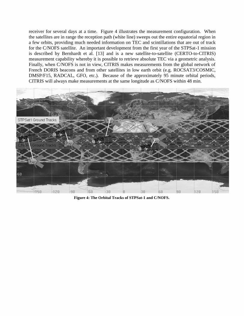
receiver for several days at a time. Figure 4 illustrates the measurement configuration. When
the satellites are in range the reception path (white line) sweeps out the entire equatorial region in
a few orbits, providing much needed information on TEC and scintillations that are out of track
for the C/NOFS satellite. An important development from the first year of the STPSat-1 mission
is described by Bernhardt et al. [13] and is a new satellite-to-satellite (CERTO-to-CITRIS)
measurement capability whereby it is possible to retrieve absolute TEC via a geometric analysis.
Finally, when C/NOFS is not in view, CITRIS makes measurements from the global network of
French DORIS beacons and from other satellites in low earth orbit (e.g. ROCSAT3/COSMIC,
DMSP/F15, RADCAL, GFO, etc.). Because of the approximately 95 minute orbital periods,
CITRIS will always make measurements at the same longitude as C/NOFS within 48 min.
Figure 4: The Orbital Tracks of STPSat-1 and C/NOFS.
4. LESSONS LEARNED AND RECOMMENDATIONS
As of this writing, STPSat-1 continues to operate despite the continuing, radiation-induced
degradation of its systems. We anticipate processor resets to continue to rise in frequency (1 in
the first year, 4 in the second). However, the automated recovery process discussed above largely
mitigates that concern. The spacecraft continues to produce valuable science data and provides a
model for maximizing the value of low-cost missions and ensuring responsible cost efficiency of
their operations. This also leads to the question of whether ground station automation, after the
initial launch and early orbit operations, can be used to reduce the cost of future satellite
missions. Based on the success of the STPSat-1 mission extension, the answer is definitely
“yes” for missions that can accept the moderately increased risk of anomaly downtime. Given
the often limited funding, the significant cost reduction offered by this operations approach
warrants that it be considered for future mission planning.
Furthermore, for missions like STPSat-1, completely separate ground systems are generally
developed for (1) the integration and test phase and (2) the flight phase of the mission. One of
the reasons StreamLINK was so easily adapted to operate STPSat-1 was that it was the I&T
ground system when the spacecraft was being built. Mission costs could be reduced even more
by utilizing the same ground system for both I&T and flight and not duplicating development
costs. This also enables the spacecraft engineers to develop and test automation scripts in a
controlled environment on the ground prior to launch to ensure reliability and repeatability of the
operational activities. While it is understood that operations personnel and engineering support
must be actively engaged in early orbit checkout and initial operations, it seems reasonable that
most missions could transition to automated operations 2-3 months after launch, potentially
saving the government or commercial customer millions of dollars depending on the lifetime of
the mission.
Finally, to meet the demanding schedule constraints of the mission, the entire development cycle
from concept to on-orbit commanding was accomplished in less than six weeks. There is
currently a strong desire in the small satellite industry for Operationally Responsive Space
(ORS) missions to reduce the time from concept development to having an operational satellite
on orbit that fully meets the customer’s requirements. The hardware, software, and techniques
that were used in support of the STPSat-1 mission extension demonstrate the ability to field a
small, inexpensive ground station, fully integrated and tested in a minimal amount of time. This
capability could be useful and cost effective for future ORS missions.
ACKNOWLEDGEMENTS
SHIMMER and CITRIS are joint programs between the Naval Research Laboratory and the
DoD Space Test Program. The authors would like to thank the engineers and personnel at the
Blossom Point Tracking Facility for hosting and providing on-site support for the STPSat-1
mission extension. We also want to thank Andrew Straatveit and Doug Koch for their support of
the SHIMMER and CITRIS payloads throughout the life of the STPSat-1 mission. Partial
funding for the STPSat-1 extension was provided by a grant from the NASA Heliophysics
Division. Funding for the CITRIS mission extension was provided by the US Office of Naval
Research.
REFERENCES
1. Haskett SA, Weis SC, Doggrell LJ, Sciulli D, Mienk T, Ganley J, Maly JR, Jurisson K,
EELV Secondary Payload adapter (ESPA), Proc. of SPIE, 2000, 4136, 27-35.
2. Harlander JM, Roesler FL, Englert CR, Cardon JG, Conway RR, Brown CM, Wimperis J,
Robust monolithic ultraviolet interferometer for the SHIMMER instrument on STPSat-1,
Applied Optics, 2003, 42, 2829-2834.
3. Englert CR, Stevens MH, Siskind DE, Harlander JM, Roesler FL, Pickett HM, von Savigny
C, Kochenash AJ, First Results from the Spatial Heterodyne Imager for Mesospheric
Radicals (SHIMMER): Diurnal variation of mesospheric hydroxyl, 2008, Geophys. Res.
Lett., 2008, 35, L19813, doi:10.1029/2008GL035420
4. Bernhardt PA, Siefring CL, New satellite-based systems for ionospheric tomography and
scintillation region imaging, Radio Science, 2006, 41, RS5S23, doi: 10.1029/2005RS003360.
5. Taylor, M.J, et al., Mesospheric cloud observations at unusually low latitudes, J. Atm. Sol.-
Terr. Phys., 64, 991-999, 2002.
6. Thomas, G.E. et al., Comment on “Are Noctilucent Clouds Truly a “Miner’s Canary” for
Global Change”, EOS, 84, 351, 2003.
7. Russell, J.M., et al. (2009), The Aeronomy of Ice in the Mesosphere (AIM) mission:
Overview and early science results, Journal of Atmospheric and Solar-Terrestrial Physics, 71,
289-299 , doi:10.1016 /j.jastp.2008.08.011.
8. Fiedler, J., G. Baumgarten and G. von Cossart, Mean diurnal variations of noctilucent clouds
during 7 years of lidar observations at ALOMAR, Annales Geophysicae, 23, 1175-1181,
2005.
9. Stevens MH, Englert CR, Petelina SV, Singer W, Nielsen K, The diurnal variation of
noctilucent cloud frequency near 55°N observed by SHIMMER, J. Atmos. and Solar-Terr.


![Leo Magee [Imagee@SDUBLINCOCO.ie] · Processed at Thorntons baling station Processed at Ballyogan baling station Processed at Oxigen baling station 175,000 tonnes 25,000 tonnes 10,000](https://static.documents.pub/doc/80x56/5f43549a2175b52181020cd2/leo-magee-imagee-processed-at-thorntons-baling-station-processed-at-ballyogan.jpg)


