MAKING TORONTO'S STREETS September 2006 Report prepared by Paul M. Hess, PhD, University of Toronto Beth Moore Milroy, PhD, FCIP, RPP, Ryerson University in conjunction with a Steering Committee of: Paul Bedford Janice Etter Tim Lawson Mark Lenters Michael McMahon John Niedra Rhona Swarbrick Ted Tyndorf Phil Weber Funded by The Centre for Urban Health Initiatives, University of Toronto The opinions and views expressed in this report do not necessarily reflect those of the organizations associated with the Steering Committee, the Steering Committee members, or the funders.
Transcript
MAKING TORONTO'S STREETS
September 2006
Report prepared by
Paul M. Hess, PhD, University of Toronto
Beth Moore Milroy, PhD, FCIP, RPP, Ryerson University
in conjunction with a Steering Committee of: Paul Bedford Janice Etter Tim Lawson Mark Lenters
Michael McMahon John Niedra
Rhona Swarbrick Ted Tyndorf Phil Weber
Funded by The Centre for Urban Health Initiatives, University of Toronto
The opinions and views expressed in this report do not necessarily reflect those of the organizations associated with the Steering Committee, the Steering Committee members, or the
funders.
Hess & Milroy Making Toronto’s Streets
i
PAUL M. HESS, PhD, is an assistant professor in the Department of Geography / Program in
Planning at the University of Toronto. He is the principal investigator.
BETH MOORE MILROY, PhD, FCIP was a professor in the School of Urban and Regional Planning at Ryerson University at the time of this study. She is now Professor Emerita. Her role
in this study is co-investigator. Contact for further information:
PART 3 - MOVING AHEAD: FINDINGS AND RECOMMENDATIONS..... 79
FINDINGS…………………………………………………………….……. 79
RECOMMENDATIONS………………………………………………….. 84
BIBLIOGRAPHY………………………………………………………………….. 87
APPENDIX 1: METHODS………………………………………………………… 96
APPENDIX 2: POST-AMALGAMATION: A NOTE ON CONTEXT ……………98
APPENDIX 3: GLOSSARY ……………………………………………………….102
Hess & Milroy Making Toronto’s Streets
v
PREFACE
This project was initiated by questions posed by community activists, Janice Etter and Rhona Swarbrick, authors of Toronto's Pedestrian Charter. They wanted to know why the road classification system developed for road engineering and maintenance purposes has such a powerful effect on how Toronto manages its streets while pedestrianism has so little. The road classification system establishes a hierarchy of arterial, collector and local streets. Each of these categories shapes road widths, carrying capacities, safe speeds, traffic signals, and intersection design through the use of guidelines, standards, and established practices. In this way, the system influences the pedestrian environment and adjoining land uses although those are not its stated purposes. We thank them for encouraging us to do the investigation because we learned a great deal. By passing on the information we hope others will benefit too.
A special thanks to interviewees, and many others from whom we sought information, for so willingly sharing their deep intelligence about Toronto streets with us.
The study was possible because the Centre for Urban Health Initiatives promotes investigations that connect community concerns and university researchers.
Hess & Milroy Making Toronto’s Streets vi
SUMMARY
The main finding of this study is that Toronto is talking about a new vision for its streets but the tools to achieve it are missing. The new vision wants more people out of their cars, on public transit, on foot and bikes. But almost all the institutional mechanisms for making and changing streets in light of those ideals are geared to an older vision, one primarily oriented toward moving cars, not to the new one. There is little money to work with so creative solutions are needed.
Streets are central to Torontonians’ quality of life, whether considered from the point of view of mobility, the state of the economy, our health, social interaction, or how the city looks. They also occupy more than 25 per cent of a city's land. Yet most of us know little about streets, such as why are vehicles favoured over all other ways of moving from place to place? How long have we done things this way? Why are the usual strategies no longer working well? In this report there is a very brief history of Toronto street forms. This is followed by reviews of three challenges to how streets are currently made -- to the widely used road classification system as a model for managing vehicle traffic, to the myopia affecting street design, and to cavalier attitudes toward public health. Institutional structures of the city that affect street-making are covered in some detail, including the city's main departments and agencies, their initiatives and issues; and the pertinent documents, policies and practices concerning streets. We finally summarize our findings and make eight recommendations, principal among which is that a working group begin right away to tackle the very hard trade offs that have to be made in order to stop making streets in line with the old vision but instead closer to the new one.
The report is a backgrounder on how city streets are made, maintained and changed, particularly in Toronto. We have not come across any other studies like this of how a city makes its streets. We hope it is useful to groups that are pursuing particular interests in streets. They can re-package the material to suit their needs. We also hope that the report is informative for staff and politicians working for the city by pointing to the importance of zeroing in on how current institutional conditions allow the hard debates about trade-offs to be avoided. Making room for the emerging vision requires negotiating its place and managing it.
We were heartened to find that struggles over streets are not simply a matter of an engineering versus a planning view of streets. Our data show that visionary thinking is going on in both types of departments, and so is path-of-least-resistance thinking. Nor is it a matter of residents versus city staff who don't understand the "right" thing to do. From our observations, residents, staff and politicians all do their share of both promoting and delaying renewed thinking about streets.
Hess & Milroy Making Toronto’s Streets vii
LIST OF FIGURES Page
Figure 1. Parts of a street ……………………….……………………………….…. 4
Figure 2. Diagram of the Road Classification System from the Transportation Association of Canada………………………………........ 6
Figure 3. Map of Rosedale, 1905 showing a curvilinear street pattern characteristic of garden suburb designs………………………………….. 7
Figure 4. Diagram of a neighbourhood unit as conceptualized by Clarence Perry……………………………………………………………. 8
Figure 5. Plan for extension of Kapuskasing, Ontario from the1920’s showing garden suburb and neighbourhood unit ideas………………….. 8
Figure 6. Pre-World War II street patterns in central Toronto and post-war street patterns in North York…………………………………… 9
Figure 7. Bell Manor Apartment House Development by Eugene Faludi showing loose relationship between buildings and streets……………… 10
Figure 21. Housing near traditional main streets creates short walking distances between housing and commercial areas while segregated land use patterns in suburban areas create long walking distances that often require crossing large arterials……………. 23
Figure 22. The effect street patterns can have on walking distances, comparing grid-based streets and loop and cul-de-sac streets…………... 24
Figure 23. Number of official smog days in Toronto, 1993-2002………………….. 25
Figure 24. Pavement prediction model for arterials showing how pavement quality declines over time……………………………………. 28
LIST OF TABLES Page
Table 1. Pedestrians Involved in Collisions, 2000-2005…………………………. 22
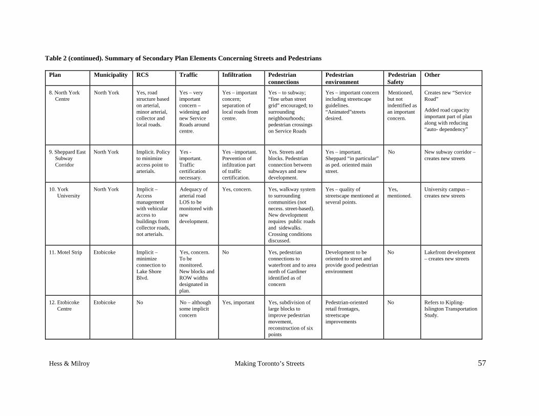
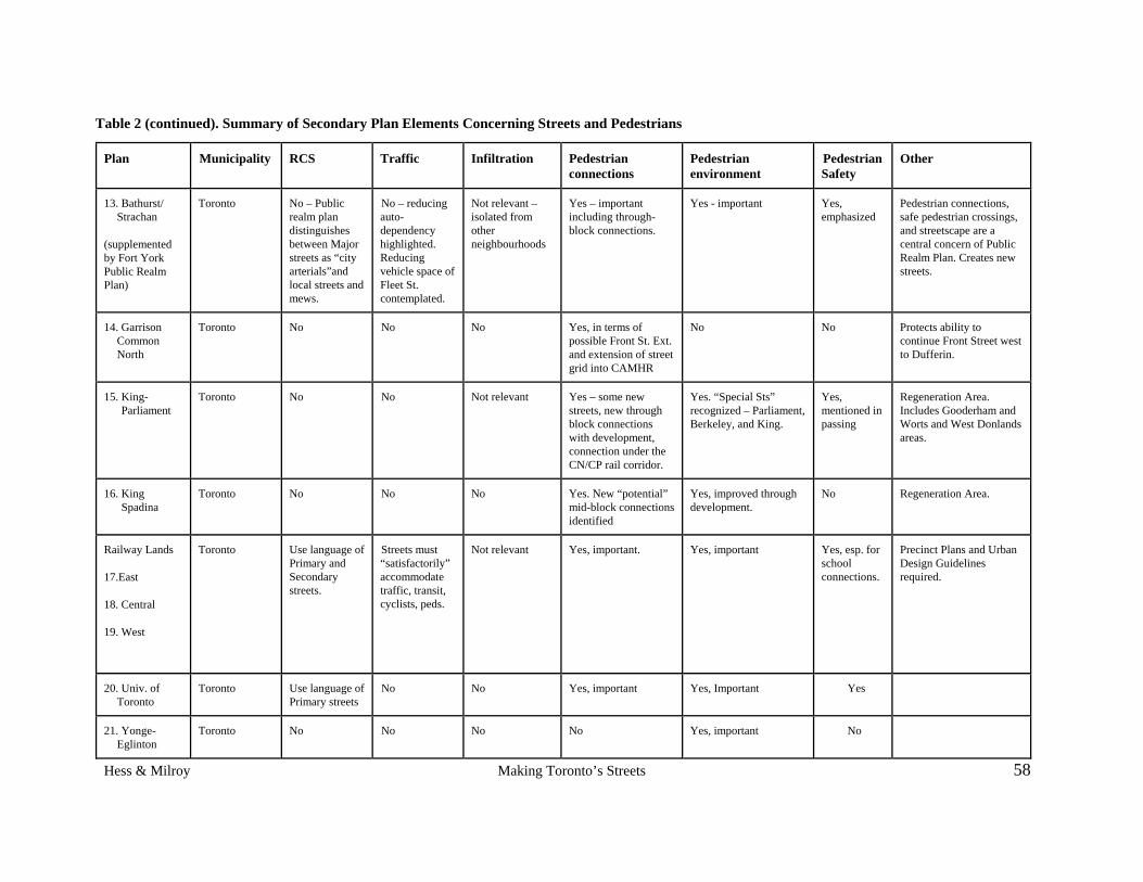
Table 2. Summary of Secondary Plan Elements Concerning Streets and Pedestrians……………………………………………………………….. 56
Table 3. Road Classification Criteria, Toronto RCS………………………………. 67
Table 4. Road and Traffic Operations Decision Routing, Toronto RCS…………. 68
Table 6. Standards for New Public Local Residential Streets/Rear Lanes……….. 74
Hess & Milroy Making Toronto’s Streets 1
MAKING TORONTO'S STREETS
PART 1: BACKGROUND
THE ISSUE
Pedestrians have a low profile when it comes to making streets in Toronto. Why? Is it because of how street-related matters are handled institutionally? with how struggles among users play out politically? or is it mostly a matter of history? This study aimed to find out how pedestrians' and motorists' interests are accounted for in institutional and political practices in Toronto. To find the answers we first needed to know how Toronto develops its streets. Because that information wasn't compiled, that was where we started.
Generally speaking, there are several reasons why knowing how a city develops its streets is useful.
Streets are important. They occupy over 25 per cent of a city's land. They are vital for moving people and goods from one part of town to another in private and public vehicles, as well as for people to move themselves on foot, by bicycle, by rollerblade, or in wheelchairs. In principle, they are spaces shared among various modes of movement.
Streets are complex. Much more than spaces of movement, they are also places to gather, stroll, be in the presence of strangers without obligation to engage with them, witness a city's history, commemorate, celebrate, protest, and so on. Some like to say, they are a city's living room. They are the main places where we see who our neighbours and other co-city residents are. For visitors, they are the face of a city.
Streets are contentious. Considering mobility alone, each mode of movement has its advocates and each of us as individuals may simultaneously hold several different, even opposing, interests in a city's street qualities. We want fire trucks to have quick access to every part of the city, and may also want narrow streets, lots of parking, or speed bumps. City governments are responsible for the tough job of trading off one set of interests against another and trying to find the best solution. How they do that is every citizen's right to know.
Street roles are changing. Ideas about what streets should be like are changing because expectations for cities have moved on from what they were even recently. Ours is a different stage of industrialization and urbanization from 1900 or 1950. Views about the quality of life we expect from cities evolve as economies -- national, local, and international -- change, along with the types of jobs available, the level and distribution of wealth, and population demographics. Indeed, a high quality city environment is now identified as key to a strong economy. A limited version of this theory about the connection between high quality city environments and a good economy has been adopted in Toronto inasmuch as physical form, design, street furniture, and waterfront redevelopment have recently gained a strong presence in the city's politics and policies. The theory, as currently expressed, is mainly directed to boosting one industry -- tourism -- in the city core. However, a more robust theory would also link the economy to an environment with clean air, water, and soil, and to equitable access to a city "commons" that
Hess & Milroy Making Toronto’s Streets 2
allows people to live productive, satisfying lives. Take the largest component of a city's commons -- its streets -- and, by deduction the theory of city success in new economic times applies to streets too. This is the prism through which this report is written.
At least two distinct approaches to streets are currently active in Toronto. Each is translated into policies and institutional practices that shape streets as physical places:
1. Streets as movement corridors, as links in a transportation network and mostly but not exclusively, oriented toward vehicles. This view sees streets as providing an economic role in moving goods and people and, more broadly as providing mobility and accessibility. It is mainly associated with policies and practices concerned with the maintenance and operation of paved street surfaces.
2. Streets as places with social, symbolic, political, aesthetic, and even ecological roles that serve various individual and group needs. This view includes seeing streets as representing the city to its residents and to the wider world; and as places collectively owned and available for use at all times. In terms of policies and practices, this approach mainly focuses on the area between a property line and the curb, especially the sidewalk.
Each conceptualization has been legitimized over the years, to varying degrees, in the form of policies and practices. Responsibilities and budgets have been divided into separate departments such as transportation, urban design, and forestry. Discussions about trade-offs are often made between departments acting as if they were separate, competing companies. Horns are often locked, generating exchanges that take the general form of this hypothetical one:
A: Fox Street is an arterial.
B: A new plan making Fox Street more of an "urban place" has been agreed to by citizens, the transit company, public works, urban design, ....
A: Fox Street will still be an arterial after that plan is implemented.
B: Fox Street's new plan didn't come about by insisting it's an arterial but by asking if it could be a better street for its users, and if so how.
A: Fox Street will still be an arterial but it'll provide a lower level of service for vehicles.
The vignette brings out important points in the struggle to re-think a street. A street's role in providing a certain vehicle "level of service" is put up against its role as an "urban place". Level of service is associated with traffic movement over the network of a city's streets while urban "placeness" refers to how a street segment functions and is experienced in a specific locale. These are the main elements in conflicts over the use of street space, and they manifest themselves in many different ways as we will see in this report.
Holding onto these two conceptualizations as if they were separate and separable is less and less logical under the new economic, socio-cultural, and environmental demands being made on cities and their streets. This issue is not specific to Toronto. This same bifurcation and realization of its ineffectiveness is showing up in most cities in western countries. The problem is that tools to build streets by different means are unfamiliar while the old ones are still ensconced, familiar, and therefore easy to fall back on. So the question is how to re-organize institutionally in a way
Hess & Milroy Making Toronto’s Streets 3
that breaks down the dichotomy and re-assembles the pieces to make streets that better reflect today's interests.
While there is now more attention to pedestrian issues than a decade ago, and the debate is more broadly based and sophisticated, still pedestrian issues are not institutionalized into processes in Toronto, whereas vehicle and traffic issues are. As one of our respondents said, "There's nobody at the table for pedestrians, not even for local streets".
How are streets handled in Toronto? The principal portion of this report focuses on the institutional structures that come into play when:
- a street undergoes regular maintenance.
- substantial repair is needed. A recent case is Royal York Road.
- the basic design of a street is going to be changed. An example is St. Clair Avenue West and the streetcar right-of-way.
- a new street is built. Recent cases are the planned reintroduction of a grid of streets into Regent Park or, in a different context, new streets in the Mornington Heights area in northeast Scarborough.
We focus on how the city manages the physical environments of streets. We do not address more operational issues such as the determination of posted speed limits, traffic and parking enforcement or traffic signal timing. These are important topics, but beyond the scope of this study.
We pay particular attention to the relevant city departments, agencies and committees, how they interact, and the policies and documents they use. Before that we give some context to the making of streets and at the end summarize the findings and make some recommendations for action.
The methods we used for this research are described in Appendix 1. The 1998 amalgamation of the six cities of the former Metro Toronto, together with Metro itself, came up repeatedly and spontaneously during our investigations. It is a significant contextual factor in how Toronto functions even today. Appendix 2 describes what we heard about the effects of amalgamation inside the city government.
The primary audiences for this report are Torontonians with interests in how streets function and how their characteristics can be influenced. We hope the report contributes information for debates about streets. We also hope the report is informative for staff and politicians who work for the City of Toronto and may be unaware how enormous an enterprise it is to build, maintain and change this essential part of the urban fabric, one that involves numerous parts of government. Few people have a handle on how the whole thing works so we hope the information here helps the city and its citizens in changing how streets are made.
A FEW DEFINITIONS
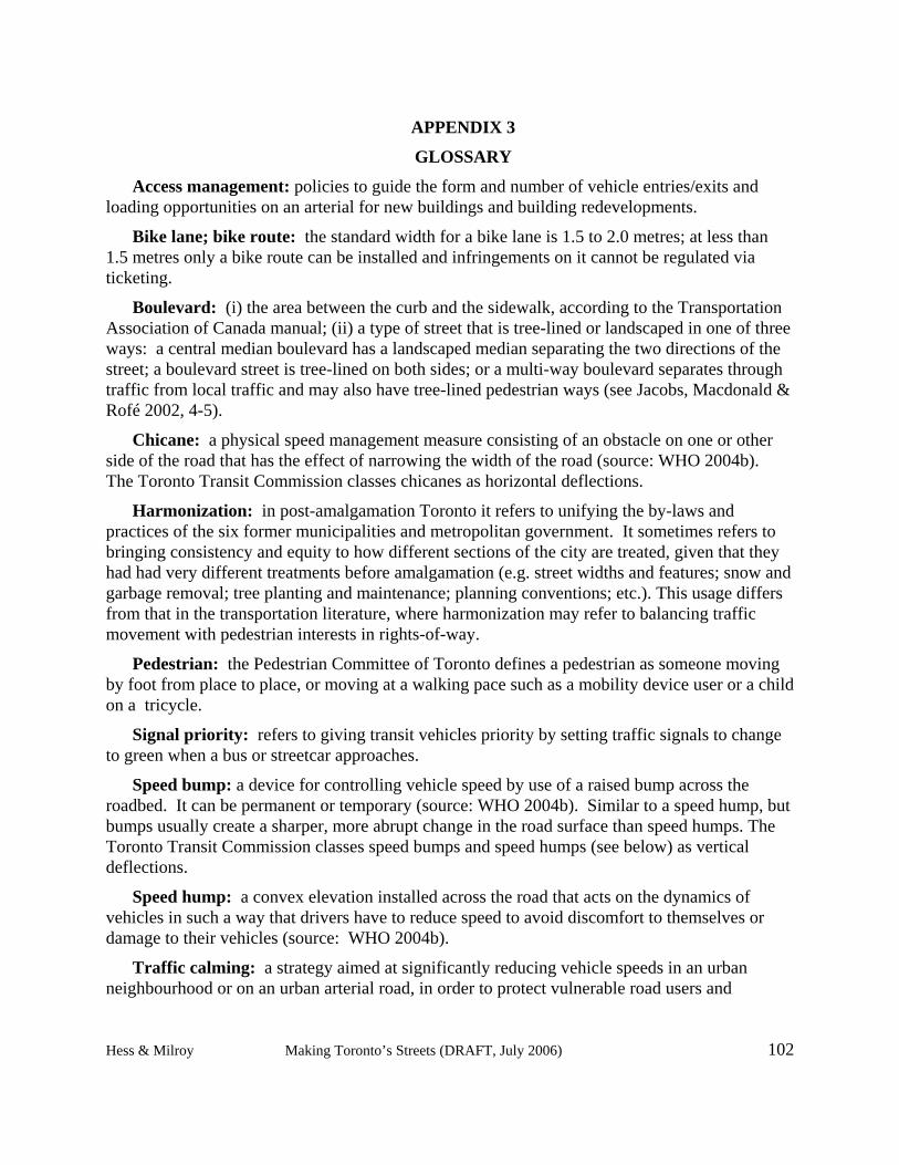
Definitions appear throughout the report but here are meanings for several terms that are used frequently. Also see the glossary, found at the end as appendix 3.
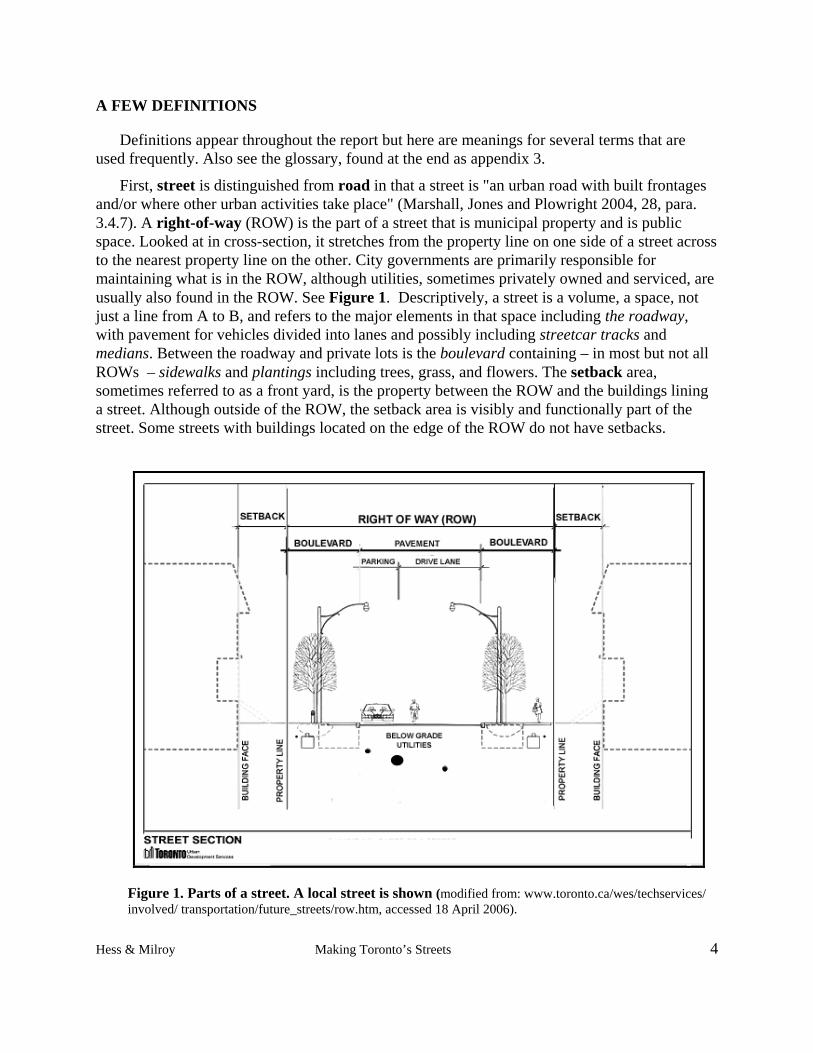
First, street is distinguished from road in that a street is "an urban road with built frontages and/or where other urban activities take place" (Marshall, Jones and Plowright 2004, 28, para. 3.4.7). A right-of-way (ROW) is the part of a street that is municipal property and is public space. Looked at in cross-section, it stretches from the property line on one side of a street across to the nearest property line on the other. City governments are primarily responsible for maintaining what is in the ROW, although utilities, sometimes privately owned and serviced, are usually also found in the ROW. See Figure 1. Descriptively, a street is a volume, a space, not just a line from A to B, and refers to the major elements in that space including the roadway, with pavement for vehicles divided into lanes and possibly including streetcar tracks and medians. Between the roadway and private lots is the boulevard containing – in most but not all ROWs – sidewalks and plantings including trees, grass, and flowers. The setback area, sometimes referred to as a front yard, is the property between the ROW and the buildings lining a street. Although outside of the ROW, the setback area is visibly and functionally part of the street. Some streets with buildings located on the edge of the ROW do not have setbacks.
Figure 1. Parts of a street. A local street is shown (modified from: www.toronto.ca/wes/techservices/ involved/ transportation/future_streets/row.htm, accessed 18 April 2006).
Hess & Milroy Making Toronto’s Streets 4
Hess & Milroy Making Toronto’s Streets 5
Within the right-of-way (ROW) are found utilities -- poles, wires, and boxes above ground, and wires, pipes, and sensors below; street furniture such as public transit shelters, garbage containers, newspaper boxes, bike rings, benches; artwork originating from various sources including requirements associated with certain building permits to provide works of art to the public realm; traffic calming treatments which may be in the form of speed bumps or humps, street narrowings, and so on.
A road classification system (RCS) is a policy designed to help manage street systems as a network by designating how individual street segments should prioritize moving vehicles along them versus how they should provide vehicle access to properties adjoining them. There are a great many road classification systems all of which share two features: (i) they treat streets functionally as part of a network, and (ii) they assume an inverse relationship between movement and access, such that as movement increases, access must decrease, and vice versa (Svensson 2005). Each road type is defined and the definition is used to guide the technical design features the road should have when municipal engineers build or carry out maintenance work on it, to manage roadway operations such as setting legal speed limits and distances between signals, and to decide standards of street cleaning and snow removal.1
Five broad road categories are commonly used for urban roads and streets in Canada and the U.S.: freeways, expressways, arterials, collectors, and local streets. See Figure 2. The last three are common internally in cities and are the ones we are concerned with in this report because they matter to pedestrians; freeways and expressways are “controlled access” facilities that do not allow pedestrians.2
Note that a single street may have a different designation on separate segments. For instance, Church Street in old Toronto is a collector from The Esplanade north to Front Street; a minor arterial from Front north to Bloor; and a major arterial where it curves northwest from Bloor to Yonge; or Lawrence Avenue East which carries three designations over its length.
In addition to a road classification system developed for engineering and public works purposes, a city like Toronto also classifies its streets from other perspectives. The planning department has classed streets as major, minor, lanes and mews, or as Avenues, ceremonial routes, and so on. There is no necessary connection between the systems: they are separate conversations about how to assess and order streets.
1 The “speed limit” is not the same as “design speed.” The design speed of the road, that is the speed the roadway has been designed to be driven at a reasonable level of saftey, usually from the prespective of vehicle collisions, is usualy higher than the posted speed limit.It is widely recognized by both roadway designers and police agencies that most drivers will travel faster than the posted speed limit. 2 It is worth noting, however, that expressway entrances and exits, where they intersect with the wider street network can be expecially dangerous places for pedestrians and cyclists. The terms expressway and freeway are often used interchangeably in Toronto. Facilities like the Gardiner are actually freeways with access fully controlled by interchanges.
Level of service (LOS) is a recognized term among transportation specialists and has been defined in guidebooks for designing roads and streets since at least the 1950s. It is associated with conventional RCSs and refers to how well streets serve vehicle traffic in terms of operating speed and non-interruption. The placement of a road in the hierarchy of roads helps determine the level of service it ought to provide to vehicles. To reach a potential LOS, certain characteristics must be met concerning the road width, surface, signs, automatic signal spacing, absence of speed change, crosswalks, pedestrian traffic, and so on. See, for example, American Association of State Highway and Transportation Officials (2001, 6).
Figure 2. Diagram of the Road Classification System from the Transportation Association of Canada. (Source: www.tac-atc.ca/English/pdf/geodes-jan02.pdf, accessed 24 April 2006).
IMPLEMENTING VISIONS
We know it is possible to have a vision for a city and implement it via policies and practices because that is precisely what happened during the last century. An important facet of that vision had to do with streets. That vision gradually became institutionalized in policies and practices that are actively used and difficult to change. People now challenge those ideas about streets
Hess & Milroy Making Toronto’s Streets 6
from many angles. Different visions are beginning to emerge as a result. Let's first look at the legacy.
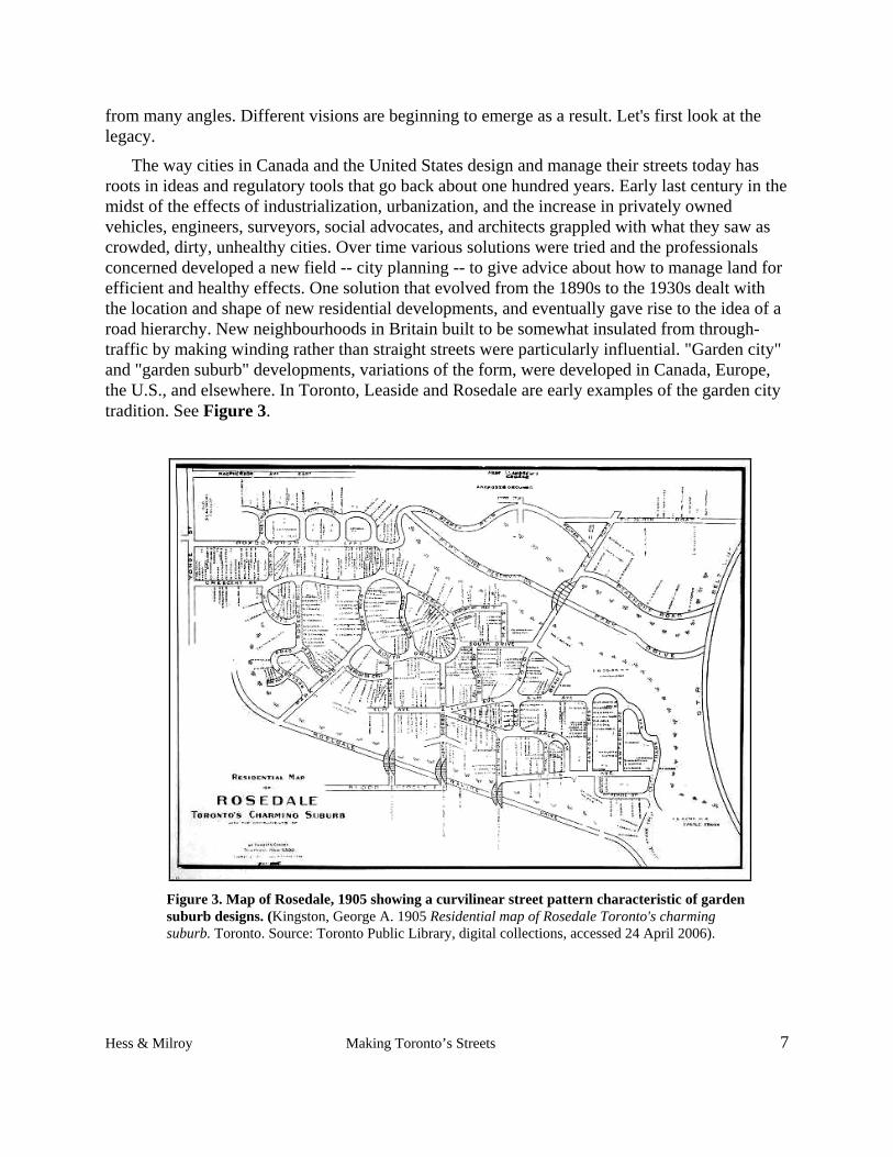
The way cities in Canada and the United States design and manage their streets today has roots in ideas and regulatory tools that go back about one hundred years. Early last century in the midst of the effects of industrialization, urbanization, and the increase in privately owned vehicles, engineers, surveyors, social advocates, and architects grappled with what they saw as crowded, dirty, unhealthy cities. Over time various solutions were tried and the professionals concerned developed a new field -- city planning -- to give advice about how to manage land for efficient and healthy effects. One solution that evolved from the 1890s to the 1930s dealt with the location and shape of new residential developments, and eventually gave rise to the idea of a road hierarchy. New neighbourhoods in Britain built to be somewhat insulated from through-traffic by making winding rather than straight streets were particularly influential. "Garden city" and "garden suburb" developments, variations of the form, were developed in Canada, Europe, the U.S., and elsewhere. In Toronto, Leaside and Rosedale are early examples of the garden city tradition. See Figure 3.
Figure 3. Map of Rosedale, 1905 showing a curvilinear street pattern characteristic of garden suburb designs. (Kingston, George A. 1905 Residential map of Rosedale Toronto's charming suburb. Toronto. Source: Toronto Public Library, digital collections, accessed 24 April 2006).
Hess & Milroy Making Toronto’s Streets 7
A further evolution of street patterns emerged in the 1920s called "the neighbourhood unit", the idea of an American, Clarence Perry. See Figure 4. Perry contrasted a family-oriented neighbourhood realm of local streets with a public realm of highways, fast traffic, and commerce. For Perry, the city should be made up of "neighbourhood units", each an area of family housing surrounding a local school and served by quiet streets for use only within the neighbourhood. Perry proposed surrounding and defining each neighbourhood with large arterial roads and highways. These could be used by everyone to quickly traverse the city by vehicle. This idea was in marked contrast to the conventional grid form that allowed traffic to go everywhere. Don Mills was a particularly influential example. A similar pattern was used in several northern Canadian resource towns built for families of mine and mill workers. See Figure 5. The surprising incongruity of using a southern suburban model for small northern towns such as seen in Kapuskasing, Ontario shows how powerful a set of ideas it encapsulated. Neighbourhood unit principles were incorporated into official plans and numerous examples can be found in post-1930 residential developments across Canada. Figure 6 shows typical pre- and post-1950 street patterns as influenced by these ideas.
Figure 4. Diagram of a neighbourhood unit as conceptualized by Clarence Perry (Perry 1929, 88).
Figure 5. Plan for extension of Kapuskasing, Ontario from the 1920’s showing garden suburb and neighbourhood unit ideas (Robson 1996).
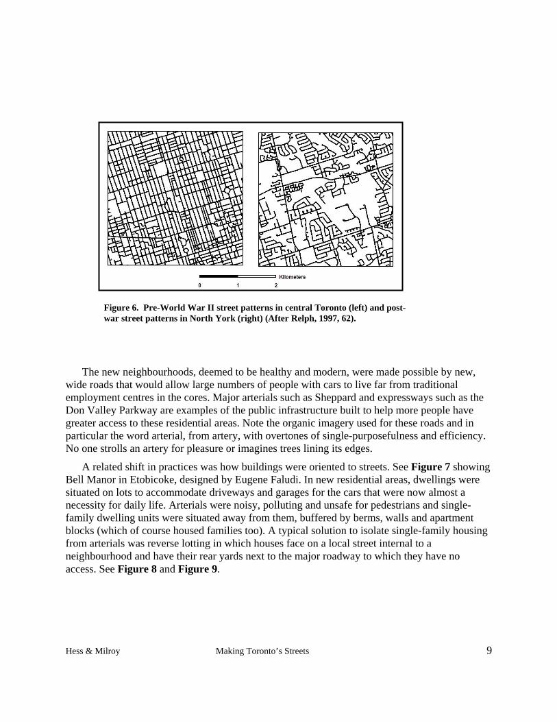
Figure 6. Pre-World War II street patterns in central Toronto (left) and post-war street patterns in North York (right) (After Relph, 1997, 62).
The new neighbourhoods, deemed to be healthy and modern, were made possible by new, wide roads that would allow large numbers of people with cars to live far from traditional employment centres in the cores. Major arterials such as Sheppard and expressways such as the Don Valley Parkway are examples of the public infrastructure built to help more people have greater access to these residential areas. Note the organic imagery used for these roads and in particular the word arterial, from artery, with overtones of single-purposefulness and efficiency. No one strolls an artery for pleasure or imagines trees lining its edges.
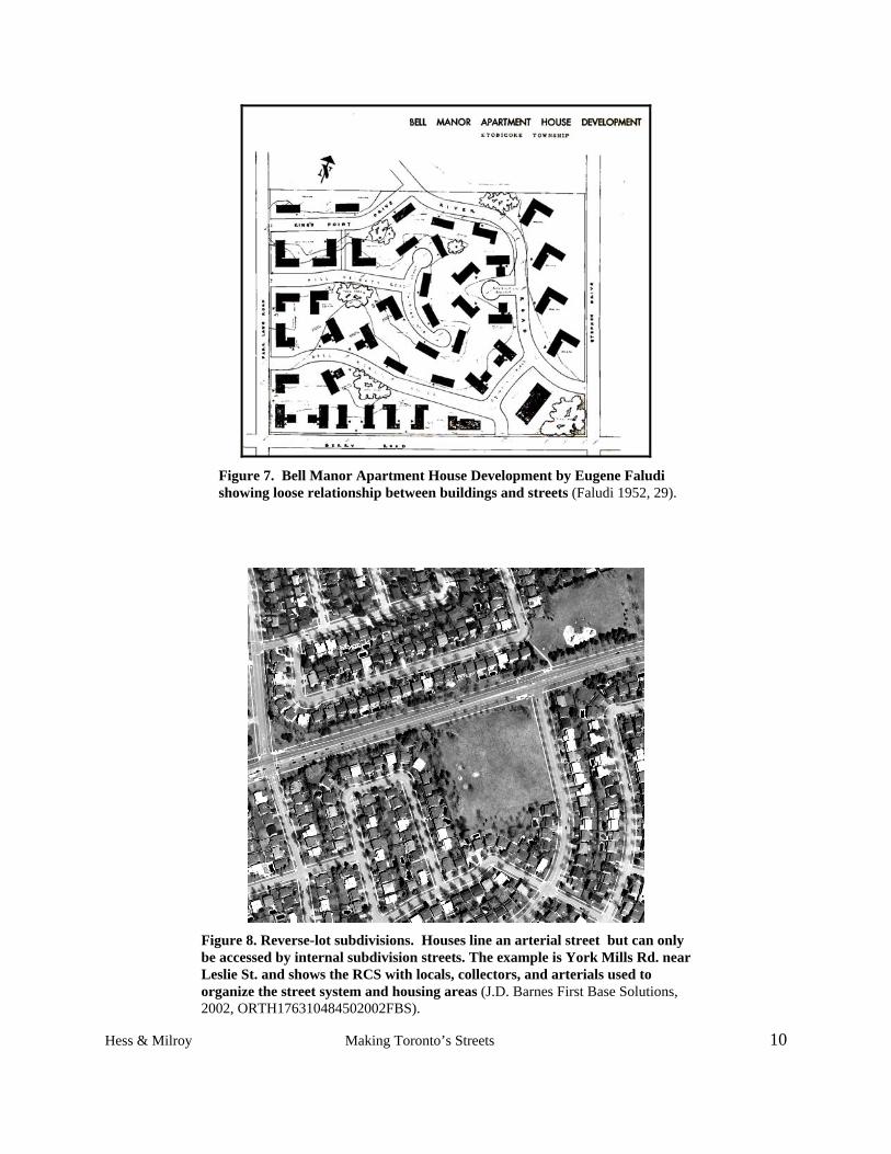
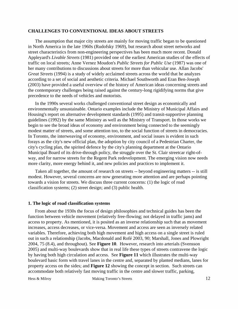
A related shift in practices was how buildings were oriented to streets. See Figure 7 showing Bell Manor in Etobicoke, designed by Eugene Faludi. In new residential areas, dwellings were situated on lots to accommodate driveways and garages for the cars that were now almost a necessity for daily life. Arterials were noisy, polluting and unsafe for pedestrians and single-family dwelling units were situated away from them, buffered by berms, walls and apartment blocks (which of course housed families too). A typical solution to isolate single-family housing from arterials was reverse lotting in which houses face on a local street internal to a neighbourhood and have their rear yards next to the major roadway to which they have no access. See Figure 8 and Figure 9.
Hess & Milroy Making Toronto’s Streets 9
Figure 7. Bell Manor Apartment House Development by Eugene Faludi showing loose relationship between buildings and streets (Faludi 1952, 29).
Figure 8. Reverse-lot subdivisions. Houses line an arterial street but can only be accessed by internal subdivision streets. The example is York Mills Rd. near Leslie St. and shows the RCS with locals, collectors, and arterials used to organize the street system and housing areas (J.D. Barnes First Base Solutions, 2002, ORTH176310484502002FBS).
Hess & Milroy Making Toronto’s Streets 10
Figure 9. Photograph of reverse-lot houses from arterial. Houses face an internal subdivision street and are separated from the arterial by fences. Such arterials tend to be barren, poor pedestrian environments. This example is from Markham across from the “pedestrian friendly” community of Cornell (Photo: Paul M. Hess).
Thus, specialized street forms for new development became firmly established. Like planned housing areas, street specialization adopted the principle of functional separation to achieve the desired orderly and healthy conditions. Each street type had different carrying capacities and speeds matched to widths and other design features. At first streets were divided into fast and slow streets. During the urban construction boom after World War II these concepts and models were expanded and fully institutionalized in codes, regulations, and professional practices. Planning departments were established in cities and towns across North America. In Canada official plans became mandatory under provincial legislation. Zoning by-laws protecting single-family housing that promoted land use patterns based on the neighbourhood unit became a standard planning tool. At the same time, roadway design standards largely based on road engineering data were established by professional organizations such as the American Association of State Highway and Transportation Officials (AASHTO) followed by the Transportation Association of Canada (TAC). Municipal transportation departments still use the TAC manual which sets out the philosophy of road development and geometric design guidelines. Its RCS remains a primary guide for city streets, as discussed below. For insights into widely accepted attitudes in the 1950s towards the motorist as "king of the road" versus the pedestrian who did the best he or she could to get by, see the reflections of the former Metro Toronto Commissioner of Roads and Traffic (Cass 1991, 7-9). It is easy to see that it was popularly understood that streets were the realm of traffic engineers.
Hess & Milroy Making Toronto’s Streets 11
CHALLENGES TO CONVENTIONAL IDEAS ABOUT STREETS
The assumption that major city streets are mainly for moving traffic began to be questioned in North America in the late 1960s (Rudofsky 1969), but research about street networks and street characteristics from non-engineering perspectives has been much more recent. Donald Appleyard's Livable Streets (1981) provided one of the earliest American studies of the effects of traffic on local streets; Anne Vernez Moudon's Public Streets for Public Use (1987) was one of her many contributions to discussions about streets for more than vehicular use. Allan Jacobs' Great Streets (1994) is a study of widely acclaimed streets across the world that he analyzes according to a set of social and aesthetic criteria. Michael Southworth and Eran Ben-Joseph (2003) have provided a useful overview of the history of American ideas concerning streets and the contemporary challenges being raised against the century-long rigidifying norms that give precedence to the needs of vehicles and motorists.
In the 1990s several works challenged conventional street design as economically and environmentally unsustainable. Ontario examples include the Ministry of Municipal Affairs and Housing's report on alternative development standards (1995) and transit-supportive planning guidelines (1992) by the same Ministry as well as the Ministry of Transport. In those works we begin to see the broad ideas of economy and environment being connected to the seemingly modest matter of streets, and some attention too, to the social function of streets in democracies. In Toronto, the interweaving of economy, environment, and social issues is evident in such forays as the city's new official plan, the adoption by city council of a Pedestrian Charter, the city's cycling plan, the spirited defence by the city's planning department at the Ontario Municipal Board of its drive-through policy, the struggle over the St. Clair streetcar right-of-way, and for narrow streets for the Regent Park redevelopment. The emerging vision now needs more clarity, more energy behind it, and new policies and practices to implement it.
Taken all together, the amount of research on streets -- beyond engineering matters -- is still modest. However, several concerns are now generating more attention and are perhaps pointing towards a vision for streets. We discuss three current concerns: (1) the logic of road classification systems; (2) street design; and (3) public health.
1. The logic of road classification systems
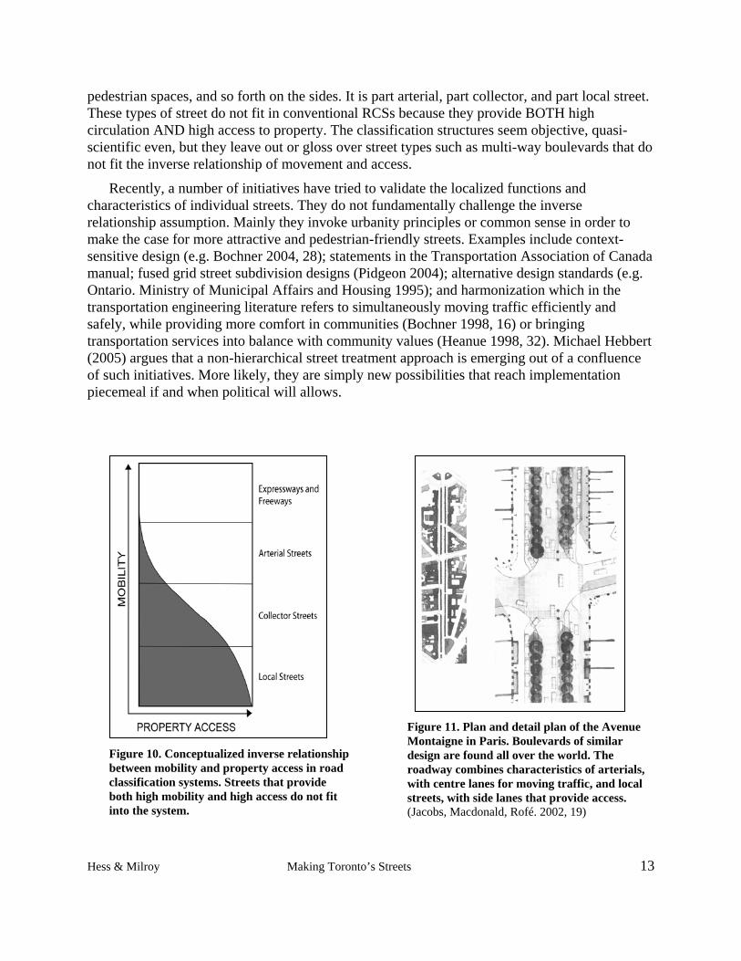
From about the 1930s the focus of design philosophies and technical guides has been the function between vehicle movement (relatively free-flowing; not delayed in traffic jams) and access to property. As mentioned, it is posited as an inverse relationship such that as movement increases, access decreases, or vice-versa. Movement and access are seen as inversely related variables. Therefore, achieving both high movement and high access on a single street is ruled out in such a relationship (Jacobs, Macdonald and Rofé 2003, 90; Marshall, Jones and Plowright 2004, 75 (8.4), and throughout). See Figure 10. However, research into arterials (Svensson 2005) and multi-way boulevards show that in real life these types of streets contravene the logic by having both high circulation and access. See Figure 11 which illustrates the multi-way boulevard basic form with travel lanes in the centre and, separated by planted medians, lanes for property access on the sides; and Figure 12 showing the concept in section. Such streets can accommodate both relatively fast moving traffic in the centre and slower traffic, parking, Hess & Milroy Making Toronto’s Streets 12
pedestrian spaces, and so forth on the sides. It is part arterial, part collector, and part local street. These types of street do not fit in conventional RCSs because they provide BOTH high circulation AND high access to property. The classification structures seem objective, quasi-scientific even, but they leave out or gloss over street types such as multi-way boulevards that do not fit the inverse relationship of movement and access.
Recently, a number of initiatives have tried to validate the localized functions and characteristics of individual streets. They do not fundamentally challenge the inverse relationship assumption. Mainly they invoke urbanity principles or common sense in order to make the case for more attractive and pedestrian-friendly streets. Examples include context-sensitive design (e.g. Bochner 2004, 28); statements in the Transportation Association of Canada manual; fused grid street subdivision designs (Pidgeon 2004); alternative design standards (e.g. Ontario. Ministry of Municipal Affairs and Housing 1995); and harmonization which in the transportation engineering literature refers to simultaneously moving traffic efficiently and safely, while providing more comfort in communities (Bochner 1998, 16) or bringing transportation services into balance with community values (Heanue 1998, 32). Michael Hebbert (2005) argues that a non-hierarchical street treatment approach is emerging out of a confluence of such initiatives. More likely, they are simply new possibilities that reach implementation piecemeal if and when political will allows.
Hess & Milroy Making Toronto’s Streets 13
Figure 10. Conceptualized inverse relationship between mobility and property access in road classification systems. Streets that provide both high mobility and high access do not fit into the system.
Figure 11. Plan and detail plan of the Avenue Montaigne in Paris. Boulevards of similar design are found all over the world. The roadway combines characteristics of arterials, with centre lanes for moving traffic, and local streets, with side lanes that provide access. (Jacobs, Macdonald, Rofé. 2002, 19)
Figure 12. Section of a multi-way boulevard showing centre lanes and side lanes separated by planted medians. ( Modified from Jacobs, Macdonald, Rofé. 2002, 15)
An exceptional piece of European research named ARTISTS (for “arterial streets towards sustainability”) directly tackles the assumptions of road classification concepts and practices. A nine-country team from universities, research centres, and municipal transportation and planning departments analyzed fourteen RCSs in use across Europe. The final report, Arterial Streets for People - Guidance for planners and decision makers when reconstructing arterial streets (Svensson 2005) summarizes the research and proposes alternative ways to conceptualize and design arterial streets emphasizing stakeholder participation and principles of sustainability. Research methods and findings are well documented in background reports (Marshall, Jones and Plowright 2004)
As in Canada and the U.S., the researchers found that European RCS definitions are based on the strategic role streets play in a network as related to moving traffic and accessing property, characteristics seen in inverse relationship. On inspection, however, they argue that classification has little to do with the actual observed use of networks, stating that “the conventional classification by 'function' is actually classification by designation "(ibid, 19, 2.6.4; emphasis in original). In particular, they found that “traffic flow hardly features at all as a criterion for distinguishing street type, arterial or otherwise” (ibid, 18, 2.5.9). Instead, they argue, classification is based on the abstract idea of “arteriality,” a property defined by “the conditions by which all strategic routes form a single contiguous network” (ibid, 19, 2.6.4). The researchers write:
“It is because arteriality is an abstract property that it works: it is more or less stable over the length of a street and over time; it can be easily retrofitted to existing networks (since it is independent of actual form or use on the ground), and finally, it has a robust logic, that allows a neat ordering of routes in a network” (Marshall, Jones and Plowright 2004, 2.6.6).
Because “arteriality” is conceptualized using a narrow focus on vehicles, the researchers argue, it ignores the broad variety of streets types, types of street users, and activities that take place on the streets found in real cities. A result is that issues of sustainability have little if any presence in the classification schemes. Sustainability for the researchers is "positively equated
with economic and social interactions and negatively related to adverse environmental impacts" (Marshall, Jones and Plowright 2004, 33, 3.4.40). So, for example, sustainability indicators include such things as dedicated public transit lanes, which were absent in the classsifications; and attention to pedestrians and cyclists which while present were "limited to the bottom end of the hierarchy -- not the middle to upper range in which arterial streets would be found" (ibid, 18, 2.5.11).
The researchers demonstrate that a RCS is a strategic ordinal ranking, not an objective measure. As such, they show how it can be traded off with other, independent ordinal ranking principles such as what the researchers call “place status” but might otherwise be called “urbanness.” Place status is locally determined where the competition for street space is most acute, and relates to the social and symbolic importance of streets. Streets can be classified by their place status simultaneously as they can be classified in a conventional RCS using their role in a larger movement network – what the researchers call their “link status.” Conceptually, this gives a more complex classification system for street planning, design, and management using two independent scales. See Figure 13. The framework used to make trade-offs between the scales is the concept of sustainability. The researchers show how this can be done in practice by engaging multiple stakeholders including street engineers, land planners, transit agencies, vehicle and transit users, cyclists, pedestrians, and local residents and workers.
Figure 13. ARTISTS classification table creating 25 functional street types. Streets are classified using two independent scales (“link” and “place”) with scales ranked by their scale of importance (local to national). Types correspond to more colloquial terms such as “local shopping street” or “suburban residential arterial” (Svensson 2005, 28).
The conclusions of the study echo those being reached in North American cities -- for
example, roads with high classifications are conceptualized in terms of moving traffic; and
Hess & Milroy Making Toronto’s Streets 15
Hess & Milroy Making Toronto’s Streets 16
conversely, only the lower end of the hierarchy is likely to incorporate any elements that are consistent with ideas of sustainability. There are also differences. In Toronto, for example, traffic volume is an explicit criterion in how a street is classified (see Toronto. 2000 [new RCS], especially p.4-5 and Table 1, "Road Classification Criteria"). Overall, however, the ARTISTS study shows that the desire for greater urbanity and environmentally sensible practices are impossible to integrate into a conventional RCS. Profoundly changing the vision of what we desire from our streets also requires profoundly changing the conceptual frameworks used to design and manage them.
2. Street Designs
The vision in the current OP of lowered car use, more people using transit and various other non-motorized modes of getting around is almost a 180-degree turn around from what was championed and built last century. What was valued and modern then is not so now. Finding practical ways to redesign existing streets in line with a new vision that realigns the relationship between urbanity and vehicles requires on-going research and experimentation. Considerable effort is going into three approaches: the re-design of arterials, the design of shared streets, and approaches to traffic calming.
Arterials
Arterials take many forms but by definition they are vehicle-focused. They are usually wide, may have concrete medians in a pseudo-boulevard form, and cut through cities in ways that isolate neighbourhoods on either side. See Figure 14 showing the difference between a standard arterial ROW and one given several functions. Toronto has many examples of vehicle-focused streets such as large sections of Eglinton, the only street that runs the entire east-west width of the new Toronto. Reconfiguring segments of it is possible: a design charette for a section of Eglinton in the late 1990s with Allan Jacobs as guest, showed the potential. Many ROWs in Toronto range from about 19 to 30 metres wide (62 to 98 feet) and can be given a variety of treatments. For wider streets, even more possibilities exist, as shown in the multiway boulevard example in Figure 11 and 12 above.
Another issue is that streets are often built wider than actually required based on the amounts of space needed for standard vehicles to pass and turn (Southworth and Ben-Joseph, 2003, 143), and this encourages fast driving. Over-sized streets are even found in new urbanism developments such as Cornell where they are 8.5 metres, although 6 metres may be adequate. These developments also typically have back lanes so, in combination with the street widths, the amount of land devoted to vehicles is very high -- which is ironic given the goals of the new urbanism movement which include building neighbourhoods with reduced car emphasis (Grant 2006). Examples from Europe and Asia show that very narrow streets can function even in high density environments. Figure 15 shows a fire truck and garbage truck in use in Tokyo, Japan,
where minimum street widths are a narrow four metres. In Canada and the U.S., access by large emergency and service trucks remains a criterion for establishing street widths. Figure 16 shows
a demonstration in Portland, Orgeon designed to overcome opposition to creating new street standards for “skinny streets.” Fire equipment is driven down one of the city’s older, residential streets built to narrower than contemporary standards set to accomodate emergency vehicle access.
Figure 14. Cross-sections comparing a car-oriented street (top) to a multi-function street (bottom). Key: A – traffic lanes; B – parking lanes; C – bike lane; D – median; E – planting strip; F – sidewalk (Frank, Engelke, and Schmid 2003, 156).
Figure 15. Fire and garbage trucks in Tokyo, Japan designed to negotiate narrow streets (Photo: Paul M. Hess).
Hess & Milroy Making Toronto’s Streets 17
Figure 16. Demonstration that older streets provide adequate space for emergency equipment in Portland, Oregon. A fire truck negotiates a street with parked trucks and a city bus (Southworth and Ben-Joseph 1996, 135).
A reason frequently given for over-sized streets is to ensure against liability in suits against the city for not building the best possible road to the highest possible standards. However, Ewing’s (2001) research on tort liability done for the New Jersey Department of Transportation showed that fear of legal proceedings was a poor reason to design streets for worst-case scenario traffic. He found that the main legal requirement for reasonable care was that a street design be recommended by a reputable source, not necessarily a transportation-focused or engineering-based association, and be approved by a city council. Southworth and Ben-Joseph (2003, 141) also cite evidence for their claim that "courts [in the U.S.] have usually ruled in favor of local jurisdictions that approved lower design standards for local roads, as long as the standards were set in writing".
Hebbert discusses the literature showing that "the safety dividend of road improvement" is very much in question in part because the standardized road with its consistent "geometrical configuration increases motorists' sense of comfort and reduces their level of caution" (2005, 53). A study in 2000 "models the safety dividend of US highways improvements undertaken between 1984 and 1996 and finds -- contrary to the conventional engineering hypothesis -- that they cause traffic fatalities and injuries to increase" (Hebbert 2005, 53). Comparing the US highway system that has been lavished with engineering expertise and funding with those in many other countries one finds that the traffic fatality rate is considerably higher. The road traffic fatality rate in the US is "15.2 per 100, 000 per year, compared with 9.5 in Australia, 8.2 in Japan, 6.8 in the Netherlands and 5.9 in Great Britain" (Hebbert 2005, 53-54). The comparable rate for Canada in 1999 was 9.3 (WHO 2004b). Although the reasons for such differences are complex, they at least put in doubt the rationale that directly connects contemporary engineering standards with safety. Another statistic that generates questions about the assumed causal connection between engineering and road fatalities is that in the period 1975 to 1998 the road fatality rate in Canada went down by 63% but only by 27% in the U.S. (WHO 2004b, Table 2.4).
Hess & Milroy Making Toronto’s Streets 18
Shared Streets.
How to tamp down motorists' temptation to disregard speed regulations and threaten pedestrians and cyclists is one of the on-going struggles over the use of street space. There will never be enough policing and monitoring, so design matters. The concept of shared street space has been in operation in the Netherlands for decades, and is common elsewhere too. The best known shared streets approach is the Dutch woonerven which means residential yards (woonerf, in the singular). The approach has pedestrians and vehicles share the same surface. Via signage, change of street surface material, and other indicators, motorists are made aware that children may be playing and people walking or socializing in the area, so they slow down. See Figure 17 and Figure 18 for a typical plan and a photograph of a shared street. Many safety studies have been conducted and the balance of evidence is that there are fewer collisions in general, and fewer severe collisions in particular, on shared streets compared with standard residential streets, and the "groups that benefit the most are pedestrians, children, and cyclists" (Southworth and Ben-Joseph 2003, 126).
Figure17. Plan of a shared street. The roadway surface is shared by all users. The street design forces vehicles to travel slowly and carefully (Southworth and Ben-Joseph 1996, 110).
Figure 18. Photograph of shared street in Delft, The Netherlands. (Denmark. Ministry of Transport 1993, 11).
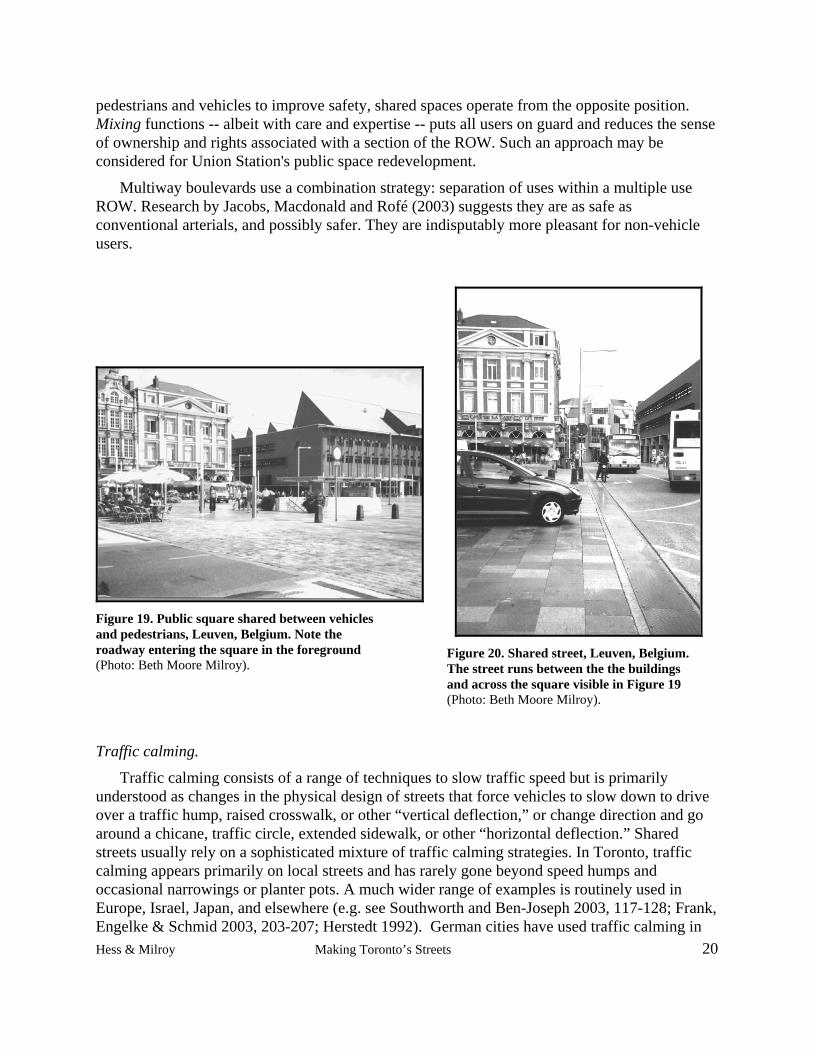
Shared streets concepts are used on non-residential streets as well. An early version in Canada in a commercial area was Vancouver's Granville Street market where the cobblestone streets are equally shared by pedestrians and vehicles. Approaches to shared streets are being used and tested in a variety of circumstances such as in public squares and downtown streets. See Figure 19 and Figure 20. Whereas for a long time specialists have sought to separate
Hess & Milroy Making Toronto’s Streets 19
pedestrians and vehicles to improve safety, shared spaces operate from the opposite position. Mixing functions -- albeit with care and expertise -- puts all users on guard and reduces the sense of ownership and rights associated with a section of the ROW. Such an approach may be considered for Union Station's public space redevelopment.
Multiway boulevards use a combination strategy: separation of uses within a multiple use ROW. Research by Jacobs, Macdonald and Rofé (2003) suggests they are as safe as conventional arterials, and possibly safer. They are indisputably more pleasant for non-vehicle users.
Figure 19. Public square shared between vehicles and pedestrians, Leuven, Belgium. Note the roadway entering the square in the foreground (Photo: Beth Moore Milroy).
Figure 20. Shared street, Leuven, Belgium. The street runs between the the buildings and across the square visible in Figure 19 (Photo: Beth Moore Milroy).
Traffic calming.
Traffic calming consists of a range of techniques to slow traffic speed but is primarily understood as changes in the physical design of streets that force vehicles to slow down to drive over a traffic hump, raised crosswalk, or other “vertical deflection,” or change direction and go around a chicane, traffic circle, extended sidewalk, or other “horizontal deflection.” Shared streets usually rely on a sophisticated mixture of traffic calming strategies. In Toronto, traffic calming appears primarily on local streets and has rarely gone beyond speed humps and occasional narrowings or planter pots. A much wider range of examples is routinely used in Europe, Israel, Japan, and elsewhere (e.g. see Southworth and Ben-Joseph 2003, 117-128; Frank, Engelke & Schmid 2003, 203-207; Herstedt 1992). German cities have used traffic calming in Hess & Milroy Making Toronto’s Streets 20
Hess & Milroy Making Toronto’s Streets 21
non-residential, higher-order roads were most collisions take place since the early 1990s with measurable benefits in terms of reduced injuries and fatalities (Hebbert 2005, 51).
………
The result of street design work is to show that safety can be achieved other than via separation of functions and users, and that mobility and access are not mutually exclusive categories.
3. Public Health
Yet other challenges to the norms of vehicle-focused street networks come from public health fields. We consider three: physical safety, exercise, and air pollution. Acknowledgement of concerns in these areas is implicit in city council's approval of the Pedestrian Charter in 2002. (See Pedestrian Charter in Documents and Policy section of this report below.)
Physical safety.
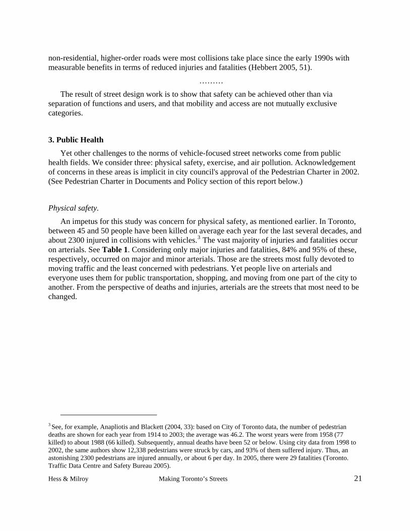
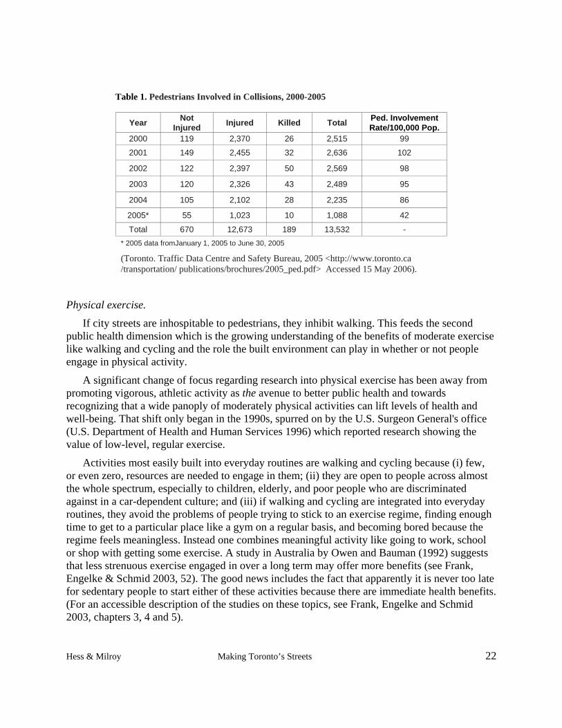
An impetus for this study was concern for physical safety, as mentioned earlier. In Toronto, between 45 and 50 people have been killed on average each year for the last several decades, and about 2300 injured in collisions with vehicles.3 The vast majority of injuries and fatalities occur on arterials. See Table 1. Considering only major injuries and fatalities, 84% and 95% of these, respectively, occurred on major and minor arterials. Those are the streets most fully devoted to moving traffic and the least concerned with pedestrians. Yet people live on arterials and everyone uses them for public transportation, shopping, and moving from one part of the city to another. From the perspective of deaths and injuries, arterials are the streets that most need to be changed.
3 See, for example, Anapliotis and Blackett (2004, 33): based on City of Toronto data, the number of pedestrian deaths are shown for each year from 1914 to 2003; the average was 46.2. The worst years were from 1958 (77 killed) to about 1988 (66 killed). Subsequently, annual deaths have been 52 or below. Using city data from 1998 to 2002, the same authors show 12,338 pedestrians were struck by cars, and 93% of them suffered injury. Thus, an astonishing 2300 pedestrians are injured annually, or about 6 per day. In 2005, there were 29 fatalities (Toronto. Traffic Data Centre and Safety Bureau 2005).
Hess & Milroy Making Toronto’s Streets 22
Table 1. Pedestrians Involved in Collisions, 2000-2005
Year Not Injured Injured Killed Total Ped. Involvement
Rate/100,000 Pop. 2000 119 2,370 26 2,515 99
2001 149 2,455 32 2,636 102
2002 122 2,397 50 2,569 98
2003 120 2,326 43 2,489 95
2004 105 2,102 28 2,235 86
2005* 55 1,023 10 1,088 42
Total 670 12,673 189 13,532 - * 2005 data fromJanuary 1, 2005 to June 30, 2005
(Toronto. Traffic Data Centre and Safety Bureau, 2005 <http://www.toronto.ca /transportation/ publications/brochures/2005_ped.pdf> Accessed 15 May 2006).
Physical exercise.
If city streets are inhospitable to pedestrians, they inhibit walking. This feeds the second public health dimension which is the growing understanding of the benefits of moderate exercise like walking and cycling and the role the built environment can play in whether or not people engage in physical activity.
A significant change of focus regarding research into physical exercise has been away from promoting vigorous, athletic activity as the avenue to better public health and towards recognizing that a wide panoply of moderately physical activities can lift levels of health and well-being. That shift only began in the 1990s, spurred on by the U.S. Surgeon General's office (U.S. Department of Health and Human Services 1996) which reported research showing the value of low-level, regular exercise.
Activities most easily built into everyday routines are walking and cycling because (i) few, or even zero, resources are needed to engage in them; (ii) they are open to people across almost the whole spectrum, especially to children, elderly, and poor people who are discriminated against in a car-dependent culture; and (iii) if walking and cycling are integrated into everyday routines, they avoid the problems of people trying to stick to an exercise regime, finding enough time to get to a particular place like a gym on a regular basis, and becoming bored because the regime feels meaningless. Instead one combines meaningful activity like going to work, school or shop with getting some exercise. A study in Australia by Owen and Bauman (1992) suggests that less strenuous exercise engaged in over a long term may offer more benefits (see Frank, Engelke & Schmid 2003, 52). The good news includes the fact that apparently it is never too late for sedentary people to start either of these activities because there are immediate health benefits. (For an accessible description of the studies on these topics, see Frank, Engelke and Schmid 2003, chapters 3, 4 and 5).
Hess & Milroy Making Toronto’s Streets 23
Walking is especially important for weight control, bone density, and muscle development. A stunning 59.2 per cent of Canadians are overwight (36.1 per cent) or obese (23.1 per cent), affecting both sexes and all age groups (Statistics Canada 2005). National community health studies show that physical activity is related to the prevalence of obesity: "People who spent their leisure time in sedentary pursuits were more likely than those who were physically active to be obese" (Statistics Canada 2005).
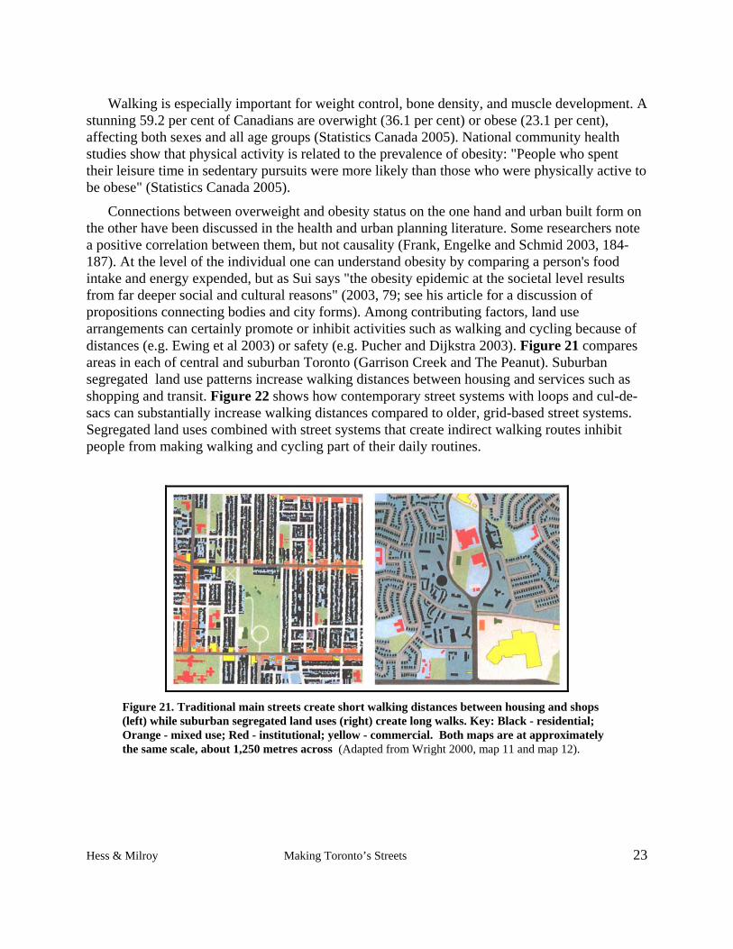
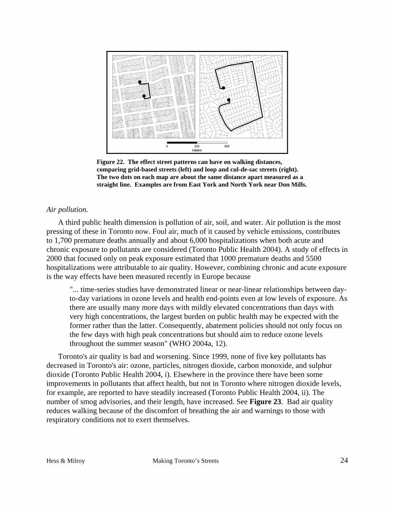
Connections between overweight and obesity status on the one hand and urban built form on the other have been discussed in the health and urban planning literature. Some researchers note a positive correlation between them, but not causality (Frank, Engelke and Schmid 2003, 184-187). At the level of the individual one can understand obesity by comparing a person's food intake and energy expended, but as Sui says "the obesity epidemic at the societal level results from far deeper social and cultural reasons" (2003, 79; see his article for a discussion of propositions connecting bodies and city forms). Among contributing factors, land use arrangements can certainly promote or inhibit activities such as walking and cycling because of distances (e.g. Ewing et al 2003) or safety (e.g. Pucher and Dijkstra 2003). Figure 21 compares areas in each of central and suburban Toronto (Garrison Creek and The Peanut). Suburban segregated land use patterns increase walking distances between housing and services such as shopping and transit. Figure 22 shows how contemporary street systems with loops and cul-de-sacs can substantially increase walking distances compared to older, grid-based street systems. Segregated land uses combined with street systems that create indirect walking routes inhibit people from making walking and cycling part of their daily routines.
Figure 21. Traditional main streets create short walking distances between housing and shops (left) while suburban segregated land uses (right) create long walks. Key: Black - residential; Orange - mixed use; Red - institutional; yellow - commercial. Both maps are at approximately the same scale, about 1,250 metres across (Adapted from Wright 2000, map 11 and map 12).
Hess & Milroy Making Toronto’s Streets 24
Figure 22. The effect street patterns can have on walking distances, comparing grid-based streets (left) and loop and cul-de-sac streets (right). The two dots on each map are about the same distance apart measured as a straight line. Examples are from East York and North York near Don Mills.
Air pollution.
A third public health dimension is pollution of air, soil, and water. Air pollution is the most pressing of these in Toronto now. Foul air, much of it caused by vehicle emissions, contributes to 1,700 premature deaths annually and about 6,000 hospitalizations when both acute and chronic exposure to pollutants are considered (Toronto Public Health 2004). A study of effects in 2000 that focused only on peak exposure estimated that 1000 premature deaths and 5500 hospitalizations were attributable to air quality. However, combining chronic and acute exposure is the way effects have been measured recently in Europe because
"... time-series studies have demonstrated linear or near-linear relationships between day-to-day variations in ozone levels and health end-points even at low levels of exposure. As there are usually many more days with mildly elevated concentrations than days with very high concentrations, the largest burden on public health may be expected with the former rather than the latter. Consequently, abatement policies should not only focus on the few days with high peak concentrations but should aim to reduce ozone levels throughout the summer season" (WHO 2004a, 12).
Toronto's air quality is bad and worsening. Since 1999, none of five key pollutants has decreased in Toronto's air: ozone, particles, nitrogen dioxide, carbon monoxide, and sulphur dioxide (Toronto Public Health 2004, i). Elsewhere in the province there have been some improvements in pollutants that affect health, but not in Toronto where nitrogen dioxide levels, for example, are reported to have steadily increased (Toronto Public Health 2004, ii). The number of smog advisories, and their length, have increased. See Figure 23. Bad air quality reduces walking because of the discomfort of breathing the air and warnings to those with respiratory conditions not to exert themselves.
Hess & Milroy Making Toronto’s Streets 25
Figure 23. Number of official smog days in Toronto, 1993-2002. (Toronto. Public Health 2003, 2)
Children are at high risk from air pollution, including the unborn. A variety of factors contribute to their susceptibility including their smaller airways and lungs, and that they breathe more per unit of body weight than adults (WHO 2004a, 12). Also, the overall evidence of epidemiological studies is that "air pollution seems to aggravate asthma, leading to an increase in symptoms, greater use of relief medication and a transient decline in lung function (WHO 2004a, 15). Asthma among children is increasing and affects one in ten. A comparative study of Canadian, American, and Mexican children using 1994 to 1999 data showed that for Canadian girls aged 11 to 15 the rate of physician-diagnosed asthma increased from 11 to 15%, and for boys of the same age from 16 to 20 per cent (Commission for Environmental Cooperation 2006, xvi). Besides the anguish and costs to individuals, each of us bears a part of the collective costs paid through the health care system.
Toronto's Public Health Department says that the evidence points to a clear policy position which should be
"... to expand and sustain public transit infrastructure and to stimulate the shift to cleaner sources of energy, given that the major sources of the pollutants that give rise to the large burden of illness in Toronto are fossil-based transportation and energy production" (Toronto Public Health 2004, ii).
………
Questions are being raised from many angles about conventions associated with making streets. We have described only three of these -- classification systems, design, and public health. The status quo looks like an unsuitable option. At the same time we see how complex a thing a street is and that numerous interests come into play when one starts to tamper with conventions. The vehicle culture is intimately linked with how people see themselves, their cities, their mobility, and their rights in public space. Further still, the vehicle culture has given rise to
Hess & Milroy Making Toronto’s Streets 26
innumerable regulations and conventions that have become ever more deeply embedded since moving vehicles efficiently emerged as the historic mission of the transportation function.
To help strengthen the Toronto discussion about streets, we turn next to how streets are currently managed. That information, too, is needed to understand the specific institutional and political complexity surrounding any effort to change a mere segment of a street, let alone the basic assumptions underlying the whole street-making system.
The five sections coming next in Part 2 are descriptive: they weave together what we learned from interviews, the steering committee, city personnel, web-sites, various reports, and other publications.
Hess & Milroy Making Toronto’s Streets 27
PART 2: TORONTO BASICS
WHEN DO OPPORTUNITIES COME UP TO CHANGE STREETS?
Changing streets occurs most often as part of the normal, institutionalized repair and development activities of the city, and occurs on already-existing streets. Designing a completely new street is an exceptional event. Here are examples of street-changing opportunities.
1. Street reconstruction. These are occasions when long sections of a roadway are rebuilt. They are scheduled reconstructions designed to keep Toronto's streets in a state of good repair. The city prepares five-year plans and budgets for repairing, upgrading, and completely reconstructing streets according to the length of time since the last upgrades, usage, state of repair, and other criteria. Figure 24 depicts the repair requirements of a street over its life. Street reconstruction can also be triggered by TTC streetcar track replacements or necessary major utility work.
2. Building development process. It generates three kinds of opportunities:
2a. Piecemeal opportunities. Changes are made to short street segments such as in front of a building being constructed. Changes to the sidewalk or street may be required and the precise changes become part of an agreement to proceed with a development. The agreement is worked out between the city and the developer, within the development approval process. This development review process is led by Planning but a great many parts of the city are involved in building and managing streets. This is how the great majority of development-related changes to streets happens in Toronto.
2b. Reinvestment opportunities. New streets are created as part of the redevelopment of large districts and smaller, scattered parcels. Examples of large redevelopment areas include the railway lands near the waterfront, the former Downsview airport lands, or Regent Park.
2c. First-time land development. The development of previously un-built land is relatively rare now in Toronto, however, examples can be found in northeastern Scarborough and northwestern Etobicoke where new streets are created through the subdivision process.
3. Major new street projects. The Dufferin Jog Elimination and the controversial Front Street Extension projects are examples.
4. Policy route. The city decides to develop a policy that affects streets. An example is traffic calming where a process and criteria for installing traffic calming devices has been developed. Another is making annual funding available to build sidewalks on arterial streets where they do not now exist (the former metropolitan government and some suburban municipalities did not always put in sidewalks).
Hess & Milroy Making Toronto’s Streets 28
Figure 24. Pavement prediction model for arterials showing how pavement quality declines over time. Opportunities to redesign arterials streets are infrequent. With regular resurfacing, shown here at about 25 and 45 years, roads function over long periods of time. Delayed maintence will required more frequent and very expensive street reconstructions, but time-frames are sill very long. (Source: John Niedra. City of Toronto. Transportation Infrastructure Management.)
Hess & Milroy Making Toronto’s Streets 29
Those are the basic existing opportunities for changing streets. Two things are clear. First, making a street is an expensive and long-term commitment. A street is meant to last 60 years or so and there are few opportunities for making large design changes. Therefore, it should be designed for the coming vision, not for the one that's expiring. Second, each and every opportunity needs to be seized: unless pressure is brought to bear, each renewal will take the same form as in the past because it's familiar and conforms to existing procedures. Once in place, the results will be around for a very long time.
WHO'S INVOLVED IN MAINTAINING AND CHANGING STREETS?
An array of people across the civil service and out in the public, private, and utilities sectors contribute to making Toronto's streets. The following descriptions capture many of the city's participants. Each description draws on a variety of written, electronic, and interview sources. Each is focused on how the participant's work is related to streets and pedestrians, so they are not descriptions of all the work they do by any means. For instance, Urban Forestry Services deals with trees in ravines and parks but we only discuss its work as it relates to street trees.
Debates on the issues and reporting take place in various forums. The forums include community councils, standing committees of city council (especially the Planning and Transportation and the Works Committees), city council itself, ad hoc committees (especially the pedestrian and cycling committees), internal committees (such as the Strategic Transportation Planning Group), sectoral interest committees (such as the Toronto Public Utility Coordinating Committee), and public participation forums. Which issue goes to which forum, and at what point, seems guided by few hard and fast rules. Many forums exist for discussing recommendations but we later discuss the absence of any forum to discuss how the process limits what is proposed and what alternatives might exist.
Staff, committee, and council reorganizations of differing scale and depth have taken place almost continuously during the post-amalgamation years as the city has tried to find a way to govern itself since 1998. New rounds of changes were occurring even during our data-gathering in mid-2005, and since. We did not try to keep track of these shifts in department names, department groupings, personnel titles, and so on but focused on generic functions concerning streets and pedestrians.
1. Policy Planning
Mandate/Tasks/Organization:
- Policy Planning is within the city planning function
- It is one of three centralized planning services, along with Urban Design and Transportation Planning (see descriptions below). Four planning offices in the districts (East, West, North, South) execute policies of this division as well as those of Urban
Hess & Milroy Making Toronto’s Streets 30
Design and Transportation Planning. Work in the districts includes development review including official plan amendments, zoning amendments, site plan approvals, minor variances, some policy studies such as for the "Avenues" initiative, and preparing secondary plans.
- It develops the city's official plan which is a statutory document required by provincial legislation. The official plan sets out the overall vision for where the city is heading in terms of land use and development, given social, economic and environmental goals and trends; and does this on behalf of city council in conjunction with other parts of the civic administration and the public.
- It develops policies that lead toward achieving the vision set out by the official plan, seeking buy-in for them from as wide a range of the public and specific participants in city development as possible.
- It defends the vision, policies, goals and objectives and their interpretation and implementation when challenged. The city's policies and actions respecting land use ought to conform to those in the OP.
Initiatives/Issues:
- Official plan: see more on this in the Documents and Policies section below in this report.
- Intensification: It distributes intensification and redevelopment in the city by designating 25% of the city as intensification areas where denser development is to be encouraged. Areas include some major "Avenues" which are selected to support increased public transit, better pedestrian and cycling environments.
- Drive-through by-law: It limits the location of drive-through developments which are car-oriented and contrary to the overall and specific policies of the OP to reduce vehicle use and improve pedestrian environments. (See Drive-through guidelines in Documents and Policies section.)
- Harmonized zoning by-law: It expects to complete this in 2007, 10 years after amalgamation.
- Public streets: In conjunction with other city departments in the Development Infrastructure Policy and Standard Review (DIPS), it is operationalizing the OP goal that all new local streets be public. (See more on DIPS in the Documents and Policy section below.)
- Working with other departments to balance the roles of streets.
Hess & Milroy Making Toronto’s Streets 31
2. Urban Design
Mandate/Tasks/Organization:
- Urban Design is within the city planning function.
- It contributes to development review for private projects including recommending up-grades to the area between the building and the curb line including sidewalks for condos and other projects.
- As part of site plan review it prepares streetscape drawings in consultation with transportation services which does the implementation. When the development nears completion, it reviews the outcome to see if it matches the requirements secured for the city from the developer.
- It prepares designs to implement the tenet of the OP that redevelopment sites be organized by a plan of public space led by a hierarchy of public streets. Examples: Regent Park; Fort York; Greenwood; West Donlands.
- It uses its very small capital budget (about $2.5 million in 2005) to piggyback street up-grades onto street reconstructions managed by the Transportation Infrastructure group. It may select 6 to 8 street projects per year on which to focus. Several criteria are used to select these. For example: Is it a substantial street? Is there a secondary plan supporting improvements? Does it fit the objective of distributing projects geographically across the city? (See Civic Improvement Program in the Documents and Policies section below.)
- It manages arrangements for public art that is to be located on a development site.4
Initiatives/Issues:
- Streetscape Manual: It has drafted a manual which describes ideal streetscape treatments for classes of streets. It is intended for use during development reviews and street reconstructions. Streetscape treatments concern the area from the curb in to the property line, and are mainly pavers, plantings, and lighting. Streets are classed according to their importance and use in the city, such as for commerce, retail, ceremonies, etc., and are called Main Streets, Emerging Main Streets, Green Streets, and Expressways. The current Streetscape Manual has been developed since amalgamation and is still under discussion with other departments. It is built on principles found in the one used in the old City of Toronto. The idea is that Streetscape Manual standards could be applied automatically by Transportation Services, the way it applies the RCS, and that standard budgetary allocations would cover the costs. Without it, all up-grades and the money to pay for them have to be negotiated one by one
4 By contrast, public art that is negotiated through section 37 of the Planning Act has, since amalgamation, been the
responsibility of the economic development, culture and tourism function. This art is usually located on public streets. The logic of splitting the public art task is unclear.
Hess & Milroy Making Toronto’s Streets 32
between Urban Design and Transportation Services, with input from others. (See the Documents and Policies section below for more detail.)
- Street widths: Urban Design prefers narrow local streets (6-7.5 metres) with some parking as a way to calm traffic without using humps, etc. Another reason is because new developments that use laneways in addition to streets need facilities to be narrow to fit in the number of units that private sector builders want to build. Urban design participated in working out agreements over local street widths in the DIPS process.
- Fleeting opportunities: It uses the development review process to find unexpected opportunities to make streetscape improvements when they won't impede traffic flow.
Example 1: At Richmond and Spadina a way was found to make a better pedestrian environment by combining a turning lane and traffic island, putting the turning lane beyond it.
Example 2: On the west side of Yonge between the rail corridor and the Gardiner an extra right turn lane will be eliminated and become a sidewalk or plaza associated with the new project at that corner.
- Pedestrian safety: Urban design staff in the districts try to enhance pedestrian safety by defining special treatment for pedestrian crosswalks such as textured paving, stamped concrete, mid-street refuges, etc; advocating on-street parking as a barrier between pedestrians and moving vehicles; requesting tighter turning radii because they require motorists to slow down; and so on.
- Urban Design Review pilot project: It is working to create peer review boards to be tried on a trial basis in selected parts of the city such as the designated centres. Development proposals would be reviewed by a panel to include design professionals, particularly architects. The review process would be voluntary as the city can not require it under the Planning Act. Public realm issues such as streetscape elements are typically an important concern of peer review processes used in other cities such as Vancouver.
3. District Community Planning
Mandate/Tasks/Organization:
- District community planning is within the city planning function
- It is located in each of four districts and is further broken down into geographically defined sections.
- It is responsible for reviewing, processing, and reporting on development applications including subdivisions, re-zonings and official plan amendments, and site plan approvals. Applications are circulated through other interested city functions such as transportation, development engineering, and the TTC, but a community planner is assigned to individual proposals and is responsible for this process to make sure city concerns and requirements are met.
Hess & Milroy Making Toronto’s Streets 33
- It is the front-line contact for the applicant, residents, resident associations and other interested parties near to the location of a proposed development as well as to the local city councillor.
- It is involved in negotiations between the city and the developer for Section 37 benefits, how large a development will be, and how it is designed. This can, but need not, include streetscape improvements.
- At the end of the review process, they write a report to city council either recommending that a proposal be approved or that it should be denied. They give their reasoning for the recommendation based on the OP and other city policies. City council may or may not follow this recommendation.
- In coordination with downtown policy planners they work on some local policy issues such as secondary plans and avenue studies.
Initiatives/Issues:
- Issues depend on area of the city with significant differences between urban and suburban areas. Suburban car-dependent residents are more likely to accept the current role of arterial streets as places for cars, not pedestrians.
Example: The Morningside Heights area where a developer is required to put in a sidewalk but some residents are vocally opposed because a sidewalk would reduce how many cars they can park in their driveways.
Example: The Harbord Village Residents Association were actively involved in sidewalk and street improvements that were part of the reconstruction of College street and pushed for experimenting with curb-side cafes (instead of along the building front) and other issues that go beyond normal city practices.
- The scale of development and traffic infiltration into “neighbourhoods” is an issue everywhere.
- Community planners have less strong relationships with the communities in which they work than they did before amalgamation. There are fewer planners working larger areas than before and planners are sometimes moved between districts.
4. Transportation Planning
Mandate/Tasks/Organization:
- Transportation Planning is within the city planning function and separate from Transportation Services. This is intended to help integrate transportation planning with land use planning.
- It studies how market demand is affecting land uses, and what the implications are for transportation demand.
Hess & Milroy Making Toronto’s Streets 34
- It develops future-oriented recommendations for transportation that take account of both transportation projections and the social, economic, and environmental future envisioned for the city. Its policies are incorporated in the OP.
- It works with groups to develop secondary plans and studies that respect the principles in the OP.
- Its policies have to do with streets, transit, pedestrians, parking, accessibility for handicapped persons on streets, cycling, and more.
- It works with transportation services on both on-street and off-street vehicle-related matters.
- Normally it has only operational, not capital, funds.
Initiatives/Issues:
- "Transit First": This initiative seeks to reduce auto-dependency where development opportunities can be found -- for example, in the proposed waterfront redevelopment.
- St. Clair dedicated streetcar lane: It championed this development on the basis of policies in the OP.
- The city's transportation plan: It was built into the OP which gives it legislative strength.
- Public streets: It participated in DIPS to develop a policy regarding the public/private status of new local streets and standards to be met.
- Street classification: The OP classes streets as "major" or "other". Neither the RCS nor its classes are mentioned in the OP. This is intentional. If they were incorporated in the OP, then changing a street's class would require a formal official plan amendment. In its current status as a city council approved policy outside the OP, changes can be made simply with approval from city council because it is an administrative, not a statutory, tool.
5. Development Engineering
Mandate/Tasks/Organization:
- Development Engineering is within the technical services function.
- It reviews all of the development applications for official plan amendments, secondary plans, subdivisions, rezonings, land division, minor variances, site plans, condominium proposals and works carried out on rights-of-way. The reviews identify servicing requirements and impacts on existing city infrastructure.
- From these reviews it establishes what the city requires from a developer to meet standards, and does this working with planning and other services. For example, if the proposed development meets existing zoning, then discussions and contractual arrangements focus on service connections, water management, and site-specific
Hess & Milroy Making Toronto’s Streets 35
matters. If a property is being upzoned, the developer may be required to build infrastructure to support it such as a sidewalk or street segment, or to increase sewer capacity.
- It is the one window for developers and others into transportation and engineering services. It determines the scope and cost of all new city infrastructure required to serve development proposals including water, wastewater, drainage, access, and streets. After discussions with planning, finance, and legal services, it prepares development contracts and oversees them throughout the development phase.
- It is the part of the city administration that lives with a development through its full cycle from concept to ribbon-cutting. Others jump in and out along the way -- for example, Planning is there at the beginning for about two years for the planning part; the buildings function comes in later; Urban Forestry and Transportation Services come in at a point; and so on. By contrast, Development Engineering's involvement may continue for seven or more years depending on the size and complexity of the development.
Initiatives/Issues:
- DIPS (Development Infrastructure Policy and Standards): It began the review process because in post-amalgamation Toronto the standards were unclear, absent, or different in each of the former cities which made discussions between the city's departments and development proponents long and complicated.
- Public streets: It has supported the principle found in the OP that all new streets be public. The issue is that private streets, built as common element condominiums in townhouse developments, may not be built to the city's standards and lack the amenities the city prizes in its public spaces. Further, they are not serviced by the city so residents must pay the cost of utility and infrastructure repairs to their private streets in addition to property taxes. Condo corporations are not required to set aside sufficient funds to guarantee these repairs so deteriorated infrastructure can become a problem for residents and the city.
6. Transportation Services
Mandate/Tasks/Organization:
- Transportation Services is the over-arching function responsible for managing city ROWs.
- It operates decentrally through four district transportation services offices and centrally through this and other offices described below -- Transportation Infrastructure Management, including Pedestrian and Cycling Infrastructure, and the Traffic Management Centre.
Hess & Milroy Making Toronto’s Streets 36
- Its priorities are (1) work that keeps streets in a "state of good repair"; (2) traffic control projects; and (3) enhancements to rights-of-way. Its budget is designed in accordance with those priorities.
- It constructs and resurfaces streets under a capital maintenance program.
- It sweeps, flushes, and undertakes winter and other right-of-way maintenance as its operations program.
- It handles traffic operations, including signs, signals, street markings, safety, enforcement, issuing permits for street closings for events and repairs.
- It develops and maintains pedestrian and cycling infrastructure.
Initiatives/Issues
- Harmonization of transportation policies across the new city: Road Classification System - completed; traffic calming warrant system - completed; access management policy - underway.
- The volume-to-capacity assumption of development review: As currently practiced within transportation services development review is intended to ensure that traffic is not impeded by a new development. The basic assumption is that the ratio of traffic volumes to street capacity will still be maintained after development is complete. This volume-to-capacity ratio is not to exceed 1.0 by assumption. Therefore, the developer must enter into agreements with the city to mitigate any effects of the new project that are expected to hinder traffic around it. If current streets are at capacity and new development generates new trips, as it invariably does, new capacity must be created. This may be done through signal improvements, lane widenings, etc. However, the new OP says that the policy of the city is to get people out of cars and onto transit. If decisions are based on old criteria then the new vision is not being advanced. A process is just beginning to explore if the volume-to-capacity criterion is still appropriate or if another measure should be used. The process will focus on traffic analysis.
- Operationalizing the OP vision: The work of translating the vision into standards, rules, and practices on the ground for staff to use on a day-to-day basis in making decisions has barely started. That is where trade-offs among pedestrians, cyclists, vehicles, parking, streetscaping, and access to businesses are to be made. It is also where qualitative values need to be turned into quantitative guidelines, or at least into clear illustrations and guides for the qualitative ideas. Staff must have something solid to work with if they are to effectively implement the ideas contained within the OP.
- Access management: This work has to do with deciding the extent to which new developments have vehicle entries/exits and loading opportunities on an arterial street. The existing policy (slightly updated since amalgamation) originated with the former Metro government that controlled most major arterials. It favoured putting access on abutting streets in order to maintain the "integrity of the arterial", that is, its designation within the Road Classification System as a street intended to focus on vehicle mobility
Hess & Milroy Making Toronto’s Streets 37
rather than access. A process is underway to fully update the standards and extend them to all major and minor arterials across the city. Issues include curb cuts that (1) inhibit traffic flow and thus the integrity of the arterial road system and (2) disrupt the pedestrian environment. But clients want their address and access on the main street. Residents on abutting streets often object to the vehicle entries on their streets which they fear may lead to increased traffic and councillors often support them. Planners and urban designers are caught between Transportation's access management policies and the councillor and residents. Developers may ask their consultants to come up with arguments for having entrances/exits on arterials for use in their defence at the Ontario Municipal Board if the city turns down their request.
- Unfunded maintenance: If new infrastructure generates new maintenance tasks they have to be parceled out as a new responsibility. No department wants to get stuck with these -- e.g. mowing grass on a new boulevard; servicing a new off-street walkway that cuts between blocks -- unless a budget increase covers new costs. As Transportation is often responsible for maintenance responsibilities and its mandate is to keep things in a state of good repair, it may oppose pedestrian improvements that come without additional funding. A related issue is “orphaned spaces” that are built, but no department is responsible for maintenance.
- Policies and politics: A city council approved policy exists on traffic calming including speed humps that incorporates a "made-in-Toronto" warrant system to decide whether or not a street is appropriate for the treatment. However, the vast majority of speed humps approved by council are on streets that do not meet the warrants set out in the policy. Two issues are raised about this. One is whether the demands of the warrants are set at appropriate levels so that they are equally workable across the whole city. If they are not, installation decisions will be made politically, by ward, and approved at city council because unless an action is egregious a ward councillor has sway over such decisions. This has been happening. The other issue is the effect on the policy-making function if council disregards its own policies. Staff expressed frustration about spending their time studying these matters, writing reports, and then having the policy-based recommendation reversed at council. (See Traffic Calming Policy in Documents and Policy section below.)
- Learning gaps: To recommend something that is not in the Transportation Association of Canada’s design manual or other standardized design criteria used by the city may open liability issues. Resources are not available to study innovations that, if they could be tried, may make better streets and reduce dependence on such standards. It would be possible to go much further with innovative solutions with a better research foundation. The new Avenues studies may be instructive in this regard. (See The Transportation Association of Canada Geometric Design Manual in Documents and Policies section below.)
Hess & Milroy Making Toronto’s Streets 38
7. Transportation Infrastructure Management
Mandate/Tasks/Organization:
- Transportation Infrastructure Management was first established after amalgamation within the transportation services function.
- It manages the inventory of approximately 5,200 km of streets and 7,100 km of sidewalks as well as over 500 bridges in the city. This includes developing a 5-year capital works planning and budgeting program for regular street repair and reconstruction, and circulating it to relevant departments, agencies, and other bodies; and keeping technical information on characteristics of streets (e.g. their geometry such as curves, turning lane radii, etc.). It monitors their performance, and their operating, maintenance and building costs in order to manage these assets most effectively in terms of engineering knowledge and cost.
- It is responsible for planning and programming long term projects to improve the transportation infrastructure such as street additions, extensions, widenings/narrowings, traffic signals; and doing environmental assessments for projects.
- It develops and manages transportation policy on a day-to-day basis taking a lead on several harmonization activities since amalgamation including the RCS, traffic calming, operating maintenance of streets like cleaning and equipment issues, and access management (described above).
- It has a separate pedestrian and cycling infrastructure section. For description, see below.
Initiatives/Issues:
- Directing more staff time to non-local roads to decide how they should be built, in concert with urban design staff and others.
- Circulation of planned work to other departments: It does not have a high rate of response because other departments do not have the resources to review the numerous proposals.
8. District Transportation Services
Mandate/Tasks/Organization:
- District transportation services is within the transportation services function.
- It is located in each of four districts and executes district-level functions including traffic planning, right-of-way management (ROW-M), road operations, traffic operations, traffic signs and pavement markings.
Hess & Milroy Making Toronto’s Streets 39
- Traffic planners review development applications to determine effects on traffic, including vehicles, pedestrians, cyclists, and transit. They also work on major developments in their district such as the waterfront redevelopment in South District.
- ROW-M (usually tied in with the district traffic planning function) deals with the effects of construction on a ROW, issues permits for on- and off-street parking, coordinates events that call for closing streets, and manages streetscape issues. It issues detailed permits for virtually all work done in the ROW resulting from private development that has gone through development review, and for Business Improvement Area (BIA) initiatives. It is also the link between Traffic Operations and a developer when a change is made to the street surface, ironing out conflicts and ensuring work is done to Traffic Operations' specifications. The function includes a substantial amount of consultation (e.g. with Development Engineering, discussed above; with BIAs, see below; with residents associations) and coordination with many other services. It is responsible for TTC platforms, benches and shelters, but not the transit marker poles, and has the final say on the location of transit stops (in consultation with the TTC). Because municipal work does not require permits, ROW managers are mainly only consulted to avoid conflicts on proposed work. It is responsible for enforcing the by-law that residents must clear snow from the sidewalks in front of their buildings in central Toronto where the city's mechanical equipment can't be used.
- Road and sidewalk supervisors execute the road operations function which includes scheduling work in the district according to engineering priorities, urgency, resident requests, and seasonal opportunities; keeping public streets, sidewalks and bridges in good and safe condition; ensuring prompt response to emergencies and seasonal conditions such as snowstorms; providing traffic control assistance for road closures; making sure road maintenance equipment and facilities are in good working order; and ensuring maintenance work (e.g. asphalt/concrete repairs, sweeping, flushing, guide rails, drainage and leaf collection) is performed in a financially responsible way that meets city standards whether carried out by city staff or contractors.
Initiatives/Issues:
- The RCS: As a descriptive tool it is good when it defines general maintenance and service standards for what exists. As a prescriptive tool it creates difficulties because it is inadequate to determine how a street should be designed or how much traffic should be on it. The RCS does get used prescriptively.
Example: Let's say the RCS says the maximum number of vehicles per day is 2500 on a given class of street. Residents complain that, having counted the traffic, there are 2800 vehicles per day on their street, and want to know what the city is going to do to get the volume back to 2500 or less. The residents say: "You set a standard. Figure out how to maintain it." It has become prescriptive.
Example: Or, the city uses it prescriptively. Residents complain that there is too much traffic on their street. The city replies: "There are only 2200 vehicles per day
Hess & Milroy Making Toronto’s Streets 40
on your street which, for its class, is below the maximum. You can't complain until there are over 2500".
- ROW widths: This issue is met full-face at the district level although it is discussed all the way up through the transportation services function and across functions, as noted above and below.
- TAC manual: This has been the source of standards for most of the now-amalgamated municipalities. Deviation from it is a worry for professional engineers because of liability.
- Pedestrian crossings: A review of pedestrian crossings was done in each district to see why they have not been working as well recently as in the past. Some crossings were identified for signalization. Although a standard distance between signals exists (210 m), decisions may be made based on examination of the actual conditions.
- Streetscape manual by urban design: In spite of its informal draft status, it is used in ROW-M as a guide in decision-making.
9. Pedestrian and Cycling Infrastructure
Mandate/Tasks/Organization:
- Pedestrian and Cycling Infrastructure (PCI) is within transportation infrastructure management in the transportation services function.
- It is responsible for planning and programming improvements for pedestrians and cyclists in ROWs and elsewhere. It works closely with the district traffic operations staff.
- It manages a budget of about $10 million for sidewalks, of which about $2 million is designated for installing new sidewalks where they do not now exist.
- It consults with relevant departments when it intends to reconstruct or build new sidewalks or add or change bike lanes, and circulates proposals for formal input.
- It contracts the city's technical services department to tender and construct sidewalks and bike lanes to meet its criteria.
- It meets monthly with both the city's pedestrian and cycling special purpose advisory committees.
- It is responsible for all bicycle parking, including in BIAs.
- It develops by-laws for new bike lanes that can be passed by city council. By-laws are necessary for bike lanes so that the street spaces set aside can be legally restricted and enforced as for bikes only.
- It maintains a watching brief over the city's Bike Plan which was a joint initiative of Transportation Planning (within the planning function) and Transportation Services.
Hess & Milroy Making Toronto’s Streets 41
Initiatives/Issues:
- "Missing sidewalks" project: The focus of the project is on arterials without sidewalks. The former Metro government's transportation services concerned itself primarily with the ROW pavement, from curb to curb, on most arterials. The six separate cities decided if they'd build sidewalks on those arterials and some arterials do not have them. The amalgamated city has decided to complete the sidewalk system gradually. PCI piggybacks sidewalk additions onto other street reconstruction projects. It uses criteria such as pedestrian safety issues to allocate money to these projects, and listens to advice from the city's pedestrian committee and local citizen groups. The project could build sidewalks on other street classes also.
Gathering enough political clout to insert bike lanes when ROWs are being reconstructed: In debates over how much space will be devoted to which forms of mobility, cyclists compete against transit and vehicles. They do not necessarily have the support of citizens, businesses, or elected councillors. In the St. Clair debate, for example, calls for including bike lanes on the rebuilt avenue lost out to space for transit, cars, parking, and pedestrians; no bike lanes are to be built.
- Developing pedestrian assessment tools that would evaluate level of service (LOS) criteria for pedestrians at intersections and mid-block locations: Motor vehicles have such tools and there are even some developed for bikes, but there is nothing to adequately measure the impact of street design on pedestrians. Using judgement calls against the quantitative measures used for motor vehicles is not a good match for making pedestrian-friendly decisions.
10. Traffic Management Centre
Mandate/Tasks/Organization:
- The Traffic Management Centre is within the transportation services function.
- It manages traffic control including the automatic signals system and the installation and maintenance of it; research and planning of signal controls; camera operations to detect motorists running red lights; street lighting; and the Traffic Data Centre and Safety Bureau that, as its name suggests, collects and presents data concerning traffic movement, collisions, and safety measures.
- It is responsible for carrying out traffic demand studies and identifying future transportation needs.
Initiatives/Issues:
- Current data: It maintains current data summaries on collisions between motor vehicles and pedestrians, cyclists, motorists, and passengers using some data from Toronto Police Service reports. The summaries show collisions by severity of injury, fatality,
Hess & Milroy Making Toronto’s Streets 42
age of person, type of street according to the RCS, time of day, and other variables. See <www.toronto.ca/transportation/publications>.
11. Urban Forestry Services
Mandate/Tasks/Organization:
- Urban Forestry is within the parks, forestry, and recreation function.
- It is responsible for coordinating and managing the forestry program of the city and to this end it collects and analyzes tree data; develops and implements by-laws to maximize protection and preservation of the urban forest resources and habitats such as the city's street tree by-law; develops and implements an overall forest management plan and contributes input to the OP and other strategic processes; and tries to convey research and education to others within the corporation, the public, utility companies, and so on.
- It maintains about 500,000 city-owned trees in ROWs (as well as another 2.5 million trees in parks, ravines, etc.). Maintenance involves inspection, evaluation, protection, pruning, watering, fertilizing, health care, removal, and planting (see <www.toronto.ca/trees/inded.htm> )
- Because of its mandate to protect and preserve trees, it participates in development review processes along with the planning, transportation services, and technical services functions.
- It participated in the DIPS process where it contributed information about the amount of space and soil needed to grow a tree to maturity in narrower, utilities-laden ROWs; and in the Toronto Public Utility Coordinating Committee where its task in part is education about tree roots and how to work around trees without damaging them.
Initiatives/Issues:
- Implementing the OP: Toronto promotes a green city and trees are discussed in the OP's environmental statements saying, for example, that the city will increase the canopy through more planting and protection of existing trees through maintenance. However, with half the staff it had prior to amalgamation existing and new trees have to survive with much less watering, pruning, fertilizing, and general care.
- Improving street tree planting practices to minimize maintenance: It is preparing a matrix of street tree-planting treatments to be used in particular situations, stretching from the best option with trees in turf, followed by trees in raised beds, then by trees in linear pits.
- Budget strategy: To make best use of its budget, Forestry piggybacks its projects on Transportation Services' projects (the approach used by urban design, discussed above).
Hess & Milroy Making Toronto’s Streets 43
- Few staff/few advantages seized: Transportation Services circulates a very large number of street rebuilding projects it wants to work on. Forestry cannot begin to review all these to find the best sites for its work because it has only one staff person to go through them. As a fall-back strategy, it selects a few approved projects and gives advice about planting for Transportation Services to follow up with.
- Criteria for selecting street tree projects: Its criteria for where it spends its tree planting budget include: sites most likely to lead to success measured by tree survival (e.g. if trees can be placed away from the curb it is better than at the curb where salt-laden snow collects); and equity across the wards of the city (some wards have had no plantings since they were built in the 1960s and amalgamation brings this issue to attention).
- Capital versus operating budgets: Transportation services has a substantial budget for planting street trees but Forestry does not get an increase in its operating budget to take care of these trees in following years.
- Tree survival: Instead of working on sites during redevelopment, Forestry asks to get potting vaults built as part of development review and approval, and then goes in after construction and the utilities are finished to plant in the reserved spaces. Better tree survival rates result.
- Utility maintenance: Transportation Services prefers utilities under sidewalks to avoid traffic interruption during repairs, but for Forestry this is a problem for tree survival. It looks for ways to protect trees while utility maintenance work is going on – e.g. lifting a tree and surrounding grate and then replacing it when the work is done; education for repairers; etc.
Inter-department initiatives: It is part of a working group with representatives from Urban Design, Policy Planning, Transportation Services, and Water looking for complementarities -- e.g. Transportation wants rainwater off the streets and Forestry wants water for greening; and to help educate each other about their responsibilities. Three internal symposia in 2004 and 2005 debated and brainstormed about trees and streetscapes from the perspectives of different disciplines -- landscape architecture, urban forestry, water resources, civil engineering, etc.
12. Fire Services
Mandate/Tasks/Organization:
- Its main task is to protect people and property from fire as well as from hazardous materials and disasters. This includes fire prevention through inspections, drills, safety education, and emergency training to employees and others. It also provides first response for medical emergencies such as heart attacks.
- It is a neighbourhood-based service. Its six municipal services had not been amalgamated prior to 1998 because agglomeration economies are negligible or absent
Hess & Milroy Making Toronto’s Streets 44
when the time/distance relationship between a fire station and the site of an emergency is the most crucial factor in delivering its primary service.
- It has over 80 fire stations distributed over the city. These are grouped into four Command Divisions (East, West, North and South) each of which is headed by a Deputy Chief, and all of these by a Fire Chief (see <www.toronto.ca/fire/index.htm>). "Divisions" as used by Fire correspond to "districts" as used by Planning and Transportation Services. Fire then sub-divides each division into 4-6 districts.
Initiatives/Issues:
- Street widths: The issue is to have sufficient pavement width (at least six metres of clear pavement) free of parking to allow a fire truck to reach any building and put out its equipment. Much of the older city street network is not built to the dimensions Fire Services desires today and also Planning seeks to build many new streets in reinvestment areas (West Donlands, Railway Lands, etc) to narrow standards. In outlying areas there are some interests as well for narrower streets, whether to fit new ideas about streets and traffic or to reduce development costs. In response to arguments that the fire service buy smaller equipment, it claims it already has the narrowest fire trucks in North America. Thus, the fire service sees street width and emergency equipment access as a critical safety issue and seeks involvement in street width discussions. Before amalgamation Fire Services in the old City of Toronto was not involved in these issues.
- Traffic calming: In the view of Fire Services, reducing the speed of delivery of their service could become a liability issue for a city. Using speed humps on local streets slows heavy fire trucks more than it does general traffic. Fire estimates that five humps spaced 150 metres apart reduce the response time by one minute which it judges undesirable, especially when responding to time critical emergencies such as heart attacks. The everyday safety benefits of traffic calming or narrow streets have to be traded off against the possibility of an emergency and the fire services' response time. It may be possible to estimate the costs of these safety trade-offs, but increased liveability ascribed to traffic calmed streets cannot be quantified. Another issue for Fire is that streets are traffic calmed one at a time, without any thought to an area wide plan which would include the impact on Fire Services.
- Turning radii: Trade-offs are also needed on turning radii because large ones suit vehicles like fire trucks but they are then invitations to all vehicles to move fast.
- Parking: It is the view of Fire Services that an inadequate supply of parking leads to illegal parking, and that in turn leads to emergency vehicles being blocked.
- Automatic fire suppression: general installation of automatic fire suppression systems (sprinklers) as is mandated in Vancouver might be an acceptable trade-off for slowed access to fires, but Fire Services also needs quick response times for medical emergencies. Another approach would be increasing the number of fire stations so that
Hess & Milroy Making Toronto’s Streets 45
the average travel distances to emergencis are reduced for fire trucks, but this is expensive.
13. Business Improvement Area Office
Mandate/Tasks/Organization:
- The Business Improvement Area Office is within the economic development, culture and tourism function.
- There are more than 50 Business Improvement Areas (BIAs) in Toronto. This office provides a liaison function between BIAs and other city departments. How BIAs are established and how they function, in broad terms, are both governed by provincial legislation. How they function in detail, including the support they receive from a municipality, is determined locally.
- A BIA can only spend its money on public lands and within the ROW. This is usually the area from the curb to the property line. The Office has delegated authority over an annual budget passed by city council and does not have to seek new council approvals for specific expenditures in BIA projects except in unusual circumstances such as when a project is very large and the cost does not fit the 50/50 cost sharing rules (e.g. the Bloor Street Transformation Project), or there are complex arrangements between the BIA and the city (e.g. decorative poles that are also traffic signals in the Downtown Yonge BIA). Transportation Services holds approval authority for most physical changes in a ROW. The BIAs' planning, designing, and implementation are normally coordinated through ROW managers.
- BIAs annually submit requests for funds for projects they propose to carry out in the following year. They must illustrate that their half of the funding for projects is raised from the self-levying of a BIA’s member businesses. The Office seeks the other half of those costs from the city via the city's annual budgeting process. The city accommodates as many requests as possible because improvements only cost it half of the total. If the total amount sought by the BIAs is too high for the city, the BIA Office tries to find ways to cut back individual projects or delay a project for a year. The city's contribution is around $4 million annually.
- Because Transportation Services is the lead for implementing changes, it does the billing, sends its bill to the BIA Office, and the BIA Office in turn bills the BIA in question.
- If a BIA improvement results in higher maintenance costs, then in principle the BIA is responsible for paying those surplus operating costs. For example, any extra lighting over and above the standard for a street and sidewalk is supposed to be placed on a different circuit and billed to the BIA.
- The Office is the city's liaison with the Toronto Association of BIAs (TABIA) where individual BIAs meet to discuss issues.
Hess & Milroy Making Toronto’s Streets 46
Initiatives/Issues:
- Piggybacking: It tries to use the 5-year capital works plan from Transportation Services to piggyback BIA improvements on its projects, as described in other cases above.
- Urban Design does not work in BIAs: It only does 100% city-funded projects outside BIAs, while the BIA Office is only concerned with cost-shared programs. Urban Design is looking for some coherence across the city. BIAs specialize in making themselves distinctive. How are these opposing interests being traded-off? The city’s new coordinated street furniture program will have to establish a policy on this issue. (See Coordinated Street Furniture Program in Documents and Policy section below.)
- Changing nature of projects: Until recently, streetscape improvements tended to be on the order of benches, planters, decorative banding on sidewalks, and so on. Lately the range has widened to include new kinds of pedestrian lighting, public art, and median planting.
- Commercial research grant program (50/50 cost sharing): The Office also manages a program to encourage BIAs and business associations "to plan strategies to improve the economic viability of their commercial areas" (Toronto. Economic Development 2004[?]). They are eligible for 50% of the cost of obtaining expert advice or developing a streetscape master plan. Such a master plan is not equivalent to a secondary plan, which is a statutory document under the Planning Act, nor is it a city policy. However, it reflects what the BIA or association wants and might obtain if its members are willing to levy themselves to pay for implementation.
- Disproportionate advantage and the public good: Allocation of city funds to BIAs while always 50/50 is disproportionate because those with the greatest resources can yield the largest levies, exert the most political leverage, and yet are not likely the most in need. Example 1: The city will spend $15 million on Bloor/Yorkville's $30 million transformation project while spending about $4 million on all the remainder of the city.5 Example 2: The Downtown Yonge BIA may ask for $500,000 a year from the city's BIA budget while a BIA in an impoverished area may ask for $10,000 because that is all it can raise in levies from its members.
- Equity and the public good: If a BIA wants trees planted it is required to pay half the cost. Trees are considered a public good in terms of the OP so presumably should be spread equitably across the city. A low-levy BIA may not be able to afford trees. Businesses outside of BIAs will get no city subsidy at all.
- Sidewalk widening or street narrowing: Both raise concerns for BIAs if parking spaces are reduced in the trade-off.
5 In part the city will meet those costs via section 37 income. These are funds received by the city from developers in
exchange for granting density bonuses over and above that which is allowed in the OP. Section 37 of the Planning Act permits such arrangements.
Hess & Milroy Making Toronto’s Streets 47
- "Clean" and "beautiful": These are the principal features promoted through BIA activities, not pedestrianism.
- Extra street cleaning in BIAs: A core city job is to clean all its streets well. Some BIAs pay for extra private services. Equity across the city and seeing the city as a single entity are compromised if the job is done better in some places than others.
14. Service Planning, Toronto Transit Commission (TTC)
Mandate/Tasks/Organization:
- Using both planning and traffic engineering skills, its focus is planning for vehicle operations on the street, that is, whether a new service is needed; whether a street is physically capable of taking a TTC service; what would be needed to put a service in or change one.
- It reviews development applications, circulated to the TTC by the city planning department, including official plan amendments, zoning and site plans. It examines applications from the point of view of whether they are transit supportive, the impact they will have on transit ridership, pedestrian access between proposed buildings and transit stops, and the implications for slowing transit services.
- It contributes to secondary plans and Avenue studies at the request of the city.
- It works with transportation services to do re-routings when streets undergo reconstruction, and when the TTC does track repair and replacement.
- It proposes new and relocated transit stops to ROW Managers for their approval (there are about 4000 in the city). Safety overrides all other concerns when it comes to stop placement. For example: Stops are never just over a hill where a car could plough into a bus; are not placed where passengers stepping off transit would be in the path of a turning vehicle; are put mainly at signalized intersections or where there is a safe place to cross the street; and where the platform meets a minimum width for passengers embarking and disembarking. The TTC provides and maintains the poles at transit stops.
- TTC policies are approved by the TTC Commission. So is its budget, but the budget also requires approval by city council. Realistically, however, many TTC actions go to city council or its standing committees because considerable coordination is almost always involved especially between Planning, Transportation Services and the TTC.
Initiatives/Issues:
- The OP and the TTC: The OP gives credibility to issues the TTC has pushed for years, sanctioning more pro-active and aggressive protection and enhancement of public transit. While the TTC used to ask questions about proposed developments on the order of whether and where new stops were needed, now it is more likely to ask how a developer will mitigate transit-slowing effects resulting from a development (which it
Hess & Milroy Making Toronto’s Streets 48
has data and models to measure), and whether the parking standards support private vehicle or public transit use.
- Gaps: The gap between the OP's vision and what exists can be huge, such as the many locations where the great majority of a street's users are on transit yet no space on the street is dedicated to the TTC.
- Transit knowledge: Some planners and transportation services people know little about how transit fits into city development and rely heavily on TTC experience. This is partly an effect of amalgamation and partly of not having digested the OP. In suburban areas, planners and transportation people did not work on transit before amalgamation because it was a Metro-level responsibility. The TTC had its working relationships mainly with Metro staff. Now TTC operations staff have to help train district planning and transportation staff on transit issues and on the implications for transit of OP policies. This is partly why the TTC is involved in secondary plans. As such, amalgamation has placed a hidden cost on the already-metropolitanized transit service. Issues remain because of inconsistent procedures across the districts and shortage of "big picture" thinking. It inhibits introduction of major policy initiatives, e.g. signal priority. On the other hand, because the TTC now works directly in all the districts it can get its points across directly.
- Most change is piecemeal: Trying to get transit advantages on Toronto streets via the development review process results in piecemeal change. The TTC routes traverse large parts of streets so changing one small piece at a time does not help much, although it is hard to see alternatives.
Example: The Regent Park redevelopment will almost double the number of dwelling units, but transit service is practically at its capacity at that geographic location. The TTC didn't want to oppose the project because it could not meet greater transit demand at that site, since the redevelopment is good in so many ways. Several options for service upgrades were considered but in the end, given that it is just one short segment of the route, the TTC compromised and only sought additional property on which to put better stop facilities with longer platforms.
- Forums for negotiation: Changing a ROW in which the TTC is involved entails negotiations; the forum and nature of discussion depend on the project.
Example 1: A recent case of negotiation within the development review process concerned Carleton Street, east of Yonge. The streetcar tracks on Carleton were due to be replaced and the TTC and city decided to rebuild the road and tracks as they were. A development application concerning Maple Leaf Gardens arrived as construction was getting underway and, through the development review process, it was possible for transportation services to change the ROW's cross-section and TTC to change track alignment to accommodate vehicle turns without generating future transit delays.
Example 2: Discussions on trade-offs regarding the St. Clair streetcar ROW took place within a formal Environmental Assessment process, a highly structured forum.
Hess & Milroy Making Toronto’s Streets 49
It was initiated by the TTC which shared project management with the city. The streetcar tracks had to be replaced because they were reaching the end of their lifespan. The city had an interest in changing the ROW to make a dedicated streetcar ROW in line with transit promotion policies in the OP.
Yet other examples of different forums are secondary plans and Avenue studies where the discussions and trade-off negotiations are coordinated by the city and the TTC is brought in as a participant. In such cases, the outcome depends on who makes the best case and the strength of city policies in the area of concern.
- TTC traffic calming: It has its own traffic calming policy that originated prior to amalgamation and was instituted because of a proposal to put traffic humps on the Davisville bus route between Yonge and Bayview. Its policy disallows humps and other vertical deflections that are difficult for buses. Horizontal deflections, chicanes and sidewalk widenings, are not a problem. In general traffic calming is not an issue because it is limited to local streets and most bus routes are on arterials, although there are a few exceptions.
- Lane widths: It developed its own standards for lane widths: 3.65 (minimum 3.3 metres) for its buses which are 3.1 metres wide. These standards were arrived at in Toronto because the Transportation Association of Canada does not make standards for city buses.
15. Pedestrian Committee (Advisory Committee of the City)
Mandate/Tasks/Organization:
- The pedestrian committee is an advisory committee of the city whose members are appointed by council, and composed of up to 16 citizens plus two members of council. Nine of the citizens represent specific interests (see <www.toronto.ca/tpc/index.htm>). It is staffed via Pedestrian and Cycling Infrastructure in Transportation Services. Staff from Planning and Police Services frequently attend meetings.
- It comments on a range of issues that affect pedestrians including forms of streets, sidewalks, or lighting, and the capital and operating budgets for streets in the form of motions sent to one of council's standing committees. There is no obligatory reporting system from city departments to the Pedestrian Committee; and it can only ask civic staff to do something indirectly through a councillor.
- It provides a forum for consultation, education, and promotion of pedestrian health, safety, convenience, and comfort on streets.
- It promotes the principles of the Pedestrian Charter in its work.
Initiatives/Issues:
- The Missing Sidewalks project: Moved forward in part by this Committee, it resulted in city council approving a policy and budget for building them.
Hess & Milroy Making Toronto’s Streets 50
- Backing of initiatives: It has backed city initiatives on safety via Police Services -- its multi-year "We're all Pedestrians" campaign; via Transportation Services -- its several programs, studies, and pilot projects; and Planning on its drive-through regulations.
- Membership: Committee members are largely residents of the three older, denser former cities where pedestrianism already has more traction. The Committee exerts little suasion regarding pedestrian issues in the more suburban districts.
- Pedestrian plan: The Committee believes such a plan is desirable in order to focus actions, just as a cycling plan did earlier.
DOCUMENTS AND POLICIES
By-laws and formal policies adopted by City Council are important to understanding how streets are shaped and managed by the City of Toronto. These range from the Official Plan to by-laws to authorize the installation of speed humps on an individual street.
Not all policies are written down and formal. There are other practices that might be termed “informal policy” embedded in professional knowledge and in various departmental “cultures” or ways of doing things across different units of the city. Reviewing developer proposals for re-zonings and Official Plan Amendments, in particular, involves many levels of policy as large numbers of city divisions are involved.
How these various policies come into play at different points in this process is very complex. Only experienced staff know the more informal levels of policy, as they must to do their jobs effectively, but even then they may only know “how things really work” for their own unit or the ones they interact with regularly. On top of this, provincial laws determine many aspects of road operations including when pedestrians have the right-of-way in a pedestrian crossover or how legal speed limits are applied. The Toronto Municipal Code, too, regulates parking and other issues involving streets.
We were only able to scratch the surface of this complexity and we identify and review what we thought to be some of the most important formal policy documents that directly address pedestrians or how streets should be designed. These consist of:
1. Pedestrian Charter
2. The Official Plan
3. Secondary Plans
4. Avenue Studies
5. Drive-through guidelines
6. Civic Improvement Program: Places, Routes, and Districts
Hess & Milroy Making Toronto’s Streets 51
7. The Streetscape Manual
8. Coordinated Street Furniture Program
9. The Road Classification System
10. The Transportation Association of Canada Geometric Design Manual
11. Traffic Calming Policy
12. Development Infrastructure Policy and Standards
Only the Transportation Association of Canada Geometric Design Manual is not produced by the city. We included it because it specifies design standards for different categories of streets that Toronto and other cities generally follow. Below we discuss the nature of each of these documents, what it is, and how streets and pedestrians are addressed.
1. The Pedestrian Charter
- Responsible City Section: Pedestrian and Cycling Infrastructure.
- Budget: There is no budget for the Pedestrian Charter.
The Pedestrian Charter is a statement of principles developed as an initiative of the Pedestrian Committee (see above) and passed by city council in 2002. Other pedestrian charters can be found in Europe and Australia, but the Toronto charter is identified as the first passed by a municipal government. It has since been a model for other jurisdictions such as Kitchener, Cambridge, and the Region of Waterloo.
According to the city’s website, the charter is intended to:
- outline what pedestrians have a right to expect from the city
- establish principles to guide the development of all policies and practices that affect pedestrians
- identify the features of an urban environment and infrastructure that will encourage and support walking
The Charter is not, however, a statutory document and is only effective if the city’s policies and practices are consistent with it; unlike the OP, consistency with the Charter is not required by law. Thus, the city’s website states that the most important purpose of the Charter is to:
- serve as a reminder to decision-makers, both in the city and in the community at large, that walking should be valued as the most sustainable of all forms of travel, and that it has enormous social, environmental and economic benefits for the city.
Based on principles of accessibility, equity, health and well being, environmental sustainability, personal and community safety, and community cohesion and vitality, the Charter states that the city:
- upholds the right of pedestrians of all ages and abilities to safe, convenient, direct and comfortable walking conditions;
- provides a walking environment within the public right-of-way and in public parks that encourages people to walk for travel, exercise and recreation;
- supports and encourages the planning, design and development of a walking environment in public and private spaces (both exterior and interior) that meets the travel needs of pedestrians;
- provides and maintains infrastructure that gives pedestrians safe and convenient passage while walking along and crossing streets;
- ensures that residents’ access to basic community amenities and services does not depend on car ownership or public transit use;
- sets policies that reduce conflict between pedestrians and other users of the public right-of-way;
- creates walkable communities by giving high planning priority to compact, human-scale and mixed land use;
- encourages research and education on the social, economic, environmental and health benefits of walking as a form of travel, exercise and recreation;
- promotes laws and regulations that respect pedestrians’ particular needs;
- advocates for improving the provincial and federal regulatory and funding frameworks that affect the city’s ability to improve the pedestrian environment; and
- works with individual citizens, community groups and agencies, businesses and other levels of government to achieve these goals.
2. The Official Plan (OP)
- Responsible City Section: City Planning Division is responsible for the plan, but many city divisions were involved in its development.
- Budget: Implementation of the plan is not covered by any specific budget. The budgetary requirements that would be required to implement street and pedestrian improvements implied by the plan is unknown.
The Official Plan passed by city council in 2002 is the most general policy document intended to guide city actions to achieve long term goals, many focused on transportation and urban development. Still partially under appeal at the Ontario Municipal Board, each pre-amalgamation area still has an older, individual OP functioning. We only discuss the current 2002 OP. The OP is a statutory document that governs (limits) the actions of the city. Once in legal effect, all municipal by-laws and public works must be consistent with the OP. The OP can be amended by a vote of council, but changes to the OP can also be appealed to the Ontario Municipal Board.
Comments on and polices concerning streets are woven throughout the OP, both in the general discussion and in formal policy statements. In the very first section “attractive, tree-lined streets with shops and housing that are made for walking” is listed as one of the visions of the plan along with such basic issues as vibrant neighbourhoods, affordable housing, a competitive economy, and clean air and water (section 1).
Formal policies addressing streets start in “Chapter Two: Shaping the City” which addresses integrating land use and transportation.
Policies include:
- Desired right-of-way widths for “major streets,” and designating some streets as transit priority routes.
- Streets should “stay within the public realm” ( section 2.2).
- The proportion of trips made by transit and cycling should be increased.
- The city may require studies of the transportation impacts of new development that identifies mitigation measures and, where relevant, weighs traffic needs “against the broader objectives of the plan.”
- An urban environment and infrastructure will be created that encourages and supports walking throughout the city through policies and practices that ensure safe, direct, comfortable, attractive and convenient pedestrian conditions, including safe walking routes to schools ( section 2.4).
The most direct, detailed policies for streets are found in “Chapter Three: Building a Successful City” in Section 3.1.1 “The Public Realm:”
- “City streets are a significant public open space that … provide space for public utilities and services, trees and landscaping, building access, amenities such as view corridors, sky view and sunlight, and are public gathering places.
- “Streets will be designed to perform their diverse roles, balancing the spatial needs of … pedestrians, people with mobility aids, transit, bicycles, automobiles, utilities, and landscaping.”
- “Sidewalks and boulevards will be designated to provide safe, attractive, interesting and comfortable spaces for pedestrians by: providing … tree planting and landscaping, pedestrian-scale lighting, and quality street furnishings…”
Chapter Five “Implementation: Making Things Happen” also has a policy that affects how streets are managed in the city. It reads:
- “Maintaining City infrastructure and assets in a state of good repair is a municipal investment priority” (Section 5.3.3., Policy 1).
Although streets are not specifically mentioned in this policy, streets are one of the most important city assets that, by their nature, need constant and costly investment to maintain. With very tight budgets, the requirement to maintain a “state of good repair” will likely be in conflict with the more general policies to improve street environments.
Hess & Milroy Making Toronto’s Streets 54
3. Secondary Plans
- Responsible City Section: City Planning Division is primarily responsible for the development of secondary plans.
- Budget: There is no specific budget for implementing Secondary Plans. Implementation of secondary plans occurs through shaping private development where public infrastructure is created or improved.
Secondary plans are formally part of the Official Plan. Where the main body of the OP is intentionally broad, a secondary plan lays out policies that apply to a smaller area of the city and is more specific about the location and nature of permitted land uses and building forms, open space, transportation, and other planning issues. Secondary plans must be consistent with the broader policies in the OP. With the exception of the Fort York Plan, the plans reviewed here were adopted into the 2002 OP via the OPs of the pre-amalgamation cities.
Table 2 shows how streets and pedestrians are treated in 21 secondary plans. The first column identifies the plan and the second locates the plan in terms of the former municipality in which it is located.
The following explains the headings of additional columns in the table:
- RCS: use of the road classification in the plan.
- Traffic: whether or not accommodating traffic or traffic capacity is a concern of the plan.
- Infiltration: whether or not keeping traffic off of “residential” or local streets is an important concern.
- Pedestrian Connections: how a plan mentions pedestrian connections.
- Pedestrian Environment: whether or not the quality of the pedestrian environment or streetscape is a plan concern.
- Pedestrian Safety: whether or not pedestrian safety is mentioned as a concern.
- Other: notes on elements of the plan concerning streets or pedestrians.
All the plans address streets in some way, but because of their different origins, because they were created at different times, and because they are more local in nature, they reflect a great variety of attitudes and approaches to streets and their purposes. These are also distinctly different between the old City of Toronto and more suburban areas of the city.
- Suburban plans use or imply the standard road classification system and plans from the former city of Toronto do not.
- Traffic capacity is a major concern in high growth suburban areas such as the Sheppard subway corridor and the suburban centres of North York and Scarborough while plans from the old city are little concerned with accommodating traffic or increasing traffic capacity.
- The suburban plans are concerned with “traffic infiltration” while traffic infiltration is either not relevant to the more urban plans (because they are isolated from other areas), or it is not listed as a concern.
In terms of pedestrians:
- Almost all the plans showed some concern with increasing pedestrian connections, with connections to transit mentioned most frequently.
- Policies on pedestrian connections are mostly very general statements; concern for crossing opportunities are found in very few plans.
- Most plans were concerned with improving the streetscape environment for pedestrians through policies on street related buildings and uses, high quality sidewalks, landscaping, or street furniture.
- Pedestrian safety is mentioned in only a few plans, and where mentioned it is often a fairly weak statement without discussion or emphasis.
- The Morningside Heights plan had a policy for safe pedestrian connections to elementary schools by siting them only on collector or local streets; other plans did not mention this issue.
Table 2. Summary of Secondary Plan Elements Concerning Streets and Pedestrians
Plan Municipality RCS
Hess & Milroy Making Toronto’s Streets 56
Traffic Infiltration Pedestrian
connections Pedestrian environment
Pedestrian Safety
Other
1. Agincourt Scarborough No Yes – new road connections a concern
Yes – to transit No No
2. Highland Creek
Scarborough No No No No No No Primary concern is to maintain character as single family housing area
3. Morningside Heights
Scarborough Yes – use of local, collector, and arterial streets explicit. Arterial connections to be minimized.
Implicit Implicit Internal streets to encourage pedestrian movement and linkage
No Yes for elementary schools
Extension of Morningside as arterial with reverse lots (implies street hierarchy
4. Port Union Scarborough No No No Trail system near rail corridor
Implicit No Aim is “village character.” Development on main roads to accommodate vehicle access at rear.
5. Scarborough Centre
Scarborough Implicit – uses language of arterial, collector, and local streets
Yes Yes – important concern
Yes – between multiple land uses, spaces, transit
Yes- explicit concerns. Street character “plays a major role” in image of SC.
Yes Intersections designed to be shared by pedestrians and vehicles. Interior pedestrian routes encouraged.
6. Yonge-St. Clair
Toronto No No – traffic not mentioned
No – although some implicit concern over parking
Yes – mid-block, subway
Yes – explicit concerns. Defines “Special Streets.” Yonge and St. Clair “enhanced” for peds.
No Very streetscape and urban design focused.
7. Downsview North York Implicitly through use of lanugauge of arterials-collectors-locals.
Yes Yes, important Yes – across, within park, from neighbourhoods
Yes – important concern in some development
Yes – minor concern
Parc Downsview Park and related development areas.
Table 2 (continued). Summary of Secondary Plan Elements Concerning Streets and Pedestrians
Plan Municipality RCS
Traffic Infiltration Pedestrian connections
Pedestrian environment
Pedestrian Safety
Other
8. North York Centre
North York Yes, road structure based on arterial, minor arterial, collector and local roads.
Yes – very important concern – widening and new Service Roads around centre.
Yes – important concern; separation of local roads from centre.
Yes – to subway; “fine urban street grid” encouraged; to surrounding neighbourhoods; pedestrian crossings on Service Roads
Yes – important concern including streetscape guidelines. “Animated”streets desired.
Mentioned, but not indentified as an important concern.
Creates new “Service Road”
Added road capacity important part of plan along with reducing “auto- dependency”
9. Sheppard East Subway Corridor
North York Implicit. Policy to minimize access point to arterials.
Yes - important. Traffic certification necessary.
Yes –important. Prevention of infiltration part of traffic certification.
Yes. Streets and blocks. Pedestrian connection between subways and new development.
Yes – important. Sheppard “in particular” as ped. oriented main street.
No New subway corridor – creates new streets
10. York University
North York Implicit – Access management with vehicular access to buildings from collector roads, not arterials.
Adequacy of arterial road LOS to be monitored with new development.
Yes, concern. Yes, walkway system to surrounding communities (not necess. street-based). New development requires public roads and sidewalks. Crossing conditions discussed.
Yes – quality of streetscape mentioned at several points.
Yes, mentioned.
University campus – creates new streets
11. Motel Strip Etobicoke Implicit – minimize connection to Lake Shore Blvd.
Yes, concern. To be monitored. New blocks and ROW widths designated in plan.
No Yes, pedestrian connections to waterfront and to area north of Gardiner identified as of concern
Development to be oriented to street and provide good pedestrian environment
No Lakefront development – creates new streets
12. Etobicoke Centre
Etobicoke No No – although some implicit concern
Yes, important Yes, subdivision of large blocks to improve pedestrian movement, reconstruction of six points
Avenues are major streets designated in the Toronto OP to accommodate new housing and jobs in the city while “improving the pedestrian environment, the look of the street, shopping opportunities and transit service for community residents” (Toronto. Urban Development Services. 2002, 22). Avenues are expected to change incrementally as development occurs along them. The OP also calls for Avenue Studies to be undertaken to determine a local “framework for change” to include:
- how the streetscape and pedestrian environment can be improved.
- where public open space can be created and existing parks improved.
- where trees should be planted
- how use of the road allowance can be optimized and transit service enhanced.
The recommendations in the avenue studies are intended to guide city council actions on making OP amendments (to the pre-amalgamation OPs if still in legal effect), changing zoning by-laws, and adopting urban design guidelines and policies for streetscape improvements.
Many designated avenues are large suburban arterials lined with low density, auto-oriented development such as Kingston Road or The Queensway. Others are older main streets lined with mixed-use buildings directly lining sidewalks such as College Street or Queen Street. The OP suggests that all Avenues should perform a main street role “with attractive bustling sidewalks …. [that] become meeting places for local neighbours and the wider community” (Toronto. Urban Development Services. 2002, 23). Although the section of the OP discussing Avenues is entitled “Avenues: Reurbanizing Arterial Corridors” the plan suggests that some designated Avenues are already appropriately developed and need neither an Avenue Study nor changes to zoning by-laws.
Avenue studies are conducted with substantial consultation of local residents and business associations and with professional design firms hired as consultants. Four avenue studies were conducted as “pilots” as part of the development of the new Toronto OP:
- Queensway (between Mimico Creek and Kipling Avenue)
- Finch (centred on Weston Road between Signet Road and Milvan Avenue
- Bloor Street (between Dundas and Landsdowne)
- Kingston Road (between the Guildwood GO station and Highland Creek
Other completed studies are:
- Lakeshore Boulevard West (Etobicoke Creek to Fleeceline Road)
- Wilson Avenue (Bathurst to Keele)
Hess & Milroy Making Toronto’s Streets (DRAFT, July 2006) 60
- College Street (Spadina to Ossignton)
Development opportunities vary widely in these areas. For example, the Finch study includes the Finch West Mall redevelopment site (Emory Village Secondary Plan area) with over 1,200 housing units and new streets proposed, while College Street has relatively few infill or redevelopment sites. With the exception of College and some individually identified sites in the the other studied areas, the built form recommendations made have a great deal of consistency. They are designed to create mid-rise, mixed-use, main-street type buildings and protect residential areas located near the avenues from development impacts.
They include:
- Mixed-use buildings with grade-related commercial, retail, or service uses with entries off public sidewalks
- Buildings lining the edge of the public ROW with no or minimal setbacks.
- Buildings with walls that line 60 to 70 percent of front of the lot along the street.
- Buildings on lots 35 metres or less in depth with a maximum of about six storeys.
- New buildings with a minimum of between two to four storeys, depending on the avenue.
- A maximum Floor Space Index or Floor Area Ratio (the ratio of total built floor space to area of the building lot) of 3.0.
- A 45-degree set back plane extending from the rear of lots where Avenues adjoin residential areas
- Parking placed at the rear of buildings wherever possible
- Slightly reduced parking requirements for off-street parking
- Buildings that are “contextual” and fit in with existing traditional main street buildings lining streets with mixed uses, where they exist
Recommended streetscape improvements to be carried out either with new development or in conjunction with street resurfacing or reconstruction projects include:
- wider sidewalks sometimes to be achieved through small building setbacks
- pedestrian scale lighting, unified street furniture, decorative pavers, and concrete crosswalks
- substantial street tree planting along sidewalks and on medians where present
- consolidate driveways
- encouragement or requirement of public art through the development process
- provision of bicycle lanes where they are already in the city’s bike plan.
Transit and changes to the configuration or operation of roadways is a relatively minor component of the studies although some studies (The Queensway, Kingston Road, and Lakeshore) state that increasing pedestrian crossing opportunities with new traffic signals
Hess & Milroy Making Toronto’s Streets (DRAFT, July 2006) 61
“where appropriate” should be “considered.” The Kingston Road study also contemplates redefining (although not reconfiguring) lanes “following pavement repairs” to widen the curb lane for short-term parking and bicycles, and “eventual” median cuts with left-turn lanes. The Finch study, focused on major development areas around a large arterial intersection rather than along a corridor, is the major exception in that it recommends major changes to roadways including the possibility of rebuilding the intersection of Finch Avenue and Weston Road as a traffic circle.
5. Draft Urban Design Guidelines for Sites with Drive-through Facilities
- Responsible City Section: Urban Design, City Planning Division
- Budget: No budget; implementation is through shaping private development.
Drive-through facilities such as fast-food restaurants and banks were recognized as a separate land use category in 2002 and restricted to commercial and industrial zoning districts outside of the designated Centres of North York, Etobicoke, Scarborough, Yonge and Eginton and downtown Toronto. New drive-through facilities also could not be built within 30 metres of any zone containing residential uses. The Ontario Municipal Board upheld these drive-through restrictions in January 2004.
Urban design guidelines to support the new rules were developed based on OP policies to enhance the public realm, improve the city’s pedestrian environment, and create high-quality “built form” in context with its surroundings. In June 2005, city council approved the guidelines for community consultation. During the consultation period, the draft guidelines are in use by staff in reviewing development applications.
Where drive-throughs are permitted, the principal design concepts of the guidelines are:
- Place the building as close to the street as possible to define and support the street edge
- Put the main building entrance directly off the public sidewalk
- Separate how vehicles and pedestrians move into and within the site
- Place stacking lanes for waiting vehicles, parking areas, utilities and services away from the street
- Use walking paths, lighting, landscaping and other design features to create a high quality, safe environment for pedestrians
- Use landscaping to screen parking lots and stacking lanes from the street and surrounding lots.
Hess & Milroy Making Toronto’s Streets (DRAFT, July 2006) 62
6. Civic Improvement Program
- Responsible city section: Urban Design, City Planning Division
- Budget: Funded through the Capital Budget for the City Planning Division. Projects listed in December 14, 2005 report total approximately $1.6 million.
The Civic Improvement Program is intended to guide city decisions in capital investment for public space improvements including streets, plazas, parks, and public buildings. (Toronto. Planning and Transportation Committee 2004a, 2004b). Building the Beautiful City: Places, Routes, Districts - Strategic Opportunities for Civic Improvements (Toronto. Urban Development Service 2004) contains a detailed discussion of project types classified by Places, Routes, and Districts. The document contains a number of illustrated examples of recent projects around the city and contains a map of “strategic opportunities” for new projects.
Places are defined by “opportunities to create outdoor ‘rooms’ or distinctive ‘locations’ in the public realm that enhance the quality of the pedestrian environment” (8). Project types under the Places theme include Gateways, Special Areas, and Natural System Connections. Landscaping, street furniture, public art, plazas, gardens are listed as common “project elements.”
Routes are defined by “the City’s network of expressways, major arterials and minor arterials” as described in the road classification system. Arterial roads are divided into those designated in the OP as “Avenues” and others “that serve as corridors.” Expressways are included as a third project type (11). Common improvements for Routes are listed as “enhanced public sidewalks,” street furniture, public art, landscaping, and bicycle lanes “if possible.”
Districts are more loosely defined as areas that “may reflect a distinctive setting within the City.” Districts can contain Places and Routes and are secondary plan and community improvement plan areas including the downtown, central waterfront and the suburban centres. The project elements described are quite general, including an “enhanced pedestrian environment,” streetscaping and public art, and public parks and plazas.
It is broadly suggested that priority projects should support the OP, the “beautification” efforts of other City departments and agencies, promote environmental sustainability, realize public-private “partnering opportunities,” engage the public in project development and implementation, and contribute to coordination of capital works programs across City departments.
A later document (Toronto. Planning and Transportation Committee 2005) contains more specific criteria used for project selection and identifies seven specific projects and nineteen possible substitution projects for completion. Projects are required to be done in conjunction with other public and private capital spending (piggybacking). Roadway resurfacing and reconstruction projects run by Transportation Services (approximately 100 per year) are the most common opportunities for piggybacking, strongly affecting the location and timing of civic improvement projects.
Beyond piggybacking, criteria for project selection include:
Hess & Milroy Making Toronto’s Streets (DRAFT, July 2006) 63
- Community consultation and involvement in conception, planning and ongoing maintenance of project
- Location in priority areas identified by the Official Plan such as Avenues under study, designated centres, and Secondary Plan areas
- Geographic distribution of projects in the four City districts
7. Streetscape Manual
- Responsible City Section: Urban Design, City Planning Division
- Budget: None to date
- Website: None specifically for Streetscape Manual
The Streetscape Manual is a document that builds on the City of Toronto Streetscape Manual of 1997 for the old City of Toronto. It is still a working draft and has not been approved by council or released to the public, but is referred to in descriptions of the Civic Improvement Program and the Coordinated Street Furniture Program (see below).
The new Streetscape manual describes “a streetscape hierarchy that identifies how different types of arterial streets are to be given different urban design treatments” (Toronto. Planning and Transportation Committee 2005, 2). Important streets in the city are classified using designations such as special streets, existing main streets, emerging main streets and green streets.
Urban design treatments include combinations of special paving, lighting, street tree placement, waste bins, benches and other street furniture in use on various Toronto streets. Technical design details of elements as well as their placement in the ROW are considered.
The manual is intended to harmonize streetscape standards and help “certain streetscape elements …become an embedded part of standard roadway and sidewalk reconstruction without the need for separate selection, approval and implementation.” This would institutionalize streetscape improvements as part of major roadway work and would require a larger budget for this purpose.
8. Coordinated Street Furniture Program
- Responsible city section: The project is currently being run by a joint committee including representatives from Technical Services, Transportation, and Planning.
- Budget: None to date although the project is exploring private funding in exchange for advertising rights.
The Coordinated Street Furniture Program is intended to standardize street furniture on arterial streets such as transit shelters, newspaper boxes, and waste and recycling bins across the city. Business Improvement Areas will be allowed to use non-standard street furniture to maintain their own identities.
Hess & Milroy Making Toronto’s Streets (DRAFT, July 2006) 64
Some street furniture including transit shelters and waste and recycling bins are currently provided to Toronto by private companies. These companies generate revenue through the advertising space created by the new equipment. The city typically also gets a percentage of this revenue. This is a common (and growing) practice across North America and Europe, and some cities contract for entire packages with almost all street furniture provided. Toronto’s initiative working towards a Request for Proposal outlining the city’s goals and requirements for the private provision of public street furniture.
9. The Road Classification System (RCS)
- Responsible City Section: Transportation Services maintains the RCS
- Budget: There is no specific budget for the RCS.
With the exceptions of Toronto and Scarborough, the former municipalities including Metro all had a road classification system written into their official plans. The current system was adopted by city council in early June of 2000 as an administrative policy to direct internal decision making and operations rather than as part of the OP (Toronto. [Transportation Services 2000]). Thus changes to the RCS can be made by council decision and cannot be appealed to the OMB.
The Toronto RCS is based on the road classification system published in the Geometric Design Guide for Canadian Roads: Urban Supplement (Transportation Association of Canada, 1995). Some of the modifications to the basic RCS that Toronto has made are:
- Emphasizing that all arterial streets should have sidewalks, with missing sidewalks built when arterial streets are reconstructed
- Giving transit weight in addition to traffic volumes when classifying arterial streets
- Using mutually exclusive ranges of traffic volumes to define street classes
- Assigning responsibility to the community councils for most decisions regarding design and operations changes to local and collector streets and to the Works Committee for decisions to change arterial streets and expressways.
RCSs, including Toronto’s, treat streets as part of street networks, not individually. (See general RCS discussion in this report under “A Few Definitions” in “Part 1: Background.”) Networks are seen to perform “most efficiently and safely… [if] roads are designated and operated to serve their intended purposes.” (Toronto. [Transportation Services 2000], 1). The Toronto RCS establishes five classes of streets:
Hess & Milroy Making Toronto’s Streets (DRAFT, July 2006) 65
- Expressways
- Major arterials
- Minor arterials
- Collectors
- Locals
Street classes are defined based on how a street prioritizes moving traffic or providing access to property. Moving traffic and accessing property are seen as conflicting properties and are placed in an inverse relationship. Implicitly, property access is conceptualized as access by motor vehicle and not other modes.
At the top of the system, expressways (sometimes referred to as limited-access highways) are designed for traffic movement only and provide no direct access to property. At the bottom, local streets are seen as primarily providing property access and are not intended for moving traffic. In between arterials and collectors mix the functions of access and traffic movement to varying degrees. The Toronto RCS clearly states that major and minor arterials are “both intended to serve primarily a traffic movement function” (ibid, 4).
Eliminating through-traffic on local streets is intended to keep these streets safe for pedestrians and maintain “quality of life” for residents. Local streets are described as the only appropriate place for housing. The Toronto RCS, for example, identifies arterials lined with residences “for historic reasons” as a problem. Policies in secondary plans intended to prevent traffic infiltration mirror the RCS where local streets are for “living” and arterial roads are for “traffic.”
Table 3 drawn from the Toronto RCS summarizes criteria for classification. In addition to traffic movement and access, the Toronto RCS distinguishes road classes by legal speed limit, traffic volumes, number of traffic lanes, how different classes of streets should be connected to each other, right-of-way widths, the location of bicycle facilities, the presence of sidewalks, and the installation of pedestrian cross-overs. Indeed, most traffic operations policies and characteristics are influenced by the classification system, including legal speed limits, truck restrictions, number of lanes, traffic signal location, transit route selection, bicycle facility location and parking and stopping regulations. Higher order streets are maintained at higher levels of service through repair schedules, snow plowing priorities, parking regulations, and a host of other management and operations issues.
The RCS system is most fully realized in newer, suburban areas. The large, fast arterial roads of Scarborough lined by reverse-lot single-family housing only accessible by internal subdivision streets are a classic example. Many suburban arterials that combine traffic movement and access such as Kingston Road and The Queensway, however, do not well correspond to the design goals of the system. In these cases the economic logic of businesses locating next to busy roads, with their large streams of potential customers, has proved to be stronger than the transportation logic of the RCS that attempts to minimize access along large roads.
Hess & Milroy Making Toronto’s Streets (DRAFT, July 2006) 66
Whether a street is an old main street with lots of pedestrian activity or contains substantial amounts of housing are also not factors built into the classification system. The Toronto RCS acknowledges that there are older parts of the city with “arterial roads having different characteristics from those normally associated with arterial roads” (ibid, p 4., emphasis added), because of “varied historic land use.” In particular “traffic movement tends to be less dominant as access remains an important function in the numerous commercial areas of the City” (ibid, p. 4).
The document also stresses that the system is not to be rigidly applied and that “there will always be some differences between roads of the same class.” Still, consistency of design is held out as an ideal and the report notes that “land redevelopment and periodic road reconstruction” will present opportunities for standardization.
Another important component of the Toronto RCS is apportioning responsibility to either the community councils or the works committee for making recommendations to city council for street changes. See Table 4. Changes discussed include operational issues such as legal speed limits and traffic control devices as well as physical road alterations, adding sidewalks or bicycle lanes, or implementing traffic calming. Most responsibilities for local and collector streets are placed with the community councils. Responsibility for minor arterials is split between the community councils and the works committee. Responsibility for making recommendations for changes to major arterials rests mostly with the works committee. This is in keeping with the understanding that arterial streets are part of the city-wide transportation network and any changes should be examined by a committee concerned with this scale.
Hess & Milroy Making Toronto’s Streets (DRAFT, July 2006) 67
Table 3. Road Classification Criteria, Toronto RCS
Notes: Private roads and lanes (public or private) are not part of this classification system.
Characteristic Locals Collectors Minor Arterials Major Arterials Expressways
Traffic movement versus property access
Property access primary function
Traffic movement and property
access of equal importance
Traffic movement primary
consideration; some property access
control
Traffic movement
primary consideration;
subject to property access
control
Traffic movement
primary consideration; no property access
Typical daily motor vehicle traffic volume (both directions)
Minimum number of peak period lanes (excluding bicycle lanes)
One (one-way streets) or two
One (one-way streets) or two
Two Four Four
Desirable connections Locals, collectors
Locals, collectors, arterials
Collectors, arterials Collectors, arterials,
expressways
Major arterials, expressways
Flow characteristics Interrupted flow
Interrupted flow Uninterrupted except at signals and crosswalks
Uninterrupted except at signals and crosswalks
Free-flow (grade separated)
Legal speed limit, km/h
40 - 50 40 - 50 40 - 60 50 - 601 80 – 100
Accommodation of pedestrians
Sidewalks on one or both sides
Sidewalks on both sides
Sidewalks on both sides
Sidewalks on both sides
Pedestrians prohibited
Accommodation of cyclists
Special facilities as required
Wide curb lane or special facilities
desirable
Cyclists prohibited
Surface transit Generally not provided
Permitted Preferred Preferred Express buses only
Surface transit daily passengers
Not applicable
< or = 1,500 1,500 - 5,000 > 5,000 Not applicable
Heavy truck restrictions (e.g. seasonal or night time)
Restrictions preferred
Restrictions permitted
Generally no restrictions
Generally no restrictions
No restrictions
Typical spacing between traffic control devices2, metres
0 -150 215 -400 215 -400 215 -400 Not applicable
Typical right-of-way width, metres
15 - 22 20 - 27 203 – 304 203 – 454 > 454
1. A number of major arterial roads have speed limits which fall outside this range, as noted in the report under the heading “Speed Limits” 2. Traffic control devices mean traffic control signals, pedestrian crossovers and ‘stop’ signs 3. 20 m rights-of-way exist on many downtown or older arterial roads. New arterial roads should have wider rights-of-way 4. Wider rights-of-way (within the ranges given) are sometimes required to accommodate other facilities such as utilities, noise mitigation installations, bicycle facilities, and landscaping. For new streets, wider rights-of-way (upper end of ranges given) should be considered to accommodate such facilities. This table to be used in conjunction with the report “Road Classification System – A Consolidated Report”. (Source: Toronto. [Transportation Services 2000], Table 1. <http://www.toronto.ca/transportation/pdf/classqualifications.pdf> Accessed 24.06.2005.)
Hess & Milroy Making Toronto’s Streets (DRAFT, July 2006) 68
Table 4. Road and Traffic Operations Decision Routing, Toronto RCS Issue Local Collector Minor
Arterial Major
Arterial Express-
way Dispute resolution regarding property access CC CC CC WC NA Speed limits CC CC CC WC WC Road alterations CC CC CC WC WC Sidewalks on existing streets
In accordance with City policy* Deviations from City policy
CC CC CC WC CC WC CC WC NA NA
Sidewalks on new streets
In accordance with City policy Deviations from City policy
CC WC CC WC CC WC CC WC NA NA
Bicycle facilities CC CC CC WC NA High Occupancy Vehicle (HOV) lanes NA NA WC WC WC
‘Stop’ signs In accordance with City policy
CC CC CC NA NA
Deviations from City policy CC CC WC NA NA
Turn Restrictions and Entry Prohibitions CC CC CC WC NA Traffic signal installations
In accordance with City policy Deviations from City policy
NA NA CC WC CC WC CC WC NA NA
Pedestrian crossover (PXO) installations
In accordance with City policy Deviations from City policy
NA NA CC WC CC WC CC WC NA NA
On-street parking/ standing/stopping
In accordance with City policy Deviations from City policy
CC CC CC CC CC CC CC WC NA NA
Permit parking In accordance with City policy
CC CC CC NA NA
Deviations from City policy CC CC CC WC NA
Heavy truck prohibitions In accordance with City policy Deviations from City policy
CC CC CC CC CC WC NA NA NA NA
Traffic calming CC CC NA NA NA Road closures CC CC WC WC WC Road classification (new or existing streets) WC WC WC WC WC CC Community Councils; WC Works Committee; NA Generally not applicable - exceptions to be considered by Works Committee * “City policy” in all references above means the relevant policy contained in “Road Classification System – A Consolidated Report”. This table to be used in conjunction with the report “Road Classification System – A Consolidated Report”.
Hess & Milroy Making Toronto’s Streets (DRAFT, July 2006) 69
10. Geometric Design Guide for Canadian Roads.
- Responsible organization:: The Transportation Association of Canada (TAC)
- Website for TAC: <http://www.tac-atc.ca/>
The Geometric Design Guide for Canadian Roads (1999) is not official city policy but has a strong influence on the design of streets in Toronto and other Canadian cities. The TAC is the leading Canadian professional association of transportation officials and engineers with institutional roots dating back to 1914 (<http://www.tac-atc.ca/english/abouttac/abouttac.cfm#history>, accessed 20.01.06) and strong ties to other important professional groups, including the American Association of State Highway and Transportation Officials.6
The TAC manual defines the standardized Canadian road classification system (on which Toronto’s system is based), provides technical information on vehicle and driver performance characteristics such as average driver reaction times and braking distances, and gives comprehensive design guidance for geometric road features such as lane configurations and widths, turning radii, and intersection spacing and design.
The use of design practices in the manual, backed by a well developed body of professional experience and research, helps protect cities from legal liability issues that might arise if more innovative designs were used. As Ewing (2001) argues referring to US practices, cities need not only rely on standardized engineering manuals for these purposes, but it is fair to say that the TAC manual is the primary source for legitimating current practices.
The road classification system is fundamental to the manual’s overall design approach. It is presented before chapters devoted to more concrete issues of lane configuration, roadway cross sections, or intersection design. Classification is also seen as “the first step in any roadway planning, design or administration study,” and as assisting “in establishing the geometric design features for each group of roads.” In a subsequent chapter, the manual also emphasizes design consistency stating that for “a given classification of road in given terrain conditions, cross section elements should desirably be the same everywhere” (section 1.4.2).
The TAC manual emphasizes that judgment and experience of the designer are important and avoids using the term “standards” to specify required features of a design. In general, the manual refers to the “design domain,” a range of acceptable geometric configurations and dimensions that the designer should choose from. Still, as a previous version of the manual puts it, the manual represents “customary practice that is generally recognized by the profession to be sound,” and virtually no innovative street designs are discussed in any version. Given this, the manual can be seen as conservative in its approach.
In a discussion of land use and access, for example, the manual demonstrates its deep connection to early planning ideas by defining apartments as a commercial rather than a residential land use and thus relegated to arterials. It is recognized that pedestrians and cyclists
6 AASHTO produces its own geometric design manual for use in the US. Canadian design standards were initially
Hess & Milroy Making Toronto’s Streets (DRAFT, July 2006) 70
will be found on urban arterials, but urban arterials are never discussed in the broad social terms that are used for local, residential streets.
The manual has been periodically expanded and updated since its initial publication in 1963.7 Significantly, in 1995 an Urban Supplement was produced to supplement the information in the manual that had not before had a focus on city streets. As of 1999, this information was integrated into a single document.
The manual is inconsistent in how its discusses design goals and the understanding of streets and pedestrians. In most of the manual pedestrians are a very minor concern if not altogether missing from discussions of design, and streets are mostly conceptualized as conduits for moving traffic. Toward the end of the manual, however, a chapter on “streetscape” focuses on pedestrians “to reflect in part the trend to reduce emphasis on the automobile.” The chapter does not refer to the Road Classification System and is almost entirely devoted to pedestrian concerns. For instance, without specifying street class it states:
“Streets in an urban setting serve a variety of functions including provision for motorized vehicles, cyclists, and pedestrians, and the creation of public spaces for social interactions and contact” (section 3.3.1).
Key pedestrian needs are listed as mixed land uses, short walking distances between origins and destinations, and
“physical features which provide protection, coherence, security, convenience, community identity, wayfinding and orientation, aesthetic quality and interest along an urban street. … in high activity pedestrian areas, streetscaping elements can influence driver behaviour so as to reduce vehicular travel speed and create an increased awareness of pedestrian crossing areas …” (section 3.3.1).
11. Traffic Calming Policy
- Responsible City Section: Transportation Services
City Council passed a traffic calming policy including a warrant system for installing physical traffic calming devices on local and collector streets in April 2002. Installation is also covered by a complex legislative framework that includes the City of Toronto Act, 2000, and the Municipal Class Environmental Assessment Act, 2001. Each new installation of traffic calming must receive approval from council.
Devices used in Toronto are based on design guidance found in The Canadian Guide to Neighbourhood Traffic Calming, (Transportation Association of Canada, 1998) and in the Traffic Calming Handbook of the City of Toronto. They include:
7 The 1963 Manual of Geometric Design Standards for Canadian Roads and Streets was published by the
Canadian Good Roads Association, the predecessor to the TAC.
Hess & Milroy Making Toronto’s Streets (DRAFT, July 2006) 71
- Speed humps, by far the most common type of traffic calming device found and continuing to be installed in the city
- Curb extensions that shorten pedestrian crossing distance by extending the sidewalk area into the roadway at intersections, usually where local streets meet larger streets
- Traffic islands.
- Raised crosswalks
- Chicanes that narrow streets in mid-block locations so vehicles cannot travel in a straight line and must slow down
- Full or directional street closures
The policy states that physical traffic calming must not be installed on arterial streets or expressways. For staff to recommend installation on local or collector streets three warrants must be satisfied as described in Table 5. The policy also establishes criteria for ranking which projects will be installed based on the number of speeding vehicles, vehicle volumes, crash history, and pedestrian and cycling generators.
Table 5. Traffic Calming Warrant Criteria.
Warrant Criterion Requirement
Warrant 1 Petition 1.1 Petition Consideration for physical traffic calming initiated by the local Councillor following a public meeting, or upon receipt of petition signed by at least 25% of affected households (or 10% in the case of multiple family rental dwellings), or by a survey conducted by the Ward Councillor. Warrants #2 and #3 will not be considered until Warrant #1 is satisfied.
Impacts to Adjacent Streets Should the District Traffic Operations Manager anticipate that the proposed traffic calming will have significant traffic impacts on adjacent streets, the review of the traffic calming proposal shall be modified to include the proposed street as well as adjacent streets where traffic is expected to divert.
Warrant 2 Safety Requirements (All three criteria must be fulfilled to satisfy this Warrant)
2.1 Sidewalks
On streets where traffic calming is proposed, there must be continuous sidewalks on at least one side of the street (both sides for collector). OR On streets where there are no sidewalks, the installation of a sidewalk on at least one side of the street must have first been considered.
2.2 Road Grade
Traffic calming measures may be considered at or near locations where the road grade is up to 5%. Traffic calming measures may be considered at or near locations where the road grade is between 5%and 8%.
2.3 Emergency Response
On streets where traffic calming is proposed, impacts on Emergency Services will not be significant (as determined in consultation with Emergency Services (Fire, Ambulance, and Police) staff).
Hess & Milroy Making Toronto’s Streets (DRAFT, July 2006) 72
On streets where traffic calming is proposed, the 85th%ile speed must be a minimum of 10 km/h (but less than 15 km/h) over the warranted1 speed limit, and the traffic volume requirements of Warrant 3.2 must be fulfilled. OR On streets where the 85th%ile speed exceeds the warranted1 speed limit by a minimum of 15 km/h, there is no minimum volume required in Warrant 3.2.
3.2 Minimum and Maximum Traffic Volume
Local Roads For streets where traffic calming is proposed, the traffic volume must be between 1,000 vehicles per day and 8,000 vehicles per day.
Collector Roads For streets where traffic calming is proposed, the traffic volume must be between 2,500 vehicles per day and 8,000 vehicles per day.
3.3 Minimum Block Length
On streets where mid-block traffic calming measures are proposed, the block length2 must exceed 120 metres.
Warrant 3 Technical Requirements (All four criteria must be fulfilled to satisfy this Warrant)
3.4 Transit Service
On streets where traffic calming is proposed, impacts on regularly scheduled Toronto Transit Commission (TTC) services will not be significant (as determined in consultation with TTC staff).
Notes: The review should generally be conducted from one intersecting collector street (or minor or major arterial street) to another. Road classifications are as determined in the City’s Road Classification System. 1Warranted speed limit is the speed limit specified by the City of Toronto 40 km/h Speed Limit Warrant. 2Block length as measured from centre to centre of controlled intersections. A controlled intersection is one that has either traffic control signals or a stop sign controlling traffic in the direction of travel. (Source: Toronto. Transportation Services. 2003, Table 1, page 5)
12. Development Infrastructure Policy and Standards (DIPS)
- Responsible City Section: Process lead by Technical Services. Phase 2 report by City Planning Division and Transportation Services to the Works Committee and Planning and Transportation committee (November, 16, 2005).
- Budget: No specific budget is assigned to this project. The report discusses cost implications, but does not estimate total increased costs to the city of building new public versus private streets. The report estimates that between 30km and 125km of new local residential streets will be developed in the city by 2031.
The Development Infrastructure Policy and Standards (DIPS) process was initiated in 2004 to establish uniform street standards for new local streets. The initiative is a response to OP policy that all new streets in the city should be public and the prevalence of new infill townhouse developments that rely on private streets built to lower than public standards.
Hess & Milroy Making Toronto’s Streets (DRAFT, July 2006) 73
The interdepartmental DIPs process, led by development engineering, involved many city functions with interests in streets including planning, fire, transportation, and forestry. A consultation process also included public and development industry meetings.
New street designs were sought that provide:
- A high quality, safe and comfortable pedestrian environment to promote non-automobile trips
- Vehicular access including emergency vehicles, cars and bicycles
- Improved access for persons with disabilities
- Increases to the city’s tree canopy
- Solid waste collection and waste diversion
- Adequate emergency access
- Environmentally sustainable stormwater run-off
- Maintenance and servicing efficiencies
- Space to accommodate telecommunications and energy infrastructure provided by utility companies
The process resulted in recommending:
- Four basic street types for new local streets
- A logic for their application
- A policy that new public streets should be established through the subdivision process
- Criteria for making exceptions to the requirement that some new streets be public in particular development contexts.
(Toronto. Works Committee/Planning and Transportation Committee 2005, 3-4)
The four established street types are seen in Table 6. New local streets are classified into major locals, intermediate locals, and minor locals. The fourth type is the rear lane. The types are distinguished by their ROW width and pavement width. Intermediate locals and minor locals have ROW widths and pavement widths less than those currently found on most public streets, but are wider than those found in some private streets developed in townhouse projects.
The logic of differentiation of the four new classes is broadly similar to that used in the RCS with the types distinguished by function based on declining traffic volumes as one goes down the classes, but variables beyond movement and access are included. In particular, the policy considers both traffic and pedestrian demands along with the “continuity of road hierarchy, other design criteria such as space required for infrastructure or special functions not normally found in or associated with that design. ” It also states that “the street design should integrate with the existing context of the neighbourhood …[and ] in particular, the location of sidewalks will depend on the context and the pattern of the neighbourhood streetscape rather than on a technical design consideration” (ibid., 5).
Hess & Milroy Making Toronto’s Streets (DRAFT, July 2006) 74
Table 6. Standards for New Public Local Residential Streets/Rear Lanes
Street Type ROW Width Pavement Width Sidewalk
Major Local Street – Option A 20.0m 8.5m Both Sides – Adjacent to curb
Major Local Street – Option B 20.0m 8.5m Both Sides – Away from curb
Intermediate Local Street – Option A 18.5m 8.5m Both Sides – Adjacent to curb
Intermediate Local Street – Option B 18.5m 8.5m Both Sides – Away from curb
Minor Local Street – Option A 16.5m 8.0m Both Sides – Adjacent to curb
Minor Local Street – Option B 16.5m 8.0m One Side – Adjacent to curb
Rear Lane 6.0m 6.0m No sidewalk
(Source:Toronto Works Committee/Planning and Transportation Committee. 2005, 5)
WHERE DOES THE MONEY COME FROM AND FLOW TO?
Transportation Services' 5-year road reconstruction and repair plan and budget leads most street operations. That plan and budget are designed to meet "state of good repair" standards as the department defines them using engineering criteria and the expectations for a street's level of service as described in the RCS. Several other services piggyback their changes onto that "engine" whenever they can. Sometimes Transportation Services can accommodate an up-grade in physical materials through sourcing or manage an up-grade using its own budget. But in most cases others must bring money to the table to get the work they want done, whether it is basic work or up-grades. Every up-grade has to be negotiated and budget transfers made. Services that piggyback at least part of their work on Transportation Services include Urban Design; BIAs; Urban Forestry; Pedestrian and Cycling Infrastructure; TTC; utilities. All but the last two have miniscule budgets by comparison to Transportation Services. To illustrate, here are a few ballpark comparisons from the city's 2005 capital budget, in millions of dollars:
Hess & Milroy Making Toronto’s Streets (DRAFT, July 2006) 75
Transportation Services $283
- Sidewalk installation and replacement $12
- Cycling infrastructure $4
- Pedestrian initiatives $1
- Tree planting $1
Planning (Urban development services) $7
- Civic improvement projects $3
Economic Development $6
- BIA streetscape improvements $4
(Toronto 2005, 117, 141, 162)
Evidently, the city's budget for streets is driven by the state of good repair mandate of Transportation Services. Beauty and pedestrian comfort are far down the line. Even the economic interests of BIAs are funded at a higher level than civic improvements to the entire remainder of the city. Planning mainly leverages piecemeal improvements from private development as part of re-zonings, obtaining section 37 benefits and other parts of the development review process.
The most frequently cited problem concerning money distribution is the fit between capital and operating budgets on the one hand and the distinctly different mandates of adequate versus beautiful streets. Those with the "make beautiful streets" mandate -- especially urban design -- do not have operating funds. So improvements that will cost more to maintain after installation are harder to negotiate. Why? Because the added cost falls on Transportation Services operations functions and it wants assurance that it will receive a larger budget to accommodate the increased operating costs. Of course that cannot be assured. So even when an improvement can be arranged via piggybacking some of urban design's capital funds onto those of transportation services, if that improvement will subsequently require operating budget for upkeep, then the deal could fall through or, alternatively, the improvement could become what is known as an "orphaned space". No one looks after it.
As we have seen, most changes are piecemeal, coming through the development process, via contracts between private developers and the city. Here again operating budgets can be affected by requested improvements so, logically, they must be fed through a future operating costs filter in the hands of Transportation Services.
Billing and budgeting from negotiations becomes complex. For example, BIAs who cost-share up-grades on a 50/50 basis with the city ask for a capital expenses budget; this is sent to the BIA liaison office where the request is assessed and if it fits its overall spending envelope and is reasonable, it then asks for the funds via the city's annual budget process. When approved,
Hess & Milroy Making Toronto’s Streets (DRAFT, July 2006) 76
the work is carried out by various Transportation Services offices which send the bills to the liaison office. That office then bills the BIA for its half of the costs. The BIA pays the liaison office. The liaison office then pays back Transportation Services. Transportation Services is like a behind-the-scenes banker.
HOW ARE PEDESTRIAN ISSUES ADDRESSED INSTITUTIONALLY?
While pedestrian issues have more profile today than twenty years ago, one would have to conclude from the evidence that Toronto is just starting to exchange its "car is king" model for a more mixed mobility culture that includes pedestrianism.
Issues, decisions, and actions are mainly about vehicles, not about pedestrians who are barely visible institutionally in the city. In pockets of the civil service there are advocates trying to bring pedestrian issues forward within their day-to-day work. Importantly, there is a section of Transportation Services devoted to pedestrian infrastructure, but in general citizens' proposals or objections to plans regarding pedestrianism don't fit into frameworks with responsibilities to match, so they tend to evaporate.
The development process is illustrative. Development review is enormously important as a key activity in which city staff spend their time and effort. It is also a key arena where decisions get made that shape city streets, if only on a piecemeal basis. Development proposals are circulated through many of the city’s functions that have interest in streets. Proposals are reviewed to make sure that traffic will work, that garbage can be collected, that utilities can be accommodated, but there is no institutionalized review of how a proposal will affect (much less improve!) the pedestrian environment.
Community planners, transportation engineers, or TTC staff reviewing development projects may evaluate projects in terms of pedestrians, but they have no specific mandate, no clear guidelines, and no tools to make these evaluations. Pedestrian issues are likely to get lost in more central concerns of these various city functions when dealing with the complex tradeoffs that are part of development review. Even if urban design staff is involved, clean and beautiful concerns may be more paramount than pedestrian ones. If these concerns largely overlap, they are still unlikely to challenge basic roadway design that fundamentally affect pedestrians as much as what the sidewalk will look like.
A small example is turning radii: big ones serve large vehicles (fire trucks; transport trucks; moving vans; etc.) but also allow all smaller ones to go around a corner fast. This is dangerous for pedestrians and a source of injuries and fatalities. The design quite literally encourages high speed. How do pedestrians intervene in that debate? Where is the framework? What options are there?
Hess & Milroy Making Toronto’s Streets (DRAFT, July 2006) 77
Pedestrianism is a different matter in the older sections of the city than in the newer. Indeed, as an example, pedestrians' interests are rarely raised in meetings with citizens concerning new suburban developments. The interests expressed tend to clearly separate infiltration of traffic on local streets, which is anathema, from traffic on arterials where it is simply assumed that pedestrians are in second place. A strong rights orientation underlies and bifurcates discussions: motorists' rights predominate here, not there, and vice versa for pedestrians.
Yet large suburban arterials must be crossed and waited on by transit users, and are the location of commercial uses that must be walked to by the young, the old, the poor, and others who do not have access to a motor vehicle at all times during the day and night. Large arterials are also residential streets, not only because of “historic practices” in older sections of the city, but in suburban areas also where they are often lined with enormous apartment blocks accommodating large numbers of people.
CITIZEN INVOLVEMENT IN PEDESTRIANISM
There has been no mass organizing of pedestrians in Toronto as there was with cyclists who formed activist groups and seized the attention of the city, resulting in the cycling and pedestrian infrastructure group and a cycle plan. There are public advocates for pedestrians but despite energy and effort their voices are relatively weak. The way to organize has not yet gelled.
There are two main approaches to citizen action on street and pedestrian issues. Citizens can create their own pedestrian initiatives to get the city's attention or involve themselves in city-sponsored opportunities. In the first case citizens choose the topic and how it will be addressed; in the latter, the city chooses. In either case, our premise underlying this report is that having some knowledge about how the city works inside is one key to developing strategies to put pedestrian issues forward. (Others are getting councillors on side; sheer numbers of supporters; strong leadership; and tight tactical focus.)
Among citizen initiatives so far, the Pedestrian Charter stands out for having reached city council approval. Interviewees raised the concern that the Charter spells out ideas that council agrees with but because it is not a statutory document it often does not affect individual council decisions on streets and their design. The Charter can still be influential when staff and citizens take it up and use it. The work has begun; now it needs stronger legs to put it into effect.
As for city-generated opportunities found during our research, many are associated with the OP. Absolutely minimal requirements for citizen involvement are stipulated in the Planning Act. Toronto conventionally goes beyond those. Most occasions are formally structured and associated with reviews of development applications, OPAs, new policies, secondary plans, or the new Avenue studies. Other opportunities occur when local traffic and parking studies are
Hess & Milroy Making Toronto’s Streets (DRAFT, July 2006) 78
done or during environmental assessments required by the province when, for example, a major street change is contemplated. Specific policy development initiatives may ask for citizen input in formally managed processes such as the 2005 consultation on street widths and in 2006 on street furniture. These may involve going to a meeting room, hearing a presentation on the topic, small group discussions and recording of views. Or the consultation may be conducted by e-mail. Such consultations help the city gauge the level and type of concern among citizens for a decision they need to take. Strong expressions of concern could lead to re-thinking the direction. Otherwise the direction is deemed more or less on track.
Another city-mandated citizen involvement forum is the pedestrian advisory committee. It is highly structured by the city right down to its agenda, membership, and to whom it asks questions and can expect answers. Committees structured in this manner are hard pressed to innovate or challenge city practices.
Hess & Milroy Making Toronto’s Streets (DRAFT, July 2006) 79
PART 3: MOVING AHEAD
FINDINGS AND RECOMMENDATIONS Part 1 of the report described how Toronto arrived at its street forms over a century and what
the current challenges are to those forms. Part 2 described or summarized many of the structures, policies, and procedures that contribute to building and maintaining Toronto's streets today. In this section we extricate key points from the mesh of issues, policies, interests, and actions discussed in Parts 1 and 2. They are points we gathered during the research and the ones we judge the most significant now in trying to push forward a multiply mobile-adept city.
The problem we find is that current institutional arrangements do not adequately match the challenges. Some people accept the need to change course. A general vision of where to head towards is on paper. But actual course-correction will only happen through long, hard discussions, haggling, and acceptance of new policies and practices. We make several recommendations for sharpening those discussions.
FINDINGS
1. Processes are not in place to develop the trade-offs that have to be made between beautiful streets and streets in good repair, between moving traffic and making city "places", between the generality of the OP and the uncompromising facts of a street's lifespan, between the legal standing of the city's OP and where the big street budget lies. In fact, the institutional structures of the city allow these hard debates to be avoided as much as possible.
While making streets more pedestrian and transit friendly is inscribed in the language of the official plan, the Pedestrian Charter, and elsewhere, those statements are unfortified by a framework within which to discuss them at the same time as discussing the money needed to act on them. Institutional processes were designed to build the old vision and are for the most part still doing so. Attempts to change what is built according to the new vision have no processes to balance interests and come to decisions. Instead initiatives often depend on individual champions to further them. Alternatively, without adequate institutional processes, major political struggles can ensue as in the St Clair streetcar project.
2. Enlightened thinking about streets does not lie exclusively in one "camp" or another.
We find that visionary thinking about streets goes on in both planning and engineering departments, and so does path-of-least-resistance thinking. Further, residents, city staff, and politicians all do their share of both promoting and delaying renewed thinking about streets. Stereotypes are unreliable.
Hess & Milroy Making Toronto’s Streets (DRAFT, July 2006) 80
3. The "Clean and Beautiful" initiative is not a substitute for tackling trade-offs. It seeks to bridge the "adequate" versus "beautiful" streets binary using political suasion without having the debate on why there's a split and what holds it in place. It papers over the binary rather than addressing its fundamental conflicts.
Making streets “clean and beautiful” is not the same thing as making excellent pedestrian environments. BIA beautification programs, street furniture unification initiatives and the like have many benefits but do not address rebalancing the needs of different street users or tackling important pedestrian issues such as making more and better opportunities for crossing wide, heavily trafficked arterials. A sharp focus on “clean and beautiful” helps more fundamental issues to be less visible in city initiatives.
4. Opportunity to change the structure of a given street in a major way comes up only once every 60 or 70 years. Therefore, each chance needs to be seized and resources put to trying to re-build it in line with the emerging vision, not the one that has expired.
Part 1 shows how effective Toronto was in building the previous vision of a car-oriented city. If Toronto could take a vision and run with it a century ago, it can do it again now with a new vision. The new one requires everyone to turn around about 180 degrees. Under the current regime there is little ability to experiment with types of streets that are different than the Toronto norm -- a street pavement in the centre and, usually but not always, sidewalks on the sides. Boulevards that mix mobility and access, shared streets, or other models cannot be tried without huge difficulties. The default position is to rebuild a street pretty much as it has been. Perhaps the sidewalks will be wider or the paving material nicer, but no real re-thinking will have taken place.
5. On the other hand, there are many opportunities to make small changes on streets. Without a process in place devoted to operationalizing the new vision literally at the street level, the old one will automatically be re-built bit by bit.
Private development brings many changes to small sections of streets. Almost all city departments are involved in reviewing development proposals that affect their operations. Some small changes to streets are made in this process and pedestrian and transit environments may be improved, but just as likely new development will bring changes that are oriented toward improving traffic flow without being able to examine trade-offs.
6. Major and minor arterials need the most attention and these will require the hardest bargaining over whose interests are to be served.
They are (a) the sites of the most injuries and fatalities; (b) they differently serve vehicle and pedestrian interests; (c) to some extent those interests are identified geographically with suburban and core areas; and (d) in Canada and the U.S. they have hardly as yet been conceptualized outside of a traffic-moving framework.
Hess & Milroy Making Toronto’s Streets (DRAFT, July 2006) 81
7. The inverse relationship between mobility and access underlying the road classification system (RCS) is a construct suited to a traffic-centred plan. A multi-mobility plan entails changing the construct. A different goal requires a different decision-making mechanism.
The current construct is too simplified to take account of differences in street contexts. All arterials are conceptualized in essentially the same terms. However, planned old main streets and fast suburban arterials support different activities. An arterial that is lined with high density housing should be seen as different from one that is connected to only low density commercial uses. An arterial that functions as a main street and a destination and location of social activities needs to be seen differently from one that has a more singular function of moving vehicles across the city. Traffic planners and road designers do, of course, take some of these differences into account when they design or redesign a street, but the construct of the RCS does not give guidance in how to do so and in fact works against doing so. At the moment there is no institutional mechanism for deliberating about such redesigns.
8. The safety dividend reaped from separating pedestrians, cyclists, and cars may be close to saturation so that other approaches to achieving safer streets should be explored.
9. The city's transportation plan is embedded in the OP which gives it statutory clout. Thus it can be used to change how streets are designed and built in the city.
10. Two important matters concerning streets are already strongly promoted: (a) to be public is the correct status for a street; it conforms to the public interest; and (b) major redevelopment projects lead with enlightened discussions about street structure (see Regent Park; West Donlands). Take heart!
11. Numbers and images are often lined up against each other in arguments over streets. The numbers are assumed to bear the greater validity.
Some departments can argue with numbers, others need to rely more on images. Numbers seem to be "scientific" because they are more precise, but numbers can dampen general discussion while images can offer room for interpretation and open discussion to a wider audience. Numbers and images are like apples and oranges. Disputes about changing streets are partly about replacing one image (vision) with another. Therefore, images are as essential as numbers. Balanced respect for each is needed!
12. Equity in the context of Toronto's streets is unclear and is not being attended to.
Hess & Milroy Making Toronto’s Streets (DRAFT, July 2006) 82
Equity, as a topic related to streets, emerged from several sources during our research, including city staff. Equity should not be confused with harmonization, the post-amalgamation process intended to establish similar services across the new city in the future. Nor should it be taken to mean only equal in the sense of equal distribution of resources geographically across the city. Equal distribution of resources could result in inequitable treatment of areas. An area may need more resources for various reasons such as having had fewer in the past, or because people in an area need more in order to closer approximate equality of opportunity for all residents.
13. Because BIAs and the city cost-share 50/50 for street improvements, rich BIAs that can spend more money get more city resources. Generally, public money appears to be sucked towards the city centre. At the same time services deemed in the public interest (e.g. trees; urban design) become either inaccessible or differentially accessible to them.
14. Transportation Services is the "engine" that pulls almost all other street agendas along.
By comparison to other services, it has huge capital and operating budgets for building, repairing, and maintaining streets. The "engine" circulates an impossibly large number of future projects to other departments. In the best of all possible worlds, the departments would review them to find piggybacking and intervention possibilities. However, some departments are overwhelmed by the circulated material and may miss important if small opportunities to fix streets in tune with the new vision.
15. There seems to be a disjunction between capital and operating budgets in the case of streets.
City functions mandated to make streets more beautiful, particularly urban design, have small capital budgets and no operating budgets, but beautification projects often have implications on operating expenses for ongoing maintenance and repair. These operating expenses often fall on transportation with its mandate to keep streets in a state of good repair, but transportation’s operating budget is not generally increased to cover these new expenses. This gives little incentive for transportation to fully support street beautification, or, if the issue is forced, to later maintain the newly improved space. The same issue can arise with street frontage upgrades that are funded through new private development where responsibility for new operating costs may not be assigned or funded.
16. Pedestrians' interests are not institutionalized effectively within structures having to do with streets.
They are almost invisible for historical, institutional, and political reasons -- that is, for all three reasons mentioned at the start of the report. Attention depends on individuals in the city speaking up outside their primary duties.
Hess & Milroy Making Toronto’s Streets (DRAFT, July 2006) 83
17. Citizen involvement in street-related processes occurs in a scattered fashion as best the staff can manage at the moment, it would appear.
Staff seem open to more, rather than less, citizen involvement on the matter of streets. When headway has been made it is often been based on personal relationships rather than institutionalized, transparent processes. Staff resources are severely stretched making it difficult to launch public participation processes.
18. The symposia on topics like trees and street design thought up and carried out by senior city staff are excellent examples of breaking out of silo-thinking.
Instead of bringing together city staff who knew about the same subject to deepen knowledge, senior staff have brought together city employees who knew little about a subject, but whose work affected it, in order to spread knowledge. Examples include symposia on trees and on streets. Their objective was to discuss problems and find more intelligent and effective ways to deal with them on a day-to-day basis.
19. "The liability card" can be used as a threat and a shield.
20. The learning cycle has been battered by post-amalgamation upheavals and lack of funds.
Staff work in criteria-based forums and need evidence to back up their recommendations. Primary research is needed on Toronto experiments. Secondary research is needed to find innovations elsewhere, critically examine them, and assess their transferability to Toronto.
Hess & Milroy Making Toronto’s Streets (DRAFT, July 2006) 84
RECOMMENDATIONS
1. Establish a process to work on the trade-off problem right a way.
Its goals should be
(1) to ascertain a vision for streets that incorporates economic, social, and environmental goals given the policies of the OP;
(2) to figure out how to tackle trade-offs between interests;
(3) to determine the tools needed (policies, consultation processes, by-laws, etc.) to achieve trade-offs in various street change circumstances; and
(4) to ensure eventual choices are publicly explicit so that authority and responsibility can be properly assigned for implementation and on-going maintenance.
The working group should be made up of the agencies with the most involvement in policies and budgets associated with making streets such as Transportation Services, Planning, Urban Forestry, Development Engineering, and the TTC, and should consult periodically with other internal functions and of course with the public.
It should be given resources to look into how trade-offs are being achieved elsewhere (for example, as described by the European ARTISTS' research team; see Marshall, Jones & Plowright 2004), to hold symposia if needed, and to consult with others.
The access management policy and the volume-to-capacity ratio are two specific, immediate issues that should be addressed within this process.
The St. Clair streetcar right-of-way case should be used as one example from which to learn how trade-offs were achieved in a real situation where confrontation over transit, pedestrian, cycling, and vehicle choices had to be made. Instead of reducing the volume of traffic in line with the OP, the decision to avoid this fight was made early in the process and the volume remains. The sidewalks are to be narrowed in some locations. Cycle lanes were not provided. A battle was won for transit. How were the issues presented? What tools were used to what effect? Why didn't traffic mitigation happen? How did pedestrianism fare? Learning from such cases should be fed into the interdisciplinary working group's reflections to figure out if, and how, trade-offs could have been improved upon.
2. Investigate how to interpret and work towards equity in terms of making and maintaining streets.
A study should be conducted by staff or consultants within the next year with these goals:
(1) to examine how streets-related public money is currently allocated across the city, including for BIAs, recognizing pre-amalgamation policy and spending differentials and areas of the city with concentrations of need;
Hess & Milroy Making Toronto’s Streets (DRAFT, July 2006) 85
(2) to identify equity issues related to mobility, access, safety, streetscapes, trees, and funding;
(3) to pay special attention to populations that are strongly affected but not well represented in city decision making about streets, with transit-dependent populations living in apartments along large suburban arterials being an important example;
(4) to present findings in a manner that is useful to the trade-offs working group.
3. Transportation Services should use its considerable in-house ingenuity to improve how future road projects are circulated to relevant city departments, in consultation with them.
4. Find a way to link capital and operating budgets to encourage better trade-off discussions between state of good repair and beautiful capital improvements that entail higher operating costs.
This should be pursued in the new "mature budgeting" context.
5. Pedestrian and Cycling Infrastructure should lead an initiative to make it obligatory in streets-related reports to describe the impact that a new street or sidewalk undertaking will have on pedestrians. The objective is to ensure attention to pedestrians on an as-of-right basis.
6. Citizens interested in street-related issues should insist on involvement regarding actions they deem important. Councillors respond to squeaky wheels.
7. Have more staff-based symposia that bring different service fields together to explain, learn, debate, and make cross-field connections.
8. To help staff have more research available to them, experiment with a part-time "research broker" located in either Transportation Services or Planning whose task is to match those departments' research needs to willing students and faculty in the universities and community colleges.
Most research would be directed toward finding and testing innovative solutions to problems. However, one research goal should be to clarify the city's liability concerning street form and use so that liability cannot be used inappropriately to close down innovations.
Hess & Milroy Making Toronto’s Streets (DRAFT, July 2006) 86
.........
If inspiration to address some or all of these recommendations is to happen, leadership will be needed from city councillors. They need to be pushed to action by citizens. There is willingness among some staff to engage these questions because it falls to them to come up with recommendations about how to move changes forward in the midst of conflicting values which is what characterizes the street agenda now in Toronto. No small responsibility. Based on what we learned, a forum for a healthy if tough debate on trade-offs is the best place to start.
Hess & Milroy Making Toronto’s Streets (DRAFT, July 2006) 87
BIBLIOGRAPHY
This bibliography lists the references citied in the report and a selection of other documents relevant to street design and planning.
Alexander, D. 1990. "Ups and Downs Of Traffic Calming." New Civil Engineer 910: 12-3.
American Association of State Highway and Transportation Officials. 2001. A Policy on Geometric Design of Highways and Streets. Washington, DC: The Association.
Anapliotis, Nick and Matt Blackett. 2004. "Dead Man Walking". Spacing (spring): 33.
Anderson, S., Ed. 1986. On Streets. Cambridge, MA: MIT Press.
Aoki, M. and L. Moore 1996. "Kidsafe: a Young Pedestrian Safety Study." ITE Journal 66(9): 36.
Appleyard, Donald. 1981. Livable Streets. Berkeley: University of California Press.
Atash, F. 1994. "Redesigning Suburbia For Walking and Transit: Emerging Concepts." Journal of Urban Planning and Development 120(1): 48-57.
Baass, K. G. 1989. Review Of European and North American Practice Of Pedestrian Signal Timing. Ottawa: Roads and Transportation Association Of Canada.
Bashevkin, Sylvia. 2005. "Training a spotlight on urban citizenship: the case of women in London and Toronto". International Journal of Urban and Regional Research 29, 1:9-25.
Ben-Joseph, E. 1995. "Changing the Residential Street Scene: Adapting the Shared Street (Woonerf) Concept to the Suburban Environment." Journal of the American Planning Association Autumn 61(4): 504-515.
Bish, Robert L. 2001. Local government amalgamations: discredited nineteenth-century ideals alive in the twenty-first. Report no. 150, 35 pp. Toronto: The C.D. Howe Institute. <www.cdhowe.org>
Bochner, Brian S. 2004. "Beyond the current envelope - context-sensitive street design". Institute of Transportation Engineers. ITE Journal 74, 7: 28-31.
Bochner, Brian S. 1998. "Harmonizing transportation and community objectives". Institute of Transportation Engineers. ITE Journal 68, 2: 16.
Bosselmann, P. and E. Macdonald. 1999. "Livable Streets Revisited." Journal of the American Planning Association 65(2).
Bowman, B. L. and R. L. Vecellio. 1994. "Assessment Of Current Practice In Selection and Design Of Urban Medians to Benefit Pedestrians." Transportation Research Record 1445: 180-188.
Hess & Milroy Making Toronto’s Streets (DRAFT, July 2006) 88
Bowman, B. L. and R. L. Vecellio. 1994. "Effect Of Urban and Suburban Median Types On Both Vehicular and Pedestrian Safety." Transportation Research Record 1445: 169-179.
Bowman, B. L., J. J. Fruin, et al. 1989. Planning Design and Maintenance of Pedestrian Facilities. Southfield, MI; Washington, DC, Goodell Graves, inc.; Federal Highway Administration.
Brilon, W. and H. Blanke 1990. "Area-Wide Traffic Calming Measures and Their Effects On Traffic Safety In Residential Areas." Living and Moving In Cities 1990.: 231-7.
Brilon, W. and H. Blanke (1990). Traffic Safety Effects From Traffic Calming, Linkoping, Sweden: Statens Vaeg- Och Trafikinstitut.
Canadian Council of Motor Transport Administrators. 2002. Road Safety Vision 2010. Annual Report 2002. <http://www.ccmta.ca/english/pdf/rsv_report_02_e.pdf>
Canada Mortgage and Housing Corporation. 2000. Learning from Suburbia: Residential Street Pattern Design. Ottawa, Canada: Mortgage and Housing Corporation.
Cass, Sam. 1991. Interview 3, with interviewer Michael McMahon. 2 December. Toronto Archives.
Clarke, A. and M. J. Dornfeld. 1994. National Bicycling and Walking Study. Case Study No. 19: Traffic Calming, Auto-Restricted Zones and Other Traffic Management Techniques - Their Effects On Bicycling and Pedestrians. Washington, DC: Federal Highway Administration.
Commission for Environmental Cooperation. 2006. Children's Health and the Environment in North America. 26 January. <http://www.cec.org/files/PDF/Pollutants/CEH-Indicators-fin_en.pdf>. Accessed 6 February 2006.
Davis, A. 1992. "Livable Streets and Perceived Accident Risk: Quality-Of-Life Issues For Residents and Vulnerable Road-Users." Traffic Engineering and Control 33(6): 374-9.
Denmark. Ministry of Transport. Road Directorate. 1993. An Improved Traffic Environment: A Catalogue of Ideas. Herlev, Denmark.
Ewing, Reid. 2001. "From Highway to My Way". Planning Practice January: 22-27.
Ewing, Reid, T. Schmid, R. Killingworth, A. Zlot, S. Raudenbush, B. McCann. 2003. "Relationship between urban sprawl and physical activity, obesity, and morbidity". American Journal of Health Promotion 16, 1: 47-57.
Faludi, E. G. 1952. Land Development in the Metropolitan Area of Toronto. Toronto: The Toronto Real Estate Board.
Frank, Lawrence D., Peter O. Engelke, & Thomas L. Schmid. 2003. Health and Community Design. Washington: Island Press.
Fruin, J. J. 1971. Pedestrian Planning and Design. New York: Metropolitan Association of Urban Designers and Environmental Planners, Inc.
Hess & Milroy Making Toronto’s Streets (DRAFT, July 2006) 89
Gassaway, A. 1992. "The Adequacy of Walkways for Pedestrian Movement Along Public Roadways in the Suburbs of an American City." Transportation Research Part A: Policy and Practice 9(26A(5)): 361-79.
Gehl, J. 1980. Life Between Buildings, Using Public Space. New York: Van Nostrand Reinhold.
Grant, Jill. 2006. "The Ironies of New Urbanism". Canadian Journal of Urban Research 15, 2.
Greenwald, M. J. and M. Baoarnet, G. 2001. "The Built Environment as a Determinant of Walking Behavior: Analyzing non-work pedestrian travel in Portland, Oregon." Transportation Research Record 1780: 33-43.
Handy, S. L. 1996. "Urban Form and Pedestrian Choices: Study Of Austin Neighborhoods." Transportation Research Record 1552: 135-144.
Hass-Klau, C. 1992. "A German Lesson In Traffic Calming." Transport Innovation Spring 2(1): 9-11.
Hass-Klau, C, I. Nold, et al. 1992. Civilised Streets. a Guide to Traffic Calming: Brighton, United Kingdom: Environmental and Transport Planning.
Hass-Klau, C. 1990. The Pedestrian and City Traffic. London; New York: Belhaven Press.
Heanue, Kevin E. 1998 "Harmonizing transportation and community values". Institute of Transportation Engineers. ITE Journal 68, 11: 32-35.
Hebbert, Michael. 2005. "Engineering, urbanism and the struggle for street design". Journal of Urban Design 10, 1: 39-59.
Herstedt, L. 1992. "Traffic Calming Design - a Speed Management Method: Danish Experiences On Environmentally Adapted Through Roads." Accident Analysis and Prevention 24(1): 3-16.
Hess, P. M. 1997. "Measures of Connectivity." Places 11(2): 58-65.
Hess, P. M. 2001. Pedestrians, Networks, and Neighborhoods: A Study of Walking and Mixed-Use, Medium-Density Development Patterns in the Puget Sound Region. Interdisciplinary Ph.D. Program in Urban Design and Planning. Seattle: University of Washington.
Hess, P. M., A. V. Moudon, et al. 1999. "Neighborhood Site Design and Pedestrian Travel." Transportation Research Record 1674: 9-19.
Hill, M. R. 1984. Walking, Crossing Streets, and Choosing Pedestrian Routes: A Survey of Recent Insights from the Social/Behavioral Sciences. Lincoln, Nebraska: University of Nebraska, Lincoln.
Hine, J. and J. Russell. 1996. "The Impact Of Traffic On Pedestrian Behaviour: 2. Assessing the Traffic Barrier On Radial Routes." Traffic Engineering and Control 37(2): 81-5.
Hine, J. P. and J. R. E. Russell. 1993. "Traffic Barriers and Pedestrian Crossing Behaviour." Journal of Transport Geography 1(4): 230-239.
Hocherman, I., A. S. Hakkert, et al. 1990. "Safety Of One-Way Urban Streets." Transportation Research Record 1270: 22-27.
Hess & Milroy Making Toronto’s Streets (DRAFT, July 2006) 90
Homburger, W. S. et al. 1989. Residential Street Design and Traffic Control. Englewood Cliffs, NJ: Prentice Hall.
Hopkinson, P. G., O. M. J. Carsten, et al. 1989. "Review Of Literature On Pedestrian and Cyclist Route Choice Criteria." ITS Working Paper. Leads, University of Leads, Institute of Transportation Studies.
Hopkinson, P., A. May, et al. 1989. "Development Of Traffic Calming In a Heavily-Trafficked Shopping Street." Traffic Engineering and Control. 30(10): 482-486.
Insitute of Transportation Engineers 1993. Guidelines For Residential Subdivision Street Design. A Recommended Practice. Washington, DC: Institute of Transportation Engineers.
Institute of Transportation Engineers. 1994. Design and Safety Of Pedestrian Facilities. Washington, DC: Institute of Transportation Engineers.
Institute of Transportation Engineers. Technical Council Committee. 1986. "Pedestrian Planning Activities." ITE Journal 56: 17-20.
Jacobs, Allan B. 1994. Great Streets. Cambridge, MA: MIT Press.
Jacobs, Allan B., Elizabeth Macdonald & Yodan Rofé. 2002. The Boulevard Book: History, Evolution, Design of Multiway Boulevards. Cambridge, MA: MIT Press.
J.D. Barnes First Base Solutions. 2002. “Ortho-Photos of Southern Ontario.” Photo ORTH176310484502002FBS.
Jefferson, C., J. Rowe, et al., Eds. 2001. The Sustainable Street: The Environmental, Human and Economic Aspects of Street Design and Management. Southampton, Boston: WIT Press.
Khisty, C. J. 1994. "Evaluation Of Pedestrian Facilities: Beyond the Level-Of-Service Concept." Transportation Research Record 1438: 45-50.
Knoblauch, R., H. Tobey, et al. 1984. "Pedestrian Characteristics and Exposure Measures." Transportation Research Record 959: 34-41.
Kushner, Joseph and David Siegel. 2005a. "Citizen satisfaction with municipal amalgamations". Canadian Public Administration 48, 1: 73-95.
Kushner, Joseph and David Siegel. 2005b. "Are services delivered more efficiently after municipal amalgamations?" Canadian Public Administration 48, 2: 251-267.
Marshall, Stephen, Peter Jones and Ian Plowright. 2004. A Framework for Classification and Assessment of Arterial Streets. European Commission Fifth Framework Programme, Key Action: City of Tomorrow and Cultural Heritage. ARTISTS: Arterial Streets Towards Sustainability project. 2 July. <http://www.tft.lth.se/ artists/dokument/ D1_July_2.pdf> Accessed 17 January 2006.
Langlois, J. A., P. M. Keyl, et al. (1997). "Characteristics Of Older Pedestrians Who Have Difficulty Crossing the Street." American Journal of Public Health 87(3): 393-397.
Moudon, Anne Vernez, ed. 1987. Public Streets for Public Use. New York: Van Nostrand Co.
Hess & Milroy Making Toronto’s Streets (DRAFT, July 2006) 91
Moudon, A. V., P. M. Hess, et al. 1997. "Effects of Site Design on Pedestrian Travel in Mixed-Use, Medium-Density Environments." Transportation Research Record 1578: 48-55.
Niedra, John. 2005. "Pavement prediction model: composite pavement performance for major and minor arterials". Toronto: Transportation Services.
Ontario. Ministry of Municipal Affairs and Housing. 1995. Alternative development standards: Making choices. Guideline. Toronto: Queen's Printer.
Ontario. Ministry of Transportation. 1992. Transit-supportive land use planning guidelines. Toronto: Queen's Printer.
Pat Noyes & Associates. 1998. Traffic Calming Primer. Boulder, CO: Pat Noyes & Associates.
Peat Marwick Mictchell and Company. 1975. A Manual for Planning Pedestrian Facilities. McLean, Virginia: Federal Highway Administration.
Perry, Clarence. 1929. “The neighborhood unit” in Neighborhood and community planning comprising three monographs:”The neighborhood unit, by Clarence Arthur Perry. Sunlight & daylight for urban areas, by Wayne D. Heydecker, in collaboration with Ernest P. Goodrich. Problems of planning unbuilt areas, by Thomas Adams, Edward M. Bassett [and] Robert Whitten, The Regional Plan of New York and its Environs, vol. 7. New York, 1929.
Pietrucha, M. T. and K. S. Opiela. 1993. "Safe Accommodation Of Pedestrians At Intersections." Transportation Research Record 1385: 12-21.
Pline, J. L. 1992. Traffic Engineering Handbook. Fourth Edition. Washington, DC: Institute of Transportation Engineers.
Poel, Dale H. 2000. "Amalgamation perspectives: citizen responses to municipal consolidation". Canadian Journal of Regional Science 23, 1: 31-48.
Polus, A. and J. Craus. 1988. "Planning Considerations and Evaluation Methodology For Shared Streets." Transportation Quarterly 42(4): 587-597.
Polus, A. and J. Craus (1996). "Planning and Geometric Aspects Of Shared Streets." Transportation Research Record 1523: 29-33.
Pucher, John and Lewis Dijkstra. 2003. "Promoting safe walking and cycling to improve public health: lessons from The Netherlands and Germany". American Journal of Public Health 93, 9: 1509- 1516.
Region of Ottawa-Carleton. 2000. Regional Road Corridor Design Guidelines. Delcan Corporation and The Planning Partnership for the Region of Ottawa-Carleton in collaboration with Canada Mortgage and Housing Corporation. Ottawa: ROC.
Relph, Edward. 1997. The Toronto Guide: The City, Metro, The Region. Major Report 35. Toronto: Centre for Urban and Community Studies, University of Toronto.
Hess & Milroy Making Toronto’s Streets (DRAFT, July 2006) 92
Replogle, M. A. 1993. Bicycle and Pedestrian Transportation In Japan and Australia: Lessons For America. Washington, DC: Institute of Transportation Engineers,
Roads and Transportation Association of Canada. 1986. Geometric design standards for Canadian roads and streets Metric ed. – Ottawa: Roads and Transportation Association of Canada.
Robson, R. 1996. “Government policy impact on the evolution of forest dependent communities in Canada since 1880” Unasylva: an International Journal of Forestry and Forest Related Industries.47, 3. <http://www.fao.org/documents/show_cdr.asp?url_file=/docrep/w1033e/ w1033e0b.htm> Accessed 5 May 2006.
Rudofsky, Bernard. 1969. Streets for People. New York: Anchor Press.
Sancton, Andrew. 2000. Merger mania: the assault on local government. Westmount: Price-Patterson Ltd.
Sancton, Andrew. 1996. "Reducing costs by consolidating municipalities: New Brunswick, Nova Scotia and Ontario". Canadian Public Administration 39: 267-289.
Sewell, John. 1994. The Shape of the City: Toronto Struggles with Modern Planning. Toronto: University of Toronto Press.
Sarkar, S. 1993. "Determination Of Service Levels For Pedestrians, With European Examples." Transportation Research Record 1405: 35-42.
Shriver, K. 1997. "Influence of Environmental Design on Pedestrian Travel Behavior in Four Austin Neighborhoods." Transportation Research Record 1578: 64-75.
Slack, Enid. 2000. "A preliminary assessment of the new City of Toronto". Canadian Journal of Regional Science 23, 1: 13-29.
Smith, S. A. (1993). "The Suburban Pedestrian Crossing Dilemma." TR News(164): 11-14.
Smith, S. A., K. S. Opiela, et al. 1987a. Planning and Implementing Pedestrian Facilities in Suburban and Developing Rural Areas. Research Report. Final Report. Washington, D.C.: Transportation Research Board.
Smith, S. A., K. S. Opiela, et al. 1987b. Planning and Implementing Pedestrian Facilities in Suburban and Developing Rural Areas. State of the Art Report. Final Report. Washington, D.C.: Transportation Research Board.
Southworth, M. and E. Ben-Joseph. 1995. "Street Standards and the Shaping of Suburbia." Journal of the American Planning Association 61(Winter (1)): 65-81.
Southworth, Michael and Eran Ben-Joseph. 2003. Streets and the shaping of towns and cities. Second edition. Washington: Island Press.
Hess & Milroy Making Toronto’s Streets (DRAFT, July 2006) 93
Svensson, Åse. 2005. Arterial Streets for People: Guidance for Planners and Decision Makers when Reconstructing Arterial Streets. European Commission Fifth Framework Programme, Key Action: City of Tomorrow and Cultural Heritage. ARTISTS: Arterial Streets Towards Sustainability project. Final report. 21 September. <http://www.tft.lth.se/guide/artistsguide.htm> Accessed 17 January 2006.
Tan, C. H. and C. V. Zegeer. 1995. "European Practices and Innovations For Pedestrian Crossings." ITE Journal 65(11): 24.
Thiemann, H. J. 1990. Encouraging the Urban Pedestrian: The Renaissance Of Walking In Current Transportation Plans In West Germany. Bagneaux, France: Centre d'etudes des transports urbains.
Thompson, L. 1996. "Pedestrian Road Crossing Safety. CPL Bibliography 331/332/333." Journal Of Planning Literature 11(2): 263-300.
Todd, K. 1992. "Pedestrian Regulations In the United States: a Critical Review." Transportation Quarterly 46(4): 541-559.
Tolley, R., ed. 1997. The Greening of Urban Transport: Planning for Walking and Cycling in Western Cities. Chichester ; New York : Wiley.
Topp, H. H. 1990. "Traffic Safety, Usability and Streetscape Effects Of New Design Principles For Urban Arterial Roads." Transportation 16: 297-310.
Toronto. 2002. Toronto Pedestrian Charter. <http://www.toronto.ca/pedestrian/pdf/charter.pdf> Accessed 20.07.05
Toronto. 2005. Operating and Capital Budget Summary 2005. <http://www.toronto.ca/ budget2005/pdf/2005budgetbook_link.pdf> Accessed: 20.04.2006
Toronto. City Manager's Office. 2000[?]. Building the New City of Toronto: Three-year Status Report on Amalgamation, January 1998-December 2000. <http://www.toronto.ca/city_manager/ amalgamation_3yearstatus.htm#top>. Accessed 24.01. 2006
Toronto. Economic Development. 2004[?]. Commercial research grant program (brochure). Toronto: Economic Development, Culture and Tourism Department.
Toronto. Planning and Transportation Committee. 2004a. The Civic Improvement Program and its Relationship to the City Beautification Initiative. 7 September. <http://www.toronto.ca/planning/urbdesign/pdf/staff_report_sep0704.pdf> Accessed: 03.03.2006.
Toronto. Planning and Transportation Committee. 2004b. The Civic Improvement Program and its Relationship to the City Beautification Initiative. 16 September. <http://www.toronto.ca/ planning/urbdesign/pdf/civicimprove_pt_report_091605.pdf> Accessed: 03.03.2006.
Toronto. Planning and Transportation Committee. 2005. Civic Improvement Program - Selection of Streetscape Enhancement Projects for 2006. 14 December.
Hess & Milroy Making Toronto’s Streets (DRAFT, July 2006) 94
Toronto. Public Health. 2003. Air Pollution and Physical Activity: Examination of Toronto Air Data to Guide Public Advice on Smog and Exercise. <http://www.toronto.ca/health/hphe/pdf/air_pollution_and_exercise_technical.pdf>. Accessed 29.04.06.
Toronto. Public Health. 2004. Smog alert days in Toronto since 1993. <http://www.toronto.ca/ health/smog/smog_new.htm>. Accessed 24.01.06.
Toronto. Traffic Data Centre and Safety Bureau. 2006. Pedestrian Collision Summary. <http://www.toronto.ca/transportation/publications/brochures/2005_ped.pdf> Accessed 04.02.06.
Toronto. Transportation Services. 2000. Road Classification System: A Consolidated Report. Adopted by City Council June 7, 8, 9. Table 1 - Road classification criteria; Table 2 - Road and traffic operations decision routing. <http://www.toronto.ca/transportation/pdf/roadlist.pdf>. Accessed12 December 2005.
Toronto. Urban Development Services. 2002. Toronto Official Plan. <http://www.toronto.ca/torontoplan/official_plan.htm> Accessed 01.06.05.
Toronto. Urban Development Services. 2004. Places, Routes, Districts: Strategic Opportunities for Civic Improvements. Sept.
Toronto. Urban Development Services. 2005. Urban Design Guidelines for Sites with Drive-through Facilities. Draft for consultation purposes. May.
Toronto. Works Committee/Planning and Transportation Committee. 2005. Development Infrastructure Policy and Standards - Phase 2 Report. 16 November.
Transportation Association of Canada. 1986. Geometric design guide for Canadian roads 1986 metric ed. Transportation Association of Canada. Ottawa: Transportation Association of Canada.
Transportation Association of Canada. 1995. Urban supplement to the Geometric design guide for Canadian roads. Ottawa: Transportation Association of Canada.
Transportation Association of Canada. 1998a. The Canadian Guide to Neighbourhood Traffic Calming. Ottawa: Transportation Association of Canada.
Transportation Association of Canada. 1998b Manual of uniform traffic control devices for Canada. 4th ed. Ottawa: Transportation Association of Canada.
Transportation Association of Canada. 1999. Geometric Design Guide for Canadian Roads. Ottawa: Transportation Association of Canada.
Trench, S., T. Oc, et al. 1995 . "Current Issues In Traffic Calming Practice." Current Issues In Planning 2: 67-77.
Hess & Milroy Making Toronto’s Streets (DRAFT, July 2006) 95
Untermann, R. K. 1984. Accommodating the Pedestrian: Adapting Towns and Neighborhoods for Walking and Bicycling. New York: Van Nostrand Reinhold.
U.S. Department of Health and Human Services. 1996. Physical Activity and Health: A Report of the Surgeon General. Centers for Disease Control and Prevention, National Center for Chronic Disease Prevention and Health Promotion.
Vojnovic, Igor. 2000. "Municipal consolidation, regional planning and fiscal accountability: the recent experience in two Maritime provinces". Canadian Journal of Regional Science 23, 1: 49-72.
Vojnovic, Igor. 1997. Municipal consolidation in the 1990s: an analysis of five Canadian municipalities. Toronto: Intergovernmental Committee on Urban and Regional Research.
Whyte, W. H. 1988. City: Rediscovering the Center. New York: Anchor Books.
Wilkinson, W. C., III . 1993. National Bicycling and Walking Study. Case Study No. 10: Trading Off Among the Needs Of Motor Vehicle Users, Pedestrians, and Bicyclists. Washington, DC: Federal Highway Administration.
Woodhull, J. 1991. "Calmer, Not Faster: a New Direction For the Streets Of Los Angeles." Transportation Research Record 1305: 326-336.
World Health Organization (WHO). 2004a. Health Aspects of Air Pollution: Results from the WHO Project 'Systematic Review of Health Aspects of Air Pollution in Europe. Available at www.euro.who.int/document/E83080.pdf.
World Health Organization (WHO). 2004b. World Report on Road Traffic Injury Prevention. Geneva: World Health Organization and World Bank. <www.who.int/world-health-day/2004>
Wright, Robert M. 2000. The Evolving Physical Condition of the Greater Toronto Area: Space, Form, Change. Toronto: The Neptis Foundation.
Zacharias, J. 1994. "Planning For Pedestrian Networks In North American Downtowns." Journal of Advanced Transportation 28(2): 141-156.
Zegeer, C. V. 1991 . Synthesis Of Safety Research: Pedestrians. Final Report. Chapel Hill; McLean, VA: North Carolina University, Highway Safety Research Center; Federal Highway Administration.
Zegeer, C. V. and S. F. Zegeer. 1988. "Designing a Safer Walking Environment." Traffic Safety 88(1): 16-19.
Zegeer, C. V. and S. F. Zegeer. 1988. Pedestrians and Traffic-Control Measures. Washington, DC: Transportation Research Board.
Zegeer, C. V., M. Cynecki, et al. (1994). Summary Report On FHWA Study Tour For Pedestrian and Bicyclist Safety In England, Germany, and The Netherlands. Washington, DC; Baltimore: Federal Highway Administration; Loyola College, , Transportation Technology Evaluation Center, International Technology Research Institute.
Hess & Milroy Making Toronto’s Streets (DRAFT, July 2006) 96
APPENDIX 1:
METHODS
Three methods were used. First, we were helped by a Steering Committee of people who are very knowledgeable about Toronto, its governance, history, politics, and in particular its streets. Two meetings of the Steering Committee aided in shaping the research direction. Members of the Steering Committe were invited to review and commented on this report in draft form.
Second, we read about streets within and outside the Toronto context, adding to what we already knew about them from previous work. For example, we re-read Toronto's Official Plan and all secondary plans, traffic calming policy, interdepartmental committee documents; the TAC street design manual, and reports and policy statements; books, articles, and reports from Canada, the U.S., and Europe on street design, pedestrianization, and managing street environments.
Third, we conducted interviews. Before starting these, considerable time was given to identifying the most appropriate people to interview inside and outside the governing structure of Toronto, and the focus of questions. It is important to note that no member of the Steering Committee was interviewed, nor did we tell them whom we did interview. The interviewees were assured that what they said would be kept anonymous and confidential. Seventeen audiotaped interviews were conducted. We asked questions in the following areas, varying them to suit specific interviewees:
- the person's professional and educational background;
- the person's main responsibilities and those of his or her office or organization;
- the policy documents the person relies upon and/or produces (here we often asked about the Official Plan, the Streetscape Manual, and the Road Classification System explicitly);
- the policies and practices in use (for example, those in use when physical changes in a street's design or configuration were under review; those serving as mechanisms for trading off the different needs of users);
- how street-related activity coordination happens between city departments or other units;
- whether and how pedestrians are taken into account in policies and practices;
- how citizens get involved;
- who else we should talk to and which documents we should read.
Because these were semi-open-ended interviews, the responses were much richer than merely the answers to our questions. We sorted the interview data so that we could both answer those questions and also benefit from themes that emerged in the course of these interviews. An issue we did not specifically ask about at all was raised spontaneously in almost all interviews.
Hess & Milroy Making Toronto’s Streets (DRAFT, July 2006) 97
This was the effects of amalgamation on staff, on day-to-day processes, and on the city's capacity to envision itself. These effects are still being felt eight years later in almost all parts of the bureaucracy and council. The city has not been in a business-as-usual situation since 1998. Readers are encouraged to refer to Appendix 2, "Post-amalgamation: A note on context".
The report reflects those data sources and those main methods of obtaining the information. It is our attempt to capture some of what Steering Committee members and interviewees know and present it in a useful format for interested audiences.
Hess & Milroy Making Toronto’s Streets (DRAFT, July 2006) 98
APPENDIX 2:
POST-AMALGAMATION: A NOTE ON CONTEXT
Even though amalgamation took effect in January 1998, it continues to have significant effects on how decisions are made in Toronto, as many Torontonians realize. Indeed it and the simultaneous changes to service and funding responsibilities ("downloading") demanded of the city by the province, are so thoroughly threaded through the workings of the city that they cannot be separated out from them. Seven governments (six municipal and one regional) were involuntarily merged all at once, and changes were made via downloading and property tax reform to their responsibilities and financial resources. It occurred rapidly with little time to prepare: the amalgamation bill was announced in December 1996, received third reading in April 1997, survived two subsequent court challenges, and was implemented January 1, 1998. Decision-making has been in a state of flux more or less continuously since. It is therefore part of the context in which this discussion of streets takes place.
As already mentioned, we did not ask respondents questions about amalgamation. However, without any prompting nearly all volunteered that amalgamation had greatly affected their decision-making and experience. It also came up spontaneously in Steering Committee meetings. The post-implementation effects of Toronto's amalgamation have hardly been studied at all so far, let alone the particular effects on staff and how the city changed on the inside. Indeed, we are not aware of studies of effects on staff done elsewhere either. For instance, recent Canadian work on post-amalgamation effects has dealt with service delivery (Kushner and Siegel 2005b), effects for citizens (Bashevkin 2005; Kushner and Siegel 2005a; Poel 2000), municipal finances (Bish 2001; Sancton 1996; Slack 2000; Vojnovic 2000), or some combination of those (Sancton 2000; Vojnovic 1997). At this time, we simply report some of the points made to us during information gathering for this project.
Regarding post-amalgamated Toronto, a review three years after the event from the City Manager's Office (Toronto. City Manager's Office 2000[?]) describes service harmonization, staffing cuts, finances, and municipal structure, showing them all in considerable disarray for the first three years. It may be recalled that prior to the 1998 amalgamation, 73% of services as measured by gross expenditure were already amalgamated (e.g. police; public transit). In amalgamating the final 27%, workforce positions providing that last set of programs were reduced by 9% (1,935 of 21,600 positions were eliminated). Looking only at management positions, they were reduced by 34%, while executive management positions were cut by 60% (Toronto. City Manager's Office. 2000[?]). The number of departments was reduced by 88%, divisions by 82%. Planning was one of the newly amalgamating programs and its positions were cut by about two-thirds, for example. A little later new hires were sought because too many cuts had been made.
New management structures had to be developed; staff recruited into new positions; and the organizational structure revised to deal with newly downloaded responsibilities from the province. This new structure inherited 56 collective agreements, wage parity issues (employees doing similar work were paid at different rates in the seven governments), 160,000 municipal by-
Hess & Milroy Making Toronto’s Streets (DRAFT, July 2006) 99
laws, and service provision variations because a program or service was rarely provided in the same way by any two amalgamated governments. All of this led to one of the biggest challenges institutionally and financially which was, and continues to be, making services, programs, operations, and wages consistent and equitable in the new city.
That report reviewing three years of experience concluded that amalgamation itself had been a success even if it cost more than expected. By contrast downloading was not working. This is one perspective, declared in an internal and necessarily politically entangled report so it would be inappropriate to consider it the last word. It was also partial: it focused on finances, taking no account of the toll on employee morale, on councillors, and only cursorily on citizens. Even on finances the calculations were based on outlays not on lost momentum or lost opportunities. And of course it was early days, coming out before the costs of scandals of a barely-in-control system were assessed. In the entire country there was not a municipal bureaucrat or a councillor with experience in a municipal government anywhere near the size of the new Toronto who could have been recruited.
We simply report here some experiences described to us for the sake of context, points that others may wish to pursue in the future.
SOME OF THE AFTER-EFFECTS OF AMALGAMATION
1. Effects on staff morale and effectiveness
Institutional memory was lost with staff cuts. Senior staff in one government competed against those from the other six for the amalgamated chief positions, a process that went on for nearly two years. Staff members said their physical health suffered from overwork and stress, running the gamut from increased proneness to colds and flu to problems with backs, necks, sleep disorders, and other ailments.
2. Effects on resident effectiveness
Residents found that a staff member would no sooner get to know the issues in an area than he or she would be transferred to another part of the city and they'd have to start at the beginning again to build a relationship and acquaint the new person with the issues. With the staff cuts, inattention to local issues came from overwork, not unwillingness to provide the services.
At the same time the number of elected councillors dropped from 106 to 45 under amalgamation, and each had larger areas and more residents to represent. We were told the structures of the new city are less responsive, even though residents recognized it was hard to verify this with precise evidence. No reliable studies have been done on this point to our knowledge.
3. City staff did not know one another
Prior to amalgamation, the staff of a given government knew one another and developed working relationships that were necessary to implement policies concerned with streets, such as between planning and development engineering, between development engineering and the TTC, or between urban design and the fire service. All
Hess & Milroy Making Toronto’s Streets (DRAFT, July 2006) 100
of these were thrown up in the air with amalgamation. "Districts" replaced cities -- North, South, East and West. Employees in East district didn't know what those in West district were doing, nor were there mechanisms for finding out. Standards in Etobicoke were different from those in North York. Managers moved from one district to another, although one respondent thought it would have helped if lower level staff had been required to change districts too. Respondents said, "We are still trying to get our act together following amalgamation" and "We are just getting to a point where we can stick our heads up and look around".
An initiative begun in 2004 that met with great success was holding internal symposia around service provision issues. Staff from all the districts for whom the issue was salient, were invited and introduced to one another, helping them to develop their contacts and build bridges across the city and its departments. In the confusion it took a while to discover this was necessary, even expedient.
4. Having to re-develop all the policies, procedures, etc.
It's one thing to renew policies and procedures periodically. It is quite another to have to do them all more or less at the same time. Amalgamation did not introduce a tabula rasa. That might have been easier than having to change all that was in place because change required people to release their investment in the existing way of doing things and open themselves to new approaches.
Such a transition seems to have worked best either where a strong hierarchical command structure existed or where a new service was introduced. Where wide-ranging, values-laden discussion about how to do things anew was expected, or where ingrained habits had to be shifted, it has been harder to re-establish the esprit de corps needed to work effectively. Some benefits have emerged in mixing up staff from different parts of the new city in opening some people's perspectives and bringing new thinking to bear.
5. Different viewpoints, organization, etc. in core and suburban governments
Under the metropolitan form of government, differences between the core area and suburban municipalities were managed at that level. However, precisely those facets of municipal government that lend the most to the character of an individual municipality were handled by the six local governments, not by Metro. These include most streets (though Metro managed most arterials, using the TAC guidelines), planning, urban design, libraries, fire service. These services that can draw a lot of heated exchange in a municipality were developed for residents who at least had in common the fact that they were living in either a relatively dense or relatively low density urban form with the concomitant understanding of what those forms permit. For example, in Scarborough, as one respondent said, "street widths are set, period; they are not negotiated", whereas in the old City of Toronto, for instance, not only are the widths different, they could be negotiated.
With amalgamation, ruptures occurred in the bonds of understanding and ways of functioning as between, for instance, city councillors and residents, or residents and staff. People had to recognize those relationships were now taking place in a much larger
Hess & Milroy Making Toronto’s Streets (DRAFT, July 2006) 101
forum. Accepting or refusing an intiative in north district which used to make its own decisions as an independent city would require approval at the new city level. New ways to do things were being spread across the city. Debates on levels of service which had already been undertaken in old Toronto, and which tended towards car-use reduction for residents had to be started over for a new, suburban-heavy mix of residents. Without saying this is good or bad, it must still be noted that it was an effect of amalgamation on debate and power distribution, and it took time to go over old arguments yet again.
Harmonization refers to bringing the seven bureaucratic systems together, finding consistency and equity within constrained budgets. Closely related to (5), above, amalgamation meant that decision-making mechanisms had to be looked at in order to set standards. This applied to all departments and related agencies such as TTC and GO. Indeed, the TTC which had been amalgamated long before and had figured out how to work with each of the separate municipalities, now had to assist informally with re-training the city's personnel to work with new policies and practices.
"Some by-laws have been harmonized, but there is still a way to go", one respondent pointed out. Meanwhile, the rule has been "if you have a standard, use it until the new city passes a set of standards", another said.
Harmonization has raised questions about equity across the city and how this should be interpreted and implemented. Does equity refer to equal treatment of all parts of the city, or equity of outcome so that each part of the city is helped towards its potential? Does equity mean applying the same standards everywhere or finding special applications for specific conditions? Are arterials like Yonge, Steeles, Queen's Quay and Eglinton to be treated the same because they are arterials or differently because they function in different contexts? And if differently, how will this be decided? If the tree canopy is distinctly inferior in a geographic area of the city, how does that fact get processed in the city's institutions, and what gets done about it, when?
.........
In addition to amalgamation, and imposed at the very same time, was a series of downloading measures by the provincial government that put cost burdens on the municipal government that it has never been able to meet without incurring debt and reducing services. The two main issues that came up again and again in our research (for this particular subject of streets) were: first, that budgets were much tighter and so managers had to exert tremendous effort to keep from being given more responsibilities unless the money for carrying them out was clearly assigned too; and second, there weren't enough staff to cover all the duties.
Hess & Milroy Making Toronto’s Streets (DRAFT, July 2006) 102
APPENDIX 3
GLOSSARY
Access management: policies to guide the form and number of vehicle entries/exits and loading opportunities on an arterial for new buildings and building redevelopments.
Bike lane; bike route: the standard width for a bike lane is 1.5 to 2.0 metres; at less than 1.5 metres only a bike route can be installed and infringements on it cannot be regulated via ticketing.
Boulevard: (i) the area between the curb and the sidewalk, according to the Transportation Association of Canada manual; (ii) a type of street that is tree-lined or landscaped in one of three ways: a central median boulevard has a landscaped median separating the two directions of the street; a boulevard street is tree-lined on both sides; or a multi-way boulevard separates through traffic from local traffic and may also have tree-lined pedestrian ways (see Jacobs, Macdonald & Rofé 2002, 4-5).
Chicane: a physical speed management measure consisting of an obstacle on one or other side of the road that has the effect of narrowing the width of the road (source: WHO 2004b). The Toronto Transit Commission classes chicanes as horizontal deflections.
Harmonization: in post-amalgamation Toronto it refers to unifying the by-laws and practices of the six former municipalities and metropolitan government. It sometimes refers to bringing consistency and equity to how different sections of the city are treated, given that they had had very different treatments before amalgamation (e.g. street widths and features; snow and garbage removal; tree planting and maintenance; planning conventions; etc.). This usage differs from that in the transportation literature, where harmonization may refer to balancing traffic movement with pedestrian interests in rights-of-way.
Pedestrian: the Pedestrian Committee of Toronto defines a pedestrian as someone moving by foot from place to place, or moving at a walking pace such as a mobility device user or a child on a tricycle.
Signal priority: refers to giving transit vehicles priority by setting traffic signals to change to green when a bus or streetcar approaches.
Speed bump: a device for controlling vehicle speed by use of a raised bump across the roadbed. It can be permanent or temporary (source: WHO 2004b). Similar to a speed hump, but bumps usually create a sharper, more abrupt change in the road surface than speed humps. The Toronto Transit Commission classes speed bumps and speed humps (see below) as vertical deflections.
Speed hump: a convex elevation installed across the road that acts on the dynamics of vehicles in such a way that drivers have to reduce speed to avoid discomfort to themselves or damage to their vehicles (source: WHO 2004b).
Traffic calming: a strategy aimed at significantly reducing vehicle speeds in an urban neighbourhood or on an urban arterial road, in order to protect vulnerable road users and
Hess & Milroy Making Toronto’s Streets (DRAFT, July 2006) 103
residents and improve the quality of life of those living in the neighbourhood (source: WHO 2004b).
Vulnerable road users: road users most at risk in traffic, such as pedestrians, cyclists and public transport passengers. Children, older people and disabled people may be identified specifically in this category (source: WHO 2004b, adapted).