119
May 2014 Mandurah Heritage Register
May 2014
Mandurah Heritage Register

ii
Mandurah H
eritage Register
Record of Adoption
Stage Document Version No Document Date Approval Date
Draft For Internal Review 1 May 2012
Revised Draft for Internal Review 2 Oct 2012
Draft For Council Adoption 3 Nov 2012 27 November 2012
Final 4 May 2014 27 May 2014
Schedule of Modifications
Description Document Revision No Document Date Approval Date
iii
Man
dura
h Pl
anni
ng S
chem
e20
11
Man
dura
h H
erita
ge R
egis
ter
Part 1 Introduction 5
Part 2 Mandurah’s History 13
Part 3 Heritage List Place Records 25
HL 1 Allandale Homested 26 HL 2 Halls Cottage 28 HL 3 Sutton Farm and Graveyard 30 HL 4 Peninsula Hotel (fmr), Boatsheds and Stingray Point 32 HL 5 Agricultural Hall 34 HL 6 Barragup House 36 HL 7 Brighton Hotel 38 HL 8 Christ’s Church Anglican Church 40 HL 9 Eacott Cottage 42 HL 10 Falcon Stock Well 44 HL 11 Granny Cooper’s Cottage 46 HL 12 Hardy’s Cottage 48 HL 13 Herron Homestead 50 HL 14 Mandurah Community Museum 52 HL 15 Mandurah Terrace Bakery 54 HL 16 Residence: 82 Cooper Street 56 HL 17 Residence: 12 Cooper Street 60 HL 18 Residence: 115 Cooper Street 61 HL 19 Santoy Dance Hall 62 HL 20 Sutton Street Hall 64 HL 21 Sutton Corner Store 66 HL 22 Tuckey House 68 HL 23 Tuckey Store 70 HL 24 Ward Cottage 72
Part 4 Heritage Inventory Place Records 75
HI 1 Atrium Hotel 76 HI 2 Bonnie Doone Residence 78 HI 3 Mandurah Traffic Bridge 80 HI 4 Mandurah Post Office 82 HI 5 Manduah Performing Arts Centre 84 HI 6 Migrant Workers Housing 56 HI 7 Peel Memorial Wall 86 HI 8 Residence: 39 Gibson Street 88 HI 9 Scott’s Garage 90 HI 10 Wearne House 92 HI 11 Barragup Fish Mungah 94 HI 12 Creery Wetlands 96 HI 13 Goegrup Lakes 98 HI 14 Island Point Crossing 100 HI 15 Lake Clifton Thrombolites 102 HI 16 Morfitt’s Cave 104 HI 17 Peel Harvey Estuarine System 105 HI 18 Winjans Camp 106
Part 5 Archived / Demolished Sites Place Records 107
HA 1 Coopers House 108 HA 2 Eacott’s Well 109 HA 3 Ferry Sheds 110 HA 4 Fish Cannery 111 HA 5 Government Jetty 112 HA 6 Mandurah House 113 HA 7 Peel’s Home 114 HA 8 Residence: 67 Sutton Street 115 HA 9 Robert Day Memorial Pool 116 HA 10 Smart Family Home 117 HA 11 Violet Sutton’s Home 118

5
Man
dura
h Pl
anni
ng S
chem
e20
11
Man
dura
h H
erita
ge R
egis
ter
Mandurah Heritage Register
Part 1 Introduction
Sets out the purpose and function of the Register Purpose of the Register

6
Mandurah H
eritage Register
1.1 Purpose of the Register
This register provides a means to remind residents and visitors of the source of the City’s history.
It identifies buildings and places of significance which have meaning to different sections of the community.
Together their presence tells many stories, and we cannot understand our present without the knowledge of those stories. Heritage places and buildings form part of a collective memory which is necessary to the functioning of a healthy community.
Under the Heritage of Western Australia Act 1990 there is a requirement that local governments within Western Australia prepare and maintain a ‘Municipal Inventory’. The Act requires that this inventory be subject to a review every 4 years and updated annually.
In addition, Town Planning Scheme 3 (the Scheme) specifies that the Council shall “establish and maintain a Heritage List of places considered by the Council to be of heritage significance and worthy of conservation.” Under Scheme 3, the Heritage List is the same as the ‘Municipal Inventory’.
Council’s current municipal inventory was formulated in 1999 and in November 2012, Council adopted a Mandurah Heritage Register for advertising purposes which included a separation between the Heritage List and Heritage Inventory.
1.2 Background
The identification, conservation and protection of places and areas of State heritage significance are provided for in the Heritage of Western Australia Act 1990. The Act provides for the compilation of the state heritage register by the Heritage Council and Heritage Minister. Any development to a state-registered place requires approval from the responsible planning authority, (being Council for development under the local planning scheme) on the advice of the Heritage Council.
The identification of places and areas of local heritage significance is provided for in the Heritage of Western Australia Act 1990, which requires all local governments to identify heritage places in local government inventories (formerly ‘municipal inventories’). The State Heritage Office provides documentation to guide the fundamentals of modern best practice in the preparation of inventories.
The conservation and protection of places and areas of local heritage significance is provided for in the Planning and Development Act 2005, which enables local governments to protect heritage places in local planning schemes. In the case of Town Planning Scheme 3, this is through the preparation and maintenance of a Heritage List.
When compiling heritage lists, a local government may elect to include all heritage places in its municipal inventory, or a smaller sub-set of places. Standard procedures for the compilation of a heritage list are set out in the Model Scheme Text, as are the procedures for designating heritage areas.
More significant places on the municipal inventory can be entered into the local government Heritage List. This allows the inventory to act as a general survey and store of information, while the List records places that need the protection through the use of planning controls.

7
Man
dura
h Pl
anni
ng S
chem
e20
11
Man
dura
h H
erita
ge R
egis
ter
Through the planning system, a local government’s role with respect to heritage as highlighted in State Planning Policy 3.5 (Historic Heritage Conservation) is as follows:
• ensuring that heritage provisions in local planningschemes are consistent with the Model Scheme Text;
• ensuring that heritage places and areas are carefullyidentified consistent with the common standards providedby the Heritage Council;
• ensuring that due regard is given to heritage significancein development assessment, planning schemes andplanning strategies; and
• adopting local planning policies affecting places enteredin heritage lists
At the current time in the City of Mandurah (through the Scheme), the Heritage List is the same as the City of Mandurah Municipal Heritage Inventory (1999).
This Heritage Inventory was subject to a review 2012, and as part of that review the information was updated and reformatted into the Mandurah Heritage Register. Council adopted the Mandurah Heritage Register in November 2012 for the purposes of advertising. This document primarily involved updating the information presented in the 1999 inventory and adopting new categories for classifying the entries, however no sites or places were added or removed from the document.
The adopted document made a clear separation between the Heritage List and the Heritage Inventory.
Upon adoption of the updated register, three key actions took taken place with respect to the Heritage Register:
• Public Comment on the revised document
This public comment sought to receive comments relatingto sites already identified as a Heritage Place and theirappropriate category of Heritage List or HeritageInventory together with requests for additional inclusionsto be included in an expanded heritage register.
• A professional peer review.
The City engaged Greenward Consulting, HeritagePlanning and Policy to undertake a peer review of thedocument. This peer review comprised a desktop analysisto consider if:
- the current listings in the Heritage Register areappropriate;
- the proposed management category is appropriatefor each place; and
- the place records meet current standards withreference to the State Heritage Office publicationCriteria for the Assessment of Local Heritage Placesand Areas (March 2012).
The peer review provided a number of recommendations with respect to the document with respect to format, content and individual entries.
• Comments received from the State Heritage Office (SHO)which was limited to the general format of the documentrather than the individual assessments of sites are asfollows.
- Recommended Local Government Inventories becompiled in accordance with our 'Criteria for theAssessment of Local Heritage Places and Areas';
8
Mandurah H
eritage Register
- Noted that places were identified in Parts, rather thanusing 'levels of significance'. The SHO suggested thata level of significance be clearly allocated to eachpart. For example, Part I State Heritage RegisteredPlaces may have an 'Exceptional' level of significance,Part 3 Mandurah Heritage List places may have a'Considerable' level of significance, and Part 4Mandurah Heritage Inventory places may have'Some/Moderate' to 'Little' levels of significance;
- For all practical purposes, there is no differencebetween interim and permanent State RegisteredPlaces in terms of their approval requirements. In thisrespect, Parts 1 and 2 should be combined;
- The separation of places into different Parts (StateRegistered Places, Heritage List and HeritageInventory) may be confusing as it infers that each Partis independent of the other. It should be clarifiedwithin the Document that inclusion of a place withinone part does not exclude it from another. Forexample, a State Registered Place may also beincluded in the Heritage List and the Inventory.Furthermore, the Inventory should be a collection ofall the City's heritage places, and as such should alsoinclude State Registered and Heritage List places;
- Clause 6.1.2 of Town Planning Scheme No. 3, whichrequires the Council to establish and maintain aHeritage List, will need to be amended to reflect theproposed Heritage Places Document. Currently theScheme states that for the purposes of this Clause, theHeritage List means the Municipal Inventory. Theproposed Document now contains a Heritage Listseparate from the Inventory, and this should bereflected in the Scheme;
- The Document should include a Thematic Historywhich addresses the physical development of the localdistrict as outlined in the 'Basic Principles for LocalGovernment Inventories'; and
- A number of recommendations for individual placerecords such as Other Listings and an expanded'Statements of Significance'.
1.3 Structure of the Heritage Register
Arising from the public advertising, peer review and State Heritage Office, a number of revisions have been made to the Heritage Register, resulting the document being structured as follows:
• Part 1: Overview and Application
• Part 2: Thematic Historya historical overview of Mandurah (as previouslypublished in the 1999 Inventory)
• Part 3: Heritage Listthe places with recognition in the planning scheme
• Part 4: Heritage Inventorythe places with that tell the story of the development andhistory of Mandurah); and
• Part 5: Archived Placesthe places that were identified in the original 1999Inventory that have subsequently been demolished.
These modifications will result in a register that is clear in fulfilling its requirements under the relevant heritage and planning legislation and also assists in fulfilling the planning strategies requirements with respect to heritage as required under State Planning Policy 3.5.
9
Man
dura
h Pl
anni
ng S
chem
e20
11
Man
dura
h H
erita
ge R
egis
ter
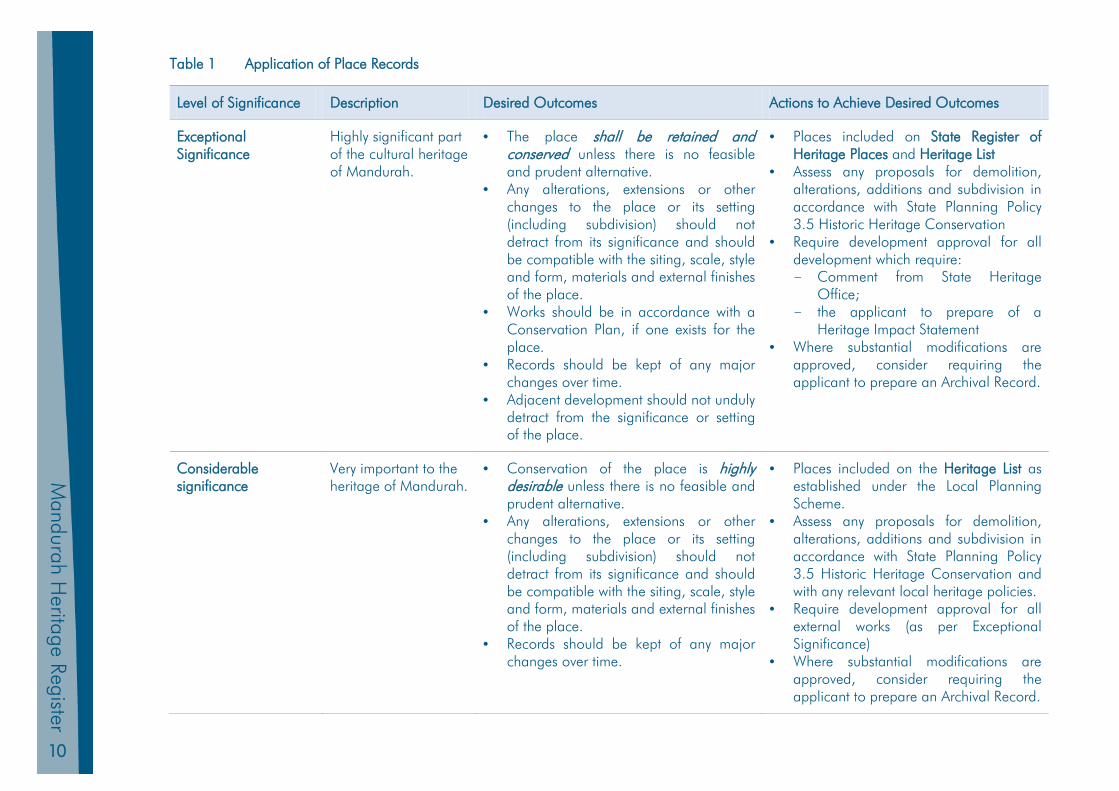
1.4 Place Records
Place records appear in Parts 3, 4 & 5 have been detailed in accordance with current standards as set out in the State Heritage Office publications:
• Basic Principles for Local Government HeritageInventories (March 2012)
• Criteria for the Assessment of Local Heritage Places and Areas (March 2012)
These publications set out guidelines for current best practice and aim to provide a level of consistency in the preparation of local government heritage inventories in Western Australia. The basic principles are not, however, mandatory, other than for the requirement that the inventory findings be made publicly available.
Each place listed in the Heritage Register has a level of significance applied to guide future conservation and management actions. This level of significance has resulted in a place being identified in either the Heritage List or Heritage Inventory. Table 1 outlines the operation of the recommendations with respect to the place records in the register.
10
Mandurah H
eritage Register
Table 1 Application of Place Records
Level of Significance Description Desired Outcomes Actions to Achieve Desired Outcomes
Exceptional Significance
Highly significant part of the cultural heritage of Mandurah.
• The place shall be retained andconserved unless there is no feasibleand prudent alternative.
• Any alterations, extensions or otherchanges to the place or its setting(including subdivision) should notdetract from its significance and shouldbe compatible with the siting, scale, styleand form, materials and external finishesof the place.
• Works should be in accordance with aConservation Plan, if one exists for theplace.
• Records should be kept of any majorchanges over time.
• Adjacent development should not undulydetract from the significance or settingof the place.
• Places included on State Register ofHeritage Places and Heritage List
• Assess any proposals for demolition,alterations, additions and subdivision inaccordance with State Planning Policy3.5 Historic Heritage Conservation
• Require development approval for alldevelopment which require:- Comment from State Heritage
Office;- the applicant to prepare of a
Heritage Impact Statement• Where substantial modifications are
approved, consider requiring theapplicant to prepare an Archival Record.
Considerable significance
Very important to the heritage of Mandurah.
• Conservation of the place is highly desirable unless there is no feasible andprudent alternative.
• Any alterations, extensions or otherchanges to the place or its setting(including subdivision) should notdetract from its significance and shouldbe compatible with the siting, scale, styleand form, materials and external finishesof the place.
• Records should be kept of any majorchanges over time.
• Places included on the Heritage List asestablished under the Local PlanningScheme.
• Assess any proposals for demolition,alterations, additions and subdivision inaccordance with State Planning Policy3.5 Historic Heritage Conservation andwith any relevant local heritage policies.
• Require development approval for allexternal works (as per ExceptionalSignificance)
• Where substantial modifications areapproved, consider requiring theapplicant to prepare an Archival Record.
11
Man
dura
h Pl
anni
ng S
chem
e 20
11
Man
dura
h H
erita
ge R
egis
ter
Level of Significance Description Desired Outcomes Actions to Achieve Desired Outcomes
Moderate significance Makes a positive contribution to the cultural heritage of Mandurah.
• Conservation of the place is desirable unless there is no feasible and prudent alternative.
• Any alterations or extensions should be sympathetic to the significance of the place and retain significant fabric wherever feasible.
• Records should be kept of any major changes over time.
• Places included on the Heritage Inventory as a means of recording these sites as part of the community’s heritage.
• Natural Places identified as Crown Reserves or other listings that protect the place in perpetuity.
Historic site
The place is associated with an event or former place that is of particular significance for the local community. There may be some potential for significant archaeological remains.
• The archaeological evidence should be retained and conserved in-situ unless there is no feasible and prudent alternative and/or a professional archaeological investigation has been planned and adequately funded.
• Professional archaeological investigation/recording is highly desirable if any ground disturbing site works are planned.
• Recognise and interpret the site if appropriate.
• Place included in the Archived / Demolished Places list as a means of recording these sites as part of the community’s heritage

13
Man
dura
h Pl
anni
ng S
chem
e 20
11
Man
dura
h H
erita
ge R
egis
ter
Mandurah Heritage Register
Part 2 Mandurah’s History
Sets out the thematic history of Mandurah
14
Mandurah H
eritage Register
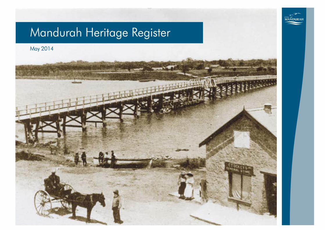
2.1 Overview The early history of Mandurah is closely linked with Sir Thomas Peel. Peel was the cousin of the British Home Secretary and was a supporter of Governor Stirling’s proposal to found a new colony on the west coast of Australia. The British government at the time was reluctant to commit itself to such a scheme, and there can be little doubt that Thomas Peel’s connections in parliament swayed the decision in Stirling’s favour. Nevertheless, the British government determined that land should only be granted to settlers who could demonstrate their capital worth, either in terms of skilled labourers sponsored to emigrate or in terms of equipment and livestock. Three pounds invested would gain 40 acres of land. Grants would also only be made to those settlers who reached the colony by the end of November 1829. Thomas Peel assembled 300 emigrants but due to a variety of reasons reached the colony in December, thus missing out on his promised grant of all the south side of the Swan River south to Rockingham. Stirling instead offered Peel an equivalent grant of land starting south of Rockingham and extending through the present town of Mandurah and to the east to the Murray region. Peel’s emigration scheme was disorganised, and Peel himself when faced with difficulties did not cope well. When one of his chartered ships carrying his settlers foundered in Cockburn Sound, Peel retreated to Garden Island and left the settlers to fend for themselves. They camped in the sandhills at Clarence, now the Henderson shipbuilding yards. There were food shortages and dysentery outbreaks. Many left his service. Once the matter of Peel’s grant was settled, he shifted with some of his people and erected some of the first cottages in
Mandurah. His own cottage was on the corner of Mandurah Tce and Stewart St, close to a wetland but the cottage was demolished long ago and the wetland filled in. Relations with the local Aborigines became strained almost immediately. In July 1830 George McKenzie was murdered, which led to the posting of a portion of the 63rd regiment. This was an instant boost to the population. Gradually other settlers made their way to the region. These included Henry Edward Hall and his family, Captain Meares and Captain Erskine. Some of Peel’s settlers including John Tuckey and Thomas Eacott were given part of Peel’s grant when Peel was shown incapable of managing it himself. Geography and Environment Mandurah is bound by water on two sides by the mouth of the inlet and the Serpentine River. This led to problems with transport and communication, but ensured easy access to fresh water and meat. It also made the area an ideal holiday spot. As early as the 1890’s Mandurah’s unique water based lifestyle was recognised as an asset for tourism but the shallowness of the estuary mouth meant that Bunbury attracted more settlers as its port was more accessible and safer. The location chosen by Peel also affected communications with the nearest settlement at Pinjarra, by virtue of the presence of the Serpentine and the Murray. This was illustrated by the fact that the telegraph line took more than a decade to reach Mandurah from Pinjarra. The general inability of settlers to access outside communities made Mandurah very self sufficient. Flooding was also a problem. While it was crucial for the first settlers to locate near fresh water, they often found problems when it came to floods, with floods reported in 1862, 1895, 1926, 1945 and 1955.
15
Man
dura
h Pl
anni
ng S
chem
e 20
11
Man
dura
h H
erita
ge R
egis
ter
The soils of Mandurah, like most on the Swan Coastal Plain, were generally deficient in trace elements. Despite this, the area supported an abundance of unique flora and fauna, which had evolved over thousands of years to thrive in low fertile soils and low rainfall. The settlers soon realized that something was wrong as their cattle sickened and grew weak. As the largest inland waterway system in the state, the estuary and its tributaries were in themselves a constraint. However, this was not widely realised until the latter half of this century as the aquatic ecosystem began to collapse due to the previous fifty years of agricultural expansion, draining and damming in the catchment altered the balance of the estuary so seriously that it was in danger of total collapse. Urban Settlement and Administration Urban settlement commenced in 1830 with the arrival of Peel and some 50 of his settlers. By the end of that year, cottages were built and the first half acre had been cleared and seeded. Peel settled on the north bank of the estuary, close to a wetland which provided rich fertile soil for the gardens. Fresh water and fish were also in abundance. Peel’s lack of organisational abilities and apparent disinterest in his settlers bred an intense dislike, and many settlers returned to Perth as soon as they were able. The 1837 census showed an adult population at Mandurah of 16 people. The sale of some 10 000 acres of his prime land at Dandalup to Francis Corbet Singleton in 1839 led to the establishment of Pinjarra as the major social and administrative centre for the region. Others followed Singleton creating a new social elite away from Mandurah. The settlement remained sparse for years. Because of its geographical isolation, the strained relations between settlers and the Aboriginals which ultimately led to the massacre at
Pinjarra and the above mentioned problems with Peel, Mandurah did not grow quickly in its early years. The only two buildings still extant from this early period are Hall’s Cottage on the southern side of the estuary and Eacott’s Cottage now in the grounds of the Mandurah High School. Much of the government administration was taken care of in Pinjarra due to the population of the two settlements. Like most of Western Australia, Mandurah benefitted from the gold boom of the 1890s. It is no coincidence that the Brighton Hotel commenced operation in this decade. What became the Peninsula Hotel was also constructed around this time and the Agricultural Hall was opened in January 1898. The railway link to Pinjarra was a great boost. It opened in 1893 and allowed more travellers to reach the region without the discomfort of a carriage ride or the danger of the boat trip. More astute members of the Mandurah community also perceived the potential of the railway to bring tourists to Mandurah. In this way it was recognised that its geographical isolation and resulting natural beauty could also be a bonus. Sufficient population supported the formation of the Mandurah Progress Association. This group remained active for decades and was a successful lobby group for the development of Mandurah. The development of land was a vexed business. As the tourist industry grew, it was realised that waterfront access was crucial. Large estates, a legacy from the early days of land grants, had locked up most of what is now the city centre. A 25 lot subdivision in 1896 assisted in relieving the problem, but it was not until a large section of Peel’s estate was sold in 1898 that the situation improved substantially.
16
Mandurah H
eritage Register
In 1920, a road between Fremantle and Mandurah had been opened which gave a boost to the local tourist industry. While the road was still rough, the three hour journey by car attracted more tourists. About 6 boarding houses operated in Mandurah to cater for the trade, as well as the Brighton and the Peninsula. While formal entertainment was limited, the environment presented plenty of opportunities for recreation. Fishing, prawning, crabbing, swimming, walking and duck shooting were all popular. Mandurah was surveyed and subdivided as a result but not gazetted as a townsite until 1950, presumably as a result of the separation of Mandurah from Murray into a separate Roads Board in 1949. The separation of Mandurah from Murray was an intensely political time. In April 1948, the Minister for Local Government gave the Mandurah Progress Association a list of issues to be considered before the establishment of separate government. These included increased use of the Mandurah Hall for offices one day a week, appointment of a full time inspector for six months of the year and a health inspector to visit once a week. Conditions were complied with by mid 1949 and the inaugural meeting was held on 1 September 1949. The Board was wound up in 1956 following complaints from residents and an investigation. Commissioner Richard Rushton was appointed in July 1956 then Acting Commission Albert White in March 1960 with the Road Board reformed again in April 1960. On 1 July 1961, the Shire of Mandurah was declared, later to become the Town of Mandurah (July 1987) and shortly following the City of Mandurah (April 1990). The gazettal of Mandurah as a Shire marked the starting point of its phenomenal growth. The 1950s saw a greater
general affluence from the post war boom that led to a greater disposable income which Perth people used, among other things, to take holidays. The disposable income was also spent on motor cars which enabled the distance between Mandurah and Perth to be covered in much quicker time. The very qualities that made Mandurah a desirable place to holiday also attracted increasing numbers of retirees. This era was the beginning of Mandurah’s exceptional growth. Some indicators of the growth were the establishment of new residential areas. A weekly rubbish removal service started. Mandurah acquired tennis courts, a beach pavilion, drive in theatre, courthouse, motel, country club and a ballroom. A new bridge, which residents had been petitioning for years was finally constructed as the old one constructed in 1893 collapsed. Since the 1960s, Mandurah has grown rapidly. The rush of urban development threatened the values that made Mandurah such an attractive holiday place. Infrastructure Roads Many of the first roads were commandeered Aboriginal tracks which were then widened to take carts. Peel spent money on improving the track between Fremantle and Mandurah as part of his location duties. Although generally unsuited to carts because it was so sandy, the track provided a far more direct route to Fremantle for the Mandurah settlers. In 1841, Singleton surveyed a new line of road and signposted the watering holes. At the same time bridges were under construction to link Mandurah and Pinjarra. The bridge over the Dandalup River close to Singleton’s property was constructed first, then the Murray Bridge.
17
Man
dura
h Pl
anni
ng S
chem
e 20
11
Man
dura
h H
erita
ge R
egis
ter
The 1842 floods severely damaged the Murray Bridge. After haggling over price, the Government paid 130 pounds for the bridge to be repaired thus restoring a vital communication link. Roads were also being brought up from the south as the new settlement at Australind created new pressures for transport. The southern road skirted the wetlands and limestone ridges and came out behind Hall’s Cottage. This road was originally known as Coach Rd, and was subsequently named Coast Rd. It was laid out by Marshall Waller Clifton as part of the Western Australian Land Company’s obligations in settling Australind. The road remained unsealed until 1969. The meeting of the north and south roads called for a ferry service. The first attempt at a ferry service was not overly successful, possibly because the ferry that was commissioned had been made of inferior timber. High tolls were charged but more often than not, the travellers were rowed over the channel in a whaleboat with animals being swum behind. This could become very dangerous if one of them panicked. The inland route was often chosen by travellers because of the expense and the danger of crossing the channel. Because of the problems experienced, the contract was taken out of Thomas Watson’s hands and given to John Sutton. Sutton had by this time leased Hall’s Cottage and was beginning to attain some prosperity. Tenders for a bridge linking Mandurah with Hall’s Head were called in 1893 by the Commissioner of Railways and Public Works with successful tenderer having a price of 1792 pounds. Sawn timber came from Port’s sawmills in Collie and was delivered by the ship Duchess of Kent. 70 piles were taken locally from bush near Pinjarra. The bridge was built in six weeks and opened to traffic in May 1894. The bridge provided an essential communication and trade link, and was obviously well constructed, as it lasted for 60 years when it was finally deemed irreparable.
It was replaced in 1953 with a concrete under structure and wooden superstructure. Mandurah Road Board Secretary NF Haynes circulated a notice of meeting for residents to discuss raising a loan for the construction of landings beneath the jetty. This bridge is still in service today although nearing replacement. The Mandurah Bypass (now Mandurah Road) together with a new bridge over the estuary opened in 1986 Water Supply Mandurah residents were self sufficient until approximately the late 1960s. While Pinjarra was connected to the South Dandalup dam in 1947, the cost of supplying Mandurah was considered exorbitant. A bore had been sunk at Ravenswood but the water did not prove to be of sufficient quality, and so the Public Works Department realised that all the areas on the way to Mandurah would also benefit from connection from the connection to scheme water. This was a fortunate decision, because in the 1970s the area began its massive expansion which could not have occurred without piped water. However, the small settlement of Madora was not connected to scheme water until 1997. A small plaque and drinking fountain in Mewburn Gardens commemorates the advent of scheme water. Sewer Sewerage was mostly disposed of by dumping after collection of pans. In 1940s and 1950s night soil was dumped at San Remo and the Caddadup tip. The Mandurah Roads Board was initially swayed by the idea of septic tanks but realized that this would most likely contaminate groundwater drawn from domestic wells which was the main source of drinking
18
Mandurah H
eritage Register
water. The first septic tanks were in the Wearne House at Soldiers Cove in 1920s, whilst the the Brighton Hotel discharged effluent directly into the estuary around late 1940s. This caused a lot of angst as the owner of the hotel was Chair of the Murray Roads Board. The hotel eventually installed a better system but discharges into the estuary still continued, from the Hotel and other buildings, until the whole area was sewered in the 1980s. While new subdivisions are connected, large parts of old Mandurah are not serviced by sewer even in the 1990s, and await the arrival of the Water Corporation’s infill sewer program. Drainage The history of drainage in the catchment has heavily influenced the development in Mandurah. Given the centrality of the estuary in Mandurah’s development, the impact of developments elsewhere is felt here more perhaps than most other local authorities. In essence, major drainage works at the time were to assist the development of dairy farmers and horticultural enterprises, had the ultimate effect of nearly destroying the Inlet. The Inlet became a sink for all the excess nutrients that drained off the agricultural districts leading to the severe eutrophication of the estuary. The solution was the Dawesville Channel, a channel cut through the estuary at the southern end in order to create a more saline environment in which the algae could not bloom. While the Channel was successful in controlling this problem, the long term effects of changing the estuary are not yet fully understood.
Postal Services Mail services for the region were intermittent until 1840 when a soldier from Pinjarra made a fortnightly trip to the Serpentine where mail was exchanged with a soldier from the Canning. The following year civilian mail contractors were appointed. Thomas Watson of Mandurah, who also ran the ferry was a regular carrier for years, primarily to Albany. Communications for the region were vastly improved with the connection of Pinjarra to the telegraph, which further cemented its reputation as the centre of the Murray district. The rail line which connected East Perth to Bunbury via Pinjarra in 1893 also helped to ease the sense of isolation of Mandurah residents and provided a much more efficient mail service. Mandurah’s first official post office was built in 1890. It was a four-roomed brick house with a galvanised iron roof, with one or both of the front two rooms functioning as the post office. It was situated on the present post office block located on Pinjarra Road. By the early 1940s Mandurah residents felt that this post office was no longer adequate for their needs, however it was not until after WWII that it was to be replaced. In 1945 a new post office was constructed, which forms part of the current building (that section extending to the north and the west on the corner). The original post office (next door) became the Post Master’s residence and was demolished circa 1970. Electricity Some residences had their own electrical power but it was not until 1932 that the Mandurah Electrical Light and Power Company commenced. Within a year there was continuous electrical power, although Halls Head residents had to wait because of the dilapidated state of the bridge.
19
Man
dura
h Pl
anni
ng S
chem
e 20
11
Man
dura
h H
erita
ge R
egis
ter
Education The first school in Mandurah in 1869 was run by John Tuckey’s wife. Prior to that, most children would not have received any formal teaching, but only what their parents could teach them in the spare time, of which there would have been precious little. This presumes that the parents had also received an education. In the 1870s Robert Mewburn was appointed school master but the government were not forthcoming with a school. Mewburn built his own in Sholl St and was school master there for many years. Mewburn was an engineer by profession and his original purpose in emigrating was to be the manager of the Peel Estate. Instead, he opened a small bank and shop in town. His wife Emma acted as midwife and nurse for the community. Finally the Education Department funded a school in 1898 Mr Dalrymple was the first teacher, and was by all accounts a strict disciplinarian. The school was situated on the Inlet on Pinjarra Rd just south of the Agricultural Hall and is now part of the Mandurah Community Museum. The school was later incorporated in the Police Station when the Education Department constructed a new school in August 1939. For this purpose they took over the recreation reserve at Hackett St where the local football team played. The cost of the school was 2238 pounds. This school is remains in operation. There was also a school run by the Presentation Sisters in Leslie St which opened in 1955. The nuns responsible for the school lived in a convent on the banks of the Inlet. The school suffered a severe blow in 1959 when three nuns and a priest drowned in a boating accident. It closed in 1966.
By 1975, only one more primary school had been added and senior high school students were bussed daily to Pinjarra. Preschool requirements were met by the Mandurah Kindergarten and Dudley Park Centre. Mandurah’s first Senior High School opened in 1979. Since this time, educational choice has also been enhanced through the addition of more primary schools in new subdivisions, private schools and the establishment of a TAFE campus. Industry Given Mandurah’s dependence on waterways for communication and transport, it is surprising that there is minimal evidence of any boatbuilding industry remaining. There is documentary evidence that boat building and repairs did provide a living for some early residents of Mandurah. It is presumed that the first ferry linking the north and south foreshores was built locally. Most boat building works would likely have been attached to the fishing industry on which the local economy was based between the 1880s and the 1920s. The first cannery was opened in 1878, followed by the Peel Inlet Preserving Works in 1880. During the mullet season, the Tuckeys kept four boats operating however overfishing had caused enough concern for the Chief Inspector of Fisheries who made a number of recommendations to improve the situation. While this had some effect, the inlet was still overfished. The appointed fishing inspector was one of the most watched residents in Mandurah, and as soon as his direction was ascertained the fisherman took off in the other direction to poach. Restrictions increased yields but never to the same levels as previously. Severe disease also swept the estuary, killing fish by the thousands. There was considerable conflict in the late 1890s over fishing methods. At that time a number of southern European and Japanese fisherman had
20
Mandurah H
eritage Register
moved to the area and practised a form of netting. By that stage, the overfishing problem was being recognised but it appears that Greek fishermen were the focus of some agitation despite the fact that the local settlers were primarily responsible for the overfishing. Fish poaching was still a problem in 1930s, exacerbated by the numbers of homeless people living along the rivers. Mandurah’s dependence on the waterways for communications and industry also saw a number of tragedies. The wreck of the James Service 1878 is the most well known, when the whole crew was lost and bodies washed on shore over several days. Other less well known ship wrecks include the Lass of Geraldton (1861), the Bee (1850), the Young Shepherd, the Chalmers (1874), the Preston (1861) and the Black Swan (1851). Farming One of the great impediments to farming and grazing was the lack of labour. With the arrival of convicts in 1850 and the amendment of land regulations, settlers were able to gain ticket of leave men to work as shepherds which enabled them to greatly extend their leases. Settlers could lease 1000 acres for 10 shillings over 8 years, with purchase rights if desired. Gradually, as fortunes improved many settlers bought the choicest sections of the leases which then discouraged others. John Sutton at the time of his death in 1857 owned most of the fertile areas of the western foreshore of the Harvey Estuary and several leases of poorer land backing on to this freehold land. The expansion of the timber industry in the Peel Region, notably in Jarrahdale, allowed many small farmers to expand their crops in the knowledge of a ready market. The railway also provided a quicker means of transporting goods to the city. According to Statham, between 1896 and 1906 grain
and vegetable crops and butter production doubled. Fruit growing commenced as an industry, and prospered despite an outbreak of San Jose scale. The general infertility of the soil was also an impediment, as settlers had earlier found with the illnesses which beset livestock and necessitated six monthly moves. The increased production of edible crops was a combination of greater mechanisation and an increasing understanding about the role of nutrients. Timber Industry A timber mill on Leslie St at Soldiers Cove was built in 1911. It is now commemorated by the street Mill Lane. The mill was a major employer of up to 12 men at its height. It closed in 1925 following the death of 25 year old James Cooper, but reopened for a short while to manufacture cabins for Ford motor vehicles. Major products were cut tuart timber used in railway wagons, truck bodies and wheels for horse drawn carts. The toughness of tuart was especially suitable for these purposes. The source of the trees was from a narrow limestone belt between the coastal dunes and the inland wetlands. The heaviness of the timber made transportation difficult as the ‘whims’ tore up the local roads. The mill owner, Mr Bolton, agreed with the Murray Roads Board in 1923 that his men would stick to the road verge when transporting timber. It is presumed that this would simply have widened the road in the long run as native vegetation would have been trampled. Tourism The tourist industry has often been considered a mainstay of the local economy. For 100 years, Mandurah’s natural assets have been the basis of a thriving seasonal tourist industry. The gold rushes of the 1890s which kick-started the sluggish colonial economy also had the benefit of creating
21
Man
dura
h Pl
anni
ng S
chem
e 20
11
Man
dura
h H
erita
ge R
egis
ter
the local tourist, a well off Perth person who would travel to Mandurah and stay at either the Brighton Hotel or one of the smaller boarding houses. Camping was also popular. The first hotel, the Brighton, was originally a residence built by the Tuckey family but it was soon seen that more benefit could be had by converting it to a commercial use and opening in October 1895. An additional boarding house was opened by 1900, and the Peninsula Hotel opened in 1903. In 1925, it was reported that nearly 2000 people visited Mandurah during the holiday season, with many camping between Ormsby Terrace and Mandurah Terrace. The pressure on the area was so great that the Murray Roads Board was forced to employ a caretaker for the bathing sheds and appoint a traffic inspector. In 1932, the Murray Roads Board raised a loan of 4000 pounds to develop the foreshore following a plan drawn up by the Town Planning Commissioner, however the money didn’t eventuate as ratepayers from other areas refused to subsidise Mandurah but 1000 pounds was allocated for lesser works. Works included a retaining wall and backfill and the construction of a bathing pavilion. The Mandurah Progress Association had also received Moreton Bay figs and Norfolk pines for planting on the foreshore. Some of this work was carried out by sustenance men. The popularity of Mandurah as a tourist destination led to the establishment of the Mandurah Tourist Bureau in the Agricultural Hall. It reported a profit in its first year, primarily from funds received during the Kanyana Festival. In 1975 there were three hotels and 11 caravan parks plus guest houses, flats and beach cottages. Improved accommodation was provided when the Atrium Hotel was opened in 1982.
Social Life An emphasis was placed on obtaining a church at both Pinjarra and Mandurah during the early years of the settlement. For some settlers facing an entirely new way of life in a new country, faith in an all seeing deity would have indeed been a comfort. The isolation and sheer back breaking work would have tested many of the settlers’ faith. It was therefore important to them to have a church, an icon that give them a recognisable symbol of both their religion and their cultural heritage. Peel converted one of his workman’s huts into a chapel, which was officially opened in 1842 but was never formally consecrated. Services were sporadic due to the fact that there was no resident minister. Reverend King came down from Fremantle when possible, and Rev Wollaston would also give services when passing through. Even so, when Peel decided to house his horse in the building years later, he attracted the ire of the Rev Wollaston among others. The situation was rectified decades later when Christ’s Church was built in the centre of Mandurah. The church, at the corner of Pinjarra Rd and Sholl St, was consecrated in 1871. It stands on land that was donated by Henry and Dora Hall (nee Peel) at a time when they were not financially well off. Settlers donated 104 pounds, raised another 52 pounds and two grants from the Perth Diocese paid for the church’s construction. A substantial addition in keeping with the church was added in 1994. Mandurah’s second church was built on the corner of Gibson and Sutton Sts in 1940. It was a Methodist Church, and was mostly paid for by fund raising by the Ladies Guild. The church served its congregation for many years until it was finally too small. It was sold to the Shire of Mandurah in order to finance the building of the new church on Pinjarra Rd.
22
Mandurah H
eritage Register
The secular life of Mandurah also developed. Mrs Sarah Lyttleton opened the Marine Hotel in late 1830s/early 1840s as it was appreciated by the authorities that a licensed premise would be easier to control. Much of the social life in the Region of the early period revolved around the church, but in Pinjarra it is possible to see more clearly the rise in importance of sport and other interest clubs as life became easier. The Mandurah Progress Association was formed in 1897 to act as a voice in civic affairs for Mandurah in the Murray Road Board. The movies and dancing were a major part of social life in the town. An open air picture theatre opened next door to the Brighton Hotel. Pictures were also shown at the Capitol Theatre on the corner of Sutton St and Pinjarra Rd and at the Hotham Valley Hall. Both the halls ran regular dances which had different opening hours so that as one closed, patrons moved on to the next dance. In later years, the Santoy Dance Hall fulfilled this role, and was the venue for debutante balls, wedding receptions, shows and meetings. Mandurah had the first drive-in in the region in 1960 partly because of its holiday town reputation, and Mandurah’s first indoor movie theatre opened its doors in 1997. Mandurah was also the first country district in WA to provide shopping facilities in a mall environment. The former Smart St was closed in 1975 to provide a mall. Shopping facilities were extended later with the construction of the Forum at the corner of Pinjarra Rd and the bypass road. While the Forum has increased the choice available to residents, there was a tension between it and the foreshore traders. Sport was an important part of Mandurah’s social life, given the lack of formal entertainment in its formative years.
Cricket, football and racing were the major sports, together with swimming, fishing and boating as informal recreation. Post WW1 Mandurah erected a swimming pool and a football ground at Halls Head. There were also active racing clubs and cricket teams. A race track was built by public subscription near the marina, shifted from its original position on the marl pit which the Roads Board purchased in the 1950s. Conclusion The development of Mandurah is a microcosm of the wider social forces in operation in Western Australia and a reflection of its unique natural environment. The settlement prospered by a reliance on local ingenuity and resources and was predominantly self sufficient for most of the 19th century. The inability of those resources, predominantly fish, to withstand constant harvesting alerted local residents to the need to be more judicious. Damage to the estuary in the 20th century from outside the town contributed to the formation of a strong environmental lobby. The Depression and the World Wars demonstrated to Mandurah residents that they were not immune from the global forces of economics and politics. Indeed, the massive expansion in Mandurah reflects the economic boom of Western Australia as it forged a place on the world market through minerals. The influx of retirees corresponded with the general ageing of the Australian population.

23
Man
dura
h Pl
anni
ng S
chem
e 20
11
Man
dura
h H
erita
ge R
egis
ter
References • K Bradby, Peel-Harvey: The Decline and Rescue of an
Ecosystem, Greening the Catchment Taskforce, 1997 • A Hasluck, Thomas Peel of Swan River, • Ronald Richards, Mandurah and the Murray: A Short
History of the Old Murray District of Western Australia, 1829-1900, self published, 1980
• Ronald Richards, Murray and Mandurah: A Sequel
History to the Old Murray District of Western Australia, Shire of Murray and City of Mandurah, 1993
• H Margaret Wilson, Sarah Theodosia and the Hall
Family, self published, Perth, 1994 • P Statham, Peel Region’s Municipal Inventories
Framework, Peel Regional Councils and Peel Development Commission, 1994
• Water and Rivers Commission, Historical Association of
Wetlands in the Perth-Bunbury Region, Water Resource Technical Series, WRT3, 1996
• Ephemera held in Mandurah Public Library • Mandurah Historical Society newspaper cuttings • J Burgess, Mandurah: Water Under the Bridge, 1988 • Notes from an interview with Des Shepherd, 22/4/98 • Notes from an interview with Merv Christiansen, former
town engineer, 25/4/98
• Graeme and Kandy-Jane Henderson, Unfinished
Voyages: Western Australian Shipwrecks 1851-1880, UWA Press, Perth, 1988
• C Hannan, The Eacotts of Mandurah 1830-1997,
Access Press, Perth, 1997


25
Man
dura
h Pl
anni
ng S
chem
e 20
11
Man
dura
h H
erita
ge R
egis
ter
Mandurah Heritage Register
Part 3 Heritage List Place Records
26
Mandurah H
eritage Register
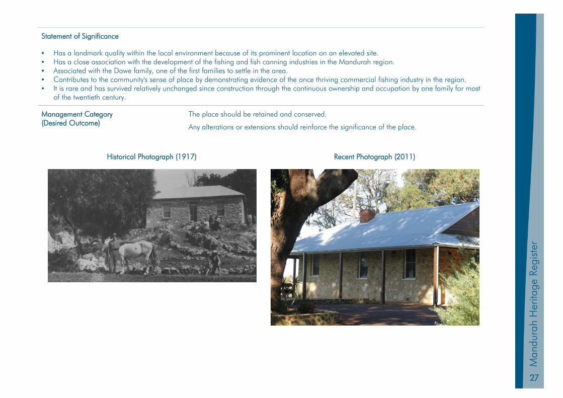
HL 1 Allandale Homested
Other Names Dawes House Original Use Dwelling
PIN No 444903 Current Use Dwelling
Land Description Lot 102 on Plan 10569 Zoning Urban Development
Location 495 Estuary Road DAWESVILLE Construction Materials Walls – Limestone; Roof – Steel
Construction Date 1913 – 1918 Condition Good (Assessed from Street)
Place Type Individual Building Authenticity High
Survey / Assessment Date July 1999 & September 2011 Other Listings State Register of Heritage Places Local Heritage Inventory
Level of Significance Exceptional State Heritage Place No 3077
Physical Description
A single-storey stone and timber dwelling with a corrugated iron roof and an adjacent water tower and stone cellar. The property overlooks the Peel Harvey Estuary. It has six rooms, interior floors of jarrah and a front jarrah gable. A cement floor veranda surrounds the whole building. A 2.5 metre deep limestone buttery is located on the southern side of the house.
Historic Notes
Louis Dawe was a South Australian tinsmith who came to Mandurah to become involved in the fish canning industry. He was employed in the Tuckey Brothers’ Peel Inlet Preserving Works, and later settled and began canning fish at Pleasant Grove. He took over a building used as a fish cannery by the Leighton brothers, who had both tragically drowned. The cannery was a simple lean-to adjacent to the original homestead with a smokehouse constructed of wattle and daub. Dawe built a weatherboard school on the Ward’s property at Pleasant Grove in 1907 for the fifteen or so children in the area and Edith Tuckey travelled daily from Mandurah to teach the pupils.
In 1913 Dawe left Pleasant Grove to build Allandale at what is now called ‘Dawesville’. Dawe established a second fish cannery in a factory built from weatherboard and corrugated iron, and also kept bee hives for producing honey. A jetty was also constructed into the estuary. The cannery was destroyed by Cyclone Alby and the jetty has since been demolished. Commercial fish canning ceased at Allandale in 1930 when it became more lucrative to send fish to Perth. Canning was revived during World War Two to supply rations to troops and was continued on a hobby scale to provide for the local market until the 1970s. Louis Dawe’s son, Allan, remained at Allandale for some seventy years.
27
Man
dura
h Pl
anni
ng S
chem
e 20
11
Man
dura
h H
erita
ge R
egis
ter
Statement of Significance
• Has a landmark quality within the local environment because of its prominent location on an elevated site. • Has a close association with the development of the fishing and fish canning industries in the Mandurah region. • Associated with the Dawe family, one of the first families to settle in the area. • Contributes to the community's sense of place by demonstrating evidence of the once thriving commercial fishing industry in the region. • It is rare and has survived relatively unchanged since construction through the continuous ownership and occupation by one family for most
of the twentieth century.
Management Category (Desired Outcome)
The place should be retained and conserved.
Any alterations or extensions should reinforce the significance of the place.
Historical Photograph (1917) Recent Photograph (2011)
28
Mandurah H
eritage Register
HL 2 Halls Cottage
Other Names Original Use Dwelling
PIN No 1007128 Current Use Dwelling
Land Description Lot 173 on Plan 17616 Zoning Canal
Location 7 Leighton Place HALLS HEAD Construction Materials Walls – Limestone; Roof – Shingles
Construction Date Circa 1833 Condition Good
Place Type Individual Building Authenticity High (Restored)
Survey / Assessment Date July 1999 & September 2011 Other Listings State Register of Heritage Places Classified by National Trust Register of National Estate Local Heritage Inventory
Level of Significance Exceptional State Heritage Place No 1485
Physical Description
Hall’s Cottage is one of the earliest homesteads in the district typifying the very earliest dwellings constructed by European settlers in the early years after the Swan River Colony was founded. Constructed of local limestone and originally roofed with hand-split sheoak shingles, the five-roomed cottage demonstrates simplicity of construction and design.
Historic Notes
The cottage (also known as ‘Dedallamup’) was built by Henry Hall as the home for his family, who came to Western Australia in the Protector in February 1830.
Henry Hall was the Squire of Shakerstone Manor in Leicestershire and upon arrival in the Colony his extensive importation of equipment, livestock and settlers entitled him to a land grant of some 16,594 acres south of the mouth of the Harvey River, and two hundred acres on the western bank of the inlet in what soon became known as Halls Head
Unfortunately the land around the Harvey proved inaccessible at the time and the Halls Head property suffered from poor soil and an abundance of poisonous plants. After several years of hardship their first home and its contents were destroyed by fire. It was then, that Hall’s Cottage was built, probably with the assistance of tradesmen and servants brought out by Hall from England.
29
Man
dura
h Pl
anni
ng S
chem
e 20
11
Man
dura
h H
erita
ge R
egis
ter
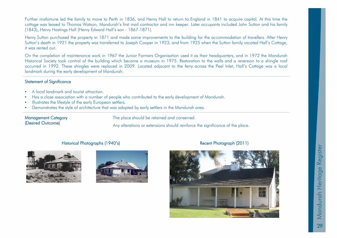
Further misfortune led the family to move to Perth in 1836, and Henry Hall to return to England in 1841 to acquire capital. At this time the cottage was leased to Thomas Watson, Mandurah’s first mail contractor and inn keeper. Later occupants included John Sutton and his family (1843), Henry Hastings Hall (Henry Edward Hall’s son - 1867-1871).
Henry Sutton purchased the property in 1871 and made some improvements to the building for the accommodation of travellers. After Henry Sutton’s death in 1921 the property was transferred to Joseph Cooper in 1923, and from 1925 when the Sutton family vacated Hall’s Cottage, it was rented out.
On the completion of maintenance work in 1967 the Junior Farmers Organisation used it as their headquarters, and in 1972 the Mandurah Historical Society took control of the building which became a museum in 1975. Restoration to the walls and a reversion to a shingle roof occurred in 1992. These shingles were replaced in 2009. Located adjacent to the ferry across the Peel Inlet, Hall’s Cottage was a local landmark during the early development of Mandurah.
Statement of Significance
• A local landmark and tourist attraction. • Has a close association with a number of people who contributed to the early development of Mandurah. • Illustrates the lifestyle of the early European settlers. • Demonstrates the style of architecture that was adopted by early settlers in the Mandurah area.
Management Category (Desired Outcome)
The place should be retained and conserved.
Any alterations or extensions should reinforce the significance of the place.
Historical Photographs (1940’s) Recent Photograph (2011)
30
Mandurah H
eritage Register
HL 3 Sutton Farm and Graveyard
Other Names Original Use Farm
PIN 1296508 (Farm); 1198206 (Graveyard)
Current Use Unoccupied
Land Description Lot 506 on Plan 22420 (Farm); Reserve 45350 (Graveyard)
Zoning Tourist (Farm Site) Canal (Graveyard Site)
Location 15 Apollo Place HALLS HEAD & 1-3 Picaroon Place HALLS HEAD
Construction Materials Walls- limestone; Roof- Corrugated steel but shingles still visible in parts
Construction Date 1870s (single men’s quarters) 1881 (current farmhouse)
Condition Good
Place Type Collection of Buildings Authenticity Medium
Survey / Assessment Date July 1999 & September 2011 Other Listings State Register of Heritage Places Local Heritage Inventory
Level of Significance Exceptional State Heritage Place No 3078
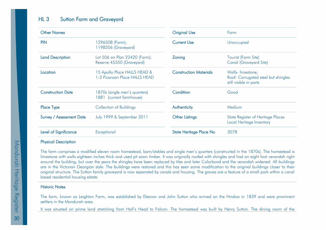
Physical Description
The farm comprises a modified eleven room homestead, barn/stables and single men’s quarters (constructed in the 1870s). The homestead is limestone with walls eighteen inches thick and used pit sawn timber. It was originally roofed with shingles and had an eight foot verandah right around the building, but over the years the shingles have been replaced by tiles and later Colorbond and the verandah widened. All buildings are in the Victorian Georgian style. The buildings were restored and this has seen some modification to the original buildings closer to their original structure. The Sutton family graveyard is now separated by canals and housing. The graves are a feature of a small park within a canal based residential housing estate.
Historic Notes
The farm, known as Leighton Farm, was established by Eleanor and John Sutton who arrived on the Hindoo in 1839 and were prominent settlers in the Mandurah area.
It was situated on prime land stretching from Hall’s Head to Falcon. The homestead was built by Henry Sutton. The dining room of the
31
Man
dura
h Pl
anni
ng S
chem
e 20
11
Man
dura
h H
erita
ge R
egis
ter
homestead was used by the community for meetings and social gatherings until the Agricultural Hall was built in 1898.
A milking shed, now demolished, was added in 1885. The farm was bought by Joseph Cooper in 1924, but was still managed by the Sutton family until 1929.
In 1956 the farmhouse had its verandah enclosed and was re roofed with clay tiles. From the 1930s to the 1950s, football was also played on one of the farm’s paddocks when the paddock near Hackett Street became too boggy. A stand of old olive trees is adjacent to the homestead. Old farm machinery and tools are still in situ as well as a stock race. Large trees on the farm were cleared, however an old Norfolk Island pine tree on the property. The single men’s’ quarters, barn, and farmhouse were restored in the 2000s to their original condition with the exception of the roofs which are corrugated iron.
Statement of Significance
• Has aesthetic value due to the pleasing proportions of the barn and single men’s quarters and their simple, unadorned rough limestone construction are representative of the form and style of buildings that were typically erected.
• Was one of the few regular places of employment in the late nineteenth century. • Associated with some of the earliest pioneering families in the Mandurah area. • Has scientific value as a collection of farm buildings dating from the nineteenth century. • Contributes to the community’s sense of place being representative of a number of family farms established throughout Western Australia in
the nineteenth century. • Rare examples of a collection of farm buildings dating from the nineteenth century.
Management Category (Desired Outcome)
The place should be retained and conserved.
Any alterations or extensions should reinforce the significance of the place.
Historical Photographs (1890’s) Recent Photograph (2011)

32
Mandurah H
eritage Register
HL 4 Peninsula Hotel (fmr), Boatsheds and Stingray Point
Other Names Original Use Dwelling
PIN 11522746 Current Use Public Open Space
Land Description Lot 3011 Reserve 48548; Lot 3009 Reserve 25710 Portions of Unallocated Crown Land
Zoning Local Recreation Reserve; Waterways Reserve
Location 2 – 20 Ormsby Tce MANDURAH Construction Materials Timber and Limestone
Construction Date 1899 Condition Good
Place Type Precinct Authenticity Medium
Survey / Assessment Date July 1999 & September 2011 Other Listings State Register of Heritage Places Local Heritage Inventory
Level of Significance Exceptional State Heritage Place No 1487
Physical Description
Peninsula Hotel (former), Boatsheds & Stingray Point, consists of a jetty and pavilion to the south-west, random rubble stone revetment wall along the shoreline, and public open space with a large Moreton Bay Fig tree at the tip of Stingray Point. The hotel was destroyed by fire in August 2003.
Historic Notes
The Peninsula Hotel was built in 1899 as a six bedroom holiday home for George Brookman, a wealthy mining magnate and Mayor of Perth, who had moved to Western Australia from Adelaide in the 1890s. The Brookmans possibly referred to the house as Sans Souchi. The pavilion jetty at the end of Stingray Point was constructed at the same time as the house and used as a dock for Brookman’s impressive ocean-going yacht Majestic.
When Brookman’s business empire collapsed he resigned from the mayoralty and came to live in Mandurah. It was converted to a hotel in 1904 when Brookman returned to Adelaide, making it the second hotel in Mandurah. At the same time a wooden footbridge was constructed across Mandjar Bay from Stingray Point to Mandurah Terrace. In 1907 the hotel was sold to Walter Bramwell of Mandurah, and then resold in 1910 to Charles Slee. The first licence was issued in 1911 and recorded as ‘Wayside House’. Local identities Hobart and Clarence Tuckey held the licence in 1925 and sold it to Thomas Blakeley for his son, Harold, who was not of legal age to hold a publican’s licence. At this stage the hotel comprised of twenty three rooms, as well as ‘sleeping out’ rooms. The Blakeleys owned and operated ‘The Pen’ for the next 62
33
Man
dura
h Pl
anni
ng S
chem
e 20
11
Man
dura
h H
erita
ge R
egis
ter
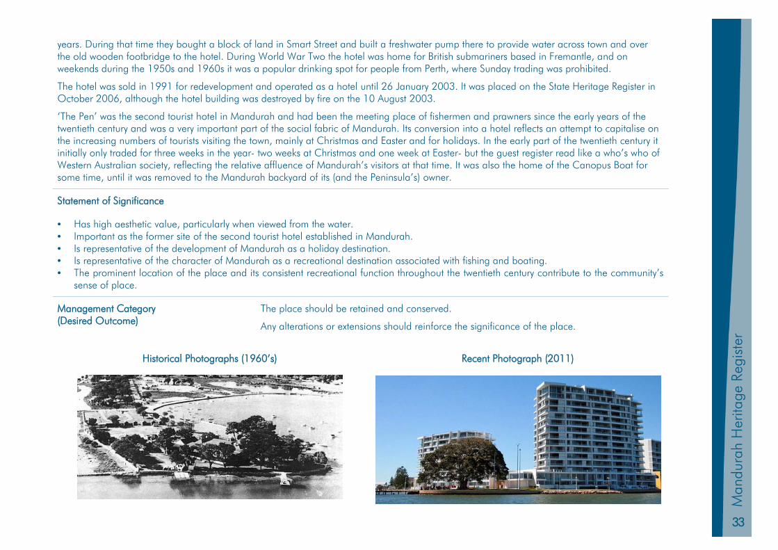
years. During that time they bought a block of land in Smart Street and built a freshwater pump there to provide water across town and over the old wooden footbridge to the hotel. During World War Two the hotel was home for British submariners based in Fremantle, and on weekends during the 1950s and 1960s it was a popular drinking spot for people from Perth, where Sunday trading was prohibited.
The hotel was sold in 1991 for redevelopment and operated as a hotel until 26 January 2003. It was placed on the State Heritage Register in October 2006, although the hotel building was destroyed by fire on the 10 August 2003.
‘The Pen’ was the second tourist hotel in Mandurah and had been the meeting place of fishermen and prawners since the early years of the twentieth century and was a very important part of the social fabric of Mandurah. Its conversion into a hotel reflects an attempt to capitalise on the increasing numbers of tourists visiting the town, mainly at Christmas and Easter and for holidays. In the early part of the twentieth century it initially only traded for three weeks in the year- two weeks at Christmas and one week at Easter- but the guest register read like a who’s who of Western Australian society, reflecting the relative affluence of Mandurah’s visitors at that time. It was also the home of the Canopus Boat for some time, until it was removed to the Mandurah backyard of its (and the Peninsula’s) owner.
Statement of Significance
• Has high aesthetic value, particularly when viewed from the water. • Important as the former site of the second tourist hotel established in Mandurah. • Is representative of the development of Mandurah as a holiday destination. • Is representative of the character of Mandurah as a recreational destination associated with fishing and boating. • The prominent location of the place and its consistent recreational function throughout the twentieth century contribute to the community’s
sense of place.
Management Category (Desired Outcome)
The place should be retained and conserved.
Any alterations or extensions should reinforce the significance of the place.
Historical Photographs (1960’s) Recent Photograph (2011)
34
Mandurah H
eritage Register
HL 5 Agricultural Hall
Other Names Original Use Community Hall
PIN 439270 Current Use Community Office (Rangers)
Land Description Reserve 4123 Zoning Community Purpose Reserve
Location 5 Pinjarra Road MANDURAH Construction Materials Walls- limestone; Roof- corrugated steel
Construction Date 1897-1898 Condition Good
Place Type Individual Building Authenticity Medium
Survey / Assessment Date July 1999 & September 2011 Other Listings Local Heritage Inventory
Level of Significance Considerable Significance State Heritage Place No 1488
Physical Description
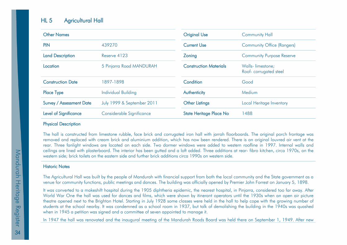
The hall is constructed from limestone rubble, face brick and corrugated iron hall with jarrah floorboards. The original porch frontage was removed and replaced with cream brick and aluminium addition, which has now been rendered. There is an original louvred air vent at the rear. Three fanlight windows are located on each side. Two dormer windows were added to western roofline in 1997. Internal walls and ceilings are lined with plasterboard. The interior has been gutted and a loft added. Three additions at rear- fibro kitchen, circa 1970s, on the western side; brick toilets on the eastern side and further brick additions circa 1990s on western side.
Historic Notes
The Agricultural Hall was built by the people of Mandurah with financial support from both the local community and the State government as a venue for community functions, public meetings and dances. The building was officially opened by Premier John Forrest on January 5, 1898.
It was converted to a makeshift hospital during the 1905 diphtheria epidemic, the nearest hospital, in Pinjarra, considered too far away. After World War One the hall was used for dances and films, which were shown by itinerant operators until the 1930s when an open air picture theatre opened next to the Brighton Hotel. Starting in July 1928 some classes were held in the hall to help cope with the growing number of students at the school nearby. It was condemned as a school room in 1937, but talk of demolishing the building in the 1940s was quashed when in 1945 a petition was signed and a committee of seven appointed to manage it.
In 1947 the hall was renovated and the inaugural meeting of the Mandurah Roads Board was held there on September 1, 1949. After new

35
Man
dura
h Pl
anni
ng S
chem
e 20
11
Man
dura
h H
erita
ge R
egis
ter
premises were built for the Council in 1965, the hall was taken over as a library. In 1969 the library was joined by the Mandurah Tourist Bureau. Early in 1997 the Tourist Bureau moved into the purpose built Peel Discovery Centre. The hall was occupied by the City of Mandurah’s Ranger Services after this time
Statement of Significance
• Built by the Mandurah community. • Part of Mandurah’s historic building stock.
Management Category (Desired Outcome)
Conservation of the place is highly desirable
Any alterations or extensions should reinforce the significance of the place
Historical Photographs (1930’s & 1950’s) Recent Photograph (2011)

36
Mandurah H
eritage Register
HL 6 Barragup House
Other Names Barraghup House; Moroerinup Original Use Dwelling
PIN 1143452 Current Use Office
Land Description Lot 31 on Plan 89622 Zoning Urban Development
Location 423 Pinjarra Road COODANUP Construction Materials Walls – Limestone & Brick Roof – Corrugated Steel
Construction Date Circa 1860 Condition High
Place Type Individual Building Authenticity Medium (Some Alterations)
Survey / Assessment Date July 1999 & September 2011 Other Listings Local Heritage Inventory
Level of Significance Considerable Significance State Heritage Place No 3309
Physical Description
The two or three roomed stone homestead, originally known as Moroerinup, is located on a site near the Serpentine River. The building has been extended with pine weatherboard to the northern and western sides and has a verandah on the eastern frontage. There is quoining around windows. There are old pine trees and palms around the property that are unlikely to be original plantings, but important to the context of the building. Some old farming implements are displayed on the exterior and around the building. One of two early windmills still stands. The current main doorway was added after 1930.
Historic Notes
The land originally belonged to Thomas Peel and was sold to Governor Hutt and developed by a Mr Bowes, when it became known as Bowes Farm. By 1840 Bowes had left the district and Thomas Eacott (who was indentured to Thomas Peel) and his wife Charlotte Tuckey were sent there by Peel to manage the farm.
Two of the Eacotts’ ten children were born at Barragup House after their marriage in 1839. It has been alleged that Peel gave Barragup House to the Eacotts as a wedding present, but it appears that they retained the homestead on Eacott’s original grant.
Run as a pig farm in the early 1900s, Barragup had a succession of owners, and was a poultry farm until the early 1930s when it was bought by Howard (Bill) Norton.
From 1987 it has operated as a nursery/tea-rooms, government offices (Department of Environment and Conservation, 1997) and visitor
37
Man
dura
h Pl
anni
ng S
chem
e 20
11
Man
dura
h H
erita
ge R
egis
ter
centre.
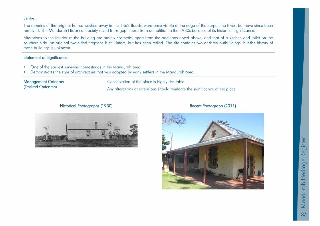
The remains of the original home, washed away in the 1862 floods, were once visible at the edge of the Serpentine River, but have since been removed. The Mandurah Historical Society saved Barragup House from demolition in the 1980s because of its historical significance.
Alterations to the interior of the building are mainly cosmetic, apart from the additions noted above, and that of a kitchen and toilet on the southern side. An original two-sided fireplace is still intact, but has been retiled. The site contains two or three outbuildings, but the history of these buildings is unknown.
Statement of Significance
• One of the earliest surviving homesteads in the Mandurah area. • Demonstrates the style of architecture that was adopted by early settlers in the Mandurah area.
Management Category (Desired Outcome)
Conservation of the place is highly desirable
Any alterations or extensions should reinforce the significance of the place
Historical Photographs (1930) Recent Photograph (2011)
38
Mandurah H
eritage Register
HL 7 Brighton Hotel
Other Names Mandurah House Original Use Dwelling
PIN 11407289 Current Use Office
Land Description Lot 307 on Plan 43226 Zoning Heritage Precinct
Location 6 Mandurah Terrace MANDURAH Construction Materials Walls- limestone Roof- corrugated steel
Construction Date 1894 Condition Good
Place Type Individual Building Authenticity Medium (Restored)
Survey / Assessment Date July 1999 & September 2011 Other Listings Local Heritage Inventory
Level of Significance Considerable Significance State Heritage Place No 1486
Physical Description
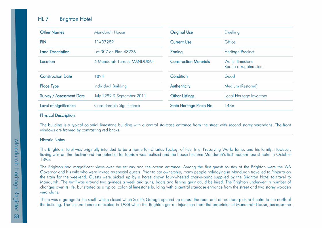
The building is a typical colonial limestone building with a central staircase entrance from the street with second storey verandahs. The front windows are framed by contrasting red bricks.
Historic Notes
The Brighton Hotel was originally intended to be a home for Charles Tuckey, of Peel Inlet Preserving Works fame, and his family. However, fishing was on the decline and the potential for tourism was realised and the house became Mandurah’s first modern tourist hotel in October 1895.
The Brighton had magnificent views over the estuary and the ocean entrance. Among the first guests to stay at the Brighton were the WA Governor and his wife who were invited as special guests. Prior to car ownership, many people holidaying in Mandurah travelled to Pinjarra on the train for the weekend. Guests were picked up by a horse drawn four-wheeled char-a-banc supplied by the Brighton Hotel to travel to Mandurah. The tariff was around two guineas a week and guns, boats and fishing gear could be hired. The Brighton underwent a number of changes over its life, but started as a typical colonial limestone building with a central staircase entrance from the street and two storey wooden verandahs.
There was a garage to the south which closed when Scott’s Garage opened up across the road and an outdoor picture theatre to the north of the building. The picture theatre relocated in 1938 when the Brighton got an injunction from the proprietor of Mandurah House, because the
39
Man
dura
h Pl
anni
ng S
chem
e 20
11
Man
dura
h H
erita
ge R
egis
ter
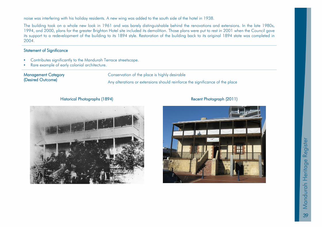
noise was interfering with his holiday residents. A new wing was added to the south side of the hotel in 1938.
The building took on a whole new look in 1961 and was barely distinguishable behind the renovations and extensions. In the late 1980s, 1994, and 2000, plans for the greater Brighton Hotel site included its demolition. Those plans were put to rest in 2001 when the Council gave its support to a redevelopment of the building to its 1894 style. Restoration of the building back to its original 1894 state was completed in 2004.
Statement of Significance
• Contributes significantly to the Mandurah Terrace streetscape. • Rare example of early colonial architecture.
Management Category (Desired Outcome)
Conservation of the place is highly desirable
Any alterations or extensions should reinforce the significance of the place
Historical Photographs (1894) Recent Photograph (2011)

40
Mandurah H
eritage Register
HL 8 Christ’s Church Anglican Church
Other Names Original Use Church
PIN 439322 Current Use Church
Land Description Lot 16 on Plan 226109 Zoning Heritage Precinct
Location 34 – 36 Pinjarra Road MANDURAH Construction Materials Walls- limestone; Roof- tiles
Construction Date 1870 Condition Good
Place Type Individual Building Authenticity Medium (extension undertaken)
Survey / Assessment Date July 1999 & September 2011 Other Listings Register of National Estate Classified by National Trust Local Heritage Inventory Significant Tree Register (ID 08/0069)
Level of Significance Considerable Significance State Heritage Place No 1489
Physical Description
The church was built from local limestone and now has an orange tiled roof. The original church was rectangular with a porch at the west door. An archway was built into the east wall to frame the entrance to a proposed chancel and sanctuary, which were not built until 1955-1956. At this time the original shingled roof was overlaid with tiles to match that of the new extensions. An extension was added in the early 1990s. There is a carob tree on the site that is listed on the Significant Tree Register.
Historic Notes
The church was built on one acre of land donated by Thomas Peel’s daughter, Dorothy Ann, and her husband, Henry Hastings Hall.
Henry was chairman of the building committee and one of its most generous donors. No contract labour was used during the church’s building with all work being done by the community on a voluntary basis.
The church was consecrated by the Bishop of Perth, Rt Rev Mathew Blagden Hale, on October 25, 1871, although the churchyard was not consecrated until November 29, 1880. The Anglican rector from Pinjarra took the services. Prior to the church being built, services were held in one of Thomas Peel’s huts, known as Peel’s Chapel. When this chapel was destroyed by bush fire in March 1869, church services were held in the home of James Tuckey.
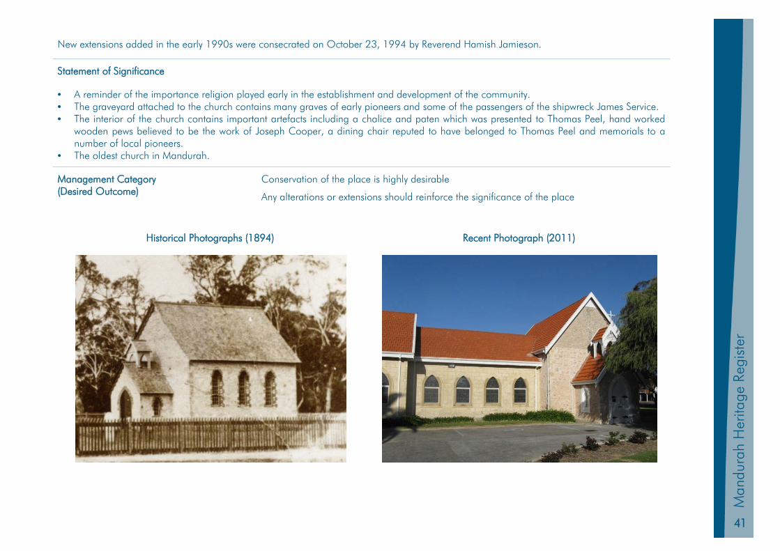
41
Man
dura
h Pl
anni
ng S
chem
e 20
11
Man
dura
h H
erita
ge R
egis
ter
New extensions added in the early 1990s were consecrated on October 23, 1994 by Reverend Hamish Jamieson.
Statement of Significance
• A reminder of the importance religion played early in the establishment and development of the community. • The graveyard attached to the church contains many graves of early pioneers and some of the passengers of the shipwreck James Service. • The interior of the church contains important artefacts including a chalice and paten which was presented to Thomas Peel, hand worked
wooden pews believed to be the work of Joseph Cooper, a dining chair reputed to have belonged to Thomas Peel and memorials to a number of local pioneers.
• The oldest church in Mandurah.
Management Category (Desired Outcome)
Conservation of the place is highly desirable
Any alterations or extensions should reinforce the significance of the place
Historical Photographs (1894) Recent Photograph (2011)
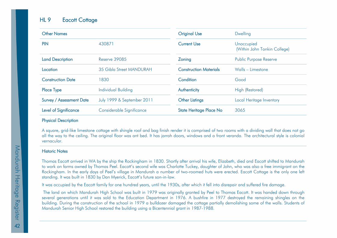
42
Mandurah H
eritage Register
HL 9 Eacott Cottage
Other Names Original Use Dwelling
PIN 430871 Current Use Unoccupied (Within John Tonkin College)
Land Description Reserve 39085 Zoning Public Purpose Reserve
Location 35 Gibla Street MANDURAH Construction Materials Walls – Limestone
Construction Date 1830 Condition Good
Place Type Individual Building Authenticity High (Restored)
Survey / Assessment Date July 1999 & September 2011 Other Listings Local Heritage Inventory
Level of Significance Considerable Significance State Heritage Place No 3065
Physical Description
A square, grid-like limestone cottage with shingle roof and bag finish render it is comprised of two rooms with a dividing wall that does not go all the way to the ceiling. The original floor was ant bed. It has jarrah doors, windows and a front veranda. The architectural style is colonial vernacular.
Historic Notes
Thomas Eacott arrived in WA by the ship the Rockingham in 1830. Shortly after arrival his wife, Elizabeth, died and Eacott shifted to Mandurah to work on farms owned by Thomas Peel. Eacott’s second wife was Charlotte Tuckey, daughter of John, who was also a free immigrant on the Rockingham. In the early days of Peel’s village in Mandurah a number of two-roomed huts were erected. Eacott Cottage is the only one left standing. It was built in 1830 by Dan Myerick, Eacott’s future son-in-law.
It was occupied by the Eacott family for one hundred years, until the 1930s, after which it fell into disrepair and suffered fire damage.
The land on which Mandurah High School was built in 1979 was originally granted by Peel to Thomas Eacott. It was handed down through several generations until it was sold to the Education Department in 1976. A bushfire in 1977 destroyed the remaining shingles on the building. During the construction of the school in 1979 a bulldozer damaged the cottage partially demolishing some of the walls. Students of Mandurah Senior High School restored the building using a Bicentennial grant in 1987-1988.
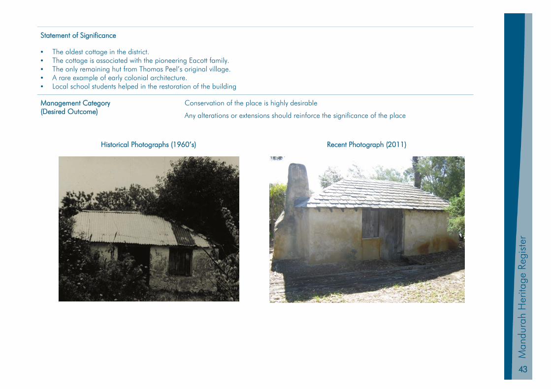
43
Man
dura
h Pl
anni
ng S
chem
e 20
11
Man
dura
h H
erita
ge R
egis
ter
Statement of Significance
• The oldest cottage in the district. • The cottage is associated with the pioneering Eacott family. • The only remaining hut from Thomas Peel’s original village. • A rare example of early colonial architecture. • Local school students helped in the restoration of the building
Management Category (Desired Outcome)
Conservation of the place is highly desirable
Any alterations or extensions should reinforce the significance of the place
Historical Photographs (1960’s) Recent Photograph (2011)

44
Mandurah H
eritage Register
HL 10 Falcon Stock Well
Other Names Original Use Stock Well
PIN 1262569 Current Use Stock Well (within POS)
Land Description Reserve 32501 Zoning District Recreation Reserve
Location Falcon Reserve Cobblers St FALCON
Construction Materials Stone
Construction Date 1890 Condition Good
Place Type Individual Structure Authenticity High
Survey / Assessment Date July 1999 & September 2011 Other Listings Local Heritage Inventory
Level of Significance Considerable Significance State Heritage Place No 17176
Physical Description
Limestone stock well with plaque located on the north eastern corner of Falcon Reserve.
Historic Notes
This cylindrical limestone stock well was excavated in 1890 by brothers William and Seymour Ward, whose family lived in the Falcon area and had their home in the Pleasant Grove locality. Around six metres deep, it was used for watering stock and the remnants of an old windmill were once located close by.
This well was part of the series of wells built on the Coast Road from Fremantle to Bunbury for the use of travellers and their livestock.
These were significant public works in their time and very few still remain with most having been filled in, built over and their locations lost as roads were paved and widened. They had great community significance at the time as markers on the journey from place to place and also as locations within the community. Locations were given by what well was the closest to the cottage or property of a settler.
The well was restored by the Falcon Progress Association in 1977 using stone taken from the ruins of Cox Cottage, located opposite the well site. A circular stone wall on a concrete base extending outward from the well wall was also constructed, with a grill covering its top.
45
Man
dura
h Pl
anni
ng S
chem
e 20
11
Man
dura
h H
erita
ge R
egis
ter
Statement of Significance
• It was sunk by members of the pioneering Ward family. • There was community involvement in the restoration of the well. • Good example of a rare structure as many of the other wells in the Mandurah area have been filled in as a result of land development.
Management Category (Desired Outcome)
Conservation of the place is highly desirable
Any alterations or extensions should reinforce the significance of the place
Recent Photograph (2011)
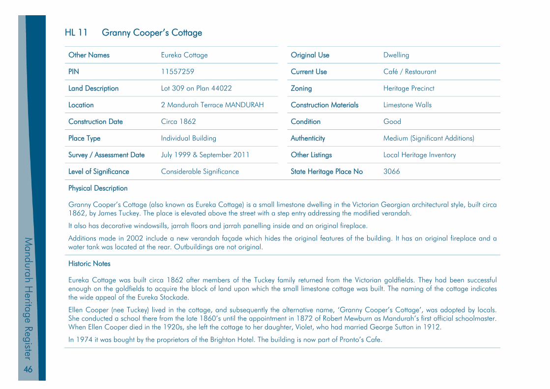
46
Mandurah H
eritage Register
HL 11 Granny Cooper’s Cottage
Other Names Eureka Cottage Original Use Dwelling
PIN 11557259 Current Use Café / Restaurant
Land Description Lot 309 on Plan 44022 Zoning Heritage Precinct
Location 2 Mandurah Terrace MANDURAH Construction Materials Limestone Walls
Construction Date Circa 1862 Condition Good
Place Type Individual Building Authenticity Medium (Significant Additions)
Survey / Assessment Date July 1999 & September 2011 Other Listings Local Heritage Inventory
Level of Significance Considerable Significance State Heritage Place No 3066
Physical Description
Granny Cooper’s Cottage (also known as Eureka Cottage) is a small limestone dwelling in the Victorian Georgian architectural style, built circa 1862, by James Tuckey. The place is elevated above the street with a step entry addressing the modified verandah.
It also has decorative windowsills, jarrah floors and jarrah panelling inside and an original fireplace.
Additions made in 2002 include a new verandah façade which hides the original features of the building. It has an original fireplace and a water tank was located at the rear. Outbuildings are not original.
Historic Notes
Eureka Cottage was built circa 1862 after members of the Tuckey family returned from the Victorian goldfields. They had been successful enough on the goldfields to acquire the block of land upon which the small limestone cottage was built. The naming of the cottage indicates the wide appeal of the Eureka Stockade.
Ellen Cooper (nee Tuckey) lived in the cottage, and subsequently the alternative name, ‘Granny Cooper’s Cottage’, was adopted by locals. She conducted a school there from the late 1860’s until the appointment in 1872 of Robert Mewburn as Mandurah’s first official schoolmaster. When Ellen Cooper died in the 1920s, she left the cottage to her daughter, Violet, who had married George Sutton in 1912.
In 1974 it was bought by the proprietors of the Brighton Hotel. The building is now part of Pronto’s Cafe.

47
Man
dura
h Pl
anni
ng S
chem
e 20
11
Man
dura
h H
erita
ge R
egis
ter
Statement of Significance
• Is a local landmark. • The building is associated with three of Mandurah’s pioneering families, the Coopers, the Suttons and the Tuckeys. • One of the oldest buildings in the Mandurah town centre. • Demonstrates the style of architecture that was adopted by early settlers in the Mandurah area.
Management Category (Desired Outcome)
Conservation of the place is highly desirable
Any alterations or extensions should reinforce the significance of the place
Historical Photographs (1890’s) Recent Photograph (2011)
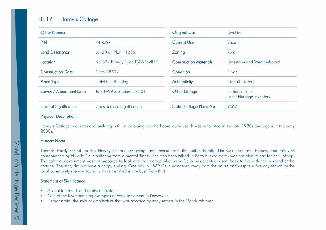
48
Mandurah H
eritage Register
HL 12 Hardy’s Cottage
Other Names Original Use Dwelling
PIN 445869 Current Use Vacant
Land Description Lot 20 on Plan 11286 Zoning Rural
Location No 824 Estuary Road DAWESVILLE Construction Materials Limestone and Weatherboard
Construction Date Circa 1860s Condition Good
Place Type Individual Building Authenticity High (Restored)
Survey / Assessment Date July 1999 & September 2011 Other Listings National Trust Local Heritage Inventory
Level of Significance Considerable Significance State Heritage Place No 9067
Physical Description
Hardy’s Cottage is a limestone building with an adjoining weatherboard outhouse. It was renovated in the late 1980s and again in the early 2000s.
Historic Notes
Thomas Hardy settled on the Harvey Estuary occupying land leased from the Sutton Family. Life was hard for Thomas, and this was compounded by his wife Celia suffering from a mental illness. She was hospitalised in Perth but Mr Hardy was not able to pay for her upkeep. The colonial government was not prepared to look after her from public funds. Celia was eventually sent back to live with her husband at the cottage. The story did not have a happy ending. One day in 1869 Celia wandered away from the house and despite a five day search by the local community she was found to have perished in the bush from thirst.
Statement of Significance
• A local landmark and tourist attraction.• One of the few remaining examples of early settlement in Dawesville.• Demonstrates the style of architecture that was adopted by early settlers in the Mandurah area.
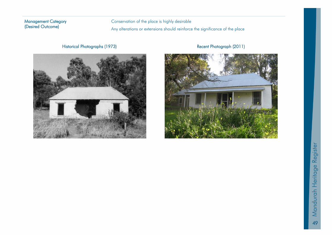
49
Man
dura
h Pl
anni
ng S
chem
e20
11
Man
dura
h H
erita
ge R
egis
ter
Management Category (Desired Outcome)
Conservation of the place is highly desirable
Any alterations or extensions should reinforce the significance of the place
Historical Photographs (1973) Recent Photograph (2011)

50
Mandurah H
eritage Register
HL 13 Herron Homestead
Other Names Original Use Dwelling
PIN 1260066 Current Use Vacant
Land Description Lot 101 on Plan 23024 Zoning Rural
Location Old Coast Road (Quail Road) HERRON
Construction Materials Walls limestone and timber Roof shingles, now covered with
corrugated steel
Construction Date 1866 Condition Unsure
Place Type Individual Building Authenticity High
Survey / Assessment Date July 1999 & September 2011 Other Listings Local Heritage Inventory
Level of Significance Considerable Significance State Heritage Place No 9070
Physical Description
Limestone cottage with lime bag finish situated at the northern end of Lake Clifton. The building has colonial bar windows, two feature chimneys and an iron roof. A shingled roof is still visible underneath. The cottage is set amongst cleared paddocks at the foot of a coastal ridge in a very picturesque setting and is only accessible via a dirt track.
Historic Notes
The homestead was built by James and Isabella Herron who arrived in WA from Ireland on the Clara in 1853.
The original 70 acres surrounding the cottage was purchased around 1864 and by 1875 the Herrons had leased a total of 13,500 acres of grazing land from the government.
Before the present cottage was built the family lived in a slab hut inland from the north end of Lake Clifton.
Herron Homestead was not as isolated as it currently is as the main line of road from Australind to Mandurah ran along the eastern shore of the lake.
Butter was made at the cottage, with wheat, barley and oats grown in the surrounding fields. Cattle were grazed on the surrounding leasehold land and horses bred for the Indian Army. Evidence of the infrastructure necessary for making butter and threshing grain still survives around
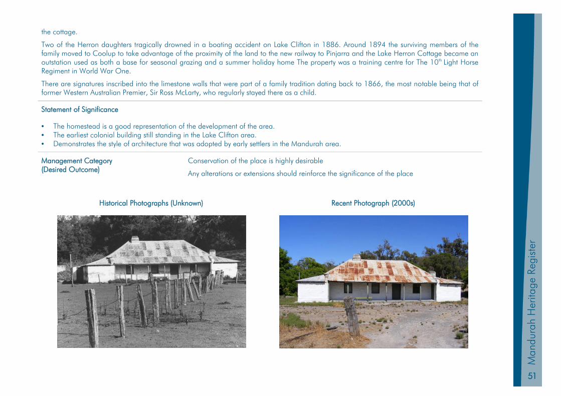
51
Man
dura
h Pl
anni
ng S
chem
e 20
11
Man
dura
h H
erita
ge R
egis
ter
the cottage.
Two of the Herron daughters tragically drowned in a boating accident on Lake Clifton in 1886. Around 1894 the surviving members of the family moved to Coolup to take advantage of the proximity of the land to the new railway to Pinjarra and the Lake Herron Cottage became an outstation used as both a base for seasonal grazing and a summer holiday home The property was a training centre for The 10th Light Horse Regiment in World War One.
There are signatures inscribed into the limestone walls that were part of a family tradition dating back to 1866, the most notable being that of former Western Australian Premier, Sir Ross McLarty, who regularly stayed there as a child.
Statement of Significance
• The homestead is a good representation of the development of the area. • The earliest colonial building still standing in the Lake Clifton area. • Demonstrates the style of architecture that was adopted by early settlers in the Mandurah area.
Management Category (Desired Outcome)
Conservation of the place is highly desirable
Any alterations or extensions should reinforce the significance of the place
Historical Photographs (Unknown) Recent Photograph (2000s)

52
Mandurah H
eritage Register
HL 14 Mandurah Community Museum
Other Names Original Use School
PIN 439263 Current Use Museum
Land Description Reserve 22284 Zoning Community Purpose Reserve
Location No 3 Pinjarra Road MANDURAH Construction Materials Walls brick Roof corrugated steel, tiles
Construction Date 1899 & 1976 Condition Good
Place Type Collection of Buildings Authenticity Medium Modifications in 1960s & 1970s
Survey / Assessment Date July 1999 & September 2011 Other Listings Local Heritage Inventory
Level of Significance Considerable Significance State Heritage Place No 9079
Physical Description
The school was constructed from local wire-cut red bricks with white banding. Red brick additions obscure the original building from the street.
Historic Notes
The Dalrymple School, opened on 4 April 1900, was the first purpose built government school in Mandurah.
It was named after Robert Dalrymple, a long-serving teacher and much admired community member who forewent promotion in order to stay in Mandurah. Ellen Cooper (nee Tuckey) had conducted a school in her home (Granny Cooper’s Cottage) from the late 1860s until the appointment in 1872 of Robert Mewburn as Mandurah’s first official schoolmaster.
In 1876 Mewburn was obliged to erect his own school building in order to continue teaching, and this remained the official school until his death in 1891.
After Mewburn’s death the school was moved to the (now demolished) police barracks in Dalrymple Park, which had been vacated in 1888 and were being privately rented. The police barracks also served as the quarters of the newly appointed schoolmaster, Robert Dalrymple.
The school was conducted at these premises until the new school was built in 1900. The Dalrymple school was in use until 1939 when the new Mandurah Primary School was opened in Hackett Street. In the 1920s and 1930s some of its classes were held in the adjacent Agricultural

53
Man
dura
h Pl
anni
ng S
chem
e 20
11
Man
dura
h H
erita
ge R
egis
ter
Hall to help cope with its growing number of pupils.
After the school relocated the building was used as an in fact health clinic and during World War Two by the RSL, Red Cross and the Women’s Auxiliary.
In 1948 the Dalrymple School was taken over by the Police Department for use as the town’s Police Station, and major extensions were added in 1960. A courthouse was subsequently added in the 1960s for the use of the Resident Magistrate. When the police moved to a new building late in 1988, the Mandurah Historical Society successfully applied to use the building as a community museum, reflecting the renewed interest in history created by Australia’s bicentennial. The front section of the building was occupied by the Education Department for administrative purposes until January 1997 when they vacated the site. From this time the site was occupied by the Citizen’s Advice Bureau and the Mandurah branch of the WA Genealogical Society.
The Historical Society recreated the schoolroom as it would have looked in the early part of the century, and the remainder of the museum is dedicated to historical artefacts and information from Mandurah’s past. Management of the Museum was taken over by the City of Mandurah in 2000 and the other two agencies were relocated.
Robert Dalrymple also planted a number of mature peppermint trees which now shade the adjacent Dalrymple Park.
Statement of Significance
• The interior of the building has high social value as it has served many community functions including law enforcement, community information and a community museum.
• The first government school in Mandurah.
Management Category (Desired Outcome)
Conservation of the place is highly desirable
Any alterations or extensions should reinforce the significance of the place
Historical Photographs (1916) Recent Photograph (2011)
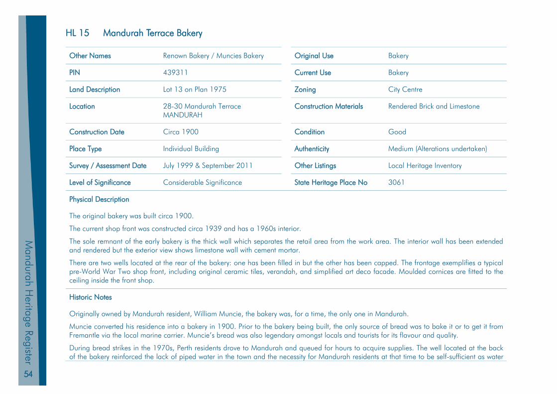
54
Mandurah H
eritage Register
HL 15 Mandurah Terrace Bakery
Other Names Renown Bakery / Muncies Bakery Original Use Bakery
PIN 439311 Current Use Bakery
Land Description Lot 13 on Plan 1975 Zoning City Centre
Location 28-30 Mandurah Terrace MANDURAH
Construction Materials Rendered Brick and Limestone
Construction Date Circa 1900 Condition Good
Place Type Individual Building Authenticity Medium (Alterations undertaken)
Survey / Assessment Date July 1999 & September 2011 Other Listings Local Heritage Inventory
Level of Significance Considerable Significance State Heritage Place No 3061
Physical Description
The original bakery was built circa 1900.
The current shop front was constructed circa 1939 and has a 1960s interior.
The sole remnant of the early bakery is the thick wall which separates the retail area from the work area. The interior wall has been extended and rendered but the exterior view shows limestone wall with cement mortar.
There are two wells located at the rear of the bakery: one has been filled in but the other has been capped. The frontage exemplifies a typical pre-World War Two shop front, including original ceramic tiles, verandah, and simplified art deco facade. Moulded cornices are fitted to the ceiling inside the front shop.
Historic Notes
Originally owned by Mandurah resident, William Muncie, the bakery was, for a time, the only one in Mandurah.
Muncie converted his residence into a bakery in 1900. Prior to the bakery being built, the only source of bread was to bake it or to get it from Fremantle via the local marine carrier. Muncie’s bread was also legendary amongst locals and tourists for its flavour and quality.
During bread strikes in the 1970s, Perth residents drove to Mandurah and queued for hours to acquire supplies. The well located at the back of the bakery reinforced the lack of piped water in the town and the necessity for Mandurah residents at that time to be self-sufficient as water
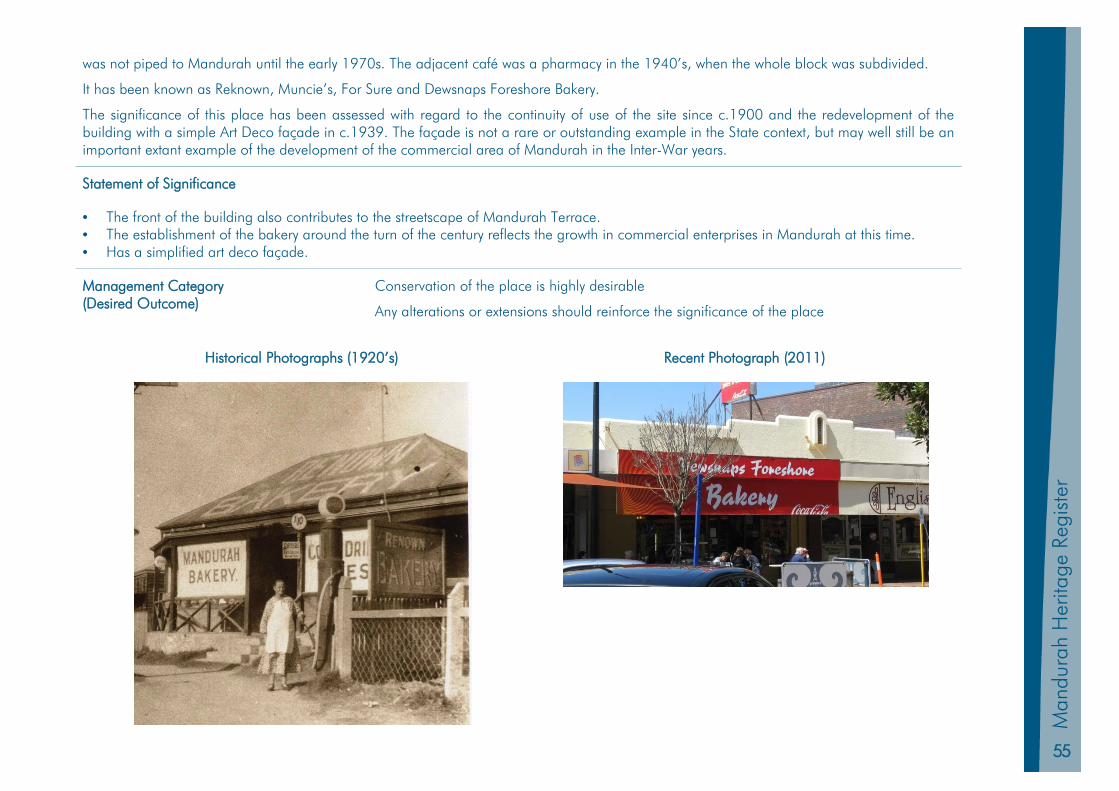
55
Man
dura
h Pl
anni
ng S
chem
e 20
11
Man
dura
h H
erita
ge R
egis
ter
was not piped to Mandurah until the early 1970s. The adjacent café was a pharmacy in the 1940’s, when the whole block was subdivided.
It has been known as Reknown, Muncie’s, For Sure and Dewsnaps Foreshore Bakery.
The significance of this place has been assessed with regard to the continuity of use of the site since c.1900 and the redevelopment of the building with a simple Art Deco façade in c.1939. The façade is not a rare or outstanding example in the State context, but may well still be an important extant example of the development of the commercial area of Mandurah in the Inter-War years.
Statement of Significance
• The front of the building also contributes to the streetscape of Mandurah Terrace. • The establishment of the bakery around the turn of the century reflects the growth in commercial enterprises in Mandurah at this time. • Has a simplified art deco façade.
Management Category (Desired Outcome)
Conservation of the place is highly desirable
Any alterations or extensions should reinforce the significance of the place
Historical Photographs (1920’s) Recent Photograph (2011)
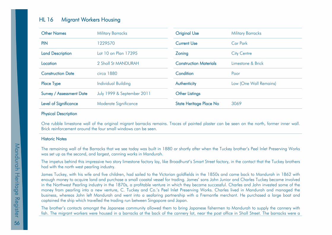
56
Mandurah H
eritage Register
HL 16 Migrant Workers Housing
Other Names Military Barracks Original Use Military Barracks
PIN 1229570 Current Use Car Park
Land Description Lot 10 on Plan 17395 Zoning City Centre
Location 2 Sholl St MANDURAH Construction Materials Limestone & Brick
Construction Date circa 1880 Condition Poor
Place Type Individual Building Authenticity Low (One Wall Remains)
Survey / Assessment Date July 1999 & September 2011 Other Listings
Level of Significance Moderate Significance State Heritage Place No 3069
Physical Description
One rubble limestone wall of the original migrant barracks remains. Traces of painted plaster can be seen on the north, former inner wall. Brick reinforcement around the four small windows can be seen.
Historic Notes
The remaining wall of the Barracks that we see today was built in 1880 or shortly after when the Tuckey brother’s Peel Inlet Preserving Works was set up as the second, and largest, canning works in Mandurah.
The impetus behind this impressive two story limestone factory lay, like Broadhurst’s Smart Street factory, in the contact that the Tuckey brothers had with the north west pearling industry.
James Tuckey, with his wife and five children, had sailed to the Victorian goldfields in the 1850s and came back to Mandurah in 1862 with enough money to acquire land and purchase a small coastal vessel for trading. James’ sons John Junior and Charles Tuckey became involved in the Northwest Pearling industry in the 1870s, a profitable venture in which they became successful. Charles and John invested some of the money from pearling into a new venture, C. Tuckey and Co.’s Peel Inlet Preserving Works. Charles lived in Mandurah and managed the business, whereas John left Mandurah and went into a seafaring partnership with a Fremantle merchant. He purchased a large boat and captained the ship which travelled the trading run between Singapore and Japan.
The brother’s contacts amongst the Japanese community allowed them to bring Japanese fishermen to Mandurah to supply the cannery with fish. The migrant workers were housed in a barracks at the back of the cannery lot, near the post office in Sholl Street. The barracks were a
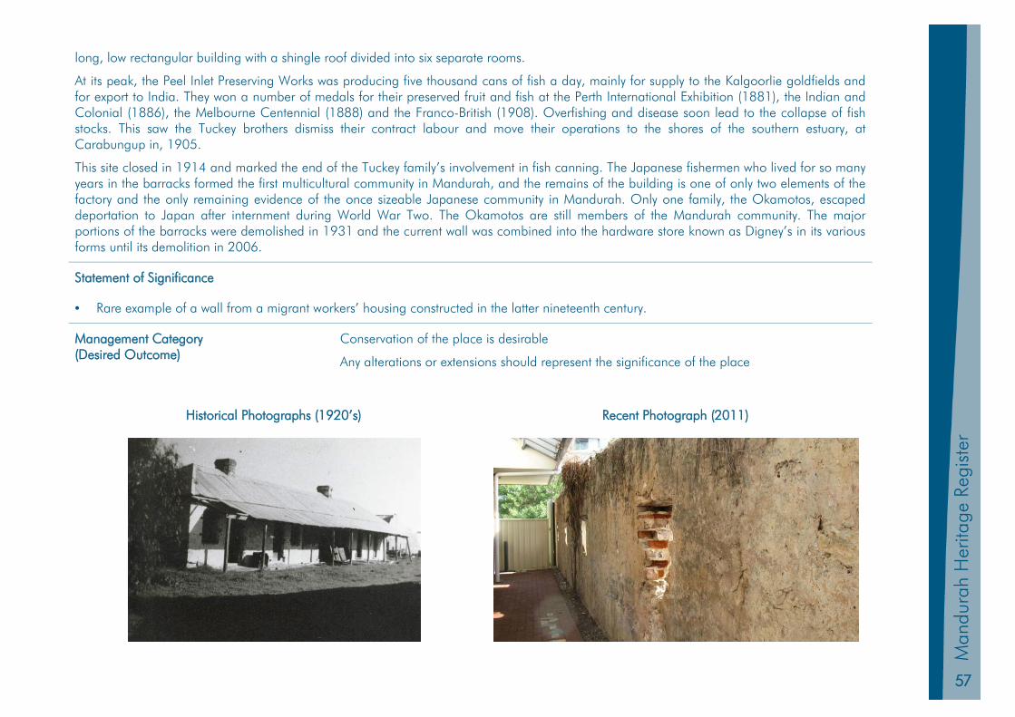
57
Man
dura
h Pl
anni
ng S
chem
e 20
11
Man
dura
h H
erita
ge R
egis
ter
long, low rectangular building with a shingle roof divided into six separate rooms.
At its peak, the Peel Inlet Preserving Works was producing five thousand cans of fish a day, mainly for supply to the Kalgoorlie goldfields and for export to India. They won a number of medals for their preserved fruit and fish at the Perth International Exhibition (1881), the Indian and Colonial (1886), the Melbourne Centennial (1888) and the Franco-British (1908). Overfishing and disease soon lead to the collapse of fish stocks. This saw the Tuckey brothers dismiss their contract labour and move their operations to the shores of the southern estuary, at Carabungup in, 1905.
This site closed in 1914 and marked the end of the Tuckey family’s involvement in fish canning. The Japanese fishermen who lived for so many years in the barracks formed the first multicultural community in Mandurah, and the remains of the building is one of only two elements of the factory and the only remaining evidence of the once sizeable Japanese community in Mandurah. Only one family, the Okamotos, escaped deportation to Japan after internment during World War Two. The Okamotos are still members of the Mandurah community. The major portions of the barracks were demolished in 1931 and the current wall was combined into the hardware store known as Digney’s in its various forms until its demolition in 2006.
Statement of Significance
• Rare example of a wall from a migrant workers’ housing constructed in the latter nineteenth century.
Management Category (Desired Outcome)
Conservation of the place is desirable
Any alterations or extensions should represent the significance of the place
Historical Photographs (1920’s) Recent Photograph (2011)

58
Mandurah H
eritage Register
HL 17 Residence: 82 Cooper Street
Other Names Original Use Dwelling
PIN 11963102 Current Use Dwelling
Land Description Strata Lot 3 on Strata Plan 61532 Zoning Residential
Location 82 Cooper Street MANDURAH Construction Materials Walls patterned cement brick Roof corrugated steel
Construction Date Circa 1930 Condition Good
Place Type Individual Building Authenticity High
Survey / Assessment Date July 1999 & September 2011 Other Listings Local Heritage Inventory
Level of Significance Considerable Significance State Heritage Place No 17187
Physical Description
Cottage constructed of concrete patterned bricks with pillared verandah.
One side of the verandah is now enclosed. A brick chimney with two chimney pots is located on the eastern side of the building.
Historic Notes
A good example of a 1930s Mandurah residence. The patterned concrete bricks were fairly common in Mandurah and were made by locals with a mould, before being erected, and then painted. This house may have been one of the last ones of its type built in Mandurah, given the onset of the Great Depression and the shortage of materials associated with the commencement of World War Two in 1939.
Statement of Significance
• A rare example of a surviving Mandurah house from the 1930s. • Representative of houses constructed in the interwar period within regional centres.
Management Category (Desired Outcome)
Conservation of the place is highly desirable
Any alterations or extensions should reinforce the significance of the place
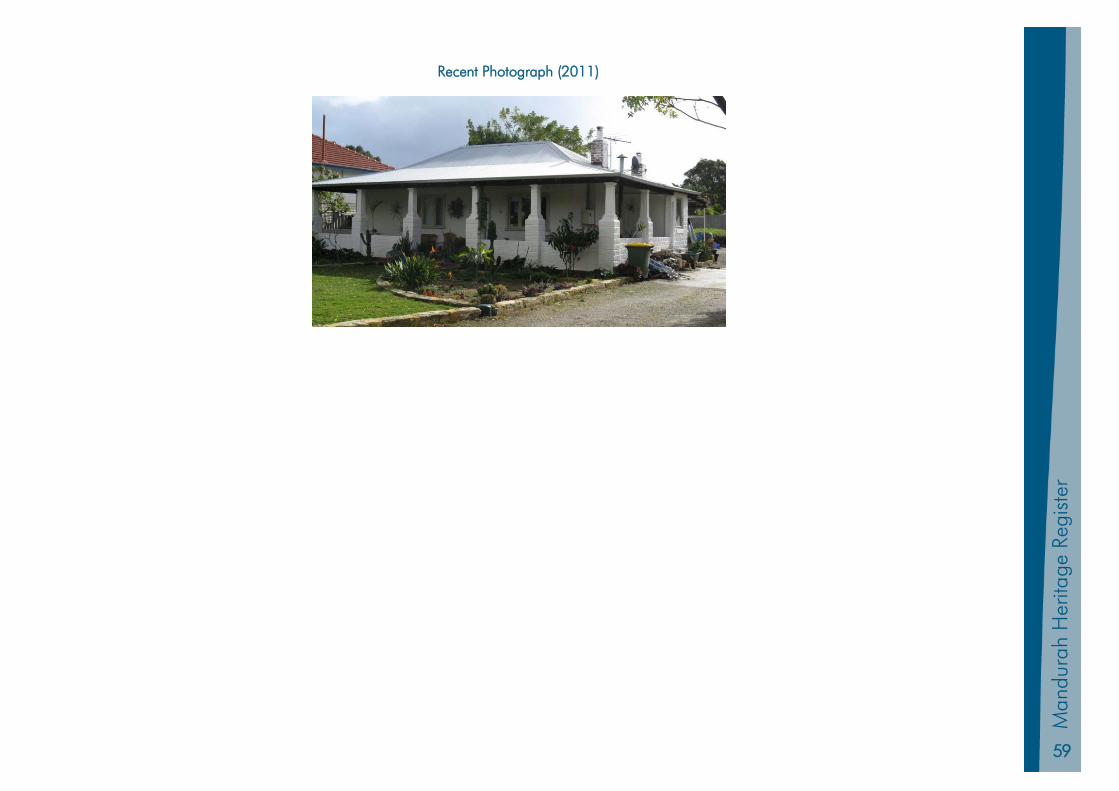
59
Man
dura
h Pl
anni
ng S
chem
e 20
11
Man
dura
h H
erita
ge R
egis
ter
Recent Photograph (2011)
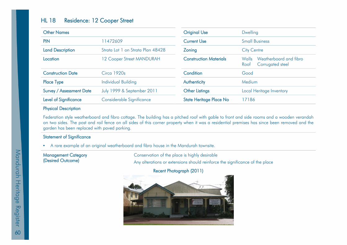
60
Mandurah H
eritage Register
HL 18 Residence: 12 Cooper Street
Other Names Original Use Dwelling
PIN 11472609 Current Use Small Business
Land Description Strata Lot 1 on Strata Plan 48428 Zoning City Centre
Location 12 Cooper Street MANDURAH Construction Materials Walls Weatherboard and fibro Roof Corrugated steel
Construction Date Circa 1920s Condition Good
Place Type Individual Building Authenticity Medium
Survey / Assessment Date July 1999 & September 2011 Other Listings Local Heritage Inventory
Level of Significance Considerable Significance State Heritage Place No 17186
Physical Description
Federation style weatherboard and fibro cottage. The building has a pitched roof with gable to front and side rooms and a wooden verandah on two sides. The post and rail fence on all sides of this corner property when it was a residential premises has since been removed and the garden has been replaced with paved parking.
Statement of Significance
• A rare example of an original weatherboard and fibro house in the Mandurah townsite.
Management Category (Desired Outcome)
Conservation of the place is highly desirable
Any alterations or extensions should reinforce the significance of the place
Recent Photograph (2011)
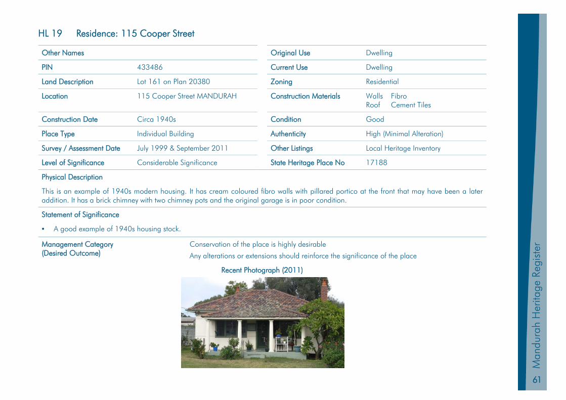
61
Man
dura
h Pl
anni
ng S
chem
e 20
11
Man
dura
h H
erita
ge R
egis
ter
HL 19 Residence: 115 Cooper Street
Other Names Original Use Dwelling
PIN 433486 Current Use Dwelling
Land Description Lot 161 on Plan 20380 Zoning Residential
Location 115 Cooper Street MANDURAH Construction Materials Walls Fibro Roof Cement Tiles
Construction Date Circa 1940s Condition Good
Place Type Individual Building Authenticity High (Minimal Alteration)
Survey / Assessment Date July 1999 & September 2011 Other Listings Local Heritage Inventory
Level of Significance Considerable Significance State Heritage Place No 17188
Physical Description
This is an example of 1940s modern housing. It has cream coloured fibro walls with pillared portico at the front that may have been a later addition. It has a brick chimney with two chimney pots and the original garage is in poor condition.
Statement of Significance
• A good example of 1940s housing stock.
Management Category (Desired Outcome)
Conservation of the place is highly desirable
Any alterations or extensions should reinforce the significance of the place
Recent Photograph (2011)

62
Mandurah H
eritage Register
HL 20 Santoy Dance Hall
Other Names Sontoy Dance Hall Original Use Dance Hall
PIN 439256 Current Use Retail Shops
Land Description Lot 300 on Plan 33040 Zoning City Centre
Location 14-21 Mandurah Tce MANDURAH Construction Materials Walls – Brick; Roof – Asbestos
Construction Date 1950’s Condition Good
Place Type Individual Building Authenticity Medium (Northern Extensions)
Survey / Assessment Date July 1999 & September 2011 Other Listings Local Heritage Inventory
Level of Significance Considerable Significance State Heritage Place No 17182
Physical Description
The hall has been divided up for use as shops. It has the original front masonry steps and the upper part of the entry has patterned cement rendering. There are moulded cornices around the perimeter of the hall ceiling.
Original jarrah floors are now covered but still intact. There are also louvred vents on the exterior. A toilet block at the rear has some original fittings. The building has been extended on the northern side. The architectural style is post World War Two modern.
Historic Notes
Approval for the construction of the hall was granted in September 1955, on the site of what was J Downing’s General Store. It was designed and built by Roy Tuckey and named after a boat (the Sontoy) that his father used in the north-west trade. Mandurah’s most important functions were held in the ballroom including dances and wedding receptions. It was from the debutante ball which was held here that many in the community went to the rescue of the young boy who fell down a borehole in January 1957.
From 1960 the Mandurah Parents’ & Citizens annual spring show was held there. In 1963 a shop was added which fronted onto Smart Street. The Santoy was converted to a shopping arcade circa 1968 following a successful appeal by the owner to the Minister for Planning.
The significance of this place has been assessed with regard to the use of the site as a community centre from the 1950s to 1968 (after which it was converted to a shopping arcade).
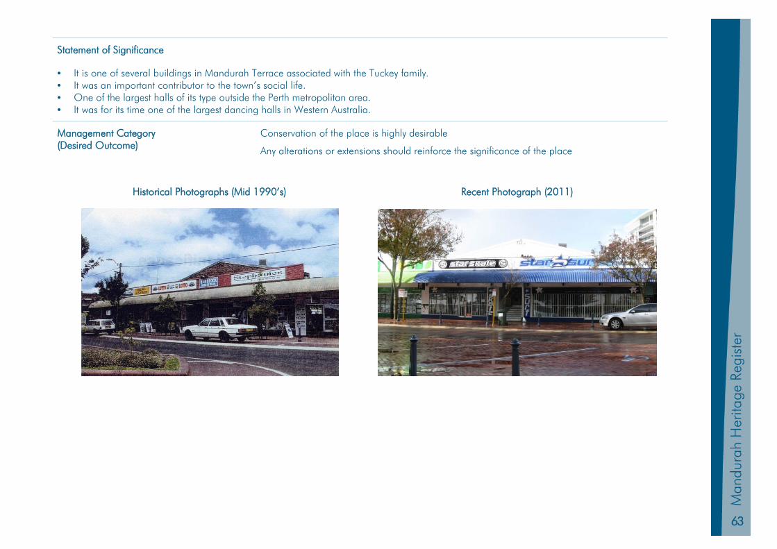
63
Man
dura
h Pl
anni
ng S
chem
e 20
11
Man
dura
h H
erita
ge R
egis
ter
Statement of Significance
• It is one of several buildings in Mandurah Terrace associated with the Tuckey family. • It was an important contributor to the town’s social life. • One of the largest halls of its type outside the Perth metropolitan area. • It was for its time one of the largest dancing halls in Western Australia.
Management Category (Desired Outcome)
Conservation of the place is highly desirable
Any alterations or extensions should reinforce the significance of the place
Historical Photographs (Mid 1990’s) Recent Photograph (2011)
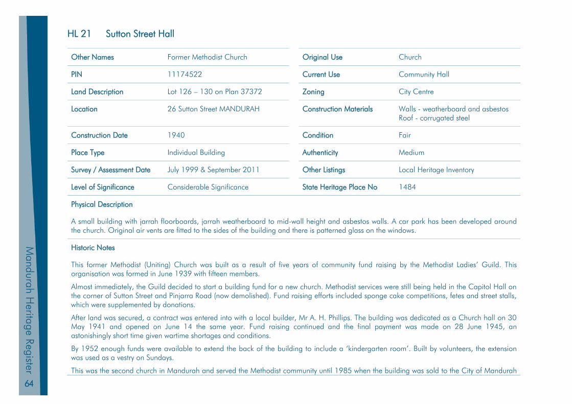
64
Mandurah H
eritage Register
HL 21 Sutton Street Hall
Other Names Former Methodist Church Original Use Church
PIN 11174522 Current Use Community Hall
Land Description Lot 126 – 130 on Plan 37372 Zoning City Centre
Location 26 Sutton Street MANDURAH Construction Materials Walls - weatherboard and asbestos Roof - corrugated steel
Construction Date 1940 Condition Fair
Place Type Individual Building Authenticity Medium
Survey / Assessment Date July 1999 & September 2011 Other Listings Local Heritage Inventory
Level of Significance Considerable Significance State Heritage Place No 1484
Physical Description
A small building with jarrah floorboards, jarrah weatherboard to mid-wall height and asbestos walls. A car park has been developed around the church. Original air vents are fitted to the sides of the building and there is patterned glass on the windows.
Historic Notes
This former Methodist (Uniting) Church was built as a result of five years of community fund raising by the Methodist Ladies’ Guild. This organisation was formed in June 1939 with fifteen members.
Almost immediately, the Guild decided to start a building fund for a new church. Methodist services were still being held in the Capitol Hall on the corner of Sutton Street and Pinjarra Road (now demolished). Fund raising efforts included sponge cake competitions, fetes and street stalls, which were supplemented by donations.
After land was secured, a contract was entered into with a local builder, Mr A. H. Phillips. The building was dedicated as a Church hall on 30 May 1941 and opened on June 14 the same year. Fund raising continued and the final payment was made on 28 June 1945, an astonishingly short time given wartime shortages and conditions.
By 1952 enough funds were available to extend the back of the building to include a ‘kindergarten room’. Built by volunteers, the extension was used as a vestry on Sundays.
This was the second church in Mandurah and served the Methodist community until 1985 when the building was sold to the City of Mandurah

65
Man
dura
h Pl
anni
ng S
chem
e 20
11
Man
dura
h H
erita
ge R
egis
ter
by the (now Uniting) Church and new premises were established in Pinjarra Road.
In the late 1990s consideration was given to demolishing or relocating the building, however, a commitment was made by the Council at the time to ensure that the building was retained for community purposes.
Statement of Significance
• Built during wartime as a place for prayer and solace. • Significant for its use as a church and for various community activities. • Represents a collective achievement for women from the Methodist Ladies Guild. • The design and materials used in its construction reflect war-time austerity.
Management Category (Desired Outcome)
Conservation of the place is highly desirable
Any alterations or extensions should reinforce the significance of the place
Recent Photographs (2011/12)
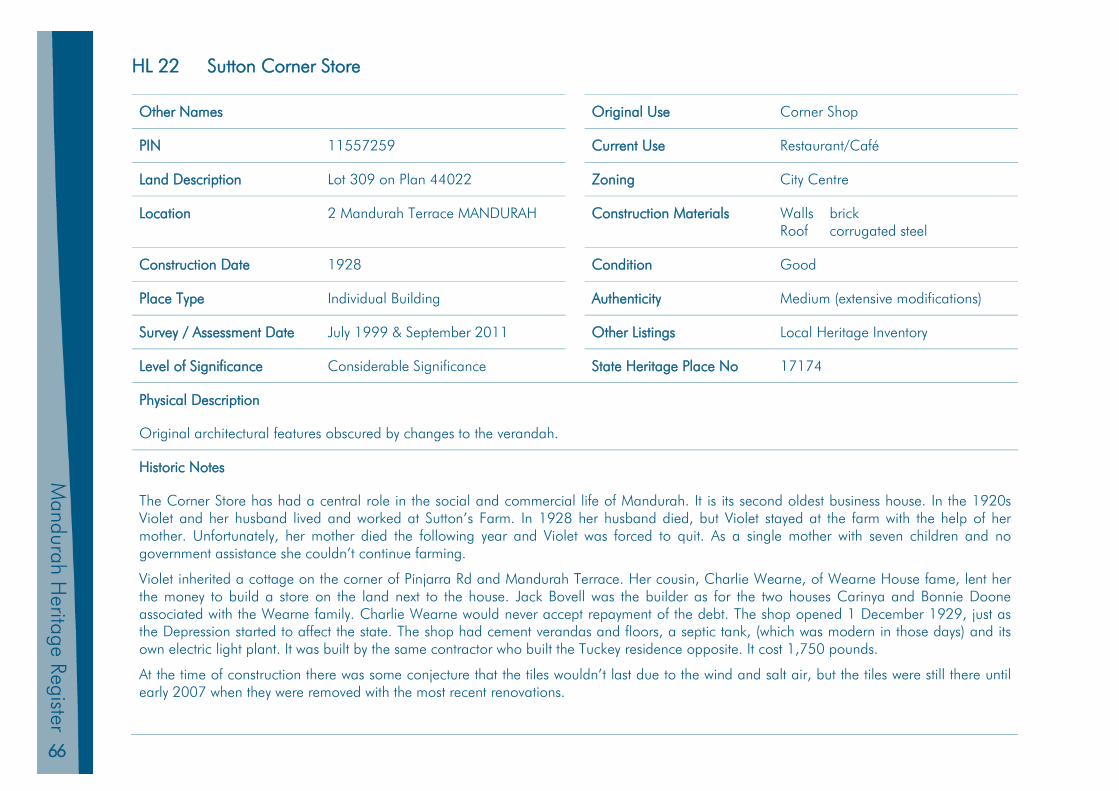
66
Mandurah H
eritage Register
HL 22 Sutton Corner Store
Other Names Original Use Corner Shop
PIN 11557259 Current Use Restaurant/Café
Land Description Lot 309 on Plan 44022 Zoning City Centre
Location 2 Mandurah Terrace MANDURAH Construction Materials Walls brick Roof corrugated steel
Construction Date 1928 Condition Good
Place Type Individual Building Authenticity Medium (extensive modifications)
Survey / Assessment Date July 1999 & September 2011 Other Listings Local Heritage Inventory
Level of Significance Considerable Significance State Heritage Place No 17174
Physical Description
Original architectural features obscured by changes to the verandah.
Historic Notes
The Corner Store has had a central role in the social and commercial life of Mandurah. It is its second oldest business house. In the 1920s Violet and her husband lived and worked at Sutton’s Farm. In 1928 her husband died, but Violet stayed at the farm with the help of her mother. Unfortunately, her mother died the following year and Violet was forced to quit. As a single mother with seven children and no government assistance she couldn’t continue farming.
Violet inherited a cottage on the corner of Pinjarra Rd and Mandurah Terrace. Her cousin, Charlie Wearne, of Wearne House fame, lent her the money to build a store on the land next to the house. Jack Bovell was the builder as for the two houses Carinya and Bonnie Doone associated with the Wearne family. Charlie Wearne would never accept repayment of the debt. The shop opened 1 December 1929, just as the Depression started to affect the state. The shop had cement verandas and floors, a septic tank, (which was modern in those days) and its own electric light plant. It was built by the same contractor who built the Tuckey residence opposite. It cost 1,750 pounds.
At the time of construction there was some conjecture that the tiles wouldn’t last due to the wind and salt air, but the tiles were still there until early 2007 when they were removed with the most recent renovations.
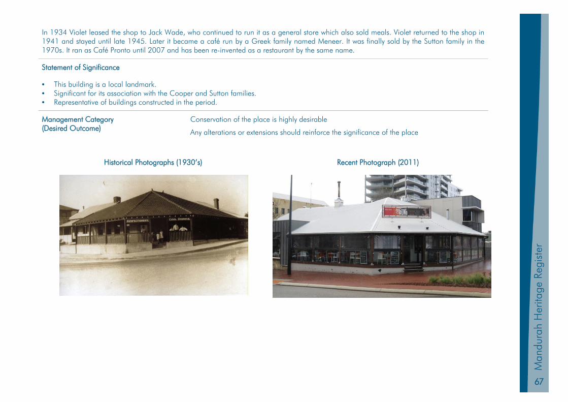
67
Man
dura
h Pl
anni
ng S
chem
e 20
11
Man
dura
h H
erita
ge R
egis
ter
In 1934 Violet leased the shop to Jack Wade, who continued to run it as a general store which also sold meals. Violet returned to the shop in 1941 and stayed until late 1945. Later it became a café run by a Greek family named Meneer. It was finally sold by the Sutton family in the 1970s. It ran as Café Pronto until 2007 and has been re-invented as a restaurant by the same name.
Statement of Significance
• This building is a local landmark. • Significant for its association with the Cooper and Sutton families. • Representative of buildings constructed in the period.
Management Category (Desired Outcome)
Conservation of the place is highly desirable
Any alterations or extensions should reinforce the significance of the place
Historical Photographs (1930’s) Recent Photograph (2011)
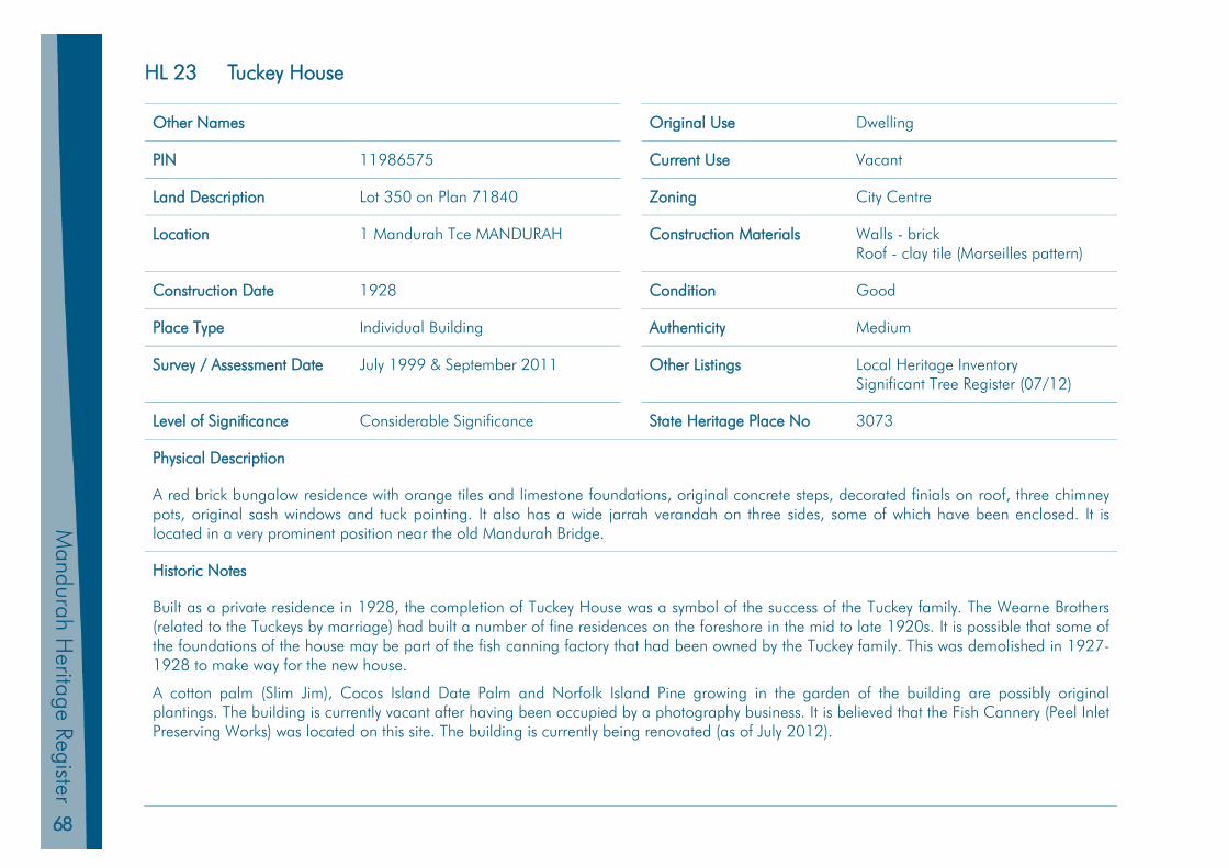
68
Mandurah H
eritage Register
HL 23 Tuckey House
Other Names Original Use Dwelling
PIN 11986575 Current Use Vacant
Land Description Lot 350 on Plan 71840 Zoning City Centre
Location 1 Mandurah Tce MANDURAH Construction Materials Walls - brick Roof - clay tile (Marseilles pattern)
Construction Date 1928 Condition Good
Place Type Individual Building Authenticity Medium
Survey / Assessment Date July 1999 & September 2011 Other Listings Local Heritage Inventory Significant Tree Register (07/12)
Level of Significance Considerable Significance State Heritage Place No 3073
Physical Description
A red brick bungalow residence with orange tiles and limestone foundations, original concrete steps, decorated finials on roof, three chimney pots, original sash windows and tuck pointing. It also has a wide jarrah verandah on three sides, some of which have been enclosed. It is located in a very prominent position near the old Mandurah Bridge.
Historic Notes
Built as a private residence in 1928, the completion of Tuckey House was a symbol of the success of the Tuckey family. The Wearne Brothers (related to the Tuckeys by marriage) had built a number of fine residences on the foreshore in the mid to late 1920s. It is possible that some of the foundations of the house may be part of the fish canning factory that had been owned by the Tuckey family. This was demolished in 1927-1928 to make way for the new house.
A cotton palm (Slim Jim), Cocos Island Date Palm and Norfolk Island Pine growing in the garden of the building are possibly original plantings. The building is currently vacant after having been occupied by a photography business. It is believed that the Fish Cannery (Peel Inlet Preserving Works) was located on this site. The building is currently being renovated (as of July 2012).
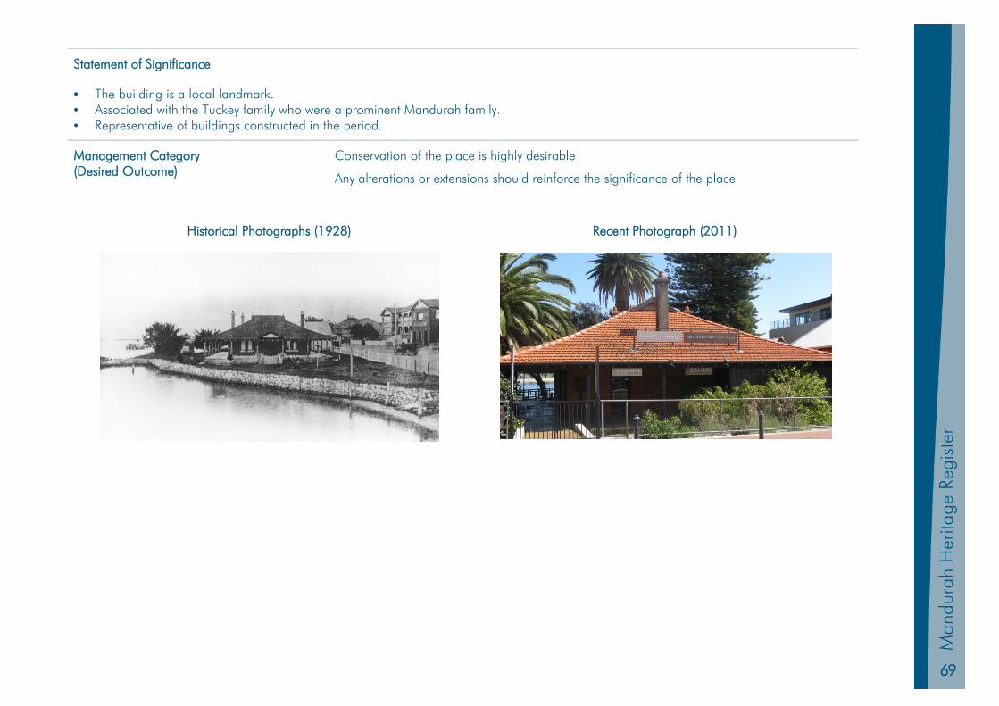
69
Man
dura
h Pl
anni
ng S
chem
e 20
11
Man
dura
h H
erita
ge R
egis
ter
Statement of Significance
• The building is a local landmark. • Associated with the Tuckey family who were a prominent Mandurah family. • Representative of buildings constructed in the period.
Management Category (Desired Outcome)
Conservation of the place is highly desirable
Any alterations or extensions should reinforce the significance of the place
Historical Photographs (1928) Recent Photograph (2011)

70
Mandurah H
eritage Register
HL 24 Tuckey Store
Other Names Original Use Fish Cannery
PIN 11986575 Current Use Retail Shops
Land Description Lot 350 on Plan 71840 Zoning City Centre
Location 5 Mandurah Tce MANDURAH Construction Materials Walls – Limestone Roof – Corrugated Steel
when re-roofed, sheoak shingles were found and judged to be over 100 years old
Construction Date circa 1880 Condition Good
Place Type Individual Building Authenticity Medium
Survey / Assessment Date July 1999 & September 2011 Other Listings Local Heritage Inventory
Level of Significance Considerable Significance State Heritage Place No 3073 & 24392
Physical Description
This building is comprised of two shopfronts with a traditional front entrance to each. There were several additions and alterations to the store over time. There are extensions and renovations at the rear of the building completed in 2013.
Historic Notes
The Tuckeys fished for their Peel Inlet Preserving Works (a fish and fruit cannery) when it was established in 1880. There was also a second storey (later demolished in 1927-1928) at the rear of the shop which was occupied by Charles and Emma Tuckey, and later Roy and Mavis Tuckey until Tuckey House was erected next door.
The portion of the factory which became a shop was the can store where boxes of canned fish awaited transportation to Fremantle.
For a short time from December 1926 Roy Tuckey had a petrol bowser in front of the store. Tuckey’s Store was a popular port of call for visitors to Mandurah and locals alike. Its conversion to a fishing tackle shop in the 1970s reflected the increasing specialisation of commercial enterprises with the advent of large supermarkets in Mandurah, and returned the shop to its origins in Mandurah’s fishing industry. Lloyd Tuckey advised that his father was requested to remove the verandahs at approximately the time when the Shire of Mandurah separated from the Shire of Murray. It currently houses two retail stores.
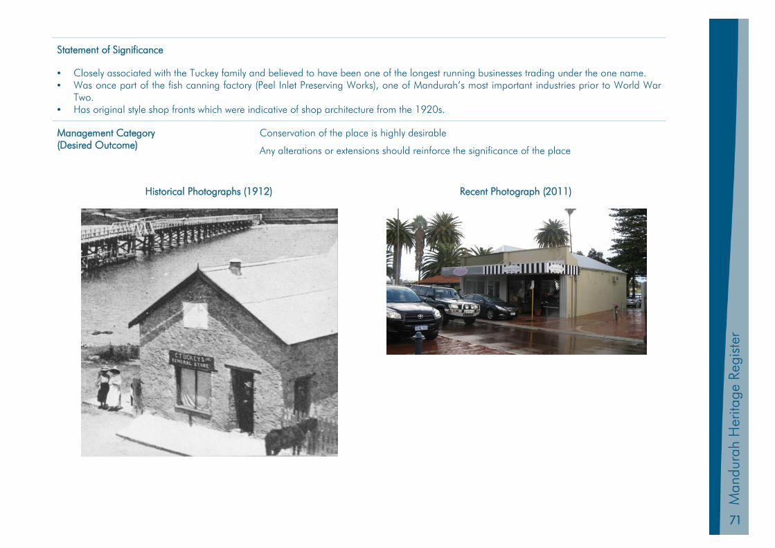
71
Man
dura
h Pl
anni
ng S
chem
e 20
11
Man
dura
h H
erita
ge R
egis
ter
Statement of Significance
• Closely associated with the Tuckey family and believed to have been one of the longest running businesses trading under the one name. • Was once part of the fish canning factory (Peel Inlet Preserving Works), one of Mandurah’s most important industries prior to World War
Two. • Has original style shop fronts which were indicative of shop architecture from the 1920s.
Management Category (Desired Outcome)
Conservation of the place is highly desirable
Any alterations or extensions should reinforce the significance of the place
Historical Photographs (1912) Recent Photograph (2011)
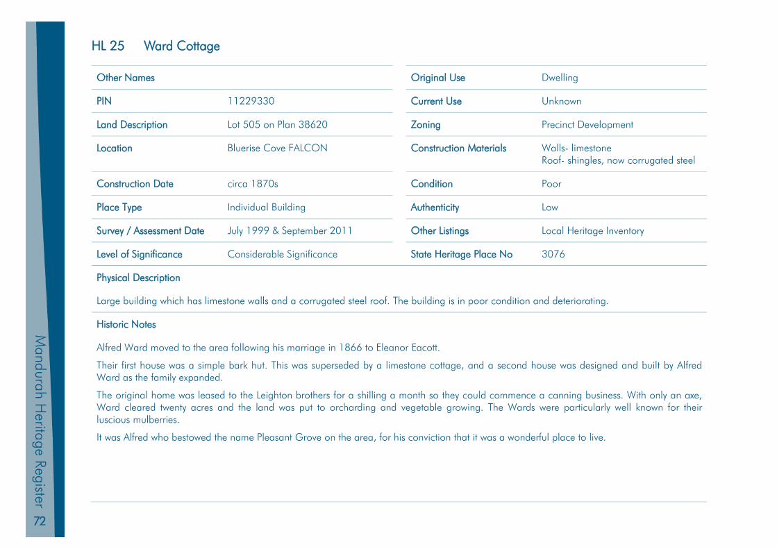
72
Mandurah H
eritage Register
HL 25 Ward Cottage
Other Names Original Use Dwelling
PIN 11229330 Current Use Unknown
Land Description Lot 505 on Plan 38620 Zoning Precinct Development
Location Bluerise Cove FALCON Construction Materials Walls- limestone Roof- shingles, now corrugated steel
Construction Date circa 1870s Condition Poor
Place Type Individual Building Authenticity Low
Survey / Assessment Date July 1999 & September 2011 Other Listings Local Heritage Inventory
Level of Significance Considerable Significance State Heritage Place No 3076
Physical Description
Large building which has limestone walls and a corrugated steel roof. The building is in poor condition and deteriorating.
Historic Notes
Alfred Ward moved to the area following his marriage in 1866 to Eleanor Eacott.
Their first house was a simple bark hut. This was superseded by a limestone cottage, and a second house was designed and built by Alfred Ward as the family expanded.
The original home was leased to the Leighton brothers for a shilling a month so they could commence a canning business. With only an axe, Ward cleared twenty acres and the land was put to orcharding and vegetable growing. The Wards were particularly well known for their luscious mulberries.
It was Alfred who bestowed the name Pleasant Grove on the area, for his conviction that it was a wonderful place to live.
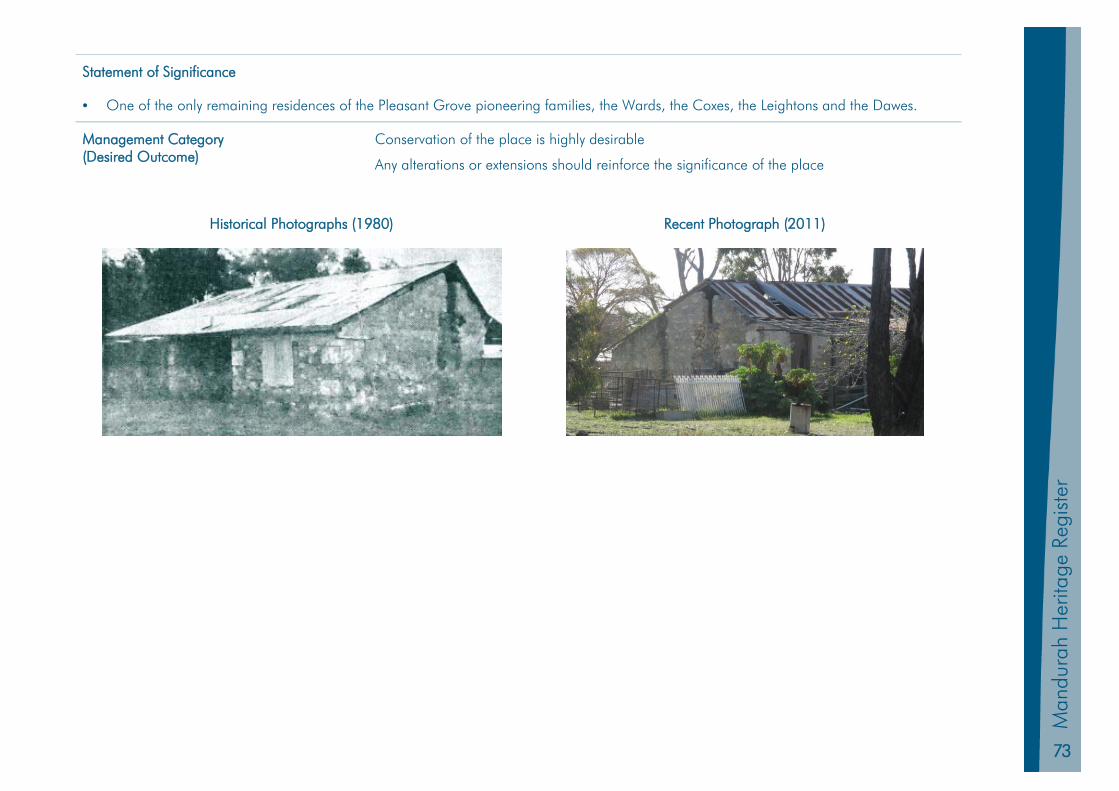
73
Man
dura
h Pl
anni
ng S
chem
e 20
11
Man
dura
h H
erita
ge R
egis
ter
Statement of Significance
• One of the only remaining residences of the Pleasant Grove pioneering families, the Wards, the Coxes, the Leightons and the Dawes.
Management Category (Desired Outcome)
Conservation of the place is highly desirable
Any alterations or extensions should reinforce the significance of the place
Historical Photographs (1980) Recent Photograph (2011)

75
Man
dura
h Pl
anni
ng S
chem
e 20
11
Man
dura
h H
erita
ge R
egis
ter
Mandurah Heritage Register
Part 4 Heritage Inventory Place Records
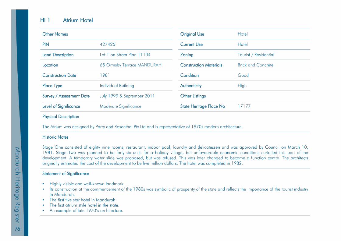
76
Mandurah H
eritage Register
HI 1 Atrium Hotel
Other Names Original Use Hotel
PIN 427425 Current Use Hotel
Land Description Lot 1 on Strata Plan 11104 Zoning Tourist / Residential
Location 65 Ormsby Terrace MANDURAH Construction Materials Brick and Concrete
Construction Date 1981 Condition Good
Place Type Individual Building Authenticity High
Survey / Assessment Date July 1999 & September 2011 Other Listings
Level of Significance Moderate Significance State Heritage Place No 17177
Physical Description
The Atrium was designed by Parry and Rosenthal Pty Ltd and is representative of 1970s modern architecture.
Historic Notes
Stage One consisted of eighty nine rooms, restaurant, indoor pool, laundry and delicatessen and was approved by Council on March 10, 1981. Stage Two was planned to be forty six units for a holiday village, but unfavourable economic conditions curtailed this part of the development. A temporary water slide was proposed, but was refused. This was later changed to become a function centre. The architects originally estimated the cost of the development to be five million dollars. The hotel was completed in 1982.
Statement of Significance
• Highly visible and well-known landmark. • Its construction at the commencement of the 1980s was symbolic of prosperity of the state and reflects the importance of the tourist industry
in Mandurah. • The first five star hotel in Mandurah. • The first atrium style hotel in the state. • An example of late 1970’s architecture.
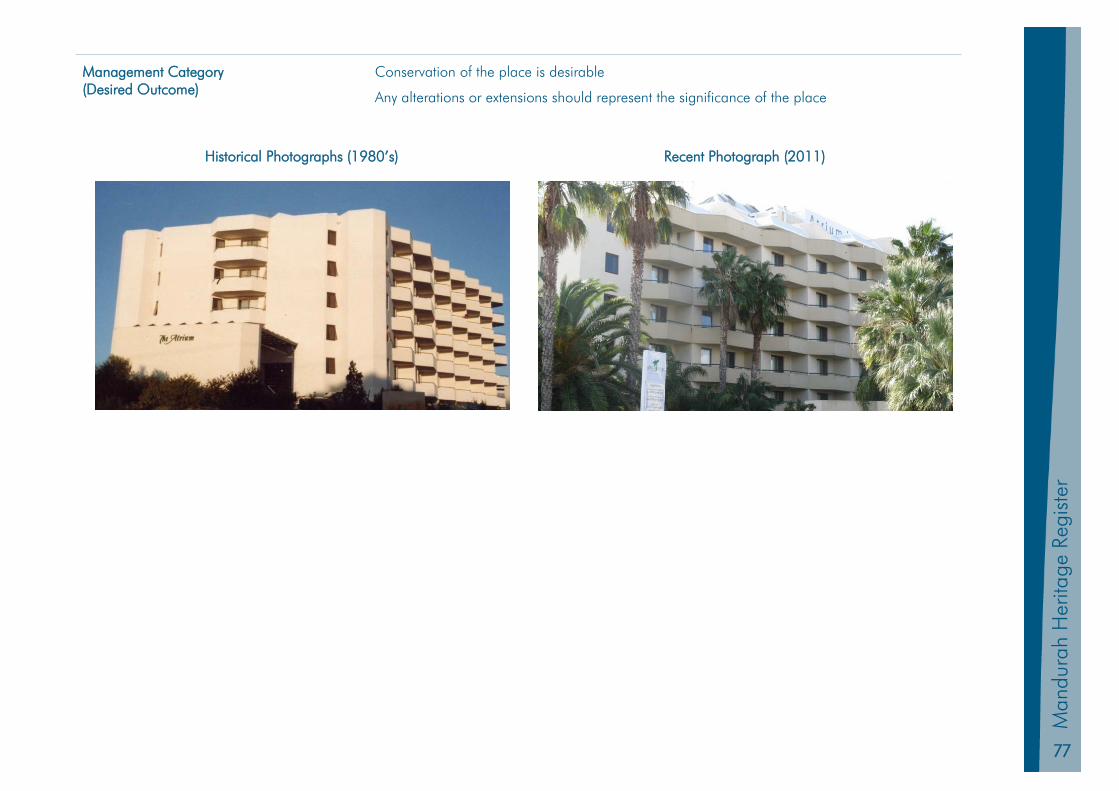
77
Man
dura
h Pl
anni
ng S
chem
e 20
11
Man
dura
h H
erita
ge R
egis
ter
Management Category (Desired Outcome)
Conservation of the place is desirable
Any alterations or extensions should represent the significance of the place
Historical Photographs (1980’s) Recent Photograph (2011)

78
Mandurah H
eritage Register
HI 2 Bonnie Doone Residence
Other Names Original Use Dwelling
PIN 1081669 Current Use Dwelling (Relocated)
Land Description Lot 567 on Plan X (existing) Lot 100 (Strata Plan 28137) (original)
Zoning Residential
Location 3 Lyndhurst Pl GREENFIELDS (exist) 3 Leslie St MANDURAH (original)
Construction Materials Walls- brick Roof- clay tiles
Construction Date 1928 Relocated 1995
Condition Good
Place Type Individual Building Authenticity Verification Required
Survey / Assessment Date July 1999 & September 2011 Other Listings
Level of Significance Some Significance State Heritage Place No N/A
Physical Description
Removed from original site that is now occupied by units. The rebuilt house is in the Federation vernacular style and appears to have retained certain features from the original building.
Historic Notes
Associated with the Wearne brothers, who established the famous Singapore-based car dealership in 1906.
Bonnie Doone (and Wearne House) was built on land acquired from the Wearnes’ aunt Ellen Cooper (nee Tuckey).
Built by Jack Bovell for Theodore Wearne (son of John and Matilda Wearne [nee Tuckey] on 1.5 acres of waterfront land in 1928. His brother, Charles, owned the house next door (Wearne House). The house was later sold to the noted water colour artist, Winifred Sparkes.
In 1950 it was bought by then Brighton Hotel owner, Thornton Chivers. Part of the home and its contents were destroyed by fire in 1984.
An attempt to auction the residence in 1990 failed. The Mandurah Historical Society attempted to prevent the demolition of Bonnie Doone, which it considered a highly significant building, but its application came too late to prevent it making way for twenty nine townhouses. The house was, however, rebuilt by private owners on a site in Greenfields.
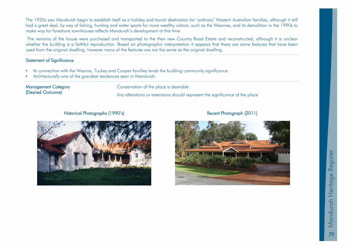
79
Man
dura
h Pl
anni
ng S
chem
e 20
11
Man
dura
h H
erita
ge R
egis
ter
The 1920s saw Mandurah begin to establish itself as a holiday and tourist destination for ‘ordinary’ Western Australian families, although it still had a great deal, by way of fishing, hunting and water sports for more wealthy visitors, such as the Wearnes, and its demolition in the 1990s to make way for foreshore townhouses reflects Mandurah’s development at this time.
The remains of the house were purchased and transported to the then new Country Road Estate and reconstructed, although it is unclear whether the building is a faithful reproduction. Based on photographic interpretation it appears that there are some features that have been used from the original dwelling, however many of the features are not the same as the original dwelling.
Statement of Significance
• Its connection with the Wearne, Tuckey and Cooper families lends the building community significance. • Architecturally one of the grandest residences seen in Mandurah.
Management Category (Desired Outcome)
Conservation of the place is desirable
Any alterations or extensions should represent the significance of the place
Historical Photographs (1990’s) Recent Photograph (2011)

80
Mandurah H
eritage Register
HI 3 Mandurah Traffic Bridge
Other Names Old Mandurah Bridge Original Use Bridge
PIN N/A Current Use Bridge
Land Description Unallocated Crown Land Zoning N/A
Location Connection between Pinjarra Road and Old Coast Road MANDURAH
Construction Materials Timber, Concrete
Construction Date 1950 – 1953 Condition Poor
Place Type Road Infrastructure Authenticity High
Survey / Assessment Date July 1999 & September 2011 Other Listings
Level of Significance Moderate Significance State Heritage Place No 9083
Physical Description
The bridge is 184 metres long and 6.7 metres wide, and the concrete piles used in construction are each 18.3 metres long weigh 10.1 tonnes. Two laneways (one for north and one for southbound traffic) exist for traffic and a footway two metres wide for pedestrians and cyclists. Steps lead down from the footway to give access to the fishing platforms. The bridge was constructed with a vertical curve so clearance from the waterline to the span girders allowed for marine traffic.
Historic Notes
This bridge replaced the previous (and first) bridge which was built across the neck of the Peel Inlet in 1894.
Planning for a replacement bridge had commenced soon after the end of World War Two by the State Government under the then Premier Sir Ross McLarty. The new bridge would have to be capable of handling the increased traffic flows expected after the improvement of Mandurah Road. McLarty, whose electorate encompassed Mandurah, made transport infrastructure one of his government’s main priorities. The design of the new structure focused on avoiding the possibility of toredo worm damage that had sealed its predecessor’s fate.
To this end, the piles were made entirely from reinforced concrete. As an economic measure, the remainder of the bridge structure was to be of jarrah, with the exception of the two navigation spans which utilised rolled steel joints to support the timber decking above. The concrete component of the construction amounted to twenty one ‘bays’ with twenty five feet between each pile. Demountable Bailey Bridge sections were used during construction. This was a new technique for the time developed from transportable bridges used in World War Two. This method
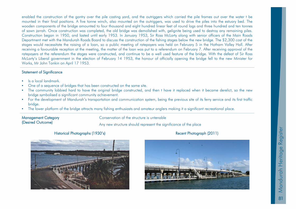
81
Man
dura
h Pl
anni
ng S
chem
e 20
11
Man
dura
h H
erita
ge R
egis
ter
enabled the construction of the gantry over the pile casting yard, and the outriggers which carried the pile frames out over the water t be mounted in their final positions. A five tonne winch, also mounted on the outriggers, was used to drive the piles into the estuary bed. The wooden components of the bridge amounted to four thousand and eight hundred linear feet of round logs and three hundred and ten tonnes of sawn jarrah. Once construction was completed, the old bridge was demolished with, gelignite being used to destroy any remaining piles. Construction began in 1950, and lasted until early 1953. In January 1953, Sir Ross McLarty along with senior officers of the Main Roads Department met with the Mandurah Roads Board to discuss the construction of the fishing stages below the new bridge. The $2,300 cost of the stages would necessitate the raising of a loan, so a public meeting of ratepayers was held on February 5 in the Hotham Valley Hall. After receiving a favourable reception at the meeting, the matter of the loan was put to a referendum on February 7. After receiving approval of the ratepayers at the referendum the stages were constructed, and continue to be a well used feature of the bridge. With the defeat of Sir Ross McLarty’s Liberal government in the election of February 14 1953, the honour of officially opening the bridge fell to the new Minister for Works, Mr John Tonkin on April 17 1953.
Statement of Significance
• Is a local landmark. • One of a sequence of bridges that has been constructed on the same site. • The community lobbied hard to have the original bridge constructed, and then t have it replaced when it became derelict, so the new
bridge symbolised a significant community achievement. • For the development of Mandurah’s transportation and communication system, being the previous site of its ferry service and its first traffic
bridge. • The lower platform of the bridge attracts many fishing enthusiasts and amateur anglers making it a significant recreational place.
Management Category (Desired Outcome)
Conservation of the structure is untenable
Any new structure should represent the significance of the place
Historical Photographs (1930’s) Recent Photograph (2011)
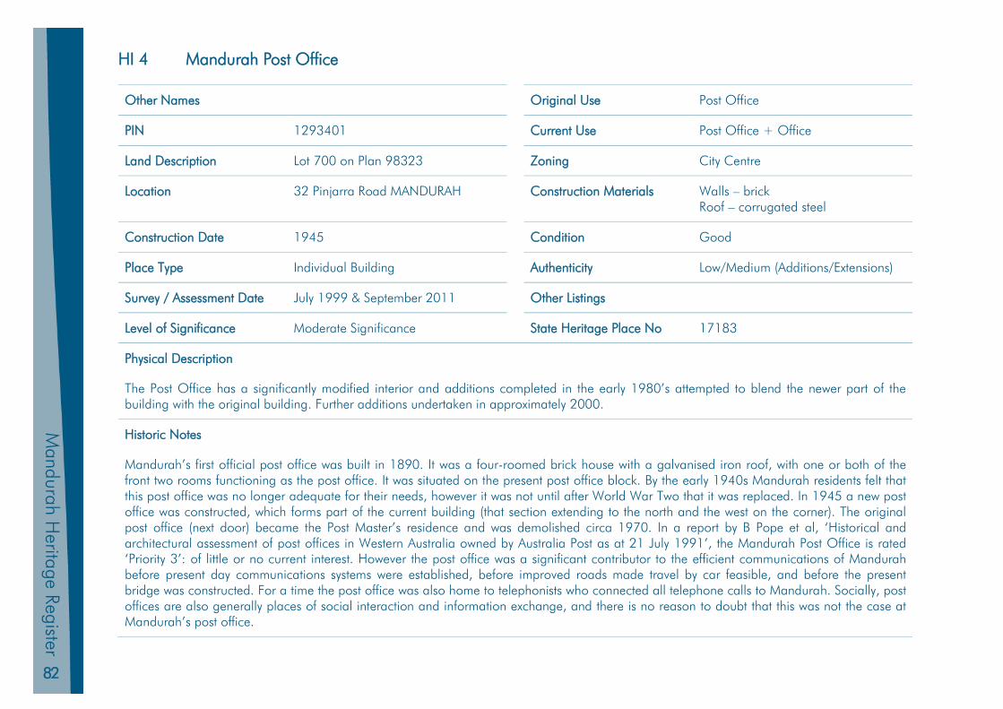
82
Mandurah H
eritage Register
HI 4 Mandurah Post Office
Other Names Original Use Post Office
PIN 1293401 Current Use Post Office + Office
Land Description Lot 700 on Plan 98323 Zoning City Centre
Location 32 Pinjarra Road MANDURAH Construction Materials Walls – brick Roof – corrugated steel
Construction Date 1945 Condition Good
Place Type Individual Building Authenticity Low/Medium (Additions/Extensions)
Survey / Assessment Date July 1999 & September 2011 Other Listings
Level of Significance Moderate Significance State Heritage Place No 17183
Physical Description
The Post Office has a significantly modified interior and additions completed in the early 1980’s attempted to blend the newer part of the building with the original building. Further additions undertaken in approximately 2000.
Historic Notes
Mandurah’s first official post office was built in 1890. It was a four-roomed brick house with a galvanised iron roof, with one or both of the front two rooms functioning as the post office. It was situated on the present post office block. By the early 1940s Mandurah residents felt that this post office was no longer adequate for their needs, however it was not until after World War Two that it was replaced. In 1945 a new post office was constructed, which forms part of the current building (that section extending to the north and the west on the corner). The original post office (next door) became the Post Master’s residence and was demolished circa 1970. In a report by B Pope et al, ‘Historical and architectural assessment of post offices in Western Australia owned by Australia Post as at 21 July 1991’, the Mandurah Post Office is rated ‘Priority 3’: of little or no current interest. However the post office was a significant contributor to the efficient communications of Mandurah before present day communications systems were established, before improved roads made travel by car feasible, and before the present bridge was constructed. For a time the post office was also home to telephonists who connected all telephone calls to Mandurah. Socially, post offices are also generally places of social interaction and information exchange, and there is no reason to doubt that this was not the case at Mandurah’s post office.
83
Man
dura
h Pl
anni
ng S
chem
e 20
11
Man
dura
h H
erita
ge R
egis
ter
Statement of Significance
• Significant point of communication between residents and businesses located in Mandurah and the outside world. • Significant meeting place of local residents.
Management Category (Desired Outcome)
Conservation of the place is desirable
Any alterations or extensions should represent the significance of the place
Historical Photographs (1945) Recent Photograph (2011)
84
Mandurah H
eritage Register
HI 5 Manduah Performing Arts Centre
Other Names Original Use Performing Arts Centre
PIN 11454336 Current Use Performing Arts Centre
Land Description Reserve 42050 Zoning City Centre
Location 9 James Service Place MANDURAH Construction Materials Precast Concrete Panels, Glass and Steel
Construction Date 1996 Condition Good
Place Type Individual Building Authenticity High
Survey / Assessment Date July 1999 & September 2011 Other Listings
Level of Significance Moderate Significance State Heritage Place No 17180
Physical Description
A large glass and steel structure this performing arts centre has two theatres an art gallery and a restaurant. Its foyer overlooks Mandjar Bay.
Historic Notes
Designed by Hames Sharley the Mandurah Performing Arts Centre received the Civic Design Award in 1997.
Statement of Significance
• A landmark in Mandurah. • Venue for social and cultural events. • A good example of 1990s modern architecture.
Management Category (Desired Outcome)
Conservation of the place is desirable
Any alterations or extensions should represent the significance of the place

85
Man
dura
h Pl
anni
ng S
chem
e 20
11
Man
dura
h H
erita
ge R
egis
ter
Recent Photograph (2011)

86
Mandurah H
eritage Register
HI 6 Peel Memorial Well
Other Names Original Use Wishing Well
PIN N/A Current Use Monument
Land Description Road Reserve (Pinjarra Road) Zoning N/A
Location Cnr Mandurah Tce & Pinjarra Rd Construction Materials Stone
Construction Date 1955 Condition Good
Place Type Individual Structure Authenticity High
Survey / Assessment Date July 1999 & September 2011 Other Listings
Level of Significance Moderate Significance State Heritage Place No 3072
Physical Description
The well overlooks the Peel Estuary at the eastern end of the Mandurah Traffic Bridge. The well has been covered by an iron disk, which indicates distances to international capitals and Australian towns and cities. The well is surrounded by paving and is constructed from stones including granite and dolomite.
Historic Notes
Erected by Mandurah Progress Association and funded by public subscriptions, the well commemorates the arrival in 1829 of Thomas Peel and his pioneer settlers, who arrived on the Gilmore (1829), the Hooghly (1830) and the Rockingham (1830).
Peel was an influential figure pushing for the establishment of the Swan River Colony, and his name is indelibly linked with both the Murray and Mandurah districts. He was a key person in the foundation of Mandurah, having originally controlled much of the land in the Murray District.
Financed by a merchant and ex convict from New South Wales, Solomon Levey, he brought out a number of skilled workmen to the Colony. Peel and his son, Thomas Junior, leased and farmed land between Mandurah and Serpentine. A controversial character, Thomas Peel had many critics but his strong and independent personality dominated the Mandurah region in its first 35 years. He died on 21 December 1865.
The Peel Memorial well was unveiled by Minister for Tourism Lionel F Kelly, on 11 December 1955. Its contents were donated to charity each year until it was covered with a disk and became a monument, rather than a wishing well.
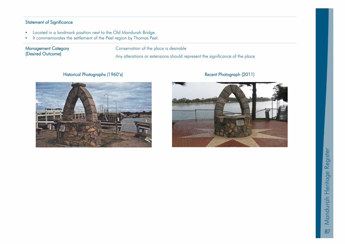
87
Man
dura
h Pl
anni
ng S
chem
e 20
11
Man
dura
h H
erita
ge R
egis
ter
Statement of Significance
• Located in a landmark position next to the Old Mandurah Bridge. • It commemorates the settlement of the Peel region by Thomas Peel.
Management Category (Desired Outcome)
Conservation of the place is desirable
Any alterations or extensions should represent the significance of the place
Historical Photographs (1960’s) Recent Photograph (2011)
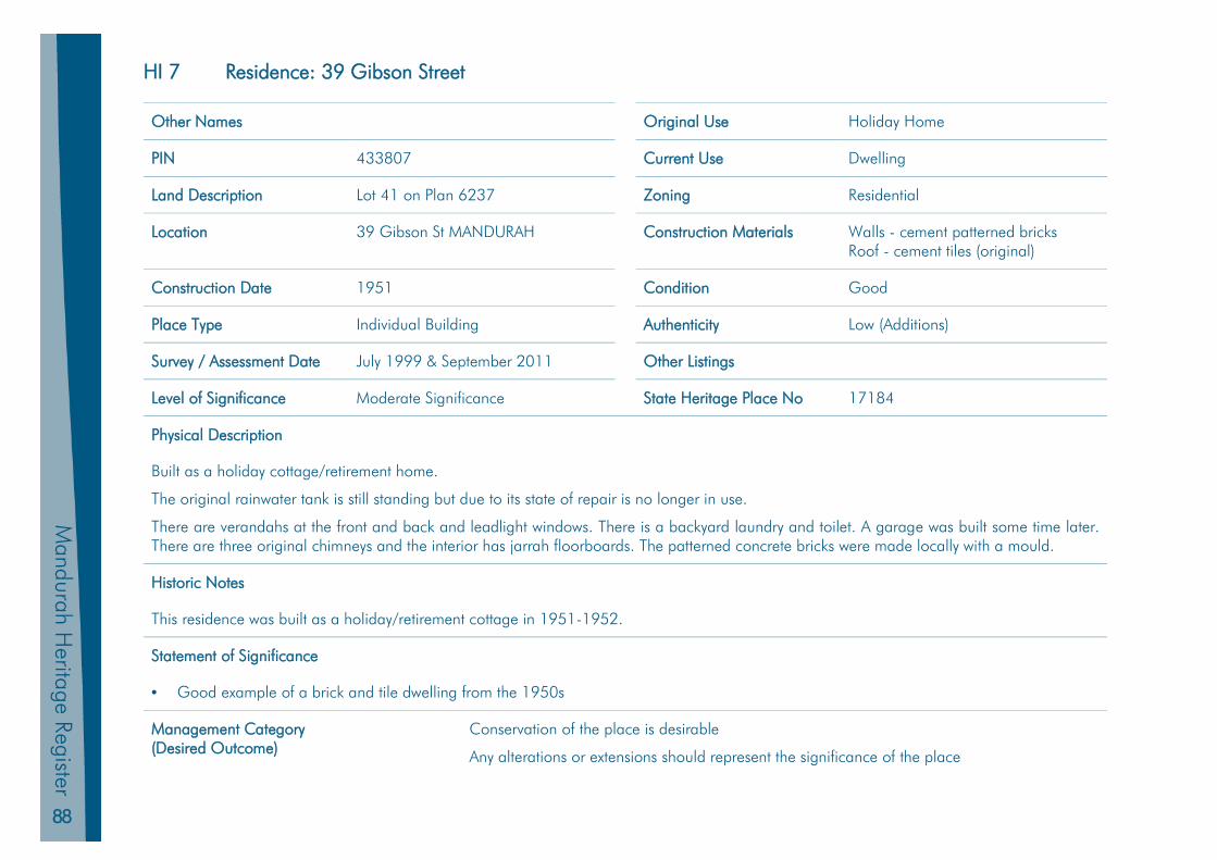
88
Mandurah H
eritage Register
HI 7 Residence: 39 Gibson Street
Other Names Original Use Holiday Home
PIN 433807 Current Use Dwelling
Land Description Lot 41 on Plan 6237 Zoning Residential
Location 39 Gibson St MANDURAH Construction Materials Walls - cement patterned bricks Roof - cement tiles (original)
Construction Date 1951 Condition Good
Place Type Individual Building Authenticity Low (Additions)
Survey / Assessment Date July 1999 & September 2011 Other Listings
Level of Significance Moderate Significance State Heritage Place No 17184
Physical Description
Built as a holiday cottage/retirement home.
The original rainwater tank is still standing but due to its state of repair is no longer in use.
There are verandahs at the front and back and leadlight windows. There is a backyard laundry and toilet. A garage was built some time later. There are three original chimneys and the interior has jarrah floorboards. The patterned concrete bricks were made locally with a mould.
Historic Notes
This residence was built as a holiday/retirement cottage in 1951-1952.
Statement of Significance
• Good example of a brick and tile dwelling from the 1950s
Management Category (Desired Outcome)
Conservation of the place is desirable
Any alterations or extensions should represent the significance of the place
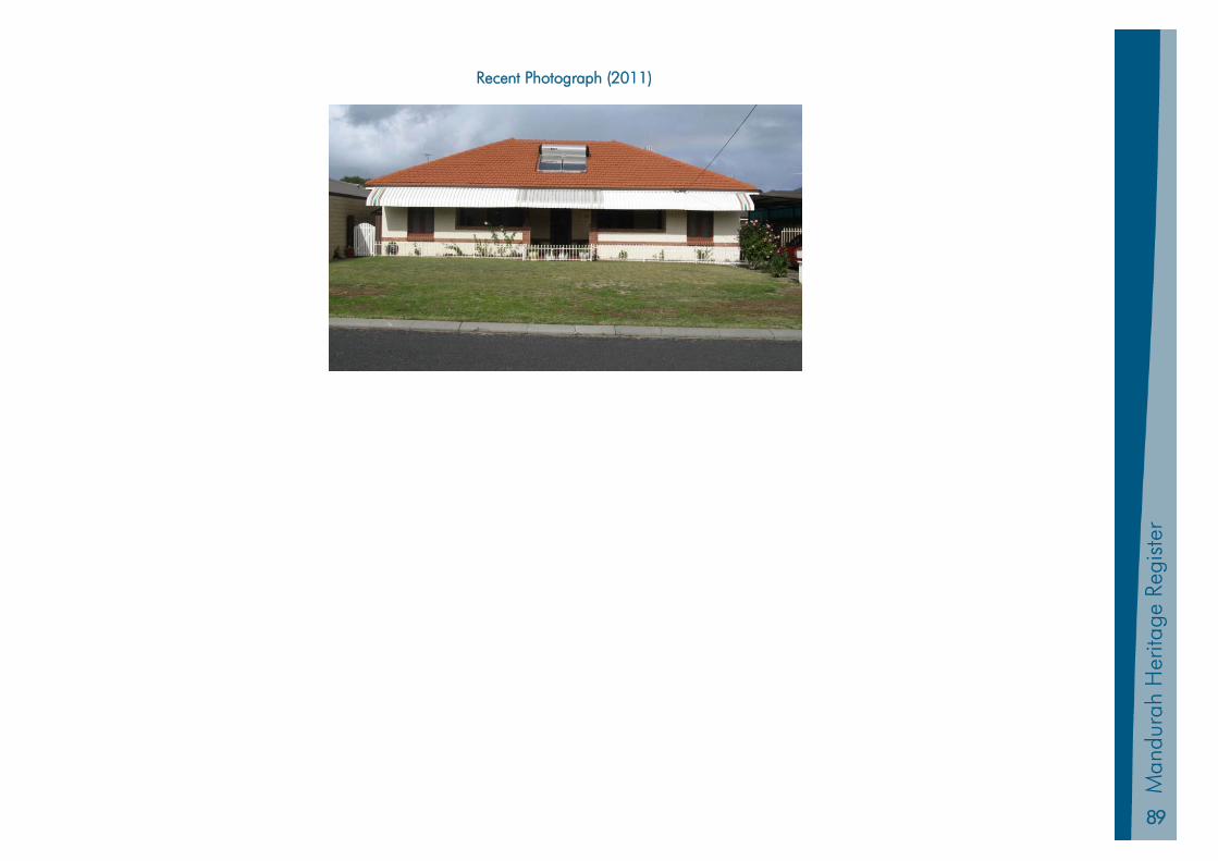
89
Man
dura
h Pl
anni
ng S
chem
e 20
11
Man
dura
h H
erita
ge R
egis
ter
Recent Photograph (2011)
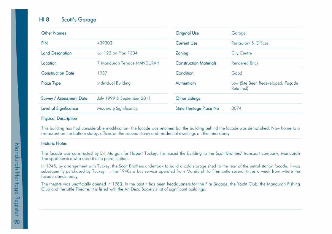
90
Mandurah H
eritage Register
HI 8 Scott’s Garage
Other Names Original Use Garage
PIN 439303 Current Use Restaurant & Offices
Land Description Lot 123 on Plan 1334 Zoning City Centre
Location 7 Mandurah Terrace MANDURAH Construction Materials Rendered Brick
Construction Date 1937 Condition Good
Place Type Individual Building Authenticity Low (Site Been Redeveloped; Façade Retained)
Survey / Assessment Date July 1999 & September 2011 Other Listings
Level of Significance Moderate Significance State Heritage Place No 3074
Physical Description
This building has had considerable modification- the facade was retained but the building behind the facade was demolished. Now home to a restaurant on the bottom storey, offices on the second storey and residential dwellings on the third storey.
Historic Notes
The facade was constructed by Bill Morgan for Hobart Tuckey. He leased the building to the Scott Brothers’ transport company, Mandurah Transport Service who used it as a petrol station.
In 1945, by arrangement with Tuckey, the Scott Brothers undertook to build a cold storage shed to the rear of the petrol station facade. It was subsequently purchased by Tuckey. In the 1940s a bus service operated from Mandurah to Fremantle several times a week from where the facade stands today.
The theatre was unofficially opened in 1983. In the past it has been headquarters for the Fire Brigade, the Yacht Club, the Mandurah Fishing Club and the Little Theatre. It is listed with the Art Deco Society’s list of significant buildings.
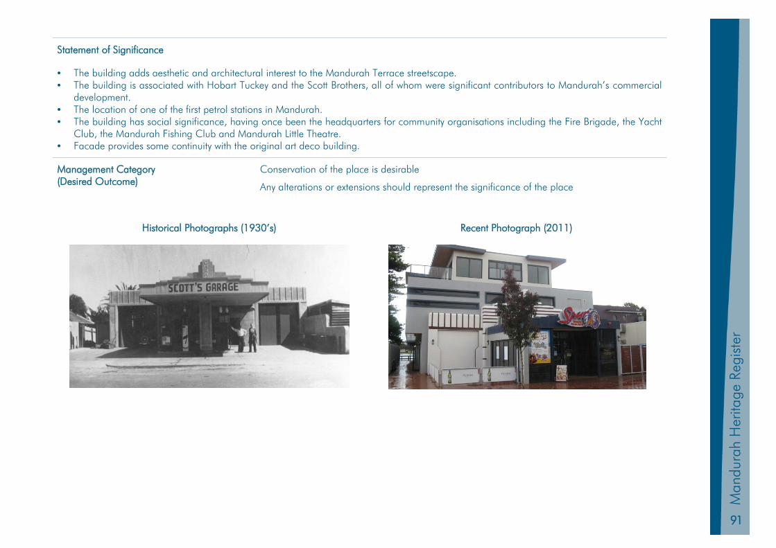
91
Man
dura
h Pl
anni
ng S
chem
e 20
11
Man
dura
h H
erita
ge R
egis
ter
Statement of Significance
• The building adds aesthetic and architectural interest to the Mandurah Terrace streetscape. • The building is associated with Hobart Tuckey and the Scott Brothers, all of whom were significant contributors to Mandurah’s commercial
development. • The location of one of the first petrol stations in Mandurah. • The building has social significance, having once been the headquarters for community organisations including the Fire Brigade, the Yacht
Club, the Mandurah Fishing Club and Mandurah Little Theatre. • Facade provides some continuity with the original art deco building.
Management Category (Desired Outcome)
Conservation of the place is desirable
Any alterations or extensions should represent the significance of the place
Historical Photographs (1930’s) Recent Photograph (2011)

92
Mandurah H
eritage Register
HI 9 Wearne House
Other Names Original Use Holiday Home
PIN 439269 Current Use Aged Persons Village
Land Description Lot 17 on Plan 68177 Zoning Residential
Location 7 Leslie St MANDURAH Construction Materials Unknown
Construction Date 1926 Condition Good
Place Type Individual Building Authenticity Medium
Survey / Assessment Date July 1999 & September 2011 Other Listings
Level of Significance Moderate Significance State Heritage Place No N/A
Physical Description
Extensive additions and changes have been made over the years, with the original building being located within the centre of the complex. A photographic interpretation suggests that very little of the original building is visible from the exterior.
Historic Notes
Wearne House (or ‘Carinya’) was built originally as a holiday home by Charles Wearne. Shacks owned by the pioneering Cooper family stood on the original site, with a few fishermen’s cottages close by. The Wearne family, had moved to Mandurah in the 1890s from Victoria, and then moved to Perth. Matilda Tuckey met John Wearne when her family went to the Victorian goldfields. They subsequently married, and their sons, Charles and Theodore (who in 1928 built Bonnie Doone next door) went on to form Wearne Brothers, the famous Singapore based motor company. Charles became the engineer in charge of dredging Fremantle Harbour and Albany’s Princess Royal Harbour.
The house was designed by Allan & Nicholas architects in Fremantle to specific requests by Charles. Included was to be deep sewerage, water to bedrooms and a veranda circling the house. Jack Bovell was engaged to complete this work. This engagement was to prove significant for Bovell as he went on to build a further cottage for caretakers, boat shed and jetty, following that he was engaged to build Bonnie Doone for Theo and also the corner shop for Violet Sutton. Charlie and Sue first spent time in Wearne House, early in 1927.
Wearne House was donated to the Anglican Church in 1957 by Mrs Q.S.W. Angus, a member of the Wearne family.
After extensive renovations and extensions were made the home became a centre for the aged, and was officially opened in 1968.

93
Man
dura
h Pl
anni
ng S
chem
e 20
11
Man
dura
h H
erita
ge R
egis
ter
Subsequent redevelopments were also undertaken in the 1980s and 1990s. Wearne House (and Bonnie Doone) were built on land acquired from the Wearne’s’ Aunt Ellen Cooper (nee Tuckey).
Although holiday homes, Wearne House and Bonnie Doone were architecturally the grandest residences seen in Mandurah, and Wearne House had the town’s first septic tank installed. The 1920s saw Mandurah begin to establish itself as a holiday and tourist destination for ‘ordinary’ Western Australian families, although it still had a great deal, by way of fishing, hunting and water sports for more wealthy visitors, such as the Wearnes.
Statement of Significance
• The site was associated with the pioneering Mandurah families, the Wearne, Tuckey and Cooper families. • The original building is representative of Mandurah as a holiday destination.
Management Category (Desired Outcome)
Conservation of the place is desirable
Any alterations or extensions should represent the significance of the place
Historical Photographs (1930’s) Recent Photograph (2011)
94
Mandurah H
eritage Register
HI 10 Barragup Fish Mungah
Other Names Original Use Fish Trap
PIN Current Use River (Destroyed)
Land Description N/A Zoning Regional Open Space / Waterways
Location Serpentine River Upstream from Serpentine Bridge
Construction Materials Timber
Place Type Natural Feature Authenticity N/A
Survey / Assessment Date July 1999 & September 2011 Other Listings RAMSAR Wetland
Level of Significance Considerable Significance State Heritage Place No 9017
Physical Description
The Barragup Fish Mungah was a fish trap used by local Nyungar people to catch fish. It was in regular use during the 19th century and probably used prior to this by the local people.
Historic Notes
The mungah would have provided considerable numbers of fish and potentially would have been a meeting place for legal, social and ceremonial activities. It became a source of tension between Aboriginal people and white fishermen during the 1890’s with local fishermen and fisheries inspectors claiming that it was leading to a decline in fish numbers.
The mungah was destroyed at least 3 times and rebuilt and in 1897 a number of local Aborigines lodged a complaint with Governor Smith who was visiting Mandurah.
At times the mungah was used by European fishermen and Charles Tuckey reported to a Joint Select Committee that he had secured 10000 tins from that source in 6 weeks in 1896. The mungah was destroyed by a Marine and Harbours snagging operation in 1937.
A team of divers from the Western Australia Museum found that the bottom of the Serpentine River had been cleared of any structures related to the mungah.
Statement of Significance
• Site of a fish trap that would have been an important source of food for the local Nyungar people.
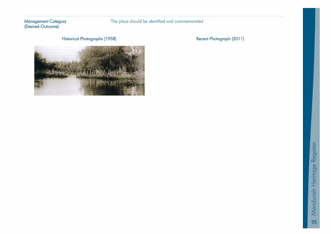
95
Man
dura
h Pl
anni
ng S
chem
e 20
11
Man
dura
h H
erita
ge R
egis
ter
Management Category (Desired Outcome)
The place should be identified and commemorated
Historical Photographs (1958) Recent Photograph (2011)
96
Mandurah H
eritage Register
HI 11 Creery Wetlands
Other Names Original Use Reserve
PIN Current Use Reserve
Land Description Reserve 46661 Zoning Regional Open Space / Waterways
Location Mandurah Road DUDLEY PARK Construction Materials N/A
Place Type Natural Feature Authenticity N/A
Survey / Assessment Date July 1999 & September 2011 Other Listings RAMSAR Wetland
Level of Significance Considerable Significance State Heritage Place No 9087
Physical Description
The wetlands contain 13 per cent of the tidal samphire wetland in the Peel Harvey Estuary. It is managed by the Department of Parks and Wildlife.
Historic Notes
The Creery Wetlands are remnants of a once extensive wetlands system which supported the Aboriginal way of life. The area contains many Aboriginal sites including a mass grave of local Aboriginals who died from disease (probably measles) in the 1860s.
The wetlands in the Mandurah region are extremely diversified and range from those of international importance to those that have been severely modified. Wetlands provide the community with opportunities for recreation, education and nature study, and also contribute to amenity through views, landscape and nature interaction.
The Creery Wetlands provide a unique and vital habitat for local fauna and flora, but land uses in the Mandurah region have reduced the quality and number of wetlands on the Swan Coastal Plain, with two thirds of the wetlands destroyed or degraded due to human activity and development. Native animals depend on permanent water to survive summer drought, and the wetlands plant communities provide a range of habitats for aquatic and terrestrial fauna. Creery’s fringe vegetation of tuart, jarrah and redgum is particularly important for stabilising and aerating the soil and for filtering material passing into the wetland. It also serves as a buffer between adjacent residential development.
The Creery Wetlands are the primary feeding ground in the Peel-Harvey Region for the largest population of water birds in South-Western Australia. Australia is a signatory to the Ramsar Convention (1971), which obliges it to conserve wetlands and waterfowls within its territory by establishing nature reserves in wetlands and managing them effectively. The wetlands are very important breeding grounds for migratory birds
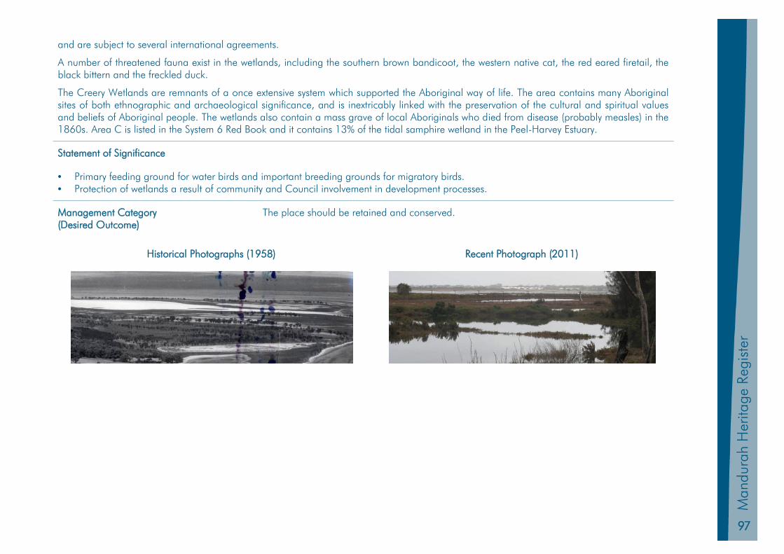
97
Man
dura
h Pl
anni
ng S
chem
e 20
11
Man
dura
h H
erita
ge R
egis
ter
and are subject to several international agreements.
A number of threatened fauna exist in the wetlands, including the southern brown bandicoot, the western native cat, the red eared firetail, the black bittern and the freckled duck.
The Creery Wetlands are remnants of a once extensive system which supported the Aboriginal way of life. The area contains many Aboriginal sites of both ethnographic and archaeological significance, and is inextricably linked with the preservation of the cultural and spiritual values and beliefs of Aboriginal people. The wetlands also contain a mass grave of local Aboriginals who died from disease (probably measles) in the 1860s. Area C is listed in the System 6 Red Book and it contains 13% of the tidal samphire wetland in the Peel-Harvey Estuary.
Statement of Significance
• Primary feeding ground for water birds and important breeding grounds for migratory birds. • Protection of wetlands a result of community and Council involvement in development processes.
Management Category (Desired Outcome)
The place should be retained and conserved.
Historical Photographs (1958) Recent Photograph (2011)
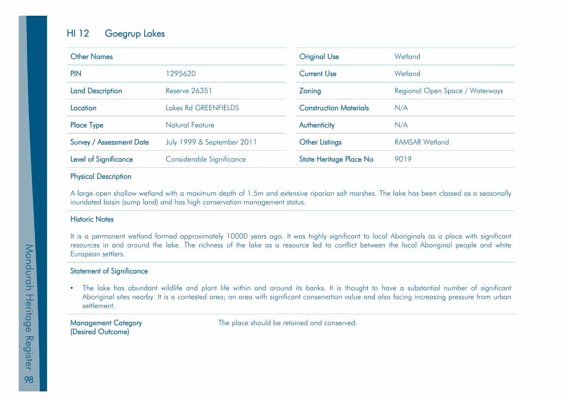
98
Mandurah H
eritage Register
HI 12 Goegrup Lakes
Other Names Original Use Wetland
PIN 1295620 Current Use Wetland
Land Description Reserve 26351 Zoning Regional Open Space / Waterways
Location Lakes Rd GREENFIELDS Construction Materials N/A
Place Type Natural Feature Authenticity N/A
Survey / Assessment Date July 1999 & September 2011 Other Listings RAMSAR Wetland
Level of Significance Considerable Significance State Heritage Place No 9019
Physical Description
A large open shallow wetland with a maximum depth of 1.5m and extensive riparian salt marshes. The lake has been classed as a seasonally inundated basin (sump land) and has high conservation management status.
Historic Notes
It is a permanent wetland formed approximately 10000 years ago. It was highly significant to local Aboriginals as a place with significant resources in and around the lake. The richness of the lake as a resource led to conflict between the local Aboriginal people and white European settlers.
Statement of Significance
• The lake has abundant wildlife and plant life within and around its banks. It is thought to have a substantial number of significant Aboriginal sites nearby. It is a contested area; an area with significant conservation value and also facing increasing pressure from urban settlement.
Management Category (Desired Outcome)
The place should be retained and conserved.
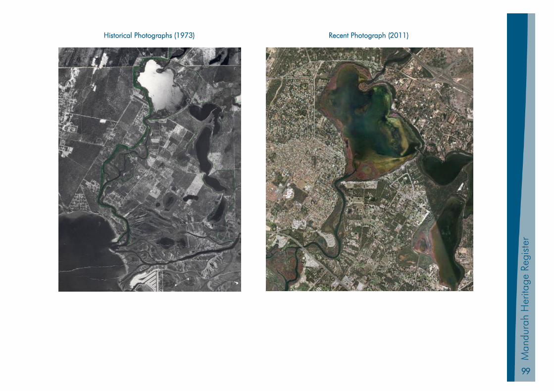
99
Man
dura
h Pl
anni
ng S
chem
e 20
11
Man
dura
h H
erita
ge R
egis
ter
Historical Photographs (1973) Recent Photograph (2011)
100
Mandurah H
eritage Register
HI 13 Island Point Crossing
Other Names Original Use Wetland (Cattle Crossing)
PIN 446063 Current Use Wetland (Estuary)
Land Description Reserve 2990 Zoning Regional Open Space / Waterways
Location 267 Southern Estuary Rd HERRON Construction Materials N/A
Place Type Natural Feature Authenticity N/A
Survey / Assessment Date July 1999 & September 2011 Other Listings RAMSAR Wetland
Level of Significance Considerable Significance State Heritage Place No 9069
Physical Description
Shallow sand bar at the southern end of the Peel Harvey Estuary
Historic Notes
Aboriginal people camped in the area and crossed the shallow waters at low tide. The crossing was also an old stock route from Pinjarra to Bunbury over the Harvey Estuary. Many settlers in the southern section of Mandurah relied on the crossing. Every 6 months the cattle had to be shifted from inadequate coastal grazing areas to grazing areas further inland to avoid “coastie disease”.
Statement of Significance
• There is considerable scenic beauty attached to the site. • Island Point Crossing was a major link between west and east of the Peel Harvey Estuary. • It was a significant crossing point for Aboriginal people who camped in the area.
Management Category (Desired Outcome)
The place should be retained and conserved.
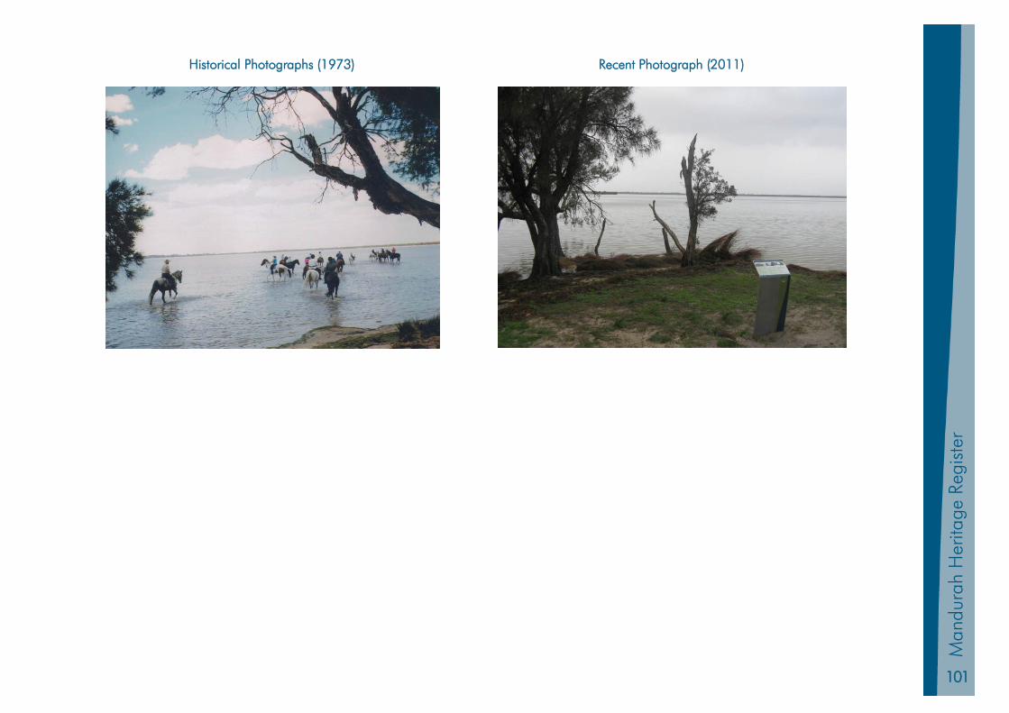
101
Man
dura
h Pl
anni
ng S
chem
e 20
11
Man
dura
h H
erita
ge R
egis
ter
Historical Photographs (1973) Recent Photograph (2011)
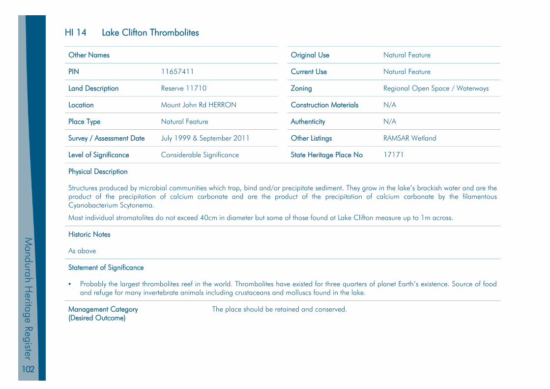
102
Mandurah H
eritage Register
HI 14 Lake Clifton Thrombolites
Other Names Original Use Natural Feature
PIN 11657411 Current Use Natural Feature
Land Description Reserve 11710 Zoning Regional Open Space / Waterways
Location Mount John Rd HERRON Construction Materials N/A
Place Type Natural Feature Authenticity N/A
Survey / Assessment Date July 1999 & September 2011 Other Listings RAMSAR Wetland
Level of Significance Considerable Significance State Heritage Place No 17171
Physical Description
Structures produced by microbial communities which trap, bind and/or precipitate sediment. They grow in the lake’s brackish water and are the product of the precipitation of calcium carbonate and are the product of the precipitation of calcium carbonate by the filamentous Cyanobacterium Scytonema.
Most individual stromatolites do not exceed 40cm in diameter but some of those found at Lake Clifton measure up to 1m across.
Historic Notes
As above
Statement of Significance
• Probably the largest thrombolites reef in the world. Thrombolites have existed for three quarters of planet Earth’s existence. Source of food and refuge for many invertebrate animals including crustaceans and molluscs found in the lake.
Management Category (Desired Outcome)
The place should be retained and conserved.
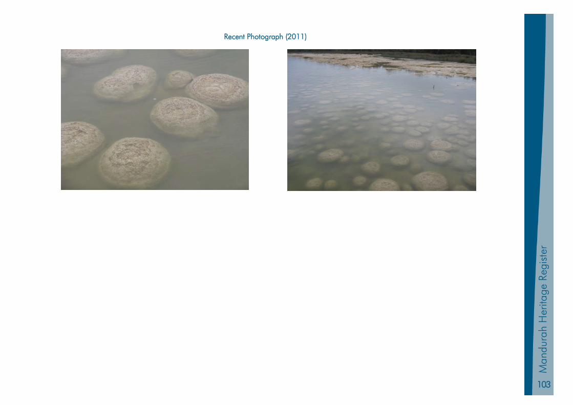
103
Man
dura
h Pl
anni
ng S
chem
e 20
11
Man
dura
h H
erita
ge R
egis
ter
Recent Photograph (2011)
104
Mandurah H
eritage Register
HI 15 Morfitt’s Cave
Other Names Eagles Nest Cave Original Use Wetland
PIN 11191376 Current Use Wetland
Land Description Lot 2 on Plan 38503 Zoning Regional Open Space / Waterways
Location 1461 Old Coast Rd BOUVARD Construction Materials N/A
Place Type Natural Feature Authenticity High
Survey / Assessment Date July 1999 & September 2011 Other Listings Aboriginal Site ID 3277
Level of Significance Considerable Significance State Heritage Place No 9066
Physical Description
Large single chamber cave located within a narrow band of Tamala limestone approximately 8km long by 0.5km wide on the western side of the Peel Harvey Estuary. It is one of at least fourteen caves in the area.
Historic Notes
Long known by local Aboriginal people J W Charnley the secretary of the Mandurah Progress Association reported the discovery of limestone caves to the Chief Inspector of Fisheries in 1921. It was so named because it was located on Henry Morfitt’s property. Morfitt was a convict granted a ticket of leave in 1863 and was by 1870 a free man. He worked around Mandurah for many years before taking up land around the cave farming and fishing in the area with his family for the rest of his life.
Non-figurative engravings in the cave are thought to be 21000 years old.
Statement of Significance
• Formed important part of the childhood experience of local children. • Important site to local Aboriginal people.
Management Category (Desired Outcome)
The place should be retained and conserved.

105
Man
dura
h Pl
anni
ng S
chem
e 20
11
Man
dura
h H
erita
ge R
egis
ter
HI 16 Peel Harvey Estuarine System
Other Names Original Use Wetland
PIN N/A Current Use Wetland
Land Description Unallocated Crown Land Zoning Regional Open Space / Waterways
Location Peel Inlet Construction Materials N/A
Place Type Natural Feature Authenticity N/A
Survey / Assessment Date July 1999 & September 2011 Other Listings RAMSAR Wetland
Level of Significance Considerable Significance State Heritage Place No 16113
Physical Description
The system is the largest estuarine ecosystem of the Swan Coastal plain.
Historic Notes
The estuary has been a major source of food for both Aboriginal people and the early settlers. Aboriginal people gathered around the estuary tributaries at their mungahs for many years and during the latter half of the nineteenth century a commercial fishing industry was established. The inlet was also highly valued as a place of recreation for both local residents and holidaymakers. Concern regarding eutrophication saw the Dawesville Channel being constructed between the ocean and the estuary in an attempt to flush out the estuary.
Statement of Significance
• Extremely important as bird habitats. The area provides the most important estuarine bird habitat in south west Western Australia. Seventy species of bird have been recorded there including sixteen migratory species protected by international migratory bird treaties. The samphire flats and wetlands of the area support a considerable diversity of invertebrate fauna. There are thirty seven species of fish that are supported by the estuary and are an important food source for birdlife, but also have significant importance for commercial and recreational fishing. The vegetation along the banks is representative types that were once more extensive on the coastal plain.
Management Category (Desired Outcome)
The place should be retained and conserved.

106
Mandurah H
eritage Register
HI 17 Winjans Camp
Other Names Original Use Campsite
PIN 1273545 Current Use Local Reserve
Land Description Reserve 45814 Zoning Canal
Location McLarty Road HALLS HEAD Condition Good
Place Type Natural Feature Authenticity High
Survey / Assessment Date July 1999 & September 2011 Other Listings Aboriginal Site ID 3724
Level of Significance Considerable Significance State Heritage Place No 17172
Physical Description
Campsite was located in close proximity to the existing park.
Historic Notes
Daisy Bates suggested that the Winjan family had the oldest purely Western Australian family tree recorded, dating back to the days before Flinders visited King George Sound and incorporated the genealogy of the groups of the Bibbulman people who occupied the whole of the south west of Western Australia at the time of European settlement.
Statement of Significance
• Home of George Winjan who is believed to have survived the Battle of Pinjarra as a young child, was a leader of the local Aboriginal people and was respected by both white European settlers and Aboriginal people.
Management Category (Desired Outcome)
The place should be retained and conserved.

107
Man
dura
h Pl
anni
ng S
chem
e 20
11
Man
dura
h H
erita
ge R
egis
ter
Mandurah Heritage Register
Part 5 Archived / Demolished Sites Place Records
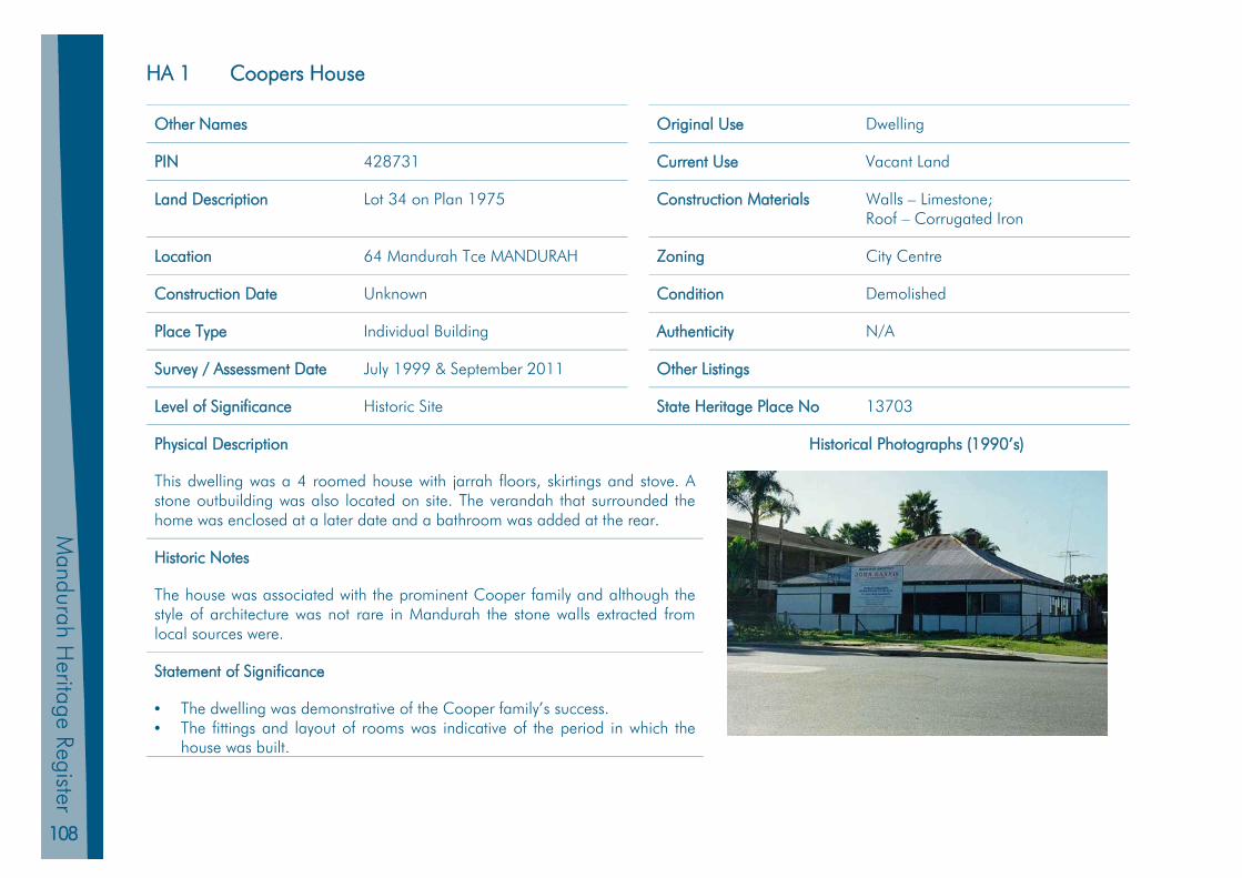
108
Mandurah H
eritage Register
HA 1 Coopers House
Other Names Original Use Dwelling
PIN 428731 Current Use Vacant Land
Land Description Lot 34 on Plan 1975 Construction Materials Walls – Limestone; Roof – Corrugated Iron
Location 64 Mandurah Tce MANDURAH Zoning City Centre
Construction Date Unknown Condition Demolished
Place Type Individual Building Authenticity N/A
Survey / Assessment Date July 1999 & September 2011 Other Listings
Level of Significance Historic Site State Heritage Place No 13703
Physical Description Historical Photographs (1990’s)
This dwelling was a 4 roomed house with jarrah floors, skirtings and stove. A stone outbuilding was also located on site. The verandah that surrounded the home was enclosed at a later date and a bathroom was added at the rear.
Historic Notes
The house was associated with the prominent Cooper family and although the style of architecture was not rare in Mandurah the stone walls extracted from local sources were.
Statement of Significance
• The dwelling was demonstrative of the Cooper family’s success. • The fittings and layout of rooms was indicative of the period in which the
house was built.
109
Man
dura
h Pl
anni
ng S
chem
e 20
11
Man
dura
h H
erita
ge R
egis
ter
HA 2 Eacott’s Well
Other Names Original Use Water Supply
PIN 428496 Current Use Dwelling
Land Description Lot 82 on Plan 49828 Construction Materials Unknown
Location 1 Andrew St MANDURAH Zoning Precinct Development
Construction Date Unknown Condition Demolished
Place Type Individual Building Authenticity Further Research Required
Survey / Assessment Date July 1999 & September 2011 Other Listings
Level of Significance Historic Site State Heritage Place No 9075
Physical Description
Unknown
Historic Notes
The well was associated with the Eacott family. The well was filled in at some time and is no longer discernible. The site is of historic interest but opportunities for effective interpretation may be limited.
Statement of Significance
• Served as a local water supply for many years and as a watering hole used by travellers as they travelled to the south west of Western Australian.

110
Mandurah H
eritage Register
HA 3 Ferry Sheds
Other Names Original Use Ferry Sheds
PIN Current Use
Land Description Construction Materials Unknown
Location Close to Mandurah Traffic Bridge Zoning City Centre
Construction Date Unknown Condition Demolished
Place Type Individual Building Authenticity Further Research Required
Survey / Assessment Date July 1999 & September 2011 Other Listings
Level of Significance Historic Site State Heritage Place No 9078
Physical Description
Unknown
Historic Notes
Further research is required.
Statement of Significance
• Was a critical part of the transport link between western and eastern foreshores before a bridge was constructed.
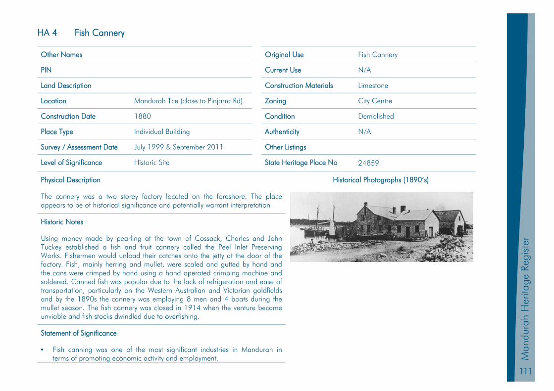
111
Man
dura
h Pl
anni
ng S
chem
e 20
11
Man
dura
h H
erita
ge R
egis
ter
HA 4 Fish Cannery
Other Names Original Use Fish Cannery
PIN Current Use N/A
Land Description Construction Materials Limestone
Location Mandurah Tce (close to Pinjarra Rd) Zoning City Centre
Construction Date 1880 Condition Demolished
Place Type Individual Building Authenticity N/A
Survey / Assessment Date July 1999 & September 2011 Other Listings
Level of Significance Historic Site State Heritage Place No 24859
Physical Description Historical Photographs (1890’s)
The cannery was a two storey factory located on the foreshore. The place appears to be of historical significance and potentially warrant interpretation
Historic Notes
Using money made by pearling at the town of Cossack, Charles and John Tuckey established a fish and fruit cannery called the Peel Inlet Preserving Works. Fishermen would unload their catches onto the jetty at the door of the factory. Fish, mainly herring and mullet, were scaled and gutted by hand and the cans were crimped by hand using a hand operated crimping machine and soldered. Canned fish was popular due to the lack of refrigeration and ease of transportation, particularly on the Western Australian and Victorian goldfields and by the 1890s the cannery was employing 8 men and 4 boats during the mullet season. The fish cannery was closed in 1914 when the venture became unviable and fish stocks dwindled due to overfishing.
Statement of Significance
• Fish canning was one of the most significant industries in Mandurah in terms of promoting economic activity and employment.
112
Mandurah H
eritage Register
HA 5 Government Jetty
Other Names Original Use Jetty
PIN 439297 Current Use N/A
Land Description Reserve 14004 Construction Materials Timber
Location Eastern Foreshore Zoning N/A
Construction Date 1896 Condition Demolished (Approx 1994)
Place Type Individual Building Authenticity N/A
Survey / Assessment Date July 1999 & September 2011 Other Listings
Level of Significance Historic Site State Heritage Place No 9088
Physical Description
Little detail known, however the place appears to be of historical significance and potentially warrant interpretation
Historic Notes
The timber T shaped jetty was built on the northern side of Mandurah Bridge for the Western Australian government for 303 pounds and 11shillings in 1896. At one stage it had a crane on the end of the jetty for the purpose of unloading cargo from boats. Major repairs were undertaken in 1927 and it was regularly maintained until replaced by a similar structure on the same site in 1994.
Statement of Significance
• Important landmark in the area. • One of the earliest State public works projects in Mandurah. • Site where local boats loaded and unloaded their cargo and repaired and dried fishing nets. • Meeting place for local fishermen.
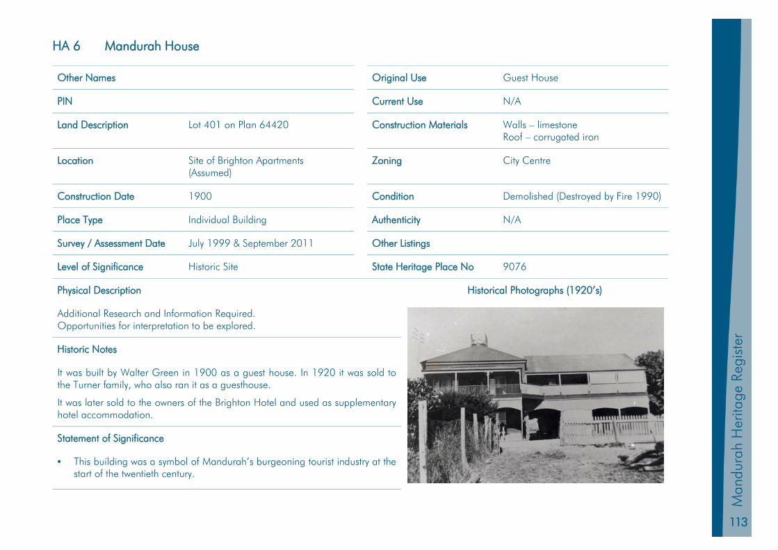
113
Man
dura
h Pl
anni
ng S
chem
e 20
11
Man
dura
h H
erita
ge R
egis
ter
HA 6 Mandurah House
Other Names Original Use Guest House
PIN Current Use N/A
Land Description Lot 401 on Plan 64420 Construction Materials Walls – limestone Roof – corrugated iron
Location Site of Brighton Apartments (Assumed)
Zoning City Centre
Construction Date 1900 Condition Demolished (Destroyed by Fire 1990)
Place Type Individual Building Authenticity N/A
Survey / Assessment Date July 1999 & September 2011 Other Listings
Level of Significance Historic Site State Heritage Place No 9076
Physical Description Historical Photographs (1920’s)
Additional Research and Information Required. Opportunities for interpretation to be explored.
Historic Notes
It was built by Walter Green in 1900 as a guest house. In 1920 it was sold to the Turner family, who also ran it as a guesthouse.
It was later sold to the owners of the Brighton Hotel and used as supplementary hotel accommodation.
Statement of Significance
• This building was a symbol of Mandurah’s burgeoning tourist industry at the start of the twentieth century.
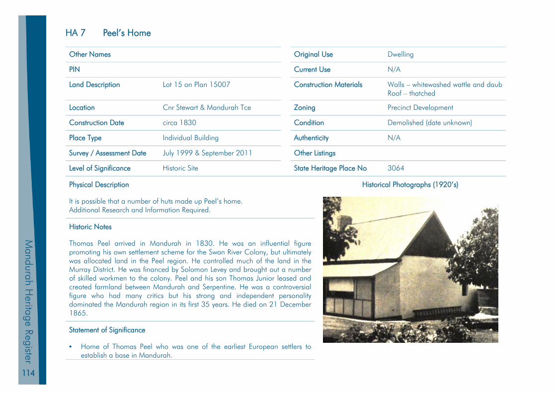
114
Mandurah H
eritage Register
HA 7 Peel’s Home
Other Names Original Use Dwelling
PIN Current Use N/A
Land Description Lot 15 on Plan 15007 Construction Materials Walls – whitewashed wattle and daub Roof – thatched
Location Cnr Stewart & Mandurah Tce Zoning Precinct Development
Construction Date circa 1830 Condition Demolished (date unknown)
Place Type Individual Building Authenticity N/A
Survey / Assessment Date July 1999 & September 2011 Other Listings
Level of Significance Historic Site State Heritage Place No 3064
Physical Description Historical Photographs (1920’s)
It is possible that a number of huts made up Peel’s home. Additional Research and Information Required.
Historic Notes
Thomas Peel arrived in Mandurah in 1830. He was an influential figure promoting his own settlement scheme for the Swan River Colony, but ultimately was allocated land in the Peel region. He controlled much of the land in the Murray District. He was financed by Solomon Levey and brought out a number of skilled workmen to the colony. Peel and his son Thomas Junior leased and created farmland between Mandurah and Serpentine. He was a controversial figure who had many critics but his strong and independent personality dominated the Mandurah region in its first 35 years. He died on 21 December 1865.
Statement of Significance
• Home of Thomas Peel who was one of the earliest European settlers to establish a base in Mandurah.
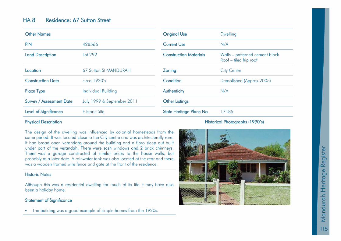
115
Man
dura
h Pl
anni
ng S
chem
e 20
11
Man
dura
h H
erita
ge R
egis
ter
HA 8 Residence: 67 Sutton Street
Other Names Original Use Dwelling
PIN 428566 Current Use N/A
Land Description Lot 292 Construction Materials Walls – patterned cement block Roof – tiled hip roof
Location 67 Sutton St MANDURAH Zoning City Centre
Construction Date circa 1920’s Condition Demolished (Approx 2005)
Place Type Individual Building Authenticity N/A
Survey / Assessment Date July 1999 & September 2011 Other Listings
Level of Significance Historic Site State Heritage Place No 17185
Physical Description Historical Photographs (1990’s)
The design of the dwelling was influenced by colonial homesteads from the same period. It was located close to the City centre and was architecturally rare. It had broad open verandahs around the building and a fibro sleep out built under part of the verandah. There were sash windows and 2 brick chimneys. There was a garage constructed of similar bricks to the house walls, but probably at a later date. A rainwater tank was also located at the rear and there was a wooden framed wire fence and gate at the front of the residence.
Historic Notes
Although this was a residential dwelling for much of its life it may have also been a holiday home.
Statement of Significance
• The building was a good example of simple homes from the 1920s.
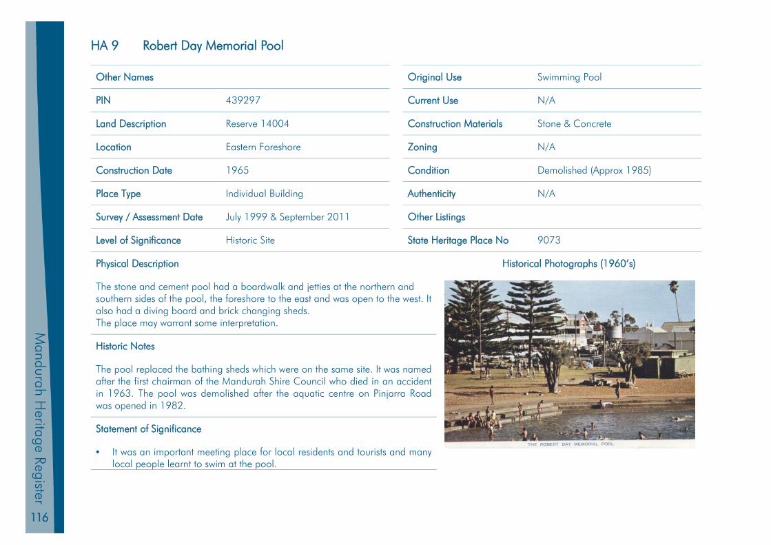
116
Mandurah H
eritage Register
HA 9 Robert Day Memorial Pool
Other Names Original Use Swimming Pool
PIN 439297 Current Use N/A
Land Description Reserve 14004 Construction Materials Stone & Concrete
Location Eastern Foreshore Zoning N/A
Construction Date 1965 Condition Demolished (Approx 1985)
Place Type Individual Building Authenticity N/A
Survey / Assessment Date July 1999 & September 2011 Other Listings
Level of Significance Historic Site State Heritage Place No 9073
Physical Description Historical Photographs (1960’s)
The stone and cement pool had a boardwalk and jetties at the northern and southern sides of the pool, the foreshore to the east and was open to the west. It also had a diving board and brick changing sheds. The place may warrant some interpretation.
Historic Notes
The pool replaced the bathing sheds which were on the same site. It was named after the first chairman of the Mandurah Shire Council who died in an accident in 1963. The pool was demolished after the aquatic centre on Pinjarra Road was opened in 1982.
Statement of Significance
• It was an important meeting place for local residents and tourists and many local people learnt to swim at the pool.

117
Man
dura
h Pl
anni
ng S
chem
e 20
11
Man
dura
h H
erita
ge R
egis
ter
HA 10 Smart Family Home
Other Names Original Use Dwelling
PIN 428736 Current Use N/A
Land Description Lot 40 on Plan1975 Construction Materials Walls- weatherboard Roof- corrugated iron
Location 70 Mandurah Tce MANDURAH Zoning City Centre
Construction Date 1920 Condition Demolished (Approx 2012)
Place Type Individual Building Authenticity N/A
Survey / Assessment Date July 1999 & September 2011 Other Listings
Level of Significance Historic Site State Heritage Place No 17179
Physical Description Historical Photographs (1990’s)
This large residence was comprised of seven rooms. There was an old cement block structure at the rear that may have been wash-house. There were two rendered brick chimneys and wooden verandahs on three sides of the house.
Historic Notes
This building was owned and built by the Smart family who were involved in the fishing and fish canning industries in Mandurah. They sold it to Reginald and Florence Peters circa 1955. The Peters let the rooms as bed-and-breakfast accommodation. Since then it has accommodated a dental surgery, an antique shop, a branch of a government agency, a teddy bear shop, an art gallery and antique store under various owners.
Statement of Significance
• Associated with a prominent Mandurah family, the Smarts. • The home represents a good example of a large federation era timber
residence, a style of architecture that is becoming increasingly rare in Mandurah.
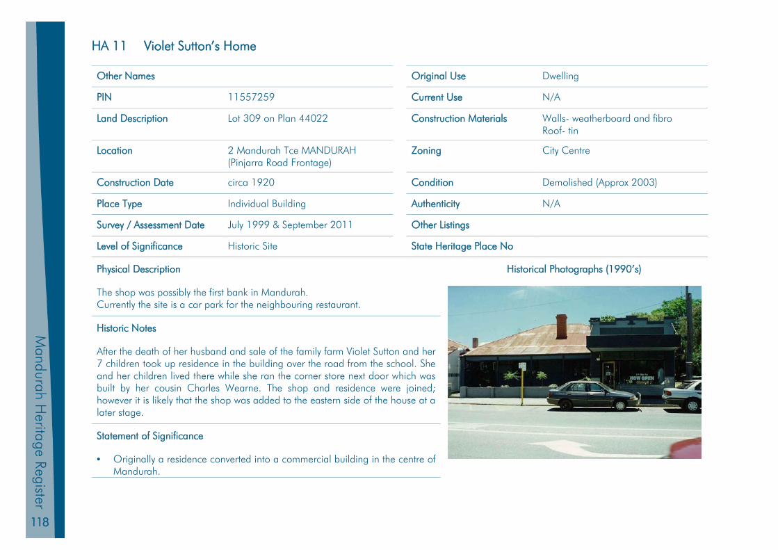
118
Mandurah H
eritage Register
HA 11 Violet Sutton’s Home
Other Names Original Use Dwelling
PIN 11557259 Current Use N/A
Land Description Lot 309 on Plan 44022 Construction Materials Walls- weatherboard and fibro Roof- tin
Location 2 Mandurah Tce MANDURAH (Pinjarra Road Frontage)
Zoning City Centre
Construction Date circa 1920 Condition Demolished (Approx 2003)
Place Type Individual Building Authenticity N/A
Survey / Assessment Date July 1999 & September 2011 Other Listings
Level of Significance Historic Site State Heritage Place No
Physical Description Historical Photographs (1990’s)
The shop was possibly the first bank in Mandurah. Currently the site is a car park for the neighbouring restaurant.
Historic Notes
After the death of her husband and sale of the family farm Violet Sutton and her 7 children took up residence in the building over the road from the school. She and her children lived there while she ran the corner store next door which was built by her cousin Charles Wearne. The shop and residence were joined; however it is likely that the shop was added to the eastern side of the house at a later stage.
Statement of Significance
• Originally a residence converted into a commercial building in the centre of Mandurah.

119
Man
dura
h Pl
anni
ng S
chem
e 20
11
Man
dura
h H
erita
ge R
egis
ter
Index of Places
Heritage List Exceptional Significance: State Heritage Register Places Conservation and Retention is Essential HL 1 Allandale Homestead HL 2 Halls Cottage HL 3 Sutton Farm HL 4 Peninsula Hotel (fmr), Boatsheds and Stingray Point
Considerable Significance Conservation and Retention is Highly Desirable HL 5 Agricultural Hall HL 6 Barragup House HL 7 Brighton Hotel HL 8 Christ’s Church Anglican Church HL 9 Eacott Cottage HL 10 Falcon Stock Well HL 11 Granny Cooper’s Cottage HL 12 Hardy’s Cottage HL 13 Herron Homestead HL 14 Mandurah Community Museum HL 15 Mandurah Terrace Bakery HL 16 Migrant Workers Barracks HL 17 Residence: 82 Cooper Street HL 18 Residence: 12 Cooper Street HL 19 Residence: 115 Cooper Street HL 20 Santoy Dance Hall HL 21 Sutton Street Hall HL 22 Sutton’s Corner Store HL 23 Tuckey House HL 24 Tuckey’s Store HL 25 Ward’s Cottage
Heritage Inventory Places that have some cultural significance
Built Form HI 1 Atrium Hotel HI 2 Bonnie Doone Residence HI 3 Mandurah Traffic Bridge HI 4 Mandurah Post Office HI 5 Mandurah Performing Arts Centre HI 6 Peel Memorial Well HI 7 Residence: 39 Gibson Street HI 8 Scott’s Garage HI 9 Wearne House
Natural Features HI 10 Barragup Fish Mungah HI 11 Creery Wetlands HI 12 Goegrup Lakes HI 13 Island Point Crossing HI 14 Lake Clifton Thrombolites HI 15 Morfitt’s Cave HI 16 Peel Harvey Estuarine System HI 17 Winjan’s Camp
Archived / Demolished Sites HA 1 Cooper’s House HA 2 Eacott’s Well HA 3 Ferry Sheds HA 4 Fish Cannery HA 5 Government Jetty (Eastern Foreshore) HA 6 Mandurah House (Brighton Hotel Site) HA 7 Peel’s Home (Mandurah Terrace) HA 8 Residence: 67 Sutton Street Mandurah HA 9 Robert Day Memorial Pool (Eastern Foreshore) HA 10 Smart Family Home (Mandurah Terrace) HA 11 Violet Sutton’s House (Pinjarra Road


