57
Manor Kingsway Hospitals SPD April 2007
ContentsPage No.
1.0 Introduction ....................................................................................................................... 2
2.0 Site Context ................................................................................................................................... 4
3.0 Planning Policy Guidance ........................................................................................................... 6
4.0 Opportunities & Constraints ........................................................................................................ 8
5.0 Development Guidelines ........................................................................................................... 15
6.0 Design & Layout Guidelines...................................................................................................... 62
Appendix
1. List of Relevant Development Plan Policies
2. Arboricultural Report
List of Plans
1. Figure 2.1 – SPD Boundary
2. Figure 3.1 – City of Derby Local Plan Review Policies
3. Figure 4.1 – Existing Land Uses & Buildings
4. Figure 4.2 – Landscape Character Areas
5. Figure 4.3 – Constraints – Trees & Buildings
6. Figure 4.4 – Constraints – Ecology & Archaeology
7. Figure 4.5 – Constraints – Air, Noise & Contamination
8. Figure 4.6 – Land Ownerships
9. Figure 5.1 – Indicative Junction Design (A5111/Kingsway Retail Park Junction)
10. Figure 6.1 – Land Use Masterplan
11. Figure 6.2 – Development Potential
Page i
Manor Kingsway Hospitals SPD April 2007
1.0 INTRODUCTION
1.1 Purpose of Document
1.1.1 Reorganisation of health care facilities in Derby, coupled with the need for modern facilities have resulted in significant areas of the Manor Kingsway Hospitals site becoming surplus to the needs of the NHS. The surplus land has been transferred to English Partnerships to secure a high quality mixed-use redevelopment.
1.1.2 This document explains how the Council’s Local Plan policies and the forthcoming Local Development Framework should be developed as part of sustainable master planning process.
1.1.3 Policy R4 of the adopted City of Derby Local Plan Review allocates the site as a major mixed-use regeneration opportunity. The Local Plan indicates that the Council will prepare a Supplementary Planning Document [SPD] for the site.
1.1.4 The Council, landowners and English Partnerships are working in partnership to prepare an SPD for Manor Kingsway Hospitals in accordance with guidance contained in Planning Policy Statement 12 (PPS12).
1.2 Scope & Status of Document
1.2.1 The SPD is to be subject to public consultation and will be formally adopted by the Derby City Council. Any proposal to redevelop the site will be the subject of a planning application. In determining such an application, the Council is required to have regard to the development plan and to all material considerations, including the Manor Kingsway Hospitals SPD.
1.3 Objectives
1.3.1 The objectives for this SPD and the subsequent development of the site are set out below.
1.3.2 To establish a broad range of land uses and create a vibrant well used place by: -
1) Making the best use of previously developed public sector land and buildings to provide a minimum of: -
500 new homes,
200 key worker units,
6.9ha of business development (or equivalent in floor space); and,
A park and ride interchange.
2) Integrating new development with proposed extensions to existing healthcare uses and car parking provision, a nursery and ancillary facilities related to these
Page 1
Manor Kingsway Hospitals SPD April 2007
uses.
3) Encouraging the creation of a balanced community by providing a broad mix of housing reflecting EP’s policy on integrated tenure- housing not differentiated by differences in design, quality, or location.
4) Creating a range of new employment opportunities improving access to jobs and services.
1.3.3 To create an energy efficient movement strategy by: -
1) Developing a movement network, which promotes walking and cycling and integrates with surrounding neighbourhoods to provide safe routes to local services and facilities.
2) Ensuring public transport integration and good access to bus routes.
3) Creating a high quality gateway and arrival points which welcome visitors to the site and create a positive public face for the new development.
4) Managing car parking to limit traffic demands, whilst sensitively meeting the needs of the car in line with Policy T4, Access, Parking and Servicing, Appendix A, Parking Standards in the Adopted City of Derby, Local Plan Review.
1.3.4 To encourage high quality sustainable urban design and architecture by: -
1) Creating higher building densities in appropriate locations to meet urban design and site development objectives and support local amenities.
2) Creating a well defined public realm consisting of safe streets and spaces, which reflect principles of good urbanism and meet English Partnerships objectives for Secure by Design accreditation.
3) Creating an appropriate new identity for the site through high quality architecture and good urban design.
4) Establishing a physical focal point in the new development as a natural hub of activity.
5) Ensuring long-term adaptability in the built fabric through the creation of flexible internal and external environments, which reflect EP’s Lifetime Homes standards.
6) Addressing at the outset the opportunities for the building design and construction to reduce energy consumption and carbon and greenhouse gas emissions and maximise long term sustainability including: -
The landform, layout, landscaping and building orientation;
Page 2
Manor Kingsway Hospitals SPD April 2007
The massing of buildings, density and mix of development; and,
EP’s quality standards regarding material specifications, modern methods of construction and construction efficiency.
7) Utilising English Partnership’s urban design ‘toolkit’ of guidance and design codes to help realise these objectives and undertaking reviews throughout the design process and phased completion in accordance with best practice, for example, CABE Building for Life standards.
1.3.5 To enhance the recreation and amenity potential of the site by: -
1) Retaining the best of the existing landscape structure and integrating it with open space and movement networks to contribute to a new identity.
2) Maximising the potential of the green wedge through its improvement as a recreation, amenity and biodiversity resource to serve the new development and wider community.
3) Providing enhanced sports facilities for use by the hospital trust and the new community.
4) Enhancing the green infrastructure including maximising the enhancement of local biodiversity.
Page 3
Manor Kingsway Hospitals SPD April 2007
2.0 SITE CONTEXT
2.1 Introduction
2.1.1 The Manor/Kingsway Hospital site extends to 49ha. This section provides a description of the site and outlines the current land ownerships.
2.2 Land Ownership
2.2.1 The site is within the following ownerships: -
1) The central and southern parts of the site, together with the undeveloped land adjacent to the A38(T), is within the ownership of English Partnerships. Part of the land occupied by the Kingsway Hospital (which is leased to the Derbyshire Mental Health Services NHS Trust) and is to close in 2007/08. The ownership extends to 33.1ha.
2) The northern part of the site is within the ownership of the Derbyshire Mental Health Services NHS Trust. The ownership extends to 10.7ha.
3) The south-western part of the site together with an area of land adjacent to the A38(T) is within the ownership of the Derby Hospitals NHS Foundation Trust. The ownership extends to 6.1ha.
4) A small area of land in the centre of the site is within the ownership of the East Midlands Ambulance Service. The ownership extends to 0.3ha.
The land ownership is illustrated on Figure 4.6.
2.3 Land to be Released for Development
2.3.1 The landowners will release approximately 22.5ha for new residential and business development (including the provision of key worker housing). The remainder of the land will be used as follows: -
1) The Mental Health Trust will retain 7.5ha of land for healthcare purposes. This land will accommodate the new patient facilities.
2) The Derby Hospitals Trust will retain their land holding (6.1ha) to provide car parking and other facilities for use in association with the expansion and redevelopment of the City Hospital.
3) The northern and western part of the Manor Kingsway site is designated as Green Wedge and will not therefore be available for development, although the land will provide recreational facilities for NHS staff and the future residents of the site.
Page 4
Manor Kingsway Hospitals SPD April 2007
2.4 Site Location and Description
2.4.1 The Manor/Kingsway Hospital site is located on the western side of Derby and lies approximately 2.5km to the south-west of Derby City Centre. The land covered by the Manor/Kingsway Hospital SPD is shown on Figure 2.1.
The Site
2.4.2 The Manor Kingsway site is bounded by the A38 (T) to the west, the A5111 Kingsway to the east and the A516 Uttoxeter New Road to the south. The hospital complex occupies the central and eastern part of the site and extends to approximately 22.0ha. It contains a variety of C19th and C20th buildings.
2.4.3 Access into the site is presently from three points: -
1) The roundabout on Uttoxeter Road to the south of the site;
2) The main hospital entrance from Kingsway to the east; and,
3) A secondary hospital entrance from Kingsway to the north.
The Surroundings
2.4.4 To the east of the site, on the opposite side of Kingsway, is a Sainsbury’s superstore and retail park comprising a mixture of do-it-yourself, furnishing and electrical goods retailers. Further to the east is the Kingsway Park Close Industrial Estate.
2.4.5 Immediately to the south of the hospitals site is an Aldi supermarket, restaurant and hotel and a group of flats. On the opposite side of Uttoxeter Road is the Derby City Hospital, which is undergoing major redevelopment and expansion. Elsewhere to the south, west and east is residential development. On the northern side of the site is the A38 with open countryside beyond.
2.4.6 The site is well related to services and facilities with shops, schools, employment and recreation facilities all within easy walking distance.
2.4.7 Local public transport is also available. Bus services operate on the adjacent highway network providing rapid and frequent services direct to the city centre and elsewhere.
2.4.8 Footpath and cycle access within the site to the general public is poor. The development of the site will provide the opportunity for a comprehensive series of footpaths and cycleways to be provided, allowing existing and future residents to access local facilities, public open space and employment in ways other by using the private car.
Page 5
Manor Kingsway Hospitals SPD April 2007
3.0 PLANNING POLICY GUIDANCE
3.1 Introduction
3.1.1 In accordance with Section 38(6) of the 2004 Act, the development plan for Derby comprises the RSS for the East Midlands, the Derby and Derbyshire Joint Structure Plan and the City of Derby Local Plan Review.
3.1.2 A list of the planning policies relevant to the development of the Manor Kingsway site is contained in Appendix 1. This SPD and the subsequent redevelopment of the Manor Kingsway Hospitals site will be required to accord with the policies of the development plan, unless material considerations indicate otherwise.
3.2 Site Specific Planning Policies
3.2.1 The City of Derby Local Plan Review contain site specific planning polices that apply to the Manor Kingsway site. These policies provide a spatial context for the development of the site and are illustrated on Figure 3.1. They include: -
1) Policy R4 identifies the Manor Kingsway Hospitals site as a major mixed-use regeneration opportunity. The policy states: -
38.0 hectares of land at the former Manor and Kingsway Hospitals is identified as a major mixed use regeneration opportunity. Planning permission will be granted for a mixed-use development, which includes: -
a. A high quality business park (Class B1) on no less than 6.9hectares;
b. The erection of a minimum of 500 open market dwellings;
c. The erection of a minimum of 200 ‘key-worker’ residential units;
d. Extensions to existing healthcare uses;
e. New healthcare uses and ancillary facilities, including car parking and a nursery;
f. A park and ride interchange.
Development proposals should: -
1. be accompanied by a Transport Assessment;
2. provide measures to encourage alternative modes of transport to the car; related road and junction improvements; and high quality pedestrian and cycle routes within the site;
3. provide measures to secure improvements to the surrounding road network to facilitate public transport and any necessary road and junction improvements;
4. include phased implementation of the business and residential uses;
5. secure the retention of trees and landscape features, which make a significant contribution to the character and appearance of the site;
Page 6
Manor Kingsway Hospitals SPD April 2007
6. make provision for sports facilities based on a robust and up-to-date assessment of the need for such facilities.
The City Council will seek to enter into obligations under Section 106 of the 1990 Act to secure contributions including open space provision, community facilities, affordable housing (key worker units), contributions to public transport improvements and measures to promote walking and cycling including a contribution towards a link across the A38 to the proposed Bramble Brook cycle route (PolicyT15(15))’.
2) Policy E2 identifies a Green Wedge across the western and northern part of the site. Within this area only limited forms of development will be permitted.
3) Policy E4 identifies a Wildlife Site on the northern side of the site. Development will not be permitted if it will destroy or adversely affect, either directly or indirectly, the site of local importance.
4) Policy L10 identifies an area of land along the western boundary as allotments. Development, which involves the loss of allotments, will only be permitted if satisfactory alternative provision is made.
5) Policy T9 identifies a site for a Park & Ride facility on the land to the north of the City Hospital roundabout.
6) Policy T15 identifies a potential cycleway from Uttoxeter Road to Kingsway across the Kingsway Hospital site.
3.2.2 These policies are supported by a wide range of other environmental policies that address open space, landscape, recreational provision and protection, the impact of new developments on archaeology, as well as issues of land contamination, access, transport and parking.
3.2.3 The above policies underpin the guidance provided in this SPD, but the criteria set out in Policy R4 represent the starting point for any consideration of specific development proposals. Thus the development within the on the Manor Kingsway Hospitals site must: -
1) Meet the development objectives outlined in Section 1 of this SPD;
2) Be within the area defined as a mixed-use regeneration opportunity;
3) Respect the openness and landscape setting of the Green Wedge and provide a clear boundary to the urban area of Derby;
4) Not have an adverse impact on the area designated as being of importance for nature conservation;
5) Retain and incorporate the landscape features of importance on the site; and,
6) Include replacement provision for the open space and allotments on the site.
Page 7
Manor Kingsway Hospitals SPD April 2007
4.0 OPPORTUNITIES & CONSTRAINTS
4.1 Introduction
4.1.1 The site represents an opportunity to create a high quality sustainable development that is integrated within the existing urban area. However, as with all large sites there are constraints on the development of the land, which must be considered.
4.1.2 This section identifies the main opportunities and constraints on future development.
4.2 Topography
4.2.1 The site is mounded towards the existing hospital buildings located in the centre of the site. The site itself can generally be split in two. The eastern section has gentle slopes, whilst the western section has greater slopes, as it falls towards Bramble Brook.
4.2.2 In general there are no areas of the site where the existing topography will preclude development.
4.3 Existing Land Uses & Buildings
4.3.1 The site is mainly used for healthcare purposes, although there are substantial areas of undeveloped land on the site. The existing uses are illustrated on Figure 4.1 and described below.
Kingsway Hospital Complex
4.3.2 This is the oldest part of the hospital and is located in the centre of the site. It is currently occupied by the Mental Health Trust but will be vacated by the end of 2008.
Mental Health Trust Buildings
4.3.3 The Mental Health Trust occupies approximately 10ha of the site. The Trust will remain on the site and it will be a focal point for the treatment of patients. It will therefore be important to ensure that the proposed development secure an appropriate environment for the continuing treatment of patients on the site.
Intensive Care Unit & Cherry Tree Close
4.3.4 Immediately to the north of the Kingsway Hospital complex is the Intensive Care Unit and Cherry Tree Close. The Intensive Care Unit is a modern 2-storey building. To the north of this building is Cherry Tree Close, which comprises a group of 5 bungalows used for the rehabilitation of patients.
Albany House
4.3.5 Albany House is located immediately to the east of Cherry Tree Close and is in healthcare use. It is a 2 and 3-storey Victorian building constructed from red brick with a slate roof. There are mature trees along the frontage of the building.
Kingsway House & Bramble House
Page 8
Manor Kingsway Hospitals SPD April 2007
4.3.6 Kingsway House is located on the northern side of the hospital and comprises a 1 and 2-storey 1930s building constructed from red brick with a tile roof. Bramble House is a 2-storey building of a similar period in red brick with a plain tile roof. Both of the buildings are used for office accommodation.
Ambulance Trust
4.3.7 On the western side of the complex is the Derbyshire Ambulance headquarters. This is a modern 2-storey building constructed from red brick with a concrete tile roof. Adjacent to the headquarters is a group of prefabricated and brick buildings used as stores and offices.
The Parkland
4.3.8 On the eastern side of the Kingsway Hospital is 7.5ha of parkland associated with the original hospital. The parkland area contains numerous mature trees as well as the Lodge (c1888) and former social club. Part of the land was used for playing fields but no sports use is currently made of the land. In formulating the proposed development consideration should be given to the possible re-use of the Lodge.
The Open Land
4.3.9 On the western and southern sides of the Kingsway Hospital is agricultural land extending to some 22ha. A significant part of this land is being temporarily used by the contractors for the redevelopment of the City Hospital site. A small part of the land (on the western side of the site) was formerly used for allotments but this use ceased in 2001.
Hospital Trust Car Parking
4.3.10 Further to the south-west is a recently constructed car park and park and ride facility for the Derby City Hospital. This use will be retained and expanded on the site.
4.4 Highways & Access
4.4.1 Vehicular access to the site is recommended from the A38/A516/B5020 roundabout and from a new signal controlled junction to replace the existing A5111 Kingsway Retail Park roundabout.
4.4.2 The site is surrounded on all sides by busy roads and there are few controlled pedestrian and cyclist crossing facilities. Any new development should therefore seek to strengthen pedestrian and cycle integration with adjoining land uses through the provision of new crossing facilities at appropriate locations.
4.4.3 Significant off-site highway improvements may be required in order to mitigate the traffic effects of the development. The key locations that are anticipated to be affected are: -
1) A38/A516/B5020 roundabout
2) A516 /A5111 signal-controlled crossroads
Page 9
Manor Kingsway Hospitals SPD April 2007
3) A38(T)/A5111 ‘Grand Canyon’ junction
4) A38(T)/A52 Markeaton Roundabout
5) A5111/A5250 signal-controlled crossroads
6) A516/Uttoxter Old Road.
4.4.4 Access will need to be maintained to ‘third-party’ interests on the site at all times and any proposed transport infrastructure should integrate with the following: -
1) The Kingsway Hospital, which is due to be comprehensively reconfigured within the site under a Private Finance Initiative (PFI) scheme.
2) The existing Derby Hospitals NHS Trust car park located in the south-western corner of the site and from where Derby City Council will also commence to operate a ‘Park and Ride’ service from mid 2008.
3) The possible future expansion of the Derby Hospitals NHS Trust car park located in the south-western corner of the site to provide additional hospital and ‘Park and Ride’ parking spaces.
4.4.5 Future development should be designed to accommodate bus penetration Into/through the site in order to comply with recommended maximum walking distances between all areas of the site and the nearest bus stops. The opportunity to integrate bus services with the adjacent ‘Park and Ride’ facility should also be explored.
4.5 Landscape & Trees
4.5.1 The site divides easily into 3 clear character areas (see Figure 4.2).
4.5.2 Area 1: The north eastern part of the site has a ‘parkland estate’ character with a strong, simple and cohesive landscape structure.
4.5.3 Area 2: This is predominantly arable fields with areas of grass, scrub and trees around its periphery and with views out towards Derby and the surrounding areas. To the north the land slopes down to the A38 and Bramble Brook, with its associated areas of Willow, Alder and Birch. Area 2 has few high quality trees worthy of retention, and no tree avenues.
4.5.4 Area 3: This area is dominated by car parking and has few high quality trees worthy of retention, and no tree avenues. The western and northern site boundaries are well vegetated creating a visual (but not auditory) screen between the site and the surrounding roads.
4.5.5 A number of constraints and opportunities have been identified in each character area: -
1) The existing landscape framework of mature trees would provide a fine
Page 10
Manor Kingsway Hospitals SPD April 2007
backdrop to future development as well as providing an opportunity to define extensive green links through and into the site. However, long term management of these avenues is necessary to ensure their ongoing health and longevity.
2) The unused allotments offer the potential to be relocated within the development to create a small pocket of cultivated greenspace or community garden.
3) The existing landscape of Area 3 is anonymous and lacks unique character. Future development can address this and create interest and quality.
4) Land within the Green Wedge provides an opportunity to create a significant public open space with both active and passive uses.
5) It is not considered that development will give rise to significant adverse visual impacts due to the vegetated site boundaries and the distance of most of the receptors from the site. The existing car park is a major landscape constraint both strategically and locally, as it underperforms as a gateway feature and it blocks access to the land in the Green Wedge.
4.5.6 The landscape constrains are illustrated on Figure 4.3.
4.6 Ecology
4.6.1 There are no statutory designated sites of nature conservation importance within or adjacent to the Manor Kingsway Site. There is a non-statutory designated County Wildlife Site (CWS) adjacent to the A38 (T) and along the northern boundary of the site to the west of the Hospital. This is identified as site Ref: DE014 and is designated for its ‘flowing water rivers and streams’. It includes the brook and adjacent woodland vegetation only.
4.6.2 The CWS should be protected, maintained and enhanced by future development proposals. This could be achieved through; incorporation within a landscape framework, connection with other designated sites on the west of the A38 (T) by new structures (i.e. a pedestrian bridge), provision of a buffer zone of new planting, control of use of the CWS for amenity purposes, habitat improvement along the Bramble Brook including areas of wetland and woodland in accordance with the Lowland Derbyshire Biodiversity Action Plan, and long term management.
4.6.3 Outside the designated CWS, the mature parkland trees and woodland blocks are of local nature conservation value only. These features should be retained and integrated into the development design as much as possible and augmented with new woodland planting of native tree species as part of an integrated tree infrastructure. Buildings should be designed to take account of nearby mature trees.
4.6.4 There is evidence of bats present on the site and bat roosts have been identified in Albany House and the main hospital complex. A number of other buildings and trees
Page 11
Manor Kingsway Hospitals SPD April 2007
have also been identified as being highly suitable. Where possible development proposals should seek to retain roosts. If this is not possible, then provision will be required for a replacement roost and mitigation programme to minimise impacts on bats, subject to obtaining the necessary DEFRA Licences. There are no records of other specially protected fauna or flora species within the site.
4.6.5 Opportunities also exist for habitat creation in relation to surface water drainage systems. Where there is no conflict with groundwater protection or other hydrogeological or geotechnical constraints, the development should aim to include provision for Sustainable drainage systems (SuDS) including vegetated systems such as swales and ponds.
4.6.6 The ecological constrains are illustrated on Figure 4.4.
4.7 Ground Contamination
4.7.1 The site is directly underlain by the solid geology of Mercia Mudstone, with a narrow band of Alluvial deposits present in the north east of the site, which extend eastwards away from the site boundary.
4.7.2 The Environment Agency, Groundwater Vulnerability Map Sheet No. 23, Leicestershire, shows that the underlying geology is classed as a non aquifer (negligible permeability), which is associated with Mercia Mudstone. The nearest water course is Bramble Brook which flows in culvert from under the A38 (T) into a deep pond and across the western boundary of the site then back underneath the A38 (T) slip road and towards the A38 (T)/A5111 Kingsway roundabout.
4.7.3 Circa 1897 the site was the location of Derby Union Workhouse (later becoming known as Manor Hospital). The Borough Lunatic Asylum (known as Kingsway Hospital from 1955) was added to the site circa 1901. Additional buildings were added to the hospital site between 1938 and 1992.
4.7.4 A number of potential sources of ground contamination have been identified; including asbestos within the buildings and underground structures. Development proposals should be formulated to take account of these constraints and the need for appropriate remediation.
4.7.5 The contamination constraints are illustrated on Figure 4.5.
4.8 Noise & Vibration
4.8.1 It is recognised that noise from the existing road network may be a significant constraint for any proposed residential development closest (within about 25m) to the roads. The effects of the increased traffic as a result of the development on existing residential occupiers should be undertaken in accordance with PPG24.
4.8.2 Residences adjacent to the development site along Uttoxeter New Road / Kingsway to the south-east and Manor Park Way / North Mead Drive to the south-west could be
Page 12
Manor Kingsway Hospitals SPD April 2007
significantly affected by construction noise as work nears these boundaries. Noise from construction activities will need to be carefully mitigated through the use of screens and selection of equipment close to sensitive receptors.
4.8.3 The noise constrains are illustrated on Figure 4.5.
4.8.4 Air Quality
4.8.5 The site is currently occupied by existing hospital uses and as such it is considered that the site does not currently form a significant source of emissions to air. The site is surrounded by the highway network of the A38 (T), A516 and A511. These are all busy roads and will have significant pollutant emissions with levels of nitrogen dioxide above 30 µg/m3 within 10 m of the kerb.
4.8.6 Monitoring on the A516 and A511 has not recorded levels above the objective level of 40 µg/m3. However, modelling work undertaken by Derby City Council has shown that residential properties along Manor Road, Uttoxeter New Road (A516) and Kingsway are likely to experience levels above this objective and therefore these areas have been included within the Air Quality Management Area. Where possible, traffic to/from the development site should be routed away from the AQMA to avoid increases in vehicle pollutant emissions.
4.8.7 Residences should not be built within 25m of the A38 (T) due to poor quality air close to this major road. Consideration should also be given to restricting housing development from within 25m of Uttoxeter New Road and Kingsway.
4.8.8 With the exception of a number of heating exhaust vents (including the main chimney) no significant stationary emission sources have been identified on the site, Records from the Environment Agency do not show any significant polluting processes within 3 miles of the site. Odour and smoke is however periodically emitted from the fire station site during smoke chamber training sessions, which has the potential to cause nuisance. Development should not necessarily be precluded adjacent to the fire station but mitigation measures may be required.
4.8.9 Receptors affected by short term construction effects would include those at the rear of Uttoxeter New Road, Kingsway, Manor Park Way and North Mead Drive. It is unlikely that dust and particulate levels from construction works would be above objective levels at residential receptors provided appropriate mitigation measures are provided.
4.8.10 The air quality constrains are illustrated on Figure 4.5.
4.9 Flood Risk
4.9.1 The site is located away from any flood plain as identified in the Environment Agency’s flood mapping archive. There are therefore no constraints imposed on future development of the site by the possibility of flooding from an external source such as river or tidal flooding.
Page 13
Manor Kingsway Hospitals SPD April 2007
4.9.2 The majority of the site is currently undeveloped and therefore any changes made to this current dominance will have an affect on both overland and positive drainage.
4.9.3 It is likely that both the Environment Agency and Severn Trent Water will impose restrictions to limit surface water discharge rates to those of the existing ‘Greenfield’ site use. This will be particularly relevant for any new development that will drain towards Bramble Brook to the north-west corner of the site.
4.9.4 As a result there is a need to minimise water use and surface run-off and a drainage solution will need to incorporate some form of water storage on the site, which could be at the expense of otherwise developable land. The opportunity to employ innovative design solutions for water storage for example individual storage mediums for each building or residence to enable reuse of the water for non potable uses and the use of green roof systems and permeable paving should therefore be explored
4.10 Public Open Space & Allotments
4.10.1 The Manor Kingsway Hospitals site formally accommodated recreational facilities for patients, although members of the public did use the sport facilities with the permission of the land owners. The sports facilities comprised: -
1) One Football Pitch (adult).
2) Two tennis courts (all weather surface).
3) Bowling green.
The recreational facilities have not been used for over 10 years, with the exception of the bowling green, which only ceased to be used recently.
4.10.2 In addition, there was an area of land given over to allotments on the western side of the site. The allotments were never fully used and the last allotment holder ceased to use the land in 2001.
4.10.3 In accordance with the requirements of PPG17, and the City of Derby Local Plan Review developers will be expected to replace these facilities as part of the proposed development. They will be additional to any requirements associated with Policy L3 of the Local Plan for the future residents of the site.
Page 14
Manor Kingsway Hospitals SPD April 2007
5.0 DEVELOPMENT GUIDELINES
5.1 Introduction
5.1.1 Developers will be expected to formulate proposals in accordance with the requirements of Policy R4 of the City of Derby Local Plan Review and the contents of this SPD. This section provides guidance on the appropriate type and form of development that could be accommodated on the site.
5.2 Land Use Principles
5.2.1 The planning policy context for assessing the appropriate land uses to be accommodated on the site is provided by Policy R4 of the City of Derby Local Plan Review. The following land uses are specifically stated in the Local Plan as being appropriate: -
1) A high quality business park (Class B1) on not less than 6.9hectares;
2) The erection of a minimum of 500 open market dwellings;
3) The erection of a minimum of 200 ‘key-worker’ residential units;
4) Extensions to existing healthcare uses;
5) New healthcare uses and ancillary facilities, including car parking and a nursery; and,
6) A park and ride interchange.
In addition, it should be noted that the provision of employment and residential development are expressed in the Local Plan as minima and developers will be expected to formulate proposals, which meet these minimum requirements.
5.2.2 However, a wide range of additional land uses would be acceptable on the site in land use planning terms. The following are examples: -
1) Shopping facilities to serve the future community. It is considered that retail floorspace not exceeding 500sq.m. would be acceptable, although developers will be expected to demonstrate compliance with PPS6 and Policy S2 of the City of Derby Local Plan Review as part of the submission of any planning application. Any such retail provision should be located where it is accessible to the future residents by non-car modes of transport.
2) Leisure facilities associated with the healthcare uses, business park or residential development. It is considered that a hotel and leisure complex (i.e. gymnasium/fitness suite, sports facilities and health spa) would be acceptable, although developers will be expected to demonstrate the accessibility of the proposed development as well as compliance with PPS6 and Policy L9 of the City of Derby Local Plan Review as part of the submission of any planning
Page 15
Manor Kingsway Hospitals SPD April 2007
application.
3) Community and recreational facilities required to meet the needs of the future residents and other occupiers of the site. In particular, the provision of sporting and recreational facilities within the Green Wedge will be permitted provided the essential open character of the Green Wedge is maintained in accordance with Policy E2 of the City of Derby Local Plan Review.
4) Disabled Driving School relocation within the proposed business park.
5.2.3 This list is not intended to be exhaustive and other land uses that respect the character of the site and the surrounding uses will be considered on their merits. Indeed, it is difficult to encompass all of the options that could be accommodated on the site.
5.2.4 The Council considers that the following land uses would be inappropriate as part of the redevelopment of the Manor Kingsway Hospitals site: -
1) Large scale retail development (i.e. above 500sq.m.) as this would conflict with the guidance contained in PPS6 and Policy S2 of the City of Derby Local Plan Review.
2) Distribution (Class B8) and general industrial (Class B2) uses which could generate unacceptable land use and highway impacts if permitted on the site.
5.3 Masterplanning and Development Layout Principles
5.3.1 Masterplan proposals for Manor Kingsway should seek to integrate the existing and proposed uses in a complementary manner whilst respecting the existing landscape characteristics of the site. The development should use the mature landscape features and characteristics of the site to derive a sense of identity and historical association.
Residential Uses
5.3.2 A good mix of housing types, sizes and tenures is important in creating a basis for a balanced new community. The aim is to create housing, which responds to the local context in terms of layout and design, but appeals to the widest spectrum of market requirements and potential occupiers. This involves mixing houses with flats, key worker accommodation and dwellings for private sale. It involves creating new and innovative forms of housing which meet the needs of a wide spectrum of people.
5.3.3 The requirement to provide affordable housing as part of the redevelopment of the Manor Kingsway Hospitals site can be met by the provision of 200 key worker places in affordable units (or equivalent) on the site. The proposed key worker units are required to meet the needs of the Hospital Trust. Any planning application for the redevelopment of the site should include details of how this requirement is to be implemented.
5.3.4 Whilst the exact format and type of key worker units to be provided is yet to be finalised, it is likely that the mix will include both flatted / apartment types as well as individual dwellings. The approach to providing the key worker units will be to ensure “tenure blind
Page 16
Manor Kingsway Hospitals SPD April 2007
areas”, integrating different housing types and tenures in a sensitive manner whilst recognising market motivations and imperatives. The key worker units should be ‘pepper potted’ throughout the development with no more than 10 units in any one group (apart from buildings providing flatted accommodation).
Employment Uses
5.3.5 There is a requirement to provide a range of high quality employment and commercial premises as part of the overall development mix. Care will be required in the siting of the commercial development to avoid any potential conflicts with the existing and future healthcare uses together with the adjacent houses and the proposed residential development.
Mixed Use Hub
5.3.6 Creating a focal point to the development will help to create activity and identity for the site. It is appropriate to develop a hub of activity, which has a finer grain of horizontally and vertically mixed uses in an accessible position. The focal area can be used as a mechanism to seamlessly merge the employment and residential areas.
Existing and Proposed Health Care Uses
5.3.7 Proposals for new and improved health care facilities must be integrated within the overall development layout in a way, which respects the clinical and operational requirements of these uses whilst meeting overall development and urban design objectives recognising the change from a semi-public campus to a new fully accessible mixed use neighbourhood. The aim will be to create a high quality environment for the future patients on the site.
5.3.8 The Mental Health Trust has proposals for the replacement of the existing facilities within the Kingsway Hospital on the land to the south of Kingsway House. These facilities are required to facilitate the redevelopment of the site and improve patient care. The facilities will be provided through a Private Finance Initiative scheme and is accommodated on the Land Use Masterplan for the site (see Figure 6.1).
5.3.9 The Hospital Trust currently operates a Regional Disability Driving School on the site. It is proposed to relocate the Driving School within the land identified for business purposes on the Land Use Masterplan for the site (see Figure 6.1). Any planning application for the redevelopment of the site should include details of how this requirement is to be implemented.
Green Wedge / Open Space
5.3.10 The City of Derby Local Plan Review (Policies R4 & E2) identifies the extent of the development boundary to the north and west. The green wedge allocation within the site boundary presents an exciting opportunity to deliver a new park, and developers will be required to enhance recreation, amenity and biodiversity potential as part of the overall development mix.
Page 17
Manor Kingsway Hospitals SPD April 2007
Car Parking and Park and Ride
5.3.11 The Hospital Trust has recently developed a new surface car park in the south west corner of the site to serve staff from the City Hospital. The Trust has plans to extend this car park and develop a number of support facilities in their ownership adjacent to the existing surface level car park. Figure 6.1 indicates the existing car park provision developed on site and the potential land available for other possible acute service facilities, such as further parking, a School of Nursing and a Nursery.
5.3.12 It is accepted by Derby City Council that additional parking will be required for the Acute Services over and above the existing car parking provision and to take account of the loss of Trust spaces when the Park and Ride comes into operation. The precise number of additional parking spaces needed by the Trust should be established and justified through an updated Transport Assessment. Care will be required in the design and layout of the development together with the provision of appropriate landscape planting along the boundaries, in order to minimise the visual impact of the car park on the remainder of the development site.
5.4 Density of Development
5.4.1 Government policy as set out in PPS3 requires higher densities of residential development between 30 and 50 dwellings per hectare, and it is within this range that the new residential development can be accommodated. Based on the policy requirements for the site (200 key worker units and 500 units for private sale) it is envisaged that the new residential density will be between 40 and 50 dwellings per hectare. This can be comfortably accommodated on-site whilst balancing the desire to create a range of housing opportunities in a pleasant setting. This will also make the best use of the land and provide a critical mass of activity, which will support public transport services and help the vitality of surrounding neighbourhoods.
5.4.2 Rather than a blanket approach to development densities across the site, developers should configure housing density in relation to accessibility considerations and the extent to which the type of housing will meet required urban design objectives, in accordance with best practice.
5.5 Highways and Transportation
Traffic Generation
5.5.1 A detailed Transport Assessment (TA) and Travel Plan (TP) will be required in support of any proposals to develop the site. The A38 (T) adjacent to the site forms part of the national trunk road network, the Highways Agency (HA) will therefore need to be consulted as well as the local highway authority, Derby City Council (DCC).
5.5.2 Any TA for the site shall be based upon forecast traffic flows obtained from the Derby Area Traffic Model (DATM) and should be prepared having regard to the emerging DCLG/DfT ‘Guidance on Transport Assessment’.
Page 18
Manor Kingsway Hospitals SPD April 2007
Traffic Generation
5.5.3 Any proposals for development of the site will be required to minimise new vehicular trips as far as possible through the provision of measures and initiatives to encourage the use sustainable modes of travel. These will need to be explored in detail as part of the TA and TP.
Location and Design of Access Points
5.5.4 Vehicular access to the site is recommended from the A38/A516/B5020 roundabout and from a new signal controlled junction to replace the existing A5111 Kingsway Retail Park roundabout. The two accesses should be linked by an internal street network configured to prevent ‘rat running’ whilst also serving the vehicular access requirements of the site.
5.5.5 It is recommended that the existing A5111/Kingsway Retail Park roundabout be replaced with a signal-controlled crossroads with a fourth arm providing access into the site (see indicative junction layout sketch Figure 5.1). A signal-controlled junction is preferred since it will provide improved pedestrian/cyclist crossing facilities and increased traffic capacity whilst minimising land-take requirements.
Off-Site Highway Improvements
5.5.6 Significant off-site highway improvements may be required in order to mitigate the traffic effects of the development and these will need to be identified and agreed with DCC and the HA as part of the TA process. Key locations likely to be affected are: -
1) A38/A516/B5020 roundabout
2) A516 /A5111 signal-controlled crossroads
3) A38 (T)/A5111 ‘Grand Canyon’ junction
4) A38 (T)/A52 Markeaton Roundabout
5) A5111/A5250 signal-controlled crossroads
6) A516/Uttoxter Old Road
Public Transport
5.5.7 The site is not readily accessible by public transport as there is currently no easy access for pedestrians between existing bus services on Uttoxeter New Road and the site. It is essential therefore that pedestrian links between the site and this road be created to provide a desirable alternative to the private car. In addition, developers should explore increasing the frequency of bus services to enhance the attractiveness of non-car modes of transport.
5.5.8 Future development should be designed to accommodate bus penetration into/through the site in order to comply with recommended maximum walking distances between all areas of the site and the nearest bus stops.
Page 19
Manor Kingsway Hospitals SPD April 2007
Pedestrian Links and Provision
5.5.9 To encourage walking and cycling any proposals for development of the site will be required to include a network of footpaths/cycle tracks that integrate with existing facilities and adjacent land uses. In addition, the network should provide safe and attractive routes for future users.
5.5.10 To the east of the site the existing pedestrian crossing on the A5111 should be supplemented with signal controlled crossing facilities incorporated into the proposed upgrade of the A5111/Kingsway Retail Park junction from where site access is proposed. The provision of a further signal controlled pedestrian crossing on the A5111 immediately to south of its junction with the A38 (T) is also recommended to connect the site to the existing cycle/footway network to the north east, thereby connecting the site to Mackworth and the existing educational and community facilities in this area.
5.5.11 To the northwest the site is bounded by the A38 (T), which is a dual 4 lane carriageway at this location. There are no existing crossing facilities for pedestrians or cyclists on this site frontage. A major new residential development is proposed on land immediately to the west of the A38 (T) opposite to the site. It would therefore be preferable to provide a new pedestrian/cyclist crossing over the A38 (T) to link the site to this new development. Opportunities to achieve this (including utilisation of existing structures) should be explored.
5.5.12 The design of both the development and any associated new transport infrastructure should be undertaken in accordance with the requirements of the 1995 Disability Discrimination Act and in accordance with current good practice as embodied within the DfT’s “Inclusive Mobility” document. The requirement to design for disabled people must include access to and movement within the site, but also the interface between the development and the surrounding street network, and in particular pedestrian routes and public transport facilities.
5.5.13 The above list is by no means exhaustive, but provides a cross-section of key issues that will need to be addressed at detailed design stage. This approach will ensure that the completed development is fully inclusive and meets the needs of all users, including those with disabilities or temporary mobility impairments, such as those escorting elderly people or young children. The requirement to design for disabled people should permeate all aspects of the design process and should include access to and movement within the site, but also the interface between the development and the surrounding highway network, and in particular the pedestrian routes and public transport facilities.
Car and Cycle Parking
5.5.14 Car parking provision will be required to be designed in accordance with the Council’s standards, as detailed in the City of Derby Local Plan Review. For residential uses no more than an average of 1.5 off-street spaces should be provided per dwelling and cycle storage facilities should also be provided.
5.5.15 For business uses the maximum number of parking spaces varies depending on the
Page 20
Manor Kingsway Hospitals SPD April 2007
gross floor space and use class of the building. Table 5.1summarises the maximum number of spaces that shall be permitted.
Table 5.1 - Maximum Parking Standards
Use Class Gross Floor Area Maximum No. of Spaces
Up to 2,500m2 1 space per 40m2
B1a>2,500 m2 1 space per 30m2
B1b N/A 1 space per 85m2
B1c N/A 1 space per 85m2
5.5.16 For developments over 100m2 there must be a minimum of 3 secure cycle spaces, which should preferably be covered. For developments of 1,000 m2 and above the number of cycle spaces provided should be equivalent to 5% of the total number of car parking spaces and provision should be made for showers, lockers and changing facilities.
5.5.17 Disabled parking spaces should be provided as follows: -
1) Where up to 25 spaces are provided, a minimum of 1 space should be reserved for disabled parking
2) 1 space per 25 or part thereof should be made available for disabled parking where the number of spaces is between 25 and 100
3) 4 spaces plus 1 per additional 100 or part thereof should be made available for disabled parking where the number of spaces is above 100.
5.6 Contamination / Remediation
5.6.1 The Rowditch Landfill site adjacent to the north eastern boundary of the site could have a potential impact on the northern area of the site and a series of boreholes may be required along the site’s northern boundary to allow for ongoing monitoring for both land gas and leachate to better study the level of potential risk to any future development close to this boundary.
5.6.2 In addition, localised pockets of ground contamination may also be encountered across the site associated with both current and historic site features. On this basis, a targeted ground investigation may be required to better study these features. It is considered that the findings of these additional works would allow for an assessment of the potential constraints associated with ground contamination to be assessed.
5.7 Noise and Vibration
5.7.1 Enhanced glazing for any roadside residences will need to comply with BS8233 ‘Sound
Page 21
Manor Kingsway Hospitals SPD April 2007
Insulation and noise reduction in buildings’.
5.7.2 To help mitigate construction noise, the use of screens and selection of equipment close to sensitive receptors will be required.
5.8 Air Quality
5.8.1 Residences should not be built within 25m of the A38 (T) due to poor quality air close to this major road. Restricting housing development within 25m of Uttoxeter New Road may be required. Access routes to/from the site should seek to minimise additional traffic activity on the nearby AQMA area. Consideration should be given to preventing residential dwellings within close proximity to the fire station.
5.9 Provision of Open Space
5.9.1 The recreational facilities formally located on the Manor Kingsway site should be provided as part of the redevelopment scheme. In particular, prior to the development of the land to the south of Kingsway House, the development should include provision for: -
1) One Football Pitch (adult).
2) Two tennis courts (all weather surface).
3) Bowling green.
It is currently proposed that approximately 4.3ha of land within Green Wedge will be transferred to the Acute Hospitals Trust to enable the provision of sports facilities for the employees of the Trust. The precise nature of the proposed sports facilities have yet to be finalised but will include the replacement facilities noted above. The design of the facilities in the Green Wedge must conform to the requirements of Policy E2, Green Wedges in the adopted City of Derby Local Plan Review
5.9.2 The City of Derby Local Plan Review (Policy L3) requires a minimum standard of 3.8ha of open space per 1,000 population. Based upon an average of 2.4 persons per dwelling it is estimated that the development will have a population of approximately 1,700 persons, which generates a requirement for approximately 6.5ha of public open space to meet the needs of the future residents on the site.
5.9.3 The Local Plan indicates that the following types of public open space should be provided: -
1) Incidental open space of 1.4ha per 1,000 population (2.4ha on the development); and,
2) Major open space of 2.4ha per 1,000 population for public use (4.1ha on the development).
5.9.4 Developers will be expected to meet these standards in the formulation of their proposals. In addition, developers should follow best practice guidance (such as that
Page 22
Manor Kingsway Hospitals SPD April 2007
published by the National Playing Fields Association and Sport England) on the location, distribution and design of the play areas and sports provision.
5.9.5 The Council will also expect that small play areas should be on an area of open land of at least 500sq.m., contain toddlers play equipment and be within 200m of each dwelling. Large play areas should be on an area of open land of at least 3000sq.m. and contain play equipment and be within 400m of each dwelling.
5.9.6 There was an area of land given over to allotments on the western side of the site. In accordance with Policy L11 of the City of Derby Local Plan Review replacement allotments must be provided before the land is permanently developed. The replacement site should be suitable for allotment use and be able to accommodate 10 allotments together with associated car parking.
5.10 Landscaping
5.10.1 The current most valuable assets of the existing Manor Kingsway landscape are the avenues and stands of mature trees. They provide scale and enclosure to open space, create impressive routes and vistas, and provide a high quality setting for built form.
5.10.2 Responding to this landscape character and integrating it into a comprehensive green infrastructure offers an opportunity for the landscape to help drive the overall strategic development of the site. The arboricultural survey identifies trees worthy of retention, which, where possible, must be retained and designed into the proposals. Suitable replacement planting should be provided for those trees lost.
5.10.3 To create a responsive and sustainable development, it is essential that new planting integrates with and complements the existing landscape character and structure. Development proposals must relate to the existing site features and planting proposals should enhance these and positively contribute to the overall character.
5.10.4 The development will be required to comply with the following design principles for planting provision across the whole site: -
1) Complement and extend the character of the retained vegetation, using ornamental and non-native species where appropriate. This will strengthen the locally distinctive character.
2) Increase the biodiversity and habitat potential of the site by creating linked green corridors and areas of habitat at key locations throughout using suitable variety of native species, locally sourced where possible, in schemes which have clear future maintenance regimes.
3) Have a clear function, which will support the Green Infrastructure aims and urban design principles, and not just be filler planting.
4) Respect and acknowledge current best practice with regards to creating a safe and secure environment, to ensure that spaces do not offer areas of
Page 23
Manor Kingsway Hospitals SPD April 2007
concealment or encourage anti-social behaviour. Secured by Design principles should be followed regarding natural surveillance and defensible space.
5.11 Flood Risk
5.11.1 From the analysis completed so far there are no flood plains in the vicinity of the site in either the 1:100 year or 1:1,000 year event cycle.
5.11.2 In accordance with Planning Policy Statement 25, Table 1, the site is characterised as being in “Flood zone 1”. In short this means that because of the very low risk of flooding (<0.1%) no constraints are imposed on future development of the site in terms of river, tidal or coastal flooding.
5.12 Amenity
5.12.1 Developers in formulating the redevelopment scheme should ensure that the proposed land uses together with the layout and design of buildings takes account of the adjacent land uses. In particular, the amenities of the adjoining residents and patients of the Mental Health Trust should be given particular consideration and development should be avoided which would adversely affect privacy or the general amenity (in terms of dominance, overshadowing, noise and other disturbance) of the adjoining occupiers.
5.13 Phasing
Hospitals Trust
5.13.1 The additional car park for the City Hospital is required before Phase 1 of the hospital redevelopment can open in late 2007. The park and ride facility on the existing car park will be transferred to the City council in accordance with the planning obligation once the new car park has been constructed. The nursery will be constructed at the same time as the additional car park.
5.13.2 The Driver Training School will be relocated within the business park and the transfer will be managed to ensure a continuing service is provided.
Mental Health Trust
5.13.3 The Mental Health Trust’s PFI scheme for the provision of replacement and additional facilities will be operational by 2008. Once the new buildings have been constructed the use of the Kingsway Hospital buildings is expected to cease and this land will be made available for redevelopment.
Redevelopment Scheme
5.13.4 The proposed redevelopment will commence with the realignment of the junction of Kingsway and the Kingsway retail park, followed by the construction of the main access road from this point to the existing hospital. It will be undertaken in three phases with priority given to the release of previously developed land in advance of greenfield land.
Page 24
Manor Kingsway Hospitals SPD April 2007
These are: -
1) Phase One (2008-2010) The land for housing and employment adjacent to the main access from Kingsway, including the relocation of the Ambulance Trust facilities. This land forms part of the curtilage of the hospital and constitutes previously developed land in accordance with PPS3 (Annex B).
2) Phase Two (2010-2012) The former Kingsway Hospital and Ambulance Trust, when the land becomes surplus to healthcare requirements. This land constitutes previously developed land in accordance with PPS3 (Annex B).
3) Phase Three (2012-2014) The land to the south of the Kingsway Hospital. This land does not form part of the curtilage of the hospital and constitutes greenfield land in accordance with PPS3 (Annex B).
5.13.5 The community facilities and open space will be provided as part of Phase Two.
Page 25
Manor Kingsway Hospitals SPD April 2007
6.0 DESIGN & LAYOUT GUIDELINES
6.1 Introduction
6.1.1 The City Council and landowners have agreed a Design Concept and Development Framework for the Manor Kingsway Hospital site. This Framework identifies a suggested land use distribution on the site together with the infrastructure framework and the principal elements of landscape and open space. In addition, the Framework provides a number of guidelines that should influence the form and design of the new development on the site.
6.2 Design Concept and Development Framework
6.2.1 A development framework for the Manor Kingsway site has been prepared (see Figure 6.1). The land use master plan shows the retention and expansion of the mental health services on the northern side of the site together with the surface car parking for the City Hospital in the south-western corner of the site. These healthcare requirements represent a constraint on the future redevelopment of the site. In addition, the Green Wedge alongside the A38 represents the extent of the developable part of the Manor Kingsway Hospital site.
6.2.2 The land use master plan illustrates the location of the business park on the south-eastern side of the site adjacent to Kingsway and the Fire Station. The location of the major employment component of the development on this part of the site will provide a high quality commercial frontage for the business park whilst provisioning a degree of separation between the Fire Station and residential properties.
6.2.3 The residential development is to be located in the centre of the site with links to Kingsway, the Green Wedge and City Hospital. This will create a high quality residential environment, which brings the mental health facility into the community.
6.2.4 The proposed development framework will be required to: -
1) Create a permeable movement network of streets and pedestrian routes through the site, centred on a principal new spine avenue offering good public transport accessibility,
2) Create a series of interconnected spaces as new focal points and amenity resources,
3) Open up the Green Wedge as a park and providing enhanced linkages to the open space from within the site and from surrounding areas,
4) Respond to the existing landscape structure and open space features to create an attractive safe pedestrian environment, define routes and spaces, provide amenity and derive a new identity,
Page 26
Manor Kingsway Hospitals SPD April 2007
5) Integrate the existing and proposed healthcare uses in a sensitive way and ‘wrapping’ these facilities in new residential development,
6) Create new and improved gateways and arrival points from the south and the north,
7) Respond to Kingsway through the development of a mixed residential / employment frontage which will provide commercial presence, prominence and a high quality edge to this strategic distributor road,
8) Locate employment and commercial uses to form buffers to poor neighbour uses such as the fire station and Hospital Trust car park / park and ride facility,
9) Locate new residential areas in close proximity to existing properties and creating a residential heart to the core area of the site.
10) Create a mixed commercial residential edge to the park, providing improved natural surveillance and helping to create identity,
11) Create a mixed use focal square as a busy hub of activity drawing together the residential and commercial elements of the scheme,
12) Make provision for the land take associated with the new car park, park and ride facility and the Hospital Trust’s planned support facilities, and in response configuring adjacent uses appropriately.
6.2.5 There is the possibility of developing a multi-storey car park to accommodate the Hospital Trust’s requirements and the park and ride facility in the southern corner of the site, adjacent to the Uttoxeter New Road roundabout along Manor Park Way. A well-designed and high quality car park in this location would provide greater built definition to this important arrival point. The reduced land take associated with pursuing the multi-storey option could release sufficient land to also deliver a new hotel adjacent to the multi-storey car park along Manor Park Way, again contributing to the profile of this strategic gateway and arrival point.
6.2.6 The relevant stakeholders and interested parties acknowledge the benefits of pursuing a multi-storey car park. However, further feasibility analysis and testing is required in order to ascertain whether the multi-storey option is financially viable.
6.3 Creating Local Character and Identity
6.3.1 The surrounding area lacks any discernible architectural and historical character or precedents, apart from the generally pleasant suburban characteristics. These factors, along with the physical and visual separation of the site from the surrounding areas, suggests redevelopment can be free to develop its own distinctive character and sense of place, which whilst complementary, seeks to introduce greater variety in terms of both housing choice and townscape character. Public Art works will be commissioned intergrading artists and crafts people’s skills, vision and creative abilities in the creation of
Page 27
Manor Kingsway Hospitals SPD April 2007
new spaces to enliven them and help define their unique character.
6.3.2 The overall masterplanning approach and development pattern will be of a more ‘urban’ form compared to the spacious suburban characteristics of surrounding neighbourhoods. In this respect, designers and developers should look toward the city centre for examples of local precedent on which to base a contextually responsive design approach. Other precedents, which should inform the design response, include the existing on-site buildings.
6.3.3 The proposed development of buildings and spaces will be required to encompass the principles of energy conservation and resource recycling which could lead to the development of a distinctive new building aesthetic.
6.3.4 The overall aim is to create a coherent character for the site, although there are opportunities to create varied and distinctive areas within this overall identity. The development framework should be been broken down into a number of character areas in order to provide guidance on the approach with the various sub-areas. These character areas should be detailed through design codes developed further through the outline planning application.
6.4 Movement Hierarchy
6.4.1 The development framework for the site has been developed in accordance with best practice urban design principles. A permeable, legible and connected movement network comprised of enclosed and supervised streets, framed by a range of properties of a varied, yet complementary character.
6.4.2 Developers will be expected to adopt a traditional street based approach to the layout of the extension. Each of the streets should have its own identity derived from the various compositions of buildings, landscape, orientation and outlook. The streets will be designed recognising that place making and vehicle movement be considered in combination with their importance depending on the street position within the network. Widespread use of typical cul-de-sac development is not appropriate, and should only be used in exceptional circumstances. The Council will look more favourably upon downgraded streets and mews solutions for more intimate residential streets, which whilst restricting through movement of traffic ensure pedestrian and cyclist permeability. The character will be less formal in recognition of the increased importance of providing a sense of place and traffic speeds will be managed by the arrangement of buildings and spaces.
6.4.3 Streets should be places for people and not just motorised traffic. They should allow safe and easy access to facilities (e.g. safe routes to school), promote walking and cycling, be interesting, and provide opportunities for personal expression, social interaction and informal play.
6.4.4 The main street represents the primary distributor through the site. Its orientation and direction has been purposefully designed in order to discourage “rat-running” and slow
Page 28
Manor Kingsway Hospitals SPD April 2007
traffic speeds encouraging a better cycling environment in line with best practice.
6.4.5 The secondary street type is the most common and is proposed in both the residential and commercial areas. Whilst there is scope to create a variety of different ‘sub-types’ for the secondary routes for example home zones and shared spaces) a common approach to the street characteristics in terms of layout, materials and proportions will help to unify the residential and commercial parts of the scheme. Streets will be uncluttered.
6.4.6 The crescent is a unifying street, which will be of a spacious parkland character and defined by a range of uses. The width of the street relates to the desire to create sufficient space between the healthcare uses and new development, and derive the character through retention of existing mature vegetation and new planting. Significant vehicular movements will be discouraged through vehicle restrictions.
6.4.7 The avenues are of a similar scale and proportion to the secondary routes. However, they are slightly wider with tree planting within the pavement. The avenues linearity will be re-enforced by a constant building line and smaller front thresholds / gardens (1-2 metres). The avenues will incorporate some on street parking.
6.4.8 Manual for Streets will be used as a guidance for the design, construction, adoption and maintenance of the streets within the development
6.5 Green Infrastructure
6.5.1 Green Infrastructure [GI] is an interconnected multi purpose and diverse network of greenspace, which helps to define communities, providing quality of life and engendering a sense of identity. The GI is the context for, and essential to, a high quality built environment.
6.5.2 A local GI for the Manor Kingsway site will provide a framework for the landscape development and should connect into DCC’s biological network. Within the Manor Kingsway site, the main components of the GI will be the retained mature tree avenues, new public open space (hard and soft), green routes, sports facilities, play areas, boundaries and hedgerows, allotments, and the brook/wetland habitats within the green wedge. These key elements are part of a coherent strategy, which should also enhance biodiversity on the site.
Open Space
6.5.3 A linked network of public open space will form the backbone of the GI. There must be a variety of types and uses across the site and they should sit within a clear hierarchy, outlined in Table 6.1 and form an integrated multi functional whole.
Table 6.1 Typology and Hierarchy of Open Space for the Manor Kingsway site
Type- Local park Providing a range of active and passive recreation, sports facilities, a play area and a
Page 29
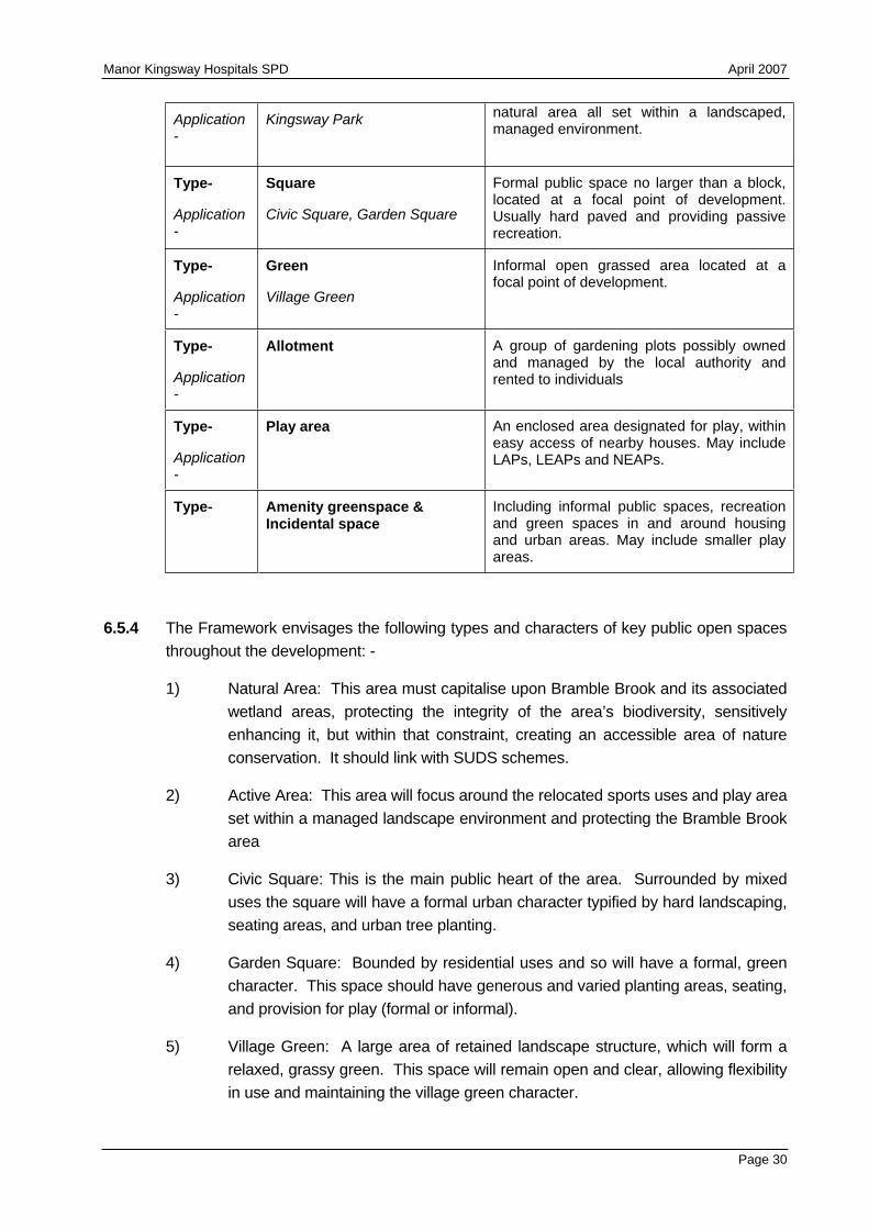
Manor Kingsway Hospitals SPD April 2007
Application-
Kingsway Park natural area all set within a landscaped, managed environment.
Type-
Application-
Square
Civic Square, Garden Square
Formal public space no larger than a block, located at a focal point of development. Usually hard paved and providing passive recreation.
Type-
Application-
Green
Village Green
Informal open grassed area located at a focal point of development.
Type-
Application-
Allotment A group of gardening plots possibly owned and managed by the local authority and rented to individuals
Type-
Application-
Play area An enclosed area designated for play, within easy access of nearby houses. May include LAPs, LEAPs and NEAPs.
Type- Amenity greenspace & Incidental space
Including informal public spaces, recreation and green spaces in and around housing and urban areas. May include smaller play areas.
6.5.4 The Framework envisages the following types and characters of key public open spaces throughout the development: -
1) Natural Area: This area must capitalise upon Bramble Brook and its associated wetland areas, protecting the integrity of the area’s biodiversity, sensitively enhancing it, but within that constraint, creating an accessible area of nature conservation. It should link with SUDS schemes.
2) Active Area: This area will focus around the relocated sports uses and play area set within a managed landscape environment and protecting the Bramble Brook area
3) Civic Square: This is the main public heart of the area. Surrounded by mixed uses the square will have a formal urban character typified by hard landscaping, seating areas, and urban tree planting.
4) Garden Square: Bounded by residential uses and so will have a formal, green character. This space should have generous and varied planting areas, seating, and provision for play (formal or informal).
5) Village Green: A large area of retained landscape structure, which will form a relaxed, grassy green. This space will remain open and clear, allowing flexibility in use and maintaining the village green character.
Page 30
Manor Kingsway Hospitals SPD April 2007
6) Memorial Pocket Park: This space is another area of high quality retained landscape structure. The memorial feature will be relocated here.
7) Amenity greenspace and Incidental space: These are local open spaces within and around residential areas. They should respond to the character of the area in which they sit. They may be hard or soft, but they should have a function, and not be left over arbitrary space. They can include street trees and other features such as green roofs. Opportunities could to be taken to include semi natural planting schemes into these areas.
Green Routes
6.5.5 Some of the streets in the development will have functions beyond those of the traditional residential street or access road. Green routes are streets with a substantial soft landscape treatment, creating a continuous wildlife corridor linking biodiversity resources and creating linear wildlife habitats. They are also amenity resources adding variety and identity to an area.
The Crescent:
6.5.6 This route will be the main green link running through the development, focusing around the highest quality avenues of trees within the site. It will have a wide landscape edge (at least 10m) to take in the existing trees. A path and cycleway segregated from the road will strengthen the ‘parkland estate’ character. Planting must find a balance between strengthening the existing character of ornamental specimen trees, and native species to enhance the biodiversity qualities of the route.
The Avenues:
6.5.7 The avenues are formal green routes through the site. They are lined with an avenue of closely planted trees, creating a continuous canopy along the street. They will have a segregated pavement, and a soft landscape edge to the road creating a wildlife link between the park, the Crescent and the Garden Square.
Green Edge:
6.5.8 The site boundary is an important element as it determines how the site sits in the wider landscape. The existing western and northern well vegetated boundary should be retained as it integrates the site with the immediate surroundings successfully. This boundary presents amenity value by screening the busy surrounding roads from the site, and is also a valuable part of the GI, providing a valuable linear biodiversity link around the site and between different areas.
6.6 Buildings and Townscape
6.6.1 The development framework is based upon a block layout of streets and spaces, which respond to the existing landscape framework and key routes to create an easily understandable layout, which is logical. It facilitates good overlooking of the street and restricts access to the rear of properties. It allows scope for gardens, parking and
Page 31
Manor Kingsway Hospitals SPD April 2007
servicing within the block, which has the benefit of reducing parking pressures and its visual consequences on the street. The size of the block has a direct correlation with the permeability of an area for pedestrians, and therefore smaller block sizes are encouraged. However, in some instances, particularly in mixed use blocks, the size may be increased.
6.6.2 The density gradients shown on the indicative development potential framework offer the opportunity to provide a broad range of housing in a variety of different types (see Figure 6.2). Similarly, developers should seek to create a variety of new commercial and employment buildings, whilst developing an overall architectural aesthetic. In general building heights will be 2 – 3 storeys to reflect the existing character of the area. There will be some 4 storey townhouses and apartment blocks. The use of a relatively constant building line and the repetition of similar housing forms and building elements will create a cohesive street scene and consistent character to the new development. The taller apartment blocks and offices should be introduced at appropriate locations to create focal points, define corners, demarcate arrival points, enclose squares, and provide natural surveillance over key spaces. Orienting active parts of the building toward the street frontage will ensure natural surveillance.
6.6.3 A detailed survey of the existing buildings on the site has been completed by the landowners. The survey indicates that none of the buildings are of sufficient historic or architectural merit to justify listing. English Heritage has separately surveyed the site, as part of a review of all of the hospitals transferred to English Partnerships, but the results of this assessment will not be know for some months. At present, it is considered that the Lodge and Kingsway House have limited local interest and developers should therefore explore the potential for the retention of these buildings, although it is recognised that Kingsway House, in its current form, is inefficient and it is difficult to provide office accommodation within the building that meets modern standards.
6.7 Accommodating the Car
6.7.1 An overarching objective for the new development is to create walkable/cycleable neighbourhoods, encouraging and assisting local people to move away from using their cars. However, cars will need to be accommodated and parking provision should be carefully considered to ensure it is sensitively integrated into the public realm. Best Practice Guidance for example, Manual for Streets, should be adhered to in designing appropriate parking solutions. Integrating parking successfully and seamlessly in the public realm throws up many challenges and there are a number of key ideas which should be incorporated, including: -
1) Considering a variety of methods to accommodate the car, to find the best mix.
2) Allowing a certain amount of appropriate on-street parking to animate the street but not creating a character dominated by parking.
3) Preventing car parking from creating unusable and unattractive places for
Page 32
Manor Kingsway Hospitals SPD April 2007
pedestrians and non-car users.
4) Providing parking which is convenient, safe and secure.
6.8 Sustainable Systems
6.8.1 To ensure the development is sustainable and environmentally responsive, best practice regarding sustainable systems must be followed. The cornerstone of these is Sustainable Urban Drainage Systems (SUDS) which aim to integrate the site with its setting in a more environmentally friendly manner and reduce the environmental impact of the scheme. SUDS systems will be required to create opportunities for biodiversity improvements and habitat creation along swales and at attenuation points.
6.9 Urban Design Principles
6.9.1 This section introduces the best practice urban design principles, which need to be considered in the development of new proposals on the Manor Kingsway site.
Continuity and Enclosure
6.9.2 Controlling the enclosure and continuity of the street will help to create a legible and memorable place by responding to the street hierarchy, character and significant events in the townscape.
Quality of the Public Realm and Landscape
6.9.3 The core objective is to create attractive and functional streets and spaces within an appropriate and well designed public realm network. All space within the townscape should have an appropriate function. Public, private and semi-private spaces should be incorporated and have clearly distinct boundaries defined to reinforce their roles. Opportunities will be sought to incorporate environmental art into the development to enhance its quality
Ease of Movement and Permeability
6.9.4 The development will be required to create a sustainable movement network that is permeable, easily navigable and encourages the circulation of people on foot, cycle and public transport.
Legibility
6.9.5 Development proposals should create a legible layout, whereby the articulation and orientation of streets and buildings will enable people to find their way around. Variety in the scale and treatment of public spaces and the creation of well defined and welcoming entrances will aid legibility.
Adaptability
6.9.6 All new residential developments will be expected to be built to Lifetime Homes Standards. Designing for flexibility and adaptability does not only apply to residential
Page 33
Manor Kingsway Hospitals SPD April 2007
properties however, and the wider principles are just as applicable to commercial and industrial properties. This allows change and development to occur over a period of time.
Architectural Richness and Diversity
6.9.7 Richness and diversity within the scheme is encouraged through the use of a variety of building forms and street layouts with integrated areas of greenspace and landscape. A unique identity and sense of place will be derived from the informed juxtaposition of a variety of building forms.
Coherence and Clarity
6.9.8 Whilst diversity in the built fabric is encouraged, through the creation of a range of house types, commercial and employment premises, these buildings and the spaces they enclose should relate to one another in a meaningful way and should be unified through a consistent approach to public realm treatment across the site. There should be a logical relationship between buildings, streets and spaces to form a coherent whole.
Safety and Security
6.9.9 All new development will be expected to be designed to ‘Secure by Design’ accreditation standards. Further detail on Secure by Design should be obtained from the local police constabulary architectural advisor and the Home Office publication ‘Safer Places’.
Sustainability
6.9.10 The development masterplan should give regard to the anticipated changes in policy and in particular the PPS Planning and Climate Change supplement to PPS1 and the requirements of the draft Regional Spatial Strategy for the East Midlands (RSS 8). The design and construction of the development will consider and address at the outset the to reduce carbon and greenhouse emissions and deliver low carbon development. The development will be required to meet, as far as possible, the following attributes as part of the masterplanning of the site and in the subsequent detailed design: -
1) Ensure future flexibility in the built fabric,
2) Using landform, layout, building orientation, and landscaping to minimise energy consumption
3) Giving careful consideration to the extent to which proposed massing of buildings, density and mix of development helps to minimise energy consumption
4) Reducing energy usage in line with the ‘energy hierarchy’
to reduce the need for energy
to use energy more efficiently
to use renewable energy
Page 34
Manor Kingsway Hospitals SPD April 2007
any continuing use of fossil fuels to be clean and efficient for heating and co-generation
5) Providing energy from micro-renewable technologies and decentralised energy supply systems based on renewable and low carbon energy.
6) Considering and taking into account the future use of renewable micro-technologies
7) Reducing demand for water,
8) Promoting waste management in line with the hierarchical approach of:
waste reduction;
re-use;
recycling and composting;
energy recovery; and,
disposal.
9) Making alternative transport modes attractive,
10) Using sustainable materials and construction techniques.
11) Adapt to climate change and built in resilience to climate change impacts now and in the future
6.9.11 There is a requirement to use modern construction techniques that achieve significant efficiencies in terms of delivery and output – whether through English Partnerships / Housing Corporation defined Modern Methods of Construction (MMC) or other methods, and by building on the lessons learnt in the Design for Manufacture Competition. The design and construction of this scheme over its lifetime will respond to the changes in policy nationally, regionally and locally, with regards to delivering low carbon and carbon neutral developments.
Page 35
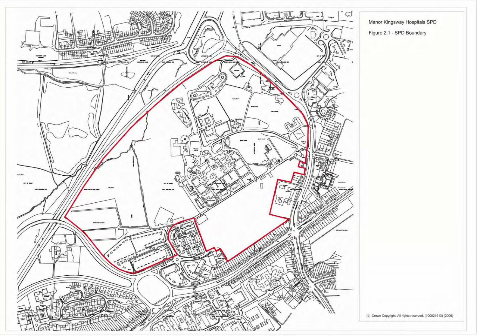
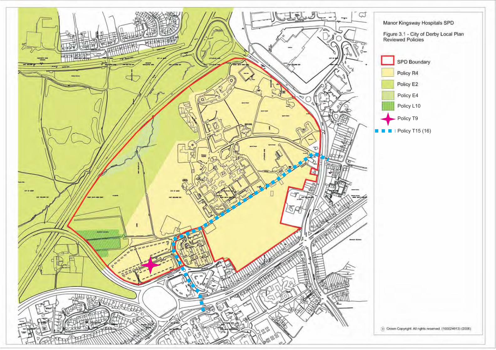
Policy E4
Policy L10
Policy T9
Policy T15 (16)
Manor Kingsway SPDFig 4.2 Landscape Character
N
Site boundary
Area 1
Area 2
Area 3
Area 2 is predominantly arable fields with areas of grass, scrub and trees around the periphery. It is characterised by large areas of open green space with views out towards Derby and the surrounding areas. 2a has a more rural feel with well vegetatedboundaries and views of the countryside, whilst 2b has views of Derby and so has a more suburban character.
A number of open lawns have their edges clearly defined by avenues and rows of trees. The area is generally well maintained and of a high landscape quality.
Area 1 has a strong, simple, and cohesive landscape structure. Spaces are well defined by formal shrub planting and mature trees (mainly beech, horse chestnut and pines). 1a is primarily larger open lawns defined by trees, whilst 1b consists of more intimate spaces and courtyards oftendefined by built form.
There is little spatialhierarchy in area 3: apartments face onto car parks with no semi-private areas. The vegetation is typified by standard low maintenance species- mainly cotoneasters. Thedesign is homogenous and lacks unique character.
Area 3 is dominated by car parking; mainly by an expansive surface car parkbut also by smaller parkingareas around the nurses accommodation and amenities. There is poor definition or enclosure of space.
To the north the land slopes down to the A38 and Bramble Brook with its associated areas of willow,alder and birch. To the west allotments are unused and getting overgrown. Site cabins are the main visual detractors of this area, visible in the left of the photo.
Area 4: sandwiched between Mickleover and Mackworth, area 4 is comprised of arable fields bounded by thick hedgerows and trees. Sports facilities and school grounds are located around the edges of the area.
1a
1b
2a
2b
3
Photograph by Roger DSmith ABIPP, Gosport
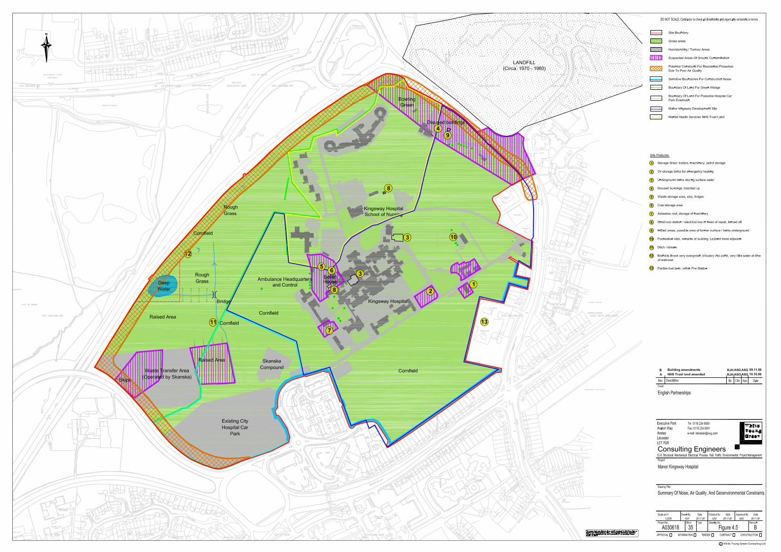
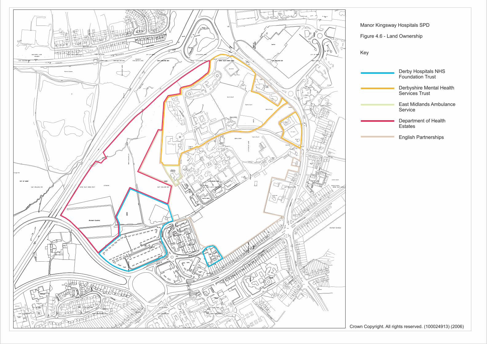
Manor Kingsway Hospitals SPD
Figure 4.6 - Land Ownership
Key
Derby Hospitals NHSFoundation Trust
Derbyshire Mental HealthServices Trust
East Midlands AmbulanceService
Department of HealthEstates
English Partnerships
Crown Copyright. All rights reserved. (100024913) (2006)
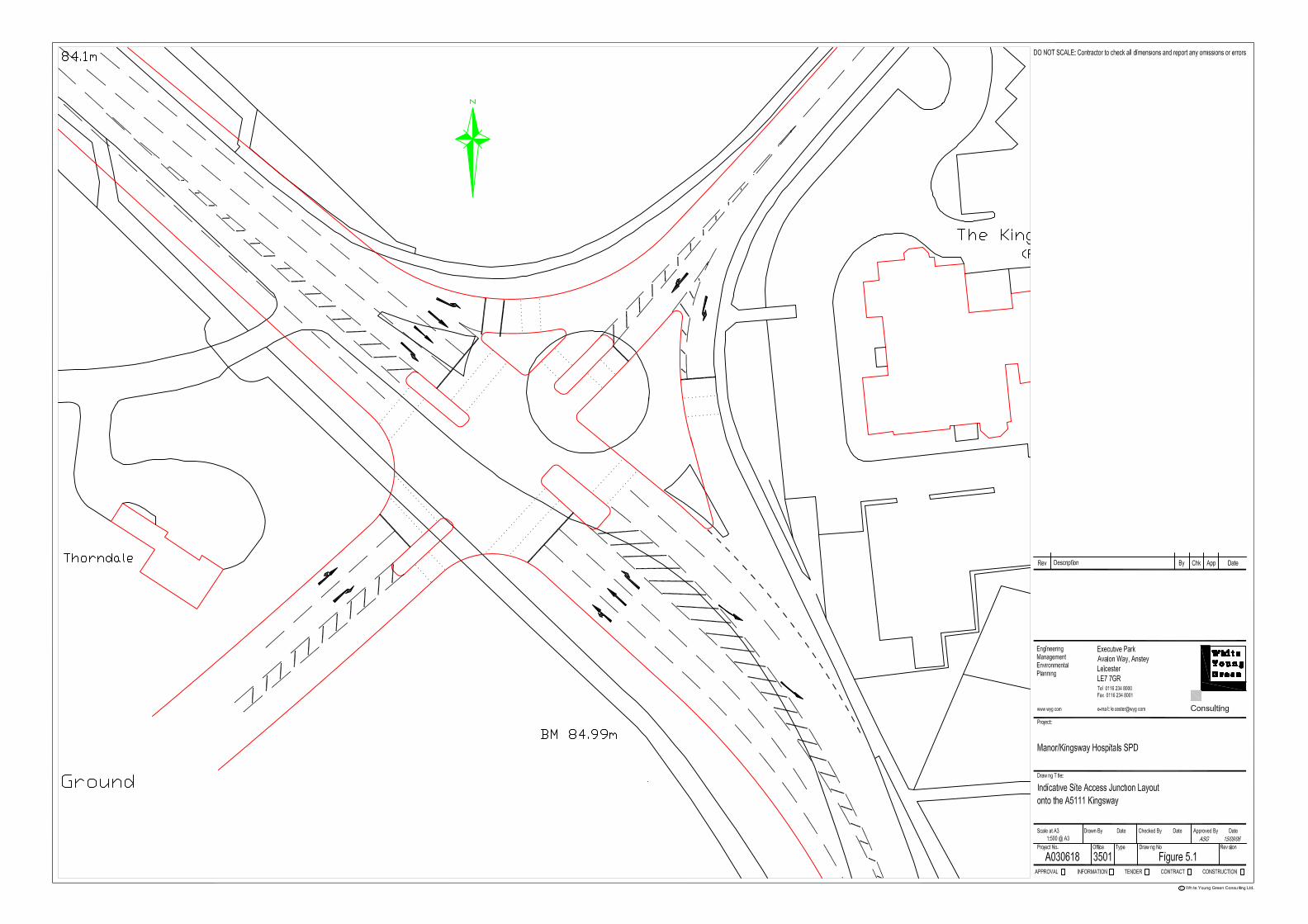
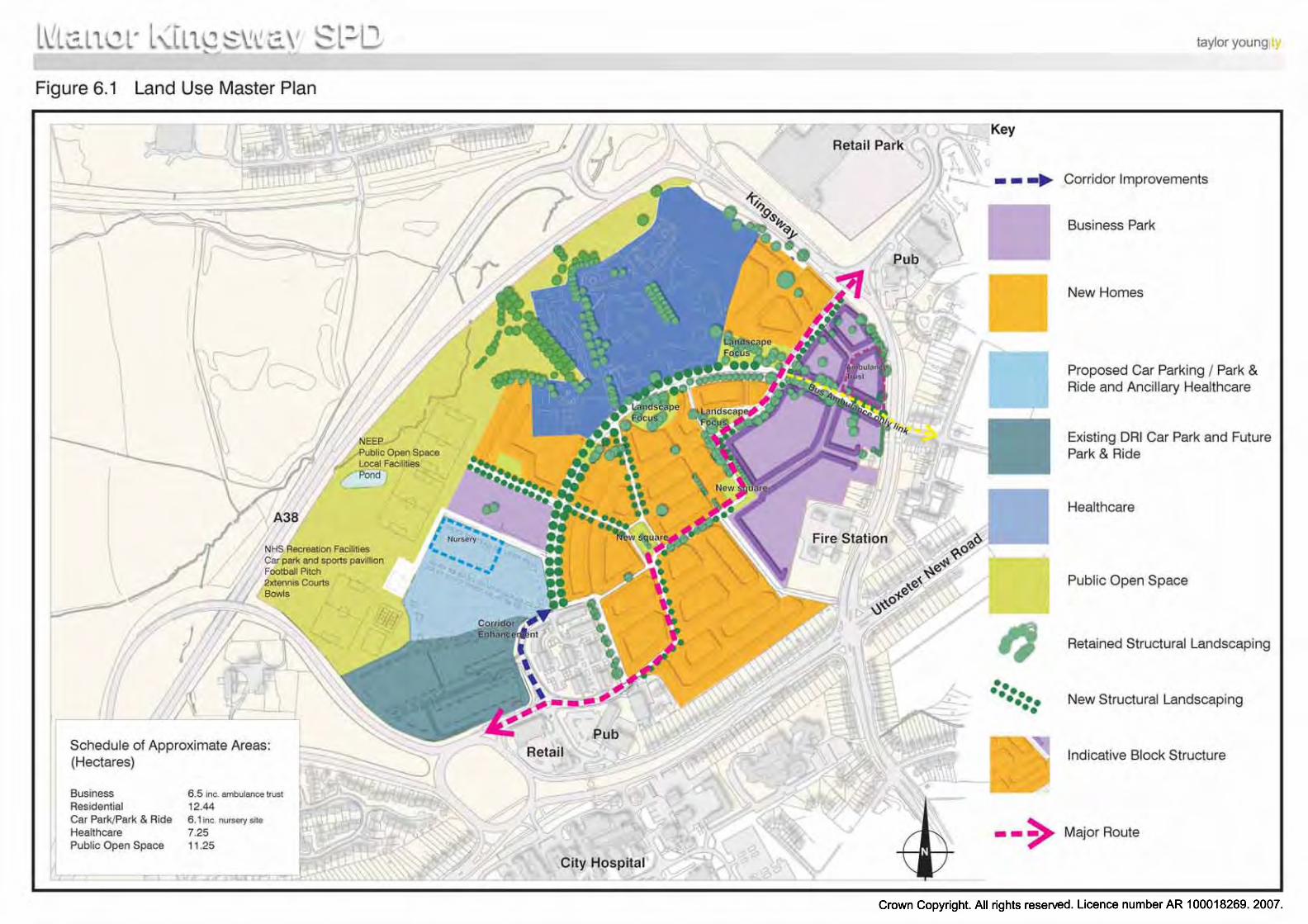
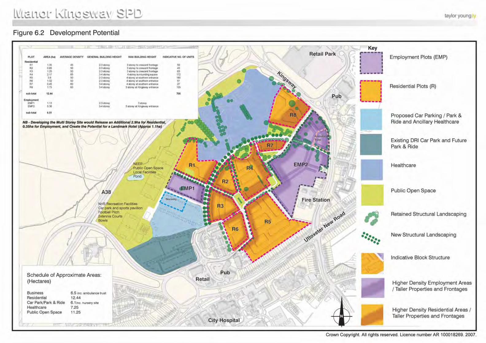

APPENDIX 1

Manor Kingsway Hospitals SPD April 2007
APPENDIX 1 – LIST OF RELEVANT PLANNING PLAN POLICIES
NATIONAL POLICY
Planning Policy Statement 1: Delivering Sustainable development
Planning Policy Statement 3: Housing
Planning Policy Guidance 4: Industrial and commercial development and small firms
Planning Policy Statement 12: Local Development Frameworks
Planning Policy Guidance 13: Transport
Planning Policy Statement 22: Renewable Energy
Planning Policy Statement 23: Planning and Pollution Control
Planning Policy Guidance 24: Planning and Noise
Planning Policy Statement 25: Development and flood Risk
LIST OF RELEVANT DEVELOPMENT PLAN POLICIES
RSS for the East Midlands (Formerly RPG8)
1. RPG8 was published by the ODPM in January 2002. It was prescribed as the RSS for Yorkshire and the Humber by the Town & Country Planning (Initial Regional Spatial Strategy) (England) Regulations 2004.
2. Policy 1 – Locational Priorities for Development, establishes a sequential approach to the selection of land for development. The highest priority is given to suitable previously developed land and buildings within urban areas that are, or will be, well served by public transport. This is followed by other suitable locations within urban areas.
3. Policy 2 – Sustainability Criteria, outlines the criteria to be taken into account in assessing the suitability of land for development. The criteria include: the availability of previously developed land; the accessibility of sites by non-car modes; the capacity of existing infrastructure; the physical constraints on land; the impact on natural resources and cultural assets; the viability of development; and the suitability for mixed use.
4. Policy 5 – Concentrating Development in Urban Areas, seeks to ensure development plans make provision for most development needs within existing urban areas.
5. Policy 10 – Development & Health, states that development plans should facilitate the modernisation of local health services. In particular, the rationalisation of hospital services in Southern Derbyshire and the release of land for mixed-use development are noted.
6. Policy 12 – Land to Meet Employment Needs, states that development plans should ensure that provision for employment is considered first on previously developed land within urban areas. In addition, a range and choice of sites should be readily available.
7. Policy 21 – Sustainable Locations for Housing, indicates that the location of housing sites should reflect the sequential approach in Policy 1 and the sustainability criteria in Policy 2.
Page (i)
Manor Kingsway Hospitals SPD April 2007
8. Policy 22 – Managing the Release of Land, requires development plans to include policies that manage the release of land for housing ensuring previously developed land is given first priority.
9. Policy 23 – Target for Re-using Previously Developed Land, establishes a target of 60% of additional dwellings to be provided on previously developed land by 2021.
10. Policy 26 – Providing Affordable Housing, encourages the provision of a mix of dwellings in terms of size, type, affordability and locations in order to create inclusive communities, which provide wider housing opportunity and choice.
11. Policy 74 – Major Transportation Studies in the Region, indicates that the Highways Agency will undertake a road based study of the A38 Derby junctions with the A52/A5111and A61.
12. Policy 84 – Development in the Three Cities Sub-area, indicates that measures should be taken, consistent with the sequential approach, to support regeneration opportunities in Derby and maintain and strengthen their economic, commercial; and cultural role by ensuring provision is made inter alia for a mix of house types and new employment land.
Derby & Derbyshire Joint Structure Plan
1. The Derby & Derbyshire Joint Structure Plan was adopted in January 2001.
2. General Development Strategy Policy 1 encourages new development to respect the principles of sustainable development by creating energy efficient patterns of development; minimising the need to travel; encouraging the increase use of public transport; and, re-using land.
3. General Development Strategy Policy 3 requires new development to be well related to settlements; respect open land within settlements; make effective use of opportunities for the redevelopment of underused land; make good use of infrastructure; and, increase density at public transport nodes.
4. Housing Policy 3 encourages housing to be located within urban areas in accordance with the principles of sustainable development.
5. Housing Policy 12 requires that about 15,500 dwellings be provided in Derby between 1991-2011.
6. Economy Policy 2 indicates that proposals for business and general industrial development should be located where there is significant public transportation provision and make full use of under-used land.
7. Economy Policy 12 requires that 315ha of land for business development is provided in Derby between 1991-2011.
8. Transport Policy 1 indicates that new development should take into account the aim of reducing the need to travel with priority given to public transport, walking and cycling.
9. Transport Policy 4 requires new development to minimise the need to travel by being located within settlements, avoiding disbursed settlement patterns, and providing for a variety of land uses within communities. In addition, development should be well served by public transport and make provision for safe and convenient access for public transport, pedestrians and cyclists.
10. Transport Policy 9 seeks to encourage a greater proportion of journeys to be made on foot by a range of measures.
Page (ii)
Manor Kingsway Hospitals SPD April 2007
11. Transport Policy 10 seeks to encourage a greater proportion of journeys to be made on cycles by a range of measures.
12. Transport Policy 14 indicates that studies are being undertake by the Department of the Environment, Transport and the Regions of the A38 Derby Ring Road junctions.
City of Derby Local Plan Review
1. The City of Derby Local Plan Review was adopted in January 2006.
2. Policy GD1 – Social Inclusion, indicates that the Council will seek to ensure that development proposals help meet the objectives of promoting social inclusion and reduce the effects of exclusion, such as poverty, ill-health and disability. The policy also seeks to ensure a mix of housing types and tenures in all areas.
3. Policy GD2 – Protection of the Environment, states that the development should protect, and where possible enhance, the City’s environment, its natural resources and its built heritage. Have regard to the need to protect and enhance landscape character, local distinctiveness and community identity.
4. Policy GD3 – Flood Protection, refers to circumstances where planning permission will not be granted in relation to issues of flooding.
5. Policy GD4 – Design and the Urban Environment, indicates that the Council will only permit development which makes a positive contribution to good urban design. The policy also notes that development proposals for significant or sensitive sites should be accompanied by a design statement.
6. Policy GD5 – Amenity, establishes that planning permission will only be granted for development where it provides a satisfactory level of amenity within the site or building itself and provided it would not cause unacceptable harm to the amenity of nearby areas.
7. Policy GD7 – Comprehensive Development indicates that planning permission will only be granted where a comprehensive and co-ordinated approach to development can be demonstrated. In particular the City Council will seek to ensure that the density, layout and design of roads, buildings and open space is comprehensively phased and implemented within identified development sites.
8. Policy GD8 – Infrastructure, indicates that new development will make provision for necessary and appropriate infrastructure directly related to the development proposed, including pedestrian, cycle and public transport facilities, and services, traffic management measures, road improvements, water, sewage and surface water drainage, recycling facilities; and other utilities and social infrastructure, helath and community facilities, including public space, sport and recreation.
9. Policy R4 – Former manor Kingsway Hospitals, identifies the Manor Kingsway Hospitals site as a major mixed –use regeneration opportunity. The policy states: -
38.0 hectares of land at the former Manor and Kingsway Hospitals is identified as a major mixed use regeneration opportunity. Planning permission will be granted for a mixed use development, which includes: -
a. A high quality business park (Class B1) on no less than 6.9hectares;
b. The erection of a minimum of 500 open market dwellings;
c. The erection of a minimum of 200 ‘key-worker’ residential units;
d. Extensions to existing healthcare uses;
Page (iii)
Manor Kingsway Hospitals SPD April 2007
e. New healthcare uses and ancillary facilities, including car parking and a nursery;
f. A park and ride interchange.
Development proposals should:
1. be accompanied by a Transport Assessment;
2. provide measures to encourage alternative modes of transport to the car; related road and junction improvements; and high quality pedestrian and cycle routes within the site;
3. provide measures to secure improvements to the surrounding road network to facilitate public transport and any necessary road and junction improvements;
4. include phased implementation of the business and residential uses;
5. secure the retention of trees and landscape features, which make a significant contribution to the character and appearance of the site;
6. make provision for sports facilities based on a robust and up-to-date assessment of the need for such facilities.
The City Council will seek to enter into an obligation under Section 106 of the 1990 Act to secure open space provision, community facilities, affordable housing (key worker units) and measures to promote walking and cycling including a contribution towards a link across theA38 to the proposed Bramble Brook cycle route (PolicyT15(15))’.
10. Policy H11 – Affordable Housing, indicates that the Council will seek to provide affordable housing within residential developments having regard to the evidence of need and site suitability. In doing this the Council will seek to ensure that the dwellings are genuinely affordable and remain so in perpetuity.
11. Policy H12 – Lifetime Homes, states that the Council will seek to increase the housing available to disables people and ensure that developers construct a proportion of lifetime homes on suitable sites.
12. Policy H13 – Residential Development: General Criteria, establishes the criteria against which application for residential development will be considered, including inter alia, a minimum density of 35dph and a high quality of density and layout.
13. Policy E2 – Green Wedges, identifies a Green Wedge across the western and northern part of the site. Within this area only limited forms of development will be permitted.
14. Policy E4 – Wildlife Sites states that development will not be permitted if it will destroy or adversely affect, either directly or indirectly, sites of local importance.
15. Policy E5 – Biodiversity indicates that application for new development on sites which have features of nature conservation interests will only be approved where provision is made for the retention of those features. These will include mature trees, established hedgerows and shrubs areas, water features and geological resources, and other Biodiversity Action Plan priority habitats and priority species.
16. Policy E9 – Trees states that planning permission will not be granted for development which would seriously damage, destroy or compromise the long term retention of individual trees, groups of trees or areas of woodland which contribute to the amenity of the area. Conditions will be imposed on outline and full planning permissions to secure
Page (iv)
Manor Kingsway Hospitals SPD April 2007
the protection of trees before and during development.
17. Policy E10 – Renewable Energy, states that development proposals will have full regard to the need to reduce the net use of energy and shall ensure that construction methods and materials maximise opportunities for using recycled materials, conserving energy generating energy from renewable sources such as solar energy. The policy emphasises the need to ensure that the siting, design, layout and orientation of buildings has full regard to the need to reduce energy consumption and will facilitate use of renewable energy sources.
18. Policy E13 – Contaminated Land, indicates planning permission for development on contaminated or unstable land will be granted provided that the City Council is satisfied that the proposal would not cause adverse or hazardous effects and that any necessary remedial measures are carried out before development starts.
19. Policy E17 – Landscaping Schemes, states in granting planning permission, conditions will be applied requiring the undertaking of landscaping schemes.
20. Policy 23 – Design, emphasis that the City council will expect proposals submitted for planning permission to be of a high standard of design and to complement the surrounding area in which the development would be located.
21. Policy E24 – Community Safety, indicates that new development needs to provide a safe and secure environment and take full account of the need for community safety and crime prevention measures.
22. Policy E27 – Environmental Art, states that the Council will encourage the incorporation of environmental art where it will contribute to the quality and appearance of new developments or to the general townscape.
23. Policy L2 – Public Open Space Standards, requires the provision of public open space as part of residential developments, and sets out the standards to be adopted.
24. Policy L3 – Open Space Requirement in New Developments, states that where housing development would generate needs for additional public open space and related facilities, planning permission will only be granted if public open space is provided to meet those needs.
25. Policy L10 – Allotments, identifies an area of land along the western boundary as allotments. Development, which involves the loss of allotments, will only be permitted if satisfactory alternative provision is made.
26. Policy T1 – Transport Implications of New Development, states that the Council will seek to ensure that the proposed development will not result in increased traffic congestion, have a detrimental effect on the local environment or lead to a reduction in road safety.
27. Policy T3 – Highway Agency Schemes, indicates that planning permission will not be granted for development, which would prejudice the construction of the grade separation of the A38(T) junctions with the A5111(T) and the A52(T).
28. Policy T4 – Access, Parking & Servicing, indicates that the Council will grant planning permission for development, which makes safe and appropriate provision for access, parking and servicing.
29. Policy T6 – Provision for Pedestrians, indicates that the Council will seek to provide a safe and attractive environment for pedestrians, including disabled people.
30. Policy T7 – Provision for Cyclists, states that in considering planning applications the
Page (v)
Manor Kingsway Hospitals SPD April 2007
Council will seek to negotiate provision of measurers to make cycling safer and more attractive.
31. Policy T8 Provision of Public Transport, indicates that the Council will promote the increased use of public transport services.
32. Policy T9 – Park & Ride, identifies a site for a Park & Ride facility on the land to the north of the City Hospital roundabout.
33. Policy T15 – Protection of Footpaths & Cycleways, identifies a potential cycleway from Uttoxeter Road to Kingsway across the Kingsway Hospital site.
Page (vi)
Appendix 2
Please refer to the separate document by White Young Green and ACS Consulting
‘Arboricultural Survey and Constraints Plan: Manor Kingsway Hospital, Derby’ August 2006