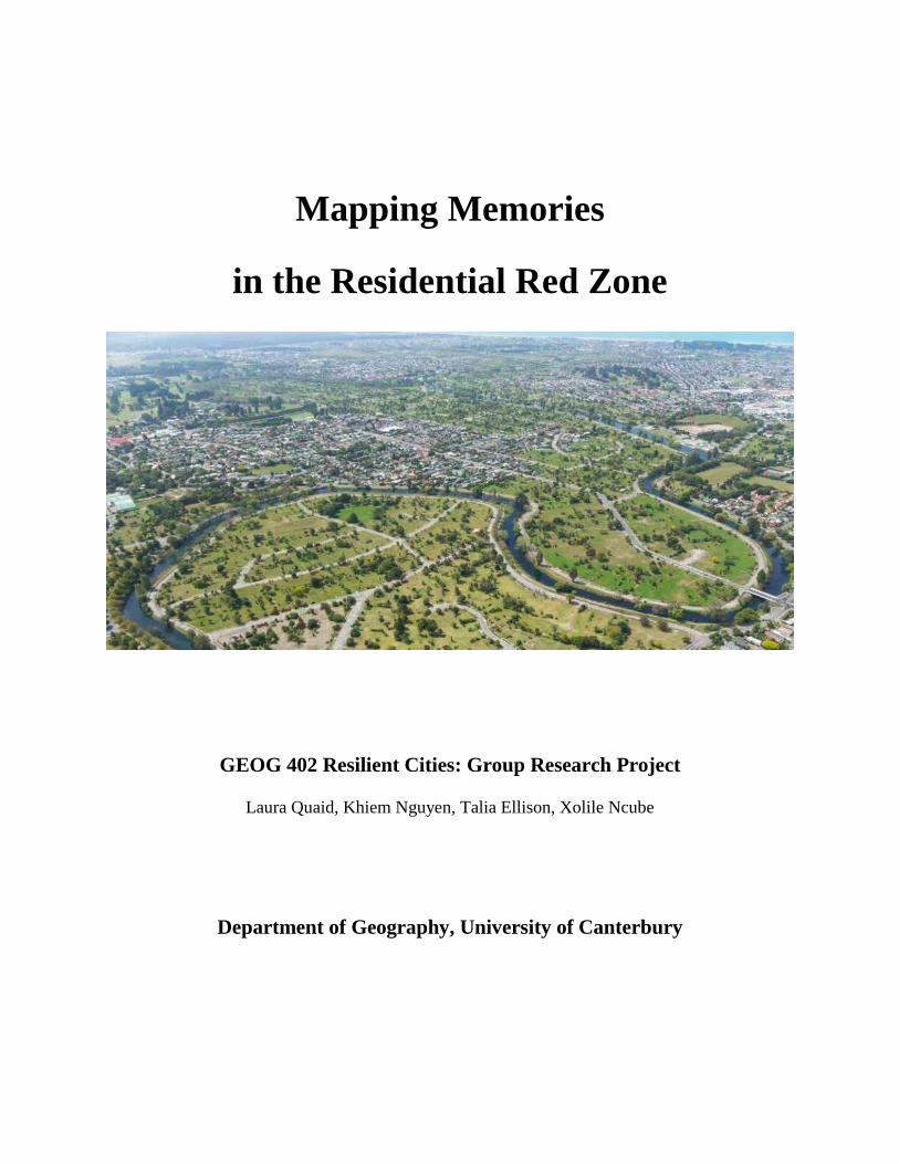
Mapping Memories in the Residential Red Zone GEOG 402 Resilient Cities: Group Research Project Laura Quaid, Khiem Nguyen, Talia Ellison, Xolile Ncube Department of Geography, University of Canterbury
Transcript
Mapping Memories
in the Residential Red Zone
GEOG 402 Resilient Cities: Group Research Project
Laura Quaid, Khiem Nguyen, Talia Ellison, Xolile Ncube
Department of Geography, University of Canterbury
Executive Summary
The objective of this research is to understand how we can best capture and present collective
and individual memories of the Residential Red Zone (RRZ). RRZ refers to the area in the East
of Christchurch, categorised by significant land damage as a result of the 2010 and 2011
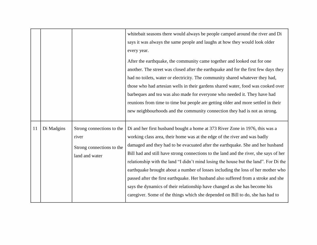
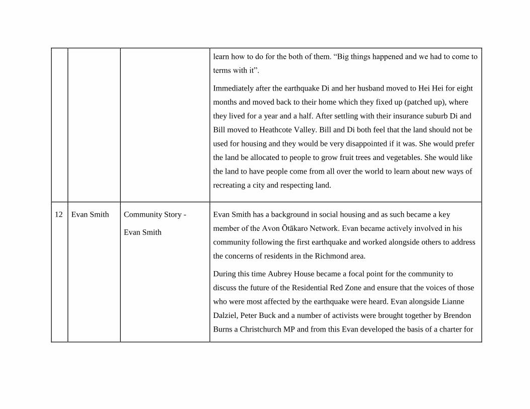
Christchurch Earthquakes, which deemed the land unsuitable for residential use for a prolonged
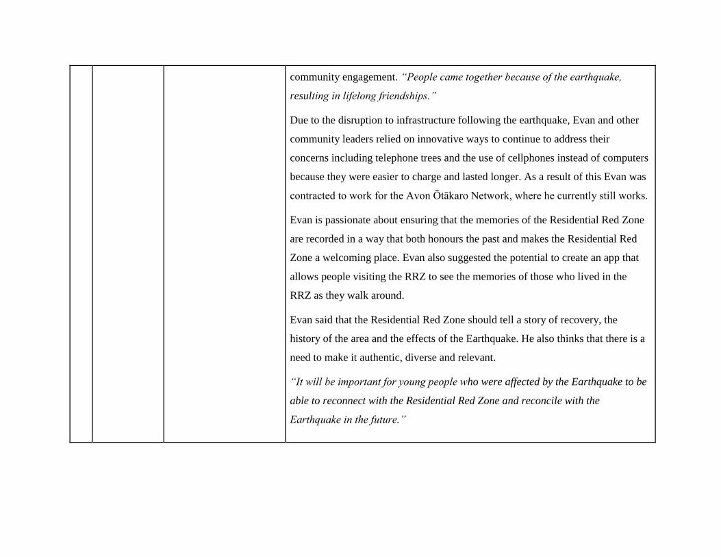
period. The results were informed by a study of literature into the sense of place, social memory,
archiving, and GIS. We used qualitative semi-structured interviews to collect stories that capture
the sense of place of living in this area and secondly, to understand the importance of preserving
the memories of the red zone. This study also focused on how to best capture, document and
share memories based on the desired outcomes from the perspective of the community.
We used snowball and purposive sampling for the selection of participants of former residents of
the Residential Red Zone. A total of eight (8) people were interviewed. Some in their individual
capacity, others on behalf of the community and some were interviewed as individuals and they
also represented the community. The community members interviewed expressed a keen desire
to preserve and archive the memories of the RRZ. Participants expressed a desire for the
memories to reflect the sense of place prior to the earthquakes and the way the community
strengthened following the disaster, and the lessons that could be shared about the process of
recovery. It was indicated that the format should be location based and should incorporate the
aspects of nature. There was also a desire to include images and videos. It was important to have
the memories shared with the wider community. The stories gathered during the interviews were
used to populate a survey on Maptionnaire, which is a participatory geospatial tool. The stories
and photographs collected during the interviews were linked to spatial locations on Maptionnaire
and the link to the survey can now be shared on social media for further population.
Following the series of earthquakes and aftershocks that struck the greater Christchurch area, the
Earthquake Commission gathered a significant amount of geotechnical information about the
magnitude of the damage that had occurred to the land in the East of Christchurch. The
government released this information to help insurers and property owners come to terms with
the effects of these earthquakes, and to determine the viability of repairing the land,
infrastructure and housing on the ‘East side’. Residents in the worst affected areas faced lengthy
negotiations with insurers while still living on unstable land, many in damaged housing with
little or no access to power, water and sewerage. The decision to ‘Red Zone’ the land was made
based on the state of the land and the length of time it would take to address the various issues
within this area (Regenerate Christchurch, 2016). According to a report written by the Human
Rights Commission, approximately 5,314 residential properties were ‘red zoned’ (Human Rights
Commission, 2016). Over 7000 households were displaced as a result of the earthquakes
(Statistics NZ, 2014), in an area that was previously home to a series of suburbs and a number of
communities that followed the Avon River from Avonside to New Brighton.
Following the earthquakes, the demography of Christchurch city changed significantly. While
the population within central Christchurch decreased, the population in Selwyn and Waimakariri
increased (Statistics NZ, 2013). In addition, there were 36.6 percent fewer occupied dwellings in
central Christchurch in comparison to 2006 and two-thirds of the population in the damaged
areas of Christchurch relocated to other areas within the greater Christchurch area (CERA,
2016). It is clear from these statistics that the earthquakes caused significant and ongoing
disruption to the livelihoods of those residents from the most affected areas.
In order to enhance community resilience, it was decided that the land would no longer be
suitable for residential use. Entire communities were displaced and caused significant disruption
to individual and collective place attachments. The experience of disaster strengthened the sense
of community across this area, and many ex-residents still engage through community events and
by contributing to the future of the RRZ. A number of residents have expressed their desire for
the memories of the RRZ to be recorded and presented in a meaningful way. Ideally, this could
be a way of maintaining the sense of community that existed prior to the earthquakes and as a
way to share experiences of living in the RRZ both during the earthquakes as well as after, and to
give residents the opportunity to share their desires for the future of the RRZ.
The aim of this report is to understand the best way to capture and present the memories of the
RRZ in a format that can be further populated and shared with the wider public. This report was
compiled in response to the request from members of the Avon-Ōtākaro Network to develop a
map that portrays the memories of the RRZ. It is hoped that this resource will be a place in which
stories, videos, and photos can be uploaded and geotagged to a specific geographical location on
a map.
The research group performed a literature review with a focus on ethnographic research, sense of
place, archiving and social memory. The primary objective of this research is to portray the lived
experiences and narratives of individuals and communities who were displaced from the RRZ
after the 2010 and 2011 earthquakes. This involves combining primary and secondary
information to capture the social and environmental landscape of these communities and, to
develop an interactive resource for the wider community that stores and encourages the sharing
of memories within this spatial area.
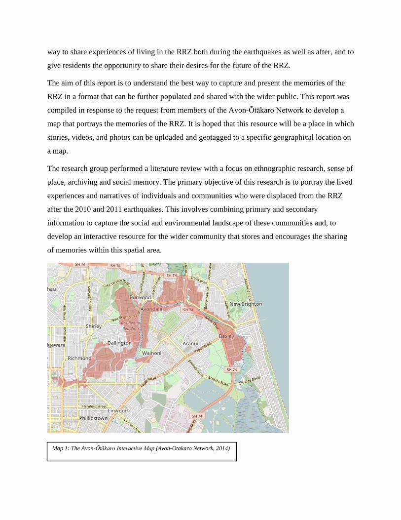
Map 1: The Avon-Ōtākaro Interactive Map (Avon-Otakaro Network, 2014)
2. Background
Sense of place refers to the ways in which an individual perceives their surroundings
(Kudryavtsev, Krasny, & Stedman, 2012). Adams (2013, p. 49) summarises sense of place as
“the lens through which people experience and make meaning of their experiences in and with
place”. This is shaped by an individual's experience in a place, within its natural and built
elements and through that individual’s social and personal connections (Scannell & Gifford,
2010). Sense of place is crucial in fulfilling fundamental human needs; therefore, places are
important in shaping identity, behaviour and wellbeing (Brown & Perkins, 1992). However, a
disruption to an individual's connection to place and a disorientation away from previous
infrastructure, community connections and resources can threaten livelihoods and identity (Cox
& Perry, 2011). Cohen, Meek, & Liebeman (2010) stated that the memories of a previous sense
of place can be used to maintain an emotional connection to place and a sense of community.
Memories are usually shared through stories and photographs, which contain important
experiences that have accumulated for several generations. Some stories have value in general
(Colten & Sumpter, 2009), while others are more specific because of their cultural and social
foundation (Cohen et al., 2010).
If information is not preserved, the wider community will not understand the social memories of
an area that no longer exists in its previous state. Archiving, the process that involves
documenting and preserving historical data, is important in capturing and preserving the social
memory, through imagined and actual lived experience (Blouin, Rosenberg, & ebrary, 2010).
Information such as digital photographs, locations, voice and video clips and stories can be
collected through Geographic Information Systems (GIS). The information captured in a GIS can
be utilised to convey meanings, feelings, memories and emotions (Kwan, 2007), and to represent
the past, present and future (Elwood, Goodchild, & Sui, 2012). Maptionnaire is a Public
Participatory GIS, which can be utilised to create map-based questionnaires, collect and store
interview data as well as other materials. Maptionnaire can also be used to analyse data,
produce reports and provides a platform to share the results promoting discussion and learning.
Maptionnaire is compatible with mobile phones and tablets (Kahila & Broberg, 2017). It is
against this background of literature study that the capturing of memories of the RRZ using a
geospatial technology (Maptionnaire) is possible and has the potential to deliver the desired
results for the project.
3. Methods
3.1 Research Approach
For the project, we utilised the qualitative research method, to answer the question “How can we
best capture and present the memories of the RRZ?’. Semi-structured interviews were conducted
with members of the RRZ. The interviews were casual, they were more of a discussion where we
used open ended questions to prompt participants to talk about their experiences before, during
and after the earthquakes. The aim of the interviews was to:
Collect and capture descriptive information about the lives of participants while they lived in
the RRZ
Gain an understanding of the importance of documenting and preserving the memories of the
red zone
Understand how former RRZ residents would prefer their memories captured and shared
Gain an understanding of the desired outcome of documenting and sharing their stories
The information our interviews captured was mainly shaped by our literature review of the
concepts of ‘lived experience’, ‘sense of place’ and ‘archiving’. Initial discussions with our
community partner and our first two interviews further guided the structure of the interviews. It
is with this background information that we decided it was important to capture the sense of
place prior to the earthquake, how this changed through the experience of disaster, and to capture
the vision of the future of the red zone.
3.2 Sampling Method
The sampling method used for this project was two pronged, we used purposive and snowball
sampling. For the purposive sampling method, we obtained key names from our community
partner, a resident and member of the Ōtākaro Avon Network. We also utilised the snowball
sampling method, where we asked residents and community networks to share information on
our research project with their networks, this brought forward suitable participants willing to
share their stories. Through this methodology we gained 8 participants that could speak as
individuals and also represent the community. This was an appropriate number to gain a range of
perspectives from the community, and to build a foundation for sharing of stories in the future.
3.3 Ethics
As this research project was completed as a requirement for the course ‘Geog 402 research
project’ blanket ethics approval was granted. Participants were asked to sign informed consent
forms and agreed to have their story used in the project. Participants were told that it is desired
that the final output of the stories would be shared online, and possibly used in the presentation.
As participants had already agreed to participate in, and support this research project, most were
already willing to share their stories and to have them used online. As the project did not provide
confidentiality, the stories would be linked to their name, this meant only people willing to
provide this were participating. People were given the choice for their transcript to be used only
for analysis in the report, and to remain confidential, if they were not comfortable with having
their story linked to their name. Participants would be given the option to view their story before
having it used in the final product.
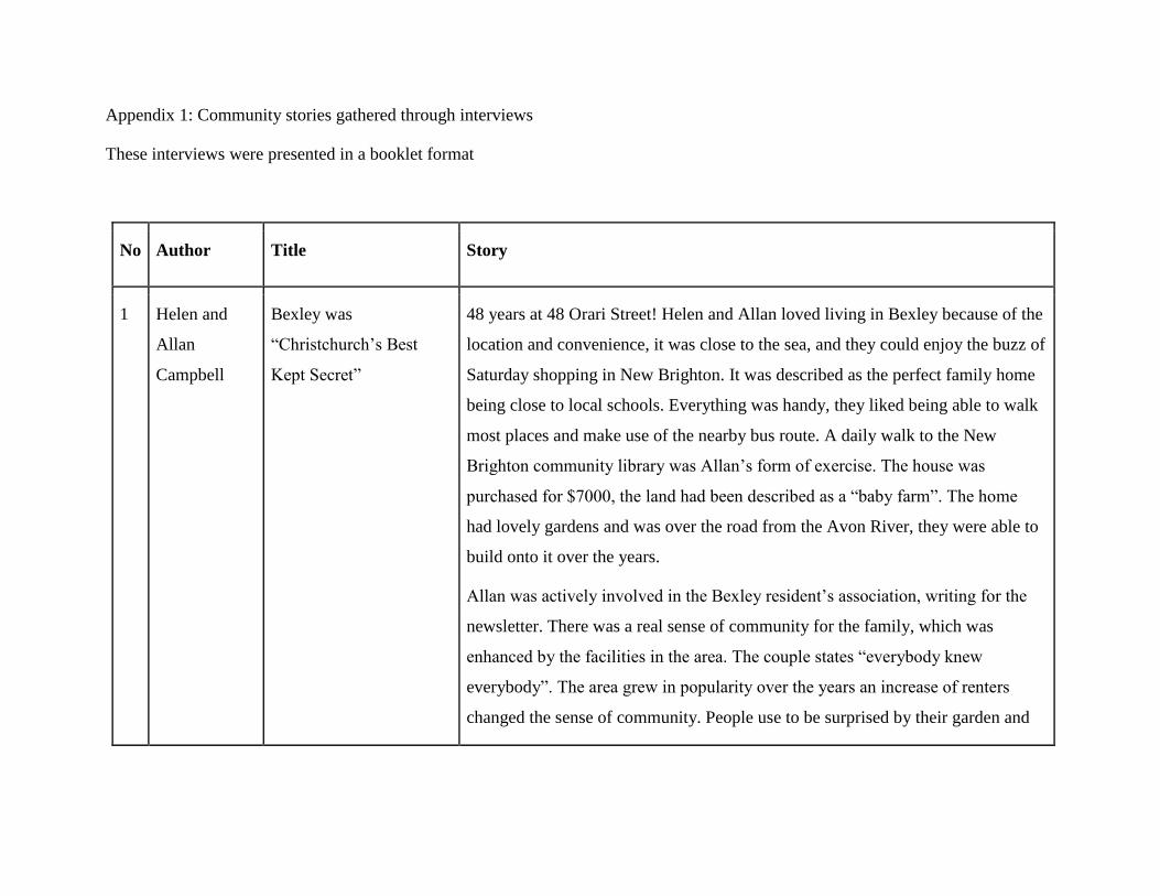
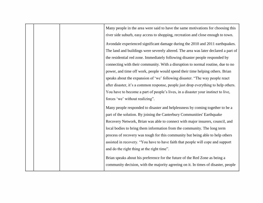
3.4 Maptionnaire & Community Stories
In-depth stories were produced from the transcriptions of the semi-structured interviews, we
were able to utilise the stories to produce a booklet that could be distributed back to the
community and to become a tool for others to know about, and participate in our project. The
interviews also helped us answer the question “How can we best capture and present memories
of the RRZ?”. Respondents were asked to indicate how they would like their stories archived and
shared, why they think this it is important to do so, and the desired outcome of preserving the
memories of the RRZ. This information helped us to form conclusions on the desired outcome.
The stories themselves helped to reveal the common aspects that should be preserved within
stories of the Red Zone. These aspects formed a series of questions that would be used to form
the Maptionnaire interface, for others to add their stories to the database. Data from interview
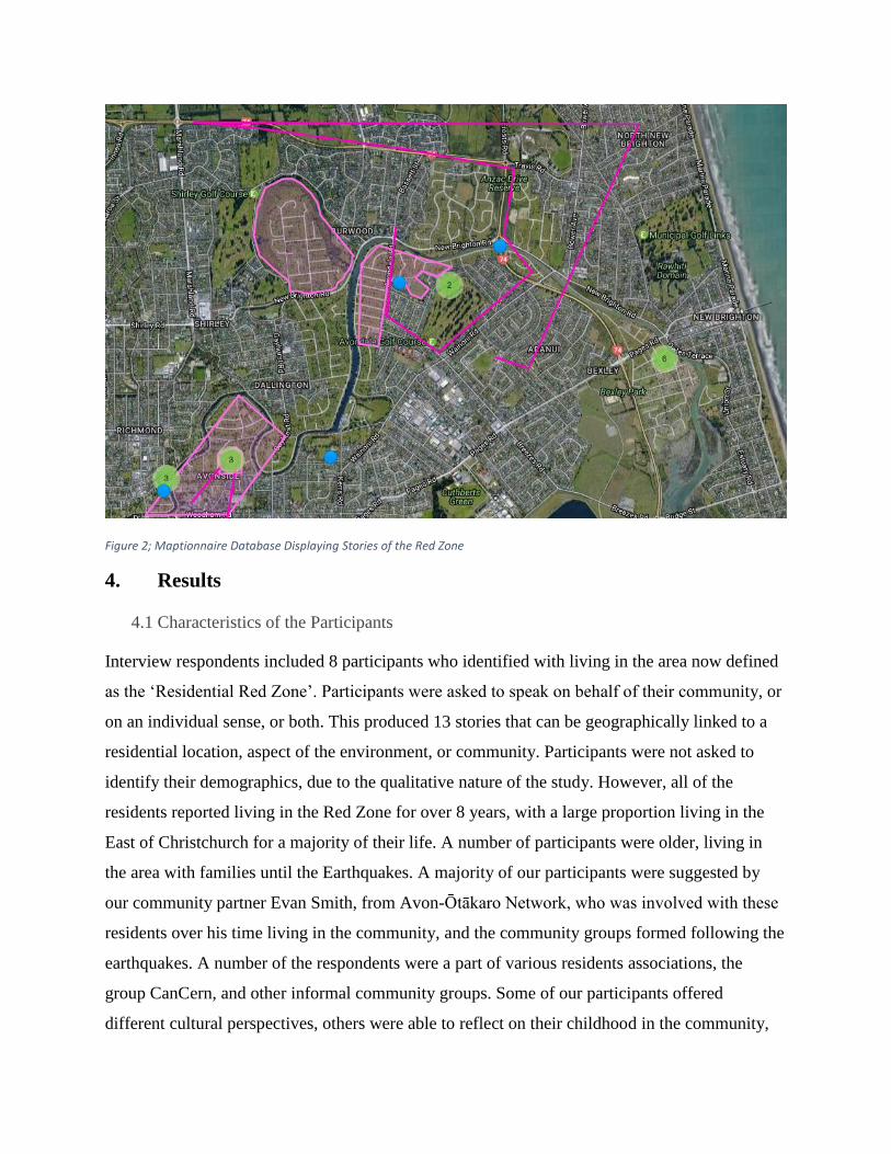
transcripts was used to fill out a separate questionnaire for each participant. On Maptionnaire we
could link each story with the location of the household in the RRZ and we could also upload
photographs for each story (Output displayed in Figure 2). The link to the questionnaire will be
shared with our community partner who can also share it on social media and with his networks
so that those interested in the project can go on to also share their stories on the platform.
Figure 2; Maptionnaire Database Displaying Stories of the Red Zone
4. Results
4.1 Characteristics of the Participants
Interview respondents included 8 participants who identified with living in the area now defined
as the ‘Residential Red Zone’. Participants were asked to speak on behalf of their community, or
on an individual sense, or both. This produced 13 stories that can be geographically linked to a
residential location, aspect of the environment, or community. Participants were not asked to
identify their demographics, due to the qualitative nature of the study. However, all of the
residents reported living in the Red Zone for over 8 years, with a large proportion living in the
East of Christchurch for a majority of their life. A number of participants were older, living in
the area with families until the Earthquakes. A majority of our participants were suggested by
our community partner Evan Smith, from Avon-Ōtākaro Network, who was involved with these
residents over his time living in the community, and the community groups formed following the
earthquakes. A number of the respondents were a part of various residents associations, the
group CanCern, and other informal community groups. Some of our participants offered
different cultural perspectives, others were able to reflect on their childhood in the community,
and therefore the stories were varied and also revealed commonalities. Through the process of
interviewing individuals and community representatives, important aspects of recording
memories, the parts of the process that people wanted to be shared with future generations, and
how best these memories can be displayed were revealed.
4.2 Archiving the Memories of the Residential Red Zone
The first objective of the semi-structured interviews was to understand the community members’
perspectives on the topic of ‘archiving’ and ‘social memory’. The group sought to understand the
importance of documenting and sharing memories, how this could best be done and the desired
outcome. Some quotes from participants that effectively answer the following questions have
been analysed.
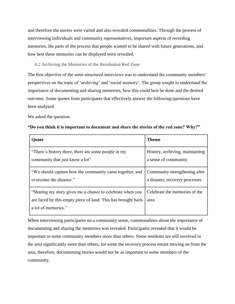
We asked the question:
“Do you think it is important to document and share the stories of the red zone? Why?”
Quote Theme
“There’s history there, there are some people in my
community that just know a lot”
History, archiving, maintaining
a sense of community
“We should capture how the community came together, and
overcome the disaster.”
Community strengthening after
a disaster, recovery processes
“Sharing my story gives me a chance to celebrate when you
are faced by this empty piece of land. This has brought back
a lot of memories.”
Celebrate the memories of the
area
When interviewing participants on a community sense, commonalities about the importance of
documenting and sharing the memories was revealed. Participants revealed that it would be
important to some community members more than others. Some residents are still involved in
the area significantly more than others, for some the recovery process meant moving on from the
area, therefore, documenting stories would not be as important to some members of the
community.
A common response in most of the stories was about maintaining the sense of community of the
area. The main importance of documenting the memories was to capture how the community
came together through the recovery process. This process was thought to be valuable to the
learnings of other communities and would increase resilience.
Some participants who were interviewed on an individual sense, focused the answers around the
idea of preserving the identity of the area. Individuals expressed that it was important to them
that the wider community knew about what their suburb was like prior to the earthquakes. Many
residents spoke about the misconceptions that the wider Christchurch had about the eastern
suburbs. Individuals felt that by documenting and sharing their story they could spread and
preserve the true identity of the area. It was important in capturing the history of the area and the
sense of place. Individuals also felt that it would be important to them on a personal level, it
would help them to preserve their land by tying their stories to locations of meaning.
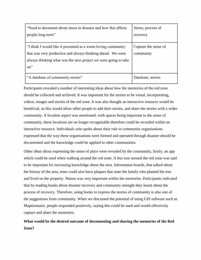
How do you think the memories of the red zone should be recorded?
Quote Theme
“We want to get a plaque made for our Totara tree on our
property that says ‘Campbell Family’”
Use nature to preserve
memories, maintain a
sense of the location
“We would use the idea of an online interactive map to
document the stories, it would be lovely”
Interactive
“Soon after I read a book called shock doctrine, reading that and
the documentation of disasters, Katrina and tsunami that was
helpful for me realising that we are in a process that we have to
work through to recover.”
Books, documenting
process of recovery
“More books, pictures… visualizing the memory. I would love
the memories to be preserved. They can use them to show the
next generation how beautiful it was in the Red Zone, and also
lessons from earthquake.”
Books, preserve
memories, show others
what the red zone was like
“Need to document about stress in disaster and how this affects
people long term”
Stress, process of
recovery
“I think I would like it presented as a warm loving community
that was very productive and always thinking ahead. We were
always thinking what was the next project we were going to take
on”
Capture the sense of
community
“A database of community stories” Database, stories
Participants revealed a number of interesting ideas about how the memories of the red zone
should be collected and archived. It was important for the stories to be visual, incorporating,
videos, images and stories of the red zone. It was also thought an interactive resource would be
beneficial, as this would allow other people to add their stories, and share the stories with a wider
community. A location aspect was mentioned, with spaces being important to the sense of
community, these locations are no longer recognisable therefore could be recorded within an
interactive resource. Individuals who spoke about their role in community organisations
expressed that the way these organisations were formed and operated through disaster should be
documented and the knowledge could be applied to other communities.
Other ideas about expressing the sense of place were revealed by the community, firstly, an app
which could be used when walking around the red zone. A bus tour around the red zone was said
to be important for increasing knowledge about the area. Information boards, that talked about
the history of the area, trees could also have plaques that state the family who planted the tree
and lived on the property. Nature was very important within the memories. Participants indicated
that by reading books about disaster recovery and community strength they learnt about the
process of recovery. Therefore, using books to express the stories of community is also one of
the suggestions from community. When we discussed the potential of using GIS software such as
Maptionnaire, people responded positively, saying this could be used and would effectively
capture and share the memories.
What would be the desired outcome of documenting and sharing the memories of the Red
Zone?
Quote Theme
Hopefully it will help other people work through it and know
what happened.”
Share knowledge of disaster
recovery
“The way the community came together in disaster could be
useful in improving community connectedness in everyday
life”
Apply ideas of community
recovery to everyday life
“Sharing what the community was like, Bexley was not a
suburb it was a home”
Increase awareness about
what the area was like
“We want people to know what the Red Zone was like” Increase awareness about
what the area was like
“How many people are maintaining a connection to the area
and found that helped with their recovery”
Recovery processes
“To keep the identity of the area” Share the identity
The desired outcome of preserving and sharing the memories of the Red Zone was to maintain an
identity of the area. People felt a huge sense of affection for the area and it was hoped that a GIS
resource would help to preserve the stories and lived experience within the area. It was also
hoped that by preserving the experience of disaster, and the process of recovery, the memories
would increase the resilience of other communities.
4.3 Creating Stories
The second objective of the semi-structured interviews was to understand the important values to
the community through the process of creating a story from a few key community members. We
asked residents about their experience of living in the East of Christchurch, their sense of place,
the process of disaster, and ideas about the future of the red zone. The objective of this was to
firstly, gain initial stories that could later form an interactive resource that can be added to, and
secondly, to gain an understanding of the important values of the community, which would later
shape the format of future stories (Questions displayed in figure 3 & 4) Generalities were
revealed from the stories, including the sense of place, and the lessons that could be shared
through disaster recovery.
4.4 Sense of place and Community
“Everybody knew everybody”
“The river was a real asset to the community”
“Quite a few of the residents lived there for over 50 years”
Describes it as a “small village”, community members knew each other well
It was important for residents to mostly focus on their lives in their Eastern community.
Residents enjoyed retelling their history, with a majority of residents speaking of their
experience of living for about 30 years in one home or suburb. This meant people had a strong
connection to the environment, their homes, gardens and the surrounding community. Nature
was a significant part of the stories. Many residents said their main motivation for living in the
area was the proximity to the river, and the abundance of wildlife and green space. The
proximity to amenities was also an
important factor in these stories. For
many, interview respondents they
raised families in this area, therefore
it was crucial for the stories to reflect
on positive family lives in this area.
This focus may have been different if
residents had only lived in the area
for a short time. It was desired to
focus on these memories when
sharing their stories as this was Figure 3; Maptionnaire Questions: Sense of Place and Community
positive and provided insight into the community prior to red zoning. It was believed that this
would also provide a learning experience for others.
4.5 The earthquakes strengthened the community
“You do more for people you know”
“The community shared whatever they had”
“The community was well connected and immediately began gathering to discuss the future”
When speaking about the earthquakes the focus was mostly on how the earthquake strengthened
the sense of community and support, or created a new sense of community, through formation of
community networks and support. Residents spoke about getting to know their neighbours more
after the earthquake as they immediately checked on each other, shared food, resources and
bonded over a shared experience. One participants said, “The community shared whatever they
had” and another stated “The community was well connected and immediately began gathering
to discuss the future”. The sense of community was crucial in the long-term process of recovery.
Figure 4; Maptionnaire Questions; Response to Earthquakes
5. Discussion
Our group found that semi-structured interviews were valuable in understanding and capturing
the memories of residents in the RRZ. The personal interviewing style allowed for informal
conversations to take place. The questions were shaped by the participant and interviewers’
conversation. These conversations revealed the aspects of memories that were most important to
this group to preserve and share with the wider public. The initial focus of the interviews was to
reveal resident’s perspective on the process and output of archiving the memories of their prior
community.
Even though our sample size was small the information obtained, helped us to understand how
residents from the area would like their memories archived and shared, why this is important to
them and the desired outcome of creating an archive of memories would be. People stated that
they would prefer an interactive visual resource such as Maptionnaire, as location and the natural
environment were revealed as important aspect of their memories. Other ideas expressed by the
residents, showed the significant desire for the community to be involved in the future planning
of the red zone, in a way that preserves the identity of its prior state.
Residents found the process of reflecting on their memories valuable for their own wellbeing.
The focus was no longer about the devastation of the earthquakes, but rather about the lessons
that can be learnt from their experiences, and capturing the identity of communities that have and
will be altered significantly. Initially, there was an option to utilise Maptionnaire to gather the
stories, through a questionnaire format. However, in reflection this would not have allowed such
an understanding of how the community would like their stories to be preserved, and would not
have resulted in the production of such rich and insightful stories.
These initial interviews also allowed us to understand the format that these stories should follow,
including a focus on the ‘sense of place’ prior to the earthquakes as this was an important part of
resident’s social memory that could be lost due to the changing environment. Residents were
able to reveal what the environment was like prior to settlement, and the sense of the community.
Residents chose to recall their memories of the earthquakes in a way that could be utilised as a
learning experience for others. Residents fondly spoke about how the community strengthened
following the disaster. The increased support of the community assisted the recovery process.
Therefore, residents hoped that this information would help the recovery of other communities.
Maptionnaire, can be an effective tool for this project going forward in reaching a wider
community to share their stories. The values expressed by participants in the stories helped us to
shape a range of questions in the Maptionnaire application. As these ideas were developed with
the community in mind, it is hoped that these will generate valuable stories. The initial stories are
hoped to act as encouragement for the wider community to be involved in the process of
archiving and sharing memories.
6. Further Development of the Research
This project aims to provide the research behind the best way to capture and present the
memories of the RRZ. We advise that there are several factors to consider, in the continuation of
this project.
Firstly, it would be beneficial to get feedback on the initial stories produced and the output of
Maptionnaire as the basis for gathering future stories. Community consultation could involve an
event to share the initial stories gathered, and the opportunity for others to add their stories to the
database. This would reveal the perspectives of the wider community on the process. It would be
interesting to see if other community members reveal similar values in their stories. It is possible
that our initial stories have a bias towards a particular experience of disaster due to the high
proportion of participants being involved in the community for a long-period of time. When
preserving the memories, it could be possible that future respondents may wish to focus more on
the process of disaster. However, it was our intention (shaped by our previous interviews) to
focus on sense of place prior to the earthquake.
Secondly, existing projects that have attempted to record the memories of the red zone should be
consulted and possibly included within the database.
7. Limitations
This section includes a brief overview of the main limitations of our research project including
the process of capturing and preserving memories;
Recruitment of Participants - The participants involved in this research project are not
necessarily a demographically representative sample for a number of reasons, including
the scope of the project, time constraints and the spatial dispersal that occurred as a result
of the earthquake. Our primary method of recruitment was through the networks of our
community partner and as such is likely to produce a bias towards a certain experience of
disaster.
Similar Projects - There are a number of similar projects that also aim to archive
memories of the RRZ. We acknowledged their contribution to the broader archiving of
the memories of this area and as a result chose to focus on aspects that they excluded to
allow collaboration in the future.
Individual vs. Community Capacity - A number of our participants were also community
leaders and as such it was difficult to separate personal experiences and community
experiences due to the fact that these community leaders who were, and some still are,
heavily involved in their communities.
Privacy - Concerns around privacy raised further limitations. During the data collection
process we realised that while some participants might be open to sharing their stories
with us, this does not necessarily mean that they are comfortable sharing their stories
with a broader group or the public. As such, this is an area that will require consideration
in future, especially given the fact that Maptionnaire uses geotags to attach responses,
narratives, photos and other forms of media.
Maptionnaire - An expansion of this project requires greater capacity and GIS capability
to further develop Maptionnaire as a means of archiving and preserving memories. It is
important that any expansion of this project is done in a way that ensures that
Maptionnaire is very user friendly.
8. Conclusions
This report was compiled as a way of undertaking analysis of the data collected throughout the
Mapping Memories group project. There were a number of key themes that emerged from the
interviews that were conducted with individuals and community representatives who were
affected by the ‘red zoning’ on the East of Christchurch.
Overall, participants expressed a keen desire for the memories of the RRZ to be preserved and
archived in meaningful ways. In particular, participants felt that it was important for these
memories to reflect both the sense of place prior to the earthquakes, as well as the ways in which
community cohesion was strengthened as a result of the earthquakes. Participants also
highlighted the importance of ensuring that the lessons learnt throughout this process could be
used to inform future recovery responses.
With regards to how the memories should be ‘mapped’, participants indicated the need to ensure
that the format used to map these memories is location based and celebrates the natural
environment of the RRZ. In addition, participants felt that media such as images and videos
would be an invaluable way to collect, capture and celebrate these memories. While the semi-
structured interviews produced rich and insightful narratives, the use of Maptionnaire could be
an invaluable tool to efficiently and effectively increase more widespread community
participation and engagement in this project.
9. Acknowledgements
We as a group would like to acknowledge the support and guidance of the following individuals.
The process of engaging with a community was valuable and provided us with an insight into the
livelihoods of residents of the East of Christchurch.
Evan Smith- Our community partner
The Department of Geography, especially Prof. Eric Pawson and Prof. Simon Kingham
Rita Dionisio- Our supervisor throughout the project
All of the interviewees for sharing your stories with us and allowing us to use them to create
a story focused archive
References
Adams, J. (2013). Theorizing a Sense of Place in a Transnational Community. Children, Youth and Environments, 23(3), 43-65. doi:10.7721/chilyoutenvi.23.3.0043
Avon-Otakaro Network. (2014). The Avon Interactive Map. Avon Otakaor Network. Retrieved from http://www.avonotakaronetwork.co.nz/resources/maps.html
Blouin, F. X., Rosenberg, W. G., & ebrary, I. (2010). Archives, documentation, and institutions of social memory: essays from the Sawyer Seminar. Ann Arbor: University of Michigan Press.
Brown, B. B., & Perkins, D. D. (1992). Disruptions in Place Attachment. In I. Altman & S. M. Low (Eds.), Place Attachment (pp. 279-304). Boston, MA: Springer US.
CERA. (2016). Residential Red Zone Survey. Retrieved from http://www.dpmc.govt.nz/sites/all/files/publications/cera-rrz-surveyreport-feb2016.pdf:
Cohen, H. L., Meek, K., & Lieberman, M. (2010). Memory and Resilience. Journal of Human Behavior in the Social Environment, 20(4), 525-541. doi:10.1080/10911350903275309
Colten, C. E., & Sumpter, A. R. (2009). Social memory and resilience in New Orleans. Natural Hazards, 48(3), 355-364. doi:10.1007/s11069-008-9267-x
Cox, R., & Perry, K. (2011). Like a fish out of water: Reconsidering disaster recovery and the role of place and social capital in community disaster resilience. American Journal of Community Psychology, 48(3-4), 395–411.
Elwood, S., Goodchild, M. F., & Sui, D. Z. (2012). Researching Volunteered Geographic Information: Spatial Data, Geographic Research, and New Social Practice. Annals of the Association of American Geographers, 102(3), 571-590. doi:10.1080/00045608.2011.595657
Human Rights Commission. (2016). Staying in the Red Zones; Monitoring human rights in the Canterbury Earthquake Recovery. Retrieved from https://www.hrc.co.nz/files/9914/7804/9551/Red_Zone_Report__FINAL_-_201016.pdf:
Kahila, M., & Broberg, A. (2017). Making Cities Wiser; Crowdsourcing for Better Decisions. Retrieved from https://www.fig.net/resources/monthly_articles/2017/kahila_etal_may_2017.asp
Kudryavtsev, A., Krasny, M. E., & Stedman, R. C. (2012). The impact of environmental education on sense of place among urban youth. Ecosphere, 3(4), 29. doi:http://dx.doi.org/10.1890/ES11-00318.1
Kwan, M. P. (2007). Affecting Geospatial Technologies: Towards a Feminist Politics of Emotion. The Proffesional Geographer, 59(1), 22-34.
Regenerate Christchurch. (2016). Residential Red Zone. Regenerate Christchurch. Retrieved from http://www.regeneratechristchurch.nz/residential-red-zone/
Scannell, L., & Gifford, R. (2010). Defining place attachment: A tripartite organizing framework. Journal of Environmental Psychology, 30(1), 1 - 10. doi:http://dx.doi.org/10.1016/j.jenvp.2009.09.006
Statistics NZ. (2013). Census offers post-quake snapshot of greater Christchurch. Census 2013. Statistics NZ. (2014). 2013 Census QuickStats about greater Christchurch. Retrieved from