Title 8.52 MCC (unrevised chapters are not included) 8.52.010 - Authority. ..................................................................................................................................... 2
8.52.010 - Authority. This chapter shall be known as the Mason County Resource Ordinance and is adopted under the authority of RCW Chapters 36.32, 36.70, 36.70A, 39.34, 58.17, 76.09, 84.33, 84.34, and 90.58. It shall become effective as provided by law. (Ord. 77-93 (part), 1993).
8.52.030 - Definitions. For the purposes of this chapter:
Accessory Use or Structure: A subordinate or ancillary use, structure, building or portion of a building located on the same parcel of land as the principal legally permitted use, structure or building.
Administrator: The Director of Mason County Community Services Department, or his/her designee.
Aggrieved Person: The person appealing a decision of the county, who shows that he/she may suffer specific injury and that the interests claimed are those intended to be protected by this chapter.
Agricultural Activities and Existing and Ongoing Agriculture: Uses and practices including but not limited to producing, breeding, or increasing agricultural products; rotating and changing agricultural crops; allowing land used for agricultural activities to lie fallow in which it is plowed and tilled but left unseeded; allowing land used for agricultural activities to lie dormant as a result of adverse agricultural market conditions; allowing land used for agricultural activities to lie dormant because the land is enrolled in a local, state, or federal conservation program, or the land is subject to a conservation easement; conducting agricultural operations; maintaining, repairing, and replacing agricultural equipment; maintaining, repairing, and replacing agricultural facilities, provided that the replacement facility is no closer to the shoreline than the original facility; and maintaining agricultural lands under production or cultivation. Excluded from this definition are transportation of products, related commercial or industrial uses such as wholesale and retail sales or final processing.
Agricultural Lands: Lands primarily devoted to the commercial production of horticultural, viticultural, floricultural, dairy, apiary, vegetable or animal products or of berries, grain, hay, straw, turf, seed, Christmas trees not subject to the excise tax imposed by RCW 84.33.100 through 84.33.140, finfish in upland hatcheries, or livestock, and that has a long term commercial significance for agricultural production.
Agriculture Practices: Any activity whether for commercial or recreational use directly pertaining to production of food, fiber or livestock including but not limited to cultivation, harvest, grazing, animal waste storage and disposal, fertilization, suppression or prevention of diseases and insects.
Anaerobic: Living or functioning in the absence of oxygen.
Annual Amendment Process: The process for amending the Mason County Comprehensive Plan and development regulations, as adopted in the Mason County development code, Title 15.
Applicant: A person who files an application for permit under this chapter and who is either the owner of the land on which that proposed activity would be located, a contract vendee, a lessee of the land, the person who would actually control and direct the proposed activity, or the authorized agent of such a person.
"Approval Authority: The authority for all administrative decisions under this chapter is the Director of Community Services, or his/her designee. The approval authority for all decisions subject to public review is the hearing examiner.
Appurtenant Structure: A structure that is ordinarily connected to the use and enjoyment of a single-family residence; normal appurtenant structures include, but are not limited to, a garage, deck, storage shed, woodshed, pump house, upland retaining wall, and fence.
Aquaculture: The culture and farming of food fish, shellfish and other aquatic animals and plants in lakes, streams, inlets, bays and estuaries. Methods of aquaculture include, but are not limited to, fish pens, shellfish rafts, racks and longlines, seaweed floats; and the culture of clams and oysters on tidelands and subtidal areas. Excluded from this definition are related commercial or industrial uses such as wholesale and retail sales, or final processing and freezing.
Aquifer: A groundwater-bearing geologic formation or formations that contain enough saturated permeable material to yield significant quantities of water to wells or springs (source: Chapter 173-100 WAC).
Aquifer Recharge Areas: Areas where water infiltrates the soil, and percolates through it and surface rocks, to the groundwater table.
Base Flood: A flood having a one percent chance of being equaled or exceeded in any given year.
Beach Access: A structural pathway/walkway for purposes of providing pedestrian access to a beach or shoreline area, not for motorized vehicle access. It often includes a stairway, tram, stair tower, platform and/or elevated walkway anchored to the ground surface by structural means.
Beach Nourishment: A process by which sediment lost through erosive forces is replaced from sources outside of the eroding shoreline. Nourishment is typically a repetitive process, since it does not remove the physical forces that cause erosion, but simply mitigates their effects.
Best Management Practices: Schedules of activities, prohibitions of practices, maintenance procedures, and structural and/or managerial practices, that when used singly or in combination, prevent or reduce the release of pollutants and other adverse impacts to waters of Washington State (source: 2005 Stormwater Management Manual for Western Washington, Volumes 1 and 2).
Block: A parcel or set of contiguous parcels that collectively meet all classification criteria for any officially designated resource land pursuant to this chapter.
Board or Board of County Commissioners: The Mason County Board of Commissioners.
Bog: A unique type of wetland dominated by mosses that form organic peat. Bogs form in areas where the climate allows the accumulation of peat to exceed its decomposition. Bog hydrology is dominated by precipitation rather than surface inflow. The plant community is specialized to survive in the nutrient-poor and highly acidic conditions typical of bog systems.
Building official: The building official of Mason County.
Buffer: An area of land used or designated for the purpose of insulating or separating a structure or land use from a critical area or resource land in such a manner as to reduce or mitigate any adverse impacts of the developed area. Permitted development and activities within buffers depend on the type of critical area or resource land the buffer is protecting. Buffer widths are measured horizontally.
Bulkhead. See “Shoreline Stabilization.”
Channel Migration Zones (CMZ): Areas along a river within which the channel(s) can be reasonably predicted to migrate over time as a result of natural and normally occurring hydrological and related processes when considered with the characteristics of the river and its surroundings.
Chapter: Unless otherwise stated, “chapter” refers to Chapter 8.52 of the Mason County Code.
Class V Injection Well: A drywell used for collection of stormwater (source: Federal Register, Monday, August 28, 1995, Volume 60, No. 166, Part IV, Environmental Protection Agency-40 CFR, Part 144 and 146, Table 1, Categories of Class V Injection Wells, page 44653). A Class I injection well is a well used for injection of industrial, commercial, or municipal waste fluids. A Class II injection well is a well used in natural gas and oil exploration or production. A Class III injection well is a well used for extraction of minerals. A Class IV injection well is a well used for injection of dangerous waste or radioactive waste fluids. Class V wells are commonly known as drywells.
Clearing or Land Clearing: The removal or disturbance of trees, shrubs and other vegetation, from a designated critical area or its buffer/vegetation area by physical, mechanical, chemical or any other means, to the extent that the Director determines such removal or disturbance may constitute a safety hazard or otherwise pose a probable adverse impact on the functions or values of that critical area or buffer/vegetation area; provided, that removal or disturbance of vegetation from artificially landscaped areas existing at the time of adoption of this chapter shall not constitute clearing.
Commercial and Recreational Shellfish Areas: All public and private tidelands or bedlands suitable for shellfish harvest, including commercial and recreational shellfish areas, and including any shellfish protection districts established pursuant to Chapter 90.72 RCW.
Common Line Mitigation Plan: A plan prepared in accordance with Appendix B, which is required for reducing setbacks to a “common line” on lakes and marine shorelines for single family residential development. See Chapter 8.52.170(E)(3).
Compensatory Mitigation. See Mitigation, compensatory.
Conditional Uses: Those uses requiring a Mason conditional environmental permit (MCEP) and that may, due to their complexity or greater potential for impact, go through a public review process subject to the terms of this chapter.
Conservation Futures.: As provided in Section 84.34.220 RCW, "conservation futures" are the rights in perpetuity to future development which may be acquired by the county on any open space land, farm and agricultural land, and timberland which are so designated under the provisions of Chapter 84.34 RCW and taxed at current use assessment as provided by that chapter. Revenue for this purpose is provided by an optional levy on assessed valuation of all taxable property within the county.
Contaminant(s): Hazardous substance(s) which, if released in sufficient quantity, would impair a component of the environment as a useful resource.
County: Mason County.
Critical Aquifer Recharge Areas: Aquifer recharge areas that are designated by this chapter for protection.
Critical Areas: Designated wetlands, aquifer recharge areas, frequently flooded areas, landslide hazard areas, seismic hazard areas, erosion hazard areas, and Fish & Wildlife Habitat Conservation Areas, as defined by this chapter.
Critical Facility: A facility to which the existence of a geologic hazard or the chance of flooding would present even a slight threat. Critical facilities include, but are not limited to, public buildings; schools; hospitals; jails; police, fire and emergency response installations; nursing homes; and installations which produce, use or store hazardous materials and/or hazardous waste.
Danger Tree: A tree with a high probability of falling due to a debilitating disease, a structural defect, a root base more than fifty percent exposed, or having been exposed to wind throw within the past ten years, and where there is a residence or residential accessory structure within a tree length of the base of the trunk, or where the top of a bluff or steep slope is endangered. Where not immediately apparent to the review authority, the danger tree determination shall be made after review of a report prepared by an arborist or forester.
Dangerous Waste: Solid waste designated in Chapter 173-303-070 through 130 WAC as dangerous or extremely hazardous waste. The word dangerous waste will refer to the full universe of wastes regulated by Chapter 173-303 (including dangerous and extremely hazardous waste).
Development or Development Activities: A planning or construction project involving property improvement and, usually, a change of land-use character within the site; the act of using land for building or extractive purposes. This includes but is not limited to grading (filling, excavation, etc.) clearing, and the construction or the siting of structures.
Development Envelope: The total area where development activities are proposed.
Director or Director of Community Services: The Director of the Mason County Community Services Department, or his/her designee.
Emergent Wetland: A regulated wetland with at least thirty percent of the surface area covered by erect, rooted, herbaceous vegetation as the uppermost vegetative strata.
Engineer: A person who is licensed in the state of Washington in a particular field in question.
Erosion Control: On-site and off-site control measures that are needed to control conveyance and/or deposition of earth, turbidity or pollutants after development, construction or restoration.
Erosion Hazard Areas: Areas susceptible to erosion that are designated by this chapter for protection.
Exotic: Any species of plants or animals that are not native to the watershed.
Facility: All structures, appurtenances and other improvements on or in the land.
Feeder Bluffs: Bluffs along marine shorelines experiencing periodic erosion from waves, sliding or slumping and/or whose eroding material is naturally transported by longshore drift and provides the building blocks and nourishment for spits, bars, hooks, and other accretion shore forms.
Feedlot: An outdoor enclosure where livestock is confined or fed for the purpose of fattening for market for more than forty-five days a year and where no crops, forage, or post-harvest residues are sustained during the normal growth season. This definition is not intended to apply where fewer than five livestock are kept on the site.
Fish and Wildlife Habitat Conservation Areas (FWHCA): Both aquatic and terrestrial areas within Mason County that are managed for maintaining species in suitable habitats within their natural geographic distribution so that isolated populations are not created. See Chapter 8.52.170 for more details.
Floodplain: Any lands that are susceptible to the base flood.
Floodway: The channel of a river or other watercourse and the adjacent land areas that must be reserved in order to discharge the base flood without cumulatively increasing the water surface elevation more than one foot.
Footprint: The total area within the perimeter of a structure, regardless of how the structure is supported, or the total area within the perimeter of any development other than a structure.
Forested Wetland: A regulated wetland with at least thirty percent of the surface area covered by woody vegetation greater than twenty feet in height.
Forest Lands: Lands primarily useful for growing trees, including Christmas trees subject to the excise tax imposed under RCW 84.33.100 through 84.33.140, for commercial purposes, and that has long-term commercial significance for growing trees commercially.
Forest Practices: Any activity conducted on or directly pertaining to forest land and related to growing, harvesting, or processing of timber including but not limited to: (1) road and trail construction, (2) harvesting, (3) pre-commercial thinning, (4) reforestation, (5) fertilization, (6) prevention and suppression of diseases and insects, (7) salvage of timber, (8) brush control, and (9) slash and debris disposal.
Frequently Flooded Areas: Lands in the floodplain subject to a one percent or greater chance of flooding in any given year, including floodplain related areas of avulsion risk. These areas include, but are not limited to, streams, rivers, lakes, coastal areas, wetlands and the like.
Geologist: A person who has earned his/her livelihood primarily from the field of geology for at least five years, and has received a degree in geology from an accredited four-year institution of higher education.
Government Lots: Those irregular tracts of land designated on the plats of the United States Public Lands surveys.
Habitats and Species of Local Importance: A seasonal range or habitat element with which a given species has a primary association, and which, if altered, may reduce the likelihood that the species will maintain and reproduce over the long term (WAC 365-190-030 (9)); species of local importance are those species that are of local concern due to their population status or their sensitivity to habitat manipulation.
Hazardous Materials or Hazardous Substance(s): Such materials as flammable solids; corrosive liquids; radioactive material; oxidizing material; highly toxic material; poisonous gases; reactive material; unstable material; hyperbolic material; pyrophoric material as defined in Article 2 of the Uniform Fire Code; and substances, or mixtures of substances, that are an irritant or strong sensitizer or which generate pressure through exposure to heat, decomposition, or other means. Hazardous substances shall also mean hazardous waste as designated in Chapter 173-303 WAC as dangerous or extremely hazardous waste. Hazardous substances also means any dangerous waste or extremely dangerous waste as defined in Chapter 70.105.010(5) and (6) RCW, or any dangerous or extremely dangerous waste as designated by rule under 70.105 RCW; and hazardous substance as defined in Chapter 70.105.010(14) RCW or any hazardous substance as defined by rules under Chapter 70.105 RCW; and substance that, on the effective date of Ord. 62-99, is a hazardous substance under Section 101(14) of the Federal Cleanup Law, 42 U.S.C. Section 9601(14); petroleum products; and any substance or category of substances including solid waste decomposition products, determined by WDOE's Director to present a threat to human health or the environment if released into the environment. The term hazardous substances does not include crude oil or any fraction thereof or petroleum provided that such are contained in an underground storage tank from which there is no release of material and provided that the tank is in compliance with all applicable federal, state, and local law.
Health Manager: The Manager of the Environmental Health Division of the Mason County Community Services Department.
Height: A measurement from average grade level to the highest point of a structure provided that television antennas, chimneys, and similar appurtenances shall not be used in calculating height of buildings.
Hydric Soil: Soil that is saturated, flooded or ponded long enough during the growing season to develop anaerobic conditions in the upper part. The presence of hydric soil shall be determined following the methods described in the approved federal wetland delineation manual and applicable regional supplements, as required by WAC 173-22-035.
Hydrogeology: The science that deals with the hydrology of geologic formations.
Hydrophytic Vegetation: Macrophytic plant life growing in water or on a substrate that is at least periodically deficient in oxygen as a result of excessive water content. The presence of hydrophytic vegetation shall be determined following the methods described in the approved federal wetland delineation manual and applicable regional supplements, as required by WAC 173-22-035.
Impervious Surface: That hard surface area which either prevents or retards the entry of water into the soil mantle, whereas it entered under natural conditions prior to development; and/or that hard surface area which causes water to run off the surface in greater quantities or at an increased rate of flow, from that present under natural conditions prior to development.
Inholding Lands: Blocks of land that are surrounded on all sides by designated long-term commercial forest lands and are crucial areas for conservation of those lands but are not directly of long-term commercial significance for forestry.
Isolated Wetlands: Those wetlands which:
(1) Are outside of and not contiguous to any one-hundred-year floodplain of a lake, river, or stream;
(2) Have no contiguous hydric soil or hydrophytic vegetation between the wetland and any surface water; and
(3) Have no surface water connection to a lake; river or stream.
Landfill: A disposal facility or part of a disposal facility at which solid and demolition waste is permanently placed in or on the land that is not a land spreading disposal facility (source: Chapter 173-304 WAC). In addition, landfills means all continuous land and structures and other improvements on the land used for the disposal of solid waste, pursuant to Chapter 173-351 WAC.
Landscape Wall or Retaining Wall: A structure (consisting of rocks, blocks, logs, or other substrate) that is constructed between lands of differing elevations to stabilize the surfaces, prevent erosion, and/or protect structures. A hedge of shrubs or trees is not considered a landscape wall or fence.
Landslide Hazard Areas: Areas susceptible to landslides that are designated by this chapter for protection.
Large Quantity Generators: Businesses which generate more than two thousand two hundred pounds of dangerous waste per month. They accumulate more than two thousand two hundred pounds of dangerous waste at any time. They generate and accumulate more than 2.2 pounds of acutely hazardous waste or toxic extremely hazardous waste.
Long-term: A period of time that exceeds one hundred years for forest management uses and exceeds twenty years for all other land uses.
Long-term Commercial Forest Lands. See Forest Lands definition.
Long-term Commercial Significance: The growing capacity, productivity and soil composition of the land for long-term commercial production, in consideration with the land's proximity to population areas, and the possibility of more intense uses of land.
Lot: A designated parcel, tract or area established by a plat or otherwise as permitted by law and to be used, developed or built upon as a unit. A lot shall not include a segregation of land established by the county Assessor and assigned numbers for assessment purposes only.
Major new development: All activities which require subdivision, short subdivision, or large lot subdivision approval, mobile home park or RV park approval, grading permit approval, or building permit approval, provided that this does not include repair, remodel, or alteration of existing structures which do not increase the footprint of the structure.
Mason Conditional Environmental Permit (MCEP): A county permit required for any proposed development or use in an area designated by this chapter as a critical area or resource land, where the proposed development or use is listed as a conditional use in one or more designated critical areas or resource lands.
Mason Environmental Permit (MEP): A county permit required for any proposed development or use in an area designated by this chapter as a critical area or resource land, where the proposed development or use is listed as a permit required use in one or more designated critical areas or resource lands. Such permits shall, when possible, be processed concurrently with other county permits, and are designed to minimize any additional steps or staff time. Where an MEP is required by this Ordinance, the proposal is within shoreline jurisdiction, and a Shoreline permit or exemption is not required by the Shoreline Master Program, a Shoreline Exemption shall be required rather than an MEP.
Medium Quantity Generators: Businesses that generate more than two hundred twenty pounds, but less than two thousand two hundred pounds of dangerous waste per month. They are limited to the accumulation of less than two thousand two hundred pounds of waste at any time. They are limited to the generation of, and accumulation of, less than 2.2 pounds of acutely hazardous waste or toxic extremely hazardous waste.
Mineral resource lands: lands devoted primarily to the extraction of minerals, or that have known or potential long-term commercial significance for extraction of minerals.
Mining: All or any part of the process involved in extraction of minerals from the earth by removing mineral deposits for commercial use, including surface mining and sub-surface mining. Mining shall not include extraction, excavation or grading conducted on site exclusively for construction, road maintenance, forestry or farming.
Mitigation: Actions necessary to replace project-induced critical area and buffer area losses, including land acquisition, planning, construction plans, monitoring and contingency actions. Replacing project-induced critical area losses or impacts, which includes but is not limited to the following:
(1) Avoiding the impact altogether by not taking a certain action or parts of an action;
(2) Minimizing impacts by limiting the degree or magnitude of the action and its implementation, by using appropriate technology; or by taking affirmative steps to avoid or reduce impacts;
(3) Rectifying the impact by repairing, rehabilitating, or restoring the affected environment;
(4) Reducing or eliminating the impact over time by preservation and maintenance operations;
(5) Compensating for the impact by replacing, enhancing, or providing substitute resources or environments; and
6) Monitoring the impact and the compensation projects and taking appropriate corrective measures.
Mitigation for individual actions may include a combination of the above measures.
Mitigation, Compensatory or Compensation, or Compensatory Mitigation: A form of mitigation that replaces project-induced wetland or habitat losses or impacts, and includes, but is not limited to, restoration, enhancement, substitute resources, creation, and preservation. "Substitute resources" means actions performed
to provide for an alternative environmentally sensitive area. "Preservation" means actions taken to ensure the permanent protection of existing, high-quality environmentally sensitive areas. Compensation also is not limited to mitigation at or adjacent to the site on which a critical area has been impacted by a regulated activity.
Moderate Risk Waste: the following two types of hazardous wastes: (1) hazardous waste generated by households, called household hazardous waste; and (2) hazardous waste generated by businesses in amounts less than the quantity exclusion limit established in Chapter 173-303-071 through 173-303-103 WAC, which is most commonly two hundred twenty pounds per month or batch, called small quantity generator waste.
Native Vegetation: Plant species which are indigenous to the area in question.
Naturally Occurring Lakes and Ponds: Naturally occurring ponds, not including ponds deliberately designed and created from dry sites, such as canals, stormwater detention facilities, waste water treatment facilities, farm ponds and landscape amenities. However, naturally occurring ponds may include those artificial ponds intentionally created from dry areas in order to mitigate conversion of ponds, if permitted by a regulatory authority.
New Construction: Structures for which the start of construction commenced on or after the effective date of Ord. 112-97.
On-site Sewage System Site Evaluation and Disposal Permit Application: An application to place an on-site sewage system on a property approved under the authority of the Mason County Health Department. Also known as a "County on-site system permit."
Ordinary High Water Mark (OHWM) On all lakes, streams and tidal water, the mark that will be found by examining the bed and banks and ascertaining where the presence and action of waters are so common and usual, and so long continued in all ordinary years, as to mark upon the soil a character distinct from that of the abutting upland, in respect to vegetation as that condition exists on January 31, 1992, or as it may naturally change thereafter or as it may change thereafter in accordance with permits issued by local government or the state; provided, that in any areas where the ordinary high water mark cannot be found, the ordinary high water mark adjoining fresh water shall be the line of mean high water.
Parcel. See definition for Lot.
Permit Required Uses: Uses requiring a Mason environmental permit (MEP) under the terms of this chapter, unless otherwise stated.
Practicable Alternative: An alternative that is available and capable of being carried out after taking into consideration cost, existing technology, and logistics in light of overall project purposes, and having fewer impacts to designated wetlands. It may include an area not owned by the applicant which could reasonably have been or be obtained, utilized, expanded or managed in order to fulfill the basic purpose of the proposed activity.
Prime Farmland Soils: Soils identified by the U.S. Department of Agriculture Natural Resources Conservation Service as prime farmland soils.
Priority Habitat: A habitat type with unique or significant value to many species. An area classified and mapped as priority habitat must have one or more of the following attributes:
Comparatively high fish and wildlife density; Comparatively high fish and wildlife species diversity; Important fish and wildlife breeding habitat; Important fish and wildlife seasonal ranges;
Important fish and wildlife movement corridors; Limited availability; High vulnerability to habitat alteration; Unique or dependent species.
Priority Habitat and Species Database: The database for the Washington State Department of Fish and Wildlife's (WDFW) Priority Habitat and Species (PHS) Program which provides the following three products:
Lists of the WDFW's most important habitats and species; Management recommendations for each priority habitat and species; and Maps showing the geographic location of priority habitats and species.
Public Building: Any structure owned by a governmental entity that is designed for human occupancy pursuant to the Uniform Building Code.
Public Works Director: The Director of the Mason County Department of Public Works.
Qualified Fish and Wildlife Professional: A person with experience and training in fish and wildlife issues; who has experience analyzing fish and wildlife habitats and their functions and values, impacts to the habitats, and mitigation; and who derives his/her livelihood from employment as a wildlife biologist, habitat management consultant, or fisheries biologist, as appropriate to the type of critical area under review. Qualifications include:
(1) Bachelor of Science or Bachelor of Arts or equivalent degree in biology, environmental studies, fisheries, wildlife or related field, and two years of related work experience; or
(2) Five years of related work experience.
Qualified Groundwater Professional: A hydrologist, geologist, engineer, or other scientist who meets all of the following criteria:
(1) Has received a baccalaureate degree or post graduate degree in the natural sciences or engineering; and
(2) Has sufficient training and experience in groundwater hydrology and related fields as may be demonstrated by state registration, professional certifications, or completion of accredited university programs that enable that individual to make sound professional judgements regarding groundwater vulnerability.
Qualified Wetland Professional: A person with experience and training in wetland issues, and with experience in performing delineations, analyzing wetland functions and values, analyzing wetland impacts, and recommending wetland mitigation and restoration. Qualifications include:
(1) Bachelor of Science or Bachelor of Arts or equivalent degree in biology, botany, environmental studies, fisheries, soil science, wildlife or related field, and two years of related work experience, including a minimum of one year experience delineating wetlands using any Federal Manual for Identifying and Delineating Jurisdictional Wetlands and preparing wetland reports. The Washington State Wetland Identification and Delineation Manual (Ecology No. 96-94) will become the standard delineation methodology for wetlands beginning in 1997. Experience with this manual will be required when it is adopted. Additional education may substitute for one year of related work experience; or
(2) Four years of related work experience and training, with a minimum or two years experience delineating wetlands using any Federal Manual for Identifying and Delineating Jurisdictional Wetlands and preparing wetland reports; or
(3) A person certified by the Society of Wetland Scientists as a Professional Wetlands Scientist.
Reasonable Use: A legal concept that has been articulated by federal and state of Washington courts in regulatory taking cases.
Recreation: Activities such as hiking, canoeing, viewing, nature study, photography and fishing that do not require extensive preparation of facilities. Activities that include, but are not limited to, parks, playgrounds, athletic fields, campgrounds and boat ramps, and may require land clearing, earth modification, construction of permanent structures and other facilities.
Release: Any spilling, leaking, emitting, discharging, escaping, leaching or disposing of a hazardous substance(s) from a facility or activity into or onto soil, air, water, groundwater or other materials.
Release Detection: A method or methods of determining whether a release or discharge of a hazardous substance from a regulated facility into the environment has occurred.
Repair or Maintenance: An activity that restores the character, scope, size, and design of a serviceable area, structure, or land use to its previously authorized and undamaged condition. Activities that change the character, size, or scope of a project beyond the original design and drain, dredge, fill, flood, or otherwise alter additional designated critical areas or have a significant adverse impact on the critical areas are not included in this definition. However, within the shoreline jurisdiction, replacement and vertical expansion of some residential structures is considered repair (see the FWHCA Chapter).
Residential Density: The permissible number of dwelling units that may be developed on a specific amount of land area measured in number of dwelling units per acre.
Residential Development: The development of land, or the construction or placement of dwelling units for residential occupancy or appurtenant structures and for accessory uses. This definition shall not be construed to authorize any use under the variance criteria.
Resource Lands: Agricultural lands, forest lands, and mineral resource lands as defined by this chapter.
Scrub-shrub Wetland: A regulated wetland with at least thirty percent of its surface area covered by woody vegetation less than twenty feet in height as the uppermost strata.
Seismic Hazard Areas: Areas particularly susceptible to damage from seismic activity that are designated by this chapter for protection. Types of seismic hazards include:
(1) Differential settlement: the downward movement of soil caused by a shift in underlying sediments which result in a depression in the soil surface;
(2) Earthquake: ground failures that could affect an area and include landslides, lateral spreading, liquefaction, lurch cracking, stream and canal bank failures, rockfalls and differential settlement of the ground surface not directly attributable to one of the foregoing. Earthquakes can cause landslides due to the shaking of unstable rock and soil resulting in a sliding of the surface even on gentle slopes;
(3) Ground shaking: a complex surface wave motion produced by its passage of seismic waves through the earth's outer crust;
(4) Lateral spreading: the lateral movement of soil on top of liquefied granular or sandy soils induced by strong seismic shaking;
(5) Liquefication: this can change certain granular soils into a kind of quicksand when caused by strong seismic shaking;
(6) Lurch cracks: random cracks and fissures in the soil induced by strong seismic shaking;
(7) Regional uplift/settlement: a result of tectonic movements of the earth's crust during large scale earthquake activity. Regional uplift on the order of eight to twelve feet occurred along the lower arm of Hood Canal, North Bay of Case Inlet some eight hundred to one thousand years ago during a great earthquake in the Puget Sound south of Seattle. Evidence is seen in old elevated beach terraces in this area;
(8) Rockfalls: this can occur when nearly vertical rock slopes fail during strong seismic shaking;
(9) Seiches: earthquake-induced water waves in a confined body of water caused by periodic oscillations of the water in response to ground shaking;
(10) Surface faulting: the fracturing of soil or rock on the earth's surface. Surface faulting could occur on mapped faults shown on geologic maps of the Mason County area;
(11) Tsunami: catastrophic sea waves generated in large bodies of water by strong earthquakes, underwater landslides or volcanic explosion. Tsunami waves travel at speeds of up to four hundred mph across the open ocean and can form waves reported up to two hundred feet in height when encountering land with a long shallow ocean fronting shelf. Tsunamis, averaging at least twenty feet in height, have been generated in Puget Sound as evidenced in recent geologic studies.
Sensitive Species: Any wildlife species listed by the federal government or the state of Washington as sensitive because it is vulnerable or declining and is likely to become endangered or threatened in a significant portion of its range within the state without cooperative management or removal of threats.
Serviceable: Presently useable.
SEPA: The State Environmental Policy Act, 43.21c RCW, and implementing state and county administrative rules.
Setback: The distance from a lot, parcel, tract, critical area or resource land boundary, beyond which the footprint or foundation of a structure shall not extend.
Shoreline Stabilization or Bank Stabilization: Actions taken to address erosion impacts to property and dwellings, businesses, or structures caused by processes such as current, flood, tides, wind, or wave action. These actions include a range of methods from “hard” structural methods such as bulkheads, and “softer” nonstructural methods such as bioengineering.
Site: Any lot, tract, parcel, large lot holding, either owned or leased, intended for development.
Slope: An inclined ground surface, the inclination of which is expressed as a ratio of vertical distance to horizontal distance.
Small Quantity Generators: Businesses that generate less than two hundred twenty pounds of dangerous waste per month. They are limited to the accumulation of less than two thousand two hundred pounds of waste at any time. They are limited to that accumulation of less than 2.2 pounds of acutely hazardous waste or toxic extremely hazardous waste (see WAC 173-303-070(8)).
Solid Waste: All putrescible and non-putrescible solid or semisolid wastes including, but not limited to, garbage, rubbish, ashes, industrial waste, swill, demolition and construction waste, abandoned vehicles or parts thereof, and discarded commodities. This includes all liquid, solid, and semisolid, materials that are not the primary products of public, private, industrial, commercial, mining, and agricultural operations. Solid waste includes, but is not limited to, sludge from wastewater treatment plants and seepage, septic tanks, wood waste, dangerous waste, and problem wastes (source: Chapter 173-304-100 WAC).
Start of Construction: Includes substantial improvement, and means the date the building permit was issued, provided the actual start of construction, repair, reconstruction, placement, or other improvement was within
one hundred eighty days of the permit date. The actual start means either the first placement of permanent construction of a structure on a site, such as the pouring of slab or footings, the installation of piles, the construction of columns, or any work beyond the stage of excavation; or the placement of a manufactured home on a foundation. Permanent construction does not include land preparation, such as clearing, grading and filling; nor does it include the installation of streets and/or walkways, nor does it include excavation for a basement, footings, piers, or foundation or the erection of temporary forms; nor does it include the installation on the property of accessory buildings, such as garages or sheds not occupied as dwelling units or not part of the main structure.
Streams: Those areas where surface waters flow sufficiently to produce a defined channel or bed. A defined channel or bed is an area which demonstrates clear evidence of the passage of water and includes, but is not limited to, bedrock channels, gravel beds, sand and silt beds and defined channel swales. The channel or bed need not contain water year round. This definition is not meant to include irrigation ditches, canals, storm or surface water runoff devices or other entirely artificial watercourses, unless they are used by salmon or used to convey streams naturally occurring prior to construction.
For regulatory purposes under this chapter once streams are identified, the streams are typed following the Washington State Department of Natural Resources Stream Typing System (WAC 222-16-030):
(1) "Type S Streams" are streams, within their bankfull width, as inventoried as "shorelines of the state" under chapter 90.58 RCW and the rules promulgated pursuant to chapter 90.58 RCW including periodically inundated areas of their associated wetlands.
(2) "Type F Streams" are segments of natural waters other than Type S Waters, which are within the bankfull widths of defined channels and periodically inundated areas of their associated wetlands, or within lakes, ponds, or impoundments having a surface area of 0.5 acre or greater at seasonal low water and which in any case contain fish habitat or are described by one of the following four categories:
(a) Waters, which are diverted for domestic use by more than 10 residential or camping units or by a public accommodation facility licensed to serve more than 10 persons, where such diversion is determined by the department to be a valid appropriation of water and the only practical water source for such users. Such waters shall be considered to be Type F Water upstream from the point of such diversion for 1,500 feet or until the drainage area is reduced by 50 percent, whichever is less;
(b) Waters, which are diverted for use by federal, state, tribal or private fish hatcheries. Such waters shall be considered Type F Water upstream from the point of diversion for 1,500 feet, including tributaries if highly significant for protection of downstream water quality. The department may allow additional harvest beyond the requirements of Type F Water designation provided the department determines after a landowner-requested on-site assessment by the department of fish and wildlife, department of ecology, the affected tribes and interested parties that:
(i) The management practices proposed by the landowner will adequately protect water quality for the fish hatchery; and
(ii) Such additional harvest meets the requirements of the water type designation that would apply in the absence of the hatchery;
(c) Waters, which are within a federal, state, local, or private campground having more than 10 camping units: Provided, That the water shall not be considered to enter a campground until it reaches the boundary of the park lands available for public use and comes within 100 feet of a camping unit, trail or other park improvement;
(d) Riverine ponds, wall-based channels, and other channel features that are used by fish for off-channel habitat. These areas are critical to the maintenance of optimum survival of fish. This habitat shall be identified based on the following criteria:
(i) The site must be connected to a fish habitat stream and accessible during some period of the year; and
(ii) The off-channel water must be accessible to fish.
(3) "Type Np Streams" are all segments of natural waters within the bankfull width of defined channels that are perennial nonfish habitat streams. Perennial streams are flowing waters that do not go dry any time of a year of normal rainfall and include the intermittent dry portions of the perennial channel below the uppermost point of perennial flow.
(4) "Type Ns Streams" are all segments of natural waters within the bankfull width of the defined channels that are not Type S, F, or Np Waters. These are seasonal, nonfish habitat streams in which surface flow is not present for at least some portion of a year of normal rainfall and are not located downstream from any stream reach that is a Type Np Water. Ns Waters must be physically connected by an above-ground channel system to Type S, F, or Np Waters.
*(5) For purposes of this section:
(a) "Residential unit" means a home, apartment, residential condominium unit or mobile home, serving as the principal place of residence.
(b) "Camping unit" means an area intended and used for:
(i) Overnight camping or picnicking by the public containing at least a fireplace, picnic table and access to water and sanitary facilities; or
(ii) A permanent home or condominium unit or mobile home not qualifying as a "residential unit" because of part time occupancy.
(c) "Public accommodation facility" means a business establishment open to and licensed to serve the public, such as a restaurant, tavern, motel or hotel.
(d) "Natural waters" only excludes water conveyance systems which are artificially constructed and actively maintained for irrigation.
(e) "Seasonal low flow" and "seasonal low water" mean the conditions of the 7-day, 2-year low water situation, as measured or estimated by accepted hydrologic techniques recognized by the department.
(f) "Channel width and gradient" means a measurement over a representative section of at least 500 linear feet with at least 10 evenly spaced measurement points along the normal stream channel but excluding unusually wide areas of negligible gradient such as marshy or swampy areas, beaver ponds and impoundments. Channel gradient may be determined utilizing stream profiles plotted from United States geological survey topographic maps (see board manual section 23).
(g) "Intermittent streams" means those segments of streams that normally go dry.
(h) "Fish habitat" means habitat which is used by any fish at any life stage at any time of the year, including potential habitat likely to be used by fish which could be recovered by restoration or management and includes off-channel habitat..
Structure: A permanent or temporary building or edifice of any kind, or any piece of work artificially built up or composed of parts joined together in some definite manner, whether installed on, above, or below the surface of the ground or water, except for vessels. Retaining walls, decks, bulkheads, roads, fences, and similar improvements to real property are all examples of structures. For section 8.52.130 (Frequently Flooded Areas), structure means a walled or roofed building including a gas or liquid storage tank that is principally above ground.
Substantial Damage: Damage of any origin sustained by a structure whereby the cost of restoring the structure to its before damaged condition would equal or exceed fifty percent of the market value of the structure before the damage occurred.
Substantial Improvement: Any repair, reconstruction, or improvement of a structure, the cost of which equals or exceeds fifty percent of the market value of the structure either:
(1) Before the improvement or repair is started; or
(2) If the structure has been damaged and is being restored, before the damage occurred. For the purposes of this definition substantial improvement is considered to occur when first alteration of any wall, ceiling, floor, or other structural part of the building commences whether or not that alteration affects the external dimension of the structure.
The term does not, however, include either:
(1) Any project for improvement of a structure to comply with existing state or local health, sanitary, or safety code specifications which are solely necessary to assure safe living conditions, or
(2) Any alteration of structures listed on the National Register of Historic Places or a state inventory of historic places. Surface Mining Operations: The mining of rock, stone, gravel, sand, earth and minerals, as regulated by the Washington Department of Natural Resources pursuant to Chapter 78.44, RCW.
Threatened or Endangered Species: All species of wildlife listed as "threatened" or "endangered" by the Washington State Department of Wildlife.
Trail: A trail is a limited use path or beaten track, with minimum improvements.
Type SP Streams: In addition to the DNR stream typing system, the county may propose to identify specific streams of high value for anadromous fish for a higher level of habitat protection when they have limiting factors that are dependent on buffer width.
Underground Storage Tanks (UST) or Below Ground Storage Tanks: Underground storage tanks and connecting underground piping as defined in the rules adopted under Chapter 90.76 RCW; or any one or combination of tanks (including underground pipes connected thereto) that is used to contain an accumulation of regulated substances, the volume of which (including the volume of underground pipes connected thereto) is ten percent or more beneath the surface of the ground. This term does not include any exempt UST systems specified in WAC 173-360-110(2). The following UST systems, including any piping connected thereto, are exempt from the definition:
(1) Any UST system holding hazardous waste subject to Subtitle c of the Federal Solid Waste Disposal Act, or a mixture of such hazardous waste and other regulated substances.
(2) Any wastewater treatment tank system that is part of a wastewater treatment facility regulated under Section 402 or 307(b) of the Clean Water Act.
(3) Equipment or machinery that contains regulated substances for operational purposes such as hydraulic lift tanks, and electrical equipment tanks.
(4) Any UST system whose capacity is one hundred gallons or less.
(5) Any UST system that contains a de minimus concentration of regulated substances.
(6) Any emergency spill or overflow containment UST system that is expeditiously emptied after use.
(7) Farm or residential UST systems of one thousand one hundred gallons or less capacity used for storing motor fuel for noncommercial purposes (i.e., not for resale).
(8) UST systems used for storage of heating oil for consumptive use on the premises where stored; except that such systems which store in excess of one thousand one hundred gallons are subject to release reporting requirements of WAC 173-360-372.
(9) Septic tanks.
(10) Any pipeline facility (including gathering lines) regulated under:
(a) The Natural Gas Pipeline Safety Act of 1968 (49 U.S.C. App. 1671, et seq.); or (b) The Hazardous Liquid Pipeline Safety Act of 1979 (49 U.S.C. App. 2001, et seq.); or (c) Which is an intrastate pipeline facility regulated under state laws comparable to the provision of
the law referred to in (x)(a) or (b) of this subsection.
(11) Surface impoundments, pits, ponds, and lagoons.
(12) Stormwater or wastewater collection systems.
(13) Flow-through processing tanks.
(14) Liquid traps or associated gathering lines directly related to oil or gas production and gathering operations.
(15) Storage tanks situated in an underground area (such as a basement, cellar, vault, mineworking drift, shaft, or tunnel) if the storage tank is situated upon or above the surface of the floor.
Variance: A grant of relief from the specific requirements of this chapter which permits use of property in a manner that would otherwise be prohibited by this chapter.
Vegetation Area: An area of land used or designated for the purpose of insulating or separating a structure or land use from a critical area or resource land in such a manner as to reduce or mitigate any adverse impacts of the developed area. Permitted development and activities within vegetation areas depend on the type of critical area or resource land the vegetation area is protecting.
WAC: Washington Administrative Code.
Water-dependent Use: A use that cannot exist in other than a waterfront location and is dependent on the water by reason of the intrinsic nature of its operation. Examples include but are not limited to marine terminals; ship building, repair, servicing and dry docking; docks, floats and buoys; boat launches; aquaculture; and log booming.
Water-enjoyment Use: A recreational use or other use that facilitates public access to the shoreline as a primary characteristic of the use; or a use that provides for recreational use or aesthetic enjoyment of the shoreline for a substantial number of people as a general characteristic of the use and which through location, design, and operation ensures the public's ability to enjoy the physical and aesthetic qualities of the shoreline. In order to qualify as a water-enjoyment use, the use must be open to the general public and the shoreline-oriented space within the project must be devoted to the specific aspects of the use that fosters shoreline enjoyment.
Water-oriented Use: A use that is water-dependent, water-related, or water-enjoyment, or a combination of such uses.
Water-related Use: A use that is not intrinsically dependent on a waterfront location but whose operation cannot occur economically and functionally without a shoreline location because (1) The use has a functional requirement for a waterfront location such as the arrival or shipment of materials by water or the need for large quantities of water; or (2) The use provides a necessary service supportive of the water-dependent uses and the proximity of the use to its customers makes its services less expensive and/or more convenient. Examples include but are not limited to warehousing of goods transported by water, seafood processing, oil refineries, paper and wood mills (if materials or products are water transported) and ships' parts and equipment fabrication.
Watershed: A geographic area of land bounded by topographic high points in which water drains to a common destination.
Waters of the State: A classification system established in WAC 222-16-030, or as hereafter amended.
Well Head Protection Area: The area delineated by the well head protection plan for a Class A public water system and approved by the Washington State Department of Health after June 1994, in accordance to Chapter 246-290 WAC.
Wetland Edge: The boundary of a wetland as delineated based on the regulations contained in this chapter.
Wetland Hydrology: Permanent or periodic inundation, or soil saturation to the surface during the growing season which typically creates anaerobic conditions in the soil that affects the types of plants that can grow and the types of soils that can develop. The presence of wetland hydrology shall be determined following the methods described in the approved federal wetland delineation manual and applicable regional supplements, as required by WAC 173-22-035.
Wetlands: Areas that are inundated or saturated by surface water or groundwater at a frequency and duration sufficient to support, and that under normal circumstances do support a prevalence of vegetation typically adapted for life in saturated soil conditions. Wetlands generally include swamps, marshes, bogs, and similar areas. Wetlands do not include those artificial wetlands intentionally created from non-wetland sites, including, but not limited to, irrigation and drainage ditches, grass-lined swales, canals, detention facilities, waste water treatment facilities, farm ponds, and landscape amenities or those wetlands created after July 1, 1990, that were unintentionally created as a result of the construction of a road, street or highway. However, wetlands may include those artificial wetlands intentionally created from non-wetland areas created to mitigate conversion of wetlands, if permitted by the county or city.
Wetlands, Creation or Establishment of or the Creation or Establishment of Wetlands: the manipulation of the physical, chemical, or biological characteristics present to develop a wetland on an upland or deepwater site where a wetland did not previously exist. Establishment results in a gain in wetland acres. Activities typically involve excavation of upland soils to elevations that will produce a wetland hydroperiod, create hydric soils, and support the growth of hydrophytic plant species.
Wetlands, Cowardin Classification or Cowardin Classification Wetlands: The first commonly used classification system for wetlands developed in 1979 by the U.S. Fish and Wildlife Service. The Cowardin system classifies wetlands based on water flow, substrate types, vegetation types, and dominant plant species. See Appendix A.
Wetlands, Enhancement or the Enhancement of Wetlands: The manipulation of the physical, chemical, or biological characteristics of a wetland site to heighten, intensify, or improve specific function(s) or to change the growth stage or composition of the vegetation present. Enhancement is undertaken for specified purposes such as water quality improvement, flood water retention, or wildlife habitat. Enhancement results in a change in some wetland functions and can lead to a decline in other wetland functions, but does not result in a gain in wetland acres. Activities typically consist of planting vegetation, controlling non-native or invasive
species, modifying site elevations or the proportion of open water to influence hydroperiods, or some combination of these activities.
Wetlands, Estuarine or Estuarine Wetlands: Wetlands where salt tolerant plant species are dominant and the water regime is influenced by tidal action. The wetlands are usually partially enclosed by land with open, or partially obstructed access to open saline water. In areas where freshwater wetlands grade into estuarine areas, the boundary of the latter extends to an area where the salinity is less than five ppt (parts per thousand) during the period of average annual low flow.
Wetlands, Forested or Forested Wetlands: A wetland class in the Cowardin classification where woody plants taller than twenty feet from the dominant cover. Shrubs often form a second layer beneath the forest canopy, with a layer of herbaceous plants growing beneath the shrubs.
Wetlands, Isolated or Isolated wetlands: Wetlands that have no surface water connections to other aquatic resources. For the purposes of this chapter, wetlands are not regulated as "isolated wetlands" if they are part of a mosaic wetlands. (See Wetlands, Mosaic for additional information.)
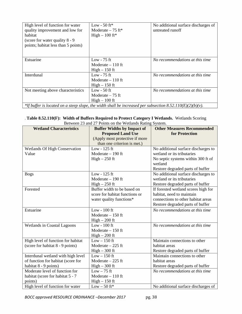
Wetlands, Mosaic or Mosaic Wetlands: Groups of wetlands that should be rated and regulated as an aggregate. Although each patch the wetlands that make up the mosaic is separated from nearby wetlands by some upland area these wetlands are not regulated as "isolated wetlands" as the term is used in this chapter. That is, in determining whether a wetland falls into the category of non-regulated wetlands (See Table 8.52.110) the area of the wetland is the area of the mosaic wetland and not the area of an individual wetland component of the mosaic. Guidance for determining when nearby wetlands compose a mosaic wetland is provided in the Washington State wetland rating system for western Washington — Revised, Washington State Department of Ecology Publication # 04-06-025. The patches of wetlands compose a mosaic when: (1) the patches are less than one acre in size, (2) the patches are separated from each other by one hundred feet or less on average, and (3) the area of the wetlands in the potential mosaic are greater than fifty percent of the total combined area of wetland and upland. An illustration of this analysis of whether the potential mosaic should be considered as an aggregate rather than as individual isolated wetlands is shown below. (The illustration is from the DOE Guidance Document Volumes 1 and 2.)
Wetlands, Protection/Maintenance (Preservation) of or Protection/Maintenance (Preservation) of Wetlands: Removing a threat to, or preventing the decline of, wetland conditions by an action in or near a wetland. This includes the purchase of land or easements, repairing water control structures or fences, or structural protection such as repairing a barrier island. This term also includes activities commonly associated with the term preservation. Preservation does not result in a gain of wetland acres, may result in a gain in functions, and will be used only in exceptional circumstances. Preservation does not result in a gain of wetland acres, may result in a gain in functions, and will be used only in exceptional circumstances.
Wetland Restoration or Restoration of Wetlands: The manipulation of the physical, chemical, or biological characteristics of a site with the goal of returning natural or historic functions to a former or degraded wetland. For the purpose of tracking net gains in wetland acres, restoration is divided into:
(1) Re-establishment. The manipulation of the physical, chemical, or biological characteristics of a site with the goal of returning natural or historic functions to a former wetland. Re-establishment results
in a gain in wetland acres (and functions). Activities could include removing fill material, plugging ditches, or breaking drain tiles.
(2) Rehabilitation. The manipulation of the physical, chemical, or biological characteristics of a site with the goal of repairing natural or historic functions of a degraded wetland. Rehabilitation results in a gain in wetland function but does not result in a gain in wetland acres. Activities could involve breaching a dike to reconnect wetlands to a floodplain or return tidal influence to a wetland.
Wetlands with a High Conservation Value (formerly called Natural Heritage Wetlands): Wetlands that are identified by the Natural Heritage Program of the Washington State Department of Natural Resources as important ecosystems for maintaining plant diversity in our state. (Ord. 138-06 (part), 2006; Ord. 50-04 Attach. B (part), 2004; Ord. 24-04 Attach. B, 2004; Ord. 89-00, Attachment A (part), 2000; Ord. 118-99, Attachment B §§ 4, 5, 1999; Ord. 16-00, Attachment D, 2000; Ord. 62-99 (part), 1999; Ord. 152-97 (part), 1997; Ord. 112-97 (part), 1997; Ord. 111-97 (part), 1997; Ord. 56-97 (part), 1997; Ord. 36A-97 (part), 1997: Ord. 77-93 (part), 1993).
8.52.040 - Establishment of designated lands.
(A) Designation Authority. Under authority of 36.70 and 36.70A RCW, portions of Mason County are designated as critical areas and/or resource lands as are necessary to protect the natural environment, protect public and private property, maintain and enhance natural resource based industries, and enhance the health, safety and welfare of the public.
(B) Scope of Authority.
(1) Within the designated resource lands and critical areas established by this chapter, all buildings or structures which shall be erected, reconstructed, altered, enlarged or relocated; all lots or parcels which shall be created, used or developed; all grading or land clearing which shall be engaged in, and all other land uses, shall be in compliance with this chapter. All development and uses which are not "Permit required," or "Conditional Uses" must meet the terms of this chapter, and any applicable regulations listed in Section 8.52.050. This chapter establishes standards and review processes for all proposed uses which shall be followed prior to commencement of those uses.
(2) Areas in Mason County in one or more critical areas or resource lands, may be subject to regulations pursuant to this chapter. When an area is designated under more than one critical area or resource land, all applicable sections of this chapter shall be met; provided any and all permit processing shall occur concurrently. In case of conflict, the more protective provision shall prevail.
(C) Boundaries of Designated Lands.
(1) Designated resource lands and critical areas are bounded and defined, in part, as shown on the following official maps of Mason County, which together with all explanatory materials contained thereon, are made a part of this chapter. These maps will automatically be updated as new data becomes available.
(a) "Mason County Long-Term Commercial Forest and Inholdings as shown on the Development Areas Map 1."
(b) "Water Type Reference Maps of Mason County," Washington Department of Natural Resources.
(c) "Mason County Soil Survey Map," United States Department of Agriculture; Series 1951, No. 9.
(d) "Mason County Critical Aquifer Recharge Areas Map."
(e) "The Flood Insurance Study for Mason County," U.S. Federal Emergency Management Agency.
(f) "National Wetlands Inventory," U.S. Fish and Wildlife Service, and all Mason County Maps referencing wetlands.
(g) The approximate location and extent of critical fish and wildlife habitat areas as displayed in the Washington Department of Fish and Wildlife's (WDFW) Priority Habitat and Species (PHS) Program database.
(h) Kelp and eelgrass beds, identified by the Department of Natural Resources Aquatic Lands Division and the Department of Ecology, including, but not limited to, locations of kelp and eelgrass beds compiled in the Puget Sound Environmental Atlas.
(i) Herring and smelt spawning times and locations outlined in WAC 220-110-240 through 220-110-260 and the Puget Sound Environmental Atlas.
(j) Other maps adopted in specific sections of the Resource Ordinance.
Each map shall state the source or sources of scientific and other methodologies used in the determination of boundaries, and all maps shall be individually stored and available for review at the Mason County Department of Community Services, except for the priority habitat and species program data, which is available to the public from the WDFW.
(2) The actual presence or absence of lands which meet the designation criteria for a specific critical area or resource land shall govern the treatment of a specific development proposal. When classification criteria contain both map references and non-map criteria to be reviewed on-site, the non-map criteria shall take precedence. When, through project review, lands or waters are discovered which are required by the text of this chapter to be designated in another classification than that shown on the map, the text designation shall take precedence over mapping, and any development therein or thereon shall comply with this chapter. The property owner or the county may initiate a reclassification procedure pursuant to Section 8.52.190 of this chapter, wherein any official map shall also be amended to conform to the redesignation.
(3) Interpretation of Boundaries.
The following rules shall be used to determine the precise location of any designation boundary shown on any official critical area or resource land map of Mason County:
(a) Boundaries shown as following or approximately following the limits of any city shall be construed as following such limits;
(b) Boundaries shown as following or approximately following roads or streets shall be construed to follow the centerline of such roads or streets;
(c) Boundaries which follow or approximately follow platted lot lines or assessor's parcel boundary lines shall be construed as following such lines;
(d) Boundaries shown as following or approximately following section lines, half-section lines, or quarter-section lines shall be construed as following such lines;
(e) Boundaries shown as following or approximately following shorelines of any lakes or Puget Sound shall be construed to follow the ordinary high water lines of such bodies of
water, and, in the event of change in the ordinary high water line, shall be construed as moving with the actual ordinary high water line.
(f) Boundaries shown as following or approximately following the centerline of streams, rivers, or other continuously flowing water courses shall be construed as following the channel centerline of such water courses taken midway between the ordinary high water marks of such channel, and, in the event of a natural change in the location of such streams, rivers, or other water courses, the designation boundary shall be construed as moving with the channel centerline.
(g) Boundaries shown as separated from, and parallel or approximately parallel with, any of the features listed in paragraphs a through f above shall be construed to be parallel with such features and at such distances therefrom as are shown on the map.
(4) Interpretation of Parcel Sizes.
The following rules shall be used to interpret parcel or property sizes for determinations in classifications, designations, and regulations of this chapter:
(a) Parcels legally described as 1/256th of a section shall be equivalent to two and one-half acres (1.08 hectares).
(b) Parcels legally described as 1/128th of a section shall be equivalent to five acres (2.15 hectares).
(c) Parcels legally described as 1/64th of a section shall be equivalent to ten acres (4.03 hectares).
(d) Parcels legally described as 1/32nd of a section shall be equivalent to twenty acres (8.06 hectares).
(e) Parcels legally described as 1/16th of a section shall be equivalent to forty acres (16.12 hectares).
(f) Parcels legally described as 1/8th of a section shall be equivalent to eighty acres (32.24 hectares).
(g) Property legally described as one section shall be equivalent to six hundred forty acres (257.92 hectares).
(5) Preferential Right to Manage Resources — "Right to Forestry," "Right to Farm," "Right to Mine." Description of Preferential Rights.
(a) No resource use or any of its component activities shall be or become a nuisance, private or public, by any changed conditions in or about the locality thereof after the same has been in operation for more than five years, when such operation was not a nuisance at the time the operation began; provided that the provisions of this subsection shall not apply whenever a nuisance results from the negligent or improper operation of any such operation or its component activities, and the property owner follows the standards of this chapter.
(b) A resource operation shall not be found to be a public or private nuisance if the operation conforms to local, state, and federal law and best management practices.
(c) A farm or forest operation shall not be restricted to time of day or days of the week, but shall be conducted according to best management practices pursuant to state law.
(d) A farm or forest operation shall be free from excessive or arbitrary regulation. (Ord. 138-06 (part), 2006: Ord. 118-99, Attachment B § 2, 1999; Ord. 56-97 (part), 1997; Ord. 77-93 (part), 1993).
(A) General Provision. No permit granted pursuant to this chapter shall remove an applicant's obligation to comply in all respects with the applicable provisions of any other federal, state, or local law or regulation, including, but not limited to, the acquisition of any other required permit or approval.
(B) State Environmental Policy Act. This chapter is an officially adopted land use policy of the county and shall be a basis for analyzing development proposals pursuant to 43.21c RCW. The areas described on adopted critical area maps, pursuant to Section 8.52.040(c)(1), are declared sensitive areas under provisions of WAC 197-11-908.
(C) County Policies and Regulations.
(1) The following adopted county policies and regulations shall be enforced consistent with the terms of this chapter:
(a) International Building & Residential Code;
(b) International Fire Code;
(c) Mason County Health Code;
(d) Mason County Environmental Policy Ordinance;
(e) Mason County Mobile Home and Recreational Vehicle Ordinance;
(f) Mason County Six-year Transportation Improvement Program;
(g) Title 16, Mason County Subdivision Ordinance including Large Lot Requirements;
(h) Parking Standards Ordinance;
(i) Other adopted ordinances by Mason County;
Where this chapter is found inconsistent with any of the above documents, the more restrictive terms shall prevail. All county application forms, review procedures, or standards that are inconsistent with this chapter shall be amended within three months of adoption of this chapter; except where to do so would require approval by state authorities, or extended local public review, in which case, no time limit is established.
(2) Responsibilities of county departments of Community Services (Building Environmental Health, and Planning Divisions) and Public Works.
For all development applications under the preview of the county Building Official, Environmental Health Manager, and/or Public Works Director, and in the course of their respective standard site inspection programs, a site inspection shall be performed to determine whether the site has lands, waters or shorelands that are likely to meet the designation criteria for one or more county resource lands or critical areas. If a site is found likely to contain such lands, the building official, Environmental Health Manager and/or Public Works Director shall notify the Planning Manager of that interpretation and any permit under their authority shall not be approved until:
(a) The Planning Manager finds that the site does not contain any lands, shorelands, or waters subject to regulations under this chapter; or
(b) The Planning Manager finds that the site does contain lands, shorelands, or waters subject to regulations under this chapter and the proposed development is in compliance with all regulatory and procedural requirements of this chapter.
(D) Shoreline Master Program and Flood Damage Prevention Regulations.
(1) Mason County intends for the policies and regulations of this chapter to be compatible and consistent with the following adopted county policies and regulations:
(a) Mason County Flood Damage Prevention Ordinance (MCFDPO);
(b) Mason County Shoreline Master Program (MCSMP) 17.50 MCC.
(2) While there are no inherent conflicts between this chapter and the MCFDPO, and the MCSMP, there may be sections that overlap as in the case of Section 8.52.140. Where such sections overlap, the more restrictive policy or regulation between either of the above documents and this chapter shall prevail, except where substantive or procedural requirements are specified in the SMP.
(3) All activities and developments that are subject to approval under provisions of this chapter that also require approval of the MCFDPO, shall be processed under provisions of the MCFDPO and shall meet all the standards of this chapter. Granting of approval of the MCFDPO shall constitute compliance with this chapter.
(4) All activities and developments that are subject to approval under provisions of this chapter that also require approval of the MCSMP, shall be processed concurrently with provisions of the MCSMP and shall met all the requirements of this chapter. Where provisions of the MCFDPO and the MCSMP conflict, the more restrictive provisions shall apply. Applications that are processed as a Mason Environmental Permit per MCC 8.52.190(C), and do not require a Shoreline Variance, Shoreline Substantial Development Permit, or Shoreline Conditional Use shall instead be processed as a Shoreline Exemption.
(5) The general exemptions in section 8.52.200 do not apply within Shoreline Jurisdiction. For exemptions to the SMP, see section 17.50.060(E) and WAC 173-27-045. For exemptions from the Substantial Development Permit process, see section 17.50.400(B)(1) and WAC 173-27-040.
(Ord. 77-93 (part), 1993).
8.52.060 - Agricultural resource lands. The purpose of this section is to maintain and enhance natural resource based industries, to encourage the conservation of commercial agricultural lands, and to discourage incompatible land use.
(A) Classification. The following criteria shall be used in identifying lands appropriate for Agricultural Resource Lands:
(1) The property has an existing commercial agricultural use (as of the date of designation) or where the property was used for agricultural purposes as of January 1991, where identified by property tax classification in the open space - agriculture property tax classification program pursuant to Chapter 84.34 RCW or where agricultural use has been identified as the principal use of the property, are presumed to meet this criteria;
(2) The property has a minimum parcel size of ten (10) acres;
(3) The parcel has prime farmland soils;
(4) The property is surrounded by or adjacent to lands qualifying under classification criteria (1) to (3) above;
(5) The property is an upland fin-fish hatchery. Provided that, property owners may apply to have their land designated as Agricultural Resource Lands upon a showing that the property is eligible for and participates in the open space - agricultural property tax classification program pursuant to Chapter 84.34 and upon a showing that either that the property has prime farmland soils or that, in some other fashion, the agricultural use has long-term commercial significance. Such applications shall be reviewed by the county as provided for in the annual amendment process for the county Comprehensive Plan and Development Regulations.
(B) Designation. Lands of Mason County which have been identified as meeting the classification criteria for Agricultural Resource Lands, and are so specified on the official Mason County map, available at the Mason County Planning Division, titled, "Mason County Agricultural Resource Lands" or as thereafter amended, are designated as Agricultural Resource Lands.
(C) Land Uses. Development and land uses and activities allowed in the Agricultural Resource Lands or on adjacent lands are as specified in the Mason County Development Regulations and other applicable ordinances, codes and regulations.
(1) Accessory uses that support, promote, or sustain agricultural operations and production, are allowed and shall comply with the following standards:
(a) Accessory uses shall be located, designed, and operated so as not to interfere with natural resource land uses and shall be accessory to the growing of crops or raising of animals;
(b) Accessory commercial or retail uses shall predominately produce, store, or sell regionally produced agricultural products from one or more producers, products derived from regional agricultural production, agriculturally related experiences, or products produced on-site. Accessory commercial and retail uses shall offer for sale predominantly products or services produced on-site; and
(c) Accessory uses may operate out of existing or new buildings with parking and other supportive uses consistent with the size and scale of existing agricultural buildings on the site but shall not otherwise convert agricultural land to nonagricultural uses.
(2) Accessory uses may include compatible commercial or retail uses including, but not limited to, the following:
(a) Storage and refrigeration of regional agricultural products;
(b) Production, sales, and marketing of value-added agricultural products derived from regional sources;
(c) Supplemental sources of on-farm income that support and sustain on-farm agricultural operations and production;
(d) Support services that facilitate the production, marketing, and distribution of agricultural products; and
(e) Off-farm and on-farm sales and marketing of predominately regional agricultural products and experiences, locally made art and arts and crafts, and ancillary retail sales or service activities.
(D) Development Standards.
(1) Development Standards for Proposed Land Uses.
(a) Front yard setback: twenty-five feet.
(b) Side and rear yard setbacks: side and rear yard setbacks for the residential dwelling is twenty feet, for accessory buildings shall be twenty feet, for accessory structures used for agricultural purposes or home occupations shall be fifty feet, and for buildings of nonresidential land uses shall be fifty feet.
(c) Floor Area Ratio: one is to twenty, except for fire stations.
(d) Size: five thousand sq. ft. maximum (or up to seven thousand five hundred sq. ft. with a special use permit) for nonagricultural and accessory buildings except for dwellings and agricultural buildings.
(e) Height: thirty-five feet except for agricultural buildings, cell towers, antennas or water tanks.
(2) Proposed land uses shall meet the review standards for land uses established in the Mason County development regulations, including Section 1.03.020 (Matrix of Permitted Uses) and Section 1.03.021 (Home Occupation and Cottage Industries).
(E) Preferential Right to Manage Resources and Resource Use Notices.
(1) For land owners who have land designated as Agricultural Resource Lands, provisions of "Right to Farm" provided under Section 8.52.040(C)(5) shall fully apply.
(2) All plats, short plats, large lot subdivision, development permits, and building permits issued for activities on, or within five hundred feet of lands designated as Agricultural Resource Lands shall contain the following notification: "This property is within or near designated Agricultural Resource Lands on which a variety of commercial activities may occur at times and that are not compatible with residential development. Residents of this property may be subject to inconvenience or discomfort associated with these activities including, but not limited to: dust, odor, noise, and chemical applications."
8.52.070 - Inholding lands. The purpose of this section is to mitigate potential incompatible land uses between the long-term commercial forest lands and the neighboring Inholding Lands.
(A) Classification. The following criteria, as they exist at the time of adoption of this chapter, shall be used in determining Inholding Lands:
(1) Lands that as a block are surrounded on all sides by designated long-term commercial forest lands; or in the case of properties abutting another county on at least one side, lands that are surrounded in the county by properties designated long-term commercial forest lands; and maximum block size is less than six hundred forty acres (257.92 hectares) in size; and lands that do not meet the classification criteria for long-term commercial forest lands.
(2) Lands which meet the criteria for long-term commercial forest lands pursuant to Section 8.52.060(A) of this chapter and are within four hundred feet of the Cloquallum/Lake Communities border as of the effective date of this chapter. The border to be that defined on the official map of "Mason County Long-Term Commercial Forest Lands and Inholding Lands."
The intent of this classification is to mitigate potential incompatible land uses between the long-term commercial forest land and the neighboring Inholding Lands.
(B) Designation.
(1) Lands of the county meeting the classification criteria for Inholding Lands, and so specified on the official Mason County map, available at the County Planning Division, titled, "Mason County Long-Term Commercial Forest Lands and Inholding Lands, 1991" or as thereafter amended, are designated, under RCW 36.70A.060 and RCW 36.70A.170, as crucial areas for the conservation of forest resource lands of long-term commercial significance.
(2) The four-hundred-foot strip described in subsection (A)(2) of this section, shall not be designated as long-term commercial forest land.
(3) As stated in policy RE-200 of the Comprehensive Plan, Inholding Lands shall remain Inholding Lands even if they no longer meet the classification criteria in subsection (A) of this section due to the redesignation of some portion of the long-term commercial forest land which had previously caused the subject property to meet the criteria for classification as inholding land.
(C) Land Uses. Permit-required and conditional uses within Inholding Lands are the same as for designated long-term commercial forest lands, with the exception that mining and related activities are conditional uses if the county has authority to make such determination pursuant to the State Surfacing Mining Act, RCW 78.44 or as thereafter amended. Land uses in the four-hundred-foot strip designated in subsection (b) of this section shall be the same as Inholding Lands.
(D) Development Standards. The following development standards for Inholding Lands shall apply to the lands designated in subsection (B) of this section.
(1) Lot Size/Density.
The minimum lot area for any new subdivision, short subdivision or large lot segregation of property shall be five acres (2.15 hectares). Exceptions to this minimum lot size may occur for nonresidential permit-required and conditional uses and facilities; provided that the county approval authority finds that there will be no impact on surrounding resource uses and further provided that a restrictive covenant be placed on the property, to be held by the county, prohibiting future residential use.
Average residential densities for any new subdivision or short subdivision of property may be increased up to one unit per two and one-half acres (1.08 hectares); provided all of the following conditions can be met:
(a) The property to be divided is at least twenty acres (8.06 hectares) in size; and
(b) Each residential lot created is no more than one acre (0.40 hectares) in size; and
(c) All identified residential building sites are located outside any one-hundred-year floodplains, geologically hazardous areas, or other critical areas; and
(d) The county approval authority finds that the design of the subdivision or short subdivision minimizes impact on surrounding resource uses; and
(e) A natural resource management and/or conservation easement; to be held by the county, recognized nonprofit land trust or similar institution; be placed on the nonresidential portion of the subdivision or short subdivision restricting the use of the property to uses consistent with natural resource management and/or conservation, and prohibiting future residential use; or
A natural resource management and/or conservation restriction is placed on the face of the plat accomplishing the same purpose as an easement. No less than fifty percent of the subdivided property shall be maintained in this manner.
(2) Each parcel currently below five acres in size may be developed for an individual single-family residence.
(3) For lots five acres to 9.99 acres in size, the original owner at the time this plan is adopted may divide their property into two parcels, the smallest of which is not less than 2.5 acres in size.
(4) (a) Other Development Standards.
(i) Front yard setback: Twenty-five feet;
(ii) Side and rear yard setbacks: Side and rear yard setbacks for the residential dwelling is twenty feet, for accessory buildings shall be twenty feet, for accessory structures used for agricultural purposes or home occupations shall be fifty feet, and for buildings of nonresidential land uses shall be fifty feet;
(iii) Floor area ratio: 1:20, except for fire stations;
(iv) Size: Three thousand square feet maximum for nonagricultural and accessory buildings except for dwellings and agricultural buildings;
(v) Height: Thirty-five feet except for agricultural buildings, cell towers, antennas, or water tanks.
(b) Water Supply. Inholding properties shall meet all water supply standards as required under Section 17.01.068 [sic].
(5) Preferential Right to Manage Resources.
For landowners who have designated Inholding Lands, provisions of "right to forestry" and "right to farm" under Section 8.52.040(C)(5), and resources use notices provided under Section 8.52.060(D), shall fully apply.
(Ord. 32-04 Attach. B (part), 2004; Ord. 77-93 (part), 1993). (Ord. No. 36-12, Att. A, 4-17-2012)
8.52.090 - Mineral resource lands. The purpose of this section is to identify and designate commercial mineral lands, to establish guidelines for their development and to discourage incompatible land use.
(A) Classification. The following criteria shall be used in determining Mineral Resource Lands of long-term commercial significance within the county:
(1) Class 1a—Mineral deposits which could meet the immediate and future needs of the regional community. These deposits shall be of significant size (greater than twenty-five acres) and readily accessible to water traffic on the Puget Sound;
Class 1b—Mineral deposits which could meet the long-term future and immediate needs of the regional community. These deposits shall be of significant size (greater than twenty-five acres) and accessible to rail or truck haul routes;
(2) Class 2—Mineral deposits within existing permitted surface mining operations operating under authority of RCW Chapter 78.44.
(B) Designation.
(1) Mineral lands of the county meeting the classification criteria for Class 1a and 1b mineral resource of long-term commercial significance, and so specified on the official county map, available at the County Planning Division titled "Mason County Long-Term Commercial Mineral Lands, 1992" or as thereafter amended, are designated, under RCW 36.70A.060 and RCW 36.70A.170, as conversation areas for mineral lands of long-term commercial significance.
(2) Lands of the county meeting the classification criteria for Class 2 are eligible for designation as mineral lands of long-term commercial significance. Those property owners who wish to "opt in" to this designation may do so pursuant to Section 8.52.200(C) within sixty days of the effective date of this chapter. This designation shall continue for as long as a state operating permit exists.
Designation of mineral lands of long-term commercial significance does not mean that such lands are exempt from the normal environmental review process of the county or state agencies. Areas not now identified as Class 1a or Class 1b but where a qualified geologist or mining engineer can now or in the future, demonstrate the probability for occurrence of a mineral deposit, may be so designated upon approval of the county.
(C) Land Uses. Prior to full utilization of a Class 1a or 1b designated mineral resource land's mineral resource potential, subdivisions, short subdivisions or large lot segregation shall be prohibited. Exceptions may be made through a resource redesignation or through the variance procedure.
(1) Conditional Uses.
(a) Mineral processing facilities including rock crushing, asphalt and concrete batch plants;
(b) Public and semi-public structures including but not limited to fire stations, utility substations, pump stations, and waste water treatment facilities;
(c) "Class IV—General Forest Practices" under authority of the "1992 Washington State Forest Practices Act Rules and Regulations," WAC 222-12-030, or as thereafter amended, which involve conversion to a conditional use in designated Mineral Resource Lands;
(d) Any industrial or commercial development.
(D) Development Standards. All mining operations shall conform to the following standards. Variances for these standards and nonconforming uses may be appropriate when an operation is located in isolated areas or contains unusual topographical conditions.
(1) Setbacks/Screening.
(a) Within Mineral Resource Lands.
(i) A fifty-foot (15.25 meter) setback from all property lines, other than for access purposes onto public rights-of-way, shall be maintained for areas of direct cut or fill connected with resource extraction operations. For mining operations, setbacks may be increased when necessary to protect lateral support of abutting properties or public rights-of-way.
(ii) A twenty-five-foot (7.63 meter) screen on all property lines, consisting of site obscuring vegetation, or other methods to conceal the mine as approved by the county shall be maintained.
(iii) A fifty-foot (15.25 meter) setback of all direct extraction operation areas shall be maintained from public utility lines.
(2) Fencing. Prior to the commencement of surface mining, a fence shall be constructed and maintained enclosing the area authorized by the surface mining permit if public safety is in question. Fences shall be at least six feet in height and constructed of woven wire. Gates, the same height as the fence, shall be installed at all points of vehicular or pedestrian ingress and egress, and shall be kept locked when not in regular use.
(3) Road Access. For surface mining operations, access on any public right-of-way shall be surfaced in accordance with the county engineering division or State Department of Highways development standards as appropriate.
(4) Road Use. In order to assure maintenance and development of adequate county roadways, owners of surface mining operations may be required to enter into a haul route agreement with the county engineer upon adoption and implementation of a haul route agreement program.
(5) Traffic Safety. The county engineer may require the installation of traffic control and warning signs at intersections of private access roads with publicly maintained roads.
(6) Noise/Bright Lights.
(a) No development or activity shall exceed the maximum Environmental Noise Levels established by WAC 173-60, and Chapter 9.36 of this code.
(b) Bright lights are allowed outside of normal operating hours only for short-term mining operations necessary to facilitate emergency repairs.
(7) Surface Mining Operation within Critical Aquifer Recharge Areas. The purpose of this section is to protect critical aquifer recharge areas as required by RCW 36.70A.060(2).
Any surface mining operation within a critical aquifer recharge area (as designated in Section 8.52.120 shall meet the following standards:
(a) Fuel tanks and oil drums shall be double containment construction and protected by bermed areas having adequate capacity to accommodate, contain, and allow the removal of chemical spills. Fuel nozzles shall not contain locking devices. Fuel storage shall be above ground. Fueling of mobile equipment shall be located at least twenty feet above the seasonal high ground water level or within lined and bermed areas with adequate capacity to accommodate, contain and allow the removal of chemical spills;
(b) All operations shall maintain a fuels/hazardous waste management plan maintained by the operator and available on the site at all times;
(c) Fencing, or some comparable deterrent, shall be installed to prevent unauthorized dumping of any materials within surface mining operations;
(d) Surface mines shall not use any noxious, toxic, flammable, compactable, or combustible materials not specifically authorized by the county Division of Environmental Health for backfill or reclamation. Noncontaminated process water used for gravel washing shall be routed to settling ponds to minimize off-site discharges. A general permit from the Department of Ecology for process and storm water discharge may substitute for these requirements;
(e) On-site truck and equipment wash run-off shall be routed to a retention facilities equipped with an oil-water separator prior to its release to settling ponds;
(f) Use of chemicals, petroleum or hazardous products, and disposal of such products, in concrete or asphalt plant operations within critical aquifer recharge areas shall meet all the standards set forth in WAC 90.48 and WAC 173.303.
(8) Public Safety. Owners of surface mines shall ensure that their operation(s) will not be hazardous to neighboring uses. Blasting activities shall be conducted so that ground vibrations and fly-rock to off-mine site uses are monitored and minimized.
(9) Waiver Clauses. The county may waive some or all of the restrictions outlined above following a written finding of fact and favorable findings under SEPA.
(E) Preferential Right to Manage Resources and Resource Use Notice.
(1) For those land owners of Mineral Resource Lands who choose to use their property for resource management, the provision of "right to mine" provided under Section 8.52.040(C)(5) shall fully apply.
(2) Mining Use Notice.
(a) For properties designated mineral resource land upon application of the property owner or owners pursuant to Section 8.52.200(B) of this chapter.
Within two weeks of redesignation to mineral resource land, pursuant to Section 8.52.200(B), the property owner(s) of the land shall submit to the county, for recording with the county Auditor, a written notice of the designation. This notice shall be in a form authorized by the Director and shall include:
(i) The legal description of the property subject to the designation;
(ii) The sixteenth section or sections in which lie:
b. Any other property within five hundred feet of the boundary of the designated property;
(iii) The following statement:
NOTIFICATION This notification is to inform property owners that the property described herein is designated as or within 500 feet of land designated for mining. Mining, operations may be carried out now or in the future. Mason County has established designated Mineral Resource Land that sets as a priority the use of these lands for mining. The normal and usual practices associated with said operations when performed in accordance with county, State and Federal law, shall not be subject to legal action as a public nuisance. A variety of commercial activities may occur on Mineral Resource Land that is not compatible with residential development for certain periods of limited duration. On Mineral Resource Land, an application might be made for mining-related activities, including mining, extraction, washing, crushing, stockpiling, blasting, transporting, and recycling of minerals.
The mineral right owner/operator shall execute and acknowledge the notice, and pay the fee to the county for recording the notice.
(b) For properties designated mineral resource land pursuant to Section 8.52.090(B)(1) of this chapter.
Within four months of the effective date of this chapter, the Director shall submit to the county Auditor for recording, a written notice of all designated Mineral Resource Lands. This notice shall be in a form similar to subsection (E)(2)(a)(iii) of this section. The Director shall execute and acknowledge the notice, and no affected property owner shall be charged a fee for recording the notice.
(c) For all properties within three hundred feet of designated Mineral Resource Lands.
All plats, short subdivisions, large lot subdivisions, development permits and building permits issued by the county after the effective date of this chapter for development activities within three hundred feet of property designated as mineral resource land, or within three hundred feet thereof, shall contain a notice as specified in subsection (E)(2)(a)(iii) of this section.
8.52.110 - Wetlands. The purpose of this section is to avoid, or in appropriate circumstances, minimize, rectify, reduce or compensate for impacts arising from land development and other activities affecting wetlands; to maintain and enhance the biological and physical functions and values of wetlands with respect to water quality maintenance; stormwater and floodwater storage and conveyance; fish and wildlife habitat; primary productivity, recreation, education and historic and cultural preservation. When avoiding impacts is not reasonable, mitigation shall be implemented to achieve a no net loss of wetlands in terms of acreage, function and value.
(A) Classification. The following shall be classified as wetland areas: Areas that are inundated or saturated by surface or groundwater at a frequency and duration sufficient to support, and that under normal circumstances do support, a prevalence of vegetation typically adapted for life in saturated soil conditions. Wetlands generally include swamps, marshes, bogs and similar
areas. However, wetlands may include those artificial wetlands intentionally created from non-wetland areas created to mitigate conversion of wetlands, if permitted by the county.
(B) Designations.
(1) The following lands, shorelands, and waters of Mason County are hereby designated under RCW 36.70A.060 and RCW 36.70A.170 as wetland critical areas requiring immediate protection from incompatible land uses:
(a) All areas described in subsection (A) of this section;
(b) Ponds less than twenty acres;
(c) Wetlands created as mitigation, and those modified for approved land use activities, including their submerged aquatic beds.
(2) The following are designated as non-regulated wetlands:
(a) Artificial man-made wetlands intentionally created from non-wetland sites, including, but not limited to, irrigation and drainage ditches, grass-lined swales, canals, detention facilities, wastewater treatment facilities, farm ponds, and landscape amenities or those wetlands created after July 1, 1990, that were unintentionally created as a result of the construction of a road, street or highway.
(b) Exempt wetlands that are isolated and less than one thousand square feet in area where it has been shown by the applicant that they are not associated with a riparian corridor or a shoreline of the state, they are not part of a wetland mosaic, and do not contain habitat identified as essential for local populations of priority species identified by Washington Department of Fish and Wildlife.
(3) Identification of wetlands and delineation of their boundaries shall be done in accordance with the approved federal wetland delineation manual and applicable regional supplements, as required by WAC 173-22-035. All areas within the county meeting the wetland designation criteria in that procedure are hereby designated critical areas and are subject to the provisions of this Chapter.
(4) Owners and applicants with non-regulated wetlands are strongly urged to cooperate voluntarily in this plan of wetland protection, using the guidelines in this ordinance and in materials provided by the Department of Community Services.
(C) Procedures.
(1) Responsibilities for the determination of wetland boundaries:
(a) Formal determination of wetland boundaries is the responsibility of the county. The responsibility to provide all necessary and accurate data to the county for its determination rests with the applicant. This information will include a field delineation by a qualified wetland professional applying the current approved federal wetland delineation manual and applicable regional supplements. When, in the opinion of the Director, sufficient information exists from the county's wetland inventory, or other sources, the requirement for a full or partial delineation may be waived. For instance, in some cases, the applicant may only be required to determine the wetland boundary, or portion thereof, of the wetland system. The Director shall determine when a permit application is required and what additional information may be necessary. Wetland delineations shall be performed in accordance with the procedures as specified in the current approved federal wetland
delineation manual and applicable regional supplements. Evidence documenting the results of any boundary survey, or other submitted data, may be required by the Director.
(b) Mason County, at a fee, when requested by the applicant, or the affected party, may perform the delineation in lieu of direct action by the applicant. Mason County may use hydrology, soils, plant species, and other data, and consult with biologists, hydrologists, soil scientists, or other experts, as needed, to perform the delineation. The county shall make a good faith effort to provide this service, consistent with budgetary constraints and available in-house expertise, for smaller projects and especially for those property owners with lesser financial capabilities.
(c) Where Mason County performs a wetland boundary determination at the request of the applicant, it shall be considered a final determination unless contested.
(d) Where the applicant has provided a determination of the wetland boundary, the Director shall verify the accuracy of, and may render adjustments to, the boundary delineation.
(e) In the event the boundary delineation is contested by the applicant or affected party, the Department of Ecology, or a mutually agreed upon party, shall settle the dispute.
(D) Land Uses.
(1) Mason Environmental Permit Required Uses and Activities.
A Mason Environmental Permit shall be obtained from the county, using the administrative review process in this chapter, prior to undertaking, in a regulated wetland or its buffer, for the following activities.
(a) The removal, excavation, grading, dredging, dumping, discharging, or filling of any material; or the draining or flooding of the site, except where undertaken for maintenance (but not construction) of drainage ditches or for emergency repair;
(b) The construction of stormwater management facilities; or(c) The driving of pilings;
(d) The placing of obstructions;
(e) The construction, reconstruction, demolition, or expansion of any structure;
(f) The destruction or alteration of wetlands and wetland buffer through clearing, harvesting, shading, intentional burning, or planting of vegetation that would alter the character of a designated wetland or buffer, provided that this subsection shall not apply to the following activities undertaken in a manner which minimizes impacts:
(i) The harvesting or normal maintenance of vegetation in a manner that is not injurious to the natural reproduction of such vegetation;
(ii) The removal or eradication of noxious weeds so designated in Chapter 17.10 RCW or other exotic, nuisance plants;
(iii) Site investigative work necessary for land use application submittals such as surveys, soil logs and percolation tests;
(iv) The construction or trails, which shall be unpaved when located in the buffers and elevated when located in wetlands, that are not intended for motorized use, and which are no wider than three feet, unless additional width is necessary for safety along a precipice, steep hillside, or other hazardous area. See subsection (E)(3)(c) for additional details on regulated (but permitted) trail activity;
(v) Emergency services or repairs for health and welfare; or
(vi) Activities of a mosquito control district; or
(g) Activities that result in a significant change of water temperature, a significant change of physical or chemical characteristics of wetland's water sources, including quantity, or the introduction of pollutants.
(2) Activities Permitted without a Mason Environmental Permit.
The following uses shall be allowed, in addition to those defined in General Exemptions (see Section 8.52.200), within a wetland or wetland buffer to the extent that they are not prohibited by the Shorelines Management ACT of 1971 (Chapter 90.58 RCW), Federal Water Pollution Control Act (Clean Water ACT), State Water Pollution Control Act (Chapter 90.48 RCW), State Hydraulic Code (RCW 75.20.100 - .140), Forest Practices Act (Chapter 76.09 RCW and Chapter 222-16 WAC) or any other applicable ordinance or law and provided they are conducted using best management practices, except where such activities result in the conversion of a regulated wetland or wetland buffer to a use to which it was not previously subjected and provided further that forest practices and conversions from forest land shall be governed by Chapter 76.09 RCW and its rules:
(a) Conservation or preservation of soil, water, vegetation, fish, shellfish, and other wildlife;
(b) Outdoor recreational activities that do not have a significant adverse impact on the wetland and its related buffer;
(c) The harvesting of wild crops in a manner that is not injurious to natural reproduction of such crops and provided the harvesting does not require tilling of soil, planting of crops, or alteration of the wetland by changing existing topography, water conditions or water resources;
(d) Existing and ongoing agricultural activities, including farming, horticulture, aquaculture, irrigation, ranching or grazing of animals. Activities on areas lying fallow as part of a conventional rotational cycle are part of an ongoing operation. Activities which bring an area into agricultural use are not part of an ongoing operation. An operation ceases to be ongoing when the area in which it was conducted has been converted to another use or has lain idle for more than five years unless that idle land is registered in a federal or state soils conservation program. Forest practices are not included in this definition.
(e) The maintenance (but not construction) of drainage ditches;
(f) Education, scientific research, and use of nature trails;
(g) Site investigative work necessary for land use application submittals such as surveys, soil logs, percolation tests and other related activities. In every case, wetland impacts shall be minimized and disturbed areas shall be immediately restored; and
(h) The following uses are allowed within wetlands and/or wetland buffer, provided that any required permits or approvals are obtained and further provided that wetland impacts are minimized and that disturbed areas are immediately restored:
(i) Normal maintenance, repair, or operation of existing serviceable structures, facilities, or improved areas. Maintenance and repair does not include any modification that changes the character, scope, or size of the original structure, facility, or improved area and does not include the construction of a maintenance road; and
(ii) Minor modification of existing serviceable structures within a buffer zone where modification does not adversely impact wetland functions.
(iii) Repair or reconstruction of damaged or destroyed structures within two years of the damage or destruction.
(i) The felling of danger trees within buffers providing the following conditions are met:
(i) When it is demonstrated to the satisfaction of the Administrator that an imminent threat exists to public health or safety, or the safety of private or public property. Landowner shall provide to the Administrator a written statement describing tree location, danger it poses, and proposed mitigation.
(ii) Should the imminent threat not be apparent to the Administrator (as danger trees are defined in Section 8.52.030), the Administrator may require the landowner submit a report from a professional forester or certified arborist.
(iii) Before a danger tree may be felled or removed, with the exception of an emergency pursuant to Section 8.52.240, the landowner shall obtain written approval from the Administrator. This approval shall be processed promptly and may not be unreasonably withheld. If the Administrator fails to respond to a danger tree removal request within ten business days, the landowner's request shall be conclusively allowed.
(iv) Trees felled as danger trees shall be counted in the allowed amounts under Section 8.52.170(F)(4).
(v) Mitigation as approved by the Administrator to include:
a. The planting within the critical area or its buffer a total of six new native trees, each a minimum three years old. Should a report be submitted under subsection (i)(ii), it shall contain recommendations for suitable replacement trees;
b. Felled trees shall be left within the critical area or buffer unless a submitted report warrants its removal to avoid spreading disease or pests;
c. The trunk of the cut tree may be segmented, but should be left in as large of segments as possible to provide habitat;
d. The branches from the cut tree may be removed to control fire hazard; and
e. Additional mitigation may be required if three or more trees are to be felled on one property within a ten-year period.
(j) Where a legally established, non-conforming use of the buffer exists (e.g., a road or structure that lies within the width of buffer recommended for that wetland), proposed actions in the buffer may be allowed without a Mason Environmental Permit and without mitigation as long as they do not increase the degree of non-conformity. This means no increase in the impacts to the wetland from activities in the buffer.
(E) Development Standards.
(1) Wetlands Rating System. A four-tier wetlands rating system is adopted as the rating system for Mason County. Wetland buffer widths, wetland activities, and replacement ratios shall be based on this rating system.
Procedures for applying the wetland rating system are set forth in the Washington State Wetland Rating System for Western Washington, revised 2014, or as amended hereafter, Washington State Department of Ecology.
(a) Wetlands shall be categorized as follows:
Table 8.52.110(A): Wetland Categories. 1) Category I Wetlands. Category I wetlands are those regulated wetlands that include but are not limited
to rare, unique wetland types that are more sensitive to disturbance than most wetlands and that contain ecological attributes that are impossible to replace within a human lifetime. Category I wetlands score between 23- 27 points on the wetlands ratings systems.
2) Category II Wetlands. Category II wetlands are those regulated wetlands that score between 20-22 points on the wetlands ratings system.
3) Category III Wetlands. Category III wetlands are those regulated wetlands that score between 16-19 points on the wetlands ratings system.*
4) Category IV Wetlands. Category IV wetlands are those regulated wetlands that score between 9-15 points on the wetlands ratings system.*
5) Wetlands intentionally created from non-wetland areas to mitigate conversion of other wetlands. 6) Mosaic wetlands as defined in Section 8.52.030 * Mason County non-Regulated Wetlands. Isolated wetlands under 1,000 square feet which are not associated with a riparian corridor or a shoreline of the state, not part of a wetland mosaic, and not essential habitat of a priority species as identified by the Washington Department of Fish and Wildlife. Please refer to Appendix A or the Department of Ecology publication for more information.
(2) Wetland Buffers.
(a) Buffer Widths.
Wetland buffers (plus a 15 foot structural setback) shall be required for all regulated wetlands. Any wetland created, restored, or enhanced as compensation for approved wetland alterations shall also include a buffer required for the category of the created, restored, or enhanced wetland. The buffer widths are established by adjusting a base width for the category of wetland at the site for the habitat value as scored by the wetland rating system and for the land use intensity of the proposed activity. All buffers shall be measured horizontally from the wetland boundary as surveyed in the field. The width of the wetland buffer shall be determined by the following process:
(i) The wetland is categorized according to wetland ratings system category as shown in Table 8.52.110(A);
(ii) Table 8.52.110(B) rates examples of different land uses for intensity of impacts to wetlands;
(iii) The width of the buffer is determined based on the habitat value scored by the wetland on the wetland rating system and on the land use intensity of the proposed use as shown in Tables 8.52.110 C, D, E, or F.
Table 8.52.110(B): Ratings of Impact from Land Uses.
Rating of impact from proposed changes in
land use Examples of land uses that cause the impact based on common zoning categories
High
• Commercial • Urban • Industrial • Institutional • Retail sales • Residential (more than 1 unit/acre) • Conversion to high intensity agriculture (
dairies, nurseries and green houses, growing and harvesting crops requiring annual tilling, raising and maintaining animals)
• Single-family residential (1 unit/acre or less) • Moderate-intensity open space (parks with biking, jogging, etc) • Conversion to moderate intensity agriculture (orchards and hay fields) • Paved trails • Building of logging roads • Utility corridor or right-of-way shared by several utilities and including
access/maintenance road
Low
• Forestry (cutting of trees only) • Low intensity open space (hiking, bird watching, preservation of natural
resources, etc.) • Unpaved trails • Utility corridor without a maintenance road and little or no vegetation
management
Table 8.52.110(C): Width of Buffer Required to Protect Category IV Wetlands. Wetlands Scoring Between 9 and 15 Points on the Wetland Rating System.
Wetland Characteristics Buffer Widths by Impacts of Proposed Land Use Score for all 3 basic functions is less than 16 points Low - 25 ft
Moderate – 40 ft High – 50 ft
Table 8.52.110(D): Width of Buffers Required to Protect Category III Wetlands. Wetlands Scoring Between 16 and 19 Points on the Wetlands Rating System.
Wetland Characteristics Buffer Widths by Impacts of Proposed Land Use Moderate level of function for habitat (score for habitat 5 - 7 points)
Low - 75 ft Moderate – 110 ft High – 150 ft
Score for habitat 3-4 points Low - 40 ft Moderate – 60 ft High – 80 ft
Table 8.52.110(E): Width of Buffers Required to Protect Category II Wetlands. Wetlands Scoring Between 20 and 22 Points on the Wetlands Rating System.
Wetland Characteristics Buffer Widths by Impact of
Proposed Land Use (Apply most protective if more
than one criterion is met.)
Other Measures Recommended for Protection
High level of function for habitat (score for habitat 8 - 9 points)
Low - 150 ft Moderate – 225 ft High – 300 ft
Maintain connections to other habitat areas
Moderate level of function for habitat (score for habitat 5 - 7 points)
quality improvement (8 – 9 points) and low for habitat (less than 5 points)
Moderate – 75 ft* High – 100 ft*
untreated runoff
Not meeting any of the above characteristics
Low – 50 ft Moderate – 75 ft High – 100 ft
No recommendations at this time
*If buffer is located on a steep slope, the width shall be increased per subsection 8.52.110(E)(2)(b)(v).
(b) Increased Wetland Buffer Width.
The administrator shall require increased standard buffer widths or may require other conditions be placed on the development on a case-by-case basis when necessary to protect wetland functions and values based on local conditions. This determination shall be supported by appropriate documentation showing that it is reasonably related to protection of the functions and values of the regulated wetland. Such determination shall be attached as a permit condition and shall demonstrate that:
(i) A larger buffer is necessary to maintain viable populations or critical habitat of threatened or endangered species living within the subject wetland(s) boundaries;
(ii) The adjacent land is susceptible to severe erosion and erosion control measures otherwise required will not effectively prevent adverse wetland impacts;
(iii) There are other nearby wetlands or critical areas and adjustments to the buffers would prevent fragmentation of the habitat or is otherwise necessary to preserve the structure, function and value of the wetland;
(iv) The buffer is poorly vegetated due to lack of vegetation or invasive or non-native species being the dominant cover. Conditions would include enhancement of the area, a larger buffer, or both, or
(v) If a buffer is based on the score for its ability to improve water quality (see Tables 8.52.110(E and F)) rather than habitat or other criteria, then the buffer should be increased by 50% if the slope is greater than 30% (a 3-foot rise for every 10 feet of horizontal distance).
(c) Wetland Buffer Width Averaging.
The widths of buffers may be averaged if this will improve the protection of wetland functions, or if it is the only way to allow for reasonable use of a parcel.
(i) Averaging to improve wetland protection may be permitted when all of the following conditions are met:
a. As demonstrated by a report from a qualified wetland professional, the wetland has significant differences in characteristics that affect its habitat functions, such as a wetland with a forested component adjacent to a degraded emergent component or a “dual-rated” wetland with a Category I area adjacent to a lower rated area;
b. The buffer is increased adjacent to the higher-functioning area of habitat or more sensitive portion of the wetland and decreased adjacent to the lower-functioning or less sensitive portion;
c. The total area contained in the buffer after averaging shall be no less than that contained within the buffer prior to averaging. In other words, mitigation for buffer impacts will be on a minimum of a 1:1 ratio; and
d. In no instance shall the buffer width be reduced to less than seventy-five percent of the required width for each of the wetland categories.
(ii) Averaging to allow reasonable use of a parcel may be permitted when all of the following are met:
a. There are no feasible alternatives to the site design that could be accomplished without buffer averaging;
b. The averaged buffer will not result in degradation of the wetland’s functions and values as demonstrated by a report from a qualified wetland professional;
c. The total buffer area after averaging is equal to the area required without averaging; and
d. The buffer at its narrowest point is never less than 3/4 of the required width.
(iii) Proposals for wetland buffer averaging shall be submitted to the Department with a Mason Environmental Permit Application and a wetland categorization and buffer determination. Approvals are made at the Director’s discretion.
(iv) Averaging may not be used in conjunction with any of the other provisions for reductions in buffers (listed below).
(d) Wetland Buffer Reduction.
The width of the buffer may be reduced for proposed land uses with high-intensity impacts under the following conditions:
(i) For wetlands that score moderate or high for habitat (five points or more for the habitat functions), the width of the buffer may be reduced to that required for moderate-intensity impacts provided that:
a. A relatively undisturbed, vegetated area corridor at least one hundred feet wide is protected between the wetland and any other priority habitats as defined by the Washington State Department of Fish and Wildlife. Protection of the entire corridor shall be assured by a conservation easement or equivalent legal protection;
b. Measures to minimize the impacts of the land use shall be applied. Examples of these measures are shown in Table 8.52.110(G).
(ii) For wetlands that score less than five points for habitat, the buffer width can be reduced to that required for moderate-impact land uses provided that measures to minimize the impacts of the land use shall be applied. Examples of these measures are shown in Table 8.52.110(G).
(e) Wetland Buffer Conditions.
Except as otherwise specified, wetland buffers shall be retained in their natural condition..
(3) Permitted Uses In A Wetland Buffer.
Regulated activities shall not be allowed within a buffer except as follows:
(a) Activities that are permissible within a wetland shall be permissible within a wetland buffer; and
(b) Stormwater management facilities (bioswales and dispersal trenches) only when required to allow a reasonable use of the property. Encroachment into the buffer shall be the minimum necessary and will be permitted only within the outer twenty-five feet or outer twenty-five percent of the buffer, whichever is more restrictive;
(c) Other passive activities such as recreational trails and tot lots are also permitted within the outer twenty-five percent of the buffer;
(d) Selective commercial timber cutting will be limited to the outer twenty-five percent of Category I and II wetland buffers and fifty percent of Category III and IV wetland buffers. No more than thirty percent of the merchantable trees may be harvested in this area on a one-time-only basis as associated with a land use conversion application. The thirty percent harvest must be representative and maintain an intact forest community character. The percentage and species distribution of all trees must be consistent before and after the selective timber harvest.
(4) Structure Setback Lines.
A structure setback line of fifteen feet is required from the edge of any wetland buffer. Minor structural intrusions into the area of the setback may be allowed if the administrator determined that such intrusions will not negatively impact the wetland.
Table 8.52.110(G): Examples of measures to reduce impacts to wetlands.
Examples of Disturbance Activities and Uses that Cause Disturbances
• Retrofit stormwater detention and treatment for roads and existing adjacent development
• Prevent channelized flow from lawns that directly enters the buffer
Change in water regime • Impermeable surfaces • Lawns • Tilling
• Infiltrate or treat, detain, and disperse into buffer new runoff from impervious surfaces and new lawns
Pets and human disturbance • Residential areas • Use privacy fencing: plant dense vegetation to delineate buffer edge and to discourage disturbance using vegetation appropriate for the ecoregion; place wetland and its buffer in a separate tract
Dust • Tilled fields • Use best management practices to control dust
* These examples are not necessarily adequate for minimizing toxic runoff if threatened or endangered species are present at the site.
(1) If wetland or wetland buffer impacts are proposed, the following sequence of review must be considered.
(a) Avoid the impact all together by not taking a certain action or parts of an action;
(b) Minimize the impact by limiting the degree or magnitude of the action and its implementation, by using appropriate technology, or by taking affirmative steps to avoid or reduce impacts;
(c) Rectify the impact by repairing, rehabilitating or restoring the sensitive areas;
(d) Reduce or eliminate the impact over time by prevention and maintenance operations;
(e) Compensate for the impact by replacing, enhancing or providing substitute areas and environments and replace the ecological processes and functions of the resource;
(f) Monitor the impact and taking appropriate corrective measures
(2) As a condition of any permit allowing alteration of wetlands and/or wetland buffers, the county shall require that the applicant engage in the restoration, creation or enhancement of wetlands and their buffers in order to offset the impacts resulting from the applicant's actions.
When the acreage required for compensatory mitigation is divided by the acreage of impact, the result is a number known variously as a replacement, compensation, or mitigation ratio. Methods to achieve compensation for wetland functions shall be approached in the following order of preference: restoration, creation, enhancement (defined in 8.52.030).
(3) The overall goal of any compensatory project shall be no net loss of wetland function and acreage.
(4) Mitigation Ratios.
(a) Mitigation ratios for preservation in combination with other forms of mitigation shall range from 10:1 to 20:1, as determined on a case-by-case basis, depending on the quality of the wetlands being impacted and the quality of the wetlands being preserved.
(b) Wetland mitigation ratios for restoration (re-establishment and/or rehabilitation), creation, and enhancement are illustrated in the following Table 8.52.110(H):
Table 8.52.110 (H): Wetland Mitigation Ratios.
Wetland Category
Re-establishment or Creation Rehabilitation 1
Re-establishment or Creation (R/C) and
Rehabilitation (RH)1
Reestablishment or Creation (R/C) and Enhancement (E) 1
Enhancement
Only 1
All Category IV 1.5:1 3:1 1:1 R/C and 1:1RH 1:1 R/C and 2:1 E 6:1
All Category III 2:1 4:1 1:1 R/C and 2:1 RH 1:1 R/C and 4:1 E 8:1
1:1 R/C and 2:1 RH Compensation has to be interdunal wetland
Not considered an option2
Not considered an option2
All other Category II 3:1 6:1 1:1 R/C and 4:1 RH 1:1 R/C and 8:1 E 12:1
Category I Forested 6:1 12:1 1:1 R/C and 10:1 RH 1:1 R/C and 20:1 E 24:1
Category I based on score for functions
4:1 8:1 1:1 R/C and 6:1 RH 1:1 R/C and 12:1 E 16:1
Category I Natural Heritage
site
Not considered possible3
6:1 Rehabilitation of a Natural Heritage site
R/C Not considered possible3
R/C Not considered possible3
Case-by-case
Category I Coastal Lagoon
Not considered possible3
6:1 Rehabilitation
of a coastal lagoon
R/C not considered possible3
Not considered possible3
Case-by-case
Category I Bog
Not considered possible3
6:1 Rehabilitation
of a bog
R/C Not considered possible3
Not considered possible3
Case-by-case
Category I Estuarine Case-by-case
6:1 Rehabilitation of an estuarine
wetland
Case-by-case Case-by-case Case-by-case
1 These ratios are based on the assumption that the rehabilitation or enhancement actions implemented represent the average degree of improvement possible for the site. Proposals to implement more effective rehabilitation or enhancement actions may result in a lower ratio, while less effective actions may result in a higher ratio. The distinction between rehabilitation and enhancement is not clear-cut. Instead, rehabilitation and enhancement actions span a continuum. Proposals that fall within the gray area between rehabilitation and enhancement will result in a ratio that lies between the ratios for rehabilitation and the ratios for enhancement.
2 Due to the dynamic nature of interdunal systems, enhancement is not considered an ecologically appropriate action. 3 Natural Heritage sites, coastal lagoons, and bogs are considered irreplaceable wetlands because they perform some
special functions that cannot be replaced through compensatory mitigation. Impacts to such wetlands would therefore result in a net loss of some functions no matter what kind of compensation is proposed.
(c) The Administrator may increase or decrease the ratios based on one or more of the following:
(i) Replacement ratios may be increased under the following circumstances:
a. Uncertainty exists as to the probable success of the proposed restoration or creation;
b. A significant period of time will elapse between impact and establishment of wetland functions at the mitigation site;
c. Proposed mitigation will result in a lower category wetland or reduced functions relative to the wetland being impacted; or
d. The impact was an unauthorized impact.
(ii) Replacement ratios may be decreased under the following circumstances:
a. Documentation by a qualified wetland specialist (provided by the applicant) demonstrating that more certainty that the proposed compensation actions will be successful. For example, demonstrated prior success with similar compensation actions as those proposed, and/or extensive hydrologic data to support the proposed water regime;
b. Documentation by a qualified wetland specialist (provided by the applicant) demonstrating that the proposed compensation actions will provide functions and values that are significantly greater than the wetland being impacted; or
c. The proposed mitigation actions are conducted in advance of the impact and are shown to be successful.
(d) Compensation for wetland buffer impacts shall occur at a minimum 1:1 ratio.
(e) Preservation.
Impacts to wetlands may be mitigated by preservation of at-risk, high-quality wetlands and habitat areas when used in combination with other forms of mitigation such as creation, restoration, or enhancement. See “Appendix 8-B Recommendations for Wetland Language in a Critical Areas Ordinance” [Wetlands in Washington State Volume 2 – Protecting and Managing Wetlands] published by the Washington Department of Ecology (April 2005) for detailed requirements pertaining to the use of preservation as mitigation.
(5) Off-Site Compensatory Mitigation.
(a) Considerations for determining whether off-site mitigation is preferable include, but are not limited to:
(i) On-site conditions do not favor successful establishment of the required vegetation type, or lack the proper soil conditions, or hydrology;
(ii) On-site compensation would result in an aquatic habitat that is isolated from other natural habitats or severely impaired by the effects of the adjacent development;
(iii) Off-site location is crucial to one or more species that is threatened, endangered, or otherwise of concern, and the on-site location is not;
(iv) Off-site location is crucial to larger ecosystem functions, such as providing corridors between habitats, and the on-site location is not; and
(v) Off-site compensation has a greater likelihood of success or will provide greater functional benefits.
(b) When determining whether off-site mitigation is preferable, the value of the site-specific wetland functions at the project site, such as flood control, nutrient retention, sediment filtering, and rare or unique habitats or species, should be fully considered.
(c) When conditions do not favor on-site compensation, off-site compensatory mitigation shall be located as close to the impact site as possible, at least within the same sub-drainage basin unless:
(i) Watershed goals established by the county for water quality, flood storage or conveyance, habitat, or other wetland function justify location of mitigation at another site;
(ii) Credits from a state-certified wetland mitigation bank are used as compensation and the use of credits is consistent with the terms of the bank’s certification; or
(iii) Credits from an authorized in-lieu fee mitigation program are purchased.
(i) Credits from a wetland mitigation bank may be approved for use as compensation for unavoidable impacts to wetlands when:
a. The bank is certified under Chapter 173-700 WAC;
b. The Administrator has determined that the wetland mitigation bank has provided the appropriate compensation for the authorized impacts; and
c. The proposed use of credits is consistent with the terms and conditions of the bank’s certification.
(ii) Replacement ratios for projects using bank credits shall be consistent with replacement ratios specified in the bank’s certification.
(iii) Credits from a certified wetland mitigation bank may be used to compensate for impacts located within the service area specified in the bank’s certification. In some cases, the service area of the bank may include portions of more than one adjacent drainage basin for specific wetland functions.
(6) Mitigation Plans.
When a project involves wetland and/or buffer impacts, a compensatory mitigation plan shall be prepared by a qualified professional wetland scientist with a minimum of five (5) years experience designing compensatory mitigation projects. The plan shall contain the following:
(a) The name and contact information of the applicant; the name, qualifications, and contact information for the author of the Mitigation Plan; a description of the proposal; a summary of the impacts and proposed compensation concept; and a vicinity map for the project;
(b) Description of the existing wetland and buffer areas proposed to be impacted including: acreages (or square footage) based on professional surveys of the delineations; Cowardin classifications including dominant vegetation community types (for upland and wetland habitats); hydrogeomorphic classification of wetland(s) on and adjacent to the site; the results of a functional assessment for the entire wetland and the portions proposed to be impacted; wetland rating based on subpart (E)(1) of this chapter;
(c) An assessment of the potential changes in wetland hydroperiod from the proposed project and how the design has been modified to avoid, minimize, or reduce adverse impacts to the wetland hydroperiod;
(d) An assessment of existing conditions in the zone of the proposed compensation, including: vegetation community structure and composition, existing hydroperiod, existing soil conditions, existing habitat functions;
(e) A description of the proposed conceptual actions for compensation of wetland and upland areas affected by the project;
(f) The field data collected to document existing conditions and on which future condition assumptions are based for hydroperiod (e.g., existing hydroperiod based on piezometer data, staff/crest gage data, hydrologic modeling, visual observations, etc.) and soils (e.g., soil pit data - hand dug or mechanically trenched, and soil boring data. Do not rely upon soil survey data for establishing existing conditions.);
(g) A discussion of ongoing management practices that will protect wetlands after the project site has been developed, including proposed monitoring and maintenance programs (for remaining wetlands and compensatory mitigation wetlands);
(i) Proposed conditions expected from the proposed actions on site including future hydrogeomorphic types, vegetation community types by dominant species (wetland and upland), and future hydrologic regimes;
(j) A planting schedule for the compensatory area including all species by proposed community type and hydrologic regime, size and type of plant material to be installed, spacing of plants, “typical” clustering patterns, total number of each species by community type, timing of installation;
(k) Performance standards for upland and wetland communities, monitoring schedule, and maintenance schedule and actions by each biennium;
(l) A bond estimate for the entire compensatory mitigation including the following elements: site preparation, plant materials, construction materials, installation oversight, maintenance for up to five (5) years, annual monitoring field work and reporting for 5 to 10 years, and contingency actions for a maximum of the total required number of years for monitoring; and
(m) A site plan(s), drawn to scale and including:
(i) Surveyed edges of the existing wetland(s) and the minimum wetland buffers and setbacks, the proposed areas of wetland and/or buffer impacts, and the location of proposed wetland and/or buffer compensation actions;
(ii) If any grading activity is proposed to create the compensation area(s), show the existing topography, ground-proofed, at two-foot contour intervals in the zone of the proposed compensation actions;
(iii) Required wetland buffers and setbacks for existing wetlands and proposed compensation areas. Also, identify any zones where buffers are proposed to be reduced or enlarged outside of the standards identified in this Title.
(7) Memorandum of Agreement.
Approval of the mitigation plan shall be signified by a notarized memorandum of agreement signed by the applicant and the Administrator. The agreement shall refer to all requirements for the mitigation project.
(8) Notice to Title.
The property owner shall record on the Title (with the Mason County Auditor) both the memorandum of agreement and the approved site plan.
(9) Monitoring Requirements.
Mason County shall require monitoring reports on an annual basis for a minimum of five years and up to ten years, or until the Administrator determines that the mitigation project has achieved success. The wetlands mitigation plan shall provide specific criteria for monitoring the mitigation project. Criteria shall be project-specific and use best available science to aid the Administrator in evaluating whether or not the project has achieved success.
(10) Noncompliance.
The county may suspend or revoke a permit if it finds that the applicant has not complied with the conditions or limitations set forth in the permit or has exceeded the scope of work set for in the permit.
(G) Permit Review. The basic concern in the permitting process is to avoid and minimize wetland impacts. Permits are issued when the applicant can demonstrate that the activity is both unavoidable and necessary. The applicant must state the purpose of the proposed project and demonstrate the requirement for a wetland
8.52.120 - Critical aquifer recharge areas. In order to protect the public health and safety, prevent the degradation of groundwater aquifers used for potable water, and to provide for regulations that prevent and control risks to the degradation of groundwater aquifers, the following standards for Mason County are described in this section. Critical aquifer recharge areas are those areas which are determined to have an important recharging effect on aquifers used as a source for potable water and vulnerable to contamination from recharge. Critical aquifer recharge areas are areas of special concern and are subject to the Mason County Health Codes.
(A) Classification of Aquifer Recharge Areas.
(1) Classes.
Critical aquifer recharge areas are classified as either Class I (Extremely Susceptible), Class II (Highly Susceptible), Class III (Moderately Susceptible), or Class IV (Low Susceptibility), as described below.
(2) Methodology.
The aquifer classification system and maps were developed by a qualified geologist in consultation with the Washington Department of Natural Resources and considering data from the following sources;
(a) Mineral Resources of the Southern Hood Canal Area, Washington; Mackey Smith and R. J. Carson; Department of Geology and Earth Resources - Geologic Map GM-21; 1976.
(b) Geology and Related Water Occurrence, Southeastern Mason County, Washington; Dee Molenaar and John B. Noble; Water Supply Bulletin No. 29, Department of Water Resources, State of Washington; 1970.
(c) Geologic Map of the South Half of the Shelton and South Half of the Copalis Beach Quadrangles Washington; Robert L. Logan; Washington Division of Geology and Earth Resources; Open file Report 87-9; 1987.
(d) Geologic Map of North Central Mason County; R. J. Carson; Department of Geology and Earth Resources; Open File Report 76-2; 1976.
(e) Soil Conservation Maps for Mason County Washington; various.
(f) Topographic maps for Mason County; various.
(g) Water Well Records. Interpretation of these data sources was performed by Geologist Gordon Adams. An explanation of that interpretation is included in a letter from Gordon Adams dated March 29, 1999.
(3) Standards of Classification.
(a) Class I (Extremely Susceptible). Areas designated as Class I demonstrate hydrogeologic characteristics that allow for an extremely high susceptibility of an underground source of drinking water. These areas are identified as recessional outwash of thickness' greater than twenty-five feet. Recessional outwashes are a geological formation predominantly
composed of underground source of drinking water unconsolidated sands and gravels. These formations exhibit horizontal permeabilities greater than thirty feet per day (horizontal permeabilities are generally ten times less than vertical permeabilities). Potential contaminants entering an underground source of drinking water can be expected to travel one mile in six months or less.
(b) Class II (Highly Susceptible). Areas designated as Class II demonstrate hydrogeologic characteristics that allow for a high susceptibility of an underground source of drinking water. These areas are identified as recessional outwash and alluvium twenty-five feet or less in thickness. These geologic formations are composed of unconsolidated sands and gravels interlain with discontinuous layers of hardpan and silty clays. Depth to water is generally twenty-five to one hundred twenty-five feet below land surface. These formations exhibit horizontal permeabilities in the range of thirty to fifteen feet per day. Potential contaminants entering an underground source of drinking water can be expected to travel one mile in a time frame greater than six months and up to one year.
(c) Class III (Moderately Susceptible). Areas designated as Class III demonstrate hydrogeologic characteristics that allow for a moderate susceptibility of an underground source of drinking water. These areas are identified as advance outwash. The geologic formations consist of discontinuous layers of clayey gravel and sand and layers of silt and clay, which are more continuous and have been compacted into hardpan. Depth to water is greater than one hundred twenty-five feet below land surface. These formations exhibit horizontal permeabilities in the range of fifteen to three feet per day. Potential contaminants entering an underground source of drinking water can be expect to travel one mile in a time frame greater than one year and up to five years. Class III areas include those well head protection areas, not otherwise designated as a Class I, II, or III critical recharge area, and recorded with the Mason County Department of Community Services.
(d) Class IV (Low Susceptibility). Areas designated as Class IV demonstrate hydrogeologic characteristics that allow for a low susceptibility of an underground source of drinking water. These areas are identified as advance outwash found in the southwest part of Mason County along the Satsop drainage.
(B) Designation. The lands and fresh waters of Mason County meeting the critical aquifer recharge areas classification, plus three hundred feet beyond the mapped boundary of all Class I, II or III areas, are designated under RCW Chapter 36.70A as Critical Area Protection Zones requiring protection for public health.
(C) Pre-existing Uses. Uses legally existing as of the date of adoption of this ordinance and which are listed under subsections (D) (Prohibited Uses and Activities) or (E) (Uses Requiring an Environmental Permit) are defined to be pre-existing uses. Pre-existing uses may continue operation pursuant to the following provisions and procedures. The purpose of these provisions is to assure that pre-existing uses that represent a threat to the aquifer are brought into compliance with the provisions of this chapter over time and to the highest degree possible. These provisions shall not be construed to mean that a pre-existing business must cease operations even if the type of business operates as a prohibited use per subsection (C)(4) below. The following procedures and requirements are established; Upon identification of a legal pre-existing use, the county shall contact the operator and/or owner in order to develop a compliance plan and time line for bringing the pre-existing use into compliance to the highest degree practicable and which provides an acceptable low level of risk to the aquifer.
(1) The county will negotiate with the owner/operator to identify a reasonable time frame and necessary steps to bring the use into compliance with this chapter.
(2) Technical assistance will be offered the owner/operator by state and/or local personnel to enable the owner/operator to bring the operation into compliance.
(3) The county will require that a written compliance plan be developed and agreed to by the owner/operator setting forth the compliance steps that will be taken and the agreed time frame under which these steps will be completed.
(4) The compliance plan shall be agreed to in a reasonable time as defined by the Director on a case-by-case basis.
(5) Such compliance plan will take the form of a contract between the county and the owner/operator.
(6) No expansion of any nonconforming aspect of the use or business activity will be permitted.
(7) Failure to meet the terms of the contract, including time frames agreed to, shall constitute a breach of contract subject to all applicable law. If legal action on the part of the county becomes necessary to enforce the contract, the owner/operator shall be liable for all legal expenses.
(D) Prohibited Uses. The following uses or activities are considered high impact uses due to the probability and/or potential magnitude of their adverse effects on groundwater and shall be prohibited in Class I, Class II and Class III Critical Aquifer Recharge Areas.
(1) Landfill.
(2) Wood preserving, not fully contained operations.
(3) Electroplating.
(4) Dry cleaners excluding drop-off only operations where there is no on-site cleaning using hazardous materials.
(5) Class V injection wells, but limited to subclasses 5F01, 5D03, 5D04, 5W09, 5W10, 5W11, 5W31, 5X13, 5X14, 5X15, 5W20, 5X28, and 5N24.
(6) Surface mining operations within designated urban growth areas, or within Class I, II, or III areas contiguous with the urban growth areas.
(7) Radioactive disposal sites.
(8) Outdoor auto wrecking operations.
(9) Hazardous waste transfer and treatment.
(10) Land spreading disposal sites where disposal is above agronomic rates (as in WAC 173-304).
(11) Feedlots.
(12) Dumping of chemicals into an on-site septic system of a type or quantity that exceeds the systems designed capacity to treat.
(13) Hazardous waste storage facilities unless accessory to an otherwise permitted use and approved under state hazardous waste permit.
(E) Uses Requiring an Environmental Permit. The following activities are allowed in Class I, Class II and Class III Aquifer Recharge Areas after issuance of a Permit per subsection (I) below. This requirement is not intended to apply to schools, colleges, hospitals and other public institutions where the activities are incidental or accessory to the principal activity. This requirement is not intended to apply to a home occupation or cottage industry, where the amounts of hazardous materials use are below the thresholds established and regulated in the Uniform Fire Code. Permit review shall be by the administrative review process specified in this section.
(1) Chemical manufacturing;
(2) Chemical mixing and remanufacture;
(3) Above and below ground storage tanks ad pipes used to contain regulated substances (see Section 8.52.030);
(4) Facilities that conduct biological research;
(5) Boat repair shops;
(6) Chemical research facilities;
(7) Gasoline service stations;
(8) Pipelines (petroleum and chemical transfer);
(10) Below ground transformers and capacitors;
(11) Sawmills producing over ten thousand board feet per day;
(12) Solid waste handling and processing facilities;
(13) Vehicle repair, recycling, and auto wrecking activities;
(14) Mortuary;
(16) Motor vehicle service garages;
(17) Chemical processing of photographic film;
(18) Creosote and asphalt manufacturing and treatment facilities;
(19) Golf courses or ranges;
(20) Medium quantity generators (of dangerous, acutely hazardous, and toxic extremely hazardous waste);
(21) Large quantity generators (of dangerous, acutely hazardous, and toxic extremely hazardous waste);
(22) Activities reclassified as eligible for a permit after county approval of a request to reclassify per subsection (L);
(23) Fully contained wood preserving operations;
(24) Surface mining operations permitted under general permit by the Washington State Department of Ecology and not otherwise prohibited per subsection (D).
(F) Subdivision Standards and Evaluation Requirements.
(1) Subdivision, short subdivisions and other divisions of land in areas of special concern shall be evaluated for their impact on groundwater quality as follows:
(a) In urban growth areas, land divisions may be allowed which create lots less than one acre in size which rely on individual on-site septic systems. Such approvals shall be conditioned so that the total development allowed within the area to be divided shall not exceed an average density of one dwelling unit per acre, or an equivalent wastewater volume, until such development is served by public sewer.
(b) In urban growth areas, land divisions may be allowed which create lots less than one acre in size which rely on a community on-site septic systems. Such approvals shall be conditioned so that the total development allowed within the area to be divided shall not exceed an average density of one dwelling unit per acre, or an equivalent wastewater volume, until such development is served by public sewer. In addition, said system shall be evaluated to assure that it does not have localized effects that might have a significant adverse impact on wells or surface water bodies. Information for the evaluation shall be provided by the applicant in the form of a site evaluation report as specified in subsection (M)(2).
(c) Outside of urban growth areas, subdivisions which provide for clusters of residential development where the density of the cluster of residential lots exceed one lot per acre, or where development will rely on a community on-site septic system, shall be evaluated to assure that they do not have localized effects that might have a significant adverse impact on wells or surface water bodies. Information for the evaluation shall be provided by the applicant in the form of a site evaluation report as specified in subsection (M)(2).
(2) Approval of a permit for subsection (F)(1)(b) or (c) above shall be based on a review of the report and a determination that there are no probable significant adverse impacts to wells, springs, surface water bodies, or off-site groundwater quality.
(G) On-site Septic System Standards.
(1) The proper operation and maintenance of community or on-site septic systems is required in the critical aquifer recharge areas. The standards and procedures to be met to assure this are as set forth in the "Mason County On-Site Sewage Operation and Maintenance Program" and any subsequent implementing regulations. Participation in this program is mandatory for existing and new septic systems in the critical aquifer recharge areas.
(2) New Construction.
(a) New construction which relies on on-site septic systems shall not be allowed to exceed a density of one dwelling unit per acre, or an equivalent wastewater volume, except for the development of one dwelling on lots existing or vested by December 5, 1996, where the on-site septic system can comply with all Environmental Health Division standards. For the purposes of this section, the sewage flow of one single-family dwelling equals one unit volume of sewage equals four hundred fifty gallons per day. An exception to this may be made where a sewage treatment system or plant is used that processes the effluent so that the total of contaminants is equivalent to or less than that which would be produced by one dwelling unit per acre in suitable soils using individual on-site septic systems. The intensity of nonresidential development that is allowed in compliance with this standard shall be calculated from Table 1. Alternative calculations for activities not included in Table 1 may be proposed, but the calculation method and conclusions must be approved by the county Environmental Health Division.
(b) Where such development relies on a new on-site sewage treatment plant or other new on-site community septic system, said plant or system shall not have localized affects that might have a significant adverse impact on wells or surface water bodies. Information for the evaluation shall be provided by the applicant in the form of a site evaluation report as specified in subsection (M)(2). Approval of a permit shall be based on a review of the report and a determination that there are no probable significant adverse impacts to wells, springs, surface water bodies, or off-site groundwater quality.
(3) All new development within the designated urban growth areas, except for single-family residences built prior to the opportunity to connect to a public sewer system, shall be required to connect to existing public sewer systems, or to proposed public sewer systems as soon as connection is available.
(H) Well Head Protection Area — Notice. Within well head protection areas, in addition to any other notice requirements, notice shall be provided to the manager of said area for any applications for an environmental permit for the critical aquifer recharge area or for any long subdivisions.
(I) Standards for an Environmental Permit for the Critical Aquifer Recharge Area. To receive an environmental permit to operate in the critical aquifer recharge area an applicant must:
(1) Implement best management practices (BMP), implement the Washington State Department of Ecology's Storm Water, Water Quality, Hazardous Waste, Wetland, and Solid Waste Program BMP and BMP from the Departments of Health, Agriculture, Transportation, and State Conservation District Office; or
(2) Demonstrate through a best management practices report pursuant to subsection (M)(1) below, how they will integrate other necessary and appropriate mitigating measures in the design, installation, and management of the proposed facility or use; and
(3) Provide a written agreement to the county providing that all employees at the site will be notified that the operation lies above an aquifer recharge area and providing annual training regarding all measures set forth by the BMP established in subsection (I)(1) or (2) above.
(J) BMP Monitoring and Inspection. To assure that best management practices are implemented and maintained over time, the following procedures and requirements are hereby established:
(1) The county will maintain a database identifying all pre-existing prohibited uses or uses requiring a permit under the provisions of this section. Information for this purpose will be gathered from applicants for development permits and by consultation with appropriate state agencies. During pre-application meetings or on application, the county will require applicants to identify if they are required to have a hazardous waste identification number by the Washington State Department of Ecology and whether they generate any hazardous waste as defined under WAC 173-303.
(2) Inspection and Monitoring Procedures. As a condition of approval, regular inspections for compliance will be required as appropriate to the activity, but not less than once in two years. The first inspection shall be made within three months of the issuance of the certificate of occupancy for the project.
(K) Map Amendments. Applicants may seek to have the aquifer recharge map amended as it pertains to the parcel or parcels for which they are applying. The application will be for a conditional environmental permit. This may be granted after the applicant demonstrates to the satisfaction of the county that site conditions meet the standards of classification per subsection (A)(3) for the aquifer area class sought. Such demonstration shall be accomplished by providing a map amendment report per subsection (M)(2) to the county. The county shall evaluate the report and make a written determination as to whether the map will be amended. Approval of the map amendment requires that, based on the best available science, the site does not qualify as a critical aquifer recharge area, or qualifies as a different class designation from its current designation, as applied by the county pursuant to the Growth Management Act. The report shall be reviewed by the county in conjunction with the underlying permit process, if any exists. The review process shall be a public review as specified in subsection 8.52.190(C)(2)(b). The county may consult with the Mason County Health Division, state of Washington Department of Health, independent reviewer, or any other parties it sees fit. The county will review the report with consideration of the level of science that currently exists and was employed to make the map designation being challenged. The applicant will not be required to provide information and/or analysis in excess of that required to convince the county that a map change is warranted. In addition, the county will re-assess all map amendment reports and all other pertinent information received on a periodic basis and consider other appropriate map amendments on the basis of this increased information.
(L) Reclassification of Specific Land Use Activity. Applicants may seek to have the use for which they are applying able to receive an aquifer areas protection permit per subsection (E). This may be granted after the applicant demonstrates to the satisfaction of the county, that the use proposed applies new technologies and/or procedures, not traditional to the industry, that reduce the threat to the aquifer beyond that posed by the traditional technologies and/or procedures to a degree that the county determines will justify the reclassification. Such demonstration shall be accomplished by providing an activity reclassification report per subsection (M)(3) to the county. The county shall evaluate the report and make a written determination as to whether the individual proposed land use will be recategorized. Review of the application shall be a public review as provided in Section 8.52.190(C)(2)(B). Reclassification of a land use shall apply only to the particular use for which the reclassification is sought and shall not be applied to all or any similar uses. In addition, the county will re-assess all reports received pursuant to this chapter and all other pertinent information received on a periodic basis and consider the other changes in the categorization of land uses in this chapter on the basis of this increased information.
(M) Reports.
(1) Best Management Practices (BMP) Report—Criteria. The following criteria shall apply when preparing a best management practices (BMP) report:
(a) The report shall be prepared by, or done under the direction of and designed by, a qualified person with demonstrated expertise in the industry or field as demonstrated by a statement of qualifications and at least three references from parties familiar with common business practices in the subject field or known expertise in the field.
(b) The report will identify appropriate best management practices by specifying all known and available reasonable technologies and how they will be employed to prevent degradation of groundwater. All necessary technical data, drawings, calculations, and other information to describe application of the BMP must be supplied.
(c) The report will identify how the applicant will satisfy the requirements of the Dangerous Waste Regulations, Chapter 173-303 WAC in the event that hazardous material is released into the ground or groundwater.
(d) The report will be reviewed by the Planning Division or a consultant hired by the county, at the applicant's expense, for this review. The county may consult with the Mason County Environmental Health Division; state of Washington Departments of Health or Ecology, independent reviewer, or any other parties it sees fit.
The following criteria shall apply when preparing a map amendment report/site evaluation report:
(a) A qualified groundwater professional will make a determination whether the proposed map amendment or project application will have adverse impacts on groundwater based on the requirements of the Safe Drinking Water Act and the Wellhead Protection Program, pursuant to Public Water Supplies, Chapter 246-290 WAC; Water Quality Standards for groundwaters of the state of Washington, Chapter 173-200 WAC; and Dangerous Waste regulations, Chapter 173-303 WAC. Those chapters of Washington Administrative Code are adopted, as written or hereafter amended, as part of this chapter by reference. They are available at county offices.
(b) Map amendment report/site evaluation reports shall include the following:
(i) Identification of features of the proposed development plan (e.g., on-site septic systems and other on-site activities) that may adversely impact groundwater quality underlying or down gradient of the project or project area.
(ii) Drawing in an appropriate scale showing location of abandoned and active wells, springs, and surface water bodies within one thousand feet of the project limits.
(iii) A description of the geologic and hydrologic characteristics of the subject property sufficient to justify the map amendment sought. This information may include any or all of the following:
a. Lithologic characteristics and stratigraphic relationships;
b. Aquifer characteristics including recharge and discharge areas, depth to groundwater, static water flow patterns, and estimated groundwater flow velocity;
c. Contaminant rate and transport including probable migration pathways and travel time of a potential contaminant release from a site through the unsaturated zone to the aquifer(s) and through the aquifers(s), and how contaminant(s) may be attenuated within the unsaturated zone and the aquifer(s);
d. Appropriate hydro geologic cross sections which depict lithology, stratigraphy, aquifer, units, potential or probable contaminant pathways from a chemical release, and rate of groundwater flow; and
e. Existing groundwater quality, proposal for a groundwater monitoring plan to detect changes and indicate the corrective actions that will be taken if monitoring results indicate contaminants from the site have entered the underlying aquifer(s);
f. Existing soils types and characteristics;
g. A discussion of the probable geologic history of the site and its impact on aquifer formation, soils conditions, and aquifer susceptibility.
(3) Activity Reclassification Report—Preparation and Review Criteria.
The following criteria shall apply when preparing an activity reclassification report:
(a) The report shall be prepared by, or done under the direction of and signed by, a qualified person with demonstrated expertise in the industry or field as demonstrated by a statement of qualifications and at least three references from parties familiar with common business practices in the subject field or known expertise in the field.
(b) The report shall contain a complete description of the activity for which reclassification is being sought. This description shall include all necessary technical data for the county to assess potential threat to the aquifer from an unmitigated operation, including chemicals and substances used, byproducts produced, etc.
(c) The report shall present best management practices and/or mitigation techniques adequate to insure, to the satisfaction of the county, that the activity or land use for which reclassification is sought will present no greater threat to groundwater quality than other uses listed in this chapter in the category being sought. The burden is on the applicant to make this showing sufficient in the eyes of the county to reclassify the use. The report will include all technical data necessary, design drawings, specifications for equipment used, performance data on equipment or structures, and any evidence or testimony of successful operation of same or similar facilities and practices in other locations.
(d) The report will demonstrate to the satisfaction of the county that reclassification of a land use will have no adverse impacts on groundwater based on the requirements of the Safe Drinking Water Act and the Wellhead Protection Program, pursuant to Public Water Supplies, Chapter 246-290 WAC; Water Quality Standards for Ground Waters of the State of Washington, Chapter 173-200 WAC: and Dangerous Waste Regulations, Chapter 173-303 WAC.
(e) The report will be reviewed by the Planning Division of the Mason County Community Services Department. The Planning Division may consult with the Environmental Health Division of the Mason County Community Services Department, the state of Washington Departments of Health or Ecology, an independent reviewer, or any other parties it sees fit.
(M) Public Education/Notice.
(1) The household or commercial use of herbicides, pesticides, and fertilizers not in conformance with the manufacturers' instructions/label directions is a violation of state and/or federal regulation. Improper disposal of oil based paints, paint thinners and other hazardous materials is a violation of the Mason County solid waste regulation and of state and/or federal regulation. The county encourages proper use of such materials and shall provide educational information to the public through its sponsorship of the Washington State Cooperative Extension Service, the Mason Conservation District, or through the provision of informational materials in its offices.
(2) Notification:
(a) Title Notification. The owner of any site within a designated critical aquifer recharge area as identified in the Mason County critical aquifer recharge areas map, on which a development proposal is submitted, shall record a notice with the Mason County Auditor. The notice shall indicate in the public record the presence of a critical aquifer recharge area, the application of this chapter to the site, and that limitations on regulated activities may exist. Only one such notice is required to be made on any individual property or lot. The notice shall be as set forth below.
Notice: This site lies within a critical aquifer recharge area as defined by Chapter 8, Mason County Code. The site was the subject of a development proposal for application
number ____________ filed on (date). Restrictions on use or alteration of the site may exist due to natural conditions of the site and resulting regulation. Review of such application provides information on the location of a critical aquifer recharge area and the restrictions on the site. A copy of the plan showing the aquifer recharge area is attached hereto.
(b) Plat Notification. For all proposed short subdivision and subdivision proposals within critical aquifer recharge areas, the applicant shall include a note on the face of the plat. The note shall be as set forth below:
Notice: This site lies within a critical aquifer recharge area as defined by Chapter 8, Mason County Code. The site was the subject of a development proposal for application number ____________ Filed on ____________ (date). Restrictions on use or alteration of the site may exist due to natural conditions of the site and resulting regulation. The note shall be recorded as part of final plat approval of any short subdivision or subdivision.
(iii) Evidence of recording of these notices must be provided to the county.
(N) Protection of Private Wells. Generators of hazardous materials are defined as a known or suspected source of contamination per state law. No small, medium, or large quantity generators of hazardous materials shall be permitted to locate within one hundred feet of any water well per the provisions of WAC 173-160-171 or its successors. This requirement applies to all portions of the county.
(O) Secondary Containment of Recycling of Hazardous Materials. The following practices and procedures shall be observed throughout the county:
(1) Moderate risk waste and petroleum products, including but not limited to oil and grease, shall be disposed of by recycling or use of a hazardous waste management facility operating under interim status or with a permit issued by EPA or an authorized state. No person shall intentionally or negligently dump or deposit or permit the dumping or depositing of any such waste in any other manner, including onto the surface of the ground, into surface water, or into groundwater.
(2) Moderate risk waste, petroleum products, and hazardous materials shall be kept in containers and shall be stored in such a manner and location that if a container is ruptured, the contents will not discharge, flow, be washed or fall into surface water or groundwater. This is not intended to supersede any regulations as stated in the Fire Code.
Table 17.01.120(A) Type of Facility Design Units Flow (GPD)
Airports per employee; add per passenger 10; 4.0 Banquet rooms per seat 5 Barber and beauty shops per chair 100 Bowling alleys (bar and food) per lane 125 Bowling alleys (bar only) per lane 75 Campgrounds with no laundry, no wet sewer hookups or dump station per camp site 50
Campgrounds/RV park, with toilets per camp site 75 Campgrounds/RV park, showers, toilets, laundry, sewer hookup per camp site 100 Church - food service, 4-hour per person 5 Church - no food, 4-hour per person 3 Community College per student and faculty, 12-hours 15
Country club - includes food, showers, lounge per member; add per non-member 50; 25 Day Care Centers, 12-hour per person 20 Dentist office per dentist; add per wet chair 250; 200 Doctor office per doctor 250 Doctor office, in medical center per 1,000 sq. ft., 12-hours 500 Food Service and Bars
a. Ordinary restaurant per seat 50 b. 24-hour restaurant per seat 75 c. Bar and cocktail lounge per seat 30 d. Drive-in restaurant per car space 75 e. Bar only, no food per seat 10 f. Coffee shop, 6-hour operation per seat 6
Hospital per bed 300 Hospital - mental per bed and per employee 172 and 11 Hotels and motels, rooms only per room 130 Industrial building, excl. cafeteria and process waste per employee/8-hour shift 17 Industrial, add for Cafeteria per employee 13 Laundries, self serve, 16-hour per machine 400 Meeting rooms per seat 3 Mobile home parks per space 300 Nursing home/rest home per bed 200 Office building per worker 20 Parks - toilets per person 10 Parks - toilets and showers per person 20 Prison per resident; add per employee 159; 16 Resort camps, cottages per room 100 Rooming house per resident 50 Schools, no food or showers per student 10 Schools, add for cafeterias per student 5 Schools, add for showers per student 5 Schools, boarding per student 75 Service station - pumps per island; add per employee 500; 25 Service stations - repair for first bay; add each additional bay 1000; 500 Shopping centers, 12-hour per 1,000 sq. ft. floor space 300 Stadiums, race tracks, ball parks per seat 3 Stores, without food service
a. Private toilets, for employees only per employee 20 b. Public toilets per toilet room 400
Theaters a. Indoor, auditoriums, 12-hour per seat 5 b. Outdoor, drive-ins, 4-hour per space 5
Sources: WA DOE, Criteria for Sewage Works Design; State of Florida, Dept. of Environmental Regulation, Technical Information Memorandum 6.2.1; WA DOE, Large On-Site Sewage Guidelines; US EPA, Design Manual, Onsite Wastewater Treatment and Disposal Systems.
8.52.130 - Frequently flooded areas. The purpose of this section is to prevent the potential for further aggravation of flooding problems and to guide development in areas vulnerable to flooding.
(A) Classification. The following shall be classified frequently flooded areas:
Frequently flooded areas are identified by the Federal Emergency Management Agency as those areas within the one hundred year floodplain in a report entitled "The Flood Insurance Study for Mason County" dated May 17, 1988, and revised December 8, 1998, with accompanying Flood Insurance Rate Maps, and any subsequent amendments thereto, and should be utilized as a guide to development. The Skokomish River and floodplain as shown in the Comprehensive Flood Hazard Management Plan for the Skokomish River, February 1997. Avulsion risk areas as identified under the provisions of the Mason County Flood Damage Prevention Ordinance.
(B) Designation. Lands of Mason County meeting the classification criterion for frequently flooded areas are hereby designated, under RCW 36.70A.060 and RCW 36.70A.170, as frequently flooded areas requiring immediate protection from incompatible land uses.
(C) Land Use.
(1) Land uses in frequently flooded areas shall be in compliance with the applicable provisions and requirements of all ordinances as referenced in Section 8.52.050, or as amended and updated.
(2) The following uses within frequently flooded areas are subject to Mason Conditional Environmental Permits:
(A) Radio and transmission towers, resource based industries, schools, trailer-mix concrete plants, sawmills, marinas, fire stations, fuel storage tanks, and commercial outdoor recreation.
(B) Other uses and activities determined by the Director that are likely to pose a threat to public health, safety, and general welfare if located within a frequently flooded area.
(D) Development Standards. Mason County flood damage prevention ordinance provides specific regulations and permit requirements for development conducted within the frequently flooded areas of Mason County.
8.52.140 - Landslide hazard areas. The purpose of the landslide hazard section is to identify areas that present potential dangers to public health and safety, to prevent the acceleration of natural geological hazards, to address off-site environmental impacts, and to minimize the risk to the property owner or adjacent property owners from development activities. Except for the exceptions listed below, development in or near landslide hazard areas requires a permit and the professional preparation of a geotechnical report or geological assessment to determine under what conditions the development may proceed at a reasonable risk. All development applications are reviewed to determine if they are likely to be in or near a landslide hazard area.
Landslide hazard areas in Mason County are defined in subsection (A).
The designation of landslide hazard areas is done in subsection (B).
Activities exempt from these requirements are described in subsection (C)(1) and others are listed in Section 8.52.200 of the Resource Ordinance.
Activities requiring permits are described in subsection (C)(2).
Standard requirements for certain activities are contained in subsection (D).
When a geotechnical report or geological assessment is required is determined in subsections (E)(1) and (2).
The standards for a geotechnical report and geological assessment are contained in subsections (E)(3) through (6).
The general review standard for approval of a permit is in subsection (E)(7).
Notice of the risks inherent in development in a landslide hazard area is required for the applicant and future property owners in subsection (F).
(A) Classification.
(1) The following shall be classified as landslide hazard areas:
(a) Areas with any indications of earth movement such as debris slides, earthflows, slumps and rock falls (see Figure LHA-1).
(b) Areas with artificial oversteepened or unengineered slopes, i.e., cuts or fills.
(c) Areas with slopes containing soft or potentially liquefiable soils.
(d) Areas oversteepened or otherwise unstable as a result of stream incision, stream bank erosion, and undercutting by wave action.
(e) Slopes greater than fifteen percent (8.5 degrees) and having the following:
(i) Hillsides intersecting geologic contacts with a relatively permeable sediment overlying a relatively impermeable sediment or bedrock (e.g., sand overlying clay); and
(ii) Springs or groundwater seepage.
(f) Any area with a slope of forty percent or steeper and with a vertical relief of ten or more feet except areas composed of consolidated rock. A slope is delineated by establishing its toe and top and measured by averaging the inclination over at least ten feet of vertical relief.
(2) The following information may be used as a guide by the county to indicate areas that have a higher likelihood of meeting the classification criteria above:
(a) Landslide hazards mapped by the Washington Department of Natural Resources, Division of Geology and Earth Resources (Washington Geological Survey) such as “Landforms and Hazard Ratings -- Mason Watershed,” Isabelle Sarikhan and Timothy J. Walsh, August 2007.
(b) The areas identified on the Mason County Soil Survey Map as having slopes greater than fifteen percent.
(c) The areas identified on the Coastal Zone Atlas, Volume 9, of Mason County, Washington as:
(d) The areas identified as Class 2, 3, 4, or 5 of the maps: "Relative Slope Stability of the Southern Hood Canal Area, Washington," by M. Smith and R.J. Carson, U.S. Geological Survey, Series Map I-853-F, 1977
(e) Areas described and mapped as areas of poor natural stability and historical and recent landslides by the Washington State Department of Natural Resources, Division of Geology and Earth Resources including "The Geological Map of North Central Mason County, Washington," by R.J. Carson, Washington State Department of Natural Resources, Division of Earth Resources, 1975;
(d) Areas mapped as landslide deposits (Map Unit Qls) on the Geologic Maps of Washington 7.5-Minute Quadrangle (Longbranch, Squaxin Island, Shelton, Summit Lake, Vaughn, Lake Wooten, Mason Lake, Belfair, Skokomish Valley and Union, Lilliwaup, Hoodsport, and Holly).
(B) Designation.
(1) Lands of Mason County classified as landslide hazard areas are designated, under RCW 36.70A.060 and RCW 36.70A.170, as critical areas requiring immediate protection from incompatible land uses.
(2) Upon an application for development on either mapped or unmapped lands, the Administrator shall determine if a potential landslide hazard exists on a particular site based on:
(a) Information supplied by the applicant in the form of a geotechnical report or geological assessment,
(b) Actual physical observation of the site,
(c) Existing county Hazard Area maps identified in subsection (A), or
(d) Other means determined to be appropriate.
(C) Land Uses.
(1) Exempt Uses.
(a) The growing and harvesting of timber, forest products and associated management activities in accordance with the Washington Forest Practices Act of 1974, as amended, and regulations adopted pursuant thereto; including, but not limited to, road construction and maintenance; aerial operations; applications of fertilizers and pesticides; helispots; and other uses specific to growing and harvesting timber forest products and management activities, except those Forest Practices designated as "Class IV - General Forest Practices" under the authority of the "Washington State Forest Practices Act Rules and Regulations," WAC 222-16-030;
(b) Those activities and uses conducted pursuant to the Washington State Surface Mining Act, RCW 78.44 and its Rules and Regulations, where state law specifically exempts local authority;
(c) Existing and ongoing agriculture, aquaculture, floriculture, horticulture, general farming, dairy operating under best management practices (BMP) of the Washington State Department of Ecology's Storm Water, Water Quality, Hazardous Waste, Wetland, and Solid Waste Program and BMP from the Departments of Health, Agriculture, Transportation, and State Conservation District Office.
(2) Permit Required Uses. Permits are required for all new construction, grading, land clearing, and other uses subject to Section 8.52.050, and any Class IV Conversion Permit pursuant to the State Forest Practices Act which involves conversion to a permit required use, and are within a landslide hazard area or its buffer. Permit required use in or within three hundred feet of a landslide hazard areas requires a Special Report, see subsection (E).
(D) Development Standards. Any land use on landslide hazard areas or their buffers shall conform to the following standards:
(1) Grading.
(a) No grading shall be performed in landslide hazard areas prior to obtaining a grading permit subject to approval, by the Director, based on recommendations contained in the geotechnical report with slope stability, drainage, erosion control and grading recommendations.
(b) Clearing during grading shall be limited to the area of the approved development.
(c) No fill, dead vegetation (slash/stumps), or other foreign material shall be placed within a landslide hazard area or its associated buffers; with the exception of engineered compacted fill for construction of buttresses for landslide stabilization which shall be in accordance with recommendations specified in a geotechnical report.
(2) Land Clearing.
(a) Within this section, "Land Clearing" is defined as the cutting or harvesting of trees or the removing or cutting of vegetation so as to expose the soil and which is not otherwise exempt from this section.
(b) Land clearing in landslide hazard areas or their buffers is permitted when it is consistent with the recommendation and plans contained in the geotechnical report and development approval.
(c) If there is no geotechnical report for the site, land clearing is not permitted: however removal of danger trees, selected removal for viewing purposes of trees less than six inches dbh (diameter at breast height) and trimming or pruning of existing trees and vegetation is allowed with the qualifications cited herein. Danger trees shall be identified with the recommendation of a member of the Association of Consulting Foresters of America, an arborist certified by the International Society of Arboriculture, or with the recommendation of a person qualified to prepare a geotechnical report if removing trees for slope stabilization purposes. Removal of trees less than six inches dbh shall be limited to less than two percent of the total number of trees of that size or larger in the hazard area. Removal of multiple trees in a concentrated area, i.e., within a distance of twenty-five feet of each other, shall be accompanied by replacement by deep rooting native shrubs or other vegetation that serve similar moisture and erosion protective functions to that provided by the removed trees. Trimming and pruning shall be accomplished in accordance with pruning standards of the International Society of Arboriculture, as published in "ANSI A300-95" or subsequent updated versions in order to minimize the potential for long-term damage to the trees.
(d) Removal of selected trees and ground cover is allowed without a permit for the purpose of surveying and geotechnical exploration activities that do not involve grading, provided that re-vegetation of the disturbed areas occurs immediately afterward.
(e) Land clearing for which a permit has been obtained shall not be allowed during the wet season, i.e., from October 15 through May 1, unless special provisions for wet season
erosion and landslide protection have been addressed in the geotechnical report and approved by the Director.
(3) Drainage.
(a) Surface drainage, including downspouts and runoff from paved or unpaved surfaces up slope, shall not be directed onto or within fifty feet above or onto the face of a landslide hazard area or its associated buffer. If drainage must be discharged from the top of a landslide hazard area to below its toe, it shall be collected above the top and directed to below the toe by tight line drain and provided with an energy dissipating device at the toe.
(b) Stormwater retention and detention systems, including percolation systems utilizing buried pipe or French drain, are prohibited unless a licensed civil engineer certifies appropriate mitigation measures.
(c) Erosion shall be controlled as provided in the Mason County Stormwater Management Ordinance and in accordance with the recommendations provided in any geotechnical report or geological assessment prepared for the site.
(4) Sewage Collection/Treatment Systems. Sewage collection and treatment systems shall be located outside of the landslide hazard areas and associated buffers, unless an approved geotechnical report specifies appropriate mitigation measures. See subsection (E).
(5) Subdivision Design and Lot Size. For the purpose of determining lot sizes under Title 16 of this code, and other county regulatory requirements, the Director shall review available information and required geotechnical reports or geological assessments under subsection (E), and make a decision on a case-by-case basis based on the reports. To avoid impacts to anadromous fisheries and fish habitat, land divisions, (short plats, subdivisions, and large lot divisions) shall not be approved unless:
(a) No improvements or construction shall be within Fish and Wildlife Habitat Conservation Areas, wetlands, or their buffers, provided that necessary water or wetland crossings or encroachments approved pursuant to other sections of the Mason County Resource Ordinance or other county regulations may be permitted for roads and utilities.
(b) All lots must have designated building areas on which structures may be safely located without the requirement for bulkheading, bank protection or other structures that encroach on Fish and Wildlife Habitat Conservation Areas, wetlands, or their buffers. Future buildings are to be limited to such designated areas.
The number, size, or configuration of lots may be changed as a condition of approval to meet this requirement.
(6) Buffers.
A buffer of undisturbed, natural vegetation shall be established from the edges (top, toe) of Landslide Hazard Areas unless specified below.
(a) For marine bluffs, the minimum buffer shall be the larger of the following:
(i) Equal to or greater than a distance from the ordinary high water mark landward at a slope of 2:1 (horizontal to vertical) that intersects with the existing topography of the site;
(ii) Fifty (50) feet from Landslide Hazard Area; and
(iii) The minimum distance recommended by the geotechnical professional in the geotechnical report.
(b) For development that is not adjacent to marine bluffs, the minimum buffer shall be the larger of the following:
(i) Fifty (50) feet from Landslide Hazard Area (crest and toe); and
(ii) The minimum distance recommended by the geotechnical professional in the geotechnical report.
(c) An application may be made to reduce the buffer for the purpose of constructing single-family residential development on a lot existing or vested by December 6, 1996.
(i) Notice of application for the reduction of the buffer shall be made as provided in Section 15.07.010 of the Mason County Development Code (which specifies how notice is sent to adjacent property owners and posted on the site).
(ii) The Director shall approve such a reduction only on finding the following:
a. The approval is conditioned as necessary to be consistent with the recommendations contained within the geotechnical report (described in subsections (E)); and
b. Impacts to anadromous fish or their habitat or to Fish and Wildlife Habitat Conservation Areas shall be avoided or mitigated as detailed in an approved Habitat Management Plan (described in Section 8.52.170.)
(7) Shoreline Stabilization (such as Bulkheads and Bank Protection). Shoreline stabilization approved under the Shoreline Master Program or the Fish and Wildlife Habitat Conservation Area regulations, shall be consistent with recommendations specified in a geotechnical report.
(8) Residential Densities and Floor Area Ratios. The landslide hazard area and its buffer shall be counted in calculating the number of dwelling units (determined by the size of the site and residential density allowed) or the area of nonresidential building (determined by the size of the site and the floor area ratio allowed) that may be built on the site; provided that:
(a) The development is outside of the landslide hazard area or its buffer, and
(b) The development is able to comply with all county regulations without encroaching on the landslide hazard area or its buffer.
Clustering of residential development away from landslide hazard area and its buffer may receive a density bonus if performed meeting the design requirements contained in Chapter 16.22, Mason County Code.
(E) Special Reports.
(1) Applicability. Every application for development within a landslide hazard area or its buffer or within two hundred fifty feet of the buffer (that is — within three hundred feet of the landslide hazard area) shall meet the standards of subsection (D) and shall require a professionally prepared special report: either a geological assessment or a geotechnical report, or both. The intent of the geological assessment is to confirm that the proposed development is outside of the landslide hazard area and its associated buffers and setbacks. The intent of the geotechnical report is to specify how the hazards are to be mitigated when development is proposed within the landslide hazard area itself or its buffers or setbacks. The type of report that is required is specified below:
Category a. Development proposed within three hundred feet of areas slopes greater than forty percent (21.8 degrees) will require a geotechnical report.
Category b. Development proposed within two hundred feet of areas with any visible signs of earth movement such as debris slides, earthflows, slumps and rockfalls, or areas of previously mapped or recorded landslides will require a geotechnical report. If the proposed development is two hundred feet or more from these areas, but not more than three hundred feet from them, then a geological assessment is required and a geotechnical report may be required based on findings of the assessment.
Category c. Development proposed within one hundred feet of areas of oversteepened or otherwise potentially unstable slopes as a result of stream incision, stream bank erosion, and undercutting by wave action will require a geotechnical report. If the proposed development is one hundred feet or more from these areas, but not more than three hundred feet from them, then a geological assessment is required and a geotechnical report may be required based on findings of the assessment.
Category d. Development proposed within three hundred feet of areas with slopes between fifteen percent (8.5 degrees) and forty percent (21.8 degrees) will require a geological assessment, and may further require a geotechnical report upon analysis of the following factors by the Director:
(i) Lot size and use;
(ii) Overall height of slope and maximum any planned cut or fill (requires a grading plan from the applicant);
(iii) Soil types and history of sliding in the vicinity;
(iv) Groundwater conditions, including depth to water and quantity of surface seepage;
(v) Approximate depth to hard or dense competent soil, e.g., glacial till or outwash sand;
(vi) Impervious surfaces and drainage schemes (requires development/grading plan from the applicant);
(vii) Wastewater treatment (requires on-site sewage disposal system approval from Mason County Division of Environmental Health);
(viii) Potential off-site impacts, including adjacent properties, roadways, etc. (requires environmental statement from the applicant, dependant on scope of project).
(2) Waiver of Geotechnical Report. The Administrator may waive the requirement for the geotechnical report for Category c and d sites upon a written finding in the Geological Assessment that the potential for landslide activity is low and that the proposed development would not cause significant adverse impacts, or that there is adequate geological information available on the area proposed for development to determine the impacts of the proposed development and appropriate mitigating measures.
(3) Qualifications of Preparer. The geologic assessment shall be prepared at the discretion of the Director by either a licensed civil engineer with specialized knowledge of geotechnical/geological engineering or a licensed geologist or engineering geologist with special knowledge of the local conditions. The geotechnical report shall be prepared at the discretion of the Administrator by a licensed civil engineer with specialized knowledge of geotechnical/geological engineering or a licensed engineering geologist. The preparer shall be licensed in the State of Washington.
(4) Content of the Geological Assessment. A geological assessment shall include but not be limited to the following:
(a) A discussion of geologic conditions in the general vicinity of the proposed development, with geologic unit designation consistent with terminology used in the Coastal Zone Atlas of Washington; Volume 9 (Washington Department of Ecology, 1980) or in applicable U.S. Geologic Survey maps and the Washington Geological Survey’s Geologic maps of Washington (7.5-minute quadrangles for Longbranch, Squaxin Island, Shelton, Summit Lake, Vaughn, Lake Wooten, Mason Lake, Belfair, Skokomish Valley and Union, Lilliwaup, Hoodsport, and Holly).
Use of soil conservation service soil layer terminology is considered inappropriate for this assessment.
(b) A discussion of the groundwater conditions at the site, including the estimated depth to water and the quantity of surface seepage and the upslope geomorphology and location of upland waterbodies and wetlands.
(c) The approximate depth to hard or dense competent soil, e.g., glacial till or outwash sand.
(d) A discussion of any geomorphic expression of past slope instability (presence of hummocky ground or ground cracks, terraced topography indicative of landslide block movement, bowed or arched trees indicating downslope movement, etc.).
(e) A discussion of the history of landslide activity and potential hazards in the vicinity, as available in the following publications and maps:
(i) Landslides and landslide hazards mapped by the Washington Department of Natural Resources, Division of Geology and Earth Resources (Washington Geological Survey) such as “Landforms and Hazard Ratings -- Mason Watershed,” Isabelle Sarikhan and Timothy J. Walsh, August 2007;
(ii) The map of "Relative Slope Stability of the Southern Hood Canal Area, Washington" by M. Smith and R.J. Carson, 1977;
(iii) The Coastal Zone Atlas; and
(iv) Geologic maps of Washington (7.5-minute quadrangles for Longbranch, Squaxin Island, Shelton, Summit Lake, Vaughn, Lake Wooten, Mason Lake, Belfair, Skokomish Valley and Union, Lilliwaup, Hoodsport, Holly) and any landslide records on file with the Mason County Community Services Department.
(v) Where available, geotechnical documents prepared for nearby properties and developments.
(f) An opinion on whether the proposed development is within the landslide hazard area or its associated buffer or setback. If it is, then a Geotechnical Report is required.
(g) A recommendation by the preparer whether a geotechnical report should be required to further evaluate site conditions and the proposed development of the subject property.
(h) If the presence of a hazard is determined within three hundred feet of the proposed development, then the area of the proposed development, the boundaries of the hazard, and associated buffers and setbacks shall be delineated (top, both sides, and toe) on a geologic map/site map.
(i) A site map drawn to scale showing the property boundaries, scale, north arrow, and the location and nature of existing and proposed development on the site.
(j) A determination on whether the proposal is within an Erosion Hazard Area. If it is, then a Geotechnical Report and a Soil Erosion and Sediment Control Plan prepared by a professional engineer licensed in the State of Washington is required (see MCC 8.52.160).
(k) If development is within a Seismic Hazard Area, demonstrate conclusively that the hazards (see MCC 8.52.150) are to be avoided or mitigated in such a manner as to prevent harm to
property and public health and safety and to prevent significant adverse environmental impacts.
(l) For development proposed within shoreline jurisdiction per 17.50 MCC, provide an assertion that the proposed development is set back sufficiently to ensure that new shoreline stabilization is unlikely to be necessary during the life of the structure or that the proposed development has been, to the extent feasible, minimized and located as far from the shoreline as possible.
Note: New development that would require shoreline stabilization which causes significant impacts to adjacent or down-current properties and shoreline areas is not allowed.
(m) If the proposed development includes shoreline stabilization (bulkheads, etc), a Shoreline Geotechnical Assessment is required per the Shoreline Master Program (SMP) 17.50 MCC. The Geological Assessment required by this Chapter and the Shoreline Geotechnical Assessment required by the SMP may be combined into one report, provided the requirements of both are addressed.
(5) Content of a Geotechnical Report. A geotechnical report shall include, but not be limited to, the following:
(a) A discussion of general geologic conditions, specific soil types, groundwater conditions, the upslope geomorphology and location of upland waterbodies and wetlands, and history of landslide activity in the vicinity, as available in the following publications, documents, and maps:
(i) Landslides and landslide hazards mapped by the Washington Department of Natural Resources, Division of Geology and Earth Resources (Washington Geological Survey) such as “Landforms and Hazard Ratings -- Mason Watershed,” Isabelle Sarikhan and Timothy J. Walsh, August 2007;
(ii) The map of "Relative Slope Stability of the Southern Hood Canal Area, Washington" by M. Smith and R.J. Carson, 1977;
(iii) The Coastal Zone Atlas;
(iv) Geologic maps of Washington (7.5-minute quadrangles for Longbranch, Squaxin Island, Shelton, Summit Lake, Vaughn, Lake Wooten, Mason Lake, Belfair, Skokomish Valley and Union, Lilliwaup, Hoodsport, and Holly).
(v) Where available, geotechnical documents prepared for nearby properties and developments.
(b) A site plan drawn to scale showing the property boundaries, scale, and north arrow which identifies the following:
(i) The important development and geologic features.
(ii) Locations and logs of exploratory holes or probes.
(iii) The area of the proposed development, the boundaries of the hazard, and associated buffers and setbacks shall be delineated (top, both sides, and toe) on a geologic map of the site. See subsection (D)(6) for minimum buffer widths.
If recommending or supporting a development activity to occur within the LHA or buffer, label that minimum setback on the site plan.
(c) A minimum of one cross section at a scale which adequately depicts the subsurface profile, and which incorporates the details of proposed grade changes.
(d) A description and results of slope stability analyses performed for both static and seismic loading conditions. Analysis should examine worst case failures. The analysis should include the Simplified Bishop's Method of Circles. The minimum static safety factor is 1.5, the minimum seismic safety factor is 1.1 and the quasi-static analysis coeffients should be a value of 0.15.
(e) Appropriate restrictions on placement of drainage features, septic drain fields and compacted fills and footings, including recommended buffers and setbacks from the landslide hazard areas.
(f) Recommendations for the preparation of a detailed clearing and grading plan which specifically identifies vegetation to be removed, a schedule for vegetation removal and replanting, and the method of vegetation removal.
(g) Recommendations for the preparation of a detailed temporary erosion control plan which identifies the specific mitigating measures to be implemented during construction to protect the slope from erosion, landslides and harmful construction methods.
(h) An analysis of both on-site and off-site impacts of the proposed development.
(i) Specifications of final development conditions such as, vegetative management, drainage, erosion control and buffer widths.
(j) Recommendations for the preparation of structural mitigation or details of other proposed mitigation.
(k) If development is within an Erosion Hazard Area (see the Erosion Hazard Area chapter of the Resource Ordinance), a Soil Erosion and Sediment Control Plan prepared by a professional engineer licensed in the State of Washington is required.
(l) If development is within a Seismic Hazard Area (see the Seismic Hazard Area chapter of the Resource Ordinance), demonstrate conclusively that the hazards can be overcome
(m) For development proposed within shoreline jurisdiction per 17.50 MCC, provide an assertion that the proposed development is set back sufficiently to ensure that new shoreline stabilization is unlikely to be necessary during the life of the structure or that the proposed development has been, to the extent feasible, minimized and located as far from the shoreline as possible.
Note: New development that would require shoreline stabilization which causes significant impacts to adjacent or down-current properties and shoreline areas is not allowed.
(n) If the proposed development includes shoreline stabilization (bulkheads, etc), a ‘shoreline geotechnical assessment’ is required per the Shoreline Master Program (SMP) 17.50 MCC. The geotechnical report required by this Chapter and the shoreline geotechnical assessment required by the SMP may be combined into one report, provided the requirements of both are addressed.
(6) Applicable Standards. Geological assessments and geotechnical reports shall be prepared using terminology, descriptions, evaluation methods and mitigation approaches that reflect the current standard of care for practitioners in the field of geologic hazards. Professionals performing geological assessments and geotechnical reports should consider information in, but not limited to the following publications and sources:
(a) Turner, A.K. and Schuster, R.L. 1996, Landslides, Investigation and Mitigation, Transportation Research Board Special Report 247, National Research Council, Washington DC National Academy Press;
(b) Washington Department of Ecology, 1993. Slope Stabilization and Erosion Control Using Vegetation, A Manual of Practice for Coastal Property Owners, Publication No. 93-30. Olympia, WA;
(c) Washington Department of Ecology, 1993. Vegetation Management: A Guide for Puget Sound Bluff Property Owners, Publication No. 93-31. Olympia, WA;
(d) Washington Department of Ecology, 1995. Surface Water and Groundwater on Coastal Bluffs, Publication No. 95-107. Olympia, WA);
(e) Washington Department of Ecology, 2005. Stormwater Management Manual for Western Washington. Olympia, WA; and
(f) Washington State Department of Licensing, 2006, Guidelines for Preparing Engineering Geology Reports in Washington. Prepared by Washington State Geologist Licensing Board, November 2006.
(7) Administrative Determination. Any area in which the geotechnical report or geological assessment indicates the presence of landslide hazards shall not be subjected to development unless the report demonstrates conclusively that the risks posed by the landslide hazards can be mitigated through geotechnical design recommendations, and that the development meets all standards in subsection (4). Hazards must be mitigated in such a manner as to prevent harm to property and public health and safety, and to assure no significant adverse environmental impact.
Impacts to anadromous fish or their habitat or to Fish and Wildlife Habitat Conservation Areas shall be avoided or mitigated as detailed in an approved Habitat Management Plan, as described in Section 8.52.170. The Administrator may submit either the geologic assessment or the geotechnical report to an outside agency with geotechnical expertise or to a geotechnical consultant for third party peer review prior to issuing a ruling on the project.
(F) Applicant Hold Harmless Statement. The property owner shall be required to acknowledge in writing the risks inherent in developing in a geologic hazard area, to accept the responsibility of any adverse affects which may occur to the subject property or other properties as a result of the development, and to agree to convey the knowledge of this risk to persons purchasing the site by filing the notice on the property title.
8.52.170 - Fish and wildlife habitat conservation areas.
(A) Purpose. Fish and wildlife habitat conservation means land management for maintaining species in suitable habitats within their natural geographic distribution so that isolated populations are not created. This does not mean maintaining all individuals of all species at all times, but it does mean intergovernmental cooperation and coordination is critically important in a region. In some cases, it is sufficient to assure that a species will usually be found in certain regions across the state. The provisions for the protection of habitat contained in this section cannot succeed in their purpose of supporting viable populations of fish and wildlife species unless other agencies and the public also act to protect the species. In the case of anadromous fish, the Statewide Salmon Recovery Strategy identifies that it will take a balanced approach to addressing the factors of decline that are within human control, including harvest, hatchery, habitat, and hydropower. The underlying assumption within this section is that impacts to anadromous fish or their habitat or to fish and wildlife conservation areas shall be avoided or mitigated as detailed in an approved Habitat Management Plan as described in subsection (J). The intent of this section is to:
(1) Protect critical habitat features to support genetically viable populations of fish and wildlife species and allow for commercial and non-commercial uses.
(2) Protect the biological, physical, and chemical components of water quality for the benefit of aquatic and terrestrial resources, as well as human consumptive uses.
(3) Ensure that natural stream and marine shoreline functions such as flow patterns, production of sediment and large woody debris are maintained with minimal interference or impact to private property.
(4) Protect habitat for federal or state listed endangered, threatened or sensitive fish and wildlife.
(5) Encourage non-regulatory methods of habitat retention whenever practical, through education, and the Open Space Tax Program.
(6) Supplement the Shorelines Master Plan for Mason County to preserve and protect critical fish and wildlife habitat pursuant to (WAC 365-190-080(5)). It is the intent that the ordinance codified in this chapter will compliment and supplement the Shorelines Master Plan.
(7) Implement the Mason County Comprehensive Plan and to achieve these purposes consistent with the Comprehensive Plan.
(B) Fish and Wildlife Habitat Conservation Area Categories. Fish and wildlife habitat conservation areas include both aquatic and terrestrial areas within Mason County. The approximate location and extent of critical fish and wildlife habitat areas are displayed in the Washington Department of Fish & Wildlife's (WDFW) Priority Habitat and Species (PHS) Program database. Mason County will also use other available information for these critical fish and wildlife habitat areas, including tribal and federal databases and local knowledge. The following categories shall be used in classifying critical areas to be regulated under this chapter:
(1) Commercial and recreational shellfish areas;
(2) Kelp and eelgrass beds; herring, sand lance, and smelt spawning areas;
(3) Naturally occurring lakes and ponds under twenty acres and their submerged aquatic beds that provide fish or wildlife habitat;
(5) Saltwater shorelines, and lakes 20 acres and greater in surface area;
(6) Lakes, ponds, streams, and rivers planted with game fish by a governmental or tribal entity;
(7) State natural area preserves, natural resource conservation areas, and wildlife areas;
(8) Areas with which federal or state endangered, threatened and sensitive species of fish and wildlife have a primary association. Those species known to be found in Mason County are listed in Table 8.52.170(A). The protection of a species’ habitat is determined by the state or federal listing, and their actual presence near the site subject to review. Other listed and protected species may be found in Mason County, which are not in Table A.
(9) Other areas that contain habitats and species of local importance (which include juvenile salmonid migration areas) as listed in Table A below. Species of local importance may include, but are not limited to, state candidate and monitor species.
Table 8.52.170(A): Species of Importance that May Occur in Mason County Species Scientific Name State Status Federal Status
Fish Pacific Herring Clupea pallasi Species of Concern none Pacific Lamprey Entosphenus tridentata none Species of Concern Pacific Cod Gadus macrocephalus Candidate Species of Concern River Lamprey Lampetra ayresi Candidate Species of Concern Pacific Hake Merluccius productus Candidate Species of Concern Olympic Mudminnow Novumbra hubbsi Sensitive none Hood Canal Summer Chum Oncorhynchus keta Candidate Threatened Coho Oncorhynchus kisutch none Species of Concern Steelhead Oncorhynchus mykiss Candidate Threatened Sockeye Oncorhynchus nerka Candidate none Puget Sound Chinook Oncorynchus shawytscha Candidate Threatened Brown Rockfish Sebastes auriculatus Candidate Species of Concern Copper Rockfish Sebastes caurinus Candidate Species of Concern Greenstriped Rockfish Sebastes elongatus Candidate none Yellowtail Rockfish Sebastes flavidus Candidate none Quillback Rockfish Sebastes maliger Candidate Species of Concern Black Rockfish Sebastes melanops Candidate none Canary Rockfish Sebastes pinniger Candidate Threatened Redstripe Rockfish Sebastes proriger Candidate none Yelloweye Rockfish Sebastes ruberrimus Candidate Threatened Bull Trout Salvelinus confluentis Candidate Threatened Dolly Varden Salvelinus malma none none Walleye Pollock Theragra chalcogramma Candidate Species of Concern
Reptiles and Amphibians Western Toad Anaxyrus boreas Candidate Species of Concern Tailed Frog Ascaphus truei Monitor Species of Concern Western Pond Turtle Clemmys maramorata Endangered Species of Concern Van Dyke's Salamander Plethodon vandykei Candidate Species of Concern Cascade Frog Rana cascadae Monitor Species of Concern Olympic Torrent Salamander Ryacotriton olympicus Monitor none
Mollusks Newcomb's Littorine Snail Algamorda newcombiana Species of Concern Species of Concern Olympia Oyster Ostrea conchaphila Candidate none
Species Scientific Name State Status Federal Status Taylor's Checkerspot Butterfly Euphydryas editha taylori Endangered Endangered Johnson's Hairstreak Butterfly Mitoura johnsoni Candidate none
Puget Blue Butterfly Plebejus icarioides blackmorei Candidate none
Birds Northern Goshawk Accipiter gentilis Candidate Species of Concern
Western Grebe Aechmophorus occidentalis Candidate none
Golden Eagle Aquilla chrysaetos Candidate none Great Blue Heron Ardea herodias Monitor None
Peregrine Falcon Falco peregrinus Sensitive Species of Concern Common Loon Gavia immer Sensitive none Bald Eagle Haliaetus leucocephalus Sensitive Species of Concern Harlequin Duck Histrionicus histrionicus none Species of Concern
(C) Designation. The areas classified in subsection (B) above as Fish and Wildlife Habitat Conservation Areas (FWHCA) are designated under RCW 36.70A.060 and RCW 36.70A.170, as critical areas requiring proper land management to protect their value and functions.
(D) Establishment of Buffers on Fish and Wildlife Habitat Conservation Areas. FWHCA’s shall have buffers established and maintained along their perimeters. Buffers shall be retained in their natural condition, except as provided elsewhere in the ordinance codified in this chapter.
(1) Buffers Widths.
(a) Buffers shall be a minimum of the following applicable width:
(i) Buffer widths associated with saltwater shoreline, lakes, and streams shall be measured horizontally from the ordinary high water mark (OHWM) to the width shown in Table C.
(ii) On streams where ‘channel migration zones’ (CMZ) have been mapped and adopted by the county, the buffer shall be 150 feet or shall extend to the outer edge of the channel migration zone, whichever is larger. Major new development within a CMZ is prohibited unless one of the following is submitted:
a. A report prepared by a qualified professional demonstrating that the proposed development would not result in interference with the process of channel migration, cause significant adverse impacts to property or public improvements, and/or result in a net loss of shoreline ecological functions within the rivers and streams. Based on the results of the report, the Director may limit development in the CMZ and require a buffer of undisturbed natural vegetation from the edge of the CMZ; or
b. A report prepared by an experienced geologist, hydrologist, or civil engineer with at least 5 years experience with fluvial systems of the Pacific Northwest. The report shall include a review of historic and current aerial photos and maps; a field analysis of specific channel and valley bottom characteristics; and, based on the guidance provided by Ecology on channel migration assessments, the report shall demonstrate the following:
I. The site upon which the development is proposed is effectively disconnected from the CMZ due to levies, or infrastructure such as roads and bridges constructed and maintained by public agencies; and
II. The risk that the channel will migrate during the next 75 years is minimal as indicated by the existing channel type, intact land cover (and low likelihood future alterations in land cover); stable surficial geology, low soil and potential; lack of evidence of likely avulsion pathways (include area upstream of, but proximate to, the site); low
inundation frequency(ies). The assessment shall include review of all available data regarding historical channel locations at the site; identification of the site within a broader area.
(iii) When major new development is proposed within 1/4 mile of a listed species point location (den or nest site), as identified through the WDFW PHS data base, tribal and other local fish and wildlife databases or knowledge, a preliminary review by a qualified fish and wildlife professional shall be provided to the county which shall determine if a FWHCA or its buffer is within the area of the development. The buffer distance shall be measured horizontally from the established FWHCA perimeter.
(b) Provision for Increasing Buffer. Mason County may increase the buffer width on a case-by-case basis, after a public hearing, as provided in Section 8.52.190(J), when a larger buffer is necessary to protect the structure, function and value of Fish and Wildlife Habitat Conservation Areas. The buffer shall be increased or other protections shall be provided in order to prevent a significant adverse environmental impact by a proposed project on those functions and values. This determination shall be supported by appropriate documentation to be obtained in consultation with the state of Washington and the Skokomish Tribe, Quinault Tribe and/or the Squaxin Island Tribe. Such determination shall be attached as a permit condition and shall demonstrate that:
(i) A larger buffer is necessary to maintain viable populations or critical habitat of endangered, threatened, or sensitive species;
(ii) The adjacent land is susceptible to severe erosion and erosion control measures will not effectively prevent adverse impacts to the FWHCA; or
(iii) If the FWHCA contains variations in sensitivity, increasing the widths will only be done as necessary to preserve the structure, function and value of the FWHCA.
(2) Activities in FWHCA’s and/or Buffers that Require a Habitat Management Plan.
Unless specified below in (D)(4) below, the destruction or alteration of FWHCA's or their buffers through removal, excavation, grading, dumping, discharging or filling of any material; clearing; shading; intentional burning; vegetation removal (terrestrial, freshwater, or marine); planting of non-native vegetation that would alter the character of the FWHCA or buffer; or the construction or placement of structures or increasing the structural footprint shall undergo mitigation sequencing and shall require a Habitat Management Plan. The design and siting of these projects should not adversely impact water quality of receiving waters such as wetlands, streams, rivers, Hood Canal or Puget Sound. In addition, project design should meet or exceed any stormwater design requirements to avoid any risk of decertification of shellfish beds or impacts to baitfish (herring, smelt, sand lance, candlefish, etc.) spawning areas. Habitat Management Plans shall be submitted with either a Mason Environmental Permit (or a Shoreline Permit or Exemption when within shoreline jurisdiction). When applicable, a Channel Migration Zone Report may also be required per (D)(1)(a)(ii).
(3) Additional Performance Standards. If the following performance standards cannot be met, a Variance is required:
(a) Chemical Application or Storage. Chemical applications are not permitted within FWHCA’s and buffers unless expressly approved as part of a farm plan, forest practices application, National Pollutant Discharge Elimination System (NPDES) permit, or for the control of invasive or noxious plant species, when applied by a certified pesticide applicator. In cases where approved chemical applications occur as part of a forest practices application, farm plan, or NPDES permit, proper reporting procedures shall be
followed. Chemical application consistent with state and federal regulation does not require a Mason Environmental Permit, but it does need to comply with the standards included herein. Chemical storage shall not be permitted within a FWHCA or its buffer.
(b) Gravel Mining. Gravel mining is discouraged within FWHCA’s or their buffers, but it may be allowed if it does not cause significant adverse environmental impact as demonstrated in an HMP and a detailed mining and reclamation plan (required by the Washington Department of Natural Resources).
(c) Land Divisions. In order to implement the purpose of this section and the county Comprehensive Plan, to accommodate design innovation, creativity, and flexibility, and to achieve a level of environmental protection that would not be possible by typical lot-by-lot development, the use of the performance subdivision process (Title 16 Mason County Subdivision Ordinance) is strongly encouraged. Divisions of land (subdivisions, short subdivisions, large lot subdivisions) shall comply with the following development standards:
(i) In order to avoid the creation of nonconforming lots, each new lot shall contain at least one building site that meets the requirements of this chapter, including buffer requirements for habitat conservation areas. This site must also have access and a sewage disposal system location that are suitable for development and do not adversely impact the FWHCA.
(ii) After preliminary approval and prior to final land division approval, the common boundary between a required buffer and the adjacent property shall be identified using appropriate signs. In lieu of signs, alternative methods of buffer identification may be approved when such methods (fences or enhanced native planting) are determined by Mason County to provide adequate identification to the buffer and the FWHCA.
(iii) Buffer areas shall be dedicated as permanent open space tracts, functioning as FWHCA buffers.
(d) Mobile Home or RV Parks. New or expanded mobile home or RV parks shall comply with the following development standards:
(i) Lots or spaces and other improved areas shall be outside of FWHCA and its buffer and setback.
(ii) Roads, utilities, and trails may encroach on the buffer with a HMP. The project as a whole shall not adversely impact the FWHCA.
(iii) The common boundary between a required buffer and the adjacent property shall be identified using signs or alternative methods determined Mason County to provide adequate identification to the buffer and the FWHCA.
(iv) Buffer areas shall be designated as open space and preserved to the extent possible.
(e) Parking. Parking areas for recreational, commercial, or other non-residential use shall use Low Impact Development techniques and shall be minimized and located outside of buffers, unless there is no area available and a HMP is provided. Perimeters of parking areas shall be landscaped to minimize visual impacts.
(f) Pedestrian Stream Crossings.
(i) A residential, pedestrian or bicycle stream crossing shall span the entire stream’s ordinary high water marks (i.e. a bridge or arch culvert), and are allowed when it is the only feasible access that the property owner has to a portion of their lot, it is limited to a total of 5 feet wide, and a HMP is provided.
(ii) A recreational and/or public pedestrian/bicycle stream crossing are allowed when it spans the entire stream’s ordinary high water marks (i.e. a bridge or arch culvert), is limited to the minimum size necessary for the intended use, and a HMP is provided.
(iii) Stream crossings for off road vehicles (ORV) shall meet the transportation standards below.
(g) Stream Relocation. Stream relocation is discouraged and shall only be permitted when consistent with Washington State Department of Fish and Wildlife Hydraulic Project Approval and when adhering to the recommendations made within the approved HMP and when adhering to the following minimum performance standards:
(i) The channel, bank and buffer areas shall be replanted with native vegetation that replicates a natural, undisturbed riparian condition; and
(ii) For those shorelands and waters designated as frequently flooded areas pursuant to Section 8.52.130, a professional engineer licensed in the state of Washington shall provide information demonstrating that the equivalent base flood storage volume and function will be maintained; and
(iii) Relocated stream channels shall be designed to meet or exceed the functions and values of the stream to be relocated as determined by the monitoring in the HMP.
(h) Transportation (Roads).
(i) Expansion and New Construction. Any private or public road or street expansion or construction that in a FWHCA or its buffer shall comply with the recommendations made within the approved HMP and shall comply with the following minimum development standards:
a. Only locate in a FWHCA or buffer when there is no other reasonable or practicable alternative exists and the proposed road or street serves multiple properties whenever possible;
b. Public and private roads should provide for other purposes, such as utility crossings, pedestrian or bicycle easements, viewing points, etc;
c. The road or street construction shall be the minimum necessary, as required by the Department of Public Works and Fire Marshall, and shall comply with the Department of Public Works' guidelines and the Fire Code to provide public safety and mitigated stormwater impacts. Minimum necessary provisions may include projected level of service requirements; and
d. Construction time limits shall be determined in consultation with the Washington Department of Fish and Wildlife in order to ensure species and habitat protection.
(ii) Stream Crossings. All new stream crossings shall be discouraged and alternatives shall be explored. Any private or public road expansion or construction which is proposed and must cross streams classified within this chapter, shall comply with the following minimum development standards:
a. Bridges or arch/bottomless culverts shall be required for all Type S or F streams (which have anadromous fish habitat). Fish passage shall be provided, if necessary to address man-made obstructions on site. Other alternatives may be allowed upon a showing that, for the site under review, the alternatives would be less disruptive to the habitat or that the necessary building foundations were not feasible.
b. Crossings shall not occur in salmonid spawning areas unless no other reasonable crossing site exists. For new development proposals, if existing
crossings are determined to adversely impact salmon spawning or passage areas, new or upgraded crossings shall be located as determined necessary through coordination with the Washington State Department of Fish and Wildlife and the Skokomish Tribe, the Quinault Tribe and/or the Squaxin Island Tribe;
c. Bridge piers or abutments shall not be placed either within the floodway or between the ordinary, high water marks unless no other reasonable alternative placement exists;
d. All stream crossings shall be required to pass one hundred-year projected flood flows, even in non-fish bearing Type Np or Ns streams. In addition, crossings for Type S or F should allow for downstream transport of large woody debris;
e. Crossings shall serve multiple properties whenever possible;
f. Where there is no reasonable alternative to providing a culvert, the culvert shall be the minimum length necessary to accommodate the permitted activity.
g. All disturbed soils shall be planted with native vegetation where possible. And the utilization of ‘rip rap’ shall be minimized.
(iii) Maintenance. Maintenance of roads and bridges shall minimize impacts to water quality.
(i) Utility Corridors.
(i) Expansion and New Construction. New or expanded utility corridors shall comply with the HMP and the following minimum development standards:
a. They shall be aligned when possible to avoid cutting trees greater than twelve inches in diameter at breast height (four and one-half feet) measured on the uphill side.
b. They shall be re-vegetated with appropriate native vegetation at not less than pre-construction vegetation densities or greater, immediately upon completion of construction or as soon thereafter as possible due to seasonal growing constraints. The utility shall ensure that such vegetation survives for a three-year period.
c. Utility towers shall be painted with brush, pad or roller and shall not be sandblasted or spray painted, nor shall lead base paints be used.
(ii) Maintenance. Maintenance shall protect the environment of Fish and Wildlife Habitat Conservation Areas and their buffers.
(j) Water Oriented Recreational Facilities. As demonstrated in the HMP, development activities associated with water oriented recreation (including scientific/environmental education) shall be designed and located to minimize impacts to wildlife, fish, or their habitat and/or critical characteristics of the affected conservation area including the following:
(i) Locating development on existing road grades, utility corridors, or other such previously disturbed areas where possible;
(ii) Minimizing the removal of trees, shrubs, snags and important wildlife habitat;
(iii) Setting trails back from FWHCA’s so that there will be minimal impact from trail use or maintenance.
(iv) Providing bridges at all pedestrian stream intersections;
(v) Implementing low impact development (LID) techniques such as pervious surfaces and rain gardens to the greatest extent feasible.
(vi) See (D)(3)(e) above for parking area standards.
(4) Activities in FWHCA’s or Buffers that Do Not Require a Habitat Management Plan.
(a) Agricultural Activities. All new agricultural activities within any FWHCA and/or its buffer complying with a current conservation plan that conforms with the standards and specifications of the Natural Resources Conservation Service and is submitted to and approved by the Administrator; or operating in conformity with a permit of a state agency. Direct seeding of aquaculture is not considered development.
(b) Danger Trees (felling of). The felling of danger trees are allowed within buffers without a Habitat Management Plan provided the following conditions are met:
(i) When it is demonstrated to the satisfaction of the Administrator that an imminent threat exists to public health or safety, or the safety of private or public property. Landowner shall provide to the Administrator a written statement describing tree location, danger it poses, and proposed mitigation.
(ii) Should the imminent threat not be apparent to the Administrator (as danger trees are defined in Section 8.52.030), the Administrator may require the landowner submit a report from a professional forester or certified arborist.
(iii) Before a danger tree may be felled or removed, with the exception of an emergency pursuant to Section 8.52.240, the landowner shall obtain written approval from the Administrator. This approval shall be processed promptly and may not be unreasonably withheld. If the Administrator fails to respond to a danger tree removal request within ten business days, the landowner's request shall be conclusively allowed.
(iv) Mitigation as approved by the Administrator to include:
a. The planting within the critical area or its buffer a total of six new native trees, each a minimum three years old. Should a report be submitted under subsection (6)(ii), it shall contain recommendations for suitable replacement trees;
b. Tree trunks shall be left within the critical area or buffer unless a submitted report warrants its removal to avoid spreading disease or pests. This may be achieved by leaving at least 20 feet of the tree standing as a ‘snag’ or by leaving the trunk of the cut tree on the ground in as large of segments as possible to provide habitat. The branches from the cut tree may be removed to control fire hazard; and
c. Additional mitigation may be required if three or more trees are to be felled on one property within a ten-year period.
(c) Enhancement. Enhancement of a buffer by planting native vegetation (see also subsection (E)(8)).
(d) Fences. Fences limited to three (3) feet in height are allowed in the buffer and setback, provided they do not extend waterward of the ordinary high water mark and provided the removal of native vegetation does not exceed the ratio allowed in subsection (F)(21) (View Corridors).
(e) Forest Practices. Except for conversions to a non-forestry uses, timber harvesting and forest practices shall be conducted in accordance with the Washington State Forest
Practices Act (RCW 76.09 as amended), and any implementing regulations (WAC 222 as amended) and are not regulated by this Program except as expressly provided herein.
(f) Harvesting of Wild Crops. Harvesting wild crops which do not significantly affect the viability of the wild crop, the function of the Fish and Wildlife Habitat or regulated buffer (does not include tilling of soil or alteration of the Fish and Wildlife Habitat Conservation Area).
(g) Maintenance and Use of Existing Landscaped Areas (landward of OHWM). An existing landscaped area is one which is defined by mowed grass, flower beds, orchard trees, shrubs, and trees. Maintenance and use includes mowing, weeding, trimming, replacement of vegetation types, placing landscape walls no more than two feet in height, excavating or placing top soil or compost not exceeding six inches in depth or ten cubic yards in total, placing play equipment (swings, slides, temporary plastic above-ground pools, but not including tree houses or other play houses), and picnic tables and chairs.
Maintenance does not include the removal of native trees (see “View Corridors” in (k) below). Exposure of more than two hundred square feet of soil at any one time requires stormwater precautions so that no contaminated runoff reaches the river, wetland, stream, or lake. If such maintenance or use in the buffer area is abandoned or discontinued for greater than five (5) years, activities must conform to the provisions of this chapter. This maintenance allowance does not apply to areas where the ordinance requires restoration or enhancement for common line and other buffer reductions and encroachments.
(h) Noxious Weed Removal. The removal of noxious weeds designated in Chapter 17.10 RCW.
(i) Remodel, Repair, and Replacement of Structures and Uses.
The remodel, repair, or replacement within the footprint or combined footprints per (D)(4)(i), as long as the modification does not increase any intrusion into the FWHCA or its buffer and as long as the footprint has not been moved any distance. However, an HMP is required to add gravel to the beach as maintenance of a bulkhead. Note: Substantial improvements that are located within floodplains must meet the standards detailed in the Mason County Flood Ordinance, which may include submitting a Habitat Assessment or Habitat Management Plan.
(j) Trails, Single Family Residential. The construction of trails associated with residential use which shall be unpaved when located in the buffer areas, which are not intended for motorized use, which are no wider than four (4) feet, and which avoid clearing native vegetation.
(k) View Corridors. Buffer alterations for view corridors are allowed with emphasis placed on limbing and with selective timber removal minimized to the extent possible. Proposed alterations shall be the minimum to afford views within the buffer and shall minimize shrub vegetation removal and ground disturbance while maintaining the large mature trees. Under this provision, no more than ten percent of the shrubs and ten percent of trees in the buffer less than six inches in diameter at breast height may be cut without specific authorization from Mason County. View corridor improvement actions which include the cutting of more than 10 percent of shrubs, cutting more than 10 percent of trees less than 6 inches diameter, or cutting any native trees larger than six inches in diameter at breast height will require a Habitat Management Plan.
(E) Establishment of Setbacks on Fish and Wildlife Habitat Conservation Areas.
(1) Standard Setbacks for Saltwater, Lakes Larger than 20 Acres, and Streams.
(a) Unless exempt per MCC 8.52.200 or as provided in subsection (E)(4), new or expanded structures shall be set back from the FWHCA a distance equal to or greater than the required buffer width plus fifteen (15) feet or shall obtain approval through a Variance or Reasonable Use Exception. See Figure FWHCA - 1 and Table C.
(b) An uncovered deck or a pervious patio may be constructed up to fifteen (15) feet waterward of the setback provided it does not exceed 200 square feet and the deck floor is no more than one foot above average grade. Guard railings along the perimeter of the decks are limited to 36 inches in height.
Table 8.52.170(C): Fish and Wildlife Habitat Conservation Area Development Standards. Habitat Type Buffer Structure Setback
Streams
Type S 1 150 feet2 165 feet 3
Type F 150 feet2 165 feet 3
Type Np 100 feet 115 feet
Type Ns 75 feet 90 feet
Lakes
Over 20 acres 1 100 feet 115 feet 4
Less than 20 acres with no critical habitat for listed species 5 35 feet 50 feet
Saltwater
‘Conservancy’ or a ‘Natural’ SED 1, 6 150 feet 165 feet 4, 7
‘Residential’ or a ‘Rural’ SED 1, 6 100 feet 115 feet 4, 7
‘Commercial’ SED 1, 6 50 feet 65 feet 4, 7
Stream Types: S = shoreline of the state, F = fish habitat, Np = non-fish habitat with perennial (all year) water, Ns = non-fish habitat with dry periods or seasonal water flow. Please see the Definitions section under "Stream" for further explanation. 1 Uses and development are also governed by the Shoreline Master Program 17.50 MCC. 2 Or the channel migration zone, whichever is larger. 3 Or the channel migration zone plus 15 feet, whichever is larger. 4 The setback may be larger or smaller for single family residential development based on the “common line” provisions in
(E)(3)(b). 5 Buffers and setbacks for wetlands are regulated by the Wetlands Chapter of the Resource Ordinance MCC 8.52.110. 6 Commercial, Residential, Rural, Conservancy, and Natural are Shoreline Environment Designations found in the Mason
County Shoreline Master Program 17.50 MCC. 7 For marine bluffs, there is an additional 2:1 horizontal to vertical setback measured from the OHWM (See MCC
Lakes and ponds under twenty acres that are not regulated as wetlands and that do not have critical habitat for listed species of local importance shall have buffers of thirty-five feet with an additional fifteen-foot structure setback.
(3) Provisions for Decreasing or Increasing the Setback.
(a) Variance or Reasonable Use Exception.
Unless exempt per MCC 8.52.200, or allowed per subpart (E)(4) below, a new or expanded structure that cannot meet required setbacks shall require approval of a Variance or Reasonable Use Exception. Mason County may decrease the setback on a case by case basis with a Variance or Reasonable Use Exception after consultation with the Washington State Department of Fish and Wildlife and the Skokomish Tribe, the Quinault Tribe and/or the Squaxin Island Tribe, after review and approval of a Habitat Management Plan, and after a public hearing. Mitigation proposed in a Habitat Management Plan must be adequate to preserve or enhance the functions and values of the critical area. This means that a finding must be made that the net effect of the proposal is equal or better than applying the standard buffers. If enhancement is part of the mitigation plan, then a greater level of enhancement is required to offset the time lost while the enhancement matures.
(b) ‘Common Line’ on Residential Lots.
The following are special provisions for buffers and setbacks for single family residential development on lots created prior to December 5, 1996, and which are located on saltwater or on a freshwater lake twenty (20) acres or larger in size.
(i) Where existing residences are on both sides of and within one hundred fifty feet of the lot line of the subject lot, and no more than two hundred feet from the shoreline OHWM, the setback on the subject lot is determined by an imaginary common line drawn across the subject lot that connects the shore-side roof lines of the first adjacent existing residences (Figure 3 and 4 in Appendix B); or
If the shoreline has a high degree of curvature, the administrator may use the average set back from OHWM of the two existing residences rather than the imaginary line between the rooflines in order to establish the common line setback (Figure 6 in Appendix B).
(ii) Where an existing residence is on one side of and within one hundred fifty feet of the lot line of the subject lot, and no more than two hundred feet from the shoreline OHWM, the setback on the subject lot is determined by an imaginary common line drawn from the shore-side roof line of the existing residence and across the subject lot to a point which is the standard setback (shown in Table 8.52.170.C) from the OHWM along the far lot line of the subject lot (Figure 5 in Appendix B); or
If the shoreline has a high degree of curvature, the administrator may use the average of the set back from OHWM of the existing residence and the standard setback, rather than the imaginary line between the roof line and the standard setback, in order to establish the common line setback (Figure 6 in Appendix B).
(iii) The common line set back may be more or less than the standard setback (shown in Table 8.52.170.C), provided that:
a. The minimum setback for structures shall not be less than 35 feet from the OHWM, and the development envelope (including clearing and grading) shall not encroach more than 15 feet waterward of the setback.
b. If the resulting common line setback is less than the standard setback (shown in Table 8.52.170.C), a Common Line Mitigation Plan or a Habitat Management plan shall demonstrate that mitigation will be provided to offset the potential impacts (resulting from the proposed development and use) to the buffer and resource.
A Common Line Mitigation Plan may be prepared by the property owner or his/her designee and shall meet the requirements in Appendix B, or a Habitat Management Plan shall be prepared by a qualified habitat biologist and meet the requirements in subpart J. Best management practices such as those in Appendix C shall also be implemented to limit impacts to the resource.
(iv) As used in this section, a "residence" refers to the principal dwelling/residential structure and does not include outbuildings or other structures.
(4) Structures for which Setbacks Do Not Apply.
In addition to the exemptions in MCC 8.52.200, structures associated with the following uses shall be allowed, within a setback without a Variance to the extent that they are conducted so as to minimize any impact on the values and functions of the FWHCA and provided they are consistent with the Shoreline Master Program, the Landslide Hazard Areas chapter, the Flood Damage Prevention Ordinance, and any other applicable policies and regulations. A Habitat Management Plan (HMP) is required in most circumstances and is indicated by an asterisk (*).
(a) Agricultural structures associated with existing commercial agricultural operations. (New agricultural development activities are subject to setbacks and Habitat Management Plans.)
(b) *Aquaculture, Marinas, and other Water Dependent Uses.
(c) *Bank Stabilization/Shoreline Stabilization. Bank stabilization on shorelines is allowed in certain circumstances (see the Shoreline Master Program).
A stream channel, stream bank, or non-shoreline lake may be stabilized when naturally occurring earth movement threatens existing legal structures (structure is defined for this purpose as those requiring a building permit pursuant to the International Building Code), public improvements, unique natural resources, public health, safety or welfare, or the only feasible access to property, and when such stabilization results in maintenance of fish habitat, flood control and improved water quality. Mason County may require that bank stabilization be designed by a professional engineer licensed in the state of Washington with demonstrated expertise in hydraulic actions of shorelines. For bank stabilization projects within FWHCAs, emphasis shall be placed on bioengineering solutions (techniques used alone or in combination such as beach nourishment, coarse beach fill, gravel berms, or vegetation rather than hard surfaces such as concrete armoring) unless proved by the applicant to be infeasible. Bank stabilization projects may also require a hydraulic project approval from the Washington Department of Fish and Wildlife and will be determined after consultation with WDFW.
(d) *Beach Access (stairs to the beach) and Boat Launches. Beach access and boat launches on non-shoreline lakes shall meet the same dimensional requirements as those required for shoreline beach access (in the Shoreline Master Program).
(e) *Docks (piers, ramps, and floats), Unattached Floats, Boat Lifts, and Buoys. Docks and unattached floats on non-shoreline lakes (less than 20 acres) shall meet the same dimensional requirements as those required for shoreline docks (in the Shoreline Master Program).
(f) Fences. Fences limited to three (3) feet in height provided they do not extend waterward of the ordinary high water mark.
Fences to protect habitat and water quality may be taller than three feet tall, provided they are designed and located to allow wildlife to safely move and access forage and water, and provided the fence is recommended in an HMP or recommended by the Mason Conservation District to protect the critical area.
(g) Forest Practice structures, provided they are in compliance with WAC 222.
(h) *Pedestrian stream crossings, provided they meet the standards in (D)(3)(f).
(i) *Retaining walls to protect an existing primary structure. Primary structure means the structure (or the only access) associated with the principal use of the property that cannot feasibly be relocated.
(j) Remodel, Repair, and Replacement.
(i) The remodel or repair of an existing legally established structure shall be approved within its existing footprint, as long as the modification does not increase any intrusion into the FWHCA or its buffer.
Note: Substantial improvements that are located within floodplains must meet the standards detailed in the Mason County Flood Ordinance.
(ii) Reconstruction of legally established structures destroyed by fire or other means shall be approved, provided that the planned reconstruction occurs within the previous structural footprint and completed application is made within five years of the destruction.
(iii) *To further reduce the impacts of existing development, the footprint of existing legally established structures within the FWHCA or its buffer may be combined into one footprint area equal to or lesser than the original area, provided that:
a. The combined footprint proposed shall be located in the site of legally established residences and garages most distant from or less intrusive to the FWHCA or buffer, and the other structures nearer to the FWHCA shall be removed from the FWHCA or buffer; and
b. For the purpose of this section, footprint does not include uncovered decks and patios.
(iv) The following additional provisions only apply within the shoreline jurisdiction (per 17.50 MCC):
a. Replacing a legally established structure within the footprint is considered repair, provided:
I. A complete application is submitted within five (5) years of the date of damage; and
II. If a non-conforming use is discontinued (ceases to operate, use, or produce) for more than thirty-six 36 months, any subsequent use, if allowed, shall comply with the Shoreline Master Program.
b. *The replacement of existing, legally established factory built homes, a greater building footprint than existed prior to replacement may be allowed in order to accommodate the replacement of a factory built home that is less than 1,000 square feet with another factory built home that does not have the same size and shape. A proposed increase less than 25% of the existing home’s footprint shall not require a Variance. The replacement home may be no closer to the shoreline than the existing residence.
c. *The structural footprint may be moved within the subject parcel and may change in shape provided:
I. The modification does not increase any intrusion into the FWHCA or its buffer or setback and provided its conformity with property line setback requirements (per the Development Regulations) is increased to the maximum extent practicable;
II. Unless recommended otherwise by a fish and wildlife habitat professional or a by the author of a geotechnical report (per MCC 8.52.140), any remaining structural components (such as a foundation) shall be removed from an abandoned footprint. (* The Habitat Management Plan shall include enhancement of the abandoned footprint with riparian vegetation (upland of the OHWM only) as well as mitigation for the new footprint; and
III. For overwater construction such as docks, a footprint may not be moved to a location where there is documented submerged aquatic vegetation and forage fish spawning areas.
d. Except for overwater structures, legally established residences may be expanded by addition of space above the existing building footprint up to authorized heights. Upward expansions shall minimize impacts to existing views and FWHCA’s to the greatest extent practical. For the purposes of this subsection, footprint does not include covered or uncovered decks, boat houses, sheds or other appurtenances.(k) *Stairs, Upland. The construction of an upland stairs (waterward of OHWM) provided it does not exceed four (4) feet wide.
(l) *Transportation/roads may encroach into the setback, provided they meet the standards in (D)(3)(h). Stream crossings for transportation shall comply with (D)(3)(h)(ii).
(m) *Utilities. Placement or expansion of utilities pursuant to the following standards:
(i) Wells, water lines, and sewer lines and associated pumps and lifts are not permitted in FWHCA's but may be permitted within setbacks (without a Variance) only when no practicable or reasonable alternative location is available and it meets state and local health codes.
(ii) Construction and expansion of on-site sewage systems are not permitted in FWHCA's but may be permitted within the setback without a Variance, provided that the applicant demonstrates it is to serve an existing building and use and that the expansion is necessary to meet state and/or local health code requirements.
(n) *Water Oriented Recreational Facilities. Structures associated with water oriented recreation (including scientific/environmental education) such as boardwalks, kiosks, benches, and viewing platforms. See (D)(3) for additional standards.
(F) Stewardship Options and Incentives. The purpose of this subsection is to encourage property owners to protect critical areas and their buffers and to reduce the burden on property owners from the application of the Resource Ordinance regulations. The options given below may be used individually, or they may be combined for greatest effect and benefit.
(1) Open Space Bonus. Any property owner, except on land designated as long-term commercial forest lands, Agricultural Resource Lands or Mineral Resource Lands, may apply for a performance subdivision as provided in Chapter 16.22, Mason County Code. Approval of such a
subdivision provides for a development density bonus - that is, it allows more lots for development - in exchange for the protection of critical areas and meeting other design requirements.
(2) Open Space Tax Assessment and Public Benefit Ratings System. Any property owner may apply for current use property tax assessment for lands which are Fish and Wildlife Habitat Conservation Areas or their buffers pursuant to RCW 84.34. The county is developing an open space plan and system of evaluating the public benefit rating and an assessed valuation schedule to provide incentives for property owners to conserve important open space lands.
(a) The land proposed for current use tax assessment shall be in a separate tract or a conservation easement.
(b) Any person who owns an identified critical area or its associated buffer may place a conservation easement over that portion of the property. A conservation easement is a legal agreement a property owner makes to restrict the type and amount of development that may occur on a parcel. Each easement is tailored to the particular property and to the interest of the individual owner. The property owner grants an easement to an appropriate governmental agency or non-profit land trust. It provides significant property and federal income tax benefits to the property owner. The purpose of the easement shall be to preserve, protect, maintain, restore and limit future use of the property affected. The terms of the conservation easement may include prohibitions or restrictions on access and shall be approved by the property owner and the county.
(3) Density Credit. On lands containing FWHCAs or their buffers, the county shall allow a transfer of density for residential uses from the portion of the property containing the critical areas or buffers to that portion of the property that does not contain critical areas or buffers - that is, the property could be developed with the same number of lots it would have if critical areas were not present - provided that such transfer does not create any adverse impacts to the critical area that cannot be adequately mitigated and provided that all other development regulations can be met.
(4) Tax Re-assessment. The owner of any property that has been affected by a permit decision by the county may request an immediate re-assessment by the Mason County Assessor’s Office, as provided by RCW Chapter 84.
(5) Conservation Futures. If approved by a vote of the people of Mason County, Mason County shall use conservation futures revenue to compensate affected property owners for the impact of protecting fish and wildlife through the purchase of conservation easements on impacted land or the impacted land.
(6) Education. The county encourages proper stewardship on land to provide benefits to fish and wildlife. The county shall provide educational information to the public through its sponsorship of the Washington State Cooperative Extension Service, the Mason Conservation District, or through the provision of informational materials in its offices.
(7) Best Management Practices. Where not otherwise required, Mason County encourages the use of best management practices that are part of site preparation, development construction, and use activities after construction: erosion and sediment control measures; maintain existing vegetation and minimize site clearing; use native plants in landscaping rather than lawn areas; control runoff to small ponds and buffer vegetation; and minimize use of fertilizers and chemicals in property maintenance (pest, weed, and moss control; sealants, oils, and fuels).
(8) Enhancement. Mason County encourages property owners to enhance critical areas and buffers which have been degraded by past land clearing and site modification activities or replaced by noxious vegetation. The county has established a noxious weed board to assist with this process.
Critical area enhancement projects shall require staff review and needed approvals. Mason County shall waive review fees for enhancement projects that meet either of the below criteria:
(a) Sponsored Projects. Enhancement projects sponsored by Mason County, Washington Department of Fish and Wildlife, Mason Conservation District, U.S. Natural Resources Conservation Service, U.S. Fish and Wildlife Service, Washington Department of Natural Resources, or other public agency approved by the administrator which are consistent with the Comprehensive Plan, Resource Ordinance, and other plans adopted by the Board of County Commissioners.
(b) Vegetation Planting/Removal. Planting of native vegetation or removal of non-native species for the enhancement of the critical area; provided, that such activities are performed using hand tools and are limited to the area being enhanced; provided further, that watering of newly planted vegetation is limited to the first three years. Watering of newly planted vegetation on landslide hazard areas shall require approval of a geotechnical report, mitigation plan or restoration plan in accordance with this chapter. Allowable hand tools include gas and electric-powered equipment which is typically moved by hand, including equipment such as chain saws, hedge trimmers, and lawn mowers.
(G) Habitats and Species of Local Importance—Listing and Delisting Important Habitats and Species. (1) Locally significant species are those which are not state listed as threatened, endangered or
sensitive, but which live in Mason County, and the species is special importance to the citizens of Mason County for cultural or historical reasons, or the county is a critically significant portion of their range. Mason County is a critically significant portion of the range of a species when any of the following conditions apply:
(a) The species would be extirpated from the state of Washington if it is extirpated from Mason County; or
(b) The species' population would be divided into non-viable populations if it is extirpated from Mason County, where the isolated populations are critical to the survival of the species; or
(c) The species is listed as a state monitor or candidate species and Mason County is a significant portion of the range of the species and significant reduction or extirpation of the species from Mason County would result in changing the status of the species to that of state endangered, threatened, or sensitive.
(2) Locally significant habitats are those habitats in which significant species live, or which is of special importance to the citizens of Mason County because they have been determined to contribute to the variety of habitats or diversity of species.
(3) Regulations prepared to protect locally important habitat and species shall consider and, where possible, support the economic development of Mason County and the use of resource lands and resources industry, enhance the affordability of housing, and otherwise promote the achievement of other goals in the Mason County Comprehensive Plan.
(4) The process for listing or delisting an important habitat or species in Mason County shall be an amendment to this section of the interim Resource Ordinance. This action may be initiated by request of the State Department of Fish and Wildlife, the Skokomish Tribe, the Quinault Tribe and/or the Squaxin Island Tribe, county staff, or interested citizens. Any such request shall be in writing and shall include:
(a) The common and scientific names of for species under consideration;
(d) Habitat management recommendations, including potential uses and restrictions of the habitat areas, seasonally sensitive areas, and other guidelines necessary for the protection of the nominated species;
(e) Other supporting documentation, including an analysis which weighs the non-environmental impacts of the proposal, addressing economics and land use, against the benefits of the proposed listing.
(5) The written request and supporting data may be evaluated by a qualified wildlife biologist or equivalent professional selected by the county.
(6) In addition to the above, the county shall consider the following factors when evaluating the request:
(a) The specificity and scientific validity of the information about the nominated species needs and behaviors;
(b) The sufficiency of habitat areas currently available to sustain the species over time; and
(c) The versatility of the proposed habitat area to sustain species other than the one being nominated for local species of importance designation.
(H) Application Review Process. (1) Upon the receipt of an application for development, the Director shall determine whether the
requirements of this section apply. The Director may consult with affected Tribes or state agencies in determining that the subject property is shown to be documented habitat for federal or state listed endangered, threatened or sensitive species.
(2) Boundaries.
(a) The procedures for formal determination of regulated FWHCA boundaries are as follows:
(i) The FWHCA boundary for streams shall be the ordinary high water mark (OHWM).
(ii) The FWHCA boundary for marine shorelines and lakes greater than twenty (20) acres shall be the OHWM.
(iii) The boundary of all other FWHCAs may be determined using published databases, resource agency personnel, consultation with the Skokomish Tribe, Quinault and/or the Squaxin Island Tribe, and/or by a qualified environmental professional based upon site specific assessment and species presence.
(b) Formal boundary determination or stream typing is the responsibility of the county. The county may make this determination based on a site visit or on existing natural resource documentation or mapping, at a fee to the applicant. However, when sufficient natural resource information does not exist or is unclear, the Department shall require a field delineation or stream typing be performed by a qualified professional (biologist, hydrologist, soil scientist, and/or other expert as circumstances warrant) at the applicant’s expense.
(c) Where Mason County performs a formal determination at the request of the applicant pursuant to subsection (b) above, it shall be considered a final determination unless contested by the applicant or other affected party.
(d) Where the applicant has provided the information in support of a permit for a formal determination by the county of the fish and wildlife habitat conservation area boundary, Mason County shall verify the accuracy of, and may render adjustments to, the boundary determination in compliance with the provisions of this chapter.
(3) In addition to any other requirements, permits shall only be granted if:
(a) The proposed activity avoids adverse impacts to regulated FWHCA, or takes affirmative and appropriate measures to compensate for impacts. Mitigation sequencing should follow the avoidance, minimization, and compensation analysis, in that order of preference;
(b) When impacting the critical area or buffer cannot be avoided, the proposed activity shall be consistent with an approved Habitat Management Plan, prepared by a qualified habitat biologist at the applicant’s expense; and
(c) A Mason Environmental Permit, Variance, or Reasonable Use Exception is approved as required by this chapter for development activities proposed within FWHCA buffers and/or setbacks. When a permit is required under this chapter, it is the applicant's responsibility to provide all necessary and accurate data to the county for its review.
(4) The Administrator shall provide HMP’s to the Washington State Department of Fish and Wildlife, the Skokomish Tribe, the Quinault Tribe and/or the Squaxin Island Tribe and, if required, the U.S. Fish and Wildlife Service so that they may respond in writing to Mason County with review comments or a request for additional information within twenty-eight days from the date of issuance of a draft habitat management plan. Mason County shall have the authority to approve Habitat Management Plans or require additional information.
(5) A performance bond, or other security, shall be posted by the permittee prior to commencing a FWHCA mitigation project. This requirement may be waived by the Director for small scale projects if other measures are used to ensure that compliance is achieved. The security shall be in an amount sufficient to cover the cost of conformance with the recommended mitigation, maintenance, and monitoring measures detailed within the HMP.
Security monies shall be released under two options: 1) After the Director determines that mitigation has been successfully completed in compliance with the approved HMP, all performance standards have been achieved, and the monitoring period has expired, the bond or other security shall be released, 2) after the Director determines that a portion of the mitigation has been successfully completed in compliance with the approved HMP and the appropriate performance standards have been achieved, as documented in an annual mitigation monitoring report, a portion of the bond or other security shall be released. The county may collect against the security and require the property owner to sign a property access release form when work, which is not completed, is found to be in violation of the conditions set forth in the HMP and/or the Director determines that the site is in violation of the purposes of this section.
(6) After the Habitat Management Plan has been approved by the county, it shall (with a Notice of Habitat Management Plan) be recorded on the property Title. The Director may allow portions of the HMP (such as the site plan and the mitigation language) to be recorded rather than the entire HMP, when appropriate.
(7) FWHCA permits shall not be effective and no activity thereunder shall be allowed during the time provided to file and process a permit appeal.
(I) Mitigation for Regulated Activities in Fish and Wildlife Habitat Conservation Areas and Buffers. Permit applicants shall conduct compensatory mitigation for regulated activities that impact FWHCA or their buffers shall prepare a detailed HMP for all impacts. The HMP shall be prepared according to standards in Section 8.52.170(J). The overall goal of any compensatory buffer mitigation project shall be no-net-loss of FWHCA function and area.
(1) Permit applicants shall mitigate for FWHCA and buffer impacts at a minimum 1:1 replacement ratio (meaning that for every square/linear foot if buffer encroachment or impact, the applicant shall provide 1 square/linear foot of buffer replacement).
(2) The Director or his/her designee may allow off-site mitigation, provided priority shall be given to in-kind, onsite mitigation. Selection of the appropriate location and type of mitigation shall be based on the nature and degree of impacts to ecological functions, the functional lift provided by the mitigation project, limiting functions within the watershed, the sustainability of the mitigation project, and other relevant considerations applicable to the specific impact and mitigation project. The permit applicant shall consider watershed conditions and best available science to determine the type and location of mitigation.
(3) The Director or his/her designee may allow the use of certified public or private mitigation banks and/or In-Lieu Fee (ILF) programs to mitigate for impacts when appropriate site conditions are present; the applicable permitting agencies approve the use of alternative mitigation; and a ‘mitigation bank use plan’ or ‘ILF program use plan’ shall be submitted rather than a HMP.
(J) Habitat Management Plan (HMP) Requirements. Habitat Management Plans shall identify how impacts to FWHCAs and their buffers will follow the ‘mitigation sequencing’ detailed in the definition of ‘mitigation’ in MCC 8.52.030. The following describes the requirements of a HMP as discussed in this chapter:
(1) A HMP shall consider measures to preserve and protect the wildlife habitat and associated buffer and shall consider effects of land use intensity, setbacks, impervious surfaces, erosion control and retention of natural vegetation on the functions and values of the FWHCA and the watershed as a whole. This report shall identify how the impacts from the proposed use or activity will follow ‘mitigation sequencing.’ The rationale for site selection, using a watershed approach, shall be provided when the applicant proposes to implement mitigation themselves, regardless of whether the mitigation is onsite or offsite.
(2) The report shall be based on the most recent publication of the Management Recommendations for Washington's Priority Habitats and Species, as now or hereafter amended, and consultation with a habitat biologist from the Washington State Department of Fish and Wildlife and with the Skokomish Tribe, the Quinault Tribe and/or the Squaxin Island Tribe.
(3) The HMP shall be prepared by a qualified fish and wildlife professional, or the HMP shall be reviewed and approved for adequacy by a qualified fish and wildlife professional prior to submittal to the county.
(4) For those projects requiring the preparation of a biological assessment (BA) or biological evaluation (BE) as part of the application for a Corps of Engineers permit, the approved BA or BE meets the requirements of a HMP.
(5) The HMP shall contain but not be limited to the following information:
(a) A map(s) prepared at an easily readable scale, showing:
(ii) The relationship of the site to surrounding topographic and built features;
(b) A site plan at an easily readable scale on 11” by 17”, 8 ½” by 14”, or 8 ½” by 11” showing the existing site conditions, structures, property lines, easements, and natural features.
(c) A site plan at an easily readable scale on 11” by 17”, 8 ½” by 14”, or 8 ½” by 11” showing the following:
(i) The area of the proposed development envelope (including landscaping, driveway, structure, drain field, etc);
(ii) Proposed structures;
(iii) Existing structures to remain;
(iv) FWHCA’s and their associated OHWM’s and/or buffers required by this chapter;
(v) Any other natural features including wetlands;
(vi) Proposed compensatory mitigation areas; and
(vii) A legend which includes:
a. A complete and accurate parcel number, legal description, and total acreage of the parcel;
b. Title, scale, and north arrow; and
c. The authoring qualified biologist’s printed name, signature, and date;
(d) A report which contains:
(i) A description of the nature, density and intensity of the proposed use or activity in sufficient detail to allow analysis of such land use change upon identified wildlife habitat;
(ii) An analysis, including area or linear feet of impact, of the effect of the proposed use or activity upon fish and wildlife species and their habitats and associated buffers listed in this chapter;
(iii) A plan which explains how the applicant will apply mitigation sequencing to mitigate for adverse impacts to fish and/or wildlife habitats created by the proposed use or activity. This explanation must address the management goals, policies and recommendations presented in this chapter. While species and site specific management practices will often be required, some general best management practices have been developed in Appendix C and may be used in the plan. Mitigation measures within the plan may include, but are not limited to:
a. Habitat enhancement areas,
b. Preservation of critically important plants and trees,
c. Limitation of access to buffer and habitat enhancement area,
d. Seasonal restriction of construction activities,
e. Clustering of development and preservation of open space,
f. Sign marking habitats or habitat buffer areas,
g. Conservation easements.
(iv) Review comments by a habitat biologist from the Washington State Department of Fish and Wildlife (WDFW) and the Skokomish Tribe, the Quinault Tribe and/or the
Squaxin Island Tribe shall be included in the HMP when available. If the HMP recommends mitigation involving federally listed threatened or endangered species, migratory waterfowl or wetlands, the U.S. Fish and Wildlife Service shall receive a copy of the draft HMP and their review comments shall be included in the final report.
(v) A schedule for monitoring and maintenance of the mitigation. This shall specify it is the property owner’s responsibility to submit (to the Department) monitoring reports on a periodic basis for a duration determined by the Department to be appropriate. After physically inspecting the site, the Department may require that these monitoring reports be prepared by a qualified professional and shall use best available science to evaluate whether or not the mitigation has achieved success. Performance standards may assess:
a. Vegetation (aerial cover, density, composition, percent of natives, etc).
b. Water regime, if applicable.
c. Water quality and quantity, if applicable.
d. Wildlife use.
e. Development of habitat structure.
f. Condition of habitat features.
(vi) A dollar estimate for the projected costs to professionally install or perform the mitigation and to perform the maintenance and monitoring. The property owner will be required to post a bond for this amount (see subpart (H)(5)).
(K) Relief from the Requirements in this Section. Specific relief from the requirements of this section may be obtained on a case-by-case basis by applying for a variance (Section 8.52.220) or a reasonable use exception (Section 8.52.190).
(Ord. 138-06 (part), 2006: Ord. 128-04 Att. B (part), 2004; Ord. 106-04 Att. B (part), 2004; Ord. 53-04 Att. B (part), 2004; Ord. 32-04 Att. B (part), 2004; Ord. 9-03 Att. B (part), 2003; Ord. 17-02 Att. B, 2002: Ord. 89-00 Att. A (part), 2000: Ord. 118-99 Att. B § 1, 1999). (Ord. No. 54-09, 6-16-2009)
8.52.190 - Development review process.
(A) Administration. There is established an administrative system designed to assign responsibilities for implementation of the Resource Ordinance, and to prescribe an orderly process by which to review proposals and permit applications, and to ensure that all persons affected by this chapter are treated in a fair and equitable manner.
(B) Administrator.
(1) The Director of the County’s Community Services Department, is vested with:
(a) Overall administrative responsibility for this interim Resource Ordinance;
(b) Authority to grant statements of exemption from the interim Resource Ordinance; and
(c) Authority to determine compliance with RCW 43.21C, State Environmental Policy Act.
(2) The duties and responsibilities of the Director shall include:
(a) Establishing the procedures and preparing forms deemed essential for the administration of the chapter;
(b) Advising interested citizens and applicants of the policies, regulations, and procedures of this chapter;
(c) Making administrative decisions and interpretations and policies of this chapter and the Growth Management Act;
(d) Collecting fees;
(e) Determining that all applications and necessary data is completed;
(f) Grant or deny permits after considering all relevant information;
(g) Making field inspections, as necessary;
(h) Reviewing, insofar as possible, all provided and related data deemed necessary for appropriate application needs;
(i) Determining if a permit, conditional use or variance is required;
(j) Submitting variance applications and conditional use permit applications and making written recommendations and findings on such permits to the hearing examiner. The Director shall assure that all relevant information and testimony regarding the application is made available to the hearing examiner during their review.
(k) Assuring that proper notice is given to the appropriate persons and the public of all hearings;
(l) Informing the citizens of the county of the purposes, goals, policies, and regulations of this chapter and any changes or amendments thereto;
(m) Investigate, develop, and propose amendments to this chapter as deemed necessary to more effectively and equitably achieve its goals and policies.
(C) Environmental Permit.
(1) Applicability. All developments and uses that are permit required or conditionally permitted under the terms of this chapter within designated resource lands and critical areas shall be subject to review and approval by the county through the permit process described by this section. However, proposals within the jurisdiction of the Shoreline Master Program shall require a shoreline permit (exemption, substantial development, or variance) instead of an Environmental Permit.
(2) Approval Authority.
(a) Administrative Review. All development listed as "permit required" in this chapter shall be processed through administrative review procedures. Decisions of the Director shall be appealable to the hearing examiner pursuant to terms of Title 15 Development Code Section 15.11.010 Appeals of administrative decisions.
(b) Public Review. All development listed as "conditional" in this chapter shall be processed through administrative review procedures; provided that public review procedures shall be followed under the following conditions:
(i) Any person, who would qualify as an aggrieved person if an appeal was being requested, requests to the Director in writing within ten calendar days following
posting of the public notice, pursuant to subsection (j) of this section, that a public review procedure be conducted; or
(ii) The Director determines, based on the nature and complexity of the project, that the public review procedure should be conducted.
When public review procedures are followed, the final approval authority shall be the hearing examiner.
(c) Shoreline Master Program Review. When a use, development or other activity that is subject to review under this chapter is also subject to review under the county Shoreline Master Program, the proposed use, development or activity shall be processed concurrently with provisions of the Shoreline Master Program. Administrative decisions under terms of this chapter should generally, but are not required to, precede a public hearing before the hearing examiner.
(3) Permit Name.
(a) A permit required under one or more of the permit required use categories of this chapter shall be known as a Mason environmental permit (MEP).
(b) A permit required under one or more of the conditional use categories of this chapter shall be known as a Mason conditional environmental permit (MCEP).
(c) If a use is listed as a permit required use for one or more critical areas or resource lands, and a conditional use for one or more of the critical areas or resource lands, it shall be considered a conditional use and require a Mason conditional environmental permit (MCEP) for county approval. If a site is subject to permitting authority under more than one designated critical area or resource land, all such permits shall be processed concurrently.
(4) Pre-Application Consultations. Any person intending to apply for a permit under terms of this chapter is strongly encouraged, but not required, to meet with the county at the earliest possible stage of project planning in order to discuss potential impacts of this chapter on the development proposal. Applicant will be encouraged to fill out a checklist to determine the need for particular permits in critical areas. Efforts put into pre-application consultations and planning will help applicants create projects which will be more quickly and easily processed. The county shall not charge a fee for pre-application consultations.
(5) Permit Application Form.
(a) The Director shall establish, upon consultation with the County Engineer, Health Official, Fire Marshal, and Building Official, a single Mason Environmental Permit (MEP) and Mason Conditional Environmental Permit (MCEP) form, to be used for all development proposals subject to review under authority of this chapter. Such form shall include requests for applicants to provide such information as to facilitate compliance with the terms of this chapter.
(b) In addition, all application forms for building permits, sanitary waste permits, shoreline permits, floodplain permits, and subdivision approvals including boundary line adjustments, short subdivisions and large lot segregations shall include adequate references to identify those properties subject to resource land and critical area regulations that enables the county to determine whether a Mason environmental permit (MEP) or Mason conditional environmental permit (MCEP) is also necessary.
(6) Administrative Determination of Applicability. Any person seeking to determine whether a proposed activity or an area is subject to this chapter may request in writing, at a fee set by the board, a formal "determination of applicability" from the Director. Such a request for
determination shall contain plans, data, and other information as may be specified by the Director.
(7) Permit Fees. Fees for a Mason Environmental Permit (MEP), Mason Conditional Environmental Permit (MCEP), and other special studies review shall be set by resolution of the board.
(D) SEPA Compliance. An application for a permit shall not be considered complete until it has complied with all procedural requirements of RCW Chapter 43.21c, the State Environmental Policy Act (SEPA), administrative regulations adopted to implement SEPA and the county Environmental Policy Ordinance, 99-84, or as hereafter amended.
(E) Olympic Region Clean Air Agency Compliance. All Mason Environmental Permit (MEP) and Mason Conditional Environmental Permit (MCEP) applications shall be forwarded for review to the Olympic Region Clean Air Agency (ORCAA) unless the Director makes written findings that the proposed development is unlikely to result in any direct or indirect impacts on air quality. Development shall be consistent with all applicable ORCAA standards.
(F) Special Studies and Plans.
(1) Developments lying within one or more designated critical areas may be required by the Director to submit a special study or plan that assures the proposed development does not degrade the functions and values of those critical areas. Those studies include:
(a) Wetland delineation and/or categorization report under Section 8.52.110
(b) Wetland mitigation plan under Sections 8.52.110;
(c) Aquifer recharge area report under Section 8.52.120;
(d) Geotechnical report or geological assessment under Section 8.52.140
(e) Habitat management plan under Section 8.52.170
(2) Requirements for special plans can be found in each critical area section.
(3) An application for a Mason Environmental Permit (MEP) or Mason Conditional Environmental Permit (MCEP) shall not be considered complete until it includes all special studies or plans required by this chapter.
(G) Acceptance of Applications.
(1) The original complete Mason Environmental Permit (MEP) or Mason Conditional Environmental Permit (MCEP) application shall be submitted to the Community Services Department. Copies of the accepted application shall be forwarded to the appropriate agencies for review.
(2) Upon acceptance of an application, notice of application shall be posted by the applicant on the property or principal entry point to the property from the nearest public right-of-way upon which the proposed development is located using a form provided by the county, on a waterproof sign. The sign shall be maintained until action is taken on the application, when it shall be promptly removed. The sign shall be located so that it is visible from the abutting road. When more than one road abuts the property, then the sign shall be visible from the road having the greatest traffic
volume. Signs shall be of a size determined by the Planning Division of the Community Services Department.
(H) Review by Agencies. For all applications, within twenty-one calendar days of acceptance of a complete application:
(1) The Planning Division Manager shall notify the Director of Community Services that the proposal does or does not conform to the goals and policies of RCW 36.70A, the standards of this chapter, and report on such other matters as may properly be their responsibility;
(2) The Public Works Director shall notify the Director of Community Services that the proposed roads, utilities, drainage facilities and other improvements can or cannot conform to county development standards and state law under the Public Works Director's authority;
(3) The Public Works Director shall also, in such manner deemed appropriate, establish the adequacy of legal descriptions of the subject property;
(4) The Environmental Health Division Manager shall notify the Director of Community Services that the proposed method of waste disposal and proposed system of water supply can or cannot conform to adopted development standards, including the county Health code and state law under the Health Director's authority;
(5) The county Fire Marshal shall notify the Director of Community Services that the development can or cannot conform to adopted fire safety standards, including the Uniform Fire Code and state law under the fire marshal's authority.
(6) The County Building Official shall notify the Director of Community Services that the development can or cannot conform to adopted building safety standards, including the Uniform Building Code and state law under the building official's authority.
In addition to the above agencies, the Planning Division Manager of Community Services shall provide, on a timely basis, a copy of the development proposal to all agencies of jurisdiction and affected tribes, as required by RCW Chapter 43.21c, the State Environmental Policy Act (SEPA); and incorporate any comments received into the County decision making process.
(I) Administrative Review.
(1) Review of permits shall follow the provisions of Title 15 Development Code Section 15.09 for Type II decision review.
(2) Director's Findings.
(a) The Director shall make findings based upon the review and recommendations of County departments, other agencies, affected tribes, and any public comments received. Such findings and conclusions shall also set forth the manner by which the decision would carry out and conform to the goals of RCW 36.70A, other adopted County policies, objectives and regulations and this chapter.
(b) A decision on the application may be to grant, deny, or grant with such conditions, modifications and restrictions as the Director finds necessary to ensure that the proposed development is compatible with the natural environment, and is in compliance with the goals of RCW 36.70A, the Shoreline Master Program, State Environmental Policy Act, the standards of this chapter, and other County codes and ordinances found applicable. Examples of the kinds of conditions, modifications and restrictions which may be imposed
include, but are not limited to, additional setbacks, screenings in the form of fencing or landscaping, storm drainage facilities, restrictive covenants, easements, dedications of additional rights-of-way, performance bonds and measures to mitigate identified adverse environmental and socio-economic impacts associated with the proposed action.
(J) Public Review. If a determination is made that a public review is necessary, pursuant to subsection (C)(2)(b) of this section, then the provisions of Title 15 Development Code Section 15.09 for Type III decision review shall be followed.
(K) Reasonable Use Exception.
(1) If the application of this chapter would deny all reasonable use of a site, development may be allowed which is consistent with the general purposes of this chapter and the public interest.
(2) Nothing in this chapter is intended to preclude all reasonable use of property. An applicant for a development proposal may file a request for a reasonable use exception which shall be considered by the hearing examiner at a public hearing.
(a) A description of the areas of the site which are critical and/or resource lands or within setbacks required under this chapter;
(b) A description of the amount of the site which is within setbacks required by other County standards;
(c) A description of the proposed development, including a site plan;
(d) An analysis of the impact that the amount of development would have on the resource lands or critical areas;
(e) An analysis of whether any other reasonable use with less impact on the resource lands or critical areas is possible;
(f) A design of the proposal so that the amount of development proposed as reasonable use will have the least impact practicable on the resource lands and/or critical areas;
(g) Other information as the Administrator determines is reasonably necessary to evaluate the issue of reasonable use as it relates to the proposed development.
(3) The hearing examiner may approve the reasonable use exception, if the hearing examiner determines the following criteria are met:
(a) There is no other reasonable use or feasible alternative to the proposed development with less impact on the resource lands or critical areas; and
(b) The proposed development does not pose a threat to the public Health, safety or welfare on or off the site; and
(c) Any alteration of the resource lands and/or critical areas shall be the minimum necessary to allow for reasonable use of the property; and
(d) The inability of the applicant to derive reasonable use of the property is not the result of actions by the applicant in subdividing the property or adjusting a boundary line thereby creating the undevelopable condition after the effective date of the chapter; and
(e) The proposal mitigates the impact on the resource lands and/or critical areas to the maximum extent possible, while still allowing reasonable use of the site.
(4) Except when application from this chapter would deny all reasonable use of a site, an applicant who seeks an exception from the regulations of the chapter shall pursue a variance as provided in Title 15 Development Code Section 15.09.057
(A) Purpose. This section establishes the terms and conditions for continuing nonconforming uses, structures and lots which were lawfully established prior to the effective date of this chapter.
(B) Standards.
(1) A legally established nonconforming lot, use or structure shall be deemed a legal nonconforming lot, use or structure and may be continued, transferred or conveyed and/or used as if conforming.
(2) A reduction in the setback and/or buffer requirements may be considered for a nonconforming lot. A reduction of setback shall be approved only if:
(a) The reduction of setback and/or buffer is necessary in order to achieve reasonable use of the land, and that it is the minimum reduction of setback and/or buffer which accomplishes this purpose; and
(b) The proposed reduction of setback and/or buffer is compatible with the character of surrounding permitted uses, and shall not adversely affect efficient and safe traffic circulation; and
The burden of establishing the above-listed criteria for setback and/or buffer reductions is upon the applicant. Note: (B)(2) does not apply to the reduction of setbacks on lakes and saltwater via the “common line” or “average” setback of adjacent residences outlined in the FWHCA Chapter (MCC 8.52.170).
(3) The burden of establishing that any nonconforming lot, use or structure lawfully existed as of the effective date of this chapter shall, in all cases, rest with the owner and not with the county.
(C) Use of Nonconforming Lot. Any permitted use authorized by this chapter in one or more designated areas shall be permitted on a legal nonconforming lot provided that it complies with all sections of this chapter other than tract or parcel size or conditions imposed pursuant to subsection (D) of this section and other pertinent chapters of this code and state law.
(1) Adjustment of boundary lines to make legally established nonconforming lots more nearly conforming is encouraged and may be made pursuant to Title 16 of this code.
(2) A conforming use or structure located on a legally established nonconforming lot may be expanded, enlarged or extended as if it were on a conforming lot.
(D) Maintenance and Repair of Nonconforming Structure. Normal maintenance and incidental repair of legal nonconforming structures shall be permitted, provided that it complies with all sections of this chapter and other pertinent chapters of the code.
(E) Reconstruction. Reconstruction, restoration or repair of a legal nonconforming structure damaged by fire, flood, earthquake or other disaster shall be permitted; provided that such reconstruction shall not result in an expansion of the nonconforming structure.
(F) Expansion of Nonconforming Use or Structure. No legal nonconforming use or structure may be expanded, enlarged, or extended in any way (including extension of hours of operation), unless such modification is in full compliance with this chapter or the terms and conditions of approved permits pursuant to this chapter.
(G) Discontinuance of Nonconforming Use. All legal nonconforming uses shall be encouraged to convert to a conforming use whenever possible and conformance shall be required when:
(1) The use is changed;
(2) The structure(s) within which the use is conducted is moved; or
(3) The use is terminated or discontinued for more than five (5) years. (Ord. 77-93 (part), 1993).
8.52.220 - Variances from standards.
(A) Purpose. The purpose of this section is to allow the county to consider requests to vary or adapt certain numerical standards of this chapter where the strict application of said standards would deprive property owners of reasonable use of their property.
(B) Applicability. The provisions of this section shall apply to:
(1) Setback requirements within designated critical areas and resource lands; except wetland related setbacks.
(2) Buffer/vegetation area requirements associated with designated critical areas; except wetland related vegetation areas.
(3) Tract or parcel size requirements of Sections 8.52.060, 8.52.070 and 8.52.090; except that when the following conditions are met, creation of nonconforming lots under the terms of this chapter are allowed outright; provided that all Mason County Code Title 16 (Subdivisions) requirements are followed:
(a) The parcel to be divided was legally established prior to the effective date of this chapter;
(b) The parcel contains two dwelling units which were constructed prior to the effective date of this chapter;
(c) No more than two lots are proposed to be created;
(d) No lot proposed to be created shall be less than one acre (0.405 hectares) in size; and
(e) Use of the lots to be created shall comply with all terms and conditions of this chapter, other than lot size, and shall comply with other pertinent requirements of this code.
A variance from standards may be appropriate where a lot is exceptionally narrow or shallow or contains unusual topographic conditions, but only when strict application would result in hardship on the owner of such property.
(C) Application Requirements. Application requirements shall be the same as for a Mason Environmental Permit in Section 8.52.190, as well as the following:
(1) A description of the specific modification from the terms of the chapter required; and
(2) A description of the reasons for the variance.
(D) Review Process. The review process for variances from standards shall be the public review process set forth in Chapter 15.09 of this code for Type III decision review.
(E) Review Standards. See Mason County Code 15.09.057 for the review criteria. In addition to the review criteria in Mason County Code 15.09.057, the minimum reasonable use for a residence in a residentially zoned area shall be defined by the lesser of (a) forty percent of the area of the lot, or (b) two thousand five hundred fifty square feet.
(1) Included in the total allowed area for a residence is (a) the area of the first floor of the residence, (b) the area of any covered or uncovered decks or patios proposed, except for the area of landings at entrances of a minimum size to meet building code requirements, (c) the area of roof overhangs greater than two feet, and (d) the area of any living space or decks on any floor other than the first floor that extend beyond the walls of the first floor unless its area is already included in (b) or (c) above, and (d) the area of any accessory structure. The area should be the same as the area covered by structures as seen in a birds-eye view of the site looking directly down, with the exceptions of not counting the roof overhangs of not more than two feet and of not counting the landings at entrances of a minimum size to meet building code requirements.
(2) This provision does not allow wetlands or Fish and Wildlife Habitat Conservation Areas or their buffers to be converted to lawn or residential landscaping.
(1) Administrative decisions of the Director of Community Services shall be final and conclusive, unless a written statement of appeal is filed using the appeal procedures contained in Mason County Development Code Chapter 15.11, Appeals. Said statement shall set forth any alleged errors and/or the basis for appeal and shall be accompanied by a fee in an amount as set by resolution of the board; provided, that such appeal fee shall not be charged to a department of the county or to other than the first appellant.
(2) The timely filing of an appeal shall stay the effective date of the decision until such time as the appeal is heard and decided or is withdrawn. The burden of proof regarding modification or reversal shall rest with the appellant.
(B) Designations.
(1) Within fifteen calendar days following application for a land development permit pursuant to this chapter, the Director of Community Services shall make a determination as to whether a designated resource land or critical area is affected by said proposed development. Such designation shall be final and conclusive unless a written statement of appeal is filed using the appeal procedures contained in Development Code Chapter 15.11, Appeals. Said statement shall set forth any alleged errors and/or the basis for appeal and shall be accompanied by a fee as approved by resolution of the board; provided, that such appeal fee shall not be charged to a department of the county or to other than the first appellant.
(2) Appeals of designations shall be processed using the appeal procedures contained in Development Code Chapter 15.11, Appeals.
8.52.270 - Enforcement. The Director is charged with enforcement of the provisions of this chapter. Outside of shoreline jurisdiction, the enforcement procedures are set forth in Title 15 Development Code Chapter 15.13 Enforcement. The enforcement procedures that apply within the shoreline jurisdiction are set forth in Title 17.50. (Ord. 32-04 Attach. B (part), 2004: Ord. 36A-97 (part), 1997; Ord. 77-93 (part), 1993).
8.52.275 - Restoration/Reparation. When a critical area or buffer has been impacted (by clearing, construction, or other activity) in violation of this chapter, the area shall be restored and maintained, per a Restoration Plan approved by the Director, and no permit or approval or development of the property shall be authorized or granted for a period of up to three years from completion of restoration as determined by the Director. In the event of intentional or knowing violation of this chapter, the county may bring an action against the owner of the land or the operator who committed the violation.
(1) The applicant shall submit a restoration plan prepared by a qualified biologist, plant ecologist, geologist or similarly qualified professional, as appropriate, which shall include as a minimum the following:
(a) Property owner name(s) and mailing address, parcel number(s), site address.
(b) Site plan 1, drawn to scale, showing north arrow and parcel lines, and depicting site characteristics prior to disturbance; the extent of disturbance, or permitted action requiring mitigation, including an inventory of all vegetation cleared shall be shown;
(c) Site plan 2, drawn to scale, showing north arrow and parcel lines, and depicting the specific location of all proposed restoration measures. Those measures shall include:
(i) Measures necessary to restore the critical areas or their buffers/vegetation area, including removal of fill, regrading to original contours, if necessary, replacement of excavated material, revegetation of all cleared areas with native trees and/or plants and removal of structures, or
(ii) Location of the proposed mitigation actions and ownership;
(d) A schedule for restoration;
(e) An annual monitoring plan to evaluate the success of the restoration and provide for amendments to the plan which may become necessary to achieve its purpose; and
(f) A bond or security estimate for the entire mitigation/restoration, maintenance, and monitoring activities.
(2) The restoration plan shall meet or exceed all applicable minimum requirements for mitigation outlined within the applicable chapter or chapters. For example, restoring a stream buffer (FWHCA) shall require a restoration plan that meets all applicable requirements for a Habitat Management Plan. Where this subsection 8.52.275 and the applicable critical area chapter(s) differ, the most restrictive provisions apply.
(3) In preparing and approving the restoration plan, the applicant and the county, respectively, should consult with the Washington State Department of Fish and Wildlife, Department of Natural Resources, and the Department of Ecology as appropriate.
(4) The restoration plan shall be prepared at the applicant's cost and shall be approved by the Director. The Director may approve, reject or approve the plan with conditions. All restoration shall be consistent with the approved restoration plan.
(B) Monitoring. In any designated critical area where restoration has been required, the applicant, at its own cost, shall provide for monitoring of the site by a qualified biologist or other qualified professional, for a period of three years after completion. The applicant shall submit an annual report to the Director which discusses:
(1) the condition of introduced or reintroduced plant species;
(2) the condition of open water areas or other water features;
(3) use of the site by fish and wildlife species;
(4) any disturbances or alterations and their affects on the restoration;
(5) additional or corrective measures which should be taken to ensure the success of the restoration; and
(6) other information which the Director considers necessary to assess the status of the restoration.
(C) Restoration Bond. Prior to commencing restoration of a critical area or buffer, the applicant shall post with the Director a bond or other security in an amount sufficient to cover the cost of conformance with the conditions of the restoration plan, including corrective work necessary to provide adequate drainage, stabilize and restore disturbed areas, remove sources of hazard associated with work which is not completed, as well as to provide for maintenance and monitoring. After the Director determines that restoration has been completed in compliance with approved plans and the monitoring period has expired, the bond or other security shall be released. The county may collect against the bond when work which is not completed is found to be in violation of the conditions set forth in the restoration plan and/or the Director determines that the site is in violation of the purposes of this chapter.
(Ord. 32-04 Attach. B (part), 2004).
8.52.280 - Evaluation. This chapter shall be formally evaluated on an annual basis by the county for its effectiveness and administrative efficiency. By September 1, 1994 and annually thereafter the Director shall report to the board in writing an evaluation of this chapter which shall include:
(A) A summary of all Mason Environmental and Conditional Environmental Permits issued in the preceding year by type of critical area/resource land and geographic location in the county;
(B) A list of written administrative interpretations of the chapter, including determinations of applicability pursuant to Section 8.52.190(A)(B);
(C) A list of all applications for variation from standards pursuant to Section 8.52.210;
(D) A list of all applications for variation from standards pursuant to Section 8.52.220;
(E) A list of all administrative appeals pursuant to Section 8.52.250; and
(F) Recommendations on any changes to this chapter to accomplish, in the Director's opinion, any of the following: (1) Clarification of ambiguities,
(2) Correction of errors,
(3) Reduction in regulations placed on property owners that are not necessary and effective in conservation of resource lands and protection of critical areas,
(4) Streamlining development review procedures to reduce the administrative burden on the county and/or the applicant.
(Ord. 77-93 (part), 1993).
Attached:
Appendix A: RATIONALE FOR THE WETLAND CATEGORIES Appendix B: MITIGATION MANUAL FOR COMMON LINE SETBACKS Appendix C: BEST MANAGEMENT PRACTICES FOR HABITAT MANAGEMENT