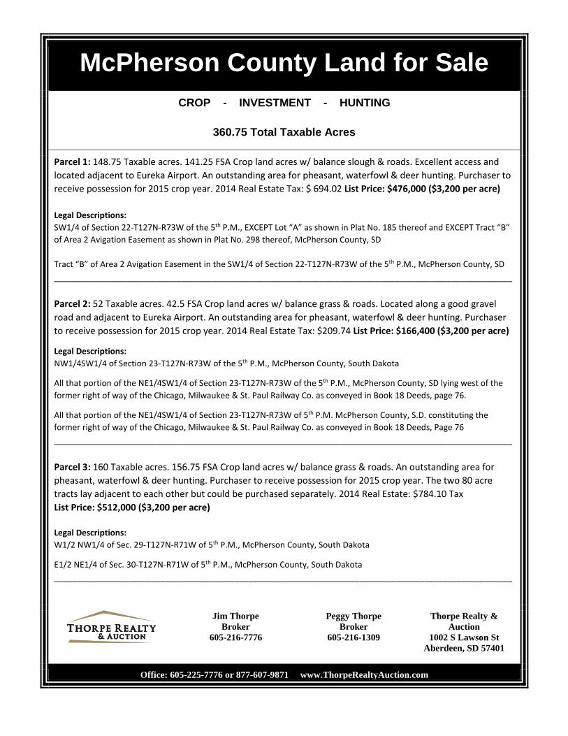
McPherson County Land for Sale CROP - INVESTMENT - HUNTING 360.75 Total Taxable Acres Parcel 1: 148.75 Taxable acres. 141.25 FSA Crop land acres w/ balance slough & roads. Excellent access and located adjacent to Eureka Airport. An outstanding area for pheasant, waterfowl & deer hunting. Purchaser to receive possession for 2015 crop year. 2014 Real Estate Tax: $ 694.02 List Price: $476,000 ($3,200 per acre) Legal Descriptions: SW1/4 of Section 22-T127N-R73W of the 5 th P.M., EXCEPT Lot “A” as shown in Plat No. 185 thereof and EXCEPT Tract “B” of Area 2 Avigation Easement as shown in Plat No. 298 thereof, McPherson County, SD Tract “B” of Area 2 Avigation Easement in the SW1/4 of Section 22-T127N-R73W of the 5 th P.M., McPherson County, SD __________________________________________________________________________________________ Parcel 2: 52 Taxable acres. 42.5 FSA Crop land acres w/ balance grass & roads. Located along a good gravel road and adjacent to Eureka Airport. An outstanding area for pheasant, waterfowl & deer hunting. Purchaser to receive possession for 2015 crop year. 2014 Real Estate Tax: $209.74 List Price: $166,400 ($3,200 per acre) Legal Descriptions: NW1/4SW1/4 of Section 23-T127N-R73W of the 5 th P.M., McPherson County, South Dakota All that portion of the NE1/4SW1/4 of Section 23-T127N-R73W of the 5 th P.M., McPherson County, SD lying west of the former right of way of the Chicago, Milwaukee & St. Paul Railway Co. as conveyed in Book 18 Deeds, page 76. All that portion of the NE1/4SW1/4 of Section 23-T127N-R73W of 5 th P.M. McPherson County, S.D. constituting the former right of way of the Chicago, Milwaukee & St. Paul Railway Co. as conveyed in Book 18 Deeds, Page 76 __________________________________________________________________________________________ Parcel 3: 160 Taxable acres. 156.75 FSA Crop land acres w/ balance grass & roads. An outstanding area for pheasant, waterfowl & deer hunting. Purchaser to receive possession for 2015 crop year. The two 80 acre tracts lay adjacent to each other but could be purchased separately. 2014 Real Estate: $784.10 Tax List Price: $512,000 ($3,200 per acre) Legal Descriptions: W1/2 NW1/4 of Sec. 29-T127N-R71W of 5 th P.M., McPherson County, South Dakota E1/2 NE1/4 of Sec. 30-T127N-R71W of 5 th P.M., McPherson County, South Dakota ___________________________________________________________________________________________________ Jim Thorpe Broker 605-216-7776 Peggy Thorpe Broker 605-216-1309 Thorpe Realty & Auction 1002 S Lawson St Aberdeen, SD 57401 Office: 605-225-7776 or 877-607-9871 www.ThorpeRealtyAuction.com
Transcript
McPherson County Land for Sale CROP - INVESTMENT - HUNTING
360.75 Total Taxable Acres
Parcel 1: 148.75 Taxable acres. 141.25 FSA Crop land acres w/ balance slough & roads. Excellent access and located adjacent to Eureka Airport. An outstanding area for pheasant, waterfowl & deer hunting. Purchaser to receive possession for 2015 crop year. 2014 Real Estate Tax: $ 694.02 List Price: $476,000 ($3,200 per acre) Legal Descriptions: SW1/4 of Section 22-T127N-R73W of the 5th P.M., EXCEPT Lot “A” as shown in Plat No. 185 thereof and EXCEPT Tract “B” of Area 2 Avigation Easement as shown in Plat No. 298 thereof, McPherson County, SD Tract “B” of Area 2 Avigation Easement in the SW1/4 of Section 22-T127N-R73W of the 5th P.M., McPherson County, SD __________________________________________________________________________________________ Parcel 2: 52 Taxable acres. 42.5 FSA Crop land acres w/ balance grass & roads. Located along a good gravel road and adjacent to Eureka Airport. An outstanding area for pheasant, waterfowl & deer hunting. Purchaser to receive possession for 2015 crop year. 2014 Real Estate Tax: $209.74 List Price: $166,400 ($3,200 per acre)
Legal Descriptions: NW1/4SW1/4 of Section 23-T127N-R73W of the 5th P.M., McPherson County, South Dakota
All that portion of the NE1/4SW1/4 of Section 23-T127N-R73W of the 5th P.M., McPherson County, SD lying west of the former right of way of the Chicago, Milwaukee & St. Paul Railway Co. as conveyed in Book 18 Deeds, page 76.
All that portion of the NE1/4SW1/4 of Section 23-T127N-R73W of 5th P.M. McPherson County, S.D. constituting the former right of way of the Chicago, Milwaukee & St. Paul Railway Co. as conveyed in Book 18 Deeds, Page 76 __________________________________________________________________________________________ Parcel 3: 160 Taxable acres. 156.75 FSA Crop land acres w/ balance grass & roads. An outstanding area for pheasant, waterfowl & deer hunting. Purchaser to receive possession for 2015 crop year. The two 80 acre tracts lay adjacent to each other but could be purchased separately. 2014 Real Estate: $784.10 Tax List Price: $512,000 ($3,200 per acre) Legal Descriptions: W1/2 NW1/4 of Sec. 29-T127N-R71W of 5th P.M., McPherson County, South Dakota
E1/2 NE1/4 of Sec. 30-T127N-R71W of 5th P.M., McPherson County, South Dakota ___________________________________________________________________________________________________
Jim Thorpe Broker
605-216-7776
Peggy Thorpe Broker
605-216-1309
Thorpe Realty & Auction
1002 S Lawson St Aberdeen, SD 57401
Office: 605-225-7776 or 877-607-9871 www.ThorpeRealtyAuction.com
Page: 1 of 3
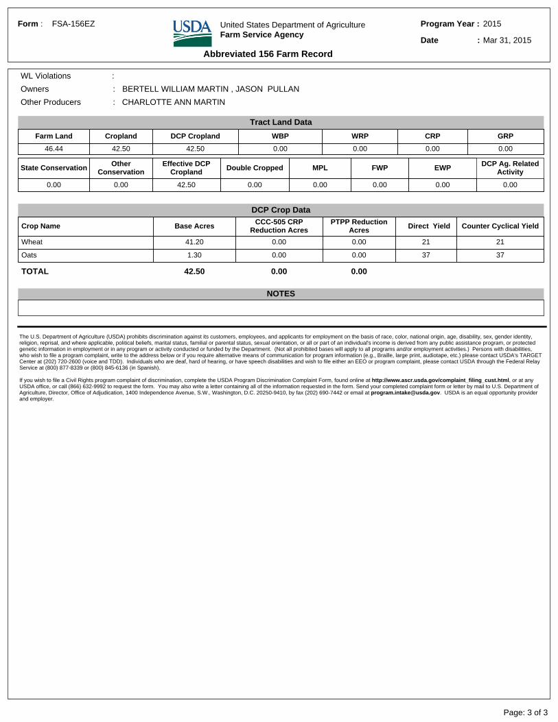
2015Program Year :
Mar 31, 2015Date :
Abbreviated 156 Farm Record
FSA-156EZForm : United States Department of AgricultureFarm Service Agency
PTPP Reduction Acres Direct Yield Counter Cyclical Yield
Wheat 41.20 0.00 0.00 21 21
Oats 1.30 0.00 0.00 37 37
TOTAL 42.50 0.00 0.00
NOTES
The U.S. Department of Agriculture (USDA) prohibits discrimination against its customers, employees, and applicants for employment on the basis of race, color, national origin, age, disability, sex, gender identity, religion, reprisal, and where applicable, political beliefs, marital status, familial or parental status, sexual orientation, or all or part of an individual's income is derived from any public assistance program, or protected genetic information in employment or in any program or activity conducted or funded by the Department. (Not all prohibited bases will apply to all programs and/or employment activities.) Persons with disabilities, who wish to file a program complaint, write to the address below or if you require alternative means of communication for program information (e.g., Braille, large print, audiotape, etc.) please contact USDA's TARGET Center at (202) 720-2600 (voice and TDD). Individuals who are deaf, hard of hearing, or have speech disabilities and wish to file either an EEO or program complaint, please contact USDA through the Federal Relay Service at (800) 877-8339 or (800) 845-6136 (in Spanish). If you wish to file a Civil Rights program complaint of discrimination, complete the USDA Program Discrimination Complaint Form, found online at http://www.ascr.usda.gov/complaint_filing_cust.html, or at any USDA office, or call (866) 632-9992 to request the form. You may also write a letter containing all of the information requested in the form. Send your completed complaint form or letter by mail to U.S. Department of Agriculture, Director, Office of Adjudication, 1400 Independence Avenue, S.W., Washington, D.C. 20250-9410, by fax (202) 690-7442 or email at [email protected]. USDA is an equal opportunity provider and employer.
&-
33.3
9
26.47
1141.25NHEL
142.5NHEL
T 928
T 929
United StatesDepartment ofAgriculture
Farm 4802²2014 Program Year
McPherson County, South Dakota
22-127N-73W
Map Created February 14, 2014
0 620 1,240310Feet
Common Land UnitNon-croplandCropland
Section Line
Wetland Determination Identifiers&- Restricted Use#*Limited Restrictions") Exempt from Conservation
Compliance Provisions
United States Deparment of Agriculture (USDA) Farm Service Agency (FSA) maps are for FSA Program administration only. This map does not represent a legal survey or reflect actualownership; rather it depicts the information provided directly from the producer and/or National Agricultural Imagery Program (NAIP) imagery. The producer accepts the data 'as is' and assumes all risks associated with its use. USDA-FSA assumes no responsibility for actual or consequential damage incurred as a result of any user's reliance on this data outside FSA Programs. Wetland identifiers do not represent the size, shape, or specific determination of the area. Refer to your original determination (CPA-026 and attached maps) for exactboundaries and determinations or contact USDA Natural Resources Conservation Service (NRCS).
Tract Boundary
2012 Ortho-Photography - not to scale
Conservation Reserve Program
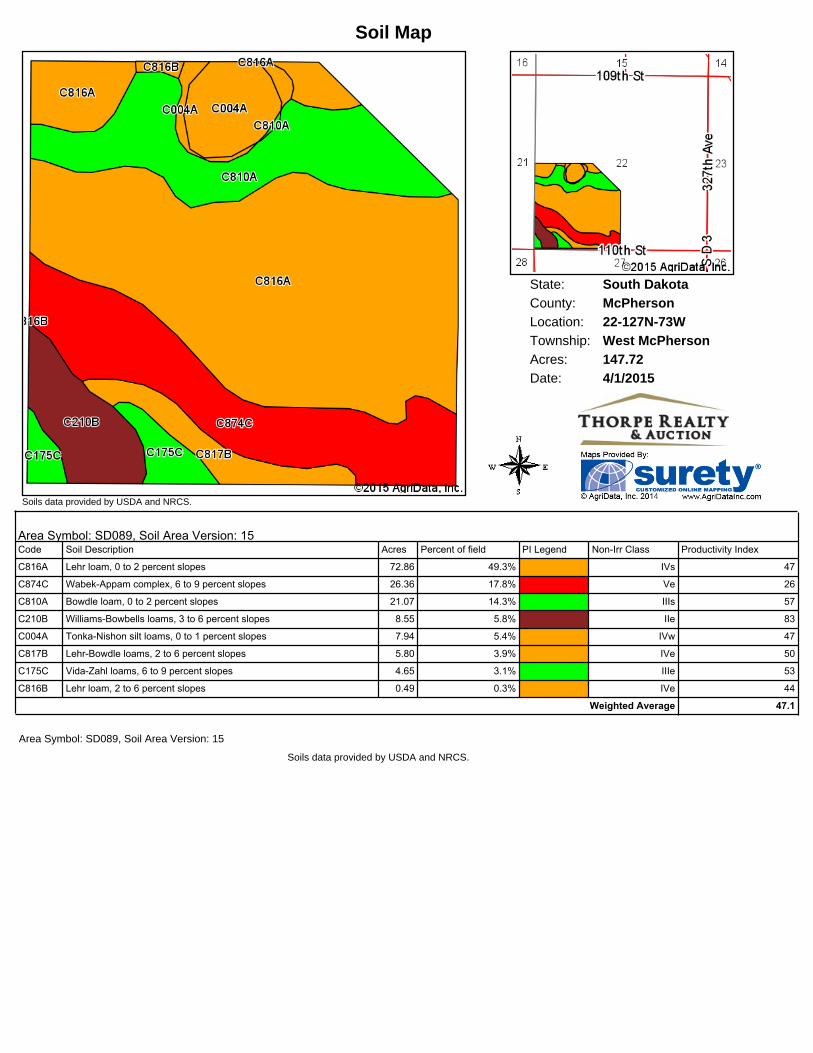
State: South DakotaMcPhersonCounty:22-127N-73WLocation:
Township: West McPhersonAcres: 147.72Date: 4/1/2015
Soils data provided by USDA and NRCS.
Soil Map
Area Symbol: SD089, Soil Area Version: 15Code Soil Description Acres Percent of field PI Legend NonIrr Class Productivity Index
Wetland Determination Identifiers&- Restricted Use#*Limited Restrictions") Exempt from Conservation
Compliance Provisions
United States Deparment of Agriculture (USDA) Farm Service Agency (FSA) maps are for FSA Program administration only. This map does not represent a legal survey or reflect actualownership; rather it depicts the information provided directly from the producer and/or National Agricultural Imagery Program (NAIP) imagery. The producer accepts the data 'as is' and assumes all risks associated with its use. USDA-FSA assumes no responsibility for actual or consequential damage incurred as a result of any user's reliance on this data outside FSA Programs. Wetland identifiers do not represent the size, shape, or specific determination of the area. Refer to your original determination (CPA-026 and attached maps) for exactboundaries and determinations or contact USDA Natural Resources Conservation Service (NRCS).
Tract Boundary
2012 Ortho-Photography - not to scale
Conservation Reserve Program
State: South DakotaMcPhersonCounty:23-127N-73WLocation:
Township: West McPhersonAcres: 46.44Date: 4/1/2015
Soils data provided by USDA and NRCS.
Soil Map
Area Symbol: SD089, Soil Area Version: 15Code Soil Description Acres Percent of field PI Legend NonIrr Class Productivity Index
C874C WabekAppam complex, 6 to 9 percent slopes 20.52 44.2% Ve 26
Wetland Determination Identifiers&- Restricted Use#*Limited Restrictions") Exempt from Conservation
Compliance Provisions
United States Deparment of Agriculture (USDA) Farm Service Agency (FSA) maps are for FSA Program administration only. This map does not represent a legal survey or reflect actualownership; rather it depicts the information provided directly from the producer and/or National Agricultural Imagery Program (NAIP) imagery. The producer accepts the data 'as is' and assumes all risks associated with its use. USDA-FSA assumes no responsibility for actual or consequential damage incurred as a result of any user's reliance on this data outside FSA Programs. Wetland identifiers do not represent the size, shape, or specific determination of the area. Refer to your original determination (CPA-026 and attached maps) for exactboundaries and determinations or contact USDA Natural Resources Conservation Service (NRCS).
Tract Boundary
2012 Ortho-Photography - not to scale
Conservation Reserve Program
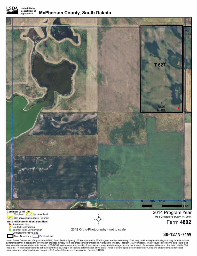
&-&-
31.13
178.05NHEL
278.7
NHEL
T 627
United StatesDepartment ofAgriculture
Farm 4802²2014 Program Year
McPherson County, South Dakota
29-127N-71W
Map Created February 14, 2014
0 630 1,260315Feet
Common Land UnitNon-croplandCropland
Section Line
Wetland Determination Identifiers&- Restricted Use#*Limited Restrictions") Exempt from Conservation
Compliance Provisions
United States Deparment of Agriculture (USDA) Farm Service Agency (FSA) maps are for FSA Program administration only. This map does not represent a legal survey or reflect actualownership; rather it depicts the information provided directly from the producer and/or National Agricultural Imagery Program (NAIP) imagery. The producer accepts the data 'as is' and assumes all risks associated with its use. USDA-FSA assumes no responsibility for actual or consequential damage incurred as a result of any user's reliance on this data outside FSA Programs. Wetland identifiers do not represent the size, shape, or specific determination of the area. Refer to your original determination (CPA-026 and attached maps) for exactboundaries and determinations or contact USDA Natural Resources Conservation Service (NRCS).
Tract Boundary
2012 Ortho-Photography - not to scale
Conservation Reserve Program
State: South DakotaMcPhersonCounty:29-127N-71WLocation:
Township: West McPhersonAcres: 157.88Date: 4/1/2015
Soils data provided by USDA and NRCS.
Soil Map
Area Symbol: SD089, Soil Area Version: 15Code Soil Description Acres Percent of field PI Legend NonIrr Class Productivity Index


![enrollment program that allows high school PowerPoint - Move on When Ready - Satyn Nishon Geary - GA [Compatibility Mode] Created Date 20160714183044Z ...](https://static.documents.pub/doc/80x56/5aacde5b7f8b9a9c2e8d8932/enrollment-program-that-allows-high-powerpoint-move-on-when-ready-satyn-nishon.jpg)


