Page 1
A CRITICAL EXAMINATION OF PRIVATE CONSERVATION AREAS ON CAMPESINO
COMMUNITY LANDS IN PERU
By
MEGAN MARIE BARNHART
Bachelor of Science, Western Michigan University, Kalamazoo, Michigan, 2009
Thesis
Presented in partial fulfillment of the requirements
for the degree of
Master of Science
In Resource Conservation, International Conservation and Development
The University of Montana
Missoula, MT
Fall 2015
Approved by:
Dr. Sandy Ross, Dean of the Graduate School
Dr. Jill M. Belsky, Chair
Department of Society and Conservation
Dr. Laurie Yung
Department of Society and Conservation
Dr. Kimber H. McKay
Department of Anthropology
Page 2
ii
Barnhart, Megan, M.S., Fall 2015 Resource Conservation
Campesino Community-Owned Private Conservation Areas in the Amazonas Region of Peru:
Collaboration or Missed Opportunities?
Chairperson: Dr. Jill M. Belsky
Abstract
Community-owned private reserves are emerging around the world as an alternative to
government-run resource management and as a way to more directly involve citizens as stewards
of their local natural resources. Despite their recent proliferation globally, voluntary efforts by
communities to include their land in protected area systems, and the motivations and
expectations of their legal recognition remain largely unknown. This thesis examines
community-owned private conservation areas in Northern Peru locally known as Áreas de
Conservación Privadas (ACPs) which are voluntary and legally recognized by the Peruvian State.
The study investigates the rationales and outcomes of the application of ACPs in campesino
(peasant) communities, and how both are shaped by socio- political, economic, historical,
cultural, and legal contexts at multiple (nested) scales. The field work of this research
investigated the creation and management of two case study campesino community-owned ACPs
in the Amazonas region of Peru: Molinopampa and Tilacancha. Field research was conducted
from December 2012 to Febuary 2015 during my service as a Peace Corps volunteer in the
region where the study took place. The field research included largely qualitative methods
including participant observation, in-depth interviews with government officials at the national
level, regional NGOs and governmental agencies, and community leaders, and household
surveys in the community-owned ACPs. The research found that the implementation and
outcomes of ACPs in Peru are shaped by interests, policies and discourses at national and
international levels, and their interactions with local communities. Although labeled as
“community-owned” the ACPs were being used to increase the amount of land in conservation
according to the dominant paradigm involving strict protection and restricted use in designated
areas; it even involved displacement in some cases. The case study demonstrated that the local
communities examined were excluded from making decisions in regards to what constitutes
appropriate land uses for their land, both in national decentralized land planning policies and in
the creation of the ACPs. These findings provide for a more nuanced understanding of the
inclusion of Indigenous and Community Conserved Areas (ICCAs) in legal frameworks. The
alignment of community land rights recognition with conservation initiatives as determined by
the outside entities led to many negative outcomes for the communities, including less control
over their lands, distrust for outside entities, and a growing resistance to conservation as defined
by the ACP management plan. This study revealed it is important to understand how new
political and economic discourses and actions surrounding nature play into regionally or locally
specific histories of environments, land use, and governance and agrarian relations.
Page 3
iii
TABLE OF CONTENTS
LIST OF TABLES………………………………………………………………..........………..iv
LIST OF FIGURES......................................................................................................................iv
GLOSSARY OF ACRONYMS....................................................................................................v
CHAPTER 1. INTRODUCTION……….....................................................................................1
CHAPTER 2. LITERATURE REVIEW.....................................................................................9
CHAPTER 3. SOCIO-POLITICAL CONTEXT OF CAMPESINO COMMUNITIES AND
THE AMAZONAS REGION OF PERU...................................................................................29
CHAPTER 4. RESEARCH METHODS...................................................................................38
CHAPTER 5. RESULTS.............................................................................................................55
CHAPTER 6. DISCUSSIONS AND CONCLUSIONS..........................................................128
ACKNOWLEDGEMENTS ......................................................................................................147
BIBLIOGRAPHY......................................................................................................................148
APPENDICES............................................................................................................................158
Page 4
iv
LIST OF TABLES Pg.
Table 1. Types of Legally Recognized Conservation in Peru……………………..…………….26
Table 2. Overview of Research Methods and Scales of Analysis…………………………….…39
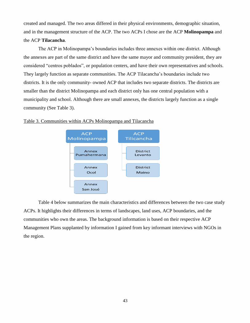
Table 3. Communities within ACPs Molinopampa and Tilacancha………………………..……43
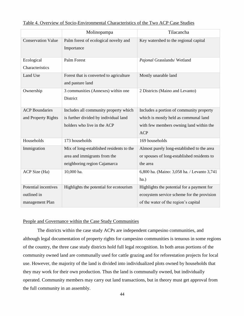
Table 4. Overview of Socio-Environmental Characteristics of the Two ACP Case Studies……44
Table 5. Household Survey Sample……………………………………………………...………52
Table 6. Household Expected Benefits from the Creation of the Molinopampa ACP…… …….68
Table 7. Household Expected Benefits from the Creation of the Tilacancha ACP……...………69
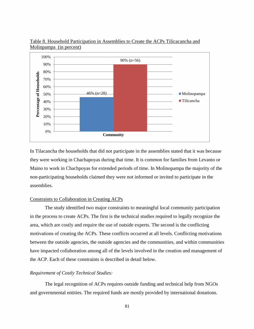
Table 8. Household Participation in Assemblies to Create the ACPs Tilicacancha and
Molinopampa…………………………………………………………………………………….81
Table 9. Perception of Awareness of ACP Training……………………………………………..88
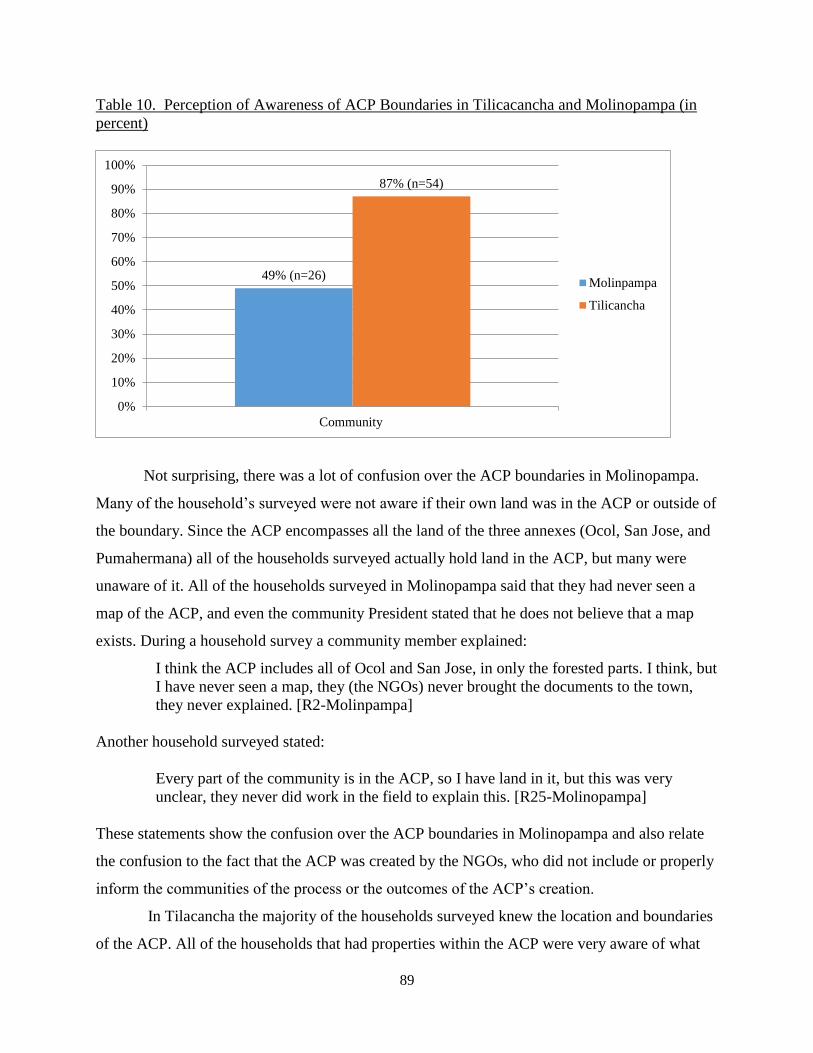
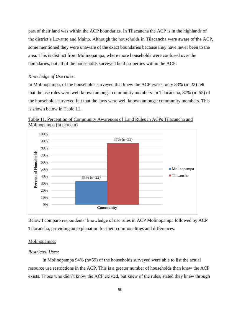
Table 10. Awareness of ACP Boundaries in Tilicacancha and Molinopampa………………….89
Table 11. Community Awareness of Land Rules in ACPs Tilacancha and Molinopampa…...…90
Table 12. Resource Use Restrictions as Reported by Households in Molinopampa………...…..91
Table 13. Resource Uses Permitted as Reported by Households in Molinopamapa…………….92
Table 14. Resource Use Restrictions as Reported by Households in Tilacancha……………..…93
Table 15. Resource Uses Permitted as Reported by Households in Tilacancha…………………94
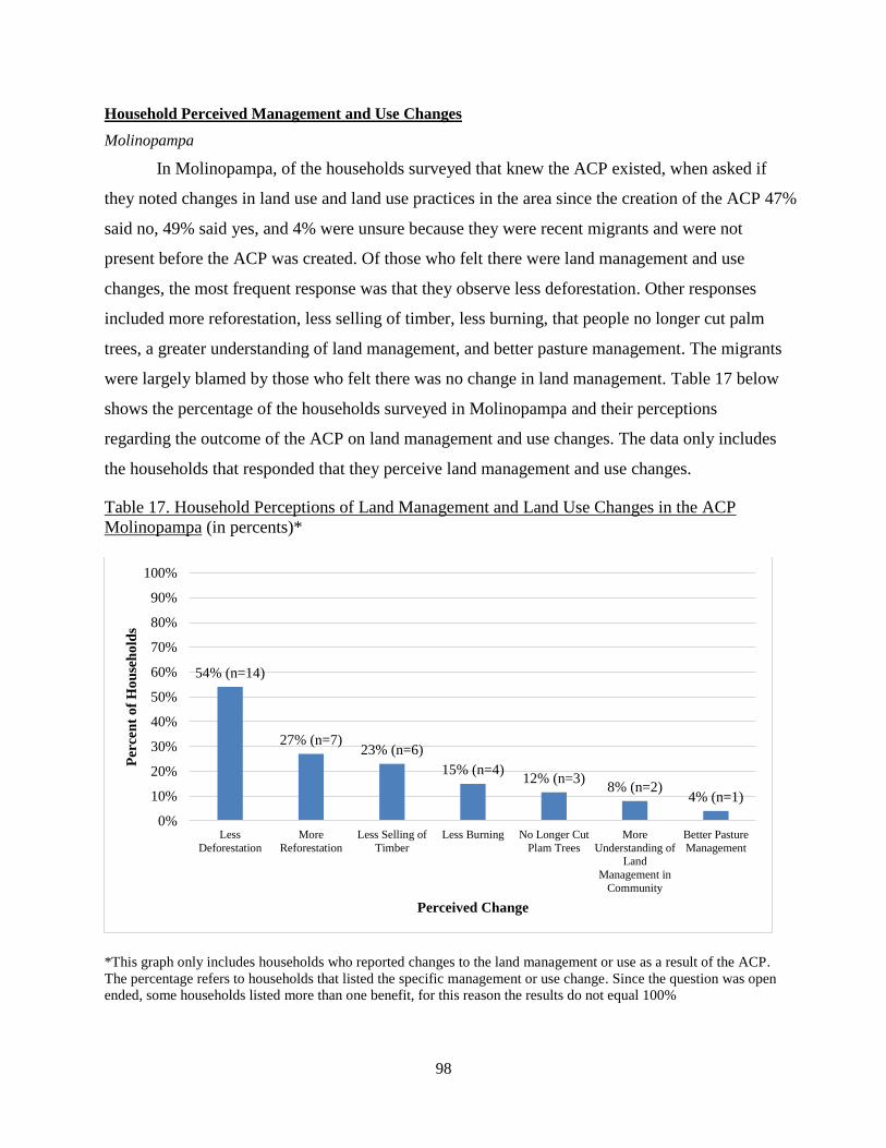
Table 16. Household Perception on Land Management and Use Changes…………………..….97
Table 17. Household Perceptions of Land Management and Land Use Changes in the ACP
Molinopampa………………………………………………………………………….…………98
Table 18. Perception of Land Management and Land Use Changes in the ACP Tilacancha…....99
Table 19. Household Perceptions on ACP Benefits in ACP Molinopampa……………...…….103
Table 20. Household Perceptions on ACP Benefits in ACP Tilacancha...........................…......103
LIST OF FIGURES Pg.
Figure 1. Map of ACPs in the Amazonas Region…………………………………………………6
Figure 2. Complexity of Land Governance in Peru…………………………………………..….22
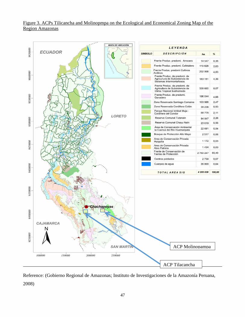
Figure 3. ACPs Tilicancha and Molinopmpa on the Ecological and Economical Zoning Map of
the Region Amazonas……………………………………………………………………………47
Figure 4. Map of ACP Molinopampa…………………………………………………..………..48
Figure 5. Map of ACP Tilacancha…………………………………….…………………………48
Page 5
v
GLOSSARY OF ACRONYMS
ICCA Indigenous and Community-Conserved Areas
IUCN International Union for the Conservation of Nature
CBC Convention on Biological Diversity
CBRM Community-Based Natural Resource Management
ACP Private Conservation Area (Spanish Acronym)
MINAM Ministry of Environment (Spanish Acronym)
SERNANP National Service for Natural Protected Areas (Spanish Acronym)
PROFANANPE Peruvian Trust Fund for National Parks and Protected Areas (Spanish
Acronym)
SINANPE Peruvian State National Protected Area System (Spanish Acronym)
ZEE Economic and Ecological Zoning (Spanish Acronym)
ARA Regional Environmental Authorities (Spanish Acronym)
APECO Peruvian Association for the Conservation of Nature (Spanish Acronym)
NCI Nature and Culture International
SPDA Peruvian Society for Environmental Law
GTT Technical Group for Tilacancha (Spanish Acronym)
Page 6
1
CHAPTER 1. INTRODUCTION
Peru provides an important setting for learning more about the experience of community-
based private conservation. It is particularly relevant to understand issues related to its recent
institutionalization and state recognition of “Indigenous and Community Conserved Areas”
(ICCAs). The concept of ICCAs was a product of the 2003 International Union for the
Conservation of Nature (IUCN) World Parks Conference, and is defined as natural areas under
community governance, self-initiated by local, mobile, or indigenous communities (IUCN, 2008).
The recognition and inclusion of ICCAs in national protected area systems are being promoted
by and included as a theme in the action plans of the United Nations Environmental Program, the
Convention on Biological Diversity (CBD), and IUCN. Community conserved areas often lack
formal recognition and can be threatened by agro-development schemes and resource extraction
projects, such as mining. The growing understanding of ICCAs and their potential contribution
to the contemporary conservation framework has led to the integration of ICCAs within
governmental conservation plans and policies (Kellert et al., 2000). In Peru the main possibility
for indigenous and peasant (campesino) titled communities to request the government to
recognize their land as formal conservation areas is through Private Conservation Areas (ACPs-
Spanish acronym). In Peru there are 83 legally recognized ACPs covering 280,199 hectares of
land. The ACPs are declared by both individual landowners and communities with land titles;
this study focuses on the issues related to the declaration and implementation of ACPs by
campesino communities.
Three important elements coincide in Peru to enable the rise in legally documented
community-based private protected areas owned by campesino communities. First, campesino
communities are legally recognized in Peru as autonomous governing organizations with
historical ties to their land and hold self-governing rights over their land, which is considered
private land, not public. Second, the country initiated a national decentralization agenda which
has devolved land management planning to the regional and local level. And, third, there are new
regional land planning efforts and legal frameworks that call for the increased use of landscape-
level environmental conservation management which relies on voluntary efforts on privately-
owned lands and financial incentives. The example of how the Peruvian state is engaging private
land owners and campesino communities in the country’s protected area system through the legal
recognition of voluntary conservation efforts elucidates the nuanced ways in which recognition
Page 7
2
of peasant land rights, and land planning by regional level governance institutions and authorities,
are negotiated to meet the objective of landscape conservation. These negotiations are important
to the social and environmental aspects of conservation in the biodiverse countries of the
Amazon, as well as the current academic debates regarding institutionalizing private community-
based conservation in accordance with what has been called rights-based conservation (Campese
et al., 2009).
This study examines the perspectives and experiences of the multiple actors involved
with the application of the legal and institutional framework that has boosted conservation efforts
on private land in Peru, especially on campesino community-titled lands. Using a nested
multiscale approach the study analyzes the movement in Peru to give state recognition to
“voluntary” conservation efforts on campesino community-titled lands at the global, national,
regional, and local levels. The research reveals how factors at one level impact the next and how
the different scales interact, paying particular attention to power relations and historical and
political contexts. The research draws on three areas of literature: community-based
conservation, indigenous and community conserved areas policy developments, and incentive-
based conservation and the contention in the academic literature over the growth and
management of their applications critiquing their ability to conserve biodiversity (Hutton et al,
2005; Kellert et al., 2000; Oates, 1999) as well as their capacity to achieve sustainable
development for local populations (Barrett & Arcese, 1995; Wainwright & Wehrmeyer, 1998;
West, 2006). It examines the recent increased use of voluntary private community-owned
conservation areas in international conservation policy and discourses, and how these same
arguments may apply or be overcome through their application.
The literature on indigenous and community-conserved areas advocates for the
international and national recognition of Indigenous and Community Conserved Areas (ICCAs)
by acknowledging local management systems that are consistent with “conventional
conservation” and are seen by the IUCN to contribute to non-local conservation objectives and
goals (CENESTA, 2009; IUCN, 2011). Despite the rise in the recognition of ICCAs by
governments across the globe, little is known about the contexts that can lead to a positive
collaboration between indigenous or peasant communities and the state. Also, even with the
recent proliferation of government recognized private protected areas and the rise of their use as
a conservation tool by international organizations, there has been little documentation of the
Page 8
3
areas; especially absent has been research on the motivating forces behind the creation of the
areas and their inclusion in state systems – such research has been called “non-existent”
(Langholz & Lassoie, 2001).
Although small scale, locally-initiated conservation efforts are becoming common
globally, their management and the rationale behind their implementation, as well as why certain
land uses are accepted as “conserving” over others is rarely described in literature (Fletcher,
2010) . This lack of research is in contrast to the wider literature on community- based natural
resource management and the impacts of these interventions on resource conservation and the
socioeconomic conditions of rural populations (Berkes F. , 2009; Dressler & Pulhin, 2009;
Kellert, Mehta, Ebbin, & Lichtenfeld, 2000), as well as the wider literature on connections
between rural people and their natural environments (Li, 2002; Sheil, 2004; Western, 1994). As
programs such as REDD+ and Payments for Ecosystem Services increase there is an increasing
number of studies including critiques of how they relate to neoliberal economic policies and their
negative impact on conservation and rural livelihoods (Fairhead et al., 2012; Corbera et al.,
2007). Though there is a growing base of knowledge on these subjects, there has been a lack of
attempt to bring these areas of research together and understand the interaction between external
conservation agencies and voluntary local environmental conservation initiatives (Shanee, 2013).
Understanding areas of disagreement as well as agreement on private conservation areas by rural
residents living in biodiversity hotspots as well as by mainstream conservation practitioners
responsible for implementing them can help to inform how these new conservation areas are
operating. Perhaps they can even identify important conservation opportunities that allow local
people the political will and recognition to lead conservation projects and initiatives.
Over the last decade, Peru has developed legal mechanisms for both private conservation
areas and payments for ecosystem services schemes, and has given the legal recognition of
private conservation area (ACP) to several campesino communities. The institutionalization of
the ACPs is making it necessary for interaction among conventional conservation NGOs who are
helping with legal documentation of private conservation areas, the state who grants legal
recognitions, and the campesino communities, and for these groups to find ways to resolve
conflicts over land use and management. The country’s decentralization process and regional
level land planning have led to a suite of different forms of conservation mechanisms in the
country’s protected area system (SINANPE) including state-run national protected areas,
Page 9
4
regional conservation areas, private protected areas, and conservation and ecotourism
concessions. Many communities across Peru hold the legal status of campesino communities
dating back to the countries agricultural reforms in the 1970s that granted collective land tenure
to the communities that practiced agriculture on the lands. Although the communities have, at
least on paper, autonomy to manage their own land, land planning in Peru has been complicated
and multi-leveled, with different ministries in charge of different aspects of landscape planning.
The signing of a free trade agreement with the United States in 2007 and the passing of an
economic stimulus package in 2014 favor economic development and resource extraction and
have created tension and contradiction for campesino and native community land rights and
environmental protection. This has led to an overlap in jurisdiction over lands, and it is becoming
common (and problematic) that mining concession or large scale agriculture projects are
superimposed on campesino and indigenous community lands (Kovacevic, 2014). Nonetheless,
internationally ICCAs are being seen as mechanisms for the recognition of local rights and
protection against external threats (Alcorn, 2005; IUCN, 2011).
The Amazonas region of Peru, where this research took place, is in Northeastern Peru and
a central part of the ‘Tropical Andes Biodiversity Hotspot.’ This area is considered one of the
most biodiverse areas on earth (Myers, 2003). The high biodiversity and acute threats perceived
by the Peruvian government and others to important habitats have led to Northeastern Peru being
considered a global conservation priority. The Amazonas region suffers from one of the highest
rates of deforestation in Peru, fueled by a large and rapid influx of immigrants and a lack of
government intervention (Gobierno Regional de Amazonas; Instituto de Investigaciones de la
Amazonía Peruana, 2010).
The people of the Amazonas region come from a mix of indigenous and European origin.
The rural, campesino communities reflect this mix and consist of mostly impoverished farmers
who suffer from the deterioration of natural resources and land insecurity due to high rates of in-
migration, competition from mining, and a lack of state acknowledgement; as well as corrupt
decision making processes (Shanee, 2013). They rely on mostly subsistence agricultural crops
production based on a combination of corn, beans, and tubers for home use, supplemented by a
small income from commercial production of cattle, coffee, and cacao; the combination depends
on the area. There is a growing number of migrants from the country’s northern highlands,
mainly from the region Cajamarca, where an increase in population together with an increase in
Page 10
5
mining operations have led to a lack of affordable fertile land. The migrants often settle in areas
that have communal land laws which do not provide private land titles recognized by the
regional government but “titles of position” awarded by local governing bodies. Titles of
position are not registered through the regional government. Many of the migrants do not register
legally within the region. Due to the ecological differences between the regions, migrants use
farming methods poorly adapted to their new areas, such as the intensive clearing of forest to
create pasture lands using species of grasses and cattle not suited to the areas. This is a large
reason for current local land degradation and has led to large forest clearing, uncontrollable
burning, and illegal use of resources; as well as conflicts between long-established populations
and the immigrant settlers (Shanee, 2013).
In response to the lack of state recognition and state assistance, and through a push from
international NGOs teaming with regional government institutions, locally-run conservation
initiatives in the Amazonas region are increasing in number and include the creation of
campesino community run ACPs. Despite the explosion of their application in regional
conservation, research is lacking regarding the initiation of the movement to create the
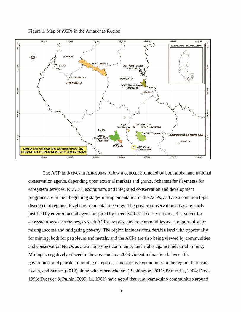
“voluntary” community-based private protected areas. Currently there are 14 ACPs throughout
the region of Amazonas, 8 of which are on campesino community land and managed by
campesino communities. The ACPs add 107,489 hectares to the regional conservation system
and encompass a diverse range of microclimates and ecosystems. There are currently more
individuals and campesino communities that are in the legal process of declaring their land as
ACPs. Below is the most recent map of the ACPs in the region.
Page 11
6
Figure 1. Map of ACPs in the Amazonas Region
The ACP initiatives in Amazonas follow a concept promoted by both global and national
conservation agents, depending upon external markets and grants. Schemes for Payments for
ecosystem services, REDD+, ecotourism, and integrated conservation and development
programs are in their beginning stages of implementation in the ACPs, and are a common topic
discussed at regional level environmental meetings. The private conservation areas are partly
justified by environmental agents inspired by incentive-based conservation and payment for
ecosystem service schemes, as such ACPs are presented to communities as an opportunity for
raising income and mitigating poverty. The region includes considerable land with opportunity
for mining, both for petroleum and metals, and the ACPs are also being viewed by communities
and conservation NGOs as a way to protect community land rights against industrial mining.
Mining is negatively viewed in the area due to a 2009 violent interaction between the
government and petroleum mining companies, and a native community in the region. Fairhead,
Leach, and Scones (2012) along with other scholars (Bebbington, 2011; Berkes F. , 2004; Dove,
1993; Dressler & Pulhin, 2009; Li, 2002) have noted that rural campesino communities around
Page 12
7
the world are vulnerable to appropriation by more powerful state and corporate entities for
environmental or resource extraction (Fairhead et al., 2012). ACPs may have the ability to
devolve land rights, control, and management decisions to communities where historically socio-
economic and political factors have favored elite capture and loss of communal lands.
This research examines the actual experience of developing ACPs in two campesino
communities in Peru to document why actors at the local, regional and national level pursued
developing ACPs, how they were implemented and ultimately whom they actually benefit. My
analysis is particularly directed at understanding how community-based natural resource
management actually operated within the two case study ACPs as compared to what has been
assumed about ICCAs in Peru as well as in the academic literature. As will be shown below, the
thesis demonstrates that the legal inclusion of community-owned and managed ICCAs in
Peruvian protected area frameworks while seemingly progressive and in line with community
interests is considerably more complex than documented.
Research Questions
Building on the above background, this research examines the history and outcomes of
the development and use of community- based ACPs as a conservation tool in the Amazonas
region of Peru. The project more specifically seeks to examine:
1) Why did the movement for the creation of ACPs on campesino community-owned land
come about, and what were the justifications and motivations behind the creation of the
ACPs? To explain the origin of the motivations I ask further: who was involved in the
formation of the ACPs, what were the roles of the different actors involved in the creation
of the ACP, and who started the initiative to create the legally documented conservation
areas?
2) How were the campesino community conservation areas established and based on what
form of community ownership of, or inclusion in the planning processes? I am
particularly interested in who was included and who was left out of the process of
deciding upon declaring the community land as a conservation area and in creating the
zoning and use plans for the conservation area.
Page 13
8
3) In order to evaluate the outcomes of the implementation of the ACPs, I examined the
views of different groups involved in developing the legal and material basis of the ACPs
including what does the national government, regional NGOs and agencies, and local
community members feel they are achieving, or not, through creating an ACP? In
pursuing this question I was very careful to identify and differentiate where need be as to
the criteria used by the different groups to define success or challenges with the ACPs.
Organization of the Thesis
The thesis is organized into five chapters followed by references and appendices. Chapter
2 covers the literature on community-based conservation, Indigenous and Community Conserved
Areas (ICCAs), and incentive-based conservation. The literature review places the three topics in
the context of Peru and the nation’s current decentralization process.
Chapter 3 first examines the prominent characterizations of campesino communities that the
community-based private conservation areas are intended to benefit in Peru, delving into the
history of the country’s agricultural reforms that led to the titling and the governing of lands
within the campesino territories. The chapter then describes the socio-political dynamics in the
region where the two case study ACPs are located, and how these underlying forces have
interacted with Peru’s decentralization policies to create regional governments and devolve
responsibility of land management planning to the regional level. Chapter 4 presents the
methodology used in this research to examine the motivations of the creation of the ACPs and
the outcomes of their implementation from national, regional, and campesino community
perspectives. Chapter 5 presents the results from the study. Finally, Chapter 6 provides a
summary of the principal findings, recommendations for improving the implementation and legal
recognition of ACPs in campesino communities, shortcomings of the thesis, and topics for future
research.
Page 14
9
CHAPTER 2. LITERATURE REVIEW
Introduction
The studies of decentralization, community-based natural resource management, private
protected areas, local participation, and incentive-based conservation have an extensive literature.
Thus, my review will focus on literature revealing contention and disagreement over the impacts
and effectiveness of natural resource governance. More specifically, in this chapter I review sites
of contention regarding the opportunities and constraints of decentralization methods of natural
resource management and role of local users in resource governance, and especially where they
are related to the inclusion of indigenous and private protected areas in legal conservation
frameworks, and involve incentive-based conservation schemes. I then place these issues within
the Peruvian context. I discuss broader historical and political processes of decentralization of
natural resource governance and management at the national level, as well as the subsequent
regional land use planning laws that have been implemented. I do this because this historical
context is necessary to understand different motivations and experiences with the emergence of
community-based private protected areas in Peru. The final section introduces the region where
the case study sites are located, and provides socio-political background to provide detail on the
dynamic contexts in which the new private forms of community-based conservation were applied.
Community-Based Natural Resource Management
Since the 1970s variations of what can be collectively termed community-based natural
resource management (CBNRM) methods have exerted significant impacts on the governance of
natural resource management. The term often refers to the design and implementation of
programs and policies involving devolution and decentralization of natural resource management
in many developing as well as developed countries across the globe. It also can refer to
community-based governance and management of indigenous systems and livelihoods. The
literature review here pertains largely to those systems involving a change in policy from a top-
down, state controlled management approach to the community level. This policy change has
been fueled by the recognition of the limits of government agencies in managing resources at the
local level, which has often created a vacuum resulting in degradation of natural resources and
peoples’ livelihood systems (Bocking, 2004). The debate about the linkage between poverty and
conservation has become sophisticated and complex, and it is recognized that they are dynamic
Page 15
10
and context specific, reflecting particular social, political, historical, and ecological factors
(Brosius et al., 1998; Farmer, 2003; West, 2006). A prominent objective of CBNRM is the
improvement of social and economic conditions in rural areas and local empowerment,
participation, and property rights of marginalized, rural populations (Kellert, Mahta, Ebbin, &
Lichtenfeld, 2000).
CBNRM aims to empower local resource management and conservation, especially in
situations where governments have undermined local authority (Alcorn, 2005). The idea of
CBNRM is to devolve management decisions to local communities. Ideally this is based on
supporting local practices and initiatives which support both local economies and ecologies,
while providing the communities with national or in some cases international recognition for
their efforts and approaches they have been employing in some cases for many generations
(Berkes, et. al, 2000). CBNRM has been celebrated as an improvement over top-down
centralized approaches to natural resource management because in theory CBMRM utilizes local
knowledge and participation to empower communities, while addressing the socio-economic
needs of the marginalized resource users (Berkes F. , 2003; Drew, 2005; Kellert, Mehta, Ebbin,
& Lichtenfeld, 2000).
Critiques of Community-Based Conservation as Implemented by External NGOs
Despite the theorized potential benefits, CBNRM projects as designed and implemented
by outsiders have also come under a great deal of criticism. The most common argument against
them is the tendency of outside implementers, funders and advocates to simplify “community”,
and approach community generically as an ideal entity that is homogeneous and well defined
rather than work from real situations which differ by context and history (Brosius et al., 1998).
Outside organizations design programs with profound implications for communities with
imperfect ethnographic and historical knowledge, finite resources, and a diverse scope of
interests they wish to implement (Scott, et al., 2013). Belsky, 1999 argues that rather than assist
communities in these situations, otherwise well-intentioned CBNRM projects can lead to greater
local socioeconomic differentiation and conflict among local populations.
The subjects of CBNRM are usually described as resource dependent communities that
are in pursuit of improved and sustainable livelihoods. Li (2002) argues the founding assumption
of CBNRM is that targeted communities have livelihoods that are natural resource dependent
and therefore already have, or can be encouraged to adopt “sustainable” resource management
Page 16
11
practices. The implementation of the projects often fails to distinguish whether communities
identify with these practices, or if they are instead practices conceived of by outsiders and
promoted through incentives. Michael Dove (1993) debates that the search for new incomes
under conservation agendas ignores historic and even current livelihoods and that effort may be
better placed in identifying current resource use and management and institutional forces that
restrict ownership and productive use of resources already in use by marginalized communities.
He draws attention to power relations associated with outside conservation agendas, and the fact
that impoverished, marginal rural people are expected to conserve rather than exploit for profit, a
burden from which those with power are exempt.
These critiques all come from the argument that local communities in externally-
generated projects are never truly empowered to decide what uses are appropriate for the
“conservation” projects. Lynch and Talbott (1995) state that a resource management system is
only “community-based” if the rules for resource allocation and management are set primarily by
the communities themselves. Rather the projects are introduced as part of what Brockington et al.
(2008) define as mainstream conservation, or the dominant global conservation paradigm. These
schemes are based on what the international NGOs view as the local environmental history and
the causes of degradation as well as their solutions or “sustainable livelihoods” which are often
in conflict with local views and have come to represent dominant narratives or discourses
(Fairhead & Leach, 2003). In the dominant discourses local populations are viewed as a threat to
biodiversity conservation, rather than acknowledging the way local people have interacted with
and shaped the landscapes into multifunctional landscapes, where people and biodiversity have
co-existed (Igoe & Brockington, 2007; Siebert & Belsky, 2014). The mainstream conservation
discourse views capacity building as involving new skills and livelihoods rather than building on
historic ones where they existed, and privileges market-based livelihoods such as in efforts to
provide economic valuation of nature; these efforts undermine local knowledge, livelihoods and
connection with the local landscapes; and can actually contribute to cultural devaluation of
nature (Dressler & Roth, 2011; Shanee, 2013). The use of state-sponsored community-based
conservation management to empower people, reduce poverty, and protect natural resources has
in many cases failed in practice, and it can be argued that many central states’ use of community-
based forest management and conservation is a form of control and can push for agrarian and
Page 17
12
economic changes that don’t necessarily benefit land holders in the conserved area (Dressler &
Pulhin, 2009).
In summary, while at higher levels conservation approaches since the 1970s have
increased attention to the role of communities and local participation in conservation there has
been tremendous disconnect between theory and practice. Rather than truly devolve decision-
making and governance, NGO-led CBNRM projects have failed to enable local stakeholders to
base new governance systems and livelihoods on their understanding of environmental change in
their areas and what they prioritize as ways forwards. They are critiqued for having failed to
actually implement environmental conservation, as well as to achieve sustainable development.
The failure of CBNRM to meet its goals bolsters mainstream discourse which dismisses local
knowledge and local populations and perceives them as a threat to biodiversity rather than a
potential collaborator. Thus, the efforts have failed to be truly “bottom-up” and the relationships
are enlaced with power conflicts. They are particularly nasty when they entail new land and
resource-use regulations on already disenfranchised marginalized groups.
Indigenous and Community Conserved Areas and Private Conservation
Despite concerns with CBNRM projects, there remains sufficient belief in the values of
devolution and in indigenous rights to seek governance models which can more effectively
embrace this approach. An example of this is the rapidly developing idea of Indigenous and
Community Conserved Areas (ICCAs) in protected area systems (Berkes F. , 2009; IUCN, 2008;
Massey, Bhagwat, & Porodong, 2011). The IUCN defines ICCAs as:
Natural and/or modified ecosystems including significant biodiversity values,
ecological benefits, and cultural values voluntarily conserved by indigenous and
local communities, both sedentary and mobile, through customary laws or other
effective means (Borrini-Feyerabend, et al., 2013, p. 40).
Berkes, 2009 defines three important features of ICCAs:
First, ICCAs involve a community (or communities) closely connected to the
ecosystem culturally and/or because of livelihood needs. Second, management
decisions of the community effectively lead to conservation, even though
conservation may not be the primary objective. Third, the community is the major
decision maker, and community institutions have the capability to enforce
regulations. (p.19)
Including ICCAs in protected area systems aims to recognize the contribution of community
resource management to non-local conservation objectives and goals (CENESTA, 2009). This
Page 18
13
notion came largely through the IUCNs Fifth World Parks Congress in 2003, where it was
decided that the Convention on Biological Diversity (CBD) should recognize diverse protected
area approaches, such as community-based conservation areas, indigenous conservation areas,
and private protected areas (Berkes, 2009). ICCAs are defined as “natural and/ or modified
ecosystems containing significant biodiversity values, ecological services, and cultural values,
voluntarily conserved by indigenous, mobile, and local communities through customary laws and
other effective means” (IUCN, 2008). Berkes (2009) describes that the fundamental difference
between formal protected areas and ICCAs is that the former is solely about biodiversity
conservation, where the latter are established also for livelihoods and the well-being of local
inhabitants, such as for the provision of water or cultural reasons. The inhabitants in the ICCAs
organize their governance and management not around external biodiversity discourse, but
locally-meaningful activities and concepts emphasizing productive and ecologically healthy
landscapes and waterscapes, ones which can also provide what conservation literature has termed
“ecosystem services” (Berkes F. , 2009; IUCN, 2008; Shanee, 2013; CENESTA, 2009).
ICCAs are receiving attention because they are promoted as a means to both expand
conservation results while also securing local communities livelihoods and rights (Oviedo, 2003).
IUCN describes the outcomes of the discussions that took place at the Fifth World Parks
Congress as the following:
The participants at the Fifth World Parks Congress (WPC, Sept. 2003)
recommended that national and international recognition of ICCAs is an urgent
necessity. In its Message to the CBD, this largest ever gathering of
conservationists suggested to “recognize the diversity of protected area
governance approaches, such as community conserved areas, indigenous
conservation areas and private protected areas, and encourage parties to support
this diversity”. The Durban Accord further “urged commitment to recognize,
strengthen, protect and support community conserved areas” (IUCN, 2011).
The growing understanding of ICCAs and their potential contribution to the
contemporary conservation framework has led to the integration of ICCAs within governmental
conservation plans and policies (Kellert et al, 2000). Since 2003, International conservation
agents, including multilateral organizations and NGOs have promoted legal and financial
mechanisms to institutionalize ICCAs and legitimize local conservation efforts; again these
differ from state-managed or otherwise externally driven protected areas (Reyes-Garcia, et al.,
2012). Bohman et al. (2008) view the institutionalization of ICCAs as a way to also create a
Page 19
14
union between the state, conservation NGOs, and local communities and argues that this union
and state recognition allow local communities to be empowered to defend their own lands from
newly arrived land “invaders”.
The expansion of the range of actors involved in conservation is part of a broader
international trend to grow the constituency of conservation, making “conservation” more
multicultural and diverse (Brown, 2002; Berkes, 2004). Voluntary community-owned private
conservation areas, which fall under the IUCN ICCA category, have been growing in number
and according to Stolton et al. (2014) private reserves are strong in Latin America, with Peru
holding the largest area of privately protected land (Monteferri & Coll, 2009). Despite the
international interest in using different governance schemes to expand protected area coverage,
little is known about situations that can lead to positive collaboration between the communities
and protected area managers when self-governing rights are acknowledged by the state.
The Paradox of ICCA Inclusion in State Protected Area Systems
State recognition and support of ICCAs may help retain conservation and provide legal
status against land uses not desired by community members (such as mining concessions or
conversion to large scale agriculture for example palm oil). However, even with ICCA’s there is
risk of imposing mainstream conservation agendas on local communities who conserve as an
externality of cultural practices, values, or beliefs (Alcorn, 2005). Borrini-Feyerabend et al.
(2004) and Kothari (2006) along with other scholars have questioned how the ICCAs are
identified for inclusion in national frameworks; are they selected by conservation agencies or by
the request of the concerned community and with prior community consent? There is a concern
that the institutionalization of private community-based protected areas and indigenous cultural
reserves and integration of local people into national and international protected area agendas
may negatively affect local people’s perceptions of and interactions with their local
environments (Reyes-Garcia, et al., 2012).
The inclusion of ICCAs in protected area systems has been advocated as an alternative
for conserving the world’s remaining biodiversity from development. A great share of the global
biodiversity occurs on private lands, including ones owned by communities (Langholz & Krug,
2004). While recognition of the areas may increase the area of land under conservation status,
the influence of global biodiversity conservation discourse continues to raise questions for
private community conserved areas. Berkes (2009) argues that policy implications will arise with
Page 20
15
the inclusion of the communities in protected area systems such as: lack of capacity to assess the
ability of the areas to provide real conservation benefits, methods for integrating traditional
knowledge with protected area management, and the right mix of governance authorities to
manage areas. He argues that although the strengthening of resource tenure and payments for
ecosystem service schemes provide incentives for communities to join the national system of
protected areas, many rural groups associate “protected areas” with “land disposition” and may
view legal recognition of conservation as a loss of land control (Berkes F. , 2009). The
promotion of state recognition of ICCAs as a rights based and conservation-through use
approach to conservation overlooks the fact that the classification of ICCAs remain part of the
international conservation apparatus, and may further entrench the idea that indigenous or rural,
marginalized groups should remain “traditional” based on subsistence-oriented livelihoods.
There remains limited information concerning the expectations of communities included
in legally recognized ICCAs despite official calls to include them in establishing the areas. The
synthesis document “Community Conserved Areas: A Review of Status and Needs” by the
IUCN group “Theme on Indigenous Peoples, Local Communities, Equity and Protected Areas”
(TILCEPA, 2008) states key factors for ICCAs and provides recommendations for the support
and recognition of ICCAs. The document recommends to require that ICCAs must identify their
conservation role, articulating what they are conserving and why, and that the evaluation of the
conservation outcomes should rely on indicators jointly agreed upon between local communities
and the NGO or government agencies aiding in their legal recognition. Assessing a community’s
capacity to achieve “conservation” depends on the collective expectations of community
members on the desired outcomes for their territories, and the chosen model of development and
resource use within the communities (Riascos et al., 2008). Not all collective territories desire or
prioritize conservation outcomes per se, rather they care about sustainable use which depends on
the visions community members have for the self-development of their territories. The report by
Riasco et al. (2008) highlights the need to look at the governance types in operation in
communities, and points out that overlapping jurisdictions with different landscape management
objectives pose great challenge. For example, while a collective territory may seek to meet their
livelihood needs through market integration, protected area and conservation objectives may be
limited to the protection of natural systems. The requirement for ICCAs to identify their role in
the “conservation” of biodiversity and the need to articulate what, how, and why the area is
Page 21
16
conserving relies on technical criteria (TILCEPA, 2008). This may risk the exclusion of local
knowledge and local plans for development, and present the problem of conflicting meanings of
“conservation” at different scales. The limited power of indigenous communities means they
may not have the capacity to challenge the environmental understandings and approach to
conservation by more powerful authorities.
Traditional practices of local communities, such as using fire and rotation of crops, have
created ecological diversity and multifuntional landscapes, which has been acknowledged by
ecologists to promote biodiversity conservation (Alcorn, 2005; Berkes et al, 2000). Many
observers have noted the compatibility of these practices with conservation agendas despite the
unwillingness of governments and others to recognize their value (Dressler & Pulhin, 2009;
Siebert & Belsky, 2014). Furthermore, the application of incentive-based conservation in the
community-based conservation plans and ICCAs suggests that there is compromise in play, in
that the communities are expected to give up practices deemed unsuitable by authorities in
exchange for the proposed alternative incomes.
In summary, despite good intentions the official recognition of ICCAs could still risk
losing local autonomy, control of property and decision making authority over natural resources
in their areas. If this is the case, there is a dilema faced by communities. In the application for
inclusion of their land in a states’ protected area system the community faces the threat of the
loss of some autonomy in land use decision making, but if they do not apply for the inclusion of
their land for conservation, the land could be declared as an area for mining, logging, or large
scale agricultural schemes. The ICCAs are recognized by states and conservation organizations
for the protection of biodiversity, whereas for the communities the declaration of the areas might
be to safeguard their livelihood in their ancestral homelands through receiving possible
protection against intruders and new income generating opportunities. The cross-cultural
communication required for the creation and legal recognation of the ICCAs and different
priorities and expectations at the local, instution, and national level could also produce conflict.
Although the formalization and legal recognition of ICCAs may seem promising, it does also
raise the question of how the new arrangement will influence the adaptive dynamics of local
management systems.
Page 22
17
Incentive-Based Conservation
Some ICCAs seem to be new protected areas encouraged by payments for ecosystem
services schemes (Berkes F. , 2009; Shanee, 2013). Participants in the 3rd
World Conservation
Congress, in Bangkok, Thailand in 2004 recommended that in strengthening the legal framework
for privately-owned protected areas there should be policies and programs that strengthen the
economic incentives for private and community land owners to adopt modern conservation
practices including: tax exemptions, payments for the environmental services provided by
conserved lands, and development of new markets for local environmental goods and services
(Langholz & Krug, 2004). The congress also stated that if not already established, governments
should create trust fund, with support from international aid, and authorize that these funds be
used to support the establishment and operation of privately-owned protected areas (Langholz &
Krug, 2004).
In Peru the application of payment for ecosystem services schemes in the ACPs is already
developing and the passing of a law in June of 2014 indicates that the development of such
projects will proceed. Peru also has a land trust fund, The Peruvian Trust Fund for National
Parks and Protected Areas (PROFONANPE), which has been designed to capture, manage, and
channel local and international funds. The fund was born as a result of negotiations by the
government of Peru, a team of local NGOs devoted to environmental conservation, and the
Global Environmental Facility (GEF) of the World Bank (Paniagua, 2003). PROFONANPE has
helped to create some ACPs and has been helping the ACPs with funds to help with sustainable
agricultural production and tourism projects. But along with opportunities there are potential
constraints relating to incentive-based conservation in community-based conservation.
Payment for ecosystem services (PES) is a particular type of incentive-based
conservation tool that is often defined as a voluntary transaction between one or more service
buyers and service providers for a well-defined ecosystem service (or use-practices to secure its
service) (Wunder, 2005). PES is intended to improve environmental outcomes while at the same
time support local livelihoods by providing the sellers with secure access to financial resources;
buyers are provided with the ensured integrity or provision of ecosystem services. Ecosystem
services for which payment schemes have been employed include forests, watersheds,
biodiversity, and carbon sequestration (Rodriguez et al., 2011).
Page 23
18
Critiques of Incentive-Based Conservation
Although PES schemes are being applied around the world, some environmental experts
caution against them because they involve contradictory and incompatible goals and methods
(Corbera, Kosoy, & Martinez Tuna, 2007; McAfee & Shapiro, 2010). Cobera et al. (2007)
argued that PES programs often emerge from top-down processes in Latin American countries
which can reinforce asymmetrical power relationships that dismiss local level governance. As
discussed, there are uncertainties about what drives the action of ICCAs to be recognized by a
state. Developing financial incentives can alter individual and group decision making
significantly (Bowles, 2008). PES schemes hold the risk of conflating intrinsic and cultural
motivations to conserve and can promote land trafficking and corruption (Corbera et al., 2007;
Fairhead et al., 2012).
Dressler and Roth (2011) argue that the logic of the market economy is increasingly
informing the motives, designs, and outcomes of conservation policy and practice in the
developing world. They state:
International donors, governments, and NGOs have supposedly moved on from
coercive conservation to identify and fund community-based initiatives that offer
“win-win” market based solutions for livelihood support and forest
conservation…. The logic of the market economy increasingly informs the
motives, design, and outcomes of conservation policy and practice near protected
areas in the developing world. ….. Recent research has begun to show, however,
that rather than replacing coercive forms of conservation, emerging forms of
devolved neoliberal conservation have rearticulated older modes of governance,
incorporating farmers into livelihood programs that have them intensify to
produce more commodities with fewer resources.
The use of market-based schemes to encourage community conservation often promote market-
oriented projects with the funds that are generated from the payment schemes, such as
ecotourism and high value agriculture, which create economic reliance on the conservation of the
ecosystems. They promote market strategies to cope with the reduction of land associated with
traditional livelihood practices, such as swidden agriculture (Dressler & Roth, 2011). The
application of payment schemes that specify what land uses are acceptable and what uses should
be restricted raises many questions about the motivations behind the “voluntary” conservation
efforts of ICCAs. Peru provides a unique opportunity to examine so called locally-driven
conservation through private communal conservation where PES schemes are being developed
Page 24
19
and implemented. The research could contribute to a better understanding of the process of
developing private community conservation areas and for whom they actually benefit or not.
ICCAs in Peru
Conservation deals with institutions at various social organizational levels, from the local
to the regional, the national, and the global (Berkes, 2007). Higher level institutions and multi-
scale drivers of change such as the market economy, migration and population change, land
tenure, agriculture reforms, and changing government regimes may have widespread impacts on
local-level institutions (MEA, 2005). The inclusion of ICCAs in state systems requires
interactions across different levels of organization as well as functional partnerships between the
levels and legal recognition. In order to understand the motivation for and the outcomes of
including community-based private conservation areas in Peru’s protected areas system it is
important to understand the national socio-political context and the institutional arrangements
that drove the legal recognition of the areas.
Conservation in Peru
At the institutional level, implementing conservation programs in Peru is very recent. It
was only in 2008 that protected areas, formerly part of the ministry of agriculture’s portfolio,
were placed under the authority of a newly created Ministry of the Environment (Ministerio del
Ambiente- MINAM). Within this ministry, the National Service for Protected Areas (El Servicio
Nacional de Áreas Naturales Protegidas por el Estado- SERNANP) was also established in 2008
(Solano, 2009). The creation of MINAM and SERNANP was seen as a major opportunity to
strengthen a system which has always faced a number of threats: mining, illegal logging,
commercial agriculture, livestock, and encroachment by migrant settlements (Solano, 2009).
Significant factors contributed to the creation of MINAM, including: a growing awareness in the
public and private sector of increasing environmental issues, pressure within the framework of
negotiations of the congressional passing of the US-Peru Free Trade agreement in 2007, and a
growing concern from civil society, NGOs, and the international donor community about the
need for an environmental authority to balance the ecological impacts of economic growth
(World Bank, 2009). The new ministry was faced with the challenge of building and
implementing an efficient management model consistent with national development strategies,
and that is in line with the country’s political and economic decision making processes.
Page 25
20
Decentralization in Peru
The decentralization and governance process in Peru is another new development, and is
relevant to protected areas and land planning. Understanding the process of decentralization in
Peru is key to unpacking the complex tale of different agencies in land-use planning and
governance.
As a country with a legacy of centralized political decision making and administrative
management, Peru is a relative latecomer to decentralization that swept Latin America in the late
twentieth century (Andersson & Ostrom, 2008). It wasn’t until the early 2000s that new
decentralization schemes were implemented in Peru, which called for a distribution of
responsibilities among national, regional, and local governments with the goal of increasing
public participation across the three levels of government. Prior to 2000, the decade long
presidency of Alberto Fujimori was condemned as authoritarian and centralized; it
disempowered and stripped regional and municipal governments of local power over decision
making (Carrion, 2006).
The process of decentralization formally started in 2002, during the presidency of
Alejandro Toledo, who promoted the initial legal frameworks, installation of regional
governments, and the transfer of responsibilities and duties to these regional governments (Che
Piu & Menton, 2014). The second stage of decentralization occurred during the government of
President Alan Garcia (2006-2011), and involved the regions developing their national plans and
the devolution of powers to regional and local governments. Decentralization processes are slow,
and in Peru are still considered to be in their early stages (Kovacevic, 2014).
Power and Decentralized Land Planning in Peru
Despite the development of the ministry of environment and decentralization, land use
classification and titling in the country has remained complex and often involves competing
mandates related to decisions made at the national level. The Ministry of Environment does not
always have the power necessary to fulfil their environmental conservation agendas, since most
of the key powers related to land use classification and permitting are held by other ministries,
such as the ministry of mining and energy (Ministerio de Energia y Minas- MINEM) (Kovacevic,
2014). Land planning, and the declaration of protected areas in Peru, is controlled by many
Page 26
21
different ministries, making it challenging for the ministry of environment alone to promote
conservation agendas.
When the Peruvian government makes decisions concerning tradeoffs between the
conservation of natural capital and development of large scale investment projects that would
increase economic capital, the benefits are often in favor of the economic capital. This was made
evident by the recent passing of an economic stimulus package passed in July of 2014 by the
ministry of finance, which aims to set the country on a path of 5% annual growth and weakens
the power of MINAM over land use decisions (Kovacevic, 2014; Sullivan, 2014). Sullivan (2014)
argues that the passing of the legislation strips MINAM of authority over environmental
regulation and land planning, and states that the creation of MINAM as part of the US free trade
agreement suggests that the desire to form a ministry of environment never really came from the
Peruvian state, but was rather an obligation in exchange for access to international markets.
Regardless of the motivation behind the creation of a ministry of environment, public budget for
protected areas remains low, and as long as protected areas are not perceived as assets the
budgets are unlikely to increase.
Conflict between development objectives and environmental discourses come down to
political negotiation and power, and often who holds the power controls who ultimately makes
the decision on land use, regardless of who is affected by the outcomes (Dressler & Pulhin, 2009;
Fairhead et al., 2012; Kovacevic, 2014). Millions of hectares of land in Peru have overlapping
claims, meaning for example, a piece of land can be identified as a mining concession and a
peasant farmer’s field at the same time (Kovacevic, 2014). Romero-Wolf (2010) argues that in
Peru considerations for more basic issues such as property rights are often ignored and is
evidenced by the superposition of mining concessions on top of land that has been designated
and titled for other purposes, including protected areas, indigenous reserves, and campesino
communities (Romero-Wolf, 2010). This points to the complexity of land classification and
titling in the country (Kovacevic, 2014; Romero-Wolf, 2010). As Kovacevic (2014) explains,
decentralization has contributed to overlapping claims, since the decentralization process has
started to distribute land use powers across ministries and different levels of government that
often have competing obligations and powers related to land uses. This complexity is
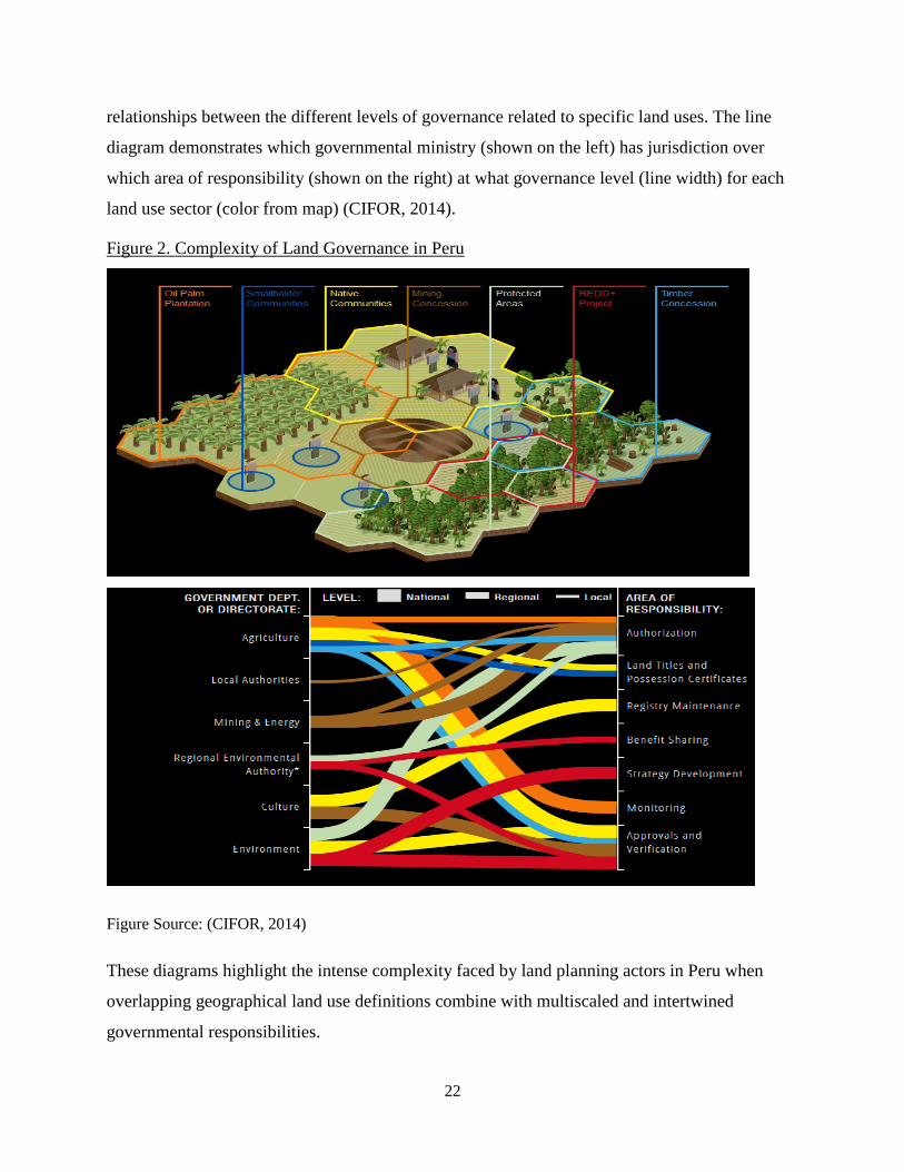
demonstrated below in figure 2. The land map diagram created by CIFOR (2014) shows
examples of how geographical boundaries of different land use titles often overlap, as do the
Page 27
22
relationships between the different levels of governance related to specific land uses. The line
diagram demonstrates which governmental ministry (shown on the left) has jurisdiction over
which area of responsibility (shown on the right) at what governance level (line width) for each
land use sector (color from map) (CIFOR, 2014).
Figure 2. Complexity of Land Governance in Peru
Figure Source: (CIFOR, 2014)
These diagrams highlight the intense complexity faced by land planning actors in Peru when
overlapping geographical land use definitions combine with multiscaled and intertwined
governmental responsibilities.
Page 28
23
In the case of forestry decentralization, a model has been implemented in some parts of
the country which passed the responsibility of forest control and monitoring actions to regional
governments. The Amazonas region is one of the eight regional governments to which forest
duties have already been transferred. Although in theory land planning rights have been
transferred to regional governments, Che Pi and Menton (2014) argue that they have not been
given the necessary capacitation and resources to fulfill these responsibilities. Despite the lack of
capacitation and preparation regional governments have been held responsible for development
plans to promote economic, social, and environmental development.
Regional Territorial Planning and Ecological Economic Zoning (ZEE)
A planning and land classification system being used in the decentralization of land
planning in Peru is territorial planning (ordenamiento territorial) carried out by MINAM with
regional governments (Kovacevic, 2014; Che Piu & Menton, 2014). A main component of
territorial planning is Economic and Ecological Zoning (ZEE). The implementation of ZEE is the
responsibility of MINAM, while regional governments are in charge of planning and
enforcement, and political administration of the plans (Che Piu & Menton, 2014). ZEE aims to
help decision makers determine the suite of suitable land uses for the landscapes across the
region by collecting and modeling physical, environmental, social, ecological, and cultural data.
The rational for ZEE land use planning is that if local authorities were to have a clearer
and strategic view of the alternative forms of local development that they would like to pursue,
then they would have much greater technical leverage in arguments over how to use different
geographical areas and how to combine conservation, agriculture, water management, and
mining in the region (Bebbington, 2011). The combined process of zoning and land use planning
was deliberate because it drew on the already national debate regarding extractive industry and
land use planning in response to the US free trade agreements (Romero-Wolf, 2010). A mix of
civil society organizations, researchers and others had argued that decisions regarding extraction
of minerals should be taken with the context of larger land use plans (Bebbington, 2011). In
explaining ZEE, Ashwin Ravikumar, who is publishing a book on decentralization and land use
power in Peru, provides the following example of land use decision making using ZEE:
Page 29
24
A really simple example is, if the data show an area has large tracts of pristine
forest, a long history of indigenous community areas, and poor soils, then it may
be best classified as a protected area. An area of land with good water supply and
degraded forest might be best considered for agricultural purposes. (Kovacevic,
2014).
Once land has been classified and titled, Peru’s 25 regional governments are responsible
for development plans, including working with other regions to promote economic, social and
environmental development, preserving and managing protected areas and promoting sustainable
use of forest resources.
The transfer of powers to regional and local governments has been slow, and has had a
major impact on the ability of regions to govern their land. Typically the regional governments
do not have technical staff with sufficient training to gather the data required for ZEE planning.
The studies require the collection of scientific data, special analysis, and leading stakeholder
discussions for large and remote areas (NatureServe, 2010). To fill this gap in needed technical
skills, many national and international NGOs assisted the regional governments in the creation of
the plans, providing aid in the gathering of technical data and capacity building. The role of
NGOs in the ZEE planning is important to note, since NGOs often rely on international funding
and may have any number of priorities and motivations for their activities. Considering the
literature on decentralization of land management and private conservation areas, my research of
the case study ACPs considers to what degree local resource users interests and priorities are
being met in the decentralized land planning, specifically in the creation of private protected
areas.
Regional Land Planning and Protected Areas
The ZEE planning for the regions provided ecological valuation for different areas in the
region, and the areas with high-biodiversity and natural forests were selected as areas ideal to
create protected areas. In the past decade the interest in the conservation of Peru has exploded, in
terms of the expansion in the number of international institutions that want to take part in it
(Romero-Wolf, Masters Thesis: Promoting Investments in Ecosystem Services: The Case of The
Peruvian Amazon, 2010). For many of these institutions, promoting conservation through
protected area creation is the most important objective. New legal and institutional frameworks,
including the legal recognition of voluntary protected areas on private land (ACPs), conservation
concessions, ecotourism concessions, and regional conservation areas, have provided legal tools
Page 30
25
that have permitted the institutions to build a mosaic of protected areas across the landscape of
Peru. Many of the international and national NGOs and institutes that helped with the ZEE
planning have also been involved in the creation of the legal frameworks for the different types
of conservation and in the establishment of new areas under these frameworks. The following
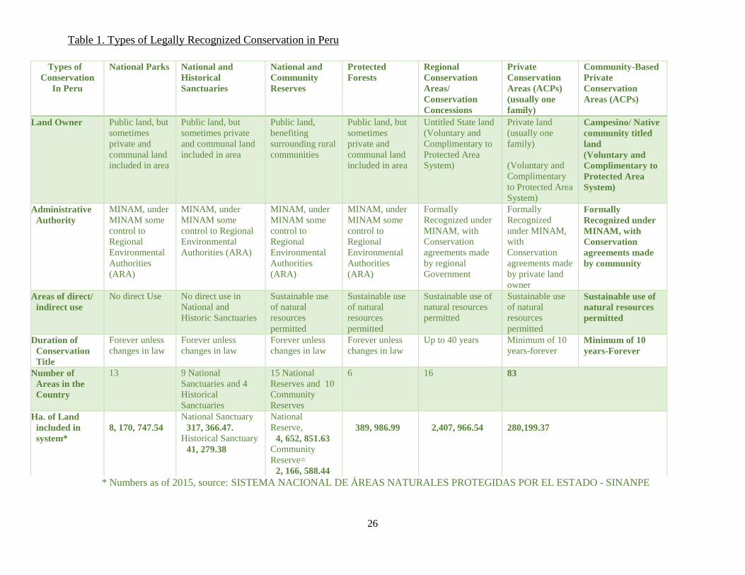
table (Table 1) shows the different legal options for protected areas in Peru.
The type of protected area that can be created depends on the land owner. National
protected areas on publically owned land currently hold the largest area of land under protected
area status in Peru, but there are more ACPs in number than any other legally recognized type of
conservation area. The national protected areas require national government management and are
expensive to operate. A lack of government funding for public protected areas hinders the ability
to create new national protected areas on public lands, which has contributed to the expansion of
the new types of conservation on private and community-owned land.
Page 31
26
Table 1. Types of Legally Recognized Conservation in Peru
* Numbers as of 2015, source: SISTEMA NACIONAL DE ÁREAS NATURALES PROTEGIDAS POR EL ESTADO - SINANPE
Types of
Conservation
In Peru
National Parks National and
Historical
Sanctuaries
National and
Community
Reserves
Protected
Forests
Regional
Conservation
Areas/
Conservation
Concessions
Private
Conservation
Areas (ACPs)
(usually one
family)
Community-Based
Private
Conservation
Areas (ACPs)
Land Owner Public land, but
sometimes
private and
communal land
included in area
Public land, but
sometimes private
and communal land
included in area
Public land,
benefiting
surrounding rural
communities
Public land, but
sometimes
private and
communal land
included in area
Untitled State land
(Voluntary and
Complimentary to
Protected Area
System)
Private land
(usually one
family)
(Voluntary and
Complimentary
to Protected Area
System)
Campesino/ Native
community titled
land
(Voluntary and
Complimentary to
Protected Area
System)
Administrative
Authority
MINAM, under
MINAM some
control to
Regional
Environmental
Authorities
(ARA)
MINAM, under
MINAM some
control to Regional
Environmental
Authorities (ARA)
MINAM, under
MINAM some
control to
Regional
Environmental
Authorities
(ARA)
MINAM, under
MINAM some
control to
Regional
Environmental
Authorities
(ARA)
Formally
Recognized under
MINAM, with
Conservation
agreements made
by regional
Government
Formally
Recognized
under MINAM,
with
Conservation
agreements made
by private land
owner
Formally
Recognized under
MINAM, with
Conservation
agreements made
by community
Areas of direct/
indirect use
No direct Use No direct use in
National and
Historic Sanctuaries
Sustainable use
of natural
resources
permitted
Sustainable use
of natural
resources
permitted
Sustainable use of
natural resources
permitted
Sustainable use
of natural
resources
permitted
Sustainable use of
natural resources
permitted
Duration of
Conservation
Title
Forever unless
changes in law
Forever unless
changes in law
Forever unless
changes in law
Forever unless
changes in law
Up to 40 years Minimum of 10
years-forever Minimum of 10
years-Forever
Number of
Areas in the
Country
13 9 National
Sanctuaries and 4
Historical
Sanctuaries
15 National
Reserves and 10
Community
Reserves
6 16 83
Ha. of Land
included in
system*
8, 170, 747.54
National Sanctuary
317, 366.47. Historical Sanctuary
41, 279.38
National
Reserve,
4, 652, 851.63
Community
Reserve=
2, 166, 588.44
389, 986.99
2,407, 966.54
280,199.37
Page 32
27
The Rise of Private Conservation in Peru
The opportunity for private land protection increased greatly in June of 2001 when the
government created the new regulation for the Law on National Protected Areas, which
authorized for the first time the formal creation of private reserves and conservation concessions
(The Environmental Law Institute, 2003). The law was passed by the National Institute for
Natural Resources, an agency within the Ministry of Agriculture that was responsible for
oversight of forests and protected areas before the establishment of the Ministry of Environment.
The 2001 law authorizes individuals or communities that own land to create Private
Conservation Areas (ACPs) that form part of the national protected areas system (SIANPE)
(Monteferri & Coll, 2009). The community-owned ACPs are established on land under the
collective ownership of campesino or indigenous communities who have voluntarily requested
that their land be recognized under the legal ACP instrument (The Environmental Law Institute,
2003). The areas are registered through the Peruvian state by the Ministry of Environment. These
private conservation areas are restricted to areas identified by regional and national land plans as
having significant biological resources, and in effect are treated as “mini parks”, with the owners
required to create and adopt a management plan and report annually to SERNANP (The
Environmental Law Institute, 2003).
The extensive regulatory framework developed by the Peruvian government with the
support of international and national conservation organizations has led to an expansion of
protected areas, mostly on private lands. Today there are 83 private conservation areas with
280,199 hectares of private and community-owned land. The proliferation of private protected
areas has been rapid and continues to increase. Since 2009 seventy new private protected areas
have been created (Ministerio Del Ambiente: SERNANP, 2015). Recently, some communities
have also applied to payments for ecosystem services (PES) programs, whereby private or
communal landowners are paid to maintain or enhance land conditions for areas that provide
specific services such as hydrological services or biodiversity maintenance (Shanee, 2013).
Consequently, private conservation areas are expanding also because they are viewed as
economically beneficial.
Property owners applying for ACPs can apply for the area to be declared an ACP for
eternity or for a declared amount of time, for a minimum of 10 years, which can then be renewed
(MINAM, 2014). In MINAM’s working document for ACPs it is states that “The contribution
Page 33
28
of ACPs as strategies in conservation are not only for expansion of protected areas or for the
specific species that they protect, but also to demonstrate that citizens committed to the
conservation of species, natural resources, and landscapes can make a grand difference in
conservation” (MINAM, 2014). The document also draws attention to the economic
development aspect of the conservation areas explaining, “ACPs can present opportunities and
benefits for communities or individuals that wish to realize activities such as ecotourism and
payment for ecosystem services” (MINAM, 2014).
The management plans include “conservation compromises” that are recognized in the
registration of the property as an ACP by the state property titling agency SUNARP, and under
the law the compromises need to be met by the current owner, and future owners in the case of
transfers in property (MINAM, 2014). In defining activities that can be realized in ACPs the
MINAM document for ACPs states:
The idea is that the property owners are who defines the uses that are permitted
within the area, with the limitation that the uses will not contradict the objective
of establishing the area for conservation. In ACPs it is possible to program any
activity that is compatible with the conservation of the area, such as investigations,
environmental education, ecotourism, management of wildlife, along with other
activities. The specific spaces for different activities are defined through the
zoning. (MINAM, 2014).
In order to create an ACP technical studies of the area have to be completed which define limited
and multiple use zones and activities which can be developed in the defined areas of the ACPs.
The property owners have the voluntary responsibility to use the property as defined by the
zoning activities in the technical study. ACPs can cover part of a property or all of a property.
The Environmental Law Institute (2003) states that community land owners may be
reluctant to establish the areas for the fear that it will allow the government to monitor their land
use, but that this may be dispelled once the designation of private conservation areas becomes
more commonly used. The government will need to find an appropriate balance between the
need to ensure the objectives as a protected area are complied with, and being overly restrictive.
Although the working documents for the creation of the ACPs state that their creation is
voluntary, there has not been research conducted to view the motivations behind campesino
communities to engage in these “voluntary” efforts which establish their land as conservation
areas included in the nation’s protected area system (SINANPE) or their outcomes.
Page 34
29
CHAPTER 3. SOCIO-POLITICAL CONTEXT OF CAMPESINO COMMUNITIES AND
THE AMAZONAS REGION OF PERU
Introduction
In order to understand the setting in which private conservation areas are being developed
in Peru, this chapter provides background on campesino communities and the socio-political
history and context of the Amazonas region where Community-Owned Private Conservation
Areas are being strongly promoted and utilized. Since ACPs are being developed as a result of
the country’s decentralization policies, it is important to understand the particular power
relations and history of land management in relevant regions. Attention here is on how
international and national level laws and forces come to influence regional land planning and
conservation efforts in combination with regional and local forces. Together they played a multi-
scaled role in shaping motivations for the use of ACPs in the region and their outcomes.
Campesino Communities
In Peru the most respected and democratic institution in communal life is the Campesino
(peasant) community, which legally acts as a corporate body to defend communal interests from
internal or external threats (Gelles, 2000). The organization of campesino communities is borne
out of centuries of exploitation and adaptive relationships between the Spanish colonizers and
later post-colonial powers with Andean indigenous cultures (Armstrong, Baillie, Fourie, &
Rondon, 2014; Deere, 1990; Gelles, 2000). Peru, along with other Latin American countries
holds a contradictory position of celebrating its pre-colonial past while concurrently
marginalizing the large existing native populations (Forte, 2013; Hough & Rau, 2008). Forte
(2013) states:
Officially there are no “Indigenous” communities in Peru, but rather comunidades
campesinos (peasant communities) in the highlands and comunidades nativas
(native communities) in the Amazonian lowlands (p.73).
Forte (2013) and Hough and Rau (2008) argue that in Peru the prevailing Andean rural
organization was based on class, and not race. Cadena (2000) attributes Peru’s lack of indigenous
movement as a result of state-sponsored culturist projects supporting indigenous identity
executed by the same elites who disempowered the rural populations. Identity in the campesino
communities has been grounded in geography and agriculture in the highlands where the native
Page 35
30
Peruvians prefer to be called “campesinos” over “indigenous”, a term used by outsiders which
they find offensive due to historical power relations (Hough & Rau, 2008).
The laws granting land titles to campesinos communities were created in the 1970s as a
result of agrarian reform and the titling was mostly done in the Peruvian highlands (Minority
Rights Group International, 2007). Land titles were granted to communities where land had been
converted for agricultural use, in accord with Peru’s emphasis on economic development
granting titles only to communities who had converted land for productive purposes. Campesino
communities are significant to the country’s agriculture and biodiversity. These communities
control 40% of the country’s agricultural area according to the 1994 census, but many
researchers argue that the percentage is much higher (Castillo, 2006). Campesino communities
make up a very significant part of rural population and are considered keepers of the nation’s
biodiversity (Castillo, 2006). They also played a significant role in the struggle against the
Shining Path guerilla movement and were most affected by the associated political violence
(Castillo, 2006; McClintock, 1981).
The general titling law of campesino land takes the form of settlements recognized with
the title of communities, with legal person status, and stipulates that each community determines
the regime of land use, in a communal, family, or joint way (Castillo, 2006). Thus, the titling
combines collectively held possession with family possession. Castillo (2006) states that the
current reality in campesinos communities is that almost all communities have their agricultural
lands distributed in family parcels, and that practically every Peruvian cultivable land is
individually possessed, even if recognized by titles as communally-owned. Individuals are
inscribed as comuneros into the Campesino Community. At the national level individual
properties are not recognized, but inside the campesino communities the methods of
appropriation and disposition of lands is divided in a family way. The main and most widespread
mechanism of land division is by inheritance (McClintock, 1981). Recently there has been a
gradual opening to contracts within the communities to lease and sell the family parcels, even to
people outside of the community (Castillo, 2006). Alejandro Diez (2012) draws attention to the
important fact that although the property is communal, the land within is divided into parcels
under the communities own laws, and inside the communities the access to parcels is not
egalitarian, because some communards have more parcels than others, or parcels of better quality.
The communities are also impacted by larger political decisions. Although the campesino
Page 36
31
communities own the land in their territory, and autonomy over land use decisions, they cannot
claim ownership of the water resources or minerals therein, because all freshwater, both above
and below ground, and subterranean resources are property of the Peruvian national government
(Romero-Wolf, 2010).
Community Structure of Campesino Communities
During the period of titling, campesinos were bound by a common heritage and kinship,
and although most residents work their land individually, the residents typically share many
community activities and the responsibility over areas of the land that are communal
(McClintock, 1981). In return for attending communal assemblies and carrying out leadership
roles and communal work service (faena), the comunero gains access to the common property
resources of the community. These vary among communities, but can include irrigation water,
grazing lands, firewood from the forest, walking paths (Castillo, 2006). The communal meetings
and faenas are obligatory to attend and there is a fine, sometimes very large, when a comunaro
doesn’t attend. Faenas include working on cleaning the community’s water system, fixing things
at the school, cleaning common paths that go to farm lands, working on communal pasture land,
manicuring the cemetery, among other work tasks for the good of the community (Castillo,
2006). In campesino communities portions of the community-owned land are communally used
for cattle grazing and communal planting of trees for local use. However, in Amazonas the
majority of the land within campesino communities is divided into predios, or individualized
plots, that male and female heads of households may work for their own production as
posesionarios (Shanee, 2013). When the communities were titled as Campesino Communities the
land was divided amongst comuneros into predios, with portions of the land left as communal.
The size of each family’s predio depends on a number of factors, some historical and some based
on the size of the family and number of children. Posesionarios may carry out land transactions
between themselves and outsiders, but must get approval from the full community in an
assembly.
Page 37
32
Regional Contexts
As discussed above, Peru is considered one of the world’s megadiverse countries and the
region of Amazonas is a central part of the “Tropical Andes Biodiversity Hotspot”, which is
considered the most biodiverse area on earth and a global conservation priority (Shanee, 2013).
The region also suffers one of the highest rates of deforestation in the country (IIAP, 2008).
Several social, political, and economic factors have impacted the rate of deforestation in the
Amazonas region. These factors have played a role in the regional ZEE planning and in creation
and outcomes of ACPs in the region. I have divided these influences into three categories: (1)
demographic change especially population growth through in-migration, (2) mining, and (3)
market integration.
Demographic Changes and Population Growth
Deforestation has increased in the Amazon region due to high rates of in-migration from
the Andes to the Amazon, and the subsequent agricultural expansion. In Peru, migration to the
Amazon regions was promoted by the national government to address land scarcity problems
elsewhere, reduce migration to coastal cities, and stop social conflict over properties and mining
in the highlands (Che Piu & Menton, 2014). Increased migration to the Amazon and its resultant
agricultural expansion has been one of the main causes of deforestation in the Amazonas region.
The opening of roads is a key factor in increasing access to previously inaccessible areas. It is a
common practice for new migrants to clear and area, use it for a short period (until fertility
declines) and then abandon the area; the few areas that have a potential for ongoing agriculture
are handed over to relatives or sold to new migrants (Che Piu & Menton, 2014). It is important to
recognize that this form of clearing and land abandonment is not the same as forest farming
known as swidden, a form of integral shifting cultivation which is highly managed based on
accumulated ecological knowledge, local governance and long-term (including enriched) fallows
(Siebert & Belsky 2014). The agriculture settlement of the Amazonas region entails a more
opportunistic and all would agree unsustainable form of forest conversion and campesino
agriculture. In fact, the migrants themselves view the forest as a barrier to agricultural
development (MINAM, 2009).
Migration to the Amazon was promoted by the Peruvian government in 1970s and 1980s
with subsidies for agriculture and livestock production, focusing on promoting farmer migration
Page 38
33
to the amazon and border areas, to occupy the national territory, which was becoming too
concentrated on the coast, and to protect the borders (Che Piu & Menton, 2014). This was
accompanied by policies to formalize the rural property, where lands deforested for the
establishment of agricultural activities were granted campesino community land titles, which
worsened issues including land grabbing, land trafficking, and deforestation (Deere, 1990).
The majority of the immigrants to the region come from the neighboring region
Cajamarca, which has Peru’s highest rate of campesino out-migration (Shanee, 2013). Cajamarca
was the focal point of Spanish colonization, and under colonial rule, Cajamarca became a major
center for textile and then mining with the discovery of silver in Hualgayoc in 1772 (Deere,
1990). The region was then developed into a hacienda system which expanded at the expense of
the land base of Indigenous communities. Deere has described the hacienda system as one of
‘feudal class relations’ (Deere 1990, p. 24). With the Spanish colonization of Latin America,
lower classes of Spanish immigrants “could ‘buy’ their way into aristocracy as soon as they had
accumulated enough money to pay for it”. By 1940 Cajamarca had the highest concentration of
campesinos living under the hacienda system: 46 haciendas owned 65% of the land (Deere 1990,
p. 27). After the Colonial period, once the Spaniards were expelled from the Andes, the land did
not return to the campesino populations but stayed in the hands of creoles who perpetuated the
hacienda system. A lack of cultivatable land for the indigenous groups, an increasing population,
and environmental contamination from mining, combined with the subsidies promoting
migration into the amazon region, have all contributed to the massive migration of campesinos
from Cajamarca to the region Amazonas.
The migrants often settle in geographically marginal areas which can also be seen as
social, political and economically marginal to the dominant Peruvian society. These areas have
retained communal land laws, which do not provide private land titles recognized by the regional
government, but titles of position managed by the local governing system (Che Piu & Menton,
2014). Since titles of position are not registered through the regional government, many of the
migrants do not register legally within the region or the communities. This causes clashes within
the communities, and protected areas in some cases are being seen as a way in which
communities can get help from outside agencies to organize their land use and stop the illegal
settling of migrants on communal lands (Shanee, 2013).
Page 39
34
Natural Resource Extraction and Land Rights in Peru
The Amazon of Peru has been a target of poorly planned, but ambitious natural resource
extraction projects of public and private investment. Romero Wolf (2010) explains that this rush
for development is evidenced by the following fact: in 2003 15% of the Amazon region was
designated as lots for exploration and exploitation of mining, and in 2009 this number rose to
70%. During past President Alan Garcia’s second term (2006-2011), he was convinced that local
and foreign private investment was the best way for Peru to rise out of poverty (Levy, 2011).
During this period land concessions for oil and gas exploration, mining, palm oil plantations, and
logging were granted by the central government, and many of these concessions were
superimposed on campesino community agriculture land and indigenous land, which is a formula
for conflict (The Economist, 2015). In the Amazonas region alone there are 79 lots granted for
exploitation and exploration of mining, or a total of 52,754 hectares (IIAP, 2008). The granting
of resource extraction concessions combined with the ambiguity of land titles and land
ownership in Peru has encouraged land grabs, migration, and deforestation.
Mining is not viewed positively in the Amazonas region due to a 2009 violent
interaction between the government, petroleum mining companies, and a native community in
the regional province of Bagua. The police staged a violent raid on indigenous people who were
participating in a peaceful blockade to revoke the “free trade” decrees, issued by former Peruvian
president Alan Garcia with the United States, allowing private companies’ access to the Amazon
for resource development. On June 6, 2009 over 600 police attacked several thousand unarmed
Awajen and Wamba indigenous people using tear gas and live ammunition (Armstrong, Baillie,
Fourie, & Rondon, 2014). This violent interaction is known as the “Baguazo” and not since the
Shining Path had so many people been killed or injured in a political clash in Peru. According to
an official report by the Defensoría del Pueblo, Peru’s national human rights ombudsman, the
cause of the Bagua conflict is one of public policies on natural resource management, land tenure,
and the promotion of the investments in the Amazon region that trace back to the free trade
agreement (Romero-Wolf, 2010).
Alan Garcia viewed the free trade agreement signed with American president George
W. Bush as a way to allow for the establishment of American factories and companies in Peru,
claiming that by 2009 the country’s economy could grow by 10 percent (Peru This Week, 2007).
Garcia suggested that there was conflict between the county’s development which would be
Page 40
35
accelerated under the free trade agreement and indigenous people’s rights. Garcia made a
statement that was published in a newspaper in 2007 explaining this contradiction:
We have been misled into handing over small land lots to poor families that do
not have a penny to invest…. This happens across Peru, idle land because the
owner has no training or resources, so your ownership is apparent. This same
earth sold in great lots would bring technology that could benefit community
members, or comuneros, but the ideological spider web of the 19th
century is still
a barrier (Che Piu & Menton, 2014).
In campesino communities, if the surface land is under campesino land title, a favorable vote of
2/3 by all community members is required in order for mining to enter. Despite the law for free
and prior consent for mining in campesinos communities, several conflicts over mining have
ensued and there are many cases where mines entered without prior consent (Armstrong, Baillie,
Fourie, & Rondon, 2014). But, it is important to note that mining activities are restricted in some
areas such as: national protected areas and their buffer zones, archeological sites, tourism areas,
and urban areas (Wieland Fernandini & Farfan Sousa, 2015).
The regional governments in many cases did not have a say in where the extraction
concessions were created, rather the plans were created in the capital Lima, without coordination
with the regions where the land is located (The Economist, 2015). The regional land planning
efforts, and the declaration of conservation areas, may be tools that empower regional
governments and local communities to gain control over their land, providing legal barriers to
the extraction industries.
Market Integration
Another factor in the deforestation of the Amazonas region is that of rapid economic
growth because of greater market integration. Amazonas was historically economically and
socially isolated from the rest of the country until a highway was built in the 1960s and 1970s
(Gobierno Regional Amazonas, IIAP, 2008). The highway improved trade by serving as an
intermediate market between the coast and the Amazon Basin. Since the highway was created,
human travel has increased and the region has been integrated into the national market and social
system.
With the opening of the inter-departmental roads connecting Amazonas to the coast and
the jungle regions, campesino commercial agricultural production has flourished. This trade may
Page 41
36
also have had unintended consequences, spurring campesino social differentiation. The more
wealthy strata increasingly rely on the wage labor of campesinos. The growing monetization of
the rural economy gradually led to the replacement of traditional forms of labor agreement with
the payment of cash wages (Deere, 1990). The traditional labor trade was “minga” or trading
days of work amongst campesinos, but in a communal manner, not for wage. The current levels
of global market linkages encourages farmers to maximize their investment returns, and the
growing global demand for soybeans, palm oil, biofuels, and cattle is accelerating the rate of
deforestation in the region (Shanee, 2013). The profitability of agriculture and livestock in the
Amazonas region is increasing and encouraging the campesino farmers to convert their forest
reserves to agriculture plots and pasture lands (MINAM 2009).
Conservation Area and Land Planning in the Amazonas Region
The Economic and Ecological Zoning (ZEE) plans in Amazonas identified areas that are
best for agriculture, livestock, forestry, fishing, mining, and for the protection of biodiversity
(Gobierno Regional Amazonas, IIAP, 2008). The information from the plan has served as a basis
to guide decision making in the formulation of policies, land use planning, and economic
development at the regional and national level (Gobierno Regional Amazonas, IIAP, 2008).
In 2007 the regional government of Amazonas along with the Peruvian Association for
the Conservation of Nature (APECO) signed a convention to create a regional strategy for
biological diversity and a plan for a regional conservation system. The regional conservation
system (Sistema de Conservación Regional-SICRE) use the regions ZEE plans in order to
identify areas of major conservation importance in the region that should be included in SICRE.
The areas were prioritized based on the following conservation values: biodiversity value, key
watersheds, the presence of endemic or endangered species, history and cultural values, and
archeology. The goal of the plan was to ensure that at least 10% of all life zones present in the
region Amazonas are in conservation protection (RENAMA and APECO, 2008). Once the areas
to include in SICRE were selected, the land tenure of the areas was identified as state land,
private land, or private communal land, and the available conservation tools for the different
forms of tenure were identified. In Amazonas, ACPs are one of the instruments used for regional
conservation. It is important to note that many of the international and national institutes and
NGOs that aided in the development of the ZEE plan are the same entities that have been
assisting to create the legal framework for and the creation of ACPs. The use of private
Page 42
37
conservation areas in the Amazon region has been increasing rapidly, and the region currently
holds more land under the status of ACP than any other region.
Page 43
38
CHAPTER 4. RESEARCH METHODS
Introduction
This study examines community- owned private conservation areas, known in Peru as
Áreas de Conservación Privadas (ACPs) and the motivations for creating an ACP, their
outcomes, and how both are shaped by socio-economic, political, historical, cultural, and legal
contexts at multiple (nested) scales. To collect the necessary data to conduct the study, the
research used a multilevel, mixed-methods approach which included document analysis, in-depth
interviews with key informants, participant observation, and household surveys. The
methodology is mostly qualitative with some simple quantitative analysis (e.g., descriptive
statistics and frequency of survey responses). Data collection took place between August 2012
and January 2015 in Peru while I served for 25 months as a Peace Corp volunteer (PCV).
Because of my extended time and status as a PCV I was able to supplement formal data
collection with ongoing observation and participation in community life, especially in one of the
case study areas where I lived.
This chapter outlines the data collection methods, notably the rationales for a multiscaled
analysis, sampling procedures, and why and how I used in-depth interviews, household surveys,
participant observation, and document analysis. See Table 2 below for an overview of the
methods and the scales of analysis in which they cover. The chapter concludes with a brief
discussion of the ethical considerations I addressed and the limitations of the research methods
and data.
Page 44
39
Table 2 Overview of Research Methods and Scales of Analysis
Scale
(nested)
Data Source/
Method
Sample Size (n) Data Analysis
Global Literature
Review
National Literature and
Policy Review
Key Informant
Interviews n = 2 1. National Service for Natural Protected Areas Employee (Lima)
2. PROFONANPE, The Peruvian Trust Fund for National Parks and
Protected Areas employee (Lima).
Interviews were recorded and reviewed for key points
within the interviews and linkages and differences with
the data collected within and between different scales.
This involved careful comparison among interviews
noting similarities and differences in opinion and
behavior within and across scales.
Regional
Key Informant
Interviews
with NGO and
Government
Agency
employees
n=5 1. The State Agency Regional Environmental Authorities (ARA)
2. The Amazonas regional office of the Peruvian Association for the
Conservation of Nature (APECO)
3. The Amazonas regional office of Nature and Culture International
(NCI)
4. The Amazonas regional office of The Peruvian Amazon Research
Institute (IIAP)
5. The Amazonas Regional office of The Peruvian Society for
Environmental Law (SPDA)
Interviews were recorded and reviewed for key points
within the interviews and linkages and differences with
the data collected within and between the different scales.
This involved careful comparison among interviews
noting similarities and differences in opinion and
behavior within and across scales.
Local Comparative
Case Study n=2 ACPs
1. Molinopampa
2. Tilacancha
In depth
Community
Leader
Interviews
n=14
Molinopampa n=8
Tilacancha n=6
Detailed notes were recorded during interviews and
reviewed for key points within the interviews and
linkages and differences with the data collected within
and between the different scales. Household
surveys
n=125 of the total, N=342 households, or 36% of total
households
Molinopampa n=63 of the 173 total households in the area
Tilacancha n=62 of the 169 total households in the area
For open and closed ended questions with identifiable
themes codes were developed that were mutually
exclusive and exhaustive. Descriptive statistics were used
to explore connections between respondent characteristics
and responses.
Page 45
40
Scales and Units of Analysis
In order to assess and understand the interaction between global, national, and regional
movements towards the creation of local private conservation areas the study focuses on three main
scales of analysis: (1) Global and national conservation trends, (2) Regional agencies including
conservation NGOs, and (3) Local campesino communities who have agreed to have their private
collective land declared as an ACP.
The nature of the research question is multi-scaled and complex. It required an understanding
of both the broad socio-economic, political, historical, cultural, and legal contexts behind the
movement of the use of ACPs as a conservation tool, as well as in-depth understanding of what has
been occurring in the actual ACPs. The data required to provide these understandings at different
scales were different, and are described in detail below.
Methods of Data Collection:
Global
A global level of analysis was necessary to understand the forces leading to the creation of the
ACP as a new form of protected area as well as the main institutions such as IUCN which helped to
legitimate and implement them; it also included to some extent attention to the global neoliberal
economic policy context which has influenced Peru as well. To gather the global perspective I
conducted a literature review on trends in protected area management with an emphasis on
decentralization mechanisms especially community-based natural resource management and
conservation, and on novel instruments within these fields, namely private community-conservation
areas. In conducting the literature review I included both rationales for and opportunities noted as
coming from decentralizing conservation and community-based conservation as well as the critiques
which have arisen over the last few decades.
National
To gather data on national-level dynamics I also began with a literature review. This included
learning about the country’s complex and dynamic property rights and legal system, and specifically
how it informed conservation in Peru; with the latter focusing on how private conservation fits into the
nation’s evolving protected area system. As discussed in detail above, Peru’s experience with
conservation governance and management has shifted greatly in the late 20th and early 21st centuries.
The governance shift I refer to is the decentralization of decision-making and administration to more
regional and local-scales and ecologically determined territories, and in the process engaging a wider
Page 46
41
array of social groups and processes. To gather information about the latter I read widely on Peruvian
development, agrarian change, and specifically socio-ecological change in the Amazon region where I
was living and working as a PCV (and where the rate and impacts of these changes are dramatic).
To further understand the decentralization of environmental decision-making, the legal recognition
of private conservation areas, and the new laws promoting payment for ecosystem service schemes I
conducted an in-depth policy analysis. Once I understood the current policies involving ACPs, I
conducted key informant interviews with two national level officers in Lima. One interview was with
an employee of SERNANP, the National Service for Natural Protected Areas under the Ministry of
Environment, and the other with PROFONANPE, The Peruvian Trust Fund for National Parks and
Protected Areas.
SERNANP is the agency which grants legal recognition to ACPs and is also in charge of the
monitoring of the areas. SERNANP holds the power to rescind legal recognition if the ACP does not
comply with the management plan. At SERNANP I interviewed the coordinator in charge of
coordination with the regional governments of San Martin, Amazonas, and Lorrento. The officer is in
charge of monitoring of the ACPS in the regions. He has an understanding of SERNANP’s role in
ACPs and how the ACPs are contributing to the nation’s protected area system, and also more
specifically in the three regions.
PROFANANPE has established a strong reputation as one of the main financial tools for
conserving Peru’s biological diversity. It plays an important role in the creation of public policies and
is key in encouraging and executing the participatory management model for Protected Areas. It
actively fostered new conservation strategies through private, and regional and municipal
governments’ initiatives. PROFONANPE has provided funding for management and sustainable
development initiatives in ACPs. At PROFANANPE I interviewed the organization’s specialist in
funds for regional conservation areas.
To guide the key informant interviews with the above members, I developed a list of questions
(Appendix A). Each interview was conducted face to face and lasted about an hour. The interviews
were conducted in Spanish and were recorded. I listened to the recordings paying particular attention to
each informant’s explanations for why ACPs were created as a legal form of conservation in Peru, how
they fit into the nation’s protected area system, and how the ACPs fit in with Peru’s recent
participatory governance model. I listened for statements in the interviews on opinions regarding how
the ACPs are currently functioning (or not functioning) as a contribution to the nation’s protected area
system.
Page 47
42
Regional
The first step of my research to learn about regional dynamics involved gaining familiarity with the
Amazon region, private conservation areas, and building personal relationships with key people. To
accomplish this I attended regional meetings and workshops involving the agencies and NGOs active
in creating and managing ACPs. As a Peace Corps volunteer working in an ACP, I interacted with
regional environmental agencies and NGOs through my work as a volunteer. As the offices got to
know me and my work, I started to be invited to regional meetings and workshops. I worked with the
Regional Environmental Authorities (ARA) to identify my research topic and to design the study.
Once I had completed a research proposal I introduced my topic at the regional meetings and
scheduled interviews with key informants from the five environmental entities in the region that aid
communities in the creation and management of ACPs.
I selected and interviewed 5 key informants from agencies and organizations that, based on my
prior knowledge, play a key role in the implementation and management of ACPs in the region. I
developed an interview guide which consisted of a list of questions (Appendix A). The questions I
asked were designed to understand the following: to understand the agencies, institutions, and personal
reasons and roles they played in creating ACPs; the procedures they used to create the ACPs and
especially how they engaged with the communities who own the ACP lands; and what internal and
external inputs were used to create the ACPs. Interviews were recorded and varied in length from 40
minutes to 3 hours. They were conducted in Spanish. I carefully listened to the recordings for
statements in the respondents’ answers that informed my research questions. Analysis involved
identifying themes that arose within as well as across the interviews; with regard to the latter I was
careful to note when there were differences as well.
Local
To understand the creation, operation and outcomes of ACPs I chose a comparative case study
approach using two ACPs operating in the Amazon region. Examining two cases in the same regional
and national context allowed for an in-depth examination of local and historically-specific conditions
and concerns within each site, and in light of similar broader characteristics, as well as the dynamic
relationships that exist between the two ACPs. I limited my formal data collection to focusing on these
two ACPs though as a PCV I had interaction and knowledge of other ACPs in the region, information I
draw upon as supplemental information.
With some prior knowledge of ACPs in the region, I chose two ACPs as my case studies that
provide two different socio-ecological contexts and examples of the way in which ACPs were being
Page 48
43
created and managed. The two areas differed in their physical environments, demographic situation,
and in the management structure of the ACP. The two ACPs I chose are the ACP Molinopampa and
the ACP Tilacancha.
The ACP in Molinopampa’s boundaries includes three annexes within one district. Although
the annexes are part of the same district and have the same mayor and community president, they are
considered “centros poblados”, or population centers, and have their own representatives and schools.
They largely function as separate communities. The ACP Tilacancha’s boundaries include two
districts. It is the only community- owned ACP that includes two separate districts. The districts are
smaller than the district Molinopampa and each district only has one central population with a
municipality and school. Although there are small annexes, the districts largely function as a single
community (See Table 3).
Table 3. Communities within ACPs Molinopampa and Tilacancha
Table 4 below summarizes the main characteristics and differences between the two case study
ACPs. It highlights their differences in terms of landscapes, land uses, ACP boundaries, and the
communities who own the areas. The background information is based on their respective ACP
Management Plans supplanted by information I gained from key informant interviews with NGOs in
the region.
Page 49
44
Table 4. Overview of Socio-Environmental Characteristics of the Two ACP Case Studies
Molinopampa Tilacancha
Conservation Value Palm forest of ecological novelty and
Importance
Key watershed to the regional capital
Ecological
Characteristics
Palm Forest Pajonal Grasslands/ Wetland
Land Use Forest that is converted to agriculture
and pasture land
Mostly unarable land
Ownership 3 communities (Annexes) within one
District
2 Districts (Maino and Levanto)
ACP Boundaries
and Property Rights
Includes all community property which
is further divided by individual land
holders who live in the ACP
Includes a portion of community property
which is mostly held as communal land
with few members owning land within the
ACP
Households 173 households 169 households
Immigration Mix of long-established residents to the
area and immigrants from the
neighboring region Cajamarca
Almost purely long-established to the area
or spouses of long-established residents to
the area
ACP Size (Ha) 10,000 ha. 6,800 ha. (Maino: 3,058 ha. / Levanto 3,741
ha.)
Potential incentives
outlined in
management Plan
Highlights the potential for ecotourism Highlights the potential for a payment for
ecosystem service scheme for the provision
of the water of the region’s capital
People and Governance within the Case Study Communities
The districts within the case study ACPs are independent campesino communities, and
although legal documentation of property rights for campesino communities is tenuous in some regions
of the country, the three case study districts hold full legal recognition. In both areas portions of the
community owned land are communally used for cattle grazing and for reforestation projects for local
use. However, the majority of the land is divided into individualized plots owned by households that
they may work for their own production. Thus the land is communally owned, but individually
operated. Community members may carry out land transactions, but in theory must get approval from
the full community in an assembly.
Page 50
45
Campesino communities in the Amazonas region are populated with impoverished farmers
who have a history of being disenfranchised, suffering from land insecurity and deteriorating
environmental resources. Both case study sites were exploited by state authorized timber concessions
which provided community members little compensation for their valuable timber during the 1970s
timber boom in the region. The communities farm for subsistence (mainly tubers, corn, and beans) and
commercially (mainly cattle, peppers, and potatoes). In both case study ACPs some families sell cattle
and dairy products for income, but there is variance among families for size of herd. I was unable to
include in-depth socio-economic data for the surveys because community members are unwilling to
share information on the amount of livestock they own. It was very evident that information I was
being provided was false. It was explained to me that people do not want others to know their social
status for two reasons: because of social conflicts within the community and the fear of the data
resulting in the loss of governmental aid provided to the family.
Rapid migration to the region Amazonas from the neighboring region Cajamarca has been
observed to negatively affect the governance and management of natural resource systems (Shanee,
2013). The residents in the communities within the ACP Tilicancha, Levanto and Maino, have not
allowed for the transaction of land to migrant populations, and the communities’ populations identified
ancestry to the community. This is in opposition to Molinopampa, where nearly half of the population
identifies as migrants from campesino communities in the region Cajamarca, where an increase in
population, social differences, and mining operations caused a scarcity in fertile land for campesino
community members. The campesino community Molinpampa has allowed for the transaction of land
to outsiders, but often the transactions are done illegally and without community approval.
Many migrant families appear unlikely to improve newly acquired lands due to lack of capital,
limited desire to create permanent agricultural systems, or to reside in the region, and because the
majority of these lands are marginal. The migrants were sold forested land that is high in the mountains,
in some cases taking six hours of hiking through difficult terrain to reach. This limits opportunities for
market integration. The male head of households often live in the mountains on the agricultural land,
leaving the mother and children in their homes on the road system while the children are in school.
During school breaks the migrant families reside in the mountain, where there is no running water or
access to health facilities.
The campesino communities hold regular assemblies at least once every three months if not
more frequently. These meetings are to discuss concerns, issues, and requests among community
members and from outside organizations. Attendance of community members at the assemblies is
obligatory and a fine is typically placed for absent members. Entry into the community as a community
Page 51
46
member who can take part in decision making and assemblies is not a rapid process. The individual
must have married a community member or have resided in the community for five years and then be
formally approved for membership by community members in an assembly.
Page 52
47
Figure 3. ACPs Tilicancha and Molinopmpa on the Ecological and Economical Zoning Map of the
Region Amazonas
Reference: (Gobierno Regional de Amazonas; Instituto de Investigaciones de la Amazonía Peruana,
2008)
ACP Tilacancha
ACP Molinopampa
Page 53
48
Figure 4. Map of ACP Molinopampa
Reference: (Guzman et al., 2011)
Figure 5. Map of ACP Tilacancha
Reference: (APECO, 2011)
Page 54
49
Participant observation:
Participant observation is a research method that enables a researcher to become closely
acquainted with a community and the day-to-day activities of its members, through engagement as a
participant (Dewalt & Dewalt, 2002). In the context of this research, I conducted participant
observation throughout my two years living and working in the ACP Molinopampa as well as during
my stays in the ACP Tilacancha. I engaged in informal unstructured discussions in every-day casual
conversations and participated in daily activities allowing me to distinguish the difference between
what people say they do, and what they actually do (Guber, 2004). This included my attendance of
formal meetings in both the regional capital and in the communities regarding the ACPs. My
involvement in the meetings enabled me to learn what community members and NGOs were present,
who spoke during the meetings and who didn’t, whose opinions were expressed, and how community
members interact with the NGOs working with the ACPs. This facilitated an understanding of the
inner-community dynamics of social relationships.
Beyond the attendance of meetings I also spent many days on farms with community members
observing their practices in the ACP Molinopampa. Since my time spent in the ACP Tilacancha was
significantly shorter I did not get the same experience on farms as I did in Molinopampa. However, I
did conduct some interviews and surveys on the farms of respondents and observed their practices.
At the scale of ACPs my approach was basically at two levels: community leaders and
households. I interviewed 14 leaders in the two ACP communities before conducting the household
surveys to understand the particular issues in each area. I begin below with a description of methods I
used to learn from community leaders followed by those I used at individual (household) level.
Community Leaders
I began my research at the local level with identifying formal community and conservation
leaders. I identified the governing structures and working groups within the communities and formal
leadership positions. Since I had been living in Molinopampa for over a year when I started the study,
and had attended various community meetings, I had a strong knowledge of the leaders within this
community. Community meetings are led by the formal community leaders who are elected by
community members and represent the community in the district municipality. The communities also
had formed associations which worked on different reforestation and agriculture projects. The
associations were originally formed when projects came from NGOs and state agencies. Since the
associations work closely with the NGOs and the projects that come for the ACP, I also interviewed
the associations’ president who is elected as president by association members.
Page 55
50
In order to identify leaders within the ACP Tilacancha which includes the districts of Levanto
and Maino, I coordinated with the NGOs that work in the ACP to identify the formal leaders before my
initial visit. I also participated in a regional workshop that visited the ACP Tilacancha before my first
solo visit. At the workshop I was introduced to the formal community leaders and I explained the study
and coordinated for my visit.
I personally interviewed a total of 14 community leaders: eight in the ACP Molinopampa and
six in the ACP Tilacancha. Each interview lasted from a half hour to two hours guided by a Semi-
structured questionnaire. (Appendix B). I took detailed notes during and immediately after the
interviews. I reviewed the notes to understand their explanations and details on their involvement in
the formation, management, and activities of the ACPs; and their overall sense of what is working and
not, and for whose benefit.
Individual (Household)
After completing interviews with community leaders I moved to methods to understand how
individuals were involved in the ACPs and their views on how they were working and affecting them
personally. To do this, I developed a questionnaire drawing on the KAP (Knowledge, Attitude, and
Practice) format outlined by the World Health Organization (World Health Organization, 2008). KAP
studies are evaluations that measure human knowledge, attitudes, and practices in response to a
particular topic, in this case community-based ACPS. KAP studies have been widely used and valued
around the world for at least 40 years (World Health Organization, 2008). The logic of KAP studies is
that they provide insight into knowledge subjects have about a certain topic, attitudes about how they
feel about it, and practices indicating how they actually behave. The questionnaire I developed
contained both open and close ended questions (Appendix C). I pre-tested the questionnaire with three
households outside of the two case study ACPs to ensure sure that they fit within the social and
cultural contexts of the area before the formal research was started. I made minor adjustments to the
questionnaires after the pretests to use local terms and improve participant understanding. In the
context of the communities I surveyed a household is typically one nuclear family and sometimes, but
not often, includes grandparents.
Sampling
The two ACPs involve some differences which influenced my sampling design. As explained
in Table 3 there was a difference in the number of districts in the case study ACPs.
Because of the differences in number of districts, I divided the sample into central population areas
within the ACPs. In calculating sample sizes for my household survey I wanted a proportionately equal
Page 56
51
representation of the different population centers because from my prior knowledge and work in the
area I knew there was a difference in projects developed by NGOs across the population centers. The
different population centers also hold meetings separately and have had different experiences with the
formation and management of the ACPs.
I obtained a list of households from the community president for each population center, which
I used to identify the number of households in each central population within the two sample ACPs.
The presidents hold a current list of households because in campesino communities households are
fined if they do not attend community meetings and workdays. The lists contained the name of the
male head of every household in the community.
I sought the advice of a statistician at the regional university, Universidad Nacional Torbio
Rodríguez de Mendoza, to assist with the sampling design. Once the sample size for each population
center within the ACPs was determined with the advice of the statistician, the households were
numbered and a random number generator was used to select households to be included in the sample.
If the household could not be contacted the house to its immediate right replaced it. In order to gain
information on gender differences in the understanding of the ACPs and the participation in ACP
activities I tried to interview an equal amount of females as males. In order to do this I conducted half
of the surveys with women during the day while men were typically in the fields, and the other half
during the evening, when the men return from the field and women were generally busy with the task
of preparing dinner. The male or female parent of the nuclear family was surveyed.
The household sampling design is described below in Table 5. The household interviews were
conducted during the four months of November-February of 2015. In the ACP Molinopampa they
were conducted during the months of November, December, and January of 2015; while I was still
living and working in the area as a Peace Corps volunteer. Household surveys in the ACP Tilacancha
were executed during two four days stays; one in the district of Levanto in December of 2015 and the
other in the district of Maino in February 2015. November-February is raining season in both of the
areas. This season was chosen because community members tend to be in their homes more during
rainy season and it is the off season for the cultivation of the local crops.
In Molinopampa I was able to contact all households that were selected by the random number
generator; however, in Tilacancha there were eleven instances where households were not reachable
because they were in the capital or staying on their farms. In these cases the closest house to the right
was used in the sample. The eleven households that I could not contact worked and lived in the capital
Chachapoyas, but had homes and land in the area.
Page 57
52
Table 5. Household Survey Sample
Methods of Analysis for the Household Interviews:
I developed codes for the answers to closed ended questions and for open ended questions that
had identifiable themes. I created a coding book which was used to systematically observe and record
context from the survey answers. The categories used in coding the answers were mutually exclusive
and exhaustive. Using the code book the respondent’s answers were entered into a SPSS spreadsheet.
SPSS was used to run descriptive statistics to explore the connections between characteristics of the
population and their responses to the questions asked in the questionnaire.
All of the ACPs have baseline data and a master plan that was created to complete the legal
documentation of the ACP. The baseline data includes both ecological and socio-economic data
collected by study teams from the NGOs and state institutions, and is available to the public. The
master plan includes management and zoning plans created by NGOs with communities. As such, this
data provided insight into management plans and use zones, as well as conservation objectives. I used
these documents as a basis for knowing the legal rules and procedures permitted in each ACP and as a
platform to compare responses of households regarding their knowledge of management plans and
zoning use rules.
ACP Molinopampa Tilacancha
Total Number of Households N=173 N=169
Number of HHs Surveyed n=63 (36% of total) 62 (37% of total)
Stratified By 3 communities:
Pumahermana, Ocol, and
San Jose
2 districts (communities):
Levanto and Maino
Total Number of Households in Each
Community:
Pumahermana: 15
Ocol: 22
San Jose: 26
Levanto: 81
Maino: 88
Households Sampled in Each
Community
Pumahermana: 42
Ocol: 60
San Jose: 71
Levanto: 30
Maino: 32
Non-Responsive Households 0 11
Number of Men Respondents 31 (49.2%) 30 (51.6%)
Number of Women Respondents 32 (50.8%) 32 (48.4%)
Size of HHs Surveyed 1-7 inhabitants 1-7 inhabitants
Age Range of HHs Surveyed 20-69 18-68
Immigration Status 31 long established
residents to the area (49%)
32 Immigrants (51%)
62 long established residents to
the area (100%)
Page 58
53
For questions that involved more in-depth answers that could not be easily categorized and
coded, I selected quotations that provide detail and explanations to aid in telling the areas complex
story. I used respondent’s comments that address the research questions and aid in telling a rich story
from multiple perspectives within the diverse community. The household surveys were numbered for
identification and the numerical IDs are found after quotes in the research results.
Research Ethics
Before beginning data collection, I explained the purpose of the study to all informants and
respondents and asked if they were willing to participate in the study before I conducted the interview
or survey. At interview appointments, I informed the respondent of their rights to refrain from
participating and their rights to anonymity and confidentiality. I have followed these rules to the best
of my ability in reporting research results. The household surveys and interviews did not include
names. Surveys were assigned numbers, not names, to ensure participants that their name would not be
attached to the information provided. I also informed survey and interview respondents that they would
not receive any direct financial or other kind of benefit for their participation.
Limitations of the Research:
There are two types of limitations to this research: logistical and methodological. Logistically,
the limitations to this study were the lack of time and transportation options to coordinate with ACPs
outside of the district Molinopampa where I was serving as a Peace Corps volunteer. I originally
proposed to include more ACPs in my case study, but time and logistics led me to focus on two ACPs,
and the two that I concluded provided a wide range of relevant differences (i.e., characteristics of
ACPs ecosystems, motivating forces, management plans, and demographics).
Methodologically, the limitations of this study have to do with the scope and scale of the
research topic. As one of the first research efforts on this topic, I asked the different subjects in my
project questions suggested from the literature, but remained open to enable them to introduce new
topics and concepts of importance to them. This is why my questionnaires always included open-ended
questions as well as encouragement to talk about any topic they thought relevant to the main subject.
The interview format facilitated conversations and hence documentation of a wide range of
experiences, which influenced subsequent phases of the research.
In many cases the current directors or employees are new, as there is a high turnover rate in the
region, and may not be person who was in charge of the creation of the ACP. This likely influenced
their ability to explain fully the story of how the ACP was created. Also, in the region there is a sense
Page 59
54
of competition between different entities, and this could have skewed answers given, out of fear that I
will tell other entities how they responded to the questions.
Participant observation provided rich detail and can be used to validate or refute claims about a
particular context, adding another type of information to interpret different kinds of data. The
observations assisted in understanding the way social power is distributed in particular contexts and in
explaining why people hold different viewpoints. This aided in understanding dynamics of social
relationships that are not overtly acknowledged. Interactions and deep conversations in daily settings
allowed for the introduction of topics informants felt were important to them and facilitated the
exploration of topics that they maybe would not bring up in a more formal survey setting.
Although valuable, as with interviews, participant observation data has several weaknesses.
First, it can be difficult to know the extent to which the researcher’s presence has influenced the
behavior of people being observed. Since I was living in the ACP Molinopampa and had strong
personal and work relationships with various community members, the information I received from
households and leaders was more in-depth than responses I obtained in Tilacancha. In Molinopampa I
was also able to provide thicker and deeper ethnographic information using examples from my
experience working in the area over two years and informal conversations I had with my neighbors. In
Molinopampa the community members understood that I was working with the Peace Corps and not
with the NGOs that created the ACPs. In Tilicancha community members were less aware of my
position with the ACP. I explained before interviews and surveys the purpose of my study, but my
position as a foreigner and an outsider to the community may have impacted interview and survey
responses. For example, in one instance a community member in Tilicancha mentioned that
community members thought that I was with the NGO APECO when they saw me in the community.
Although I explained that I was not with any NGO before conducting the interviews and surveys, my
position as a foreigner may have influenced responses. For these reasons, my understanding and
explanations provided for the ACP Molinopampa are significantly more detailed than those of the ACP
Tilacancha. Another limitation is the scope of the study. A common critique of case studies is that the
findings are not generalizable beyond the specific case. While this study is a detailed examination of
two ACPs, it may offer insightful information about ACPs in general. Instead of drawing conclusions
about ACPs in general from my two cases, readers should be able to form ideas that can be applied to
different settings. For this reason I have provided in depth descriptions of the two study sites and their
relationship to community-owned private protected areas in a broader context. I strive to provide
sufficient contextual information on the two cases to enable the reader to draw parallels between the
cases and other sites.
Page 60
55
CHAPTER 5. RESULTS
Introduction
In this chapter I present the results concerning the factors motivating the creation of
community-based private conservation areas (ACPs) and their outcomes from the perspectives of
three main groups: (1) national governmental agencies, which include the Peruvian National
Service for Natural Protected Areas (SERNANP) and PROFONANPE, The Peruvian Trust Fund
for National Parks and Protected Areas, (2) regional governmental agencies and NGOs who
directly work with the ACPs, including the State Agency Regional Environmental Authorities
(ARA) and the Amazonas regional offices of the Peruvian Association for the Conservation of
Nature (APECO), Nature and Culture International (NCI), the Peruvian Amazon Research
Institute (IIAP), and the Peruvian Society for Environmental Law (SPDA), and (3) leaders and
households in the two case study communities that become ACPs, Molinopampa and Tilacancha.
I present the results in four sections. The first section discusses the motivations of actors
at the three different scales for participating in the creation and management of ACPs. The
second examines the roles of the three sets of actors in the creation of the two case ACPs,
Molinopampa and Tilacancha. The third reviews the communities’ in each of the two ACPs
knowledge of ACPs’ management including contested definitions and operationalization of
“conservation”, the latter involving land use compromises within the ACPs. The fourth section
focuses on the land management and development outcomes of the ACPs, comparing and
contrasting the expectations of the various actors to the actual results.
Section one begins with a brief discussion of SERNANP and PROFANANPE’s views of
how ACPs strengthen the nation’s protected area system. At the national level I found that the
motivation for the inclusion of ACPs into the national protected area system is to increase the
amount of the nation’s biodiversity in designated protected areas and to provide state recognition
of the voluntary efforts of private land owners towards contributing to the protection of the
country’s biodiversity. The section then presents the factors motivating the creation of the two
case study ACPs, Tilacancha and Molinopampa. To do this I first introduce the different regional
governmental and non-governmental entities involved in the two areas creation and their
motivations for engaging in the establishment of the ACPs. At the regional level the
governmental and non-governmental organizations that were involved with the creation and
management of the ACPs had diverse motivations for the creation of the ACPs, influenced by the
Page 61
56
organization’s missions and funding. I found that the regional land use plans that were part of
Peru’s decentralization process are being used by the regional organizations to identify areas to
create ACPs. I briefly discuss the use of these plans in identifying the areas. Finally, the section
presents data from the community leader interviews and household surveys to discuss the factors
motivating them and their communities to create the ACPs of Tilacancha and Molinopampa. I
first present the household survey results regarding the expected benefits from the creation of the
ACPs for both Molinopampa and Tilacancha. At the community level, within the ACPs
Molinopampa and Tilacancha, I identified three themes relating to motivations to create the
ACPs: local economic development through state and NGO aid, the protection of the integrity of
the ecological system for current and future use, and the strengthening of community control
over land and resources. I explain each of the three themes in detail.
The second section discusses campesino community participation in the planning and
creation of the ACPs Tilacancha and Molinopampa. I found that in both ACPs the idea to create
a private conservation area was introduced by outside entities. In order to create the ACPs the
majority (2/3) of the community has to vote in favor for the creation of the ACP during a
community assembly. Although both communities eventually reached a 2/3 majority vote in
favor of the ACP, the community engagement process and the communities understanding and
perceptions about how the ACP actually got started were very different in the two case study
sites. I explain the history of the creation of the two case study ACPs, drawing attention to the
roles of the varying actors involved in the creation, and whose opinions were represented in the
creation of the management plan, as well as who was left out of the process. I then analyze the
differences in campesino community participation between the ACP Tilacancha and
Molinopampa. I found that the ACP Tilacancha took longer to create, but allowed for more
participation of community members through the creation of a technical group which included
community members and various meetings in the community. In Molinopampa there was not a
technical group created that included community members, rather the decisions for the creation
of the ACP and the management plan were made by technicians from the regional capital. I
conclude the section with the explanation of two identified constraints to including the
campesino communities in the process to declare the areas: the requirement of technical studies,
and conflicting motivations between the various actors involved in the creation of the ACPs.
Page 62
57
The third section presents the Tilacancha and Molinopampa campesino community
knowledge of the private conservation areas’ existence, the zoning of the private conservation
areas, and the land use compromises within the areas. I begin the section with the meaning of the
term ‘conservation’ to campesino community members within the ACPs Molinopampa and
Tilacancha. I found that not all households surveyed were familiar with the term conservation.
Of those surveyed who provided a meaning of the term, the most common definition was to
‘cuidar’ or take care of the environment. Many of the respondents also associated the term
‘conservation’ with the taking care of nature as defined by the management rules of the ACP, in
some cases correlating the term with restricted use. Next, I present the campesino communities
within the ACPs Molinopampa and Tilacancha’s knowledge of the ACP boundaries and the
associated use rules, and how this knowledge was influenced by community participation. I
describe the communities understanding of the restricted and permitted uses as outlined by the
use plans separately for the ACPs Molinopampa and Tilacancha, and then compare and contrast
the understanding of the use rules between the two ACPs. I provide explanations for the
commonalities and differences in the knowledge of the use rules between the two ACPs.
The final section of the results analyzes the outcomes of and experiences with the
creation and management of the ACPs from the perspective of households in the campesino
communities within the ACPs Tilacancha and Molinopampa and the organizations that aided in
their creation. The section is divided into five parts: (1) Households in the main communities’
perceptions of land use and land management changes in the ACPs, (2) The ability of the ACPs
to prevent outside threats (immigration in Molinopampa and Mining in Tilacancha), (3)
perceived household and community benefits of declaring the ACP, (4) projects implemented in
the ACPs and their results, and (5) the comparison of motivations to create the ACPs to the
actual results, and how the differences between the two, combined with many other factors, has
increased mistrust and community resistance of the ACP.
Section 1: Motivation of Participating Organizations to Create Community-based Private
Conservation Areas:
Motivation of SERNANP and PROFONANPE to Include ACPs in the Nation’s Protected Area
System:
At the national level, the respondent at SERNANP emphasized that Private Conservation
Areas (ACPs) are voluntary and considered complimentary to the Peruvian System of Natural
Page 63
58
Protected Areas (SINANPE). SERNANP views the areas to supplement SINANPE by helping to
protect part of an area of biological interest and increases the total coverture and
representativeness of the nation’s ecosystems that are in protected area status. The respondent
from SERNANP stated that the ACPs can serve as a biological corridors or buffer zones to state
run protected areas.
A SERNANP employee working with regional municipalities to support ACPs explains
the role of ACPs as biological corridors:
For example a large national park may conserve an ecosystem that is delicate, and
maybe for political actions or geographical reasons there are limits to the area, but the
ecosystem is large and there is a private property owner that wants to conserve a small
parcel of land within the ecosystem. This parcel complements the national conservation
system by providing a corridor and helps in the representation of this ecosystem in the
nation’s protected area system.
This respondent clarified that SERNANP does not select the areas to be conserved as ACPs, but
before an ACP is legally recognized SERNANP verifies that the areas proposed by property
owners are in zones that do not interfere with other land rights or concessions, and that they
contribute to the representation of biodiversity under protected area status in Peru. The employee
emphasized that ACPs should not be viewed as a way to prevent resource extraction activities
from entering the community, but rather as a way to support sustainable resource use and
conservation:
The ACPs should not be viewed as a way to prevent mining, what happens is some
communities think that by establishing a conservation area they are creating an obstacle
for mining or other activities. It shouldn’t be viewed this way…..ACPs should be
formed without the idea that they are an obstacle to other activities that are a threat to
conservation. ACPs should be seen as a way to contribute and benefit the conservation
of the nation’s biodiversity, and at the same time help the communities or property
owners use their natural resources sustainably.
The SERNANP regional employee went on to explain that although the formal recognition of the
areas is new, the areas themselves have been informally conserved by their owners long before
the law passed in 2001 allowing for their legal recognition:
Many of them (land owners) have a portion of forest that they do not want to touch,
and they never wanted to have productive activities in this area. ACPs through our
law have become formalized, but the conservation in the ACPs in many cases are
practices that the owners have been doing for many years, since the area’s settlement.
The person viewed the “conservation” of the areas as in-line with land owner’s current land
management practices.
Page 64
59
Furthermore, this interviewee stated that SERNANP views the legal recognition of ACPs
as a way for communities and private land owners to be recognized for their conservation efforts,
and at the same time add to the amount of national land that is in formal protection. ACPs
require little national funding, but contribute to the amount of the countries’ biodiversity that is
included in the national protected area system. A lack of government funding for creating new
protected areas and the country’s current decentralization movement have contributed to the
increase in the creation of ACPs. ACPs are seen by the national government as a tool for regional
governments to strengthen their regional system of conservation. The representative at
PROFONANPE explained:
Regional governments should have a vision of how to manage the biodiversity in their
region. They need to use different instruments to do this. ACPs are a tool for regional
governments. SERNANP does not currently have the capacity to have representatives in
every region.
As discussed in the literature review, Peru’s decentralization process started 10 years ago with
the aims of redistributing state power, funds, and administrative duties. Part of the process
included increasing public participation and improved resource management planning among
three levels of government, national, regional, and local. The regional land planning efforts in
many regions, including Amazonas, include conservation goals. The legal documentation of
ACPs is comprehended by the national government to provide a tool for regions to include the
local level in land management planning and expand regional conservation.
Motivations to Create the ACPs Tilacancha and Molinopampa
Based on the two case study ACPs, Molinopampa and Tilacancha, I will explain the
motivation behind their creation according to first, the various regional organizations that aided
in the legal recognition of the areas as ACPs, and then move to the motivation of the rural
campesino households within the communities of Molinopampa, Levanto, and Maino to create
the ACPs.
Motivation of Regional Non-Governmental and Governmental Organizations in the Creation of
Molinopampa and Tilacancha ACPs
In both of the two case study ACPs, Molinopampa and Tilacancha, the community
leaders were approached by outside organizations with the idea of creating the private
conservation areas. Both Tilacancha and Molinopampa were identified in the regional
Page 65
60
conservation system plan (SICRE) and the region’s economic and ecological zoning plan (ZEE)
as areas of conservation priority. Tilacancha was identified as an important area to protect its
watershed and water resources for the Region’s capital, Chachapoyas, and Molinopampa for its
unique palm forest that contributes to the region’s special biodiversity.
Tilacancha
The organizations that started the ACP Tilacancha are the Chachpoyas provincial
municipality and APECO, the latter formally contracted by the provincial municipality through
an open-bid procurement. APECO was contracted to write a technical report to assess the
ecological and social elements of the Tilacancha watershed territories, and justify the need to
conserve the territory via the MINAM legislation for legal recognition of ACPs. The
Chachapoyas municipality was concerned about the provision of water resources from
Tilacancha for current and future downstream water users in Chachapoyas. Their concern
stemmed from the growing pressure of community members’ agricultural and livestock practices
on the area in and immediately surrounding the watershed. The community members mostly
practiced slash-and-burn field preparation. A livelihood shift from using swidden to produce
their subsistence is occurring towards cattle production. The historic practice of crop rotation and
leaving lands fallow for long periods has been abandoned, and burned land is now permanently
converted to pasture land with no fallow period. Grazing areas were located in the area that was
identified to create the ACP. Regional scientists identified overgrazing, soil compacting, and
waterway pollution in the area as a result of livestock grazing. The intentional planting of non-
native tree species (particularly pine and eucalyptus) was also identified by the scientist as a
negative disturbance to the watershed.
As described previously, the region Amazonas has been experiencing rapid economic
growth and human in-migration in response to highway construction in the 1960s and 1970s. The
highway connected the region to the coast and the Amazon basin, and increased trade and
integrated the Chachapoyas region into the regional economy. The need for water in the
provincial capital Chachapoyas from the Tilacancha watershed is increasing, and there is worry
in the region over the future of the watershed to provide sufficient water resources for the
capital’s growing population and economy. This makes the protection of the Tilacancha
watershed a priority in the region and forming the ACP is a key motivation for the NGO APECO
as well as the regional and provincial governments.
Page 66
61
APECO has aided in the creation of other ACPs in the region to protect private land
from mining or other potential extractive threats and this could be a concern in Tilacancha in the
future. As noted by the APECO employee,
An ACP makes it more complicated for a mine to enter, since a study has been completed
that is recognized by the government on the ecological, cultural, and archeological
importance of the area.
As discussed in the literature review, mining agreements on campesino lands are signed at the
national level without checking land ownership or consulting landowners. Despite the law for
prior consent with communities, mining agreements affecting campesino communities are often
passed without their prior consent. Developing ACPs means campesino titled lands will have
state recognition as conservation areas and complicates the entrance of a mine. Although
opposition to potential mining was not brought up by APECO specifically for Tilacancha, the
technical studies for the ACP Tilacancha acknowledge that there are eight mining concessions
near the ACP Tilacancha, three in Levanto and five in Maino. The mines were concessioned by
the national government in 2007 to Votorantim Metais, a Brazilian owned company. Currently
there is no evidence of mining exploration, activity, or planning. But mining poses an
unpredictable threat to the Tilacancha area, and was a topic frequently discussed by regional
conservation agencies. As presented in Chapter 3, the history of mining and land struggles
concerning mining concessions is highly political and contentious in the region. Mining poses a
threat to the socio-economic and environmental well-being of Tilacancha and surrounding areas,
so regional leaders consider it in their decision making.
APECO also pursued social outcomes of the ACP, notably increasing education and
awareness building on the importance of protecting the Tilacancha watershed among the
Chachapoyas, Levanto, and Maino populations. APECO, the regional government, and the
provincial government all agreed that there was also a mission towards better sustaining the
livelihoods of the community members in Levanto and Maino. The provincial municipality and
APECO expressed the motivation to create a broad awareness of the ecosystem services the ACP
Tilacancha provides to the regional capital and the significance of its “conservation”. Along with
the creation of the ACP, APECO and other regional entities began working on preparing a
payment mechanism to compensate the communities Levanto and Maino for their conservation
opportunity costs. The planned payments would be used in “sustainable” development projects.
APECO’s motivation was to work with the communities in a participatory collaboration where
Page 67
62
community members would participate in developing and implementing the management plan,
and especially in identifying their respective community needs and goals for the ACP. The funds
for the payment scheme would be used to help the communities complete their goals and offset
costs, while ideally increasing their livelihoods and productive activities in areas outside of the
ACP.
In summary, pursuing the ACP Tilacancha was largely a response to the threats raised
by increased grazing and agricultural on the area by community. These activities were viewed by
regional conservation agents as key drivers of forest conversion and diminishing water in the
Tilacancha basin. The possibility for mining in the area also introduces an extreme threat to the
health of the watershed. Since the watershed provides the water for a growing regional capital,
the disturbances were seen as a large threat to the future of the region’s water security. The ACP
management plan is intended to address these concerns, educate the community members in the
Tilacancha area and water users on the significance of managing the area, and seek development
opportunities for the communities of Levanto and Maino. Importantly, developing the ACP
provided an opportunity for collaboration to achieve sustainable development in Levanto and
Maino and sustainable water access for Chachapoyas.
Molinopampa
The efforts to create an ACP in Molinopampa were initiated by the international non-
profit organization Nature and Culture International (NCI). Their regional office is in
Chachapoyas and, during the creation of the ACP Molinopampa, they worked in partnership with
the Peruvian government Institute for the Investigation of the Peruvian Amazon (IIAP). NCI was
founded in the U.S. with a mission and strategy “that puts local communities at the center of its
efforts to support the establishment and expansion of protected areas in Latin America” (Butler,
2015, para.2). NCI currently works in Peru, Ecuador, and Mexico. NCI’s website states that they
have an “ambitious plan to create 20 million acres of protected areas by 2020.” To accomplish its
goal, the organization plans to expand to new regions in current countries and establish offices in
Bolivia, Columbia, and Brazil. The organization’s website states, “we can protect land for as
little as $5 a hectare” (Nature and Culture International, 2015). The legal recognition of private
protected areas in Peru is a tool being used by NCI to create new protected areas, and by working
with private and communally-titled land holders, NCI aims to participate with land holders to
create private protected areas. NCI seeks ‘win-win’ solutions that embrace economic growth and
Page 68
63
conservation, and believes the strategy of developing private conservation areas is an effective
mechanism for realizing this approach to conservation.
In line with the organization’s goal for expanding private conservation areas, during
my interview with an NCI employee they showed me a large map on the wall, demonstrating
their recent expansion. They pointed to communities with “large land holdings” where they are
working to create new ACPs, reciting how many hectares each contained. The respondent at NCI
described the organization’s motivation for creating ACPs as multifaceted with the most
important factor being community empowerment. He views the ACPs as a way to increase
community capacity in land management, secure their legal rights as land owners, and obtain
funding to improve their agricultural production, all while conserving the environment. In
explaining the empowerment of communities through private conservation areas, this respondent
also emphasized that they are “helping property owners understand the value of their ecosystems”
and “empowering them to know what they have, so they know how to negotiate”. To explain this
further, he used mining as an example:
We are in an area with possibility for mining and gas, the communities need to
know how to negotiate. If a politician comes and wants to start extraction in the
contract they have to be responsible in their social responsibility. They can’t just
give gifts and food. A community leader needs to know how to negotiate, if not the
extractors will come and give something small and the people will be left poorer,
without productive land.
The respondent at NCI explained that communities need to know the value of their land, and
through this knowledge they are empowered to negotiate and stand up for their land rights. In
this way ACPs are viewed as a way for communities to control their land against the entrance of
resource extraction projects introduced by the state in partnership with extraction companies.
The regional respondent at NCI also exemplified the organization’s method of
providing the communities with productive projects. The organization focuses on projects such
as bee keeping, fruit production, shade grown coffee and chocolate, and ecotourism. The belief is
that these projects can provide sustainable income and compensate the communities for their
conservation efforts, which sometimes require reducing timber extraction, or other activities that
reduce forest cover, such as the expansion of agriculture and grazing land. The respondent at
NCI stressed the need for human benefits from conservation:
Page 69
64
We want to look at each area and look at what eco-negotiations and activities can
be implemented in each. In all the areas we have to look at what people can do to
create an income. Otherwise the people will say ‘we can’t cut, so what work can
we do here? This is the idea, but there is not an exact recipe.
NCI assisted with the economic and ecological zoning (ZEE) study in the area. When identifying
areas to implement conservation efforts they use the plan to look at what economic activities
they think would be best for the different conservation areas and, after the declaration of the
ACP, work with the communities to capture international and national funds to implement these
economic generating activities.
IIAP, who also one of the leading organizations in the planning and implementation of
the Amazonas regions ZEE management plan, also helped with the creation of the ACP
Molinopampa. IIAP identified Molinopampa to be an area of biological importance in the region
because of the special palm ecosystem, which is “the only one of its kind in the world.” IIAP
identified the two major threats to Molinopampa as the increasing invasion and selling of lands
to migrants and the conversion of forested lands to pasture. The declaration of the ACP was seen
by them as a way for IIAP and NCI to improve pasture management, stop further land trafficking,
and introduce alternative livelihood activities. The main livelihood activity they promoted for the
area was ecotourism, and was seen by them as a way to provide the community with an income
while reducing the need to expand agriculture and grazing. They hoped that the development of
ecotourism enterprises would reduce current pressures on the forest.
Seed funding for the Legal Documentation of the ACPs
The Peruvian non-profit Sociedad Peruana de Derecho Ambiental (SPDA) was
involved in the creation of the Molinopampa and Tilacancha ACPs, and was especially important
for developing the legal and institutional frameworks bolstering private land reserves in Peru.
SPDA has an office in the region Amazonas, and has provided funding and legal help the ACPs
in the region. SPDA’s motivation for creating the ACPs in the Amazonas region is to help
advertise the work that communities and private land owners are doing that contributes to the
conservation of the country. A respondent from SPDA described the recognition as an ACP as an
incentive for those who own land in important ecosystems to protect their lands:
Sometimes communities want to create an ACP because they have been
conserving their land for a long time. The initiative is up to the community
leaders. The people in the communities themselves realize that it is important to
protect their forests. They themselves notice changes; that they are lacking water,
Page 70
65
their soils have problems, and they need to protect their forests so their problem
isn’t heightened. The ACP is good for the communities in that it provides the
documentation and recognitions from the state for the work that they are doing as
a community.
The SPDA respondent also mentioned that the recognition by the ministry of environment “helps
the private land owners realize their land is important and can help them to receive funding for
managing their areas”. As a legal environmental organization, promoting conservation through
legally protected areas has been an important objective of SPDA. They work with the Peruvian
government to design and implement guidelines to improve the legality and management of
protected areas. SPDA created an online platform, Conservamos por Naturaleza, that promotes
the ACPs, and through the campaign seeks partnerships and donations to contribute to the
creation and management of the areas.
The Use of the Regional Conservation Plans in Identifying and Creating the ACPs
All of those interviewed for insights at the regional level explained their use of the
Ecological and Economical zoning plan (ZEE) or the regional conservation system plan (SICRE)
to identify areas for implementing conservation. The organizations then look at the mosaic of
different types of land ownership and apply legal options for conservation in the areas depending
on the type of ownership. Promoting conservation through the creation of legal protected areas is
the main objective of most of the conservation agents in the region. On private and campesino
community titled land, the option to create protected areas is through the legally documented
private conservation areas. In the case of the ACPs Tilacancha and Molinopampa, the regional
plans identified the lands as conservation priorities, and the communities that owned the land
were approached to talk about the creation of an ACP in the area. A respondent at APECO
explained how they approach the communities to create ACPs:
Once the areas were identified by SICRE we viewed if they are on state, or
private, or communal land. Then we talked to the communities that own the areas
in a participative manner to view the possible forms of conservation. ACPs are
voluntary, they have to be born in the community. You can’t just go there and say
you have to create a conservation area in their land, you have to work together.
The employee at NCI also shared their land ownership maps which display the different types of
legal protected area statuses they were applying in the different areas targeted by ZEE for
creating protected areas. The map denoted areas with legally documented mining concessions
Page 71
66
and the respondent said that you have to work around the areas with concessions, which made
conserving large areas difficult. The NCI employee explained:
The idea is the following, (pointing to a map) this is an ACP, and here we can
implement a conservation concession, and here can be an ecotourism concession,
and on this land you can create a municipal conservation area. Then we see what
products they can sell that are produced in the area, like cacao, café, ecotourism,
and then we create associations or committees in the area, so they can better their
production and sales.
Sometime the conservation organizations in the region use the ZEE and SICRE plans to
create management plans for the ACPs, exploring what economic opportunity the ZEE plan
identified as suitable for the area. For instance, the ZEE plan identified the following economic
activities for Molinopampa: tourism, conservation, investigation, and reforestation. It also stated
that there should be use, but with restrictions for the following activities: cattle, non-timber forest
products, managed timber extractions, agroforestry, fish farming, and silvopasture. These
restricted uses and suggested uses are mirrored in management plan for the ACP Molinopampa.
The recent regional planning efforts ZEE and SICRE played a large role for the
conservation organizations in deciding what areas of the region are being chosen to conserve,
what they are being conserved from, and what actions and economic activities will be
implemented in the areas.
Motivation of Campesino Communities in the Creation of the ACPs Tilacancha and
Molinopampa
As previously stated, in both the ACP Tilacancha and Molinopampa, the goal to create an
ACP was initially introduced by outside, regional organizations. Interviews with community
leaders revealed that in both of the case study ACPs, community members were not initially
open to the idea of creating an ACP because they feared losing community and individual
control over land use decisions. A community leader in Tilacancha who worked with APECO in
creating the ACP explained the reasoning for the creation of the ACP in this area and the initial
concern over land control in the following way:
Because of the goals of APECO, they started the initiative, to protect the water, to
protect against drought…..At first the people thought that it was going to take away
their land. At first they (the other community members) insulted me. They didn’t want
the ACP.
Page 72
67
Another informant in Tilacancha also noted distrust of outsiders and fear of losing their land:
At first there was distrust, we thought that our land would be taken away after we
declared it an ACP, but after we participated in more meetings learned more we gained
trust in them (the NGOs) [R88-Tilacancha]
This concern was repeated by many in Molinopampa whom I interviewed. A community leader
in Molinopampa stated:
At first the community members thought that you weren’t going to be able to touch the
forests, and they were scared of creating an ACP.
Eventually the idea to create the ACPs gained enough local support to pass the two-thirds
majority vote in the communities required for the legal recognition as an ACP. Below I first
discuss the expected benefits for Molinopampa and Tilacancha ACPs as reported by households,
and then I will discuss in detail what I interpret as their key three motivations: (1) to increase
local economic development through state and NGO aid, (2) to protect the integrity of the areas
ecological system for current and future use, and (3) to strengthen community control over land
and resources. Below I further explain each of the three themes.
Molinopampa
In Molinopampa, 89% (n=41) of households surveyed, who knew the ACP existed and
were present during the creation of the ACP expected to receive benefits, whereas 11% (n=5)
said that they did not expect to receive any benefits. Table 6 presents the household patterns on
their expected benefits from creating ACPs. As shown in figure 6, the most common expected
benefit was that the community would receive help from state entities and non-governmental
organizations. Many of the households expected that the aid would come to the community in the
form of direct payments. Other forms of expected help from outside entities included
reforestation projects, tourism, and projects in improving pasture management. They also listed
protecting the environment and protecting the water as expected benefits to their household.
Page 73
68
Table 6. Household Expected Benefits from the Creation of the Molinopampa ACP*
(in percents).
*The graph refers to the frequency of expected benefits raised by households. Some households listed more than one
benefit, and for this reason the results do not equal 100%.
Tilacancha:
In Tilacancha 76% (n=47) of the households surveyed responded that they expected to receive
benefits from the ACP, and 24% (n=15) said that they did not expect to receive benefits. As in
Molinopampa, the most common expected benefit was that the community would receive help
from the state and non-governmental entities, but few households in Tilacancha believed that
they would receive direct payments for their conservation efforts. The majority of the households
understood that the aid would come in the form of projects, such as to improve pasture
management and reforestation projects with paid labor. The respondents in Tilacancha also listed
protecting the environment and water as expected benefits to their household. Protecting the
water was a more common response in Tilacancha, likely since the motivation to conserve the
area was presented to protect the water for Chachapoyas as well as for the community. The
results are shown below in Table 7.
41% (n=24)
33% (n=13)
21% (n=10) 17% (n=7) 15% (n=6) 15% (n=6)
7% (n=3)
0%
10%
20%
30%
40%
50%
60%
70%
80%
90%
100%
Help from
outside
entities
Direct
Payments
Protect the
Environment
Reforestation
Projects
Tourism Receive help
in Managing
Pasture Land
Protect the
Water
Per
cen
t o
f H
H
Page 74
69
Figure 7. Household Expected Benefits from the Creation of the Tilacancha ACP (in percents) *
* The graph refers to the frequency of expected benefits raised by households. Some households listed more than
one benefit, and for this reason the results do not equal 100%.
Motivations of Households for Creating the ACP
The three main reasons for resident households to create ACPs were: (1) to increase local
economic development through state and NGO aid, (2) to protect the integrity of the areas
ecological system for current and future use, and (3) to strengthen community control over land
and resources. I explain each of the three themes below.
Increasing Local Economic Development through State and NGO Aid:
The promise of development projects that would improve livelihoods and increase
household incomes led many community leaders and households in both areas to support the
creation of an ACP on community land. In Tilacancha the community members were aware that
the designation of the area would benefit the city of Chachapoyas with the provision of water
including a payment for ecosystem services being developed for the downstream water users in
Chachapoyas to pay the upstream communities in Tilacancha. In Tilacancha the households
understood that this money would come in the form of projects, but they expected projects and
49% (n=23)
25% (n=12) 21% (n=10) 21% (n=10) 21% (n=10)
4% (n=2)
0%
10%
20%
30%
40%
50%
60%
70%
80%
90%
100%
Help from
outside entities
Reforestation
Projects
Protect the
Environment
Receive help in
Managing
Pasture Land
Protect the
Water
Direct
Payments
Per
cen
t o
f H
H
Page 75
70
capacity building that would increase their livelihoods and improve their farming techniques.
One household stated:
We accepted because they said we would receive capacitation in changing our form of
planting, to learn with engineers, to learn new techniques to our production and better our
soil. We were never told we would be given money. [R75-Tilacancha]
Another household in Tilacancha explained
They (the NGOs) spoke of benefits: economic benefits, cows, pasture
management, and using better techniques in the lower areas outside of the ACP,
since we can’t use the area near the water source. [R99-Tilacancha]
Although some households mentioned reforestation as a benefit, there was the expectation that
the reforestation projects would provide paid labor, as explained in the following statement:
They (APECO) always said they are going to raise the price of water in
Chachapoyas and that the money will benefit us, with projects that pay to reforest,
and that the work will be paid labor [R104-Tilacancha]
These example show that in both areas there was a clear expectation that the creation of an ACP
would bring economic opportunities to the community.
In Molinopampa the management plan for the ACP focused on developing alternative
livelihoods, mainly ecotourism and reforestation projects. The projects were presented as means
for the community members to increase their household income. One household in Molinopampa
explained it in the following way:
The community members said they were in agreement with the ACP because the
NGOs said that there were other communities with ACPs that benefit alot with
tourism and activities, with this information we were in favor of the ACP. We
were told that when we protect the forest and have an ACP we would receive
more help from the state and from NGOs for projects. We were told that tourists
would come and we could sell food and our products. They flirted with us, they
gave us the illusion that we would receive benefits. [R1-Molinopampa]
In contrast to Tilacancha, where the expectation was to reduce impact on the land within the
ACP, but improve existing livelihood practices outside of the ACP, in Molinopampa the
expectation was to halt expansion of local agriculture and pasture land in exchange for more
“sustainable” income generating activities, such as ecotourism and reforestation with local fruit
trees. In Molinopampa all of the three included communities' land is within the ACP, so all of the
households have properties within the ACP, and the land is productive. The alternative
livelihoods were presented as promising high income generating activities that would allow the
community members to stop clearing new areas of forest for current productive activities. In
Page 76
71
Molinopampa many of the households surveyed were under the impression that they would
receive direct payments for protecting areas of the forest. For example, one household surveyed
stated:
They (the outside entities) said that those that have palms on their land were going
to receive money to conserve. [R53-Molinopampa]
Another respondent recalled:
There was talk that money would be given for the conservation area. The engineers
said with time we would receive money if we keep reforesting, but it is always good
to reforest. In the future if we aren’t given money, we can sell a part of the wood
that we planted. [R62-Molinpamapa]
In sum, there was agreement in both of the sample ACPs that community members should be
assisted with income generating activities.
Protecting Ecological Systems
Individuals interviewed in the two case ACPs also expressed the desire to protect their
local ecological systems for current and future use. They said that environmental protection was
an expected benefit and identified management activities to limit the degradation of soil, water,
and plant and animal life. A common theme they raised in the interviews was the need for local
residents to engage in efforts to offset growing problems resulting from local climate changes
and soil degradation arising from forest destruction in the area, especially from intensive
commercial forest extraction earlier. Tilacancha depleted nearly all of their lowland forest for
timber sales. One individual in Tilacancha explained the historical land changes in the landscape
and livelihoods in the following way:
Before everything here was forest, before the community sold lumber, to
Chachapoyas, it was brought down on horses, after it was changed to agricultural
land, but before there wasn’t much agriculture here. [R98-Tilacancha]
Forests were also cleared in Molinopampa during this period. One leader in
Molinopampa explained that there is no longer valuable timber near the road. Forty years ago
there were more than 30,000 hectares of palm forest that covered the district of Molinopampa,
but timber extraction combined with in-migration has led to the forest currently being a third of
its 1970’s size (Conservamos Por Naturaleza, 2015). Timber companies paid local communities
very little for this timber, mostly just for workers’ labor and not for the actual timber. One
community member in Molinopampa explained that initially the outside timber companies
Page 77
72
exchanged the timber for cans of tuna. The increased traffic into the region and improved road
systems has led in both districts to be more integrated into the market system, and now when
they do sell timber they receive wages. In Molinopampa a community leader explained:
There are other types of work now, there is paid farm labor, construction work, and
increased transportation allows for the direct sale of more products, cows and
timber. There is more paid labor now.
In both Tilacancha and Molinopampa there has been a shift from subsistence agriculture
towards raising cattle both for home consumption and sale of milk. Some households explained
that the clearing of forest for timber and pasture land has led to local climate changes, water
scarcity, and the shortage of wood for local construction and fuel for cooking. They saw the
creation of the ACP as aiding the community in managing their resources for future use through
learning new farming techniques. One household in Molinopampa described the resource
shortage:
The people are noticing that we are going to run out of resources, or we are
running out, so there is a need for less cutting of trees [R60-Molinopampa]
Some long-term residents also recognized that the deforestation had impacted their agricultural
soil:
Before the soil was more fertile, where we destroyed the forest the soil is more
acidic, with reforestation the soil is becoming better again [R63-Molinopampa]
Another household in Molinopampa explained the ACP was viewed as important to protect
water:
We wanted the ACP to maintain the water, it’s important for the water, for the
changes in climate, right now climate change is strong, we need to conserve
because we still have water, which is the most important thing for life [R15
Molinopampa]
Protecting water sources was also brought up by several migrants to Molinopampa as well. They
left the region Cajamarca because it lacked fertile land and water due to environmental
destruction from mining and land pressure from growing population. One migrant leader in
Molinopampa stated:
In Cajamarca we had the problem of drought, we know that it is important to
conserve. We all remember why we came to live here. We have to protect the
forest so the same thing doesn’t happen here.
Page 78
73
In Tilacancha ensuring water provision for future use was a common theme. A household
exemplified this in the following way:
The ACP was created to protect the water source, if we do not conserve with time
we won’t have water, it’s really important that everyone participates to conserve,
to have water in the future [R81-Tilacancha]
A leader in Tilacancha reinforced the role of ACP for forest protection:
We now see it is important to conserve our forests, before we destroyed a lot
without knowing the damage we were doing, now the little that we have we want
to conserve. To reforest is not the same to have what used to be there. There are
no longer the animals and birds there used to be. The Puma, the condor, the bear,
we used to see them close to the community. Now we know that when we destroy
we do damage, we made the animals run.
In sum, there was a strong motivation in both cases for creating the ACP as a way to protect
ecological systems, and especially to gain assistance to managing their land use to offset growing
problems resulting from past and current land use.
Strengthening Local Control Over Community Land and Resources
The importance of strengthening and formalizing land and resource tenure through
governmental recognition was also viewed as important by households surveyed in both
Tilacancha and Molinopampa ACPs. This topic was brought up in interviews with all community
leaders as well. The communities in Tilacancha are concerned to organize themselves against the
threat of mining; in Molinopampa they sought to control the large influx of immigration to the
area which has involved the illegal sale of communal lands. As previously mentioned, there are
mining concessions in the districts Maino and Levanto within the Tilacancha ACP. The resident
communities are opposed to the mining and have signed a document stating that they do not want
mining to enter their area. One leader explained that the ACP was attractive to them as a means
to protect the community’s land from mining:
The goal is to conserve the water, and mining would impact the water, which
impacts Chachapoyas, and us. Mining can be good for income, but our town is
small, and we live off of agriculture. With mining you cannot have agriculture, and
in the ACP you cannot have mining.
As seen in the motivations of the regional entities, ACPs are being presented by external
supporters as a way for communities to organize themselves and be better prepared to negotiate
with mining or extraction industries. Some leaders in Levanto saw the ACP as a way to gain
outside support in legitimizing the community’s decision to not allow mining activity.
Page 79
74
The household survey in Molinopampa also found strong emphasis that creating the ACP
was a way to increase control over their communal land. Originally, when migrant families
entered the community they bought property from long-term residents. Now many migrants
come and buy land from other migrants, but without documentation and without registering the
land transaction with the community president. The dividing and selling of land into smaller
parcels has led to an increased pressure on the forest and local resources as more families enter
the community and use land for pasture and agriculture. Residents placed considerable blame on
migrants for local forest destruction. One leader in Molinopampa explained the goal of the ACP
to:
Protect the forest, the flora, and the fauna, and the palms. To protect the forest
from the destruction by the migrants.
One household also stated that “the migrants are destructive, they keep cutting, there aren’t trout
in the river anymore, and there isn’t consciousness among them” [R-13-Molinopampa]. Another
household claimed that “they (migrants) keep cutting and do not plant new when they cut down
trees” [R-29 Molinopampa].
In sum, long-term residents as well as community leaders in both sample sites viewed
creating the ACP as a way to gain legal recognition of their communal land rights, to better
organize their land use and to stop further undocumented land transactions. Importantly, as part
of the ACP creation it became illegal to buy and sell land within the forest.
Section 2: Community Participation in the Planning and Creation of Tilacancha and
Molinopampa ACPs
In both the Tilacancha and Molinopampa ACPs, communal assemblies were used as a
forum for NGOs and government agencies to engage with the resident communities. As
previously explained, in order to legally recognize an ACP on campesino titled community land
there has to be a two-thirds majority vote in favor of the creation of the ACP. The community
voting takes place during community assemblies which are obligatory for residents to attend.
Community assemblies occur often in these communities, at least once every few months if not
more frequently. Every household is expected to have at least one member registered as part of
the communal land holding community, usually a senior male. Households are fined if they do
not have a household representative at the assemblies. The assemblies are meetings to discuss
issues, concerns, and requests among community members and others from the outside, and are
Page 80
75
the main forum for the community members to meet and make decisions on community issues.
Although in both Molinopampa and Tilacancha community members voted in favor of the ACP,
the community engagement process and the communities’ understandings and perceptions about
how the ACPs actually got started were very different between the two case study sites. Below I
explain the different histories of the creation of Tilacancha and Molinopampa ACPs, and how
this has led to different patterns of community participation.
ACP Tilacancha
In 2008 a group of regional government agencies and NGOs began meeting to discuss
potential and real threats to the ecological integrity of the Tilacancha watershed, especially how
further degradation would impact residents in the Levanto and Maino districts and provision of
water services to the provincial and regional capital, Chachapoyas. The group became known as
the Grupo Tecnico Tilcicancha (GTT). Those involved in the GTT include domestic and
international NGOs, the water utility company that supplies Chachapoyas with water from
Tilacancha, Levanto and Maino district authorities, and representatives of the Levanto and
Maino campesino communities. The communities of Maino and Levanto voted for GTT
community representatives during an assembly. The role of the GTT was to share information,
coordinate activities, and inform decision-making to protect watershed’s services. After the GTT
was formed, the provincial government became interested in establishing environmental
protected status on Tilacancha’s pajonales (high altitude grasslands), remnant forests, and water
bodies. Citing the shared interest of the local communities of Levanto and Maino, the
Chachapoyas municipality, the regional Amazonas government, and NGOs to protect the area,
the Chachapoyas government issued an open procurement request for proposals for an
organization to conduct a technical study, which is the first data gathering assessment to create
an ACP. APECO won the contract to investigate the idea with Levanto and Maino, bringing
them into the process through a series of meetings and workshops. The technical study was
performed by biologists and mapping specialists, and included socioeconomic data from
household surveys. Following its completion, APECO played a key organizing and facilitating
role in the communities’ development of a master plan. The informant at APECO explains the
importance of community participation in the design of the master plan:
Page 81
76
The master plans are made by the community members, but sometimes they need
help in elaborating the plans. In Tilacancha we had six workshops in Maino and six
workshops in Levanto with all community members. It was an important
participation for the community to determine their interests in the ACP, the zoning,
the management plans, their vision for the area, and their compromises of what they
will and will not do in the ACP. The process of working with the community was
so important, because it was a participative process.
The master plan explicitly includes the mission statement, visions, and conservation
compromises of Maino and Levanto that were agreed upon during the six planning workshops in
each of the communities. The mayor of Maino remembers the process as follows:
The master plan was made by APECO with the community during community
assemblies, with the participation of the community members. A group was also
made with 20 community members that helped creating the plan. The community
elected this group and the work was done well.
One individual also agreed that the community participated in creating the vision for the ACP:
There were a lot of meetings to form Tilacancha, also assemblies. When the master
plan was made everyone created the vision. [R65-Tilacancha]
The master plan clearly delineates different use zones, using local descriptions and landmarks.
The ACP Tilacancha is in located in the highlands of Maino and Levanto and includes 54% of
the land in the campesino community Maino and 50% of the land in the campesino community
Levanto (APECO, 2011). In Levanto the land included in the ACP is mostly communal land
with the exception of two community members with land holdings within the ACP, and land
described as not suitable for pasture or agriculture. In Maino the land within the ACP is a mix of
communal land and land with property owners. A community leader in Maino affirmed that there
are 43 families that own land within the ACP used for pasture and agriculture. The families who
own land in the ACP were informed of ACP land use rules and that their land is included in the
ACP.
In creating the master plan in Levanto and Maino, community members guided by
APECO outlined their commitments for things they will “do and not do” in limited use and
multi-use zones. The ACP’s limited use zone includes areas that have not yet been developed for
agriculture or pasture. In this zone it is prohibited to graze cattle or create new farm areas. The
multiple use zone have been developed for agriculture and pasture land. The latter also includes a
reforestation project involving planting exotic pine trees where no agriculture and pasture land
can be developed. Both communities committed to not burning the high altitude grass land or
clearing forests in either the limited or multiple use zones. The commitments also do not extend
Page 82
77
reforestation of the exotic pine trees into the limited use zone, but encourages reforestation of
native species. In both communities the “vision” for the ACP includes projects to introduce new
technologies and improve the pasture land that already exists in the multiple use zone and
outside of the ACP. The plan also calls for realizing other potential economic activities such as
creating irrigation canals, tourism, and establishing a reciprocal water agreement to receive
compensation from water users in Chachpoyas for their protection of the ACP.
The activities that are allowed and prohibited in each zone are well defined and were
agreed upon with the elected community members included in the GTT; they were later
presented in a community assembly for community input. APECO took a major role in
facilitating the development of the master plan, but comments from leaders and community
members indicated that APECO’s staff was and is still actively present in various aspects of the
communities, including school activities, meetings, technical support, and projects.
ACP Molinopampa
In Molinopampa the idea to create the ACP was introduced to the community by NCI
along with the former community president, who works for IIAP. IIAP in collaboration with NCI
created the technical study of the area, which included a study of the flora and fauna, maps
created with GIS to determine the zoning and ACP boundaries, and a socio-economic study of
the area. The respondent at NCI explained the use and role of “specialists” in completing the
technical studies for ACP as follows:
The specialists help in making maps, to help with the location of the ACP. We look at
where to conserve, where the forests are, where the water sources are, what areas
have been reforested, and what areas have been burned. We use this data to make a
good zoning plan. At NCI we have specialist that help with that. We use biologists to
complete biological inventories and to look for indicator species to tell us if the area
is in good health or bad health, species that are sensitive to climate change. We (NCI)
use education and capacitation to include the local population. We do economic
studies. It is important, for example, to know the value of the forests, the value of the
sources of water, the value of the crops that the people have. To look at how much
should be conserved.
In Molinopampa there was not a technical group that included community members in creating
the technical study or the master plan. I spoke with two families who said they served as guides
when the specialists went into the forest, but they said very few community members went out
Page 83
78
with the specialists. Education on creating and managing the conservation area was the main
form of community inclusion and was infrequent. The current community president recalled:
When they (IIAP and NCI) were forming the ACP there were not many meetings.
There were not meetings in the community, in their offices yes, but in the
community no.
Another community leader in Molinopampa stated: “only the offices made the documents.”
Many of the households surveyed were unaware that a management plan existed. The households
surveyed that knew of the masters plan’s existence were only able to list the past community
president when asked who from the community played a role in creating the master plan for the
ACP. The idea to declare the area an ACP was presented at community assemblies and most
households who attended the assemblies stated there was only one or two assemblies where the
creation of the ACP was discussed. Importantly, the assemblies took place in the district capital,
Molinopampa proper, but the ACP spans the land of three annex communities, which involve a
45 minute drive from the district capital. One community member who is very involved in the
community, and who had the biologist staying at her house during the technical studies and
attended the assemblies, does not remember the master plan being presented to the community.
She had been invited to a meeting to create an ACP in a neighboring district and noted that in the
other district the community had been made more aware of the master plan:
In another ACP nearby the NGOs had a reunion and read the management plan to
the community, in front of all the people. The people gave their opinions. Here
the management plan was never presented for the community to give their
opinions….. The people here did not read the management plan. We do not know
where it was made, likely by IIAP and NCI [R1-Molinopampa]
There was no indication that the master plan was presented to the Molinopampa community, or
that there was opportunity for community members to provide opinions or suggest changes to the
plan. The residents who attended the community assemblies said that the ACP was explained by
the community president at the time together with representatives from IIAP and NCI, and that
there was a vote.
In Molinopampa recent migrants are not invited to the community assemblies that
introduced the idea to create the ACP and hence were unable to participate in the voting. New
community members must register with the community president and live in the community for
five years to become an official community member (comunero). Although all community
members can attend assemblies and provide input, only official registered ones who have been in
Page 84
79
the community for five years are allowed to vote. Many migrants bought their land less than five
years before the creation of the ACP, and therefore were not included in the decision making
process. One community leader who is a migrant explained:
When we bought our land the ACP was not created yet. We were confused when
the ACP was created. During this time there was a lot of discrimination against
migrants and we were not included in general assemblies.
The ACP in Molinopampa includes all of the land of three of the communities within the district
of Molinopampa, and these three communities have had a large amount of immigration in recent
years. Increasing land invasion and selling of lands and the uncontrolled conversion of forest
land into pasture land were described as the main threats to the area in the master plan (Guzman
Castillo, Gil Perleche, & Oliva Valle, 2011). Despite the fact that the ACP included the land that
the migrants recently bought, they were not allowed to participate in its creation. The current
president of the community identified this as a major problem stating:
The migrants were not consulted, and this created problems. The new people were
not consulted and their land is within the limited use zones.
The migrants were left out of the process, but were the community members who would be the
most impacted by the creation of the ACP. The description of the zones in the master plan
declares the limited use zone as areas where conserved forest is present and the multiple use zone
as areas where agricultural development has already occurred. Many of the migrants bought land
from long term residents that had not yet been cleared for agriculture, with the hopes to develop
the land for pastures and subsistence crops. The conservation compromises for the limited use
zone states:
No direct use of resources is permitted: agriculture, ranching, hunting, fishing,
cutting wood, and collection of forest materials. No other type of activity that
alters the habitat or the structure of the biological communities in this zone are
allowed. (Guzman Castillo, Gil Perleche, & Oliva Valle, 2011)
The uses allowed in the limited use zone are monitoring, basic trails, and tourism activities. The
master plan declared 70% of the ACP in the limited use zone and 30% in the multiple use zone.
The multiple use zone was described as areas where there is already pasture land, agriculture,
and allows for subsistence use of timber extraction only for building homes. The use rules state
that in this zone it is permitted to use the farm land that has already been developed, but for
subsistence use only and without any chemical fertilizers. The permitted activities again include
Page 85
80
scientific investigation and tourism in addition to reforestation and improving pasture and
agriculture land management to reduce pressure on the forest.
Differences in Campesino Community Participation between the ACPs Tilacancha and
Molinopampa
In the ACP Tilacancha, the formation of a technical group that includes community
members voted for in a democratic manner allowed for a more transparent process in the creation
of the management plan. The creation of the ACP Tilacancha took longer than in the ACP
Molinopampa, but community members had more opportunity to participate and provide
opinions on the ACP’s master plan. In Tilacancha, Levanto and Maino each had six communal
assemblies over a period of time to create the ACP, in contrast to Molinopampa where there was
only a couple meetings held in the district capital, a 45 minute drive from the communities
whose land makes up the ACP.
Although rapid migration into the Amazonas region from the norther sierra region
Cajamarca has been observed to negatively affect the governance and management of natural
resource systems in many regional districts, the districts in Tilacancha, Levanto and Maino, have
not allowed the sale of lands by land holders to migrants from outside the community. Nearly
100 percent of Levanto and Maino’s population identified maternal ancestry to their districts. It
was explained that community members who are from other districts married a community
member in Levanto or Maino. There was not discrimination in Tilacancha, at least not to the
extent that occurred in Molinopampa.
All of these factors contribute to the difference in the percentage of the households
surveyed that participated in the assemblies in which ACPs were created. As shown in Table 8
below, in Molinopampa only 46% (n=28) of households surveyed participated in the assemblies
to create the ACP and in Tilacancha 90% (n=56) of households surveyed said they participated
in the assemblies.
Page 86
81
Table 8. Household Participation in Assemblies to Create the ACPs Tilicacancha and
Molinpampa (in percent)
In Tilacancha the households that did not participate in the assemblies stated that it was because
they were working in Chachapoyas during that time. It is common for families from Levanto or
Maino to work in Chachpoyas for extended periods of time. In Molinopampa the majority of the
non-participating households claimed they were not informed or invited to participate in the
assemblies.
Constraints to Collaboration in Creating ACPs
The study identified two major constraints to meaningful local community participation
in the process to create ACPs. The first is the technical studies required to legally recognize the
area, which are costly and require the use of outside experts. The second is the conflicting
motivations of creating the ACPs. These conflicts occurred at all levels. Conflicting motivations
between the outside agencies, the outside agencies and the communities, and within communities
have impacted collaboration among all of the levels involved in the creation and management of
the ACP. Each of these constraints is described in detail below.
Requirement of Costly Technical Studies:
The legal recognition of ACPs requires outside funding and technical help from NGOs
and governmental entities. The required funds are mostly provided by international donations.
46% (n=28)
90% (n=56)
0%
10%
20%
30%
40%
50%
60%
70%
80%
90%
100%
Per
cen
tag
e o
f H
ou
seh
old
s
Community
Molinopampa
Tilicancha
Page 87
82
The Peruvian state presents the ACPs as part of a decentralization process and proudly promotes
the ACPs as a form of public participation and contribution to the nation’s protected area system.
However, the process of legally registering the private conservation areas is complicated,
expensive, and slow. Interviews with regional offices revealed that the average cost of the initial
registration of the community ACPs was $17,000 US dollars. Although the registration of the
area opens up some doors for communities to participate in funding opportunities, the
government currently does not provide any support for the private land owners establishing
ACPs, on the contrary, they require compliance with the conservation compromises and
additional annual reports.
The high cost of the ACP is due to the specialized technical skills and studies required to
create biological reports, maps, and formal management plans for the areas. The studies require
GPS equipment, GIS mapping, biological inventories, and the writing of legal documents. The
process to legally register the ACPs is lengthy and bureaucratic. The technical skills required to
complete the studies makes the creation of an ACP inaccessible for local communities without
the aid of NGOs. The process also requires quick turnarounds to complete the studies. An effect
of the quick turnaround, the level of technical knowledge required, and the cost of the process is
the exclusion of “non-experts” and dismissal of local knowledge in the area. In the ACPs
Tilacancha and Molinopampa, none of the community members I surveyed were able to name
community members who helped with the technical studies involved in the biological surveys of
the area.
Conflicting Motivations to Conserve
Although in regional conservation meetings the topic of inter-institutional cooperation in
the creation of ACPs is frequently discussed, it is contentious. A root of the tension is conflict
among those involved related to the cost and benefits each expects for creating the areas. The
priorities for designating ACPs varied within and across the different levels involved in the
creation of the ACPs
There were differing expectations for ACPs as a conservation tool and this has caused
tensions among the regional organizations. The respondent at the regional office for the
organization that played a large role in developing the national legal framework for ACPs,
Sociedad Peruana de Derecho Ambiental (SPDA) explained the differences in this way:
Page 88
83
We do not use ACPs as an area to prevent other uses. Sometimes the institutions
that are helping with the ACPs have the single goal of creating the areas. We help
with the creation of the areas, but not with the vision of having more and more
hectares. There are institutions that are financed from foreign countries, and their
funding depends on how many hectares they conserve. Since communities are the
private owners in the region that hold the largest areas of land, they sometimes
give the idea to the community that if they conserve the area it will prevent mining,
for one example.
This statement suggests that some organization in the region is using ACPs in a way which
contradicts SERNANP’s view of how ACPs should be used to protect biodiversity, and not to
prevent extractive activities. It also introduces the idea that some institutions are not taking into
account community rationales for creating ACPs, revealing the sentiment that in some cases the
ACP’s are being used as a way for organizations to increase their scale in order to attract funding,
rather than as a tool to empower and recognize local communities’ conservation efforts. Lastly, it
supports that land tenure security is a major motivation for communities to engage in creating
ACPs, and that some conservation organizations in the region are using the ACPs as a way for
communities to prevent extractive industries from entering.
SERNANP’s view is that in many cases the areas have been conserved long before they
were recognized as ACPs through community conservation practices. However this view was
also challenged by regional entities, who identified activities of the campesinos as the major
negative disturbance to conservation of the areas. In the case of the ACP Molinopampa the
practices of the migrants were viewed by the outside organizations as incompatible with the local
ecology, and the clearing of forested land to create new pasture land by migrants was recognized
as incompatible with the conservation of the ACP. Migrants were identified as the main
destroyers of the area. The activities of long-term residents were not particularly distinguished as
aiding conservation, but since long-term residents had established productive areas there was less
need to clear forested areas for new production. The ACPs Tilacancha and Molinopampa were
viewed by the regional conservation organizations as a way to teach communities new and
improved land management practices, and dismissing their local knowledge and land
management practices. For example, when explaining the role of the organization in building
local community capacity, the respondent at NCI stated:
We help them understand how their forest is, what is the flora and fauna that
existed years before and is slowly being lost. They say burning is a custom,
because their great grandpas taught them. The campesinos say they are unaware
of various things; the idea is to capacitate them.
Page 89
84
The respondent at APECO also expressed an inconsistency among actors’ visions for the
ACPs exclaiming that “the outside entities need to act more in line with the needs and interests
of the actual ACP communities”. There was the lack of trust and sense of competition among
different entities, the state, and the local communities. This was explained by the informant at
PROFANANPE in the following way:
Sometimes there is more competition than collaboration even when there is a
shared goal. This is a problem of confidence between the state and society, we are
a country where there is a lack of confidence between the government and private
owners
Some of the disagreements have been so strong that they led to the end of partnerships
between regional actors. For example, the creation of the ACP in Molinopampa was a
collaborative effort between NCI and IIAP. After the ACP was created there were disagreements
over the management of projects and funding in Molinopampa, and NCI and IIAP ended their
collaboration, but both still work in the area in varying capacities. These disagreements have
created confusion within the communities of the Molinopampa ACP, as different messages are
being delivered and different projects enter by the varying agencies that work in the area.
At the local level, as seen in Molinopampa, existing discrimination and community
conflict largely influenced whose ideas were voiced in the creation of the ACP. The exclusion of
community members by regional entities in creating the management plan for the ACP, and the
community governing structure which left out around half of the community members in the
voting to create the ACP, created conflicting views of the ACP when it was initiated.
Differences in motivation for creating the ACP and the exclusion of groups in the
decision making also impacted community knowledge of the ACPs and the outcomes of the
implementation of the ACP in both Molinopampa and Tilacancha. Different community
understandings of key concepts and issues were also impactful. These are discussed in the
following sections.
Section 3: Community Understandings, Knowledge and Practices and the ACPS
Community Definition of “Conservation”
Despite the fact that the Tilacancha private conservation area had been legally recognized
for four years and the Molinopampa ACP for two years at the time of this study, not all of the
households surveyed or community leaders were familiar with the term “conservation”. Several
community members in Tilacancha and Molinopampa explained that although they had heard the
Page 90
85
word conservation, they are unfamiliar with the meaning of the term. However many others did
have definitions of the term. Among the community members surveyed who provided a meaning
of the term, the most recurrent definition is “ cuidar” or to take care of something; here referring
to the environment which they often applied to a specific resource, most frequently to water and
forests. As one household in Tilacancha phrased it: “Conservation is to take care of nature, the
water, when we protect the forests we conserve the water” [R88-Tilacancha]. And, in
Molinopampa, “Conservation is to take care of nature, the forest, the trees” [R41-Molinopampa].
In explaining their understanding of the term conservation several survey respondents
link the term to subsistence, and to protecting resources now and for future use. They
emphasized that protecting the environment sustains life and human activities. In most cases this
was in reference to protecting the local environment in order to protect water and resources for
their livelihood and human benefit more generally. An informant from Molinopampa gave a
comprehensive response:
Conservation is to protect the environment, the plants, to take care of and protect the
water, which is the most important thing for life. [R41-Molinopampa]
A respondent in Tilacancha stated:
Conservation is to take care of what exists, to protect the forests and the water, when
we protect the forest, we conserve the water, which is life. [R88-Tilacancha]
Conserving for health and “pure air” was also another common response exemplified in the
statement:
Conservation is the source of health for us, for the animals, if there aren’t heathy
soils there is not animals, like in Lima, where the birds do not sing. Here we have
pure air. [R24-Molinopampa]
Many community members also tied the term “conservation” with the importance of protection
for future generations. For example, a household from Molinopampa explained:
Conservation is to care for the forest to protect the birds, animals, and trees for future
generations, so that my great grand kids are able to see it, if we do not protect the
forest they aren’t going to know how it was here, how we worked. If we destroy our
forest our great grandchildren won’t see the forest and they won’t have water. I
learned this in the trainings. [R1-Molinpampa]
Respondents also noted that their definitions were informed by NGO trainings on conservation
practices in the ACP. They recognized the term as taking care of nature as defined by the ACP
Page 91
86
management rules. The most common definition of conservation in reference to management and
restrictions in both Tilacancha and Molinopampa was “no tocar” or “do not touch”. In
Molinopampa, as seen in the following statement, this was often in reference to the forest: “Do
not touch the trees, it is prohibited, so the forest doesn’t disappear” [R27-Molinpampa]. In
Tilacancha conservation was referred to as not using the land in the ACP that surrounds the
Tilacancha watershed illustrated in the following quotation: “do not destroy, do not do anything
but guard an area” [R66-Tilacancha].
Informants specified negative consequences of conservation for them because of ACPs
approach to conservation based on restricting their resource use. In Molinopampa respondents
were very concerned about the ACP rules prohibiting them from cutting cu trees to create new
areas for farming. According to a community member in Molinopampa conservation is: “To take
care of the environment, for a time when resources aren’t available, but sometimes out of
necessity we need to use resources, we need to cut the trees to earn money, but we feel bad about
it”[R29-Molinopampa]. In Tilacancha conservation was associated with restrictions placed on
entering the land within the ACP, one community member defined conservation as: “a private
area where people cannot enter, it is to protect the water source of Chachapoyas” [R100-
Tilacancha]. Importantly, respondents in the ACP did not connect the term “conservation” as
including their traditional uses or activities. Only one informant in Tilacancha made an explicit
reference to the ACP being new, and that his ancestors used conservation in the same way as the
ACP. The informant stated, “Before the ACP, in the time of our ancestors they used Andean
terraces. That is conservation” [R113]. Andean terraces are a practice that is now rarely used in
Tilacancha, since the shift from subsistence agriculture towards commercial cattle ranching.
In Molinopampa some community members were also confused over the word “private”
in understanding the private conservation area. One community member expressed:
It isn’t private, that means it is private land. Here the land belongs to the
community. It belongs to the community, not a private owner.
Community members in both Molinopampa and Tilacancha associate the word private with
privatization, which as described later in the outcomes is viewed negatively by community
members. Campesino communities are legally recognized in Peru as autonomous governing
organizations with historical ties to their land and hold self-governing rights over their land,
which is considered private land, not public. For this reason conservation areas on campesino
titled land falls into the category of private conservation areas. This is confusing to community
Page 92
87
members because communal land with individual access granted through the community
governing system is not the same as “private”, but does confer partial rights to households to use
lands and exclude others from their land holdings. The ACP was implemented for the whole
community, and as seen in the outcomes section the use compromises do not pay particular
attention to the separation of land amongst community members within the ACP.
Knowledge of the ACP
The difference in the communities’ participation creating the ACPs Tilacancha and
Molinopampa is reflected in the community members’ variable knowledge of the ACP and
especially in their zoning and resource use compromises. In Tilacancha 100% (n=62) of the
households surveyed in both Levanto and Maino knew about the ACP. In Molinopampa 84%
(n=53) of the households surveyed knew that the ACP existed whereas 16% (n=10) had no
knowledge of the ACP. When taking into account immigration status in Molinopampa, 90% of
the long-established campesinos knew of the ACP and only 78% of migrants.
The knowledge of the ACP zoning and land use was also influenced by the amount of
training and education the community received on managing the ACP. As shown below in Table
9, in Molinopampa of those surveyed that knew the ACP exists 52% (n=27) said that the
community received training on the management of natural resources within the ACP and 48%
(n=25) said that there was no trainings on management of the ACP. In Tilacancha 95% (n=59) of
the households surveyed said that the community received training on the management of natural
resources within the ACP and only 5% (n=3) said that there was no training on management of
the ACP. In the ACP Tilacancha APECO has been very present at community assemblies and
during the assemblies they provide education on the management of the ACP. As seen in the
participation section, in the ACP Tilacancha 6 communal assemblies were held in each
community to define the multiple and limited use zones and the use compromises for the
respective zones. The community members in Molinopampa explained that there were no
assemblies to explain the management of the ACP and that the ACP was only briefly explained
at the few communal assemblies that presented the idea to create the ACP. As seen in the
participation section, migrant community members were excluded from these assemblies.
Page 93
88
Table 9. Perception of Awareness of ACP Training (in percents)
This difference in training sessions held is reflected in the communities’ knowledge of the ACP
boundaries, and land use rules. Below I compare and explain the knowledge of ACP boundaries
and use rules in the ACPs Tilacancha and Molinopampa.
Knowledge of ACP Boundaries
In Molinopampa, where about half knew there were trainings and few training were held
a similar percent ( 49% (n=26)) of those aware of the ACP also knew the actual ACPs
boundaries, in contrast to Tilacancha, where a greater number of trainings were held and
community members were more involved in the planning, 87% (n=54) knew the ACP
boundaries. This is shown below in Table 10.
52% (n=27)
95% (n=59)
0%
10%
20%
30%
40%
50%
60%
70%
80%
90%
100%
Community
Ho
use
ho
lds
Molinopampa
Tilicancha
Page 94
89
Table 10. Perception of Awareness of ACP Boundaries in Tilicacancha and Molinopampa (in
percent)
Not surprising, there was a lot of confusion over the ACP boundaries in Molinopampa.
Many of the household’s surveyed were not aware if their own land was in the ACP or outside of
the boundary. Since the ACP encompasses all the land of the three annexes (Ocol, San Jose, and
Pumahermana) all of the households surveyed actually hold land in the ACP, but many were
unaware of it. All of the households surveyed in Molinopampa said that they had never seen a
map of the ACP, and even the community President stated that he does not believe that a map
exists. During a household survey a community member explained:
I think the ACP includes all of Ocol and San Jose, in only the forested parts. I think, but
I have never seen a map, they (the NGOs) never brought the documents to the town,
they never explained. [R2-Molinpampa]
Another household surveyed stated:
Every part of the community is in the ACP, so I have land in it, but this was very
unclear, they never did work in the field to explain this. [R25-Molinopampa]
These statements show the confusion over the ACP boundaries in Molinopampa and also relate
the confusion to the fact that the ACP was created by the NGOs, who did not include or properly
inform the communities of the process or the outcomes of the ACP’s creation.
In Tilacancha the majority of the households surveyed knew the location and boundaries
of the ACP. All of the households that had properties within the ACP were very aware of what
49% (n=26)
87% (n=54)
0%
10%
20%
30%
40%
50%
60%
70%
80%
90%
100%
Community
Molinpampa
Tilicancha
Page 95
90
part of their land was within the ACP boundaries. In Tilacancha the ACP is in the highlands of
the district’s Levanto and Maino. Although the households in Tilacancha were aware of the ACP,
some mentioned they were unaware of the exact boundaries because they have never been to the
area. This is distinct from Molinopampa, where more households were confused over the
boundaries, but all of the households surveyed held properties within the ACP.
Knowledge of Use rules:
In Molinopampa, of the households surveyed that knew the ACP exists, only 33% (n=22) felt
that the use rules were well known amongst community members. In Tilacancha, 87% (n=55) of
the households surveyed felt that the laws were well known amongst community members. This
is shown below in Table 11.
Table 11. Perception of Community Awareness of Land Rules in ACPs Tilacancha and
Molinopampa (in percent)
Below I compare respondents’ knowledge of use rules in ACP Molinopampa followed by ACP
Tilacancha, providing an explanation for their commonalities and differences.
Molinopampa:
Restricted Uses:
In Molinopampa 94% (n=59) of the households surveyed were able to list the actual
resource use restrictions in the ACP. This is a greater number of households than knew the ACP
exists. Those who didn’t know the ACP existed, but knew of the rules, stated they knew through
33% (n=22)
87% (n=55)
0%
10%
20%
30%
40%
50%
60%
70%
80%
90%
100%
Per
cen
t o
f H
ou
seh
old
s
Community
Molinopampa
Tilicancha
Page 96
91
statements neighbors made the cutting the forest was illegal. This was described by one
household who said, “There weren’t any trainings or meetings here in the community, I’ve heard
through people talking about not cutting and protecting the forest” [R61-Molinopampa].
In Molinopampa the most frequent response about land use restrictions within the ACP
was that “you cannot cut the forest”. “You cannot burn land” was second in response frequency,
and few respondents also listed that it is prohibited to sell timber and to create new agriculture
and pasture land. Table 12 below shows the percentage of households in Molinopampa that listed
the specific land use restrictions. Only the households that were able to list restrictions (94%) are
represented in the calculations.
Table 12. Resource Use Restrictions as Reported by Households in Molinopampa (in percents)
*The percentage is the percentage of households that listed the specific use restriction. Since the question was open
ended, some households listed more than one benefit, for this reason the results do not equal 100%
Permitted uses
In Molinopampa 71% (n=45) of the households surveyed were able to list resource uses
permitted in the ACP. The response with the most frequency (53%) was planting pasture land,
but leaving large trees. This use is actually only permitted in the multiple use zone where the
land was already cultivated. It is prohibited to create new pasture land. Other responses included
reforestation, using timber and forest products for household needs, tourism, and “only conserve
the land”.
92% (n=55)
32% (n=19)
10% (n=6) 8% (n=5)
0%
10%
20%
30%
40%
50%
60%
70%
80%
90%
100%
Cut the forest Burn Sell Timber Create new
agriculture or Pasure
Land
Ho
use
ho
lds
Reported Resource Use Rules
Page 97
92
Table 13 below shows the percentage of households in Molinopampa that listed the
specific permitted land uses. Only the households that were able to list permitted uses (71%) are
represented in the calculations.
Table 13. Resource Uses Permitted as Reported by Households in Molinopamapa (in percecnt)
*The percentage is the percentage of households that listed the specified permitted land uses. Since the question was
open ended, some households listed more than one benefit, for this reason the results do not equal 100%.
Importantly, some households listed permitted uses that were not in compliance with the
use compromises in the ACP master plan. For instance, 53% (n=24) of the households stated that
it is permitted to plant pasture land and raise cattle in the ACP, but this is a restricted use in the
master plan. Only 4% (n=2) of the households surveyed listed tourism as a permitted use, while
the master plan highlights tourism as a permitted use in both the multiple and limited use zones.
The plan introduces the importance of preserving the landscape and forest in order to attract
tourists, but the lack of acknowledgement of this use by residents reveals that this is not viewed
as an important land use at the local level.
Tilacancha:
Restricted Uses
In Tilacancha 97% (n=60) of the households surveyed were able to list restrictions to land
use within the ACP. Tilacancha provided a more comprehensive list of uses that are restricted
uses in the ACP. The most common restricted uses reported in Tilacancha were burning land and
cutting forest. Households also noted that it is prohibited to graze cattle or create new pasture or
53% (n=24)
36% (n=21)
13% (6)
4% (n=2) 2% (n=1)
0%
10%
20%
30%
40%
50%
60%
70%
80%
90%
100%
Plant Pasture
Land, but Leave
Large Trees
Reforestation Cut firewood/
Timber for
Household Use
Tourism Nothing, Only
Conserve
Ho
use
ho
lds
Permitted Use
Page 98
93
agricultural areas within the ACP boundaries. Table 14 below shows the percentage of
households in Tilacancha that noted specific land use restrictions. Only the households that were
able to list restrictions (97%) are represented in the calculations.
Table 14. Resource Use Restrictions as Reported by Households in Tilacancha (in percents)
*The percentage is the percentage of households that listed the specific use restriction. Since the question was open
ended, some households listed more than one benefit, for this reason the results do not equal 100%
Permitted Uses
In Tilacancha 74% (n=46) of the households surveyed could list land uses that are
permitted in the ACP. In Tilacancha the most common response was that it is not permitted to
use the land at all. The second most common response was reforestation. There was confusion
over the type of reforestation permitted in the area, 52% (n=21) of the households that listed
reforestation specified with pine, while 21% (n=8) stated that the only reforestation permitted
was native species. The frequent discussion of pine trees among household surveys revealed
areas of divergence among the outsider’s view of how Tilacancha should be used and that of the
community members. The master plan determined that, in accordance with the ACP, the existing
pine trees within the ACP would not be harmed beyond sustainable trimming. Regional
government development funds are being channeled away from further pine tree plantings within
the ACP. The households surveyed mentioned the planted pine forest with pride and placed a lot
of value on the pine trees and their economic value. The inconsistency between the regional
government’s previous efforts to promote reforestation with pine trees and the new effort by
53% (n=32) 48% (n=30)
37% (n=22) 37% (n=22)
13% (n=8) 15% (n=9)
0%
10%
20%
30%
40%
50%
60%
70%
80%
90%
100%
Burn Cut Forests Put Cattle in
the Area
Create new
Agricuture or
Pasure Land
Plant Pine
Trees
Touch the
Area
Ho
use
ho
lds
Restricted Use
Page 99
94
APECO to stop the planting of pine trees was confusing to community members. Many
households in both Maino and Levanto referred to the previous efforts of reforestation with pine
as the communities’ first efforts to “conserve” Tilacancha. This contradicts the “conservation”
view of the NGOs who aided in creating the ACP, which are working with the community and
the management plan to restrict the planting of non-native trees within the ACP. Table 15 below
shows the percentage of households in Tilacancha that listed the specific permitted land uses.
Only the households that were able to list restrictions (74%) are represented in the calculations.
Table 15. Resource Uses Permitted as Reported by Households inTilacancha (in percent)
*The percentage is the percentage of households that listed the specified permitted land uses. Since the question was
open ended, some households listed more than one benefit, for this reason the results do not equal 100%
Comparison of Household Understanding of ACP Use Rules in Molinopampa and Tilacancha
In both Molinopampa and Tilacancha, households understood restricted activities more
than permitted ones. In general, households in Tilacancha were more aware of use rules in the
ACP than Molinopampa, explained by their greater inclusion in the creation of the ACP’s
management plan and the NGO’s training efforts.
In the ACP Tilacancha “conservation” in the ACP was understood by many to mean strict
preservation, where in Molinopampa the rules were less clear, but most viewed the rules to
include some land uses. In Tilacancha more respondents referred to limitations in livelihood
activities within the ACP than in Molinopampa. For example, In Tilacancha 37% of the
households that could list use restrictions listed that it is prohibited to create new agriculture and
70% (n=32)
41% (n=19)
7% (n=3)
0%
10%
20%
30%
40%
50%
60%
70%
80%
90%
100%
Only Conserve, Can't Use the
Land
Reforestation Plant Pasture Land, but Leave
Large trees
Ho
use
ho
lds
Permitted Use
Page 100
95
pasture land within the ACP and to have cattle within the ACP boundaries; 15% of the
households in Tilacancha listed that it was prohibited to use the area at all, stating that “it is
prohibited to touch the area”. Illustrative of this view is the statement by a community member
in Tilacancha:
We cannot do anything in the ACP, it is untouchable, and you cannot do any
production. In the rules it says you cannot touch any branch, absolutely nothing.
You cannot plant pine. [R68-Tilacancha]
In Molinopampa only 8% (n=5) of those surveyed listed creating new pasture or agricultural land
as a use restriction and no households stated that it was restricted to use the area. In
Molinopampa the majority (53%) who could list permitted uses mentioned creating new pasture
land, but leaving the trees. In Tilacancha only 7% (n=3) of the households that could list
permitted use rules listed creating pasture land while leaving trees as a permitted use. This
difference is due to the fact that all of the household’s productive land in Molinopampa is within
the ACP, so households place their emphasis on land use. In Tilacancha a large portion of the
land is unproductive, especially in the district Levanto, where there are very few property owners
within the ACP boundaries. A community member surveyed in Levanto stated “it is only
allowed to conserve the area, it isn’t productive land, so we can only conserve” [R80-Tilacancha].
In Levanto strict regulations on land use in the area within the ACP was not seen as in conflict
with the household’s livelihoods, in contrast to Maino where many households own land within
the ACP, and in Molinopampa where the ACP encompasses all of the land owned by households.
In both Molinopampa and Tilacancha, community leaders and households commented
that not all of the campesinos understand what the ACP is, what the community members are
doing to conserve it, and why the use rules exist. In Molinopampa one household described this
in the following way:
We do not know the boundaries, they (the NGOs) didn’t explain how to manage
the area, they didn’t say anything, and they only said it was for the palm trees, the
river, but we do not know with what outcomes, what’s going to come for us?
[R23-Molinopampa]
The communities’ lack of knowledge regarding the logic of planners over use rules and
reflects also limited information-sharing practices, inter-organizational trust, and opportunities
for learning and knowledge gathering. The communities’ definitions of conservation and their
interpretations of the use “compromises” suggest that the outside organizations have differing
Page 101
96
definition and approach to implementing conservation compared to the communities especially
with regard to what the ACPs are being conserved for, how they should be conserved, and for
what result? Conflicts that emerged regarding these differences in the perceptions of
“conservation” are revealed in the following section on the outcomes of implementing the ACP.
Section 4: Outcomes of the Creation of ACPs Tilacancha and Molinopampa
In this section I present the outcomes of the creation of the ACP and the implementation
of the associated land use compromises. I have divided the outcomes of the implementation of
the ACPs into five sections: (1) ACP Communities’ perceptions of land use and land
management changes in the ACPs, (2) the ability of the ACPs to prevent outside threats
(especially immigration in Molinopampa and Mining in Tilacancha), (3) perceived household
and community benefits of declaring the ACP, (4) projects implemented in the ACPs and their
results, and (5) the comparison of the motivations to create the ACPs to the actual results, and
how the differences between the two, combined with other factors, in some cases led to mistrust
and community resistance of the ACP.
It is important to note that the trends I present are the perceptions of community leaders
and households in the two ACPs. There has been very little monitoring for how the ACPs have
impacted communities’ development or ecological changes in the areas, besides infrequent visits
by the NGOs and weather stations that were installed by the Institute for the Investigation of the
Peruvian Amazon (IIAP) in both ACPs. SERNANP supervises the ACPs every two years
through site visits. If they visit an area and the land owners are not complying with the
compromises in their management plan, SERNANP can take away the area’s status as an ACP.
This has not happened in any area. This supervision is a recent action by SERNANP, before this
action wasn’t possible due to insufficient funding and staff, but now there is a larger staff
dedicated to visiting and monitoring the ACPs. Currently there are no specific tools for the
monitoring of the ACPs. The SERNANP representative explained that:
The visits to the areas involve an evaluation of whether or not the conservation
compromises are being met, what actions have been applied to complete the
compromises, if they are receiving help from regional entities, and what projects
they have implemented in the area.
Page 102
97
The representative I interviewed at PROFONANPE explained the introduction of ACPs into the
national protected area system as an “interesting phenomenon in recent years” that is in need of
evaluation, and stated that:
Right now there are a lot of forces behind the creation of ACPs, but we do not
have any reports showing that they are working or advancing the conservation of
the areas. Right now we can only say they are functioning on paper, we need to
have a monitoring system to track advances. We need to organize this with the
regional environmental authorities (ARA).
The lack of monitoring has also impacted the effectiveness and legitimacy of the ACPs, which I
argue below is related to the outcomes or operation of the two ACPs.
Land Management and Compliance with ACP Conservation Goals in Tilacancha and
Molinopampa
The two sites revealed large differences in how households understand the actual impact
of the creation of the private conservation areas In Molinopampa, only 49% (n=26) of the
households surveyed that knew the ACP existed perceived there to be changes in land use and
management in response to the creation of the ACP. In Tilacancha 94% (n=58) perceived that
there were actual land changes.
Table 16. Household Perception on Land Management and Use Changes as a Result of the ACP
49% (n=25)
94% (n=58)
0%
10%
20%
30%
40%
50%
60%
70%
80%
90%
100%
Community
Ho
use
ho
lds
Molinopampa
Tilicancha
Page 103
98
Household Perceived Management and Use Changes
Molinopampa
In Molinopampa, of the households surveyed that knew the ACP existed, when asked if
they noted changes in land use and land use practices in the area since the creation of the ACP 47%
said no, 49% said yes, and 4% were unsure because they were recent migrants and were not
present before the ACP was created. Of those who felt there were land management and use
changes, the most frequent response was that they observe less deforestation. Other responses
included more reforestation, less selling of timber, less burning, that people no longer cut palm
trees, a greater understanding of land management, and better pasture management. The migrants
were largely blamed by those who felt there was no change in land management. Table 17 below
shows the percentage of the households surveyed in Molinopampa and their perceptions
regarding the outcome of the ACP on land management and use changes. The data only includes
the households that responded that they perceive land management and use changes.
Table 17. Household Perceptions of Land Management and Land Use Changes in the ACP
Molinopampa (in percents)*
*This graph only includes households who reported changes to the land management or use as a result of the ACP.
The percentage refers to households that listed the specific management or use change. Since the question was open
ended, some households listed more than one benefit, for this reason the results do not equal 100%
54% (n=14)
27% (n=7) 23% (n=6)
15% (n=4) 12% (n=3)
8% (n=2) 4% (n=1)
0%
10%
20%
30%
40%
50%
60%
70%
80%
90%
100%
Less
Deforestation
More
Reforestation
Less Selling of
Timber
Less Burning No Longer Cut
Plam Trees
More
Understanding ofLand
Management in
Community
Better Pasture
Management
Per
cen
t o
f H
ou
seh
old
s
Perceived Change
Page 104
99
Tilacancha
In Tilacancha, of the households surveyed, when asked if they noted changes in land use
and land use practices in the area since the creation of the ACP, only 3% said no, 94% said yes,
and 3% were indifferent. Table 18 below shows the percentage of the households surveyed in
Tilacancha that listed the specified perceived land management and use changes. The data only
includes the households that responded that they perceive land management and use changes.
Of those surveyed that stated they noticed changes in land use, the most frequent
responses were the observation of less burning in the area and that community members no
longer put cattle in the high grass lands within the ACP boundaries. Other responses included the
observation of less deforestation, more reforestation, a greater understanding of land
management amongst community members, and better pasture management.
Table 18. Household Perception of Land Management and Land Use Changes in the ACP
Tilacancha (in percent)*
*This graph includes only households that reported changes to the land management or use as a result of the ACP.
The percentage refers to households that listed the specific management or use change. Since the question was open
ended, some households listed more than one benefit, for this reason the results do not equal 100%
Several responses from the interviews with community leaders and household surveys in
Molinopampa indicated that rules or commitments on paper to manage the ACPs have not
necessarily fully translated to action at the time of the study, in part because community
53% (n=31)
31% (n=18) 28% (n=16) 28% (n=16)
16% (n=9)
5% (n=3)
0%
10%
20%
30%
40%
50%
60%
70%
80%
90%
100%
Less Burning No longer put
Cattle in the
ACP
Less
Deforestation
More
Reforestation
More
Understanding
of Land
Management in
Community
Better Pasture
Management
Per
cen
t o
f H
ou
seh
old
s
Perceived Change
Page 105
100
members are not well aware of their conservation commitments. This holds true for both
Tilacancha and Molinopampa, but as seen in the previous section on knowledge of the ACP, the
confusion over the zoning and use rules in was much more prominent in Molinopampa than in
Tilacancha.
In both Molinopampa and Tilicancha respondents observed that there was less burning
and less deforestation as a result of the creation of the ACP. Environmental education by the
NGOs in both areas as well as regional government radio programs emphasized the impact of
these activities on the availability of water. This education coupled with the noted climate
change impacts to a degree catalyzed the rural community members to reduce forest clearance by
more tightly controlling burning of forests and deforestation. Although burning and deforestation
did not stop completely in either area many community members in both areas noted a reduction.
In both areas it was explained that this was to a degree because of the communities’ decision to
create the ACP and the subsequent social pressure. For example, one community member in
Molinopampa stated:
Between neighbors we don’t want to burn the forest, if you burn or cut the
neighbors will complain, before everyone burned a lot [R17-Molinopampa]
In Tilicancha a community member explained how the community learned to administer their
land use through the creation of the ACP and the trainings the community received:
They (the NGOs) instruct the people, we are learning how to administer our land
as a community differently, using more management of our products. There is
social pressure to conserve. Before people didn’t respect the land and burned a lot,
they would burn all the way to the watershed [R87-Tilicancha]
At least to some degree social face and community social dynamics aided in reinforcing the ACP
land use rules in both Molinopampa and Tilicancha.
The pressure and enforcement to conserve was stronger in Tilicancha than in
Molinopampa. Since the ACP Tilacancha plays such an important role on the wellbeing of the
region’s capital, the management of the ACP Tilacancha has been more enforced than in
Molinopampa, and the outside organizations have been more present. This explains the
difference in the observation of land management changes between the two areas. In
Molinopampa where only 49% of those surveyed noted land use changes as a result of the ACP
many community members emphasized that there has not been any change. One community
member said:
Page 106
101
Everything is the same, everyone continues to create pasture land and cut down
trees [R12- Molinopampa]
Another community member stated “people still cut down the forest and sell timber, nothing has
changed” [R-36-Molinopampa]. As previously mentioned, in Tilacancha the ACP was upland
grass land. In the district Levanto there were few individual owned properties, and in the district
Maino there were around 40 individual properties. In Tilacancha, those who owned the
properties within the ACP were being asked by APECO and the private water company to stop
using the land for further agricultural activities or in some cases were asked remove their cattle
from their land within the ACP. As I will explain at the end of the section, although more
households in Tilacancha perceived management changes, the changes were viewed as causing
conflict, particularly in Maino where there were more land holders in the area.
The Ability of the ACPs to prevent outside threats
Control over the large influx of Immigration and Unregistered Land Transactions in
Molinopampa
At the time of the study the ACPs had not achieved the goal to control further migration
and undocumented land transactions. The community president, who is in charge of documenting
individual properties, explained:
I made it illegal to buy land in the forest, and the people were discontent with me
over this. It is prohibited to sell land in the forest, but the people keep selling,
without the legal documents. I explain that you shouldn’t sell land, but they do not
comply with the laws. There have been a few times when people come to the
office to complete the documents, and I told them that they cannot sell the land,
and they didn’t, but often they do not come to the office….. The money is
exchanged before they come to my office for the documents, or sometimes they
do not get the documents at all. Since you have to pay a fee for the documents a
lot of people do not.
Informal land transactions was a much contested topic because it involved the selling of large
parcels by long-established landholders, and as previously explained these parcels are further
divided as migrants further sell and divide the land to family members and other migrants from
the Cajamarca region. The long-established community members blame forest destruction on the
actions of the newcomers. The ACP did not implement any new methods for monitoring or
controlling the sale of lands, despite a main goal of the ACP to prevent further sale of lands in
the ACP areas.
Page 107
102
Prevention of Mining in Tilacancha
Although mining has not entered the area, it is unclear what role the ACP has played in
preventing it from happening. After the creation of the ACP an agreement for mining in the area
was signed by the regional government, but under Peruvian law campesino communities receive
free prior and informed consent on the activity of mining concessions on communal lands. The
community and many regional actors signed a document stating that they vote against the mine.
Some community members related the ACP to the efforts to stop the mine from entering. For
example, a community respondent from Tilacancha during a household survey stated that
“without the ACP mines could enter, without the ACP the mines would have come, and we do
not want that.”[R105-Tilacancha]. Legally, the state owns all water and mineral rights in Peru, so
the ACPs do not formally protect the area from mining, but the ACP gives more state recognition
to the campesino land and the importance of its conservation. The outside organizations creating
the ACP also can help community members to organize themselves against the mine. As
described by NCI, a goal of NCI is to use the ACPs to inform the community members how to
negotiate when conflicts with extractive industries occur. Despite the clear use in the region of
ACPs to aid in the prevention of mineral extraction in areas of biological and water resource
importance, ACPs are too new to assess their ability to prevent the expansion of extractive
industry in the region.
Perceived Household Benefits from the ACP
Molinopampa:
In the ACP Molinopampa, of the households surveyed that knew the ACP exists, only 51%
(n=27) reported that their household has benefited from the creation of the ACP. The most
frequent benefit reported was that their household gained improved health, followed by
environmental protection and safeguarding water resources for future use. Other benefits listed
included reforestation, help from outside entities, and learning new land use practices. Table 19
below demonstrates the percentage of households that named the listed outcomes as benefits of
the ACP to their household. The graph only represents the households surveyed that responded
that their household is benefiting from the ACP.
Page 108
103
Table 19. Household Perceptions on ACP Benefits in ACP Molinopampa (in percent)
*The data represents the responses of the households who claim benefits from the ACP
Tilacancha:
In the ACP Tilacancha, 65% (n=42) of the households surveyed reported that their
household benefits from the creation of the ACP. The results differed for the two communities
located within the ACP (Maino and Levanto). In Maino, only 57% feel that their household
benefits from the ACP, in contrast to Levanto where 83% feel that their household benefits. In
Tilacancha, the most frequent reason why households report benefits was through the protection
of water. Other responses included through increased learning and consciousness, environmental
protection, NGO and state aid, and reforestation.
Table 20. Household Perceptions on ACP Benefits in ACP Tilacancha (in percents)*
*The table includes households that responded that their household is benefitting from the ACP
33% (n=9) 22% (n=6) 19% (n=5)
11% (n=3) 11% (n=3) 4% (n=1)
0%10%20%30%40%50%60%70%80%90%
100%
Improved
Health from
Healthy
Environment
Protection of
the
Environment
Protecting water Reforestation Help from
Outside entities
Learning new
practices
Ho
use
ho
lds
Household Benefit
38% (n=16)
18% (n=7) 10% (n=5) 10% (n=5) 8% (n=3)
3% (n=2) 2% (n=1)
0%
10%
20%
30%
40%
50%
60%
70%
80%
90%
100%
Protection of
Water
Learning and
Conciousness
Protection of
the
Environment
NGO and State
Help
Reforestation Improved
Health from a
Healthy
Environment
Other
Ho
use
ho
lds
Benefit
Page 109
104
The benefits from the ACPs recognized by households were mostly non-monetary. As
noted above, health was an important benefit. Many of the households stated that their families
were benefiting from the ACP through clean air, clean water, and the provision of water and
forest resources. The households who mentioned health related the provision of water and clean
air to the health of their families. Many of the community members have a broad awareness of
the value of ecosystem services such as: erosion control, clean air and water, drought prevention,
and trees that improve soil productivity. The importance of these services was mentioned several
times in interviews with community leaders and by households. The households that perceived
that they were receiving benefits from the ACP referred to the benefits from their ecosystem – on
their own personal health and its connection to the physical environment. One community leader
in Molinopampa explained the community’s understanding of managing now for future use in
the following way:
Each community member knows and understands that when you destroy you
aren’t going to have what you need in the future. They are using their land in an
organized way. They plant trees. It isn’t only because of the ACP, it is because it
is a necessity that they see for the future.
A household in Molinopampa stated:
The ACP benefits us with wood, with time we are going to still have resources,
like wood, and when we need it, it will be there. [R54-Molinopampa]
Basic household resources such as fodder and fuelwood were considered resources in both ACPs
that households could not live without, and through using the resources sustainably, they realized
that there would be more for future use.
In Tilacancha the households responded that the ACP benefited their household through
having clean water and the promise of water in the future. One household in Tilacancha
contributed the ACP to the reforestation and to the benefits of the trees:
In my opinion, thanks to the trees we breathe pure air, we have water, it is pretty
[R71-Tilacancha]
A small number of households surveyed in both Molinopampa and Tilacancha also mentioned
that they benefited through learning new techniques to manage their land and through
“consciousness”. This was expressed in the following ways.
We benefited through consciousness, we now know the value of the nature that
we have, and why to protect it” [R20-Molinpampa]
Page 110
105
And,
They (APECO) instruct the people, we are learning how to administer our land
differently, using more technical management of our products, before people
didn’t respect the land and burned a lot, they would burn all the way to the
watershed” [R87-Tilacancha]
These statements show that although there was the original expectation for state aid and
economic gain, some campesinos noted the ecosystem services provided by the management of
the ACP as beneficial to their households.
Although around half of the households surveyed in both ACPs felt that their households
were in some way benefiting from the ACP, a common theme during both household surveys
and interviews with leader was that the original expectations for benefits had not been realized at
the time of the study. Several projects were implemented in the area after the creation of the ACP,
but as seen from the survey results only 3 households in Molinopampa and 4 in Tilacancha listed
the projects or outside aid as benefiting their households. I will explain the projects that have
been implemented in each ACP and how they interacted with existing social, economic, and
views of land management to produce unexpected results. These projects were also planned for
outside of the community, which led to a lack of trust between the community members and the
outside agencies. This lack of trust will be further explained at the end of the outcomes section.
Projects Implemented in the ACPs
Molinopampa
In Molinopampa, of the households surveyed that knew the ACP exists, 66% said that
projects have been implemented for the ACP, but for reasons explained below the projects were
viewed negatively by many community members. The majority of the respondents responded
that tree nurseries for reforestation were implemented and four households mentioned tourism as
a project in the ACP. I will briefly explain the implementation of both of the projects and then
discuss community participation and the outcomes of the projects. I begin with tourism because
tourism is outlined in the ACP management plan as well as the regional ZEE planning as a
promising land use for the ACP in Molinopampa. The management plan for the ACP
Molinopampa and the associated land use compromises are largely centered on tourism.
Tourism
Page 111
106
To understand the tourism project implemented with the creation of the ACP, it is
important to introduce the historical context and prior efforts to establish and promote
ecotourism in the area. Before the ACP was created, the NGO Caritas worked with the
community Ocol (one of the three annexes included in the ACP) on reforestation, artisan projects
and local timber for furniture, and creating tourism facilities including an interpretation center.
While the papers to create the ACP were still in the legal process, community members
improved the interpretation center, adding a restaurant, a room for tourists to sleep, and a
bathrooms with showers and a septic tank. The flush toilets, gas stoves, and refrigerator made the
tourist center the most developed home in the community. The funding for improving the tourist
center and implementing the restaurant and dormitory was a joint effort of the organizations IIAP
and NCI. The construction was done by local residents and the labor was paid for through the
project’s funding. Following the process to create the ACP, the Association “Las Palmeras de
Ocol” was created. The group that had previously worked with the NGO Caritas on reforestation
projects and on the construction of the original tourist center continued as the newly formed and
legally registered association. All households in the community Ocol were originally invited to
participate with the prior reforestation projects, but few continued with the project long term,
because the reforestation was labor intensive and the work was not generating as much
household income as paid labor on farms or raising cattle.
The association that was legally registered consisted of men, who were trained as guides,
and women, who were trained in how to provide local meals and wait on customers. The
association originally consisted of around 10 families and the men of the association were in the
leadership positions. The men in the association built a tourist trail that went through the palm
forest and led to a waterfall.
As aid came to the association conflicts ensued, both within the association, and between
the association and other community members. After living in the community and conversing
with local residents, I learned that two major events occurred in the association before my arrival
that caused tensions within the association. The first event was the theft of wood working
machines that had been given to the group by caritas. The machines were locked in the tourism
center, and only association members had copies of the key. No one in the group would admit to
taking the machines or giving a copy of the key to anyone outside of the association. Another
conflict arose when the studies to create the ACP were being conducted. The specialists that
Page 112
107
were conducting the study stayed at the former president of the association’s home. Since the
specialists stayed with the family, they built the family a bathroom and paid for food and stay.
This was viewed as unfair to other association members, who felt his family was receiving
additional benefits.
Since the association has been the main point of contact for the ACP, much of the outside
help for the ACP has been captured by the association. This has caused conflict between the
association and other members of the community. The association members felt like they
devoted years of effort with projects by the time the ACP was created, through their participation
with Caritas and the building and maintenance of the tourism center. The members did not feel
that it was fair for other community members to enter the group when help came, after they had
put in the work of coordinating with offices and building and establishing their group. To keep
other community members from entering the group they placed an entrance fee of 500 Peruvian
soles, a price that ensured no one else could afford to enter. In response other community
members were bitter. The tourist trail went through the properties of community members
outside of the group, and these community members said that the association could no longer
bring tourists through their land, leaving the association with no access to bring tourists to the
waterfall that was being advertised as the main tourist attraction. One community member
outside of the association explained the association’s capture of the outside aid that comes for the
ACP:
There is a tourism center that we build with caritas, after the ACP was established
we worked to also add a beautiful restaurant, but it isn’t functioning because of
selfishness, the group doesn’t want to work with tourism, but doesn’t want to give
the center and restaurant to people who do. It was supposed to be for the
community, but the group doesn’t want to include others and the authorities do
not want to create a document to pass it over to the community. The work to
create the center and restaurant was paid labor, by the community, but the NGO
paid for the labor [R1-Molinopampa]
A conflict also occurred between the directors of the NCI and IIAP soon after the ACP
was declared over the way funds were being used and how the projects were being executed.
NCI largely stopped their participation in the area, but IIAP remained present. During my time as
a volunteer, both organizations would visit the area occasionally, bringing different small
projects, but without coordination. This confused the community as many of the projects’ goals
overlapped, but were administratively separate. At one point there was a regional opportunity for
Page 113
108
ACPs to enter sustainable production projects into a competition to be funded through funds
from PROFANANPE. Both NCI and IIAP entered the association in the competition to improve
tourism opportunities for the group. Since both organizations entered the association, but without
coordinating, the project was disqualified.
As time passed few tourists came to the area. Regional tourism was growing, but Ocol
was not one of the main tourist attractions in the region. The route through the forest in Ocol was
muddy and a six hour hike. Most visitors want to visit for day trips, and a lack of transportation
to the area is not compatible to coordinate coming for a 6 hour hike and leaving. Eventually, the
men left the association. The meetings demanded taking time off during the day, and since there
are more paid opportunities for men, the association work did not compare to the income
opportunities of other labor and raising cattle.
During my time in Ocol the association consisted of six women. Since the women also
work on the farms, receiving an occasional guest was not seen as being worth the effort needed
to maintain a trial and the tourist center. In my two years of living in Ocol I only saw the center
and restaurant open four times, and all four times it was a trip coordinated by the NGOs to
promote tourism to the area. One association member described the need for other benefits, since
tourism was not bringing in income:
We need to do something that provides income, we hope in the future there will
be an income, not many tourists come….in a year we have 2 or 3 visitors [R7-
Molinopampa]
Despite the fact that the association only includes 6 community members in one of the three
annexes included in the ACP, the majority of the aid for the ACP continues to go to the
association. The 6 association members do not feel that tourism is providing them benefits, but
the outside agencies continue to seek support to better ecotourism in the area. A website by
SPDA titled “Conservamos por Naturaleza” that promotes the ACPs says the following of
Molinopampa:
A group of 6 women stood up and are working to protect the palm forest.
Sustainability plans have been initiated in the areas, which is a complicated task
when you have to involve 100s of people in three communities. The men of the
community who started the initiative passed the baton over to their wives, who
now are in charge of the management of the area. The women began to see
different forms to make their dream of conservation feasible. They developed a
restaurant next to the interpretation center and rooms for adventurous tourists to
stay overnight. These strong women are responsible for the protection of the
whole forest. (Conservamos Por Naturaleza, 2015).
Page 114
109
The NGOs fail to recognize that the ACP encompasses three communities, and the properties of
hundreds of other families whose livelihoods also depend on the land within the ACP. The
outcomes of tourism in the area suggest that perhaps tourism is not the best economic solution
for the area and that there is a need for a reassessment of the management plan, which is largely
strategized around having tourism in the area.
Reforestation:
Here too there is a historical context which needs to be discussed which influenced the
reforestation efforts of the more recently established ACP. NCI and IIAP received funding from
the International Tropical Timber Organization (ITTO), which was created under the auspices of
the United Nations in 1986 in response to the increasing international concern over tropical
forest depletion in tropical countries. ITTO promotes sustainable forest management, research on
the production trade of tropical timber, and funds projects aimed at developing timber industries
and forest management (International Tropical Timber Organization, 2011). NCI and IIAP
applied for the project funds while still in partnership and received $149,958.00 US dollars from
ITTO, with the objective of using a participatory approach to implement an ACP wide project in
reforestation and the creation of a community-owned enterprise for the marketing of certified
seeds, seedlings, and timber products from 5 native tree species. The project plan contributed to
strengthening regional forest policies based on the use of native timber species, involving the
community in scientific research, and working to improve community living standards while
addressing the management and reforestation of the palm forest. The plan also included the
development of research activities related to natural regeneration, propagation and germplasm
conservation of native species, restoration of degraded areas through the establishment of forest
plantations, and permanent plots. Three tree nurseries were implemented, one in each of the
annexes included in the ACP: Ocol, San Jose, and Pumahermana.
The project promoted participatory-action research and before the tree nurseries were
started a survey was conducted with households to determine what native species they were most
interested in planting. Two engineers from IAAP lived and worked with the community on the
construction of the nursery, the identification of mature trees for seed propagation, seed
collection, and reforestation. The reforestation project included the establishment of permanent
plots that would serve as seed propagators. The permanent plots were of a single species.
Page 115
110
The project trained 20 local promoters for the project that were capacitated in the
production, management, and commercialization forest species seeds and plants. The promoters,
the engineers, and staff from IIAP met monthly to discuss progress and share their experiences
and any complications that they faced. The community promoter also went on two informational
trainings in other regions where to visit communities who sold certified seeds, in order to see
how the work was implemented in other regions. The project was funded for two years, with the
goal that by the end of the second year the seeds would be certified and the community would
have a business selling the seeds to reforestation projects in the region, promoting regional
reforestation with native species.
At the end of the second year the seeds were still not certified, the community members
that participated in the project were disorganized, and was no income from the seeds. Some of
the work in the tree nursery was paid labor, so some members did earn an income through the
labor in the tree nursery. Participation in all three communities was low, again due to conflicts
within the community. In Ocol and San Jose the tree nurseries were on the properties of
individual community members, and due to past conflicts most community members did not feel
welcome to participate. One community member in San Jose explained:
The tree nursery is the only project that has come here, and the project ended. We
were not invited. They (the NGOs) made it for one family. They should have
made it on a piece of land that belongs to the community, not to a family. [R29-
Molinopampa]
Another household in San Jose claimed that the project divided the community:
When the tree nursery was created it separated the community, not everyone
could go there, it’s for a group, and this made people mad. The group wants
people to pay to enter the group. There used to be a tree nursery behind the
community center, and there the people would participate, everyone planted, aji,
fruit trees, alder, in 2012 it changed for the house of a group member, who was
the town authority, now it only benefits him and his group, people got mad at him
and voted for a new authority, but the tree nursery stayed there. [R56-
Molinopampa]
In Ocol the tree nursery was on the property of one of the women in the association, so the
community felt that this project was for the Association “Las Palmeras de Ocol”. The meetings
for the project in Ocol were held in the tourist center, which community members that did not
participate in the association felt uncomfortable entering.
Page 116
111
In Pumahermana the tree nursery was on communal land, but the community members
were not interested in the native tree species and did not feel that the project met their needs.
Pumahermana is the most recently settled of the three communities with the ACP Molinopampa
and the population is 90% migrants. The planting of these native trees did not interest the
migrants, who were less familiar with the species and their utilities. In Pumaheramana one
household contributed the community’s lack of interest in the reforestation project to the fact that
the original project goal of earning money for the household was not met:
We were told we were going to get paid to work in the tree nursery and plant, the
engineers got paid, but we did not, because of this the people were no longer
interested. We were told we were going to be paid, and in the end weren’t [R35-
Molinopampa]
During a meeting that I attended for the project the community members also expressed this
concern. The community members were presented the amount of funds, and they were
questioning the project managers from IIAP and NCI where these funds went. The organizations
explained that the money went to materials and to paying the engineers and field technicians, and
also for the training trips that the promoters attended. The community members who participated
did not feel that the help was reaching the community.
The certification and sale of seeds had not been implemented yet, and there was a lot of
confusion of how the transactions would work, and how the profits would be divided. The
permanent plots and the marked trees that propagated seeds were on individual’s properties. The
group was unsure how the money would be divided. Those who did not have enough land to
dedicate the amount of land needed for a permanent plot did not feel that they would benefit
from the sale of seeds. When the project ended 15 hectares of land were reforested and the
project participants expressed that they benefited through receiving trees to plant in their pastures
and on their property, but the unmet promise of the projects ability to reduce household poverty
and earn money left the participants feeling they had been lied to by the outside organizations.
The tree nurseries did not continue after the funding support seized at the end of the two years.
The employee at NCI recognized that the ACP Molinopampa had not achieved all of its
motivations and attributed this to the following:
People want benefits immediately. We put a lot of money into Molinopampa and
we are very sad about it not working out, we are going to pick up working there
again. The community didn’t put in the work, they didn’t organize themselves.
SERNANP is concerned about the problem of buying and selling of land. If it is a
campesino community there shouldn’t be selling of lands. In the multiple use
Page 117
112
zone there can be the cutting of trees, but in the limited use zone they can only
protect the palm trees, but sometimes they do not understand”
The NGO largely placed the blame for the failures of the ACP on the community, rather than the
lack of community participation in the creation of the ACP or the ACP’s management plan.
Tilacancha
In Tilacancha 50% of the households surveyed said that projects have been implemented
for the ACP. The projects listed were tree nurseries, a field school teaching new farming
techniques and pasture management, and a project for improved pasture land and improving
cattle genetics.
Tree Nursery
The most common project mentioned by the household’s surveyed when asked about
projects implemented in the ACP was pine tree reforestation, which was a project that was
introduced by the regional government long before the creation of the ACP. The campesinos in
Levanto and Maino had planted pine trees in the area as a reforestation and income generating
project with donor organizations and the regional government. When I visited the area I was
surprised by the trees that were prim and trimmed and were already at a height above my head.
This sight made it clear that humans had been making their mark on the landscape far before
APECO started the study to declare the ACP. One household in Maino stated with pride that the
district Maino reforested “750 ha of Maino with pine starting in the 1995.”[R103-Tilacancha].
The non-native trees were intended to be cultivated for household use and timber sales. The trees
were promoted for “conservation” of the area by the regional government and international
NGOs who provided the funding for the pine reforestation project.
APECO and other scientist I spoke with in the region that were involved with the creation
of the ACP Tilacancha acknowledged the perceived economic security that the trees provided,
but express concern that the chemical composition of the trees could impact the soil and water of
the high altitude grassland, and the watershed if reforestation with pine is further expanded.
APECO considered the pine trees and their cultivation ambiguously, because planting pine could
be a driver of undesired and unnecessary ecological change to the Tilacancha ecosystem.
The households associated the pine trees with conservation and the ACP, despite the fact
that the master plan called for no further planting of non-native trees. When speaking with
campesinos about conservation many of them start the story of how the community got involved
Page 118
113
with conserving Tilacancha by describing the first pine tree reforestation project in the
community. Many of the community members who knew the use rule prohibiting further pine
tree plantations indicated displeasure in learning that they could no longer plant pine trees in the
area declared as the ACP. The master plan also decided that the existing pine trees would not be
harvested beyond sustainable use and trimming. The campesinos were upset that the time and
resources they had put into planting and caring for the pine trees would not result in the intended
outcome of income generation. A leader in Maino explained that the community wants help in
expanding pine reforestation and managing and selling the wood from the existing pine trees:
We have 800 ht. reforested, we want help in maintaining, managing, and selling
and using the wood. It’s all pine, the site is good for pine, not much else grows
there, and the pine has the fastest growth rate.
The topic of pine trees was one that was frequently brought up with mixed feelings, first pride in
the work the community had contributed to reforesting the area, and then anger and confusion
that they could no longer continue this work. One household stated:
We reforested with 600 ha of pine trees, and we want more, but we cannot now,
we wanted to plant them for the whole corilledera (watershed) [R105-Tilacancha]
Some households also mentioned that after learning from APECO that the pine trees can dry the
water, they feel like the engineers from the previous pine project gave them false information.
One household stated:
It is prohibited to burn the grassland, this is what captures the water, the grassland
and first we were told that pine trees helped with water, to conserve it, but now
we are noticing it dries the water [R111-Tilacancha]
Another household observed that the pines had caused her land to become drier:
Pine dries up the water, I planted them and it dried up my pond that I had, the
engineers lied they said it would help the water” [R107-Tilichancha]
The situation and confusion that emerged when the experts that came to help create the
ACP determined that the pre-2008 reforestation projects were not desirable for the Tilacancha
ACP raises questions as to whether the organizations responsible for creating the ACP identified
social, economic, and ecological tradeoffs to refraining from the further planting of pine trees.
There is still some production of pine trees in a tree nursery, but now there is a switch towards
native trees and funding has been channeled away from increasing pine tree production.
Page 119
114
Field School
APECO in coordination with the University implemented a technical field school for both
the communities Maino and Levanto where community members learned new farming technique
to improve their pasture land through silvopasture and other management techniques. The project
was in the beginning stages when I conducted my research. The participating households were
selected through a lottery system. All households would eventually have the opportunity to
participate, but in cycles. The first cycle of households were in the field school during my study.
Of those who knew that the project was implemented, but didn’t participate, the main reason
given was that the project was in its first stages and in its first round of families, and that they
plan to participate in the following round.
Section Summary
In both Tilacancha and Molinopampa the project planning largely consisted of the
transfer of information and technology to the communities, rather than building on existing
customs and institutions. Many of the efforts to implement economic generating activities reflect
the understandings and interests of the state or NGOs that started the initiatives and introduce
new practices and livelihoods, such as ecotourism, seed sales, and native tree reforestation. In
Tilacancha there was a lot of discontent with the discontinuation of the pine tree reforestation,
which many residents associated with conservation, as was taught by previous aid to the area.
While the projects in Tilacancha also included agriculture and pasture management, the
programs focused on having the farmers intensify commodity production on land that has
already been worked and avoid creating new productive areas through the traditional practice of
crop rotation and burning.
No attention was directed at developing an understanding how property rights and social
institutions in the communities had been organized or the conflicts within the communities that
may impact the project outcomes. Intra-community conflicts were very visible in Molinopampa.
There were a couple of statements in Tilacancha regarding the Grupo Tecnico Tilacancha (GTT)
group capturing the projects and not disseminating the information to the community, but it was
not as evident as in Molinopampa. If I had spent more time in Tilacancha it is possible that I
would have noticed more conflict among the community members that participated in the
projects, but as seen in the participation section the use of a technical group in Tilacancha that
involved community members, and the constant presence of APECO in the area provided a
Page 120
115
forum for the community members to be more informed and express opinions on project
planning.
Social conflict within communities of the ACP Molinopampa largely impacted the
outcomes of the projects, and the aid also deepened the existing community conflicts. In the
communities within Molinopampa there are differences in economic standing, land holding,
family ties, and migration status. Community members within the communities often have
conflicting interests. Different types of assets (e.g., land and cattle holdings, social networks,
extended family ties, and migrant remittances) vary from family to family. As seen in the
outcomes of the projects implemented, the influx of aid to the community increased competition,
factionalism, and envy amongst households in the community. A common word in interviews
when speaking of benefits in Molinopampa was “egoistas”- meaning selfish. Many times in
Molinopampa when people are voted into community authority roles they refuse. The
community votes for leaders based on their competence, and those selected are compelled to take
office by community consensus and pressure. Conscientious authorities are often hindered in
their attempt to better the town. One past community authority in Molinopampa explained “you
want to help the community progress, and do what is good for the community, but people say
you are just out for yourself.” In a town meeting I attended a group wanted to denounce a
current community authority because they aren’t working to bring help to the ACP. The
authority responded that this isn’t fair because their role is unpaid and no one is contributing for
them to travel to the regional offices asking for help. When the community wanted to vote for a
new authority no one wanted to step into the role.
Consequences of the difference in Expected Outcomes Compared to Actual Outcomes
As seen in the expected results section, the communities in Tilacancha and Molinopampa
had high expectations for the creation of the ACP to provide economic benefits and livelihood
improvement. In both areas the majority felt that the objectives to improve livelihoods from the
ACP had been unmet at the time of the study. The unmet promises, combined with the lack of
community inclusion in project planning and decision making, had a large impact on how the
community members perceived the implementation of the ACP. I identified three consequences
of the unmet promises: a strengthened mistrust of outside organizations, a resistance in
“conservation” as defined by the ACP management plan, and that land management is now
Page 121
116
“controlled” by the outside organizations. Although I separate the themes, these consequences
are intertwined and are not mutually exclusive.
Mistrust of outside organizations
As mentioned in the section on the motivation of the campesino communities to
participate in the creation of the ACP Tilacancha and Molinopampa, there was an initial mistrust
among the community members in both communities for the organizations that introduced the
concept to create the ACPs. I found that for many this lack of trust remains, or potentially was
heightened by the creation of the ACP and the subsequent implementation of land use rules and
the introduction of development aid.
Molinopampa
As mentioned in the explanation of the projects implemented in the areas, the projects in
Molinopampa created a lot of conflicts between community members. The projects also created
conflict between the community members and the organizations that implemented the projects
when the community members felt that the projects were not being implemented transparently.
One leader in Molinopampa described this in the following way:
We aren’t against conservation, in Cajamarca we had the problem of dry periods,
we know it is important to conserve. What we do not like is that the people in the
offices are managing the projects, help comes, but it doesn’t reach here. It only
reaches the workers for the NGOs. We work for the projects and give up days, but
do not benefit. We won’t sign other projects with NGOs. Here is the water that
feeds the watershed to Mendoza. Water is life, we are in agreement to protect it,
but are not in agreement with the management of the NGOs.
There was an overall sentiment that “projects come to the community, but the people in the
campo receive little” [R41-Molinopampa]. The lack of trust was also revealed through
statements that even when benefits were offered the campesinos did not want to accept, because
they did not know what the motives were:
An institution came, I cannot remember who, and they said we were going to get
money to protect the forest, but the people didn’t accept. They were scared, they
didn’t know with what motives [R20-Molinopampa]
The lack of trust for the outside organizations in Molinopampa largely had to do with the fact
that the ACP was created and imposed new rules on land use of individual properties, but the
community was largely left out of the planning process. In many cases community members
were informed after the ACP was already established that they could no longer cut forest to
Page 122
117
create new pasture and agriculture land. Although compliance with the rules is not being
monitored, there is fear by some that it will be with time. Pumahermana made a proposal to
create a road for better access to their farmland, and this construction was denied by district
authorities because it was not in compliance with the use zoning of the ACP. It is unclear if the
ACP was responsible for the proposals denial, or if the ACP only gave leverage to the authorities
in Molinopampa to stop further development by migrants, whom they viewed as destroyers of
the areas resources. The ACP was being used as a way to prevent the development of livelihood
activities by the already disadvantaged migrant families.
Tilacancha
In the districts Levanto and Maino there was an overwhelming response that the objective
of the ACP to increase economic development for the rural communities had not been
accomplished at the time of the study. The community leaders and household surveys indicated
that the community is still waiting for the promised ecosystem service payments from the
Chachapoyas water users to compensate the communities for their conservation opportunity
costs. The community leaders stated that Chachapoya’s residents needed to be held accountable
for compensating them for using less land for agricultural and livestock production and
recognize their work to protect the Tilacancha watershed. The provincial municipality and
APECO are working to achieve broader education and awareness among the Chachapoyas,
Levanto, and Maino populations of the ecosystem services Tilacancha watershed provides and
the significance of the protection of the watershed through the ACP. APECO received
international funding to carry out a series of public awareness campaigns in support of the ACP
Tilacancha. Two slogans from the campaign illustrate the role of the community members in
protecting the water for Chachapoyas. One slogan reads: “Let us [community members in the
ACP Tilacancha] care for the grasslands, and you [Chachapoyas] will have water.” A survey has
been conducted in Chachapoyas which confirmed the willingness of the water users to pay an
ecosystem service fee on top of the utility fee to compensate community members in Tilacancha
for their conservation efforts.
The compensation measures have not yet been implemented, and a sentiment repeated by
many community members was that the ACP is only benefiting Chachapoyas and that the
community has yet to receive the benefits that were promised in exchange for leaving their land.
Page 123
118
This led to community members feeling that they had been “tricked” into creating the ACP. A
community leader in Levanto expressed this in the following way:
APECO and Chachapoyas benefit from the ACP more than the community, they
come and trick us. The help and money needs to come if people are going to leave
their land, it wasn’t good land, that’s why it wasn’t difficult to leave it, but in
Maino it is more difficult
A household expressed a similar feeling, stating:
Our neighbors who have land in the area were lied to, now APECO says that we
cannot have cows there (in the ACP). They lied to us. Recently they came taking
away land. We got mad. Before the area was free land, everybody put their cows
there. Now we cannot because of ACPECO. [R113-Tilacancha]
In Levanto the area did not have to give up land, but the community still acknowledged that
Chachapoyas was benefiting more from the area than the communities. Levanto authorities noted
that the compromise to conserve Tilacancha was larger for the district of Maino, where the land
was productive and individuals have property within the ACP. There was also mistrust of
whether or not funds generated from a payment for ecosystem services scheme would reach the
community, as stated by a household:
They (NGOs) always say they are going to raise the price of water in
Chachapoyas and that the money will benefit us with projects that pay to reforest.
They say that the work will be paid labor. There isn’t direct help yet, APECO
absorbs funds, but doesn’t bring them, or give anything [R104-Tilacancha]
This raises concern that income generation from a payment scheme to introduce projects in a
community will likely increase the perception of NGO capture of funds, unless the projects are
implemented and managed at the community level.
It angered community members that Chachapoyas was receiving water from the area that
they are making land management changes to conserve, yet their water is untreated and is not in
the limited use zone of the ACP. As stated by one comunero:
We are conserving, but we do not have help, the water is for Chachapoyas, we do
not benefit from this water, I had cows in the land and they got mad at me, but
what can I do? They do not give me an alternative [R110-Tilacancha]
The community members have been working to meet the “conservation compromises” of the
ACP management plan, but do not feel that the agreement to compensate them for these
conservation efforts has been met.
Page 124
119
Resistance to “conservation” as defined by the ACP Management Plan
In light of both interviews conducted for this study and understanding of the historical
context which is influencing the operation of the ACPs, there is a pattern of local resistance to
the “conservation” efforts of the ACPs. The key issues involved the impact of the ACP in
fostering loss of local income without compensation or providing new income generation
opportunities, and displacement. In both the district Maino (Tilacancha) and in the ACP
Molinopampa a common topic was the need for alternative incomes, since they had to leave land
that they would otherwise use for production. The district Levanto (Tilacancha) has only a few
property owners within the ACP boundaries and the land within the ACP is less productive, so
the community members do not feel that they had to change productive activities in order to
conserve the area. In the district Maino there were several families (around 40) that hold land
within the ACP and as part of the ACP’s management plan they can longer clear new areas to
cultivate. Many were also asked to take their cows off of their land. In Molinopampa the ACP
includes all the land in the three communities within the forest (Ocol, San Jose, and
Pumahermana). The management plan states that all forested areas that have not been cultivated
need to be left for activities such as tourism and non-timber forest products. A common theme in
district of Maino in Tilacancha and in Molinopampa was that if they could no longer produce in
these areas they needed another form of income. I provide more detailed analysis below on the
two ACPs.
Molinopampa
In Molinopampa, the current president of the community stated that “Molinopampa is a
productive area, while other ACPs like in Levanto are unproductive grassland” and that he found
it rare that SERNANP would declare an ACP where there are property owners and productive
land. Another leader in Molinopampa expressed this concern in the following way:
We hope for income. Since the land is now illegal to use, we are limited in our
cultivations. So, now we need help to live. We cannot cut down the trees. We
have to manage our land manipulated by those that made the ACP.
The sentiment that there needed to be an alternative income if further agriculture land could not
be developed was repeated by many community members, but was the strongest among the
migrant population. One community leader of Molinopampa who was a migrant believed that
Page 125
120
“there are benefits to conservation, but the community needs help, we have needs that are larger
and more urgent”. This idea was also conveyed in the following assertion by a household:
Once we were told we were going to receive money to not cut down trees, but the
majority of the community members were not in agreement because they want to
make their farms. What are we going to live off of if we do not create farms? In
part it is important to protect the forest… for our children and the future, so they
do not suffer of not having water. But, when you live off of agriculture it is
difficult to comply. [R29-Molinopampa]
This statement shows that even when presented with the opportunity to receive payments, some
campesinos do not want to leave their farming activities. This is possibly in part because they do
not trust the outside organizations that would implement the payment programs.
The expression of being in support of the protection of forests and the resources, but also
needed to use the land for agriculture was very common when speaking with campesinos.
Despite the conflicting views of “conservation” under the context of the regulation of the ACP,
many community members in Molinopampa stated that they saw the importance of managing
their land in a way that is in line with the desired results of the outside organizations, but
individually and not under the rules that were placed by outsiders. Community members stated
that some people in the area conserve, while other choose not to, but recognized this as an
individual decision. One community member explained that “Each community member protects
their own area of forest, some chose to protect, others chose to destroy” [R43-Molinopampa].
One community member clarified that although the offices made the documents and the plans, it
is the community members that protect the area and that they organized themselves to protect
their own farm land. Another community member expressed a similar view of conservation
being an individual effort and separate from the outside organizations:
A lot of the mountain here belongs to my family, I have the forests on my land
conserved, I plant trees, I didn’t participate in the meetings to create the ACP
because I didn’t know about them, but I plant trees and conserve my forest for
myself. I didn’t go to the trainings, the engineers come here to make money, I
conserve for myself. [R22-Molinpampa]
The mistrust for the NGOs and the lack of inclusion of community members in the management
planning led some campesinos who were in agreement with forest protection to be against the
ACP.
Page 126
121
Tilacancha
In Tilacancha landowners within the ACP resist giving up their ongoing livelihood
activities because some community members were removed from their land and the community
doesn’t have other land to give them. It generates for example a huge loss for cattle producers.
To reduce grazing land for the same amount of cattle requires new technology that is expensive
and unaffordable to local households, such as stables and machines for concentrated feed.
Without this technology there is not enough pasture land close enough to homes to completely
move cattle from the ACP. No help has been given to attain and implement these technologies.
The mayor of Maino expressed that with the ACP there are not areas to expand agriculture or to
provide productive land for the community members that had to leave their land as a result of the
ACP:
Fifty four percent of Maino’s land is in the ACP and as an authority I am worried
about where we can do agricultural activities. Most of the community is in
agreement with the ACP, but some are not because they (Chachapoyas) haven’t
carried through with what was in the master plan.
One community member who had land in the area stated:
I have land in the ACP and I had the land a long time before the ACP was created.
40 community members have land in the ACP. Sometimes there isn’t enough
other land to put our cows. We have pasture land there and we cannot just leave it.
They say if we move our cows from the area they can help with a benefit, but it is
not defined what benefits yet. It costs a lot to use sustainable techniques in pasture
management. [R98-Tilacancha]
In Tilacancha the land management rules were being enforced to a greater extent than in
Molinopampa and many community members in Maino were already asked to leave their pasture
land and remove their cattle from their land within the ACP:
It is the law to follow the land use rules, but when there isn’t enough land in the
lower area that is outside of the ACP we have to cultivate it. If not what will we
live off of? There are times when it is too dry in the land below and the pasture
land is too dry, and we have to put cows in the ACP. Now there are less there, my
grandpa had cows there and he had to remove them [R101-Tilacancha]
A landowner in the ACP told the story of how he and other landowners were given land in the
ACP before the creation of the ACP and expressed the following concern:
We were given that land, and now they want to remove us from our land, but how
are we going to live? We were reported for burning shrubs to create pasture for our
Page 127
122
horse there and the water company reported us. We had to pay a lawyer. We do not
have other land. We were given this land 20 years ago, before the ACP, and now
we cannot put our animals there. I do not have land to produce and there is no
other land left in the community. This land was supposed to be for our kids.
[R119-Tilacancha]
Another household that was displaced from living on and using their land said that when APECO
came they explained that after the declaration of the ACP little by little they would remove the
people from the land within the ACP. The household expressed the same worry as the
community president that there is not enough free land in the community to displace all the
people who will need to be removed. The story of the household that was fined for burning
shrubs in the area was told often during carrying out the household surveys. The enforcement of
the rules and the lack of compensation instilled fear in the community members who had land in
the area with cattle and plans to expand their production.
Outside Control of Land Management
The ACP efforts by the NGOs and state entities left some community members fearful regarding
the loss of community control over community land.
Molinopampa
In Molinopampa, even though community members have not been personally displaced
from their land there are some community members that associate “conservation” with a loss of
land. Many of the campesinos and leaders stated that when the ACP was first being created the
community felt they would lose their land. Some of the campesinos still felt this way when
discussing the ACP. One community member believed:
The candidates do not talk about conservation because they know that people
won’t vote for them if they do. There are a lot of people that are not in agreement.
They do not understand well. They think that that state will take away their land.
Alot of people think this [R54-Molinpampa]
The community member felt that many community members believed that their land would be
taken away by the project to implement “conservation” and this became an issue during
municipal elections. The community members took note that the candidates that were running for
mayor of the district Molinopampa did not mention the ACP, and believed it was because he
realized community members are against conservation. Another household stated that:
Page 128
123
Right now the NGOs are monitoring the area. They are preventing our activities,
but we know what we need. The Ronda cannot monitor because the Ronda is to
help the community, not to contradict the community. [R40-Molinopampa]
Ronda campesinos are the community watch system in campesino communities, where there is
no police enforcement, throughout history they have been viewed as the protectors of the rights
of campesino communities. The community member felt that the ACP was being enforced and
monitored by NGOs. He stated that the Ronda would not participate in the ACP, because the
ACP is contradictory to what community members want.
The view of conservation as not supporting or even in opposition to local community
development and needs and the mistrust for the outside organizations in Molinpampa contradicts
the idea of ACPs as a locally beneficial activity; it counters the idea that it was a voluntary effort
when households neither directly participated nor agreed with its foundational terms. Many
campesinos viewed the ACP as another form of state control over their land rights. Two
examples express this idea.
In Tilacancha, particularly in the district Maino, some campesinos felt that their land had
become “privatized” by the implementation of the ACP. For example, one household explained:
We didn’t participate and it was obligatory to enter the agreement (for the ACP). I
still do not want the conservation area. Since it was made private we no longer
have enough land. The ACP is for the water for Chachapoyas and we didn’t know
that it was going to be made private. We cannot cultivate that land now, we
cannot reforest. It is all prohibited. We didn’t know with what expected results the
ACP was made. We didn’t understand well. After it was made we understood that
it is private. They (APECO) are suggesting that the people who have land in the
area will receive help to leave the area and do other activities. We are waiting for
an economic help. The area has been declared and we cannot do anything. In
Levanto it is different, it is all grassland, but here in Maino the land is productive.
[R104-Tilacancha]
Another community member explained that they agreed with conservation, but not with
“privatizing” the water:
In my opinion the conservation of water is good, but after they help they can
privatize the water. This doesn’t convince me, the water is ours, and it is part of
nature.
The enforcement to halt the use of the land within the ACP and the current lack of benefits has
left community members in Maino and Levanto feeling that their land has become controlled by
outside organizations.
Page 129
124
Chapter Summary
In this Chapter I have presented the motivations and experiences of the multiple actors
involved with the application of the legal and institutional framework of private conservation
areas (ACPs) in Peru, particularly in campesino communities. Community-owned ACPs are
being endorsed in Peru at the national level to recognize the voluntary and community driven
efforts of peasant and indigenous landowning communities in biodiversity conservation. The
Peruvian protected area service SERNANP views the areas as an opportunity to supplement the
Peruvian System of Natural Protected Areas (SINANPE) by increasing the total coverture and
representativeness of the countries biodiversity under legal protected area status. The ACPs are
seen as particularly useful as biological corridors or buffer zones to state run protected areas. At
the national level it was emphasized by SERNANAP that the areas should not be viewed as a
way to prevent resource extraction activities from entering a community, but as a way to
contribute to the country’s conservation. It was expressed by SERNANP that the conservation
efforts are practices that the communities have been implementing for many generations and the
legally documented ACP provides the community with formal recognition for their efforts. The
legal recognition of ACPs provides a biodiversity conservation tool for regional governments
that are in charge of their resource management planning under the country’s recent
decentralization process.
At the regional level I found that ACPs are being used by conservation NGOs and the
regional governmental entities to implement their ecological and economical zoning plans (ZEE).
These plans were created by the regional government along with both national and international
conservation NGOs. The ACPs Tilacancha and Molinopampa were identified by the regional
ZEE plan as areas to create protected areas, and since the lands are on campesino community-
owned land the option for legal protected area status was to create an ACP. In both
Molinopampa and Tilacancha the initiative to create the ACP came from the outside
conservation NGOs that were working in partnerships with state entities. The regional entities
and national and international NGOs who aided in the creation of the ACPs had differing
motivations for engaging with ACPs including the expansion of biodiversity conservation,
community development and empowerment, and to provide the land with protected area status to
prevent mining and resource extraction projects from entering the areas.
Page 130
125
The private conservation areas are justified by environmental agents inspired by
incentive-based conservation and payment for ecosystem service schemes, as such ACPs are
presented to communities as an opportunity for raising income and mitigating poverty. This
largely impacted the communities’ decisions to engage with outside agencies and to declare their
community land as an ACP. Other motivations of communities to create ACPs included
protecting the integrity of their ecosystems for their current and future use and strengthening
community control over their land and resources. The latter involved the desire for the
communities in Tilicanacha to prevent mining companies from entering and in Molinopampa to
prevent further land sales to migrants, who community members viewed as destructive to their
local environment.
Although the communities in both Molinopampa and Tilacancha eventually voted in
favor of the creation of the ACPs, it is important to note the methods used by the outside
agencies to involve the communities in the planning for the areas management plans and who
was left out of the process. In Tilacancha there was more community inclusion in the creation of
the management plan than in Molinopampa and the community members were aware of the use
compromises and zoning. In Molinopampa the management plan was made by outside agencies
and community members were never presented the plan or given an opportunity to provide input.
In Molinopampa the migrant community members were not consulted and were excluded from
planning processes, yet they were the most impacted by the use compromises imposed by the
ACP since they recently bought land with hopes to develop their properties for pastures and
subsistence crops. Two constraints emerged in the legal structure of ACPs that prevent
community collaboration in creating ACPs: the requirement of costly technical studies and
conflicting motivations between and within the levels necessary to complete the legal recognition
of the ACPs. The differences in the motivations for creating the ACPs and the exclusion of
groups in decision making have had a large impact on the community knowledge of ACPs and
the outcomes of the implementation of the ACP.
In the formal process to create the ACP the conservation discourse of outside agencies
predominated in the decision making regarding land zoning and appropriate land uses for the
ACP. This was revealed in the communities understanding of conservation, which they related to
land use restrictions as outlined by the ACP land use compromises. There was also confusion
among community members over the word private in the term “private conservation area”.
Page 131
126
Community members in both Molinopampa and Tilacancha associate the word private with
privatization, which is viewed negatively by community members.
Reflective of the lack of community inclusion in the creation of the ACPs, in both
Molinopampa and Tilacancha, community leaders and households commented that not all of the
campesinos understand what the ACP is, what the community members are doing to conserve it,
and why the use rules exist. The communities’ definitions of conservation and their
interpretations and knowledge of the use compromises suggest that the outside organizations
have differing definition and approach to implementing conservation compared to the
communities especially with regard to what the ACPs are being conserved for, how they should
be conserved, and for what results.
The lack of community participation in creating the ACPs, the communities’ expectation
for economic benefits, and the implementation of land use restrictions within the ACPs had
several outcomes. In both the ACPs Molinopampa and Tilacancha community members and
leaders indicated that the rules or commitments on paper to manage the ACP were not fully
translated into action at the time of the study. This perception was strongest in the ACP
Molinopampa were the rules were not being enforced and community members were confused
over the creation of the ACP and the associated use rules. In the ACP Tilacancha 40 families
from the community Maino with land inside the ACP were asked to remove their cattle from the
area and halt productive activities on these lands. This was a large concern to these families as
well as to the community as a whole, as more than half of the communities land is in the ACP
and there is no other land to provide the families for their production.
The ACPs provided limited protection from external threats. In the ACP Molinopampa
the ACP was not succeeding in its mission to prevent the further sale of land to migrant families.
Although there was no proof that the ACP plays a role in preventing mining activity in
Tilacancha, some community leaders and members mentioned the ACP as aiding in the
prevention of mining companies entering the community.
The high expectations of economic activities from the ACP were not being met in either
Molinopampa or Tilacancha at the time of the study. In Molinopampa only 51% of the
households surveyed felt they were benefiting from the creation of the ACP and in Tilacancha
65%. The perceived household benefits were mostly non-monetary and largely included the
services that the local ecosystem provides to the families’ health and livelihood activities. Few
Page 132
127
families mentioned projects as benefiting their household, but projects had been implemented in
both Molinopampa and Tilacancha. Many of the efforts to implement economic generating
activities reflect the understandings and interests of the state or NGOs that started the initiatives
and introduce new practices and livelihoods, such as ecotourism, seed sales, and native tree
reforestation. No attention was directed at developing an understanding of how property rights
and social institutions in the communities had been organized or the conflicts within the
communities that may impact the project outcomes. In Molinopampa the projects outcomes were
negatively impacted by existing social conflicts, which were exacerbated as a result of funds
entering the community. The consequences of the difference in expected outcomes compared to
actual outcomes included deepening community mistrust of outside organizations, a resistance to
“conservation” as defined by the ACP management plans, and the feeling of a loss of community
autonomy over land use decisions.
There is a lack of monitoring of the ecological change and community development in
the ACPs by both the community and the outside organizations. As a representative at the
Peruvian Trust Fund for National Parks and Protected Areas explained, there is a recent rise in
the use of ACPs in protected area creation in Peru, but currently there has been no monitoring of
the areas. The lack of monitoring has impacted the effectiveness and legitimacy of the areas.
In the following chapter I further discuss these results, connecting them back to the
current literature and the national history and political-economic discourses discussed in the
literature review. I use the results to draw a conclusion and provide recommendations for the use
of legally recognized community-owned conservation areas in Peru and globally.
Page 133
128
CHAPTER 6. DISCUSSION AND CONCLUSIONS
Introduction
Voluntary privately owned protected areas have arisen around the world as a new option
for state recognized community conserved areas. These private reserves are emerging as an
alternative to government-run resource management as a way to more directly involve citizens as
stewards of their local natural resources. Indigenous and Community Conserved Areas (ICCAs)
are being promoted by mainstream conservation and the IUCN as a type of community
conserved area which enables conflict resolution and improves social relations among
stakeholders while enhancing natural resource management (Berkes F. , Community Conserved
Areas: Policy Issues in Historic and Contemporary Context, 2009). Despite their recent
proliferation, voluntary community-based private protected areas and the motivations behind
their legal recognition remain largely unknown (Langholz & Lassoie, 2001). This study
examines community-based private conservation areas in Northern Peru known in Peru as
Private Conservation Areas (ACPs-Spanish Acronym). Specifically, I investigated the creation
and management of two case study campesino (peasant) community-owned ACPs in the
Amazonas region of Peru. The implementation and outcomes of ACPs in Peru are shaped by
interests, policies and discourses at national and international levels, and their interactions with
local communities. In Peru it also directly involves the national government’s ministry of
environment (MINAM) which grants their legal recognition, and non-governmental
organizations that aid the communities in gaining recognition and managing the community
conservation areas.
The purpose of this final chapter is to take a step back and examine the two ACPs which
were the focal point of this study, and to place them in the context of wider national and
international forces at play. It highlights the challenges and obstacles across these scales of
interests in ACPs, as well as opportunities. I return to the main questions posed at the beginning
of the study and use the results to try and answer them. The chapter is presented in four sections.
Each begins with a summary of key findings, and then moves to a discussion of them in terms of
the literature, and where appropriate, offers recommendations. The topics of the four sections
are the following: (1) the motivations and justifications behind the movement for the creation of
ACPs on campesino community titled lands, (2) the participation of community members in the
Page 134
129
establishment and planning processes of the state-recognized ACPs in campesinos communities,
(3) what has been achieved, or not in the creation of these ACPs, and finally (4) my concluding
thoughts on the use of legally recognized community-owned private protected areas in Peru, and
how these results may be useful to the inclusion of ICCAs in protected area legislation elsewhere.
Motivations and Justifications to Create ACPs
Community-Based Private Conservation Areas (ACPs) are endorsed in Peru at the
national level to recognize the voluntary efforts of peasant and indigenous landowning
communities in biodiversity conservation. At the national level this involves both state agencies
as well as non-governmental organizations, some of which originate outside Peru. The private
protected areas are legally recognized by the government and supplement the national protected
area network. Despite the seemingly straightforward motivation of national interests for the
creation of the ACPs, the results of this study show that examining the motivations of the
multiple actors involved in their creation and management reveals complexities embedded with
historic power relations.
The two case study ACPs were identified to be designated as ACPs through the regional
ecological and economic zoning plans drawn up as part of the country’s decentralization process.
The areas were identified as important for expanding the regional biodiversity under protected
area status and for the provision of water sources to downstream urban areas. Importantly,
although ACPs are considered community initiated and voluntary the initiation to create ACPs in
these two areas did not come from the local communities, rather the idea was introduced to them
by outside entities. Another important finding was that the process to create the ACPs involved
expensive ecological studies that required experts and that participants claimed largely dismissed
their local knowledge. The process to create state recognized ACPs may risk the exclusion
communities who want to create areas, but whose resources are not valued by conservation
NGOs who provide funding.
As described in the literature review, land tenure of campesino communities was
reformed in the 1970s to facilitate the change in rural dwellers status from land “squatters” to
land “stewards”. It did so by provided communal land titles to communities that had been
developing land for agriculture. These land titles in practice have had varying effects depending
on federal policies and local socioeconomic, political, and ecological conditions. As reported in
Page 135
130
the literature, in several cases throughout the country, community autonomy over titled land does
not always hold up against the central government’s desire to pursue economic growth through
increased resource extraction (Che Piu & Menton, 2014). As part of the 2007 free-trade
agreement with the US, economic policies were modified to attract foreign investment in Peru.
Collective rights to indigenous and community territories, trying to increase autonomy through
communal land titles, appear to offer no line of defense against external threats, such as from
mining and large-scale development projects. In the Amazonas region ACPs are being used, in
part, by communities and conservation NGOs to provide additional state recognition to
campesino and indigenous community land rights and hence a legally recognized voice in how
these lands are utilized.
As mentioned in the literature review, migration to the Amazonas region from the
neighboring region Cajamarca has been identified by regional conservation agencies and NGOs
as a major threat to the region’s biodiversity and natural resources. Migrant populations typically
settle in campesino communities, which do not provide individual private land titles recognized
by the state but “titles of position” awarded by the local communal governing system. Thus, the
state can’t control the sale of land to the migrants. In light of their resource use, the migrants are
viewed by the regional government and regional conservation NGOs as destroyers of the
region’s environment. My view is that the outside entities promoting ACPs are in part using the
creation of the community conservation areas to monitor and control the sale of land to migrants
which have been putting pressure on the region’s limited resources.
Creating ACPs to limit migrants’ resource access is not the official reason for creating
ACPs as declared by the ministry of environment (MINAM). The latter stressed that the areas
should not be used to prevent extractive development and outside threats. Also in contradiction
to MINAM’s view, and the promotion of ICCAs internationally, is the use of the areas to control
environmental degradation as perpetuated by local populations as well. This research found that
conservation organizations were viewing the campesino population’s land uses as a major threat
to the conservation of biodiversity in the areas. This mirrors Igoe and Brockington’s (2007)
argument that mainstream conservation discourses continue to present local populations as the
primary threat to conservation, and under this model, existing local concerns including their own
sense of environmental threats are frequently ignored. The reputation of campesino communities
as destroyers of the environment is deeply embedded in dominant environmental discourses at
Page 136
131
play in the Amazonas region of Peru, and both state and non-governmental conservation agents
continue to blame local communities for the failure of conservation initiatives to achieve their
goals.
Li (2002) notes that despite new global environmental discourses which suggest a
willingness of national governments to recognize peasant needs, this does not mean that the
historic asymmetrical power relations have reversed. She observes that in both the Philippines
and Indonesia the timing of the recognition of community-based natural resource control was
after the economically valuable timber had been extracted and there were no new investments to
be made (Li, 2002). This situation can be observed in the case study sites in this study as well,
where all of the accessible valuable timber had already been extracted and sold to state-backed
timber companies in the 1970s. In Tilacancha the opportunity of mining exists, but extraction
would destroy the water source for the region’s growing capital creating powerful outside
interest that the land is under protected area status and protected from resource extraction and
exploitation. The natural resources in the areas studied in this research are geographically (as
well as political-economically) negligible to the national economy and elite interests. As reported
by Li (2002) the opportunity for peasant communities to have greater land recognition through
the creation of ACPs came not only after their main timber resources were exploited, but under
the conditions that they take on the conservation of the forest that remains and that they “limit
their economic aspirations accordingly” (p.270). As described above, historic livelihood and land
use practices are changing around the world in response to agricultural reforms, government laws
and policies, market integration and economic opportunities, and demographic transitions. These
changes hold true for the region in which this research was conducted. As discussed in the
literature review the communities in the region have been integrated into the regional and
national market and traditional subsistence agricultural land practices are being replaced by
production of cattle. The meat and milk products are sold in regional and national markets. These
activities provide the main source of household income. The framework for the ACPs
acknowledged subsistence agriculture for household use in the area and small scale cattle
production, but increasing cattle production, although the most economically important
livelihood practice in the area, was deemed as “unsustainable” and inappropriate to the area’s
ecology. Although from an ecological and biodiversity standpoint this could be true, from a
justice standpoint it follows what Dove deemed as “rainforest crunch”. Dove points out that
Page 137
132
when rural people stumble upon economically beneficial development opportunities they are
quickly removed from them; it is usually the least economically valuable activities that they are
permitted to continue (1993, p.18). The shift to cattle production in my two case study ACPs
actually came after the local forests had already been cleared and sold by outsiders, and was one
of the few opportunities for local communities to find income generating activities. The solutions
provided by the outside agencies did not provide lucrative opportunities as promised, especially
not at the level provided through cattle production.
Local Community Participation
The initiatives to develop ACPs in my two case study sites eventually gained sufficient
local support to pass the majority vote and become declared as ACPs, but the initiatives were not
built on locally relevant practices. The efforts largely reflected the understandings and interests
of the outside organizations that introduced the idea to create the ACP. In both areas the leaders
and households reported that the conservation area was introduced by outside entities, listing off
the names the institutions, NGOs, and consultants that visited their communities. Often the
community members were confused by who these organizations were. The “community-based”
ACP initiatives conformed to the biodiversity conservation paradigm that emphasizes restricted
use and access to resources. The results show that in the case study sites the main form of
community involvement was the transfer of information from outside agencies to the
communities through communal assemblies. In the ACP Tilacancha the boundaries and use
compromises were made in collaboration with community members during several communal
assemblies allowing for community input in the ACP management plan. The research revealed
that in the ACP Molinopampa community members were presented the idea to create the ACP
during a communal assembly, but the management plan was never presented to the community
for input before the ACP was declared. To create an ACP on community titled land a 2/3
majority vote is needed during a community assembly. Despite the community involvement in
the ACP Tilacancha, I found that local leaders in both areas refer to the ACP as initiatives of
outside organizations and in the communities where there were individual land owners within the
ACP land the leaders and community members complained of the new outside governance over
their land use. Both communities voted in favor of the creation of the ACPs, but as my results
Page 138
133
show and as discussed below not everyone was included in the voting and those that were did not
fully understand the land use agreements they were approving.
Berkes (2009) argues that although IUCN makes a distinction between “co-managed”
and “community-owned and managed conserved areas” under the protected area category ICCA,
the ICCAs will require co-management when guided and recognized by government legislation.
He states that for many communities this “co-management” may imply a threat of government
intervention in local land uses. The argument that the legal recognition of community-owned and
managed conservation areas would lead to undesired government intervention was supported by
my research. In both of the case study areas, the communities were not initially open to the idea
of developing an ACP, or to “conservation” itself; they feared losing control over their land.
There was an initial distrust by community members for the outside organizations and a fear that
the community would lose control over land use decisions. As seen in the results, for some this
lack of trust and fear remained and possibly heightened after the creation of the ACP.
In Molinopampa which was composed of a campesinos migrant population from the
neighboring region Cajamarca as well as long-established community members, the migrants
were completely left out of the decision making process to create the ACP. The migrant
populations are discriminated against in the region and are viewed by long-established
community members, NGOs and governmental agencies as a threat to the region’s natural
environment. As discussed above, in-migration to the region was largely caused by agricultural
reforms and the loss of land by mining activity. The migrants came to the area and bought land
from the long-established community members in Molinopampa for agricultural livelihoods. The
migrant populations were not consulted whether to create the ACP on their land, because they
were not viewed as legitimate land owners; yet the designation of the area as an ACP, and the
resource rules that came along with it, largely restricted their resources and livelihoods. They
learned after the ACP was created that their land was included in the conservation area, and were
only explained the rules when the desire to create a road came up in a meeting. They were denied
a road they wanted which would have increased access to their farm land and market transport;
ironically they were denied the road because their land was legally in the conservation area – an
area they neither wanted nor had any say in designating.
Community land tenure in Peru is incredibly complex and imprecise. As Castillo (2006)
states, the current reality in campesino communities is that almost all communities have their
Page 139
134
agricultural lands distributed in family parcels, and that practically every Peruvian cultivable
land is individually possessed, even if recognized by titles as communally-owned. In areas where
the land is divided into individual parcels it could be more valuable to sign individual
conservation agreements with each land holder, reducing the conflict that has been created by the
“majority vote”, which clearly left many community members out of the decision making
process. This could help to reduce the social conflicts that the ACPs have created. This concept
was presented by community members in Molinopampa who view conservation as an individual
household effort with each household making land use decisions on their own land. In
Tilacancha those with land holdings in the area were the most impacted by the majority vote to
create the conservation area. In the district Maino this created conflict, as the estimated 40
families who held productive land within the ACP were pressured to remove their cattle and halt
further expansion of agriculture on their land as required in the ACP land use compromises. The
pressure became strong when one land holder was sued by the private water company for
burning an area of their property within the ACP for creating pasture. This worried the Mayor of
Maino who was concerned that since the ACP covers more than half of the communities land
there was no land to provide a productive space for displaced families.
Whose Valuation Of Nature Was Involved In Creating The ACPs?
The term “conservation” in the area was highly contested. The term was not always
recognized by the community members involved in the study’s survey. Those who recognized
the term associated it with “taking care” of nature as defined by the use compromises for the
ACP. As Garcia et al. (2012) found in ICCAs in Mexico, the communities’ understanding of
conservation largely reflects the prevalent conservation discourse (often reflecting global trends)
and contrasts with the local narratives of what they value in nature (especially the nature in their
area). Very few community members interviewed in both case study sites in this research related
the term conservation to local land practices. Rather they recognized that conservation was a new
term.
Despite the framing of ACPs as voluntary community-driven efforts providing state-
recognition to expand the legitimate social actors involved in conservation, the outside
imposition of the mission of “conservation” in the ACPs in Peru’s mirrors experience with so-
called community-based conservation efforts elsewhere. Key critiques of community-based
natural resource management are that dominant models ignore local understanding and stories of
Page 140
135
their environmental histories including drivers of resource change (Brosius, 1998; Brockington et
al., 2008; Dove, 1993; Fairhead & Leach, 2003). In the ACP Tilacancha, where land owners
were being displaced from their land within the ACP, a strict preservation view of conservation
that human use and habitation is environmentally degrading was dominant. Households
understood here that conservation means leaving an area untouched by humans (despite a prior
history of use). In both areas the term conservation was used to describe and defend the ACP
initiatives. As such, community members understood conservation as a restriction on their
livelihood activities, and that the latter were inappropriate uses for the area.
The commodification of nature and the idea of payment for ecosystem services had
reached both ACP case study sites by the time of my research. These were both largely treated
and viewed as potential income sources. In both areas there were high expectations that the
ACPs would provide economic benefits to the community and households in exchange for
community compliance with the ACP land use compromises. These expectations were promoted
with the concept that if the communities met their “conservation agreements” they would benefit
because of new income generating projects that would increase their livelihood while conserving
their environment (according to the criteria set by the outside agencies). Not surprisingly, the
conservation agreements largely dismissed historical and current land practices, mostly based on
agriculture, and instead encouraged new practices that the outside agencies deemed “sustainable”.
This occurred despite the fact that the latter activities were new to the area and evaluations of
what is “sustainable” were largely advocated rather than based on empirical study and research
over the time scales necessary to conclude something is sustainable.
As such the private conservation areas in Peru reflect much of mainstream conservation
despite the label of recognizing voluntary community initiated conservation projects. Importantly
ACPs are promoted as being created by and for local communities, but in practice, the new
institutional arrangement of ACP is far from representing a new form of local and indigenous
communities contribution to the project of “conservation” through recognizing ICCAs as
imagined by IUCN. Rather than facilitating the emergence of resource management and use
based on local knowledge and in harmony with local environmental realities and landscape
management strategies, the legal declaration of ACPs in Peru promoted the expansion of the
mainstream conservation approaches; and ones not in accordance with local concerns. Although
labeled as “community-owned” the ACPs were being used to increase the amount of land in
Page 141
136
conservation according to the dominant paradigm involving strict protection and restricted use in
designated areas; it even involved displacement in some cases. The opportunity to identify ways
to harness the practical contributions of local communities in the protection of biodiversity has
not been realized.
Outcomes of ACPs
My research identified many challenges to creating and maintaining community
conservation areas. One issue has been a lack of follow up by those seeking to initiate the ACPs.
The majority of the outside actors who initially promoted the conservation areas rarely interacted
with the communities or provide supporting services. They did not provide information or seek
to assist the communities with ACP operations and processes. A second issue is the competition
among the regional conservation agencies involved in creating the ACPs. This competition has
created confusion within the communities due to different messages and numerous projects. A
third issue relates to the competition and socio-political problems within the communities, and as
shown in Molinopampa regarding the exclusion of migrants in the creation of the ACPs; and in
general regarding the effectiveness and limited benefits accruing to the communities. All of the
above has led to tensions and distrust between ACP members and the outside agencies, which
has increased with the introduction of ecotourism and payment for ecosystem services projects.
The unrealized expectations of income generation from the ACPs exacerbate these problems.
That forests can produce economic value is a concept promoted by most NGOs and
governmental agencies in the region and is understood by the local communities. Many
community members in the campesinos communities suffer from limited income exacerbated by
resource restrictions associated with new conservation efforts; they welcome the opportunities
identified by NGOs to protect local resources and simultaneously raise incomes. In this view, it
is a win-win conservation concept promoted by global and local conservation agents. However in
reality it has not happened. The presentation of the areas as a means for development and income
generation that has been left unmet has led community members to distrust the government
agencies and partnering organizations. It is creating cynicism about “conservation” and likely to
dissuade communities from initiating or participating in other conservation efforts; it may even
lead to the abandonment of projects. As seen in the results the new land use restrictions
combined with unmet promises for improved livelihoods caused some community members to
view conservation with hostility.
Page 142
137
The projects that were introduced to the communities did not take into account the
existing social structures and conflicts within the communities and worked within the existing
structures to increase conflict within the communities, especially evident in the ACP
Molinopampa. The dependence on outside funds to create the ACPs and to implement
development projects created conflict between the two outside organizations that initiated the
creation of the ACP Molinopampa. Disagreements over what organization was capturing the
funds for the ACP and how the funds were being used caused the two organizations to stop their
collaboration. Both organizations continued to work in the area, but with different small projects
and passing differing messages to community members regarding the management of the ACP.
These disagreements trickled down to the community level, where community members were
confused and angry over how the projects funds were being managed. The existing conflicts
within community groups caused project benefits that reached the community to be captured by
particular groups and families, despite the fact that the ACP and the associated use restrictions
included the land of all community members.
Plans for an ecosystem services scheme that provides funding from downstream water
users in the city of Chachapoyas to the upstream communities in Tilacancha for the provision of
water through their conservation efforts had been initiated at the time of my research and the
recent passing of a law in Peru to allow such schemes ensured that the project will be executed.
My research showed that the community members were waiting for these funds to arrive and
were well aware that their new land use restrictions were benefiting the city of Chachapoyas and
expected compensation. Some community members even mentioned with anger that their
community’s water was untreated and came from a different watershed.
The promised economic benefits of the ACPs were not realized at the time of my
research, but the land management rules and restrictions were being promoted and in some cases
enforced. As seen in the results, strict enforcement was being used in the ACP Tilacancha, where
community members with land holding in the area were forcibly displaced from their land. This
led community members to feel a loss of power in decision making and control over their land,
and increased distrust for the state and outside agencies.
The projects that were introduced to improve livelihoods reflect the understandings and
interests of the state or NGOs that started the initiatives and introduce new, untested practices
and livelihoods with high risk (i.e.,ecotourism, artisan work, and fruit preserves). While the plans
Page 143
138
also mentioned improving agriculture and pasture management, these efforts did not build on
their ongoing farming but sought, again, to introduce new activities focused on intensifying
commodity production; and on land that has already been worked and not particularly productive.
While this met the concerns of conservationists to limit opening of new farming areas and
continuity of crop rotation and burning, it leaves farmers to cultivate less productive areas with
no assistance on new and so called improved methods. These findings are in line with recent
research that has begun to show that rather than replacing coercive forms of conservation,
emerging forms of devolved incentive-based conservation have rearticulated older modes of top-
down governance and market-oriented development, seeking to incorporate farmers into
livelihood programs to promote commodity production with fewer resources (Dressler & Roth,
2011). Dressler and Roth (2011) argue that the political economic processes that drive the so
called incentive-based conservation programs seek to increase commodity production as a way to
generate incentives and abandon extensive forest land uses; however, this situation leaves the
farmers with many unknowns and new risks.
Strengthening Land Tenure
The alliances between conservation NGOs and rural and indigenous communities at
national and international level, as envisioned in the ACPs in Peru, are not new and represent a
double- edged sword (Ulloa, 2005). The areas may provide communities recognition for their
conservation efforts and in-turn strengthen land tenure and provide outside aid in economic
development, but only under the agreement that the community will abide to newly introduced
land use constraints. My research shows that the legal recognition of the ACPs required
communities to create land use agreements. Simarly, in an assessment of ICCAs and co-
governance of protected areas in Columbia, Premauer and Berkes (2015) found that in pursuing
multiple objectives, such as biodiversity conservation and land rights, these efforts inevitably
involve tradeoffs. They found that local groups in Columbia compromised full recognition of
self-governance rights when agreeing to the creation of an ICCA. An important finding in my
research was that communities engaging with the outside organizations to create ACPs were
expected to comply with the terms and conditions, or ‘conservation’ agreements established by
the government and conservation NGOs. “Agreements” that they had little or no say in
determining. Unless they reduce the threat of mining or other large-scale industrial development
Page 144
139
in the area that the local populations are resisting, the establishment of use zones, including
limited-use and multiple-use zones, dramatically alter their current livelihoods and future options.
This study revealed that the creation of an ACP and the implementation of land use rules
created fears of land “privizitation”. Fairhead et al. (2012) explain that privizitation can include
the transfer of public or privately owned assets from the state to private companies, and that this
can happen through dispossing of current owneers, delegitimizing claims through legislation, or
“disposition through the market” (p.243). Payment for Ecosystem Service Schemes and REDD+
are in the preliminary stages in Peru and many communities are led to believe that there is a lot
of money to be made from them; but the mechanisms of how these will be implemented and who
will benefit from them are extremely unclear. Land grabbing and disposition associated with
these schemes is a growing phenomenom around the world including Peru. Many claim these
land grabs are increasingly occuring in Northeastern Peru, facilitated by environmental NGOs
and corporations (Dooley et al. 2011; Fairhead et al, 2012; Shanee 2014). Shanee (2014)
explains that these land grabs are taking three forms: 1) conservation concessions granted to
organizations where no formal land titles exist, 2) land bought from local people who have
privately titled lands, and 3) organizations secure participation in local conservation projects on
communally titled land. My research illustrates the example of the last form of land grabbing on
communal lands described by Shanee (2014). The use of protected areas as a means to promote
increased economic activity in rural areas and as a means to control local land uses has been
reported in other countries (Langholz & Krug, 2004, Igoe & Brockington, 2007). The concern
over the privizitation of land as a result of the ACP was legitimized and heightened in Tilacancha
when a community member was sued by the private water utility company that services
Chachpoyas city with water sourced from Tilacancha for burning an area of his land within the
ACP for cultivation. The increasing concern of community members over “privizitation” raises
the question of how payment for ecosystem service schemes would play out if applied in
community-owned ACPs. A third party seems to always be involved and, as this research found,
this is very problematic as mistrust has already been built by the involvement of outside
conservation agencies. The well known cases of community land rights being disregarded in
order to promote the country’s economic development, especially the violent case in the region’s
province of Bagua also plays an undeniable role in campesino community fear over a loss in land
control when private companies and outside organizations enter with project proposals.
Page 145
140
Community Member Awareness of Ecosystem Services
Despite the expectation for economic benefits with payment for ecosystem services
programs, I found that the community members in both Molinopampa and Tilacancha valued the
ACPs role in protecting ecosystem services, such as clean air and water; indeed some said these
are the most important benefits they receive through the ACP. They reported that they practice
land management because a healthy landscape produces quality ecosystem services that improve
both their health and livelihoods. Community members also identified the need to practice good
land management currently, in order to have resources in the future. This is similar to findings
by Berkes (2009) that the people in ICCAs may not speak the formal biodiversity conservation
discourse, but nevertheless have their own understanding and concepts for maintaining
productive landscapes that link livelihoods with fostering ecological benefits that
conservationists can interpret as ecosystem services. As my analysis of motivations for and the
perceived benefits of the ACPs revealed, local members recognize the importance of maintaining
a healthy ecological system, although they may prefer to continue to use resources in a way that
may alter the current landscape in ways undesired by the “conservation discourse”. As a result,
Berkes (2006, 21) suggests that conservation programs foster alienation among local users who
feel “conservation without use makes no sense”; this is a similar process happening in the two
ACPs I studied for this project. As explained above, community members in both case study
sites continually raised problems with the land use rules they were supposed to follow, especially
the prohibition of creating new farms from existing forests.
Conclusions
In the 1980s, many Latin American governments confronted with economic crisis and
pressure by transnational institutions enacted neoliberal strutural adjustment programs that
required the privatization of public entreprises and goods, market deregulation, and free trade
(Hough & Rau, 2008). This restructuring is being used by Latin American states to make
environmental resources available to global capital (Castree, 2008).These processes result in the
restructuring of and changes to surface and subsurface land rights, the role and management of
protected areas and conservation efforts, and native and campesino community land rights
(Premauer & Berkes, 2015). In Peru, a recent threat that campesino and native community face is
the assignment of mining and resource extraction titles within their community-owned territories.
Acknowledging historical community forests or creating new ones has become an important
Page 146
141
mechanism for communities to wield control over their lands and resources (Belsky, 2008).
Today communities around the world are able to gain legal protection of native land claims,
culture, and natural resource regimes through a variety of legally-recognized arrangements.
Peru is still in the beginning stages of a national decentralization agenda which started in
2002, and aims to devolve land management planning to the regional and local level.
Concurrently, the central government signed a Free Trade agreement with the United States in
2007 which led to the imposition of mining concessions and resource extraction plans on top of
land that had been previously designated and titled for other purposes, including protected areas,
indigenous lands, and campesino community agricultural land. The extraction development plans
were agreed to by the central government in the national capital Lima without the consultation of
regional governments or local communities. In the past decade, interest in conservation of Peru
has exploded. The decentralization policy for regional Economic and Ecological Zoning Plans
(ZEE-Spanish acronym), together with legislation for new legal and institutional frameworks that
include the recognition of voluntary protected areas and conservation concessions on private and
communal lands, has allowed international and national conservation institutions to create a
mosaic of protected areas across the Peruvian landscape. This study revealed that the use of
private protected areas on campesino and native community titled lands within the ZEE plans in
part is being used by regional planners and conservation NGOs to prevent extractive industries
from entering areas of ecological importance. The ZEE plans, and the studies necessary for the
legal recognition of ACPs, required technical expertise and funds which led to national and
international NGOs and agencies to aid in their development; providing them space to enact their
priorities and motivations. This study revealed that some of the conservation NGOs in the region
tend to increase the scale of their planning and operations to attract funding, focusing on the
increase in hectares under protected area status rather than the local outcomes for people and
ecosystems. This is in line with what Vidal (2008) termed “green grabbing”, defined as “the
appropriation of land and resources for environmental ends (Fairhead et al., 2012, p. 238).
Fairhead et al. (2012) explains that in the process of “green grabbing” the notions of ‘green’ are
defined in particular ways, and while not necessarily involving the alienation of land from
existing owners, it involves the restructuring of rules, authority over access, and the use of
resources. In this form of land grabbing environmental agendas are the core drivers (Fairhead, et
al., 2012).
Page 147
142
This case study demonstrated that the local communities examined were excluded from
making decisions regarding what constitutes appropriate land uses for their land, both in the ZEE
land planning and in the creation of the ACPs. The alignment of community land rights
recognition with conservation initiatives as determined by the outside entities led to many
negative outcomes for the communities, including less control over their lands, distrust for
outside entities, and a growing resistance to conservation as defined by the ACP management
plan. This was largely due to the fact that local institutions and traditional management practices
were ignored in the creation of the ACPs and actions taken worked against what local
communities viewed as crucial to their well-being.
Rural communities in the Amazonas region are comprised of peasant farmers who have
endured land insecurity and degradation of environmental resources through land exploitation
and livelihood loss by government backed resource extraction projects for timber and mining. As
reported by Li (2002) in the Philippines and Indonesia, the efforts to create community-based
conservation areas occur after the most valuable resources are extracted and with the expectation
that the community members would leave current livelihood practices in exchange for more
sustainable economic development plans. The development plans may even be managed by
engineers paid for through project funds and expect the voluntary work of community members
for projects that have uncertainties in their ability to foster economic growth, as seen in the
reforestation and tourism efforts in Molinopampa. Whereas earlier reports on negative
implications of conservation on farmers focus on how new income streams excludes historic
livelihoods (Dove 1993), here my work joins with recent scholars (Dressler and Ross) to
emphasize how the designation of new incomes under incentive-based conservation agendas are
also exploitative and risky. In this research I found that the current livelihood practices of
campesino community members were viewed by the conservation organizations as maladaptive
and contradictory to the biodiversity conservation of the areas, despite the provision of food and
income to the producers. The presentation of a new valuation of nature through ecotourism and
payment schemes was the economic development solution presented by the outside agencies,
although the model comes from elsewhere and has not been proven to work under the conditions
found in my areas. In this way the decentralized ZEE planning and the use of legally recognized
community conservation areas can be viewed as a new way for extending state control over land
use by peasant communities, replicating old patterns of discrimination disguised by what is
Page 148
143
termed by Li (2002) as “environmental garb” (p.278). This study revealed it is important, as
described by Fairhead et al. (2012), to understand how these new political and economic
discourses and actions surrounding nature play into regionally or locally specific histories of
environments, land use, and governance and agrarian relations.
As the race to declare protected areas continues, in July of 2014 the Peruvian Ministry of
Finance passed a stimulus package which striped the recently created Ministry of Environment
of many of its decision making powers and favors economic development over environmental
protection (Kovacevic, 2014; Sullivan, 2014). Increasing financial capital is being privileged
over raising natural capital. The recent legislation also brings into question the legitimacy of the
regional economic and ecological zoning plans (Kovacevic, 2014). Given the current context of
social-environmental conflicts initiated by the central Peruvian government’s desire for
development in the Amazon, there is a dire need for a national and international policy debate on
the overlapping powers and land claims. This includes the need to reevaluate the way that
environmental and social impacts from development and resource extraction projects are
assessed as well as how the territories will be organized and zoned to guarantee the provision of
ecosystem services. It will be necessary to address the need for land use planning that uses
integrated and cross-cultural information systems that aggregate information across all sectors
and governing levels and which addresses property rights. The lack of reliable data restricts
sound planning. Furthermore, environmental management policies must include mechanisms to
guarantee that decision-making processes are transparent and take into account native and
campesino community land rights and valuation of nature – in real ways rather than symbolic
ones.
Part of the argument by ICCA advocates is that by making the areas visible and officially
recognized as areas of conservation priority, acknowledgement of indigenous rights and
protection against external threats can be achieved (IUCN, 2008; Premauer & Berkes, 2015).
ICCAs and the establishment of private protected areas in Peru may put campesino communities
on national conservation planning maps, but should not be the solution for achieving the
recognition of indigenous and peasant community rights. This study demonstrates that the
recognition of rights are critically important and should come from the constitutional and policy
level, but that they should not be tied to conservation objectives or particular schemes.
Page 149
144
Local communities seek protection of forest resources and water, so as to ensure future
use and to mitigate local climate changes. Community members perceive their environment as
the source of their life, both materially and culturally. Historically the inhabitants have both
protected and transformed the areas to safeguard their livelihoods. They understand that when
the integrity of the ecosystem is significantly compromised, so is their capacity to survive
economically. As described by Richard Peterson et al. (2010), despite the interconnection
between the desires for local users to protect the integrity of their land for their livelihoods and
the government agencies and conservation NGOs desire to protect for biodiversity, their different
ways of perceiving, valuing, and using the natural world conflict. Viewing conservation through
a cultural lens can help to illuminate the historical and cultural context within which groups
disagree and why those with power, both political and economic, are able to translate their views
into policy and practice. Trying to resolve conflicts with economic or material compensation
may provide short-term results, but long term solutions will only come through carefully and
respectfully negotiating different perspectives, despite the otherwise disparate social and
economic inequalities among actors.
The ACPs in Northeastern Peru are an example of a widespread international
conservation movement occurring since the IUNC incorporated Indigenous and Community
Conserved Areas (ICCAs) as a distinct governance category in its protected area matrix in 2003,
calling for their inclusion in state protected area systems. International agents of conservation,
including multilateral organizations and non-governmental organizations have promoted legal
and financial mechanisms to support the expansion of land under protected area status and the
range of legitimate social actors involved in the constituency of conservation (Alcorn, 2005;
Berkes, 2009; Reyes-Garcia, et al., 2012). The recognition of ICCAs aims to legitimize local
conservation initiatives that differ from formal systems of state-managed or externally driven
protected areas. This study shows that, despite the emphasis on voluntary and community
ownership in the terminology and legal status of ICCA, the case studies reflect the ongoing
challenges with NGO and state initiated community-based conservation more broadly. Similar to
critiques on state introduced community based conservation efforts, the new instrument in Peru,
ACPs, were not based on authentic community-led governance, livlihoods, and land uses. Instead
the ACPs studied involved externally initiated governance, livlihoods, and land uses that were
not based on historical land uses or locally relevant practices (Dressler & Pulhin, 2009; Siebert &
Page 150
145
Belsky, 2014). In this context it is important to understand how the institutionalization of ICCAs
may impact local populations perceptions of and interactions with their local environment. The
ACPs in both case-study sites were introduced and enforced from the top down, and not locally
driven despite their promotion as a way to recognize voluntary efforts by local communities. The
case studies illuminate the complexity of the interactions between the nested levels that
influenced the creation and outcomes of the ACPs. The movement to create ACPs on campesino
community lands and the outcomes of their implementation were largely influenced by the
complex relationships between local land rights, development policies, environmental
governance, and processes of decentralization, privatization, and neoliberal trade policies.
Instead of promoting campesino community self-autonomy and land rights, in many ways the
ACPs represent state resistance towards increasing individual land ownership and control in
campesino communities. Ultimately, the future of the campesino communities and the land
management therein will depend on how the neoliberal policies continue to play out in Peru and
the resulting intersections between the resistance to these policies by regional and local
populations, political discourses, and the demands of economic interests and capital.
This research and the new development of laws to permit payment for ecosystem service
schemes in Peru that allow for the commodification of nature within native and campesino titled
communities raise many questions. First, the majority of lands within campesino communities
are viewed by the communities’ governance systems as individually owned by households, and
people are buying and selling the land as individual parcels in some communities, so is it viable
and sensible to approach these area as community conservation efforts rather than as individual?
As shown in the case studies not everyone was included in the community decision making
process to create the ACPs, and the creation of the ACP had an unequal impact to members
within the communities based on land holding distribution and migrant status. Second, as the
legal declaration of ACPs on community titled lands in Peru continues to spread across the
country it is important to further evaluate the outcomes of their application in the existing areas.
For example, how will local disturst and resistance impact further implementation and
management of the areas, especially with the passing of the new laws promoting payment
schemes? The communities in the case studies were disillusioned by the ACPs. The promotion of
incentive based conservation and payment for ecosytem service schemes are accelerating the
local communities fear of “privatization” and what they see as a potential transition to a state
Page 151
146
monitiored protected area with park guards and a real loss of self-governing rights over their
lands. Currently there has been little monitoring of the areas and no research regarding the social
and environmental impact of the areas. The areas are considered voluntary, but there is no
discussion by the NGOs or state agencies regarding what would happen if the communities
decided that they no longer want the area and resist the outside organizations and state agencies
that aided in their legal recognition.
Page 152
147
ACKNOWLEDGEMENTS
I would like to thank the members of my committee, Jill Belsky, Kimber Mckay, and
Laurie Yung, for their generous contributions to my graduate studies. Not only were they crucial
to the development of this thesis, but they also guided me through my coursework and my time
in the Peace Corps, encouraging me to think critically from multiple perspectives.
I also give many thanks to the administration of Peace Corps Peru, particularly Diego
Shoobridge, the Community Based Environmental Management Director, for the energy he put
into my volunteer service. He went out of his way to facilitate my research by giving me extra
opportunities to network with Peruvian counterparts and visit my case study sites.
I must acknowledge the inspiration of my fellow UM graduate students and my fellow
PCV colleagues, especially the Amazonas regional group. Their company kept me sane and
motivated to work during difficult times.
Finally, I have to give the utmost appreciation to all of the amazing Peruvian counterparts
and friends that I made during the course of my Peace Corps service and this research. I am
forever grateful to my second family in Ocol, Peru, Maggie, Pablo, and Cesar, who graciously
welcomed me into their home and lives for over two years. Working for two years in the
communities Ocol, Pumahermana, San Jose, and Izcuchaca with some of the participants of this
research will forever keep me grounded.
Page 153
148
BIBLIOGRAPHY
Alcorn, J. B. (2005). Dances Around the Fire: Conservation Organizations and Community
Based Natural Resource Management. In J. Brosius, & A. Zerner, Communities and
Conservation: Histories and Politics of Community-Based Natural Resource
Management (pp. 38-68). Altamira Press.
Andersson, K., & Ostrom, E. (2008). Analyzing Decentralization Resource Regimes from a
Polycentric Perspective. Policy Sciences, 41(1), 71-93.
APECO. (2011). Plan Maestro Area de Conservacion Privada Tilicancha. Chachapoyas:
APECO.
Armstrong, R., Baillie, C., Fourie, A., & Rondon, G. (2014). Mining and Community
Engagement in Peru: Communities Telling Their Stories to Inform Furture Practice.
Perth WA Australia: University of Western Australia, International Mining for
Development Centre.
Barrett, C., & Arcese, P. (1995). Are Integrated Conservation-Development Projects (ICDPs)
Sustainable? On the Conservation of Large Mammals in Sub-Saharan Africa. World
Development, 1073-1084.
Bebbington, A. (2011). Social Conflict, Economic Development, and the Extractive Industry.
New York : Routledge.
Belsky, J. (1999). Misrepresenting Communities: The Politics of Community-Based Rural
Ecotourism in Gales Point Manatee, Belize. Rural Sociology, 641-666.
Belsky, J. (2008). Creating Community Forests. In E. Donoghue, & E. Sturtevant, Forest
Community ConnectionL Implications for Research, Mangement, and Governance (pp.
219-233). Washington, DC: Resources for the Future.
Berkes, F. (2003). Alternatives to Conventional Management: Lessons from Small Scale
Fisheries. Environment, 31(1), 5-19.
Berkes, F. (2004). Rethinking Community Based Conservation. Conservation Biology, 18(3),
621-630.
Page 154
149
Berkes, F. (2007). Community-Based Conservation in a Globalized World. Proceedngs of the
National Academy of Science, 15188-15193.
Berkes, F. (2009). Community Conserved Areas: Policy Issues in Historic and Contemporary
Context. Conservation Letters, 19-24.
Berkes, F. (2009). Community Conserved Areas: Policy Issues in Historic and Contemporary
Context. Conservation Letters, 19-24.
Berkes, F., Colding, J., & Folke, C. (2000). Rediscovery of Traditional Ecological Knowledge as
Adaptive Management. Ecological Applications, 1251-1262.
Bocking, S. (2004). Nature's Experts: Science, Politics, and the Environment. New Jersey:
Rutgers University Press.
Bohman, C. A., Sacayon, E., & Tzi, E. (2008). Protecting Imperiled "Paper Parks": Potential
Lessons from the Sierra Chinaja, Guatamala. Biodiversity Conservation, 1581-1593.
Borrini-Feyerabend, G., Dudley, N., Jaeger, T., Lassen, B., Pathak Broome, N., Phillips, A., &
Sandwith, T. (2013). Governance of Protected Areas: From Understanding to Action.
Cambridge: IUCN.
Bowles, S. (2008). Policies Designed for Self-Interested Citizens May Undermine "the Moral
Sentiments": Evidence from Economic Experiments. Science, 320, 1605-1609.
Brockington, D., Duffy, R., & Igoe, J. (2008). Nature Unbound: Conservation, Capitalism, and
the Future of Protected Areas. London: Earthscan.
Brosius, J., Tsing, A., & Zerner, C. (1998). Representing Communities: Histories and Politics of
Community-Based Natural Resource Management. Society and Natural Resources, 157-
168.
Brown, K. (2002). Innovations for Conservation and Development. The Geographical Journal,
168(1), 6-17.
Cadena, M. (2000). Indigenous MestizosL The Politics of Race and Culture in Cuzco, Peru 1919-
1991. Durham: Duke University Press.
Page 155
150
Campese, J., Sunderland, T., Greiber, T., & Oviedo, G. (2009). Rights-Based Approaches:
Exploring Issues and Opportunities for Conservation. Bogor, Indonesia: CIFOR and
IUCN.
Carrion, J. (2006). The Fujimori Legacy: The Rise of Elecotral Authoritarinism in Peru. (J.
Carrion, Ed.) University Park, PA: Penn State Press.
Castillo, L. (2006). Property rights in peasant communities in Peru. Lima: Peruvian Center of
Social Studies .
Castree, N. (2008). Neoliberalizing Nature: The Logics of Deregulation and Reregulation.
Environment and Planning, 131-152.
CENESTA. (2009). Indigecous Peoples' and Community Conserved Areas and Territories
(ICCAs): A bold frontier for conservation. Retrieved October 12, 2015, from ICCA
Indigenous and Community Conserved Areas: www.iccaforum.org
Che Piu, H., & Menton, M. (2014). The Context of REDD+ in Peru: Drivers, Agents, and
Institutions. Bagor, Indoniesia: CIFOR.
CIFOR. (2014, November). The Complexity of Governance: The complicated multi-level, multi-
jurisdictional landscape of Madre de Dios, Perul. Retrieved December 16, 2015, from
CIFOR: http://www.cifor.org/gcs/landscapes-governance-peru/
Conservamos Por Naturaleza. (2015, August 10). Bosque Palmeras Taulia Molinopampa.
Retrieved from Conservamos Por Naturaleza:
http://www.conservamospornaturaleza.org/area/bosque-palmeras-taulias-molinopampa/
Corbera, E., Kosoy, N., & Martinez Tuna, M. (2007). Equity Implications of Marketing
Ecosystem Services in Protected Areas and Rural Communities: Case Studies from
Meso-America . Global Environmental Change, 365-380.
Deere, C. D. (1990). Household and Class Relations: Peasant and Landlords in Northern Peru.
Los Angeles: University of California Press.
Dewalt, K., & Dewalt, B. (2002). Participant Observation: A Guide for Field Workers. Walnut
Creek: AltaMira Press.
Page 156
151
Diez Hurtado, A. (2012). Tensiones y Transformaciones en Comunidades Campesinas. Lima:
Pontificia Universidad Catolica del Peru.
Dove, M. (1993). A Revisionist View of Tropical Deforestation and Development.
Environmental Conservation, 20, 17-24.
Dressler, W., & Pulhin, J. (2009). People, Power, and Timber: The Politics of Community-Based
Forest Management. Journal of Environmental Management, 206-214.
Dressler, W., & Roth, R. (2011). The Good, the Bad, and the Contradictory: Neoliberal
Conservation Governance in Rural Southeast Asia. World Development, 39(5), 851-862.
Drew, J. (2005). Use of Traditional Ecological Knowledge in Marine Conservation.
Conservation Biology, 1286-1293.
Fairhead, J., & Leach, M. (2003). Science, Society, and Power: Environmental Knowledge and
Policy in West Africa and the Carribean. Cambridge, United Kingdom: Cambridge
University Press .
Fairhead, J., Leach, M., & Scoones, I. (Eds.). (2012). "Green Grabs": Appropriating Nature
[Special Edition]. The Journal of Peasant Studies, 39(2).
Fairhead, J., Leach, M., & Scoones, I. (2012). Green Grabbing: A New Appropriation of Nature?
The Journal of Peasant Studies, 237-261.
Farmer, P. (2003). Pathologies of Power: health, human rights, and the new war on the poor.
Berkeley: University of California Press.
Fletcher, R. (2010). Neoliberal Envionmentality: Towards a Poststructualist Political Ecology of
the Conservation Debate. Conervation and Society, 171-181.
Forte, M. (2013). Who is an Indian? Race, Place, and the Politics of Indigeneity. Toronto:
University of Toronto Press .
Gelles, P. H. (2000). Water and Power in Highland Peru: The Cultural Politics of Irrigation and
Development. new Jersey: Rutgers University Press.
Gobierno Regional Amazonas, IIAP. (2008). Zonificacion Ecologica y Economica del
Departmento Amazonas. Chachapoyas, Peru: Gobierno Regional Amazonas.
Page 157
152
Gobierno Regional de Amazonas; Instituto de Investigaciones de la Amazonía Peruana. (2008).
ZONIFICACIÓN ECOLÓGICA Y ECONÓMICA DEL Departmento de Amazonas.
Chachapoyas, Amazonas, Peru.
Gobierno Regional de Amazonas; Instituto de Investigaciones de la Amazonía Peruana. (2010).
ZONIFICACIÓN ECOLÓGICA Y ECONÓMICA DEL Departmento de Amazonas.
Chachapoyas, Amazonas, Peru.
Guber, R. (2004). El Salvaje Metropolitano. Reconstrucción del conocimiento social en el
trabajo de campo. Buenos Aires: Editorial Paidos.
Guzman Castillo, W., Gil Perleche, L. C., & Oliva Valle, M. (2011). Expediente Tecnico y Plan
Maestro Para El Reconocimiento Del Area de Conservacion Privada Bosque de
Palmeras de La Comunidad Campesina Taulia Molinopampa. Chachpoyas: Nature and
Culture International, Instituto de Investigaciones de la Amazonía Peruana.
Hough, E., & Rau, P. (2008). Troubled Water Ethnodevelopment, Natural Resource
Commodification, and Neoliberalism in Andean Peru. Urban Anthropology and Studies
of Cultural Systems and World Economic Development, 283-327.
Hutton, J., Adams, W., & Murombedzi, J. (2005). Back to the Barriers? Changing Narratives in
Biodiversity Conservation. Forum for Development Studies, 341-370.
Igoe, J., & Brockington, D. (2007). Neoliberal Conservation: A Brief Introduction. Conservation
and Society, 432-449.
International Tropical Timber Organization. (2011). Documento de Pequeno Proyecto:
Comercializacion de Semillas, Plantones, y Productos Maderables de Espcies Nativas,
Para Mejorar Condiciones de Vida y Fortalecer Politicas Regionales Forestales en La
Region Amazonas/ Peru: Caso Piloto. International Tropical Timber Organization.
IUCN. (2008). Indigenous and Community Conserved Areas. Retrieved January 25, 2014, from
IUNC: http://cns.iunc.org/about/union/commissions/ceesp/topics/governance/icca
IUCN. (2011, April 26). Indigenous and Community Conserved Areas. Retrieved October 20,
2015, from International Union for Conservation of Nature (IUCN):
https://www.iucn.org/about/union/commissions/ceesp/topics/governance/icca/
Page 158
153
Kellert, S. R., Mehta, J. N., Ebbin, S. A., & Lichtenfeld, L. L. (2000). Community Natural
Resource Management: Promise, Rhetoric, and Reality. Society and Natural Resources,
705-715.
Kellert, S., Mahta, J., Ebbin, S., & Lichtenfeld, L. (2000). Community Natural Resource
Management: Promise, Rhetoric, and Reality. Society and Natural Resources, 705-715.
Kothari, A. (2006). Community Conserved Areas: Towards Ecological and Livelihood Security.
Parks, 16(1), 3-13.
Kovacevic, M. (2014). Power and Political Interest Pervade Peru's Land Sector. Lima: CIFOR.
Langholz, J. A., & Krug, W. (2004). New Forms of Biodiversity Governance: Non-State Actors
and the Private Protected Area Action Plan. Journal of International Wildlife Law and
Policy, 7(1:2), 9-29.
Langholz, J. A., & Lassoie, J. (2001). Perils and Promise of Privately Owned Protected Areas.
BioScience, 51(12), 1079-1085.
Levy, P. (2011). The American Enterprise Institute Presents....Free Trade Foreign Policy; How
Trade Myths Impede a Key US Policy Tool (Vol. 33). Cambridge.
Lynch, O. J., & Talbott, K. (1995). Balancing Acts: Community-Based Forest Management and
National Law in Asia and the Pacific. Washington D.C.: World Resources Institute.
Massey, A., Bhagwat, S., & Porodong, P. (2011). Beware the Animals that Dance: Conservation
as an Externality of Cultural Practices. Society, Biology, and Human Affairs, 1-10.
McAfee, K., & Shapiro, E. (2010). Payments for Ecosystem Services in Mexico: Nature,
Neoliberism, Social Movements, and the State. Annals of the Association of American
Geographers, 579-599.
McClintock, C. (1981). Peasant Cooperatives and Political Change in Peru. New Jersey:
Princeton University Press .
MEA. (2005). Ecosystems and Human Well Being: Multiscale Assessments . MEA.
MINAM, M. D. (2014). Docemento de Trabajo: Areas de Conservacion Privada. Lima: Servicio
Nacional de Areas Naturales Protegidas por el Estado (SERNANP).
Page 159
154
Ministerio Del Ambiente: SERNANP. (2015, August 25). Sistema Nacional De Areas Naturales
Protegidas por el Estado (SINANPE). Retrieved October 31, 2015, from Servicio
Nacional de Areas Naturales Protegidas Por el Estado:
http://www.sernanp.gob.pe/sernanp/
Minority Rights Group International. (2007). World Directory of Minorities and Indigenous
Peoples- Peru: Overview. Retrieved November 7, 2015, from Minority Rights Group
International: http://www.refworld.org/docid/4954ce0b2.html
Monteferri, B., & Coll, D. (2009). Conservacion Privada y Comunitaria en los Paises
Amazonicos. Lima: Sociedad Peruana de Derecho Ambiental.
Murray Li, T. (2002). Engaging Simplifications: Community-Based Resource Management,
Market Process, and State Agendas in Upland Southeast Asia. World Development, 265-
283.
Murray Li, T. (2002). Engaging Simplifications: Community Based Resource Management,
Market Process and State Agendas in Upland Southeast Asia. World Development, 30(2),
265-283.
Myers, N. (2003). Biodiversity Hotspots Revisited. BioScience, 916-917.
Nature and Culture International. (2015, 9 15). Retrieved from Nature and Culture International:
http://natureandculture.org/
NatureServe. (2010). Catalyzing Effective Land-Use Planning in Southern Peru. Charlottesville,
VA: Blue Moon Fund.
Oates, J. (1999). Myth and Reality in the Rainforest: How Conservation Strategies are Failing in
West Africa. Berkeley: University of California Press.
Oviedo, G. (2003). Lessons Learned in the Establishment and Management of Protected Areas
by Indigenous and Local Communities: Regional Report for South America. IUNC.
Paniagua, A. (2003). Bilateral Debt-for-Nature Swaps: The PROFONANPE Experience-Peru.
5th World Parks Congress: Sustainable Finance Stream (pp. 1-5). Durban, South Africa:
PROFANANPE.
Page 160
155
Peru This Week. (2007, November 9). Alan Garcia: US Free Trade Agreement to Improve
Peru's Economy. Retrieved from Peru This Week: http://archive.peruthisweek.com/news-
5065-politics-alan-garcia-us-free-trade-agreement-improve-perus-economy
Premauer, J., & Berkes, F. (2015). A Pluralistic Approach to Protected Area Governance:
Indigenous Peoples and Makuira National Park, Columbia. Ethnobiology and
Conservation, 1-16.
RENAMA and APECO. (2008). Antecedentes de SICRE. Retrieved November 8, 2015, from
SICRE Amazonas: http://www.regionamazonas.gob.pe/sicre/antecedentes_p.php
Reyes-Garcia, V., Ruiz-Mallen, I., Proter-Bolland, L., Garcia-Frapolli, E., Ellis, E. A., Mendez,
M.-E., . . . Sanchez-Gonzalez, M.-C. (2012). Local Understandings of Conservation in
Southeastern Mexico and Their Implications for Community-Based Conservation as an
Alternative Paradigm. Condervation Biology, 856-865.
Riascos, J., Ormaza, P., Zambranda, G., & and Silva, C. (2008). Caracterizacion de las Areas
Indigenas y Comunitarias para La Conservacion in Bolivia, Ecuador, y Columbia.
Retrieved October 10, 2015, from ICCA Forum: www.iccaforum.org
Rodriguez, L., Pasucual, U., Muradian, R., Pazmino, N., & Whitten, S. (2011). Towards a
Unified Scheme for Environmental and Social Protection: Learning from PES and CCT
Experiences in Developing Countries. Ecological Economics, 70(11), 2163-2174.
Romero-Wolf, M. (2010). Masters Thesis: Promoting Investments in Ecosystem Services: The
Case of The Peruvian Amazon. Durham: Duke University.
Romero-Wolf, M. (2010). Promoting Investents in Ecosystem Services: The Case of the
Peruvian Amazon. Durham, NC: Duke University .
Scott, C. A., Meza, F. J., Varady, R. G., Tiessen, H., McEvoy, J., Garfin, G. M., . . . Montana, E.
(2013). Water Scarcity and Adaptive Management in the Arid Americas. Annals of the
Association of American Geographers, 130(2), 280-289.
Shanee, N. (2013). Campesino Justification for Self-Initiated Conservation Actions: A Challenge
to Mainstream Conservation . Journal of Political Ecology , 413-428.
Page 161
156
Sheil, D. (2004). Exploring Biological Diversity, Environment, and Local People's Perspective.
Bogor, Indonesia: CIFOR.
Siebert, S., & Belsky, J. (2014). Historic . Historic Livelihoods and Land Uses as Ecological
Disturbances and Their Role in Enhancing Biodiversity: An Example from Bhutan, 82-89.
Solano, P. (2009). Legal Framework for Protected Areas: Peru. Lima: International Union for
the Conservation of Nature .
Stolon, S., Redford, K., & Dudley, N. (2014). The Furtures of Privately Protected Areas. Gland,
Switzerland: IUNC.
Sullivan, L. (2014, July 25). Peru Passes a Packet of Neoliberal Reforms, Erodes Environmental
Protections and Labor Rights. Retrieved 2015, from Covering Activism and Politics in
Latin America: http://upsidedownworld.org/main/peru-archives-76/4956-peru-passes-a-
packet-of-neoliberal-reforms-erodes-environmental-protections-and-labor-rights
The Economist. (2015, 08 20). Land Rights in Peru: Whose Jungle Is It? Retrieved from The
Economist: http://www.economist.com/node/13331350
The Environmental Law Institute. (2003). Legal Tools and Incentives for Private Lands
Conservation in Latin America. Washington D.C.: The Environmental Law Institute.
TILCEPA. (2008). Community Conserved Areas: A Review of Status and Needs after Durban
2003 and CBD COP 7 2004: Preliminary Synthesis. Gland, Switzerland: TILPECA.
Ulloa, A. (2005). The Ecological Native: Indigenous Peoples' Movements and Eco-
Governmentality in Columbia. New York: Routledge.
Vidal, J. (2008). The Great Green Land Grab. The Guardian.
Wainwright, C., & Wehrmeyer, W. (1998). Success in Integrating Conservation and
Development? A Study from Zambia. World Development, 933-944.
West, P. (2006). Conservation is Our Government Now: The Politics of Ecology in Papua New
Guinea. Durham: Duke University Press.
Western, D. a. (1994). Natural Connections: perspectives in community-based conservation.
Washington, DC: Island Press.
Page 162
157
Wieland Fernandini, P., & Farfan Sousa, R. (2015). The Distribution of Powers and
Responsibilities Affecting Forests, Land Use, and REDD+ Across Levels and Sectors in
Peru. Indonesia: CIFOR.
World Bank. (2009). Program Document for a Proposed Environmental Development Policy
Loan in the Amount US$ 330 Million to the Republic of Peru. Washington DC: World
Bank.
Wunder, S. (2005). Payments for Environmental Services: Some Nuts and Bolts. Bogor: Center
for International Forestry Research.
Page 163
158
APPENDICES
Appendix A: Interview Guide for State Agency and NGO Respondents
Introducción:
1. ¿Cuál es su posición con ___ (nombre de la organización) ____? (What is your position
with __________organization?)
2. ¿Cuánto tiempo ha estado trabajando con _ (nombre de la organización) __? (How long
have you been working with _______?)
3. ¿Puede usted explicar la misión de ___ (nombre de la organización) ___? (Can you explain
the mission of _________?)
4. ¿Cuál es el papel de ___ (nombre de la organización) ____ en conservación de la región?
(What is the role of _______________in the conservation of the region?)
5. ¿Cómo apoya___ (nombre de la organización) ____ en la formación de los ACPs? (How
does _________________help in the formation of ACPs?)
6. ¿Qué espera lograr con los ACPs y cuáles son sus metas para los ACPs? (What does ______
hope to achieve with ACPs, and what are your goals for ACPs?)
7. ¿Cómo conseguir esos objetivos? (esto se pone en métodos / enfoques / gestión) (How
do you hope to meet these objectives?)
8. ¿Cree que están logrando esos objetivos? (do you think you are achieving these goals?)
¿Por qué? (why?)
En su opinión, ¿cuál considera usted que son las barreras para el éxito de los ACPs? (In
your opinión what do you consider the barriers to the success of the ACPs?)
9. ¿Cómo sabe cuándo ha logrado sus metas? (How do you know when you have met
your goals?)
¿Qué herramientas se utilizan para monitorear el éxito de los impactos ecológicas,
sociales y desarrollo de los ACPs? (What tools are used to monitor the ecological and
social impacts of the ACPs?
10. ¿Quién decide sobre los objetivos? (who decides the objectives for the ACPs?)
11. ¿Quién evalúa los resultados de los ACPs? (who evaluates the results of the ACPs?)
Page 164
159
12. Cómo se identifica y selecciona las áreas para crear ACPs? (How are areas selected to
create ACPs?)
13. ¿Cuáles son los costos para las comunidades, cuando quiere formar un ACP? (what
are the costs for the communities when they want to create an ACP?)
14. Cuando _____ (nombre de la organización) ______da asistencia financiera a las
comunidades para formar los ACPs, en promedio, cuánto dinero se invierte en el
desarrollo de cada ACP? (When ____________________ provides financial assistance to
communities to form ACPs, on average, how much money is spent on the development of
each ACP?)
15. ¿En qué forma colaboras con otras entidades de la región para crear y en el manejo
los ACPs? (In what form does _________collaborate with other entities in the region in
the creation and management of ACPs?)
16. ¿Hay algo más que quisiera añadir acerca de los ACPs? (Is there anything else you
would like to add about ACPs?)
Page 165
160
Appendix B: Interview Guide for Community Leaders
1. ¿A qué comunidad pertenece su ACP? (In what community is your ACP located?)
2. ¿Cuál es su cargo dentro de la comunidad? (What is your position in the community?)
3. ¿Cuánto tiempo ha estado en este cargo?, ¿Cuánto tiempo está viviendo en la comunidad?
(How long have you been in this position?, How long have you been living in the community?)
4. ¿Por qué decidieron establecer un área de conservación privada? (Why did you decide to
create a private protected area?)
5. ¿Pensaron en recibir algún beneficio? ¿Cuál? (When you created the ACP did you think you
would receive any benefits?)
6. ¿Qué espera su comunidad de lograr con la formación de un ACP, cuáles son sus metas
para el ACP? (What does your community hope to achieve with the formation of ACPs, What
are your goals for the ACP?)
7. ¿Cómo conseguir esos objetivos? (O si es nuevo, como planificar a conseguir esos objetivos)
(How do you hope to meet these goals?)
8. ¿Cree que están logrando esos objetivos? (Do you think you are achieving these goals?)
¿Por qué? (why?)
En su opinión, ¿cuál considera usted las barreras para el éxito de los ACPs? (In your
opinion what are the barriers to meeting the objectives of the ACP?)
9. ¿Cómo sabes si has logrado tus metas? (How do you know when you have met your goals?)
¿Qué herramientas se utilizan para monitorear el éxito de los impactos ecológicas,
sociales y desarrollo del ACP? (What tools does the community use to monitor the
ecological and social impacts of the ACP?)
¿Existe un grupo o comité encargado del monitoreo del ACP? (Is there a group or
committee in the community in charge of monitoring the ACP?)
Page 166
161
10. ¿En qué forma colabora con otras entidades de la región para su ACP? (In what form have
you collaborated with other entities in the region for your ACP?)
11. ¿Quién decide sobre los objetivos del ACP? (Who decided the objectives of the ACP?)
12. ¿Cómo se incluyan los miembros de la comunidad en la formación del ACP? (How were
community members included in the formation of the ACP?)
13. ¿Quién evalúa los resultados de su ACP? (who evaluates the results of your ACP?)
14. ¿Cuál fue los costos para su comunidad en formar su ACP? (What were the costs to the
community in forming the ACP?)
15. ¿Qué tipo de entrenamiento recibió su comunidad a cerca del manejo de recursos naturales
dentro el ACP? (what type of training has the community received on the management of natural
resources within the ACP?)
16. ¿Según su opinión que significa conservación? (In your opinion what does conservation
mean?)
17. ¿Hay algo más que quisiera añadir acerca de su experiencia con su ACP? (Is there anything
else you would like to add about your experience with your ACP?)
Page 167
162
Appendix C: Household Survey Guide
ACP:
Annex:
Interview #:
General Data:
Gender:
Age:
How many people live in the household/ages/ and gender of each member:
How long have you been living in the community?
Where are you from (if not born in the community)?
Socioeconomic Data:
What is the major way your household obtains income?
Probe: What other livelihood activities does the household receive income from?
Of these, which activity provides the most income?
What is your household’s main source of food?
Probe: What produce and livestock does your household produce for consumption?
Knowledge/ Perceptions of the ACP/ Conservation:
1. Can you tell me about your involvement in creating the ACP?
2. Did you participate in the meetings to establish the ACP?
a. Did another member of your household participate in the meetings to establish
the ACP?
If no, why not?
3. When the ACP was created did you think your household would receive any benefits?
a. What benefits?
4. What areas of the community are included in the ACP?
Page 168
163
5. Do you own land that lies within the ACP?
6. What activities are allowed in the ACP?
7. What activities are not allowed in the ACP?
a. Why are these activities not allowed
8. What training has the community received on the management of natural resources
within the ACP?
a. Did you participate in the trainings?, if no skip to b
What did you learn?
b. Did any member of your household participate in the trainings?
If not, why not?
9. What activities have been implemented in the ACP?
a. Does your household participate in any of these activities?
Which activities?
b. Why?
c. Who in your household participates in the activities?
d. How often?
Please respond to the following statements
1. The ACP benefits me and my family
1- No 2- Indifferent 3- Yes 0 -no opinion
a. How has the ACP benefited your family?
2. Many community members were involved in creating the management plan for the
ACP
Page 169
164
1- No 2- Indifferent 3- Yes 0- no opinion
a. Can you give an example of who did what in creating the management plan?
3. The Zoning within the ACP and use laws are well known amongst community
members
1- No 2- Indifferent 3- Yes 0- no opinion
4. Since the implementation of the ACP I have noticed a change in land use and
practices in the area
1- No 2- Indifferent 3- Yes 0- no opinion
a. Can you give an example of a change in land use or practices
Practices of Conservation:
1. What do you do to keep your agricultural land healthy?
2. What do you do to protect your water source?
3. What do you do to keep your forested areas healthy?
4. What does conservation mean to you?