Project Investigators Robert Walter, Franklin & Marshall College Dorothy Merritts, Franklin & Marshall College Michael Rahnis, Franklin & Marshall College Michael Langland, Dan Galeone, and Allan Gellis, US Geological Survey William Hilgartner, The Johns Hopkins University David Bowne, Elizabethtown College John Wallace, Millersville University PA Fish and Boat Commission Paul Mayer, Ken Forshay, Roxanne Adeuya, and Bart Falkner, EPA Funders PA DEP (Jeff Hartranft), US EPA, F&M NSF grants Engineers LandStudies, Inc. Evalua&ng a New Approach to Aqua&c Resource Restora&on, Big Spring Run, PA
Transcript
Project Investigators
Robert Walter, Franklin & Marshall College Dorothy Merritts, Franklin & Marshall College Michael Rahnis, Franklin & Marshall College
Michael Langland, Dan Galeone, and Allan Gellis, US Geological Survey William Hilgartner, The Johns Hopkins University
David Bowne, Elizabethtown College John Wallace, Millersville University
PA Fish and Boat Commission Paul Mayer, Ken Forshay, Roxanne Adeuya, and Bart Falkner, EPA
Funders
PA DEP (Jeff Hartranft), US EPA, F&M NSF grants
Engineers
LandStudies, Inc.
Evalua&ng a New Approach to Aqua&c Resource Restora&on, Big Spring Run, PA
Lauren Manion ‘04, Graham Boardman ‘05, Serena Wren, ‘05, Christina Arlt ’05, Caitlin Lippincott ‘05, Sauleh Siddiqui ‘07, Yoanna Voynova ‘06, Andrey Voynov ‘05, A. Sullivan ‘06, Adam Ross ‘07, Mark Voli ‘08, Chris Scheid ‘08, Zach Stein ‘08, Julie Weitzmann ‘08, Colette Buchanan ’08, Doug Smith, ‘08, Alison Winterer, ‘09, Zain Rehman ‘09, Brian Hughes, ‘09, Erik Ohlson ‘10, Franklin Dekker ‘10, Stacey Sosenko ‘09, Liz Cranmer ‘09, Matt Jenschke ’09, Wanlin Deng ‘12, Katie Datin ‘12, Laura Kratz ’11, Andrea Shilling, ‘10, Yupu Zhao, ’10, Derek Matuszewski, ‘10, Austin Reed, ‘10, Alex DiIonno, ‘10, Erik Olsen, ‘11, Ali Neugebauer, ’11, Elvis Andino, ‘12, Peter Rippberger, ‘12, Aakash Ahamed, ‘12, Conor Neal, ’12, Danielle Verna , ‘12, Joe Galela, ’11., Kayla Schulte, ‘13, Aaron Blair (IUP), ‘13, Evan Lewis, ‘15
Evalua&ng a New Approach to Aqua&c Resource Restora&on, Big Spring Run, PA
Student Collaborators
Landowners
J. Sweeney, Kirchner Family, and H. Keener (Big Spring Run)
• Modern high loads of bank erosion and suspended sediment in stream
• High nutrients in surface/groundwater
• Limited habitat, invasive species
• 303d listed stream
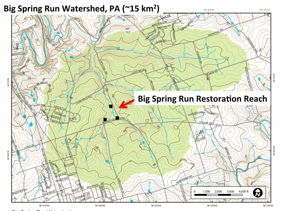
Why Restore It?
Big Spring Run: Typical Incised mid-‐Atlan&c Stream
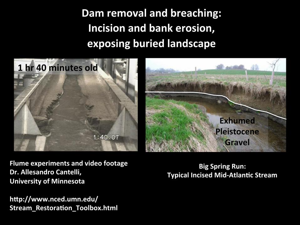
Flume experiments and video footage from Dr. Allesandro Cantelli, Univ. of Minnesota, NCED h\p://www.nced.umn.edu/Stream_Restora&on_Toolbox.html
~80 yr old channel
Exhumed Pleistocene
Gravel
300-‐yr old wet meadow
Dam removal and breaching: Incision and bank erosion, exposing buried landscape
Pompeii Effect
1 hr 40 minutes old
Big Spring Run: Typical Incised Mid-‐Atlan&c Stream
Flume experiments and video footage Dr. Allesandro Cantelli, University of Minnesota h\p://www.nced.umn.edu/Stream_Restora&on_Toolbox.html
Exhumed Pleistocene
Gravel
Dam removal and breaching: Incision and bank erosion, exposing buried landscape
Wetlands and Their Value
Ecosystem services they provide: – Habitat for fish and wildlife
– Improved water quality – Storing floodwaters – Maintaining surface water flow
– DenitrificaSon
Objec&ve: Rejuvenate the ecological funcSon of the buried wetland.
Banta Restoration (2004) on Lititz Run, Warwick Twp., Lancaster Co., PA
• 90 tons/yr silt from ~3000 e of stream bank erosion
• Majority of erosion in winter (Dec-‐Mar)
• Majority of suspended sediment transport in April, May, December
• Associated nutrients
Why Restore It?
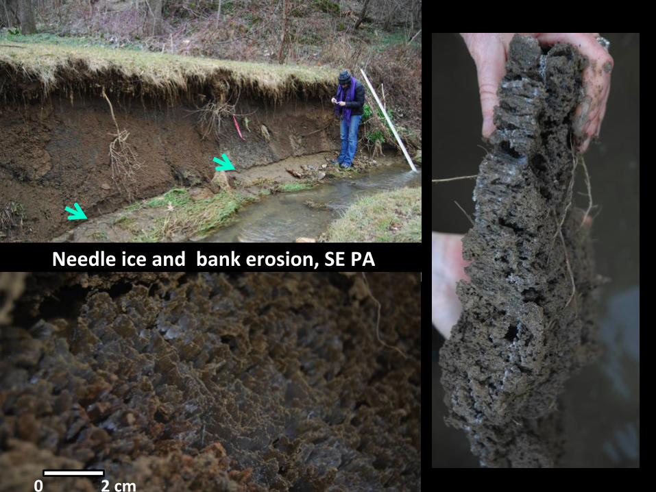
New Freeze-‐thaw Apron Forming 8 Days aeer Jan 25, 2010, High Flow Event, Big Spring Run, PA
Yellow arrows mark trim line from high water event
Needle ice and bank erosion, SE PA
0 2 cm
Needle Ice Forma&on and Erosion on Stream Bank, Big Spring Run, PA Day and Night (Infrared) Field Camera, March-‐April 2011
Thesis work of J. Galella, 2010-‐11, F&M College
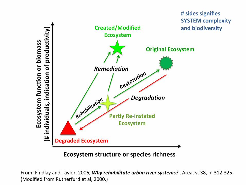
Restore to What?
From: Findlay and Taylor, 2006, Why rehabilitate urban river systems? , Area, v. 38, p. 312-‐325. (Modified from Rutherfurd et al, 2000.)
# sides signifies SYSTEM complexity and biodiversity
Ecosystem structure or species richness
Ecosystem fu
nc&o
n or biomass
(# individu
als, indica&o
n of produ
c&vity)
Original Ecosystem
Partly Re-‐instated Ecosystem
Degraded Ecosystem
Created/Modified Ecosystem
Remedia4on
Degrada4on
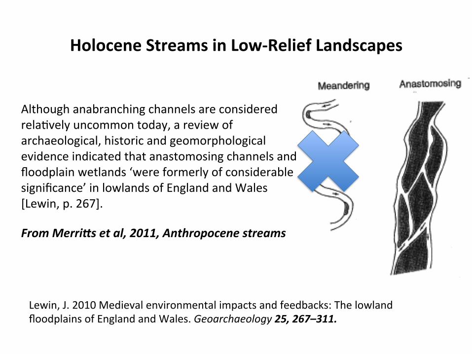
Holocene Streams in Low-‐Relief Landscapes
Although anabranching channels are considered relaSvely uncommon today, a review of archaeological, historic and geomorphological evidence indicated that anastomosing channels and floodplain wetlands ‘were formerly of considerable significance’ in lowlands of England and Wales [Lewin, p. 267]. From Merri:s et al, 2011, Anthropocene streams
Lewin, J. 2010 Medieval environmental impacts and feedbacks: The lowland floodplains of England and Wales. Geoarchaeology 25, 267–311.
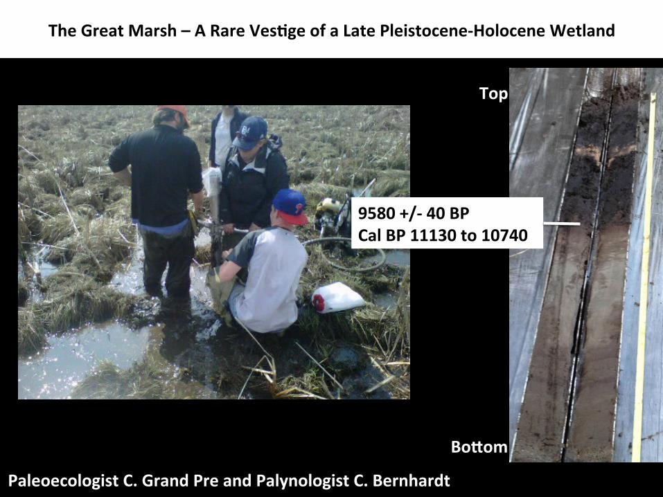
A remnant, late Pleistocene-‐Holocene tussock-‐sedge wet meadow
The Great Marsh – A Rare Ves&ge of a Late Pleistocene-‐Holocene Wetland
Paleoecologist C. Grand Pre and Palynologist C. Bernhardt
The Great Marsh – A Rare Ves&ge of a Late Pleistocene-‐Holocene Wetland
Top
Bo\om
9580 +/-‐ 40 BP Cal BP 11130 to 10740
Alaskan Periglacial Valley and Slopes (analog for mid-‐Atlan&c Pleistocene condi&ons)
Photo Courtesy Ellen Wohl
Coarse gelifluc&on deposits fill small valley bo\om
Holocene Wetland plants and organic muck accumulate at groundwater seeps/springs.
Small channels.
Alaskan Periglacial Valley and Slopes (analog for mid-‐Atlan&c Pleistocene condi&ons)
Photo Courtesy Ellen Wohl
Millpond sediments bury periglacial toe of slope and
wetland VB deposits
Incised channel post-‐dam breach.
Coarse gelifluc&on deposits fill small valley bo\om
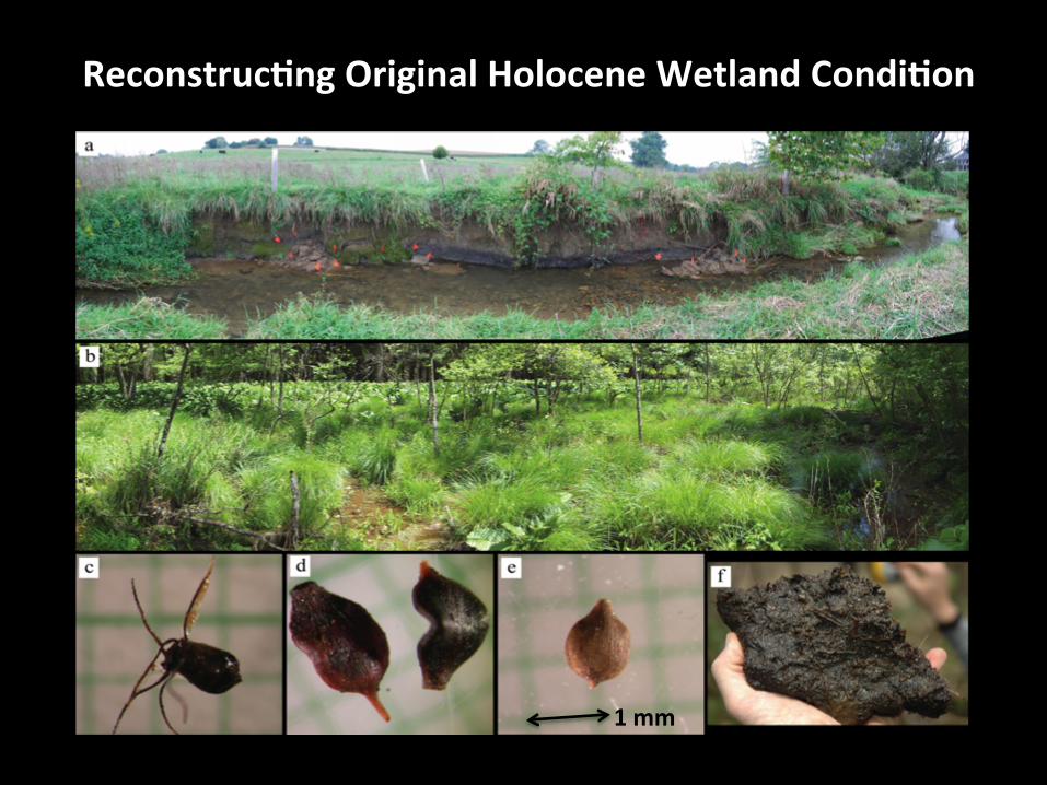
Reconstruc&ng Original Holocene Wetland Condi&on
1 mm
160± 40
140± 40
90 ± 40
270 ± 40 230 ± 40
230 ± 40 850 ± 40
1220 ± 40
2860 ± 40 3000 ± 40
All but one date on single nut.
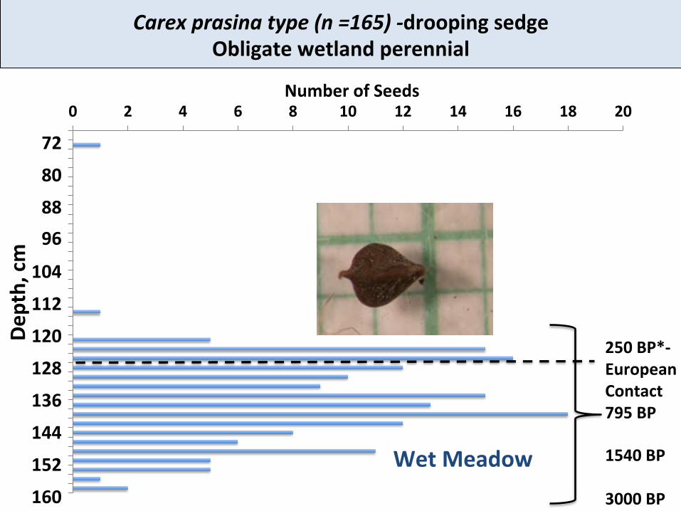
Big Spring Run, PA, Buried Wetland Soil Radiocarbon (AMS) Dates and Paleo-‐seed Sampling
European se\lement 1709
Paleo-‐seed sample column
0 170 cm
Paleo-‐seed Analysis: Changes in Seeds with Depth (Time)
Transgression (higher water) Not just increase in sed supply
250 BP*-‐European Contact 795 BP 1540 BP 3000 BP
Pond
Mud Flat
72
80
88 96
104
112
120
128
136
144
152
160
Depth, cm
Wet Meadow
How to Restore to “Target”
04/2013
Before: 04/2005
Aeer: 04/2013
0 0 0.25 0.5 km
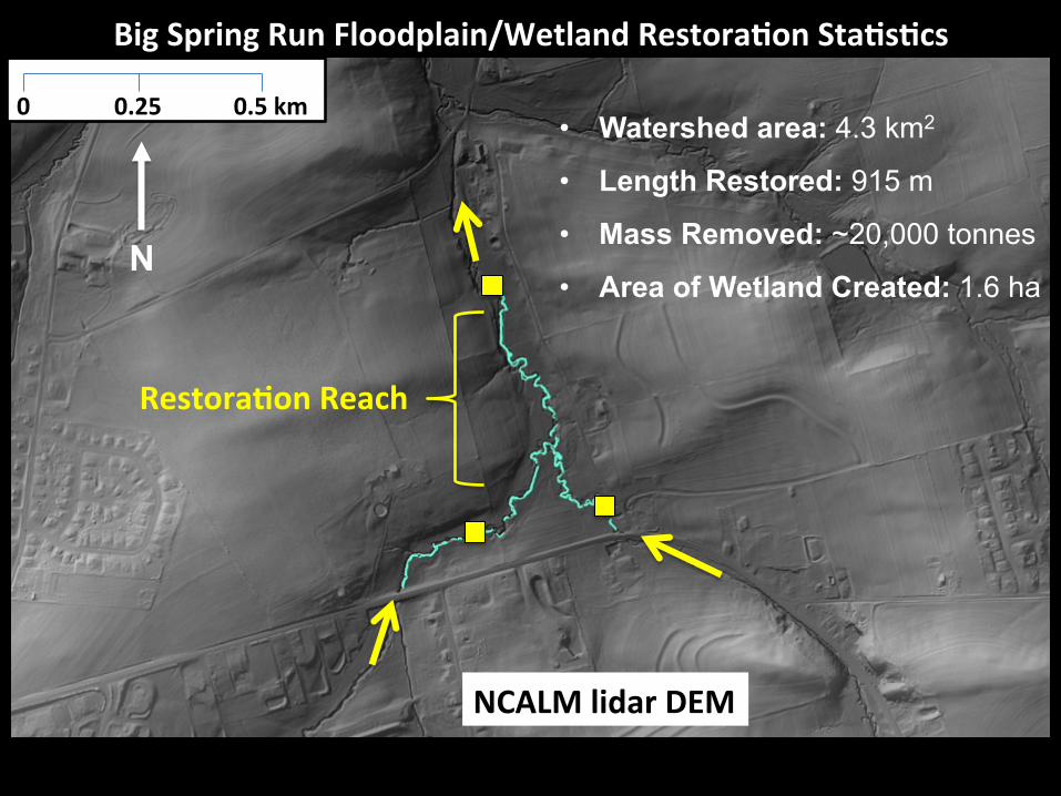
Big Spring Run Floodplain/Wetland Restora&on Sta&s&cs
NCALM lidar DEM
• Watershed area: 4.3 km2
• Length Restored: 915 m
• Mass Removed: ~20,000 tonnes
• Area of Wetland Created: 1.6 ha N
Restora&on Reach
Map Boundaries and Depth of Historic Sediment and
Reconstruct Extent of Original Wetland
• Trenching • Coring • Mapping incised
banks
New Channel(s) and Floodplain
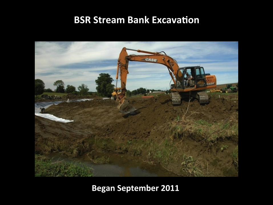
BSR Stream Bank Excava&on
Began September 2011
Big Spring Run Floodplain Wetland Restora&on WebCamera
Completed November 2011- Designed and Engineered by LandStudies Inc.
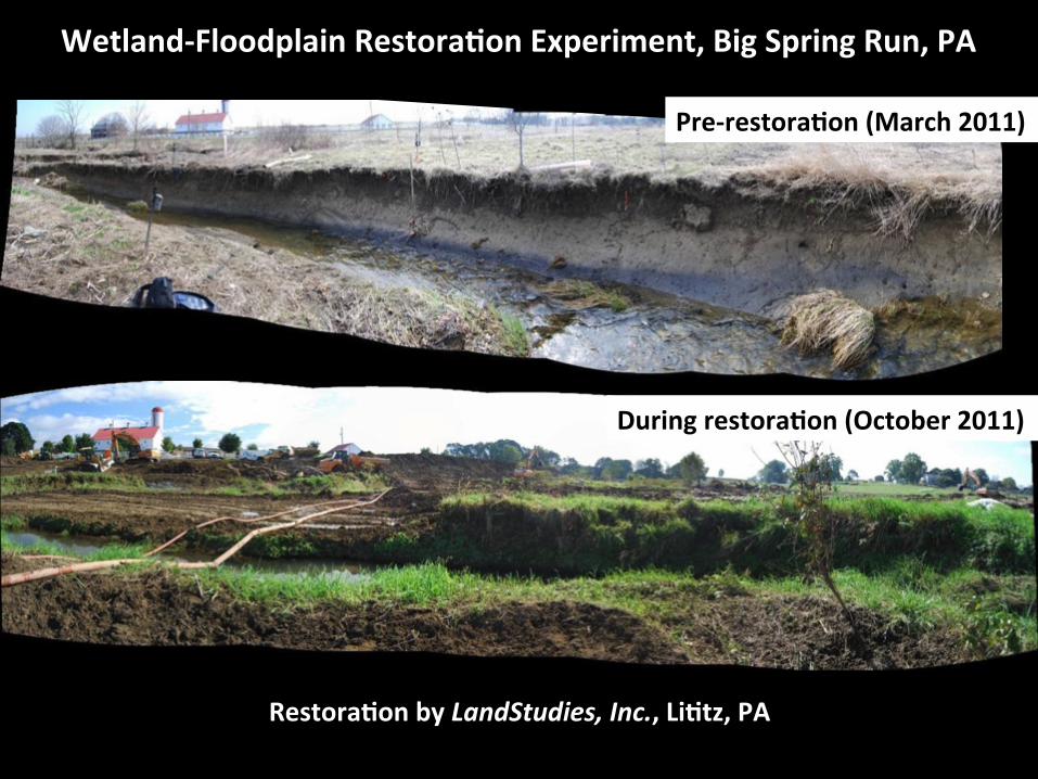
Wetland-‐Floodplain Restora&on Experiment, Big Spring Run, PA
Restora&on by LandStudies, Inc., Li&tz, PA
Pre-‐restora&on (March 2011)
During restora&on (October 2011)
Big Spring Run View West
Before Excava&on 9/13/11 Aeer Excava&on 9/28/11
Objec&ve: Reconnect the groundwater with a low, hydric floodplain. Increase hyporheic exchange, storage of OM, and interacSon with DOC.
Big Spring Run View East
Before Excava&on 9/13/11 Aeer Excava&on 9/28/11
Objec&ve: Remove the impairment… the eroding stream banks that contribute to high suspended sediment and nutrient loads, and permit frequent OB flow.
Big Spring Run Aeer Restora&on April 2013
Before Restoration April 2005
Big Spring Run Before Restora&on April 2005
Big Spring Run Aeer Restora&on November 2011
Post-‐Restora&on August 2013
Pre-‐ and Post-‐Restora&on Monitoring
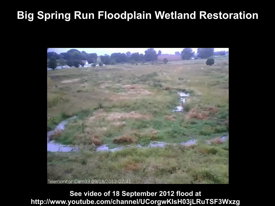
Big Spring Run Floodplain Wetland Restoration
See video of 18 September 2012 flood at http://www.youtube.com/channel/UCorgwKIsH03jLRuTSF3Wxzg
Aerial views Pre-‐ and Post
04 14 2007 06 04 2013
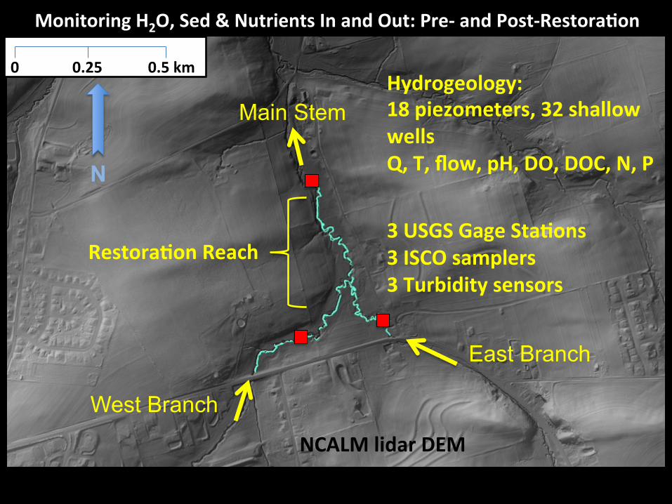
0 0 0.25 0.5 km Hydrogeology: 18 piezometers, 32 shallow wells Q, T, flow, pH, DO, DOC, N, P 3 USGS Gage Sta&ons 3 ISCO samplers 3 Turbidity sensors
Monitoring H2O, Sed & Nutrients In and Out: Pre-‐ and Post-‐Restora&on
NCALM lidar DEM
East Branch
West Branch
Main Stem
N
Restora&on Reach
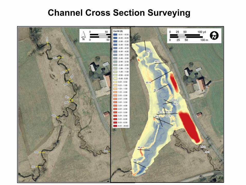
Channel Cross Section Surveying
Mapping & Surveying Stream Banks
Pre-‐se\lement Wet Meadow and Modern Anthropocene Stream Measuring Rates of Erosion and Deposi&on 2004 -‐ present
Repeat high-‐resolu&on topographic surveys, Big Spring Run, PA Shilling, 2010, and Becker, 2011 (F&M); Collabora&on with A. Gellis, USGS
2004
Cross sec&on
Cross sec&on
Measuring Rates of Erosion and Deposi&on 2004 -‐ present
Repeat high-‐resolu&on topographic surveys, Big Spring Run, PA Shilling, 2010, and Becker, 2011 (F&M); Schulte, Blair, and Lewis, 2013 (F&M); Collabora&on with A. Gellis, USGS
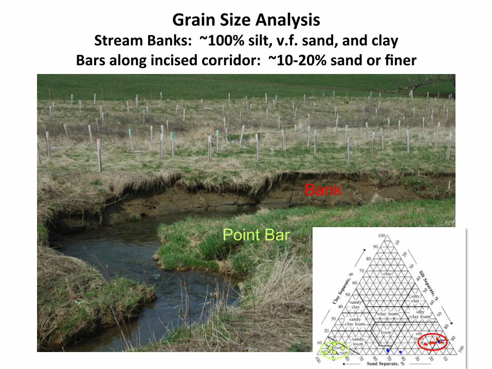
Bars along incised corridor: ~10-‐20% sand or finer
Bank
Point Bar
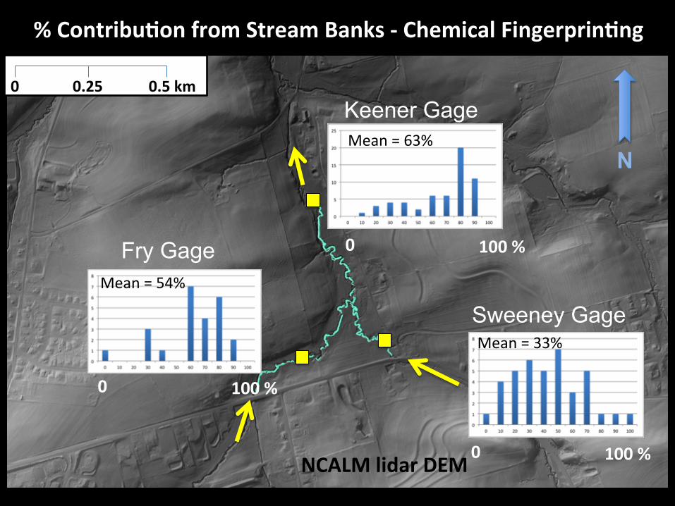
0 0 0.25 0.5 km
% Contribu&on from Stream Banks -‐ Chemical Fingerprin&ng
NCALM lidar DEM
Sweeney Gage
Fry Gage
Keener Gage
N Mean = 63%
Mean = 54%
Mean = 33%
0 100 %
0 100 %
0 100 %
Inset Point Bars
“Floodplain” 1. 80-‐100% of deposiSon on “Sle pads” on inset point bars is from bank erosion.
% Bank Erosion
2. No deposiSon on Sle pads on “floodplain” (i.e., on legacy sediment terrace).
Tile Pad Experiment – Where Does Deposi&on Occur?
• Discharge • Turbidity • Suspended sediment loads • Loud out – Load into restora&on reach
USGS Gage Data
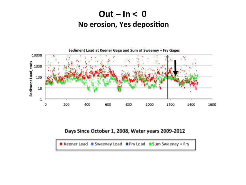
Out – In < 0 No erosion, Yes deposi&on
Out – In < 0 No erosion, Yes deposi&on
Out – In < 0 No erosion, Yes deposi&on
Pre-‐ and Post-‐Restora&on (Out – In)
Legacy Sediment Removal/Riparian Wetland Restoration Best Management Practice
• The BMP proposed by PADEP is an ecological restoration and management strategy. • Restoration and management actions are proposed to re-establish
natural stream, wetland, floodplain and riparian conditions and functions. • Monitoring at BSR and future implementation sites are necessary to fully quantify and document the BMP benefit (i.e., load reduction). • Contact Jeff Hartranft, PADEP: [email protected]
Collaborators include • 37 researchers, • 11 ins&tu&ons • 3 agencies PA DEP, EPA, USGS • 4 graduate • ~22 undergrad • Restora&on by LandStudies, Inc.