METEOSAT SECOND GENERATION MISSION STATUS Sergio Rota EUMETSAT, Am Kavalleriesand 31, 64295 Darmstadt, Germany, Email: [email protected]ABSTRACT The MSG mission started its operational service at the beginning of 2004, after commissioning activities were successfully completed in December 2003 and the satellite repositioning was done in January this year. This paper briefly summarises the major events and steps which took place following the launch of MSG-1, it then focuses on the current status of the MSG mission and the future plans. The on going activities in the framework of the routine operations are described, the plan for MSG-2 preparation, its launch and commissioning, and the key milestones are addressed. With the launch and commissioning of MSG-2, the nominal in orbit configuration will be established; the transition plans from the old MOP/MTP system to the new Meteosat Second Generation are presented. 1. METEOSAT SECOND GENERATION (MSG) – HIGH LEVEL MISSION OBJECTIVES AND IMPLEMENTATION ASPECTS The MSG mission constitutes the European contribution to the Global Observing System (GOS) of the World Weather Watch (WWW), as part of the global system of geo-stationary satellites. It fulfils the new user’s requirements in the timeframe from the year 2000 associated with the new weather forecasting methods, meteorological observations and climate monitoring. In support to these objectives the MSG system provides Multi-spectral imaging of cloud systems, Earth surface and atmospheric emissions with significantly improved capabilities versus the existing systems, Extraction of meteorological products, Dissemination of images and data to the users. The primary mission of the MSG system is in fact an observation mission, relying on the Spinning Enhanced Visible and Infrared Imager (SEVIRI) imaging radiometer to derive Multi-spectral Imagery, Airmass Analysis and High-Resolution Imagery. Supporting missions of the MSG system are data processing and product extraction, data dissemination, and archiving/retrieval of data and products. Furthermore, the MSG system also offers a Data Collection capability and supports two additional missions, the Geostationary Earth Radiation Budget (GERB) experimental mission embarking the dedicated GERB instrument and finally the Search and Rescue mission, embarking the dedicated transponder to capture and relay distress signals. The capabilities of the MSG system target major improvements in two disciplines of operational meteorology, Nowcasting and Very Short Term Forecasting (VSRF), and Numerical Weather Prediction (NWP). Major performance improvements produces about 20 times more data than Meteosat: the imaging frequency is increased from 30 to 15 minutes, the twelve spectral channels of the imager observes the Earth-atmosphere system with a spatial sampling distance of 3 km (1 km for the High Resolution Visible channel). The shorter repeat cycle of 15 minutes for full-disk imaging provides unprecedented multi-spectral observations of rapidly changing phenomena (e.g. deep convection) and better and more numerous wind observations from the tracking of cloud features. This enables a better characterisation of rapidly evolving weather patterns, supported by improved discrimination between surfaces and clouds. More information is also made available from some infrared channels on the vertical structure of the atmosphere. Meteosat First Generation (MOP/MTP) • 3-channel Imaging Radiometer • 100 RPM Spin-stabilised Body • Solid Apogee Boost Motor • 5 years Station Keeping • 200 Watts Power Demand • 720 kg in GTO orbit • Flight qualified with Delta 2914, Ariane 1-3-4 Meteosat Second Generation (MSG) • 12-channel Enhanced Imaging Radiometer • 100 RPM Spin-stabilised Body • Bi-propellant Unified Propulsion System • 7 years Station Keeping • 600 Watts Power Demand • 2036 kg in GTO orbit • Design compatibility with Ariane 4 and 5 Fig.1 Comparison between the Meteosat satellites of the First and Second Generation The MSG system is established as a result of the cooperation between ESA and EUMETSAT. ESA was responsible for the development of the MSG-1 prototype satellite and acts as procurement agent for the MSG-2/3/4 satellites on behalf of EUMETSAT. EUMETSAT has finalised and maintains the End User _____________________________________________________________ Proc. Second MSG RAO Workshop, Salzburg, Austria 9 – 10 September 2004 (ESA SP-582, November 2004)
Transcript
METEOSAT SECOND GENERATIONMISSION STATUS
Sergio Rota
EUMETSAT, Am Kavalleriesand 31, 64295 Darmstadt, Germany, Email: [email protected]
ABSTRACT
The MSG mission started its operational service at thebeginning of 2004, after commissioning activities weresuccessfully completed in December 2003 and thesatellite repositioning was done in January this year.This paper briefly summarises the major events andsteps which took place following the launch of MSG-1,it then focuses on the current status of the MSG missionand the future plans. The on going activities in theframework of the routine operations are described, theplan for MSG-2 preparation, its launch andcommissioning, and the key milestones are addressed.With the launch and commissioning of MSG-2, thenominal in orbit configuration will be established; thetransition plans from the old MOP/MTP system to thenew Meteosat Second Generation are presented.
1. METEOSAT SECOND GENERATION(MSG) – HIGH LEVEL MISSIONOBJECTIVES AND IMPLEMENTATIONASPECTS
The MSG mission constitutes the European contributionto the Global Observing System (GOS) of the WorldWeather Watch (WWW), as part of the global system ofgeo-stationary satellites. It fulfils the new user’srequirements in the timeframe from the year 2000associated with the new weather forecasting methods,meteorological observations and climate monitoring.
In support to these objectives the MSG system providesMulti-spectral imaging of cloud systems, Earth surfaceand atmospheric emissions with significantly improvedcapabilities versus the existing systems, Extraction ofmeteorological products, Dissemination of images anddata to the users. The primary mission of the MSGsystem is in fact an observation mission, relying on theSpinning Enhanced Visible and Infrared Imager(SEVIRI) imaging radiometer to derive Multi-spectralImagery, Airmass Analysis and High-ResolutionImagery. Supporting missions of the MSG system aredata processing and product extraction, datadissemination, and archiving/retrieval of data andproducts. Furthermore, the MSG system also offers aData Collection capability and supports two additionalmissions, the Geostationary Earth Radiation Budget
(GERB) experimental mission embarking the dedicatedGERB instrument and finally the Search and Rescuemission, embarking the dedicated transponder to captureand relay distress signals.
The capabilities of the MSG system target majorimprovements in two disciplines of operationalmeteorology, Nowcasting and Very Short TermForecasting (VSRF), and Numerical Weather Prediction(NWP). Major performance improvements producesabout 20 times more data than Meteosat: the imagingfrequency is increased from 30 to 15 minutes, thetwelve spectral channels of the imager observes theEarth-atmosphere system with a spatial samplingdistance of 3 km (1 km for the High Resolution Visiblechannel). The shorter repeat cycle of 15 minutes forfull-disk imaging provides unprecedented multi-spectralobservations of rapidly changing phenomena (e.g. deepconvection) and better and more numerous windobservations from the tracking of cloud features. Thisenables a better characterisation of rapidly evolvingweather patterns, supported by improved discriminationbetween surfaces and clouds. More information is alsomade available from some infrared channels on thevertical structure of the atmosphere.
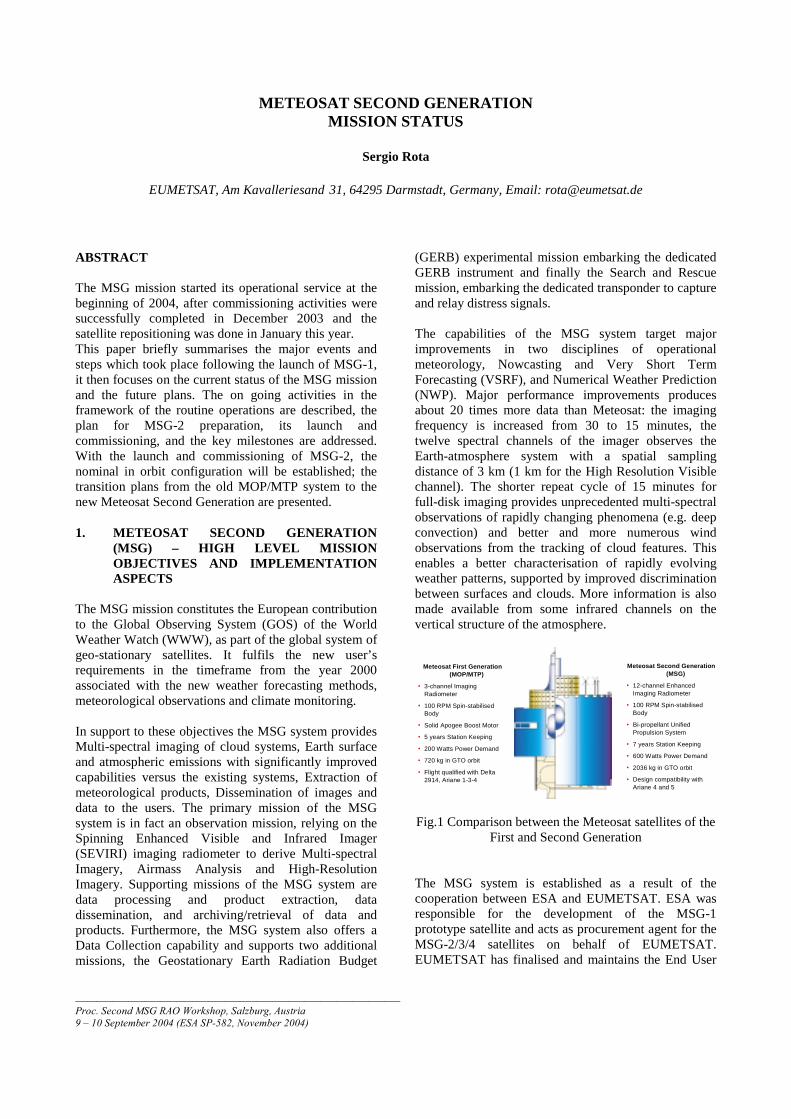
Meteosat First Generation(MOP/MTP)
• 3-channel ImagingRadiometer
• 100 RPM Spin-stabilisedBody
• Solid Apogee Boost Motor
• 5 years Station Keeping
• 200 Watts Power Demand
• 720 kg in GTO orbit
• Flight qualified with Delta2914, Ariane 1-3-4
Meteosat Second Generation(MSG)
• 12-channel EnhancedImaging Radiometer
• 100 RPM Spin-stabilisedBody
• Bi-propellant UnifiedPropulsion System
• 7 years Station Keeping
• 600 Watts Power Demand
• 2036 kg in GTO orbit
• Design compatibility withAriane 4 and 5
Fig.1 Comparison between the Meteosat satellites of theFirst and Second Generation
The MSG system is established as a result of thecooperation between ESA and EUMETSAT. ESA wasresponsible for the development of the MSG-1prototype satellite and acts as procurement agent for theMSG-2/3/4 satellites on behalf of EUMETSAT.EUMETSAT has finalised and maintains the End User
Requirements, has contributed one third of the MSG-1funding, funds the procurement of MSG-2/3/4, procuresall launch services, and operates the MSG system afterhaving developed the Ground Segment. The RutherfordAppleton Laboratory (RAL), UK, is the third partner ofthe Programme, providing GERB instruments for flighton all four MSG satellites and associated data services.The first GERB instrument flying on MSG-1 wasselected under an ESA Announcement of Opportunity,its development and operations are funded by NERC,whilst the procurement of additional instruments forMSG-2/3/4 and the associated data service are fundedby EUMETSAT.
2. MSG-1 LAUNCH AND COMMISSIONING
The final activities leading to the start of the MSG-1launch campaign were particularly intense. Residualuncertainties on Ground Segment (GS) readiness weremitigated by implementation of an initial GS version (V0). This was sufficient for performing the satellite inorbit testing phase. It was based on the Image QualityGround Support Equipment (IQGSE) for imagerectification and a dedicated system for relaying data toother ground segment facilities. Delays/non availabilityof the possible co-passengers caused the change to theLauncher baseline from Ariane 4 to Ariane 5 less then 6months before the planned launch date. A task forceinvolving EUMETSAT/ESA/Arianespace/Alcatel (thesatellite prime contractor) established then the means toattenuate the A5 Generic shock levels in March/April2002. Based on the task force results, the consent to shipthe satellite for the launch campaign was released byEUMETSAT to ESA on 12 April 2002.
MSG-1 was launched on 28th August 02 at 22h 45minUTC. The very accurate injection in orbit achieved byAriane 5 (Perigee 0.3%, Apogee 0.1%, Inclination0.3%), together with an high initial inclination of 1.98°resulted at the end of the drift phase into a fuel lifetimelimit significantly extended, by about 2 years.
After the Launch and Early Orbit operations (LEOP)phase, satellite operations were handed over from ESOCto EUMETSAT on 25 September 2002 to perform thesatellite and system commissioning. Commissioning isthe final phase of verification of the performance of thecomplete system versus the applicable requirements,involving both the space and ground segments. Itencompasses validation of the procedures to be usedduring the routine operations, calibrations of theinstruments in space and tuning of the facilities onground, validation of the meteorological productsagainst agreed methods - e.g. comparison with othersatellite measurements, in situ measurements etc. In
view of GS development, the MSG-1 commissioningwork was split into a Phase A, oriented to satellite inorbit testing, and a Phase B, addressing the finalcalibration and validation of the mission products.
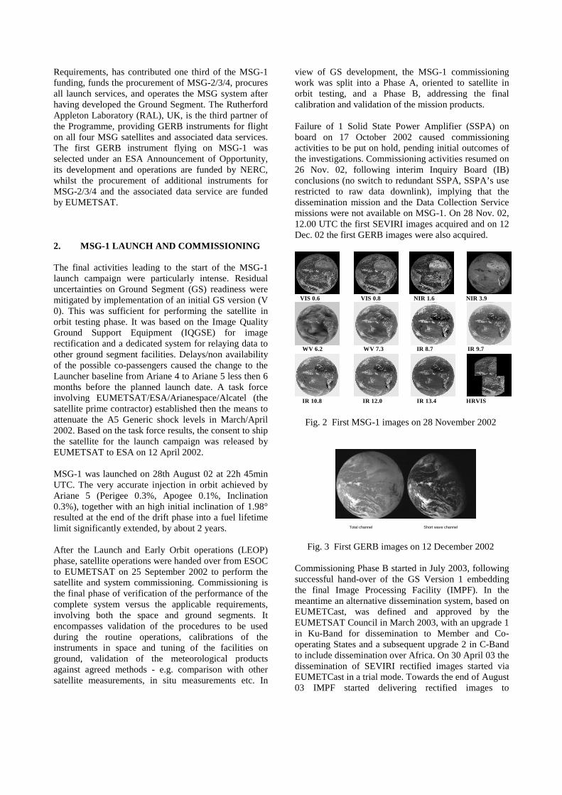
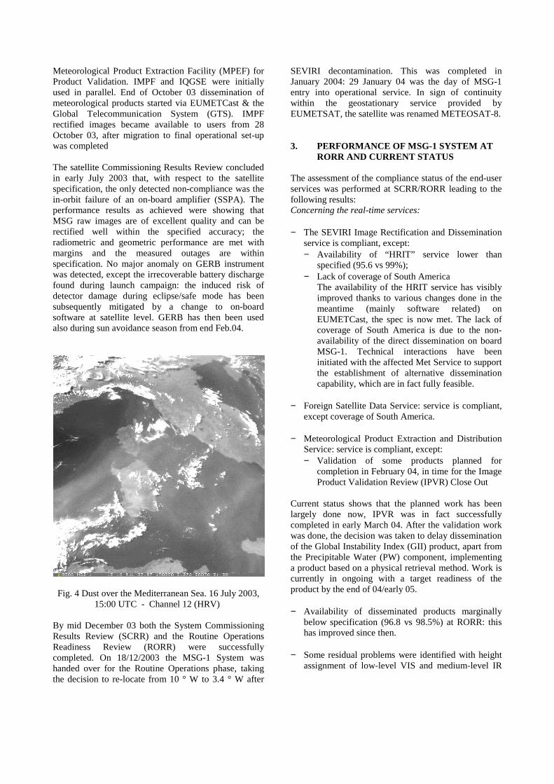
Failure of 1 Solid State Power Amplifier (SSPA) onboard on 17 October 2002 caused commissioningactivities to be put on hold, pending initial outcomes ofthe investigations. Commissioning activities resumed on26 Nov. 02, following interim Inquiry Board (IB)conclusions (no switch to redundant SSPA, SSPA’s userestricted to raw data downlink), implying that thedissemination mission and the Data Collection Servicemissions were not available on MSG-1. On 28 Nov. 02,12.00 UTC the first SEVIRI images acquired and on 12Dec. 02 the first GERB images were also acquired.
VIS 0.6 VIS 0.8 NIR 1.6 NIR 3.9
WV 6.2 WV 7.3 IR 8.7 IR 9.7
IR 10.8 IR 12.0 IR 13.4 HRVIS
Fig. 2 First MSG-1 images on 28 November 2002
Total channel Short wave channel
Fig. 3 First GERB images on 12 December 2002
Commissioning Phase B started in July 2003, followingsuccessful hand-over of the GS Version 1 embeddingthe final Image Processing Facility (IMPF). In themeantime an alternative dissemination system, based onEUMETCast, was defined and approved by theEUMETSAT Council in March 2003, with an upgrade 1in Ku-Band for dissemination to Member and Co-operating States and a subsequent upgrade 2 in C-Bandto include dissemination over Africa. On 30 April 03 thedissemination of SEVIRI rectified images started viaEUMETCast in a trial mode. Towards the end of August03 IMPF started delivering rectified images to
Meteorological Product Extraction Facility (MPEF) forProduct Validation. IMPF and IQGSE were initiallyused in parallel. End of October 03 dissemination ofmeteorological products started via EUMETCast & theGlobal Telecommunication System (GTS). IMPFrectified images became available to users from 28October 03, after migration to final operational set-upwas completed
The satellite Commissioning Results Review concludedin early July 2003 that, with respect to the satellitespecification, the only detected non-compliance was thein-orbit failure of an on-board amplifier (SSPA). Theperformance results as achieved were showing thatMSG raw images are of excellent quality and can berectified well within the specified accuracy; theradiometric and geometric performance are met withmargins and the measured outages are withinspecification. No major anomaly on GERB instrumentwas detected, except the irrecoverable battery dischargefound during launch campaign: the induced risk ofdetector damage during eclipse/safe mode has beensubsequently mitigated by a change to on-boardsoftware at satellite level. GERB has then been usedalso during sun avoidance season from end Feb.04.
Fig. 4 Dust over the Mediterranean Sea. 16 July 2003,15:00 UTC - Channel 12 (HRV)
By mid December 03 both the System CommissioningResults Review (SCRR) and the Routine OperationsReadiness Review (RORR) were successfullycompleted. On 18/12/2003 the MSG-1 System washanded over for the Routine Operations phase, takingthe decision to re-locate from 10 ° W to 3.4 ° W after
SEVIRI decontamination. This was completed inJanuary 2004: 29 January 04 was the day of MSG-1entry into operational service. In sign of continuitywithin the geostationary service provided byEUMETSAT, the satellite was renamed METEOSAT-8.
3. PERFORMANCE OF MSG-1 SYSTEM ATRORR AND CURRENT STATUS
The assessment of the compliance status of the end-userservices was performed at SCRR/RORR leading to thefollowing results:Concerning the real-time services:
− The SEVIRI Image Rectification and Disseminationservice is compliant, except:− Availability of “HRIT” service lower than
specified (95.6 vs 99%);− Lack of coverage of South America
The availability of the HRIT service has visiblyimproved thanks to various changes done in themeantime (mainly software related) onEUMETCast, the spec is now met. The lack ofcoverage of South America is due to the non-availability of the direct dissemination on boardMSG-1. Technical interactions have beeninitiated with the affected Met Service to supportthe establishment of alternative disseminationcapability, which are in fact fully feasible.
− Foreign Satellite Data Service: service is compliant,except coverage of South America.
− Meteorological Product Extraction and DistributionService: service is compliant, except:− Validation of some products planned for
completion in February 04, in time for the ImageProduct Validation Review (IPVR) Close Out
Current status shows that the planned work has beenlargely done now, IPVR was in fact successfullycompleted in early March 04. After the validation workwas done, the decision was taken to delay disseminationof the Global Instability Index (GII) product, apart fromthe Precipitable Water (PW) component, implementinga product based on a physical retrieval method. Work iscurrently in ongoing with a target readiness of theproduct by the end of 04/early 05.
− Availability of disseminated products marginallybelow specification (96.8 vs 98.5%) at RORR: thishas improved since then.
− Some residual problems were identified with heightassignment of low-level VIS and medium-level IR
winds: this, considered part of normal work, hasbeen largely addressed in the meantime.
− Data Collection and Retransmission Service:compliant with the understanding that the DCPmission is fulfilled by Meteosat-7 until MSG-2 willbecome available and the retransmission service isfulfilled via EUMETCast.
− Meteorological Data Dissemination (MDD): serviceis compliant except coverage of South America, dueto absence of onboard direct dissemination.
− GERB Raw Image Data Service (to RAL): service iscompliant.
− Support service to Search and Rescue (SAR): serviceis compliant. The MSG Search and Rescueperformance evaluation recently provided byCOSPAS-SARSAT concluded that the test datafrom the different ground stations are consistent andthat the MSG system performance is consideredstable both in terms of satellite behaviour and interms of mature stage of ground stationsdevelopment. In addition, the operational (real alert)data provided by France shows that the MSGcomplements the existing C/S services, providinguseful and essential data to assist in SAR missions.41 persons were reported to have been rescued in theperiod January-March 04, also thanks to MSG: inabout half of the cases MSG-1 was the first mean ofalert, and in more than 10% of the cases it was theonly means of alert.
Concerning the Off Line Services:− Archive and Retrieval Service compliant, except for:
− some meteorological products not yet availablefor archiving at RORR (now all disseminatedproducts are available),
− the on-line interface to U-MARF which will notbe available until last Q 2004 when the firewallis due to be implemented in response to securityconcerns (now under implementation),
− restrictions on size of user data retrieval requests,500MB orders were not possible within thetimeliness requirements: retrievals possible viaoffline interface (i.e. as for MTP) . (Significantlyimproved since then)
− Satellite Data Dissemination via Internet underacceptance testing. Now it is operational
− User Support Service: compliant
4. MSG-1 (METEOSAT-8)ROUTINE OPERATIONS: STATUS ANDPLANS
The operational geostationary service provided byEUMETSAT is now made by satellite of the first andsecond Meteosat generation. Meteosat-8 operates at3.4°W, in parallel with Meteosat-7 (at 0°). Meteosat-6 isat 10°E in rapid scanning (ensuring also the backup forthe DCS mission) while, Meteosat-5 is above the Indianocean at 63°E.
All MSG mission components are operational but theDCS mission due to the SSPA failure, which iscontinued by Meteosat-7 until MSG-2 will becomeavailable. All meteorological products are validatedexcept for GII and Total Ozone (O3). For GII, afterdecision to implement the physical retrieval,dissemination is currently limited to PW; for O3 theoptimum estimation retrieval is still planned forimplementation in 2004: development work has beennow completed, dissemination is planned during IV Qthis year. For the various products, full performanceassessment over one seasonal cycle is continuing.
10°W
0°
10°E
63°E
2003 2004
Met-6
Met-7
Met-5
MSG-1
Met-5
Met-7
Met-8
Met-6
Parallel OperationsMSG-1 Comm
J J JF M A M A S O N D J J JF M A M A S O N D
3.4°W
Fig. 5 Previous transition with current configuration
The real-time dissemination with EUMETCast (both inKU and C-Band) is now the agreed baseline for MSG-1/2/3/4. As result of the modification implemented tothe SSPAs, on board dissemination will also beavailable from MSG-2 onwards: interaction withEUMETSAT Council concluded in using the LRITtransmission with contents TBC, keeping the HRIT asback up of EUMETCast if required. Contents of theLRIT transmission will be discussion with EUMETSATDelegates in the autumn 04 session of delegate bodymeetings.
Fig. 6 EUMETCast – Ku and C-Band coverage
The MSG-2 launch is planned in Feb-Apr 2005,establishing the “hot back up” in orbit configuration toMSG-1. The precise launch slot definition (i.e. month ofthe launch) had to be postponed from July to September2004 in agreement with Arianespace, due touncertainties both on the launcher and co-passengerreadiness.
Following the launch of MSG-2 and its commissioning,the next planned satellite transition is presented in Fig.7. To be noted that this plan is associated with anextension of the Meteosat Transition Programme up to2008 which is subject to EUMETSAT Council approvaland that the Meteosat-8 position at 3.4ºW from 2007onwards (versus 10ºW) is to be confirmed.
MSG-3 is in a short-term storage configuration untilcompletion of the MSG-2 launch campaign. Then it willenter the long-term storage, with tentative launcharound end 2008/early 2009.
1 0 °W
0 °
1 0 °E
6 3 °E
2 0 0 5 2 0 0 6
M e t-6
M e t-7
M e t-5
M S G -2
M e t-7
M e t-9
M e t-8
M e t-6
M S G -2 C o m m
J J JF M A M A S O N D J J JF M A M A S O N D
3 .4 °WM e t-8
Fig. 7 Planned satellite transitionNote1: Extension of Meteosat Transition Programme up to
2008 is subject to EUMETSAT Council approval.Note2: Meteosat-8 position at 3.4ºW from 2007 onwards is to
be confirmed
Following the decision of the 52nd EUMETSAT Councilin March 2003 to initiate industrial activities associatedwith the MSG-4 satellite and GERB-4 Instrument, theMSG Programme Extension to include MSG-4 has beenfully approved at the 55th EUMETSAT Council in June2004. The MSG Programme Extension with MSG-4includes a fourth recurrent satellite, embarking theGERB and SAR missions, provision for development ofa Hydrology theme on Satellite Applications Facilities(SAFs), the MSG-4 Launch and LEOP services,Commissioning activities and Routine Operationsensuring the extension of Geostationary operationalservice until 2018. The MSG-4 satellite will enter intostorage in 1st half 2007, with tentative launch in2010/2011.An overview of the in-orbit plans of the EUMETSATGeostationary Programmes is presented in Fig. 8. Afterthe launch of MSG-2 in the first half of 2005 andfollowing the start of its routine operations in 2006, thegeostationary service over Europe will be provided bysatellite of the Meteosat Second Generation.