116
MINUTES PLANNING AND DEVELOPMENT COMMITTEE 15 AUGUST 2017 - 6.00PM

MINUTES
PLANNING AND DEVELOPMENT COMMITTEE 15 AUGUST 2017 - 6.00PM


TABLE OF CONTENTS
ITEM SUBJECT PAGE
1. OFFICIAL OPENING 4
2. ATTENDANCE, APOLOGIES AND LEAVE OF ABSENCE 4
ATTENDANCE 4
APOLOGIES 4
APPROVED LEAVE OF ABSENCE 4
3. MEMORANDUM OF OUTSTANDING BUSINESS 5
4. DISCLOSURES OF INTERESTS 7
5. CONFIRMATION OF MINUTES 7
6. ANNOUNCEMENTS BY THE PRESIDING MEMBER 7
7. PLANNING AND DEVELOPMENT COMMITTEE ITEMS 8
APPROVALS 8
AP1 LOT 2, HOUSE NUMBER 22, DIANELLA DRIVE, DIANELLA - LOCAL
DEVELOPMENT PLAN
8
CITY PLANNING 28
CP1 LOCAL PLANNING SCHEME NO.3 AMENDMENT NO.87 - REZONING
OF LOT 256, HOUSE NUMBER 249, WEST COAST DRIVE, NORTH
BEACH FROM 'RESIDENTIAL (R20)' TO LOCAL CENTRE' -
OUTCOMES OF ADVERTISING
28
CP2 LOCAL PLANNING SCHEME NO.3 AMENDMENT NO.93 - AMENDING
THE SCHEME TEXT TO ALLOW 'SHORT STAY ACCOMMODATION'
TO BE CONSIDERED IN 'LOCAL CENTRE' ZONES - OUTCOMES OF
ADVERTISING
43
CP3 LOCAL PLANNING SCHEME NO.3 AMENDMENT NO.99 - LOT 7261,
HOUSE NUMBER 7, MORRIS ROAD, INNALOO - REZONING FROM
'PUBLIC USE RESERVE (POLICE STATION) TO 'SPECIAL USE (S34)
- RESIDENTIAL (R40)' - INITIATION
54
CP4 SHORT TERM RENTAL ACCOMMODATION AND THE SHARING
ECONOMY WALGA DISCUSSION PAPER - PROPOSED
SUBMISSION
72
CP5 UPDATED DRAFT LOCAL PLANNING STRATEGY - CONSENT TO
ADVERTISE
107
8. MATTERS BEHIND CLOSED DOORS 116
9. CLOSURE 116

MINUTES OF THE PLANNING AND DEVELOPMENT COMMITTEE 15 AUGUST 2017
4
MINUTES OF THE PLANNING AND DEVELOPMENT COMMITTEE MEETING OF TUESDAY 15 AUGUST 2017 HELD IN THE CITY OF STIRLING PARMELIA
ROOM, 25 CEDRIC STREET, STIRLING
1. OFFICIAL OPENING
The Presiding Member declared the Planning and Development Committee meeting open at 6.01pm.
2. ATTENDANCE, APOLOGIES AND LEAVE OF ABSENCE
ATTENDANCE
Acting Presiding Member Councillor Stephanie Proud JP
Members Councillor David Boothman JP Councillor Andrew Guilfoyle (deputy for Councillor Samantha Jenkinson)
Councillor Mark Irwin Councillor Giovanni Italiano JP (Mayor) Councillor Terry Tyzack Councillor Rod Willox AM JP
Observers Councillor Karen Caddy Councillor Joe Ferrante Councillor David Lagan
Councillor Keith Sargent
Employees Acting Chief Executive Officer - Ross Povey Director Infrastructure - Michael Littleton
Manager Approvals - Greg Bowering Manager City Planning - Fraser Henderson Manager Governance and Strategy - Bernadine Tucker Coordinator City Planning Projects - Daniel Heymans Coordinator City Planning - Schemes and Policies - Neil Maull Acting Senior Coordinator Governance - Jaclyn Farrow Governance Officer - Regan Clyde
Public 8
Press 0
APOLOGIES
Chief Executive Officer - Stuart Jardine PSM. Councillor Samantha Jenkinson.
APPROVED LEAVE OF ABSENCE
Councillor Giovanni Italiano (granted a leave of absence for the period 8 September 2017 to 17 September 2017 inclusive).

MINUTES OF THE PLANNING AND DEVELOPMENT COMMITTEE 15 AUGUST 2017
5
3. MEMORANDUM OF OUTSTANDING BUSINESS
# Item
No. Item Resolution
Meeting
Presented/
Council
Resolution
Responsible
Officer Status
1. 10.2/CP1 Endorsement of Tuart Hill Local Centre –
Urban Design Strategy
“3. That the City UNDERTAKES a 15% design
involving local businesses and traders in a
review process, and REPORTS back to
Council and that the process includes
investigation of the following:-
a. Formalising a “U” turn at Lawley
Street to allow access to the eastern
side of the centre; and
b. The possibility of a trial period and / or
staging of new or changed access
arrangements.”
13
September
2016
Council
Resolution
0916/013
Manager City
Planning The City is currently seeking support for the
proposed Strategy. As part of this process, the
City met with the Department of Transport on
14 October 2016; with Local Members of
Parliament on 3 November 2016; with the
Department of Main Roads on 1 December
2016; with the Hon Michael Sutherland MLA on
7 December 2016; and with the Commissioner
of Main Roads Western Australia on 16 January
2017.
At all of the meetings, except for that with the
Department of Main Roads, the City obtained
verbal support for the project.
The City sent a letter to the Commissioner of
Main Roads on 13 February 2017 seeking his
support for the preparation of a 15% road
design.
The Director General of Transport, in a letter
dated 5 May 2017, advised that the City’s
proposal does not sufficiently resolve road
safety issues and therefore cannot be
supported.

MINUTES OF THE PLANNING AND DEVELOPMENT COMMITTEE 15 AUGUST 2017
6
# Item
No. Item Resolution
Meeting
Presented/
Council
Resolution
Responsible
Officer Status
The Department does not support the proposals
to reduce the speed limit along this part of
Wanneroo Road, introduce a
mid-block pedestrian crossing and to provide
on-street parking.
The City will enter into further negotiations with
the Department of Transport to work towards an
outcome acceptable to the Department and the
City, and will continue to keep Council
updated.

MINUTES OF THE PLANNING AND DEVELOPMENT COMMITTEE 15 AUGUST 2017
7
4. DISCLOSURES OF INTERESTS
Nil.
5. CONFIRMATION OF MINUTES
Moved Councillor Willox, seconded Councillor Boothman That the Minutes of the Planning and Development Committee meeting of 25 July 2017 be CONFIRMED, and SIGNED by the Presiding Member as a true and correct record of proceedings. The motion was put and declared CARRIED (7/0). For: Councillors Boothman, Guilfoyle, Irwin, Italiano, Proud, Tyzack and Willox. Against: Nil.
6. ANNOUNCEMENTS BY THE PRESIDING MEMBER
Nil.

MINUTES OF THE PLANNING AND DEVELOPMENT COMMITTEE 15 AUGUST 2017
8
7. PLANNING AND DEVELOPMENT COMMITTEE ITEMS
APPROVALS
J Garber addressed the Committee regarding Item AP1, and spoke against the recommendation. D Read addressed the Committee regarding Item AP1, and spoke in favour of the recommendation.
AP1 LOT 2, HOUSE NUMBER 22, DIANELLA DRIVE, DIANELLA - LOCAL DEVELOPMENT PLAN
Report Information
Location: Lot 2, House Number 22, Dianella Drive, Dianella
Applicant: TPG and Place Match
Reporting Officer: Manager Approvals
Business Unit: Approvals
Ward: Inglewood
Suburb: Dianella
Authority/Discretion
Definition
Advocacy when Council advocates on its own behalf or on behalf of its community to another level of government/body/agency.
Executive the substantial direction setting and oversight role of the Council. e.g. adopting plans and reports, accepting tenders, directing operations, setting and amending budgets.
Legislative includes adopting local laws, town planning schemes and policies. It is also when Council reviews decisions made by Officers.
Quasi-Judicial when Council determines an application/matter that directly affects a person’s right and interests. The judicial character arises from the obligation to abide by the principles of natural justice. Examples of Quasi-Judicial authority include town planning applications, building licences, applications for other permits/licences (eg under Health Act, Dog Act or Local Laws) and other decisions that may be appealable to the State Administrative Tribunal.
Information Purposes
includes items provided to Council for information purposes only, that do not require a decision of Council (i.e. - for 'noting').

MINUTES OF THE PLANNING AND DEVELOPMENT COMMITTEE 15 AUGUST 2017
9
Procedural Motion Moved Councillor Tyzack, seconded Councillor Italiano That the Item relating to Lot 2, House Number 22, Dianella Drive, Dianella - Local Development Plan be REFERRED to the Planning and Development Committee meeting to be held 19 September 2017 to allow further information to be provided to Councillors. The motion was put and declared CARRIED (7/0). For: Councillors Boothman, Guilfoyle, Irwin, Italiano, Proud, Tyzack and Willox. Against: Nil.
Recommendation
That pursuant to Schedule 2 Part 6 Clause 52 of the Planning and Development (Local Planning Schemes) Regulations 2015, the Local Development Plan for Lot 2, House Number 22, Dianella Drive, Dianella be APPROVED subject to the following modifications:- a. The proposed Local Development Plan be modified to incorporate the following:-
i. Setbacks to residential boundaries shall be 3m to the ground floor and 6m to the first floor;
ii. Ground floor and first floor setbacks to the Dianella Drive frontage and Public Open Space boundaries shall be 3m; and
iii. The first floor setback of 6m to residential boundaries is to be illustrated on the Local Development Plan with a dashed line.
b. The proposed Local Development Plan be modified to remove the following:-
i. Car parking to be in accordance with the City of Stirling Local Planning Policy
6.7: Parking and Access;
ii. A retaining wall with a maximum height of 800mm, will be permitted along the south-eastern boundary;
iii. Banking and retaining wall annotations and the illustration of a retaining wall to south eastern boundary; and
iv. A 3m minimum setback will apply to the primary street, south western, south eastern and northern site boundaries.
Report Purpose
To consider a Local Development Plan for Lot 2, House Number 22, Dianella Drive, Dianella.

MINUTES OF THE PLANNING AND DEVELOPMENT COMMITTEE 15 AUGUST 2017
10
Relevant Documents
Attachments
Attachment 1 – Proposed Local Development Plan. Attachment 2 – Department of Fire and Emergency Services comment. Attachment 3 – Department of Planning comment. Available for viewing at the meeting
1. Applicant’s original submission ECM Doc No: 7827514
2. Photographs of the site and surrounding area ECM Doc No: 8209912
3. Applicant’s response to submissions ECM Doc No: 8398857
Description of Development
Site Area: 8,729m2
Nearest Cross Street: Oliver Street
Location Plan
MINUTES OF THE PLANNING AND DEVELOPMENT COMMITTEE 15 AUGUST 2017
11
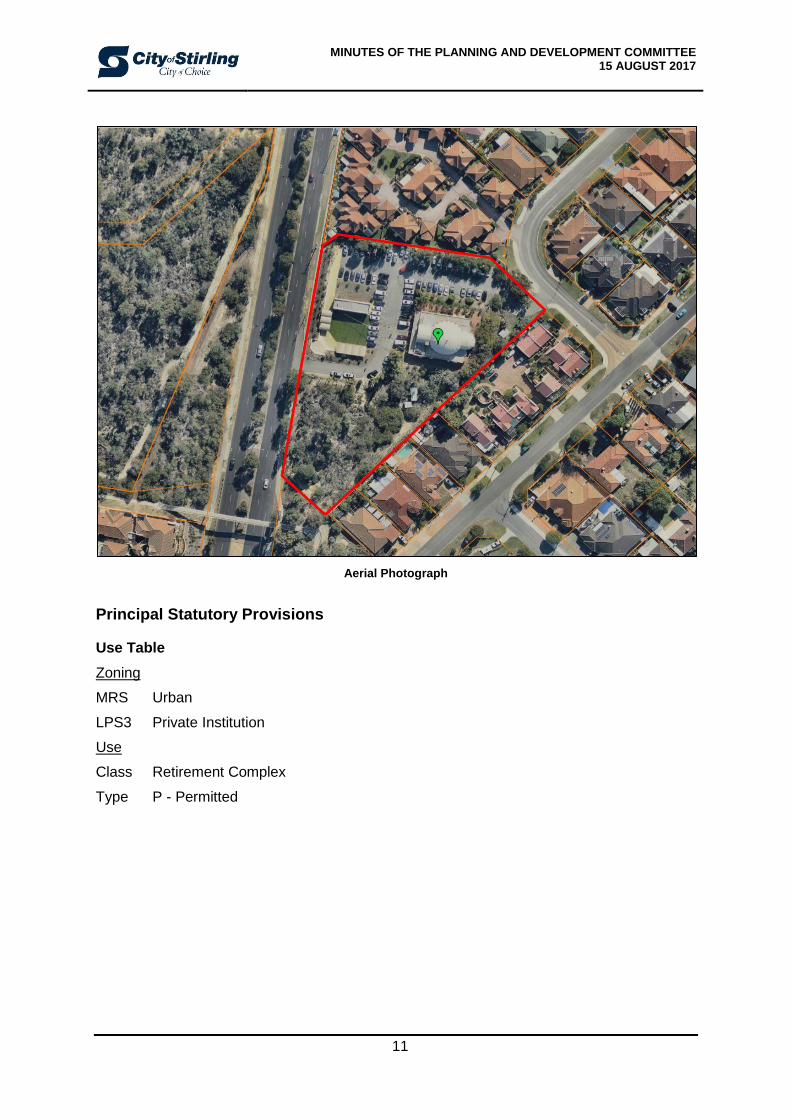
Aerial Photograph
Principal Statutory Provisions
Use Table
Zoning
MRS Urban
LPS3 Private Institution
Use
Class Retirement Complex
Type P - Permitted

MINUTES OF THE PLANNING AND DEVELOPMENT COMMITTEE 15 AUGUST 2017
12
Development Standards
Planning and Development (Local Planning Schemes) Regulations 2015
The Planning and Development (Local Planning Schemes) Regulations 2015 defines a Local Development Plan as follows:-
‘A plan setting out specific and detailed guidance for a future development including one or more of the following –
(a) Site and development standards that are to apply to the development;
(b) Specifying exemptions from the requirement to obtain development approval for development in the area to which the plans relates.
Clause 47 of the Planning and Development (Local Planning Schemes) Regulations 2015 relates to when a Local Development Plans may be prepared, stating the following:-
A local development plan in respect of an area of land in the Scheme area may be prepared if –
(a) the Commission has identified the preparation of a local development plan as a condition of approval of a plan of subdivision of the area; or
(b) a structure plan requires a local development plan to be prepared for the area; or
(c) an activity centre plan requires a local development plan to be prepared for the area; or
(d) the Commission and the local government considers that a local development plan is required for the purposes of orderly and proper planning.
Local Planning Scheme No.3
Objectives of the Zone
The subject site is zoned ‘Private Institution’ under Local Planning Scheme No.3 (LPS3). The objectives of the Private Institution zone are as follows:-
a) To provide for a range of privately owned community facilities, and uses that are incidental and ancillary to the provision of such facilities, which are compatible with surrounding development.
b) To ensure that the standard of development is in keeping with surrounding development and protects the amenity of the area.
Other Policies
Local Planning Policy 4.5 - Private Institution Design Guidelines
The ‘Private Institution Design Guidelines’ Acceptable Development Provisions outline the following Local Development Plan requirement:-
All applications for development shall be accompanied by a Local Development Plan for the site, as per Clause 5.12 of Local Planning Scheme No.3, with the exception of:-
Single storey proposals;
Additions to existing buildings less than 10% of the subject lot area; and
Family Day Care and Rural Pursuit.
Note: The Planning and Development (Local Planning Schemes) Regulations 2015 require the agreement of the Western Australian Planning Commission for the preparation of a Local Development Plan.
MINUTES OF THE PLANNING AND DEVELOPMENT COMMITTEE 15 AUGUST 2017
13
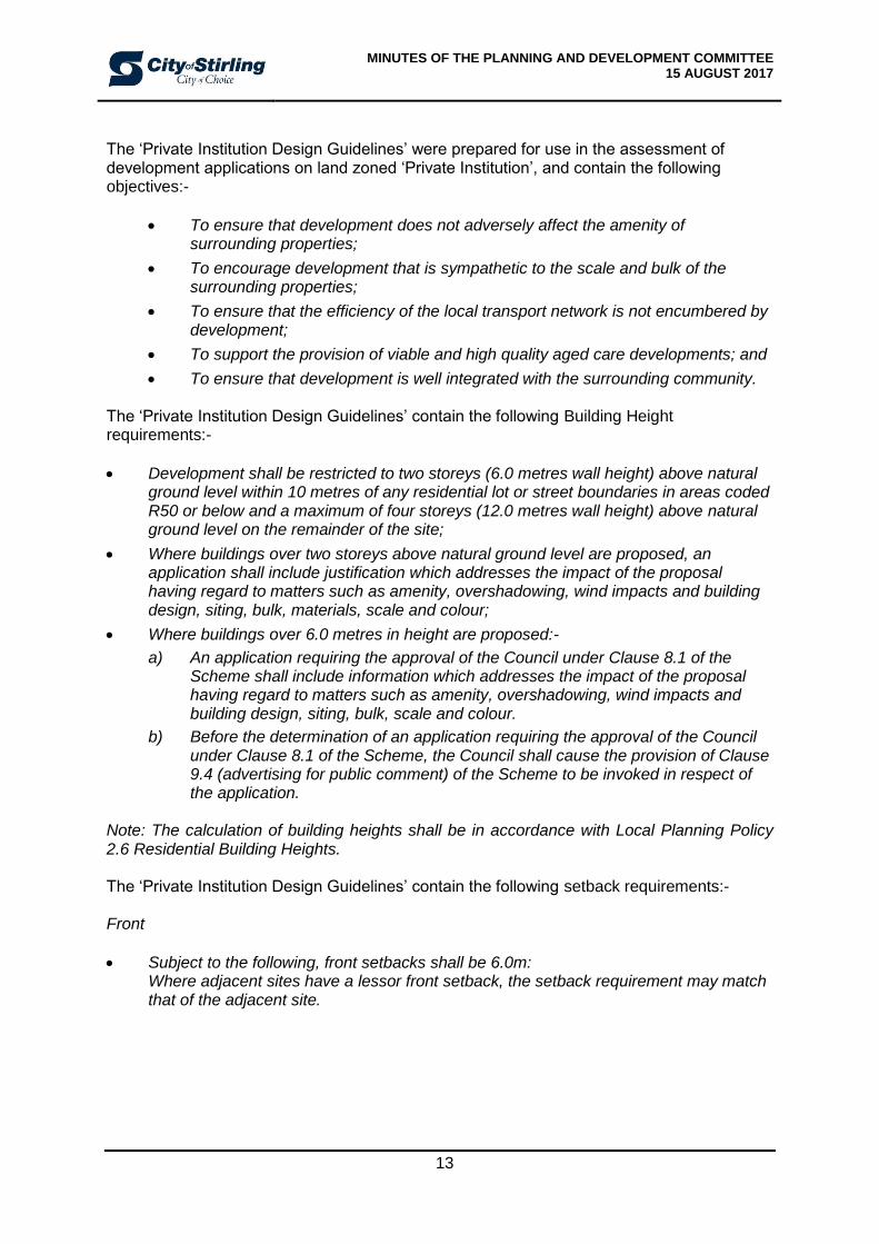
The ‘Private Institution Design Guidelines’ were prepared for use in the assessment of development applications on land zoned ‘Private Institution’, and contain the following objectives:-
To ensure that development does not adversely affect the amenity of surrounding properties;
To encourage development that is sympathetic to the scale and bulk of the surrounding properties;
To ensure that the efficiency of the local transport network is not encumbered by development;
To support the provision of viable and high quality aged care developments; and
To ensure that development is well integrated with the surrounding community. The ‘Private Institution Design Guidelines’ contain the following Building Height requirements:-
Development shall be restricted to two storeys (6.0 metres wall height) above natural ground level within 10 metres of any residential lot or street boundaries in areas coded R50 or below and a maximum of four storeys (12.0 metres wall height) above natural ground level on the remainder of the site;
Where buildings over two storeys above natural ground level are proposed, an application shall include justification which addresses the impact of the proposal having regard to matters such as amenity, overshadowing, wind impacts and building design, siting, bulk, materials, scale and colour;
Where buildings over 6.0 metres in height are proposed:-
a) An application requiring the approval of the Council under Clause 8.1 of the Scheme shall include information which addresses the impact of the proposal having regard to matters such as amenity, overshadowing, wind impacts and building design, siting, bulk, scale and colour.
b) Before the determination of an application requiring the approval of the Council under Clause 8.1 of the Scheme, the Council shall cause the provision of Clause 9.4 (advertising for public comment) of the Scheme to be invoked in respect of the application.
Note: The calculation of building heights shall be in accordance with Local Planning Policy 2.6 Residential Building Heights. The ‘Private Institution Design Guidelines’ contain the following setback requirements:- Front
Subject to the following, front setbacks shall be 6.0m: Where adjacent sites have a lessor front setback, the setback requirement may match that of the adjacent site.

MINUTES OF THE PLANNING AND DEVELOPMENT COMMITTEE 15 AUGUST 2017
14
Side and Rear
Where adjacent to residential properties all side and rear setbacks of all development shall be calculated in accordance with the Residential Design Codes of W.A;
Where adjoining non-residential uses, setbacks of all development shall match those of adjacent and/or adjoining lots; and
Where adjacent and/or adjoining Public Open Space, the applicant shall demonstrate adequate passive surveillance of and pedestrian access to Public Open Space.
The ‘Private Institution Design Guidelines’ contain the following site level requirements:-
The levels of sites shall generally match the levels of adjoining sites; and
No more than 500mm of fill shall be permitted unless acceptable justification is provided.
Background
A proposed Local Development Plan for Lot 2, House Number 22, Dianella Drive, Dianella was lodged with the City on 1 February 2017. The subject site is zoned Private Institution under LPS3 and is occupied by a place of worship. The Local Development Plan proposes to retain the Greek Orthodox Church which is located to the north-east corner of the site, with future development indicated to the south side of the site. The proposed Local Development Plan will facilitate a future development application for a Retirement Complex. The future Retirement Complex facility will include communal activity rooms, dining area, consultant rooms and an administrative office component. The provisions of the proposed Local Development Plan are summarised as follows:-
Building Height – A maximum height of two storeys (8m concealed wall height) above natural ground level. The calculation of building height shall be in accordance with the City of Stirling’s Local Planning Policy 2.6: Residential Building Heights.
Overshadowing – The overshadowing of adjoining residential lots is not to exceed 25%, in accordance with the Solar Access provisions of the Residential Design Codes.
Parking – All future car parking on site is to be in accordance with the City of Stirling’s Local Planning Policy 6.7: Parking and Access, which can consider a reciprocal car parking arrangement.
Setbacks – A minimum 3m setback will apply to the street, the south western and south eastern site boundaries.
Levels – A retaining wall with a maximum height of 800mm will be permitted along the south eastern lot boundary. Any other site works and retaining walls are to be assessed in accordance with the provisions of the Residential Design Codes.
Visual Privacy – Visual privacy to adjoining residential properties is to be assessed in accordance with the Visual Privacy provisions of the Residential Design Codes.
Landscaping – Setback areas adjoining residential properties are to be landscaped in accordance with the City of Stirling’s Local Planning Policy 6.6: Landscaping, and to the satisfaction of the City of Stirling.

MINUTES OF THE PLANNING AND DEVELOPMENT COMMITTEE 15 AUGUST 2017
15
It should be noted that the Local Development Plan addresses items such as parking and ground levels. The details of the future development including land use will be assessed upon receipt of a development application.
Assessment
Non-Residential Assessment - Local Planning Scheme No.3 Local Planning Policy 4.5 - Private Institution Design Guidelines Assessment The proposal seeks to vary the following requirements of Local Planning Policy 4.5:-
Building Height;
Setbacks; and
Levels.
Design Element
Subclause Complies with the Policy
Seeks to Vary the Policy Provisions
Building Height Development shall be restricted to two storeys (6.0m wall height) above natural ground level within 10m of any residential lot or street boundaries in areas coded R50 or below and a maximum of four storeys (12.0m wall height) above natural ground level on the remainder of the site.
The Local Development Plan proposes a maximum height of two storeys (8m concealed wall height) above natural ground level at a minimum 3m setback from the primary street, south western, south eastern and northern lot boundaries.
Setbacks Front Subject to the following, front setbacks shall be 6.0m. Where adjacent sites have a lesser front setback, the setback requirement shall match that of the adjacent site.
The Local Development Plan proposes a minimum primary setback of 3m to Dianella Drive. Adjacent sites to the north have lesser setbacks to Dianella Drive; however these setbacks are not classified as the primary setbacks.
Side and Rear Where adjacent to residential properties all side and rear setbacks of all development shall be calculated in accordance with the Residential Design Codes of W.A.
The Local Development Plan proposes a minimum setback of 3m to the adjoining residential properties to the north and south eastern side boundaries. Whether a 3m setback satisfies the deemed-to-comply setback requirements of the Residential Design Codes cannot be confirmed without assessment of under a development application.

MINUTES OF THE PLANNING AND DEVELOPMENT COMMITTEE 15 AUGUST 2017
16
Design Element
Subclause Complies with the Policy
Seeks to Vary the Policy Provisions
Streetscape Relationship
Uses New uses shall not cause a detrimental impact on the amenity of the surrounding lots in terms of traffic and parking impacts, noise, dust, vibration, odour and the like.
The land use is not considered to have a detrimental impact on the amenity of the immediate locality of Dianella Drive and Oliver Street. The applicant’s Traffic Impact Statement has been considered by the City’s Engineering officers and the City is satisfied that future development will not have an unacceptable impact on the surrounding road network. Impacts relating to noise, dust, vibration and odour will be addressed at development application and building permit stage.
Levels The levels of sites shall generally match the levels of adjoining sites.
A retaining wall with a maximum height of 800mm is proposed by the Local Development Plan along the south eastern lot boundary. All other future site works and retaining walls are to be assessed in accordance with the relevant provisions of the Residential Design Codes.
Fencing Fencing shall be in accordance with the provisions of the City’s Streetscapes local planning policy and shall be compatible with that of surrounding properties.
N/A
Not applicable.
Fencing abutting Public Open Space reserves shall promote passive surveillance from the site to the reserve.
N/A
Not applicable.
Consultation/Communication Implications
The Local Development Plan (LDP) was advertised for a period of 21 days, in accordance with the City’s Planning Consultation Procedure and Clause 9.4 of LPS3. Letters were sent to owners and occupiers of properties within a 100m radius of the subject site, a letter was sent to the relevant community group, a notice was placed on the City’s website and in the local newspapers and signs were erected on both the Dianella Drive and Glanton Way street frontages. During the public consultation period a total of two submissions were received. The submissions are summarised with their relative locations in the table below.

MINUTES OF THE PLANNING AND DEVELOPMENT COMMITTEE 15 AUGUST 2017
17
Submissions Received
Within 100m of proposed site
Remainder of City All Submissions
SUPPORT 0% 0% 0%
OBJECT 50% 50% 100%
OTHER
(Not stated/ no opinion/ 'conditional')
0% 0% 0%
The two submissions received during the advertising period have been summarised in the table below.
Submission Number
Submission Details Officer's Comment
1
Objection:
There are black cockatoos and other wildlife that nest in the trees on the said property through certain months of the year.
The height of the building - the church premises are higher than ours as we are able to see almost half of the height of the church sheds from our back door. These sheds have already been set back a few metres from the fence.
Having a two storey building takes away the privacy to our back yard. We have young children and strangers being able to watch them play outside is of a concern.
The height of the new building may overshade our back yard where nothing in our garden will grow.
Site fauna and the implications of the proposal on existing vegetation is discussed later in this report.
Building height, setbacks, visual privacy and overshadowing is discussed later in this report.
2
Objection:
The Local Development Plan does not acknowledge or accurately indicate the number and location of the existing trees, some of which are very good, well established eucalypt species and Western Australian Xmas Trees and several Banksias and Sheoak.
The proposed five bay car park makes no mention of contouring or cutting into the southern side of the existing vehicle access driveway from Dianella Drive and removal of sand from this high ground, to provide a five car bay parking area.
The clearance of existing on site vegetation and the significance of this vegetation is discussed later in this report.
The engineering design and grading of any future car parking areas on site will be assessed at development application stage.
MINUTES OF THE PLANNING AND DEVELOPMENT COMMITTEE 15 AUGUST 2017
18
Submission Number
Submission Details Officer's Comment
From the information supplied we cannot be certain at this point, but believe establishment of the proposed car park will require removal of at least one Eucalypt tree approx. 10 meters tall and a small grove of Western Australian Xmas Trees and several Banksias and possibly Sheoak. If sand were to be excavated from this location, smaller trees will be removed and the larger significant trees if left the remaining root system would be very vulnerable.
Loss of these significant trees goes against the City Council’s greening, retention and expansion of tree canopy principles in the city.
Can it be confirmed if significant trees on this site are to be lost.
For the visitors in the proposed buildings one would assume there to be good visibility to the south therefore some landscaping over the remaining degraded area would present a calming vista.
Amendment No. 9 to the City’s LPS3 and the introduction of Local Planning Policy 6.11: ‘Trees and Development’ primarily seeks to retain significant trees on development sites and necessitates new tree(s) to be planted on sites, should a development application be required. At time of writing the gazettal of the Amendment and Policy is anticipated on 24 October 2017. Accordingly, the City currently has no powers to enforce the applicant to retain any vegetation on site under LPS3.
Landscaping provision on site will be assessed under the provisions of the City’s Local Planning Policy 6.6: Landscaping, at development applications stage.
Applicant’s Justification The applicant has provided the following justification in support of the Local Development Plan proposal:-
“Building Height
The proposed additional height is a result primarily of the existing levels on the site and, as this building will be used predominately by aged people who generally have lower levels of mobility, the need to ensure the ground level of the building is essentially level with the main driveway and access point to ensure ease of access. A minor increase in wall height is also attributable to the proposed modern, flat roof design roof form, which requires slightly greater wall height but then does not propose any additional visible roof structure beyond this height. It is important to note that the overall permissible height of 8m is measured from the existing ground level and therefore includes portion of the retaining and banking along this side. With respect to the potential amenity impacts of the increased height we note that:
The 8m represents a 'worst case' height. and the majority of the actual walls developed will have a height of less than 8m;

MINUTES OF THE PLANNING AND DEVELOPMENT COMMITTEE 15 AUGUST 2017
19
The proposed setbacks of the building exceed the minimum requirements of the R-Codes, reducing the potential 'bulk and scale' impact of the walls;
The 'stepped' design of the proposed wall provides articulation and a level of visual interest. to further reduce the perceived bulk and scale of the building;
An overshadowing plan has been prepared which demonstrates that any overshadowing on adjoining properties is minimal, and well under the 25% 'deemed to comply' requirements of the R-Codes;
The design does not propose any windows along the eastern side of the building to protect the privacy of these adjoining residents;
This side of the building will be well landscaped, to 'soften' the interface with the adjoining residential properties; and
As detailed above, the slightly increased height results partially from the proposed flat roof design, which while requiring slightly greater wall height does not incorporate any additional visible roof structure beyond this height.
Front Setback
Reduced setback is designed to respond to the existing built form along this portion of Dianella Drive including the site immediately north (No. 87 Glanton Way) which has setbacks to Dianella Drive ranging from 1-5m, and to the south, the Juniper Rose Mount site with setbacks of a minimum of 2m to Dianella Drive. Dianella Drive is not a typical residential street with standard front setbacks, so reduced front setbacks are considered highly appropriate in this instance, and would not impact on the amenity of any surrounding residents. Levels The development has been designed having regard for the sites topography, including the existing church and vehicle access network though the site along the eastern edge of the site there is a considerable existing slope, with battering already provided along this boundary. For this development, being a facility for aged people who generally have lower levels of mobility, it is especially important to ensure the ground level of the building is essentially level with the main driveway and access point to ensure ease of access. Given the slope of the land, this has resulted in filling of between 0.5-15m along the south-eastern side of the site. The required fill is shown on the proposed LDP, though further information will be provided at the DA stage. Landscaping The proposed LDP provides ample room for the provision of landscaping. While 1.5m wide landscaped buffers will be able to be provided along the south eastern side, along the 'battered' portion the width of this buffer will be increased to at least 3m to provide additional privacy to adjoining residents given the level change.”

MINUTES OF THE PLANNING AND DEVELOPMENT COMMITTEE 15 AUGUST 2017
20
Comment
Height
Local Planning Policy 4.5: Private Institution Design Guidelines restricts development to two storeys in height (6m wall height) to be setback 10m from residential lots. The LDP provides for a maximum of two storey development with an 8m concealed wall height with a minimum setback of 3m from residential boundaries.
Despite the presence of Overshadowing, Visual Privacy and Landscaping provisions in the LDP, the City is concerned that the proposed 8m height and a 3m minimum setback will result in significant building bulk and scale from a visual amenity and outlook perspective.
Accordingly the City recommends the LDP Setback provision be modified to read as follows:-
‘Setbacks to residential boundaries shall be 3m to the ground floor and 6m to the first floor.’
Setbacks
Front Setback
The subject lot’s primary setback is to Dianella Drive, to the west. The City’s LPP 4.5 requires a minimum front setback of 6m, which may be reduced where an adjacent site has a lesser setback to the front lot boundary. The LDP proposes a minimum front setback of 3m.
The adjacent site to the north is an established residential strata development with its primary setback orientated to Glanton Way and rear setback to Dianella Drive. The site directly opposite House Number 22, Dianella Drive, Dianella is occupied by thick bushland with Public Open Space skirting Dianella Drive to the south of the subject site.
The proposed 3m minimum front setback provision of the LDP can be supported on the basis that the setback of future built form on site at 3m would be consistent with the established streetscape. The proposed bulk and scale would not have a detrimental impact upon a stretch of Dianella Drive which functions as a transport corridor rather than traditional streetscape. The setback variation is deemed to meet the overlying objectives of LPP 4.5 by having a negligible impact upon the amenity of adjoining properties; however the City recommends the LDP Setback Provision be modified to include the following:-
‘Ground floor and first floor setbacks to the Dianella Drive street and Public Open Space boundaries shall be 3m.’
Side and Rear Setback
The ‘Private Institution Design Guidelines’ were prepared for use in the assessment of development applications on land zoned ‘Private Institution’, therefore an assessment of an LDP is unable to determine whether the setback requirements of the Residential Design Codes (R-Codes) will be satisfied by the proposed 3m setback minimum to the northern and south eastern side boundaries. Notwithstanding this, the City is confident that the modifications cited earlier in this report with regard to the LDP setback provision, coupled with the presence of the Visual Privacy provision, will assist in enabling future development on site to achieve compliant setbacks in accordance with the design principles of the R-Codes.
Despite the support of the above LDP setback variations, the City recommends the LDP be modified to remove the proposed setback provision.

MINUTES OF THE PLANNING AND DEVELOPMENT COMMITTEE 15 AUGUST 2017
21
Levels The provisions of the City’s LPP 4.5 require the site levels to generally align with the levels of adjoining sites, and that no more than 500mm of fill be permitted unless acceptable justification is provided, to the satisfaction of the City. The LDP proposes permitting a retaining wall to a maximum height of 800mm located along the south eastern rear boundary. Additionally the LDP requires all other site works and retaining walls to be assessed in accordance with the provisions of the R-Codes. The Planning and Development (Local Planning Schemes) Regulations 2015 acknowledge that an LDP may seek to vary the deemed-to-comply provisions of the R-Codes; however in such circumstances the decision-maker must first be satisfied that such a variation meets the desired outcome for future development on site and that the deviation is consistent with the relevant design principle(s) of the R-Codes. The proposed retaining provision is silent on whether the 800mm retaining wall height is taken from natural ground level or a future modified level. It is recommended that the LDP be modified to remove the provision and ensure any level changes over 500mm are assessed in accordance with the provisions of the R-Codes at the development application stage. Parking The proposed LDP includes a parking provision which requires car parking on site to be assessed against the provisions of the City’s Local Planning Policy 6.7: Parking and Access (LPP 6.7), and an option to consider a future reciprocal car parking arrangement on site. The City deems this provision unnecessary as any future development on site would automatically require an assessment against the provisions of LPP 6.7. Furthermore LPP 6.7 already contains provisions to allow the City to consider reciprocal car parking arrangements, should policy criteria be met to the satisfaction of the City. Accordingly the City recommends the LDP be modified to remove this provision entirely as it repeats existing provisions of the Scheme and Policy. Overshadowing As outlined earlier in this report the LDP proposes variations to the building height provisions of the City’s LPP 4.5. As a consequence of the orientation between the subject site and the adjoining residential lots to the south east, and the aforementioned building height variation, the City has concerns regarding the implications of overshadowing upon adjoining lots by a future development. LPP 4.5 contains no explicit overshadowing provision. Accordingly in response to these concerns the applicant has sought to include an Overshadowing provision within the LDP which requires any overshadowing produced by a future development to not exceed 25% of an adjoining residential lot. This standard is consistent with the ‘Solar Access for Adjoining Sites’ provision of the R-Codes for residential lots zoned Residential R25 and lower. Visual Privacy In order to assist in minimising visual privacy concerns between a future development on the site and the adjoining residential lots, the LDP includes a Visual Privacy provision which requires future development on site to be assessed against the Visual Privacy provisions of the R-Codes, and this is supported by the City.

MINUTES OF THE PLANNING AND DEVELOPMENT COMMITTEE 15 AUGUST 2017
22
Landscaping Future development on the subject site would require assessment against the provisions of the City’s Local Planning Policy 6.6: Landscaping (LPP 6.6); the provisions of which apply to all non-residential development. In order to safeguard the amenity between future development on site and the adjoining residential lots, the applicant has inserted a specific Landscaping provision which ensures setback areas to adjoining residential properties are suitably landscaped to the requirements of LPP 6.6, and to the satisfaction of the City. Moreover a landscape buffer is highlighted along the south eastern boundary of the site. The landscaping provision of the LDP and the aforementioned buffer will further assist in maintaining an acceptable level of amenity between the subject site and the adjoining residential lots. LDP Annotations and Illustrations The proposed LDP contains detailed annotations to the south eastern boundary entitled ‘Banking at 1:2 gradient’ and ‘Retaining wall’. Furthermore a retaining wall is illustrated along the south eastern boundary. These annotations and illustrations are deemed redundant as a result of the modifications sought by the City to the Levels provision of the LDP and can be removed. Internal Referrals Senior Engineer Approvals The application has been referred to the City’s Senior Engineer, Approvals who confirmed no concerns with on-site vehicle access and manoeuvring at the LDP stage. Engineering Design Business Unit The City’s Engineering Design Business Unit has reviewed the proposal with regard to the traffic movement on site and within the surrounding area, and the content of the applicant’s Traffic Impact Statement. The City’s Engineering Design Business Unit has not identified any traffic engineering matters that would prevent the LDP from being supported. Health and Compliance Business Unit The LDP has been referred to the City’s Health and Compliance Business Unit which is supportive of the application and does not foresee any significant health related issues on receiving a development application at a later date. Parks and Sustainability Business Unit The LDP has been referred to the City’s Parks and Sustainability Business Unit with regard to vegetation on site. The existing vegetation on site is a mix of native and non-native species and is not considered significant as it is mainly regrowth from clearing previously undertaken on site. There are no Threatened Ecological Communities or any protected status on this land.

MINUTES OF THE PLANNING AND DEVELOPMENT COMMITTEE 15 AUGUST 2017
23
Consultation with other Agencies or Consultants
Department of Planning The Planning and Development (Local Planning Schemes) Regulations 2015 were gazetted on 25 August 2015, and took effect as of 19 October 2015. Under Clause 47 (d) of Schedule 2 of the Planning and Development (Local Planning Schemes) Regulations 2015, an LDP may be prepared only if the Commission and the Local Government consider the LDP is required for the purposes of orderly and proper planning. The City has received agreement from the Department of Planning that an LDP for the subject site is required for the purposes of orderly and proper planning, as the LDP will help facilitate the development of an aged day care and administrative facility, and associated uses on the site (Attachment 3). Department of Fire and Emergency Services (DFES) The subject site is located within a Bushfire Prone Area. Accordingly the applicant prepared a Bushfire Management and Evacuation Plan which was referred by the City to DFES for comment. DFES has confirmed that the Bushfire Management and Evacuation Plan identifies and responds to the issues arising from the bushfire risk assessment and confirms its support of the application.
Policy and Legislative Implications
The following policy and legislation was considered in assessing this application:-
Planning and Development (Local Planning Schemes) Regulations 2015.
Local Planning Scheme No.3.
Local Planning Policy 4.5 - Private Institution Design Guidelines. Should Council refuse the application for a Local Development Plan, the applicant may have the right to have the decision reviewed in accordance with Part 14 of the Planning and Development Act 2005.
Financial Implications
Nil.
Strategic Implications
Theme 1: Liveable City and Thriving Neighbourhoods
Objective 1.1: A Strong Sense of Place
Objective 1.5: Health and Wellbeing
SI 1.1.4: Create distinctive neighbourhoods
SI 1.5.1: Health and wellbeing opportunities are made available to the community

MINUTES OF THE PLANNING AND DEVELOPMENT COMMITTEE 15 AUGUST 2017
24
Sustainability Implications
The following tables outline the applicable sustainability issues for this proposal:-
ENVIRONMENTAL
Issue Comment
Nil.
SOCIAL
Issue Comment
Amenity The impact on amenity of surrounding properties has been considered in the assessment of this proposal.
Health, wellbeing and safety The proposed land use will enable an aged day care and administrative facility for the local community.
ECONOMIC
Issue Comment
Job creation Provide employment opportunities for members of the local community.
Conclusion
The proposed Local Development Plan with appropriate modifications as recommended meets the provisions of the City’s Local Planning Policy 4.5: Private Institution Design Guidelines and is recommended for approval.

MINUTES OF THE PLANNING AND DEVELOPMENT COMMITTEE 15 AUGUST 2017
25
ATTACHMENT TO ITEM AP1 - LOT 2, HOUSE NUMBER 22, DIANELLA DRIVE, LOCAL DEVELOPMENT PLAN
Attachment 1 – Proposed Local Development Plan

MINUTES OF THE PLANNING AND DEVELOPMENT COMMITTEE 15 AUGUST 2017
26
Attachment 2 – Department of Fire and Emergency Services comment

MINUTES OF THE PLANNING AND DEVELOPMENT COMMITTEE 15 AUGUST 2017
27
Attachment 3 – Department of Planning comment

MINUTES OF THE PLANNING AND DEVELOPMENT COMMITTEE 15 AUGUST 2017
28
CITY PLANNING
C Famiano addressed the Committee regarding Item CP1, and spoke against the recommendation.
CP1 LOCAL PLANNING SCHEME NO.3 AMENDMENT NO.87 - REZONING OF LOT 256, HOUSE NUMBER 249, WEST COAST DRIVE, NORTH BEACH FROM 'RESIDENTIAL (R20)' TO LOCAL CENTRE' - OUTCOMES OF ADVERTISING
Report Information
Location: Lot 256, House Number 249, West Coast Drive, North Beach
Applicant: TPG Placematch
Reporting Officer: Manager City Planning
Business Unit: City Planning
Ward: Coastal
Suburb: North Beach
Authority/Discretion
Definition
Advocacy when Council advocates on its own behalf or on behalf of its community to another level of government/body/agency.
Executive the substantial direction setting and oversight role of the Council. e.g. adopting plans and reports, accepting tenders, directing operations, setting and amending budgets.
Legislative includes adopting local laws, town planning schemes and policies. Review when Council reviews decisions made by Officers.
Quasi-Judicial when Council determines an application/matter that directly affects a person’s right and interests. The judicial character arises from the obligation to abide by the principles of natural justice. Examples of Quasi-Judicial authority include town planning applications, building licences, applications for other permits/licences (eg under Health Act, Dog Act or Local Laws) and other decisions that may be appealable to the State Administrative Tribunal.
Information Purposes
includes items provided to Council for information purposes only, that do not require a decision of Council (i.e. - for 'noting').

MINUTES OF THE PLANNING AND DEVELOPMENT COMMITTEE 15 AUGUST 2017
29
Moved Councillor Irwin, seconded Councillor Willox
THE COMMITTEE RECOMMENDS TO COUNCIL
1. That pursuant to the Planning and Development Act 2005, Council ADOPTS Amendment No.87 to Local Planning Scheme No.3 in an unmodified form, as shown in Attachment 1.
2. That AUTHORITY be given to the Mayor and Chief Executive Officer to sign and
affix the Common Seal to Local Planning Scheme No.3 Amendment No.87 documents, and that the Amendment be REFERRED to the Western Australian Planning Commission and the Minister for Planning for determination.
The motion was put and declared CARRIED (7/0). For: Councillors Boothman, Guilfoyle, Irwin, Italiano, Proud, Tyzack and Willox. Against: Nil.
Recommendation
1. That pursuant to the Planning and Development Act 2005, Council ADOPTS Amendment No.87 to Local Planning Scheme No.3 in an unmodified form, as shown in Attachment 1.
2. That AUTHORITY be given to the Mayor and Chief Executive Officer to sign and affix
the Common Seal to Local Planning Scheme No.3 Amendment No.87 documents, and that the Amendment be REFERRED to the Western Australian Planning Commission and the Minister for Planning for determination.
Report Purpose
To consider the outcomes of advertising of Local Planning Scheme No.3 (LPS3) Amendment No.87 to rezone Lot 256, House Number 249, West Coast Drive, North Beach from ‘Residential (R20)’ to ‘Local Centre’.
Relevant Documents
Attachments
Attachment 1 – Local Planning Scheme No.3 - Amendment No.87 Document (for adoption) Available for viewing at the meeting
Nil.

MINUTES OF THE PLANNING AND DEVELOPMENT COMMITTEE 15 AUGUST 2017
30
Background
On 18 October 2016 an application was received to rezone Lot 256, House Number 249, West Coast Drive, North Beach from ‘Residential R20’ to ‘Local Centre’ on behalf of the owners of the lot (LPS3 Amendment No.87). The application was subsequently modified to request that ‘Short Stay Accommodation’ (a use that is currently not permitted by LPS3 in Local Centre zones) be made a discretionary use (‘D’ use) in the Local Centre. LPS3 states that a ‘D’ use means that the use is not permitted unless Council has exercised its discretion by granting planning approval. The subject lot is zoned ‘Residential (R20)’ and is currently vacant. It is located to the north of an existing ‘Local Centre’ containing a café, real estate office and a deli. The land surrounding the site is zoned Residential R20 to the east and north of the site. The location of the subject lot, the aerial photograph and the surrounding zoning under LPS3 are shown in Figures 1, 2 and 3 below.
Figure 1 - Location Plan

MINUTES OF THE PLANNING AND DEVELOPMENT COMMITTEE 15 AUGUST 2017
31
Figure 2 - Aerial Photograph
Figure 3 - Zoning Map

MINUTES OF THE PLANNING AND DEVELOPMENT COMMITTEE 15 AUGUST 2017
32
Having considered the appropriateness of ‘Short Stay Accommodation’ in the City’s Local Centres, the City’s officers recommended to Council that LPS3 Amendment No.93 be initiated to allow ‘Short Stay Accommodation’ to be considered in all Local Centre zones in the City. At its meeting held 21 February 2017, Council resolved to initiate LPS3 Amendments No.87 and No.93 (Council Resolution Number 0217/042) as follows:-
“1. That pursuant to the Planning and Development Act 2005, Council INITIATES Amendment No.87 to Local Planning Scheme No.3 to rezone Lot 256, House Number 249, West Coast Drive, North Beach from ‘Residential (R20)’ to ‘Local Centre’, as shown in Attachment 1.
2. That pursuant to Regulation 35 of the Planning and Development (Local
Planning Schemes) Regulations 2015, Council RESOLVES that, in its opinion, Local Planning Scheme No.3 Amendment No.87 is a Complex Amendment.
3. That pursuant to the Planning and Development Act 2005, Council INITIATES
Amendment No.93 to Local Planning Scheme No.3 to make ‘Short Stay Accommodation’ a Discretionary Use in Local Centre zones across the City, as shown in Attachment 2.
4. That pursuant to Regulation 35 of the Planning and Development (Local
Planning Schemes) Regulations 2015, Council RESOLVES that, in its opinion, Local Planning Scheme No.3 Amendment No.93 is a Complex Amendment.”
Advertising of LPS3 Amendments No.87 and No.93 was subsequently undertaken. The outcome of advertising of LPS3 Amendment No.87 is the subject of this report. The outcome of advertising of LPS3 Amendment No.93 is the subject of a separate report on this agenda.
Consultation/Communication Implications
Advertising of LPS3 Amendment No.87 was undertaken for a period of 60 days in accordance with the Planning and Development (Local Planning Scheme) Regulations 2015 and the City’s Planning Consultation Procedure. Advertising commenced on 16 May 2017 and finished on 18 July 2017. An advertisement was placed in the local community newspapers on 16 May 2017 and 23 May 2017. One sign was erected on the road verge abutting the lot, and all property owners and occupants within 200m of the subject lot were notified in writing of the proposal. A notice was placed on the City's website and the notice board in the City's Administration Centre. In addition, all relevant community groups and public authorities were notified in writing of the proposal. At the conclusion of the advertising period, 10 submissions were received - four from government agencies and six individual submissions. A summary of the relative location of the submissions received in regards to Scheme Amendment No.87 is outlined in Table 1 below:-

MINUTES OF THE PLANNING AND DEVELOPMENT COMMITTEE 15 AUGUST 2017
33
TABLE 1 - SUBMISSIONS RECEIVED - RELATIVE LOCATION
SUBMISSIONS RECEIVED WITHIN 200M RADIUS OF
PROPOSED SITE
REMAINDER OF THE CITY
ALL SUBMISSIONS
SUPPORT 0% 0% 0%
OBJECT 45.45% 0% 45.45%
OTHER (Not stated / No opinion /
Conditional) 9.1% 45.45% 54.55%
A summary of the issues raised, and the City’s Officers response are outlined in Table 2
below:-
TABLE 2 - SUMMARY OF ISSUES RAISED IN SUBMISSIONS
NUMBER OF
SUBMISSIONS TO RAISE
ISSUE
SUBMISSION COMMENT
OFFICER COMMENT
3 Opposes the rezoning due to traffic problems in the area.
Noted.
The City’s Engineering Design Business Unit has advised that there are currently no specific traffic issues related to the area around the subject site, and that the proposed rezoning will not create major traffic issues.
3 Opposes the rezoning due to parking problems in the area.
Noted.
The City’s Community Safety Business Unit has advised that over the last two years, four complaints have been received in the locality around the subject site.
Two complaints were related to a boat on a verge, one complaint was regarding an abandoned vehicle and one regarding a vehicle parked contrary to signage.
The Community Safety Business Unit does not consider this area to be a parking ‘hot spot’.

MINUTES OF THE PLANNING AND DEVELOPMENT COMMITTEE 15 AUGUST 2017
34
NUMBER OF
SUBMISSIONS TO RAISE
ISSUE
SUBMISSION COMMENT
OFFICER COMMENT
Should the site be rezoned to Local Centre, the parking requirements for any development proposal will be assessed against the City’s Local Planning Policy 6.7 Parking and Access.
1 Opposes the rezoning due to negative impact of any development that may take place.
Noted.
The City’s Local Planning Policy 4.2 - Mixed Use and Commercial Centre Design Guidelines prescribes development standards for development in a Local Centre zone to control the built form of development.
Should the site be rezoned to Local Centre, the parking requirements for any development proposal will be assessed against Local Planning Policy 4.2 - Mixed Use and Commercial Centre Design Guidelines.
1 Opposes the rezoning as the submitter did not buy into a commercial area.
Noted.
The comment made by the submitter is not correct as the property which they purchased was located next to the existing Local Centre at the time of purchase.
1 Opposes the rezoning as it will have a negative impact on property values.
Noted.
This is not a valid planning consideration.
1 Opposes the rezoning and it will cause a disruption of peace in the area.
Noted.
The proposal may result in a minor increase in local noise from the increased patrons and associated traffic.
Noise from development is controlled by the Environmental Health Noise Regulations.

MINUTES OF THE PLANNING AND DEVELOPMENT COMMITTEE 15 AUGUST 2017
35
NUMBER OF
SUBMISSIONS TO RAISE
ISSUE
SUBMISSION COMMENT
OFFICER COMMENT
The area immediately abutting the subject site already experiences elevated noise levels from the existing Local Centre and West Coast Highway.
1 Opposes the rezoning as it will decrease the local vitality of the centre by reducing attractiveness of the centre to local residents.
Noted.
The expansion of the ‘Local Centre’ zone would meet a key objective of the zone, which is “to provide for a limited range of small-scale retail, commercial and community facilities to meet the day-to-day needs of the immediate neighbourhood.”
Achieving this objective is considered likely to increase the vitality of the area.
1 Opposes the rezoning as expansion of higher density areas should be based on good planning principles stated in the City’s North Beach, Trigg and Watermans Bay Local Area Plan.
Noted.
The North Beach, Trigg and Watermans Bay Local Area Plan has no statutory weight. However, this document states that “the community expressed a desire to encourage and support small businesses” and that “local services such as professional and medical facilities, entertainment options, cafes, leisure centres and local dining were encouraged”.
It also stated that “in considering the redevelopment of local centres within the Local Area, the City encourages the general principles of mixed use development (i.e. commercial and residential land uses) as well as the increase of residential density in the area immediately surrounding the local centre”.

MINUTES OF THE PLANNING AND DEVELOPMENT COMMITTEE 15 AUGUST 2017
36
NUMBER OF
SUBMISSIONS TO RAISE
ISSUE
SUBMISSION COMMENT
OFFICER COMMENT
The proposed LPS3 Amendment No.87 would achieve these goals.
1 Opposes Scheme Amendment No.87.
Noted.
4 No objection. Noted.
Comment 1. Strategic Context - Regional a) Directions 2031 and Beyond ‘Directions 2031 and Beyond’ is the primary strategic plan guiding development of the Perth and Peel metropolitan areas providing a framework for urban growth and consolidation. The strategy recognises that there are a significant number of existing local and neighbourhood centres spread throughout the Perth Metropolitan Region. These centres provide for the incidental shopping needs of people within a walkable catchment area and which are a social meeting place for the local community. LPS3 Amendment No.87 to rezone Lot 256, House Number 249, West Coast Drive, North Beach is consistent with the aims and objectives of ‘Directions 2031’. The expansion will support and complement the adjacent Local Centre by increasing the range of services available to both the local and wider community through the expansion of the Local Centre. b) State Planning Policy 4.2 - Activity Centres for Perth and Peel State Planning Policy 4.2 states that Local Centres are important community focal points that help to provide for the daily and weekly household shopping and community needs. They also play an important role in providing walkable access to services and facilities for communities. By introducing greater land use flexibility, LPS3 Amendment No.87 to rezone Lot 256, House Number 249, West Coast Drive, North Beach will assist the existing Local Centre to provide for daily and weekly needs of the local and wider community. 2. Strategic Context - Local
Draft Local Planning Strategy The City’s draft Local Planning Strategy has received consent to advertise from the Western Australian Planning Commission, subject to modifications. The Local Planning Strategy will set the strategic context for where residential density increases and future commercial development may occur.

MINUTES OF THE PLANNING AND DEVELOPMENT COMMITTEE 15 AUGUST 2017
37
The draft Local Planning Strategy recognises the importance of the City’s smaller Local Centres in meeting the needs of the community, and supports the expansion of these centres and aids in their economic viability. LPS3 Amendment No.87 is consistent with the City’s draft Local Planning Strategy. 3. Redevelopment Considerations Under LPS3, the subject lot is zoned ‘Residential R20’ and Amendment No.87 proposes to rezone the site to ‘Local Centre’. The objectives of the Local Centre’ zone are:-
“To provide for a limited range of small-scale retail, commercial and community facilities to meet the day-to-day needs of the immediate neighbourhood;
To ensure safe and convenient access to facilities, in an environment which is conducive to pedestrian movement; and
To ensure development is sited and designed so as to reinforce a sense of place and attractive streetscapes.”
The proposed rezoning is in keeping with these objectives as it will facilitate commercial facilities that meet the day-to-day needs of the immediate neighbourhood and which are convenient for local residents through an increased range of commercial uses. Parking and Traffic Concern has been raised that traffic and parking issues that are perceived to affect the area will increase if the land is rezoned. The City’s Engineering Design Business Unit has advised that there are currently no specific traffic issues related to the area around the subject site. Parking restrictions (timed parking) have previously been implemented in surrounding streets, and these restrictions allow parking in front of residential properties abutting the ‘Local Centre’ to be controlled. The Engineering Design Business Unit has advised that the City will continue to monitor the traffic conditions on West Coast Drive as it is a major distributor road, however, in their opinion, the proposed rezoning will not create major traffic issues. West Coast Drive is a popular destination for residents and visitors, and contains three ‘Local Centres’. Resident concern that customer parking for commercial development along the City’s coastline is an ongoing issue. West Coast Drive has been provided with on street car parking bays and public parking areas, and these bays assist in ameliorating on-site parking demand. Due to concerns raised by submitters regarding parking problems, the City’s Community Safety Business Unit were requested to provide details of complaints received around the subject site. Community Safety advised that they have had four complaints regarding parking in the last two years, though they do not consider this area to be a parking ‘hot spot’. Should Lot 256, House Number 249, West Coast Drive, North Beach be rezoned to ‘Local Centre’, the car parking requirements for any proposed development would be assessed against the requirement of Local Planning Policy 6.7 – Access and Parking.

MINUTES OF THE PLANNING AND DEVELOPMENT COMMITTEE 15 AUGUST 2017
38
Built Form
Concern has been raised that development of the subject site as a ‘Local Centre’ will have a negative impact on the area. Should Lot 256, House Number 249, West Coast Drive, North Beach be rezoned to ‘Local Centre’, the City’s Local Planning Policy 4.2 - Mixed Use and Commercial Centre Design Guidelines would be the planning instrument against which any development proposal would be assessed. Key elements of the Policy include requiring:-
A maximum building height of between two and three storeys for new buildings;
Retail and other active commercial uses to be provided on the ground floor, with office and other non-active uses (residential) on upper floors;
A nil setback to the primary street is permitted, however the street setback shall be stepped to match the setback of any adjoining residential building; and
Side and rear setbacks to comply with the provisions of the R-Codes. Though these guidelines permit buildings with a height of between two and three storeys, the objective of the Policy in relation to building height is ‘that building height and scale is appropriate to its site and context’. The development application process will determine the appropriate building height for this site. Should LPS3 Amendment No.87 not be approved, the site can be developed in line with the R-Codes and relevant Local Planning Policies. Recent single house development along West Coast Drive is characterised by large two storey dwellings, and this is the built form that is likely should LPS3 Amendment No.87 not be approved. 4. Options The following Options are available to Council. Option 1 - Not adopt LPS3 Amendment No.87 to rezone Lot 256, House Number 249, West Coast Drive, North Beach from ‘Residential R20’ to ‘Local Centre’. This option involves retaining the existing ‘Residential’ zoning for Lot 256, House Number 249, West Coast Drive, North Beach. The costs and benefits of this option are as follows:- Costs
Expansion of the adjoining Local Centre to meet existing demand would not be permitted.
The opportunity to facilitate an upgrade and redevelopment of the existing Local Centre would be lost.
Benefits
The Residential zoning would continue. This option is not supported as the expansion of the Local Centre at Lot 256, House Number 249, West Coast Drive, North Beach is supported by the draft Local Planning Strategy and an opportunity has presented itself to expand the existing Local Centre to meet existing local demand, and attract visitors to the City.

MINUTES OF THE PLANNING AND DEVELOPMENT COMMITTEE 15 AUGUST 2017
39
Option 2 - Adopt Local Planning Scheme No.3 Amendment No.87 to rezone Lot 256, House Number 249, West Coast Drive, North Beach from ‘Residential R20’ to ‘Local Centre’.
This option proposes to rezone Lot 256, House Number 249, West Coast Drive, North Beach from ‘Residential R20’ to ‘Local Centre’. The costs and benefits of this option are as follows:-
Costs
Increased traffic movements in the locality would occur as a result of the vacant site being developed.
Residential development would not be permitted on the ground floor of a building fronting the street.
Potential noise and building bulk of future development at the site could have an adverse impact on adjoining residential properties to the north and east.
Benefits
The ‘Local Centre’ zone will provide for a diversity of land uses in the area, aid in supporting the viability of the existing centre and will facilitate in meeting an existing local demand for the types of use patronised along the City’s coastline.
The proposed uses will aid in attracting visitors to the City.
This option is supported as the expansion of the Local Centre is supported by the draft Local Planning Strategy and an opportunity has presented itself to expand commercial uses along the City’s coastline to meet existing local demand and attract visitors to the City.
Implementation Implications
Should Council resolve to adopt LPS3 Amendment No.87, it will be referred to the Western Australian Planning Commission (WAPC) for consideration.
Local Planning Policy 4.2 - Mixed Use and Commercial Centre Design Guidelines contains development standards that will be used to assess any development proposals for development in ‘Local Centres’ including Lot 256, House Number 249, West Coast Drive, North Beach, should the Minister for Planning approve LPS3 Amendment No.87.
Should the Minister for Planning not approve LPS3 Amendment No.87, a single house could be developed on the lot which would be assessed against the R-Codes and relevant Local Planning Policies.
Policy and Legislative Implications
Part 5 of the Planning and Development Act 2005, together with the Planning and Development (Local Planning Scheme) Regulations 2015, details procedures for amending an existing Town Planning Scheme.
Financial Implications
All costs associated with processing of LPS3 Amendment No.87 are being met by the applicant.
MINUTES OF THE PLANNING AND DEVELOPMENT COMMITTEE 15 AUGUST 2017
40
Strategic Implications
Theme 1: Liveable City and Thriving Neighbourhoods Objective 1.1: A Strong Sense of Place
Sustainability Implications
The following tables outline the applicable sustainability issues for this proposal:-
ENVIRONMENTAL
Issue Comment
Nil.
SOCIAL
Issue Comment
Amenity Should Amendment No.87 be approved by the Minister for Planning, development of the site would have to comply with the requirements of Local Planning Policy 4.2 - Mixed Use and Commercial Centre Design Guidelines. This policy will protect the amenity of adjoining residents while increasing the amenity of the wider area by supporting land uses and activities that will help to create a vibrant local centre.
ECONOMIC
Issue Comment
Dvlpmt of key business sectors The proposed rezoning would enable a greater diversity of commercial and residential uses on the subject lots.
Job creation The proposed rezoning will provide further local employment opportunities.
Conclusion
LPS3 Amendment No.87 proposes to rezone Lot 256, House Number 249, West Coast Drive, North Beach, from ‘Residential R20’ to ‘Local Centre’. The Amendment is supported as it is consistent with State Planning Policy 4.2 and the City’s draft Local Planning Strategy. If approved, development of Lot 256, House Number 249, West Coast Drive, North Beach as a ‘Local Centre’ will aid in providing a diversity of land uses in the area, will support the viability of the existing centre, and will facilitate meeting an existing local demand for the types of use heavily patronised along the City’s coastline. It is recommended that LPS3 Amendment No.87 be adopted and forwarded to the WAPC and the Minister for Planning for determination.

MINUTES OF THE PLANNING AND DEVELOPMENT COMMITTEE 15 AUGUST 2017
41
ATTACHMENT TO ITEM CP1 - LOCAL PLANNING SCHEME NO.3 - SCHEME AMENDMENT NO. 87 - REZONING OF LOT 256, HOUSE NUMBER 249, WEST COAST DRIVE, NORTH BEACH FROM ‘RESIDENTIAL (R20)’ TO ‘LOCAL CENTRE’ AND AMENDMENT NO.93 – SHORT STAY ACCOMODATION IN LOCAL CENTRE ZONES - OUTCOMES OF ADVERTISING Attachment 1 - Local Planning Scheme No.3 - Amendment No.87 Document (for
adoption)

MINUTES OF THE PLANNING AND DEVELOPMENT COMMITTEE 15 AUGUST 2017
42

MINUTES OF THE PLANNING AND DEVELOPMENT COMMITTEE 15 AUGUST 2017
43
P Collins addressed the Committee regarding Item CP2, and spoke against the recommendation.
CP2 LOCAL PLANNING SCHEME NO.3 AMENDMENT NO.93 - AMENDING THE SCHEME TEXT TO ALLOW 'SHORT STAY ACCOMMODATION' TO BE CONSIDERED IN 'LOCAL CENTRE' ZONES - OUTCOMES OF ADVERTISING
Report Information
Location: City Wide
Applicant: City of Stirling
Reporting Officer: Manager City Planning
Business Unit: City Planning
Ward: City Wide
Suburb: Not Applicable
Authority/Discretion
Definition
Advocacy when Council advocates on its own behalf or on behalf of its community to another level of government/body/agency.
Executive the substantial direction setting and oversight role of the Council. e.g. adopting plans and reports, accepting tenders, directing operations, setting and amending budgets.
Legislative includes adopting local laws, town planning schemes and policies. Review when Council reviews decisions made by Officers.
Quasi-Judicial when Council determines an application/matter that directly affects a person’s right and interests. The judicial character arises from the obligation to abide by the principles of natural justice. Examples of Quasi-Judicial authority include town planning applications, building licences, applications for other permits/licences (eg under Health Act, Dog Act or Local Laws) and other decisions that may be appealable to the State Administrative Tribunal.
Information Purposes
includes items provided to Council for information purposes only, that do not require a decision of Council (i.e. - for 'noting').
Procedural Motion
Moved Councillor Tyzack, seconded Councillor Willox
That the Item relating to Local Planning Scheme No.3 Amendment No.93 - Amending the Scheme Text to Allow ‘Short Stay Accommodation’ to be Considered in ‘Local Centre’ Zones - Outcomes of Advertising be REFERRED to the Planning and Development Committee meeting to be held 19 September 2017 to allow further information to be provided to Councillors.
The motion was put and declared CARRIED (5/2).
For: Councillors Boothman, Guilfoyle, Italiano, Tyzack and Willox. Against: Councillors Irwin and Proud.

MINUTES OF THE PLANNING AND DEVELOPMENT COMMITTEE 15 AUGUST 2017
44
Recommendation
1. That pursuant to the Planning and Development Act 2005, Council ADOPTS Amendment No.93 to Local Planning Scheme No.3 in an unmodified form, as shown in Attachment 1.
2. That AUTHORITY be given to the Mayor and Chief Executive Officer to sign and affix
the Common Seal to Amendment No.93 to Local Planning Scheme No.3 documents, and that the Amendment be REFERRED to the Western Australian Planning Commission and the Minister for Planning for determination.
Report Purpose
To consider the outcomes of advertising of Local Planning Scheme No.3 (LPS3) Amendment No.93 to allow ‘Short Stay Accommodation’ to be considered in ‘Local Centre’ zones across the City.
Relevant Documents
Attachments
Attachment 1 – Local Planning Scheme No.3 - Amendment No.93 Document (for adoption). Available for viewing at the meeting
Nil.
Background
On 18 October 2016 an application was received to rezone Lot 256, House Number 249, West Coast Drive, North Beach from ‘Residential R20’ to ‘Local Centre’ on behalf of the owners of the lot (LPS3 Amendment No.87). The application was subsequently modified to request that ‘Short Stay Accommodation’ (a use that is currently not permitted by LPS3 in Local Centre zones) be made a discretionary use (a ‘D’ use) in the Local Centre. LPS3 states that a ‘D’ use is not permitted unless Council has exercised its discretion by granting planning approval. In considering whether ‘Short Stay Accommodation’ was appropriate to that Local Centre, the City’s officers concluded that ‘Short Stay Accommodation’ was a use that was appropriate in all of the City’s Local Centres. The City’s officers recommended that Council initiate LPS3 Amendment No.93 to allow ‘Short Stay Accommodation’ to be considered in all Local Centre zones in the City. At its meeting held 21 February 2017, Council considered a report to initiate LPS3 Amendments No.87 and No.93, and resolved (Council Resolution Number 0217/042) as follows:-
“1. That pursuant to the Planning and Development Act 2005, Council INITIATES Amendment No.87 to Local Planning Scheme No.3 to rezone Lot 256, House Number 249, West Coast Drive, North Beach from ‘Residential (R20)’ to ‘Local Centre’, as shown in Attachment 1.

MINUTES OF THE PLANNING AND DEVELOPMENT COMMITTEE 15 AUGUST 2017
45
2. That pursuant to Regulation 35 of the Planning and Development (Local
Planning Schemes) Regulations 2015, Council RESOLVES that, in its opinion, Local Planning Scheme No.3 Amendment No.87 is a Complex Amendment.
3. That pursuant to the Planning and Development Act 2005, Council INITIATES
Amendment No.93 to Local Planning Scheme No.3 to make ‘Short Stay Accommodation’ a Discretionary Use in Local Centre zones across the City, as shown in Attachment 2.
4. That pursuant to Regulation 35 of the Planning and Development (Local
Planning Schemes) Regulations 2015, Council RESOLVES that, in its opinion, Local Planning Scheme No.3 Amendment No.93 is a Complex Amendment.”
Advertising of LPS3 Amendment No.93 was subsequently undertaken and the outcomes of advertising are the subject of this report. The outcomes of advertising of LPS3 Amendment No.87 are the subject of a separate report on this agenda.
Consultation/Communication Implications
Advertising of LPS3 Amendment No.93 was undertaken for a period of 60 days in accordance with the Planning and Development (Local Planning Scheme) Regulations 2015 and the City’s Planning Consultation Procedure. Advertising commenced on 16 May 2017 and concluded on 18 July 2017. An advertisement was placed in the local community newspapers on 16 May 2017 and 23 May 2017, and a notice was placed on the City's website and the notice board in the City's Administration Centre. In addition, all relevant community groups and public authorities were notified in writing of the proposal. At the conclusion of the advertising period, two submissions were received - one from a community group and one individual submission. A summary of the issues raised, and the City’s responses, are outlined in Table 1 below:-

MINUTES OF THE PLANNING AND DEVELOPMENT COMMITTEE 15 AUGUST 2017
46
TABLE 1 – SUMMARY OF ISSUES RAISED IN SUBMISSIONS
NUMBER OF
SUBMISSIONS TO RAISE
ISSUE
SUBMISSION COMMENT
OFFICER COMMENT
2 Supports Scheme Amendment No.93.
Noted.
1 Supports ‘Short Stay Accommodation’ being a ‘Discretionary Use’ accompanied by a notation in the zoning table to prevent residential or short stay accommodation on the ground floor in ‘Local Centre’ zones.
Noted.
The City’s officers recognise the importance of Local Centres having active ground floor uses, and that ‘Short Stay Accommodation’ on the ground floor does not result in active ground floor uses.
The proposed LPS3 Amendment No.93 contains Condition ‘2’ This condition, which is already in the LPS3 zoning table, does not allow ‘Short Stay Accommodation’ on the ground floor fronting a road reserve greater than 10m in width in a ‘Local Centre’ zone.
Condition ‘2’ also applies to Single houses, grouped and multiple dwellings in a ‘Local Centre’ zone.
LPS3 Amendment No.93 does not need to be modified as requested by the submitter as proposed LPS3 Amendment No.93 already prevents residential uses on ground floors in Local Centre zones.
1 Requests the City's Parking and Access Policy be amended to insert a parking requirement for 'Short Stay Accommodation' that is not less than the parking requirement for residential dwellings in the R-Codes.
Noted.
The City’s Local Planning Policy 6.7 Parking and Access does not contain any parking requirements for 'Short Stay Accommodation’.
The City is currently reviewing Local Planning Policy 6.7 Parking and Access, and will investigate 'Short Stay Accommodation’ parking standards as part of that review.

MINUTES OF THE PLANNING AND DEVELOPMENT COMMITTEE 15 AUGUST 2017
47
NUMBER OF
SUBMISSIONS TO RAISE
ISSUE
SUBMISSION COMMENT
OFFICER COMMENT
1 Requests compliance with the Character Retention Guidelines in assessment of 'Short Stay Accommodation’.
Noted.
Any development proposal for 'Short Stay Accommodation’ in the City’s Heritage Protection Area Special Control Area must comply with the requirements of LPS3 and the Character Retention Guidelines for the Heritage Protection Area Special Control Area.
No further changes are required.
1 The permissibility of short stay accommodation within a residential zone should be changed from a 'Permitted' to a 'Discretionary' use.
Noted.
This Amendment does not deal with ‘Short Stay Accommodation’ in Residential zones. It is for ‘Short Stay Accommodation’ in Local Centre zones. The submitter’s request is outside the scope of this Amendment.
However, in Residential zones 'Short Stay Accommodation’ is an ‘A’ use (which means the use is not permitted unless Council has exercised its discretion by granting planning approval after giving special notice in accordance with Clause 9.4) in a Residential zone.
LPS3 and the Planning and Development (Local Planning Schemes) Regulations 2015 contain a detailed list of matters that are to be taken into consideration by a decision maker in determining a development application for 'Short Stay Accommodation’.
The list of considerations is significant and includes matters such as the compatibility of a use with its setting, and the amenity of a locality, including its character.

MINUTES OF THE PLANNING AND DEVELOPMENT COMMITTEE 15 AUGUST 2017
48
Comment
1. Strategic Context - Regional a) Directions 2031 and Beyond ‘Directions 2031 and Beyond’ is the primary strategic plan guiding development of the Perth and Peel metropolitan areas providing a framework for urban growth and consolidation. An objective of the strategy is to ‘Promote and support tourism opportunities’. LPS3 Amendment No.93 to allow 'Short Stay Accommodation’ to be considered in Local Centre zones is consistent with the aims and objectives of ‘Directions 2031’ as it will support tourism opportunities by allowing 'Short Stay Accommodation’ in all of the City’s Local Centres. b) State Planning Policy 4.2 - Activity Centres for Perth and Peel State Planning Policy 4.2 states that Local Centres are important community focal points that help to provide for the daily and weekly household shopping and community needs. They also play an important role in providing walkable access to services and facilities for communities. By introducing greater land use flexibility, LPS3 Amendment No.93 to allow 'Short Stay Accommodation’ to be considered in Local Centre zones will assist the viability of existing Local Centres to provide services and facilities for communities by allowing this additional use. 2. Strategic Context - Local
Draft Local Planning Strategy The City’s draft Local Planning Strategy has received consent to advertise from the Western Australian Planning Commission (WAPC), subject to modifications. The draft Local Planning Strategy aims to build on the City’s significant tourism opportunities, particularly the beaches between Trigg and Watermans Bay, and encourage more day trippers and overnight stays by providing and retaining a range of short stay accommodation within the City. LPS3 Amendment No.93, which proposes to allow 'Short Stay Accommodation’ to be considered in all of the City’s Local Centres, is consistent with the City’s draft Local Planning Strategy. 3. Redevelopment Considerations Built form Development in the City’s Local Centres, regardless of the proposed use, is assessed against the requirements of Local Planning Policy 4.2 - Mixed Use and Commercial Centre Design Guidelines. Key elements of the Guidelines include the following requirements:-

MINUTES OF THE PLANNING AND DEVELOPMENT COMMITTEE 15 AUGUST 2017
49
A maximum building height of between two and three storeys for new buildings;
Buildings to have a nil setback to the primary street;
Retail and other active commercial uses to be provided on the ground floor, with office and other non-active uses (residential) on upper floors;
A nil setback to the street is permitted, however the street setback shall be stepped to match the setback of any adjoining residential building; and
Side and rear setbacks to comply with the provisions of the R-Codes. Though the Guidelines permit buildings with a height of between two and three storeys, the objective of the Guidelines in relation to building height is ‘that building height and scale is appropriate to its site and context’. The development application process will determine the appropriate building height for sites that propose 'Short Stay Accommodation’ on a case by case basis. One submission raised the importance of any development application that proposes 'Short Stay Accommodation’ in the City’s Heritage Protection Area complying with Local Planning Policy 3.1 – Character Retention Guidelines Mount Lawley, Menora and Inglewood. Irrespective of the proposed use of a building, the requirements of Local Planning Policy 3.1 – Character Retention Guidelines Mount Lawley, Menora and Inglewood apply when assessing development proposals in these areas. Development proposing 'Short Stay Accommodation’ in the Heritage Protection Areas would not require a different built form to a development that proposed, for example, multiple dwellings on upper floors in mixed use development. Parking One submission requested that the parking requirement for 'Short Stay Accommodation’ should not be any less than that required for residential dwellings in the R-Codes. The City’s Local Planning Policy 6.7 Parking and Access does not contain a specific parking requirement for 'Short Stay Accommodation’. This means that when development applications are submitted that propose 'Short Stay Accommodation’, the application is referred to Council to determine the appropriate ratio, with supporting advice on the parking provision, taking into account the local context. The City’s officers are, however, currently reviewing Local Planning Policy 6.7 Parking and Access, and will investigate 'Short Stay Accommodation’ parking standards as part of that review. The submitter’s request will be considered as part of that review. 4. Options The following options are available to Council.
MINUTES OF THE PLANNING AND DEVELOPMENT COMMITTEE 15 AUGUST 2017
50
Option 1 - Not adopt Local Planning Scheme No.3 Amendment No.93 to allow ‘Short Stay Accommodation’ in ‘Local Centre’ zones.
This option involves retaining the existing LPS3 prohibition on ‘Short Stay Accommodation’ in the City’s Local Centre zones. The costs and benefits of this option are as follows:-
Costs
The opportunity to meet the significant tourism opportunities identified in the draft Local Planning Strategy would be lost.
The loss of opportunity for a wider range of uses (and associated economic benefits) in Local Centres.
Benefits
Nil.
This option is not supported as ‘Short Stay Accommodation’ in the City’s Local Centre zones is considered to be an appropriate use that will help to support the City’s Local Centres.
Should the Amendment not be adopted, there may be a lost opportunity to take advantage of the significant tourism opportunities, particularly the beaches between Trigg and Watermans Bay. Also lost may be the opportunity to encourage more day trippers and overnight stays by providing and retaining a range of short stay accommodation, as identified in the City’s draft Local Planning Strategy.
Option 2 - Adopt Local Planning Scheme No.3 Amendment No.93 to allow ‘Short Stay Accommodation’ in ‘Local Centre’ zones.
This option involves modifying LPS3 to allow ‘Short Stay Accommodation’ to be considered in all of the City’s Local Centre zones. The costs and benefits of this option are as follows:-
Costs
Residential uses will not be allowed on the ground floors of ‘Short Stay Accommodation’ uses within the ‘Local Centre’ zone.
Benefits
The rezoning will help to meet the significant tourism opportunities identified in the draft Local Planning Strategy.
The proposed uses will aid in attracting visitors to the City.
Short Stay Accommodation will improve the economic vitality of Local Centres and increase the range of local services available to existing residents.
The built form outcome of development incorporating short stay accommodation would be no different to development containing multiple dwellings, which are permitted in the ‘Local Centre’ zone, therefore would not have an adverse amenity impact.
Short Stay Accommodation is an appropriate use for consideration in all of the City’s Local Centres as it is consistent with the objectives of the zone, and the draft Local Planning Strategy. The proposed Condition preventing ‘Short Stay Accommodation’ from being permitted on the ground floor fronting a road reserve greater than 10m in width in all ‘Local Centre’ zones will ensure that active ground floor uses are retained and promoted in the City’s Local Centres.

MINUTES OF THE PLANNING AND DEVELOPMENT COMMITTEE 15 AUGUST 2017
51
Implementation Implications Should Council resolve to adopt LPS3 Amendment No.93, it will be referred to the WAPC for consideration. Local Planning Policy 4.2 - Mixed Use and Commercial Centre Design Guidelines contains development standards that will be used to assess any development proposals for ‘Short Stay Accommodation’ development in Local Centre zones should the Minister for Planning approve LPS3 Amendment No.93. The parking requirement for ‘Short Stay Accommodation’ in the Local Centre zones will need to be determined by Council, until Local Planning Policy 6.7 - Access and Parking has been reviewed and updated to include a parking requirement for this use.
Policy and Legislative Implications
Part 5 of the Planning and Development Act 2005, together with the Planning and Development (Local Planning Scheme) Regulations 2015, details procedures for amending an existing Town Planning Scheme.
Financial Implications
The costs associated with Amendment No.93 are covered within the City Planning Business Unit’s budget.
Strategic Implications
Theme 1: Liveable City and Thriving Neighbourhoods Objective 1.1: A Strong Sense of Place
Sustainability Implications
The following tables outline the applicable sustainability issues for this proposal:-
ENVIRONMENTAL
Issue Comment
Nil.
SOCIAL
Issue Comment
Amenity Making Short Stay Accommodation a Discretionary use will help ensure that any potential off-site amenity impacts are assessed during the development application process.

MINUTES OF THE PLANNING AND DEVELOPMENT COMMITTEE 15 AUGUST 2017
52
ECONOMIC
Issue Comment
Dvlpmt of key business sectors The proposed rezoning would enable a greater diversity of commercial and residential uses on the subject lots.
Job creation The proposed rezoning will provide further local employment opportunities.
Conclusion
LPS3 Amendment No.93 proposes to allow ‘Short Stay Accommodation’ in all of the City’s Local Centre zones; this is supported as it is a use that meets the objectives of the Local Centre zone, will provide additional accommodation options throughout the City and is consistent with the City’s draft Local Planning Strategy. It is recommended that LPS3 Amendment No.93 be adopted and forwarded to the WAPC and the Minister for Planning for determination.

MINUTES OF THE PLANNING AND DEVELOPMENT COMMITTEE 15 AUGUST 2017
53
ATTACHMENT TO ITEM CP2 - LOCAL PLANNING SCHEME NO.3 AMENDMENT NO.93 - AMENDING THE SCHEME TEXT TO ALLOW ‘SHORT STAY ACCOMMODATION’ TO BE CONSIDERED IN ‘LOCAL CENTRE’ ZONES - OUTCOMES OF ADVERTISING Attachment 1 - Local Planning Scheme No.3 - Amendment No.93 Document (for adoption)

MINUTES OF THE PLANNING AND DEVELOPMENT COMMITTEE 15 AUGUST 2017
54
CP3 LOCAL PLANNING SCHEME NO.3 AMENDMENT NO.99 - LOT 7261, HOUSE NUMBER 7, MORRIS ROAD, INNALOO - REZONING FROM 'PUBLIC USE RESERVE (POLICE STATION) TO 'SPECIAL USE (S34) - RESIDENTIAL (R40)' - INITIATION
Report Information
Location: Lot 7261, House Number 7, Morris Road, Innaloo
Applicant: TPG Placematch
Reporting Officer: Manager City Planning
Business Unit: City Planning
Ward: Doubleview
Suburb: Innaloo
Authority/Discretion
Definition
Advocacy when Council advocates on its own behalf or on behalf of its community to another level of government/body/agency.
Executive the substantial direction setting and oversight role of the Council. e.g. adopting plans and reports, accepting tenders, directing operations, setting and amending budgets.
Legislative includes adopting local laws, town planning schemes and policies. Review when Council reviews decisions made by Officers.
Quasi-Judicial when Council determines an application/matter that directly affects a person’s right and interests. The judicial character arises from the obligation to abide by the principles of natural justice. Examples of Quasi-Judicial authority include town planning applications, building licences, applications for other permits/licences (eg under Health Act, Dog Act or Local Laws) and other decisions that may be appealable to the State Administrative Tribunal.
Information Purposes
includes items provided to Council for information purposes only, that do not require a decision of Council (i.e. - for 'noting').
Moved Councillor Tyzack, seconded Councillor Willox
THE COMMITTEE RECOMMENDS TO COUNCIL
1. That pursuant to the Planning and Development Act 2005, Council INITIATES Local Planning Scheme No.3 Amendment No.99 to rezone Lot 7261, House Number 7, Morris Road, Innaloo from ‘Public Use Reserve (Police Station)’ to ‘Special Use – Residential (R40)’ as shown in Attachment 1.

MINUTES OF THE PLANNING AND DEVELOPMENT COMMITTEE 15 AUGUST 2017
55
2. That pursuant to Regulation 35 of the Planning and Development (Local
Planning Schemes) Regulations 2015, Council RESOLVES that, in its opinion, Local Planning Scheme No.3 Amendment No.99 is a Standard Amendment.
The motion was put and declared CARRIED (7/0). For: Councillors Boothman, Guilfoyle, Irwin, Italiano, Proud, Tyzack and Willox. Against: Nil.
Recommendation
1. That pursuant to the Planning and Development Act 2005, Council INITIATES Local Planning Scheme No.3 Amendment No.99 to rezone Lot 7261, House Number 7, Morris Road, Innaloo from ‘Public Use Reserve (Police Station)’ to ‘Special Use – Residential (R40)’ as shown in Attachment 1.
2. That pursuant to Regulation 35 of the Planning and Development (Local Planning Schemes) Regulations 2015, Council RESOLVES that, in its opinion, Local Planning Scheme No.3 Amendment No.99 is a Standard Amendment.
Report Purpose
To consider amending Local Planning Scheme No.3 (LPS3) to rezone Lot 7261, House Number 7, Morris Road, Innaloo from ‘Public Use Reserve (Police Station)’ to ‘Special Use - Residential (R40)’.
Relevant Documents
Attachments
Attachment 1 – Local Planning Scheme No.3 Amendment No.99 documentation. Available for viewing at the meeting
Nil.
Summary of Proposal
Current Zoning
MRS: Urban LPS3: Public Use Reserve (Police Station) Proposed Zoning
LPS3: Residential (R40) Size of Site
3,048m²

MINUTES OF THE PLANNING AND DEVELOPMENT COMMITTEE 15 AUGUST 2017
56
Background
On 24 May 2017, the City received an application to rezone Lot 7261, House Number 7, Morris Road, Innaloo from ‘Public Use Reserve – Police Station’ to ‘Residential R40’. The application was submitted on behalf of the Department of Communities – Housing (previously known as the Housing Authority) which owns the site. The subject site has an area of 3,048m² and is reserved as ‘Public Use Reserve – Police Station’ under LPS3. According to the City’s records, a Police Station has been located on this site since at least 1975, and was demolished in 2010. The site has remained vacant since this time as the Western Australian Police Service no longer has a need for the land. The land to the north, south and west of the subject site is zoned Residential R40, comprising a mix of developments primarily being grouped dwellings of both single and double storey. Directly to the east and south east of the subject lot is land zoned ‘Hotel’ and ‘Local Centre’, which accommodates the Morris Place Shopping Centre and the Saint George Hotel. To the south of the site are two lots zoned and developed to an R60 density along Morris Road between Escot Road and Ambrose Street. These two lots are outside of the mapped area where multiple dwellings in an R40 zone are permitted to be developed in line with plot ratio requirements of the R-Codes. In early 2009 the City undertook upgrades to the Morris Place Shopping Centre, which included streetscape upgrades, improvements to parking and circulation within the centre and the construction of a facilities block. This did not involve a planning study of land uses and residential densities in the locality. The Morris Place Shopping Centre is not on any planning program, however as the ‘Better Suburbs’ project is expanded, a planning study of the area around the centre could be undertaken as part of this project. However, this is unlikely to occur for at least eight years. The location of the subject lot, an aerial photograph and the surrounding zoning under LPS3 are shown in Figures 1, 2 and 3 below. Photographs of the subject site are included as Photograph 1 and 2.

MINUTES OF THE PLANNING AND DEVELOPMENT COMMITTEE 15 AUGUST 2017
57
Figure 1 – Location Plan
Figure 2 – Aerial Photograph

MINUTES OF THE PLANNING AND DEVELOPMENT COMMITTEE 15 AUGUST 2017
58
Figure 3 – Zoning Map
Photograph 1 – Subject site viewed from Morris Road

MINUTES OF THE PLANNING AND DEVELOPMENT COMMITTEE 15 AUGUST 2017
59
Photograph 2 – Subject Site showing existing large trees on the south and west (side and rear) boundaries
Since the Police Station was demolished, the City has had numerous discussions with the Department of Communities – Housing to discuss the redevelopment of the site. The City has advised the Department of Communities – Housing that the City’s LPS3 needs to be amended to allow the site to be used for any purpose other than a Police Station. However, on 5 April 2016, a development application for 36 multiple dwellings was submitted on behalf of the Department of Communities – Housing to the City. As the application proposed ‘Public Works by a Public Authority’, the approval of the City was not required, as the Western Australian Planning Commission (WAPC) were the determining authority. The application represented development at an R60 density in a predominantly R40 locality. The WAPC refused to grant development approval for the following reasons:-
1. “The proposal is inconsistent with the Public Use - Police Station reservation of the site under the City of Stirling Local Planning Scheme No.3 and the density and built form of surrounding development, and therefore does not comply with proper and orderly planning for the locality.
2. The subject land is located within an area that requires comprehensive pre-
planning prior to being developed. Approval of the proposal would result in ad hoc development that does not adequately address the strategic context to allocate an appropriate density and built form, and addresses the provision of access, protection of vegetation, community facilities, servicing and open space.”

MINUTES OF THE PLANNING AND DEVELOPMENT COMMITTEE 15 AUGUST 2017
60
Officers from the City Planning Business Unit subsequently met with representatives from the Department of Communities – Housing, who wished to progress a Scheme Amendment to allow an R60 density for this site, which, if approved, would have allowed the development proposal for 36 multiple dwellings to be considered. During these discussions, the City’s officers advised that if the Department of Communities – Housing wished to rezone the site to a greater density than the surrounding R40 density, a study would need to be undertaken that looked at densities around the whole centre. The Department of Communities – Housing subsequently submitted a Scheme Amendment to rezone the site to Residential R40. The site is not within the mapped area that allows multiple dwellings to be developed in line with the plot ratio requirements of the R-Codes (that is, in an area that allows a greater number of multiple dwellings on a site). As such, the Residential R40 lot area requirements apply to both grouped and multiple dwellings on the site, which would allow 13 grouped or multiple dwellings to be built. The redevelopment considerations for this site, should an R40 zoning be approved, are discussed further in this report.
Comment
Applicant’s Justification The following justification has been provided by the applicant in support of the proposed Scheme Amendment:-
“The proposed rezoning of the subject site from ‘Public Use (Police Station)’ to ‘Residential (R40)’ provides the opportunity to use the vacant site for residential use, assisting with realising a number of objectives for the Doubleview – Innaloo – Scarborough locality;
The proposed Scheme Amendment will allow for greater compatibility of uses of the subject site, which better reflects and integrates with the existing residential development and amenity that immediately surrounds it;
The proposed residential density of R40 will allow for a more complementary residential use to occur on site;
The subject site is located within close proximity to a number of civic and commercial developments and is well located to be serviced by the Local Centre, opposite the site, once developed.
The subject site sits in a predominantly single storey residential street block, with residential development being located directly to the north, to the west and to the south. Other permitted and contemplated uses within the current Public Use (Police Station) zone, could be detrimental to the amenity of the surrounding residential development, so there is currently little opportunity for appropriate transition to other uses. The proposed rezoning will allow for vacant land to be repurposed for more complementary uses to that of the surrounding residential area, afforded with convenient access to a range of retail and commercial uses being located opposite Morris Road to the east.

MINUTES OF THE PLANNING AND DEVELOPMENT COMMITTEE 15 AUGUST 2017
61
The proposed Scheme Amendment represents the logical, orderly and proper zoning of the land that is consistent with both the current strategic vision prescribed by the Local Housing Strategy and also the statutory objectives highlighted by the Scheme.
The proposed Scheme Amendment will allow for an alternative development application to be lodged for permanent housing that is more appropriate and complementary to the City’s position on diversifying housing choice and strategic housing objectives.”
Strategic Context – Regional Directions 2031 and Beyond and Perth and Peel @ 3.5 million The current State Government Directions 2031 and the draft Perth and Peel @ 3.5 Million Framework identify that the City of Stirling should be seeking to provide an additional 60,400 dwellings by approximately 2050. The aim is that the majority of these additional dwellings (approximately 75%) should occur within the identified urban consolidation areas of activity centre, corridors and station precincts. The balance of the infill residential development (i.e. 25%) will occur as a result of incremental infill growth in areas already zoned for infill within traditional suburban streets (i.e. outside of the urban consolidation areas). The rezoning of the subject lot to Residential R40 will permit infill development in suburban streets, contributing to the goal of 25% infill residential development in these areas. The additional dwellings that could be built if the amendment were approved would be consistent with this policy position. However the contribution would be negligible given the small number of additional houses that would be developed. The City has ample residential capacity and can easily achieve its residential growth and consolidation targets. State Planning Policy 4.2 – Activity Centres for Perth and Peel State Planning Policy 4.2 states that Local Centres are important community focal points that help to provide for the daily and weekly household shopping and community needs. They also play an important role in providing walkable access to services and facilities for communities. The subject site has good access to public transport and is conveniently located close to the Morris Place Shopping Centre. The proposed rezoning to Residential R40 will support the existing Local Centre that provides for daily and weekly needs for residents. Strategic Context – Local Draft Local Planning Strategy The City’s draft Local Planning Strategy has received consent to advertise from the WAPC, subject to modifications. The draft Local Planning Strategy sets out the strategic context for future density increases.

MINUTES OF THE PLANNING AND DEVELOPMENT COMMITTEE 15 AUGUST 2017
62
The draft Local Planning Strategy focuses residential density increases adjacent to activity centres and corridors. Although the site is not identified as an identified Activity Centre in State Planning Policy 4.2 Activity Centres for Perth and Peel, the subject site is located within 50m of an existing Local Centre (Morris Place Shopping Centre). The proposed rezoning is consistent with the draft Local Planning Strategy. Local Planning Scheme No.3 The application proposes to rezone the subject site from ‘Public Use Reserve (Police Station)’ to ‘Residential R40’. The Public Use Reserve zoning means that the following provisions of Clause 3.4.2 of LPS3 apply:-
In determining an application for planning approval the Council is to have due regard to:-
a) the matters set out in Clause 10.2; b) the ultimate purpose intended for the Reserve.
10.2 – Matters to be considered by Council Clause 10.2 of LPS3 lists the matters to be considered by Council (or any other decision maker) when determining development applications. The gazettal of the Planning and Development (Local Planning Schemes) Regulations 2015 has introduced provisions that supplement the provisions of Clause 10.2 of LPS3. Key matters to be considered include:-
The requirements of orderly and proper planning;
Any approved statement of planning policy of the Commission;
Any relevant policy or strategy of the Commission and any relevant policy adopted by the Government of the State;
The compatibility of a use or development with its setting;
Any social issues that have an effect on the amenity of the locality;
The preservation of the amenity of the locality;
The relationship of the proposal to development on adjoining land or on other land in the locality including but not limited to, the likely effect of the height, bulk, scale, orientation and appearance of the proposal; and
Any other planning consideration the Council considers relevant. The purpose of the existing zoning is to allow a ‘Police Station’ on the site. The Western Australian Police Service no longer has an operational need for this site, and the site has been transferred to the ownership of the Department of Communities – Housing. Unless the existing zoning is changed, the site cannot be developed for housing.

MINUTES OF THE PLANNING AND DEVELOPMENT COMMITTEE 15 AUGUST 2017
63
Clause 5.3.4 of Special Application of Residential Design Codes Clause 5.3.4 of LPS3 states:-
‘the development of multiple dwellings on the land (shown on a map contained in the Scheme) schedule of the Scheme, the development of multiple dwellings on the land:
a) shall be subject to the average site area per grouped dwelling requirement
specified by the Residential Design Codes for grouped dwellings on land with an R40 residential density code; and
b) shall not be subject to any maximum plot ratio requirements specified by the Residential Design Codes.’
For the subject site, this means that it can be developed for multiple dwellings, but only to the equivalent number of grouped dwellings that could be built, as the site is located outside of the area where multiple dwellings can be developed to the maximum plot ratio specified by the R-Codes. Proposed Residential zoning Clause 4.2.12 of LPS3 outlines the following objectives for the Residential zone:-
a) To provide for residential development at a range of densities with a variety of housing type and size, to meet the current and future needs of the community.
b) To provide for a range of non-residential uses, which are compatible with and complementary to residential development.
The proposed ‘Residential (R40)’ zoning is in keeping with the objectives of the Residential zone as it will allow residential development at a density that permits varying housing types and will meet current and future needs of the community. In the absence of a study to support any rezoning to a higher density, there is no rationale to support rezoning other than to reflect that of the surrounding area. LPS3 allows the City to apply a ‘Special Use’ zoning to land in the City. Clause 4.7 of LPS3 refers to Special Use Zones, and Clause 4.7.2 of LPS3 states that:-
‘A person must not use any land, or any structure or buildings on land, in a special use zone except for the purpose set out against that land in Schedule 4 and subject to compliance with any conditions set out in Schedule 4 with respect to that land.’
The benefit of a ‘Special Use’ zoning is that it allows conditions to be imposed. The City, with the support of the Department of Planning, has consistently used ‘Special Use’ zoning to ensure that land is developed in a certain way, for example by requiring compliance with a subdivision concept plan, when the land is developed. In this instance, a ‘Special Use’ zoning condition is recommended to retain some of the existing trees on site. This is discussed in detail further in the report.

MINUTES OF THE PLANNING AND DEVELOPMENT COMMITTEE 15 AUGUST 2017
64
Redevelopment Considerations
Surrounding Residential Density The majority of properties immediately surrounding the subject site are zoned ‘Residential R40’ and have been developed for single storey grouped dwellings. Although the City’s LPS3 permits multiple dwellings to be built on this site, it restricts the number of multiple dwellings that can be built in this location. Any multiple dwellings would need to comply with the minimum and average lot area requirements for grouped dwelling development in an R40 zone. Should LPS3 Amendment No.99 be approved by the Minister for Planning, development of the site will need to comply with the Residential Design Codes of Western Australia. The Residential Design Codes require dwellings to have a minimum lot area of 180m², and an average lot area of 220m². Based, on these requirements, the site could be developed for 13 grouped or multiple dwellings. Should the Department of Communities – Housing wish to develop the site for ‘Aged or Dependent Housing’, the average site area requirement reduces to 146.6m2, allowing up to 20 ‘Aged or Dependent Housing’ dwellings. Irrespective of the type of development that might ultimately be proposed, all development would need to conform to the Local Planning Policies adopted under LPS3 as well as the Residential Design Codes. This would permit two storey residential development. Retention of trees on site The subject site is vacant, but contains a number of significant Eucalyptus trees along the west and south boundary. Council previously adopted LPS3 Amendment No.9 that required, among other things, one tree per 500m2 of site area to be provided on site. LPS3 Amendment No.9 has been approved by the Minister for Planning, and will come into effect on 24 October 2017. If LPS3 Amendment No.99 is adopted, a future developer will need to provide six trees on the site, which could be new trees or the retention of existing trees. The retention of existing trees is the City’s preference given that they are currently contributing to tree canopy cover and amenity for the area. Should a future developer choose to remove these existing trees and plant six new trees, this would be a less desirable outcome due to the time that new trees take to mature. Although there is no mandatory requirement for communal open space for grouped dwelling development in the R-Codes, should the site ultimately be subdivided, subdivision of the lot would require 10% Public Open Space to be provided in line with the State Government requirements contained in Development Control Policy 2.3 – Public Open Space in Residential Areas. Although a matter for future subdivision or development application, in this instance, providing communal open space on site would allow both trees to be retained and an increased amenity for the site, as well as for residents of the area. The City’s officers have determined that at least six to eight of the trees at the rear of the site could be retained while still allowing the site to be developed for grouped dwellings.

MINUTES OF THE PLANNING AND DEVELOPMENT COMMITTEE 15 AUGUST 2017
65
As LPS3 Amendment No.9 will, when gazetted on 24 October 2017, require six trees to be provided on the site when it is developed, it is recommended that a minimum of six of the existing trees be required to be retained, as a condition of ‘Special Use’ zoning. Options The following options are available to Council. Option 1 – Not initiate Local Planning Scheme No.3 Amendment No.99 to rezone the site to ‘Residential'. This option does not require any action from Council, and the existing zoning of the site will continue. The costs and benefits of this option are outlined below:- Costs
The land will remain vacant until such time that an alternative land use permitted in the zone is developed; and
Costs to the State in not being able to redevelop their landholding for residential purposes.
Benefits
Any future needs for a Public Use Reserve (Police Station) in Innaloo will be immediately available; and
Existing vegetation to remain until such time the site is redeveloped. This option does not align with State Planning Frameworks and the infill targets identified in the Draft Perth and Peel @ 3.5 million Planning Framework as it will not allow the site to be developed with residential uses and thus provide additional housing stock. Option 2 – Initiate Local Planning Scheme No 3 Amendment 99 to rezone the site to ‘Residential R40’ This option involves initiating a LPS3 Amendment No.99 to rezone the site to Residential (R40). The costs and benefits of this option are outlined below:- Costs
May result in a loss of some of the existing large trees on the site. Benefits
Facilitates additional housing options in the community; and
Allows for an increase in density in keeping with the objectives of Directions 2013 and Perth and Peel @ 3.5 million.
This option is not recommended as the preferred option as it will not ensure that mature vegetation on the site is retained.

MINUTES OF THE PLANNING AND DEVELOPMENT COMMITTEE 15 AUGUST 2017
66
Option 3 – Initiate Local Planning Scheme No.3 Amendment No.99 to rezone the site to Special Use – Residential (R40), with conditions This option involves initiating LPS3 Amendment No.99 to rezone the site to Special Use with a condition requiring a density of Residential (R40) and conditions to retain mature vegetation on the site. The costs and benefits of this option are outlined below:- Costs
Retention of the existing trees may present development design issues; and
Trees may not be in a healthy state for retention. Benefits
Facilitates additional housing options in the community;
Allows for an increase in density in keeping with the objectives of Directions 2013 and Perth and Peel @ 3.5 million; and
Ensures the retention of mature trees on private land. This option is the recommended option as it will ensure that significant mature vegetation on the site is retained whilst providing additional land for residential purposes on a strategically located parcel of land. The Special Use zoning with conditions will fit into the existing locality which is characterized by Residential R40 development. LPS3 Amendment No.99 aligns with the aims and objectives of the State Planning Framework and State Planning Policies. Option 4 – Initiate Local Planning Scheme No.3 Amendment No.99 in a modified form to require comprehensive planning assessment of the area by the applicant This option recognises that there may be merit in supporting a residential density greater than R40. This option reflects the arguments made by the applicant in their previous unsuccessful attempt to obtain development approval for 36 multiple dwellings on the site that a higher density for the site is appropriate. That attempt to obtain development approval was unsuccessful in part because no comprehensive planning had been undertaken to determine what should be an appropriate density for this site. Should Council determine that comprehensive planning should be undertaken to determine whether this site should be rezoned to a higher density, Council can resolve to initiate the Amendment in a modified form. The most appropriate way for this to happen would be to put in place a ‘Development’ zone around the Morris Place Shopping Centre that requires a local structure plan to be prepared. A local structure plan would deal with residential density, subdivision, and the coordination of infrastructure on a neighbourhood or smaller scale. The costs and benefits of this option are outlined below:- Costs
Delay in the provision of housing on this site;

MINUTES OF THE PLANNING AND DEVELOPMENT COMMITTEE 15 AUGUST 2017
67
Does not reflect the wishes of the owner of the land; and
This would be a Complex amendment and a more time consuming process. Benefits
Potential facilitates a greater range of housing options in the area; and
Allows for an increase in density closer to the Morris Place Local Centre. This option is not recommended as the Department of Communities – Housing has advised that they prefer to rezone the site to Residential R40. Nevertheless, a comprehensive planning assessment of the area could determine that an increased density is appropriate in this location.
Amendment Type
Regulation 35 of the Planning and Development (Local Planning Scheme) Regulations 2015 require a resolution of a Local Government to prepare or adopt an Amendment to a Local Planning Scheme. The resolution must:-
(a) Specify whether, in the opinion of the local government, the Amendment is a complex Amendment, a standard Amendment or a basic Amendment; and
(b) Include an explanation of the reason for the local government forming that
opinion. Regulation 34 of the Planning and Development (Local Planning Scheme) Regulations 2015 identifies the various Amendment types. City Planning has determined that the proposed Amendment to LPS3 is a Standard Amendment, as:-
i) It is an amendment that would have minimal impact on land in the scheme area that is not the subject of the Amendment.
The proposed Amendment affects that land subject of the Scheme Amendment only.
ii) It is an Amendment that does not result in any significant environmental, social,
economic or governance impacts on land in the scheme area.
Should the proposed Amendment ultimately be gazetted, it would not result in any significant environmental, social, economic or governance impacts on land in the scheme area.
iii) It is an Amendment that is not a complex or basic Amendment.
The proposed Amendment is neither a complex nor a basic Amendment.
Therefore it is recommended that the proposed LPS3 Amendment No.99 be considered as a Standard Amendment.

MINUTES OF THE PLANNING AND DEVELOPMENT COMMITTEE 15 AUGUST 2017
68
Implementation Implications Once Council has resolved to initiate an Amendment to LPS3, the City’s officers must comply with the Planning and Development (Local Planning Schemes) Regulations 2015 in processing the amendment. Once an Amendment to LPS3 has been initiated by Council, the final decision on an amendment lies with the Minister for Planning. Assuming LPS3 Amendment No.99 is approved by the Minister for Planning, as shown in Attachment 1, and development of the site would need to retain trees on-site, and comply with the requirements of the R-Codes.
Consultation/Communication Implications
If the Amendment to the City’s LPS3 is initiated, consultation would be required in accordance with the Planning and Development (Local Planning Scheme) Regulations 2015 and Council’s Planning Consultation Procedure.
Policy and Legislative Implications
Part 5 of the Planning and Development Act 2005, together with the Planning and Development (Local Planning Scheme) Regulations 2015 details procedures for amending an existing Town Planning Scheme.
Financial Implications
All costs associated with the processing of the Applicant’s Amendment will be covered by the application fee paid by the applicant.
Strategic Implications
Theme 1: Liveable City and Thriving Neighbourhoods Objective 1.2: Housing Choice
Sustainability Implications
The following tables outline the applicable sustainability issues for this proposal:-
ENVIRONMENTAL
Issue Comment
Vegetation impact Rezoning of the subject site to Residential R40 would result in the loss of some of the mature vegetation on the property. The Special Use zone will protect the retention of mature trees.

MINUTES OF THE PLANNING AND DEVELOPMENT COMMITTEE 15 AUGUST 2017
69
SOCIAL
Issue Comment
Amenity Rezoning of the subject site to Special Use – Residential R40, will ensure that mature vegetation is maintained on the site and therefore maintain the amenity for residents that significant greenery is retained in the area.
ECONOMIC
Issue Comment
Nil.
Conclusion
An application has been submitted to rezone Lot 7261, House Number 7, Morris Road, Innaloo from ‘Public Use (Police Station)’ to ‘Residential (R40)’. The purpose of LPS3 Amendment No.99 is to facilitate the residential redevelopment of the vacant site, which can currently only be used for a ‘Police Station’. LPS3 Amendment No.99 is supported, as it allows the site to be redeveloped at a density consistent with the predominant density in the locality, and is consistent with Directions 2031 and Draft Perth and Peel @ 3.5 Million and the City’s Draft Local Planning Strategy. LPS3 Amendment No.99 is recommended to be initiated in a modified form, as shown in Attachment 1 with a condition of rezoning to require some of the large trees on the site to be retained.

MINUTES OF THE PLANNING AND DEVELOPMENT COMMITTEE 15 AUGUST 2017
70
ATTACHMENT TO ITEM CP3 - LOCAL PLANNING SCHEME NO.3 AMENDMENT NO.99 – LOT 7261, HOUSE NUMBER 7, MORRIS ROAD, INNALOO – REZONING FROM ‘PUBLIC USE ZONE (POLICE STATION)’ TO ‘RESIDENTIAL (R40)’ - INITIATION Attachment 1 - Local Planning Scheme No.3 Amendment No.99 documentation

MINUTES OF THE PLANNING AND DEVELOPMENT COMMITTEE 15 AUGUST 2017
71

MINUTES OF THE PLANNING AND DEVELOPMENT COMMITTEE 15 AUGUST 2017
72
CP4 SHORT TERM RENTAL ACCOMMODATION AND THE SHARING ECONOMY WALGA DISCUSSION PAPER - PROPOSED SUBMISSION
Report Information
Location: Not Applicable
Applicant: Not Applicable
Reporting Officer: Manager City Planning
Business Unit: City Planning
Ward: City Wide
Suburb: Not Applicable
Authority/Discretion
Definition
Advocacy when Council advocates on its own behalf or on behalf of its community to another level of government/body/agency.
Executive the substantial direction setting and oversight role of the Council. e.g. adopting plans and reports, accepting tenders, directing operations, setting and amending budgets.
Legislative includes adopting local laws, town planning schemes and policies. Review when Council reviews decisions made by Officers.
Quasi-Judicial when Council determines an application/matter that directly affects a person’s right and interests. The judicial character arises from the obligation to abide by the principles of natural justice. Examples of Quasi-Judicial authority include town planning applications, building licences, applications for other permits/licences (eg under Health Act, Dog Act or Local Laws) and other decisions that may be appealable to the State Administrative Tribunal.
Information Purposes
includes items provided to Council for information purposes only, that do not require a decision of Council (i.e. - for 'noting').
Moved Councillor Tyzack, seconded Councillor Willox
THE COMMITTEE RECOMMENDS TO COUNCIL
That Council ENDORSES the submission, as shown in Attachment 1, to the Western Australian Local Government Association on the Short Term Rental Accommodation and the Sharing Economy Discussion Paper. The motion was put and declared CARRIED (7/0). For: Councillors Boothman, Guilfoyle, Irwin, Italiano, Proud, Tyzack and Willox. Against: Nil.

MINUTES OF THE PLANNING AND DEVELOPMENT COMMITTEE 15 AUGUST 2017
73
Recommendation
That Council ENDORSES the submission, as shown in Attachment 1, to the Western Australian Local Government Association on the Short Term Rental Accommodation and the Sharing Economy Discussion Paper.
Report Purpose
To consider a submission on the Short Term Rental Accommodation and the Sharing Economy Discussion Paper released by the Western Australian Local Government Association (WALGA) for local government comment.
Relevant Documents
Attachments
Attachment 1 – Draft City of Stirling Submission. Attachment 2 – Short Term Rental Accommodation and the Sharing Economy Discussion
Paper. Available for viewing at the meeting
Nil.
Background
In June 2017, WALGA released a Discussion Paper on Short Term Rental Accommodation and the Sharing Economy. The paper was prepared at the request of members and to assist WALGA’s advocacy. The Introduction of the Discussion Paper identifies the following rationale behind its preparation:-
In recent years there has been an emergence and rapid rise in the ‘sharing economy’ with peer to peer platforms connecting customers and the providers of services such as ride sharing and short-term rental accommodation. In the context of short-term rental accommodation, the key distinction between peer to peer platforms and more traditional forms of tourist accommodation, is that these platforms do not own the properties listed, rather they simply connect customers and providers, facilitating the financial transaction between the two parties. As a result, many of the listings on these platforms have been located in residential buildings and neighbourhoods that have not traditionally contained short-term rental accommodation.
Further, peer to peer platform’s such as Airbnb and Stayz have introduced new forms of short-term rental accommodation with people able to book a spare bed or room within a home as well as an entire home, this is commonly called ‘home sharing’. These new rental accommodation types has led to community concerns arising from issues such as noise, car parking issues and other forms of anti-social behaviours, as well as some strata issues like increased building maintenance.

MINUTES OF THE PLANNING AND DEVELOPMENT COMMITTEE 15 AUGUST 2017
74
Whilst the appearance and growth in these platforms has been rapid, legislation governing short-term rental accommodation in Western Australia has not been revised since 2009. The absence of any clear guidance from the State Government about how to manage the sharing economy has been challenging for some Local Governments. Therefore the purpose of this discussion paper is to review the effectiveness of current policy responses concerning short-term rental accommodation with a particular focus on the emerging practices and services offered by online organisations and to identify possible improvements for further consideration.
The Discussion Paper seeks the feedback of local governments and elected members relating to the role and responsibilities of local governments in the management of short term rental accommodation. The following 10 questions have been provided by WALGA to guide the preparation of submissions on the Discussion Paper:-
1. Would you support a review of Planning Bulletin 99, Holiday Homes?
2. If so, should any review also seek to elevate the status of the Bulletin?
3. Should the Local Planning Scheme Regulations provide a definition of ‘short-term rental accommodation’ and a definition, or a cross reference to the definition of a ‘dwelling’ provided in the R-Codes?
4. Would you support the introduction of greater guidance or ‘deemed provisions’ relating to the control short-term rental accommodation?
5. If so what controls would you like to see?
6. Should the introduction of short-term rental accommodation controls be ‘scale’ based? And if so what should the threshold be?
7. Should ‘home sharing’ (the rental of a room(s) within a person’s primary residence) be managed differently to the rental of holiday homes (the rental of properties which are not a primary residence)?
8. Should online short-term rental accommodation providers specify that all relevant government approvals have been satisfied and that if required, evidence of this is provided?
9. Would you support the introduction of ‘party house’ laws in WA to tackle problems with individual properties?
10. Should the appropriacy of short-term rental accommodation within strata schemes be solely at the discretion of strata companies?
Comment
Attachment 1 to this report includes the draft submission that officers have prepared in response to the request for comments on the Short Term Rental Accommodation and the Sharing Economy Discussion Paper. The draft submission has been prepared to directly respond to the 10 questions identified in the Discussion Paper.
It is recommended that the City provides a submission to WALGA (Attachment 1) on the Short Term Rental Accommodation and the Sharing Economy Discussion Paper which supports the notion of further investigations into this issue. However, it is recommended that the City of Stirling’s position be that local governments should remain free to develop their own planning framework to enable an appropriate response at the local level. As such, it is recommended that the City submits that any review of Planning Bulletin 99 be accompanied by the formation of a working group to allow WALGA, local governments, state government agencies and industry representatives to collectively work together in achieving an agreed position on the key issues associated with planning for short stay accommodation.

MINUTES OF THE PLANNING AND DEVELOPMENT COMMITTEE 15 AUGUST 2017
75
Consultation/Communication Implications
Local Government comment on the Short Term Rental Accommodation and the Sharing Economy Discussion Paper is being sought until 31 August 2017. Submissions received will then be considered by the WALGA State Council.
Policy and Legislative Implications
Nil.
Financial Implications
Nil.
Strategic Implications
Theme 6: Making It Happen Objective 6.7: Partner of Choice and Persuasive Advocate
Sustainability Implications
The following tables outline the applicable sustainability issues for this proposal:-
ENVIRONMENTAL
Issue Comment
Nil.
SOCIAL
Issue Comment
Amenity The permissibility of the various types of short term rental accommodation could have amenity implications, particularly for existing neighbouring residents. It is therefore recommended that this be investigated further by WALGA in conjunction with local governments.
Community engagement Engaging with the community prior to any changes to the planning framework in relation to short stay rental accommodation would be essential.
ECONOMIC
Issue Comment
Business innovation Investigating avenues for ‘red tape’ reduction to enable more business innovation in this sector could be beneficial.
MINUTES OF THE PLANNING AND DEVELOPMENT COMMITTEE 15 AUGUST 2017
76
Conclusion
It is recommended that the City makes a submission (Attachment 1) on the Short Term Rental Accommodation and the Sharing Economy Discussion Paper which supports further dialogue between WALGA and local governments. The review of Planning Bulletin 99 by the WAPC in conjunction with the establishment of a working group to develop a toolkit on this issue could provide for consistency in local government planning responses to the various types of short stay accommodation.

MINUTES OF THE PLANNING AND DEVELOPMENT COMMITTEE 15 AUGUST 2017
77
ATTACHMENT TO ITEM CP4 - SHORT TERM RENTAL ACCOMMODATION AND THE SHARING ECONOMY - WESTERN AUSTRALIAN LOCAL GOVERNMENT ASSOCIATION DISCUSSION PAPER - PROPOSED SUBMISSION
Attachment 1 - Draft City of Stirling Submission
MINUTES OF THE PLANNING AND DEVELOPMENT COMMITTEE 15 AUGUST 2017
78

MINUTES OF THE PLANNING AND DEVELOPMENT COMMITTEE 15 AUGUST 2017
79

MINUTES OF THE PLANNING AND DEVELOPMENT COMMITTEE 15 AUGUST 2017
80

MINUTES OF THE PLANNING AND DEVELOPMENT COMMITTEE 15 AUGUST 2017
81

MINUTES OF THE PLANNING AND DEVELOPMENT COMMITTEE 15 AUGUST 2017
82
Attachment 2 – Short Term Rental Accommodation and the Sharing Economy Discussion Paper

MINUTES OF THE PLANNING AND DEVELOPMENT COMMITTEE 15 AUGUST 2017
83

MINUTES OF THE PLANNING AND DEVELOPMENT COMMITTEE 15 AUGUST 2017
84

MINUTES OF THE PLANNING AND DEVELOPMENT COMMITTEE 15 AUGUST 2017
85

MINUTES OF THE PLANNING AND DEVELOPMENT COMMITTEE 15 AUGUST 2017
86

MINUTES OF THE PLANNING AND DEVELOPMENT COMMITTEE 15 AUGUST 2017
87

MINUTES OF THE PLANNING AND DEVELOPMENT COMMITTEE 15 AUGUST 2017
88

MINUTES OF THE PLANNING AND DEVELOPMENT COMMITTEE 15 AUGUST 2017
89

MINUTES OF THE PLANNING AND DEVELOPMENT COMMITTEE 15 AUGUST 2017
90

MINUTES OF THE PLANNING AND DEVELOPMENT COMMITTEE 15 AUGUST 2017
91

MINUTES OF THE PLANNING AND DEVELOPMENT COMMITTEE 15 AUGUST 2017
92

MINUTES OF THE PLANNING AND DEVELOPMENT COMMITTEE 15 AUGUST 2017
93

MINUTES OF THE PLANNING AND DEVELOPMENT COMMITTEE 15 AUGUST 2017
94

MINUTES OF THE PLANNING AND DEVELOPMENT COMMITTEE 15 AUGUST 2017
95

MINUTES OF THE PLANNING AND DEVELOPMENT COMMITTEE 15 AUGUST 2017
96
MINUTES OF THE PLANNING AND DEVELOPMENT COMMITTEE 15 AUGUST 2017
97

MINUTES OF THE PLANNING AND DEVELOPMENT COMMITTEE 15 AUGUST 2017
98

MINUTES OF THE PLANNING AND DEVELOPMENT COMMITTEE 15 AUGUST 2017
99

MINUTES OF THE PLANNING AND DEVELOPMENT COMMITTEE 15 AUGUST 2017
100

MINUTES OF THE PLANNING AND DEVELOPMENT COMMITTEE 15 AUGUST 2017
101

MINUTES OF THE PLANNING AND DEVELOPMENT COMMITTEE 15 AUGUST 2017
102

MINUTES OF THE PLANNING AND DEVELOPMENT COMMITTEE 15 AUGUST 2017
103

MINUTES OF THE PLANNING AND DEVELOPMENT COMMITTEE 15 AUGUST 2017
104

MINUTES OF THE PLANNING AND DEVELOPMENT COMMITTEE 15 AUGUST 2017
105

MINUTES OF THE PLANNING AND DEVELOPMENT COMMITTEE 15 AUGUST 2017
106

MINUTES OF THE PLANNING AND DEVELOPMENT COMMITTEE 15 AUGUST 2017
107
CP5 UPDATED DRAFT LOCAL PLANNING STRATEGY - CONSENT TO ADVERTISE
Report Information
Location: City Wide
Applicant: City of Stirling
Reporting Officer: Manager City Planning
Business Unit: City Planning
Ward: City Wide
Suburb: Not Applicable
Authority/Discretion
Definition
Advocacy when Council advocates on its own behalf or on behalf of its community to another level of government/body/agency.
Executive the substantial direction setting and oversight role of the Council. e.g. adopting plans and reports, accepting tenders, directing operations, setting and amending budgets.
Legislative includes adopting local laws, town planning schemes and policies. Review when Council reviews decisions made by Officers.
Quasi-Judicial when Council determines an application/matter that directly affects a person’s right and interests. The judicial character arises from the obligation to abide by the principles of natural justice. Examples of Quasi-Judicial authority include town planning applications, building licences, applications for other permits/licences (eg under Health Act, Dog Act or Local Laws) and other decisions that may be appealable to the State Administrative Tribunal.
Information Purposes
includes items provided to Council for information purposes only, that do not require a decision of Council (i.e. - for 'noting').
Moved Councillor Tyzack, seconded Councillor Boothman
THE COMMITTEE RECOMMENDS TO COUNCIL
That the Draft Local Planning Strategy be FORWARDED to the Western Australian Planning Commission for certification and consent to advertise. The motion was put and declared CARRIED (7/0). For: Councillors Boothman, Guilfoyle, Irwin, Italiano, Proud, Tyzack and Willox. Against: Nil.

MINUTES OF THE PLANNING AND DEVELOPMENT COMMITTEE 15 AUGUST 2017
108
Recommendation
That the Draft Local Planning Strategy be FORWARDED to the Western Australian Planning Commission for certification and consent to advertise.
Report Purpose
To consider the City's updated Draft Local Planning for consent to advertise.
Relevant Documents
Attachments
Attachment 1 - Draft Local Planning Strategy Part 1 (circulated to Councillors under separate cover) (ECM Doc No: 8516191)
Attachment 2 - Draft Local Planning Strategy Part 2 (circulated to Councillors under separate cover) (ECM Doc No: 8516192)
Available for viewing at the meeting
Nil.
Background
The City commenced work on the original Draft Local Planning Strategy in 2011. At its meeting held 19 March 2013 Council resolved (Council Resolution Number 0313/040) as follows:-
“That the Local Planning Scheme No.3 - Draft Local Planning Strategy be FORWARDED to the Western Australian Planning Commission for certification and consent to advertise”.
The City forwarded the Draft Local Planning Strategy to the West Australian Planning Commission (WAPC) on 16 April 2013. After a considerable delay the WAPC responded to the City on 12 January 2016 and granted consent for the City to advertise the Draft Local Planning Strategy, subject to modification. The modifications required included the following:-
Identify all potential residential infill locations (Activity Centres and Corridors);
Update the document in line with the Perth and Peel @ 3.5 Million and the Central Sub-regional Planning Framework;
Incorporate the infill housing targets set by the Central Sub-regional Planning Framework;
Incorporate retail modelling in accordance to State Planning Policy 4.2 and identify a Centre’s hierarchy along with goals and objectives for the respective Activity Centres;

MINUTES OF THE PLANNING AND DEVELOPMENT COMMITTEE 15 AUGUST 2017
109
Discuss the capacity of existing utilities to service potential future additional development; and
Update the document to reflect major projects, such as Stirling City Centre, Scarborough and Mirrabooka regeneration projects, the Herdsman/Glendalough Structure plan and the principles of the City’s Better Suburbs project.
In addition, due to the nearly three years taken to obtain the WAPC’s consent to advertise, the draft document became outdated, requiring significant updating as a result of numerous changes as outlined below. Since 2013, the City has undertaken or commenced several detailed studies and projects including the Herdsman-Glendalough, Scarborough Beach Road Activity Corridor, Mirrabooka Centre Plan, Urban Forest Strategy and Better Suburbs projects. The State government has also released several strategic planning documents, including the suite of Perth and Peel @ 3.5 Million documents that include dwelling and population forecasts to 2050, and population and dwelling targets that local governments must meet. The WAPC also gazetted the Planning and Development (Local Planning Schemes) Regulations 2015 on 25 August 2015 which replaced the previous Town Planning Regulations 1967. The Draft Local Planning Strategy needs to be consistent with State Government regulations, strategies and policies and has to meet the population and dwelling targets set by State Government. The City has now updated the Draft Local Planning Strategy for submission to the WAPC for certification and consent to advertise.
Comment
A. Strategy Purpose Each local government is required to produce a Local Planning Strategy under the Planning and Development Act 2005. This Local Planning Strategy has been prepared in accordance with the Planning and Development (Local Planning Schemes) Regulations 2015, and the WAPC’s Local Planning Manual (March 2010). The Local Planning Strategy is a statutory requirement that provides a link between State and regional strategic planning policies and local interests. The Local Planning Strategy responds to the goals/targets identified in various state, regional and local planning documents and proposes actions, which best represent the desires of the City’s local communities, to address identified issues. The updated Draft Local Planning Strategy sets out the detailed long-term planning direction for the City. In particular, it sets out planning objectives, policy statements and recommended actions associated with housing, commercial, recreation, transport, environmental and heritage issues. The updated Draft Local Planning Strategy demonstrates an integrated approach to planning, including consideration of social, environmental, cultural and economic aspects of development. It focuses future development in, and around, activity centres and along activity corridors. It incorporates the Scarborough Beach Road Activity plan, the Herdsman/Glendalough Structure plan, Mirrabooka Structure Plan and the principles of the City’s Better Suburbs project.

MINUTES OF THE PLANNING AND DEVELOPMENT COMMITTEE 15 AUGUST 2017
110
The updated strategy sets out the hierarchy of the various Activity Centres in the City as well as a hierarchy of its various Activity Corridors. These are the areas where most of future development and residential growth will occur and will ensure the retention of the existing suburban fabric. The Local Planning Strategy will form the basis for guiding and assessing future Local Planning Scheme reviews and scheme amendments. The Draft Local Planning Strategy document consists of two parts:- Part 1 provides the Vision, the Strategic Planning Objectives, and the Strategic Focus Areas, including with key issues, responses, and actions for each of the Strategic Focus Areas. Part 2 of the Strategy contains the background analysis, presented under nine Strategic Focus Areas. B. Local Planning Strategy Vision The updated Vision for the Draft Local Planning Strategy is to:-
“Focus investment, jobs and growth on corridors and centres around transit; improve the quality of suburbs and centres; and the overall liveability of the City”.
The updated Strategy has four Strategic Planning Objectives to support the Vision:- 1. Prioritise Growth and Investment in Activity Centres and Corridors;
2. Keep the Jobs We Have Now and Grow Them;
3. Transport and Land Use Will Be Coordinated and Integrated; and
4. Improving the Quality and Liveability of the City. To provide guidance on delivering the Vision through the Strategic Planning themes, the updated Strategy identifies nine strategic focus areas and major opportunities/constraints that the City faces within each focus area. The nine strategic focus areas have been derived from the WAPC Local Planning Manual, and have been utilised in Part 2 of the Local Planning Strategy to provide background context and to identify key issues that the City is needing to address. The key issues are summarised under each strategic focus areas as outlined below:-
1. Physical Features, Climate, Natural Heritage, Natural Resource Management
Population growth and increasing density may impact on natural resources, flora, fauna, biodiversity and cultural heritage;
Bushfire is a risk; and
The City needs to adapt to challenges presented by climate change. 2. Population and Housing
Residential growth is happening in back-gardens and not in Activity centres and corridors; and
Local housing diversity within the community is limited, and is not assisted by the existing housing stock within the City.
MINUTES OF THE PLANNING AND DEVELOPMENT COMMITTEE 15 AUGUST 2017
111
3. Economy and Employment
No formal identification of employment areas and types of employment in those areas;
Our centres and corridors do not have a diverse range of employment; and
The City's industrial areas are being diluted with other non-industrial uses.
4. Retail and Commercial
Many of the City’s residents do not have non-car access to convenience shopping;
Lack of diversity of non-residential uses within centres and corridors;
Big Activity centres are growing at the expense of smaller Activity centres; and
Large format retail outside of centres is growing at the expense of development within identified centres.
5. Tourism and Visitors
Infrastructure to support the City’s tourism assets (e.g. beach, centres and heritage areas) is limited.
6. Recreation and Community Facilities
The City's investment in recreation and community facilities does not always support the urban growth in centres and corridors;
There is a lack of Public Open Space in some areas; and
The changing demographics and usage needs is resulting in different demands for recreational and community facilities.
7. Urban Design and Heritage
Current redevelopment and residential infill result in tree loss, reduction in private open space, and poor design;
The City's centres and corridors are poorly designed and lack a mixture of uses;
The quality of the public realm in some locations of the City is poor;
Development does not always address crime prevention; and
The City’s heritage protection measures are often challenged. 8. Traffic and Transport
Managing car parking is increasingly challenging as development intensifies;
The lack of permanent public transport infrastructure leads to uncertainty for development (e.g. light rail);
There are poor public transport links between centres and employment areas;
Many of the City's roads are at capacity and have poor walking and cycling infrastructure; and
The City has a large number of rights-of-way that are under-utilised.

MINUTES OF THE PLANNING AND DEVELOPMENT COMMITTEE 15 AUGUST 2017
112
9. Infrastructure and Utilities
There is no funding and governance model for the provision of utilities in some centres, leading to uncertainty;
There is a lack of understanding of the infrastructure capacity needs within the growth areas of the City; and
The majority of streets in the City have above-ground power. C. Local Planning Strategy Actions The preparation of the updated Draft Local Planning Strategy involved detailed background research and analysis, particularly to identify where land use conflicts and shortfalls fail to achieve the objectives of the Draft Local Planning Strategy. This analysis identified a number of key issues that the City needs to respond to, and the actions the City needs to undertake. The updated Draft Local Planning Strategy recommends 74 individual actions ranging from Local Planning Scheme amendments and Local Planning Policy reviews to site and land-use specific projects. The main themes arising from these actions include:
Facilitate growth and increase densities around Activity Centres and Corridors;
Review residential capacity in areas where sustainable growth can occur and increase housing diversity in suitable locations;
To locate medium and high density residential near Activity corridors and low density residential away from Activity in the identified opportunity areas;
Expand on place-based planning approaches to investigate potential density increases and revitalise Neighbourhood and Local centres;
Protect the natural and historic built environment;
Improve sustainable transport options and reduce car dependency;
Develop and implement an urban forest strategy which addresses both public and private tree preservation;
Ensure a hierarchy of employment areas and types of employment are identified through the City’s economic development plan;
Align infrastructure investment decisions to support development in Activity centres and along corridors;
Implement the City’s Industrial Land In Transition Strategy;
Only support Local Planning Scheme amendments for commercial, medical and business uses within or adjoining existing Activity centres and corridors;
Allow for local and neighbourhood centres to increase floor space to encourage redevelopment;
Incorporate sustainability provisions and the findings of the City’s Climate Change Adaption Plan into the Local Planning Scheme, and as part of major projects. (e.g. activity centres, corridors and Better Suburbs projects);
Do not rezone any further industrial land outside of adopted structure plans and City’s Industrial Land In Transition Strategy;
Work with Federal, State Government, private sector and other local governments to advance proposed light rail networks;

MINUTES OF THE PLANNING AND DEVELOPMENT COMMITTEE 15 AUGUST 2017
113
Endeavour to locate community and recreational infrastructure within Activity centres and along corridors to support their development;
Investigate funding models to provide and improve built community and recreational facilities;
Ensure that a mixture of residential, non-retail, community and recreational uses are mandatory requirements in the planning framework;
Implement parking provisions that limit car parking to match road capacity in industrial areas, Activity centres and corridors;
Identify and secure appropriate road reservations to accommodate high frequency public transport, as part of a place-based planning and activity centre and corridor plans; Identify centres with limited utilities and work with utility providers and State Government on funding and governance arrangements; and
Provide for increased employment and commercial opportunities within the City. Many of the actions recommended in the updated Draft Local Planning Strategy will require implementation either through:-
Local Planning Scheme No.3 amendments;
A broader Local Planning Scheme Review (commenced);
Through place-based planning projects;
Activity Centre and Corridor plans;
Local Planning Policies and guidelines; and
Site-specific land use planning projects. All projects initiated under the Local Planning Strategy will guide the City’s strategic planning workflow priorities into the future. These include:-
Economic Development Plan;
Recreation/Public Open Space Plan (including possible review of the existing Public Open Space Strategy);
Community Needs Assessments, leading to a Community Facilities Strategy; and
Continuation of the ‘Better Suburbs’ project over other areas of the City.
Implementation implications
If Council resolves to forward the Draft Local Planning Strategy to the WAPC and the modifications are agreed to, the Draft Local Planning Strategy will be deemed certified. The Draft Local Planning Strategy should then be considered in any further strategic direction and decision making of the City. Whilst the Draft Local Planning Strategy will be subject to further changes (following public consultation) and will not have its full statutory weight, it will provide direction and be a consideration in the determination of Local Planning Scheme amendments.
Consultation/Communication Implications
The City will advertise the updated Draft Local (Local Planning Planning Strategy for public comment once the WAPC has certified the document for advertising.
MINUTES OF THE PLANNING AND DEVELOPMENT COMMITTEE 15 AUGUST 2017
114
The City’s ‘Planning Consultation Procedure’ sets out the following requirements for the public advertising of a Local Planning Strategy:- a) Publish a notice in local newspapers, advising of the request for public comment of the
Draft Local Planning Strategy;
b) Advise each community group and public authority that the local government considers is likely to be affected, that the Draft Local Planning Strategy is being advertised for comment;
c) Publish a copy of the Draft Local Planning Strategy on the City of Stirling’s website;
d) Advertise on the City’s public notice board that the Draft Local Planning Strategy is being advertised for comment; and
e) Make available a copy of the Draft Local Planning Strategy for inspection at the City of Stirling offices and at the West Australian Planning Commission.
These requirements are consistent with the advertising requirements for Local Planning Strategies contained in the Planning and Development Schemes) Regulations 2015.
Policy and Legislative Implications
Local governments are required to prepare local planning strategies under the Planning and Development (Local Planning Schemes) Regulations 2015. According to regulation 11(2) of the Regulations 2015, a local planning strategy shall:-
Set out the long-term planning directions for the local government;
Apply any State or regional planning policy that is relevant to the strategy; and
Provide the rationale for any zoning or classification of land under the local planning scheme.
The WAPC is required to certify that the Local Planning Strategy is consistent with regulation 11(2) prior to the local government proceeding to advertising. The layout and content of the Draft Local Planning Strategy document follows the guidance set out in the Local Planning Manual (2010), issued by the WAPC.
Financial Implications
The estimated cost of public advertising (marketing, advertisements and printing) and consultation of the Draft Local Planning Strategy is $20,000.
Strategic Implications
Theme 1: Liveable City and Thriving Neighbourhoods Objective 1.1: A Strong Sense of Place

MINUTES OF THE PLANNING AND DEVELOPMENT COMMITTEE 15 AUGUST 2017
115
Sustainability Implications
The following tables outline the applicable sustainability issues for this proposal:-
ENVIRONMENTAL
Issue Comment
Vegetation impact The Local Planning Strategy seeks to assist in the provision of the urban tree canopy and conservation within the City.
Greenhouse emissions The Local Planning Strategy seeks to integrate transport and development, thus reducing car dependence.
SOCIAL
Issue Comment
Amenity The Local Planning Strategy seeks to improve the amenity of public spaces and streetscapes within the City.
Cultural and heritage value The Local Planning Strategy seeks to protect the built heritage within the City.
Transport and access The Local Planning Strategy seeks to facilitate improved public and alternative transport options within the City.
ECONOMIC
Issue Comment
Job creation The Local Planning Stratgy seekes to faciliate job creation within the City.
Transport and infrastructure The Local Planning Startegy seeks to facilitate improved public and altenative transport options within the City.
Conclusion
The update Draft Local Planning Strategy clearly outlines the long-term planning direction for the City over the next decade and beyond. In particular, it includes planning objectives, policy statements and recommended actions associated with the following:-
Housing;
Commercial;
Recreation;
Transport;
Environment; and
Heritage issues. The consent and certification of the WAPC is required to advertise the drat Local Planning Strategy for public comment. It is recommended that the updated Draft Local Planning Strategy be submitted to the WAPC for certification and consent to formally advertise the Draft Local Planning Strategy for public comment.

MINUTES OF THE PLANNING AND DEVELOPMENT COMMITTEE 15 AUGUST 2017
116
8. MATTERS BEHIND CLOSED DOORS
Nil.
9. CLOSURE
The Presiding Member declared the meeting closed at 6.38pm. The Presiding Member of the Committee to: RECOMMEND That the balance of the Committee Minutes be adopted. SIGNED this day of 2017 as a true record of proceedings. _________________________ PRESIDING MEMBER


