Mississippi Coastal Program Coastal Zone Management Act § 309 Assessment and Strategy 2016 - 2020 Prepared by the Mississippi Department of Marine Resources For Federal CZMA §309 Enhancement Program Office for Coastal Management National Oceanic & Atmospheric Administration, U.S. Department of Commerce June 2015
Transcript
Mississippi Coastal Program
Coastal Zone Management Act § 309 Assessment and Strategy
2016 - 2020
Prepared by the Mississippi Department of Marine Resources For Federal CZMA §309 Enhancement Program
Office for Coastal Management National Oceanic & Atmospheric Administration,
U.S. Department of Commerce
June 2015
Mississippi 309 Assessment and Strategy 2016-2020 |Page i
Table of Contents Table of Contents.................................................................................................................................................... i Acronyms ............................................................................................................................................................... ii 1.0 INTRODUCTION AND OVERVIEW ......................................................................................... 1 1.1 Overview ......................................................................................................................................................... 2 1.2 Public and Stakeholder Involvement ................................................................................................................ 2 1.3 Summary of 309 Assessment and Strategy Findings ......................................................................................... 2 1.4 Organization of this Document ........................................................................................................................ 3 2.0 SUMMARY OF COMPLETED SECTION 309 EFFORTS 2011-2015 ............................... 4 2.1 Overview of the Section 309 Enhancement Grant Projects .............................................................................. 5 2.2 Status and Results of Section 309 Grant Work for 2011-2015 Cycle ................................................................. 5 3.0 ASSESSMENT ............................................................................................................................... 7 3.1 Phase I (High Level Assessment) ....................................................................................................................... 7
Wetlands ................................................................................................................................................................. 8 Coastal Hazards .................................................................................................................................................... 12 Public Access ....................................................................................................................................................... 18 Marine Debris ....................................................................................................................................................... 22 Cumulative and Secondary Impacts ..................................................................................................................... 28 Special Area Management Planning ..................................................................................................................... 32 Ocean and Great Lakes Resources ....................................................................................................................... 35 Energy and Government Facility Siting ............................................................................................................... 40 Aquaculture .......................................................................................................................................................... 43
3.2 Phase II (In-Depth) Assessment ...................................................................................................................... 46 Wetlands ............................................................................................................................................................... 47 Coastal Hazards .................................................................................................................................................... 52 Public Access ....................................................................................................................................................... 58 Cumulative and Secondary Impacts ..................................................................................................................... 64
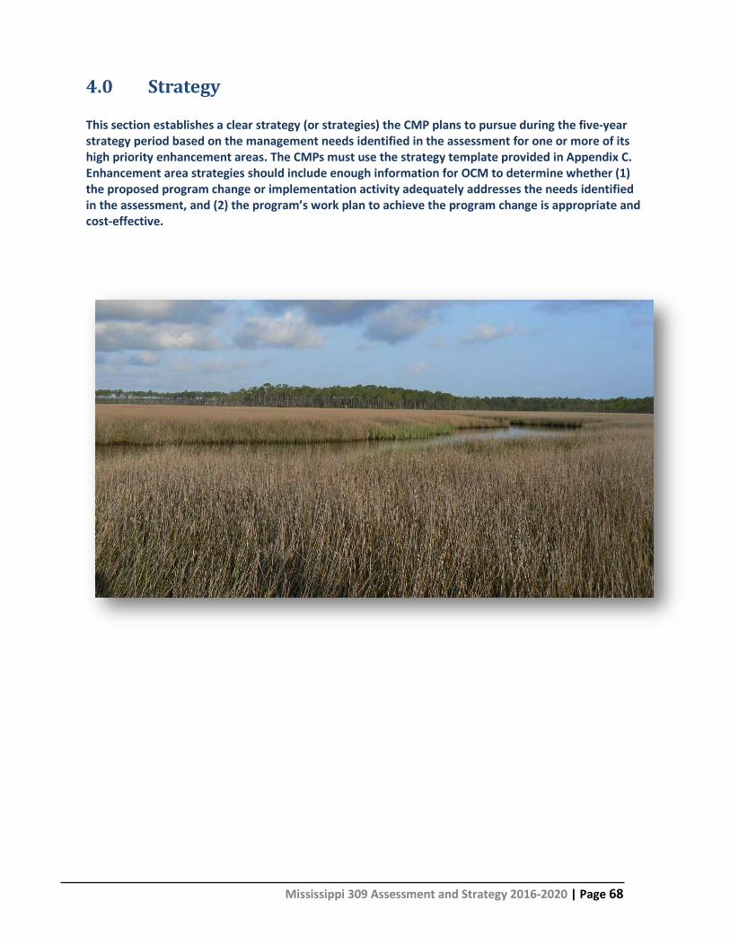
4.0 STRATEGY .................................................................................................................................. 68 4.1 Enhanced Application Procedures and Decision Support Tools ...................................................................... 69 4.2 Coastal Preserves Site Vulnerability Assessment Management of Public Access in Coastal Preserve Areas ... 73 4.3 Five-Year Budget Strategy .............................................................................................................................. 77 5.0 SUMMARY OF STAKEHOLDER AND PUBLIC INVOLVEMENT ..................................... 78 5.1 Stakeholder Involvement ....................................................................................................................... 79 5.2 Public Involvement ........................................................................................................................................ 79 5.3 Summary of Public Comments ....................................................................................................................... 79 APPENDIX A: STAKEHOLDER SURVEY RESULTS ...................................................................... 80
Mississippi 309 Assessment and Strategy 2016-2020 |Page ii
Acronyms
309 Assessment Section 309 Assessment and Strategy BU Beneficial Use BWP Bureau of Wetlands Permitting C-CAP Coastal Change Analysis Program CMP's Coastal Management Programs CSI Cumulative and Secondary Impacts CZMA Coastal Zone Management Act EIS Environmental Impact Statement FEMA Federal Emergency Management Agency GBNERRS Grandbay National Estuarine Research Reserve GSMFC Gulf State Marine Fisheries Commission LTMCP Land Trust Mississippi Coastal Plain MCERT Mississippi Comprehensive Ecosystem Restoration Tool MCP Mississippi Coastal Program MDA Mississippi Development Authority MDEQ Mississippi Department of Environmental Quality MDMR Mississippi Department of Marine Resources MDWFP Mississippi Department of Wildlife Fisheries and Parks MSGP Mississippi General Permits NMFS National Marine Fisheries Service NOAA National Oceanic and Atmospheric Administration OCM Office for Coastal Management SAMP Special Area Management Plan SAV's Submerged Aquatic Vegetation SCORP Statewide Comprehensive Outdoor Recreation Plan SLR Sea Level Rise TMDL Total Maximum Daily Limits (TMDL’s USACE U.S. Army Corps of Engineers USFWS U.S. Fish and Wildlife Service USM-GCRL University of Southern Mississippi-Gulf Coast Research Laboratory
Mississippi 309 Assessment and Strategy 2016-2020 | Page 1
1.0 Introduction and Overview The Coastal Zone Enhancement Program encourages state coastal management programs to strengthen and improve their coastal management programs in one or more of nine enhancement areas. These “enhancement areas” include: Wetlands, Public Access, Coastal Hazards, Cumulative and Secondary Impacts, Energy and Government Facility Siting, Marine Debris, Ocean Resources, Special Area Management Plans, and Aquaculture. Every five years, state coastal management programs are encouraged to conduct self-assessments of their coastal management programs to identify challenges and enhancement opportunities within each of the nine enhancement areas. Following this self-assessment , the Office for Coastal Management (OCM) within the National Oceanic and Atmospheric Administration (NOAA) works closely with state coastal programs in prioritizing and evaluating state program needs and developing strategies to improve its operations to address the program needs identified in the assessment. OCM then provides funds through a voluntary enhancement grants program to address priority issues identified through this self-assessment process that support attainment of one or more of the enhancement area objectives.
Mississippi 309 Assessment and Strategy 2016-2020 | Page 2
1.1 Overview The Mississippi Department of Marine Resources (MDMR) developed this Section 309 Assessment and Five-Year Strategy document for the CZM Program Enhancement Cycle for FY2016-2020 in accordance with the formal guidance issued by OCM in July of 20131. The purpose of the document is to evaluate and identify CZM’s program needs and outline a five-year strategy for achieving program changes and associated implementation objectives. In this case, the proposed strategy covers the federal fiscal years from 2016 to 2020 and serves as an update to the previous Section 309 Assessment and Strategy published in 2010. Preparation of this document began in late 2014 and has involved the efforts of MDMR management, a team of staff professionals with expertise and experience in the respective topics, and OCM who solicited input from other agencies, stakeholders, and the public.
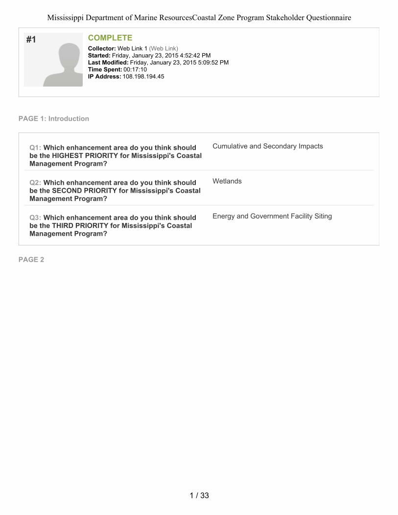
1.2 Public and Stakeholder Involvement Public and stakeholder involvement in the Section 309 Assessment and Strategy process is important to the MDMR and OCM. The assessment and strategy is a public document and the MDMR places a strong emphasis on public participation and encourages the participation, coordination, and cooperation with and among appropriate local, state, federal, and regional groups to help carry out the goals of the CZMA. As part of the public and stakeholder involvement process, the MDMR developed a Stakeholder Survey to capture stakeholder and private citizen input relative to priority enhancement areas and challenges and opportunities to strengthen the MCP. The survey was posted on the front page of the MDMR website (www.dmr.ms.gov) and emailed to several stakeholders that the MDMR works with on a regular basis. A total of 19 responses were received. The respondents included five Private Citizens, three Non-Governmental Organization representatives, one Academic representative, and three Federal/State/Local Government agency representatives. The top three priority enhancement areas as identified by the survey respondents were Coastal Hazards, (6) Wetlands (6), and Cumulative and Secondary Impacts (5). In addition to the stakeholder and private citizen survey conducted during the early stages of the 309 Assessment and Strategy process, the MDMR posted the Draft 309 Assessment and Strategy document to the MDMR website. The public was also notified of availability of the Draft 309 Assessment and Strategy document via legal notice in the Sun Herald Newspaper, and on the MDMR’s Twitter, Facebook, and LinkedIn accounts. No public comments relative to the draft 309 Assessment and Strategy were received.
1.3 Summary of 309 Assessment and Strategy Findings The prioritization of the enhancement areas is based on three main criteria: (1) the severity of problem, (2) the potential for program changes or further implementation activities to effectively address outstanding issues, and (3) the availability of other sources of funds to address issues (i.e. if an issue area has another dedicated source of funds, it may not be rated as a priority for use of limited 309 funds).
Mississippi 309 Assessment and Strategy 2016-2020 | Page 3
For this Section 309 Assessment and Strategy, the following enhancement areas have been identified as “High” priorities:
• Wetlands • Coastal Hazards • Public Access • Cumulative and Secondary Impacts
The following areas are ranked as “Medium” priorities:
• Special Area Management Planning • Aquaculture • Marine Debris
Lastly, the following areas were assigned a “Low” priority rating:
• Ocean and Great Lake Resources • Energy and Government Facility Siting
1.4 Organization of this Document This document is divided into sections that provide information regarding the current and previous assessment and strategy development activities. Section 2 of this document summarizes the Section 309 Enhancement Grant activities for the 2011-2015 cycle. Section 3 discusses the results of the Phase I (High-Level) Assessment and the Phase II (In-Depth) Assessment of the enhancement areas. Section 4 of the document is the Strategy section which discusses the strategies that will be developed and implemented by the MDMR to address the high priority enhancement areas and the programmatic gaps and needs identified in the Assessment. Finally, Section 5 summarizes the stakeholder involvement and public engagement activities implemented for the 309 Assessment and Strategy process.
Mississippi 309 Assessment and Strategy 2016-2020 | Page 4
2.0 Summary of Completed Section 309 Efforts 2011-2015 In the period covered by the previous Section 309 Assessment and Strategy (FY2011-2015), Section 309 grant funds were expended on four enhancement areas, ranked as either “high” (Wetlands and Cumulative and Secondary Impacts) or “medium” (Coastal Hazards and Public Access) priorities in the Section 309 Assessment and Strategy.
Mississippi 309 Assessment and Strategy 2016-2020 | Page 5
2.1 Overview of the Section 309 Enhancement Grant Projects
Section 309 Strategies Year 1 Year 2 Year 3 Year 4 Year 5 Total
Alternative Shoreline Management and Policy Development $91,000 $81,900 $50.000 - - $222,900
Analysis of Erosion and Wetlands Loss Related to Boat Wake and Human Activities on Islands in Bayou, Rivers, and Bays
- - $31,900 $46,900 $81,900 $160,700
2016-2020 309 Assessment and Strategy Development - - - $35,000 - -
Total Funding $91,000 $81,900 $81,900 $81,900 $81,900 $418,600
2.2 Status and Results of Section 309 Grant Work for 2011-2015 Cycle 1. Alternative Shoreline Management and Policy Development During the 2011-2015 Section 309 period, the MDMR used Section 309 funds to evaluate and develop education and outreach materials related to Living Shorelines. Enhancement Area: Wetlands, Coastal Hazards, Cumulative and Secondary Impacts Accomplishments: In Year 1, the MDMR funded a project to inventory and assess hardened shorelines specific to areas designated as tidelands and the various bays and estuaries along the Mississippi coast. Using the results of the assessment, a Living Shoreline Manual and other outreach and education materials were developed and published for distribution to waterfront property owners and contractors in Year 2. The manual and outreach materials highlighted the use of shoreline hardening alternatives such as living shorelines and hybrid stabilization in appropriate areas. In Year 3, the MDMR continued the outreach strategy by conducting a “Living Shoreline” workshop for contractors and the public, focusing on materials and techniques for establishing a living shoreline. A conceptual plan for a demonstration living shoreline was also developed under Year 3 funding. Based on the conceptual plan, the MDMR plans to construct the living shoreline demonstration project near their headquarters to serve as an example of a type of living shoreline project for shoreline types similar to those common in Mississippi’s coastal estuaries. The results of this work enabled the MDMR to develop criteria for living shoreline projects which were successfully incorporated into the Mississippi General Permit Program. The MDMR is also in the process of incorporating the criteria into the MCP Guidelines for Conducting Regulated Activities which will submitted to OCM for approval.
Mississippi 309 Assessment and Strategy 2016-2020 | Page 6
2. Analysis of Erosion and Wetlands Loss Related to and Human Activities on Islands in Bayous, Rivers, and Bays
To better understand and address human impacts on wetlands and sensitive coastal areas, the MDMR used Section 309 funds to assess impacts and evaluate the need for policy revisions that address human activities on wetlands and sensitive natural areas. Enhancement Areas: Wetlands, Cumulative and Secondary Impacts Accomplishments: During Year 5, the MDMR funded a study on the loss of wetlands and shorelines related to human impacts in three major waterfront industrial areas. The overall goal of this project is to assess the cumulative and secondary impacts related to man-made features such as bulkheads, docks, and navigation channels on adjacent natural areas. The study will also allow the MDMR to evaluate the need for new or modified guidelines for regulated activities including alternative shoreline protection measures.
Mississippi 309 Assessment and Strategy 2016-2020 | Page 7
3.0 Assessment The assessment process as described in the Section 309 Guidance is designed to: (1) identify the extent to which problems and opportunities for program enhancement exist within each of the enhancement area objectives; (2) determine the effectiveness of existing management efforts to address identified problems; and (3) identify high priority needs for program enhancement. For this assessment and strategy cycle (2016-2020), the assessment process has been divided into two phases to enable CMPs to more easily target their assessments to high priority enhancement areas for the program. The Phase I (high-level) assessment is based on data presented in a series of tables that enable the MDMR to characterize the resources and the management framework available to address issues and concerns for each of the nine enhancement areas.
3.1 Phase I (High Level Assessment) The MDMR Phase I High Level Assessment process followed the procedures outlined in the OCM Section 309 Guidance document. The objectives of each enhancement area was reviewed and MCP the staff in conjunction with the Mississippi OCM specialist assessed and evaluated each objective and discussed potential issues and priorities for the program. Using that information the MDMR ranked the enhancement area as a high, medium, or low priority for the MCP. For those enhancement areas ranked as medium or low priority, no further assessment is required. For enhancement areas ranked as a high priority, the MDMR continued its assessment by completing an in-depth Phase II assessment. The Phase I assessment for the nine enhancement areas are presented in this section of the report and follow in the order listed in the Section 309 guidance document.
Mississippi 309 Assessment and Strategy 2016-2020 | Page 8
Wetlands
Section 309 Enhancement Objective: Protection, restoration, or enhancement of the existing coastal wetlands base, or creation of new coastal wetlands. §309(a) (1)
Note: For the purposes of the Wetlands Assessment, wetlands are “those areas that are inundated or saturated at a frequency and duration sufficient to support, and that under normal circumstances do support, a prevalence of vegetation typically adapted for life in saturated soil conditions.” [33 CFR 328.3(b)]. See also pg. 17 of the CZMA Performance Measurement Guidance for a more in-depth discussion of what should be considered a wetland.
Resource Characterization: 1. Using provided reports from NOAA’s Land Cover Atlas2 or high-resolution C-CAP data3 (Pacific and
Caribbean Islands only), please indicate the extent, status, and trends of wetlands in the state’s coastal counties. You can provide additional or alternative information or use graphs or other visuals to help illustrate or replace the table entirely if better data are available. Note that the data available for the islands may be for a different time frame than the time periods reflected below. In that case, please specify the time period the data represents. Also note that Puerto Rico and the Commonwealth of the Northern Mariana Islands (CNMI) currently only have data for one time point so will not be able to report trend data. Instead, Puerto Rico and CNMI should just report current land use cover for all wetlands and each wetlands type.
Coastal Wetlands Status and Trends
Current state of wetlands in 2011 (acres) 703,331.2 (28.7% of state)
Net change in total wetlands (in acres) from 1996-2011 from 2006-2011
-18,914.7 -3,585.7*
Net change in freshwater (palustrine wetlands) from 1996-2011 from 2006-2011
-18,638.5 -3004.3
Net change in saltwater (estuarine) wetlands from 1996-2011 from 2006-2011
-502.4 -415.9
Net change in Unconsolidated Shore wetlands from 1996-2011 from 2006-2011
226.2 -165.5
2 http://www.csc.noaa.gov/ccapatlas/. Summary reports compiling each state’s coastal county data are provided on the ftp site. 3 http://www.csc.noaa.gov/digitalcoast/data/ccaphighres
Mississippi 309 Assessment and Strategy 2016-2020 | Page 9
How Wetlands Are Changing
Land Cover Type Area of Wetlands Transformed to
Another Type of Land Cover between 1996-2011 (Sq. Miles)
Area of Wetlands Transformed to Another Type of Land Cover
between 2006-2011 (Sq. Miles)
Development -5,705.8 -2,127.7 Agriculture -852.0 -2.2 Barren Land -1,711.6 -996.6
Water -640.7 -232.2
*If you add up the total for wetland area lost 1996 to 2011 in the second table above, it equals -8910 acres. The difference between that and the first table highlights changes that have occurred in wetland condition or type compared to those land covers most likely to be associated with actual losses. Some of those changes may include changes of wetland to natural upland categories, or visa-versa. Many of these additional changes are associated with timber, or silviculture, activities which (depending on the management practices in your area) may result in additional losses (not noted in table 2 above). It should also be noted that some of the above changes may not reflect permanent wetland losses and that changes to water may reflect a loss of vegetative wetlands, but could also be associated with gains in unvegetated wetland types (such as unconsolidated bottom), which Coastal Change Analysis Program (C-CAP) does not map. While the status and trends data indicate decreases in wetlands, it is difficult to pinpoint the specific cause. Furthermore, given the limitations in data analysis, it is difficult to assess changes in specific wetlands types which in turn limit the ability to accurately describe the status and trends for wetlands change. Analysis of the MDMR’s Bureau of Wetland Permitting (BWP) indicates that the number of permitting actions which result in a loss of coastal wetlands (i.e. wetlands below mean high water) is relatively minor. Wetlands other than coastal wetlands (i.e. Palustrine Forested Wetlands) appear to be the type of wetlands most often impacted, and increased development pressure makes this wetlands type particularly vulnerable. Additionally, it appears that large scale residential and commercial projects, more so than minor permit actions, represent the most significant threat to wetlands. Development activities are causing both direct and indirect impacts to wetlands. Direct impacts include filling, habitat conversion, and habitat fragmentation. Indirect impacts include alteration of overland flow, reduced habitat quality, and stormwater pollution. While wetlands mitigation and effective stormwater management controls can help to reduce these impacts, the threat to wetlands resources continues to be a concern. 2. If available, briefly list and summarize the results of any additional state- or territory-specific data or
reports on the status and trends of coastal wetlands since the last assessment to augment the national data sets.
The Mississippi MDEQ Office of Geology analyzed aerial imagery and other geospatial data south of I-10 (below 15 foot elevation) to determine levels of land gain and loss from 1850-1999. The study also analyzed coastal wetlands gain and loss from 1950-1999. The data from that analysis reported in the previous 309 assessment and indicated that approximately 9,000 acres of coastal wetlands or about 15% of the total coastal wetlands south of I-10 (below 15 ft. elevation) has been lost by natural and man-made action since 1850. The analysis also indicated that loss of coastal habitat, including wetlands, continues to occur at rates similar to historic trends.
Mississippi 309 Assessment and Strategy 2016-2020 | Page 10
In 2010, the US Geological Survey published a report entitled Emergent Wetlands Status and Trends in the Northern Gulf of Mexico: 1950–2010. The study focused on emergent wetlands and the data regarding emergent wetlands loss in Mississippi is consistent with the status and trends data provided in the tables above and in the MDEQ study. Management Characterization: 1. Indicate if there have been any significant changes at the state or territory level (positive or
negative) that could impact the future protection, restoration, enhancement, or creation of coastal wetlands since the last assessment.
Management Category Significant Changes Since Last
Assessment (Y or N)
Statutes, regulations, policies, or case law interpreting these Y
Wetlands programs (e.g., regulatory, mitigation, restoration, acquisition) Y
2. For any management categories with significant changes briefly provide the information below. If
this information is provided under another enhancement area or section of the document, please provide a reference to the other section rather than duplicate the information:
a. Describe the significance of the changes; b. Specify if they were 309 or other CZM-driven changes; and c. Characterize the outcomes or likely future outcomes of the changes.
Since the last Section 309 cycle, the BWP has focused attention on its project review, project mitigation, and regulatory efforts for those Section 404 actions in the coastal zone that are outside the direct permitting authority of the MDMR, but require federal consistency determinations. BWP staff participates in joint inspections, interagency meetings, and pre-application reviews of projects to provide applicants with guidance in the early stages of project development. The BWP staff also participates in the Mitigation Bank Interagency Review Team activities, and provides support to the Corps of Engineers (COE) in their role of permitting and monitoring mitigation banks in the Mississippi Coastal Zone. This increase in effort has produced positive results and assisted in creating a platform for coordination and cooperation with the regulatory agencies and users. MDMR‘s BWP has also worked with the COE to develop and issue the 2013 Mississippi General Permits (MSGPs) which included the addition of MSGP-03 Living Shorelines. To date, five (5) Living Shoreline MSGPs have been issued. While the MSGP’s continues to be an effective tool for streamlining the regulatory program for minor structures and activities, the National Marine Fisheries Services (NMFS) has requested that the use of MSGP’s be suspended for areas outside the footprints of existing marinas in the Mississippi Sound south of the Highway 90 bridges over the Biloxi Bay and St. Louis Bay. In July 2010, the Mississippi Legislature amended the Mississippi Coastal Wetlands Protection Law (49-27-61) requires any party proposing to dredge more than 2500 cubic yards of dredged material must participate in the MDMR’s program for beneficial use (BU) of dredge material.
Mississippi 309 Assessment and Strategy 2016-2020 | Page 11
At the present time major BU sites have been developed at Deer Island in Harrison County, and Greenwood Island and Round Island in Jackson County. During the 2016-2020 309 Assessment cycle, the MDMR will continue to work on the Analysis of Erosion and Wetlands Loss Related to and Human Activities on Islands in Bayous, Rivers, and Bays project and incorporate data from that effort into the regulatory process The changes referenced above are largely driven by MDMR-BWP programmatic CZM initiatives in response to need; however, Section 309 Assessment process was helpful in identifying the need for a more focused approach to wetlands permitting and federal consistency review. The MDMR-BWP staff remains focused on future changes identified in the 2011-2015 309 strategy cycle and continues efforts proposed for the 2016-2020 309 cycle. The MDMR-BWP staff is optimistic about future improvements of the wetlands regulatory program and the rules and regulations which have revised and are being included in the revised MCP which is currently being reviewed by OCM. Enhancement Area Prioritization: 1. What level of priority is the enhancement area for the coastal management program?
High __X__ Medium _____ Low _____
2. Briefly explain the reason for this level of priority. Include input from stakeholder engagement,
including the types of stakeholders engaged. Protection and restoration of coastal habitats, including wetlands, has always been a major goal for the MDMR. Since the passage of the Mississippi Coastal Wetlands Protection Law in 1973 and the MCP in 1980, the MDMR staff has worked to develop the necessary policies and procedures to regulate activities which have direct and indirect effects on wetlands. In the aftermath of Hurricane Katrina, development pressures shifted from areas below I-10 to areas north of I-10 that were at higher elevations in the northern portions of the counties. The new development pressure in historically rural areas has caused an increase in conversion of forested land cover types, including wetlands, to developed lands. Consequently, the land conversions have caused direct impacts to wetlands and other sensitive impacts as well as indirect impacts from increased stormwater runoff and erosion. Many of the original policies and procedures developed in the early stages of the program have been modified, refined, and improved using 309 funds. Further improvements to policies and programs related to wetlands can be made through continued 309 involvement and the MDMR places a high level of priority for the Wetlands enhancement area. One or more strategies will be developed to enhance MCP goals for wetlands management. A strategy will be developed to improve permit tracking, document land use changes, and cumulative and secondary impacts. An important part of this strategy will be the development of an integrated GIS program that will support MDMR efforts in Wetlands, Public Access, and Cumulative and Secondary Impacts.
Mississippi 309 Assessment and Strategy 2016-2020 | Page 12
Coastal Hazards Section 309 Enhancement Objective: Prevent or significantly reduce threats to life and property by eliminating development and redevelopment in high-hazard areas, managing development in other hazard areas, and anticipating and managing the effects of potential sea level rise and Great Lakes level change. §309(a) (2) Resource Characterization: 1. Flooding: Using data from NOAA’s State of the Coast “Population in the Floodplain” viewer4 and
summarized by coastal county through NOAA’s Coastal County Snapshots for Flood Exposure,5 indicate how many people were located within the state’s coastal floodplain as of 2010 and how that has changed since 2000. You may to use other information or graphs or other visuals to help illustrate.
Population in the Coastal Floodplain
2000 2010 Percent Change from 2000-2010 No. of people in coastal floodplain6 143,012 134,010 - 6.3%
No. of people in coastal counties7 363,988 370,702 1.8%
Percentage of people in coastal counties in coastal floodplain 39.3% 36.2% ----------
Analysis of data regarding the number of people in the coastal counties indicates a slight increase in 2010 over 2000; however there is a more substantial decrease in the number of people and the percentage of people living in the coastal floodplain. The downward trend in the number of people in the coastal floodplain is positive and encouraging. Further analysis of the data is needed to better understand the changes, and their associated vulnerabilities. 2. Shoreline Erosion (for all states other than Great Lakes and islands; for Great Lakes and islands, see
Question 5): Using data from NOAA’s State of the Coast “Coastal Vulnerability Index,”8 indicate the vulnerability of the state’s shoreline to erosion. You may use other information or graphs or other visuals to help illustrate or replace the table entirely if better data is available. Note: For New York and Pennsylvania that have both Atlantic and Great Lakes shorelines, fill out the table below for the Atlantic shoreline only.
Mississippi 309 Assessment and Strategy 2016-2020 | Page 13
Vulnerability to Shoreline Erosion
Vulnerability Ranking Miles of Shoreline Vulnerable Percent of Coastline
Very low (>2.0m/yr) accretion 0 0%
Low (1.0-2.0 m/yr) accretion) 30.3 16%
Moderate (-1.0 to 1.0 m/yr) stable 87.5 46%
High (-1.1 to -2.0 m/yr) erosion 34.7 18%
Very high (<-2.0 m/yr) erosion 39.2 20%
Data from the US Geological Survey’s Coastal Vulnerability Index indicates that over 84% of Mississippi’s coastal shoreline is vulnerable to Moderate (46%), High (18%), and Very High (20%) rates of erosion. In Mississippi, the primary causes of erosion are coastal storms and flooding. The threat of shoreline erosion is greatest with coastal storms and associated storm surge. Coastal erosion from recreational boating, maritime navigation, and poorly designed shoreline protection systems can also lead to erosion issues in bays, bayous, and rivers. The MDMR is aware of the damage caused by shoreline erosion and developed strategies for assessing man-induced causes of coastal erosion in the previous 309 Assessment (2011-2015). While there are many factors which exacerbate erosion, including natural forces, the MDMR is focusing on hardened shorelines along bays and bayous, and along the shorelines in three of major industrial parks in coastal Mississippi. The State of Mississippi Hazard Mitigation Plan lists coastal erosion as a non-profiled hazard but discusses the potential risks under the Hurricane and Flooding sections of the plan. 3. Sea Level Rise (for all states other than Great Lakes and islands; for Great Lakes and islands, see
Question 5): Using data from NOAA’s State of the Coast “Coastal Vulnerability Index”,9 indicate the vulnerability of the state’s shoreline to sea level rise. You may provide other information or use graphs or other visuals to help illustrate or replace table entirely if better data is available.
Coastal Vulnerability to Historic Sea Level Rise
Vulnerability Ranking Miles of Shoreline Vulnerable11 Percent of Coastline
Very low 0 0% Low 0 0%
Moderate 0 0% High 0 0%
Very high 191.7 100% Trends in sea level rise and the potential for impacts from sea level rise in coastal Mississippi is largely unknown. Data from NOAA’ State of the Coastal Vulnerability to Sea Level Rise Tool indicates that all of the shoreline areas of Mississippi have a very high vulnerability ranking for impacts from sea level rise. Data relative to land subsidence is also largely unknown.
Mississippi 309 Assessment and Strategy 2016-2020 | Page 14
The Assessment of Sea Level Rise in Coastal Mississippi, published in July 2011, includes a summary of sea level rise projections from eleven different reports and published research papers. According to the summary of global sea level rise data, coastal Mississippi could experience sea level increases of 16.6 inches in twenty years, 41.5 inches in fifty years, and 74.7 inches by the year 2100. However, regional and local projections of sea level rise that take into consideration land use/land cover, subsidence, local topography, storm surge, erosion rates, and other local/regional variables are sparse. Few studies have been conducted in coastal municipalities to collect parcel level data that could assist with local planning decisions. Although tide gauge stations record trends and seasonal variations in sea level rise, the gauge stations in Mississippi coastal waters do not have the depth of historical data that neighboring states possess. Therefore, Dauphin Island, Alabama or Pensacola, Florida are typically used as reference stations for Mississippi coastal counties. The mean sea level rise of these two stations combined (as summarized in the report) is approximately 0.10 inches/year.
4. Other Coastal Hazards: In the table below, indicate the general level of risk in the coastal zone for
each of the coastal hazards. The state’s multi-hazard mitigation plan is a good additional resource to support these responses.
Type of Hazard General Level of Risk (H, M, L)
Flooding (riverine, stormwater) Medium-High Coastal storms (including storm surge) High Geological hazards (e.g., tsunamis, earthquakes) Low Shoreline erosion High Sea level rise High Great Lake level change Not Applicable Land subsidence Medium-High Saltwater intrusion Low Other (please specify) -
The State of Mississippi Hazard Mitigation Plan utilizes risk assessment worksheets to quantitatively measure certain risks within the state of Mississippi. The coastal hazards which have been ranked in the State Plan include Hurricanes (ranking score: 53), Flooding (ranking score: 56), and Earthquake (ranking score: 30). The State of Mississippi Hazard Mitigation Plan for 2010 was updated in 2013. The plan reported property damage from coastal storms from 2010-2012 to be $12,260,000. Of all of the coastal hazards considered, hurricanes represent the most significant natural event that has led to tragic loss of life, injury, and property damage in Mississippi. In the aftermath of Hurricane Katrina, hazard mitigation plans were revised, storm surge and floodplain requirements were modified, and there is an increased awareness of the need to continually assess and address the impacts of hurricanes and storm surge in the Mississippi coastal zone.
5. If available, briefly list and summarize the results of any additional data or reports on the level of risk and vulnerability to coastal hazards within your state since the last assessment. The state’s multi-hazard mitigation plan or climate change risk assessment or plan may be a good resource to help respond to this question.
Mississippi 309 Assessment and Strategy 2016-2020 | Page 15
According information compiled by the Federal Emergency Management Agency (FEMA) the three coastal counties were listed as the top 3 out the top 10 counties with losses from flooding during a period of time from 1978 to 2013. Harrison County had 14,765 that totaled $1,269,506,283 in losses, Hancock County had 9.696 claims that totaled $734,991,310 in losses, and Jackson County had 10,076 claims that totaled $692,478,660.
Management Characterization: 1. Indicate if the approach is employed by the state or territory and if significant state- or territory-
level changes (positive or negative) have occurred that could impact the CMP’s ability to prevent or significantly reduce coastal hazards risk since the last assessment.
Management Category Employed by State
or Territory (Y or N)
CMP Provides Assistance to
Locals that Employ (Y or N)
Significant Changes Since Last
Assessment (Y or N)
Statutes, regulations, policies, or case law interpreting these that address: elimination of
development/redevelopment in high-hazard areas
N N N
management of development/redevelopment
in other hazard areas Y Y Y
climate change impacts, including sea level rise or Great Lake level change Y Y Y
Hazards planning programs or initiatives that address: hazard mitigation N Y N
climate change impacts, including sea level rise or Great Lake level change N N N
Hazards mapping or modeling programs or initiatives for: sea level rise or Great Lake level change - - -
other hazards - - -
2. Briefly state how “high-hazard areas” are defined in your coastal zone. High hazard zones in coastal Mississippi coastal zone are defined in a number of ways. Floodways and flood zones are defined by Federal Emergency Management Agency (FEMA) and floodplain ordinances are developed and enforced by local governments. Storm surge zones for high energy waves and rising water are defined by FEMA and activities in storm surge zones are enforced by local governments. 3. For any management categories with significant changes, briefly provide the information below. If
this information is provided under another enhancement area or section of the document, please provide a reference to the other section rather than duplicate the information:
a. Describe the significance of the changes; b. Specify if they were 309 or other CZM-driven changes; and c. Characterize the outcomes or likely future outcomes of the changes.
Mississippi 309 Assessment and Strategy 2016-2020 | Page 16
Cities and Counties along the Mississippi Gulf Coast have an increased awareness of the potential impacts of flooding, coastal storms including hurricanes, and sea level. New building standards have been put into place and building code enforcement for many coastal communities has been modified to require special attention to stormwater management, building location relative to floodplains, and construction techniques in areas susceptible to high energy waves and wind. In 2012, Congress passed the Biggert-Waters Flood Insurance Reform Act which reauthorized the National Flood Insurance Program (NFIP for 5-years.The bill brings several substantive changes to the NFIP, including several changes that alter the way premium rates are calculated. Cities that administer the NFIP recognize the importance of the NFIP and the benefits of compliance as it relates to Community Rating Indices and which can lead to reduced insurance premiums in those communities with high ratings. At least three coastal Mississippi communities have taken steps to include sea level rise in their Hazard Mitigation Planning efforts. For example, the City of Waveland, Mississippi prepared maps of potential sea level rise increases of 1 ft., 3 ft. and 6 ft. and the estimated losses that would occur under those conditions. The maps revealed critical infrastructure that could be affected by increases in sea level rise and showed potential flooding in northern parts of the municipality. This information was then incorporated into their local hazard mitigation planning process. Enhancement Area Prioritization: 1. What level of priority is the enhancement area for the coastal management program?
High _ _X___ Medium _ _ __ Low _ _ __
Mississippi 309 Assessment and Strategy 2016-2020 | Page 17
2. Briefly explain the reason for this level of priority. Include input from stakeholder engagement,
including the types of stakeholders engaged. Reducing risk from coastal hazards is a primary concern of the MDMR. Given the intensity of recent coastal storms, and the potential impacts for climate change and sea level rise, there is a growing concern that more people and property will be particularly vulnerable to the impacts related to coastal hazards. In an effort to address coastal hazards in a meaningful way, the MDRM has established a new Office of Coastal Restoration and Resiliency. This new office will focus attention on resiliency of the natural and built environment. The MDMR has chosen a priority level of high for this enhancement area and is currently developing ways to foster future improvements and science based strategies to educate and engage coastal communities in the implementation of coastal hazard mitigation and resiliency planning processes.
Mississippi 309 Assessment and Strategy 2016-2020 | Page 18
Public Access Section 309 Enhancement Objective: Attain increased opportunities for public access, taking into account current and future public access needs, to coastal areas of recreational, historical, aesthetic, ecological, or cultural value. §309(a) (3) Resource Characterization: 1. Use the table below to provide data on public access availability within the coastal zone.
Public Access Status and Trends
Type of Access Current number
Changes or Trends Since Last
Assessment (↑, ↓, −, unkwn)
Cite data source
Beach access sites More than 11 beach access sites ↑ MDMR Public
Access Inventory
Shoreline available for beach access
Over 659 miles of shoreline and approximately 38 miles of beaches ↑ MARIS
Recreational boat (power or non-motorized) access
sites
More than 102 boat access sites and more than 72 public boat ramps unknown MDMR Public
Access Inventory
Number of designated scenic vistas or overlook
points 0 0 0
Number of fishing access points (i.e. piers, jetties) More than 50 MDMR Public
Access Inventory
Coastal trails/ boardwalks
11 Trails/boardwalks and 4 new Blueways designated
↑ MDMR-Coastal
Preserves Section LTMCP 17 miles of trails/ 95 miles of designated
blueways
Number of acres parkland/open space
20 Coastal Preserve Tracts 39,345 acres ↑
MDMR-Coastal Preserves Section
Mississippi 309 Assessment and Strategy 2016-2020 | Page 19
Coastal Mississippi continues to recover from storm damaged impacts to public access facilities and has made progress rebuilding these facilities. Additionally, a number of coastal trail and boardwalk projects have been constructed and other existing public access areas have been expanded. Part of this increase appears to be related to the installation of the new trails throughout the MDMR Coastal Preserves Network. The Coastal Preserves Network has grown significantly since 2011 with over 3,433 acres added to the network. Major sites added to the network include the Baldwin Tract (2,936 acres) in lower Hancock County and the Cat Island Tract (497 acres). While increasing the Coastal Preserves Network and public access within the network is a positive trend, there is some concern that increased access may lead to negative impacts to coastal resources within the preserve. Many of the public access facilities such as public boat ramps and fishing piers have been funded through the Mississippi Secretary of State’s Tidelands Trust Fund which is administered by the MDMR. Public access projects are proposed by municipal and county governments in the three coastal counties and the funds are used to construct and/or expand public access projects. These funds are distributed annually and it is anticipated that the continued funding of public access facilities with Tidelands Trust Funds will address the future demands which are trending upwards. The demand for alternative public access opportunities in coastal Mississippi is growing and as the state’s population continues to grow, the demand for new and varied public access opportunities is expected to increase. The potential increases in the state’s coastal population coupled with an increased level of interest in eco-tourism indicate that the need for new and varied access opportunities is expected to increase. Based on NOAA’s State of the Coast National Coastal Population Report, the population within the state’s coastal shoreline counties is projected to increase by five (5) percent between 2010 and 2020. Since the previous 309 Assessment, a number of “Blueway Trails” have been established in coastal waterways. The Blueway Trails effort is a relatively newly established effort being implemented by the Land Trust Mississippi Coastal Plains (LTMCP). MDMR assisted LTMCP with installation of the first designated blueway on Old Fort Bayou in September of 2009. Coastal Preserves has assisted in developing user guides, establishing access points and mile markers, and developing educational kiosks and materials for the Blueways Program. 2. Briefly characterize the demand for coastal public access and the process for periodically assessing
demand. Include a statement on the projected population increase for your coastal counties.10 There are several additional sources of statewide information that may help inform this response, such as the Statewide Comprehensive Outdoor Recreation Plan, the National Survey on Fishing, Hunting, and Wildlife Associated Recreation, and your state’s tourism office.
The Mississippi Department of Wildlife, Fisheries, and Parks updates the Statewide Comprehensive Outdoor Recreation (SCORP) plan every five years. According to statistics published in 2014 for the 2015-2019 SCORP, the demand for increased activities related to public access continues to be high with the overall desired improvements being for more trails, greenways and blueways. The SCORP identified the top five statewide recreation needs as follows: 1) Hiking and Trails; 2) Canoeing, Kayaking, Rafting, Tubing; 3) Water parks, Splashpools; 4) Camping; and 5) Archery.
10 See NOAA’s Coastal Population Report: 1970-2020 (Table 5, pg. 9): http://stateofthecoast.noaa.gov/coastal-population-report.pdf
Mississippi 309 Assessment and Strategy 2016-2020 | Page 20
3. If available, briefly list and summarize the results of any additional data or reports on the status or
trends for coastal public access since the last assessment. No additional data or reports relative to the status or trends for coastal public access that may have become available for this assessment was identified. Management Characterization: 1. Indicate if the approach is employed by the state or territory and if there have been any significant
state- or territory-level management changes (positive or negative) that could impact the future provision of public access to coastal areas of recreational, historical, aesthetic, ecological, or cultural value.
Management Category Employed by State
or Territory (Y or N)
CMP Provides Assistance to
Locals that Employ (Y or N)
Significant Changes Since Last Assessment
(Y or N)
Statutes, regulations, policies, or case law interpreting these Y Y N
Operation/maintenance of existing facilities Y Y N
Acquisition/enhancement programs Y Y N
2. For any management categories with significant changes briefly provide the information below. If
this information is provided under another enhancement area or section of the document, please provide a reference to the other section rather than duplicate the information:
a. Describe the significance of the changes; b. Specify if they were 309 or other CZM-driven changes; and c. Characterize the outcomes or likely future outcomes of the changes.
There have been no significant changes in the management categories since the last 309 Assessment. 3. Indicate if your state or territory has a publically available public access guide. How current is the
publication and how frequently it is updated? Public Access Guide Printed Online Mobile App
State or territory has? (Y or N) N Y N
Web address (if applicable) -
Gulf Coast Birding Trail/Audubon
Coastal Heritage Trails -
Date of last update - - - Frequency of update - - -
Mississippi 309 Assessment and Strategy 2016-2020 | Page 21
Enhancement Area Prioritization: 1. What level of priority is the enhancement area for the coastal management program?
High __X_ Medium _____ Low _____
2. Briefly explain the reason for this level of priority. Include input from stakeholder engagement,
including the types of stakeholders engaged. The Public Access enhancement area is given a high priority. While local, county, state, and federal agencies continue to develop public access facilities in coastal Mississippi, there is a growing concern that increased public access, particularly access to sensitive coastal preserve sites may negatively affect the resource. The MDMR Coastal Preserves Staff is currently is working on use policies and rules and regulations for access to and use of Coastal Preserve areas. There is a need for additional information in the form of baseline assessments to characterize the habitat and carrying capacity of those habitats within the Coastal Preserve. At the present time, there is no new information available to accurately report the types and numbers of public access facilities. Without baseline information which includes site usage data, it is difficult to predict future needs for the type of access areas or their location. Additional data is needed to assess the types (i.e. boat ramps, fishing piers, handicap accessible sites, etc.) and locations of public access facilities needed to meet the future demands by the public. The general consensus is that the current categories of public access facilities provide a broad array of facilities that are in demand, however accurate information regarding user preferences (type and location) is needed. The most recent public access inventory was completed in 2008. Since that time, additional public access facilities have been added, however, an updated inventory has not been initiated.
Mississippi 309 Assessment and Strategy 2016-2020 | Page 22
Marine Debris Section 309 Enhancement Objective: Reducing marine debris entering the nation’s coastal and ocean environment by managing uses and activities that contribute to the entry of such debris. §309(a) (4) Resource Characterization: 1. In the table below, characterize the existing status and trends of marine debris in the state’s coastal
zone based on the best available data.
Source of Marine Debris
Existing Status and Trends of Marine Debris in Coastal Zone
Significance of Source
(H, M, L, unknown)
Type of Impact (aesthetic, resource damage, user
conflicts, other)
Change Since Last Assessment
(↑, ↓, −, unknown) Land-based
Beach/shore litter H Aesthetic, Resource Damage, User Conflicts -
Dumping M Aesthetic, Resource Damage (Filling Aquatic Habitat), User Conflicts
-
Storm drains and runoff H Aesthetic, Resource Damage (Water Quality, Sedimentation) -
Fishing (e.g., fishing line, gear) H*
Aesthetic, Resource Damage (Entanglement of Marine Fish, Mammals, and Turtles), User Conflicts
↑
Other (please specify) Ocean or Great Lake-based
Fishing (e.g., derelict fishing gear) H*
Aesthetic, Resource Damage (Entanglement of Fish and Turtles, User Conflicts
↑
Derelict vessels M Aesthetic, Resource Damage(Benthic and Tidal Marsh Habitat), User Conflicts
-
Vessel-based (e.g., cruise ship, cargo ship,
general vessel) M
Aesthetic, Resource Damage (Entanglement and Trauma to Marine Species), User Conflicts
-
Hurricane/Storm M Aesthetic, Resource Damage (Habitat Loss), User Conflicts -
Tsunami N/A Other (please specify)
* Reports from MDMR fisheries and enforcement personnel indicate that fishing gear related debris from land based and
ocean based activities appears to be more prevalent since the last assessment.
Mississippi 309 Assessment and Strategy 2016-2020 | Page 23
Fishing line, plastics, and paper products released from fisherman using jetties and fishing piers have increased and have the potential to become a significant source of marine debris. Marine debris related to derelict fishing gear such as gill nets, trawls, and derelict crab traps also appears to be increasing even though management efforts such as fishing line recycling stations, derelict crab trap recovery efforts, and the use of biodegradable materials for nets are being employed. Best available information indicates that this upward trend appears to be related to increase fishing pressure at public access facilities and accidental loss of commercial fishing gear such as crab traps, fishing trawls, and gill nets. 2. If available, briefly list and summarize the results of any additional state- or territory-specific data or
reports on the status and trends or potential impacts from marine debris in the coastal zone since the last assessment.
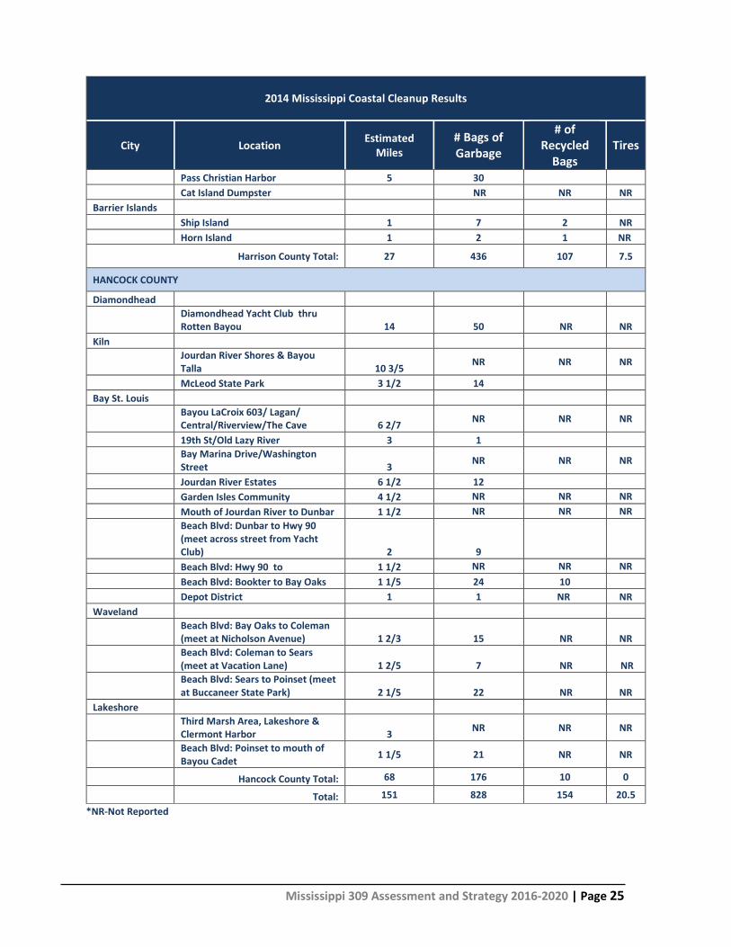
Mississippi has participated in the annual fall Coastal Cleanup event for over 25 years. The 2013 Mississippi Coastal Cleanup resulted in more than 32,700 pounds of trash and debris being removed from Hancock, Harrison, and Jackson County coastlines. A review of data from the International Coastal Cleanup 2013 Report indicates that for the United States as a whole, shoreline related activities were the largest contributor to marine debris followed by Smoking Activities and Ocean/Waterway Activities. The MDMR compiled data from the 2014 Coastal Cleanup by county and by specific areas within the county. This information is provided below and gives an overview of general location and quantity of debris from those locations. According to MDMR personnel who compiled data for the most recent cleanup, the types of marine debris remain similar to previous cleanups.
2014 Mississippi Coastal Cleanup Results
City Location Estimated Miles
# Bags of Garbage
# of Recycled
Bags Tires
JACKSON COUNTY Gautier Gautier City Park 1/2 NR NR NR* Graveline Rd/Shepard State Park 2 NR NR NR Mary Walker Waterways 2 NR NR NR W. Pascagoula Bridge 1 1/2 NR NR NR Bluff Creek 2 NR NR NR Moss Point NR NR NR Bellview Street Boat Launch & Park 1/2 NR NR NR I-10 Boat Launch 1 NR NR NR Hwy 63 Boat Ramp 1 1/2 NR NR NR River Front 1/2 NR NR NR Grand Bay NERR (Bayou Heron) 8 NR NR NR Ocean Springs NR NR NR Fort Bayou Pier & Boat Launch 1 NR NR NR Gulf Park Estates Public Pier 1 NR NR NR
Gulf Islands National Seashore/Davis Bayou 4 NR NR NR
Mississippi 309 Assessment and Strategy 2016-2020 | Page 24
2014 Mississippi Coastal Cleanup Results
City Location Estimated Miles
# Bags of Garbage
# of Recycled
Bags Tires
Graveline Bayou Pier and Boat Launch 2 NR NR NR
East Beach 2 NR NR NR Front Beach OSYC 1 NR NR NR Fort Maurepas Beachfront 1 NR NR NR Front Beach Harbor End 1 NR NR NR Graveline Bayou Beachfront 3/4 NR NR NR Pascagoula
Lighthouse Park (Includes Causeway, River Park, Spanish Fort Areas)
5 63 8 13
IG Levy, N. 4 26 11 NR
Beach Front & Pointe 3 1/2 52 9 NR
30 NR NR Round Island 3 20 9 NR Lower Pascagoula River Islands 4 14 NR NR
Signing River Yacht Club (Unofficial site) 11 NR NR
Jackson County Total: 50.5 216 31 13
HARRISON COUNTY
D'Iberville Boat Launch 1/2 16 18 NR Tuxachanie Waterway 1/2 12 NR NR Biloxi Popps Ferry Bridge 1/2 5 3 Forrest Ave Pier 1 28 NR NR Hiller Park 1/2 30 NR NR Keegan Bayou 1/4 27 NR 7.5 Deer Island 1 76 33 NR Biloxi Small Craft Harbor 1 12 NR NR Biloxi Lighthouse/Porter Ave 95 NR NR Edgewater Mall 2 NR NR NR Gulfport Courthouse Road/Ken Combs Pier 4 NR NR NR James Hill Park 1/4 NR NR NR Kremer Landing 1/4 NR NR NR
Gulfport Harbor (Beach East of Harbor) 3 86 50 NR
Lower Turkey Creek NR NR NR NR Forrest Heights NR NR NR NR Three Rivers Park River Road 1/2 10 NR NR Gulfport Lake (closed site military) Porter Ave 2 NR NR NR Long Beach Long Beach Harbor 6 NR NR NR Pass Christian
Mississippi 309 Assessment and Strategy 2016-2020 | Page 25
2014 Mississippi Coastal Cleanup Results
City Location Estimated Miles
# Bags of Garbage
# of Recycled
Bags Tires
Pass Christian Harbor 5 30 Cat Island Dumpster NR NR NR Barrier Islands Ship Island 1 7 2 NR Horn Island 1 2 1 NR
Harrison County Total: 27 436 107 7.5
HANCOCK COUNTY
Diamondhead
Diamondhead Yacht Club thru Rotten Bayou 14 50 NR NR
Kiln
Jourdan River Shores & Bayou Talla 10 3/5 NR NR NR
McLeod State Park 3 1/2 14 Bay St. Louis
Bayou LaCroix 603/ Lagan/ Central/Riverview/The Cave 6 2/7 NR NR NR
19th St/Old Lazy River 3 1
Bay Marina Drive/Washington Street 3 NR NR NR
Jourdan River Estates 6 1/2 12 Garden Isles Community 4 1/2 NR NR NR Mouth of Jourdan River to Dunbar 1 1/2 NR NR NR
Beach Blvd: Dunbar to Hwy 90 (meet across street from Yacht Club) 2 9
Beach Blvd: Hwy 90 to 1 1/2 NR NR NR Beach Blvd: Bookter to Bay Oaks 1 1/5 24 10 Depot District 1 1 NR NR Waveland
Beach Blvd: Bay Oaks to Coleman (meet at Nicholson Avenue) 1 2/3 15 NR NR
Beach Blvd: Coleman to Sears (meet at Vacation Lane) 1 2/5 7 NR NR
Beach Blvd: Sears to Poinset (meet at Buccaneer State Park) 2 1/5 22 NR NR
Lakeshore
Third Marsh Area, Lakeshore & Clermont Harbor 3 NR NR NR
Beach Blvd: Poinset to mouth of Bayou Cadet 1 1/5 21 NR NR
Hancock County Total: 68 176 10 0
Total: 151 828 154 20.5 *NR-Not Reported
Mississippi 309 Assessment and Strategy 2016-2020 | Page 26
Since the program was implemented, the MDMR has successfully removed 279 derelict vessels from coastal waters. The number of vessels removed per calendar year varied with the highest number of vessels removed (44) in 2005 following Hurricane Katrina. The lowest number of vessels removed in one calendar year was 4 in 2011. Given the number of variables involved in the removal of derelict vessels, it is difficult to establish trends that would lead to a need for a more robust level of action to address derelict vessels in coastal waters. The MDMR is an active partner in collection and recycling of monofilament fishing line from recreational fisherman through the use of approximately 35 recycling stations located at most boat launches and in local bait shops. Other partnering agencies include Pure Fishing America, USM GCRL, NOAA, MWF and GSMFC. MDMR Fisheries personnel have been actively involved in the Derelict Crab Trap Removal Program since 1999. To date, the program has resulted in the removal of 18,900 traps from Coastal Mississippi’s waterways. Since the previous 309 Assessment cycle, the MDMR, working in conjunction with USM GCRL and others have collected a total of 511 crab traps which were either recycled or properly disposed. Management Characterization: 1. Indicate if the approach is employed by the state or territory and if there have been any significant
state- or territory-level management changes (positive or negative) for how marine debris is managed in the coastal zone.
Management Category Employed by
State/Territory (Y or N)
CMP Provides Assistance to Locals
that Employ (Y or N)
Significant Changes Since Last Assessment
(Y or N)
Marine debris statutes, regulations, policies, or case law interpreting these
Y Y N
Marine debris removal programs Y Y N
The Marine Litter Law, enacted by the MS Legislature and administered by the MDMR continues to be an effective tool in reducing the amount of marine debris from boaters and recreational fisherman along the Mississippi Gulf Coast. MDMR continues to distribute public educational materials and requires trash receptacles for boats of all sizes. The MDMR is actively involved in enforcing the Marine Litter Law, removal of derelict vessels and crab traps, recycling of monofilament fishing line, and directing and sponsoring annual Coastal Clean-up events. Although it is not an enforceable policy or statutory regulation, the MDMR encourages the participation in the Clean and Resilient Marinas program. MDMR provides assistance through grant programs (Boater Infrastructure Grant, Coastal Impact Assistance Program, etc.) and recognition to facilities that design to and implement Clean Marina standards.
Mississippi 309 Assessment and Strategy 2016-2020 | Page 27
2. For any management categories with significant changes briefly provide the information below. If
this information is provided under another enhancement area or section of the document, please provide a reference to the other section rather than duplicate the information:
a. Describe the significance of the changes; b. Specify if they were 309 or other CZM-driven changes; and c. Characterize the outcomes and likely future outcomes of the changes.
There have been no significant changes in the management categories since the last 309 Assessment. Enhancement Area Prioritization: 1. What level of priority is the enhancement area for the coastal management program?
High _____ Medium __ __ Low __X___
2. Briefly explain the reason for this level of priority. Include input from stakeholder engagement,
including the types of stakeholders engaged.
The analysis of the Marine Debris enhancement area did not identify any high priority gaps or needs that require the development of enhancement strategies for this 309 Assessment cycle. Although not identified as a high priority gap or need, the MDMR Marine Debris Program is of great importance. The data from the annual Coastal Cleanup event is used for targeted public education and outreach programs. MDMR enforcement personnel administer an effective marine litter law, and continue to implement effective programs of public awareness and education relating to the impacts of marine debris in the coastal environment. MDMR personnel administer Derelict Vessel regulations, participate in and support coastal clean-up activities, and encourage and fund Clean Marina activities. While there have been no significant changes in the management categories employed by the state, in general, and the MDMR, specifically, the outcomes suggest that the existing programs are effective in managing marine debris. As a result, no specific strategies will be developed relative to Marine Debris for this 309 Assessment cycle.
Mississippi 309 Assessment and Strategy 2016-2020 | Page 28
Cumulative and Secondary Impacts Section 309 Enhancement Objective: Development and adoption of procedures to assess, consider, and control cumulative and secondary impacts of coastal growth and development, including the collective effect on various individual uses or activities on coastal resources, such as coastal wetlands and fishery resources. §309(a) (5) Resource Characterization: 1. Using National Ocean Economics Program Data on population and housing,11 please indicate the
change in population and housing units in the state’s coastal counties between 2012 and 2007. You may wish to add additional trend comparisons to look at longer time horizons as well (data available back to 1970), but at a minimum, please show change over the most recent five year period (2012-2007) to approximate current assessment period.
Population growth drives residential and commercial development and subsequently may cause and increase in cumulative and secondary impacts in coastal Mississippi. Examples of secondary impacts from this growth and development include habitat fragmentation, water quality degradation, and increased stormwater runoff. Historically, coastal Mississippi has experienced an average 4-5% annual increase in population. The decrease in population and number of housing units from 2002 to 2007 does not reflect a trend in decreasing population along the Mississippi Gulf Coast as much as it does the relocation of people in the aftermath of Hurricane Katrina. Likewise, the 9.00% increase in population from 2007 to 2012 reflects those returning to the gulf coast after houses were rebuilt and business were reopened. Notwithstanding the anomalies related to residents returning to the Gulf Coast and previously opened businesses reopening, the population along the Mississippi Gulf Coast continues to grow. 2. Using provided reports from NOAA’s Land Cover Atlas12 or high-resolution C-CAP data13 (Pacific and
Caribbean Islands only), please indicate the status and trends for various land uses in the state’s coastal counties between 2006 and 2011. You may use other information and include graphs and figures, as appropriate, to help illustrate the information. Note that the data available for the islands may be for a different time frame than the time periods reflected below. In that case, please specify the time period the data represents. Also note that Puerto Rico and the Commonwealth of the
Mississippi 309 Assessment and Strategy 2016-2020 | Page 29
Northern Mariana Islands (CNMI) currently only have data for one time point so will not be able to report trend data. Instead, Puerto Rico and CNMI should just report current land use cover for developed areas and impervious surfaces.
Distribution of Land Cover Types in Coastal Counties
Land Cover Type Land Area Coverage in 2011 (Acres)
Gain/Loss Since 2006 (Acres)
Developed, High Intensity 27,216.9 3,099.5 Developed, Low Intensity 84,881.0 2,740.8 Developed, Open Space 35,462.4 2,948.5 Grassland 78,321.0 -9,080.2 Scrub/Shrub 331,996.6 20,088.3 Barren Land 20,535.5 4,817.1 Open Water 51,7263.2 814.9 Agriculture 152,103.6 -6,451.5 Forested 505,598.3 -15,557.2 Wetland 699,777.3 -3,585.7
Note: area within the state mapped by C-CAP is 2,453,155.9 acres.
3. Using provided reports from NOAA’s Land Cover Atlas14 or high-resolution C-CAP data15 (Pacific and
Caribbean Islands only), please indicate the status and trends for developed areas in the state’s coastal counties between 2006 and 2011 in the two tables below. You may use other information and include graphs and figures, as appropriate, to help illustrate the information. Note that the data available for the islands may be for a different time frame than the time periods reflected below. In that case, please specify the time period the data represents. Also note that Puerto Rico and CNMI currently only have data for one time point so will not be able to report trend data. Unless Puerto Rico and CNMI have similar trend data to report on changes in land use type, they should just report current land use cover for developed areas and impervious surfaces.
Development Status and Trends for Coastal Counties
2006 2011 Percent Net Change
Percent land area developed 138,771.5 (5.7%) 147,560.3 (6.0%) 8,788.8 (6.3%) Percent impervious surface area 43,340.1 (1.8%) 46,366.2 (1.9%) 3,026.1 (7.0%)
Analysis of land cover types indicates significant losses for wetlands, forested lands, open water, and grasslands in Coastal Mississippi. The loss is primarily related to conversion from undeveloped land to developed land, the loss in open water is primarily related to restoration of eroded segments of beaches, establishment of Beneficial Uses of Dredged Material sites (BU), and repairs to breached areas of Deer Island. This change in land cover types and conversion of natural lands to developed sites is a concern.
Mississippi 309 Assessment and Strategy 2016-2020 | Page 30
Changes in land cover types in coastal Mississippi reflect the response by the housing industry to provide for the housing, commercial, and industrial sectors in Mississippi’s coastal zone. Loss of wetlands and other natural areas in Mississippi’s three coastal counties is generally related to large scale developments that have taken place in palustrine forested wetlands and in open areas such as agricultural and grassland areas. While it is difficult to assess the potential cumulative and secondary impacts associated land area developed, the conversion of open undeveloped land to developed land with impervious surfaces is a concern. Increased impervious surface area reduces assimilative capacity for stormwater and increases stormwater runoff coastal wetlands and coastal waters.
How Land Use Is Changing in Coastal Counties
Land Cover Type Areas Lost to Development Between 2006-2011 (Acres) Barren Land 786.8
Wetland 2,144.6 Open Water 204.4 Agriculture 1,498.9
4. Using data from NOAA’s State of the Coast “Shoreline Type” viewer,16 indicate the percent of shoreline that falls into each shoreline type. You may provide other information or use graphs or other visuals to help illustrate.
Shoreline Types
Surveyed Shoreline Type Percent of Shoreline Armored 12% Beaches 5%
Flats 3% Rocky 4%
Vegetated 77% Analysis of shoreline types indicates that a high percentage of Mississippi’s coastal shoreline is unprotected. These unprotected areas including large areas of vegetated shoreline are vulnerable to erosion from wind driven waves and boat wakes from recreational and commercial vessels. 5. If available, briefly list and summarize the results of any additional state- or territory-specific data or
reports on the cumulative and secondary impacts of coastal growth and development, such as water quality and habitat fragmentation, since the last assessment to augment the national data sets.
No additional data or reports relative to the status or trends for coastal public access that may have become available for this assessment was identified.
Mississippi 309 Assessment and Strategy 2016-2020 | Page 31
Management Characterization: 1. Indicate if the approach is employed by the state or territory and if there have been any significant
state-level changes (positive or negative) in the development and adoption of procedures to assess, consider, and control cumulative and secondary impacts of coastal growth and development, including the collective effect on various individual uses or activities on coastal resources, such as coastal wetlands and fishery resources, since the last assessment.
Management Category Employed by State or
Territory (Y or N)
CMP Provides Assistance to Locals
that Employ (Y or N)
Significant Changes Since Last Assessment
(Y or N)
Statutes, regulations, policies, or case law interpreting these
Y – one of the decision factors Y N
Guidance documents Y (MCP) Y N Management plans (including SAMPs)
Have the opportunity but there are not currently any
active SMA’s or other management plans
Y N - Last one expired in 2005
2. For any management categories with significant changes, briefly provide the information below. If
this information is provided under another enhancement area or section of the document, please provide a reference to the other section rather than duplicate the information:
a. Describe the significance of the changes; - No significant Changes b. Specify if they were 309 or other CZM-driven changes; and c. Characterize the outcomes or likely future outcomes of the changes.
Enhancement Area Prioritization: 1. What level of priority is the enhancement area for the coastal management program?
High __X__ Medium _____ Low _____
2. Briefly explain the reason for this level of priority. Include input from stakeholder engagement,
including the types of stakeholders engaged. Cumulative impacts of increased impervious surfaces and increase stormwater runoff in developed areas are far reaching. In addition to the direct impacts associated with expanded drainage conveyances on natural areas, cumulative and secondary impacts associated with increased sedimentation and degradation of water quality are a concern. For example, impacts such as sedimentation, degradation to water quality from poorly operating septic tanks can cause beach closures, fish and shellfish consumption advisories, and the potential for additional implementation of Total Maximum Daily Limits (TMDL’s) which in turn have direct effects on the quality of life and economy in the coastal region. As highlighted in the previous 309 Enhancement cycle, loss of wetlands and shoreline stability related to human activities in the coastal zone is a concern and continued assessment of these cumulative and secondary impacts is important.
Mississippi 309 Assessment and Strategy 2016-2020 | Page 32
Special Area Management Planning Section 309 Enhancement Objective: Preparing and implementing special area management plans for important coastal areas. §309(a) (6) The Coastal Zone Management Act defines a Special Area Management Plan (SAMP) as “a comprehensive plan providing for natural resource protection and reasonable coastal-dependent economic growth containing a detailed and comprehensive statement of policies; standards and criteria to guide public and private uses of lands and waters; and mechanisms for timely implementation in specific geographic areas within the coastal zone. In addition, SAMPs provide for increased specificity in protecting natural resources, reasonable coastal-dependent economic growth, improved protection of life and property in hazardous areas, including those areas likely to be affected by land subsidence, sea level rise, or fluctuating water levels of the Great Lakes, and improved predictability in governmental decision making.” Resource Characterization: 1. In the table below, identify geographic areas in the coastal zone subject to use conflicts that may be
able to be addressed through a special area management plan (SAMP). This can include areas that are already covered by a SAMP but where new issues or conflicts have emerged that are not addressed through the current SAMP.
Geographic Area Opportunities for New or Updated Special Area Management Plans
Major conflicts/issues
Harrison County Beach
Potentially emerging conflicts between waterfront development interests and preservation of the beach area as a public recreation amenity have the potential to create management concerns. Potential conflicts are primarily related to impacts to public use areas, viewsheds, and other public amenities as lands are redeveloped for commercial and/or private use.
Ports and Harbors Changes in users at Bayou Casotte, expansion of major industries (VT Halter and Chevron Oil Refinery), and the addition of the LNG facility could increase the potential for conflicts over navigation. The Port of Pascagoula has also experienced changes in users (Naval Homeport) which may create new opportunities for industrial waterfront users. The Port Bienville Industrial Park in Hancock County participated in an SMA planning process in the early 1980’s but never completed the process. Port Bienville now has several major tenants and SMA planning efforts could identify ways to maximize waterfront space.
Urban Waterfronts
The City of Pascagoula has placed emphasis on their waterfront there is a potential for conflicts between deepwater navigation interests and recreational waterfront users.
The MCP recognizes beaches as important public access areas and lists public beaches and urban waterfront areas that could benefit from SMAPs. The MCP also describes ports and harbors as important waterfront areas that could use SAMPs as a way to actively manage and plan for future needs.
Mississippi 309 Assessment and Strategy 2016-2020 | Page 33
The MDMR developed an SAMP for the Port of Pascagoula and Bayou Casotte which proved to be effective in managing development of waterfront sites and dredged material disposal. This plan has been updated to address changes in port tenants and port tenant needs as well as changes in land availability and land use (i.e. deepwater access, dredged material disposal sites, and BU sites). The MDMR also developed master plans for the public beaches in Hancock and Harrison Counties. These “SAMPs-Like” documents proved to be useful tools for identifying public access sites, associated upland development areas for compatible waterfront uses, and strategies for developing joint use concepts for neighboring communities.
2. If available, briefly list and summarize the results of any additional state- or territory-specific data or
reports on the status and trends of SAMPs since the last assessment.
No additional state or territory specific data or reports on the status and trends of SAMPs was identified since the last 309 assessment. Management Characterization: 1. Indicate if the approach is employed by the state or territory and if there have been any significant
state- or territory-level management changes (positive or negative) that could help prepare and implement SAMPs in the coastal zone.
Management Category Employed by State or
Territory (Y or N)
CMP Provides Assistance to Locals
that Employ (Y or N)
Significant Changes Since Last Assessment
(Y or N)
SAMP policies, or case law interpreting these Y - N
SAMP plans Y - N 2. For any management categories with significant changes, briefly provide the information below. If
this information is provided under another enhancement area or section of the document, please provide a reference to the other section rather than duplicate the information:
a. Describe the significance of the changes; b. Specify if they were 309 or other CZM-driven changes; and c. Characterize the outcomes or likely future outcomes of the changes.
No significant changes in Special Area Management have occurred since the last 309 Assessment. Enhancement Area Prioritization: 1. What level of priority is the enhancement area for the coastal management program?
High _____ Medium _____ Low __X___
Mississippi 309 Assessment and Strategy 2016-2020 | Page 34
2. Briefly explain the reason for this level of priority. Include input from stakeholder engagement, including the types of stakeholders engaged.
Based on current level of interest as expressed by port directors, city administrators, and the sand beach authorities, MDMR considers SAMP a low priority for this 309 assessment cycle. While the Special Area Management Planning enhancement area is considered low for this 309 assessment cycle, the MDMR recognizes the potential of this process and will continue to evaluate this enhancement area and explore opportunities to update existing plans and/or establish new SMA plans for ports and harbors, beaches, and urban waterfronts. As a result, no specific strategies will be developed relative Special Management Area Planning.
Mississippi 309 Assessment and Strategy 2016-2020 | Page 35
Ocean and Great Lakes Resources Section 309 Enhancement Objective: Planning for the use of ocean [and Great Lakes] resources. §309(a) (7) Resource Characterization: 1. Understanding the ocean and Great Lakes economy can help improve management of the resources
it depends on. Using Economics: National Ocean Watch (ENOW),17 indicate the status of the ocean and Great Lakes economy as of 2010, as well as the change since 2005, in the tables below. Include graphs and figures, as appropriate, to help illustrate the information. Note ENOW data are not available for the territories. The territories can provide alternative data, if available, or a general narrative, to capture the value of their ocean economy.
Status of Ocean and Great Lakes Economy for Coastal Counties (2011)
Sector Establishments (# of Establishments)
Employment (# of Jobs)
Wages (Millions of Dollars)
GDP (Millions of Dollars)
Living Resources 124 3,974 $72.7 $246.9 Marine Construction
*NOAA Data “suppressed”
Marine Transportation 80 1,986 $89.2 $226.9
Offshore Mineral Extraction
*NOAA Data “suppressed”
Ship & Boat Building 30 13,565 $820.2 $707.3
Tourism & Recreation 769 12,887 $179.5 $407.9
All Ocean Sectors 1,039 32,695 $1,174.9 $1,641.4 *NOAA ENOW data not available. Employment includes those listed as self-employed.
Mississippi’s coastal resources support a wide range of industries that contribute significantly to the coastal and state economy. Although oyster, shellfish, and finfish harvests have consistently increased since pre-Katrina levels, there is growing concern that the oyster fishery is at risk. Natural oyster reefs have been impacted from freshwater inflow from the Bonnie Carrie Spillway and unfortunate storm events, and efforts to revitalize the reefs has become challenging at best. The ship and boat building sectors continue to employ coastal residents and contribute significantly to the coastal economy. The tourism and recreation sectors remain strong and eco-tourism opportunities are expanding.
17 www.csc.noaa.gov/enow/explorer/
Mississippi 309 Assessment and Strategy 2016-2020 | Page 36
Change in Ocean and Great Lakes Economy for Coastal Counties (2006-2011)
Sector Establishments (% change)
Employment (% change)
Wages (% change)
GDP (% change)
Living Resources -27% -21% -19% -6% Marine Construction
*NOAA Data “suppressed”
Marine Transportation 0% 7% 26% 30%
Offshore Mineral Extraction
*NOAA Data “suppressed”
Ship & Boat Building -3% -4% 23% -3%
Tourism & Recreation 13% 24% 37% 42%
All Ocean Sectors 4% 3% 21% 10% 2. In the table below, characterize how the threats to and use conflicts over ocean and Great Lakes
resources in the state’s or territory’s coastal zone have changed since the last assessment. With the exception of recent hurricanes and the impacts of the BP Horizon oil spill in April of 2010, the threats to coastal resources remain relatively unchanged since the previous 309 Assessment. Loss of habitat, habitat fragmentation, land use changes, and water quality impacts continue to threaten the viability and sustainability of the living resources.
Significant Changes to Ocean and Great Lakes Resources and Uses
Resource/Use Change in the Threat to the Resource or Use Conflict
Since Last Assessment (↑, ↓, −, unkwn)
Resource Benthic habitat (including coral reefs) No change
Resource Living marine resources (fish, shellfish, marine
mammals, birds, etc.) Increase
Sand/gravel No change Cultural/historic No change
Other (Submerged Aquatic Vegetation) Increase Use
Transportation/navigation Increase Offshore development No change
Energy production Increase Fishing (commercial and recreational) Increase
Recreation/tourism No change Sand/gravel extraction No change
Dredge disposal Decrease Aquaculture Increase
Other (please specify) -
Mississippi 309 Assessment and Strategy 2016-2020 | Page 37
Growing demand for seafood and increased fishing pressure on threatened fisheries is a concern. Recent debate on catch and season limits for Red Snapper, loss of historic oyster reefs, and impacts of fishing activities on threatened and endangered species (i.e. hook-n-line capture of sea turtles, gear entanglement for those same species), and by-catch issues confirm that the concern over these resources is growing. In addition to the historic threats to marine resources referenced above, the impacts from the BP Horizon oil spill are being assessed and analyzed in order to address ways to restore resources damaged by the spill. 3. For the ocean and Great Lakes resources and uses in Table 2 (above) that had an increase in threat
to the resource or increased use conflict in the state’s or territory’s coastal zone since the last assessment, characterize the major contributors to that increase.
Major Contributors to an Increase in Threat or Use Conflict to Ocean and Great Lakes Resources
Resource
Major Reasons Contributing to Increased Resource Threat or Use Conflict
(Note All that Apply with “X”)
Land
-bas
ed
deve
lopm
ent
Offs
hore
de
velo
pmen
t
Pollu
ted
runo
ff
Inva
sive
spec
ies
Fish
ing
(Com
m
& R
ec)
Aqua
cultu
re
Recr
eatio
n
Mar
ine
Tran
spor
tatio
n
Dred
ging
Sand
/Min
eral
Ex
trac
tion
Oce
an
Acid
ifica
tion
Oth
er (S
peci
fy)
Example: Living marine resources X X X X X X X Benthic habitat (including coral reefs) Living marine resources (fish, shellfish, marine mammals, birds, etc.) X X X X X
Other (Submerged Aquatic Vegetation) X X X Transportation/navigation X Energy production Aquaculture X
The number of threats to living marine resources and the potential for conflicts over management and use of the resources is increasing. The MDMR has reported the loss of historic oyster reefs due to unpredictable climatic events such as Hurricane Katrina and the release of freshwater from the Bonnie Carrie Spillway. Fishing activities on local piers represents a potential threat to threatened and endangered species that are subject to the increased risk of hook-n-line capture and gear entanglement. Commercial shrimping by-catch issues confirm that the concern over these resources is growing. There is also a concern about habitat loss in coastal Mississippi. Loss of wetlands and shallow habitat due to coastal erosion reduces the quality of the estuarine nursery habitat and increases turbidity which impacts submerged aquatic vegetation (SAV’s). In addition to the historic threats to marine resources referenced above, the impacts from the BP Horizon oil spill are being assessed and analyzed in order to address ways to restore resources damaged by the spill. 4. If available, briefly list and summarize the results of any additional state- or territory-specific data or
reports on the status and trends of ocean and Great Lakes resources or threats to those resources since the last assessment to augment the national data sets.
Mississippi 309 Assessment and Strategy 2016-2020 | Page 38
No additional state or territory specific data or reports on the status and trends of ocean and Great Lakes resources or threats to those resources were identified since the last 309 assessment. Management Characterization: 1. Indicate if the approach is employed by the state or territory and if any significant state- or territory-
level changes (positive or negative) in the management of ocean and Great Lakes resources have occurred since the last assessment?
Management Category Employed by State
or Territory (Y or N)
CMP Provides Assistance to Locals
that Employ (Y or N)
Significant Changes Since Last Assessment
(Y or N)
Statutes, regulations, policies, or case law interpreting these
State comprehensive ocean/Great Lakes management plans
N N N
Single-sector management plans N N N
2. For any management categories with significant changes, briefly provide the information below. If
this information is provided under another enhancement area or section of the document, please provide a reference to the other section rather than duplicate the information:
a. Describe the significance of the changes; b. Specify if they were 309 or other CZM-driven changes; and c. Characterize the outcomes or likely future outcomes of the changes.
Mississippi 309 Assessment and Strategy 2016-2020 | Page 39
3. Indicate if your state or territory has a comprehensive ocean or Great Lakes management plan.
Comprehensive Ocean/Great Lakes Management Plan State Plan Regional Plan
Completed plan (Y/N) (If yes, specify year completed)
N N
Under development (Y/N) N N Web address (if available) - - Area covered by plan - -
Enhancement Area Prioritization: 1. What level of priority is the enhancement area for the coastal management program?
High _____ Medium _____ Low __X___
2. Briefly explain the reason for this level of priority. Include input from stakeholder engagement,
including the types of stakeholders engaged. Mississippi’s Coastal Resources are of great importance to the MDMR and their overall health and sustainability add direct social and economic benefits to its citizens. While the MDMR has concerns relating to current threats to the Coastal Resources, existing programs and policies are in place to address these issues. The Ocean and Great Lakes Resources enhancement area is considered a low priority for this 309 Assessment cycle. There is no need for new or altered policies at the present time nor are there gaps in data or specific needs that are not otherwise being addressed by other agencies and organization that cooperate with the MDMR. As a result, no specific strategies will be developed relative to Ocean and Great Lakes Resources for this 309 Assessment cycle.
Mississippi 309 Assessment and Strategy 2016-2020 | Page 40
Energy and Government Facility Siting Section 309 Enhancement Objective: Adoption of procedures and enforceable policies to help facilitate the siting of energy facilities and Government facilities and energy-related activities and Government activities which may be of greater than local significance. §309(a) (8) Resource Characterization: 1. In the table below, characterize the status and trends of different types of energy facilities and
activities in the state’s or territory’s coastal zone based on best available data. If available, identify the approximate number of facilities by type. The MarineCadastre.gov may be helpful in locating many types of energy facilities in the coastal zone.
Status and Trends in Energy Facilities and Activities in the Coastal Zone
Type of Energy Facility/Activity
Exists in CZ Proposed in CZ
(# or Y/N) Change Since Last Assessment (↑, ↓, −, unkwn) (# or Y/N) Change Since Last Assessment
Mississippi 309 Assessment and Strategy 2016-2020 | Page 41
No known significant changes have occurred in the number of energy facilities in the Mississippi coastal area since the previous 309 assessment and the MDMR is not aware of any plans to site additional energy facilities in the near term.
2. If available, briefly list and summarize the results of any additional state- or territory-specific
information, data, or reports on the status and trends for energy facilities and activities of greater than local significance in the coastal zone since the last assessment.
No additional data regarding status and trends for energy facilities and activities of greater than local significance in the coastal zone have been identified.
3. Briefly characterize the existing status and trends for federal government facilities and activities of
greater than local significance in the state’s coastal zone since the last assessment. There have been no changes in the types or number of government facilities sited in the coastal zone since the last assessment. The John C. Stennis Space Center in Hancock County, and military facilities such as Keesler Air Force Base in Biloxi, the Naval Construction Battalion Center and the U.S. Coast Guard facility in Gulfport are all considered facilities of “greater local significance” and actively pursuing the respective missions and they all coordinate with the MDMR on matters that require review and coordination under the provision of the MCP. Management Characterization: 1. Indicate if the approach is employed by the state or territory and if significant state- or territory-
level changes (positive or negative) that could facilitate or impede energy and government facility siting and activities have occurred since the last assessment.
Management Category Employed by State or
Territory (Y or N)
CMP Provides Assistance to Locals
that Employ (Y or N)
Significant Changes Since Last Assessment
(Y or N)
Statutes, regulations, policies, or case law interpreting these Y Y Y
State comprehensive siting plans or procedures Y Y N
2. For any management categories with significant changes, briefly provide the information below. If
this information is provided under another enhancement area or section of the document, please provide a reference to the other section rather than duplicate the information:
a. Describe the significance of the changes; b. Specify if they were 309 or other CZM-driven changes; and c. Characterize the outcomes or likely future outcomes of the changes.
With the exception of policies developed by the MDA for oil and gas leasing in coastal waters, there were no significant changes to the management categories listed in the table above during the assessment timeframe. In 2014, the MDA promulgated “Rules and Regulations Governing Leasing for
Mississippi 309 Assessment and Strategy 2016-2020 | Page 42
Production or Extraction of Oil, Gas and Other Minerals from State Owned Marine Waters” and “Seismic Exploration on State Owned Marine Waters.” The new rules and regulations governing leasing, production or extraction from State owned marine waters were evaluated by the MDMR and determined to be “not inconsistent; however, the MDMR emphasized that the consistency decision did not obviate the need for project specific coordination by potential leases or the requirement to comply with the policies of the MCP. Enhancement Area Prioritization: 1. What level of priority is the enhancement area for the coastal management program?
High _____ Medium _____ Low __X___
2. Briefly explain the reason for this level of priority. Include input from stakeholder engagement,
including the types of stakeholders engaged. The MDMR has determined that the current regulations implemented by state agencies provide sufficient opportunities for the MDMR to engage in the decision making process for energy facilities in the Mississippi coastal area. Furthermore, the MDMR has direct regulatory authority for oil and gas activities in coastal waters and have guidelines in the MCP that relate to oil and gas exploration and production), and for the installation of cables, pipelines and transmission lines. The MDMR is not proposing specific strategies at this time but may reevaluate this decision during this assessment cycle if offshore oil and gas development become more active in Mississippi coastal waters.
Mississippi 309 Assessment and Strategy 2016-2020 | Page 43
Aquaculture Section 309 Enhancement Objective: Adoption of procedures and policies to evaluate and facilitate the siting of public and private aquaculture facilities in the coastal zone, which will enable states to formulate, administer, and implement strategic plans for marine aquaculture. §309(a) (9) Resource Characterization: 1. In the table below, characterize the existing status and trends of aquaculture facilities in the state’s coastal
zone based on the best available data. Your state Sea Grant Program may have information to help with this assessment.22
Status and Trends of Aquaculture Facilities and Activities
Type of Facility/Activity # of Facilities
Approximate Economic Value
Change Since Last Assessment
(↑, ↓, −, unkwn) University - Research 1 Unknown - State Research/Stocking 1 Unknown - Private Oyster facility – for harvesting and selling 1 Unknown -
Historically, the MDMR has been involved in aquaculture activities and has worked closely with people who propose aquaculture ventures in coastal waters. The commercial aquaculture ventures in coastal Mississippi have ranged from net-pen culture of finfish, to pond culture of finfish, to off-bottom culture of oysters. Unlike the freshwater aquaculture activities in the state, aquaculture ventures for coastal and marine species have not experience the same large scale success as the catfish farms in the Mississippi Delta Region. Natural oyster production across the Gulf Coast has experienced extreme variability throughout time and the impacts are nowhere more evident than coastal Mississippi. During the past decade, Mississippi has suffered the triple effects of Katrina, the DWH oil spill and the release of freshwater from the Bonnet Carrie spillway. These impacts have taken a toll on oyster production and oyster harvest in Mississippi and the MDMR is currently assessing ways to revitalize this important fishery. In an effort to supplement natural oyster production some commercial fishermen are exploring various types of oyster aquaculture. For example, oystermen are investigating the possibility of supplementing natural production by adding spat on shell and/or cultch material to natural oyster reefs in order to increase oysters on reefs and material to grow reefs. Researchers are also looking at ways to diversify harvest by off bottom aquaculture and other grow out techniques. Other trends in the region include Alabama and Louisiana investing in a shellfish hatchery and providing spat on shell or clutch material for farming (off bottom and on bottom).
Mississippi 309 Assessment and Strategy 2016-2020 | Page 44
2. If available, briefly list and summarize the results of any additional state- or territory-specific data or reports
on the status and trends or potential impacts from aquaculture activities in the coastal zone since the last assessment.
In 2011, NOAA established the National Shellfish Initiative. The goal of the initiative is to increase populations of bivalve shellfish such as oysters in our nation’s coastal waters. Also NOAA in conjunction with sea-grant is looking at creating a Gulf of Mexico Shellfish Initiative. Management Characterization: 1. Indicate if the approach is employed by the state or territory and if there have been any state- or
territory-level changes (positive or negative) that could facilitate or impede the siting of public or private aquaculture facilities in the coastal zone.
Management Category Employed by State or
Territory (Y or N)
CMP Provides Assistance to Locals
that Employ (Y or N)
Significant Changes Since Last Assessment
(Y or N)
Aquaculture comprehensive siting plans or procedures N N N
Other aquaculture statutes, regulations, policies, or case law interpreting these
Y N Y
2. For any management categories with significant changes, briefly provide the information below. If
this information is provided under another enhancement area or section of the document, please provide a reference to the other section rather than duplicate the information:
a. Describe the significance of the changes; b. Specify if they were 309 or other CZM-driven changes; and c. Characterize the outcomes or likely future outcomes of the changes.
At the present time the Mississippi Aquaculture Act of 1988 (Section 79, Chapter 22) provides the overarching regulatory authority for aquaculture in Mississippi. The act designates the Mississippi Department of Agriculture and Commerce as the lead state agency responsible for permitting aquaculture activities in fresh and marine waters however, it also identifies the MDMR, the Secretary of State, and the MDEQ as agencies which have regulatory responsibilities in coastal waters. No changes have occurred in the Mississippi Aquaculture Act of 1988 since the previous 309 Assessment. The MDMR fisheries regulations include regulations for aquaculture in the coastal area. The aquaculture regulations at found MDMR fishing regulations at Title 22-Part 13 and were revised in June of 2014. The revisions addressed siting criteria for on-shore oyster aquaculture, and included provisions for locating discharge points and water quality compliance.
Mississippi 309 Assessment and Strategy 2016-2020 | Page 45
Enhancement Area Prioritization: 1. What level of priority is the enhancement area for the coastal management program?
High _____ Medium _X__ Low _____
2. Briefly explain the reason for this level of priority. Include input from stakeholder engagement,
including the types of stakeholders engaged. Given the current status of aquaculture and the growing trend to look to aquaculture as a way of supplementing natural fisheries production, the MDMR considers Aquaculture as an emerging issue area of medium priority. Future information needs or regulatory requirements outside of what is currently being developed by the MDMR are uncertain. While it is anticipated that aquaculture activities in coastal Mississippi will increase in the near future no strategy for the aquaculture enhancement area is proposed at this time.
Mississippi 309 Assessment and Strategy 2016-2020 | Page 46
3.2 Phase II (In-Depth) Assessment For the enhancement areas ranked as a high priority after the Phase I assessment, the MDMR conducted a Phase II (in-depth) assessment using the appropriate Phase II assessment templates to further explore potential problems, opportunities for improvement, and specific needs. The MDMR selected three enhancement areas for more in-depth assessment worked closely with Mississippi’s OCM program specialist to determine the most appropriate strategies for the program given their high priority needs and available resources.
Mississippi 309 Assessment and Strategy 2016-2020 | Page 47
Wetlands
In-Depth Resource Characterization: Purpose: To determine key problems and opportunities to improve the CMP’s ability to protect, restore, and enhance wetlands. 1. What are the three most significant existing or emerging physical stressors or threats to wetlands
within the coastal zone? Indicate the geographic scope of the stressor, i.e., is it prevalent throughout the coastal zone or specific areas that are most threatened? Stressors can be development/fill; hydrological alteration/channelization; erosion; pollution; invasive species; freshwater input; sea level rise/Great Lake level change; or other (please specify). When selecting significant stressors, also consider how climate change may exacerbate each stressor.
Stressor/Threat Geographic Scope (throughout coastal zone or specific areas most threatened)
Hydrological Alterations (Channelization and Overland Flow)
Coast Wide (Urban Areas and Areas Previously Developed in Wetlands
Erosion Coast Wide (Unprotected Shorelines) Invasive Species Coast Wide
Hydrological alterations to natural drainways to facilitate drainage are a significant stressor that can cause loss of wetlands habitat and loss of important stream and bayou systems. Recent interest in improving drainage and reducing flooding in urban areas has resulted in an increase in the number of permit actions requesting authorization to modify natural drainways. Furthermore, large scale projects within the coastal watershed can alter natural overland flow, change drainage patterns, and exacerbate flooding. Climate change will not exacerbate the impacts of hydrological alterations and changes in overland flow in the watershed Erosion of natural shorelines from rising sea level could have significant impacts on the type of and rate of erosion. Erosion of shorelines from high energy waves which reach further into the wetlands areas behind the historical mean high water levels will be exacerbated by sea level rise. Sea level rise may change salinity regimes which in turn will impact freshwater wetlands and cause a die back of less salt tolerant species. Coastal habitat loss will also be impacted by sea level rise in areas where development in close proximity to the shoreline limits retreat of the shoreline. Invasive species are impacting coastal areas and causing a change in the abundance and distribution of certain native species. Climate change could exacerbate the abundance and distribution of invasive plant and animal species in wetlands. Temperature changes could allow non-native species migrate to more sensitive habitats and make certain habitats more favorable to some invasive species such as Japanese climbing fern. Finally, coastal development has additional negative impacts on wetlands; see Cumulative and Secondary Impacts Phase II Assessment for additional detail. 2. Briefly explain why these are currently the most significant stressors or threats to wetlands within
the coastal zone. Cite stakeholder input and/or existing reports or studies to support this assessment.
Mississippi 309 Assessment and Strategy 2016-2020 | Page 48
The MDMR-BWP has observed an increasing number of permit applications to widen, deepen, and harden existing drainage channels in urban areas resulting in loss of bayhead habitat and increasing the rate of stormwater discharge into coastal waters. The MDMR is also concerned about proposed reservoir projects in Jackson, Mississippi and Washington Parish, Louisiana which have the potential reduce freshwater inputs into coastal waters which would impact salinity regimes. Coastal erosion and wetlands loss is well documented in the Mississippi Coastal Zone. While most of the erosion is related to high energy wave action in the Mississippi Sound, there is also evidence to indicate wetlands loss in areas with heavy recreational and commercial boat traffic. The introduction and proliferation of invasive species causes significant impacts to coastal wetlands. Invasive plant and animal species out compete native species for space and food, they reduce biodiversity, and cause loss and/or conversion of important natural habitat. 3. Are there emerging issues of concern but which lack sufficient information to evaluate the level of
the potential threat? If so, please list. Include additional lines if needed.
Emerging Issue Information Needed
Hydrological Alterations Comprehensive drainage master plan for municipalities and Counties
Erosion
Information regarding shoreline change for highly vulnerable unprotected shoreline areas is needed. project; need update 2000 DEQ study; projected trends on shoreline in 20-50 years
Invasive Species Additional information regarding abundance and distribution of invasive species is needed.
In-Depth Management Characterization: Purpose: To determine the effectiveness of management efforts to address identified problems related to the wetlands enhancement objective. 1. For each additional wetland management category below that was not already discussed as part of
the Phase I assessment, indicate if the approach is employed by the state or territory and if significant state- or territory-level changes (positive or negative) have occurred since the last assessment.
Mississippi 309 Assessment and Strategy 2016-2020 | Page 49
Management Category Employed By State
or Territory (Y or N)
CMP Provides Assistance to Locals
that Employ (Y or N)
Significant Changes Since Last Assessment
(Y or N)
Wetland assessment methodologies Y Y N
Wetland mapping and GIS Y Y N Watershed or special area management plans addressing wetlands
Y Y N
Wetland technical assistance, education, and outreach Y Y N
Other (please specify) Coastal Preserve Management Plans
Y N N
Wetlands impacts and changes in wetlands areas haves historically been mapped by MDMR and it is a performance measure that is to be reported to OCM in the MDMR annual report. As a result of personnel changes, the GIS program is not operational at the present time. The MDMR is presently seeking a GIS specialist to manage GIS program resume data collection and mapping. Historically the MDMR has developed SMA and has the capability to create but currently do not have plans to update or develop SMAs. The MDEQ is currently developing watershed plans for the Coastal Streams Basin and the DMR is assisting the MDEQ is that program. The MDMR BWP is also assisting the Land Trust Mississippi Coastal Plains in their effort to develop watershed plans in coastal Mississippi. At the present time the MDMR BWP staff provides technical assistance to applicants and provides public outreach information (brochures) and staff for educational seminars and workshops. The MDMR BWP staff also participates in pre-application meetings and hosted a MSGP educational seminar when new general permits were issued. 2. For management categories with significant changes since the last assessment, briefly provide the
information below. If this information is provided under another enhancement area or section of the document, please provide a reference to the other section rather than duplicate the information.
a. Describe significant changes since the last assessment; b. Specify if they were 309 or other CZM-driven changes; and c. Characterize the outcomes or likely future outcomes of the changes.
The effort to develop rules and regulations for Coastal Preserves sites is a CZM driven activity; however, the staff is currently assessing opportunities to use Section 309 funds to develop rules and regulations and policies for access to and use of Coastal Preserves sites.
Mississippi 309 Assessment and Strategy 2016-2020 | Page 50
3. Identify and describe the conclusions of any studies that have been done that illustrate the
effectiveness of the state’s or territory’s management efforts in protecting, restoring, and enhancing coastal wetlands since the last assessment. If none, is there any information that you are lacking to assess the effectiveness of the state’s or territory’s management efforts?
Other than the information provided to NOAA as part of the MDMR’s reporting responsibilities, there are no specific studies that are available that illustrate the effectiveness of the Mississippi’s management efforts in protecting, restoring, and enhancing coastal wetlands since the last assessment. Since the last assessment 3443 acres of wetlands have been acquired by the state to incorporate into long-term protection and management of the Coastal Preserves Program. Additionally, 100 acres of wetlands have been restored through DMR’s Beneficial Use of Dredged Materials Program, as well as several associated USACE projects to restore tidal marsh and beach dune habitat within the Coastal Preserve boundary. The success of this management technique is illustrated through simple gain in wetland acreage and the results of a long-term monitoring program developed for each of these sites. Areas planted with marsh grasses are colonizing well and an abundance of shellfish, fish, invertebrates, and bird species are using these newly restored areas for foraging and reproduction. As noted in annual MDMR reports to NOAA, an aggressive invasive species removal program is underway on coastal preserve lands. Within the tidal marshes, we have been successful in limiting the spread of Giant salvinia, Apple snail, and recent efforts are underway to control feral hogs in the marsh. Anecdotal evidence was noted in an area with previously high concentrations of feral hogs. After the first removal event in 2014, an upland area with historic rooting impacts shows native grasses recolonizing and a decline in feral hog activity, in general. Identification of Priorities: 1. Considering changes in wetlands and wetland management since the last assessment and
stakeholder input, identify and briefly describe the top one to three management priorities where there is the greatest opportunity for the CMP to improve its ability to more effectively respond to significant wetlands stressors. (Approximately 1-3 sentences per management priority.) Management Priority 1: Enhance Coordination with Relevant Agencies for Streamlined Permit
Application Process Description: The permit application process for coastal permits requires coordination with multiple state and federal agencies, including the US Army Corps of Engineers and the Mississippi Department of Environmental Quality. Understanding the needs of each agency with respect to the permitting application process would streamline the application process, and allow agencies to work together more easily on projects of joint concern.
Mississippi 309 Assessment and Strategy 2016-2020 | Page 51
Management Priority 2: Enhance Coordination with Relevant Agencies on Wetland Permit Monitoring, Surveillance, and Enforcement
Description: Once an activity has been permitted in the coastal zone, monitoring and enforcement of that permit’s specific activities requires coordination with multiple agencies, including the USACE and MDEQ. Enhancing this coordination through the development of joint standard operating procedures would ensure that wetland permit enforcement is made more efficient across agencies.
2. Identify and briefly explain priority needs and information gaps the CMP has to help it address the management priorities identified above. The needs and gaps identified here do not need to be limited to those items that will be addressed through a Section 309 strategy but should include any items that will be part of a strategy.
Priority Needs Need? (Y or N) Brief Explanation of Need/Gap
Research Y Research regarding cumulative and secondary impacts to wetlands and watersheds is needed.
Mapping/GIS Y
Data layers at the watershed level and lower is needed to supplement the much broader information that is available from sites such as NOAA’s Land Cover Atlas
Data and information
management Y
Data and information gaps exist and information management is limited with respect to cumulative and secondary impacts to wetlands, particularly in the areas of Mississippi’s coastal zone above Interstate Highway 10.
Training/capacity building Y Capacity building – need more staff in Coastal Preserves and GIS
Decision-support tools N
Decision-support tools that rely on the information, data management, and GIS analysis are needed to effectively analyze and evaluate cumulative and secondary impacts.
Communication and outreach N -
Other (Specify) N -
Enhancement Area Strategy Development: 1. Will the CMP develop one or more strategies for this enhancement area?
Yes ___ ___ No ___X___
2. Briefly explain why a strategy will or will not be developed for this enhancement area.
Wetlands resources have been a cornerstone of the MCP and developing strategies enhancement area is considered an eligible use of 309 funds. Given the fact that the MDMR has established MOU’s with the COE and the MDEQ for various regulatory permitting procedures outside the MCP umbrella, it has been determined that the priority measures referenced in this Phase II In-Depth Assessment are just as likely to be implemented as part of the routine course of business rather than through the enhancement strategy process.
Mississippi 309 Assessment and Strategy 2016-2020 | Page 52
Coastal Hazards In-Depth Resource Characterization: Purpose: To determine key problems and opportunities to improve the CMP’s ability to prevent or significantly reduce coastal hazard risks by eliminating development and redevelopment in high-hazard areas and managing the effects of potential sea level rise and Great Lakes level change. 1a. Flooding In-depth (for all states besides territories): Using data from NOAA’s State of the Coast
“Population in the Floodplain” viewer23 and summarized by coastal county through NOAA’s Coastal County Snapshots for Flood Exposure,24 indicate how many people at potentially elevated risk were located within the state’s coastal floodplain as of 2010. These data only reflect two types of vulnerable populations. You can provide additional or alternative information or use graphs or other visuals to help illustrate or replace the table entirely if better data are available. Note: National data are not available for territories. Territories can omit this question unless they have similar alternative data or include a brief qualitative narrative description as a substitute.
2010 Populations in Coastal Counties at Potentially Elevated Risk to Coastal Flooding
Under 5 and Over 65 years old In Poverty # of people % Under 5/Over 65 # of people % in Poverty
Although there has been a downward trend in the number of people living inside flood prone areas, the percent of the population in the three coastal counties that live within a FEMA designated floodplain area is considered high. The current number of coastal residents living within a FEMA designated floodplain is 53, 230 or 28%. However the number of individuals within that total that are considered at be at a greater level of risk because of age, income, or capabilities is 37% for people under 5 and Over 65, and 41% for people living at the poverty level. People, who because of age, income, or capabilities, have limited resources, at the greatest flood risk because they may have difficulty evacuating or taking action to reduce potential damage. The trend for people below age 5 and over 65 is increasing slightly since the 2000 census which is a somewhat concerning; however the number of people below the poverty line is decreasing which reflects a positive trend. Also, it should be noted that the Mississippi Gulf Coast has a large non-English speaking population that is at risk. The risks go beyond age, income, or capabilities but are exacerbated by communication barriers.
Mississippi 309 Assessment and Strategy 2016-2020 | Page 53
1b. Flooding In-depth (for all states besides territories): Using summary data provided for critical
facilities, derived from FEMA’s HAZUS25 and displayed by coastal county through NOAA’s Coastal County Snapshots for Flood Exposure,26 indicate how many different establishments (businesses or employers) and critical facilities are located in the FEMA floodplain. You can provide more information or use graphs or other visuals to help illustrate or replace the table entirely if better information is available.
Critical Facilities in the FEMA Floodplain
Schools Police Stations Fire Stations Emergency
Centers Medical Facilities
Communication Towers
Inside Floodplain 43 6 7 1 0 2
Outside Floodplain 107 19 24 2 14 15
Critical facilities such as police stations, fire stations, medical facilities, communication towers, and emergency centers play an important role in disaster response. Schools, shelters, and emergency operation centers are critical to disaster recovery. Because of its relatively flat coastal plain topography communities along the Mississippi Gulf Coast have a high percentage of critical facilities within FEMA designated floodplain. The percentage of critical facilities within floodplain areas ranges from a high of 47% for Hancock County to a low of 12% for Harrison County. The percentage of critical facilities in Jackson County is 34% which is approximately half way between Hancock County and Harrison County of critical facilities and, Mississippi, are within the floodplain. Comparisons of road miles in the three coastal counties is also similar to the percentages for critical facilities with 45% of road miles (548 miles) in Hancock County, 24% of road miles (513 miles) in Jackson County, and 22% of road miles (470 miles) in Harrison County within the floodplain. 2. Based on the characterization of coastal hazard risk, what are the three most significant coastal
hazards within the coastal zone? Also indicate the geographic scope of the hazard, i.e., is it prevalent throughout the coastal zone or are specific areas most at risk?
Type of Hazard Geographic Scope (throughout coastal zone or specific areas most threatened)
Hazard 1 Coastal Flooding Throughout the coastal zone and major shoreline areas
Hazard 2 Hurricanes and Storm Surge Throughout the coastal zone and major shoreline areas
Hazard 3 Climate Change-Sea Level Rise Throughout the coastal zone and major shoreline areas
3. Briefly explain why these are currently the most significant coastal hazards within the coastal zone.
Cite stakeholder input and/or existing reports or studies to support this assessment.
Mississippi 309 Assessment and Strategy 2016-2020 | Page 54
Because of its low, flat coastal topography, the Mississippi Gulf Coast is particularly vulnerable to coastal flooding. Mississippi is also vulnerable to hurricanes because of its location along the northern Gulf of Mexico and the increasing number of high intensity storms which follow tracks that lead almost directly to the Mississippi Gulf Coast. Please see Coastal Hazards Phase I Assessment for detailed discussion of these hazards. 4. Are there emerging issues of concern, but which lack sufficient information to evaluate the level of
the potential threat? If so, please list. Include additional lines if needed.
Emerging Issue Information Needed
Sea Level Rise Rate of sea level rise for coastal Mississippi and its potential impacts on coastal communities.
Coastal Storms Analysis of storm frequency, duration and damage relative to storm intensity.
Resiliency In light of Coastal Storms emerging issue,
information is needed regarding strengthening coastal developments to improve resiliency.
In-Depth Management Characterization: Purpose: To determine the effectiveness of management efforts to address identified problems related to the coastal hazards enhancement objective. 1. For each coastal hazard management category below, indicate if the approach is employed by the
state or territory and if there has been a significant change since the last assessment.
Management Category Employed by
State/Territory (Y or N)
CMP Provides Assistance to Locals
that Employ (Y or N)
Significant Change Since
the Last Assessment
(Y or N) Statutes, Regulations, and Policies: Shorefront setbacks/no build areas N N N Rolling easements N N N Repair/rebuilding restrictions Y N N Hard shoreline protection structure restrictions Y Y Y Promotion of alternative shoreline stabilization methodologies (i.e., living shorelines/green infrastructure)
Y Y Y
Repair/replacement of shore protection structure restrictions Y Y N
Inlet management N N N Protection of important natural resources for hazard mitigation benefits (e.g., dunes, wetlands, barrier islands, coral reefs) (other than setbacks/no build areas)
Y Y N
Repetitive flood loss policies (e.g., relocation, buyouts) Y N N
Freeboard requirements N N N Real estate sales disclosure requirements Y N N
Mississippi 309 Assessment and Strategy 2016-2020 | Page 55
Management Category Employed by
State/Territory (Y or N)
CMP Provides Assistance to Locals
that Employ (Y or N)
Significant Change Since
the Last Assessment
(Y or N) Restrictions on publicly funded infrastructure N N N Infrastructure protection (e.g., considering hazards in siting and design) N N N
Other (please specify) - - - Management Planning Programs or Initiatives: Hazard mitigation plans Y N Y Sea level rise/Great Lake level change or climate change adaptation plans Y N Y
Statewide requirement for local post-disaster recovery planning Y N Y
Sediment management plans Y Y Y Beach nourishment plans Y N N Special Area Management Plans (that address hazards issues) Y Y N
Managed retreat plans N N N Other (please specify) - - - Research, Mapping, and Education Programs or Initiatives: General hazards mapping or modeling Y N N Sea level rise mapping or modeling - - - Hazards monitoring (e.g., erosion rate, shoreline change, high-water marks) Y Y N
Hazards education and outreach Y N N Other (please specify)
2. Identify and describe the conclusions of any studies that have been done that illustrate the
effectiveness of the state’s management efforts in addressing coastal hazards since the last assessment. If none, is there any information that you are lacking to assess the effectiveness of the state’s management efforts?
The MDMR is not aware of any studies that have evaluated the effectiveness of the state’s management efforts in addressing coastal hazards. While previous assessment activities have been limited, one of the main areas of focus for the newly established Office of Coastal Restoration and Resiliency during the 2016-2020 cycle will be to work with Mississippi’s coastal communities to explore ways the MDMR can assist in the implementation of coastal hazard mitigation and resiliency planning policies.
Mississippi 309 Assessment and Strategy 2016-2020 | Page 56
Identification of Priorities: 1. Considering changes in coastal hazard risk and coastal hazard management since the last assessment
and stakeholder input, identify and briefly describe the top one to three management priorities where there is the greatest opportunity for the CMP to improve its ability to more effectively address the most significant hazard risks. (Approximately 1-3 sentences per management priority.)
Management Priority 1: Assist Communities in Determining Vulnerabilities for Community Infrastructure and “At Risk Residents Description: Assist communities in assessing vulnerability to coastal hazards that build on existing efforts coastal Mississippi. Management Priority 2: Assist Communities in Planning and Implementing Resiliency Strategies Description: Assist communities involved in the development of resiliency strategies by providing technical support and funding for planning and implementation of resiliency features in coastal communities. 2. Identify and briefly explain priority needs and information gaps the CMP has for addressing the
management priorities identified above. The needs and gaps identified here should not be limited to those items that will be addressed through a Section 309 strategy but should include any items that will be part of a strategy.
Priority Needs Need? (Y or N) Brief Explanation of Need/Gap
Research Y Mapping/GIS/modeling
Y There is a need to develop community level mapping and modeling information to assist in planning for more resilient communities.
Data and information management Y
There is a lack of parcel level data that communities need to make more informed on management decisions relative to coastal hazard issues.
Training/Capacity building Y
There is a need to provide additional support to communities who have identified vulnerabilities and need funding to implement strategies to improve resilience.
Decision-support tools N - Communication and outreach Y There is a need for risk communication materials that are
translated into appropriate languages. Other (Specify) N -
Mississippi 309 Assessment and Strategy 2016-2020 | Page 57
Enhancement Area Strategy Development: Will the CMP develop one or more strategies for this enhancement area? Yes ______ No ___N___ Briefly explain why a strategy will or will not be developed for this enhancement area. The Coastal Hazards Enhancement Area is considered to be an emerging issue that is gaining much attention and support within the various departments of the MDMR as evidenced by the recent establishment of an Office of Coastal Restoration and Resiliency and developing strategies for this enhancement area is considered vital to establishing a stronger and resilient coastal community. Given the fact that the MDMR is in the process of establishing priorities and work plans for the Office of Coastal Restoration and Resiliency, no enhancement strategies will be developed at this time.
Mississippi 309 Assessment and Strategy 2016-2020 | Page 58
Public Access In-Depth Resource Characterization: Purpose: To determine key problems and opportunities to improve the CMP’s ability to increase and enhance public access opportunities to coastal areas. 1. Use the table below to provide additional data on public access availability within the coastal zone
not reported in the Phase I assessment.
Public Access Status and Trends
Type of Access Current number
Changes or Trends Since Last Assessment (↑, ↓, −, unkwn) Cite data source
Access sites that are ADA compliant
No. of Sites -
Unknown (See Below)
DMR Inventory and Assessment of
Public Access Site 2011-
Percent of Sites -
DMR’s inventory and assessment of public access sites completed in 2011 did not include an assessment of ADA compliance for each of the sites. Of the 196 sites identified in the study, there were 10 harbors/marinas, 40 boat launches, 23 piers, 18 parks, and 5 walkways that are publicly owned sites. While it’s unknown whether these sites would be 100% ADA compliant, most of these sites were constructed in a manner that provides some level of access to individuals with disabilities. The goal of DMR’s public access policies as stated in the 2011 public access assessment is to enhance shoreline access while protecting resources and maintaining local economic prosperity and quality of life. The principles and policies incorporate best management practices and are intended to be complementary to the guidelines and design standards applicable to the local counties and municipalities within the region. 2. What are the three most significant existing or emerging threats or stressors to creating or
maintaining public access within the coastal zone? Indicate the geographic scope of the stressor, i.e., is it prevalent throughout the coastal zone or are specific areas most threatened? Stressors can be private development (including conversion of public facilities to private); non-water-dependent commercial or industrial uses of the waterfront; increased demand; erosion; sea level rise or Great Lakes level change; natural disasters; national security; encroachment on public land; or other (please specify). When selecting significant stressors, also consider how climate change may exacerbate each stressor.
Stressor/Threat Geographic Scope (throughout coastal zone or specific areas most threatened)
Uncontrolled Access and Use Throughout Coastal Preserves Network Inadequate Management Plans Throughout Coastal Preserves Network Invasive Species Throughout Coastal Preserves Network
Mississippi 309 Assessment and Strategy 2016-2020 | Page 59
3. Briefly explain why these are currently the most significant stressors or threats to public access within the coastal zone. Cite stakeholder input and/or existing reports or studies to support this assessment.
Public access to and use of Coastal Preserves sites is an important element of the Coastal Preserves Program. An important part of the program is providing opportunities to visit and enjoy the natural scenic qualities, the unique habitats, and the recreational benefits. Although public access is necessary, uncontrolled access represents a threat to the integrity of the Coastal Preserve sites. The majority of the Coastal Preserve sites are large tracks of land in remote locations. Access is uncontrolled at the present time and users often gain access via the most convenient places. This uncontrolled and random access often leads to impacts to sensitive habitats and uses which can conflict with the public recreation uses generally allowed within the preserve sites. The success of the Coastal Preserve Network depends on the implementation of comprehensive management plans that are tailored to the specific sites and habitats within the site. There is a critical need for site specific management plans that describe allowable uses, identify land use and land management objectives, and establish long terms goals that insure site sustainability. Invasive species control is needed in all of the Coastal Preserve sites. Threats relative to infestation of non-native plants such as Japanese Climbing Fern and Cogongrass are real and the damage to the natural habitats is a problem. In addition to invasive plant species, impacts from Nutria and Wild Hogs are a growing concern. 4. Are there emerging issues of concern, but which lack sufficient information to evaluate the level of
the potential threat? If so, please list. Include additional lines if needed.
Emerging Issues of Concern Information Needed
Chronic Misuse of Sites Illegal entry point Susceptibility to Visitor Impacts Visitor use Survey and Vulnerability
The chronic issue of misuse of Coastal Preserves areas is due in part to their relatively remote location and multitude of access points, as most are adjacent to public roadways. We continually face challenges of restricting illegal access, but methods are circumvented by theft of gates, establishment of new ATV trail for entry, etc. Much of this activity is happening at night when there is less activity. We are in contact with local law enforcement to increase patrol and it is a management issue that will require continued effort. Additionally, we are seeing a rise in visitor use of these sites. Because of the sensitive cultural and biological resources present, we anticipate a need to conduct a comprehensive assessment of the potential impacts of varying levels of visitor use of these sites. Results from this type of survey would allow managers to make informed decisions of what the appropriate level of use is for each site based on a combination of many biological and non-biological factors.
In-Depth Management Characterization: Purpose: To determine the effectiveness of management efforts to address identified problems related to the public access enhancement objective.
Mississippi 309 Assessment and Strategy 2016-2020 | Page 60
1. For each additional public access management category below that was not already discussed as part of the Phase I assessment, indicate if the approach is employed by the state or territory and if significant changes (positive or negative) have occurred at the state- or territory-level since the last assessment.
Management Category Employed by
State/Territory (Y or N)
CMP Provides Assistance to Locals
that Employ (Y or N)
Significant Changes Since Last
Assessment (Y or N)
Comprehensive access management planning N N N
GIS mapping/database of access sites Y Y N
Public access technical assistance, education, and outreach (including access point and interpretive signage, etc.)
N N N
Other (please specify) 2. For management categories with significant changes since the last assessment, briefly provide the
information below. If this information is provided under another enhancement area or section of the document, please provide a reference to the other section rather than duplicate the information.
a. Describe significant changes since the last assessment; b. Specify if they were 309 or other CZM-driven changes; and c. Characterize the outcomes or likely future outcomes of the changes.
There have been no significant changes in the management categories for Public Access since the previous 309 Assessment. 3. Identify and describe the conclusions of any studies that have been done that illustrate the
effectiveness of the state’s management efforts in providing public access since the last assessment. If none, is there any information that you are lacking to assess the effectiveness of the state’s management efforts?
While there has not been as assessment of effectiveness of Mississippi’s efforts, the general consensus of staff and stakeholders is that the development of public access facilities along the Mississippi Gulf Coast has been effective in providing public access facilities coast wide. Public response to new trails on Coastal Preserves lands has been positive. Local bird watchers and nature enthusiasts are using the trails and have expressed thanks for the added accessibility to the sites. The volunteer presence at the Coastal Preserves sites has been limited; however some data on visitor use is collected. It would be beneficial to install visitor use counters and to conduct visitor-use surveys, particularly for the more popular sites. Opportunities to implement visitor-use surveys are being explored, including the use of the new Environmental Interpreter Internship position being developed for the Coastal Preserves Program.
Mississippi 309 Assessment and Strategy 2016-2020 | Page 61
Identification of Priorities: 1. Considering changes in public access and public access management since the last assessment and
stakeholder input, identify and briefly describe the top one to three management priorities where there is the greatest opportunity for the CMP to improve the effectiveness of its management effort to better respond to the most significant public access stressors. (Approximately 1-3 sentences per management priority.) Management Priority 1: Assess Habitat Types and Sensitivities within the Coastal Preserves. Description: Understand the habitat types located within the Coastal Preserves, and understand their sensitivities in order to identify compatible uses. Management Priority 2: Identify and Manage Compatible Uses for Coastal Preserve Sites Description: Gain a better understanding of how the Coastal Preserves are being used and of habitat usage capacities in order to improve the management of the use of Coastal Preserves.
2. Identify and briefly explain priority needs and information gaps the CMP has to help it address the management priorities identified above. The needs and gaps identified here do not need to be limited to those items that will be addressed through a Section 309 strategy but should include any items that will be part of a strategy.
Priority Needs Need? (Y or N) Brief Explanation of Need/Gap
Research Y There is a need for habitat assessment and habitat carry capacity. There is also a need for invasive species threats and control.
Mapping/GIS Y
There is a need for habitat mapping and data collection for the Coastal Preserve sites. There is also a need for a robust GIS system that will enable MDMR Coastal Preserve staff to house baseline data, map critical habitat areas, public access areas, and identify potential habitat restoration area.
Data and information management Y Data and information gaps exist and information management is
limited.
Training/Capacity building N
Coastal Preserve staff lacks sufficient training to effectively build capacity within newly established preserve areas within the Coastal Preserve Network.
Decision-support tools Y Decision-support tools that rely on the information, data management, and GIS analysis are needed to effectively manage the Coastal Preserve Sites.
Communication and outreach Y
The MDMR Coastal Preserves staff need outreach coordinators for “Leave No Trace Programs” and interpretive guides and outreach materials including phone apps for self-directed tours.
Other (Specify) - -
Mississippi 309 Assessment and Strategy 2016-2020 | Page 62
Enhancement Area Strategy Development: 1. Will the CMP develop one or more strategies for this enhancement area?
Yes ___X___ No ______
Mississippi 309 Assessment and Strategy 2016-2020 | Page 63
2. Briefly explain why a strategy will or will not be developed for this enhancement area.
A strategy that builds on the initial success of the Coastal Preserve System is needed to insure maximum use and enjoyment of the individual sites. The Coastal Preserve Program has grown in scope and there is a significant inventory of representative coastal habitats within the system. Until recently, very little emphasis has been placed on public access and there is insufficient information at the present time to develop management plans for the site. There is also a need to regulate uses in various areas within the sites and at various Coastal Preserves sites. Public access to Coastal Preserve sites could be enhanced by developing a strategy for access, wise use, and management of Coastal Preserves.
Mississippi 309 Assessment and Strategy 2016-2020 | Page 64
Cumulative and Secondary Impacts In-Depth Resource Characterization: Purpose: To determine key problems and opportunities to improve the CMP’s ability to address cumulative and secondary impacts of coastal growth and development. 1. What are the three most significant existing or emerging cumulative and secondary stressors or
threats within the coastal zone? Indicate the geographic scope of the stressor, i.e., is it prevalent throughout the coastal zone or are there specific areas that are most threatened? Stressors can be coastal development and impervious surfaces; polluted runoff; agriculture activities; forestry activities; shoreline modification; or other (please specify). Coastal resources and uses can be habitat (wetland or shoreline, etc.); water quality; public access; or other (please specify). When selecting significant stressors, also consider how climate change may exacerbate each stressor.
Stressor/Threat Coastal Resource(s)/Use(s) Most Threatened
Geographic Scope (throughout coastal zone or specific areas most
threatened) Coastal Development (Increased Impervious Surfaces)
Water Quality and Habitat Coast Wide
Stormwater Runoff (Sedimentation) Water Quality and Habitat Urban Areas/Coast Wide
Shoreline Modifications Habitat, Fisheries Developed Areas/Coast Wide
2. Briefly explain why these are currently the most significant cumulative and secondary stressors or
threats from coastal growth and development within the coastal zone. Cite stakeholder input and/or existing reports or studies to support this assessment. Development throughout the coastal area increases the area of impervious surfaces and increases stormwater runoff which discharges into coastal streams, bayous, and bays. The increased stormwater flow exacerbates the problems of sluggish drainage systems which in turn require channel improvements with the associated impacts to natural areas adjacent to the channels. Shoreline modifications along waterways and industrial channels cause cumulative and secondary impacts such as loss of habitat, reduced primary productivity, and degraded water quality.
3. Are there emerging issues of concern, but which lack sufficient information to evaluate the level of the potential threat? If so, please list. Include additional lines if needed.
Emerging Issue Information Needed
Reservoirs and Diversions
This emerging issue relates to recent proposals by developers in the Jackson, Mississippi and St. Tammany Parish, Louisiana area proposing to construct large reservoir structures for flood control and water supply. Information regarding project impacts on freshwater inflow and reduction of freshwater discharging to the Mississippi Sound is needed.
Mississippi 309 Assessment and Strategy 2016-2020 | Page 65
In-Depth Management Characterization: Purpose: To determine the effectiveness of management efforts to address identified problems related to the cumulative and secondary impacts enhancement objective. 1. For each additional cumulative and secondary impact management category below that is not
already discussed as part of the Phase I assessment, indicate if the approach is employed by the state or territory and if significant state- or territory-level changes (positive or negative) have occurred since the last assessment.
Management Category Employed by State
or Territory (Y or N)
CMP Provides Assistance to Locals
that Employ (Y or N)
Significant Changes Since Last Assessment
(Y or N)
Methodologies for determining CSI impacts N N N
CSI research, assessment, monitoring N N N
CSI GIS mapping/database N N N CSI technical assistance, education and outreach N N N
Other (please specify) - - - 2. For management categories with significant changes since the last assessment briefly provide the
information below. If this information is provided under another enhancement area or section of the document, please provide a reference to the other section rather than duplicate the information.
a. Describe significant changes since the last assessment; b. Specify if they were 309 or other CZM-driven changes; and c. Characterize the outcomes or likely future outcomes of the changes
There have been no significant changes to CSI assessment methodologies, monitoring, mapping, database management, or technical assistance during the past 309 assessment. 3. Identify and describe the conclusions of any studies that have been done that illustrate the
effectiveness of the state’s or territory’s management efforts in addressing cumulative and secondary impacts of development since the last assessment. If none, is there any information that you are lacking to assess the effectiveness of the state and territory’s management efforts?
No specific studies that identify or describe the effectiveness of the MCP in addressing cumulative and secondary impacts of development have been completed since the last assessment. The MDMR just completed the first phase of a three phase study funded with Section 309 funds for the 2011-2015 cycle to assess human impacts on shoreline erosion within three waterfront industrial parks. The third phase of the assessment will develop and/or enhance shoreline management policies for the MCP. The MDMR tracks project impacts through its permitting database, however, database information relative to cumulative and secondary impacts is limited. The MDMR has recognized this limitation and is currently exploring ways to improve collection of quantitative data on cumulative and secondary impacts.
Mississippi 309 Assessment and Strategy 2016-2020 | Page 66
Identification of Priorities: 1. Considering changes in cumulative and secondary impact threats and management since the last
assessment and stakeholder input, identify and briefly describe the top one to three management priorities where there is the greatest opportunity for the CMP to improve the effectiveness of its management effort to better assess, consider, and control the most significant threats from cumulative and secondary impacts of coastal growth and development. (Approximately 1-3 sentences per management priority.) Management Priority 1: Develop Cumulative and Secondary Impact Analysis Procedures for Coastal Use Permits. Description: Cumulative and secondary impacts analysis is part of the MDMR review criteria for coastal permits, but there currently are no established procedures for conducting this analysis. Incorporating CSI impacts information in the permit application process will greatly improve MDMR’s ability to manage coastal uses. Management Priority 2: Revise MDMR Permit Application Description: Revise the permit application package to incorporate the necessary information items regarding status and trends, spatial and temporal scope of the project, and future projects dependent on the proposed action. Management Priority 3: Develop Cumulative and Secondary Impact Analysis Procedures Description: Develop cumulative and secondary impacts analysis procedures that include both spatial and temporal considerations; and develop and incorporate rules regulations and procedures into the MCP.
2. Identify and briefly explain priority needs and information gaps the CMP has to help it address the management priorities identified above. The needs and gaps identified here do not need to be limited to those items that will be addressed through a Section 309 strategy but should include any items that will be part of a strategy.
Priority Needs Need? (Y or N) Brief Explanation of Need/Gap
Research Y Research regarding CSI assessment methodologies is needed to provide guidance to staff in conducting CSI assessments.
Mapping/GIS
Y
Additional GIS data and mapping strategies that builds on existing data, and newly developed Mississippi Comprehensive Ecosystem Restoration Tool (MCERT) is needed to provide information documentation support for MDMR CSI analysis
Data and information
management Y The MDMR needs a mechanism and associated authorities to house
and manage data relative to Mississippi’s coastal zone.
Training/Capacity building Y
The MDMR needs the necessary resources to train coastal managers and community decision makers on the types of data available and its importance to all levels of coastal resource management.
Mississippi 309 Assessment and Strategy 2016-2020 | Page 67
Decision-support tools Y
There is also a need to build upon and refine the decision support tools developed by the USACE for Large –Scale Development projects in Mississippi‘s Coastal Zone.
Communication and outreach Y
There is a need to work loosely with federal, state, and local agencies to provide a forum for discussion on the products and programs that can be used to make informed CSI decisions.
Other (Specify) Enhancement Area Strategy Development: 1. Will the CMP develop one or more strategies for this enhancement area?
Yes ___X___ No ______
2. Briefly explain why a strategy will or will not be developed for this enhancement area.
The CSI enhancement area was determined to be a high priority area for the previous 309 assessment cycle and the previous CSI focus on habitat loss from hardened shorelines identified ways to reduce CSI’s through the use of living-shoreline techniques. Cumulative and secondary impacts of development can be both difficult to identify and evaluate. These impacts may be insignificant by themselves but when combined with other development activities may become a significant problem over time. The MDMR identified Cumulative and Secondary Impacts enhancement area as a high priority area for Section 309 involvement in the previous cycle and believe that continued support of this enhancement area is a high priority. While the focus of the Cumulative and Secondary Impact enhancement area was on habitat loss from shoreline erosion the MDMR believes that its coastal management responsibilities would be enhanced through the development of cumulative and secondary impact assessment tools to assist staff in preparing a comprehensive evaluation of large scale projects in coastal Mississippi. One of the critical tools necessary for this effort would be updated GIS system that is updated, robust, and comprehensive. The evaluation of Cumulative and Secondary Impacts is critical to the management of wetlands and coastal resources and the MDMR believes that the management program could be enhanced by developing a strategy for assessing the impacts.
Mississippi 309 Assessment and Strategy 2016-2020 | Page 68
4.0 Strategy This section establishes a clear strategy (or strategies) the CMP plans to pursue during the five-year strategy period based on the management needs identified in the assessment for one or more of its high priority enhancement areas. The CMPs must use the strategy template provided in Appendix C. Enhancement area strategies should include enough information for OCM to determine whether (1) the proposed program change or implementation activity adequately addresses the needs identified in the assessment, and (2) the program’s work plan to achieve the program change is appropriate and cost-effective.
Mississippi 309 Assessment and Strategy 2016-2020 | Page 69
4.1 Enhanced Application Procedures and Decision Support Tools
I. Issue Area(s) The proposed strategy or implementation activities will support the following high-priority enhancement areas (check all that apply): Aquaculture Cumulative and Secondary Impacts Energy & Government Facility Siting Wetlands Coastal Hazards Marine Debris Ocean/Great Lakes Resources Public Access Special Area Management Planning
II. Strategy Description Develop enhanced permit application procedures and decision support tools that will be incorporated into the MCP rules and regulations for permitting and permit evaluations.
A. The proposed strategy will lead to, or implement, the following types of program changes (check all that apply):
A change to coastal zone boundaries; New or revised authorities, including statutes, regulations, enforceable policies, administrative
decisions, executive orders, and memoranda of agreement/understanding; New or revised local coastal programs and implementing ordinances; New or revised coastal land acquisition, management, and restoration programs; New or revised special area management plans (SAMP) or plans for areas of particular concern (APC)
including enforceable policies and other necessary implementation mechanisms or criteria and procedures for designating and managing APCs; and,
New or revised guidelines, procedures, and policy documents which are formally adopted by a state or territory and provide specific interpretations of enforceable CZM program policies to applicants, local government, and other agencies that will result in meaningful improvements in coastal resource management.
B. Strategy Goal: Improve Application Processing and CSI Evaluation Procedures. The goal of this strategy will be two fold. First, this strategy will make improvements to the MRMR permit application which will require applicants to provide more specific information regarding the anticipated impacts to various environmental parameters which are currently being measured and tracked by OCM and other agencies. Secondly, this strategy will produce a set of decision support tools that will allow the MDMR to adequately and objectively assess project CSI’s in Mississippi’s coastal zone.
C. Describe the proposed strategy and how the strategy will lead to and/or implement the program changes selected above. If the strategy will only involve implementation activities, briefly describe the program change that has already been adopted, and how the proposed activities will further that program change. (Note that implementation strategies are not to exceed two years.)
Mississippi 309 Assessment and Strategy 2016-2020 | Page 70
The application procedures and the application form currently used by the MDMR is a joint application that was developed by the MDMR, the COE, and the MDEQ over 25 years ago. Although some features of the application have been modified, the basic information required by the applicant has not changed. The application does not specify the level of analysis or the types of information that should be provided to support the applicant’s conclusions regarding the possible impacts of the project. Furthermore, specific information to address CSI is generally not provided unless requested by staff. This situation often leads to inaccurate or incomplete information and unnecessary time consuming discussions with the applicant about what should and should not be included. This strategy will lead to an improved and modernized permit application that will “link” the applicant to sites where current environmental, socio-economic, and land use information can be obtained for the application package. Accurate information regarding direct impacts and cumulative and secondary impacts of projects is essential for the MDMR to adequately assess a proposed action and its impacts on the coastal zone. While cumulative and secondary impacts assessments are embodied in the MCP Decision Factors, the MDMR has never had procedural checklist or decision making tool for assessing cumulative and secondary impacts. This strategy will build upon existing CSI decision making tools to enhance the MDMR’s analysis of CSI for major projects. It is anticipated that this will produce CSI assessment tools that will become part of the policy procedures in the MCP.
III. Needs and Gaps Addressed Identify what priority needs and gaps the strategy addresses and explain why the proposed program change or implementation activities are the most appropriate means to address the priority needs and gaps. This discussion should reference the key findings of the assessment and explain how the strategy addresses those findings. The MDMR needs CSI decision making tools that will allow the MDMR staff to make objective decisions on permit and consistency determinations for major projects in the coastal zone. The methodology should be broad enough in scope to allow for assessment of both spatial (i.e. local, regional) and temporal (i.e. past present, and future); and it must be keyed to reasonable expectations that future growth proceeds with enhanced conservation and resource management practices. There is also a need to develop an updated application form that requires comprehensive information, necessary to evaluate the CSI impacts. .
IV. Benefits to Coastal Management Discuss the anticipated effect of the strategy, including the scope and value of the strategy, in advancing improvements in the CMP and coastal management, in general. This strategy will streamline the permit process, eliminate confusion, improve staff efficiency, and reduce permit and consistency processing. More importantly, this strategy will allow the MDMR to make informed decisions based on the best available information and decision making procedures.
V. Likelihood of Success Discuss the likelihood of attaining the strategy goal and program change (if not part of the strategy goal) during the five-year assessment cycle or at a later date. Address the nature and degree of support for pursuing the strategy and the proposed program change and the specific actions the state or territory will undertake to maintain or build future support for achieving and implementing the program change, including education and outreach activities.
Mississippi 309 Assessment and Strategy 2016-2020 | Page 71
This strategy has a high probability for success. Currently the MCP includes Decision Factors that require CSI’s considerations. Developing expanded CSI assessment techniques that guide the CSI process is needed and it follows the approach CSI assessment which has been developed by numerous state and federal agencies. The U.S. Army Corps of Engineers (USACE) Mobile District prepared a programmatic Environmental Impact Statement (EIS) in 2005 which described a cumulative impacts assessment methodology for coastal Mississippi. The CSI methodologies developed in the USACE EIS is comprehensive, and will be an excellent starting point for the MDMR to successfully develop CSI techniques and methodologies.
VI. Strategy Work Plan Using the template below, provide a general work plan that includes the major steps that will lead toward or achieve a program change or implement a previously achieved program change. The plan should identify a schedule for completing the strategy and include major projected milestones (key products, deliverables, activities, and decisions) and budget estimates. If an activity will span two or more years, it can be combined into one entry (i.e., Years 2-3 rather than Year 2 and then Year 3). While the annual milestones are a useful guide to ensure the strategy remains on track, OCRM recognizes that they may change somewhat over the course of the five-year strategy unforeseen circumstances. The same holds true for the annual budget estimates. Further detailing and adjustment of annual activities, milestones, and budgets will be determined through the annual cooperative agreement negotiation process. Strategy Goal: The goal of this strategy will be to improve MRMR permit application
procedure and to develop a set of decision support tools that will allow the MDMR to adequately and objectively assess project impacts in Mississippi’s coastal zone.
Total Years: Five Years Total Budget: $160,000 Year(s): Year 1-Update and expand database information, building on NOAA’s
Digital Coast efforts. Year 2- begin to revise the permit application package to incorporate the necessary information items regarding status and trends, spatial and temporal scope of the project, and future projects dependent on the proposed action. Year 3-Provide data/results/methods so that permit applicants and the MDMR can use the trends analysis and documentation for site-specific Environmental Assessment or Environmental Impact Statements. Year 4- Develop rules and regulations that reflect application and evaluation procedures. Year 5 incorporate the enhance application and evaluation procedures into the MCP.
Description of activities: Collect and incorporate existing datasets from NOAA’s Digital Coast and
other sources into the MDMR GIS system; coordinate the development of the GIS datasets with stakeholders; develop enhanced permit application procedures with COE and MDEQ; develop cumulative and secondary impacts analysis procedures that include both spatial and temporal considerations; and develop and incorporate rules regulations and procedures into the MCP.
Mississippi 309 Assessment and Strategy 2016-2020 | Page 72
Major Milestone(s): Collect and incorporate data into the MDMR GIS system; develop
cumulative and secondary impact procedures; and incorporate rules and regulations into the MCP.
Budget: Total budget of $160,000.00 will be allocated as follows: Year 1-$34,000.00;
Year 2-$34,000.00; Year 3-$34,000.00; Year 4-$34,000.00. Year 5-$16,000.00
VII. Fiscal and Technical Needs
A. Fiscal Needs: If 309 funding is not sufficient to carry out the proposed strategy, identify additional funding needs. Provide a brief description of what efforts the CMP has made, if any, to secure additional state funds from the legislature and/or from other sources to support this strategy. B. Technical Needs: If the state does not possess the technical knowledge, skills, or equipment to carry out all or part of the proposed strategy, identify these needs. Provide a brief description of what efforts the CMP has made, if any, to obtain the trained personnel or equipment needed (for example, through agreements with other state agencies). VIII. Projects of Special Merit (Optional) If desired, briefly state what projects of special merit the CMP may wish to pursue to augment this strategy. Any activities that are necessary to achieve the program change or that the state intends to support with baseline funding should be included in the strategy above. The information in this section will not be used to evaluate or rank projects of special merit and is simply meant to give CMPs the option to provide additional information if they choose. Project descriptions should be kept very brief (e.g., undertake benthic mapping to provide additional data for ocean management planning). Do not provide detailed project descriptions that would be needed for the funding competition.
Mississippi 309 Assessment and Strategy 2016-2020 | Page 73
4.2 Coastal Preserves Site Vulnerability Assessment Management of Public Access in Coastal Preserve Areas
I. Issue Area(s) The proposed strategy or implementation activities will support the following high-priority enhancement areas (check all that apply): Aquaculture Cumulative and Secondary Impacts Energy & Government Facility Siting Wetlands Coastal Hazards Marine Debris Ocean/Great Lakes Resources Public Access Special Area Management Planning
II. Strategy Description Develop comprehensive vulnerability assessment and incorporate into land use and management plans for Coastal Preserve sites in the Mississippi Coastal Preserve Network. The land use and management plans will be incorporated into the MCP Coastal Wetlands Use Plan.
A. The proposed strategy will lead to, or implement, the following types of program changes (check all that apply):
A change to coastal zone boundaries; New or revised authorities, including statutes, regulations, enforceable policies, administrative
decisions, executive orders, and memoranda of agreement/understanding; New or revised local coastal programs and implementing ordinances; New or revised coastal land acquisition, management, and restoration programs; New or revised special area management plans (SAMP) or plans for areas of particular concern (APC)
including enforceable policies and other necessary implementation mechanisms or criteria and procedures for designating and managing APCs; and,
New or revised guidelines, procedures, and policy documents which are formally adopted by a state or territory and provide specific interpretations of enforceable CZM program policies to applicants, local government, and other agencies that will result in meaningful improvements in coastal resource management.
B. Strategy Goal: Access and Public Use Capacity at Coastal Preserve Sites. The goal of this strategy will be to assess and define public access and public use capacity at Coastal Preserves sites based on findings of the comprehensive vulnerability assessment. The findings will drive the designation of compatible use areas within the preserve areas that are consistent with character of respective sites.
C. Describe the proposed strategy and how the strategy will lead to and/or implement the program changes selected above. If the strategy will only involve implementation activities, briefly describe the program change that has already been adopted, and how the proposed activities will further that program change. (Note that implementation strategies are not to exceed two years.)
Mississippi 309 Assessment and Strategy 2016-2020 | Page 74
The MDMR Coastal Preserves staff recognizes the aesthetic, recreational, and research values available at the Coastal Preserves sites along the Mississippi Gulf Coast. They are also keenly aware of the sensitive nature of these sites and the need to balance public access with the overriding need to maintain the ecological health of these habitats. In order to effectively carry out the objectives of the Coastal Preserves Program, there is a need to develop a comprehensive assessment of Coastal Preserves sites leading to enhanced management plans that allow the public to utilize the site with minimal impact to protected resources. The development of land use and management plans which identify habitat types, vulnerability is a critical element of this strategy. The information from the vulnerability assessment will be incorporated into a comprehensive management plan that is site specific and “individualized” for the site based on its sensitivity and carrying capacity. The results of this assessment will be compiled into a set of rules, regulations and procedures that will be incorporated into the MCP.
III. Needs and Gaps Addressed Identify what priority needs and gaps the strategy addresses and explain why the proposed program change or implementation activities are the most appropriate means to address the priority needs and gaps. This discussion should reference the key findings of the assessment and explain how the strategy addresses those findings. The Coastal Preserves contains over 20 sites that encompass over 39,345 acres of land. Detailed ecological information is available and there is a need to compile an inventory of the physical, biological and cultural resources within the Coastal Preserve site and identify data gaps. In addition to the inventory needs, there is a need to assess the ecological health and “carrying capacity” of the selected Coastal Preserve sites. At the present time the MDMR’s GIS capabilities are not adequate to support large scale mapping of habitat data, access points, and activity zones in the Coastal Preserve sites. There is a need for a comprehensive assessment that will assist decision makers in identifying needs, enhancing access opportunities, filling gaps, and determining appropriate use of available resources for public access facilities. A key component of this assessment would be the development of a GIS based system that identifies sensitive areas which require limited access and use limitations, as well as areas suitable for trails and controlled access points. This GIS based system could also be used to incorporate existing readily available data to identify and prioritize future Coastal Preserve acquisitions. Finally, there is a need to develop comprehensive management plan for the Coastal Preserve sites that incorporates sustainable access and use regulations as well as conservation and management features in order to maintain the integrity of the Coastal Preserve sites.
IV. Benefits to Coastal Management Discuss the anticipated effect of the strategy, including the scope and value of the strategy, in advancing improvements in the CMP and coastal management, in general. This strategy will enhance public access and public use opportunities at Coastal Preserves sites and define allowable uses within the preserve areas that are consistent with character of respective sites. More importantly, this strategy will allow the MDMR to develop rules and regulations for the Coastal Preserve sites and incorporate same in the MCP. These rules and regulations will define allowable uses and dictate a punitive structure if disregarded. The ultimate result will be greater protection of the natural and cultural resources through better management of public use of the coastal preserves sites.
Mississippi 309 Assessment and Strategy 2016-2020 | Page 75
V. Likelihood of Success Discuss the likelihood of attaining the strategy goal and program change (if not part of the strategy goal) during the five-year assessment cycle or at a later date. Address the nature and degree of support for pursuing the strategy and the proposed program change and the specific actions the state or territory will undertake to maintain or build future support for achieving and implementing the program change, including education and outreach activities. This strategy has a high probability for success. The MDMR places a high level of importance in the Coastal Preserves and believes the public can benefit from access to these sites for outdoor recreation. Assessing and developing a vulnerability tool is a critical component to the Coastal Preserves Network and the MDMR is committed to completing this strategy. The Coastal Preserves Bureau has continued to expand its staff (currently 6) and has worked with dozens of partners and contractors over the years to acquire land, construct public access sites, educate the public and conduct management activities. One of the most significant partners for this strategy will be the Grandbay NERRS. The GBNERRS has experience conducting inventories within the reserve, assessing vulnerabilities, and developing comprehensive management plans for the important coastal habitats.
VI. Strategy Work Plan Using the template below, provide a general work plan that includes the major steps that will lead toward or achieve a program change or implement a previously achieved program change. If the state intends to fund implementation activities for the proposed program change, describe those in the plan as well. The plan should identify a schedule for completing the strategy and include major projected milestones (key products, deliverables, activities, and decisions) and budget estimates. If an activity will span two or more years, it can be combined into one entry (i.e., Years 2-3 rather than Year 2 and then Year 3). While the annual milestones are a useful guide to ensure the strategy remains on track, OCRM recognizes that they may change somewhat over the course of the five-year strategy unforeseen circumstances. The same holds true for the annual budget estimates. Further detailing and adjustment of annual activities, milestones, and budgets will be determined through the annual cooperative agreement negotiation process. Strategy Goal: Assess public access and public use carrying capacity at Coastal Preserves
sites through the use of a comprehensive vulnerability assessment of Coastal Preserve resources.
Total Years: Five Total Budget: $220,000 Year(s): Year 1-Inventory Coastal Preserve Sites including physical, biological, and
cultural resources and their respective sensitivity rank. Year 2-Asssess sensitivity of Coastal Preserve sites through the development of a vulnerability matrix using year 1 resource rankings. Year 3 and 4-Map and incorporate vulnerability assessment results into Coastal Preserve management plans for all inventoried Coastal Preserve Sites. Year 5-Develop rules and regulations that reflect vulnerability assessments for the Coastal Preserve Site and incorporate rules and regulations into the MCP.
Mississippi 309 Assessment and Strategy 2016-2020 | Page 76
Description of activities: Inventory, assess, and map habitat types for Coastal Preserve site; process
resource inventories and enter into GIS; analyze resource sensitivities and develop usage capacities based on Coastal Preserve site; incorporate assessment results into land use and management plans; develop rules and regulations for Coastal Preserve sites; and incorporate Coastal Preserve rules and regulations into the MCP.
Major Milestone(s): Complete inventories, assessments, mapping, and analysis; prepare
individual management plans for Coastal Preserve sites; develop rules and regulations for Coastal Preserves, and incorporate rules and regulations into the MCP.
Budget: Total budget of $220,000.00 will be allocated as follows: Year 1-$50,000.00;
Year 2-$25,000.00; Year 3-$50,000.00; Year 4-$20,000.00; and Year 5-$22,000.00
VII. Fiscal and Technical Needs
A. Fiscal Needs: If 309 funding is not sufficient to carry out the proposed strategy, identify additional funding needs. Provide a brief description of what efforts the CMP has made, if any, to secure additional state funds from the legislature and/or from other sources to support this strategy. B. Technical Needs: If the state does not possess the technical knowledge, skills, or equipment to carry out all or part of the proposed strategy, identify these needs. Provide a brief description of what efforts the CMP has made, if any, to obtain the trained personnel or equipment needed (for example, through agreements with other state agencies). VIII. Projects of Special Merit (Optional) If desired, briefly state what projects of special merit the CMP may wish to pursue to augment this strategy. Any activities that are necessary to achieve the program change or that the state intends to support with baseline funding should be included in the strategy above. The information in this section will not be used to evaluate or rank projects of special merit and is simply meant to give CMPs the option to provide additional information if they choose. Project descriptions should be kept very brief (e.g., undertake benthic mapping to provide additional data for ocean management planning). Do not provide detailed project descriptions that would be needed for the funding competition.
Mississippi 309 Assessment and Strategy 2016-2020 | Page 77
4.3 Five-Year Budget Strategy The following is a summary of budgetary expenses for the strategies included in the 2016-2020 Section 309 Assessment & Strategy cycle.
5-Year Budget Summary by Strategy
Strategy Title Year 1
Funding Year 2
Funding Year 3
Funding Year 4
Funding Year 5
Funding Total
Funding Enhanced Application Procedures and Decision Support Tools
2021-2025 309 Assessment and Strategy Development - - - - $40,000 $40,000
Total Funding $84,000 $84,000 $84,000 $84,000 $84,000 $420,000
Mississippi 309 Assessment and Strategy 2016-2020 | Page 78
5.0 Summary of Stakeholder and Public Involvement The CZMA places a strong emphasis on public participation and encourages the participation, coordination, and cooperation with and among appropriate local, state, federal, and regional groups to help carry out the goals of the CZMA. The assessment and strategy is a public document and the MDMR places a strong emphasis on public participation and encourages the participation, coordination, and cooperation with and among appropriate local, state, federal, and regional groups to help carry out the goals of the CZMA.
Mississippi 309 Assessment and Strategy 2016-2020 | Page 79
5.1 Stakeholder Involvement As part of the public and stakeholder involvement process, the MDMR developed a Stakeholder Survey to capture stakeholder and private citizen input relative to priority enhancement areas and challenges and opportunities to strengthen the MCP. The survey was posted on the front page of the MDMR website (www.dmr.ms.gov) and emailed to several stakeholders that the MDMR works with on a regular basis. A total of 19 responses were received. The respondents included five Private Citizens, three Non-Governmental Organization representatives, one Academic representative, and three Federal/State/Local Government agency representatives. The top three priority enhancement areas as identified by the survey respondents were Coastal Hazards, (6) Wetlands (6), and Cumulative and Secondary Impacts (5).
5.2 Public Involvement In addition to the stakeholder and private citizen survey conducted during the early stages of the 309 Assessment and Strategy process, the MDMR posted the Draft 309 Assessment and Strategy document to the MDMR website. The public was also notified of availability of the Draft 309 Assessment and Strategy document via legal notice in the Sun Herald Newspaper, and on the MDMR’s Twitter, Facebook, and LinkedIn accounts. The public notice was advertised in the Sun Herald newspaper on DATE and provided information describing the process and the locations where the document could be reviewed. The public comment period was open for over 30 days and comments were received until May 29, 2015. No public comments relative to the draft 309 Assessment and Strategy were received by the MDMR.
5.3 Summary of Public Comments Written responses to those completing the on-line survey questionnaire were received from 13 of the 19 stakeholders who completed the survey. The thirteen respondents include five private citizens, three federal/state/local governments, three NGOs, and two from the academic community. The top three priority enhancement areas as identified by the survey respondents were Coastal Hazards, (6) Wetlands (6), and Cumulative and Secondary Impacts (5). Stakeholder input identified a wide range of concerns with respect to the priority issue areas. For Coastal Hazards, comments focused on the importance of planning and actions to reduce impacts and create a more resilient coast. Respondents also emphasized the importance of learning to adapt the way we live, work, and recreate on the coast, given the vulnerability to natural hazards. Comments relative to the Wetlands enhancement area spoke to the importance of wetlands and the need to adequately protect wetlands because of the functions and values they provide. The respondents also expressed concern about the values associated with inland wetlands and wetlands within the floodplains adjacent to rivers and streams that flow into the Mississippi Sound. With respect to Cumulative and Secondary impacts, comments focused on impacts of development adjacent to wetlands and the indirect effects of habitat loss, stormwater runoff, and habitat fragmentation.
Mississippi 309 Assessment and Strategy 2016-2020 | Page 80
Appendix A: Stakeholder Survey Results
31.58% 6
31.58% 6
5.26% 1
5.26% 1
26.32% 5
0.00% 0
0.00% 0
0.00% 0
0.00% 0
Q1 Which enhancement area do you thinkshould be the HIGHEST PRIORITY for
Mississippi's Coastal ManagementProgram?
Answered: 19 Skipped: 0
Total 19
Wetlands
Coastal Hazards
Public Access
Marine Debris
Cumulative andSecondary Impacts
Answer Choices Responses
Wetlands
Coastal Hazards
Public Access
Marine Debris
Cumulative and Secondary Impacts
Special Area Management Plans
Ocean and Great Lakes Resources
Energy and Government Facility Siting
Aquaculture
1 / 7
Mississippi Department of Marine ResourcesCoastal Zone Program Stakeholder Questionnaire
42.11% 8
5.26% 1
10.53% 2
15.79% 3
5.26% 1
15.79% 3
0.00% 0
0.00% 0
5.26% 1
Q2 Which enhancement area do you thinkshould be the SECOND PRIORITY for
Mississippi's Coastal ManagementProgram?
Answered: 19 Skipped: 0
Total 19
Wetlands
Coastal HazardsPublic Access
Marine Debris
Cumulative andSecondary Impacts
Special AreaManagement Plans
Aquaculture
Answer Choices Responses
Wetlands
Coastal Hazards
Public Access
Marine Debris
Cumulative and Secondary Impacts
Special Area Management Plans
Ocean and Great Lakes Resources
Energy and Government Facility Siting
Aquaculture
2 / 7
Mississippi Department of Marine ResourcesCoastal Zone Program Stakeholder Questionnaire
16.67% 3
22.22% 4
11.11% 2
0.00% 0
5.56% 1
27.78% 5
0.00% 0
11.11% 2
5.56% 1
Q3 Which enhancement area do you thinkshould be the THIRD PRIORITY forMississippi's Coastal Management
Program?Answered: 18 Skipped: 1
Total 18
Wetlands
Coastal Hazards
Public AccessCumulative andSecondary Impacts
Special AreaManagement Plans
Energy andGovernment FacilitySiting
Aquaculture
Answer Choices Responses
Wetlands
Coastal Hazards
Public Access
Marine Debris
Cumulative and Secondary Impacts
Special Area Management Plans
Ocean and Great Lakes Resources
Energy and Government Facility Siting
Aquaculture
3 / 7
Mississippi Department of Marine ResourcesCoastal Zone Program Stakeholder Questionnaire
100.00% 13
92.31% 12
92.31% 12
Q4 Please explain why you think that thoseranked enhancement areas are the highestpriority for the state’s coastal management
program.Answered: 13 Skipped: 6
Answer Choices Responses
[Q1]
[Q2]
[Q3]
4 / 7
Mississippi Department of Marine ResourcesCoastal Zone Program Stakeholder Questionnaire
100.00% 13
100.00% 13
100.00% 13
Q5 What do you think are the greatestchallenges regarding those priority
enhancement areas?Answered: 13 Skipped: 6
Answer Choices Responses
[Q1]
[Q2]
[Q3]
5 / 7
Mississippi Department of Marine ResourcesCoastal Zone Program Stakeholder Questionnaire
100.00% 13
100.00% 13
92.31% 12
Q6 What do you think are the greatestopportunities for enhancing the state'scoastal management program to moreeffectively address those challenges?
Answered: 13 Skipped: 6
Answer Choices Responses
[Q1]
[Q2]
[Q3]
6 / 7
Mississippi Department of Marine ResourcesCoastal Zone Program Stakeholder Questionnaire
38.46% 5
23.08% 3
7.69% 1
0.00% 0
23.08% 3
7.69% 1
Q7 Which of the following best describesyour affiliation?Answered: 13 Skipped: 6
Total 13
Private Citizen
Non-GovernmentalOrganization
Academic
Federal/State/LocalGovernment
Other (pleasespecify)
Answer Choices Responses
Private Citizen
Non-Governmental Organization
Academic
Consultant
Federal/State/Local Government
Other (please specify)
7 / 7
Mississippi Department of Marine ResourcesCoastal Zone Program Stakeholder Questionnaire
Q1: Which enhancement area do you think shouldbe the HIGHEST PRIORITY for Mississippi's CoastalManagement Program?
Cumulative and Secondary Impacts
Q2: Which enhancement area do you think shouldbe the SECOND PRIORITY for Mississippi's CoastalManagement Program?
Wetlands
Q3: Which enhancement area do you think shouldbe the THIRD PRIORITY for Mississippi's CoastalManagement Program?
Energy and Government Facility Siting
COMPLETECOMPLETECollector:Collector: Web Link 1 Web Link 1 (Web Link)(Web Link)Started:Started: Friday, January 23, 2015 4:52:42 PMFriday, January 23, 2015 4:52:42 PMLast Modified:Last Modified: Friday, January 23, 2015 5:09:52 PMFriday, January 23, 2015 5:09:52 PMTime Spent:Time Spent: 00:17:1000:17:10IP Address:IP Address: 108.198.194.45108.198.194.45
PAGE 1: Introduction
PAGE 2
#1
1 / 33
Mississippi Department of Marine ResourcesCoastal Zone Program Stakeholder Questionnaire
Q4: Please explain why you think that those ranked enhancement areas are the highest priority forthe state’s coastal management program.[Q1] The coastal bays and marshes are flanked
by development and in the cities,stormwater and sewer flows move directlyinto recreational and fishery areas.Managing the cumulative impacts andsecondary impacts of cities anddevelopment on the natural resources,water quality, marsh health, fishery healthseems to be looming larger as time anddevelopment moves forward.
[Q2] Wetlands in the urban drainages areundervalued and need to be preserved asspongy places that can prevent urbanflooding and retain/detain water. Wetlandsin Coastal Preserves need continuing care,restoration and protection.
[Q3] DMR's role in the state's offshore leasingand oil and gas exploration is a veryimportant one. DMR alone among the stateexecutive agencies needs to defend themarine and nearshore environments asmuch as possible if mineral exploration is totake place eventually, sooner or later instate waters.
Q5: What do you think are the greatest challenges regarding those priority enhancement areas?[Q1] The greatest challenge is that as cities
either increase their density or spread tosuburban areas, the target for resourceconservation and protection is alwaysmoving and changing.
[Q2] Challenge within cities is to define the valuethat the wetlands provide in holding anddetaining water that could othewise floodstructures, roads, etc in rainstorms.
[Q3] Challenge here is in fighting the politics thatdemand that all other natural resources andcoastal values need to take a back seat toenergy production. In a state that sees itselfas broke and underfunded, the pressure toturn mineral wealth into liquid money assetsis strong and relentless.
2 / 33
Mississippi Department of Marine ResourcesCoastal Zone Program Stakeholder Questionnaire
Q6: What do you think are the greatest opportunities for enhancing the state's coastal managementprogram to more effectively address those challenges?[Q1] Integration of urban planning and
[Q2] Convincing cities to protect the "inbetween" wetlands that help them handlewater.
[Q3] The opportunity exists to fully describe thevalue of the marine resources and balancethem against the risks from drilling, leasing,energy development.
Q7: Which of the following best describes youraffiliation?
Non-Governmental Organization
PAGE 3
3 / 33
Mississippi Department of Marine ResourcesCoastal Zone Program Stakeholder Questionnaire
Q1: Which enhancement area do you think shouldbe the HIGHEST PRIORITY for Mississippi's CoastalManagement Program?
Cumulative and Secondary Impacts
Q2: Which enhancement area do you think shouldbe the SECOND PRIORITY for Mississippi's CoastalManagement Program?
Special Area Management Plans
Q3: Which enhancement area do you think shouldbe the THIRD PRIORITY for Mississippi's CoastalManagement Program?
Wetlands
Q4: Please explain why you think that those ranked enhancement areas are the highest priority forthe state’s coastal management program.[Q1] In order to comprehensively plan one must
address a multitude of stressors on theecosystem and their associated impacts.
[Q2] Critical landscapes in need ofconservation/restoration are oftentimes inneed of timely prioritization due to a numberof factors, including their critical role in theecosystem.
[Q3] Due to the number of ecological, economic,and resiliency benefits that these criticallandscapes provide they should rank as ahigh priority for the state.
COMPLETECOMPLETECollector:Collector: Web Link 1 Web Link 1 (Web Link)(Web Link)Started:Started: Monday, January 26, 2015 9:28:48 AMMonday, January 26, 2015 9:28:48 AMLast Modified:Last Modified: Monday, January 26, 2015 1:27:30 PMMonday, January 26, 2015 1:27:30 PMTime Spent:Time Spent: 03:58:4103:58:41IP Address:IP Address: 64.71.89.1564.71.89.15
PAGE 1: Introduction
PAGE 2
#2
4 / 33
Mississippi Department of Marine ResourcesCoastal Zone Program Stakeholder Questionnaire
Q5: What do you think are the greatest challenges regarding those priority enhancement areas?[Q1] Identifying and addressing secondary
impacts can oftentimes be difficult andrequire indirect action.
[Q2] These areas require additional planningdiligence given their uniqueness and criticalrole.
[Q3] Wetlands face a broad range of issuesleading to their decrease, includinginfrastructure, water quality, water qualityissues, making them complex to restoreeffectively and efficiently.
Q6: What do you think are the greatest opportunities for enhancing the state's coastal managementprogram to more effectively address those challenges?[Q1] Comprehensive restoration planning, such
as that provided by NFWF via RESTORE.[Q2] Opportunities around acquisition and
easements.[Q3] Enhanced water quantity and quality
opportunities involving public infrastructure.
Q7: Which of the following best describes youraffiliation?
Non-Governmental Organization
PAGE 3
5 / 33
Mississippi Department of Marine ResourcesCoastal Zone Program Stakeholder Questionnaire
Q1: Which enhancement area do you think shouldbe the HIGHEST PRIORITY for Mississippi's CoastalManagement Program?
Wetlands
Q2: Which enhancement area do you think shouldbe the SECOND PRIORITY for Mississippi's CoastalManagement Program?
Coastal Hazards
Q3: Which enhancement area do you think shouldbe the THIRD PRIORITY for Mississippi's CoastalManagement Program?
Special Area Management Plans
Q4: Please explain why you think that those ranked enhancement areas are the highest priority forthe state’s coastal management program.[Q1] They provide natural storm buffers, habitat
and natural flood storage and we are losingthem at a fast rate.
[Q2] We must plan and take action to reducehazards. Natural means should be apriority.
[Q3] Comprehensive planning is critical to longterm implementation that transcendspolitical jurisdictions and terms.
Q5: What do you think are the greatest challenges regarding those priority enhancement areas?[Q1] Permitting is chopping away at our
wetlands protection.[Q2] Funds to reduce hazards.[Q3] Old coastal plan for smas needs to be
completely revised.
COMPLETECOMPLETECollector:Collector: Web Link 1 Web Link 1 (Web Link)(Web Link)Started:Started: Monday, January 26, 2015 5:47:04 PMMonday, January 26, 2015 5:47:04 PMLast Modified:Last Modified: Monday, January 26, 2015 5:53:33 PMMonday, January 26, 2015 5:53:33 PMTime Spent:Time Spent: 00:06:2800:06:28IP Address:IP Address: 166.170.52.201166.170.52.201
PAGE 1: Introduction
PAGE 2
#3
6 / 33
Mississippi Department of Marine ResourcesCoastal Zone Program Stakeholder Questionnaire
Q6: What do you think are the greatest opportunities for enhancing the state's coastal managementprogram to more effectively address those challenges?[Q1] Oil spill funds.[Q2] Mscip program.[Q3] Not sure
Q7: Which of the following best describes youraffiliation?
Private Citizen
PAGE 3
7 / 33
Mississippi Department of Marine ResourcesCoastal Zone Program Stakeholder Questionnaire
Q1: Which enhancement area do you think shouldbe the HIGHEST PRIORITY for Mississippi's CoastalManagement Program?
Coastal Hazards
Q2: Which enhancement area do you think shouldbe the SECOND PRIORITY for Mississippi's CoastalManagement Program?
Wetlands
Q3: Which enhancement area do you think shouldbe the THIRD PRIORITY for Mississippi's CoastalManagement Program?
Cumulative and Secondary Impacts
Q4: Please explain why you think that those ranked enhancement areas are the highest priority forthe state’s coastal management program.[Q1] Will promote resilience of coastal areas[Q2] Protection of species and help increase
resilience of the coastal area[Q3] Will promote resiience in coastal areas
Q5: What do you think are the greatest challenges regarding those priority enhancement areas?[Q1] Development[Q2] Development[Q3] Development
Q6: What do you think are the greatest opportunities for enhancing the state's coastal managementprogram to more effectively address those challenges?[Q1] Outreach and education/permitting[Q2] Outreach and education/permitting[Q3] Outreach and education/permitting
COMPLETECOMPLETECollector:Collector: Web Link 1 Web Link 1 (Web Link)(Web Link)Started:Started: Tuesday, January 27, 2015 9:22:12 AMTuesday, January 27, 2015 9:22:12 AMLast Modified:Last Modified: Tuesday, January 27, 2015 9:30:46 AMTuesday, January 27, 2015 9:30:46 AMTime Spent:Time Spent: 00:08:3400:08:34IP Address:IP Address: 69.60.38.3269.60.38.32
PAGE 1: Introduction
PAGE 2
PAGE 3
#4
8 / 33
Mississippi Department of Marine ResourcesCoastal Zone Program Stakeholder Questionnaire
Q7: Which of the following best describes youraffiliation?
Federal/State/Local Government
9 / 33
Mississippi Department of Marine ResourcesCoastal Zone Program Stakeholder Questionnaire
Q1: Which enhancement area do you think shouldbe the HIGHEST PRIORITY for Mississippi's CoastalManagement Program?
Coastal Hazards
Q2: Which enhancement area do you think shouldbe the SECOND PRIORITY for Mississippi's CoastalManagement Program?
Marine Debris
Q3: Which enhancement area do you think shouldbe the THIRD PRIORITY for Mississippi's CoastalManagement Program?
Wetlands
Q4: Please explain why you think that those rankedenhancement areas are the highest priority for thestate’s coastal management program.
Respondent skipped thisquestion
Q5: What do you think are the greatest challengesregarding those priority enhancement areas?
Respondent skipped thisquestion
Q6: What do you think are the greatestopportunities for enhancing the state's coastalmanagement program to more effectively addressthose challenges?
Respondent skipped thisquestion
Q7: Which of the following best describes youraffiliation?
Respondent skipped thisquestion
INCOMPLETEINCOMPLETECollector:Collector: Web Link 1 Web Link 1 (Web Link)(Web Link)Started:Started: Tuesday, January 27, 2015 10:12:15 AMTuesday, January 27, 2015 10:12:15 AMLast Modified:Last Modified: Tuesday, January 27, 2015 10:14:59 AMTuesday, January 27, 2015 10:14:59 AMTime Spent:Time Spent: 00:02:4300:02:43IP Address:IP Address: 69.60.34.9669.60.34.96
PAGE 1: Introduction
PAGE 2
PAGE 3
#5
10 / 33
Mississippi Department of Marine ResourcesCoastal Zone Program Stakeholder Questionnaire
Q1: Which enhancement area do you think shouldbe the HIGHEST PRIORITY for Mississippi's CoastalManagement Program?
Coastal Hazards
Q2: Which enhancement area do you think shouldbe the SECOND PRIORITY for Mississippi's CoastalManagement Program?
Wetlands
Q3: Which enhancement area do you think shouldbe the THIRD PRIORITY for Mississippi's CoastalManagement Program?
Special Area Management Plans
Q4: Please explain why you think that those ranked enhancement areas are the highest priority forthe state’s coastal management program.[Q1] Natural disasters along the coast will
always be a force to be reckoned with.[Q2] Wetlands are not only important
ecosystems to preserve, they are majorcontributors to the natural character of thestate.
[Q3] Plans of these nature can help consolidatea lot of the best thinking on where toconserve and what are some of the bestapproaches in conservation.
COMPLETECOMPLETECollector:Collector: Web Link 1 Web Link 1 (Web Link)(Web Link)Started:Started: Tuesday, January 27, 2015 12:45:22 PMTuesday, January 27, 2015 12:45:22 PMLast Modified:Last Modified: Tuesday, January 27, 2015 1:39:32 PMTuesday, January 27, 2015 1:39:32 PMTime Spent:Time Spent: 00:54:1000:54:10IP Address:IP Address: 24.119.60.10024.119.60.100
PAGE 1: Introduction
PAGE 2
#6
11 / 33
Mississippi Department of Marine ResourcesCoastal Zone Program Stakeholder Questionnaire
Q5: What do you think are the greatest challenges regarding those priority enhancement areas?[Q1] Understanding how to devise a flexible
approach of coordination and outreach thatensures coastal communities can get backto a state of "norma" quicker and can betterweather storms in the future.
[Q2] Headwater wetlands and other inlandwetlands that help keep a watershed clean.
[Q3] Understanding the major priority areashabitat conservation.
Q6: What do you think are the greatest opportunities for enhancing the state's coastal managementprogram to more effectively address those challenges?[Q1] Emphasizing the importance of "growing in
place" and developing policies that take alonger view of what it takes to buildresiliency over time. Be Antifragile.
[Q2] Devising local stormwater strategies thatput greater priority on land banking orenhancing existing wetland communitiesrather than relying on hard infrastructure todo the brunt of the work.
[Q3] Using department resources to collate real-time data and make that informationavailable for public dissemination.
Q7: Which of the following best describes youraffiliation?
Other (please specify)Extension Agent for Ole Miss / Land Use Planner
PAGE 3
12 / 33
Mississippi Department of Marine ResourcesCoastal Zone Program Stakeholder Questionnaire
Q1: Which enhancement area do you think shouldbe the HIGHEST PRIORITY for Mississippi's CoastalManagement Program?
Coastal Hazards
Q2: Which enhancement area do you think shouldbe the SECOND PRIORITY for Mississippi's CoastalManagement Program?
Aquaculture
Q3: Which enhancement area do you think shouldbe the THIRD PRIORITY for Mississippi's CoastalManagement Program?
Public Access
Q4: Please explain why you think that those ranked enhancement areas are the highest priority forthe state’s coastal management program.[Q1] effects the entire coastal population; is
costly and prior adaptation and planningcan help lessen the costs
[Q2] important to our future on the coast; needways to lessen impacts on wild stocks andstill meet consumer demand
[Q3] gives all generations a tie to the coast andsense of stewardship when they can accessthe resource
Q5: What do you think are the greatest challenges regarding those priority enhancement areas?[Q1] cost of insurance; funding for mitigation
projects[Q2] perception that jobs for commercial
fisheries will decrease as a result[Q3] balance of public access and habitat
protection
COMPLETECOMPLETECollector:Collector: Web Link 1 Web Link 1 (Web Link)(Web Link)Started:Started: Tuesday, January 27, 2015 12:40:39 PMTuesday, January 27, 2015 12:40:39 PMLast Modified:Last Modified: Tuesday, January 27, 2015 1:40:06 PMTuesday, January 27, 2015 1:40:06 PMTime Spent:Time Spent: 00:59:2700:59:27IP Address:IP Address: 159.118.197.217159.118.197.217
PAGE 1: Introduction
PAGE 2
#7
13 / 33
Mississippi Department of Marine ResourcesCoastal Zone Program Stakeholder Questionnaire
Q6: What do you think are the greatest opportunities for enhancing the state's coastal managementprogram to more effectively address those challenges?[Q1] educating residents on the benefits of
mitigating their homes that will help withboth wind and flood insurance as well asprotect their property
[Q2] involving local residents in the process (i.e.having them raise juvenile oysters)
[Q3] including educational signage at theseareas to increase stewardship of theresource
Q7: Which of the following best describes youraffiliation?
Academic
PAGE 3
14 / 33
Mississippi Department of Marine ResourcesCoastal Zone Program Stakeholder Questionnaire
Q1: Which enhancement area do you think shouldbe the HIGHEST PRIORITY for Mississippi's CoastalManagement Program?
Wetlands
Q2: Which enhancement area do you think shouldbe the SECOND PRIORITY for Mississippi's CoastalManagement Program?
Public Access
Q3: Which enhancement area do you think shouldbe the THIRD PRIORITY for Mississippi's CoastalManagement Program?
Special Area Management Plans
Q4: Please explain why you think that those ranked enhancement areas are the highest priority forthe state’s coastal management program.[Q1] Rapidly disappearing, critically important[Q2] Need public access so public can
appreciate natural areas[Q3] Should be following scientifically based
management plans
Q5: What do you think are the greatest challenges regarding those priority enhancement areas?[Q1] High price of land, lax permitting[Q2] money[Q3] making sure that diverse views are included
Q6: What do you think are the greatest opportunities for enhancing the state's coastal managementprogram to more effectively address those challenges?[Q1] RESTORE[Q2] RESTORE[Q3] RESTORE
COMPLETECOMPLETECollector:Collector: Web Link 1 Web Link 1 (Web Link)(Web Link)Started:Started: Tuesday, January 27, 2015 2:49:35 PMTuesday, January 27, 2015 2:49:35 PMLast Modified:Last Modified: Tuesday, January 27, 2015 2:56:56 PMTuesday, January 27, 2015 2:56:56 PMTime Spent:Time Spent: 00:07:2100:07:21IP Address:IP Address: 65.0.168.9265.0.168.92
PAGE 1: Introduction
PAGE 2
#8
15 / 33
Mississippi Department of Marine ResourcesCoastal Zone Program Stakeholder Questionnaire
Q7: Which of the following best describes youraffiliation?
Non-Governmental Organization
PAGE 3
16 / 33
Mississippi Department of Marine ResourcesCoastal Zone Program Stakeholder Questionnaire
Q1: Which enhancement area do you think shouldbe the HIGHEST PRIORITY for Mississippi's CoastalManagement Program?
Wetlands
Q2: Which enhancement area do you think shouldbe the SECOND PRIORITY for Mississippi's CoastalManagement Program?
Public Access
Q3: Which enhancement area do you think shouldbe the THIRD PRIORITY for Mississippi's CoastalManagement Program?
Coastal Hazards
Q4: Please explain why you think that those ranked enhancement areas are the highest priority forthe state’s coastal management program.[Q1] protection of wetlands significantly impacts
the promotion of public access and themanagement of coastal hazards. Protectionof wetlands also significantly impacts tehwhole ecosystem of marine life.
[Q2] The managed recreational and commercialuse of the water resources requires accessto the wetlands.
[Q3] Managing and improving the wetlandsimpacts mitigation of storm hazards on thecoastal areas which has significanteconomic impacts on coasal populations.
COMPLETECOMPLETECollector:Collector: Web Link 1 Web Link 1 (Web Link)(Web Link)Started:Started: Wednesday, January 28, 2015 9:37:15 AMWednesday, January 28, 2015 9:37:15 AMLast Modified:Last Modified: Wednesday, January 28, 2015 9:54:34 AMWednesday, January 28, 2015 9:54:34 AMTime Spent:Time Spent: 00:17:1900:17:19IP Address:IP Address: 69.60.34.9669.60.34.96
PAGE 1: Introduction
PAGE 2
#9
17 / 33
Mississippi Department of Marine ResourcesCoastal Zone Program Stakeholder Questionnaire
Q5: What do you think are the greatest challenges regarding those priority enhancement areas?[Q1] Protection and restoration of the natural
condition and habitat.[Q2] Managed public access to allow enjoyment
and use of the wetlands balanced againstnecessary protection measures.
[Q3] Obtaining and managing wetlands toprovide a buffer against storm hazards.
Q6: What do you think are the greatest opportunities for enhancing the state's coastal managementprogram to more effectively address those challenges?[Q1] Budgeting and committing finances to
obtain wetlands to be held in trust by thestate for the citizens.
[Q2] Continued modification and development ofplans to open access in a reasonable andprudent manner.
[Q3] Committing resources to the acquisition,protection and enhancement of wetlands toserve as buffers between storms and teheffects on inhabited areas.
Q7: Which of the following best describes youraffiliation?
Federal/State/Local Government
PAGE 3
18 / 33
Mississippi Department of Marine ResourcesCoastal Zone Program Stakeholder Questionnaire
Q1: Which enhancement area do you think shouldbe the HIGHEST PRIORITY for Mississippi's CoastalManagement Program?
Wetlands
Q2: Which enhancement area do you think shouldbe the SECOND PRIORITY for Mississippi's CoastalManagement Program?
Special Area Management Plans
Q3: Which enhancement area do you think shouldbe the THIRD PRIORITY for Mississippi's CoastalManagement Program?
Public Access
Q4: Please explain why you think that those rankedenhancement areas are the highest priority for thestate’s coastal management program.
Respondent skipped thisquestion
Q5: What do you think are the greatest challengesregarding those priority enhancement areas?
Respondent skipped thisquestion
Q6: What do you think are the greatestopportunities for enhancing the state's coastalmanagement program to more effectively addressthose challenges?
Respondent skipped thisquestion
Q7: Which of the following best describes youraffiliation?
Respondent skipped thisquestion
INCOMPLETEINCOMPLETECollector:Collector: Web Link 1 Web Link 1 (Web Link)(Web Link)Started:Started: Wednesday, January 28, 2015 3:32:17 PMWednesday, January 28, 2015 3:32:17 PMLast Modified:Last Modified: Wednesday, January 28, 2015 3:39:50 PMWednesday, January 28, 2015 3:39:50 PMTime Spent:Time Spent: 00:07:3200:07:32IP Address:IP Address: 69.60.32.1669.60.32.16
PAGE 1: Introduction
PAGE 2
PAGE 3
#10
19 / 33
Mississippi Department of Marine ResourcesCoastal Zone Program Stakeholder Questionnaire
Q1: Which enhancement area do you think shouldbe the HIGHEST PRIORITY for Mississippi's CoastalManagement Program?
Wetlands
Q2: Which enhancement area do you think shouldbe the SECOND PRIORITY for Mississippi's CoastalManagement Program?
Marine Debris
Q3: Which enhancement area do you think shouldbe the THIRD PRIORITY for Mississippi's CoastalManagement Program?
Coastal Hazards
Q4: Please explain why you think that those ranked enhancement areas are the highest priority forthe state’s coastal management program.[Q1] Coastal wetlands are disappearing at an
alarming rate, much lost to development.[Q2] Marine debris poses a huge danger to the
health and well-being of wildlife.[Q3] Hurricane Katrina demonstrated that South
Mississippi needs a buffer zone. We needto limit and carefully manage developmentof areas near the coastline.
Q5: What do you think are the greatest challenges regarding those priority enhancement areas?[Q1] Development, dredging, tree removal.[Q2] Human reluctance to dispose of debris
properly and disregard of need for healthywildlife and waters.
[Q3] Development, dredging, tree removal.
COMPLETECOMPLETECollector:Collector: Web Link 1 Web Link 1 (Web Link)(Web Link)Started:Started: Wednesday, January 28, 2015 8:13:17 PMWednesday, January 28, 2015 8:13:17 PMLast Modified:Last Modified: Wednesday, January 28, 2015 8:20:43 PMWednesday, January 28, 2015 8:20:43 PMTime Spent:Time Spent: 00:07:2500:07:25IP Address:IP Address: 184.155.183.135184.155.183.135
PAGE 1: Introduction
PAGE 2
#11
20 / 33
Mississippi Department of Marine ResourcesCoastal Zone Program Stakeholder Questionnaire
Q6: What do you think are the greatest opportunities for enhancing the state's coastal managementprogram to more effectively address those challenges?[Q1] Limiting permits and closely monitoring
mitigation. Better enforcement of the lawgoverning wetlands.
[Q2] Not sure what we can do about this.[Q3] Again, limiting permits and closely
monitoring mitigation. Better enforcement oflaws.
Q7: Which of the following best describes youraffiliation?
Private Citizen
PAGE 3
21 / 33
Mississippi Department of Marine ResourcesCoastal Zone Program Stakeholder Questionnaire
Q1: Which enhancement area do you think shouldbe the HIGHEST PRIORITY for Mississippi's CoastalManagement Program?
Coastal Hazards
Q2: Which enhancement area do you think shouldbe the SECOND PRIORITY for Mississippi's CoastalManagement Program?
Wetlands
Q3: Which enhancement area do you think shouldbe the THIRD PRIORITY for Mississippi's CoastalManagement Program?
Special Area Management Plans
Q4: Please explain why you think that those ranked enhancement areas are the highest priority forthe state’s coastal management program.[Q1] Past and possible future occurance of
hurricanes and the severe impacts thathave occured.
[Q2] Coast economy is tied directly to wetlandsand associated areas through the seafoodindustry, ecotourism and general quality oflife for residents through recreational uses.
[Q3] Expansion of coastal development andrelated population growth places a muchgreater strain on coastl resources and uses.
Q5: What do you think are the greatest challenges regarding those priority enhancement areas?[Q1] Acquisition of needed areas to provide
buffering capabilities against storm surges.[Q2] Retention and reclaimation of wetlands due
to natural and manmade loss througherosion and development.
[Q3] Implementation of new rules andregulations against local mindsets.
COMPLETECOMPLETECollector:Collector: Web Link 1 Web Link 1 (Web Link)(Web Link)Started:Started: Friday, January 30, 2015 8:20:47 AMFriday, January 30, 2015 8:20:47 AMLast Modified:Last Modified: Friday, January 30, 2015 8:32:54 AMFriday, January 30, 2015 8:32:54 AMTime Spent:Time Spent: 00:12:0700:12:07IP Address:IP Address: 72.24.95.5372.24.95.53
PAGE 1: Introduction
PAGE 2
#12
22 / 33
Mississippi Department of Marine ResourcesCoastal Zone Program Stakeholder Questionnaire
Q6: What do you think are the greatest opportunities for enhancing the state's coastal managementprogram to more effectively address those challenges?[Q1] Restoration of barrier islands and flood
plain marshes as well as living shorelines.[Q2] Restoration of barrier islands and flood
plain marshes as well as living shorelines.[Q3] Restoration of barrier islands and flood
plain marshes as well as living shorelines.
Q7: Which of the following best describes youraffiliation?
Federal/State/Local Government
PAGE 3
23 / 33
Mississippi Department of Marine ResourcesCoastal Zone Program Stakeholder Questionnaire
Q1: Which enhancement area do you think shouldbe the HIGHEST PRIORITY for Mississippi's CoastalManagement Program?
Cumulative and Secondary Impacts
Q2: Which enhancement area do you think shouldbe the SECOND PRIORITY for Mississippi's CoastalManagement Program?
Wetlands
Q3: Which enhancement area do you think shouldbe the THIRD PRIORITY for Mississippi's CoastalManagement Program?
Respondent skipped thisquestion
Q4: Please explain why you think that those rankedenhancement areas are the highest priority for thestate’s coastal management program.
Respondent skipped thisquestion
Q5: What do you think are the greatest challengesregarding those priority enhancement areas?
Respondent skipped thisquestion
Q6: What do you think are the greatestopportunities for enhancing the state's coastalmanagement program to more effectively addressthose challenges?
Respondent skipped thisquestion
Q7: Which of the following best describes youraffiliation?
Respondent skipped thisquestion
INCOMPLETEINCOMPLETECollector:Collector: Web Link 1 Web Link 1 (Web Link)(Web Link)Started:Started: Monday, February 02, 2015 12:34:04 PMMonday, February 02, 2015 12:34:04 PMLast Modified:Last Modified: Monday, February 02, 2015 12:35:33 PMMonday, February 02, 2015 12:35:33 PMTime Spent:Time Spent: 00:01:2900:01:29IP Address:IP Address: 108.76.137.27108.76.137.27
PAGE 1: Introduction
PAGE 2
PAGE 3
#13
24 / 33
Mississippi Department of Marine ResourcesCoastal Zone Program Stakeholder Questionnaire
Q1: Which enhancement area do you think shouldbe the HIGHEST PRIORITY for Mississippi's CoastalManagement Program?
Cumulative and Secondary Impacts
Q2: Which enhancement area do you think shouldbe the SECOND PRIORITY for Mississippi's CoastalManagement Program?
Wetlands
Q3: Which enhancement area do you think shouldbe the THIRD PRIORITY for Mississippi's CoastalManagement Program?
Coastal Hazards
Q4: Please explain why you think that those ranked enhancement areas are the highest priority forthe state’s coastal management program.[Q1] MS must improve water quality.
Q5: What do you think are the greatest challenges regarding those priority enhancement areas?[Q1] Enforcement of exisiting rule, regulation,
guidelines and procedures. Enfore ourlaws.
[Q2] Enforcing the existing laws.[Q3] Enforcing the exisiting laws, and lack of
understanding by the public. Our electedofficials continue to develop in or nearhazard zones, using public money.
Q6: What do you think are the greatest opportunities for enhancing the state's coastal managementprogram to more effectively address those challenges?[Q1] Inform the public so they understand and
support efforts[Q2] Protect existing wetlands from development
and damage.
COMPLETECOMPLETECollector:Collector: Web Link 1 Web Link 1 (Web Link)(Web Link)Started:Started: Monday, February 02, 2015 12:34:04 PMMonday, February 02, 2015 12:34:04 PMLast Modified:Last Modified: Monday, February 02, 2015 12:42:47 PMMonday, February 02, 2015 12:42:47 PMTime Spent:Time Spent: 00:08:4300:08:43IP Address:IP Address: 108.76.137.27108.76.137.27
PAGE 1: Introduction
PAGE 2
#14
25 / 33
Mississippi Department of Marine ResourcesCoastal Zone Program Stakeholder Questionnaire
Q7: Which of the following best describes youraffiliation?
Private Citizen
PAGE 3
26 / 33
Mississippi Department of Marine ResourcesCoastal Zone Program Stakeholder Questionnaire
Q1: Which enhancement area do you think shouldbe the HIGHEST PRIORITY for Mississippi's CoastalManagement Program?
Cumulative and Secondary Impacts
Q2: Which enhancement area do you think shouldbe the SECOND PRIORITY for Mississippi's CoastalManagement Program?
Special Area Management Plans
Q3: Which enhancement area do you think shouldbe the THIRD PRIORITY for Mississippi's CoastalManagement Program?
Wetlands
Q4: Please explain why you think that those ranked enhancement areas are the highest priority forthe state’s coastal management program.[Q1] Human sewage and agricultural waste[Q2] Industrial waste (plus the above)[Q3] Fresh water, drinkable, is the new oil
Q5: What do you think are the greatest challenges regarding those priority enhancement areas?[Q1] Complete ignoring of it by MDEQ, little
testing, no fixing of old infrastructure, noenforcement of non-compliance
[Q2] Planning here is loose if it exists; ready,fire, aim is how strip malls and subdivisionsare built. No thought for the future and noconsideration for the land, the water, theSound. Just get out the bulldozers.
[Q3] They are really going to be sorry. Withglobal warming and sea level rise there willbe salt water penetration into many of theareas people now pump water from. Thetrees will die. I know, Philbilly doesn't"believe in it," but he is stupid.
COMPLETECOMPLETECollector:Collector: Web Link 1 Web Link 1 (Web Link)(Web Link)Started:Started: Monday, February 02, 2015 5:06:58 PMMonday, February 02, 2015 5:06:58 PMLast Modified:Last Modified: Monday, February 02, 2015 5:37:15 PMMonday, February 02, 2015 5:37:15 PMTime Spent:Time Spent: 00:30:1700:30:17IP Address:IP Address: 159.118.183.218159.118.183.218
PAGE 1: Introduction
PAGE 2
#15
27 / 33
Mississippi Department of Marine ResourcesCoastal Zone Program Stakeholder Questionnaire
Q6: What do you think are the greatest opportunities for enhancing the state's coastal managementprogram to more effectively address those challenges?[Q1] Get a new regime at DEQ (stop having it
run by anti-environment lawyers) and startworking together. I am sick of these TMDLsthat say what is wrong, but don't plan to doa damn thing about it. I'm sure the peoplewho write the TMDLs are disgusted too.
[Q2] After Katrina, there was this big thing about"smart growth." It turned out to be just PRspin. They got the money from the feds andspent it on the sewer pipes to nowhere(Moss Point, for instance, needs a wholenew water infrastructure, bad--but Haley'srelatives who never built their subdivisionsgot free water and sewer infrastructure) andthe Fantasy Port.
[Q3] "Mitigation" is a joke here. The real estatedevelopers hand off some tire dump and getto destroy wetlands at their pleasure. You'llbe sorry. You'll be thirsty. Just saying.
Q7: Which of the following best describes youraffiliation?
Private Citizen
PAGE 3
28 / 33
Mississippi Department of Marine ResourcesCoastal Zone Program Stakeholder Questionnaire
Q1: Which enhancement area do you think shouldbe the HIGHEST PRIORITY for Mississippi's CoastalManagement Program?
Public Access
Q2: Which enhancement area do you think shouldbe the SECOND PRIORITY for Mississippi's CoastalManagement Program?
Wetlands
Q3: Which enhancement area do you think shouldbe the THIRD PRIORITY for Mississippi's CoastalManagement Program?
Aquaculture
Q4: Please explain why you think that those ranked enhancement areas are the highest priority forthe state’s coastal management program.[Q1] tourism & economic development[Q2] tourism & economic development[Q3] economic development
Q5: What do you think are the greatest challenges regarding those priority enhancement areas?[Q1] government beaurocrats[Q2] government beaurocrats[Q3] government beaurocrats
Q6: What do you think are the greatest opportunities for enhancing the state's coastal managementprogram to more effectively address those challenges?[Q1] public interest[Q2] public interest[Q3] economic development
COMPLETECOMPLETECollector:Collector: Web Link 1 Web Link 1 (Web Link)(Web Link)Started:Started: Thursday, February 19, 2015 12:09:19 PMThursday, February 19, 2015 12:09:19 PMLast Modified:Last Modified: Thursday, February 19, 2015 12:12:36 PMThursday, February 19, 2015 12:12:36 PMTime Spent:Time Spent: 00:03:1700:03:17IP Address:IP Address: 216.79.147.192216.79.147.192
PAGE 1: Introduction
PAGE 2
PAGE 3
#16
29 / 33
Mississippi Department of Marine ResourcesCoastal Zone Program Stakeholder Questionnaire
Q7: Which of the following best describes youraffiliation?
Private Citizen
30 / 33
Mississippi Department of Marine ResourcesCoastal Zone Program Stakeholder Questionnaire
Q1: Which enhancement area do you think shouldbe the HIGHEST PRIORITY for Mississippi's CoastalManagement Program?
Coastal Hazards
Q2: Which enhancement area do you think shouldbe the SECOND PRIORITY for Mississippi's CoastalManagement Program?
Marine Debris
Q3: Which enhancement area do you think shouldbe the THIRD PRIORITY for Mississippi's CoastalManagement Program?
Special Area Management Plans
Q4: Please explain why you think that those rankedenhancement areas are the highest priority for thestate’s coastal management program.
Respondent skipped thisquestion
Q5: What do you think are the greatest challengesregarding those priority enhancement areas?
Respondent skipped thisquestion
Q6: What do you think are the greatestopportunities for enhancing the state's coastalmanagement program to more effectively addressthose challenges?
Respondent skipped thisquestion
Q7: Which of the following best describes youraffiliation?
Respondent skipped thisquestion
INCOMPLETEINCOMPLETECollector:Collector: Web Link 1 Web Link 1 (Web Link)(Web Link)Started:Started: Friday, February 20, 2015 5:57:44 AMFriday, February 20, 2015 5:57:44 AMLast Modified:Last Modified: Friday, February 20, 2015 5:58:37 AMFriday, February 20, 2015 5:58:37 AMTime Spent:Time Spent: 00:00:5200:00:52IP Address:IP Address: 24.119.70.2224.119.70.22
PAGE 1: Introduction
PAGE 2
PAGE 3
#17
31 / 33
Mississippi Department of Marine ResourcesCoastal Zone Program Stakeholder Questionnaire
Q1: Which enhancement area do you think shouldbe the HIGHEST PRIORITY for Mississippi's CoastalManagement Program?
Marine Debris
Q2: Which enhancement area do you think shouldbe the SECOND PRIORITY for Mississippi's CoastalManagement Program?
Wetlands
Q3: Which enhancement area do you think shouldbe the THIRD PRIORITY for Mississippi's CoastalManagement Program?
Coastal Hazards
Q4: Please explain why you think that those rankedenhancement areas are the highest priority for thestate’s coastal management program.
Respondent skipped thisquestion
Q5: What do you think are the greatest challengesregarding those priority enhancement areas?
Respondent skipped thisquestion
Q6: What do you think are the greatestopportunities for enhancing the state's coastalmanagement program to more effectively addressthose challenges?
Respondent skipped thisquestion
Q7: Which of the following best describes youraffiliation?
Respondent skipped thisquestion
INCOMPLETEINCOMPLETECollector:Collector: Web Link 1 Web Link 1 (Web Link)(Web Link)Started:Started: Thursday, February 26, 2015 8:45:23 PMThursday, February 26, 2015 8:45:23 PMLast Modified:Last Modified: Thursday, February 26, 2015 8:46:53 PMThursday, February 26, 2015 8:46:53 PMTime Spent:Time Spent: 00:01:3000:01:30IP Address:IP Address: 173.17.164.24173.17.164.24
PAGE 1: Introduction
PAGE 2
PAGE 3
#18
32 / 33
Mississippi Department of Marine ResourcesCoastal Zone Program Stakeholder Questionnaire
Q1: Which enhancement area do you think shouldbe the HIGHEST PRIORITY for Mississippi's CoastalManagement Program?
Wetlands
Q2: Which enhancement area do you think shouldbe the SECOND PRIORITY for Mississippi's CoastalManagement Program?
Cumulative and Secondary Impacts
Q3: Which enhancement area do you think shouldbe the THIRD PRIORITY for Mississippi's CoastalManagement Program?
Energy and Government Facility Siting
Q4: Please explain why you think that those rankedenhancement areas are the highest priority for thestate’s coastal management program.
Respondent skipped thisquestion
Q5: What do you think are the greatest challengesregarding those priority enhancement areas?
Respondent skipped thisquestion
Q6: What do you think are the greatestopportunities for enhancing the state's coastalmanagement program to more effectively addressthose challenges?
Respondent skipped thisquestion
Q7: Which of the following best describes youraffiliation?
Respondent skipped thisquestion
INCOMPLETEINCOMPLETECollector:Collector: Web Link 1 Web Link 1 (Web Link)(Web Link)Started:Started: Sunday, March 15, 2015 9:06:29 AMSunday, March 15, 2015 9:06:29 AMLast Modified:Last Modified: Sunday, March 15, 2015 9:07:32 AMSunday, March 15, 2015 9:07:32 AMTime Spent:Time Spent: 00:01:0300:01:03IP Address:IP Address: 67.61.187.12867.61.187.128
PAGE 1: Introduction
PAGE 2
PAGE 3
#19
33 / 33
Mississippi Department of Marine ResourcesCoastal Zone Program Stakeholder Questionnaire