60
Foundation Document Missouri National Recreational River Nebraska and South Dakota August 2017 NATIONAL PARK SERVICE • U.S. DEPARTMENT OF THE INTERIOR MNRR_FD_PRINT.indd 1 9/22/17 11:20 AM

Foundation DocumentMissouri National Recreational RiverNebraska and South Dakota August 2017
NATIONAL PARK SERVICE • U.S. DEPARTMENT OF THE INTERIOR
MNRR_FD_PRINT.indd 1 9/22/17 11:20 AM

Foundation Document
Lake
Verm
illion
Bow
Cre
ek
River
Big Sioux River
Big
Sio
ux
Rive
r
James River
Ponca Creek
Choteau
Creek
Brul
e
Cre
ek
Bazi
le C
ree
k
Redb
ird C
reek
Eagl
e C
re
ek
Rand
all C
reek
Niobrara River
NIOBRARA RIVER
MISSOURI RIVER
MISSOURI RIVER
VER
DIG
RE
CR
EEK
Lake Francis Case
Lewis and Clark Lake
Lake
Andes
29
121
121
54C
9
12
75
0
275
29
29
20
75
77
20
20
20
20
281
281
281
281
281
18
18
18
18
81
81
81
275
12
46
19
50
50
50
52
50
50
52
50
46
50
37
37
37
35
12
12
12
8484
14 57
15
57
121
59
13
13
9
12
11
11
48
3
19
15
11
54D
14H
26E
108
IOW
A
NE
BRA
SKA
SOU
TH D
AK
OTA
IO
WA
SOUTH DAKOTANEBRASKA
N E B R A S K A
S O U T H D A K O T A
I O W A
YANKTON SIOUX
INDIAN RESERVATION
SANTEE SIOUX
OF NEBRASKA
RESERVATION
KARLMUNDT
NATIONALWILDLIFE
REFUGE
Pickstown
Marty
LakeAndes
Wagner
Avon
Tabor
Vermillion
Elk Point
Sioux City
Ponca
NorthSiouxCity
SouthSiouxCity
Newcastle
Maskell
Wynot
Hartington
St. Helena
Crofton
Springfield
Santee
Niobrara
Verdel
Lynch
Spencer
Butte
VerdigreCenter
Creighton
O'Neill
Tyndall
Outlaw Trail Scenic Byway
Outlaw
Trail Scenic Byway
Native American Scenic Byway
Oyate Trail
ToLe Mars
ToFort
Dodge
To and Sioux Falls90To and Mitchell90To and Chamberlain90 To 90 To 90
To Winner
To Valentine
To Grand Island To Norfolk To Norfolk To Fremont To Omaha
GoatIsland
James RiverIsland
IoniaVolcano
Yankton SiouxTreaty Monument
SunshineBottom
Spillway
Fort RandallHistoric Site
Overlook
(Information summer only)
FortRandall Dam
Corps ofDiscoveryWelcomeCenter
Sgt. FloydMonument
Lewis and ClarkInterpretive Center
MormonMonument
Rosenbaum
SiouxGateway
Airport
MulberryBend
Mulberry BendOverlook
Clay County ParkBrookyBottom
MyronGroveBow Creek Recreation Area
St. HelenaSantee
RunningWater
ChiefStanding
BearOverlook
Verdel
VermillionRest Area
(Informationsummer only)
GavinsPointDam
Gavins Point National FishHatchery and Aquarium
Bolton
Ponca State Park(North Unit)
Sgt. GassElection Site
Capen HillNature
Sanctuary
WellsStatePark
Old BaldyOverlook Yankton
Missouri National Recreational River HeadquartersHistoric Meridian BridgeRiverside Park
STONESTATEPARK
LEWIS AND CLARK STATERECREATION AREA
SPRINGFIELD STATERECREATION AREA
LEWIS AND CLARK LAKESTATE RECREATION AREA
NORTH POINT STATERECREATION AREA
ASHFALLFOSSIL BEDSSTATEHISTORICALPARK
SPIRIT MOUNDHISTORIC PRAIRIE
Lewis and ClarkVisitor Center
Ponca State ParkVisitor Center
Niobrara State ParkVisitor Center
Fort Randall DamVisitor Center 39-MILE DISTRICT
Missouri National Recreational River
59-MILE DISTRICT
Missouri National Recreational River
0
0
5
5 10 Miles
10 Kilometers
Missouri NationalRecreational River
Unpaved road
Lewis and ClarkNational HistoricTrail driving route
Boat launch
Campground
Hiking trail Marina
North
Canoe access
Primitive campsite
Lake
Verm
illion
Bow
Cre
ek
River
Big Sioux River
Big
Sio
ux
Rive
r
James River
Ponca Creek
Choteau
Creek
Brul
e
Cre
ek
Bazi
le C
ree
k
Redb
ird C
reek
Eagl
e C
re
ek
Rand
all C
reek
Niobrara River
NIOBRARA RIVER
MISSOURI RIVER
MISSOURI RIVER
VER
DIG
RE
CR
EEK
Lake Francis Case
Lewis and Clark Lake
Lake
Andes
29
121
121
54C
9
12
75
0
275
29
29
20
75
77
20
20
20
20
281
281
281
281
281
18
18
18
18
81
81
81
275
12
46
19
50
50
50
52
50
50
52
50
46
50
37
37
37
35
12
12
12
8484
14 57
15
57
121
59
13
13
9
12
11
11
48
3
19
15
11
54D
14H
26E
108
IOW
A
NE
BRA
SKA
SOU
TH D
AK
OTA
IO
WA
SOUTH DAKOTANEBRASKA
N E B R A S K A
S O U T H D A K O T A
I O W A
YANKTON SIOUX
INDIAN RESERVATION
SANTEE SIOUX
OF NEBRASKA
RESERVATION
KARLMUNDT
NATIONALWILDLIFE
REFUGE
Pickstown
Marty
LakeAndes
Wagner
Avon
Tabor
Vermillion
Elk Point
Sioux City
Ponca
NorthSiouxCity
SouthSiouxCity
Newcastle
Maskell
Wynot
Hartington
St. Helena
Crofton
Springfield
Santee
Niobrara
Verdel
Lynch
Spencer
Butte
VerdigreCenter
Creighton
O'Neill
Tyndall
Outlaw Trail Scenic Byway
Outlaw
Trail Scenic Byway
Native American Scenic Byway
Oyate Trail
ToLe Mars
ToFort
Dodge
To and Sioux Falls90To and Mitchell90To and Chamberlain90 To 90 To 90
To Winner
To Valentine
To Grand Island To Norfolk To Norfolk To Fremont To Omaha
GoatIsland
James RiverIsland
IoniaVolcano
Yankton SiouxTreaty Monument
SunshineBottom
Spillway
Fort RandallHistoric Site
Overlook
(Information summer only)
FortRandall Dam
Corps ofDiscoveryWelcomeCenter
Sgt. FloydMonument
Lewis and ClarkInterpretive Center
MormonMonument
Rosenbaum
SiouxGateway
Airport
MulberryBend
Mulberry BendOverlook
Clay County ParkBrookyBottom
MyronGroveBow Creek Recreation Area
St. HelenaSantee
RunningWater
ChiefStanding
BearOverlook
Verdel
VermillionRest Area
(Informationsummer only)
GavinsPointDam
Gavins Point National FishHatchery and Aquarium
Bolton
Ponca State Park(North Unit)
Sgt. GassElection Site
Capen HillNature
Sanctuary
WellsStatePark
Old BaldyOverlook Yankton
Missouri National Recreational River HeadquartersHistoric Meridian BridgeRiverside Park
STONESTATEPARK
LEWIS AND CLARK STATERECREATION AREA
SPRINGFIELD STATERECREATION AREA
LEWIS AND CLARK LAKESTATE RECREATION AREA
NORTH POINT STATERECREATION AREA
ASHFALLFOSSIL BEDSSTATEHISTORICALPARK
SPIRIT MOUNDHISTORIC PRAIRIE
Lewis and ClarkVisitor Center
Ponca State ParkVisitor Center
Niobrara State ParkVisitor Center
Fort Randall DamVisitor Center 39-MILE DISTRICT
Missouri National Recreational River
59-MILE DISTRICT
Missouri National Recreational River
0
0
5
5 10 Miles
10 Kilometers
Missouri NationalRecreational River
Unpaved road
Lewis and ClarkNational HistoricTrail driving route
Boat launch
Campground
Hiking trail Marina
North
Canoe access
Primitive campsite
MNRR_FD_PRINT.indd 2 9/22/17 11:20 AM

Missouri National Recreational River
ContentsMission of the National Park Service 1
Introduction 3
Part 1: Core Components 4
Brief Description of the Park 4Park Purpose 6Park Significance 7Fundamental Resources and Values 8Interpretive Themes 10
Part 2: Dynamic Components 11
Special Mandates and Administrative Commitments 11Assessment of Planning and Data Needs 13
Analysis of Fundamental Resources and Values 13
Identification of Key Issues and Associated Planning and Data Needs 32
Planning and Data Needs 34
Part 3: Contributors 39
Missouri National Recreational River 39NPS Midwest Region 39Park Partners 39Other NPS Staff 39Photo Credits 39
Appendixes 40
Appendix A: Enabling Legislation for Missouri National Recreational River 40
Appendix B: Inventory of Administrative Commitments 47Appendix C: Past and Ongoing Park Planning and
Data Collection Efforts 50
MNRR_FD_PRINT.indd 3 9/22/17 11:20 AM

Foundation Document
MNRR_FD_PRINT.indd 4 9/22/17 11:20 AM

The arrowhead was authorized as the official National Park Service emblem
by the Secretary of the Interior on July 20, 1951. The sequoia tree and
bison represent vegetation and wildlife, the mountains and water represent
scenic and recreational values, and the arrowhead represents historical and
archeological values.
1
Missouri National Recreational River
Mission of the National Park ServiceThe National Park Service (NPS) preserves unimpaired the natural and cultural resources and values of the national park system for the enjoyment, education, and inspiration of this and future generations. The National Park Service cooperates with partners to extend the benefits of natural and cultural resource conservation and outdoor recreation throughout this country and the world.
The NPS core values are a framework in which the National Park Service accomplishes its mission. They express the manner in which, both individually and collectively, the National Park Service pursues its mission. The NPS core values are:
· Shared stewardship: We share a commitment to resource stewardship with the global preservation community.
· Excellence: We strive continually to learn and improve so that we may achieve the highest ideals of public service.
· Integrity: We deal honestly and fairly with the public and one another.
· Tradition: We are proud of it; we learn from it; we are not bound by it.
· Respect: We embrace each other’s differences so that we may enrich the well-being of everyone.
The National Park Service is a bureau within the Department of the Interior. While numerous national park system units were created prior to 1916, it was not until August 25, 1916, that President Woodrow Wilson signed the National Park Service Organic Act formally establishing the National Park Service.
The national park system continues to grow and comprises more than 400 park units covering more than 84 million acres in every state, the District of Columbia, American Samoa, Guam, Puerto Rico, and the Virgin Islands. These units include, but are not limited to, national parks, monuments, battlefields, military parks, historical parks, historic sites, lakeshores, seashores, recreation areas, scenic rivers and trails, and the White House. The variety and diversity of park units throughout the nation require a strong commitment to resource stewardship and management to ensure both the protection and enjoyment of these resources for future generations.
MNRR_FD_PRINT.indd 1 9/22/17 11:20 AM

Foundation Document
2
In 1968, the Wild and Scenic Rivers Act (16 USC 1271-1287; PL 90-542) was signed into law. The act declared, as a matter of national policy, “that certain selected rivers of the nation which, with their immediate environments, possess outstandingly remarkable scenic, recreational, geologic, fish and wildlife, historic, cultural or other similar values, shall be preserved in free-flowing condition, and . . . they and their immediate environments shall be protected for the benefit and enjoyment of present and future generations” (16 USC 1271). To accomplish this goal, the act established a national wild and scenic rivers system (16 USC 1272).
The National Park Service is one of four federal land managing agencies with wild and scenic river management responsibilities. Wild and scenic rivers administered by the Secretary of the Interior through the National Park Service may flow wholly or partly within the boundaries of existing national park system units or may constitute new and separate units of the national park system. These congressionally designated wild and scenic rivers are part of both the national park system and the national wild and scenic rivers system (16 USC 1281(c)). Other congressionally designated rivers are administered by the National Park Service in partnership with state and nongovernmental organizations. Some of these partnership rivers are considered part of the national park system and the national wild and scenic rivers system, while others are explicitly excluded in their enabling legislation from inclusion in the national park system and are only included in the national wild and scenic rivers system. Other wild and scenic rivers are designated by secretarial action (16 USC 1273(a)(ii)) for inclusion in the national wild and scenic rivers system, but are administered by a state agency with limited NPS responsibilities. Additionally, some NPS units have river protection language in their enabling legislation that is similar or identical to some provisions of the Wild and Scenic Rivers Act, although these rivers are not included in the national wild and scenic rivers system.
The National Park Service conducts congressionally authorized studies (16 USC 1276) of rivers for potential inclusion in the national wild and scenic rivers system, and also evaluates rivers within park units for wild and scenic eligibility and suitability as part of its ongoing planning activities.
MNRR_FD_PRINT.indd 2 9/22/17 11:20 AM
3
Missouri National Recreational River
IntroductionEvery unit of the national park system will have a foundational document to provide basic guidance for planning and management decisions—a foundation for planning and management. The core components of a foundation document include a brief description of the park as well as the park’s purpose, significance, fundamental resources and values, and interpretive themes. The foundation document also includes special mandates and administrative commitments, an assessment of planning and data needs that identifies planning issues, planning products to be developed, and the associated studies and data required for park planning. Along with the core components, the assessment provides a focus for park planning activities and establishes a baseline from which planning documents are developed.
A primary benefit of developing a foundation document is the opportunity to integrate and coordinate all kinds and levels of planning from a single, shared understanding of what is most important about the park. The process of developing a foundation document begins with gathering and integrating information about the park. Next, this information is refined and focused to determine what the most important attributes of the park are. The process of preparing a foundation document aids park managers, staff, and the public in identifying and clearly stating in one document the essential information that is necessary for park management to consider when determining future planning efforts, outlining key planning issues, and protecting resources and values that are integral to park purpose and identity.
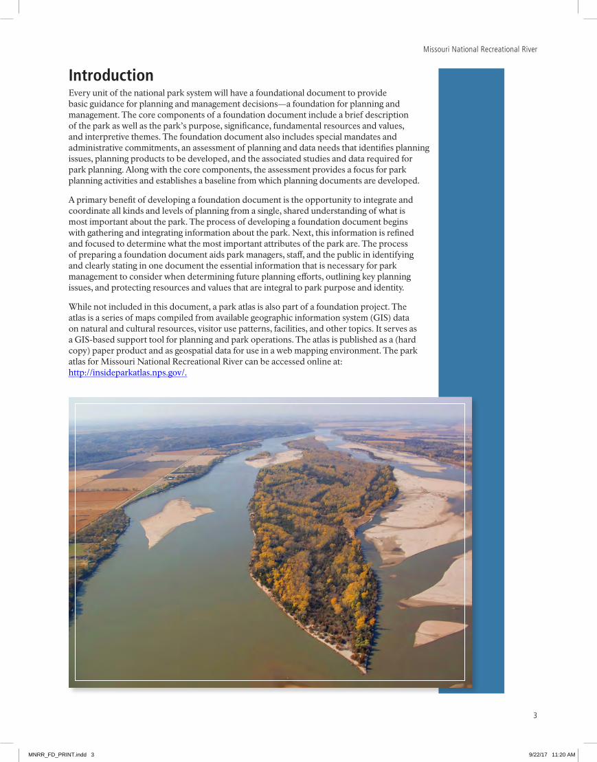
While not included in this document, a park atlas is also part of a foundation project. The atlas is a series of maps compiled from available geographic information system (GIS) data on natural and cultural resources, visitor use patterns, facilities, and other topics. It serves as a GIS-based support tool for planning and park operations. The atlas is published as a (hard copy) paper product and as geospatial data for use in a web mapping environment. The park atlas for Missouri National Recreational River can be accessed online at: http://insideparkatlas.nps.gov/.
MNRR_FD_PRINT.indd 3 9/22/17 11:20 AM
Foundation Document
4
Part 1: Core ComponentsThe core components of a foundation document include a brief description of the park, park purpose, significance statements, fundamental resources and values, and interpretive themes. These components are core because they typically do not change over time. Core components are expected to be used in future planning and management efforts.
Brief Description of the ParkThe Missouri River begins at the juncture of three tributaries at Three Forks, Montana, and flows southeast for 2,341 miles before joining the Mississippi River a few miles north of St. Louis, Missouri. It is the longest river in North America. The river is harnessed in its upper and middle reaches by a series of six multipurpose dams and reservoirs, and in its lower reaches it has been channelized for navigational purposes.
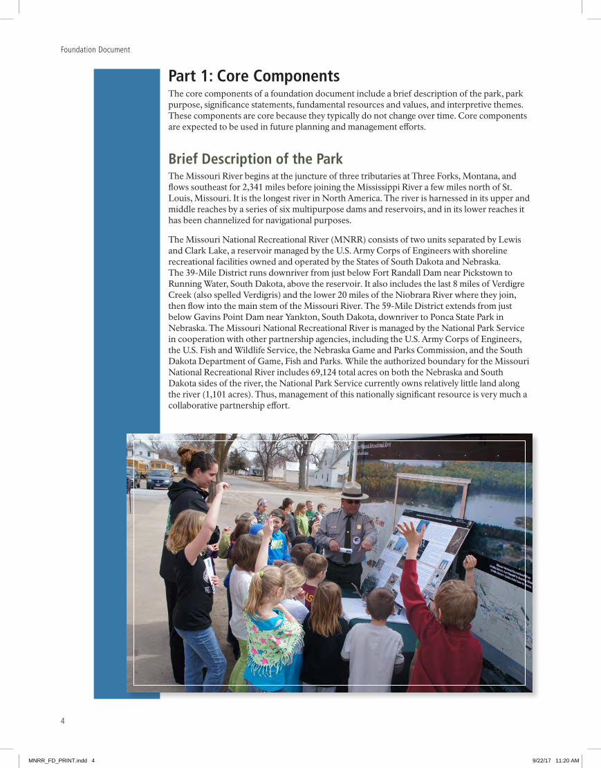
The Missouri National Recreational River (MNRR) consists of two units separated by Lewis and Clark Lake, a reservoir managed by the U.S. Army Corps of Engineers with shoreline recreational facilities owned and operated by the States of South Dakota and Nebraska. The 39-Mile District runs downriver from just below Fort Randall Dam near Pickstown to Running Water, South Dakota, above the reservoir. It also includes the last 8 miles of Verdigre Creek (also spelled Verdigris) and the lower 20 miles of the Niobrara River where they join, then flow into the main stem of the Missouri River. The 59-Mile District extends from just below Gavins Point Dam near Yankton, South Dakota, downriver to Ponca State Park in Nebraska. The Missouri National Recreational River is managed by the National Park Service in cooperation with other partnership agencies, including the U.S. Army Corps of Engineers, the U.S. Fish and Wildlife Service, the Nebraska Game and Parks Commission, and the South Dakota Department of Game, Fish and Parks. While the authorized boundary for the Missouri National Recreational River includes 69,124 total acres on both the Nebraska and South Dakota sides of the river, the National Park Service currently owns relatively little land along the river (1,101 acres). Thus, management of this nationally significant resource is very much a collaborative partnership effort.
MNRR_FD_PRINT.indd 4 9/22/17 11:20 AM
5
Missouri National Recreational River
While influenced by controlled releases from Fort Randall and Gavins Point Dams, the Missouri National Recreational River remains in a generally free-flowing condition. The 59-Mile District contains a wide, meandering channel, shifting sandbars, secondary channels, and some of the last remaining forested floodplain and floodplain wetland habitats on the Missouri River. The 39-Mile District is influenced by controlled releases from Fort Randall Dam for power generation known as “power peaking.” Forested chalkstone bluffs adjacent to gently rolling to flat agricultural bottomland mark both the Nebraska and South Dakota shorelines.
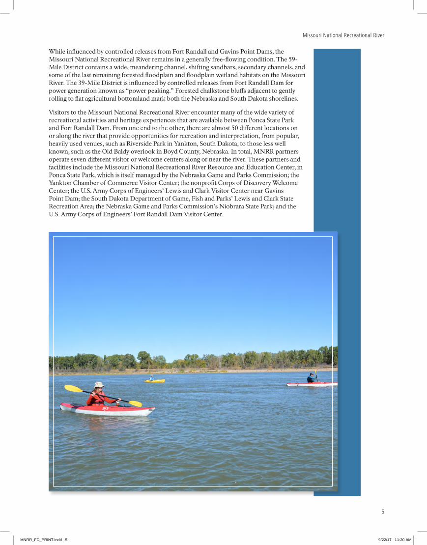
Visitors to the Missouri National Recreational River encounter many of the wide variety of recreational activities and heritage experiences that are available between Ponca State Park and Fort Randall Dam. From one end to the other, there are almost 50 different locations on or along the river that provide opportunities for recreation and interpretation, from popular, heavily used venues, such as Riverside Park in Yankton, South Dakota, to those less well known, such as the Old Baldy overlook in Boyd County, Nebraska. In total, MNRR partners operate seven different visitor or welcome centers along or near the river. These partners and facilities include the Missouri National Recreational River Resource and Education Center, in Ponca State Park, which is itself managed by the Nebraska Game and Parks Commission; the Yankton Chamber of Commerce Visitor Center; the nonprofit Corps of Discovery Welcome Center; the U.S. Army Corps of Engineers’ Lewis and Clark Visitor Center near Gavins Point Dam; the South Dakota Department of Game, Fish and Parks’ Lewis and Clark State Recreation Area; the Nebraska Game and Parks Commission’s Niobrara State Park; and the U.S. Army Corps of Engineers’ Fort Randall Dam Visitor Center.
MNRR_FD_PRINT.indd 5 9/22/17 11:20 AM

Foundation Document
6
Park PurposeThe purpose statement identifies the specific reason(s) for establishment of a particular park. The purpose statement for Missouri National Recreational River was drafted through a careful analysis of its enabling legislation and the legislative history that influenced its development. The park was established when the enabling legislation adopted by Congress was signed into law on November 10, 1978 (see appendix A for enabling legislation). The purpose statement lays the foundation for understanding what is most important about the park.
The purpose of the Missouri NatioNal recreatioNal river is to collaboratively
work with multiple stakeholders to preserve and protect the natural, cultural, and
recreational values of the last unchannelized and unimpounded segments of North
America’s longest river along the South Dakota and Nebraska border.
MNRR_FD_PRINT.indd 6 9/22/17 11:20 AM
7
Missouri National Recreational River
Park SignificanceSignificance statements express why a park’s resources and values are important enough to merit designation as a unit of the national park system. These statements are linked to the purpose of Missouri National Recreational River, and are supported by data, research, and consensus. Statements of significance describe the distinctive nature of the park and why an area is important within a global, national, regional, and systemwide context. They focus on the most important resources and values that will assist in park planning and management.
The following significance statements have been identified for Missouri National Recreational River. (Please note that the sequence of the statements does not reflect the level of significance.)
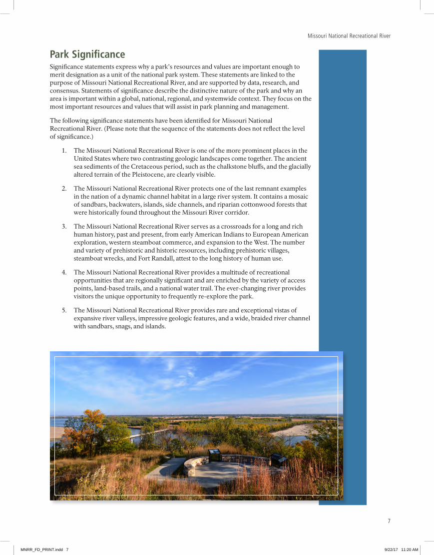
1. The Missouri National Recreational River is one of the more prominent places in the United States where two contrasting geologic landscapes come together. The ancient sea sediments of the Cretaceous period, such as the chalkstone bluffs, and the glacially altered terrain of the Pleistocene, are clearly visible.
2. The Missouri National Recreational River protects one of the last remnant examples in the nation of a dynamic channel habitat in a large river system. It contains a mosaic of sandbars, backwaters, islands, side channels, and riparian cottonwood forests that were historically found throughout the Missouri River corridor.
3. The Missouri National Recreational River serves as a crossroads for a long and rich human history, past and present, from early American Indians to European American exploration, western steamboat commerce, and expansion to the West. The number and variety of prehistoric and historic resources, including prehistoric villages, steamboat wrecks, and Fort Randall, attest to the long history of human use.
4. The Missouri National Recreational River provides a multitude of recreational opportunities that are regionally significant and are enriched by the variety of access points, land-based trails, and a national water trail. The ever-changing river provides visitors the unique opportunity to frequently re-explore the park.
5. The Missouri National Recreational River provides rare and exceptional vistas of expansive river valleys, impressive geologic features, and a wide, braided river channel with sandbars, snags, and islands.
MNRR_FD_PRINT.indd 7 9/22/17 11:20 AM
Foundation Document
8
Fundamental Resources and ValuesFundamental resources and values (FRVs) are those features, systems, processes, experiences, stories, scenes, sounds, smells, or other attributes determined to warrant primary consideration during planning and management processes because they are essential to achieving the purpose of the park and maintaining its significance. Fundamental resources and values are closely related to a park’s legislative purpose and are more specific than significance statements. For park units with wild and scenic river designations (or proposed designations), elements of the river’s outstandingly remarkable values are a fundamental part of a park unit’s resources and values.
Fundamental resources and values help focus planning and management efforts on what is truly significant about the park. One of the most important responsibilities of NPS managers is to ensure the conservation and public enjoyment of those qualities that are essential (fundamental) to achieving the purpose of the park and maintaining its significance. If fundamental resources and values are allowed to deteriorate, the park purpose and/or significance could be jeopardized.
The following fundamental resources and values (which are the same as the river’s outstandingly remarkable values) have been identified for Missouri National Recreational River:
· Cultural Values. The number and variety of prehistoric and historic resources along the river attest to the more than 10,000 years of human use. Archeological sites, prehistoric villages, steamboat wrecks, remnants of early efforts to control the river, and ethnic settlements highlight the significance of the river to a diversity of cultures over time. Four sites are listed in the National Register of Historic Places: Ponca Agency, Spirit Mound, Old Baldy, and Fort Randall. Wild food gathering, hunting, trapping, and fishing remain important activities to native peoples. These same resources made it an attractive homeland for American Indians and the subsequent homesteaders. The area between the Niobrara River and Verdigre Creek is particularly rich with sites important to the long-time inhabitants of the area and representative of early European settlement in the region.
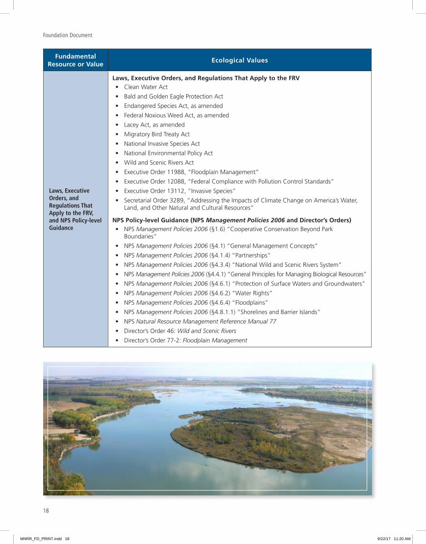
· Ecological Values. The dynamically active channels of the three major waterways of the Missouri National Recreational River (Missouri and Niobrara Rivers and Verdigre Creek) retain high-quality channel complexity with a diverse mosaic of channel habitats. These include numerous backwaters, chutes, sandbars, islands, and wetlands, which are regionally unique due to their number and extent. Extensive and mature lowland forests and large patches of intact remnant forests are abundant within the designated portions of the river, providing an outstanding contiguous corridor for many wildlife species. The area also contains prairies that provide habitat complexity and increased biodiversity. The diverse habitats of these reaches of the Missouri River are generated by dynamic river processes that continue to shape the landscape and waterscape.
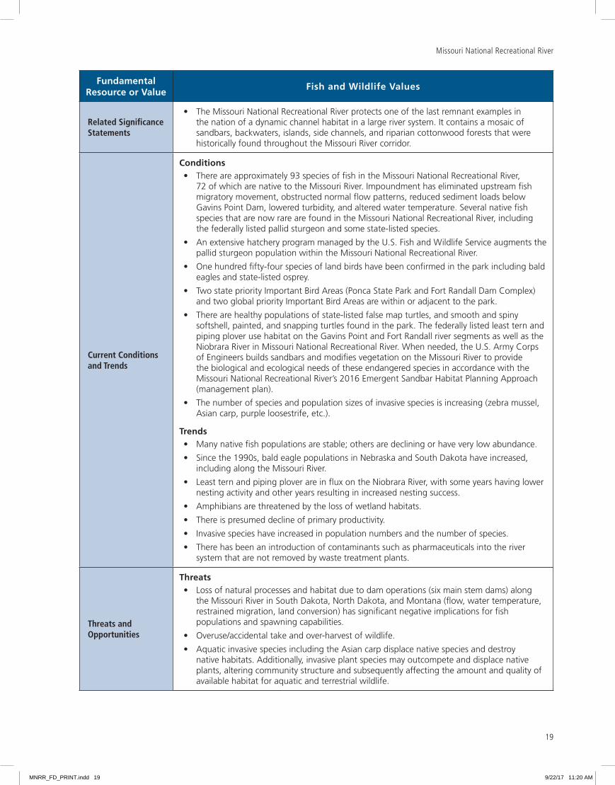
· Fish and Wildlife Values. The waters and adjacent lands of the Missouri National Recreational River support an abundance of birds, mammals, amphibians, reptiles, and insects within a diverse riparian community that does not exist in other channelized sections of the Missouri River or in reservoirs. This rare, intact assemblage is represented by more than 700 species of plants and more than 400 fish and wildlife species including the federally listed endangered and threatened piping plover, interior least tern, and pallid sturgeon. The in-river features and adjacent riparian woodlands host a multitude of migrating and nesting waterfowl, marsh birds, shorebirds, songbirds, and raptors, including the bald eagle.
MNRR_FD_PRINT.indd 8 9/22/17 11:20 AM
9
Missouri National Recreational River
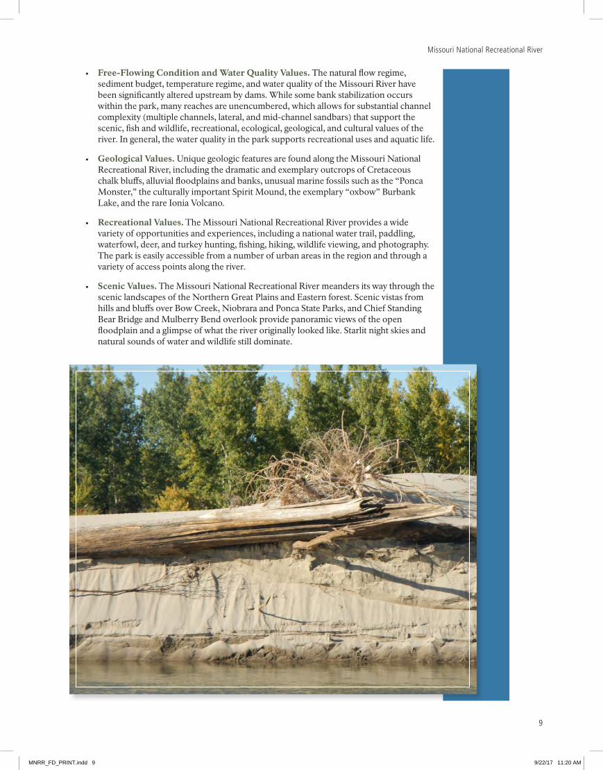
· Free-Flowing Condition and Water Quality Values. The natural flow regime, sediment budget, temperature regime, and water quality of the Missouri River have been significantly altered upstream by dams. While some bank stabilization occurs within the park, many reaches are unencumbered, which allows for substantial channel complexity (multiple channels, lateral, and mid-channel sandbars) that support the scenic, fish and wildlife, recreational, ecological, geological, and cultural values of the river. In general, the water quality in the park supports recreational uses and aquatic life.
· Geological Values. Unique geologic features are found along the Missouri National Recreational River, including the dramatic and exemplary outcrops of Cretaceous chalk bluffs, alluvial floodplains and banks, unusual marine fossils such as the “Ponca Monster,” the culturally important Spirit Mound, the exemplary “oxbow” Burbank Lake, and the rare Ionia Volcano.
· Recreational Values. The Missouri National Recreational River provides a wide variety of opportunities and experiences, including a national water trail, paddling, waterfowl, deer, and turkey hunting, fishing, hiking, wildlife viewing, and photography. The park is easily accessible from a number of urban areas in the region and through a variety of access points along the river.
· Scenic Values. The Missouri National Recreational River meanders its way through the scenic landscapes of the Northern Great Plains and Eastern forest. Scenic vistas from hills and bluffs over Bow Creek, Niobrara and Ponca State Parks, and Chief Standing Bear Bridge and Mulberry Bend overlook provide panoramic views of the open floodplain and a glimpse of what the river originally looked like. Starlit night skies and natural sounds of water and wildlife still dominate.
MNRR_FD_PRINT.indd 9 9/22/17 11:20 AM

Foundation Document
10
Interpretive ThemesInterpretive themes are often described as the key stories or concepts that visitors should understand after visiting a park—they define the most important ideas or concepts communicated to visitors about a park unit. Themes are derived from, and should reflect, park purpose, significance, resources, and values. The set of interpretive themes is complete when it provides the structure necessary for park staff to develop opportunities for visitors to explore and relate to all park significance statements and fundamental resources and values.
Interpretive themes are an organizational tool that reveal and clarify meaning, concepts, contexts, and values represented by park resources. Sound themes are accurate and reflect current scholarship and science. They encourage exploration of the context in which events or natural processes occurred and the effects of those events and processes. Interpretive themes go beyond a mere description of the event or process to foster multiple opportunities to experience and consider the park and its resources. These themes help explain why a park story is relevant to people who may otherwise be unaware of connections they have to an event, time, or place associated with the park.
The following interpretive themes have been identified for Missouri National Recreational River:
· Ecosystem/Free-Flowing River. Whereas the Missouri River was once a wild, meandering force for change cutting through the heart of America, the Missouri National Recreational River now protects rare stretches of this national treasure, which creates a landscape for healthy biodiversity, for the uplifting and inspiration of humanity, and to provide unique opportunities for the study of river dynamics and the resulting diverse habitats.
· Recreation. A network of interdependent partners provides a broad backdrop for a diversity of nature- and water-based activities that promote opportunities for visitors to escape daily life and engage in solitary, contemplative, and/or social recreational experiences at a variety of skill levels that will inspire, refresh, and invigorate them.
· Fish and Wildlife. The diversity of both abundant and rare species found at Missouri National Recreational River reflects the river’s complex ecosystems. These ecosystems are important not only for their biologic survival and ours, but also provide opportunities for research, recreation, appreciation, and lifelong learning not available elsewhere.
· Culture. In addition to its rich, multilayered 10,000 years of human history, the Missouri National Recreational River region is a living example of the ways in which people continue to struggle to balance the legal and cultural rights of individuals and communities with their impacts on the river’s natural processes. It also provides us with a place of reflection to consider where we ourselves stand in this delicate balance.
MNRR_FD_PRINT.indd 10 9/22/17 11:20 AM
11
Missouri National Recreational River
Part 2: Dynamic ComponentsThe dynamic components of a foundation document include special mandates and administrative commitments and an assessment of planning and data needs. These components are dynamic because they will change over time. New special mandates can be established and new administrative commitments made. As conditions and trends of fundamental resources and values change over time, the analysis of planning and data needs will need to be revisited and revised, along with key issues. Therefore, this part of the foundation document will be updated accordingly.
Special Mandates and Administrative CommitmentsMany management decisions for a park unit are directed or influenced by special mandates and administrative commitments with other federal agencies, state and local governments, utility companies, partnering organizations, and other entities. Special mandates are requirements specific to a park that must be fulfilled. Mandates can be expressed in enabling legislation, in separate legislation following the establishment of the park, or through a judicial process. They may expand on park purpose or introduce elements unrelated to the purpose of the park. Administrative commitments are, in general, agreements that have been reached through formal, documented processes, often through memorandums of agreement. Examples include easements, rights-of-way, arrangements for emergency service responses, etc. Special mandates and administrative commitments can support, in many cases, a network of partnerships that help fulfill the objectives of the park and facilitate working relationships with other organizations. They are an essential component of managing and planning for Missouri National Recreational River.
From PL 95-625 – November 10, 1978 (Title VII – Wild and Scenic Rivers Act Amendments)
· Sec. 707. Section 3(a)(22) – Cooperative agreement. The Secretary shall enter into a written cooperative agreement with the Secretary of the Army (acting through the Chief of Engineers) for construction and maintenance of bank stabilization work and appropriate recreational development.
· Sec. 707. Section 3(a)(22)(b) – Administration. The Secretary shall, to the extent, and in a manner consistent with this section.
(A) provide (i) for the construction by the United States of such recreation river features and streambank stabilization structures as the Secretary of the Army (acting through the Chief of Engineers) deems necessary and advisable in connection with the segment designated by this paragraph, and (ii) for the operation and maintenance of all streambank stabilization structures constructed in connection with such segment (including both structures constructed before the date of enactment of this paragraph and structures constructed after such date, and including both structures constructed under the authority of this section and structures constructed under the authority of any other Act); and
(B) permit access for such pumping and associated pipelines as may be necessary to assure an adequate supply of water for owners of land adjacent to such segment and for fish, wildlife, and recreational uses outside the river corridor established pursuant to this paragraph.
MNRR_FD_PRINT.indd 11 9/22/17 11:20 AM
Foundation Document
12
The streambank structures to be constructed and maintained under subparagraph (A) shall include, but not be limited to, structures at such sites as are specified with respect to such segment on pages 62 and 63 of the August 1977 Report, except that sites for such structures may be relocated to the extent deemed necessary by the Secretary of the Army (acting through the Chief of Engineers) by reason of physical changes in the river or river area. The Secretary of the Army (acting through the Chief of Engineers) shall condition the construction or maintenance of any streambank stabilization structure or of any recreational river feature at any site under subparagraph (A) (i) upon the availability to the United States of such land and interests in land in such ownership as he deems necessary to carry out such construction or maintenance and to protect and enhance the river in accordance with the purposes of this Act.
· Sec. 707. Section 3(a)(22)(b) – Lands and interests, acquisition. No interests, land or interests in land may be acquired without the consent of the owner: Provided, That not to exceed 5 per centum of the acreage within the designated river boundaries may be acquired in less than fee title without the consent of the owner, in such instance of the Secretary’s determination that activities are occurring, or threatening to occur thereon which constitute serious damage or threat to the integrity of the river corridor, in accordance with the values for which this river was designated.
From PL 100-534 – October 26, 1988 (Title V – Technical Change to Wild and Scenic Rivers Act)
· SEC. 501. (b) – Acreage limitations. The agency charged with the administration of each component of the national wild and scenic rivers system designated … shall, within one year from the date of designation … establish detailed boundaries therefor (which boundaries shall include an average of not more than 320 acres of land per mile measured from the ordinary high water mark on both sides of the river); and determine which of the classes outlined in … [the Wild and Scenic Act] best fit the river or its various segments.
From PL 102-50 – May 24, 1991 (Niobrara Scenic River Designation Act of 1991)
· SEC. 6. Missouri River Provisions. (b) – Bridges. The designation of the Missouri River segment … shall not place any additional requirements on the placement of bridges other than those contained in section 303 of title 49, United States Code.
· SEC. 6. Missouri River Provisions. (c) – Erosion control. Within the Missouri River segment designated … the Secretary shall permit the use of erosion control techniques, including the use of rocks from the area for streambank stabilization purposes, subject to such conditions as the Secretary may prescribe, in consultation with the advisory group … to protect the resource values for which such river segment was designated.
For more information about the existing administrative commitments for Missouri National Recreational River, please see appendix B.
MNRR_FD_PRINT.indd 12 9/22/17 11:20 AM

13
Missouri National Recreational River
Assessment of Planning and Data NeedsOnce the core components of part 1 of the foundation document have been identified, it is important to gather and evaluate existing information about the park’s fundamental resources and values, and develop a full assessment of the park’s planning and data needs. The assessment of planning and data needs section presents planning issues, the planning projects that will address these issues, and the associated information requirements for planning, such as resource inventories and data collection, including GIS data.
There are three sections in the assessment of planning and data needs:
1. analysis of fundamental resources and values
2. identification of key issues and associated planning and data needs
3. identification of planning and data needs (including spatial mapping activities or GIS maps)
The analysis of fundamental resources and values and identification of key issues leads up to and supports the identification of planning and data collection needs.
Analysis of Fundamental Resources and ValuesThe fundamental resource or value analysis table includes current conditions, potential threats and opportunities, planning and data needs, and selected laws and NPS policies related to management of the identified resource or value.
MNRR_FD_PRINT.indd 13 9/22/17 11:20 AM
Foundation Document
14
Fundamental Resource or Value
Cultural Values
Related Significance Statements
• The Missouri National Recreational River serves as a crossroads for a long and rich human history, past and present, from early American Indians to European American exploration, western steamboat commerce, expansion to the West The number and variety of prehistoric and historic resources, including prehistoric villages, steamboat wrecks, and Fort Randall, attest to the long history of human use
Current Conditions and Trends
Conditions• Fort Randall Historic Site – Fort Randall was once part of a string of frontier forts protecting
westward expansion efforts Remaining tangible elements include the Fort Randall Cemetery and Chapel The chapel is now nestled beneath a modern pavilion to protect it from further deterioration An overlook above the remains of the fort and chapel provides wayside exhibits and a panoramic view of the fort site, the dam, the river, and the U S Fish and Wildlife Service Karl Mundt National Wildlife Refuge, which was established to protect bald eagles (there is no public access to the refuge)
• Remnants of early efforts to control the river can still be seen today on and near NPS property (Green Island) in the form of wooden pilings These efforts include bank stabilization constructed by German prisoners of war during World War II
• There are archeological sites on NPS property (Mulberry Bend)
• Four sites within Missouri National Recreational River are listed in the National Register of Historic Places: Ponca Agency, Spirit Mound, Old Baldy, and Fort Randall
• American Indian cultural properties – Ponca tribal headquarters and earth lodge, Yankton Sioux tribal lands, and Treaty Monument of 1858
• The North Alabama steamboat site and the earth lodge depressions at Mulberry Bend are eligible for listing in the National Register of Historic Places
• Interpretative programming is offered for historic and cultural resources
• Flora and fauna are of cultural importance to native peoples Wild food gathering, hunting, trapping, and fishing remain important activities
Trends• There are limited partnerships and agreement with traditionally associated tribes; however,
new efforts such as the Traditional Cultural Property project, which was launched in the fall of 2016, aim at changing this
Threats and Opportunities
Threats• Limited access for tribal people to find culturally significant plants, etc
• Damage to cultural sites from limited maintenance and people
• Climate change may increase likelihood of extreme heat events, drought, flooding, erosion, invasive species, and cause a northward shift in native species ranges, all of which may alter the cultural landscape and associated values
Opportunities• Work with the three local traditionally associated tribes to establish a closer working
relationship for interpretation and education
• Provide a more diverse interpretive message
• Develop educational programming and outreach for tribal schools and for schools along the MNRR corridor to increase awareness and accentuate the link of what is now the Missouri National Recreational River to tribal heritage
• Protect sites/features through partners and conservation easements that protect cultural resources
• Expand understanding and partnership opportunities between traditionally associated tribes, the National Park Service, and other MNRR partners
MNRR_FD_PRINT.indd 14 9/22/17 11:20 AM
Missouri National Recreational River
15
Fundamental Resource or Value
Cultural Values
Existing Data and Plans Related to the FRV
• The NPS Midwest Archeological Center has GIS data of all known archeological sites in and around the park
• There are archeological surveys conducted by the NPS Midwest Archeological Center of most park property and surveys specific to Mulberry Arch Site and Green Island Pilings
Data and/or GIS Needs
• Detailed GIS imagery of all known steamboat wrecks and landings along the Missouri National Recreational River
Planning Needs • Comprehensive cultural resources management plan
Laws, Executive Orders, and Regulations That Apply to the FRV, and NPS Policy-level Guidance
Laws, Executive Orders, and Regulations That Apply to the FRV• American Indian Religious Freedom Act• Antiquities Act• Archeological and Historic Preservation Act• Archaeological Resources Protection Act• Historic Sites Act• Museum Properties Management Act, as amended• National Historic Preservation Act, as amended• Native American Graves Protection and Repatriation Act• Wild and Scenic Rivers Act• Executive Order 11593, “Protection and Enhancement of the Cultural Environment”• Executive Order 13007, “Indian Sacred Sites”• Secretarial Order 3289, “Addressing the Impacts of Climate Change on America’s Land,
Water, and Other Natural and Cultural Resources”• “National Register of Historic Places”(36 CFR 60)• “Curation of Federally-Owned and Administered Archaeological Collections”(36 CFR 79)• “Protection of Historic Properties”(36 CFR 800)
NPS Policy-level Guidance (NPS Management Policies 2006 and Director’s Orders)• NPS Management Policies 2006 (§4 3 4) “National Wild and Scenic Rivers System”• NPS Management Policies 2006 (chapter 5) “Cultural Resource Management”• Director’s Order 24: NPS Museum Collections Management• Director’s Order 28: Cultural Resource Management• Director’s Order 28A: Archeology• Director’s Order 46: Wild and Scenic Rivers• The Secretary of the Interior’s Standards and Guidelines for Archeology and Historic Preservation
MNRR_FD_PRINT.indd 15 9/22/17 11:20 AM
Foundation Document
16
Fundamental Resource or Value
Ecological Values
Related Significance Statements
• The Missouri National Recreational River protects one of the last remnant examples in the nation of a dynamic channel habitat in a large river system It contains a mosaic of sandbars, backwaters, islands, side channels, and riparian cottonwood forests that were historically found throughout the Missouri River corridor
Current Conditions and Trends
Conditions• Designated portions of the river have naturally created sandbars, large wooded islands, and
meandering channels
• As a result of dam construction on the Missouri River, bank erosion, channel migration rates, the extent of vegetated islands, and the distribution of sandbars have all significantly changed in the Missouri National Recreational River
• While cottonwood forests persist within the Missouri National Recreational River, natural regeneration has largely ceased in the Missouri River floodplain since the construction of the Missouri River Main Stem Reservoir System and Bank Stabilization and Navigation Project
• Since damming and channelization, the Missouri River has lost nearly all of its natural chutes, backwaters and shallow-water habitats
• Bank stabilization such as riprap exists and continues to be built The park has best management practices and techniques that guide the construction of new bank stabilization projects
• There is large woody debris in the river and along riverbanks
• There is delta formation and aggradation of the Niobrara River and upstream into the 39-Mile District due to Gavins Point Dam influences
• Water rights have been granted for surface withdrawals and wells for irrigation and other uses within the Niobrara basin
• Due to the presence of dams and reservoirs, the river’s flow, sediment loading, temperature, and nutrient regimes are highly altered from their natural condition
• Within riparian forests and prairies, the lack of flooding and periodic fire has allowed the native eastern redcedar to invade to the near exclusion of deciduous species, displacing bur oaks, grasses, and wildflowers
• Several invasive plant species are found along the Missouri River The worst invaders are the noxious weeds including saltcedar, purple loosestrife, and European common reed
Trends• Cottonwood forests are declining through lack of regeneration/recruitment Existing
cottonwood and willow stands are changing into later successional species compositions, including green ash, American elm, and boxelder
• Wetlands/backwaters are declining, but some restoration projects have been conducted
• Yearly bank stabilization maintenance and new revetment projects regularly occur The park continues to improve/define best management practices
• Loss of naturally created sandbars; unlikely to naturally rebuild without high-water events, which are rare due to the influence of dams and associated controlling operations
• Delta formation is continuing in the upper Lewis and Clark Lake area, including reaches of the Missouri River above the Gavins Point Dam due to sediment loading originating from the Niobrara River
MNRR_FD_PRINT.indd 16 9/22/17 11:20 AM
Missouri National Recreational River
17
Fundamental Resource or Value
Ecological Values
Threats and Opportunities
Threats• Fort Randall and Gavins Point Dams prevent the natural movement of sediment in the river,
increasing erosion rates in some areas and accelerating deposition in others Less sediment is available for natural sandbar building on the Missouri River segments due to Gavins Point and Fort Randall Dams
• The physical impediment of Gavins Point Dam has caused the Niobrara-Missouri Rivers confluence delta to develop and considerably raise the level of the river in this segment
• Lewis and Clark Lake/Reservoir, formed by Gavins Point Dam, has already reached 23% reduction in capacity due to sediment loading The rate of loading is estimated to be approximately 16,000 tons/day The Niobrara River contributes about one half of the sediment load (personal communication, Mark Sweeney, University of South Dakota) Without further sediment management intervention, including potential bypass methods, the lake is expected to reach 75% net reduction in capacity within 100 years
• Due to flow regulation, many habitats are threatened There is no flood pulse to create sandbars or bottomland forest growth, and there is also loss of fish spawning cue
• Bank stabilization limits the meandering channel
• A degrading channel limits shallow water habitats, meandering, etc
• The U S Army Corps of Engineers regulates flows to prevent floods and to allow navigation downstream There are conflicting river management objectives (dam purposes vs ecological needs)
• Land management (conversion to agricultural and residential)
• Reduced sediment input as a result of dams and bank stabilization
• Cold water releases from Fort Randall Dam threaten native fish populations that are adapted to the warm waters of the Missouri River
• Water right appropriations may reduce flow in the Niobrara River
Opportunities• Restore cottonwood riparian forests as part of a functional natural ecosystem
• Work with partners and landowners to manage lands for native plant communities and to promote regeneration and establishment
• Wetland/backwater restoration projects
• The Missouri River recovery management plan could return some natural flows and flow variability that mimics natural conditions as much as possible, which would yield many ecological benefits
Existing Data and Plans Related to the FRV
• Cottonwood management plan (U S Army Corps of Engineers) and cottonwood research
• Park’s property management plan
• Fire management plan
• Northern Great Plains Network exotic plant management plan
• Vegetation monitoring on and off park-owned properties (in process)
• Parkwide land bird monitoring (in process)
• Parkwide bat monitoring (ongoing)
• Multiple agencies monitoring fish, wildlife (waterfowl, turtles), and least tern and piping plovers
Data and/or GIS Needs
• Comprehensive bank stabilization baseline study and monitoring data
• Primary productivity studies
• River migration model (in progress)
Planning Needs • Comprehensive riverbank stabilization management plan and MNRR riparian stewardship strategy framework
MNRR_FD_PRINT.indd 17 9/22/17 11:20 AM
Foundation Document
18
Fundamental Resource or Value
Ecological Values
Laws, Executive Orders, and Regulations That Apply to the FRV, and NPS Policy-level Guidance
Laws, Executive Orders, and Regulations That Apply to the FRV• Clean Water Act
• Bald and Golden Eagle Protection Act
• Endangered Species Act, as amended
• Federal Noxious Weed Act, as amended
• Lacey Act, as amended
• Migratory Bird Treaty Act
• National Invasive Species Act
• National Environmental Policy Act
• Wild and Scenic Rivers Act
• Executive Order 11988, “Floodplain Management”
• Executive Order 12088, “Federal Compliance with Pollution Control Standards”
• Executive Order 13112, “Invasive Species”
• Secretarial Order 3289, “Addressing the Impacts of Climate Change on America’s Water, Land, and Other Natural and Cultural Resources”
NPS Policy-level Guidance (NPS Management Policies 2006 and Director’s Orders)• NPS Management Policies 2006 (§1 6) “Cooperative Conservation Beyond Park
Boundaries”
• NPS Management Policies 2006 (§4 1) “General Management Concepts”
• NPS Management Policies 2006 (§4 1 4) “Partnerships”
• NPS Management Policies 2006 (§4 3 4) “National Wild and Scenic Rivers System”
• NPS Management Policies 2006 (§4 4 1) “General Principles for Managing Biological Resources”
• NPS Management Policies 2006 (§4 6 1) “Protection of Surface Waters and Groundwaters”
• NPS Management Policies 2006 (§4 6 2) “Water Rights”
• NPS Management Policies 2006 (§4 6 4) “Floodplains”
• NPS Management Policies 2006 (§4 8 1 1) “Shorelines and Barrier Islands”
• NPS Natural Resource Management Reference Manual 77
• Director’s Order 46: Wild and Scenic Rivers
• Director’s Order 77-2: Floodplain Management
MNRR_FD_PRINT.indd 18 9/22/17 11:20 AM
Missouri National Recreational River
19
Fundamental Resource or Value
Fish and Wildlife Values
Related Significance Statements
• The Missouri National Recreational River protects one of the last remnant examples in the nation of a dynamic channel habitat in a large river system It contains a mosaic of sandbars, backwaters, islands, side channels, and riparian cottonwood forests that were historically found throughout the Missouri River corridor
Current Conditions and Trends
Conditions• There are approximately 93 species of fish in the Missouri National Recreational River,
72 of which are native to the Missouri River Impoundment has eliminated upstream fish migratory movement, obstructed normal flow patterns, reduced sediment loads below Gavins Point Dam, lowered turbidity, and altered water temperature Several native fish species that are now rare are found in the Missouri National Recreational River, including the federally listed pallid sturgeon and some state-listed species
• An extensive hatchery program managed by the U S Fish and Wildlife Service augments the pallid sturgeon population within the Missouri National Recreational River
• One hundred fifty-four species of land birds have been confirmed in the park including bald eagles and state-listed osprey
• Two state priority Important Bird Areas (Ponca State Park and Fort Randall Dam Complex) and two global priority Important Bird Areas are within or adjacent to the park
• There are healthy populations of state-listed false map turtles, and smooth and spiny softshell, painted, and snapping turtles found in the park The federally listed least tern and piping plover use habitat on the Gavins Point and Fort Randall river segments as well as the Niobrara River in Missouri National Recreational River When needed, the U S Army Corps of Engineers builds sandbars and modifies vegetation on the Missouri River to provide the biological and ecological needs of these endangered species in accordance with the Missouri National Recreational River’s 2016 Emergent Sandbar Habitat Planning Approach (management plan)
• The number of species and population sizes of invasive species is increasing (zebra mussel, Asian carp, purple loosestrife, etc )
Trends• Many native fish populations are stable; others are declining or have very low abundance
• Since the 1990s, bald eagle populations in Nebraska and South Dakota have increased, including along the Missouri River
• Least tern and piping plover are in flux on the Niobrara River, with some years having lower nesting activity and other years resulting in increased nesting success
• Amphibians are threatened by the loss of wetland habitats
• There is presumed decline of primary productivity
• Invasive species have increased in population numbers and the number of species
• There has been an introduction of contaminants such as pharmaceuticals into the river system that are not removed by waste treatment plants
Threats and Opportunities
Threats• Loss of natural processes and habitat due to dam operations (six main stem dams) along
the Missouri River in South Dakota, North Dakota, and Montana (flow, water temperature, restrained migration, land conversion) has significant negative implications for fish populations and spawning capabilities
• Overuse/accidental take and over-harvest of wildlife
• Aquatic invasive species including the Asian carp displace native species and destroy native habitats Additionally, invasive plant species may outcompete and displace native plants, altering community structure and subsequently affecting the amount and quality of available habitat for aquatic and terrestrial wildlife
MNRR_FD_PRINT.indd 19 9/22/17 11:20 AM

Foundation Document
20
Fundamental Resource or Value
Fish and Wildlife Values
Threats and Opportunities
Threats (continued)• Cold water release from Fort Randall Dam
• Power peaking from the Fort Randall hydroelectric dam releases more water to generate more power and the fluctuations in flow affect water level, velocity, temperature, and turbidity Daily water-level changes from both the Gavins Point and Fort Randall Dams are generally greater than 3 3 feet in the summer months, and can be particularly damaging for many fish and wildlife species’ habitats
• River channel degradation due to human-caused intervention, including bank stabilization, dam operations, development, and other intrusive actions over the course of the last 50+ years This causes the loss of important habitat such as wetlands, side channels, and backwaters
• Lack of cottonwood forest and habitat regeneration as these are used by rare, threatened, and endangered species
Opportunities• Restore aquatic populations and habitats
• Tap partner support for research, management, and funding opportunities
• Pursue research opportunities
• Control/manage invasive species
Existing Data and Plans Related to the FRV
• Parkwide land bird monitoring (in process)
• Parkwide bat monitoring (ongoing)
• Multiple agencies monitoring fish, wildlife (waterfowl during migration, turtles), and least tern and piping plovers
Data and/or GIS Needs
• Study and monitor impact of invasive species on native and threatened and endangered species
• Monitor species which are not listed as threatened or endangered
Planning Needs • Comprehensive river management and land protection plan
Laws, Executive Orders, and Regulations That Apply to the FRV, and NPS Policy-level Guidance
Laws, Executive Orders, and Regulations That Apply to the FRV• Clean Water Act
• Bald and Golden Eagle Protection Act
• Endangered Species Act, as amended
• Federal Noxious Weed Act, as amended
• Lacey Act, as amended
• Migratory Bird Treaty Act
• National Invasive Species Act
• National Environmental Policy Act
• Wild and Scenic Rivers Act
• Executive Order 11988, “Floodplain Management”
• Executive Order 13112, “Invasive Species”
• Secretarial Order 3289, “Addressing the Impacts of Climate Change on America’s Water, Land, and Other Natural and Cultural Resources”
MNRR_FD_PRINT.indd 20 9/22/17 11:20 AM
Missouri National Recreational River
21
Fundamental Resource or Value
Fish and Wildlife Values
Laws, Executive Orders, and Regulations That Apply to the FRV, and NPS Policy-level Guidance
NPS Policy-level Guidance (NPS Management Policies 2006 and Director’s Orders)• NPS Management Policies 2006 (§1 6) “Cooperative Conservation Beyond Park Boundaries”
• NPS Management Policies 2006 (§4 1) “General Management Concepts”
• NPS Management Policies 2006 (§4 1 4) “Partnerships”
• NPS Management Policies 2006 (§4 3 4) “National Wild and Scenic Rivers System”
• NPS Management Policies 2006 (§4 4 1) “General Principles for Managing Biological Resources”
• NPS Management Policies 2006 (§4 8 1 1) “Shorelines and Barrier Islands”
• NPS Natural Resource Management Reference Manual 77
• Director’s Order 46: Wild and Scenic Rivers
• Director’s Order 77-2: Floodplain Management
MNRR_FD_PRINT.indd 21 9/22/17 11:20 AM

Foundation Document
22
Fundamental Resource or Value
Free-Flowing Condition and Water Quality Values
Related Significance Statements
• The Missouri National Recreational River protects one of the last remnant examples in the nation of a dynamic channel habitat in a large river system It contains a mosaic of sandbars, backwaters, islands, side channels, and riparian cottonwood forests that were historically found throughout the Missouri River corridor
• The Missouri National Recreational River provides a multitude of recreational opportunities that are regionally significant and are enriched by the variety of access points, land-based trails, and a national water trail The ever-changing river provides visitors the unique opportunity to frequently re-explore the park
• The Missouri National Recreational River provides rare and exceptional vistas of expansive river valleys, impressive geologic features, and a wide, braided river channel with sandbars, snags, and islands
Current Conditions and Trends
Conditions• The Missouri National Recreational River is subject to decisions that are made by multiple
stakeholders including the U S Army Corps of Engineers, which operates the six Missouri River main stem reservoirs
• The Nebraska “2014 Clean Water Act Integrated Report” lists the Niobrara River and Verdigre, Bow, Ponca, and Steel Creeks as impaired due to the presence of excessive Escherichia coli (E coli) bacteria The Niobrara River, Ponca Creek, and Verdigre Creek are also listed as impaired by selenium Furthermore, the Niobrara River is listed as impaired by “Hazard Index Compounds” and Antelope Creek, Lewis and Clark Lake, and Verdigre Creek are listed as impaired
• “The 2014 South Dakota Integrated Report for Surface Water Quality Assessment” lists the Vermillion River from Baptist Creek to its mouth as impaired by excessive E coli and total suspended solids The James River from the Yankton County Line to its mouth is also listed as impaired by total suspended solids
• Recreation advisories are in place for the Niobrara River, Verdigre Creek, Ponca Creek, Bow Creek, Steel Creek, and the Vermillion River
• The Niobrara River has a fish consumption advisory in place
• The Missouri River, Niobrara River, and Verdigre Creek are designated by Nebraska as “State Resource Waters,” which means existing water quality will be maintained and protected unless the state, pursuant to Nebraska state statutes, decides lower water quality is in the economic or social interest of the area
• The main stem Missouri River meets all designated uses for both South Dakota and Nebraska
• Free-flowing condition – dams/impoundments
· Power peaking from the Fort Randall hydroelectric dam releases more water to generate more power and the fluctuations in flow affect water level, velocity, temperature, and turbidity
· Impoundment has eliminated upstream migratory movement, obstructed normal flow patterns, reduced sediment loads, lowered turbidity, and altered water temperature
• There is a joint application by the Nebraska Game and Parks Commission and the Niobrara River Basin Alliance to appropriate instream flows on the Niobrara River for conservation of fish, wildlife, and associated recreation
• A federal reserved water right for Missouri National Recreational River has not been adjudicated or quantified The state does not recognize federal water rights
• Excess nutrients enter MNRR water bodies via nonpoint source agricultural runoff
MNRR_FD_PRINT.indd 22 9/22/17 11:20 AM

Missouri National Recreational River
23
Fundamental Resource or Value
Free-Flowing Condition and Water Quality Values
Current Conditions and Trends
Trends• Missouri River main stem water quality is static
• Free-flow:
· Flow management from dams is unlikely to change
· Lateral migration is static to declining due to bank stabilization and channel incision
· Current discussion is about natural flow regime (Missouri River recovery management plan)
· No mechanically constructed emergent sandbar habitat has been built after the 2011 flood event However, the Missouri River recovery management plan / draft environmental impact statement released by the U S Army Corps of Engineers in December 2016 identified the mechanical creation of sandbars as being the preferred alternative to meet suitable nesting habitat in order to avoid jeopardy of two federally listed species (Interior Least Tern and piping plover)
Threats and Opportunities
Threats• Free-flow:
· Constrained flow from upstream dam operations
· Restrained fluvial processes
· Periodic reoccurring and new bank stabilization
• Water quality:
· Agricultural development poses risks to the river’s water quality because of contaminant runoff and wetland draining
· The Fort Randall Dam has the most significant effect on water temperatures, causing coldwater pollution downstream
· The Missouri River is affected by the water quality of its tributaries, most of which are impaired by one or more water quality parameters along the MNRR reach
· Point source discharge and nonpoint source runoff from urban landscapes is a threat related to coliform bacteria contamination in MNRR waters
· Excessive E coli – Niobrara River, Ponca Creek, Verdigre Creek, Bow Creek, Steel Creek, Vermillion River
· Endocrine disruptors
· Potential threats to recreation and aquatic life
Opportunities• Partnerships for basin/water quality management/improvement with Natural
Resources Conservation Service, Environmental Protection Agency, and state resource/environmental agencies
• Return to a more natural flow regime that would restore or move toward historic rates of sediment transport and deposition
• Collaboration in developing a long-term riverbank stabilization management plan and cumulative assessment
• Continued interaction with the Missouri River Recovery & Implementation Committee and the Missouri River Basin Interagency Roundtable in an effort to promote continued preservation and protection of the park’s outstandingly remarkable values, which cumulatively contributed to Congress designating the river as a recreational component of the National Wild and Scenic Rivers system
Existing Data and Plans Related to the FRV
• State monitoring programs
MNRR_FD_PRINT.indd 23 9/22/17 11:20 AM

Foundation Document
24
Fundamental Resource or Value
Free-Flowing Condition and Water Quality Values
Data and/or GIS Needs
• LiDAR
• Long-term water quality monitoring
• Sediment study
Planning Needs • Comprehensive river management and land protection plans
Laws, Executive Orders, and Regulations That Apply to the FRV, and NPS Policy-level Guidance
Laws, Executive Orders, and Regulations That Apply to the FRV• Clean Water Act
• Wild and Scenic Rivers Act
• Executive Order 11988, “Floodplain Management”
• Executive Order 12088, “Federal Compliance with Pollution Control Standards”
• Secretarial Order 3289, “Addressing the Impacts of Climate Change on America’s Water, Land, and Other Natural and Cultural Resources”
NPS Policy-level Guidance (NPS Management Policies 2006 and Director’s Orders)• NPS Management Policies 2006 (§4 3 4) “National Wild and Scenic Rivers System”
• NPS Management Policies 2006 (§4 6 1) “Protection of Surface Waters and Groundwaters”
• NPS Management Policies 2006 (§4 6 2) “Water Rights”
• NPS Management Policies 2006 (§4 6 4) “Floodplains”
• NPS Management Policies 2006 (§4 8 1 1) “Shorelines and Barrier Islands”
• Director’s Order 46: Wild and Scenic Rivers
• Director’s Order 77-2: Floodplain Management
MNRR_FD_PRINT.indd 24 9/22/17 11:20 AM
Missouri National Recreational River
25
Fundamental Resource or Value
Geological Values
Related Significance Statements
• The Missouri National Recreational River is one of the more prominent places in the United States where two contrasting geologic landscapes come together The ancient sea sediments of the Cretaceous period, such as the chalkstone bluffs and the glacially altered terrain of the Pleistocene, are clearly visible
Current Conditions and Trends
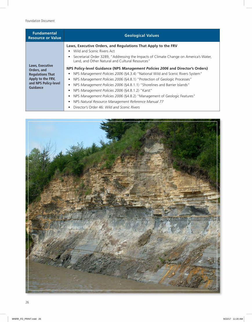
Conditions• Outcrops of rock formations deposited by an ancient sea are visible throughout the park
• There is an abundance of fossil-bearing rock formations
• The park protects a wide exposed floodplain
• Active geomorphic processes taking place in the river channel including constantly changing channel conditions create numerous features such as wetlands, sandbars, backwaters, chutes, developing floodplains, islands, and oxbow lakes
• The underlying geology of the area is glacially modified terrain
• The park protects special geologic features such as Old Baldy, Niobrara Delta, Spirit Mound, and Ionia Volcano
• The continued operation of upstream dams diverts sediment supply from the park and accelerates channel incision, except in the Niobrara Delta area which has channel aggradation due to Lewis and Clark Lake
• The lack of sediment in segments of the river continues to impact sandbar formation
Trends• There is continuous erosion of chalkstone bluffs
• The riverbed is degrading except at Niobrara and lower 39-Mile District
• There is disconnection of the river from the floodplain
Threats and Opportunities
Threats• Bluffs along the river are eroding and slumping
• Controlled flows minimize river and channel dynamics
• Vegetation overgrowth camouflages geological outcrops
Opportunities• Create additional interpretive signage for geologic features
• Analyze and document the geomorphic evolution of the Missouri River within the park
• Complete a full inventory and mapping of geologic resources within both the 39- and 59-Mile Districts of the park, including both the Nebraska and South Dakota sides of the river
• Increase and improve public access to geologic features
Existing Data and Plans Related to the FRV
• Various maps and reports produced by U S Geological Survey, South Dakota Geological Survey, and Nebraska Geological Survey
Data and/or GIS Needs
• High resolution aerial photography (ongoing need)
• Identify active slumping and erosion areas
• Identify potential resources for geologic study of the entire Missouri National Recreational River
• LiDAR
Planning Needs • None identified
MNRR_FD_PRINT.indd 25 9/22/17 11:20 AM
Foundation Document
26
Fundamental Resource or Value
Geological Values
Laws, Executive Orders, and Regulations That Apply to the FRV, and NPS Policy-level Guidance
Laws, Executive Orders, and Regulations That Apply to the FRV• Wild and Scenic Rivers Act
• Secretarial Order 3289, “Addressing the Impacts of Climate Change on America’s Water, Land, and Other Natural and Cultural Resources”
NPS Policy-level Guidance (NPS Management Policies 2006 and Director’s Orders)• NPS Management Policies 2006 (§4 3 4) “National Wild and Scenic Rivers System”
• NPS Management Policies 2006 (§4 8 1) “Protection of Geologic Processes”
• NPS Management Policies 2006 (§4 8 1 1) “Shorelines and Barrier Islands”
• NPS Management Policies 2006 (§4 8 1 2) “Karst”
• NPS Management Policies 2006 (§4 8 2) “Management of Geologic Features”
• NPS Natural Resource Management Reference Manual 77
• Director’s Order 46: Wild and Scenic Rivers
MNRR_FD_PRINT.indd 26 9/22/17 11:20 AM
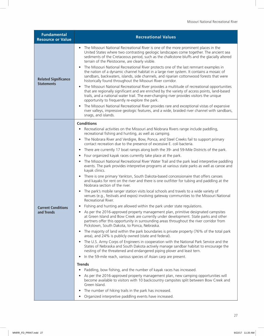
Missouri National Recreational River
27
Fundamental Resource or Value
Recreational Values
Related Significance Statements
• The Missouri National Recreational River is one of the more prominent places in the United States where two contrasting geologic landscapes come together The ancient sea sediments of the Cretaceous period, such as the chalkstone bluffs and the glacially altered terrain of the Pleistocene, are clearly visible
• The Missouri National Recreational River protects one of the last remnant examples in the nation of a dynamic channel habitat in a large river system It contains a mosaic of sandbars, backwaters, islands, side channels, and riparian cottonwood forests that were historically found throughout the Missouri River corridor
• The Missouri National Recreational River provides a multitude of recreational opportunities that are regionally significant and are enriched by the variety of access points, land-based trails, and a national water trail The ever-changing river provides visitors the unique opportunity to frequently re-explore the park
• The Missouri National Recreational River provides rare and exceptional vistas of expansive river valleys, impressive geologic features, and a wide, braided river channel with sandbars, snags, and islands
Current Conditions and Trends
Conditions• Recreational activities on the Missouri and Niobrara Rivers range include paddling,
recreational fishing and hunting, as well as camping
• The Niobrara River and Verdigre, Bow, Ponca, and Steel Creeks fail to support primary contact recreation due to the presence of excessive E coli bacteria
• There are currently 17 boat ramps along both the 39- and 59-Mile Districts of the park
• Four organized kayak races currently take place at the park
• The Missouri National Recreational River Water Trail and the park lead interpretive paddling events The park provides interpretive programs at various state parks as well as canoe and kayak clinics
• There is one primary Yankton, South Dakota-based concessionaire that offers canoes and kayaks for rent on the river and there is one outfitter for tubing and paddling at the Niobrara section of the river
• The park’s mobile ranger station visits local schools and travels to a wide variety of venues (e g , festivals and expos) involving gateway communities to the Missouri National Recreational River
• Fishing and hunting are allowed within the park under state regulations
• As per the 2016-approved property management plan, primitive designated campsites at Green Island and Bow Creek are currently under development State parks and other partners offer this opportunity in surrounding areas throughout the river corridor from Pickstown, South Dakota, to Ponca, Nebraska
• The majority of land within the park boundaries is private property (76% of the total park area), and 24% is publicly owned (state and federal)
• The U S Army Corps of Engineers in cooperation with the National Park Service and the States of Nebraska and South Dakota actively manage sandbar habitat to encourage the nesting of the threatened and endangered piping plover and least tern
• In the 59-mile reach, various species of Asian carp are present
Trends• Paddling, bow fishing, and the number of kayak races has increased
• As per the 2016-approved property management plan, new camping opportunities will become available to visitors with 10 backcountry campsites split between Bow Creek and Green Island
• The number of hiking trails in the park has increased
• Organized interpretive paddling events have increased
MNRR_FD_PRINT.indd 27 9/22/17 11:20 AM

Foundation Document
28
Fundamental Resource or Value
Recreational Values
Threats and Opportunities
Threats• Invasion of zebra mussels and Asian carp The introduction of zebra mussels poses a
significant risk to native mussels, as well as the entire ecosystem The expansion of Asian carp species represents a threat to native fish species
• Decreasing quality of river access due to reduced maintenance funding and river changes (channel degradation, shift in the location of the main channel)
• The fluctuations and inconsistencies in water levels occurring on a daily basis from power peaking at Fort Randall Dam represent a threat to the park’s recreational values including having enough water in the river to enjoy water-based recreation as well as affecting fish habitats and fishing opportunities
• Water with excessive E coli bacteria from the Niobrara River entering the 39-mile river segment
Opportunities• Increased education and public outreach on potential dangers of the river
• Increase public access to park resources including the 39-Mile District on the South Dakota side
• Improve existing public access
• Work with concessioners and service providers to align with NPS goals and the Missouri National Recreational River Strategic Plan: 2016–2021.
• Form tourism partnerships to help reach new visitors
• Planning to address what may become conflicting uses (e g , hunting and other visitor activities) in the river
• Work with the Friends of the Missouri National Recreational River to increase public access and visitor contact locations and otherwise promote and be an advocate for park mission, purpose, and vision
• Work with willing sellers to acquire key parcels of land within the park’s authorized boundary to better enhance recreational access and enjoyment by the public
Existing Data and Plans Related to the FRV
• Property management plan and environmental assessment (2016)
• Visitor study summer 2012 (2013)
• Several studies of river use (Treiman, et al , 2013 and Mestl, et al , 2010)
Data and/or GIS Needs
• Updated river map for public use
• Recreation study
• Collect data to record visitor satisfaction, perceptions, needs
Planning Needs• Commercial services strategy
• Comprehensive river management and land protection plans
Laws, Executive Orders, and Regulations That Apply to the FRV, and NPS Policy-level Guidance
Laws, Executive Orders, and Regulations That Apply to the FRV• Americans with Disabilities Act
• Architectural Barriers Act
• “Americans with Disabilities Act (ADA) Accessibility Guidelines for Buildings and Facilities; Architectural Barriers Act (ABA) Accessibility Guidelines” (36 CFR 1191)
• National Park Service Concessions Management Improvement Act
• Wild and Scenic Rivers Act
• “Concession Contracts” (36 CFR 51)
• Secretarial Order 3289, “Addressing the Impacts of Climate Change on America’s Water, Land, and Other Natural and Cultural Resources”
MNRR_FD_PRINT.indd 28 9/22/17 11:20 AM

Missouri National Recreational River
29
Fundamental Resource or Value
Recreational Values
Laws, Executive Orders, and Regulations That Apply to the FRV, and NPS Policy-level Guidance
NPS Policy-level Guidance (NPS Management Policies 2006 and Director’s Orders)• NPS Management Policies 2006 (§4 3 4) “National Wild and Scenic Rivers System”
• NPS Management Policies 2006 (chapter 7) “Interpretation and Education”
• NPS Management Policies 2006 (chapter 8) “Use of the Parks”
• NPS Management Policies 2006 (chapter 9) “Park Facilities”
• NPS Management Policies 2006 (chapter 10) “Commercial Visitor Services”
• Director’s Order 6: Interpretation and Education
• Director’s Order 42: Accessibility for Visitors with Disabilities in National Park Service Programs and Services
• Director’s Order 46: Wild and Scenic Rivers
• Director’s Order 48A: Concession Management
• Director’s Order 48B: Commercial Use Authorizations
• NPS Transportation Planning Guidebook
MNRR_FD_PRINT.indd 29 9/22/17 11:20 AM
Foundation Document
30
Fundamental Resource or Value
Scenic Values
Related Significance Statements
• The Missouri National Recreational River provides a multitude of recreational opportunities that are regionally significant and are enriched by the variety of access points, land-based trails, and a national water trail The ever-changing river provides visitors the unique opportunity to frequently re-explore the park
• The Missouri National Recreational River provides rare and exceptional vistas of expansive river valleys, impressive geologic features, and a wide, braided river channel with sandbars, snags, and islands
Current Conditions and Trends
Conditions• Human development in and around the river has altered the viewshed in the form of dams,
bridges, boat landings/access points, bank stabilization structures, and residential and commercial development While intrusive to the natural setting, some of these obstructions (e g , bridges and boat landings) enhance the recreational qualities of the Missouri National Recreational River The park strives to keep natural views intact to the greatest degree possible and is active in maintaining and improving the viewshed of the river
• Private landowners and other federal, state, and local entities own most of the land surrounding the river
• The park performs, organizes, and participates in river clean-up events to improve the viewshed by the removal of garbage and other anthropogenic debris
• Impressive overlooks and vistas of the Missouri River corridor reveal the river’s character: wide, sandbars, islands, etc
• Natural sounds are still prominent throughout the park Development, trails, roads, bridges, occasional air traffic, and recreational usage, including motor boats and other motorized personal watercraft, are the main sources of soundscape impacts
• There are low levels of light pollution, primarily related to areas of residential use Visitors have opportunities to experience unencumbered night skies
• The park contains contrasting geological landscapes from a wide, meandering channel, shifting sandbars, secondary channels, and some of the last remaining forested floodplain and floodplain wetland habitats on the Missouri River to chalkstone bluffs adjacent to gently rolling and flat agricultural bottomlands
• The park currently provides interpretative programming on “night sky ”
Trends• Development adjacent to river shoreline areas has the potential to increase due to extent of
private land ownership
• Growing awareness within the adjacent communities that the park is special with regard to viewing the free-flowing Missouri River and outstandingly remarkable values represented through MNRR designation
Threats and Opportunities
Threats• Increased erosion control / bank stabilization is likely to be exacerbated over time
• Noise intrusion from human-caused sources (e g , motor boats, overflights/aircraft, etc )
• Light intrusion from adjacent towns and cities that may reduce the ability to view the dark night sky
• Increased extent of land conversion to agricultural lands with its associated removal of trees could impact river corridor vistas
• Increased riparian development could impact the river corridor character and acoustic environment
MNRR_FD_PRINT.indd 30 9/22/17 11:20 AM
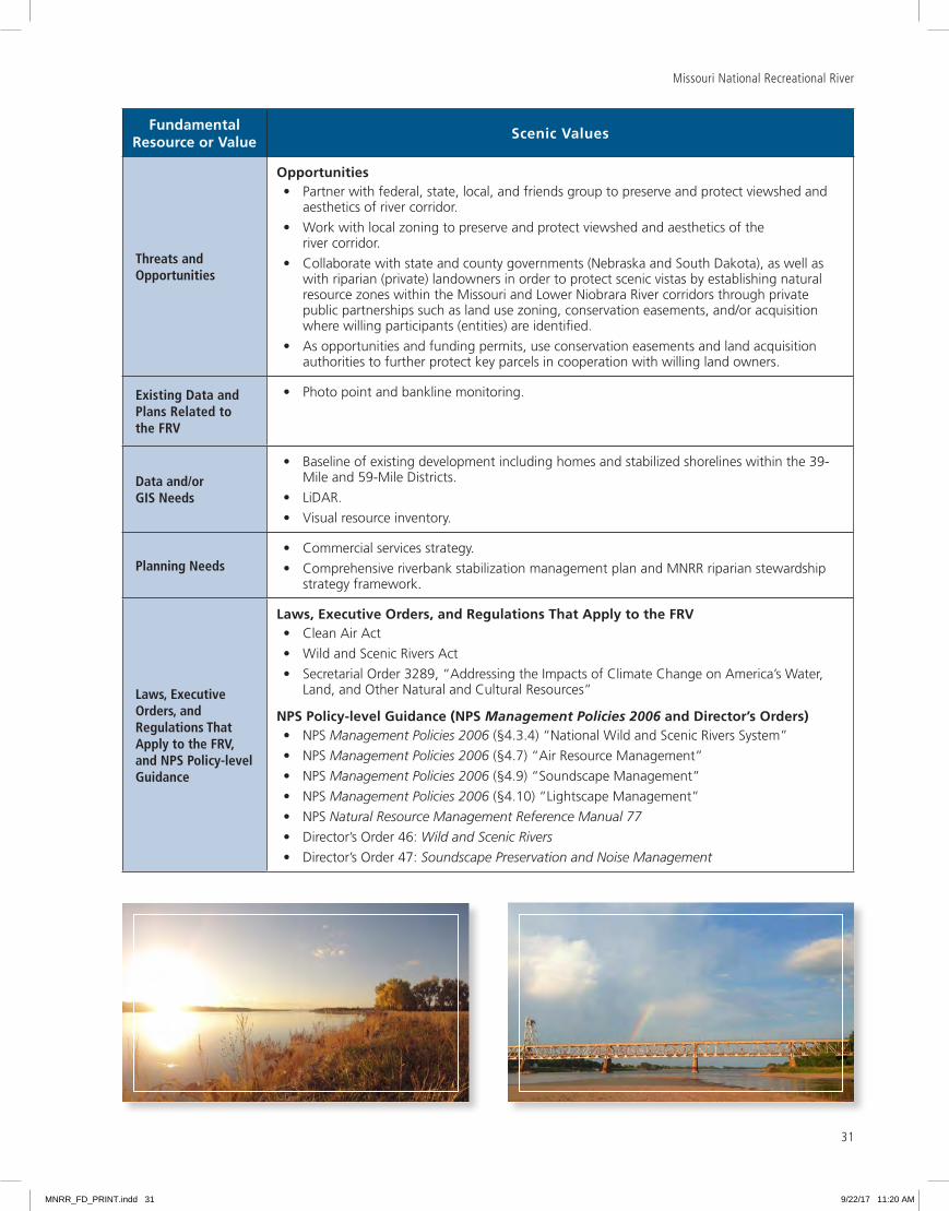
Missouri National Recreational River
31
Fundamental Resource or Value
Scenic Values
Threats and Opportunities
Opportunities• Partner with federal, state, local, and friends group to preserve and protect viewshed and
aesthetics of river corridor
• Work with local zoning to preserve and protect viewshed and aesthetics of the river corridor
• Collaborate with state and county governments (Nebraska and South Dakota), as well as with riparian (private) landowners in order to protect scenic vistas by establishing natural resource zones within the Missouri and Lower Niobrara River corridors through private public partnerships such as land use zoning, conservation easements, and/or acquisition where willing participants (entities) are identified
• As opportunities and funding permits, use conservation easements and land acquisition authorities to further protect key parcels in cooperation with willing land owners
Existing Data and Plans Related to the FRV
• Photo point and bankline monitoring
Data and/or GIS Needs
• Baseline of existing development including homes and stabilized shorelines within the 39-Mile and 59-Mile Districts
• LiDAR
• Visual resource inventory
Planning Needs• Commercial services strategy
• Comprehensive riverbank stabilization management plan and MNRR riparian stewardship strategy framework
Laws, Executive Orders, and Regulations That Apply to the FRV, and NPS Policy-level Guidance
Laws, Executive Orders, and Regulations That Apply to the FRV• Clean Air Act
• Wild and Scenic Rivers Act
• Secretarial Order 3289, “Addressing the Impacts of Climate Change on America’s Water, Land, and Other Natural and Cultural Resources”
NPS Policy-level Guidance (NPS Management Policies 2006 and Director’s Orders)• NPS Management Policies 2006 (§4 3 4) “National Wild and Scenic Rivers System”
• NPS Management Policies 2006 (§4 7) “Air Resource Management”
• NPS Management Policies 2006 (§4 9) “Soundscape Management”
• NPS Management Policies 2006 (§4 10) “Lightscape Management”
• NPS Natural Resource Management Reference Manual 77
• Director’s Order 46: Wild and Scenic Rivers
• Director’s Order 47: Soundscape Preservation and Noise Management
MNRR_FD_PRINT.indd 31 9/22/17 11:20 AM

Foundation Document
32
Identification of Key Issues and Associated Planning and Data NeedsThis section considers key issues to be addressed in planning and management and therefore takes a broader view over the primary focus of part 1. A key issue focuses on a question that is important for a park. Key issues often raise questions regarding park purpose and significance and fundamental resources and values. For example, a key issue may pertain to the potential for a fundamental resource or value in a park to be detrimentally affected by discretionary management decisions. A key issue may also address crucial questions that are not directly related to purpose and significance, but that still affect them indirectly. Usually, a key issue is one that a future planning effort or data collection needs to address and requires a decision by NPS managers.
The following are key issues for Missouri National Recreational River and the associated planning and data needs to address them:
· Management of Dam System. The U.S. Army Corps of Engineers operation of the six main stem dams has caused numerous ecosystem changes as well as impacts on individual species. Because the system is permanently altered, the historical flow regime that existed before construction of the dams has changed dramatically. In the 39-Mile District, a new ecosystem has been created with the deep-water reservoirs replacing the free-flowing river and inter-reservoir reaches affected by lower water temperatures and reduced sediment loads. In the 59-Mile District, channelization has eliminated sandbars, depth diversity, and river connections with off-channel side channels and backwaters. The historical flow regime has been transformed with spring high flows now captured in reservoirs and low summer and fall flows augmented with reservoir releases. The park will continue to collaborate with the U.S. Army Corps of Engineers with an emphasis on exploring the feasibility of updating the original 1980 cooperative agreement between agencies as stipulated in the park’s 1978 enabling legislation. Key aspects of the interagency working relationship between the U.S. Army Corps of Engineers and the National Park Service that merit additional clarification include: 1) bank stabilization permitting and budgeting; 2) river corridor conservation through easements and/or acquisition; and 3) general operations of overlapping interest including emergent sandbar habitat management.
· Water Rights. Upstream impoundments and diversions, compounded by additional development and cultivated lands along the Missouri River basin, severely reduce river flows reaching the park. The National Park Service has the authority to establish federal water rights in order to secure flows for environmental protection purposes. Current flows in the lower 20 miles of the Niobrara River that are included within park boundaries are dependent on upstream water uses and many of the efforts to secure a more natural flow regime would require coordination with the State of Nebraska and local stakeholders to explore ways to develop a legal framework that would incorporate the preservation of instream flows to maintain Niobrara River flows into the state-based instream flow water right. A comprehensive river management and land protection plan and long-term water quality monitoring would inform activities and coordination with other agencies and regional groups that would improve water quantity and quality.
· Bank Stabilization. Bank stabilization, or erosion control measures, are identified as acceptable practices within the park’s enabling legislation. Bank stabilization decreases the river meandering process and reduces the amount of woody debris introduced into the river system. Bank stabilization, in combination with other factors and processes, prevents the river from creating and maintaining new off-channel features, such as side channels and backwaters, thereby resulting in a loss of habitat. There is continued interest in identifying bank stabilization methods and processes that are acceptable for a nationally designated river. A comprehensive bank stabilization baseline study that includes work conducted prior to park establishment, monitoring data, as well as a bank stabilization database are data needs that would inform the management of this issue. A comprehensive riverbank stabilization management plan would help address this key parkwide issue.
MNRR_FD_PRINT.indd 32 9/22/17 11:20 AM
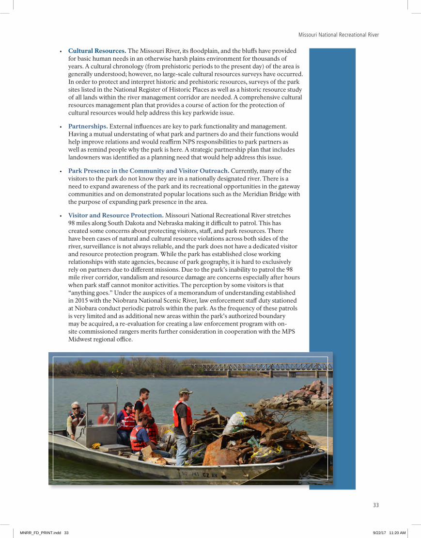
33
Missouri National Recreational River
· Cultural Resources. The Missouri River, its floodplain, and the bluffs have provided for basic human needs in an otherwise harsh plains environment for thousands of years. A cultural chronology (from prehistoric periods to the present day) of the area is generally understood; however, no large-scale cultural resources surveys have occurred. In order to protect and interpret historic and prehistoric resources, surveys of the park sites listed in the National Register of Historic Places as well as a historic resource study of all lands within the river management corridor are needed. A comprehensive cultural resources management plan that provides a course of action for the protection of cultural resources would help address this key parkwide issue.
· Partnerships. External influences are key to park functionality and management. Having a mutual understating of what park and partners do and their functions would help improve relations and would reaffirm NPS responsibilities to park partners as well as remind people why the park is here. A strategic partnership plan that includes landowners was identified as a planning need that would help address this issue.
· Park Presence in the Community and Visitor Outreach. Currently, many of the visitors to the park do not know they are in a nationally designated river. There is a need to expand awareness of the park and its recreational opportunities in the gateway communities and on demonstrated popular locations such as the Meridian Bridge with the purpose of expanding park presence in the area.
· Visitor and Resource Protection. Missouri National Recreational River stretches 98 miles along South Dakota and Nebraska making it difficult to patrol. This has created some concerns about protecting visitors, staff, and park resources. There have been cases of natural and cultural resource violations across both sides of the river, surveillance is not always reliable, and the park does not have a dedicated visitor and resource protection program. While the park has established close working relationships with state agencies, because of park geography, it is hard to exclusively rely on partners due to different missions. Due to the park’s inability to patrol the 98 mile river corridor, vandalism and resource damage are concerns especially after hours when park staff cannot monitor activities. The perception by some visitors is that “anything goes.” Under the auspices of a memorandum of understanding established in 2015 with the Niobrara National Scenic River, law enforcement staff duty stationed at Niobara conduct periodic patrols within the park. As the frequency of these patrols is very limited and as additional new areas within the park’s authorized boundary may be acquired, a re-evaluation for creating a law enforcement program with on-site commissioned rangers merits further consideration in cooperation with the MPS Midwest regional office.
MNRR_FD_PRINT.indd 33 9/22/17 11:20 AM
Foundation Document
34
· Land Protection. Land ownership within the park boundary is mixed among state and federal agencies and private holdings. The National Park Service currently owns relatively little land (1,101 acres) along the river and the different owners and managers have different emphasis and regulations regarding visitor uses and resource protection. This limits the park’s ability to provide direct visitor services and influence resource management. There is an opportunity to re-examine current land ownership and management within the boundary of the designated river, and to partner with others to increase direct NPS management in some locations. For example, the National Park Service is working with the States of South Dakota and Nebraska and the Bureau of Land Management to discuss prospective joint management arrangements concerning Goat Island near Vermillion, South Dakota. A management plan for Goat Island would guide future decisions for the island. The comprehensive river management and land protection plan would examine priorities for NPS management within the authorized boundaries of the river. The park could pursue conservation easements, land acquisition from willing sellers, and land exchanges. Increasing NPS management responsibilities would, however, also potentially result in a need to grow the law enforcement, resource protection, and visitor services staff functions of the park.
· Updating and Integrating Management Plans. The U.S. Army Corps of Engineers and U.S. Fish and Wildlife Service are developing a Missouri River recovery management plan/environmental impact statement, and the Missouri River Recovery Implementation Committee is advisor to the lead agencies with respect to review and comments concerning the plan. The National Park Service (Missouri National Recreational River) is working in partnership with the Missouri River Recovery Implementation Committee as a cooperating agency to provide guidance with respect to emergent sandbar habitat management.
To better manage park resources, the park’s upcoming resource condition assessments and resource stewardship strategies would provide additional information for management. A comprehensive riverbank stabilization management plan would provide landowners guidance on where and how riparian lands could be stabilized. All of these plans need to be integrated to ensure maximum resource protection and clarity for partners.
Planning and Data NeedsTo maintain connection to the core elements of the foundation and the importance of these core foundation elements, the planning and data needs listed here are directly related to protecting fundamental resources and values, park significance, and park purpose, as well as addressing key issues. To successfully undertake a planning effort, information from sources such as inventories, studies, research activities, and analyses may be required to provide adequate knowledge of park resources and visitor information. Such information sources have been identified as data needs. Geospatial mapping tasks and products are included in data needs.
Items considered of the utmost importance were identified as high priority, and other items identified, but not rising to the level of high priority, were listed as either medium- or low-priority needs. These priorities inform park management efforts to secure funding and support for planning projects.
MNRR_FD_PRINT.indd 34 9/22/17 11:20 AM

Missouri National Recreational River
35
Planning Needs – Where A Decision-Making Process Is Needed
Related to an FRV or Key Issue?
Planning Needs
Priority (H, M, L)
Notes
Ecological Values; Key Issue
Comprehensive riverbank stabilization management plan and MNRR riparian stewardship strategy framework
H This plan would be completed in cooperation with partners (e g , U S Army Corps of Engineers, Missouri River Bank Stabilization Association, etc ) There is continued interest in identifying riverbank stabilization methods that are acceptable and it is one of the more important issues facing the park There is a need to identify areas that had bank stabilization prior to park establishment and regulatory process to go about doing stabilization The plan would integrate climate change considerations The park received pre-NEPA funding in FY 2017 to further scope the merit of developing a comprehensive bank stabilization management plan A recommendation concerning pursuing full funding to complete the plan is expected in calendar year 2017
Cultural Values; Key Issue
Comprehensive cultural resources management plan
H This plan would provide specific guidance and set priorities for the long-term management of Missouri National Recreational River’s cultural resources and could involve intrapark cooperation with the Lewis and Clark National Historic Trail Having this plan would help work with collaborators to outline roles and functions and would help in continuing building the relationship with traditionally associated tribes and partners This plan would be an extension of the currently funded traditional cultural properties inventory
Fish and Wildlife Values; Free-Flowing Condition and Water Quality Values; Recreational Values; Key Issue
Comprehensive river management and land protection plans
H These plans would help substantiate park goals and form the basis for decision making A comprehensive river management plan is also mandated by the Wild and Scenic River Act The plans would look at instream flows and water quality, goals, desired future conditions, land development, and collaboration approach The plans would also address user capacity including the amount and type of visitor and administrative use the river can sustain while protecting and enhancing its outstandingly remarkable values, water quality, and free-flowing condition The plans would integrate climate change considerations
Key Issue Management plan for Goat Island
H This plan will address issues associated with visitor use, development needs, resource management, and the overall desired future conditions for the island
Key Issue Strategic partnership plan
M External influences are key to park operations and management Having a mutual understating of what everyone does and their roles and functions would help with the park strategic partnerships and would reaffirm the NPS responsibilities to park partners The plan would remind partners why the park was established The plan would include working with landowners
Key Issue Resource stewardship strategy
M This plan would provide comprehensive strategies designed to achieve and maintain the desired conditions of the park’s natural and cultural resources
Recreational Values; Scenic Values
Commercial services strategy
L Currently the park does not have concessions but may pursue the in the future Identifying the types of uses and opportunities that are compatible for the park would be a first step in this process Types of services could include canoe liveries and fishing and hunting guides The park wants to understand how many commercial entities are currently using the area and how the park would address commercial services in the future
MNRR_FD_PRINT.indd 35 9/22/17 11:20 AM
Foundation Document
36
Data Needs – Where Information Is Needed Before Decisions Can Be Made
Related to an FRV or Key Issue?
Data and GIS Needs
Priority (H, M, L)
Notes, Including Which Planning Need This Data Need Relates To
Recreational Values
Recreation study H It would be helpful to know the recreation that is happening, including when and where, what conflicts might exist with users and managers, and identify opportunities including when to conduct river management activities such as spraying invasive vegetation
Cultural Values Detail GIS imagery of all known steamboat wrecks and landings along the Missouri National Recreational River
H The Missouri River Institute has a project that started the process of gathering information on where some of the steamboat wrecks may be located; there are very few wrecks still on the river and having this information would be helpful for interpretation
Free-Flowing Condition and Water Quality Values; Key Issue,
Long-term water quality monitoring
H There are many partners working on this; the first step would be to synthesize and see if existing partner data and data sampling are adequate and sufficient
Ecological Values; Key Issue
Comprehensive bank stabilization baseline study and monitoring data
H The park completes bankline monitoring on a one- to two-year basis for the entire Missouri River segment of the Missouri National Recreational River Needs includes a data layer that maps historically bank-stabilized areas prior to establishment of the park and current areas where work is being done Combined, these two datasets and associated maps would serve as the baseline condition Ongoing monitoring would help record how conditions change throughout time, which would inform discussions with stakeholders on bank stabilization trends and associated impacts
Key Issue Bank stabilization database
M Currently the park incorporates comments made on section 10 and 404 permits issued by the U S Army Corps of Engineers into central files Given the reoccurrence of the park making comments on bank stabilization permits on a regular annual basis, there is a need to look back over time and further quantify how many permits have been issued to date, to what sections of river, and to what extent the recommended methods have been adopted Similarly, there is a need to reference park and/or U S Army Corps of Engineers regulatory files and determine to what extent after the fact, or no permits have been secured for bank stabilization purposes in either the 39- or 59-Mile Districts
Fish and Wildlife Values
Monitor species that are not listed as threatened or endangered
M There is a wealth of information related to threatened and endangered species within the park; however, there is limited information related to native species Having information on these species would help inform management actions and would help raise the public and partners’ awareness Information to be collected would include population trends and native species status (such as turtles, reptiles, fish)
MNRR_FD_PRINT.indd 36 9/22/17 11:20 AM
Missouri National Recreational River
37
Data Needs – Where Information Is Needed Before Decisions Can Be Made
Related to an FRV or Key Issue?
Data and GIS Needs
Priority (H, M, L)
Notes, Including Which Planning Need This Data Need Relates To
Fish and Wildlife Values
Study and monitor impact of invasive species on native and threatened and endangered species
M This would include a study of impacts of invasives on native species as well as monitoring ecosystem impacts; would clarify whether there is a problem and whether further planning is needed
Scenic Values Visual resource inventory
M This effort would include collecting information on what exists now and how it is changing over time Having a baseline would help work with park partners to help determine future conditions An inventory would identify observation points of significant viewsheds that could be used in discussion with partners and local groups to help prevent degradation
Key Issue Resource condition assessment
M Within existing boundaries, identify key habitat types and cultural sites, visitor access points Assessment would provide condition reporting for individual resources and would highlight resources in greatest need of management attention
Scenic Values Baseline of existing development including homes and stabilized shorelines within 39-Mile and 59-Mile Districts
M There is already a geodatabase that has this information; it may need to be updated
Key Issue Historic resource study
M The National Park Service currently owns relatively little land along the river corridor boundary; therefore, most of the cultural resources inside the park are owned by other entities including private owners A concise document that provides a historic overview/context, inventory of surviving historic resources and determines the extent to which those resources represent the river corridor historic context would greatly facilitate coordinating stewardship efforts with private owners, local community, and other partners The completed historic resource study would also serve as a tool for the continued development of park interpretive programs This study would inform the comprehensive cultural resource management plan, comprehensive river management and land protection plans, and the comprehensive riverbank stabilization management plan
Free-Flowing Condition and Water Quality Values
Sediment study M This study would compile sediment data that relates to Missouri National Recreational River and would look at the historical levels in these segments and current levels Furthermore, the study would identify sediment deficiencies (what is needed to return to more historical levels)
Recreational Values
Collect data to record visitor satisfaction, perceptions, needs
L Monitoring (replicate) visitor use satisfaction on five-year cycle and site specific survey that captures changing visitor amenities offered
MNRR_FD_PRINT.indd 37 9/22/17 11:20 AM
Foundation Document
38
Data Needs – Where Information Is Needed Before Decisions Can Be Made
Related to an FRV or Key Issue?
Data and GIS Needs
Priority (H, M, L)
Notes, Including Which Planning Need This Data Need Relates To
Geological Values
High resolution aerial photography (ongoing)
L This would help in tracking river conditions; information is already received from the U S Army Corps of Engineers once or twice per year
Geological Values
Identify active slumping and erosion areas
L Current bank stabilization monitoring provides this information about river dynamics and high energy areas to prioritize for restoration or protection efforts
Geological Values
Identify potential resources for geologic study of the entire Missouri National Recreational River
L Work with the NPS Geological Resources Division to continue process of scoping study and report on park geology
Free-Flowing Condition and Water Quality Values; Geological Values; Scenic Values
LiDAR L U S Army Corps of Engineers may already have this; would inform viewshed analysis
Recreational Values
River map for public use (update)
L The U S Army Corps of Engineers is in the process of updating the map
Ecological Values
River migration model (in progress)
L This model will inform the bank stabilization management plan An ongoing project with U S Geological Survey for this purpose was started in 2015
Ecological Values
Primary productivity studies
L For aquatic, trying to see if the river is being as productive as it should be and if it is not, then what the park and partners can do to help it
Key Issue Survey of park sites listed in the National Register of Historic Places
L These refer to field surveys that would yield information on the present condition of the sites listed in the National Register of Historic Places Having this information would facilitate coordinating stewardship efforts with private owners, local community, and other partners
MNRR_FD_PRINT.indd 38 9/22/17 11:20 AM

39
Missouri National Recreational River
Part 3: Contributors
Missouri National Recreational RiverRick Clark, Superintendent
Tina Hartz, Administrative Officer
Milton Haar, Chief of Science and Resources Management
Brian Korman, Lead Biological Science Technician, Science and Resources Management Division
Lisa Yager, Biologist, Science and Resources Management Division
Daniel Peterson, Chief of Interpretation, Education, and Outreach
Dugan Smith, Park Ranger Interpretation, Interpretation, Education, and Outreach Division
Laurie Wise, Administrative Officer (retired)
NPS Midwest RegionHector Santiago, Regional Rivers Coordinator
Anthony Gareau, Regional GIS Coordinator
Park PartnersTim Cowman, Natural Resources Administrator, South Dakota Geological Survey
Other NPS StaffMorgan Elmer, Project Manager, Denver Service Center, Planning Division
Brian D’Agosta, Contract Visual Information Specialist, Denver Service Center, Planning Division
Pam Holtman, Quality Assurance Coordinator, WASO Park Planning and Special Studies
Wanda Gray Lafferty, Contract Editor (former), Denver Service Center, Planning Division
Tatiana Márquez, Environmental and Natural Resource Economist, Denver Service Center, Planning Division
Nancy Shock, Foundation Coordinator, Denver Service Center, Planning Division
Laura Watt, Contract Editor, Denver Service Center, Planning Division
Photo CreditsPage: 15, © Sam Stukel, used by permission.
MNRR_FD_PRINT.indd 39 9/22/17 11:20 AM
Foundation Document
40
Appendixes
Appendix A: Enabling Legislation for Missouri National Recreational River
Establishment, PL 95-625, November 10, 1978 (Title VII - Wild and Scenic Rivers Act Amendments)
Nov. 10, 1978PL 95-625Establishment
MNRR_FD_PRINT.indd 40 9/22/17 11:20 AM
41
Missouri National Recreational River
PL 100-534 – October 26, 1988 (Title V – Technical Change to Wild and Scenic Rivers Act)
Establishment, PL 102-50, May 24, 1991
MNRR_FD_PRINT.indd 41 9/22/17 11:20 AM

Foundation Document
42
MNRR_FD_PRINT.indd 42 9/22/17 11:20 AM

43
Missouri National Recreational River
PL 102-50 – May 24, 1991 (Niobrara Scenic River Designation Act of 1991)
MNRR_FD_PRINT.indd 43 9/22/17 11:20 AM
Foundation Document
44
MNRR_FD_PRINT.indd 44 9/22/17 11:20 AM

45
Missouri National Recreational River
MNRR_FD_PRINT.indd 45 9/22/17 11:20 AM

Foundation Document
46
MNRR_FD_PRINT.indd 46 9/22/17 11:20 AM
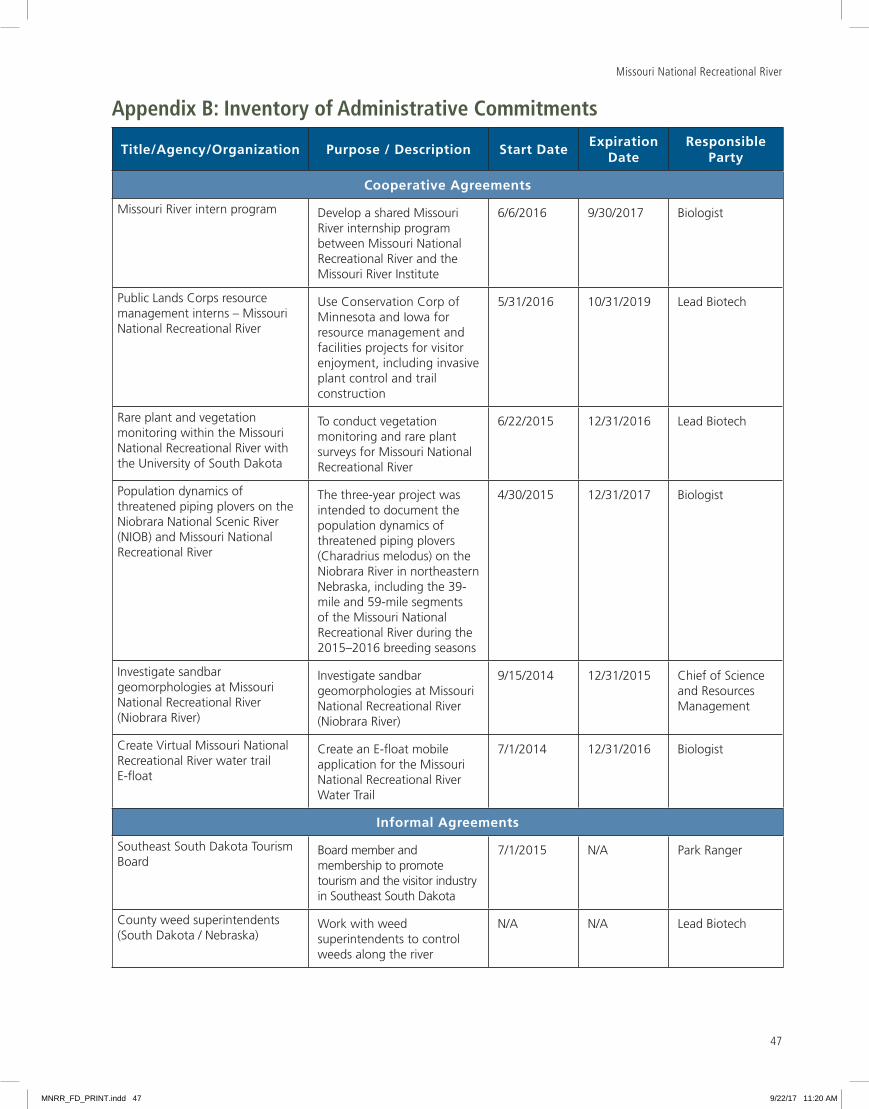
Missouri National Recreational River
47
Appendix B: Inventory of Administrative Commitments
Title/Agency/Organization Purpose / Description Start DateExpiration
DateResponsible
Party
Cooperative Agreements
Missouri River intern program Develop a shared Missouri River internship program between Missouri National Recreational River and the Missouri River Institute
6/6/2016 9/30/2017 Biologist
Public Lands Corps resource management interns – Missouri National Recreational River
Use Conservation Corp of Minnesota and Iowa for resource management and facilities projects for visitor enjoyment, including invasive plant control and trail construction
5/31/2016 10/31/2019 Lead Biotech
Rare plant and vegetation monitoring within the Missouri National Recreational River with the University of South Dakota
To conduct vegetation monitoring and rare plant surveys for Missouri National Recreational River
6/22/2015 12/31/2016 Lead Biotech
Population dynamics of threatened piping plovers on the Niobrara National Scenic River (NIOB) and Missouri National Recreational River
The three-year project was intended to document the population dynamics of threatened piping plovers (Charadrius melodus) on the Niobrara River in northeastern Nebraska, including the 39-mile and 59-mile segments of the Missouri National Recreational River during the 2015–2016 breeding seasons
4/30/2015 12/31/2017 Biologist
Investigate sandbar geomorphologies at Missouri National Recreational River (Niobrara River)
Investigate sandbar geomorphologies at Missouri National Recreational River (Niobrara River)
9/15/2014 12/31/2015 Chief of Science and Resources Management
Create Virtual Missouri National Recreational River water trail E-float
Create an E-float mobile application for the Missouri National Recreational River Water Trail
7/1/2014 12/31/2016 Biologist
Informal Agreements
Southeast South Dakota Tourism Board
Board member and membership to promote tourism and the visitor industry in Southeast South Dakota
7/1/2015 N/A Park Ranger
County weed superintendents (South Dakota / Nebraska)
Work with weed superintendents to control weeds along the river
N/A N/A Lead Biotech
MNRR_FD_PRINT.indd 47 9/22/17 11:20 AM
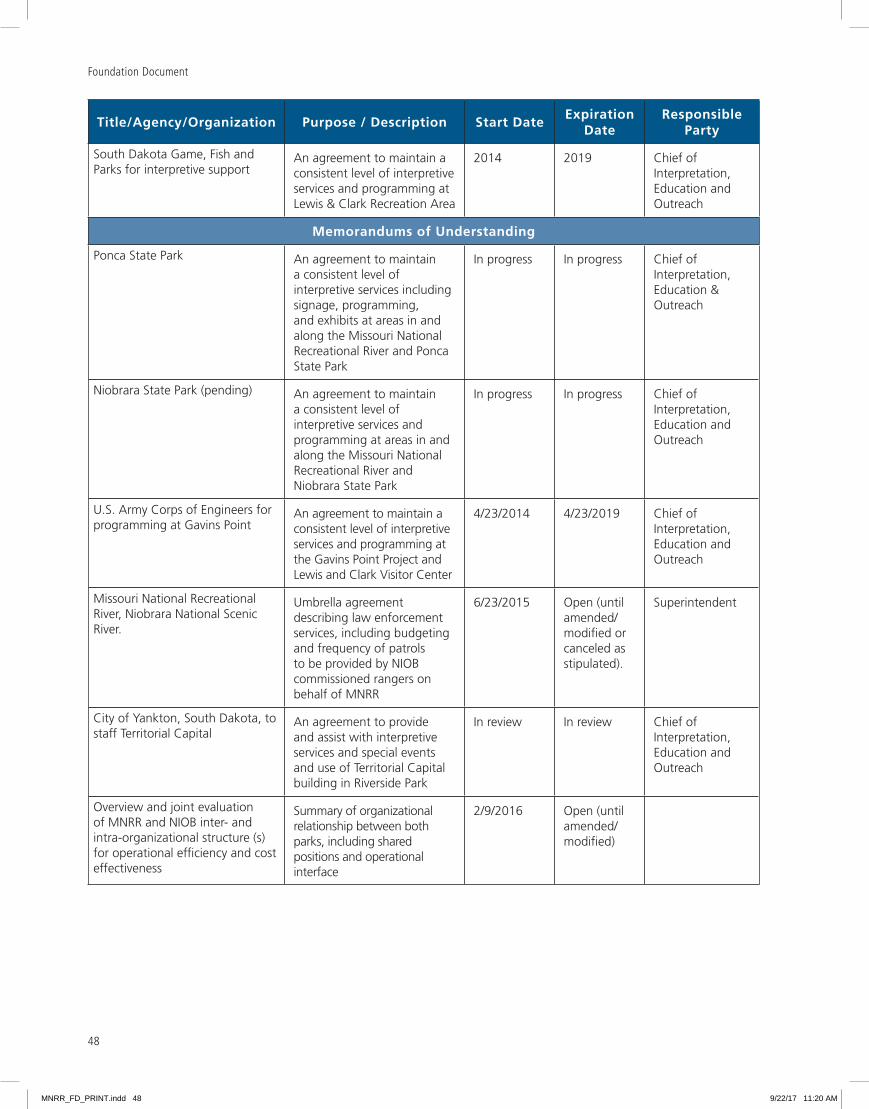
Foundation Document
48
Title/Agency/Organization Purpose / Description Start DateExpiration
DateResponsible
Party
South Dakota Game, Fish and Parks for interpretive support
An agreement to maintain a consistent level of interpretive services and programming at Lewis & Clark Recreation Area
2014 2019 Chief of Interpretation, Education and Outreach
Memorandums of Understanding
Ponca State Park An agreement to maintain a consistent level of interpretive services including signage, programming, and exhibits at areas in and along the Missouri National Recreational River and Ponca State Park
In progress In progress Chief of Interpretation, Education & Outreach
Niobrara State Park (pending) An agreement to maintain a consistent level of interpretive services and programming at areas in and along the Missouri National Recreational River and Niobrara State Park
In progress In progress Chief of Interpretation, Education and Outreach
U S Army Corps of Engineers for programming at Gavins Point
An agreement to maintain a consistent level of interpretive services and programming at the Gavins Point Project and Lewis and Clark Visitor Center
4/23/2014 4/23/2019 Chief of Interpretation, Education and Outreach
Missouri National Recreational River, Niobrara National Scenic River
Umbrella agreement describing law enforcement services, including budgeting and frequency of patrols to be provided by NIOB commissioned rangers on behalf of MNRR
6/23/2015 Open (until amended/modified or canceled as stipulated)
Superintendent
City of Yankton, South Dakota, to staff Territorial Capital
An agreement to provide and assist with interpretive services and special events and use of Territorial Capital building in Riverside Park
In review In review Chief of Interpretation, Education and Outreach
Overview and joint evaluation of MNRR and NIOB inter- and intra-organizational structure (s) for operational efficiency and cost effectiveness
Summary of organizational relationship between both parks, including shared positions and operational interface
2/9/2016 Open (until amended/modified)
MNRR_FD_PRINT.indd 48 9/22/17 11:20 AM

Missouri National Recreational River
49
Title/Agency/Organization Purpose / Description Start DateExpiration
DateResponsible
Party
Other
Friends of Missouri National Recreational River
To provide support and partnership to the park through program development and philanthropic activities to further promote and protect park resources as defined in the Friends Group Agreement
10/1/2016 9/30/2021 Regional Office and Superintendent
Nebraska Game and Parks Commission for boat ramp maintenance
For maintenance of Mulberry Bend boat ramp
4/10/2014 2/5/2018 Lead Biotech
South Dakota Game, Fish and Parks for boat ramp maintenance
For maintenance of Myron Grove and Clay County boat ramps
12/31/2013 2/11/2018 Lead Biotech
MNRR_FD_PRINT.indd 49 9/22/17 11:20 AM
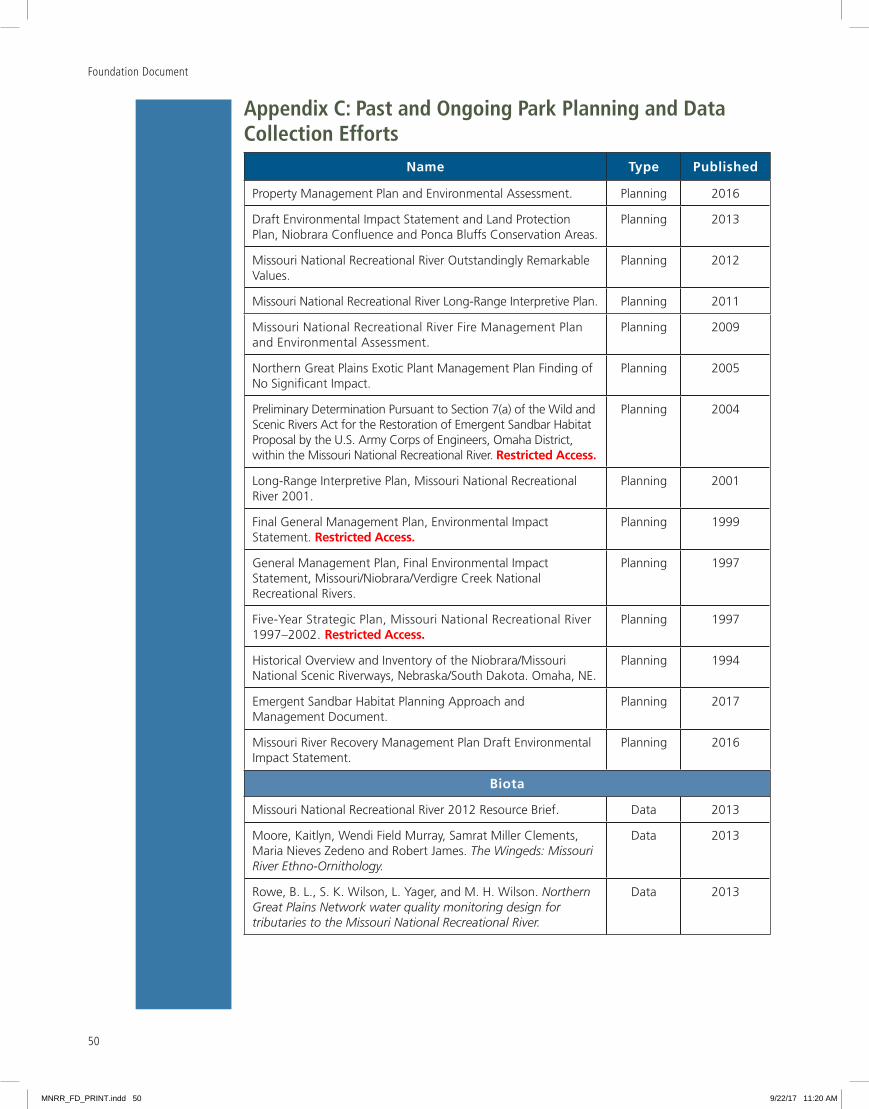
Foundation Document
50
Appendix C: Past and Ongoing Park Planning and Data Collection Efforts
Name Type Published
Property Management Plan and Environmental Assessment Planning 2016
Draft Environmental Impact Statement and Land Protection Plan, Niobrara Confluence and Ponca Bluffs Conservation Areas
Planning 2013
Missouri National Recreational River Outstandingly Remarkable Values
Planning 2012
Missouri National Recreational River Long-Range Interpretive Plan Planning 2011
Missouri National Recreational River Fire Management Plan and Environmental Assessment
Planning 2009
Northern Great Plains Exotic Plant Management Plan Finding of No Significant Impact
Planning 2005
Preliminary Determination Pursuant to Section 7(a) of the Wild and Scenic Rivers Act for the Restoration of Emergent Sandbar Habitat Proposal by the U S Army Corps of Engineers, Omaha District, within the Missouri National Recreational River Restricted Access.
Planning 2004
Long-Range Interpretive Plan, Missouri National Recreational River 2001
Planning 2001
Final General Management Plan, Environmental Impact Statement Restricted Access.
Planning 1999
General Management Plan, Final Environmental Impact Statement, Missouri/Niobrara/Verdigre Creek National Recreational Rivers
Planning 1997
Five-Year Strategic Plan, Missouri National Recreational River 1997–2002 Restricted Access.
Planning 1997
Historical Overview and Inventory of the Niobrara/Missouri National Scenic Riverways, Nebraska/South Dakota Omaha, NE
Planning 1994
Emergent Sandbar Habitat Planning Approach and Management Document
Planning 2017
Missouri River Recovery Management Plan Draft Environmental Impact Statement
Planning 2016
Biota
Missouri National Recreational River 2012 Resource Brief Data 2013
Moore, Kaitlyn, Wendi Field Murray, Samrat Miller Clements, Maria Nieves Zedeno and Robert James The Wingeds: Missouri River Ethno-Ornithology.
Data 2013
Rowe, B L , S K Wilson, L Yager, and M H Wilson Northern Great Plains Network water quality monitoring design for tributaries to the Missouri National Recreational River.
Data 2013
MNRR_FD_PRINT.indd 50 9/22/17 11:20 AM

51
Missouri National Recreational River
Name Type Published
Biota (continued)
Beaupré, K , R E Bennetts, J A Blakesley, K Gallo, D Hanni, A Hubbard, R Lock, B F Powell, H Sosinski, P Valentine-Darby, C White and M Wilson Landbird monitoring protocol and standard operating procedures for the Chihuahuan Desert, Northern Great Plains, Sonoran Desert, and Southern Plains Networks: Version 1.00.
Data 2013
Symstad, A J , R A Gitzen, C L Wienk, M R Bynum, D J Swanson, A D Thorstenson, and K J Paintner-Green Plant community composition and structure monitoring protocol for the Northern Great Plains I&M Network - Standard Operating Procedures: Version 1.01.
Data 2012
Symstad, A J , R A Gitzen, C L Wienk, M R Bynum, D J Swanson, A D Thorstenson, and K J Paintner-Green Plant community composition and structure monitoring protocol for the Northern Great Plains I&M Network: Version 1.01.
Data 2012
Rolfsmeier, S (2011 estimated date) Ponca State Park Vascular Plant Species List.
Data 2011
Tweet, J S , V L Santucci, and J P Kenworthy Paleontological resource inventory and monitoring: Northern Great Plains Network.
Data 2011
Sullivan, T J , T C McDonnell, G T McPherson, S D Mackey, and D Moore Evaluation of the sensitivity of inventory and monitoring national parks to nutrient enrichment effects from atmospheric nitrogen deposition: Northern Great Plains Network.
Data 2011
Sullivan, T J , G T McPherson, T C McDonnell, S D Mackey, and D Moore Evaluation of the sensitivity of inventory and monitoring national parks to acidification effects from atmospheric sulfur and nitrogen deposition: Northern Great Plains Network.
Data 2011
Sullivan, T J , G T McPherson, T C McDonnell, S D Mackey, and D Moore Evaluation of the sensitivity of inventory and monitoring national parks to acidification effects from atmospheric sulfur and nitrogen deposition: main report.
Data 2011
Stark, K J , L J Danzinger, M R Komp, A J Nadeau, S Amberg, E Iverson, D Kadlec, and B Drazkowski Missouri National Recreational River: Natural Resource Condition Assessment.
Data 2011
Graham, John Geologic Resource Inventory Scoping Summary Missouri National Recreational River, Nebraska/South Dakota.
Data 2008
Laustrup, M S , Jacobson, R B , and Simpkins, D G Distribution of potential spawning habitat for sturgeon in the Lower Missouri River.
Data 2007
Elliott, C M , and Jacobson, R B Geomorphic Classification and Assessment of Channel Dynamics in the Missouri National Recreational River, South Dakota and Nebraska.
Data 2006
Rust, Jill Establishing Baseline Data for Aquatic Resources in National Parks of the Northern Great Plains Network.
Data 2006
MNRR_FD_PRINT.indd 51 9/22/17 11:20 AM

Foundation Document
52
Name Type Published
Biota (continued)
A Survey for Nicrophorous americanus, Olivier “American Burying Beetle” on Sandbars and Islands in the Missouri National Recreational River
Data 2006
Lott, Casey A Distribution and abundance of the interior population of the Least Tern (Sterna antillarum), 2005: A review of the first complete range-wide survey in the context of historic and ongoing monitoring efforts.
Data 2006
Weeks, Don P , David L Vana-Miller, and Hal Pranger Missouri National Recreational River Water Resources Information and Issues Overview Report.
Data 2005
Pohlman, David and Tonnie Maniero Air Quality Monitoring Considerations for the Northern Great Plains Network Parks.
Data 2005
Kottas, Kay and James Stubbendieck Vascular Plant Inventory of the Missouri National Recreational River.
Data 2005
Fogell, Daniel D and George R Cunningham Herpetofaunal Inventory of the Missouri National Recreational River and the Niobrara National Scenic River Final Report.
Data 2005
Assessing the Risk of Foliar Injury from Ozone on Vegetation in Parks in the Northern Great Plains Network.
Data 2004
Schmidt, Cheryl A , Philip D Sudman, Shauna R Marquardt and Daniel S Licht Inventory of Mammals at Ten National Park Service Units in the Northern Great Plains from 2002–2004, Final Report.
Data 2004
Gentry, Dale Species Richness and Nesting Success of Migrant Songbirds in Natural River Corridors and Anthropogenic Woodlands in Southeastern South Dakota.
Data 2003
Northern Great Plains Network Inventories of Vascular Plants and Vertebrates
Data 2002
Perkins III, K and Backlund D C Freshwater Mussels of the Missouri National Recreational River below Gavins Point Dam, South Dakota and Nebraska.
Data 2001
Rolfsmeier, Steven B Inventory of parks division lands for threatened and endangered species habitats and exemplary plant communities 2001.
Data 2001
Mollhoff, W Breeding Bird Species List for NPS Land in Nebraska. In Mollhoff, W , Nebraska Breeding Bird Atlas.
Data 2001
Bidenharn, David S , Rebecca S Soileau, Lisa C Hubbard, Peggy H Hoffman, Colin R Thorne, Chris C Bromley and Chester C Watson Missouri River - Fort Peck Dam to Ponca State Park Geomorphological Assessment Related to Bank Stabilization.
Data 2001
Young, B A , T L Welker, M L Wildhaber, C R Berry, and D Scarnecchia, eds (1997) Population structure and habitat use of benthic fishes along the Missouri and Lower Yellowstone Rivers.
Data 1998
Rumble, Mark M , Carolyn Hull Sieg, Daniel W Uresk and Jody Javersak Native Woodlands and Birds of South Dakota: Past and Present.
Data 1998
MNRR_FD_PRINT.indd 52 9/22/17 11:20 AM
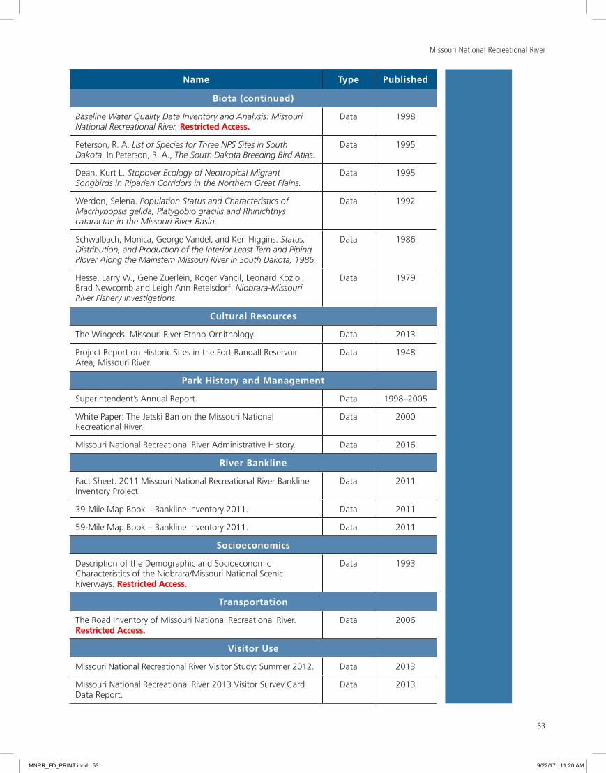
53
Missouri National Recreational River
Name Type Published
Biota (continued)
Baseline Water Quality Data Inventory and Analysis: Missouri National Recreational River. Restricted Access.
Data 1998
Peterson, R A List of Species for Three NPS Sites in South Dakota. In Peterson, R A , The South Dakota Breeding Bird Atlas.
Data 1995
Dean, Kurt L Stopover Ecology of Neotropical Migrant Songbirds in Riparian Corridors in the Northern Great Plains.
Data 1995
Werdon, Selena Population Status and Characteristics of Macrhybopsis gelida, Platygobio gracilis and Rhinichthys cataractae in the Missouri River Basin.
Data 1992
Schwalbach, Monica, George Vandel, and Ken Higgins Status, Distribution, and Production of the Interior Least Tern and Piping Plover Along the Mainstem Missouri River in South Dakota, 1986.
Data 1986
Hesse, Larry W , Gene Zuerlein, Roger Vancil, Leonard Koziol, Brad Newcomb and Leigh Ann Retelsdorf Niobrara-Missouri River Fishery Investigations.
Data 1979
Cultural Resources
The Wingeds: Missouri River Ethno-Ornithology Data 2013
Project Report on Historic Sites in the Fort Randall Reservoir Area, Missouri River
Data 1948
Park History and Management
Superintendent’s Annual Report Data 1998–2005
White Paper: The Jetski Ban on the Missouri National Recreational River
Data 2000
Missouri National Recreational River Administrative History Data 2016
River Bankline
Fact Sheet: 2011 Missouri National Recreational River Bankline Inventory Project
Data 2011
39-Mile Map Book – Bankline Inventory 2011 Data 2011
59-Mile Map Book – Bankline Inventory 2011 Data 2011
Socioeconomics
Description of the Demographic and Socioeconomic Characteristics of the Niobrara/Missouri National Scenic Riverways Restricted Access.
Data 1993
Transportation
The Road Inventory of Missouri National Recreational River Restricted Access.
Data 2006
Visitor Use
Missouri National Recreational River Visitor Study: Summer 2012 Data 2013
Missouri National Recreational River 2013 Visitor Survey Card Data Report
Data 2013
MNRR_FD_PRINT.indd 53 9/22/17 11:20 AM

Foundation Document
54
MNRR_FD_PRINT.indd 54 9/22/17 11:20 AM
As the nation’s principal conservation agency, the Department of the Interior has responsibility for most of our nationally owned public lands and natural resources. This includes fostering sound use of our land and water resources; protecting our fish, wildlife, and biological diversity; preserving the environmental and cultural values of our national parks and historic places; and providing for the enjoyment of life through outdoor recreation. The department assesses our energy and mineral resources and works to ensure that their development is in the best interests of all our people by encouraging stewardship and citizen participation in their care. The department also has a major responsibility for American Indian reservation communities and for people who live in island territories under U.S. administration.
MNRR 651/136937 August 2017
Midwest Region Foundation Document RecommendationMissouri National Recreational River
August 2017
This Foundation Document has been prepared as a collaborative effort between park and regional staff and is recommended for approval by the Midwest Regional Director
RECOMMENDED Richard A Clark, Superintendent, Missouri National Recreational River Date
APPROVED Cameron H Sholly, Regional Director, Midwest Region Date
MNRR_FD_PRINT.indd 55 9/22/17 11:20 AM

Foundation Document • Missouri National Recreational River
NATIONAL PARK SERVICE • U.S. DEPARTMENT OF THE INTERIOR
MNRR_FD_PRINT.indd 56 9/22/17 11:20 AM


