Missouri River Flood Coordination Task Force Report “Recovery from a disaster is not only about rebuilding roads and buildings, but is ultimately about rebuilding communities and the lives of those who were changed by a disaster. That is why the Governor has created this Task Force and why its members will work to ensure communities and people are able to rebuild their homes, businesses, public property and most importantly, their lives.” Iowa HSEMD Administrator J. Derek Hill
Transcript
Missouri River Flood Coordination
Task Force Report
“Recovery from a disaster is not only about rebuilding roads and buildings, but is ultimately about rebuilding communities and the lives of those who were changed by a disaster. That is
why the Governor has created this Task Force and why its members will work to ensure communities and people are able to rebuild their homes, businesses, public property and most
importantly, their lives.” Iowa HSEMD Administrator J. Derek Hill
CONTENTS
INTRODUCTION: GOVERNOR TERRY E. BRANSTAD PART I: OVERVIEW AND CHRONOLOGY OF SIGNIFICANT EVENTS PART II: DISASTER RESPONSE OPERATIONS
A. WORK GROUPS 1. Transportation 2. Natural Resources 3. Housing 4. Communications 5. Health & Human Services
PART III: DISASTER RECOVERY OPERATIONS
A. WORK GROUPS
1. Transportation 2. Natural Resources 3. Housing 4. Communications 5. Health & Human Services 6. Interagency Levee 7. Public Assistance 8. Hazard Mitigation 9. Communications 10. Utilities 11. Education PART IV: DISASTER SUMMARY ANNEXES: A. HSEMD RESPONSE BUREAU AFTER ACTION REVIEW B. SAFEGUARD IOWA SURVEY THIS REPORT WAS PREPARED BY THE MISSOURI RIVER FLOOD COORDINATION TASK FORCE AND REVIEWED BY THE TASK FORCE CHAIRMAN, BRIGADIER GENERAL J. DEREK HILL. COMMENTS CAN BE PROVIDED TO IOWA HSEMD RECOVERY BUREAU, ATTN: PATRICK J. HALL.
2
Dear Citizens and Interested Stakeholders:
Our State has repeatedly demonstrated our resolve to overcome challenges, including natural disasters. Our Iowa spirit was again tested in 2011 with severe weather, winter storms, tornadoes and flooding that impacted many of our counties. These numerous disasters damaged public infrastructure ruined multiple homes and businesses, destroyed crops, and taxed our ability to overcome adversity. In 2011, the Missouri River flooding, historic in both duration and scale, was the most significant disaster event impacting six counties along the western border of Iowa.
Adversity is the true test of character. Iowans met each disaster challenge head‐on with strength, determination, and acts of kindness. Families, friends, neighbors, and a host of volunteers assisted those in need. All Iowans are extremely grateful for the outpouring of support from fellow citizens. We all strove to provide quick assistance to our fellow citizens and to expedite long term recovery actions so we could return to normal as quickly as possible. There was tremendous cooperation between various State and Federal agencies, local governments, the private sector, the Iowa congressional delegation, non‐profits, and individual citizens. This cooperation allowed our response and recovery efforts to be very effective in overcoming the challenges of the flood.
This report summarizes the efforts undertaken by many entities during the response and recovery phases of the flood. The document captures many best practices and lessons learned that can help us better prepare for and respond to future similar events. I am grateful for the efforts of all those involved in the response and recovery efforts and for their proactive partnership to overcome the challenges presented. We should all be heartened by the positive attitude and resolve the citizens of western Iowa demonstrated when faced with the historic Missouri River flooding. That same attitude and determination helped expedite the recovery process.
Terry E. Branstad
Governor
3
PART I: OVERVIEW AND CHRONOLOGY OF SIGNIFICANT EVENTS
“Iowans need to remain vigilant as this flood is unlike any other that Iowa has experienced.” Governor Terry E. Branstad
Overview: The Missouri River floods of 2011 will go down in history as the longest duration flooding event this state has seen to date. The combination of above normal snowfall in the upper Missouri River basin followed by the equivalent of nearly one year’s worth of rainfall in May created an above normal runoff situation which filled the Missouri River and the six main reservoirs within the basin. Compounding this problem was colder than normal temperatures which kept much of the snowpack in the upper basin on the ground longer into the spring, setting the stage for this historic event. The U.S. Army Corps of Engineers (USACE) began increasing the outflow at Gavin’s Point, near Yankton, South Dakota in May. On June 14, 2011, the outflow reached a record rate of over 160,000 cubic feet per second (cfs), over twice the previous record outflow set in 1997. This increased output from Gavin’s Point caused the Missouri River to flow out of its banks covering over 283,000 acres of land in Iowa, forcing hundreds of evacuations, damaging 255,000 acres of cropland and significantly impacting the levee system on the Missouri River basin. Over the course of the summer, approximately 64 miles of primary roads closed due to Missouri River
4
flooding, including 54 miles of Interstate Highway. Many county secondary roads were closed by high water or overburdened due to the numerous detours and road closures in this area. As the Missouri River levels began to increase, municipalities and counties aided by State and Federal agencies began preparing for a sustained flood event. Citizens, businesses, state agencies, local governments and non‐profits made substantial preparations, in some cases expending millions of dollars on emergency protective measures to protect their facilities from the impending flood. Levee monitors detected weak spots in the levee system in all affected counties, with several levees being identified as at risk levees that could potentially fail. Of particular concern was the 28 miles of levees protecting Council Bluffs. Based on this concern, Council Bluffs prepared an evacuation plan for the approximately 30,000 residents that resided in the protected area. On May 25, 2011, Governor Branstad directed the execution of the Iowa Emergency Response Plan in accordance with Section 401 of the Stafford Act. On May 31, 2011, HSEMD Administrator, Brigadier General J. Derek Hill, formally requested the USACE to provide technical assistance and advanced measures for the communities along the Missouri River basin. On June 2, 2011 Governor Branstad issued a State of Iowa Proclamation of Disaster Emergency for Fremont, Harrison, Mills, Monona, Pottawattamie, and Woodbury counties. The length of this flood event created a unique set of challenges for Federal, State and local entities. In many cases, these organizations were conducting response and recovery operations simultaneously. Due to the length of this entire event, the State Emergency Operations Center and the local Emergency Operations Centers remained open for an extended period of time, putting additional strain on many organizations and resources. In response to this disaster, Governor Branstad created the Missouri River Recovery Coordination Task Force to oversee the State’s recovery efforts. The Governor announced the creation of this Task Force on October 17, 2011 and appointed Brigadier General J. Derek Hill, HSEMD Administrator as the chairman. This Task Force would be a temporary group of State agency representatives and interested stakeholders brought together to support the recovery efforts of the Iowa communities impacted by the Missouri River Flood. Collectively, this group would analyze and share damage assessment data, coordinate assistance across various stakeholders, monitor progress, capture best practices and identify lessons learned. The Task Force was then organized into the following work groups:
• Transportation (Iowa Department of Transportation (IDOT) Lead)
5
• Natural Resources (Department of Natural Resources (DNR) Lead)
• Agriculture (Iowa Department of Agriculture and Land Stewardship (IDALS) lead)
• Economic Development (Iowa Economic Development Authority (IEDA) Lead)
• Utilities (Iowa Utilities Board (IUB) Lead)
• Interagency Levee Work Group (HSEMD Lead)
• Health and Human Services (Iowa Department of Human Services (DHS) Lead)
• Education (Iowa Department of Education (DE) Lead)
This report summarizes activities and actions taken during the response and recovery phases of this disaster. This report also includes the Federal Programs (Public Assistance, Individual Assistance and Hazard Mitigation) which summarizes their roles and activities during the response and recovery phases of this disaster.
Chronology of Significant Events: 1 May 2011 Outflow at Gavin’s Point reaches 45,000 cfs 20 May USACE increases outflow to 57,500 cfs 25 May Governor Branstad directs the execution of the Iowa Emergency Response Plan 26 May Gavins Point Dam releasing at 62,000 cfs, almost twice the normal flow rate
down into the Missouri River for this time of year 2 June Governor Branstad issues State of Disaster Emergency Proclamation for
Fremont, Harrison, Mills, Monona, Pottawattamie and Woodbury 3 June Iowa Concern Hotline opens for calls
6
4 June Gavin’s Point Dam releasing at 93,000 cfs 4 June Federal Levee 575, near the City of Hamburg (Fremont County), suffers partial
collapse. USACE initiated an emergency contract to raise the levee immediately surrounding the town in order to protect it from an estimated 10 feet of flood water
10 June Iowa HSEMD activates the SEOC to coordinate Federal, State, private sector and
volunteer agencies efforts in the affected areas 10 June Iowa HSEMD launches Flood Watch Flickr Page 11 June Iowa DOT closes portions of Interstate‐29 12 June WinnaVegas Casino & Resort (Sloan, Iowa) closes 13 June Total breach at Federal levee 575, near the City of Hamburg (Fremont County)
suffered a 300 feet wide gap 14 June Gavins Point Dam releasing over 160,000 cfs 22 June Mills County declared a mandatory evacuation of all residents between
Interstate 29 and the Missouri River 23 June Fremont County orders evacuation of 661 residents 24 June Additional mandatory evacuation ordered for parts of Mills County 27 June President Obama authorizes Presidential Disaster Declaration for Public
Assistance (Emergency Work Categories A & B Only) for six Iowa Counties affected by Missouri River Flooding
30 June Fremont County Coordinator reports a 200 foot long breach in the levee north of
Percival. Mandatory evacuation ordered for the town of Percival 30 June Iowa DOT reports that Interstate 29 is closed from the Bartlett, Iowa interchange
(Exit 24) south to the I‐29/U.S. 136 interchange in Missouri
7
1 July Pottawattamie County EMA advised HSEMD the coalition for several drainage districts blew a hole in the privately owned VanDam levee
8 July USDA declares an Agriculture Disaster Declaration for Fremont, Harrison, Mills,
Monona, Pottawattamie and Woodbury Counties, along with the contiguous counties of Cass, Cherokee, Crawford, Ida, Montgomery, Page, Plymouth, and Shelby
13 Jul SBA Disaster Assistance in the form of Economic Injury Disaster Loans (EIDL’s) for
small non‐farm business, small agriculture cooperatives and private nonprofit businesses is available
18 Jul State Individual Assistance Program activated 22 Jul Levee breach reported in Harrison County on the north side of Soldier River
between Mondamin and Little Sioux 4 Aug Federal Individual Assistance for Iowa denied, Governor Branstad pledges to
appeal FEMA’s decision 8 Aug Mandatory evacuation order for the City of Hamburg lifted and changed to a
voluntary order 12 Aug Governor Branstad requests extended timeframe to appeal FEMA denial due to
unusual and ongoing nature of the flooding 22 Aug FEMA amends Public Assistance Disaster Declaration activating Permanent Work
categories of the Public Assistance Program for counties affected by Missouri River Flood
22 Aug 30‐foot section of a non‐Federal levee along St. Mary’s Drainage District
breached in Mills County 24 Aug SBA assistance is available for Private Non‐Profit organizations that provide
essential government services 1 Sept FEMA approves Governor Branstad’s request for extension to appeal the denial
of Federal Individual Assistance
8
6 Oct Governor Branstad appeals FEMA denial of Federal Individual Assistance benefits
for Iowans affected by Missouri River Flooding 18 Oct Iowa receives Presidential Disaster Declaration for Federal Individual Assistance
in Harrison, Fremont, Mills, Monona and Pottawattamie Counties. Woodbury County is not included in this declaration due to insufficient relevant damages
18 Oct State Individual Assistance Program suspended 18 Oct Following Federal Individual Assistance declaration, SBA assistance is available
for private homeowners in covered counties 26 Oct Pottawattamie County Disaster Recovery Center (DRC) opens 27 Oct Fremont County DRC opens 28 Oct Monona County DRC opens 1 Nov Crisis Counseling request sent to FEMA 2 Nov Interstate 680 Grand Re‐Opening ceremony 10 Nov Monona County DRC closes 17 Nov Fremont County DRC closes 30 Nov Case Management request sent to FEMA 8 Dec Pottawattamie County DRC closes 1 Mar 2012 Joint Field Office Closes
9
Part II Disaster Response Operations
State Emergency Operations Center Flooding along the Missouri River began in May 2011. This flood event presented numerous challenges. The floodwaters remained high for over four months which forced the state to conduct simultaneous response and recovery operations for an unusually long period of time. The response to; and ongoing recovery from an event of this duration posed significant challenges at multiple levels. Personnel worked long hours over a sustained time period, many response resources were exhausted and impacted citizens were often displaced for months. HSEMD Readiness and Response Bureau personnel are responsible for operations of the State Emergency Operations Center (SEOC) when activated. On June 10, 2011, Iowa HSEMD activated the State Emergency Operations Center to coordinate efforts in response to the Missouri River flooding. Multiple Federal, State, private sector and volunteer agencies participated in the day to day operations of the SEOC along with the many state agency update briefs that took place throughout this event. At the conclusion of the Response phase, the Readiness and Response
10
Bureau conducted an After Action Review (AAR) with all of the various agency partners who played a role in the response to the Missouri River flooding. This AAR was facilitated by FEMA and captured the many lessons learned during the Response phase of this event. The Iowa 2011 Missouri River Floods After‐Action Report is attached in Annex A. One issue that posed a challenge during the response was the availability of HESCO barriers. In early May, HSEMD leadership received a request for HESCO barriers from the USACE, Rock Island District. The Rock Island District was responding to a request for HESCO barriers from other USACE districts. HSEMD consulted with the National Weather Service (NWS) and USACE regarding the potential for flooding across Iowa. Each advised HSEMD that their models were not showing any type of flood risk across Iowa, therefore they did not see a problem releasing the HESCO barriers to USACE. HSEMD released their supply of HESCO barriers and 14 days later, information was received from the USACE that major flooding would occur along the Missouri River beginning June 6th. This caused HSEMD to have to submit an emergency request for HESCO barriers and begin purchasing vast quantities of sandbags.
Joint Preliminary Damage Assessments ‐ Public Assistance (PA) Program
On June 14, 2011, Iowa HSEMD requested a Joint Preliminary Damage Assessment (PDA) be conducted for the Federal Public Assistance Program in the six counties affected by the Missouri River flooding. In coordination with FEMA personnel, this PDA commenced on June 16, 2011, with only the costs/damages associated with Public Assistance Categories A (Debris Removal) & B (Emergency Protective Measures) being captured. Permanent work categories C (Roads and Bridges), D (Water Control Facilities), E (Buildings and Equipment), F (Utilities), and G ( Parks, Recreational Facilities, and Other facilities) were not included in this PDA because the structures that fall under the permanent work categories were inundated or inaccessible. The PDA teams working with local officials were able to identify enough costs/damages to meet the per capita threshold giving the Governor the ability to request a major disaster declaration covering Public Assistance. Table #1 shows the results of this Joint PDA conducted on June 16, 2011, and reflects the estimated requirements for Public Assistance Categories A & B under the Stafford Act.
11
Public Assistance Preliminary Damage Assessment Counties Assessed 6/16/2011
County (6) Category A
Debris Removal
Category B
Emergency Protective Measures
Total
Fremont $5,917,227 $65,189 $5,982,416
Harrison $188,201 $188,201
Mills $114,643 $983,753 $1,098,396
Monona $17,333 $57,000 $74,333
Pottawattamie $1,860,000 $1,290,453 $3,150,453
Woodbury $38,827 $1,375,461 $1,414,288
Statewide $1,034,915 $1,034,915
TOTALS $7,948,030 $4,994,972 $12,943,002
Table #1 On June 27, 2011, the President signed a Presidential Disaster Declaration making Public Assistance Program funding available for Category A and B work along with Direct Federal Assistance for Fremont, Harrison, Mills, Monona, Pottawattamie, and Woodbury Counties. On August 17, 2011, Iowa HSEMD requested that FEMA amend the major disaster declaration to include all categories of permanent work under the Public Assistance Program. This request was approved on August 22, 2011, amending the major disaster declaration to include Public Assistance for both emergency protective measures and permanent work categories for all six affected counties.
Joint Preliminary Damage Assessments ‐ Individual Assistance (IA) Program
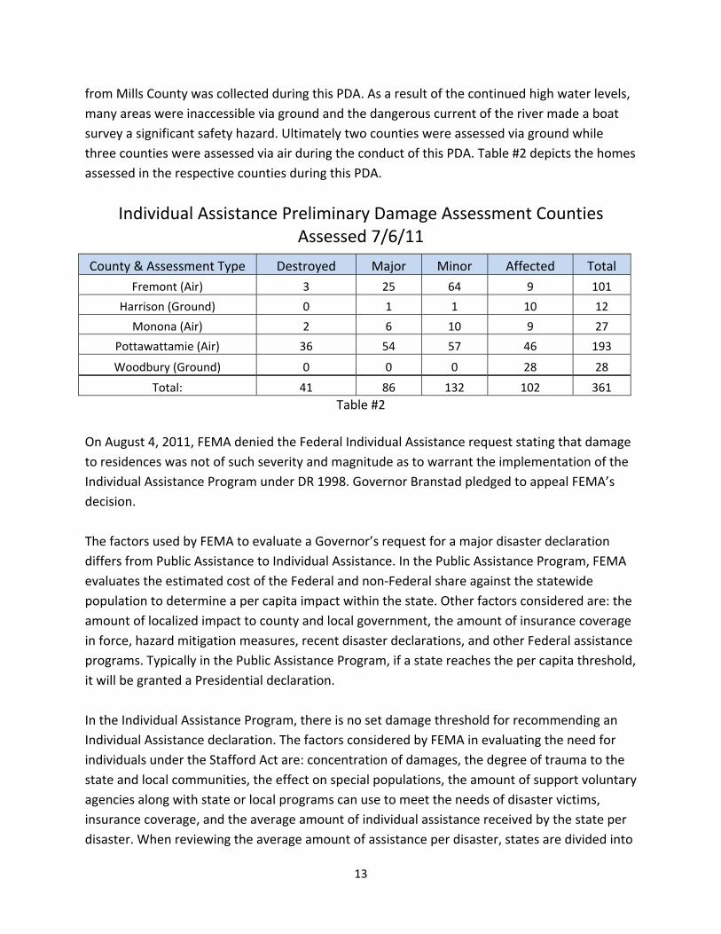
On June 24, 2011, Iowa HSEMD requested a Joint‐PDA be conducted for the Federal Individual Assistance Program for the six affected counties. This PDA commenced on July 5, 2011, with FEMA‐State‐local teams. Mills County officials chose not to participate in this PDA so no data
12
from Mills County was collected during this PDA. As a result of the continued high water levels, many areas were inaccessible via ground and the dangerous current of the river made a boat survey a significant safety hazard. Ultimately two counties were assessed via ground while three counties were assessed via air during the conduct of this PDA. Table #2 depicts the homes assessed in the respective counties during this PDA.
County & Assessment Type Destroyed Major Minor Affected Total Fremont (Air) 3 25 64 9 101
Harrison (Ground) 0 1 1 10 12
Monona (Air) 2 6 10 9 27
Pottawattamie (Air) 36 54 57 46 193
Woodbury (Ground) 0 0 0 28 28
Total: 41 86 132 102 361
On August 4, 2011, FEMA denied the Federal Individual Assistance request stating that damage to residences was not of such severity and magnitude as to warrant the implementation of the Individual Assistance Program under DR 1998. Governor Branstad pledged to appeal FEMA’s decision. The factors used by FEMA to evaluate a Governor’s request for a major disaster declaration differs from Public Assistance to Individual Assistance. In the Public Assistance Program, FEMA evaluates the estimated cost of the Federal and non‐Federal share against the statewide population to determine a per capita impact within the state. Other factors considered are: the amount of localized impact to county and local government, the amount of insurance coverage in force, hazard mitigation measures, recent disaster declarations, and other Federal assistance programs. Typically in the Public Assistance Program, if a state reaches the per capita threshold, it will be granted a Presidential declaration. In the Individual Assistance Program, there is no set damage threshold for recommending an Individual Assistance declaration. The factors considered by FEMA in evaluating the need for individuals under the Stafford Act are: concentration of damages, the degree of trauma to the state and local communities, the effect on special populations, the amount of support voluntary agencies along with state or local programs can use to meet the needs of disaster victims, insurance coverage, and the average amount of individual assistance received by the state per disaster. When reviewing the average amount of assistance per disaster, states are divided into
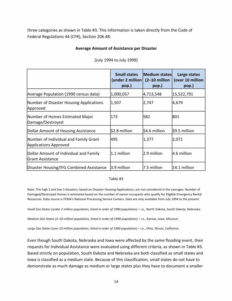
13
three categories as shown in Table #3. This information is taken directly from the Code of Federal Regulations 44 (CFR), Section 206.48:
Average Amount of Assistance per Disaster
[July 1994 to July 1999]
Small states (under 2 million
pop.)
Medium states (2–10 million
pop.)
Large states (over 10 million
pop.)
Average Population (1990 census data) 1,000,057 4,713,548 15,522,791
Number of Disaster Housing Applications Approved
1,507 2,747 4,679
Number of Homes Estimated Major Damage/Destroyed
173 582 801
Dollar Amount of Housing Assistance $2.8 million $4.6 million $9.5 million
Number of Individual and Family Grant Applications Approved
495 1,377 2,071
Dollar Amount of Individual and Family Grant Assistance
1.1 million 2.9 million 4.6 million
Disaster Housing/IFG Combined Assistance 3.9 million 7.5 million 14.1 million
Table #3
Note: The high 3 and low 3 disasters, based on Disaster Housing Applications, are not considered in the averages. Number of Damaged/Destroyed Homes is estimated based on the number of owner‐occupants who qualify for Eligible Emergency Rental Resources. Data source is FEMA's National Processing Service Centers. Data are only available from July 1994 to the present.
Small Size States (under 2 million population, listed in order of 1990 population) – i.e., North Dakota, South Dakota, Nebraska. Medium Size States (2–10 million population, listed in order of 1990 population) – i.e., Kansas, Iowa, Missouri. Large Size States (over 10 million population, listed in order of 1990 population) – i.e., Ohio, Illinois, California. Even though South Dakota, Nebraska and Iowa were affected by the same flooding event, their requests for Individual Assistance were evaluated using different criteria, as shown in Table #3. Based strictly on population, South Dakota and Nebraska are both classified as small states and Iowa is classified as a medium state. Because of this classification, small states do not have to demonstrate as much damage as medium or large states plus they have to document a smaller
14
number of homes destroyed/damaged than medium or large states. This difference in criteria resulted in South Dakota and Nebraska receiving an Individual Assistance declaration and Iowa initially being denied. Since South Dakota and Nebraska had received Individual Assistance declarations for this flooding event, a significant amount of public and political pressure was being applied to the State leadership to secure an Individual Assistance declaration for Iowa. Ongoing discussions between the Governor’s Office, Iowa HSEMD and FEMA Region VII regarding the denial of an Individual Assistance declaration continued throughout the month of August. During these discussions, FEMA Region VII advised the State to conduct a validation. The intent of this validation was to update the initial PDA assessment data and to use this updated data to re‐submit a Request for Presidential Declaration for Individual Assistance. Consequently, a validation survey was then conducted in late August 2011. Starting on August 25, 2011, a two‐person FEMA‐State team attempted to conduct a validation of the damaged homes in the same area the initial PDA was conducted. This validation was conducted using web based reporting tools and satellite imagery along with some limited assessment via air using Department of Public Safety aircraft. The Missouri River was still well above flood stage making nearly all damaged areas inaccessible to ground observation and with the dangerously swift current of the river, a boat survey was considered an extreme safety risk. The results of the validation are depicted in the Table #4. In summary, the total number of homes assessed in this validation as compared to the first PDA nearly doubled. The results of this validation showed a decrease in the number of homes destroyed but a large increase in the numbers of homes having major and minor damage. These results were compiled into a chart that showed a comparison of the first PDA to this validation effort. This chart was then emailed to the FEMA Region VII Individual Assistance Branch Chief for review and comments.
County Destroyed Major Minor Affected Total Fremont 6 60 59 8 133
Harrison 0 7 5 10 22
Monona 5 12 10 10 37
Pottawattamie 16 90 308 74 488
Total: 27 169 382 102 680 Table #4
Following the review of this validation data, FEMA did not change their position on an Individual Assistance declaration for the State of Iowa. Their reasons were: first, it was not a formally requested and recognized PDA effort; therefore FEMA did not consider these numbers to be valid. Second, this validation was conducted via air; therefore the homes were not assessed properly. Lastly, it was FEMA’s position that there was not enough impact and damage to warrant a Presidential Declaration. On September 15, 2011, Iowa HSEMD requested another Joint PDA be conducted in the six counties (including Mills County which did not participate in the first PDA or validation) affected by the Missouri River flooding. FEMA agreed and starting on September 27, 2011, another Joint PDA was conducted. At this time the flood waters had dropped sufficiently to allow the teams the ability to conduct large portions of their assessment via ground. This PDA began with a formal kick‐off meeting by State and FEMA leadership along with all of the assessment teams. The PDA criterion was clearly explained followed by a clear, concise review of the objectives for the conduct of this PDA. The results of this Joint Preliminary Damage Assessment revealed a significant increase in the number of homes adversely impacted from this event. The PDA teams were able to conduct a more thorough assessment providing a much clearer picture of the entire extent of damages in all six counties. The increased damages were attributed to the prolonged exposure to homes by flood waters and hydrostatic pressure from high ground water tables. These prolonged pressures compromised the structural integrity of many homes, causing foundation collapses and structural materials to warp or break. The building materials within these homes had been compromised and posed a health risk due to chemicals, harmful bacteria, mold and sewage from the flood waters. In summary, the final Joint PDA showed an increase in all categories. Table #5 shows the results of this PDA.
Table #5 In reviewing the timing, conduct and end results of the two – Joint PDAs and the validation, many best practices and lessons learned were identified for a Joint PDA process:
1. Managing expectations of State and local officials is critical, particularly in long duration flood events. It is prudent to wait until such time as the flood waters have sufficiently receded to allow a ground team to conduct the assessment. A ground assessment is the only established way to gather information, to confirm and verify the damages in order to meet the FEMA criteria for an Individual Assistance declaration. Conducting a PDA too soon results in gathering inaccurate information and potentially sets false expectations and causes duplication of effort. Stakeholders must recognize that long‐duration flooding requires a different approach. Perhaps further technological advancements will develop further assessment capabilities to supplement ground team assessments, but those capabilities are not mature and sufficiently exercised.
2. The validation survey conducted in August violated all PDA protocol and doctrine. It was completed at the advice of FEMA Region VII and was done primarily with web based tools, satellite imagery and some limited observations from the air by a two‐person FEMA‐State team. In order to properly complete a Joint PDA, you must have
17
enough personnel to conduct a ground based assessment to get a true picture and representation of the scope of damages.
3. Although Nebraska conducted their PDA via air which resulted in their state receiving an Individual Assistance declaration, conducting a validation/assessment via air is typically ineffective and costly. Having the ability to orient oneself from the air correctly when homes are under water presented a considerable challenge. Assessing from the air did not allow the team the ability to adequately view damaged homes and accurately document those damages.
4. Conducting a Joint PDA must be a deliberate organized process with clear lines of command and control. The senior leadership of the State HSEMD and FEMA must be involved in dedicating the appropriate assets (Personnel) to conduct the PDA, setting clear and concise objectives and ensuring the lines of communication between Federal, State and locals is functioning properly. The leadership must be linked with county EMA’s in order to receive accurate and real time information about their counties.
5. Finally, having one single data collection point is crucial to maintaining positive control of the data coming from the PDA. This prevents false data or misinformation from being presented to the leadership before the assessment team is ready to provide the final PDA report.
18
RESPONSE WORK GROUP REPORTS
Transportation Flooding forced the closure of and caused substantial damage to several primary and secondary roads in Iowa. Approximately 60 miles of the Primary Highway System (PHS) were closed, including sections of Interstate 29 and 680, and three Missouri River crossings between Iowa and Nebraska. Iowa DOT staff initially identified 21 locations on the PHS as flood mitigation sites; places where work could be done in an attempt to keep the roads open. As the flooding event unfolded, this listing was narrowed to 14 sites; seven of these sites were eventually closed, five were kept open due to the mitigation measures in place and two remained open without active mitigation measures in place. Table #6 lists the primary roads closed due to flooding.
Primary Road Closures during the 2011 Missouri River Flooding
Route Location County Closed Opened
Interstate 29 Hamilton Blvd – Sioux City Woodbury June 4 September 1
Iowa 175 Missouri River Bridge – Decatur,
NE Monona June 27 November 3
Interstate 29 / 680
North Interchange – Loveland Pottawattamie June 13 June 17
Interstate 29 Milepost (MP) 55‐71 – North of
Council Bluffs Pottawattamie June 9 September 23
Interstate 680 Missouri River to I‐29 – North of
Council Bluffs Pottawattamie June 9 November 3
Interstate 29 Missouri Border to MP 32 Fremont – Mills June 15 October 8
Iowa 2 Missouri River to I‐29 Fremont June 18 October 24
Iowa 333 I‐29 to Hamburg Fremont June 15 November 11
Table #6
19
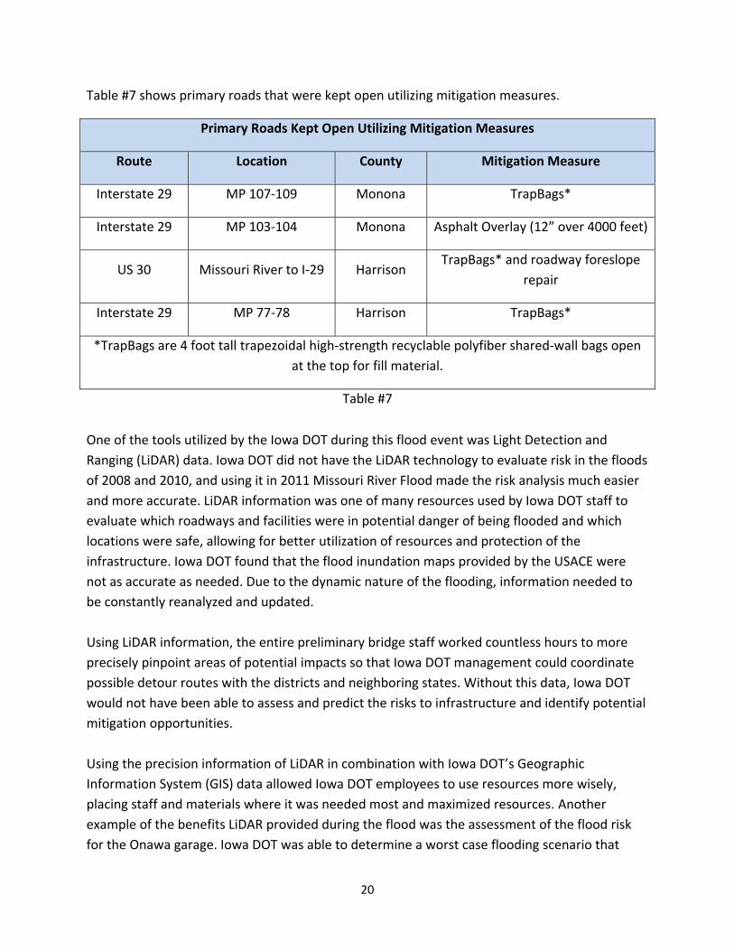
Table #7 shows primary roads that were kept open utilizing mitigation measures.
Primary Roads Kept Open Utilizing Mitigation Measures
US 30 Missouri River to I‐29 Harrison TrapBags* and roadway foreslope
repair
Interstate 29 MP 77‐78 Harrison TrapBags*
*TrapBags are 4 foot tall trapezoidal high‐strength recyclable polyfiber shared‐wall bags openat the top for fill material.
Table #7
One of the tools utilized by the Iowa DOT during this flood event was Light Detection and Ranging (LiDAR) data. Iowa DOT did not have the LiDAR technology to evaluate risk in the floods of 2008 and 2010, and using it in 2011 Missouri River Flood made the risk analysis much easier and more accurate. LiDAR information was one of many resources used by Iowa DOT staff to evaluate which roadways and facilities were in potential danger of being flooded and which locations were safe, allowing for better utilization of resources and protection of the infrastructure. Iowa DOT found that the flood inundation maps provided by the USACE were not as accurate as needed. Due to the dynamic nature of the flooding, information needed to be constantly reanalyzed and updated. Using LiDAR information, the entire preliminary bridge staff worked countless hours to more precisely pinpoint areas of potential impacts so that Iowa DOT management could coordinate possible detour routes with the districts and neighboring states. Without this data, Iowa DOT would not have been able to assess and predict the risks to infrastructure and identify potential mitigation opportunities. Using the precision information of LiDAR in combination with Iowa DOT’s Geographic Information System (GIS) data allowed Iowa DOT employees to use resources more wisely, placing staff and materials where it was needed most and maximized resources. Another example of the benefits LiDAR provided during the flood was the assessment of the flood risk for the Onawa garage. Iowa DOT was able to determine a worst case flooding scenario that
20
revealed that this garage sat on high ground and would not be inundated. This allowed Iowa DOT to leave materials and equipment in place. Typically, Iowa DOT would have moved the resources as a precautionary measure, but because of LiDAR, it was determined that the movement of materials from this garage was unnecessary. The Missouri River Flooding impacted the rail portion of the transportation sector as well. BNSF and Union Pacific Railroad (UP) both have major high capacity rail lines (together carrying as many as 75‐85 trains per day) crossing the Missouri River that were threatened by the flooding. These lines carry a wide array of freight, but most significantly, are major routes carrying coal from the western mines to eastern power plants. Because of the critical nature of these routes and the economic consequences of closures, both railroads brought in the labor, equipment and supplies needed to keep the lines open. Track structure was raised for several miles by as much as seven feet as well as raising bridges, adding culverts and building dikes to avert track damage. To facilitate a more direct route for BNSF’s repair materials from a yard to the track sites, the Iowa DOT suspended a construction project. Iowa DOT also facilitated conversations between railroad employees, State and county highway officials and emergency management personnel as the privately funded railroads accomplished the emergency repairs and modifications. Amtrak’s California Zephyr service (which operates on the BNSF) was suspended with bussing supplied from Chicago to Omaha. The CN, BNSF and UP rail lines running roughly parallel to the Missouri River in southwest Iowa and Missouri were out of service for a longer period of time and suffered significant damage. Rail shipments were detoured but some customers had to make alternative shipping arrangements because rail service was not available at their site.
21
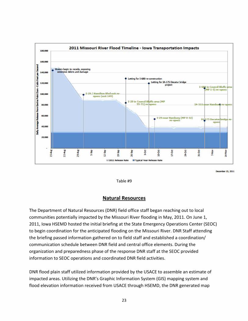
Table #8 and #9 show the 2011 Missouri River flooding timeline‐Iowa Transportation impacts.
Table #8
22
Table #9
Natural Resources
The Department of Natural Resources (DNR) field office staff began reaching out to local communities potentially impacted by the Missouri River flooding in May, 2011. On June 1, 2011, Iowa HSEMD hosted the initial briefing at the State Emergency Operations Center (SEOC) to begin coordination for the anticipated flooding on the Missouri River. DNR Staff attending the briefing passed information gathered on to field staff and established a coordination/ communication schedule between DNR field and central office elements. During the organization and preparedness phase of the response DNR staff at the SEOC provided information to SEOC operations and coordinated DNR field activities. DNR flood plain staff utilized information provided by the USACE to assemble an estimate of impacted areas. Utilizing the DNR’s Graphic Information System (GIS) mapping system and flood elevation information received from USACE through HSEMD, the DNR generated map
23
layers indicating the extent of flooding. These layers were overlain with layers showing known industrial, agricultural, and other facilities to determine risk. This information was coordinated with HSEMD and Iowa DOT GIS to provide an overall risk picture at the SEOC. DNR staff then contacted at risk facilities to determine the steps they were taking, provide technical assistance, and coordinate concerns with the SEOC. DNR staff utilized these maps to determine communities that would be impacted by floodwaters and levee failures. DNR SEOC staff coordinating with field staff began assisting local responders with evacuation plans and coordinated DNR rescue resources. The maps were also utilized to determine impacts to DNR lands and facilities including State parks, wildlife areas, and forests. Community drinking water and waste water treatment facilities are particularly vulnerable to flooding. Based on past experience the department took a proactive approach and field staff communicated early in the disaster with facility staff in potentially impacted areas. Field staff determined what steps the facilities were taking, provided technical assistance, and relayed concerns to DNR SEOC staff. This information was passed on to SEOC operations and used in planning mitigation strategies. DNR communications staff working with technical staff and SEOC communications developed fact sheets, door hangers, website information, and press releases to assist communities. Factsheets covering proper management of wastes, prevention of damage to private well and septic systems and securing/protecting underground and above ground fuel storage tanks impacted by flooding were developed, distributed to the media and by field staff working in local communities, and posted to the DNR website. These factsheets, the department’s website, and press releases connected residents, businesses and local officials with flooding resources and information. A door hanger was designed to assist homeowners with the monumental task of disaster cleanup. Approximately 4,000 door hangers were provided to local officials for distribution to residents in areas impacted by the flooding. The purpose of the door hanger is to assist homeowners with proper separation of items placed at the curb for solid waste collection. Proper separation can keep hazardous items (e.g., paints, solvents, household cleaners) out of the landfill and increases the chances of items being recycled (e.g., appliances, scrap metal, televisions and computers). Iowa Conservation Officers spent more than 2,200 hours assisting communities with sandbagging, watching levees, checking on area residents, and transporting electrical lineman by boat to shut off power. Officers partnered with county deputies to patrol closed flooded areas and help stranded Iowans, homeowners with flooded docks and hoists, and moved businesses and museum artifacts. The DNR SEOC staff coordinated with HSEMD, Iowa State
24
Patrol, Iowa DOT, and local communities the staging of conservation and recreation division boats along the Missouri River to assist local officials with evacuations should the need arise. At the request of HSEMD, DNR staff investigated methods for testing levees to determine their risk of failure. The DNR evaluated three methods of levee testing and preformed a field test of one method on two sections of levees in the Council Bluffs area. The first method evaluated, electrical resistivity imaging survey (ER Survey), provided great detail but required data analysis and later was determined to be not practical for rapid assessment of large segments of levee during a flood emergency. The field tests showed the internal structure of the levee and indicated sections that were at elevated risk of failure. The second method utilizes a similar technology that would allow for a general vulnerability assessment of levees in a much faster time frame. This method utilizes ATV mounted electromagnetic survey (EM Survey) equipment allowing for more ground to be covered over a shorter period of time. The third method evaluated, Spontaneous Potential (SP), would determine extent of water intrusion into a levee. This method allows for the most accurate risk assessment; however the time needed to test and evaluate the results makes it time prohibitive for large areas. Based on these evaluations and the field tests in Council Bluffs, the DNR proposed to HSEMD a three step approach to testing levees. First, a rapid assessment of levee segments using an EM Survey. Second, evaluate identified at risk levee segments and employ an ER Survey to identify problematic areas. Third, test identified problematic areas by the SP testing method to determine water intrusion (seeps and boils) into the levee structure. Unfortunately, due to USACE and FEMA not wishing to task out this work the testing of the levees was stopped after the initial test run. The Operation Procedures Order for Solid Waste established policies on a temporary, emergency basis to provide guidance to the regulated public on management of solid waste resulting from disasters. The policies are intended to speed up recovery efforts by easing regulations or removing permit application requirements that are normally required. Under the Order, emergency waste transfer stations may be established without a formal permit application or issuance process, sanitary landfills are able to accept and dispose of contaminated soils without prior remediation of the soil, and 30‐day public notice requirements are waived in order to allow for rapid authorization and construction of additional landfill disposal capacity. The Order was signed by the directors of the DNR and HSEMD.
25
Housing
Iowa Finance Authority (IFA) staff participated in regularly scheduled state agency coordination meetings held at the SEOC and researched and identified potential funding sources to help finance housing recovery efforts. Many best practices and lessons learned were identified as demonstrated through the following actions: IFA contacted affordable rental properties in IFA’s portfolio to determine if any property was in potential danger of flooding and offered assistance to help mitigate risk and ensure tenant safety. The agency also developed a “Rental Housing Resources” guide to assist disaster survivors search for rental housing assistance or vacant apartments. This guide was made available to the public through the Missouri River Flood Recovery web site. To help identify vacant housing units flood‐impacted Iowans might choose as temporary or permanent replacement housing options, IFA surveyed its affordable rental housing portfolio for current vacancy rate information and requested similar occupancy data from HUD and USDA Rural Development. IFA promoted several housing and community development resources for flood impacted Iowans through statewide news releases, publication in IFA newsletters and the Missouri River Flood Recovery newsletter. Flood‐affected Iowans who feared they may not be able to make their mortgage payment were encouraged to contact Iowa Mortgage Help. This State‐sponsored resource offers free, confidential mortgage counseling for Iowans through a hotline number (1‐877‐622‐4866) and web site at www.IowaMortgageHelp.com. Flood‐affected renters who were at risk of homelessness were encouraged to contact the Iowa Rental Help program for eligibility information for assistance with rent, utilities, moving costs and hotel/motel vouchers. Businesses were made aware of Midwestern Disaster Area Bonds as a tool to repair or rebuild their flood‐impacted business in eligible areas.
Communications‐ Joint Information Center The scale and duration of the event required proactive coordination and communications with all stakeholders. The following best practices and lessons learned were identified: Prompt activation of State Joint Information Center (JIC) ‐‐ The prompt activation of the State JIC facilitated the timely and prompt dissemination of emergency information to the public. State JIC operations began on June 1, 2011, and continued for over four months thereafter. The Governor’s Office, with support from HSEMD, developed a plan which enabled State JIC staff to begin disseminating products immediately. State JIC activities included daily media conference
calls, daily press release updates, calls with congressional delegation representatives, and responding to media inquiries. State agency public information officers (PIOs) worked with staff in the JIC, which helped to coordinate messaging while facilitating the flow of information among HSEMD and other State response agencies. The State JIC worked with the Iowa Department of Human Services’ Disaster Behavioral Health Response Team to ensure that populations with disabilities and other access and functional needs received information about how to obtain assistance during the disaster. The State JIC encountered challenges engaging local PIOs. In the future, State JIC will encourage counties to identify PIOs prior to the incident. Information sharing across varying levels of government is more important now than ever with the 24 hour nature of the news cycle and social media. In addition, the long duration of response operations resulted in reduced coverage of the incident by the media. This could be addressed by having videographers accompany local emergency response personnel to record response activities that would be posted on the HSEMD website. This would help to inform the public about response activities. The State JIC instituted several measures that resulted in more efficient and effective internal operations. Three new measures contributed to enhanced State JIC operations during the flood response. First, HSEMD assigned a staff member to serve as a mentor for State agency PIOs who did not have prior JIC experience. This allowed the lead PIO to focus on their responsibilities while the State agency PIOs received a thorough orientation from their HSEMD mentors. Second, the State JIC was reconfigured to place a manager at the entrance of the center. This helped to control traffic flow and directed visitors to the appropriate JIC staff member for assistance. Third, JIC telephones were configured to direct all incoming calls to a central number, allowing the JIC manager to route the calls to the appropriate staffer. This greatly reduced interruptions so that JIC staff could focus on their tasks. State JIC staff used social media to disseminate emergency information to the public. State JIC staff began utilizing Facebook and Twitter from the early stages of response operations as well as monitoring HSEMD’s and other social media sites. The use of social media helped the JIC keep apprised of information that changed rapidly. Similarly, counties used their Facebook pages to disseminate emergency information to the public, which also enhanced the State JIC’s situational awareness. This represented a major difference in the dissemination of information from the 2008 summer storms and flooding.
27
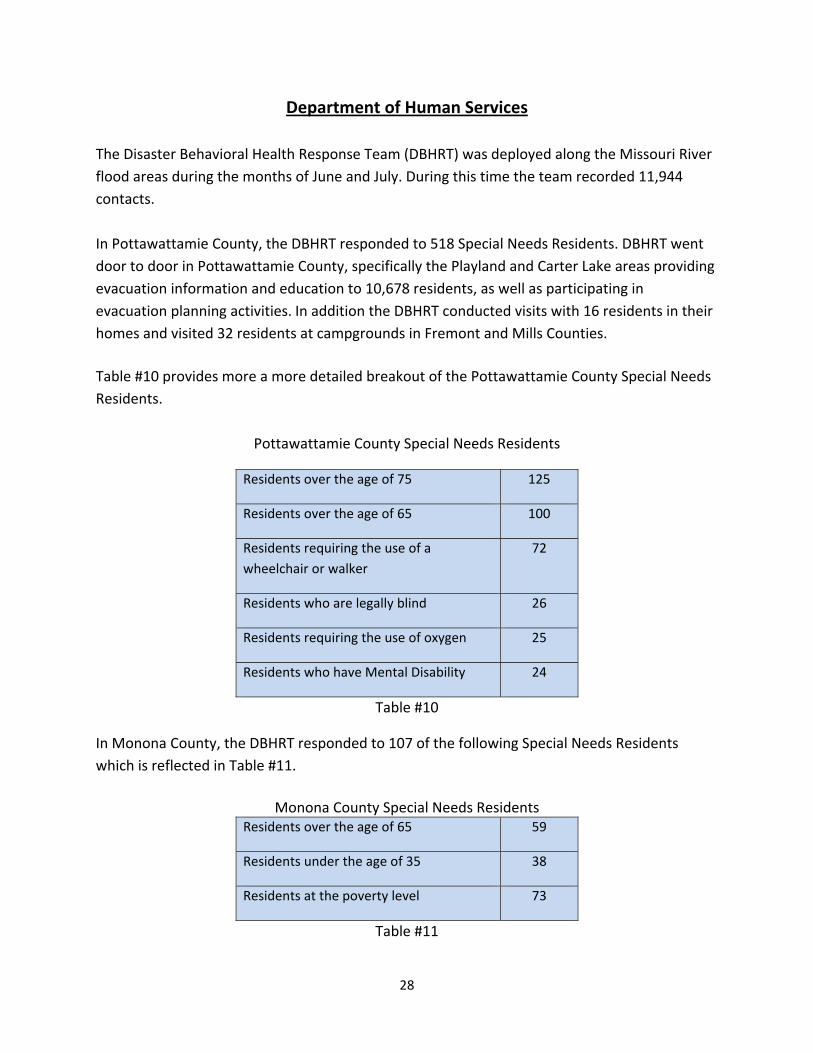
Department of Human Services The Disaster Behavioral Health Response Team (DBHRT) was deployed along the Missouri River flood areas during the months of June and July. During this time the team recorded 11,944 contacts. In Pottawattamie County, the DBHRT responded to 518 Special Needs Residents. DBHRT went door to door in Pottawattamie County, specifically the Playland and Carter Lake areas providing evacuation information and education to 10,678 residents, as well as participating in evacuation planning activities. In addition the DBHRT conducted visits with 16 residents in their homes and visited 32 residents at campgrounds in Fremont and Mills Counties.
Table #10 provides more a more detailed breakout of the Pottawattamie County Special Needs Residents.
Pottawattamie County Special Needs Residents
Residents over the age of 75 125
Residents over the age of 65 100
Residents requiring the use of a wheelchair or walker
72
Residents who are legally blind 26
Residents requiring the use of oxygen 25
Residents who have Mental Disability 24
Table #10
In Monona County, the DBHRT responded to 107 of the following Special Needs Residents which is reflected in Table #11.
Monona County Special Needs Residents Residents over the age of 65 59
Residents under the age of 35 38
Residents at the poverty level 73
Table #11
28
The DBHRT made the following contacts at these Town Hall meetings: Pacific Junction‐ 215 residents; Hamburg – 186 residents; Nebraska City – 75 residents; and Missouri Valley – 132 residents. The DBHRT members provided Psychological First Aid, brief crisis counseling, referral and assessment and resource linkage. DBHRT members made referrals for numerous social, health and financial issues stemming from the disaster events and referrals were given in areas such as: child care, mortgage assistance, food assistance, clothing, medical referrals, health, financial and disaster assistance information. The Iowa Economic Development Authority arranged for AmeriCorps members to partner with DHS’s DBHRT to provide outreach services. AmeriCorps members were teamed with DBHRT members to canvass targeted neighborhoods in Council Bluffs. The teams reached over 5000 homes in a five day period. The highlights of the effort were the ability to register people with special needs for the special needs (Special needs include: People over the age of 65, children and people with disabilities) evacuation process, many referrals to local mental health agencies were made, safety and evacuation education was highlighted and potential scams were reported.
29
PART III: DISASTER RECOVERY OPERATIONS
RECOVERY WORK GROUP REPORTS
Transportation The Iowa DOT administers the Federal Highway Emergency Relief (ER) Program during eligible disasters in Iowa. This includes monitoring projects for Iowa’s federally funded transportation systems submitted to the Federal Highway Administration (FHWA) during disasters. Projects are broken down by estimated Emergency Work or estimated Permanent Work, plus there are several differences in Emergency Work verses Permanent Work. Emergency work is defined as work that must be completed to restore essential traffic, protect the remaining facility and protect the traveling public. Permanent Work is work that is a result of the event but can be completed while the roadway is open to traffic. During a disaster FHWA requires that eligible counties receive a Governor’s Proclamation and estimated damage costs (all counties combined) must be greater than $700,000 Federal‐share.
30
In the State of Iowa all roadways maintained by the Iowa DOT are considered FHWA Emergency Relief eligible. All county and DNR routes classified as a major collector or above, as well as city routes classified as collector or above, are considered FHWA ER eligible. Railroad crossings on FHWA ER routes, damaged during eligible disasters are also eligible for FHWA ER funds. Table #12 provides a summary on the 2011 Western Iowa Flood FHWA Projects.
Typically a flooding event’s response is complete before the recovery work begins. Due to the prolonged duration of this summer’s flooding, recovery efforts were underway in some areas while the flood response was still active in others. Additionally, the scope of the recovery was much more dynamic; there were multiple recovery projects underway at the same time. Two key reasons for this were the desire to reopen roads closed for several months and to complete as much work as possible before winter. Ironically, it was the unusually warm and dry weather from August through November which allowed for accelerated construction schedules, enabling all primary roadways to reopen prior to the 2011 Thanksgiving Holiday. Many smaller projects within the DOT right‐of‐way were completed during the spring of 2012. While the Missouri River flooding took a toll on public infrastructure in western Iowa, the disaster also provided an impetus to take a fresh look at some processes used by the Iowa DOT for roadway damage inspection reporting and record keeping, as well as the highway reconstruction process itself. For an emergency roadway project to be eligible for 100 percent reimbursement under the Federal Emergency Relief (ER) program in 2011, the Federal Highway Administration (FHWA) requires that mitigation or repair work be completed within 180 days of the beginning of the disaster. If the work is not completed within that period, it would be eligible for reimbursement at a rate of 80 percent for non‐interstate roadways and 90 percent for interstate highways. To assure receipt of full Federal reimbursement for state roadways damaged by the flooding, the
31
Iowa DOT relied on two never‐before‐used processes; one involved acceleration of the Federal funding application process and the other fast‐tracking of repair and reconstruction of damaged public infrastructure. The Iowa DOT automated its paper‐based Detailed Damage Inspection Report (DDIR) system through development of an electronic submittal system. It was used for the first time during the western Iowa floods of 2011. The system was developed in‐house by the Iowa DOT’s Information Technology Division. It is used by employees with the Iowa DOT, counties, cities, Iowa Department of Natural Resources (DNR) and railroad companies. Along with the DDIR form that is eventually submitted to FHWA, the system produces a map depicting the location of the damaged site, and allows documents and pictures to be attached. In addition, the system warns users if certain fields are not entered correctly or information is missing, allows the user to select certain information from drop‐down menus and automatically creates a report number. Once the DDIR entry is complete, the system generates an e‐mail notifying the ER program administrator that a new DDIR has been created. This automated system saves time and money, and reduces the incidence of errors on the DDIR forms. The Iowa DOT’s DDIR system is being studied by the Federal Highway Administration for use in other states. Another best practice that will be instructive for future disaster response was the I‐680 re‐construction project. Preparing for a “normal” interstate reconstruction project, which involves environmental and design work and bid preparation, can take up to five years. When I‐680 was severely damaged by the Missouri River flooding, the Iowa DOT recognized that this western Iowa lifeline needed to be repaired in months, not years. Working closely with the contracting industry, the Iowa DOT’s offices of Design and Contracts developed construction plans and a bid package that included one, lump‐sum bid item – I‐680 reconstruction. Iowa DOT Transportation Engineers with the Office of Design produced the necessary construction plans in less than a week, instead of the two to three years typically allotted for this type of project. Because I‐680 was to be reconstructed on the existing highway alignment or footprint, the Iowa DOT was able to bypass the often time‐consuming environmental process associated with new construction. Utilizing elements of the as‐built plans from the original interstate project constructed in the 1960s was a significant time‐saver. At the same time the plans were being finalized, the Office of Contracts was preparing to solicit bids from contractors. Typically, contractors bid separately on several individual elements of a project. For I‐680, contractors were asked to bid on one line item, I‐680 reconstruction. This was the first major lump‐sum bid of its kind in Iowa. While several specific items were listed in
32
the proposal, contractors were asked to bid the project as a whole. Accomplishing the bid process at the same time as the design was being finalized was another significant time‐saver, as these processes are not typically accomplished concurrently. Other alterations to the bid letting process were made to accommodate a tighter time frame. These included: (1) limited bid advertising, which was authorized through an emergency governor’s proclamation; (2) inclusion of incentives and a bonus to accelerate project completion; and (3) having Iowa DOT field staff available seven days a week to answer contractor questions and resolve issues. Iowa’s contracting community came alongside the Iowa DOT in accomplishing this reconstruction project in record time. Pre‐bid meetings were held with contractors to solicit ideas and the contractor selected for the project signed the contract the same day as the bid letting. Iowa DOT commends the US Congress for providing flexibility to the US DOT Secretary via the MAP‐21 legislation passed in 2012, which allows for waiver of the 180 day requirement when circumstances, such as a long‐term flooding event, could prevent completion before winter weather stops construction.
Natural Resources Flood damage was assessed on Sovereign Lands, State Parks and USACE lands managed by Iowa DNR under license agreements. Habitat damage was extensive with thousands of acres of lost grasslands, prairies, and woodlands. Partnership meetings with surrounding states, US Fish & Wildlife Service and local experts on restoration efforts are ongoing. Wilson Island State Park received a large amount of flood damage during the flood event. Iowa DNR received a special appropriation from the Iowa Legislature to cover the damage that was not covered by FEMA. Tree mortality will be an important issue to remember as the disaster recovery continues. Iowa DNR assessed the impacts on tree mortality during the spring 2012. Iowa DNR has proceeded with salvage projects (a few involving Emergency Forrest Restoration Program) in anticipation that hackberry and black walnut will not survive. Survival of the cottonwood, sycamore, and silver maple looks promising. The main impacts will develop in the next 2‐3 years as secondary pests affect the box elder, cottonwood and black walnut. Iowa DNR continues to identify dying trees that create a hazard to park visitors. Planning continues to replace the thousands of mature trees that are dying or that are expected to die
33
from the flood. For example, the Arbor Day Foundation recently approved the Wilson Island reforestation project for 14,000 trees. FEMA received a request for a direct Federal mission assignment for the collection of orphan tanks and drums that were left behind by receding flood waters. The Environmental Protection Agency (EPA) was then tasked by FEMA via direct Federal mission assignment, with support from Iowa DNR, to begin the collection of orphan tanks and drums in Pottawattamie County. FEMA initially obligated $80,000 (75% Federal share, 25% State share) towards this direct Federal mission assignment and directed EPA to provide a cost estimate for the collection of the remaining orphan tanks and drums along the Missouri River. EPA estimated that an additional $300,000 will be needed for collection of the remaining containers along the Missouri River. Once this cost estimate was received by FEMA, collection operations were suspended while a cost benefit analysis was conducted. Once the cost analysis was complete, FEMA with concurrence of HSEMD cancelled the direct Federal mission assignment with EPA. The cost for collection of these orphan containers was significantly higher using EPA contractors, plus the EPA contractors were not Iowa companies. This mission was carried out by regional hazmat teams, Iowa companies hired by local government, with their associated eligible costs being available for reimbursement through the FEMA Public Assistance Program. State Agencies were responsible for hiring contractors to remove any orphan tanks or drums found on State land and applying for reimbursement through the Public Assistance program. Iowa DNR was and continues to be available to provide flood related technical assistance to landowners and local officials. A toll free technical assistance number is available Monday ‐ Friday, 866/849‐0321. More flood plain information can be found at: http://floodplain.iowadnr.gov.
Housing The Iowa Finance Authority’s (IFA) mission is to finance, administer, advance and preserve affordable housing and to promote community development for Iowans. During the Missouri River floods, IFA led the State’s housing recovery efforts. Federal resources were the primary source of financial assistance. Federal disaster assistance is provided as money or direct assistance to individuals, families and businesses whose property has been damaged or destroyed and whose losses are not covered by insurance. The assistance
helps cover critical expenses. Federal disaster assistance is not intended to restore a damaged property to its condition before the disaster. As of February 13, 2012, a total of 1,289 Iowans had registered for FEMA Individual Assistance. Of those registrants, 1,029 were referred for Housing Assistance. Approximately 74 percent of the Housing Assistance referrals or 752 registrants were approved for grant payments totaling $4,411,583.77. The average Housing Assistance award was $5,866.47. The maximum amount of assistance that may be awarded under this disaster declaration to a household through the FEMA Individuals and Households Program is $31,400. Of the FEMA registrants, 34 households were awarded the maximum amount. Like the FEMA Individual Assistance Program, SBA disaster loan programs are administered at the Federal level. Homeowners may apply for up to $200,000 to repair or replace their primary residence to its pre‐disaster condition. SBA disaster loans are repayable but may be provided at a low interest rate for qualified homeowners. As of February 7, 2012, the SBA had issued 811 applications for potential home loans and had received 202 completed applications. Of the completed applications, 90 home loans had been approved, providing a total of $4,304,500 in disaster assistance to Iowans. After FEMA granted Iowa’s Federal Individual Assistance appeal, assistance was to Iowans in five counties impacted by Missouri River flooding. IFA drafted a letter to the Internal Revenue Service (IRS) requesting relief from certain requirements of the Federal Low‐Income Housing Tax Credit program (LIHTC). The letter signed by Governor Branstad on November 10, 2011, specifically requested the following:
• Suspension of Income Limitations: Temporarily suspend certain income limitation requirements under Section 42 for certain qualified low‐income projects. The suspension would apply to low‐income housing projects approved by IFA (Iowa’s housing credit agency), in which vacant units are rented to individuals who resided in jurisdictions designated for FEMA Individual Assistance in Iowa and who have been displaced because their residences were destroyed or damaged as a result of the devastation caused by the severe flooding. IFA would determine the appropriate period of temporary housing for each project, not to exceed 12 months.
• Status of Units: Temporary housing of displaced individuals in low‐income units without regard to income would not cause the owners to lose low‐income housing credits.
35
• Extension of Temporary Tenancy: Revenue Procedure 2007‐54 allows an owner to rent to a displaced low‐income individual who self‐certifies income to seek temporary tenancy for 4 months prior to submitting all required documentation to support the tenant’s continued status as a qualified low‐income individual. Iowa asked that the temporary tenancy period be extended from 4 months to 12 months.
On December 21, 2011, the IRS issued Notice 2012‐07 to grant certain LIHTC properties relief from specified Section 42 requirements to provide emergency housing relief needed as a result of the devastation caused by flooding in Iowa during the period of May 25, 2011 to August 1, 2011. The IRS temporarily suspended income limitation and non‐transient requirements for LIHTC properties that received approval from IFA to rent vacant units to individuals displaced by natural disasters. Other rules and requirements of Section 42 continued to apply during the temporary housing period. IFA drafted the necessary documents and forms to implement IRS Notice 2012‐07 the same day it was received. A letter of explanation and instructions for participation were sent to all owners / agents of IFA Section 42 LIHTC properties. IFA also drafted and coordinated a press release issued by the Governor’s Office announcing the IRS approval of housing relief for those affected by Missouri River flooding. IRS approval of Iowa’s request for temporary relief under Section 42 of the Internal Revenue Code meant that Iowans who resided in one of the five counties eligible for FEMA Individual Assistance who were displaced by the flooding could rent a vacant apartment at any LIHTC property in Iowa, subject to approval by IFA. Eligible households, without regard to income levels, could seek replacement housing at any of Iowa’s 439 active LIHTC properties. Rents for apartments that house displaced families must continue to remain affordable according to Section 42 requirements, further enhancing a disaster survivor’s ability to recover. In the future, IFA will explore having standing authority from the IRS for disaster‐related flexibilities as soon as a FEMA declaration for Individual Assistance has been approved. IFA’s primary responsibilities were related to identification of unmet needs, referral, communication and coordination. IFA staff’s knowledge of existing housing assistance resources proved valuable throughout the disaster recovery process. IFA participated in state agency and task force meetings and proactively communicated with internal and external stakeholders. IFA actively coordinated communications between stakeholders at the State and local levels, such as facilitating the City of Council Bluff’s request for access to FEMA Individual Assistance data.
36
Once the designation for FEMA Individual Assistance was issued, information was immediately disseminated to the public and impacted Iowans began registering with FEMA. Housing Assistance totaling more than $4.4 million in Federal funds was disbursed in a timely manner to hundreds of disaster survivors, with 74 percent of those referred for Housing Assistance ultimately approved for payment. FEMA inspection services were completed with an average turnaround time of 1 day, 20 hours, and 56 minutes from the date of application submission. IFA has identified a number of improvement opportunities. First, there is a lack of quantitative data related to housing units lost as the result of the disaster and specific housing recovery needs by location that could be shared across agencies. Insufficient data complicated needs identification and anecdotal evidence was relied upon too heavily. Second, for the approximately 224 households referred to but determined ineligible for FEMA Housing Assistance, there was no identified alternative source of financial assistance equally available in all declared counties to meet unmet housing recovery needs and this is an area for further discussion by policymakers. Third, IFA has an opportunity to cross‐train additional staff to assist in the State’s disaster recovery efforts in the future. Lastly, IFA recommends that a centralized system be developed that can share quantifiable data related to housing units damaged or destroyed and on‐going housing recovery needs by location among all agencies partnering in housing recovery efforts.
Communications ‐ Joint Information Center The Communications ‐ Joint Information Center made a significant effort to engage state agency PIOs as mechanism for gathering and distributing information related to task force and member agency activities. By engaging the PIOs from the participating state agencies as well as the Governor’s Office, a consistent message was able to be developed and shared with the public. The Governor’s Office functioned as the lead agency for all high level Task Force information while each agency was given autonomy to issue their own public information related to the recovery, thus ensuring they received the proper attribution for their efforts. HSEMD public information staff designed, developed, launched and maintained a unique task force website. The creation of a separate task force website made it easier for the public to access task force specific information. In the past, State‐level recovery information would have
37
been dispersed on separate websites. A central website allowed the aggregation of information and also created a central repository for new releases that were issued by partner agencies in support of the recovery effort. In the future, the website needs to be more aggressive in gathering and displaying information on local recovery efforts. HSEMD public information staff designed, developed and distributed task force newsletters. The task force newsletter was designed to ensure readability and appeal to its many audiences. The delivery of the newsletter was timed so that it alternated with the HSEMD newsletter (published bi‐weekly) so existing staff could handle the increased workload. Task force agencies provided articles for the newsletter. Frequently these stories were about completion of recovery projects or efforts the task force had undertaken to obtain additional recovery aid at either the Federal or State level. As with the website, future consideration needs to be given to engaging and showcasing in a more robust fashion the local recovery efforts.
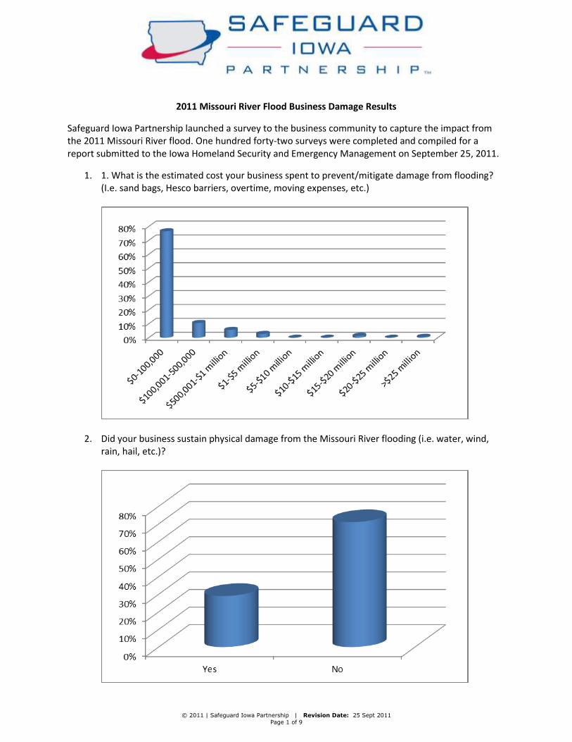
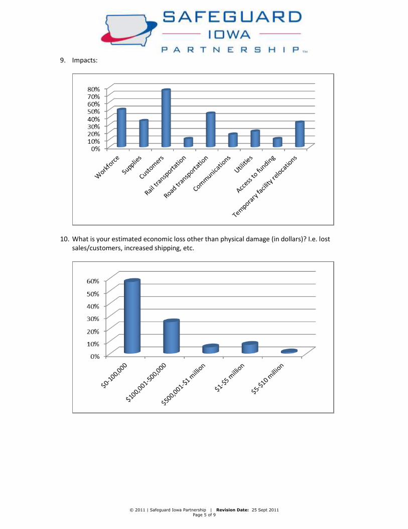
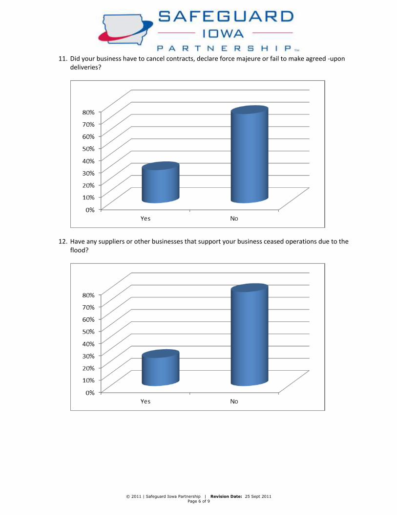
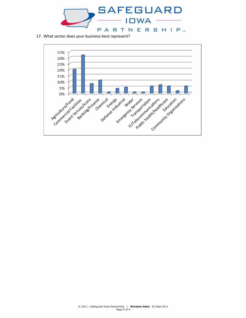
Economic Development The Economic Development work group consisted of representatives from Safeguard Iowa Partnership and the Iowa Economic Development Authority (IEDA) and the SBA disaster office. Safeguard Iowa Partnership launched a survey to the business community to capture the impact from the 2011 Missouri River flooding. One hundred forty‐two surveys were completed and compiled for a report submitted to Iowa HSEMD, which can be found at: http://www.safeguardiowa.org/Resources/Documents/MO%20River%20Business%20Survey%20Public%20Document.pdf. Safeguard Iowa Partnership also provided 2011 disaster resources on their website. As with other disasters, the SBA made low interest loans available to Iowa residents and business owners. For small businesses and most private, nonprofit organizations, SBA offers Economic Injury Disaster Loans (EIDLs) and physical disaster loans. Federal Community Development Block Grant (CDBG) disaster funds were congressionally allocated to the State of Iowa in 1993 and nearly $900 million were allocated in 2008. Iowa did not receive CDBG‐disaster funds for the Missouri River flood recovery efforts ‐‐ such funds were only given to 8 states nationally in 2011. IEDA has set aside up to $1 million in regular CDBG funds, from annual allocations, to be made available to the Missouri River disaster recovery efforts. IEDA will provide up to $1 million for the required local match portion that affected cities or counties will need to provide in order to acquire the Federal funding offered through FEMA’s Hazard Mitigation Grant Program. The Hazard Mitigation Grant Program assists affected
political subdivisions acquire property and damaged homes in the flood plain at fair market value. All properties assisted with this program are in the 100‐year flood plain and are deed‐restricted to green space.
Agriculture While there were significant impacts to more urban areas such as Bismarck, ND, Pierre, Ft. Pierre and Dakota Dunes in South Dakota, limited areas of Sioux City and Council Bluffs in Iowa, and of course limited areas in Kansas (Leavenworth) and into the State of Missouri, much of this flood was termed an agricultural disaster. Most estimates place the agricultural losses in Iowa alone in excess of $200 million. Total regional costs have now exceeded $1 billion with much of that being agricultural losses. The overall impact to cropland was vast. Over 255,000 acres of cropland was subjected to the flood waters causing enormous amounts of damage to this highly productive agricultural land. Not only did standing water eliminate the 2011 crop, but it also impacted the 2012 season and will have impacts beyond. Much of the topsoil has washed away plus producers are contending with large piles of sand, silt and other debris being deposited in fields. Sediment remaining after the flood (Fallow Syndrome) has historically proven to reduce yield potential. Table #13 is a breakout by County of the total acres flooded and the estimated acres of flooded cropland. These numbers were collected from the local Farm Service Agency representatives.
County Flooded Acres
Total Crop
Fremont 78,030 70,595
Harrison 85,752 77,849
Pottawattamie 33,939 31,394
Mills 34,467 31,532
Monona 39,625 34,549
Woodbury 12,060 9,849
TOTAL 283,873 255,768
Table #13
39
The 2012 drought however, will make any estimated yield losses due to flooding very difficult. It is estimated that approximately 75% of the flooded lands in 2011 were able to be restored enough to be planted in 2012. IDALS has an interest in the protection of environmentally sensitive lands as well as ensuring that productive crop land is not lost. From an agency authority standpoint however, there are no regulatory areas or programs which directly focus on flood mitigation or recovery. While there is at least one program of the Division of Soil Conservation (DSC) that can assist in the repair of conservation practices, it is not dedicated or targeted to solely Missouri River area projects. IDALS did play an active role with coordination and communication efforts to better inform affected producers of appropriate State or Federal agencies for assistance. For example, the Department played a valuable role in providing input to a key webinar program which was led by the United States Department of Agriculture –Natural Resources Conservation Service (USDA‐NRCS) with assistance from the University of Nebraska and Iowa State University Extension. In addition to providing program support, the Department played a role in dissemination of the webinar program information to a wide array of media outlets. While the overall effort was in fact developed by the Ag Lands subcommittee of the USACE led Missouri River Flood Task Force, the Department is encouraging FEMA officials to take a closer look at the overall impact of the project. It is the Department’s view that this was an extremely effective and well used tool that should be considered for future use in similar flooding events. The loss of key pipelines crossing the Missouri River also required the Department to provide input to the Governor’s office and the IDOT with regard to mitigation steps that could be implemented to minimize regional fuel and ammonia shortages. In its advisory role as part of the Iowa Energy Assurance Plan, the IDALS recommended that a “Waiver of Drivers Hours of Service” be granted by the IDOT to ensure that alternative modes of delivery (trucks) could accommodate regional supply demands. The IGOV and IDOT supported the IDALS recommendations including a second extension request. On behalf of the agricultural community the Department also actively assisted coordination and communication efforts between numerous State and Federal agencies including: USDA‐Farm Service Agency (FSA), USDA‐Natural Resources and Conservation Service (NRCS), USDA‐Risk Management Agency (RMA), USACE, FEMA, Iowa DNR, IUB, Iowa DOT, Iowa HSEMD, and Iowa Governor’s Office (IGOV).
40
In short, other than some modest coordination and advisory capacities, the IDALS role was very limited in direct recovery operations. Despite this limited role, the Department believes that its primary goals were generally met. These include: Ensuring that landowners with recoverable lands found and received assistance and support; Restoration of key levees and associated breeches were repaired to the extent practical and possible; and Finding and eliminating key restrictions (pinch‐points) that could both enhance environmental restoration efforts and which would provide for future flow improvements and protection to key assets IDALS would also like to acknowledge all of the above listed agencies for their extraordinary efforts both during and post flood event. We also believe that much of these efforts success lies with those at the local level who first worked tirelessly to minimize what could have been a still worse tragedy and whom have since worked with equal dedication on recovery activities. IDALS believes that the exemplary actions at all levels will have a lasting impact on future recovery models and efforts.
Health & Human Services The Health and Human Resource committee was established following the Missouri River Flood of 2011 by the Missouri River Flood Task Force. The sub‐committee was made up of representatives of the Iowa DHS (chair), the Iowa Department of Human Services Crisis counseling lead, the Iowa Department of Public Health, the Iowa Department on Aging, the Iowa Disaster Human Resource Council, FEMA, and Iowa HSEMD. Sub‐committee meetings were held weekly from the inception and then reduced to bi‐weekly and finally monthly. The mission of the sub‐committee was to look at positive actions and possible areas of improvement for Health and Human Services that were known during flood event of 2011 and note successes and make recommendations for improvement of the same services from lessons learned, and best practices. The following are the areas discussed at length: There were care facilities, of frail, elderly, mentally and physically impaired Iowans that were impacted by evacuation orders. It should be highly recommended that each facility have Continuation of Operation Plans (COOP) plans in place to include alternate locations for emergency relocation of clients/patients for short term/long term relocation during emergency situation.
41
Iowa Emergency Services Providers were challenged by road closures and areas that were inaccessible to ground traffic. Emergency Service providers adapted very well as the situation unfolded. During the event the distinct possibility arose that tens of thousands of Iowans might be displaced due to catastrophic failures in the levy system. During this time a search was done to locate large quantities of ESF 6 (Shelter and Mass Care Supplies). It was determined that no comprehensive inventory of these type of supplies exist in the State of Iowa. The Missouri River Health and Human Services subcommittee will conduct a survey of County Emergency Management Coordinators as well as Non‐profit organizations within the State of Iowa to begin to establish an inventory of ESF 6 supplies and equipment to be provided to HSEMD upon completion of the project. Exhaustive attempts have been made to catalog existing resources that exist between some non‐profit organizations as well as governmental agencies. This has not been an easy undertaking and future attempts will continue and be pursued through non‐profit, non‐governmental agencies to prepare for future events. Due to the possibility of evacuation of tens of thousands of individuals from one community, the concern arose that the main evacuation routes would negatively impact nearly all access to hospitals in the areas. Recommend that an evacuation route be established with one way in and one way out for emergency hospital access. Evacuation routes out of threatened areas should have outbound only public access. Emergency vehicle access routes should be pre‐determined during planning stages similar to emergency evacuation routes established in Florida. High water and other specialty emergency vehicles should be pre identified as to availability/accessibility (local, county, State, Federal). Determine accessibility of watercraft and other specialty rescue vehicles for catastrophic events. During this event many emergency resource contacts were developed through County Emergency Managers, HSEMD, Iowa DOT, Iowa State Patrol, DNR, Iowa National Guard, and the USACE. It is our hope that these resource lists will be maintained and expanded for future disasters throughout the State of Iowa. Individuals with functional needs were an unidentified population within the evacuated and possible evacuation areas. The community population, including functional needs individuals did not have a means of self‐identifying them to emergency management as needing assistance in the event of an evacuation order being issued. The Disaster Behavioral Health Response teams organized through DHS visited every home affected by the flood and assisted Emergency Managers in identifying functional needs individuals to begin the process to establish evacuation plans. The Disaster Behavioral Health Response Team provided evacuation
42
education and assisted by registering people in the functional needs registry and Code Red systems. Some areas were evacuated more than one time due to threat of levy failure, and /or heavy rainfall which flooded behind the levies causing secondary flooding. There were reports of residents that began to ignore warnings to evacuate after the first warning. It was reported that residents began to ignore official warnings that could have been dangerous for both residents, and rescuers that might later need to attempt rescue. It might benefit both residents, and rescuers for warnings to be issued for imminent danger with watches for other issues similar to weather watches and warnings.
Interagency Levee The Interagency Levee Work Group (ILWG) was tasked with all recovery aspects that related to levies that were impacted by the Missouri River flooding. The members included 14 state agencies, 6 federal agencies and 6 counties/municipalities. Most importantly, members included local levee and drainage district representatives many who suffered damages in the flood event. The State has significant experience in levee coordination, including the historic flooding of 2011 and previous historic flooding events in 1993 and 2008. There are many stakeholders, including Federal, State and local personnel and private sector representatives involved in levee coordination. The USACE administers levees that are in the Federal system. With more than 100 days of flooding, the extensive USACE Program levee system from the north side of Council Bluffs, south to the Missouri State line was severely impacted by three breaches in the levee system. Those breaches flooded the towns of Percival, Bartlett and threatened the city of Hamburg, all located in Fremont County. In addition, I‐29 was flooded along with thousands of acres of farmland, homes, out buildings and infrastructure and caused a serious economic impact to local and regional businesses. Near the DeSoto National Wildlife Area just north of Council Bluffs, a natural high river bank breached causing a huge scour hole, flooding the wildlife area, the Bertrand Steamboat exhibit, cropland, homes, roads and damaged levees. This area is referred to as the DeSoto Bend scour hole and is just upstream of the Fort Calhoun Nuclear Power Plant in Blair, Nebraska. It was uncertain if the Missouri River would seek its old channel or remain in the navigation channel. Also there were concerns regarding the potential for additional flooding. Engineers and hydrologists from NRCS, USACE, Iowa DNR, USGS and Iowa DOT along with other agencies
43
worked closely together to determine a possible fix and to determine the probability of flooding. The landowner is working with the Union Pacific Railroad to provide fill material and the UP is building a haul road near the Missouri River which will block flow to the scour hole. Since the breach happened on Iowa DNR land, DNR may provide funds to place rock on the river side of the haul road to protect it from flowing water. North of Council Bluffs are several levee districts and private levees that are not in the USACE program, and are the responsibility of the local levee districts and respective private levee owners. These levees also suffered numerous breaches. Those breaches increased the flood damages to I‐29 and I‐680 causing road closures and severe damage to cropland but not as extensive as those in Fremont County. Because much of the area is cropland and not developed, there were fewer business impacts, although the DeSoto National Wildlife Refuge was inundated with extensive damage. Two of these levee districts qualified for Public Assistance funding to return these levee systems back to pre‐disaster condition. A group of landowners north of Council Bluffs including the two levee districts who qualified for Public Assistance funding, contacted several Iowa legislators to look into the possibility of sponsoring a USACE Planning Assistance to States (PAS) study. The study was to determine the feasibility of building a “super levee” that connected with the Council Bluffs levee system and ran 45 river miles north to the confluence of the Soldier River. Specifically, HSEMD was asked to be the sponsor of the PAS study on behalf of the State of Iowa. The ILWG convened a meeting of state agencies from Iowa and Nebraska as well as Federal agencies and universities with hydraulic and hydrology expertise to consider what the potential impacts would be if constructed. Based on the scientific concerns and lack of consensus to move forward with this project from local, multi‐state and federal stakeholders, the Task Force recommended not pursuing this project. Levee’s in Fremont County were especially hard hit including three breaches in a levee named L‐575 which caused extensive damage to the County. Rural residents, county government and USACE were quick to respond as were the citizens of Hamburg, Percival and Bartlett. Percival and Bartlett were inundated due to the breaches in L‐575. USACE raised the existing Federal levee an additional ten feet protecting the City of Hamburg. Subsequently the City of Hamburg did not flood. USACE assists with recovery efforts for levee systems in the USACE PL 84‐99 Emergency Management Program. Local levee sponsors are responsible for a portion of the repairs to the levees and the USACE provides a 75% cost share for repairs. Repairs on the internal drainage system are eligible for the Public Assistance program, also at 75%. The levee district assesses
44
taxes on those in the district but because the repair costs are so high they believe they need to raise additional revenue. The ILWG created a sub‐committee to address the tax revenue issue and the sub‐committee of county officials has taken this issue and proposed recommendations to the Iowa State Association of Counties. The USACE has been exemplary in their recovery efforts and the entire PL 84‐99 levee systems were returned to pre‐disaster condition prior to spring 2012. As a result of this subcommittee’s efforts a local organization called the Missouri River County Officials Coalition (MRCOCO) was initiated to work on long term recovery efforts along the Missouri River on a multi‐state level. County officials from Iowa, Missouri, Nebraska and Kansas are involved in the effort which originated in Fremont County. One of their major efforts is the Highway 2 levee setback and is working with the USACE, Iowa DOT, Iowa DNR and the State of Nebraska to lengthen the Highway 2 Bridge to allow a greater volume of water under the bridge to prevent a pinch‐point in the Missouri River. Another sub‐committee was created to address the need to inventory levees in Iowa and how those levee sponsors can work with county emergency management coordinators during flood fighting. Iowa DNR is the lead agency in this effort. The DNR has completed the state‐wide inventory and has digitized all apparent structures adjacent to streams, rivers and drainage districts. The structures are levees, berms, dikes or spoil piles which are higher in elevation than the surrounding ground and may restrict water flow. The ILWG has initiated tours of damaged areas, regularly meets with the local people to discuss and coordinate recovery efforts, addresses flood plain management issues, and regulatory policies. While the Missouri River ILWG no longer meets, long term levee and flood recovery issues along the Missouri River have been undertaken by the Iowa Silver Jackets Flood Risk Management Team. The Iowa Silver Jackets is an organization of multiple local, state and federal partners created after the 2008 floods that focus on long‐term flood risk management. The Silver Jackets task is to maintain and advance state‐wide flood risk management efforts on an interagency and intergovernmental basis.
Public Assistance Between Iowa HSEMD, local and FEMA efforts approximately $70 million has been identified for possible Public Assistance funding for an estimated 123 local and State entities within Fremont, Harrison, Mills, Monona, Pottawattamie and Woodbury counties. Another $4 to $5 million dollars is estimated for 403 Demolitions under the Public Assistance program which will assist Applicants in eliminating private structures that pose an immediate health and safety threat.
45
Fremont County, Pottawattamie County and the City of Council Bluffs have submitted a request for assistance in 403 Demolitions. Positive relationships developed between Iowa HSEMD, other State agencies, FEMA, USACE and local entities have assisted in the smooth operation of the DR‐1998 Public Assistance Program. State and FEMA personnel assigned to the disaster have worked as a joint team; FEMA has allowed the State to weigh in on eligibility decisions taking into account local knowledge and the State’s ability to act as a liaison between local entities, State and Federal agencies. The relationship between agencies has enabled communication allowing for the determination of proper authorities regarding funding which has resulted in quicker processing and fewer appeals.
Hazard Mitigation Hazard Mitigation efforts started with conducting Individual Assistance Joint Preliminary Damage Assessments with FEMA and the SBA to determine the level of damage to residential properties in the six county area impacted by the Missouri River flood event. In addition to the presidential declaration process, this provided an opportunity for mitigation staff to ascertain potential Hazard Mitigation Grant Program (HMGP) property acquisition projects in communities. Disaster 1998 was declared on June 27, 2011. The Mitigation team conducted joint applicant’s briefings with the Public Assistance team in the six declared counties July 7‐8. HSEMD Mitigation published a notice of funds availability for HMGP grants on July 13 for mitigation projects to reduce or eliminate losses from future natural disasters. The Mitigation team has provided ongoing consultation and technical assistance to several jurisdictions regarding HMGP property acquisition projects to acquire and demolish damaged structures in the special flood hazard area. The State has submitted three HMGP property acquisition projects to FEMA for funding. Two projects are from the: City of Council Bluffs: to acquire 17 properties containing multiple structures. The total cost of two projects is $3.8 million. Pottawattamie County’s project will acquire thirty three properties at a cost of $6.3 million. FEMA has approved all of these projects. In all of these HMGP acquisition projects, coordination and collaboration with other internal and external stakeholders was (and will continue to be) critical:
46
• HSEMD Pubic Assistance and FEMA Public Assistance – Public Assistance grants will provide the vast majority of funding for demolition of the damaged structures
• Iowa Economic Development Authority – made available two potential sources of Community Development Block Grant funding to meet local cost share requirements.
• HSEMD, FEMA, and State Historical Preservation Office – streamlined the historical and environmental compliance process.
The HSEMD Mitigation team is also working closely with the HSEMD Public Assistance team to identify potential infrastructure mitigation projects to lessen or prevent future damage due to repetitive flooding and loss of critical utility functions along the Missouri River Basin in Iowa. Both teams will continue to work together to address the needs of the community in the area. Examples of potential mitigation infrastructure projects include: retrofitting storm water sewer systems, flood proofing of non‐residential properties, installation of minor floodwalls to protect critical facilities, construction of detention and/or retention basins and drainage systems, elevation of components to critical utility functions, and minor erosion control and bank stabilization.
Iowa Utilities Board The Iowa Utilities Board (IUB) began investigating unprecedented Missouri River flows in early May, 2011, as part of its participation in the State Interagency Missouri River Authority (SIMRA). During the activation of the SEOC and the subsequent Recovery Task Force, the IUB proactively communicated with stakeholders, including other state agencies, Governor’s office personnel, and affected utilities, and acted as communications intermediary throughout 2011 and the spring of 2012. IUB provided HSEMD Critical Infrastructure staff with the locations of telephone company central offices, cell phone towers, and pipeline crossings as well as status and information updates from telephone and cellular telephone companies, electricity providers, natural gas retailers, and pipeline operators. IUB provided information about pipeline regulations, locations, and contacts for discussions about maintaining the safety of pipelines crossing the Missouri River. Discussions followed a pipeline break in the flooded Yellowstone River. The decision was made for USGS to do sonar testing of buried pipelines in the Missouri River and provide this information to the Federal Pipeline Hazardous Materials Safety Administration (PHMSA) for distribution to pipeline companies. Post‐flood, the IUB helped ensure safe reconnection of utility services to flood‐affected areas. Staff helped coordinate a cooperative effort between MidAmerican Energy Company and the
47
State Fire Marshall, enabling fire department personnel to inspect residences for evidence of flood‐damaged equipment prior to utility reconnection. IUB also assisted utilities in coordinating with the Iowa Department of Transportation to ensure utility access to roads to facilitate infrastructure repairs. The IUB was involved when discussions about the impact of the DeSoto Bend cut began in late November and early December. IUB staff contacted staff at the Fort Calhoun nuclear facility to ask them to engage with HSEMD to discuss whether the cut would impact their facility. Fort Calhoun staff participated in the December 8 tour of the cut. One form of FEMA individual assistance is available to persons displaced due to utility disconnection. FEMA asked IUB to determine whether information on customer outages could be consolidated in order to speed up verification of claims. IUB coordinated a discussion with the utilities and it was determined to be currently unfeasible. The process requires a customer to request the information from their utility and then provide the information to FEMA. FEMA cannot request it directly from the utility and there is no easy way to consolidate the information. It is inefficient process for FEMA, the utility customers, and the utilities, but is required by customer information protection laws.
Iowa Dept. of Education The Iowa Department of Education (DE) attended an emergency management meeting for State agencies on Friday, July 8, 2011, at Iowa HSEMD. This meeting explained the urgency for Missouri River Flood disaster preparation for Council Bluffs area and south of Council Bluffs. Council Bluffs Community School District was notified about the potential flood damage that was predicted to occur during the start of the new school year. The school district informed the DE about working with the local Emergency Management representatives, as well as representatives from HSEMD and the Iowa Department of Education, to prepare flood evacuation plans for all potentially impacted schools. A flood drill was conducted during the first week of school at the two schools closest to the levee. With no actual flood damage, this precautionary planning and practice was a great preparedness exercise for the district in the event of an actual disaster. This type of planning and practice is a good exercise for all districts related to potential natural disasters of any kind. A weekly Flood Relief Coordination Committee was formed to assist and collect information from school districts. A questionnaire was sent to thirteen public school districts and two Area Education Agencies (AEA) that are contiguous to the Missouri River. Four school districts
48
responded to the questionnaire that was designed to help the DE provide specific guidance to educational agencies that could be affected by potential flood conditions:
Date School District Questions
1. Will any of your attendance centers be affected? Closed? Partially closed?
7/21/2011 Fremont‐Mills No building impacted.
7/21/2011 Sidney No.
7/26/2011 Whiting No.
8/12/2011 Council Bluffs As of this point, we plan to open school with all buildingsready to welcome students.
2. If totally or partially closed, can the remainder of yourattendance centers accommodate all of your students?
7/21/2011 Fremont‐Mills N/A
7/21/2011 Sidney N/A
7/26/2011 Whiting No.
8/12/2011 Council Bluffs We had made some very preliminary plans for some movement within district, but those plans will not be utilized unless conditions change significantly.
3. Do you anticipate having students outside the district askto start the school year with you?
7/21/2011 Fremont‐Mills We have had no requests at this time, registration is set forAugust 4.
7/21/2011 Sidney Possibly. Regarding counting students ‐ under #3 is the sameprocedure followed if the temporary district is in another state? Most of Sidney's displaced students lived in Percival. Those families have taken up temporary residence in Nebraska City.
7/26/2011 Whiting No.
8/12/2011 Council Bluffs We have heard of 2 students displaced from a differentdistrict, but they have their superintendent’s permission to drive to the previous school district until they are returned to their home. There may be other students, but we do not know of them. It is doubtful that very many students have
49
moved into the district.
4. Do you anticipate that some of your resident studentswill seek to start the school year elsewhere? If so, where?
7/21/2011 Fremont‐Mills We are not aware of anyone as of right now.
7/21/2011 Sidney Yes, Nebraska City.
7/26/2011 Whiting No.
8/12/2011 Council Bluffs It is a distinct possibility. We have used media, phone callsand website to communicate that we will help any of our students who have been displaced. To this point, we know of about a dozen families, but that may increase next week when official start of school occurs.
5. Has Emergency Services or the Red Cross contacted yourdistrict about using your school facilities for shelters during an evacuation?
7/21/2011 Fremont‐Mills Not at this time, I believe Sidney HS is a designated shelter forFremont County, East Mills HS in Mills County.
7/21/2011 Sidney Yes, the junior/senior high school was used as a shelter untillate June. It has been on stand‐by since that time as the occupants left. The Red Cross will remove their supplies and vacate the building by July 29.
7/26/2011 Whiting No.
8/12/2011 Council Bluffs Yes. We were prepared to use Kirn Middle School as a shelter,but the need has not arisen to date. Note: District officials will attend to rulings related to residency and athletic eligibility as presented.
School districts that could be impacted by the Missouri River flood conditions were also encouraged to develop a contingency plan. To develop a contingency plan, DE provided guidance regarding displaced families, athletic eligibility, counting students, transportation, and school districts were also informed about the statutory authority of the DE to grant a variety of waivers as necessitated by a natural disaster. This type of assistance was communicated to all of the potentially–impacted school districts and would be a good practice to maintain with all school districts affected by this type of natural disaster. Since the school finance formula for school districts is pupil driven, districts were concerned about the certified enrollment. The following guidance for counting students was provided:
50
1. Districts should ascertain whether displaced families intend to return within a reasonable period of time (18 months, for example) to their pre‐disaster resident district. A form was provided that districts could use or modify to collect information from displaced families. The form should be filled out by or on behalf of each displaced family who intends to return to the resident district to assist the district in gauging the likelihood of their return. 2. The students of displaced families who intend to return and who will continue their education in the resident district without interruption are to be included on the certified enrollment of the resident district. 3. The students of displaced families who intend to return but whose education will be provided in the district of temporary location of the family also are to be included on the certified enrollment of the resident district. The resident district will reimburse the serving district a pro rata amount for the days served. 4. Families are not to use open enrollment for these situations; open enrollment funding does not include all of the funding that accrues to a district per certified enrollment of a resident student. Open enrollment is appropriate if a family is displaced from District A to District B, but desires that their children attend District C.
Guidance for school transportation: Districts are encouraged (as AEA chief administrators are so advised) to cooperate during these extraordinary circumstances to allow the school buses of a contiguous district to temporarily run necessary bus routes outside the boundary of the resident district. Disputes are to be handled by AEA boards per Iowa Code section 285.9. However, displaced families who desire for their children to continue their education in the resident district without interruption may be required to be responsible for transportation to and from school when the AEA determines that it is not cost effective for the resident district to provide the transportation. Guidance regarding athletic eligibility of displaced students: Agreement has been reached among the DE, the Iowa High School Athletic Association, and the Iowa Girls High School Athletic Union to accommodate secondary students whose families are displaced by the floods. Ordinarily, the transfer rule requires high school students who transfer from one school to another without a contemporaneous parental move to sit out 90 consecutive school days from varsity level competition in interscholastic sports. Due to the extraordinary flooding in western Iowa this spring, displaced students will be held harmless (that is, have no period of ineligibility) under several scenarios, all of which are in the guidance document provided.
51
In summary, there was no physical property damage by the 2011 Missouri River flood for school districts but there were reports of displaced families. Council Bluffs Community School District used the media, phone calls, and the website to provide displaced family assistance. When displaced families leave their resident school district, certified enrollments and State funding through the pupil driven finance formula will affect school districts. School districts have worked collaboratively with Emergency Services and/or the Red Cross to prepare for possible flood evacuation of families.
Applying Disaster DR‐1998 to Future Disasters With each disaster event comes new challenges and opportunities. The documentation of best practices will help all involved continue to strive for constant improvement in future disasters. By leveraging this information we can continue to improve the service to the citizens of Iowa.
52
Appendix A: 2011 Missouri River Flood (DR 1998) After‐Action Report
Safeguard Iowa Partnership launched a survey to the business community to capture the impact from the 2011 Missouri River flood. One hundred forty-two surveys were completed and compiled for a report submitted to the Iowa Homeland Security and Emergency Management on September 25, 2011.
1. 1. What is the estimated cost your business spent to prevent/mitigate damage from flooding? (I.e. sand bags, Hesco barriers, overtime, moving expenses, etc.)
2. Did your business sustain physical damage from the Missouri River flooding (i.e. water, wind, rain, hail, etc.)?
7. Will or have you returned to your original business location (i.e. city)?
8. Did your business sustain other impacts from the flooding? For example, impacts to workforce, supplies, customers, rail/road transportation, communications, utilities, access to funding, temporary facility relocation.