25
Monitoring Cities: International Perspectives Edited by Wayne K. D. Davies and Ivan J. Townshend International Geographical Union Urban Commission ISBN: 0-88953-259-1

Monitoring Cities: International Perspectives
Edited by
Wayne K. D. Davies and
Ivan J. Townshend
International Geographical Union Urban Commission
ISBN: 0-88953-259-1
Monitoring Cities: International Perspectives
Edited by
Wayne K. D. Davies and
Ivan J. Townshend
International Geographical Union Commission on Monitoring Cities of Tomorrow

International Geographical Union, Urban Commission (with Department of Geography, University of Calgary; and Department of Geography, University of Lethbridge)
Monitoring Cities: International Perspectives
Editors: Wayne K.D. Davies Ivan J. Townshend
© International Geographical Union, Urban Commission
Full Members of the Commission Prof. Gerhard O. Braun (Chair) Prof. Willem Ostendorf (Deputy Chair) Prof. Yuji Murayama (Secretary)
Prof. A. Bopda Prof. W.K.D. Davies Prof. A. Horn Prof. I. Kim Prof. C. W. Matthiessen Prof. I. Schnell Prof. N. Spence Prof. X. Yan
Honorary Members of the Commission Prof. L.S. Bourne Prof. D. Pumain Prof. J.-B. Racine Prof. D. Shen Prof. R. Sinclair
First Published: December 2002. Printed in Canada by Graphcom Printers Ltd., Lethbridge, Alberta.
ISBN 0-88953-259-1
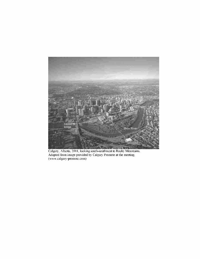
Calgary, Alberta, 2001, looking south-southwest to Rocky Mountains. Adapted from image provided by Calgary Promote at the meeting. (www.calgary-promote.com)

Monitoring Cities: International Perspectives iii Table of Contents
TABLE OF CONTENTS
PREFACE ix
INTRODUCTION 1 Wayne K.D. Davies and Ivan J. Townshend
PART I. CHANGES IN SYSTEMS OF CITIES AND TOWNS
1. THE CANADIAN URBAN SYSTEM: Old Structures, Recent Trends and New Challenges 15
Larry S. Bourne University of Toronto, Canada.
2. NEW TRENDS IN THE SWEDISH URBAN SYSTEM: Metropolitan Concentration, Inner City Growth and Urban Sprawl 33
Olof Wärneryd Lund University, Sweden.
3 . GROWTH AND MATURITY OF THE MEXICAN URBAN SYSTEM 51
Adrian Guillermo Aguilar1 and Boris Graizbord2
1 UNAM, Mexico. 2 El Colegio de Mexico, Mexico.
4. THE DIFFERENTIATION OF SOUTH KOREA’S URBAN SYSTEM: Defining the Results of Modernization 73
Wayne K.D. Davies1 and Jeong-Sam Kim 1 University of Calgary, Canada.
5. DEFINING THE WORLD SYSTEM OF CITIES: Overseas Locations of Transnational Banks (Abstract Only) 99
Hirobumi Haga. Kyusyu Sangyo University, Japan.
6. NODAL STRUCTURE OF CHINESE CITIES: An Application of GIS for Urban Systems Analysis 103
Guoqing Du Rikkyo (St. Paul) University, Japan.
iv Monitoring Cities: International Perspectives Table of Contents
7. ENVIRONMENTAL PERFORMANCE AND EUROPEAN CITIES: A New Key Parameter in the Competition between Metropolitan Centres 119
Christian Wichmann Matthiessen, Henrik Søgaard, and Stefan Anderberg University of Copenhagen, Denmark.
8. MONITORING CHINESE SMALL TOWNS OF TOMORROW 143 Daoqi Shen Chinese Academy of Sciences, Nanjing.
9. SMALL TOWNS IN THE SUDETEN REGION OF POLAND: Changes in Character, 1946 – 1999 157
Jan Łoboda University of Wrocław, Poland.
10. ATTITUDES TO ICT ADOPTION IN SPANISH CITIES: Challenges For Local Administrations In Spain 175
Manuel Valenzuela1 and Carmen Vázquez2
1 Autonomous University of Madrid, Spain. 2 University of Castilla-La Mancha, CUENCA (Spain).
1 1 . THE SUSTAINABILITY OF CITIES: Global Challenges, German Perspectives 199
Lienhard Lötscher Ruhr-University Bochum, Germany.
PART II. MEASURING AND CONCEPTUALIZING IMPACTS OF CHANGE ON CITIES AND REGIONS
12. CHANGING SPATIAL STRUCTURE OF THE TOULOUSE METROPOLITAN AREA UNDER EUROPEAN UNION INTEGRATION 213
Yuji Murayama University of Tsukuba, Japan.
13 . SITUATIONAL FACTORS AND URBAN GROWTH: The Case of Lethbridge and Alberta’s Metropolitan Centres 227
Ian MacLachlan University of Lethbridge, Canada.
Monitoring Cities: International Perspectives Table of Contents
v
14. GOVERNANCE OF A TRANSBORDER URBAN REGION: Regulation and Transgression in the Hong Kong/Pearl River Delta Region (Abstract Only) 243
Alan Smart University of Calgary, Canada.
15. MANAGING DEVELOPMENT IN MOUNTAIN COMMUNITIES: The Example of Banff in Canada’s Rocky Mountains (Abstract Only) 245
Dianne Draper University of Calgary, Canada.
16. MANAGING COMPLEXITY AND UNCERTAINTY IN URBANIZED REGIONS: Towards an Integrated Approach 247
Stefan Carsten Daimler-Chrysler, Germany.
17. DEFINING THE ELEMENTS OF URBAN SYSTEM CHANGE 269 Dan O’Donoghue Canterbury Christ Church University College, U.K.
18. THE OUTER CITY AND URBAN FRINGE REVISITED: Looking for New Solutions to Old Problems 295
Ludger Basten Ruhr-University Bochum, Germany.
19. WATERFRONT DEVELOPMENT AND REGENERATION: The Background to Contemporary Changes in Dublin and Cardiff 309
Niamh Moore1 and Wayne K.D. Davies2
1 University College Dublin, Ireland. 2 University of Calgary, Canada.
PART III COMMERCIAL AND HOUSING STUDIES OF INTERNAL CITY CHANGE
20. MONITORING CHANGES OF COMMERCIAL STRUCTURE IN CANADA 345
Jim Simmons Centre for the Study of Commercial Activity, Canada.
vi Monitoring Cities: International Perspectives Table of Contents
2 1 . CHANGES IN GOODS DISTRIBUTION AND THE CITY: Physical Distribution as an Indicator of Urban And Regional Development 357
Markus Hesse Free University of Berlin, Germany.
22. TRANSFORMATIONS OF BLOCK-NEIGHBOURHOODS IN SLOVENIA: The Impact of the Market Economy 373
Mirko Pak University of Ljubljana, Slovenia.
23 . TRANSFORMING THE AREAS AROUND SEOUL’S SUBWAY STATIONS: A Study of Residential Redevelopment in the Central City Of Seoul 385
Inn Kim Seoul National University, Korea.
24. THE DILEMMA OF SUBSIDIES IN GERMAN HOUSING 387 Gerhard O. Braun Free University of Berlin, Germany.
25. POST-WAR URBAN DEVELOPMENT IN BEIRUT: Problems of the Elyssar Project 405
Liliane Barakat St. Joseph University, Lebanon.
26. BLACK HERITAGE AREAS IN SOUTH AFRICAN CITIES: Issues and Dilemmas 421
Ron J. Davies University of Cape Town, South Africa.
PART IV SOCIAL CHANGES IN CITIES
27. MONITORING COMMUNITY DIMENSIONS: City-Wide Characteristics and Differentiation by Social Area Type 435
Ivan J. Townshend University of Lethbridge, Canada.
28. MEASURING SPATIAL LIFESTYLES IN ISRAEL: A Tel-Aviv - Jaffa Case Study 461
Izhak Schnell and Yoav Benjamini Tel-Aviv-Jaffa University, Israel.
Monitoring Cities: International Perspectives vii Table of Contents
29. SOCIAL EXCLUSION IN AMSTERDAM: Opportunity-Structures and Coping Strategies of the Unemployed 479
Wim Ostendorf University of Amsterdam, The Netherlands.
30. UNDERSTANDING CHANGES IN URBAN INCOME INEQUALITY AND SOCIAL DIVISIONS: Theories and Evidence in Contemporary Western Cities 501
Terje Wessel University of Oslo, Norway.
31. IMMIGRATION AND THE REMAKING OF CANADIAN CITIES (Abstract Only) 523
David Ley University of British Columbia, Canada.
32. SOCIAL TRANSFORMATION AND RACIAL DESEGREGATION: The Case Of Schools in Northern Gauteng, South Africa 525
André Horn University of Pretoria, South Africa.
33. CRIME AND ITS CONTROL IN URBAN ENVIRONMENTS 541 David Herbert University of Wales (Swansea).
34. EXPLAINING, REGULATING OR MONITORING VIOLENCE IN THE CITIES OF TOMORROW: Appraisals Drawn from French and Swiss Experiences 557
Jean-Bernard Racine University of Lausanne, Switzerland.
APPENDIX A: AUTHOR ADDRESSES 599
APPENDIX B: LOCATIONS OF IGU URBAN COMMISSION MEETINGS, 1976-2001 607
Monitoring Cities: International Perspectives 227 I. MacLachlan: Situational Factors and Urban Growth
= 13 = SITUATIONAL FACTORS AND URBAN GROWTH: The Case of Lethbridge and Alberta’s Metropolitan Centres
Ian MacLachlan
Department of Geography, University of Lethbridge, Alberta, Canada
Abstract The concept of situation, or the relative location of a place, includes two subsidiary components: intermediacy and centrality. Urban boosterism, the promotion of growth in a local centre in competition with other places was typically founded upon intermediacy in an effort to create centrality. Lethbridge, Alberta is presented as a case study to illustrate these different situational factors and show the difficulty of translating a situational advantage into the foundation for sustained growth.
In 1938, Lethbridge became one of the key hubs in Western Canada’s embryonic airline transportation system and a critical junction in Trans Canada Airlines’ route system. This new technology seemed to confer an enormous situational advantage, perhaps allowing Lethbridge to challenge the metropolitan dominance of Calgary and Edmonton. Twelve years later the city became host to a federally regulated stockyard which was held to be the key to industrial growth based on the livestock industry. These developments from private and public sector investment were intended to exploit the situational intermediacy of Lethbridge and create situational centrality for the city. Unabashed urban boosterism sought to build on these two apparently unlimited opportunities for the city to modernize, to compete with larger centres, and to take its rightful place on the urban map of twentieth century Canada. In the event, these situational factors proved insufficient for the city to take a more prominent place in Alberta’s urban system.
Introduction The late Edward Ullman of the University of Chicago’s former Department of Geography once reflected that the essential intellectual contribution of human geography could be summarized by two concepts: site and situation (Boyce 1980: 3). Site characteristics refer to the absolute and intrinsic physical attributes of a place viewed in isolation, while situation refers to the location in relation to its accessibility to other places and features. Site characteristics such as a mineral deposit or a naturally protected harbour have long been recognized as an impetus for urban growth. Situational advantages such as a location relative to a market area or to a route between other centres may also be decisive growth inducing factors. The inspiration for this paper is Fleming and Hayuth (1994) who argue that situation may be decomposed into two separate components: intermediacy and centrality as the definitive situational characteristics of transportation hubs. An intermediate point intervenes in the spatial interaction between two other nodes. A central point generates and receives traffic from other centres due to its functional dominance in an urban system.
228 Monitoring Cities: International Perspectives I. MacLachlan: Situational Factors and Urban Growth
This paper expands and applies these concepts as “situational factors” in the development of Lethbridge, Alberta, as an airline passenger hub and railway junction for the assembly of livestock. Intermediacy and centrality were clearly not sufficient as situational factors to encourage the city to grow and compete with the established dominance of Edmonton and Calgary, Alberta’s first and second ranked cities. Despite the spirited rhetoric of prairie boosterism, the self-confident and often exaggerated promotion of one’s own town, Lethbridge was never able to capitalize on its location and develop a competitive edge sufficient to overcome its status as a modest regional service centre. Attempts to parlay intermediacy and investment into a virtuous circle of circular and cumulative causation (Pred 1975) were unsuccessful and insufficient to overcome the initial size advantage of the provinces larger centres.
Intermediacy and Linkage Structure Intermediacy is a situational characteristic of places that are located between important origins and destinations. Intermediate points have a strategic location to expedite the traffic generated by origins and destinations as a result of mutual complementarities in passengers or freight. Put another way, the diagnostic feature of intermediate places is that their flow-through traffic exceeds their internal traffic generation as a true origin or final destination.
What accounts for the rise of an intermediate node, allowing it to intervene in traffic destined for other places? In the steamship era, Aden at the tip of the Arabian Peninsula and Tenerife in the Canary Islands served as coaling stations that were required as intermediate refuelling stops for transoceanic commerce. When the world’s steamship fleet converted from coal to bunker oil, the coal stations lost their intermediate function. In the age of riverine transportation that characterized Canada’s early nineteenth century development, break-in-bulk points were the archetypes of intermediacy to administer the intermodal transfer of passengers or freight. Settlements at the head of navigation such as Montreal (just downstream from the St Lawrence River’s Lachine rapids) or Edmonton (head of navigation on the North Saskatchewan River) owed their intermediacy to significant east-west flows of goods along their rivers. Edmonton’s source of intermediacy became severely compromised when the Canadian Northern Railway arrived from the east in 1905 and displaced water-based commerce and transportation on the North Saskatchewan River. Once the St Lawrence Seaway permitted ocean-going vessels to sail all the way to the Lakehead in 1959, Montreal’s intermediate role as a port to transship cargo from “salties” to river and lake boats came to an end
The limited range of the piston-engined airliners in the early years of the aviation age created opportunities for intermediate centres at the first or last landfall along the world’s emerging great circle air routes. During World War II Gander, Newfoundland came into regular use for servicing and refuelling trans-Atlantic aircraft (Currie 1967, 537) while Alaska’s Anchorage played a similar role on transPacific routes. Like the nineteenth century coaling stations, airports such as Gander and Anchorage owed their intermediacy purely to their strategic position in the global flow of commodities and people. Clearly they did not possess sufficient traffic generation potential to justify their critical position in transportation
Monitoring Cities: International Perspectives 229 I. MacLachlan: Situational Factors and Urban Growth
networks. However, the great circle refuelling stops were doomed to decline just as soon as aircraft performance progressed (Sealy 1968: 185-186). To generalize, situational intermediacy was a historically specific and technologically contingent spatial characteristic, not an innate feature. The economic advantage of intermediacy has been a fleeting phenomenon in the industrial age. The strategic location of intermediate centres inevitably becomes obsolete with technological change, unless the window of opportunity created by the intermediacy phase is seized upon and the node is able to develop some degree of centrality.
As a situational factor, intermediacy is also contingent in three spatial senses. First, with an infinite number of origin-destination pairs, there is an infinite number of potential intermediates. Intermediacy is a relative attribute: it depends on the origin and destination pair that is selected and it may be shared by dyads which happen to intersect, but not by others. Second, intermediacy is dependent on the scale of analysis, distance, and transportation technology. The number of intermediate points along the path between an origin and destination depends on the distance between them and the prevailing technology. In passenger aviation, Calgary-Lethbridge may be treated as a single uninterrupted airline link, but for motorists who participated in the IGU Calgary-Lethbridge excursion on Thursday, August 9, the Bar-U Ranch was selected as an intermediate point because of its luncheon and heritage attractions!
Third, intermediacy often implies linearity, intervening at some point in a linear journey between an origin and a destination. It implies “in-betweenness” according to Richard Morrill (Fleming and Hayuth 1994, 4, n.3), as intermediate points are visited en route to some place else. Intermediate points may simply be the most suitable and convenient sites near the middle of a long journey to provide a resting point for driver, passengers, crew or even freight, in the case of livestock. In other cases, intermediate points may be eccentric, remote from the centre, gaining their strategic intermediacy from some location on the origin-destination pathway which is dictated by an intermodal terminal at a natural break in the terrain.
Intermediacy may also be a locational status that has been conferred by a corporate or government decision that may take little notice of an individual origin-destination pathway. In many cases, hub location decisions arise from opportunistic or political considerations and other locational decisions could have been made quite as plausibly. For instance, air travelers from Lethbridge to Salt Lake City are obliged to travel via Calgary, flying 200 kilometres north before they can turn around and fly just over 1,000 kilometres south, gazing down at their origin on the second leg of their trip! Calgary’s intermediacy with respect to Lethbridge-Salt Lake is not a geometrical-geographical ideal; it is entirely the result of a corporate decision by the airline to structure its routes so that all southern Alberta flight connections are concentrated in its largest city. Calgary may, indeed, be the cost minimizing solution to the location-allocation problem, but such a hub may also be created and imposed by “geographically uneducated” institutions (Fleming 2001 personal communication), when other, more suitable, intervening points are available. Thus the airline hub’s intermediacy with respect to any city dyad may result more from corporate airline artifice or government regulation of trans-border airline routes than to any innate in-betweeness.

230 Monitoring Cities: International Perspectives I. MacLachlan: Situational Factors and Urban Growth
How can cities capitalize on their intermediate situation? How can they capture traffic that would otherwise simply flow through? Retarding traffic that flows through a node and getting it to stop there would reduce the efficiency of the intermediate point, making competing intermediates more attractive. Improving the rate of flow-through and efficiency of the hub as junction may kill any chance to parlay intermediacy into centrality.
Centrality as a Situational Factor If intermediacy is a linear concept implying in-betweenness along a line between two points, centrality implies “centredness” and a location at the midpoint of an area. Christallerian and Löschian central places are centred in, and surrounded by, extensive market areas. Yet many of the world’s great cities are not truly centres of their regional market areas in the naive Euclidean sense, coastal gateway cities such as New York come immediately to mind.
Urban places possessing the attribute of centrality are centres for desire lines that fan out in all directions, up and down the urban hierarchy. Some links are short while others are long; some links are contained within regional or national market areas while others vault these boundaries. As centres, they function as destinations from multiple origins and origins to multiple destinations. Centrality then implies the generation of traffic both as an origin and as a destination. Fleming and Hayuth (1994, 9) associate outgoing true origin and incoming true destination traffic with centrality, while flow-through or mid-journey passengers are the diagnostic feature of intermediacy.
Like intermediacy, centrality is a situational factor and a relative concept. The great achievement of Central Place Theory was to relate centrality to both market area size and the diversity of central place functions. Centrality may not last forever but the long term stability in rank-size structure observed in many urban systems suggests that it is a more persistent situational attribute than intermediacy.
Clearly there is a relationship between intermediacy and centrality as situational characteristics of a place. Intermediacy provides an opportunity to create the traffic generators that lead to centrality. In the case of Lethbridge, the opportunity was clearly perceived by the boosters of air travel but it was not exploited and with changes in technology, the once intermediate place on the main line returned to the peripherality that seems to be its fate.
Attitudes and Policy Considerations in the Creation of a Lethbridge Airline Hub The “Dirty Thirties” was a formative decade in Canada’s Prairie Provinces. At the beginning of the decade aviation was a carnival novelty dominated by exhibitions of “barnstorming” by aviators viewed as daredevils and performers for public amusement. By the end of the decade these vivid images had given way to airline travel as a viable and reliable mode of passenger transportation with the potential to integrate the urban system as never before. In the parlance of the day, prairie people were becoming “air minded”. In the late 1930s, Lethbridgians received a steady stream of air travel proponents anxious to promote the new travel technology and make them aware of the situational advantage of the city’s location in the new
Monitoring Cities: International Perspectives 231 I. MacLachlan: Situational Factors and Urban Growth
geography of the aviation age. No one seriously thought that the airlines could ever displace other modes of passenger travel but the most optimistic speculated that they might become complementary.
Canada occupied a strategic position on an airway that would eventually connect the Orient with the Occident. A major route from east to west, both continentally and globally, was almost directly overhead. It promised potential benefits to Canada as a whole and Lethbridge in particular (Lethbridge Herald June 9, 1937,7). Any place that was bypassed by the proposed airway would share the fate of the many stillborn prairie settlements that had been bypassed by the skein of railway lines that spanned the prairie west around the turn of the century. Lethbridge had been too far south to benefit from the Canadian Pacific’s main line which was routed through Calgary, the Kicking Horse Pass and ultimately to Vancouver in 1885, but the aviation age promised a second chance at becoming a transportation hub.
At a global geopolitical scale, Lethbridge was at the aeronautical crossroads of an ethereal “all red route” that would integrate the British Empire upon which the sun never set. Canada was the “air bridge” between Britain and its colonial outposts in Asia: Shanghai, Hong Kong, Rangoon, and on to India. Thus, the nascent Trans-Canada Airline (TCA) network was creating a “Confederation of Empire”, in the words of Air Commodore Hollick-Kenyon who would become the namesake of Lethbridge’s Kenyon Field when it officially opened (Lethbridge Herald June 7, 1939, 7). In the event of hostilities in the Pacific, Canada would have a strategic location on a vital air route joining the mother country with her far eastern colonies.
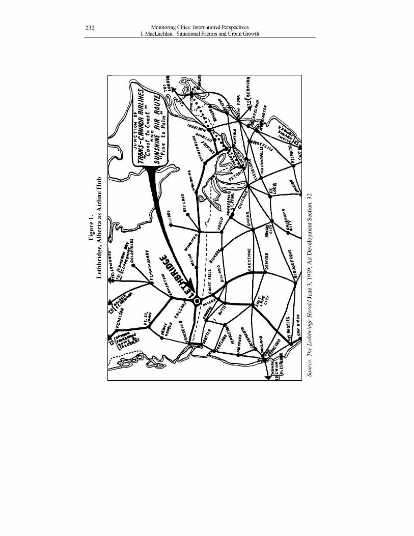
At a continental scale, Lethbridge also occupied a position of strategic importance vis-à-vis Great Falls (Montana) and more broadly, the interior or “east-of-the-mountains” route from southern California north to Alaska (Figure 1). In an era of visual flying rules, an interior route was clearly superior: it had relatively low relief, no flying obstructions of any great elevation and it was dry and fog-free. Thus the interior route had significant advantages over the coastal route through Vancouver. It was also recognized that a connection with an adjacent American city was important to “cash in” on the new preoccupation with air mail. Several other Canadian cities were becoming articulated with their nearest American neighbours, for example: Montreal-Boston, Toronto-Buffalo, Winnipeg-Fargo, and Vancouver-Seattle. The 170 miles intervening between Lethbridge and Great Falls had to be filled as the final gap in an international north-south route from “pine-to-palm” (Lethbridge Herald April 8, 1939, 5).
Cashing in on the Aviation Bonanza The Lethbridge Herald was typical of many western daily newspapers in being among the city’s most enthusiastic boosters. By the 1930s, its pages were filled with optimistic predictions about the growth-inducing impacts of aviation. Urban promotion was ineluctably dedicated to the development and construction of an “airport,” a new word in the urban booster’s vocabulary:
232 Monitoring Cities: International Perspectives I. MacLachlan: Situational Factors and Urban Growth
iu
* I
vt
Monitoring Cities: International Perspectives 233 I. MacLachlan: Situational Factors and Urban Growth
Lethbridge has a great opportunity to link up in this new transportation development. We are the crossroads of the skyways just east of the Rockies, and every move we make in the development of our new airport should be with that in mind. (Lethbridge Herald July 28, 1937: 4).
Small prairie cities had a significant advantage over large eastern cities with respect to airport sites. Ample land was available at low cost during the Depression and it could be prepared for aircraft with minor surface grading, at a fraction of the expense of clearing, blasting, draining and levelling land on the Canadian Shield. On top of this, snow accumulation in winter was modest, reducing annual operating costs.
An airport with runways of at least 3,000 feet (sea level basis) was essential to accommodate the 1930s airliners. In the case of Lethbridge, the first airfield was on the north side of the city but as time progressed, it became clear that the site was too small and the runways too short to support scheduled air service. Lethbridge was not alone in this regard, and in the 1930s the federal government provided assistance to many municipalities to acquire the land necessary to build an airport with paved runways. The 700 acre parcel selected for Lethbridge’s new airport was large enough that runway lengths would be extended to 5,500 feet in 1946, allowing it to accommodate the new 50 passenger North Star aircraft. The availability of a level landing field of such a size, reputedly the largest in Canada, and according to C.D. Howe, one of the finest on the continent, was a site-specific advantage of Lethbridge’s prairie location (Lethbridge Herald June 15, 1937, 4; June 10, 1939, 6; August 22, 1946, 4).
However, Lethbridge had no monopoly on level landing sites available at a low price; such attributes were ubiquitous on the Canadian Prairies in the 1930s. Community boosters recognized that it was the city’s situation, not its site, that seemed to offer its greatest advantage relative to competing centres:
Lethbridge is destined to be one of the important places on the world’s air map. Not only will it be related to the great round the world line of the future, but in the Canadian service, it is already recognized as a pivotal centre. It is to be the chief airport west of Winnipeg on the route from Eastern Canada to the Pacific coast. It is to be a junction point also for north and south services. It will be through Lethbridge that the United States’ mails will be carried to Alaska. It is not ridiculous to vision the day when airplane service, mail, passenger and freight, may make Lethbridge a far more important centre in air transportation than it is today in railroad transportation (Lethbridge Herald June 15, 1937, 4).
Planning for a national airline system had to take a number of typically Canadian limitations into account. First, the breadth of the country, long winter nights, and slow speed of the radial-engined airliners of the day required that a
234 Monitoring Cities: International Perspectives I. MacLachlan: Situational Factors and Urban Growth
significant portion of the sixteen-hour transcontinental flight be flown at night. Thus, the aircraft had to follow the Trans-Canada Airway, the country’s only well-marked aviation route which paralleled the Canada-U.S. border as it traversed the southernmost part of the country from Manitoba to Vancouver. Second, the limited range of the 1930’s vintage aircraft required seven stops for refuelling (Figure 1). To provide sufficient fuel to cross the mountainous interior of British Columbia, the logical penultimate stop west-bound to Vancouver had to be in Alberta, on the east side of the Rocky Mountains. To the west of Calgary, the Rockies were 12,000 feet above mean sea level through the Kicking Horse Pass while further south, the Crowsnest Pass offered maximum elevations of 10,900 feet, a small but crucial advantage for the unpressurized Lockheed 10A aircraft then in use. A number of other factors favoured the southern route.
Exhaustive surveys showed that the Crow’s Nest route through southern British Columbia was preferable in every respect. It was shorter, the climate was better, it passed through a more settled area and the difficulties of constructing aerodromes were less there than on the alternative routes via the Yellowhead and Kicking Horse Passes. Aerodromes were already in existence on the route at Fernie, Cranbrook, Trail, Grand Forks and Chilliwack which would decrease the cost of construction. (Wilson 1948, 19)
For these reasons, Lethbridge was selected as the first of a chain of intermediate stops, like beads on a string, extending from Montreal west to Vancouver. Passengers destined for, or originating from, Edmonton and Calgary were served by a feeder route which met the transcontinental service at Lethbridge.
When Western Airlines inaugurated its “pine-to-palm tree” service along the interior route originating in Los Angeles and pausing at a major hub in Salt Lake City, its logical Canadian terminal was Lethbridge where passengers could connect with TCA’s transcontinental Canadian service. Indeed, Lethbridge served as Alberta’s only international airport from 1941 until 1950. This meant that Alberta’s third largest city (population of 14,600 in 1941) enjoyed a position of strategic intermediacy and accessibility that was out of all proportion to its size and economic importance, while Edmonton and Calgary, the two largest cities in the province (populations of 93,800 and 88,900 respectively in 1941), were relegated to peripheral locations on the airline route map.
But the dream of a transportation hub was not to last. By February of 1948, it had become clear that Lethbridge would not be able to sustain this early advantage born of its intermediate situation on the Trans-Canada Airway. A TCA spokesman praised Lethbridge as a “natural site for a wonderful airport” but it did not have the population to generate the passenger air traffic required (Lethbridge Herald 1948). In March 1948 the federal government announced plans to build a radio navigation transmitter in Radium Hot Springs, B.C., which would permit the eagerly anticipated North Star aircraft to fly directly from Calgary to Vancouver without having to detour south to Cowley and the Crowsnest Pass route across the
Monitoring Cities: International Perspectives 235 I. MacLachlan: Situational Factors and Urban Growth
Rockies (MacLachlan and MacKay 2000). Thus, the construction of new navigation infrastructure and the development of longer range aircraft rendered Lethbridge’s favourable situation obsolete. The city lost its function as an airline hub late in 1948 and gradually became a peripheral node as TCA and later, Air Canada, developed a global route structure which bypassed Lethbridge.
The Railway Age Ideology and the Livestock Trade in Lethbridge By 1949, TCA’s new North Stars were routinely overflying Lethbridge on their east-west air routes and it appeared that the city had squandered the legacy of the aviation age. However, it was granted a reprieve as a new opportunity appeared on the scene. It seems paradoxical that Lethbridge’s second situational opportunity involved the railway, a transportation mode which predates commercial aviation by about 70 years. However, the railway continued to occupy a central role in Canadian prairie mythology for years after commercial aviation was established. The railway had been a city builder, and the foundation of regional economic progress, while it was also viewed as the root cause of all prairie problems. This sentiment has become known as the “Railway Age Ideology”, a collection of public predispositions and objectives in which western Canadians held the railway responsible for the region’s manifold economic difficulties. It was a “railway ideology” because it arose in the peculiar environment of a railway monopoly and the system of ideas was so rigidly held that it was unresponsive to the manifest changes in the role that railways were beginning to play (Darling 1974: 8-10). Despite the arrival of the “aviation age” in the late 1930s, the railway age ideology persisted until 1961 (Darling 1980: 219) and remained an important influence in the economic development of the prairie west during the immediate post-war era.
The Canadian Pacific Railway (CPR) held a monopoly on rail-based transportation in southern Alberta. As a divisional point, Lethbridge was the junction of four separate rail lines:
1) West-bound: Crowsnest Pass and on to Vancouver 2) North-bound: Calgary and on to Edmonton 3) East-bound: Medicine Hat, Regina, Winnipeg and on to Montreal 4) South-bound: Coutts, Sweet Grass, Montana and on to Great Falls
When Canada’s embargo on cattle exports (enacted to prevent war-time inflation of food prices) was lifted at the end of World War II, American markets for livestock were thought to offer a lucrative opportunity for prairie livestock exports. Lethbridge seemed to be ideally located to play a role as an entrepôt in this trade. The CPR expanded a small existing stockyard which became a federally regulated facility for the feeding, sale and care of livestock, principally cattle (MacLachlan and Townshend forthcoming).
Thus an expanded stockyard offered two opportunities for urban economic growth. First, the stockyard would enhance Lethbridge’s intermediate situation by providing a facility for the intermodal transfer of cattle from truck to rail and for the mandatory rest stops required of long distance rail shipments of livestock. Livestock bound for destinations in United States or eastern Canada required water, feed and
236 Monitoring Cities: International Perspectives I. MacLachlan: Situational Factors and Urban Growth
rest at some intermediate point during their journey. Second, the intermediate function involved a break-in-bulk which created an opportunity for Lethbridge to diversify its economy and process the livestock in situ in a meat packing enterprise. The local press was as optimistic about the potential of rail-based livestock development as it had been about the promise of aviation some twelve years earlier:
Announcement of plans to spend $100,000 at Lethbridge stockyards... Stockmen are hopeful that the change, besides expediting the movement of their stock through Lethbridge, will also result eventually in the establishment of a full-scale packing plant in Lethbridge. (Lethbridge Herald June 15, 1949, 6).
If Lethbridge could add value to animals in the vertically integrated meat packing industry, the city would succeed in converting intermediacy into centrality, and become a true destination for livestock and a true origin for carcass beef and beef by-products.
In another week the Lethbridge terminal stockyard will be opened for general public business and this will mark the beginning of a new phase in the livestock industry in South Alberta. It is to be hoped that, within a reasonable time, a meat packing plant will be established in Lethbridge. (Lethbridge Herald January 27, 1950, 18)
The prediction finally materialized ten years later. In 1960, Canada Packers established a beef plant on the edge of the Lethbridge Stock Yard and only one year later a second plant was added by Canadian Dressed Meats. Swift Canadian, the second largest packer in Canada, built Lethbridge’s third plant in 1971, just across the railway tracks from the first two. All three plants were “kill and chill” specialists, designed to produce dressed beef carcasses for shipment by rail and by truck, mainly for sale in eastern Canada where they were further processed into primal cuts for retail sale. Together with the stockyards, a hide plant and nearby cattle feedlots, Lethbridge became one of Canada’s largest beef producing centres in the 1960s and 1970s (MacLachlan and Townshend forthcoming).
But the city’s intermediacy with respect to the cattle trade and centrality with respect to beef carcass production was short-lived. The sale of cattle direct from producers to packing plants in Canada and in the United States made the marketing function of the Lethbridge stockyard obsolete. Truck transportation gradually displaced rail as the principal mode for livestock transportation, eroding the role of the railway for transcontinental livestock shipment. The volume of cattle shipments declined steadily and the stockyards were closed in 1974. Intensive cost competition from two new and much larger packing plants in High River and Brooks further north in Alberta, Lethbridge’s three beef plants were closed between 1986 and 1999. However, one of the three plants survives as a hog processing facility, preparing pork for export to Pacific Rim markets (MacLachlan 2001).
Monitoring Cities: International Perspectives 237 I. MacLachlan: Situational Factors and Urban Growth
The intermediacy created by the railways and the stockyard was a decisive factor in the creation of a meat packing industrial complex. The city became a true livestock destination and not merely a way-station, attaining a degree of centrality with respect to cattle and beef shipments. But changes in transportation technology and marketing channels soon eroded the intermediacy advantage and the stockyard became irrelevant to the new packing plants. Sector-specific centrality may be created out of intermediacy but it too may be short-lived.
Ironically Lethbridge now lies on the edge of Canada’s largest concentration of feedlots for the grain feeding and finishing of cattle. With a feedbunk capacity of 524,200 head of cattle, Lethbridge County accounts for 35 percent of Alberta’s total feedlot capacity (CanFax 2000). But this has everything to do with site characteristics such as the availability of irrigation water and feed grains and nothing to do with the railway age ideology or livestock centrality; the city has lost its role as an origin or destination for the cattle trade.
Urban Boosters and the Situational Challenge of Intermediacy Intermediacy has long been understood as the foundation upon which central functions can be developed. New routes and new technologies create a “window of opportunity” and boosters believe that they should seize the moment in order to capitalize on their intermediacy advantage. Originating from the rapid growth in urban places in the last decade of the nineteenth century and the first decade of the twentieth, urban prairie boosterism was founded on the belief that material growth was desirable at the expense of all else. Boosters among the prairie urban elite promoted their little towns and cities enthusiastically, scorning all naysayers, especially those who would promote other cities.
Since progress was measured in material terms, prairie boosters directed their efforts toward encouraging rapid and sustained growth in their cities at the expense of virtually all other considerations. This meant, for example, that while all prairie boosters wanted the region to grow rapidly, they were even more concerned with the growth of their own communities. Despite the early prominence of Winnipeg, the boosters of other prairie communities optimistically envisioned their centre becoming the pre-eminent metropolis of the area. (Artibise 1982, 124).
But not all boosters could succeed in making their centres pre-eminent. Several centres with arguably superior initial advantages than the eventual winners never cracked the top tier in the urban hierarchy. Selkirk, Manitoba (initially selected as the Red River crossing for the CPR), lost out to Winnipeg; Moose Jaw and Prince Albert lost out to Regina and Saskatoon; while Medicine Hat and Lethbridge failed to overtake the larger and older centres to the north. Artibise (1982) argues that the losers lost because their elites were divided and complacent, suggesting that their policies were insufficient and not up to those of the competition. “In the absence of sufficient initiative and skill, natural advantages
238 Monitoring Cities: International Perspectives I. MacLachlan: Situational Factors and Urban Growth
were incapable of sustaining growth for very long” (Artibise 1982, 142). Though he does not explicitly refer to situational factors, Artibise’s argument points to the importance of the extraordinary initiatives that were required to capitalize on intermediacy and create centrality.
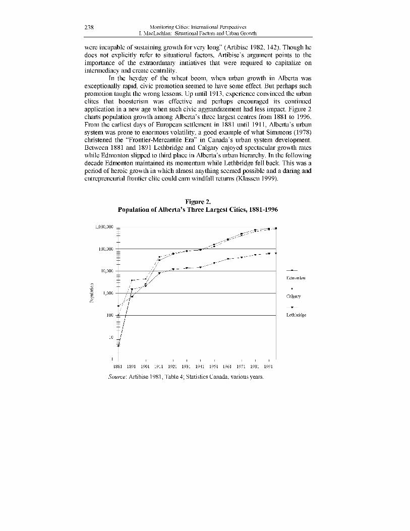
In the heyday of the wheat boom, when urban growth in Alberta was exceptionally rapid, civic promotion seemed to have some effect. But perhaps such promotion taught the wrong lessons. Up until 1913, experience convinced the urban elites that boosterism was effective and perhaps encouraged its continued application in a new age when such civic aggrandizement had less impact. Figure 2 charts population growth among Alberta’s three largest centres from 1881 to 1996. From the earliest days of European settlement in 1881 until 1911, Alberta’s urban system was prone to enormous volatility, a good example of what Simmons (1978) christened the “Frontier-Mercantile Era” in Canada’s urban system development. Between 1881 and 1891 Lethbridge and Calgary enjoyed spectacular growth rates while Edmonton slipped to third place in Alberta’s urban hierarchy. In the following decade Edmonton maintained its momentum while Lethbridge fell back. This was a period of heroic growth in which almost anything seemed possible and a daring and entrepreneurial frontier elite could earn windfall returns (Klassen 1999).
Figure 2. Population of Alberta’s Three Largest Cities, 1881-1996
Source: Artibise 1981, Table 4; Statistics Canada, various years.
Monitoring Cities: International Perspectives 239 I. MacLachlan: Situational Factors and Urban Growth
After 1911 western Canada’s urban rank structure stabilized and the period of rapid urban growth paused until the end of World War II (Figure 2). Alberta’s two largest metropolitan centres had reached a population size that gave them some inertia while Lethbridge and smaller centres such as Red Deer and Medicine Hat found themselves to be an order of magnitude smaller. The heyday of the frontier-mercantile era had drawn to a close but the boosters were slow to recognize that fact, vainly attempting to catch up in a race they could not win.
Places were thought to be so favoured by site and situation characteristics that future growth was viewed as inevitable. Many naively optimistic growth projections were predicated on intermediacy which later proved to be only a fleeting advantage. Boosterism was a parochial philosophy which sought to promote the city as though it existed in isolation. McCann and Simmons (2000) challenge this view, arguing that the attribution of urban growth to specific events (such as a new railway connection or a particular development incentive which prompts a major investment) fails to acknowledge the crucial importance of broader growth trends and the position of the city in the urban system:
The problem with this approach is the illusion it creates that any urban centre can grow given the right political leadership or the innovation capacity of a successful entrepreneur. Or, for that matter, that growth follows from attracting industries or transportation facilities. (McCann and Simmons 2000, 85).
Given the late nineteenth-century volatility portrayed in Figure 2, boosters might be forgiven for concluding that the heady urban growth of the wheat boom era resulted from any single policy initiative, firm, or municipal leader. After the wheat boom came to an end, it seems that the die was cast and faced with an overwhelming advantage in functional complexity and raw population size of the dominant centres, situational advantages were no longer sufficient to bring about much change in a city’s position in the urban hierarchy.
Conclusions As a locational attribute, the situation of a place includes two distinct aspects: intermediacy and centrality. Intermediacy is the trait of “in-betweeness” on a linear pathway joining an origin and a destination. Centrality implies areal centredness from which paths fan out to multiple origins and destinations. The relative importance of intermediacy in relation to centrality may be measured by comparing the volume of traffic flowing through the node in relation to traffic originating or terminating at the node.
Though intermediacy may only be temporary, it has been thought to convey such a powerful strategic locational advantage that it is tempting to exploit it as a springboard to increase a community’s degree of centrality and dominance in the urban system. Lethbridge provides two instructive examples of intermediacy based on aviation and rail-based modes of transportation. In both cases the city’s role as an intermediate node was of relatively short duration and, notwithstanding
240 Monitoring Cities: International Perspectives I. MacLachlan: Situational Factors and Urban Growth
the enthusiasm of its proponents and boosters, the city was unable to exploit this advantage to create any sustained growth or change in its status as a peripheral regional service centre.
The temporary nature of intermediacy and centrality as situational attributes has interesting implications for future research related to the monitoring of urban systems. How can these attributes be measured? How can the impact of technological change be anticipated? The development of higher speed, longer range aircraft and the change in the structure of the cattle trade and the replacement of railway cattle cars by semitrailer cattleliners were gradual processes whose consequences for Lethbridge seem inevitable in retrospect. Recognizing intermediacy and centrality as temporary situational attributes acknowledges the dynamic nature of urban systems. The cities of tomorrow will need a framework to monitor a broad range of external opportunities and constraints, environmental and market forces, government regulation and deregulation and the fortunes of sunrise and sunset industries. But no matter how closely such situational factors are monitored, the cities of tomorrow seem likely to grow and prosper or stagnate and decline in spite of their most vehement boosters or their most trenchant opponents.
Acknowledgements I am indebted to Douglas Fleming, Larry McKeown, and to Ivan Townshend for discussing some of these ideas, to Bruce MacKay who gathered many of The Lethbridge Herald quotations used in this paper, and to Walter Aufrecht who gave the paper a thorough reading and made many helpful suggestions.
References Artibise, A.F.J. 1981. Prairie Urban Development, 1870-1930. The Canadian
Historical Association Booklets No. 34. Artibise, A. 1982. “In Pursuit of Growth: Municipal Boosterism and Urban
Development in the Canadian Prairie West, 1871-1913”, in Shaping the Urban Landscape: Aspects of the Canadian City-Building Process edited by G. Stelter, and A.F.J. Artibise. Ottawa: Carleton University Press, pp.116-147.
Boyce, R.R., ed. 1980. Geography as Spatial Interaction. Seattle: University of Washington Press.
CanFax. 2000. “Cattle on Feed - Feedlot Capacity by Region.” Retrieved May 8, 2000 from the World Wide Web: http://www.cattle.ca/canfax/cof_region_capacity.htm.
Currie, A.W. 1967. Canadian Transportation Economics. Toronto: University of Toronto Press.
Darling, H.J. 1974. “Transport Policy in Canada: The Struggle of Ideologies Versus Realities”, in Issues in Canadian Transport Policy edited by K.W. Studnicki-Gizbert. Toronto: MacMillan, pp. 3-44.
Darling, H. 1980. The Politics of Freight Rates. Toronto: McClelland and Stewart. Fleming, D.K. 2001. Personal Communication. Fleming, D.K. and Y. Hayuth. 1994. “Spatial Characteristics of Transportation
Hubs: Centrality and Intermediacy”. Journal of Transportation Geography 2(1): 3-18.
Monitoring Cities: International Perspectives 241 I. MacLachlan: Situational Factors and Urban Growth
Klassen, H.C. 1999. A Business History of Alberta. Calgary: University of Calgary Press.
Lethbridge Herald. 1937. “Important Position of this City in Future World Air Routes is Emphasized by Major Hale, Edmonton Postal Inspector” June 9: 7.
Lethbridge Herald. 1937. “Our Future in Air Transport” June 15: 4. Lethbridge Herald. 1937. “Lethbridge’s Opportunity” July 28: 4. Lethbridge Herald. 1939. “Fill Lethbridge-Great Falls Gap” April 8:5. Lethbridge Herald. 1939. “T.C.A. Vital Link in Second Aerial Route to Outposts of
Empire Air Commodore H. Hollick Kenyon Addresses Kiwanis Club” June 7:7. Lethbridge Herald. 1939. “Lethbridge Airport” June 10: 6. Lethbridge Herald. 1946. Editorial August 22: 4. Lethbridge Herald. 1948. “Press for Canadian Pacific Airlines to Operate through
Lethbridge” February 12: 7. Lethbridge Herald. 1949. “$100,000 Expansion Program for Lethbridge
Stockyards” June 15: 6. Lethbridge Herald. 1950. “Future of Livestock Industry” January 27: 18. MacLachlan, I. 2001. Kill and Chill: Restructuring Canada’s Beef Commodity
Chain. Toronto: University of Toronto Press. MacLachlan, I. and B. MacKay. 2000. “Lethbridge and the Trans-Canada Airway”.
Alberta History 48(3): 2-13. MacLachlan, I. and I. J. Townshend. Forthcoming. “The Rise and Fall of Stockyard
Districts as Industrial Clusters in Western Canadian Cities”. Western Geography.
McCann, L.D. and J. Simmons. 2000. “The Core-Periphery Structure of Canada’s Urban System”, in Canadian Cities in Transition, Second Edition, edited by T. Bunting and P. Filion. Toronto: Oxford, pp. 76-96.
Pred, A. 1975. “On the Spatial Structure of Organizations and the Complexity of Metropolitan Interdependency”. Papers, Regional Science Association 35: 115-131.
Sealy, K. R. 1968. The Geography of Air Transport. Chicago: Aldine. Simmons, J. W. 1978. “The Organization of the Urban System”, in Systems of Cities
edited by L.S. Bourne and J.W. Simmons. Toronto: Oxford, pp. 61-69. Wilson, J.A. 1948. Development of Aviation in Canada. Ottawa: Department of
Transport 1948.


