MONTGOMERY COUNTY PLANNING DEPARTMENT THE MARYLAND-NATIONAL CAPITAL PARK AND PLANNING COMMISSION MCPB Item No. Date: 4/26/18 Montgomery Village Center: Sketch Plan No. 320170020A, Preliminary Plan No. 120180010, and Site Plan No. 820180020 Description Staff Report Completed: 4/16/18 Troy Leftwich, Senior Planner, Area 2 Division, [email protected], 301-495-4553 Garry Meus, Planner Coordinator, Area 2 Division, [email protected], 301-495-4537 Patrick Butler, Acting Supervisor, Area 2 Division, [email protected], 301-495-4561 Carrie Sanders, Chief, Area 2 Division, [email protected], 301-495-4653 Sketch Plan: Request to amend prior Sketch Plan approval for the redevelopment of the Montgomery Village Center shopping center into a mixed-use development for up to 615,000 square feet total development, including up to 450,000 square feet of residential uses, and up to 165,000 square feet of retail/service uses. Preliminary Plan: Request to create up to 55 lots for 49 townhouses, 34 two-over-two condos, 32 multi-family condos, including 12.5% MPDUs (15 total), and up to 165,000 square feet of retail/service uses; various stormwater management, public/common open space, private roads, and HOA parcels. Site Plan: Request to allow construction of a 32-unit multi- family condo building (including two MPDUs) for a total of 35,100 square feet of residential uses, and up to 165,000 square feet of retail/service uses in the first phase (Phase 1A) of development. Location: West of the intersection of Montgomery Village Avenue and Centerway Road; Master Plan: 2016 Montgomery Village Master Plan; Size: 18.78 acres; Zone: CRT 1.5, C-0.75, R-1.0, H-75, and the Montgomery Village Overlay Zone (MVOZ); Applicant: W-ARC MV Owner VII, LLC; Application Accepted: September 28, 2017; Review Basis: Chapter 50, Subdivision Regulations, Chapter 59, Zoning Ordinance, and Chapter 22A, Forest Conservation Law. Summary Staff recommends approval with conditions. The Applicant proposes Optional Method Development within the CRT Zone. This Sketch Plan Amendment replaces the existing Sketch Plan approval. The redevelopment of the Property will be phased into Phase 1A, 1B, and 2. The Sketch Plan covers all phases but will be amended for Phase 2. The Preliminary Plan covers Phases 1A and 1B and will be amended for Phase 2. The Site Plan covers Phase 1A and will be amended with each subsequent phase of development. The Preliminary Plan approval includes approval of the Preliminary Forest Conservation Plan (PFCP), and the Site Plan approval includes approval of the Final Forest Conservation Plan (FFCP). The Applicant has requested a parking waiver of 41 spaces as part of the Preliminary Plan. Staff does not object in concept, but the waiver must be reviewed as part of a subsequent Site Plan application when necessary. Staff has not received any correspondence on the Application.
Transcript
Summary
MONTGOMERY COUNTY PLANNING DEPARTMENTTHE MARYLAND-NATIONAL CAPITAL PARK AND PLANNING COMMISSION
MCPB Item No. Date: 4/26/18
Montgomery Village Center: Sketch Plan No. 320170020A, Preliminary Plan No. 120180010, and Site Plan No. 820180020
Description Staff Report Completed: 4/16/18
Troy Leftwich, Senior Planner, Area 2 Division, [email protected], 301-495-4553
Garry Meus, Planner Coordinator, Area 2 Division, [email protected], 301-495-4537
Patrick Butler, Acting Supervisor, Area 2 Division, [email protected], 301-495-4561
Carrie Sanders, Chief, Area 2 Division, [email protected], 301-495-4653
Sketch Plan: Request to amend prior Sketch Plan approval for the redevelopment of the Montgomery Village Center shopping center into a mixed-use development for up to 615,000 square feet total development, including up to 450,000 square feet of residential uses, and up to 165,000 square feet of retail/service uses. Preliminary Plan: Request to create up to 55 lots for 49 townhouses, 34 two-over-two condos, 32 multi-family condos, including 12.5% MPDUs (15 total), and up to 165,000 square feet of retail/service uses; various stormwater management, public/common open space, private roads, and HOA parcels. Site Plan: Request to allow construction of a 32-unit multi-family condo building (including two MPDUs) for a total of 35,100 square feet of residential uses, and up to 165,000 square feet of retail/service uses in the first phase (Phase 1A) of development.
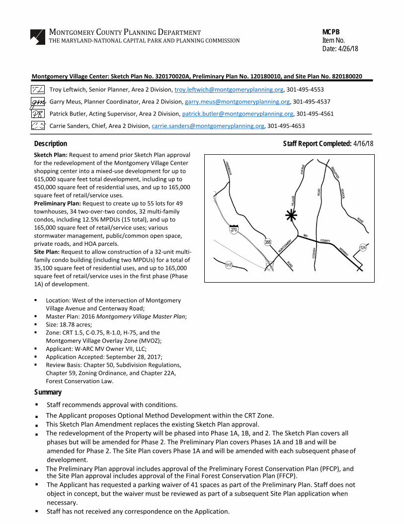
Location: West of the intersection of MontgomeryVillage Avenue and Centerway Road;
Master Plan: 2016 Montgomery Village Master Plan; Size: 18.78 acres; Zone: CRT 1.5, C-0.75, R-1.0, H-75, and the
Montgomery Village Overlay Zone (MVOZ); Applicant: W-ARC MV Owner VII, LLC; Application Accepted: September 28, 2017; Review Basis: Chapter 50, Subdivision Regulations,
Chapter 59, Zoning Ordinance, and Chapter 22A,Forest Conservation Law.
Summary Staff recommends approval with conditions.
The Applicant proposes Optional Method Development within the CRT Zone. This Sketch Plan Amendment replaces the existing Sketch Plan approval. The redevelopment of the Property will be phased into Phase 1A, 1B, and 2. The Sketch Plan covers all
phases but will be amended for Phase 2. The Preliminary Plan covers Phases 1A and 1B and will be amended for Phase 2. The Site Plan covers Phase 1A and will be amended with each subsequent phase of development.
The Preliminary Plan approval includes approval of the Preliminary Forest Conservation Plan (PFCP), and the Site Plan approval includes approval of the Final Forest Conservation Plan (FFCP).
The Applicant has requested a parking waiver of 41 spaces as part of the Preliminary Plan. Staff does not object in concept, but the waiver must be reviewed as part of a subsequent Site Plan application when necessary.
Staff has not received any correspondence on the Application.
SECTION 1: RECOMMENDATIONS & CONDITIONS Sketch Plan Amendment No. 32017002A Staff recommends approval of the Montgomery Village Center, Sketch Plan Amendment No. 32017002A, for a mixed-use development with a maximum of up to 615,000 square feet of total development, including up to 450,000 square feet of residential uses, and up to 165,000 square feet of retail/service uses. This Sketch Plan Amendment replaces all previous binding elements and conditions of Sketch Plan No. 320170020. The proposed project will be completed in three phases on 18.78 acres of land, zoned CRT 1.5, C-0.75, R-1.0, H-75 and is in the Montgomery Village Overlay Zone. The following site development elements shown on the latest electronic version as of the date of this report submitted via ePlans to the M-NCPPC are binding on the Applicant under Section 59-7.3.3.B:
1. Maximum density and height; 2. Approximate location of lots and dedications; 3. General location and extent of public open space; 4. General location of vehicular and pedestrian access points and routes; 5. Public benefit schedule; 6. Phasing plan; and 7. Phase 2 will require a Sketch Plan Amendment.
All other elements of the Sketch Plan are illustrative and subject to refinement at the time of subsequent Site Plan(s) for each phase. This approval is subject to the following conditions:
1. Density The proposed development is limited to a maximum total of 615,000 square feet (0.75 FAR), including up to 450,000 square feet of residential uses (0.55 FAR), and up to 165,000 square feet of retail/service uses (.20 FAR). The final amount of residential and retail/services uses will be determined at subsequent Preliminary Plan(s) and Site Plan(s) for each phase.
2. Height The development is limited to a maximum height of 75 feet, which must be measured consistent with the Zoning Ordinance.
3. Incentive Density The Applicant must construct the development with the public benefits listed below, unless modified under Section 59-7.3.3.I. Total points must equal at least 50 and be chosen from at least three categories as required by Section 59-4.5.4.A.2. The requirements of Division 59-4.7 and the CR Zone Incentive Density Implementation Guidelines must be fulfilled for each public benefit proposed. Final points will be established at Site Plan approval. a. Connectivity and Mobility, achieved through neighborhood services, through-block
connection, and wayfinding; b. Diversity of Uses and Activities, achieved through an onsite daycare facility, a mix of
dwelling unit types, and accessible units; c. Protection and Enhancement of the Natural Environment, achieved through providing a
green roof.
4
4. Moderately Priced Dwelling Units (MPDUs) The development must provide MPDUs in accordance with Chapter 25A with the following distribution of MPDUs and as approved by the Department of Housing and Community Affairs (DHCA) at Site Plan: a. A proportional number of the fee simple townhouses (two of the 15); and b. Townhouse MPDUs must have at least three bedrooms, unless 2-bedroom MPDU
townhouses are approved by DHCA per Chapter 25A. 5. Public Open & Common Use Space
The Applicant must provide the required minimum 10% of Public Open Space for Phase 1A and 2, and 10% Common Open Space for Phase 1B. The required Public Open Space must meet applicable standards of Section 6.3.6., and the required Common Open Space must meet the standards of 6.3.5. The Public Open Space must not include any stormwater management facilities, unless approved by Planning Staff. The Public and Common Open Space must be provided as illustrated in the Sketch Plan and finalized at Site Plan for each phase.
Per Section 59.4.9.11.C., all common and public open space in Montgomery Village must be recorded within a separate lot or parcel with a protective easement or covenant in the land records, in a form approved by the Planning Board, unless the parcel is exempted from recordation under Chapter 50.
6. Future Coordination for Preliminary and Site Plan
In addition to any other requirements of Chapter 50, Subdivision Regulations, and Chapter 59, Zoning Ordinance, the Applicant must address the following at Preliminary Plan and Site Plan review for each phase: a. Demonstrate how each public benefit satisfies the Zoning Ordinance and Incentive Density
Implementation Guideline requirements; b. Forest Conservation requirements; c. Demonstrate compliance of distribution of bedrooms in the condo building and units for the
townhouses MPDUs with the requirements of Chapter 25A; and d. Streetscape details.
Preliminary Plan No. 120180010 Staff recommends approval of Preliminary Plan No. 120180010, including the Preliminary Forest Conservation Plan (PFCP). All site development elements shown on the latest electronic version as of the date of this Staff Report submitted via ePlans to the M-NCPPC are required except as modified by the following conditions:
1. This Preliminary Plan is limited to 55 lots for 115 dwelling units (49 townhouses, 34 two-over-two condos, 32 multi-family condos) including 12.5% MPDUs, up to 165,000 square feet of retail/service uses, and various stormwater management, public/common open space, private road, and homeowners association (HOA) parcels. The Applicant must amend the Preliminary Plan for Phase 2.
5
2. The Applicant must comply with the binding elements and conditions of approval for Sketch Plan No. 32017002A and any subsequent amendments.
3. Include the stormwater management concept approval letter and Preliminary Plan Resolution
on the approvals sheet(s).
4. This Preliminary Plan includes the Preliminary Forest Conservation Plan, which is subject to the following conditions: a. A Final Forest Conservation Plan (FFCP) that substantially conforms to the PFCP must be
approved as part of the Site Plan approval process. b. Mitigation must be provided for specimen trees removed at the rate of one inch replaced
for every four inches (d.b.h.) removed, using planting stock no smaller than three inches caliper.
5. The Planning Board accepts the recommendations of the Montgomery County Department of
Transportation (“MCDOT”) in its letter dated March 22, 2018, and hereby incorporates them as conditions of the Preliminary Plan approval. The Applicant must comply with each of the recommendations as set forth in the letter, which may be amended by MCDOT provided that the amendments do not conflict with other conditions of the Preliminary Plan approval.
6. Prior to recordation of plat(s), the Applicant must satisfy the provisions for access and
improvements as required by MCDOT.
7. The Planning Board accepts the recommendations of the Montgomery County Department of Permitting Service (“MCDPS”) – Water Resources Section in its stormwater management concept letter dated April 16, 2018, and hereby incorporates them as conditions of the Preliminary Plan approval. The Applicant must comply with each of the recommendations as set forth in the letter, which may be amended by MCDPS – Water Resources Section provided that the amendments do not conflict with other conditions of the Preliminary Plan approval.
8. The Planning Board accepts the recommendations of the Montgomery County Department of
Permitting Services (MCDPS), Fire Department Access and Water Supply Section in its letter dated January 18, 2018, and hereby incorporates them as conditions of approval. The Applicant must comply with each of the recommendations as set forth in the letter, which MCDPS may amend if the amendments do not conflict with other conditions of Preliminary Plan approval.
9. The Applicant must construct all road improvements within the rights-of-way shown on the
approved Preliminary Plan to the full width mandated by the master plan and/or to the design standards imposed by all applicable road codes.
10. The Applicant must provide Private Road(s) in parcel(s), including any sidewalks, bikeways,
storm drainage facilities, street trees, street lights, private utility systems and other necessary improvements as required by either the Preliminary Plan or the subsequent Site Plan within the delineated private road area (collectively, the “Private Road”), subject to the following conditions: a. The record plat must show the Private Road in a separate parcel.
6
b. The Private Road must be subjected by reference on the plat to the Declaration of Restrictive Covenant for Private Roads recorded among the Land Records of Montgomery County, Maryland in Book 54062 at Page 338, and the terms and conditions as required by the Montgomery County Code with regard to private roads set forth at § 50-4.3.E et seq.
c. Prior to issuance of building permit, the Applicant must deliver to the Planning Department, with a copy to MCDPS, certification by a professional engineer licensed in the State of Maryland that the Private Road has been designed and the applicable building permits will provide for construction in accordance with the paving detail and cross-section specifications required by the Montgomery County Road Code, as may be modified on this Preliminary Plan or a subsequent Site Plan, and that the road has been designed for safe use including horizontal and vertical alignments for the intended target speed, adequate typical section(s) for vehicles/pedestrians/bicyclists, ADA compliance, drainage facilities, sight distances, points of access and parking, and all necessary requirements for emergency access, egress, and apparatus as required by the Montgomery County Fire Marshal.
11. Prior to submission of any plat application, Site Plan No. 820180020 must be certified by
MNCPPC Staff.
12. No clearing or grading of the site, or recording of plats prior to Certified Site Plan approval.
13. Final approval of the number and location of (buildings, dwelling units, on-site parking, site circulation, sidewalks, and bikepaths) will be determined at Site Plan(s).
14. Subject to MCDOT review and approval, the Applicant must provide one bikeshare station. The final location of the bikeshare station must be shown on the Certified Preliminary Plan and easements for public access must be provided if it is located on private property.
15. The Applicant must provide two handicap parking spaces near the new public open space and
retail uses.
16. The Applicant must include road cross sections for each type of private road and alley, including modifications, paving detail and design data on the Certified Preliminary Plan and Certified Site Plan.
17. The Certified Preliminary Plan must contain the following notes: a. Unless specifically noted on this plan drawing or in the Planning Board conditions of
approval, the building footprints, building heights, on-site parking, site circulation, and sidewalks shown on the Preliminary Plan are illustrative. The final locations of buildings, structures and hardscape will be determined at the time of issuance of building permit(s) [or] site plan approval. Please refer to the zoning data table for development standards such as setbacks, building restriction lines, building height, and lot coverage for each lot.
18. The record plat must show necessary easements.
19. The record plat must reflect common ingress/egress and utility easements over all shared driveways.
7
20. The record plat must reflect all areas under Homeowners Association ownership and specifically
identify stormwater management parcels.
21. The record plat must reference the Common Open Space Covenant recorded at Liber 28045 Folio 578 (“Covenant”). The Applicant must provide verification to Staff prior to release of the final building permit that the Applicant’s recorded HOA Documents incorporate the Covenant by reference.
22. All Public Open Space must be recorded in a separate lot or parcel with a protective easement
or covenant in the land records, in a form approved by the Planning Board, unless the parcel is exempted from recordation under Chapter 50.
23. The Subject Property is within the Watkins Mill School cluster area. The Applicant must make a
School Facilities Payment to MCDPS at the Stedwick Elementary, Montgomery Village Middle, and Watkins Mill High school level at the single-family attached and multi-family garden apt. unit rates for all units for which a building permit is issued and a School Facilities Payment is applicable. The timing and amount of the payment will be in accordance with Chapter 52 of the Montgomery County Code, and any amendments to this chapter.
24. The Adequate Public Facility (“APF”) review for the Preliminary Plan will remain valid for sixty-one (61) months from the date of mailing of this Planning Board Resolution.
Site Plan No. 820180020 Staff recommends approval of Site Plan 820180020 for a 32-unit multifamily condo building (including two MPDUs) for a total of 35,100 square feet of residential uses, and up to 165,000 square feet of retail/service uses under Optional Method Development on 18.78 acres. All site development elements shown on the latest electronic version as of the date of this Staff Report submitted via ePlans to the M-NCPPC are required except as modified by the following conditions. Conformance with Previous Approvals & Agreements
1. Sketch Plan Conformance The development must comply with the binding elements and conditions of approval for Sketch Plan Amendment No. 32017002A.
2. Preliminary Plan Conformance
The development must comply with the conditions of approval for Preliminary Plan No. 120180010.
Environment
3. This Site Plan includes the Final Forest Conservation Plan, which is subject to the following conditions: a. The Applicant must record a certificate of compliance for the purchase of off-site mitigation
credit from an approved forest mitigation bank in the land records prior to any clearing and grading occurring on site.
8
b. The Sediment and Erosion Control Plan and Storm Water Management Plan must be consistent with the limits of disturbance and the associated tree/forest preservation measures of the FFCP.
c. The Applicant must comply with all tree protection and tree save measures shown on the approved Final Forest Conservation Plan. Additional tree-save measures not specified on the FFCP may be required by the M-NCPPC forest conservation inspector at the pre-construction meeting.
4. Stormwater Management
The Planning Board accepts the recommendations of the Montgomery County Department of Permitting Service (MCDPS) Water Resources Section in its stormwater management concept letter dated April 16, 2018 and incorporates them as conditions of approval. The Applicant must comply with each of the recommendations as set forth in the letter, which the MCDPS Water Resources Section may amend if the amendments do not conflict with other conditions of Site Plan approval. The MCDPS Water Resources Section will review, approve, and inspect all landscaping within the Storm Water Management easements and facilities.
Open Space, Facilities and Amenities
5. Open Space, Facilities, and Amenities a. The Applicant must provide a minimum of 10% Public Open Space for Phase 1A, and the
Applicant is providing a total of 35,519 square feet of public open space, which equates to approximately 14.7% of the site area for this phase.
b. Before the issuance of the final use and occupancy certificate for the development, all public open space areas on the Subject Property must be completed.
6. Public Benefits
The Applicant must provide the following public benefits and meet the applicable criteria and requirements of the Zoning Ordinance and the CRT Zone Incentive Density Implementation Guidelines for each one. a. Connectivity between Uses, Activities, and Mobility Options
i. Neighborhood Services Two large stores, an array of mid-size retail bays, and over a dozen small bays under 5,000 square feet that will provide a wide range of retail goods and services onsite to serve the community.
ii. Through-Block Connection Must be open air, at least 15-feet-wide, safe and attractive, and open to the public between 8a.m. and 9p.m.
iii. Wayfinding The Applicant must coordinate with Planning Staff to finalize the proposed Way-Finding Plan prior to Certified Site Plan. The Way-Finding Plan at a minimum must include seven monument signs that efficiently direct patrons through the Property, and provide directions to the public transit stop, one bikeshare stations, open space area, and shared use path(s). In addition, the Way-Finding Plan may include internal and external signage, banners, lighting and design elements. The locations of the proposed signage shall be free of all obstructions and clearly visible from the directed routes. Final design,
9
locations, and installation details must be approved by Planning Staff prior to Certified Site Plan.
b. Diversity of Uses and Activities i. Care Centers
There is currently a children’s day care onsite and the tenant plans to remain. The daycare must be available to the public and provide care for more than 15 children. The Site Plan includes a new playground, approximately 2,500 square feet in size, to serve the children enrolled in the day care.
c. Protection and Enhancement of the Natural Environment i. Vegetation Roof
The Applicant must install a vegetated roof with a soil depth of a minimum of 8 inches covering a minimum of 33% of the building's roof, excluding space for mechanical equipment.
7. Maintenance of Public Amenities
The Applicant is responsible for maintaining all publicly accessible amenities including, but not limited to the public open space, landscape, hardscape, and associated elements, and streetscaping.
Transportation & Circulation
8. Pedestrian & Bicycle a. At Certified Site Plan, the Applicant must submit an exhibit for Staff approval, showing the
location of all pedestrian infrastructure, within 500-linear feet of the Site limits, determined to be non-compliant with standards set forth by the Americans with Disabilities Act. The exhibit will show how non-compliant facilities will be addressed and will include an engineering cost estimate for the required upgrades. An agreement of the responsibilities and ADA compliant work or funding (or partial funding) to be completed must occur by building permit issuance. The work or funding (or partial funding) must be completed prior to Use and Occupancy Permit.
b. The Applicant must provide one bike sharing station as required by the Montgomery County Department of Transportation (MCDOT).
c. The Applicant must provide: i. Eight Short-term bicycle parking spaces using inverted-U bike racks (or equivalent as
approved by the Planning Board staff) located in visible and accessible locations; and
ii. One Long-term bicycle parking spaces using bike lockers or bike rooms. d. Prior to issuance of any Use-and-Occupancy Certificate, the Applicant must replace the
existing 4-foot-wide sidewalk and 7-foot wide green panel with an 8-foot wide sidepath and a 4-foot wide green panel along the property frontage of Montgomery Village Avenue, as illustrated on the Site Plan.
9. Department of Permitting Services-Right-of-Way
The Planning Board accepts the recommendations of the Montgomery County Department of Permitting Services (MCDPS), Right-of-Way Permitting Section in its letter dated February 16, 2018, and hereby incorporates them as conditions of approval. The Applicant must comply with
10
each of the recommendations as set forth in the letter, which MCDPS may amend if the amendments do not conflict with other conditions of Site Plan approval.
Dwelling Units
10. Moderately Priced Dwelling Units (MPDUs) The Planning Board accepts the recommendations of Department of Housing and Community Affairs (DHCA) in its letter dated March 22, 2018 and incorporates them as conditions of the Site Plan approval. The Applicant must comply with each of the recommendations as set forth in the letter, which DHCA may amend provided that the amendments do not conflict with other conditions of the Site Plan approval. a. The development must provide two condo MPDUs on-site consistent with the requirements
of Chapter 25A and the applicable Master Plan. b. Before issuance of any building permit for any residential unit(s), the MPDU agreement
between the Applicant and the Department of Housing and Community Affairs (DHCA) must be executed.
Site Plan
11. Lighting a. Prior to Certified Site Plan, the Applicant must provide certification to Staff from a qualified
professional that the exterior lighting in this Site Plan conforms to the latest Illuminating Engineering Society of North America (IESNA) recommendations (Model Lighting Ordinance-MLO: June 15, 2011, or as superseded) for a development of this type. All onsite exterior area lighting must be in accordance with the latest IESNA outdoor lighting recommendations (Model Lighting Ordinance-MLO: June 15, 2011, or as superseded).
b. All onsite down-lights must have full cut-off fixtures. c. Deflectors must be installed on uplighting fixtures to prevent excess illumination and glare. d. Streetlights and other pole-mounted lights must not exceed the height illustrated on the
Certified Site Plan. e. On the rooftop of the buildings, the light pole height must not exceed the height illustrated
on the Certified Site Plan.
12. Site Plan Surety and Maintenance Agreement Prior to issuance of any building permit, sediment control permit, or Use and Occupancy Permit, the Applicant must enter into a Site Plan Surety and Maintenance Agreement with the Planning Board in a form approved by the M-NCPPC Office of General Counsel that outlines the responsibilities of the Applicant. The Agreement must include a performance bond(s) or other form of surety in accordance with Section 59.7.3.4.K.4 of the Montgomery County Zoning Ordinance, with the following provisions: a. A cost estimate of the materials and facilities, which, upon Staff approval, will establish the
surety amount. b. The cost estimate must include applicable Site Plan elements, including, but not limited to
plant material, on-site lighting, public art, site furniture, paths and associated improvements of development, including sidewalks, bikeways, stormwater facilities, street trees and street lights. The surety must be posted before issuance of the any building permit of development and will be tied to the development program.
11
c. The bond or surety must be tied to the development program, and completion of all improvements covered by the surety for each phase of development will be followed by a site plan completion inspection. The surety may be reduced based upon inspector recommendation and provided that the remaining surety is sufficient to cover completion of the remaining work.
d. The bond or surety shall be clearly described within the Site Plan Surety & Maintenance Agreement including all relevant conditions and specific Certified Site Plan sheets depicting the limits of development.
13. Certified Site Plan
Before approval of the Certified Site Plan the following revisions must be made and/or information provided subject to Staff review and approval: a. Include the stormwater management concept approval letter, approval letters from
applicable agencies, the Forest Conservation Exemption, development program, and Sketch Plan, Preliminary Plan, and Site Plan resolutions on the approval or cover sheet(s).
b. Add a note stating that “Minor modifications to the limits of disturbance shown on the site plan within the public right-of-way for utility connections may be done during the review of the right-of-way permit drawings by the Department of Permitting Services.”
c. Modified Site Plan data table to reflect development standards approved by the Planning Board.
d. Ensure consistency of all details and layout between Site and Landscape plans. e. The Applicant must provide the final Wayfinding Plan with final design, locations and
installation details approved by Planning Staff prior to Certified Site Plan. f. The architectural articulation of the three pad sites along Montgomery Village Avenue shall
show activation to the street using fenestration and signage. g. The final location of the bikeshare station must be shown on the Certified Preliminary Plan
and Certified Site Plan, and easements for public access must be provided if located on private property.
h. The location for long-term bike parking for the condo building must be shown and is subject to review and approval by M-NCPPC staff.
12
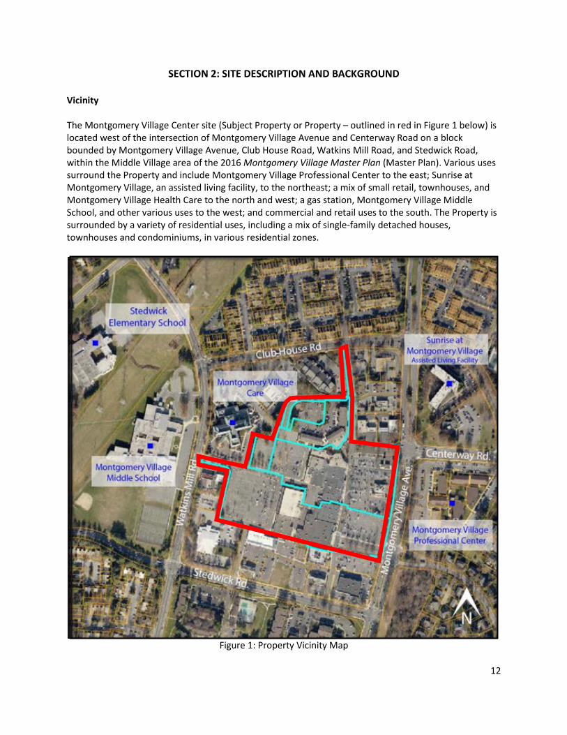
SECTION 2: SITE DESCRIPTION AND BACKGROUND Vicinity The Montgomery Village Center site (Subject Property or Property – outlined in red in Figure 1 below) is located west of the intersection of Montgomery Village Avenue and Centerway Road on a block bounded by Montgomery Village Avenue, Club House Road, Watkins Mill Road, and Stedwick Road, within the Middle Village area of the 2016 Montgomery Village Master Plan (Master Plan). Various uses surround the Property and include Montgomery Village Professional Center to the east; Sunrise at Montgomery Village, an assisted living facility, to the northeast; a mix of small retail, townhouses, and Montgomery Village Health Care to the north and west; a gas station, Montgomery Village Middle School, and other various uses to the west; and commercial and retail uses to the south. The Property is surrounded by a variety of residential uses, including a mix of single-family detached houses, townhouses and condominiums, in various residential zones.
Figure 1: Property Vicinity Map
13
Property Description The 18.78-acre Property is zoned CRT 1.5, C-0.75, R-1.0, H-75 and is also within the Montgomery Village Overlay Zone. It is currently has atotal of 226,673 square feet, including 198,591 square feet of retail uses and 28,082 square feet of professional offices. The retail use consists of approximately 35 retail stores totaling 130,649 square feet, three pad sites that total 7,680 square feet, a 30,131-square foot grocery building that will be razed. The office use consists of vintage townhomes converted into approximately 31 professional offices. There are a total of 1,026 parking spaces in various parking lots on the Property. The existing access points to the Property are from Montgomery Village Avenue in the front, Watkin Mill Road from the rear, and Stedwick Road and Club House Road from the south and north sides, respectively. The existing shopping center has struggled to retain its tenants due to the lack of visibility from Montgomery Village Avenue, low demand, and outdated façades and layout.
Figure 2: Oblique View of the Montgomery Village Center
Background Montgomery Village was Established in 1966 and is a unique planned community in the heart of Montgomery County with more than 40,000 residents. An important distinction is that for the last 29 consecutive years, Montgomery Village has been designated a “Tree City USA” by the National Arbor Day Foundation through meeting various criteria aimed at urban forestry management. In 1970, the Village Mall opened, which is now the Montgomery Village Shopping Center on Montgomery Village Avenue. At one time, it was a completely enclosed. Within the boundary of
14
Montgomery Village, the Village Center is located north of Route 124 (Midcounty Highway) and is within walking distance of Lake Whetstone park. Outside of the property boundary, a CVS Pharmacy corners the Montgomery Village Avenue and Stedwick Road intersection. A United States Post Office Service building is located to the southwest portion of the site at the intersection of Stedwick Road and Watkins Mill Road. To the west of the site, Montgomery Village Middle School is across Watkins Mill Road, while Montgomery Village Health Care Center and the Montgomery Village Liberty gas station frame the entrance to the site from Watkins Mill Road. Immediately to the north of the site, two gas stations (BP and Shell) align the main entrance, while a McDonald’s restaurant frames the northern private street off Montgomery Village Avenue. The Property was rezoned from the Town Sector (T-S) Zone to the Commercial-Residential Town Zone, CRT 1.5, C-0.75, R-1.0, H-75 and included it in the Montgomery Village Overlay Zone by the Sectional Map Amendment approved subsequent to the 2016 Montgomery Village Master Plan.
15
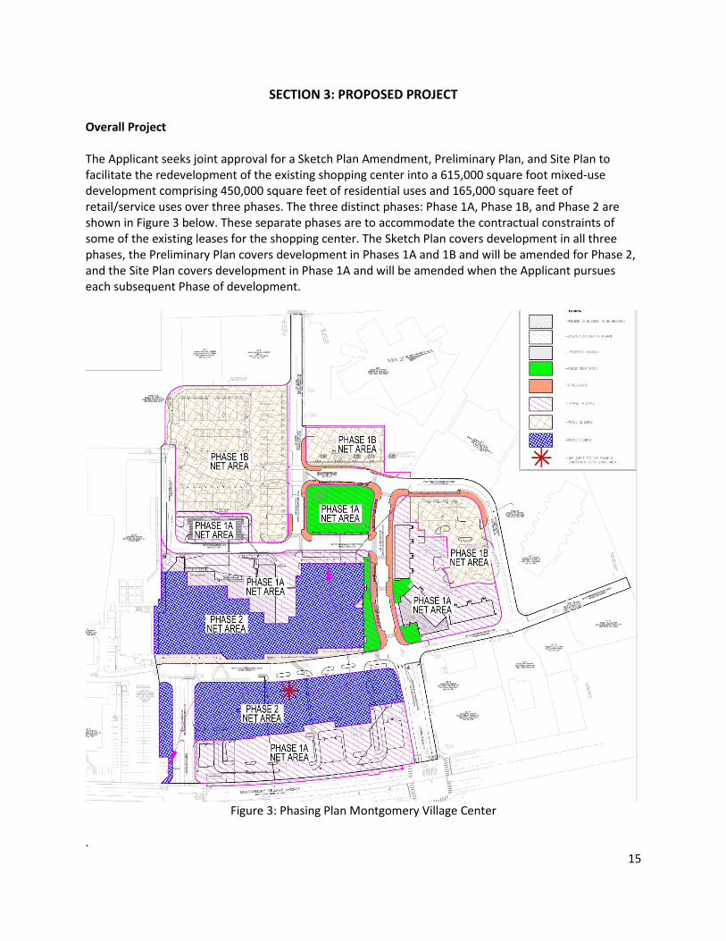
SECTION 3: PROPOSED PROJECT Overall Project The Applicant seeks joint approval for a Sketch Plan Amendment, Preliminary Plan, and Site Plan to facilitate the redevelopment of the existing shopping center into a 615,000 square foot mixed-use development comprising 450,000 square feet of residential uses and 165,000 square feet of retail/service uses over three phases. The three distinct phases: Phase 1A, Phase 1B, and Phase 2 are shown in Figure 3 below. These separate phases are to accommodate the contractual constraints of some of the existing leases for the shopping center. The Sketch Plan covers development in all three phases, the Preliminary Plan covers development in Phases 1A and 1B and will be amended for Phase 2, and the Site Plan covers development in Phase 1A and will be amended when the Applicant pursues each subsequent Phase of development.
Figure 3: Phasing Plan Montgomery Village Center
.
16
The Applicant has requested a parking waiver of 41 spaces for non-residential uses to be approved with the Preliminary Plan per Section 59.6.2.10. However, Preliminary Plans are governed by Chapter 50, the Subdivision Regulations, and there are no parking requirements in Chapter 50. Staff is not opposed to the requested parking waiver in concept, but the parking waiver is not needed to approve Phase 1A. Thus, the parking waiver will need to be formally evaluated and acted on as part of any subsequent Site Plan that does not meet the parking requirements of Chapter 59, the Zoning Ordinance.
Figure 4: Phase 1A Through Block Connection leading to the residential development of Phase 1B.
Phase 1A In Phase 1A, the retained portion of the shopping center, will be upgraded and updated with façade and infrastructure improvements, landscape, hardscape, lighting and circulation improvements, and the introduction of new retail buildings along the frontage of Montgomery Village Avenue. Each phase of development provides the minimum requirement of 10 percent Public Open Space, and all Forest Conservation requirements are proposed to be satisfied in Phase 1A. In Phase 1A, the 32-unit multi-family condo building, including two MPDUs, for a total of 35,100 square feet of residential uses will be constructed, and 165,000 square feet of retail service uses will be either constructed or reconfigured. The Applicant proposes to primarily reconfigure the existing buildings within Phase 1A by reusing the existing architectural structures of the commercial office space into a residential and retail mix of uses. The Applicant will adaptively reuse the office spaces to the north of the Property and introduce residential condo units. Phase 1A will establish a prominent east-west streetscape connection, leading to the main open space for the project. The new streetscape design proposes pedestrian-scale retail with on-street parking. The commercial retail building at the first intersection following the entrance to the Montgomery Village Shopping Center proposes a green roof with screened mechanical units. The residential condo units are above the commercial retail building and assist in framing the intersection (See Figure 5).
17
Figure 5: Phase 1A North Architectural Elevation – Residential Units Above Ground Floor Retail
Figure 6: Phase 1A Pad Site on Southeast Corner of the Property
Figure 7: Phase 1A Pad Site at the Montgomery Village and Centerway Road Entrance
The proposed road in Phase 1A which defines the Through Block Connection for the project is designed to enhance walkability of the site, and features wide sidewalks and opportunities for outdoor retail activities. On the north side of this private street, the 32-multi-family upper level residential units are envisioned. Streetscape amenities are proposed with on-street parking on both sides of the street. The existing parking area to the north will serve both the residential and retail uses. On the south side of the private street, new commercial retail opportunities are introduced from the existing commercial building to frame this pedestrian focused experience. Outdoor amenities to improve pedestrian comfort look to introduce pedestrian-scale retail, street tree plantings, wide sidewalks, and outdoor site furnishings. Making open space a part of the makeup of any development project is not just associated with zoning requirements or superior design: it allows for improved quality of life. The proposed open space for this phase of the project provides a vital amenity to the residential development designed in Phase 1B. In Figure 8, the image displays the location of the open space along the Private Modified District Street off the entrance to the Montgomery Village Shopping Center as the Through Block Connection, while Figure
18
9 identifies the specific size and locations of the Public Open Space envisioned for Phase 1A of the Site Plan.
Figure 8: Phase 1A New Proposed Private Roadway
Figure 9: Phase 1A Public Open Space
19
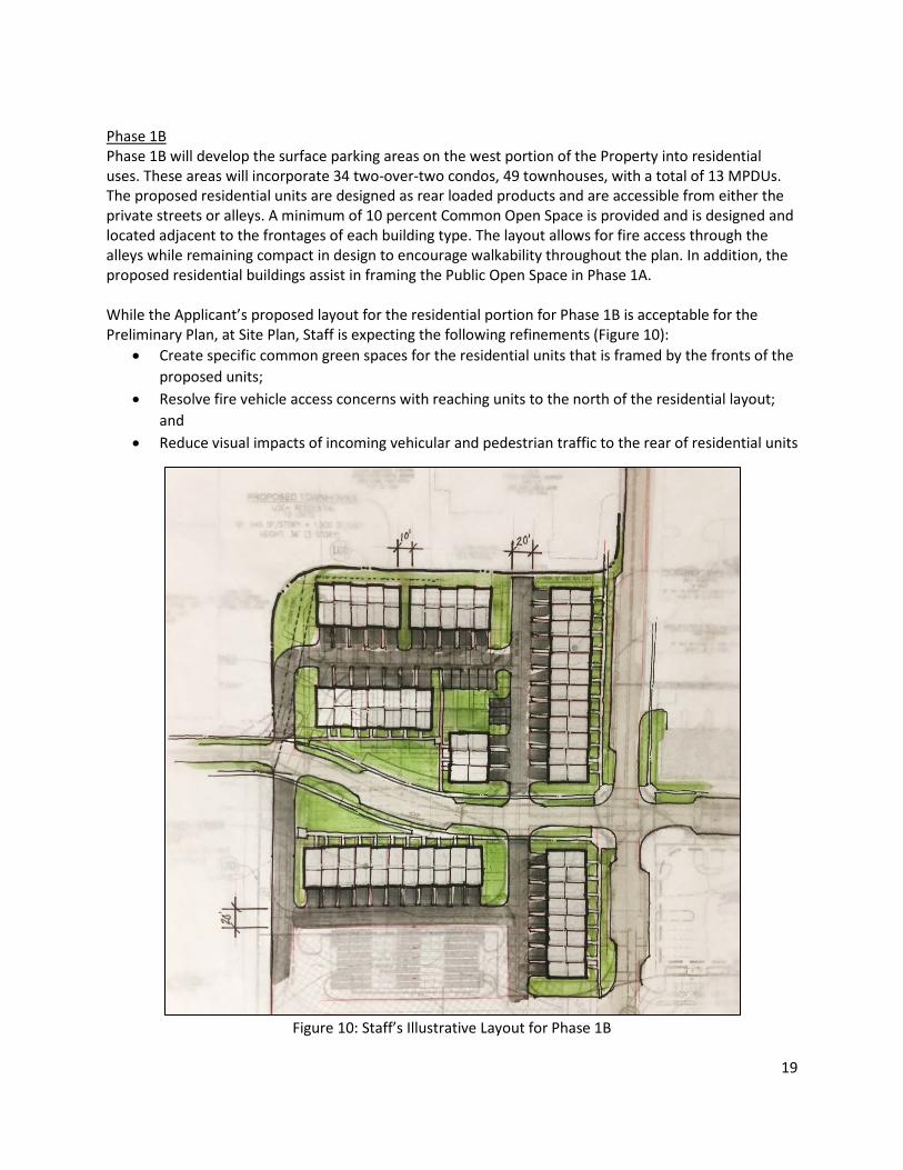
Phase 1B Phase 1B will develop the surface parking areas on the west portion of the Property into residential uses. These areas will incorporate 34 two-over-two condos, 49 townhouses, with a total of 13 MPDUs. The proposed residential units are designed as rear loaded products and are accessible from either the private streets or alleys. A minimum of 10 percent Common Open Space is provided and is designed and located adjacent to the frontages of each building type. The layout allows for fire access through the alleys while remaining compact in design to encourage walkability throughout the plan. In addition, the proposed residential buildings assist in framing the Public Open Space in Phase 1A. While the Applicant’s proposed layout for the residential portion for Phase 1B is acceptable for the Preliminary Plan, at Site Plan, Staff is expecting the following refinements (Figure 10):
• Create specific common green spaces for the residential units that is framed by the fronts of the proposed units;
• Resolve fire vehicle access concerns with reaching units to the north of the residential layout; and
• Reduce visual impacts of incoming vehicular and pedestrian traffic to the rear of residential units
Figure 10: Staff’s Illustrative Layout for Phase 1B
20
Figure 12: Phase 1B Townhouse Elevations
Phase 2 As shown in the Phasing Plan in Figure 3, Phase 2 consists of the future redevelopment of the existing shopping center and the associated surface parking lot. Sketch Plan Amendment and possibly a Preliminary Plan Amendment will be required for any modification, addition or redevelopment within Phase 2. As demonstrated in Figure 11, Phase 2 will also provide the remaining public open space, with is meant to be illustrative in nature and is incorporated only to demonstrate the feasibility of accommodating the required public open space within the Phase 2 portion of the Property. At the time of a sketch plan amendment for Phase 2, Staff recommends that the remaining public open space be located such that it connects to, and complements, the main square of the Public Open Space in Phase 1A, and that a vehicular and pedestrian connection must be established between the existing north-south main street and the new road on the south side of the proposed townhouse building products in Phase 1B, which is shown as blue arrows in Figure 11.
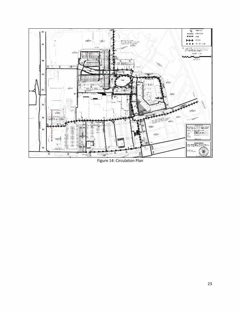
Access and Circulation Public Transit Service There are ten bus stops located along the adjacent Montgomery Village Avenue, Stedwick Road, Watkins Mill Road, and Club House Road frontages. The four most convenient bus stops are at Club House Road, Centerway Road, Stedwick Road, and Watkins Mill Road. The area is served by Ride On routes 58, 59, 60, 64, and 65. These routes serve the major roads surrounding the proposed development and terminate at the Shady Grove Metro Station. Major origins and destinations near the proposed development for these bus routes include Frederick Road (MD 355), Lakeforest Transit Center, and the Shady Grove Metro Station. Master-Planned Roadways and Bikeways In accordance with the 2016 Montgomery Village Master Plan, the 2005 Countywide Bikeways Functional Master Plan, and the draft Bikeway Master Plan, the master-planned roadways and bikeway along Montgomery Village Avenue is designated as a four-lane arterial, A-295, with a recommended 100-foot wide right-of-way and a shared-use path, LB-1, on the eastern side. The currently right-of-way is 100 feet from the opposite right-of-way line. The draft Bikeway Master Plan recommends sidepaths on both sides. The Applicant is providing a eight-foot sidepath with four-foot green along their frontage of Montgomery Village Avenue.
22
Site Access Points Site access points are from Montgomery Village Avenue, Stedwick Road, Watkins Mill Road, and Club House Road. The Stedwick Road access is the only one through an adjoining property. There will be a network of new private roads through the Property that will provide for better circulation and connection between Montgomery Village Avenue and Watkins Mill Road. Bikeshare and Bicycle Parking The Applicant has proposed one bikeshare station at the southeast corner of the Site along Montgomery Village Avenue. The final location of the bikeshare station must be shown on the Certified Preliminary and Site Plans, and easements for public access must be provided. The Applicant is providing eight public short-term bicycle parking spaces using inverted-U bike racks,or equivalent rack. The locations are visible and accessible from the main entrances of the retail businesses and proposed open space area. The one long-term bicycle space is located at the rear of the commercial shopping, adjacent to the new retail, and public open space. Circulation The Project will convert the auto-dependent shopping center to a more pedestrian and bicycle friendly environment, with improved vehicular, bicycle, and pedestrian circulation by removing a portion of the existing retail center to allow for a through-block connection and providing an internal network of private streets that further enhance connectivity with the existing grid of public streets. The central location of open space between the proposed residential refurbished retail/service spaces will create a destination for residents and the surrounding community. This will allow for economic opportunities along with creating a sense of place within the Property.
23
Figure 14: Circulation Plan
24
SECTION 4: SKETCH PLAN ANALYSIS AND FINDINGS This Sketch Plan Amendment replaces the previously approved Sketch Plan. The purpose of a Sketch Plan is to identify general land uses, development intensity, and public benefits for the optional method of development in the CR, CRT, EOF or LSC Zones. The Sketch Plan is intended to be conceptual in nature with an emphasis on: building densities; massing; building heights and anticipated uses; the locations of public open spaces; the general circulation patterns for all modes of transportation; an estimated range of peak hour trips; and relationships between existing or proposed adjacent buildings and rights-of-way. Details of the proposed development are determined during Preliminary Plan and Site Plan reviews. Section 59-7.3.3.E of the Zoning Ordinance states: “To approve a sketch plan the Planning Board must find that the following elements are appropriate in concept and appropriate for further detailed review at Site Plan. The sketch plan must:”
1. meet the objectives, general requirements, and standards of this Chapter;
The CRT zone permits a mix of residential and nonresidential uses at varying densities and heights. The zones promote economically, environmentally, and socially sustainable development patterns where people can live, work, recreate, and access services and amenities. The application of the CRT zone is appropriate where impacts can be mitigated by co-locating housing, jobs, and services.
The intent of the CRT zone is to:
a. Implement the recommendations of applicable master plans.
The property is within the boundaries of the 2016 Montgomery Village Master Plan. The master plan identifies four specific areas as potential redevelopment sites, including the Village Center. (With the exception of the former golf course, all properties included on this list were envisioned as mixed-use, pedestrian-friendly environments. General design recommendations for these in the master plan are divided in to three areas of discussion – Buildings, Connectivity, and Open Space (Section 5.2 – Overall Design Framework, page 50). Highlights from this section are:
• “Provide compact development patterns with short blocks and building frontages close to the street…” (section 5.2.1 Buildings)
• “Create complete streets that include building frontages close to the street, landscaping, bike facilities, and pedestrian areas that provide safe pedestrian crossings and include sustainable elements.” (section 5.2.2 Connectivity) New public open space should “provide alternatives for recreation and leisure in a mixed-use setting” by “creating places for community use that are framed and activated by surrounding development and uses, where the public feels welcome to gather and linger.” (Section 5.2.3 Open Spaces)
Revisions to the previous approval resulted in lower residential densities that those envisioned by the master plan, but created a better set of internal streets connected to all existing access points into the property, and additional public open spaces along these new
25
connections. As an example, the amended plan improves the internal connection to the access from Stedwick Rd. along the existing US Postal facility; this delivers a significantly improved connection through the new residential area linking directly to the new central open space. This revision substantially improves connectivity through the block, which is an important master plan goal.
The amended application delivers a mix of uses (commercial and residential), connections, and open spaces that appropriately capture the spirit of the recommendations in the master plan. Below are comments on specific master plan recommendations (italics refer to a selected quotation from the master plan):
• Transform the north south drive into a pedestrian-friendly local street.(p. 60) The application will improve existing storefronts along the north-south drive, but streetscape along existing pedestrian areas will remain as it exists today. However, the work included in this application does not preclude achieving an improved streetscape at this location as part of future phases of development. In addition, the application proposes creating a private road easement for this connection, where such future improvements could be implemented. • Establish an east-west local street connecting existing vehicular entrances at
Montgomery Village Avenue and Watkins Mill Road. (p.60) The proposal creates this connection by opening east-west vehicular access through the existing retail block, connecting the entrance from Centerway Road with the entrance from Watkins Mill Road. Both the new street segment and the proposed central open space achieve the substantial and centralized, pedestrian-friendly area envisioned by the master plan.
Along both local streets, create a main street environment with street-oriented buildings, streetscapes, and comfortable pedestrian walking areas connecting to adjacent streets and existing and future transit options. (p.60-61).
The main street environment is achieved along the portion the new street connected to existing retail uses. Beyond that area, new residential uses and open spaces for public use are located along new connections, introducing variety of uses along the new pedestrian areas that transition appropriately to existing uses beyond the redeveloping property.
• Enhance existing open spaces and provide linkages to the proposed local streets. (p.61) The application relies on a combination of existing and proposed connections and open spaces to achieve this goal. The application delivers several public open spaces along most new connections.Some existing pedestrian areas part of this local network will remain unchanged consideration should be given to improving these areas in future improvement phases, to provide a network of truly enhanced linkages.
26
• Consider strategies to integrate existing uses that are likely to remain with emerging pedestrian environments, such as streetscape enhancements or public use spaces to link new and existing development. (p.61).
The application proposes a combination of new construction and refurbished existing storefronts to achieve this master plan goal. In addition, the proposed new street segment and central open space, and pedestrian improvements to the front parking area will link the property to existing access points, and bus stops.
b. Target opportunities for redevelopment of single-use commercial areas and surface parking lots with a mix of uses. The Project is currently comprised of an existing commercial shopping center and a surface parking lot. The Project will redevelop the parking lot and existing single-use site with a low-density mixed-use development with townhouses and condos, meeting the small downtown and pedestrian-oriented development. The Project includes ground-floor non-residential uses, upper level residential units, public open space and residential amenity space.
c. Encourage development that integrates a combination of housing types, mobility options,
commercial services, and public facilities and amenities, where parking is prohibited between the building and the street. The Project encourages such development by proposing market-rate residential units in a variety of unit types as well as 12.5% MPDUs on-site, offering housing opportunities for a range of incomes to Montgomery Village. The potential commercial services (retail and/or restaurant) on the ground floor at the new Thru- Block Connection provide services for the residents and surrounding neighborhood. This area is also located adjacent to the main public open, which is an amenity to the site. The Project design allows for pedestrian, bicycle, and vehicular mobility options. It will provide an 8-foot wide sidepath along Montgomery Avenue. All new developed areas do not propose any parking between the building and the street. The existing shopping and surfacing parking is to remain.
d. Allow a flexible mix of uses, densities, and building heights appropriate to various settings to
ensure compatible relationships with adjoining neighborhoods. The Project provides mixed-use and a pedestrian-oriented development. The max height for the site is 50 feet, as allowed in CRT 1.5, C-0.75, R-1.0, H-75. The neighborhood scale development is compatible with the surrounding garden style apartments, office buildings, existing retail services.
e. Integrate an appropriate balance of employment and housing opportunities.
The redevelopment of the shopping center and adding mixed-use development will provide more opportunities for residents and employment to the local businesses. The Project provides a variety of housing options through provision of both market-rate units and MPDUs on site in an array of unit sizes (ea. townhouse, two-over-two(s), condos). In addition, the Project provides non-residential uses such as retail and/or restaurant.
27
f. Standardize optional method development by establishing minimum requirements for the
provision of public benefits that will support and accommodate density above the standard method limit. The Project will provide the public benefits for a minimum of three categories and 50-points to achieve the optional method development requirement. See Sketch Plan Findings Section 7 of this report.
The proposed project meets the development standards of the Zone as shown in Table 1, below.
2. substantially conform with the recommendations of the applicable master plan;
As discussed in Sketch Plan finding 1.a. above, the Sketch Plan substantially conforms to the recommendations of the 2016 Montgomery Village Master Plan.
3. satisfy any development plan or schematic development plan in effect on October 29, 2014; The Site is not subject to a development plan or schematic development plan.
4. under Section 7.7.1.B.5., for a property where the zoning classification on October 29, 2014, was the result of a Local Map Amendment, satisfy any green area requirement in effect on October 29, 2014; any green area under this provision includes and is not in addition to any open space requirement of the property’s zoning on October 30, 2014;
The Property’s zoning classification on October 29, 2014, was not a result of a Local Map Amendment.
5. achieve compatible internal and external relationships between existing and pending nearby
development;
Table 1- Project Data Table Section 59 Development Standard Permitted/
Required Proposed
Gross Tract Area (sf) CRT-1.5, C-0.75, R-1.0, H-75 n/a 615,000 4.5.4.B.2.b Density Non-Residential 613,690 165,000
The Amendment is designed to provide a compatible relationship with the existing structures within the block surrounded by Montgomery Village Avenue, Clubhouse Road, Watkins Mill Road and Stedwick Road as well as the existing development located outside of this block. The proposed redevelopment will create a new connection through the site and activate the street with first floor retail. The proposed public open space is appropriately located and will have adequate scale and proportions with easy access to the surrounding retail and residential uses.
6. provide satisfactory general vehicular, pedestrian, and bicyclist access, circulation, parking, and
loading;
The Amendment maintain an adequate and convenient road network for the proposed and future redevelopment of the Site. It will create a suitable layout to accommodate vehicular, pedestrian, and bicycle circulation in a safe and friendly environment. The new street connection will transform a retail plaza that currently has vacant spaces into a complete street, with new vehicular access, on-street parking, and retail store fronts, and provides adequate access for parking, service, and loading.
7. propose an outline of public benefits that supports the requested incentive density and is
appropriate for the specific community; and
As discussed further in the Site Plan findings below, and taking into account the considerations in Section 59.4.7.1.B, including the recommendations and objectives of the Sector Plan and applicable design guidelines, the Incentive Density Implementation Guidelines, the size and configuration of the Property and its relationship to adjacent properties, and additional enhancements related to the individual public benefits, the proposed public benefits support the Applicant’s request for incentive density and is appropriate for the community surrounding the Property. For an optional method development in the CRT Zone, the zoning code requires 50 points in at least three categories. The Amendment modifies the public benefit due to the removal of the multi-family building and replacing it with townhomes. At the time of the Sketch Plan review, only the categories need be approved. However, the following table below shows both the categories and points for the proposed public benefits to demonstrate the project’s ability to meet the required benefit points. Per Section 59-4.7.1.B, granting points as a public benefit for any amenity or project feature otherwise required by law is prohibited.
29
Table 2- Public Benefits Valuations
Section # Benefit Categories Points Allowed
Points Recommended
59-4.7.3C: Connectivity and Mobility
C.3 Neighborhood Services 15 12.5
C.5 Through-Block Connection 20 10
C.5 Wayfinding 10 5 59-4.7.3D: Diversity of Uses and Activities
D.2 Care Centers 20 15
59-4.7.3F: Protection and Enhancement of the Natural Environment
F.10 Vegetated Roof 15 12.5
Total 80 55
The Categories of Dwelling Units, Accessibility, Structured Parking, Recycling Facility, and Vegetation Wall were removed. Neighborhood Services and Thru-Block Connection remains unchanged by this Amendment.
Connectivity and Mobility
Wayfinding There will be seven wayfinding signs on the Site to orientate pedestrians and cyclists to the major open=spaces, bike storage, bus stops, and retail spaces. The signs will have a modern design. Final design, locations and installation details approved by applicable agencies prior to use-and-occupancy.
Diversity of Uses and Activities
Care Center There is currently a children’s day care on Site and the tenant plans to remain. The day care is available to the public and provides care for more than 15 children. The proposed Sketch Plan includes a new playground to serve the children enrolled in the day care. Final size, location, layout, and other design details will be determined at the Site Plan stage.
Protection and Enhancement of the Natural Environment
Vegetated Roof A green roof will be approximately 3,300 square feet and will be installed above the retail building at the main entrance to the new through-block connection. It will directly below the proposed multi condo unit building. The green roof will include necessary HVAC and addition mechanical equipment. Final size, location, layout, and other design details will be determined at the Site Plan stage.
8. establish a feasible and appropriate phasing plan for all structures, uses, rights-of-way,
sidewalks, dedications, public benefits, and future preliminary and Site Plan applications.
30
The Sketch Plan proposes redevelopment of the Site in three phases and establishes the overall layout of the site with building locations, open spaces, and vehicular and pedestrian circulation. All required site improvements, and circulation facilities will be provided in each phase and will be delineated in the Preliminary Plan and all subsequent Site Plans. A full development program to establish phasing of the elements required by this Application will be developed and analyzed during Preliminary and Site Plan reviews. Any redevelopment in the area delineated as Phase 2 will require a Sketch Plan Amendment. Most of the public benefit points will be provided in Phase 1A (53.5 of 55), while the remaining 1.5 points will be provided in Phase 1B.
SECTION 5: PRELIMINARY PLAN ANALYSIS AND FINDINGS
1. The layout of the subdivision, including size, width, shape, orientation and diversity of lots, and location and design of roads is appropriate for the subdivision given its location and the type of development or use contemplated and the applicable requirements of Chapter 59.
Staff finds the proposed lot size, width, shape and orientation are appropriate for the location of the subdivision considering the recommendations in the Montgomery Village Master Plan and the type of development and use contemplated. The lots were reviewed for compliance with the dimensional requirements for the CRT zone as specified in the Zoning Ordinance (See the Site Plan Data Table in Site Plan Finding 2.d.i below). The lots as proposed will meet all the dimensional requirements for area, frontage, width, and setbacks in the CRT Zone.
Private Roads - Section 50-4.3.E.4 The Applicant proposes that all roads within the project be designated as private. Thus, a total of 53 of the 55 lots will front onto a private street or open space. Per Section 50.4.3.4.c., in requesting private roads, the Applicant agrees, per the conditions of approval, that the proposed private roads must be built to the construction specifications of the corresponding public road standards (MC 2005.02 Modified and MC 201.01 Modified) including paving detail and design data, and surface depth and structural design. The proposed private roads must be fully accessible to the public; accessible to fire and rescue vehicles, as needed; and designed to the minimum public road standards, except for right-of-way and pavement widths.
For this subdivision, the proposed private internal streets and alleys, which provide frontage to 53 lots, meet the minimum standards necessary for their approval. The private roads will be constructed to the minimum public road structural standards, will have a minimum 20-foot pavement width and adequate turning radii where needed for emergency access, an appropriate paving cross-section elsewhere for private vehicles, and an appropriate circulation and turnaround pattern. The private roads will be located within separate private road parcels, with a covenant and easement that ensures they are adequately maintained and remain fully accessible to the public.
Private streets are intended to provide necessary flexibility in right-of-way width and road design, that cannot be achieved under Chapter 49, to provide enhanced sidewalk, curb and crosswalk design features that promote pedestrian circulation. The establishment of private roads within the proposed development is consistent with most of the roads within
31
Montgomery Village. The proposed private streets are modified business district streets. Most of the private roads will have a 60-foot and 50-foot right-of-way with six-foot planter boxes and five-foot sidewalks on both sides. On-street parking is also proposed on some of the private roads as shown on the Preliminary Plan and Site Plan. Private alleys are proposed at minimum as 24-foot-wide paved alleys with no sidewalks.
2. The Preliminary Plan substantially conforms to the Master Plan or Urban Renewal Plan.
As discussed in Sketch Plan finding 1.a. above, the Preliminary Plan substantially conforms to the recommendations of the 2016 Montgomery Village Master Plan.
3. Public facilities will be adequate to support and service the area of the subdivision.
The table below shows the additional primary trips generated by the existing and proposed land uses where these trips have their “primary” origins on the site with outside destinations and vice versa.
Land Use Square Footage or Number of Units
Weekday Primary Peak Hour Person Trips
Morning Evening
General Retail Space 166,600 323 653
Office Space 36,000 54 60
Subtotal Existing 377 713
General Retail Space 165,000 322 649
Mid-Rise Apartments 32 44 62
Townhouse 83 25 19
Subtotal Proposed 391 730
Difference – Additional Primary Trips 14 17
Table 3: Peak Hour Trip Generation
Local Area Transportation Review (LATR) The Use and Occupancy Certificates for the existing shopping center were issued more than 12 years ago for at least 75 percent of the originally approved development. Thus, these current commercial trips are considered existing traffic on the road network in accordance with the SSP.
Policy Area Review The Preliminary Plan application is subject to the 2016-2020 Subdivision Staging Policy (SSP), since the building permit will be filed after March 1, 2017, the Applicant will be required to pay the updated General District Transportation Impact Tax. The timing and amount of the payment will be in accordance with that in Chapter 52 of the Montgomery County Code as amended.
32
Schools The 2016-2020 Subdivision Staging Policy school test for FY2018 indicates that there is adequate capacity within the Watkins Mill School cluster for the service areas of Stedwick Elementary, Montgomery Village Middle, and Watkins Mill High School. The Applicant will be required to pay the School Impact Tax on all applicable residential units. MCDPS will determine the amount and timing of the payment.
Other Public Facilities The proposed development will be served by public water and sewer systems. Fire and Rescue has reviewed the application and has determined that the Property has appropriate access for fire and rescue vehicles. Other public facilities and services including police stations, firehouses and health care are currently operating in accordance with the Subdivision Staging Policy and will continue to be sufficient following the construction of the project. Electric, gas and telecommunications services will also be available and adequate.
4. All Forest Conservation Law, Chapter 22A requirements are satisfied.
Environmental Guidelines A Natural Resources Inventory/Forest Stand Delineation (NRI/FSD) was approved for this site on Sept 1, 2018 (NRI/FSD No. 420170040). The property contains no streams or stream buffers, wetlands or wetland buffers, hydraulically adjacent steep slopes, 100-year floodplains, known occurrences of Rare, Threatened or Endangered species, or forest. The site is within the Great Seneca Creek watershed, which is a Maryland State Use Class I-P stream. This plan is in compliance with the Environmental Guidelines.
Preliminary Forest Conservation Plan The Net Tract Area used in the Forest Conservation calculations is 18.37 acres. Based on the afforestation threshold of 15% of the Net Tract Area, the afforestation requirement is 2.76 acres. The applicant proposes to fulfill the planting requirement by retaining 0.52 acres of on-site tree canopy, planting additional landscape trees totaling 1.47 acres of tree canopy and obtaining off-site banking credit equal to 0.77 acres of forest planted or 1.54 acres of existing forest protected. A Final Forest Conservation Plan is being submitted for approval concurrently with the Site Plan for this site.
Forest Conservation Variance Section 22A-12(b) (3) of County code identifies certain individual trees as high priority for retention and protection. Any impact to these trees, including removal of the subject tree or disturbance within the tree’s critical root zone (CRZ) requires a variance. An applicant for a variance must provide certain written information in support of the required findings in accordance with Section 22A-21 of the County code. The code requires no impact to trees that: measure 30 inches or greater, dbh; are part of an historic site or designated with an historic structure; are designated as a national, State, or County champion tree; are at least 75 percent of the diameter of the current State champion tree of that species; or trees, shrubs, or plants that are designated as Federal or State rare, threatened, or endangered species.
33
Variance Request The applicant submitted a variance request on January 16, 2018 because the plan would create an impact to the CRZ of five trees that are considered high priority for retention under Section 22A-12(b) of the County code. Variance permission is requested to remove three of these trees, although the applicant will make efforts to save the 31-inch diameter English oak if possible. The remaining two trees are to be saved. A copy of the variance request letter, specifying the amount of critical root zone disturbance for the trees to be saved, is appended to this letter (Attachment 6). The existing Montgomery Village Center consists largely of a single-story shopping mall surrounded by a sea of asphalt surface parking, and an area of three-story townhouse-style office condos. The specimen trees exist in parking lot islands and planting strips between the parking lot, road rights-of-way, and shopping center buildings and sidewalk areas. The Approved and Adopted Montgomery Village Master Plan (March, 2016) affirms the Montgomery Village Vision 2030 plan vision for the Montgomery Village Center to redevelop as a mixed use town center. Based on this vision, the Village Center has received a CRT zoning designation that reflects a desire to create a denser, more urban style of development. The site is further constrained by existing utilities and the need to introduce stormwater management treatment facilities. The redevelopment recommended in the Master Plan and enabled by the CRT zoning cannot occur without disturbing the Critical Root Zone (CRZ) of the specimen trees on the site. For this reason, staff believes that denial of the variance would constitute a hardship to the applicant. This finding must be met when determining whether or not to consider a variance for the project. Based on this finding, Staff finds that a variance can be considered.
Section 22A-21 of the County code sets forth the findings that must be made by the Planning Board or Planning Director, as appropriate, in order for a variance to be granted. Staff has made the following determinations, as the Director’s designee, that granting the requested variance:
1. Will not confer on the applicant a special privilege that would be denied to other applicants.
Impacts to specimen trees are a result of the position of the trees in the middle of existing developed areas that must be disturbed for Master Plan-recommended redevelopment to be achieved, and from the requirements for infrastructure needed to support the development. The proposed development is consistent with the zoning for the site. Staff has determined that the impacts to the trees subject to the variance requirement cannot be avoided. Therefore, Staff finds that the granting of this variance is not a special privilege that would be denied to other applicants.
2. Is not based on conditions or circumstances which are the result of the actions by the
applicant.
The requested variance is not based on conditions or circumstances which are the result of actions by the applicant, but on engineering and site constraints and Master Plan-recommended redevelopment.
3. Is not based on a condition relating to land or building use, either permitted or non-
conforming, on a neighboring property.
34
The requested variance is not a result of land or building use on a neighboring property.
4. Will not violate State water quality standards or cause measurable degradation in water
quality.
The three specimen trees being removed will be replaced by planting one inch (caliper) of new trees for each four inches diameter removed, using planting stock of no less than 3 inches caliper. In a few years, the replacement trees should attain sufficient size to replace the lost water quality treatment benefits of the trees removed. In this case, the applicant must plant at least 23.5 caliper inches of new trees to replace the specimen trees being removed. The Preliminary Forest Conservation Plan shows that eight willow oak (Quercus phellos) trees, each at least three inches caliper, are being planted in mitigation for the specimen trees removed, for a minimum of 24 caliper inches of replacement. Therefore, staff finds that removal of the specimen trees will not violate State water quality standards or cause a measurable degradation in water quality.
County Arborist’s Recommendation on the Variance In accordance with Montgomery County Code Section 22A-21, the Planning Department referred a copy of the variance request to the County Arborist in the Montgomery County Department of Environmental Protection for a recommendation prior to acting on the request. The County Arborist’s variance review is approved under Section 22A-21(c) of the Forest Conservation Law.
Recommendation Staff recommends that the approval of the variance, and finds the plan in compliance with Chapter 22A, Forest Conservation.
5. All stormwater management, water quality plan, and floodplain requirements of Chapter 19 are
satisfied.
The Montgomery County Department of Permitting Services (DPS) Stormwater Management Section issued a letter accepting the stormwater management concept approval on April 16, 2018. Stormwater treatment will be accomplished through the use of micro bioretention, drywells, green roof and structural practices.
6. Any other applicable provisions specific to the property and necessary for approval of the
subdivision is satisfied.
No other provisions apply to the Subdivision
35
SECTION 6: SITE PLAN ANALYSIS AND FINDINGS
Per Section 7.3.4 of the Zoning Ordinance,
1. When reviewing an application, the approval findings apply only to the site covered by the application.
2. To approve a site plan, the Planning Board must find that the proposed development: a. satisfies any previous approval that applies to the site;
The development is consistent with Sketch Plan 320170020A and Preliminary Plan No. 120180010, which is being reviewed concurrently with this Site Plan. The existing shopping center is the subject of previous site plan approval(s) under its previous T-S (Town Sector) zoning. All of previous site plans will be superseded by the current site plan application.
b. satisfies under Section 7.7.1.B.5 the binding elements of any development plan or schematic development plan in effect on October 29, 2014;
This section is not applicable.
c. satisfies under Section 7.7.1.B.5 any green area requirement in effect on October 29, 2014 for a property where the zoning classification on October 29, 2014 was the result of a Local Map Amendment; This section is not applicable.
d. satisfies applicable use standards, development standards, and general requirements under this
Chapter;
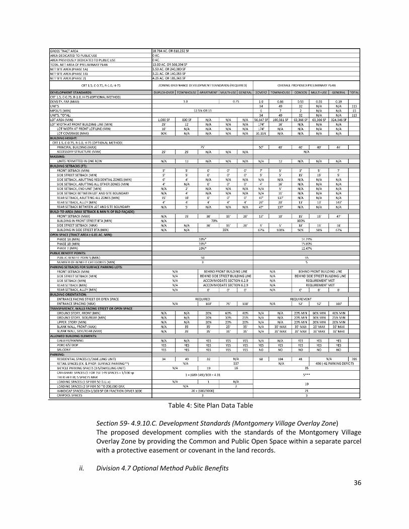
i. Division 4.5 Commercial/Residential Zones and Division 4.4 Residential Zones Development Standards The Site covers approximately 18.78 acres Zoned CRT 1.5, C-0.75, R-1.0, H-75. The data table below shows the Application’s conformance to the development standards of Section 59-4.5.4.
36
Table 4: Site Plan Data Table
Section 59- 4.9.10.C. Development Standards (Montgomery Village Overlay Zone) The proposed development complies with the standards of the Montgomery Village Overlay Zone by providing the Common and Public Open Space within a separate parcel with a protective easement or covenant in the land records.
ii. Division 4.7 Optional Method Public Benefits
37
For an optional method development in the CRT Zone, the zoning code requires 50 points in at least three categories. At the time of the Sketch Plan review only the categories need be approved. The following table shows both the categories and points for the proposed public benefits to demonstrate the project’s ability to meet the required benefit points. Per Section 59-4.7.1.B, granting points as a public benefit for any amenity or project feature otherwise required by law is prohibited.
Public Benefits Valuations
Section # Benefit Categories Points Allowed
Points Recommended
59-4.7.3C: Connectivity and Mobility
C.3 Neighborhood Services 15 12.5
C.5 Through-Block Connection 20 10
C.5 Wayfinding 10 5 59-4.7.3D: Diversity of Uses and Activities
D.2 Care Centers 20 15
59-4.7.3F: Protection and Enhancement of the Natural Environment
F.10 Vegetated Roof 15 12.5
Total 80 55
Table 5: Public Benefit Table
Connectivity and Mobility Neighborhood Services: The Site already contains more than the required minimum number of services and small businesses. In addition, it is currently surrounded by other goods and services. Within a ¼-mile radius, there are three gas stations, two banks, a drug store, a McDonalds, an assisted living facility and two small offices. The proposed redevelopment will provide an array of options both large and small. The redeveloped Site will have two large stores, an array of mid-size retail bays, and over a dozen small bays under 5,000 square feet that will provide a wide range of retail goods and services on site to serve the community. Staff supports the request for 12.5 points within the Neighborhood Services category.
Thru-Block Connection: The Site provides an open air, at least 15 feet wide, safe and attractive thru-block pedestrian connection that will be open to the public at all times. It provides a prominent connection through the Property from Montgomery Village Avenue to the central open space and continues to Watkins Mill Road. The central portion of the thru-block connection, between the retail and the central open space, provides for wide-sidewalks, plaza, retail, and café seating experiences for pedestrians and patrons to interact with. Staff supports the request for 10 points for the Thru-Block Connection category.
Wayfinding: The Way-Finding Plan at a minimum must include seven monument signs that efficiently direct patrons through the Property, and provide directions to the public
38
transit stop, one bikeshare stations, open space area, and shared use path(s). In addition, the Way-Finding Plan may include internal and external signage, banners, lighting and design elements. The locations of the proposed signage shall be free of all obstructions and clearly visible from the directed routes. Final design, locations, and installation details must be approved by Planning Staff prior to Certified Site Plan. Staff supports the request for 5 points for Wayfinding. 3.5 points (five signs) will be provided during Phase 1A, and 1.5 points (two signs) will be provided during Phase 1B.
Diversity of Uses and Activities Care Center: There is currently a children’s day care on Site and the tenant plans to remain. The day care is available to the public and provides care for more than 15 children. The proposed Site Plan includes a new playground, approximately 2,500 square feet, to serve the children enrolled in the day care. Staff supports the request for 15 points for the Care Center category.
Protection and Enhancement of the Natural Environment Vegetated Roof: A green roof will be approximately 3,300 square feet and will be installed above the retail building at the main entrance to the new through-block connection. It will directly below the proposed multi condo unit building. The green roof will include necessary HVAC and addition mechanical equipment. Final size, location, layout, and other design details will be determined at CSP. Staff supports the request for 12.5 points for the Vegetated Roof category.
iii. Division 6.1. Site Access As conditioned, the Project provides safe, adequate, and efficient circulation, parking, and loading for cars, trucks, pedestrians, and bicyclists and integrates the project into the surrounding area.
iv. Division 6.2 Parking, Queuing, and Loading The Project’s surface parking spaces will be separated by internal private roads. Access to parking is provided from multiple points internally, and the primary loading space (existing) is provided on the north side of the existing retail building. Parking, queuing, and loading will be provided in an adequate, safe, and efficient manner.
v. Division 6.3 Open Space and Recreation
The Project will provide the required Public and Common Open space in each phase. Phase 1A includes 14.74% percent, or 35,519 square feet, of Public Open Space for the area of Phase 1A, which meets the minimum 10% requirement. The development will provide adequate, safe, and efficient open space for Phase 1A. The Applicant has demonstrated that by providing the sidepath, Public and Common Open Spaces, sidewalks, plaza, picnic and seating areas, playground, and landscaping/lawn areas, the development satisfies the Recreational Guidelines.
39
Table 6: Recreational Facilities Adequacy
vi. Division 6.4 General Landscaping and Outdoor Lighting
The project provides adequate landscaping and lighting, as well as other site amenities, to ensure that these facilities will be safe, adequate, and efficient for residents and visitors. The Project will include streetscaping along many new and existing streets, with widened sidewalks, street trees, shared-use paths, and lighting.
As shown in the Development Standards table and findings above, the proposed Site Plan meets all the general requirements and development standards of Divisions 59-4.4 and 59-4.5 of the Zoning Ordinance, and the general development requirements of Article 59-6 of the Zoning Ordinance.
e. satisfies the applicable requirements of:
i. Chapter 19, Erosion, Sediment Control, and Stormwater Management; and The Montgomery County Department of Permitting Services (DPS) Stormwater Management Section issued a letter accepting the stormwater management concept approval on April 16, 2018. Stormwater treatment will be accomplished through the use of micro bioretention, drywells, green roof and structural practices.
ii. Chapter 22A, Forest Conservation Environmental Guidelines A Natural Resources Inventory/Forest Stand Delineation (NRI/FSD) was approved for this site on Sept 1, 2018 (NRI/FSD No. 420170040). The property contains no streams or stream buffers, wetlands or wetland buffers, hydraulically adjacent steep slopes, 100-year floodplains, known occurrences of Rare, Threatened or Endangered species, or forest. The site is within the Great Seneca Creek watershed, which is a Maryland State Use Class I-P stream. This plan is in compliance with the Environmental Guidelines. Final Forest Conservation Plan The Net Tract Area used in the Forest Conservation calculations is 18.37 acres. Consistent with the Preliminary Forest Conservation Plan (No. 120180010), the afforestation requirement is 2.76 acres. The applicant proposes to fulfill the planting requirement by retaining 0.52 acres of on-site tree canopy, planting additional landscape trees totaling
40
1.47 acres of tree canopy (projected at 20 years’ growth), and obtaining off-site banking credit equal to 0.77 acres of forest planted (or 1.54 acres of existing forest protected). Three specimen trees being removed will be replaced by planting one inch (caliper) of new trees for each four inches diameter removed, using planting stock of no less than 3 inches caliper. In a few years, the replacement trees should attain sufficient size to replace the lost water quality treatment benefits of the trees removed. In this case, the applicant must plant at least 23.5 caliper inches of new trees to replace the specimen trees being removed. The Final Forest Conservation Plan shows that eight willow oak (Quercus phellos) trees, each at least three inches caliper, are being planted in mitigation for the specimen trees removed, for a minimum of 24 caliper inches of replacement.
f. Provides safe, well-integrated parking, circulation patterns, building massing and, where required,
open spaces and site amenities;
As conditioned, the Site Plan provides adequate, safe, and efficient parking and circulation patterns. The Project provides well-integrated onsite surface parking with multiple access points. The Site Plan a provides adequate open space and site amenities, circulation patterns, streetscape improvements, safe pedestrian environments, and adequate building massing consistent with the zone. The Application includes sidewalk and streetscape upgrades to the Property’s frontage along Montgomery Village Avenue’s frontages. These enhancements will facilitate improved pedestrian connections from nearby neighborhoods by offering access to existing and planned bikeways, transit, side paths, and retail uses.
g. substantially conforms with the recommendations of the applicable master plan and any guidelines approved by the Planning Board that implement the applicable plan;
As discussed in Sketch Plan finding 1.a. above, the Site Plan substantially conforms with the recommendations of the 2016 Montgomery Village Master Plan.
h. will be served by adequate public services and facilities including schools, police and fire
protection, water, sanitary sewer, public roads, storm drainage, and other public facilities. If an approved adequate public facilities test is currently valid and the impact of the development is equal to or less than what was approved, a new adequate public facilities test is not required. If an adequate public facilities test is required the Planning Board must find that the proposed development will be served by adequate public services and facilities, including schools, police and fire protection, water, sanitary sewer, public roads, and storm drainage; As discussed in Preliminary Plan finding 3 above, the Property will be served by adequate public facilities, including police and fire protection, water, sanitary sewer, public roads, storm drainage, and other public facilities.
i. on a property in a Rural Residential or Residential zone, is compatible with the character of the
residential neighborhood; and Not applicable, the Subject Property is zoned CRT.
41
j. on a property in all other zones, is compatible with existing and approved or pending adjacent
development. The development is compatible with existing and approved or pending adjacent development.
3. To approve a site plan for a Restaurant with a Drive-Thru, the Planning Board must also find that a
need exists for the proposed use due to an insufficient number of similar uses presently serving existing population concentrations in the County, and the uses at the location proposed will not result in a multiplicity or saturation of similar uses in the same general neighborhood. The Applicant has conducted an analysis that takes into account such factors as a) surrounding population density, b) accessibility from heavily traveled roads, c) area income, d) market area dining and spending habits, e) the "competitive environment" and f) differentiation in product services. The Applicant notes that a 2016 consumer survey found that most people are willing to travel by car approximately 8 minutes for fast food purchases. Within 8 minutes driving time of the Montgomery Village Center there is a relatively large population that are potential customers for drive-in restaurants within the Shopping Center, but there are only two existing restaurants with drive- thrus within that primary market area. One being a McDonalds located adjacent to the Property on Montgomery Village Avenue and another McDonalds restaurant located in North Village on Goshen Road. The Applicant asserts that the reasons why a "need" exists at the Property for a drive-thru restaurant are as follows:
1. There is a substantial population density located within acceptable driving times who will patronize the restaurants.
2. The restaurants will be adjacent to Montgomery Village, a major north-south transportation corridor.
3. Redevelopment of Montgomery Village Center will make drive-thru restaurants now readily accessible to traffic on Watkins Mill Road, a heavy commuter route, particularly with the imminent opening of the interchange at I-270.
4. A drive-in restaurant operated within the context of a community convenience center will attract customers who find it advantageous to shop and dine at the same destination.
5. The opportunity will be available for a restaurant operator to provide another fast food line (chicken, seafood) than what already exists within the market area.
For the reasons set forth above, there is a demonstrable "need" for a drive-in restaurant or restaurants within the Montgomery Village Center.
4. For a property zoned C-1 or C-2 on October 29, 2014 that has not been rezoned by Sectional Map Amendment or Local Map Amendment after October 30, 2014, if the proposed development includes less gross floor area for Retail/Service Establishment uses than the existing development, the Planning Board must consider if the decrease in gross floor area will have an adverse impact on the surrounding area. Not applicable, the Subject Property is not zoned C-1 or C-2.
42
SECTION 7: COMMUNITY CORRESPONDENCE The Applicant has met all proper signage, noticing and pre-submission meeting requirements for the submitted Applications. Staff has received no correspondence on the proposed development.
SECTION 8: CONCLUSION The Applications meet all requirements established in the Subdivision Regulations and the Zoning Ordinance. It meets all the applicable requirements of Chapter 22A, forest conservation law. Access and public facilities will be adequate to serve the proposed lots and, as conditioned, the proposed project conforms with the Master Plan and the general requirements of Chapter 59. The Applications have been reviewed by other applicable County agencies, all of whom have recommended approval of the plan. Staff recommends approval of the Sketch Plan Amendment, Preliminary Plan, and Site Plan, with the conditions listed at the beginning of the Staff Report. ATTACHMENTS
1. Agency Approval Letters 2. Preliminary Forest Conservation Plan 3. Final Forest Conservation Plan 4. Preliminary Plan 5. Site Plan 6. Variance Request