50
| Date post: | 13-Feb-2018 |
| Category: |
Documents |
| Upload: | nguyentuyen |
| View: | 220 times |
| Download: | 0 times |

MONTHLY PROGRESS REPORT April 2012
Reporting Period March 14, 2012 through April 11, 2012
TABLE OF CONTENTS
Page
GEC – General Engineering Consultant .................................................................... 1
GEC – Public Involvement ......................................................................................... 5
N1 - Capital Circle NW – I-10 to US 90 ...................................................................... 6
N2 - Capital Circle NW/SW – SR 371 (Orange Avenue) to US 90 ............................. 7
W1 - Capital Circle SW – Crawfordville Road to SR 20 ........................................... 12
E3 - Capital Circle SE – Crawfordville Road To Woodville Highway ........................ 16
E2 - Capital Circle SE – Woodville Highway to Tram Road ..................................... 22
E1 - Capital Circle SE – Connie drive to Tram Road ............................................... 27
C2 - Capital Cascades Trail – Segment 2 ................................................................ 28
C3 & C4 - Capital Cascades Trail – Segments 3 and 4 Design ............................... 34
FB - Franklin Boulevard Flood Relief Project (FB) ................................................... 38
Capital Cascades Connector Bridge ........................................................................ 43
Acronym Glossary .................................................................................................... 46
MONTHLY PROGRESS REPORT April 2012
Reporting Period March 14, 2012 through April 11, 2012 Page 1
GEC – GENERAL ENGINEERING CONSULTANT
Project Description: General Engineering Consultant Contract for the Blueprint 2000 Intergovernmental Agency. THE LPA GROUP INCORPORATED is the Prime Consultant with Jacobs Engineering Group, Incorporated as the major subconsultant. Twelve additional subconsultants, seven of which are M/WBE firms, make up the LPA/Jacobs Blueprint GEC Management Team. Key Personnel: Program Manager: David Snyder – THE LPA GROUP INCORPORATED Design Manager: Jim Shepherd - Jacobs Contract Cost & Schedule Status – Contract 597 Original Contract Amount: $ 25,794,820.00Fiscal Year Re-Authorization: $ 2,821,537.00Executed Supplemental Agreements: $ 0.00Pending Supplemental Agreements: $ 0.00Current Contract Amount: $ 28,616,357.00Invoiced to Date: $ 25,531,164.95Remaining Contract Amount: $ 3,085,192.05Percent of Contract Amount Complete: 89.2%
MONTHLY PROGRESS REPORT April 2012
GEC – GENERAL ENGINEERING CONSULTANT
Reporting Period March 14, 2012 through April 11, 2012 Page 2
Subconsultant Participation: Contract Amt % of GEC Expended FY
Contract To Date To Date Moore Bass Consulting Stormwater & Landscaping $ 485,902.00 1.70 $ 239,803.62 $ 1,800.00Pope Environmental Environmental Services $ 434,276.00 1.52 $ 269,314.00 $ 30,477.08OLH International Program Controls $ 1,442,165.00 5.04 $ 1,544,130.76 $ 0.00Beck Consulting Group Government Relations $ 152,541.00 0.53 $ 133,757.89 $ 3,899.56Quest Corporation of America Public Involvement $ 1,447,465.00 5.06 $ 1,224,027.52 $ 103,083.29Uzzell Advertising Public Relations, Web Maint. $ 655,998.00 2.29 $ 704,448.51 $ 56,150.00Welch & Ward Architects (no longer in business)
Architecture, Recreation Facilities $ 1,575.00 0.01 $ 16,520.00 $ 0.00THC Right-of-Way Services, Inc. R/W appraisal and acquisition $ 1,931,433.00 6.75 $ 2,204,116.24 $ 160,084.00GPI Southeast Survey and mapping $ 491,405.00 1.72 $ 179,750.33 $ 0.00Weigal - Veasey Property Appraisal $ 0.00 0.00 $ 0.00 $ 0.00Williams Earth Sciences Geotechnical Services $ 65,000.00 0.23 $ 30,783.12 $ 0.00Allen Nobles & Associates Survey $ 24,970.00 0.09 $ 130,668.84 $ 0.00THE LPA GROUP (PRIME) Prime Consultant $ 10,970,936.00 38.34 $ 10,339,518.00 $ 780,420.87JACOBS (PRIME SUB) Prime Subconsultant $ 7,506,213.00 26.23 $ 5,826,516.14 $ 376,175.70Wilderness Graphics Signage $ 5,000.00 0.02 $ 5,000.00 $ 0.00O'Neal Survey & Mapping Survey & Mapping $ 4,928.00 0.02 $ 42,403.50 $ 3,885.00THC Right-of-Way7 Subs R/W appraisal and acquisition $ 2,996,550.00 10.47 $ 2,640,406.48 $ 8,251.00
Total Contract: $ 28,616,357.00 100.00% $ 25,531,164.95 $ 1,524,226.50
MBE Goal: $ 4,435,535.34 15.50%
MBE to Date: $ 4,174,405.80 18.24%
MONTHLY PROGRESS REPORT April 2012
GEC – GENERAL ENGINEERING CONSULTANT
Reporting Period March 14, 2012 through April 11, 2012 Page 3
Activities Since Last Period:
1. Received letter of acceptance from the FAA for construction of Broadmoor Pond
2. Opened bids for the CCNW/SW project, verified quantities, dollars and documentation
3. Met with FDOT Central Office personnel regarding Cascades Connector Bridge design
4. Continued resolving amphitheater redesign issues at stage, ramps and plaza stair areas
5. Worked with FDEP to secure permit for continued construction of box culvert on Franklin Boulevard
6. Prepared contract for furnishing and installing the shade structure at Cascades Park
7. Completed overhead utility work and removal of existing facilities along Franklin Boulevard
8. Attended Intergovernmental Agency Meeting, special meeting scheduled for April 16th
9. Prepared Invitation for Bid for construction of Coal Chute Pond
10. Negotiated revisions to Cascades Park interactive water play area based on budget concerns
11. Continued working with local contractor regarding permanent seating issues for lower amphitheater area
Planned Activities for Next Period: 1. Award CCNW/SW project to lowest responsive bidder and begin contract preparation
2. Secure permit for the Franklin Boulevard Project and continue with water and sewer replacements
3. Advertise for the construction of Coal Chute Pond
4. Meet with ADA advocates to discuss access issues at the Park
5. Finalize stage and amphitheater revisions at Cascades Park based on IA directions
6. Continue with the concrete box culvert installations and road reconstruction along the Franklin Boulevard corridor
7. Hold tour of Cascades Park for the general public on Saturday April 28th
8. Continue with the FAMU Way Extension/Cascade Trail Segment 3 project assisting the COT Public Works as needed
9. Secure additional dollars from the DCA/DEO for construction of Segment 3A Cascades Trail
10. Resolve new change orders and any outstanding issues regarding construction at Cascades Park
11. Continue with Cascades Park promotions and interest in the brick program
Note: The FAMU Way Extension Assignment to develop Construction and Right-of-Way cost estimates is not being funded with sales tax money
MONTHLY PROGRESS REPORT April 2012
GEC – GENERAL ENGINEERING CONSULTANT
Reporting Period March 14, 2012 through April 11, 2012 Page 4
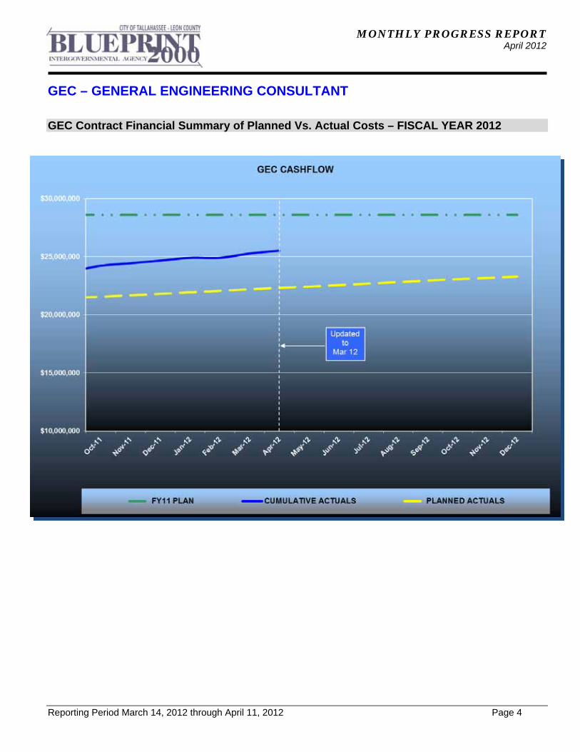
GEC Contract Financial Summary of Planned Vs. Actual Costs – FISCAL YEAR 2012
MONTHLY PROGRESS REPORT April 2012
Reporting Period March 14, 2012 through April 11, 2012 Page 5
GEC – PUBLIC INVOLVEMENT
Activities Since Last Period:
1. Organized and held Community Meeting for Leon County projects
2. Attended Progress Meetings for Cascades Park and CCSE-E3
3. Issued CCSE-E3 Project Summary Report to FDOT District 3 Public Information Office
4. Created and launched "In the Works" website for Blueprint 2000 and Leon County projects
5. Mailed out 500 invitations for Cascades Park Community tour to be held on Saturday, April 28, 2012
6. Updated Act Database for all projects with Leon County GIS Information
7. Prepared and sent news release on the closure of Franklin Boulevard at the College Avenue intersection
8. Prepared and sent news release on the closure of Jefferson Street between Meridian Street and Fleming Street
9. Handled 22 public responses
10. Coordinated and held Leon County Coordination Community Meeting on March 15, 2012
11. Prepared presentation for and attended Sales Tax Committee Meeting
12. Prepared Cascades Park Amphitheatre presentation and attended City Commission Meeting
13. Prepared presentation for Senior Advisory Board
14. Attended meeting with fountain contractors regarding Interactive Waterplay area for Cascades Park
15. Created Project Map with Right-of-Way And Construction Costs
16. Prepared PowerPoint and attended Intergovernmental Agency Meeting
17. Prepared Legal Ad for Franklin Boulevard
18. Prepared Right-of-Way maps for FAMU Way Phase I
Planned Activities for Next Period:
1. Attend Progress Meetings for Cascades Park and CCSE-E3
2. Continue to coordinate and hold monthly Leon County Coordination Community Public Meeting in May 2012
3. Continue to coordinate and hold monthly Leon County Coordination meeting on Wednesday, April 25, 2012
4. Continue to update Act Database for all projects with Leon County GIS Information
5. Continue to handle and respond to public responses
6. Continue to coordinate and organize field tour for Cascades Park to be held on Saturday, April 28, 2012
7. Continue to update website
8. Continue to develop new project database

MONTHLY PROGRESS REPORT April 2012
Reporting Period March 14, 2012 through April 11, 2012 Page 6
N1 - CAPITAL CIRCLE NW – I-10 TO US 90
Project Description - Roadway Contract: This 1.991-mile roadway project (FPID: 219722-1-52-01 & 02) consists of upgrading the existing undivided rural facility to a six-lane divided urban (curb and gutter) facility. Upgrades to the West Tennessee, Tharpe, Hartsfield and Commonwealth intersections are included. The purpose of the roadway improvement project is to increase the capacity and safety of the existing highway. The roadway project was designed, let and constructed by the Florida Department of Transportation, with advance funding provided by the Blueprint 2000 Intergovernmental Agency. The CCNW-N1 Roadway Improvement Project was final accepted by FDOT on September 4, 2007. Project Personnel: Blueprint 2000: Program Manager: David Snyder CEI Construction Manager: Marcus Kelly CEI Administrator: Joey Gordon Project Description – Park Amenity and Landscaping Contract: A roadway landscaping and pond upgrading contract was issued by Blueprint 2000 on the CCNW-N1 project. Capital Circle medians from south of Tennessee Street to south of I-10 were landscaped, as well as the medians of several intersecting roads. Regional Stormwater Pond #1, later dedicated as the Martha Wellman Park, also received landscaping, a walking trail and numerous park amenities. The CCNW-N1 Roadway Improvements project, from West Tennessee St. to Commonwealth Boulevard (with FDOT), was final accepted on September 4th, 2007. The total construction cost, including $1,259,912 of JPA utility-work with COT, was $25,364,081.84 The CCNW-N1 Park Amenities and Landscaping Project (later named Martha Wellman Park) was Final Accepted by Blueprint 2000 on June 26, 2009. The total construction cost was $1,055,653.37. The total Right-of-Way costs for these projects was $46,374,947.00.
MONTHLY PROGRESS REPORT April 2012
Reporting Period March 14, 2012 through April 11, 2012 Page 7
N2 - CAPITAL CIRCLE NW/SW – SR 371 (ORANGE AVE.) TO US 90
Project Description: The expanded Project Development and Environmental (PD&E) study limits for this 2.9 mile project extend from Tennessee Street (US 90/SR 10) to Orange Avenue (SR 371). The purpose of this roadway improvement project is to increase the capacity and safety of the existing highway by expanding the existing two-lane undivided rural roadway to a six-lane divided urban (curb and gutter) facility. New traffic signals will be provided at Orange Avenue, Blountstown Highway and Gum Road intersections. The project also includes significant landscaping as well as pedestrian, bicycle and recreational amenities. This project will develop final design plans for construction. Project Personnel: Blueprint 2000: Program Manager: David Snyder Construction Manager: Marcus Kelly Project Manager: Jim Shepherd H.W. Lochner: Project Manager: Hugh Williams Contract Cost & Schedule Status - Agreement No. 772/Authorization 1 - As of 3/13/2012 Contract Commencement: 10May04 Contract Completion: 12/31/2014 Percent of Work Performed: 99.0% Original Contract Amount: $ 1,921,585.90Executed Supplemental Agreements: $ 4,214,218.03Pending Supplemental Agreements: $ 0.00Current Contract Amount: $ 6,135,803.93Invoiced to Date: $ 5,969,452.44Remaining Contract Amount: $ 166,351.49Percent of Contract Amount Complete: 97.3% Original Contract Time: 1095 Days Contract Time Extensions: 2792 Days Current Contract Time: 3887 Days Contract Time Expended: 2892 Days Contract Time Remaining: 995 Days Percent Contract Time Expended: 74.4%
MONTHLY PROGRESS REPORT April 2012
N2 - CAPITAL CIRCLE NW/SW – SR 371 (ORANGE AVE.) TO US 90
Reporting Period March 14, 2012 through April 11, 2012 Page 8
Schedule Milestones: Final Environmental Documents 20Jun06 Final Preliminary Engineering Report 20Jun06 Location Design Concept Approval (LDCA) 22Aug06 30% Roadway Plans 28Aug06 VE Complete 27Oct06 2nd Draft Right-of-Way Maps 30Apr07 Final Right-of-Way Maps 30Sep07 60% Roadway Plans 01Nov07 90% Roadway Plans 08Aug08 60% Structures (CSX Railroad Bridge, Gum Creek Bridge and Retaining Walls) Plans
15Jan09
90% Structures (CSX Railroad Bridge, Gum Creek Bridge and Retaining Walls) Plans
13Feb09
100% Roadway and Structures Plans 16Jul09 Pre-Final Plans (US 90 to Orange) 18Dec09 100% Plans (US 90 to North of SR 20) 09Sep10 Final Plans (US 90 to North of Orange Avenue) 31Aug11 Design Subconsultant Contract Amt % of Design Expended FY Participation: Contract To Date To Date Environmental Geotechnical Specialists
Geotechnical $ 574,866.25 9.37 $ 576,358.44 $ 0.00Diversified Design & Drafting Services, Inc.
Survey and R/W Mapping $ 820,349.64 13.37 $ 791,609.85 $ 12,060.65Archaeological Consultants, Inc. Cultural Resource Assessment $ 24,093.51 0.39 $ 24,093.51 $ 0.00HNTB/TEI Traffic Analysis $ 90,310.59 1.47 $ 90,310.59 $ 0.00American Acquisition Group Right of Way $ 97,873.48 1.60 $ 94,046.22 $ 0.00HW LOCHNER (PRIME) Prime Consultant $ 4,301,791.52 70.11 $ 4,170,729.89 $ 174,841.99PBS&J Landscape $ 169,083.94 2.76 $ 169,083.94 $ 11,554.36CDM Stormwater Modeling $ 57,435.00 0.94 $ 53,220.00 $ 0.00
Total Design Contract: $ 6,135,803.93 100.00% $ 5,969,452.44 $ 198,457.00
Design MBE Goal: $ 951,049.61 15.50%
Design MBE to Date: $ 1,392,061.80 23.32%
MONTHLY PROGRESS REPORT April 2012
N2 - CAPITAL CIRCLE NW/SW – SR 371 (ORANGE AVE.) TO US 90
Reporting Period March 14, 2012 through April 11, 2012 Page 9
Project Status: Final plans and bid documents have been prepared for construction advertisement of the segment north of Orange Avenue to US 90. Project was advertised on January 8, 2012. Bids were opened March 27, 2012. Activities Since Last Period:
1. Began evaluating bids 2. Continued coordination of tree mitigation at Broadmoor Pond 3. Continued coordination with Utility Owners at CSX Railroad 4. Continued coordination of advance relocations with COT Electric 5. Authorized 3DS to update Right-of-Way, prepare monumentation maps, and monument
Right-of-Way 6. Began preparing jack and bore permit for CSX 7. Continued efforts on survey task assignments with Atkins
Planned Activities for Next Period:
1. Proceed as advised from Special Intergovernmental Agency meeting on April 16, 2012 2. Complete tree mitigation at Broadmoor Pond 3. Coordinate with Utility Owners at railroad for pipe crossing conflict resolutions 4. Execute survey task assignment with Atkins 5. Coordinate with COT Electric with advance relocations 6. Prepare jack and bore permit for CSX 7. Execute JPA with COT Water/Sewer 8. Coordinate with FDOT and FHWA on decision to reward or readvertise project
MONTHLY PROGRESS REPORT April 2012
N2 - CAPITAL CIRCLE NW/SW – SR 371 (ORANGE AVE.) TO US 90
Reporting Period March 14, 2012 through April 11, 2012 Page 10
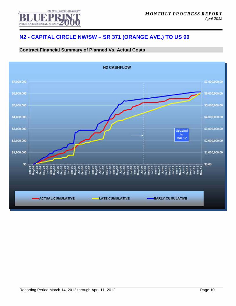
Contract Financial Summary of Planned Vs. Actual Costs

MONTHLY PROGRESS REPORT April 2012
N2 - CAPITAL CIRCLE NW/SW – SR 371 (ORANGE AVE.) TO US 90
Reporting Period March 14, 2012 through April 11, 2012 Page 11
Right-of-Way Status Report:
IN POSSESSION 88
AGREEMENTS SECURED BUT NOT CLOSED 0
NEGOTIATING/PREPARING FOR SUIT 0
TOTAL PARCELS ON PROJECT 88
DONATIONS 4
RIGHT-OF-WAY ACQUISITION, DEMOLITION AND RELOCATION ARE COMPLETE.
MONTHLY PROGRESS REPORT April 2012
Reporting Period March 14, 2012 through April 11, 2012 Page 12
W1 - CAPITAL CIRCLE SW – CRAWFORDVILLE ROAD TO SR 20
Project Description: A Project Development and Environmental (PD&E) study was conducted for this portion of Capital Circle (SR 263) between Crawfordville Road (SR 61/US 319) and Blountstown Highway (SR 20); a distance of approximately 6.7 miles. The PD&E study was conducted in accordance with Federal Highway Administration (FHWA), Blueprint 2000 Agency, and Florida Department of Transportation (FDOT) guidelines. The study evaluated alternative alignments as well as the existing alignment. Several viable alternatives were developed and evaluated in order to address the project needs while taking into account the Blueprint 2000 “Project Definitions Report”, prepared by the Economic and Environmental Consensus Committee in 1999 and the Lake Bradford Sector Plan conducted by the Tallahassee/Leon County Planning Department. Project Personnel: Blueprint 2000: Planning Manager: Dave Bright Project Manager: Jim Shepherd Kimley-Horn & Assoc.: Project Manager: Steve Godfrey Contract Cost & Schedule Status - Agreement No. 1284/Authorization 1 - As of 4/10/2012 Contract Commencement: 22Aug06 Contract Completion: 4/30/2012 Percent of Work Performed: 96.0% Original Contract Amount: $ 2,672,271.68Executed Supplemental Agreements: $ 73,028.51Pending Supplemental Agreements: $ 0.00Current Contract Amount: $ 2,745,300.19Invoiced to Date: $ 2,660,657.99Remaining Contract Amount: $ 84,642.20Percent of Contract Amount Complete: 96.9% Original Contract Time: 1096 Days Contract Time Extensions: 982 Days Current Contract Time: 2078 Days Contract Time Expended: 2058 Days Contract Time Remaining: 20 Days Percent Contract Time Expended: 99.0% Schedule Milestones: Consultant Selected 26May06 Study Begins 22Aug06 Agency Kick-off Meeting 19Oct06 Public Kick-off Meeting 19Oct06 Community Mini-Charrettes 15Jan07 Community Meeting 12Apr07 Corridor/Concepts Charrette 10May07 Interim Public Meeting 06Nov07 Alternatives Public Information Meeting 13Nov08 Preferred Alternative Public Meeting 13Aug09 Public Hearing TBD

MONTHLY PROGRESS REPORT April 2012
W1 - CAPITAL CIRCLE SW – CRAWFORDVILLE ROAD TO SR 20
Reporting Period March 14, 2012 through April 11, 2012 Page 13
Design Subconsultant Contract Amt % of Design Expended FY Participation: Contract To Date To Date Target Copy and Sign Printers Printing $ 30,000.00 1.09 $ 29,818.54 $ 0.00Keystone Field Services Relocation $ 35,000.00 1.27 $ 35,000.00 $ 0.00Environmental and Geotechnical Specialists
Geotech $ 97,641.96 3.56 $ 96,141.96 $ 0.00Diversified Design & Drafting Services
Survey $ 31,840.00 1.16 $ 31,840.00 $ 0.00StategyWise, LLC Economic Development $ 0.00 0.00 $ 0.00 $ 0.00Hamilton Smith Assoc. Traffic $ 18,600.00 0.68 $ 18,600.00 $ 0.00Registe, Sliger Engineering Structures $ 123,376.71 4.49 $ 118,564.81 $ 0.00KIMLEY-HORN & ASSOC (PRIME) Prime $ 1,823,374.38 66.42 $ 1,745,225.52 $ 48,861.43Dr. Wayson Noise $ 0.00 0.00 $ 0.00 $ 0.00Hass Center Economic Development $ 37,200.00 1.36 $ 37,200.00 $ 0.00Florida Acquisition & Appraisal Appraisal/Acquisition $ 200,804.91 7.31 $ 200,804.93 $ 0.00Biological Research Assoc. Water Quality $ 105,815.50 3.85 $ 105,815.50 $ 0.00Search, Inc Cultural Resource/Archaeological $ 53,826.73 1.96 $ 53,826.73 $ 0.00Camp, Dresser & McKee Drainage & Pond Design $ 187,820.00 6.84 $ 187,820.00 $ 0.00
Total Design Contract: $ 2,745,300.19 100.00% $ 2,660,657.99 $ 48,861.43
Design MBE Goal: $ 371,988.18 13.55%
Design MBE to Date: $ 329,965.31 12.40%
MONTHLY PROGRESS REPORT April 2012
W1 - CAPITAL CIRCLE SW – CRAWFORDVILLE ROAD TO SR 20
Reporting Period March 14, 2012 through April 11, 2012 Page 14
Project Status: Kimley-Horn and Associates began the Capital Circle Southwest PD&E study in late August, 2006. The Public and Agency Kickoff Meetings were conducted in October, 2006. Six (6) Community Forum Meetings were conducted concluding with a Town Hall Meeting held in April 2007. The Concept Charrettes were held on May 10th and 12th, 2007. The Intergovernmental Agency approved the evaluation criteria and the criteria weighting that will be used to evaluate the alternative alignments. An Interim Public Meeting was held on November 6, 2007 to present the status of the project since the Concepts Charette. The project began the analysis phase using the alternative alignments established through the Concept Charrette process. An Alternatives Public Meeting was held on November 13, 2008 to present the results of the evaluations conducted for the alternative alignments within the four (4) corridor segments. Based on the results of the analyses and input received from the public at the Alternatives Meeting, recommendations were made regarding the best alternative for each segment and these recommendations were approved by the Intergovernmental Agency on February 23, 2009. The approved segment solutions were combined to form an Existing Alignment (Widening) Alternative and a Realignment Alternative. These two "Build" alternatives were evaluated, along with the "No-Build" alternative, using the 13 evaluation criteria and associated weightings established by the IA. The results of these evaluations were presented to the public at the Preferred Alternatives Meeting on August 13, 2009. The IA approved staff's recommendation to widen the existing alignment with commitments to protect the environment and to investigate improvements to the West Ditch, Grassy Lake and Black Swamp area at the September 21, 2009 IA meeting. Seventeen (17) Community Representatives meetings have been held through the month of June 2011. Preparations are being made for a Final Public Hearing to be scheduled in Spring 2012. Activities Since Last Period:
1. Provided responses to FDOT comments for the Environmental Assessment (EA) and the Preliminary Engineering Report (PER)
2. Revised text, figures, tables, and appendices as necessary in the EA and PER to address FDOT comments
3. Completed Addendum to the Design Traffic Report in support of responses to FDOT comments on the PER
Planned Activities for Next Period:
1. Submit responses to FDOT comments and revised reports for the EA, PER, and Noise Study Report
2. Submit Addendum to the Design Traffic Report in response to FDOT comments for the PER
3. Coordinate as necessary regarding the Planning Consistency Form for use by FDOT in coordination with FHWA
MONTHLY PROGRESS REPORT April 2012
W1 - CAPITAL CIRCLE SW – CRAWFORDVILLE ROAD TO SR 20
Reporting Period March 14, 2012 through April 11, 2012 Page 15
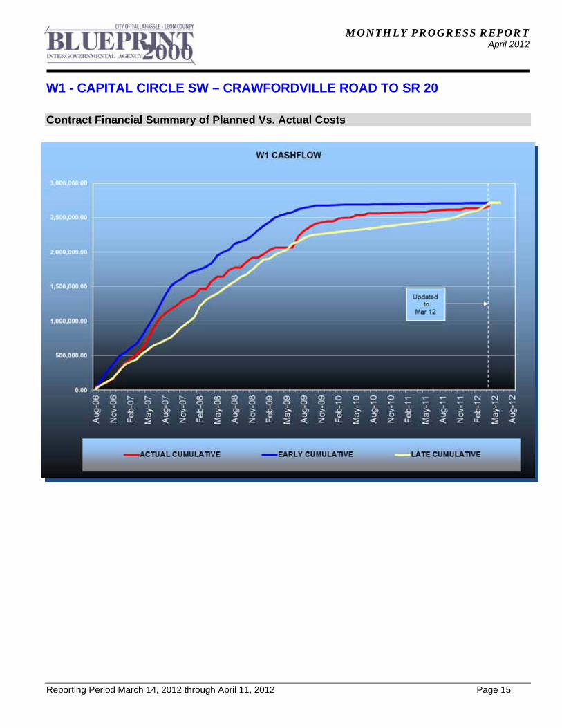
Contract Financial Summary of Planned Vs. Actual Costs
MONTHLY PROGRESS REPORT April 2012
Reporting Period March 14, 2012 through April 11, 2012 Page 16
E3 - CAPITAL CIRCLE SE – CRAWFORDVILLE ROAD TO WOODVILLE HIGHWAY
Project Description: This project proposes to widen approximately 1.15 miles of the existing two-lane Capital Circle SE from east of Crawfordville Road to west of Woodville Highway to an ultimate seven-lane facility. The purpose of the roadway improvement project is to increase the capacity and safety of the existing highway. Provisions for future traffic signal will be made at Shelfer Road and the CCSE intersection. The project includes significant landscaping as well as pedestrian, bicycle and recreational amenities. The project is funded by the 2009 American Recovery and Reinvestment Act (ARRA) Program. FDOT Roadway ID: 55002000 SR 263 Project Personnel: Blueprint 2000: Program Manager: David Snyder Project Manager: Marek Romanowski Construction Manager: Marcus Kelly C.W. Roberts/G&O: CWR Project Manager: Jonathan Parramore Design Manager: Brian Lemieux Contract Cost & Schedule Status - Agreement No. /Authorization - As of 4/11/2012 Contract Commencement: 23Oct10 Contract Completion: 6/14/2012 Percent of Work Performed: 57.5% Original Contract Amount: $ 8,984,625.00Executed Supplemental Agreements: $ 216,086.72Pending Supplemental Agreements: $ 0.00Current Contract Amount: $ 9,200,711.72Invoiced to Date: $ 5,286,107.79Remaining Contract Amount: $ 3,914,603.93Percent of Contract Amount Complete: 57.5% Original Contract Time: 600 Days Contract Time Extensions: 0 Days Current Contract Time: 600 Days Contract Time Expended: 534 Days Contract Time Remaining: 66 Days Percent Contract Time Expended: 89.0% Schedule Milestones: Contract signed 23Sep10 Notice to Proceed (NTP) 22Oct10 Contract completion date 14Jun12
MONTHLY PROGRESS REPORT April 2012
E3 - CAPITAL CIRCLE SE – CRAWFORDVILLE ROAD TO WOODVILLE HIGHWAY
Reporting Period March 14, 2012 through April 11, 2012 Page 17
Design Subconsultant Contract Amt % of Design Expended FY Participation: Contract To Date To Date HSA Consulting Survey (control, ROW) $ 66,202.62 8.65 $ 56,272.23 $ 0.00Poole Engineering Traffic studies, signalization $ 35,246.00 4.61 $ 28,501.00 $ 0.00Greenhorne & O'Mara and non-DBE Subs
Roadway, Landscaping, sewer, water
$ 626,750.38 81.91 $ 558,398.95 $ 17,250.00
Greenhorne & O'Mara and non-DBE Subs
JPA design work $ 37,000.00 4.84 $ 36,862.00 $ 0.00
Total Design Contract: $ 765,199.00 100.00% $ 680,034.18 $ 17,250.00
Design DBE Goal: $ 76,519.90 10.00%
Design DBE to Date: $ 84,773.23 12.47%
MONTHLY PROGRESS REPORT April 2012
E3 - CAPITAL CIRCLE SE – CRAWFORDVILLE ROAD TO WOODVILLE HIGHWAY
Reporting Period March 14, 2012 through April 11, 2012 Page 18
Construction Subconsultant Contract Amt % of Design Expended FY Participation: Contract To Date To Date Florida Developers, Inc. Earthworks, trucking $ 85,382.50 1.01 $ 85,382.50 $ 50,765.00Gaines & Sons Pavement markings, Erosion ctl $ 138,663.00 1.64 $ 9,574.90 $ 9,574.90Ingram, Inc Signalization $ 614,948.00 7.29 $ 240,494.76 $ 194,814.85C.W. Roberts Contracting Prime contr - ARRA $ 5,951,492.22 70.55 $ 2,772,292.29 $ 1,438,816.76C.W. Roberts Contracting Prime contr - JPA $ 1,645,027.00 19.50 $ 1,498,329.16 $ 1,179,447.43
Total Construction Contract: $ 8,435,512.72 100.00% $ 4,606,073.61 $ 2,873,418.94
Construction DBE Goal: $ 843,551.27 10.00%
Construction DBE to Date: $ 335,452.16 7.28%
Because this project is being funded with ARRA funding, the FDOT’s policies and procedures regarding
Disadvantaged Business Enterprise (DBE) Program shall apply. A 10% DBE Availability Goal has been assigned for this project.
MONTHLY PROGRESS REPORT April 2012
E3 - CAPITAL CIRCLE SE – CRAWFORDVILLE ROAD TO WOODVILLE HIGHWAY
Reporting Period March 14, 2012 through April 11, 2012 Page 19
Project Status: The Design-Build Contract was executed on 9/23/2010. Blueprint issued the Notice to Proceed (NTP) to the Design-Build Team on 10/22/10. Project kick-off meeting was held on 11/02/10 and the Utility kick-off meeting was held on 11/08/10. The National ARRA Projects Review Team has reviewed this project, and submitted their report to FDOT District 3 on 2/04/11. Project partnering meeting with Blueprint and project stakeholders was conducted on 3/31/11. The Public Information Meeting was conducted on 4/04/11. Ground breaking ceremony was conducted on 5/03/11. The COT MBE/DBE Office Representatives visited project's construction site on 11/04/2011. Environmental and permitting activities are complete. The Design-Build Team obtained gopher tortoises relocation permit and completed protection and relocation of threatened and endangered species on site. The ERP permit from NWFWMD and the EMP permit from COT Growth Management are complete (on 6/16/11). Utility coordination is near completion. Utility relocation progress meeting was held on 2/08/11. City of Tallahassee Water Utility continues design work on relocation, upgrade and adjustment of their facilities. The gravity sanitary sewer and re-use water design and installation is in progress. Blueprint continues to coordinate allocation of utility easements and permit requirements with USFS and FDOT. The Design-Build Team and Utility companies continue work in accordance with the relocation schedules in the field. Removal of Talquin's distribution line has been completed, and relocation of COT Electric distribution line to the north Right-of-Way is also complete. COT ITS conduit and cable installation is complete. COT Gravity sewer and re-use water main installation are complete on the south side of the Right-of-Way. Modifications to the existing 36" sanitary force main and installation of the Air Release Valves on same are complete. Work on 42" sanitary sewer force main is in progress and is near completion. Project design activities are complete, and "As-Built" plans and shop drawing review and approval are in progress . The Typical Cross Section and Pavement Design package was approved by FDOT at the beginning of the design/permitting process. The RFC plans were released for construction, including landscaping plans. Construction continues according to schedule, and the Design-Build Team completed construction of drainage ponds 2A and 3A, including fencing of these ponds. Backfilling and grading of the FDOT pond "I" is complete, but some repair work due to rain erosion is in progress. Placing of grass and planting beds on the south side of CCSE eastbound lanes continues. The pre-paving conference was conducted on 11/10/2011. Construction of CCSE eastbound lanes is substantially complete (to the top of 2nd structural lift of asphalt), including temporary pavement markings. Traffic was shifted to CCSE eastbound lanes on Monday, January 30, 2012. Construction of CCSE westbound lanes continues. Clearing and grubbing, and most of embankment grading has been done. Access to all properties on the north side of Right-of-Way has been provided at all times. The Contractor continues installation of closed drainage system under the CCSE westbound lanes, which is well advanced. Concrete curbs and limerock base course have been placed on some sections of westbound lanes, and construction of driveways continues. Installation of street lighting is in progress. ARRA documentation monitoring is in progress.
MONTHLY PROGRESS REPORT April 2012
E3 - CAPITAL CIRCLE SE – CRAWFORDVILLE ROAD TO WOODVILLE HIGHWAY
Reporting Period March 14, 2012 through April 11, 2012 Page 20
Activities Since Last Period:
1. Continued storm drainage conveyance system installation under CCSE westbound lanes 2. Completed grading and planting trees and wire grass in FDOT Pond "I" 3. Continued 42" sanitary sewer work on westbound lanes and miscellaneous sanitary sewer
and waterline adjustments 4. Continued placing of topsoil, sod and creating planting beds south of CCSE eastbound
lanes 5. Completed installation of street lighting cables and pull boxes 6. Continued grading and preparations for placing of concrete curbs on some sections of
CCSE westbound lanes 7. Started placing concrete curbs on CCSE westbound lanes at various locations and placing
lime rock base course on some sections 8. Installed major components of irrigation system
Planned Activities for Next Period:
1. Continue grading of subgrade and placing of concrete curbs on the CCSE westbound lanes
2. Complete modification of the 42" sanitary sewer forcemain and installation of Air Release Valves (ARVs) on same
3. Complete installation of storm drainage collection system in the CCSE median and under westbound lanes
4. Complete repair of erosion damage of FDOT Pond "I" 5. Continue construction of driveways on CCSE westbound lanes 6. Begin installation of lighting poles on the south side of CCSE eastbound lanes 7. Start construction of CCSE median, median openings and turning lanes 8. Continue placing of lime rock base course on CCSE westbound lanes and prepare for
paving of same 9. Provide monthly CPM construction schedule update
MONTHLY PROGRESS REPORT April 2012
E3 - CAPITAL CIRCLE SE – CRAWFORDVILLE ROAD TO WOODVILLE HIGHWAY
Reporting Period March 14, 2012 through April 11, 2012 Page 21
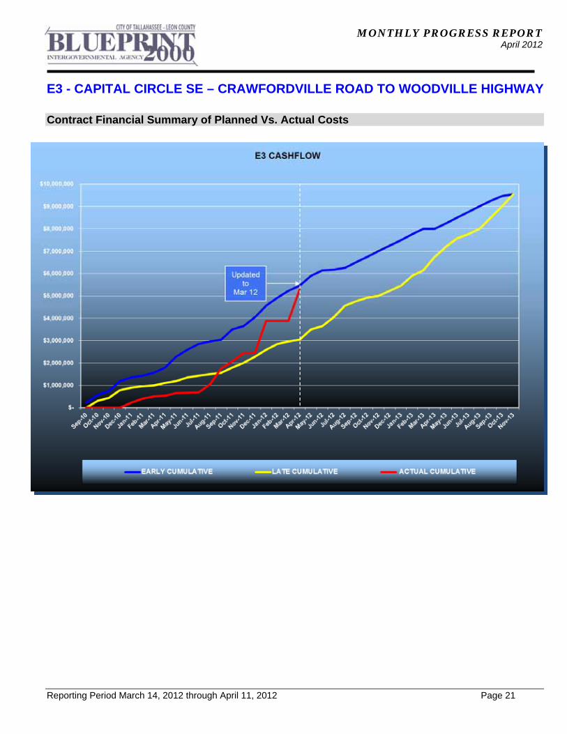
Contract Financial Summary of Planned Vs. Actual Costs

MONTHLY PROGRESS REPORT April 2012
Reporting Period March 14, 2012 through April 11, 2012 Page 22
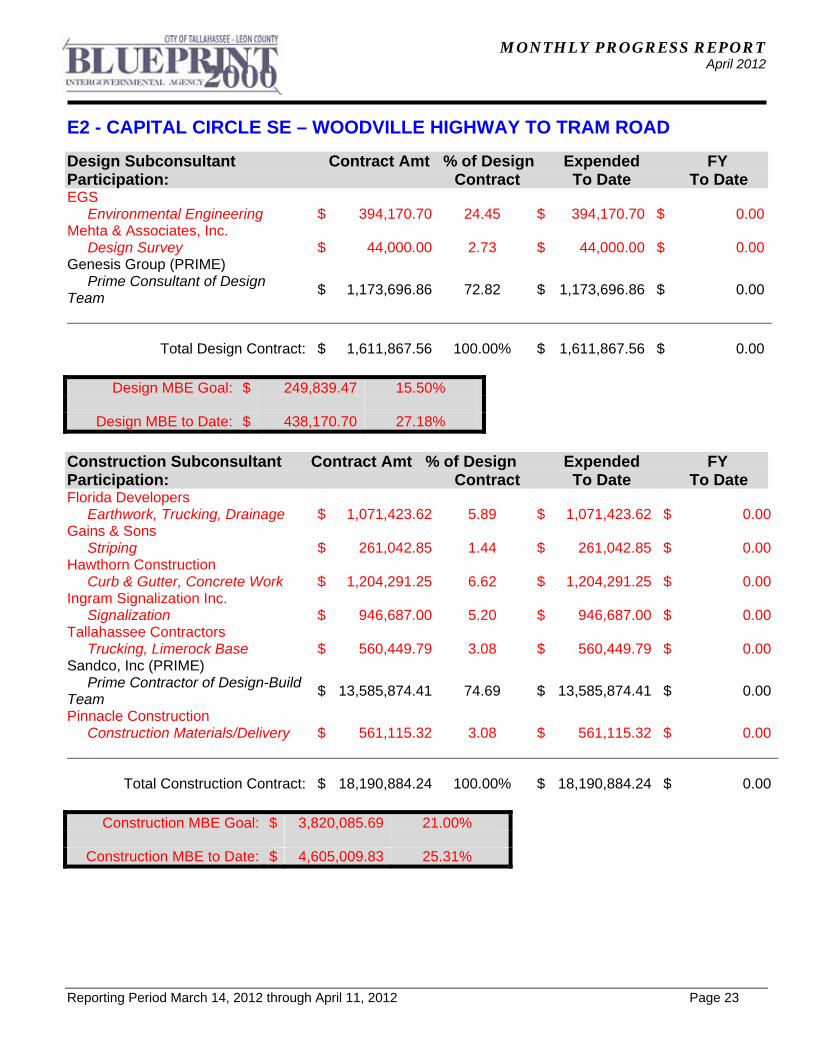
E2 - CAPITAL CIRCLE SE – WOODVILLE HIGHWAY TO TRAM ROAD
Project Description: This project widened approximately 2.3 miles of the existing two-lane Capital Circle SE from Woodville Highway to Tram Road to an ultimate six-lane facility, mileposts 0.0 to 2.12. In addition, a transitional segment west of Woodville Highway (SR 263, MP 0.0 to approximately MP 0.2) was included. The purpose of the roadway improvement project is to increase the capacity and safety of the existing highway. A new traffic signal was installed at the access to the Lakes at San Marcos development on Woodville Highway, south of CCSE. Provisions for future traffic signals were provided at three intersections: Paul Russell Road, Southchase Boulevard and Marketplace Drive to accommodate proposed developments on the north side of CCSE, between Woodville Highway and Tram Road. The project includes significant landscaping as well as pedestrian, bicycle and recreational amenities. Project Personnel: Blueprint 2000: Program Manager: David Snyder Project Manager: Marek Romanowski Construction Manager: Marcus Kelly Sandco Inc./Genesis: Project Manager: Bob Myrick Design Project Manager: Jim Sullivan Contract Cost & Schedule Status - Agreement No. 1464 - As of 04/11/2011 Contract Commencement: 28Aug07 Contract Completion: 13Feb10 Percent of Work Performed: 100.0% Original Contract Amount: $ 17,616,609.90Executed Supplemental Agreements: $ 2,186,141.90Pending Supplemental Agreements: $ 0.00Current Contract Amount: $ 19,802,751.80Invoiced to Date: $ 19,802,751.80Remaining Contract Amount: $ 0.00Percent of Contract Amount Complete: 100.0% Original Contract Time: 900 Days Contract Time Extensions: 269 Days Current Contract Time: 1169 Days Contract Time Expended: 1169 Days Contract Time Remaining: 0 Days Percent Contract Time Expended: 100.0% Schedule Milestones: Contract with Design-Build Team executed 05Jun07 Notice To Proceed 28Aug07 Groundbreaking Ceremony 29Aug07 COT EMP permit for Segment 1B 24Mar08 Project Final Completion Date 22Oct10
MONTHLY PROGRESS REPORT April 2012
E2 - CAPITAL CIRCLE SE – WOODVILLE HIGHWAY TO TRAM ROAD
Reporting Period March 14, 2012 through April 11, 2012 Page 23
Design Subconsultant Contract Amt % of Design Expended FY Participation: Contract To Date To Date EGS Environmental Engineering $ 394,170.70 24.45 $ 394,170.70 $ 0.00Mehta & Associates, Inc. Design Survey $ 44,000.00 2.73 $ 44,000.00 $ 0.00Genesis Group (PRIME) Prime Consultant of Design Team
$ 1,173,696.86 72.82 $ 1,173,696.86 $ 0.00
Total Design Contract: $ 1,611,867.56 100.00% $ 1,611,867.56 $ 0.00
Design MBE Goal: $ 249,839.47 15.50%
Design MBE to Date: $ 438,170.70 27.18%
Construction Subconsultant Contract Amt % of Design Expended FY Participation: Contract To Date To Date Florida Developers Earthwork, Trucking, Drainage $ 1,071,423.62 5.89 $ 1,071,423.62 $ 0.00Gains & Sons Striping $ 261,042.85 1.44 $ 261,042.85 $ 0.00Hawthorn Construction Curb & Gutter, Concrete Work $ 1,204,291.25 6.62 $ 1,204,291.25 $ 0.00Ingram Signalization Inc. Signalization $ 946,687.00 5.20 $ 946,687.00 $ 0.00Tallahassee Contractors Trucking, Limerock Base $ 560,449.79 3.08 $ 560,449.79 $ 0.00Sandco, Inc (PRIME) Prime Contractor of Design-Build Team
$ 13,585,874.41 74.69 $ 13,585,874.41 $ 0.00
Pinnacle Construction Construction Materials/Delivery $ 561,115.32 3.08 $ 561,115.32 $ 0.00
Total Construction Contract: $ 18,190,884.24 100.00% $ 18,190,884.24 $ 0.00
Construction MBE Goal: $ 3,820,085.69 21.00%
Construction MBE to Date: $ 4,605,009.83 25.31%
MONTHLY PROGRESS REPORT April 2012
E2 - CAPITAL CIRCLE SE – WOODVILLE HIGHWAY TO TRAM ROAD
Reporting Period March 14, 2012 through April 11, 2012 Page 24
Project Status: The Design-Build Contract was executed on 6/05/07. Utility kick-off meeting was held on 6/27/07. The Pre-construction Conference and the Public Meeting were held on 7/24/07. A Joint Project Agreement (JPA) was entered into by St. Joe Company, City of Tallahassee and Blueprint 2000 on 7/31/07. Per terms of this JPA, easements for five drainage ponds and Right-of-Way donated to the project by St. Joe were obtained from St. Joe. Notice to Proceed was issued to the Design-Build Team on 8/28/07 and the Ground Breaking Ceremony was held on 8/29/07. The Ribbon Cutting Ceremony was held on 11/09/2010. The National Features Inventory (NFI) report was approved by COT Growth Management. COT Growth Management issued the Environmental Impact Assessment exemption (EIA short form B (low)) for Segments 1 and 3A in October 2007. The EIA for Segment 2 was approved by COT Growth Management on 12/18/07. The Clearing and Grubbing Permit, including "sediment sumps" located at the future stormwater pond sites, and fill stockpiling permit, were issued by Growth Management for Segments 1 and 3A. The clearing permit for Segment 2 was issued on 1/17/08, with the exception of Pond 600. The clearing permit for Pond 600 was obtained in March 2008. The Stormwater Permit was received from the Department of Environmental Protection. The EMP permit for Segment 1B was obtained from COT Growth Management on 3/24/08, for Segment 1A on 6/27/08 and for Segment 3A on 8/28/08. The EIA for Segment 3B was approved by Growth Management on 5/08/08. The clearing and grubbing permit for Segment 3B was obtained on 7/11/08. The EMP permit application for Segment 2 was issued by Growth Management on 12/19/08. Lighting plans are complete and were released for construction on 2/17/09. Roadway plans were released for construction for Segment 2. Segment 1B EMP permit update for Southchase Boulevard and Marketplace Drive intersections were obtained on 4/07/09. Blueprint reviewed final Traffic Signal plans for Woodville Highway, Southchase Boulevard and SouthWood Marketplace Drive intersections, and released them for construction on 6/15/09. The EMP permit update for Pond 300 conveyance was obtained on 6/28/09.The EMP permit for Segment 3B was obtained on 7/10/2009. The Management of Traffic (MOT) Plans for the entire project were reviewed by Blueprint and released for construction on 7/17/09. Blueprint reviewed roadway final plans for Segment 3B and released them for construction on 10/14/09. Blueprint released final Signing and Pavement Marking plans for construction on 4/13/10. The Electrical Resistivity Imaging (ERI) tests are complete for Ponds 200, 300, Pond 300 conveyance easement and Pond 600. The ERI test results at Pond 200 and Pond 600, and the soil borings at Pond 600 indicated that all pond sites are acceptable for pond locations, and no further investigations were recommended. Karst investigations at Ponds 100 and 100A are complete. Additional borings were advanced at Pond 100A, and mitigation alternatives were prepared for that pond. Karst investigations were conducted at Segment 3A sinkhole and additional borings were advanced to establish the need for mitigation measures. The final report, including recommendations, was submitted to Blueprint on 7/17/09. Blueprint coordinated with FDOT regarding mitigation for the sinkholes. Several small diameter voids were discovered during construction of the CCSE westbound lanes, which were backfilled with embankment material or fly-ash grout and sealed with clay or geotextile. Utility relocation, adjustments and new installations are complete. Sanitary gravity sewer lines are complete. A 12 inch "bleed-off" sanitary sewer system was installed in the southeast quadrant of CCSE and Woodville Highway intersection. The Air Release Valve vaults were placed on 42" and 36" sanitary force mains. Installation of drainage pipes and structures is complete on the whole project. Road construction up to the top of friction course, including the thermoplastic pavement markings and traffic signing are complete on this project.
MONTHLY PROGRESS REPORT April 2012
E2 - CAPITAL CIRCLE SE – WOODVILLE HIGHWAY TO TRAM ROAD
Reporting Period March 14, 2012 through April 11, 2012 Page 25
Project Status (continued): Permanent traffic signal installations at the Lakes at San Marcos intersection on Woodville Highway, and on CCSE intersections with Woodville Highway and Marketplace Drive are complete. Landscaping revisions are now complete and the work on the punch list items is finished. The last Dispute Resolution Board (DRB) meeting was held on 9/17/10. The Project was Finally Accepted on 10/22/2010. Final offer of payment has been signed by Sandco on 12/14/2010. Activities Since Last Period:
1. Continued maintenance activities on warranty items 2. Continued coordination with project stakeholders as required
Planned Activities for Next Period:
1. Continue maintenance activities on warranty items 2. Continue coordination with project stakeholders as required 3. Coordinate design and construction of American Towers access 4. Coordinate project monumentation and Right-of-Way transfer to FDOT
MONTHLY PROGRESS REPORT April 2012
E2 - CAPITAL CIRCLE SE – WOODVILLE HIGHWAY TO TRAM ROAD
Reporting Period March 14, 2012 through April 11, 2012 Page 26
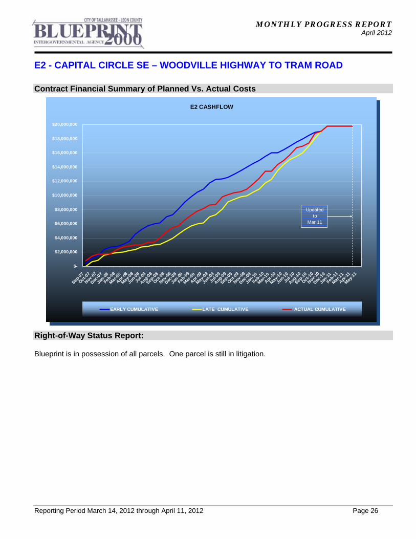
E2 CASHFLOW
$-
$2,000,000
$4,000,000
$6,000,000
$8,000,000
$10,000,000
$12,000,000
$14,000,000
$16,000,000
$18,000,000
$20,000,000
Sep-07
Oct-0
7
Nov-0
7
Dec-0
7
Jan-0
8
Feb-
08
Mar-0
8
Apr-0
8
May-
08
Jun-0
8
Jul-0
8
Aug-08
Sep-0
8
Oct-0
8
Nov-0
8
Dec-0
8
Jan-0
9
Feb-0
9
Mar
-09
Apr-09
May-
09
Jun-
09
Jul-0
9
Aug-0
9
Sep-0
9
Oct-09
Nov-09
Dec-0
9
Jan-1
0
Feb-1
0
Mar
-10
Apr-10
May
-10
Jun-
10
Jul-1
0
Aug-1
0
Sep-10
Oct-10
Nov-10
Dec-1
0
Jan-1
1
Feb-
11
Mar-1
1
Apr-1
1
May
-11
EARLY CUMULATIVE LATE CUMULATIVE ACTUAL CUMULATIVE
Updatedto
Mar 11
Contract Financial Summary of Planned Vs. Actual Costs
Right-of-Way Status Report: Blueprint is in possession of all parcels. One parcel is still in litigation.
MONTHLY PROGRESS REPORT April 2012
Reporting Period March 14, 2012 through April 11, 2012 Page 27
E1 - CAPITAL CIRCLE SE – CONNIE DRIVE TO TRAM ROAD
Project Description: The 3.44-mile project along Capital Circle Southeast (US 319/SR 261) extends from south of Tram Road to Connie Drive (milepost 1.931 and 5.371) in Leon County and includes expanding the existing two-lane undivided rural roadway to a six-lane divided urban (curb and gutter) facility. The purpose of the roadway improvement project is to increase the capacity and safety of the existing highway. New traffic signals, including ITS features, were provided at six intersections: Tram Road, Shumard Oak Boulevard, Merchants Row Drive, Blair Stone Road, Orange Avenue and Old St. Augustine Road. The project also includes significant landscaping as well as pedestrian, bicycle and recreational amenities. Project Personnel: Blueprint 2000: Program Manager: David Snyder Project Manager: Marek Romanowski Construction Manager: Marcus Kelly Joint Venture/PBS&J: Project Director, JV: William Mayfield Project Mgr., PBS&J: Steve Martin Project Status: Blueprint 2000 issued Final Acceptance Letter for this project on 6/16/08. The total contract duration was 1253 calendar days. The final construction cost was $37,715,142. M/WBE Participation: Design 18.01% Construction 25.17% Right-of-Way Status Report: Blueprint is in possession of all parcels.
MONTHLY PROGRESS REPORT April 2012
Reporting Period March 14, 2012 through April 11, 2012 Page 28
C2 - CAPITAL CASCADES TRAIL – SEGMENT 2 Project Description: Capital Cascades Park Construction Project Personnel: Blueprint 2000: Project Manager: Gary Phillips CEI Project Manager: Marcus Kelly Sandco: Project Manager: Jeff Sprouse Contract Cost & Schedule Status - As of 4/11/2012 Contract Commencement: 06Jul10 Contract Completion: 10/31/2012 Percent of Work Performed: 58.0% Original Contract Amount: $ 22,970,011.43Executed Supplemental Agreements: $ 1,430,485.18Pending Supplemental Agreements: $ 0.00Current Contract Amount: $ 24,400,496.61Invoiced to Date: $ 15,102,641.00Remaining Contract Amount: $ 9,297,855.61Percent of Contract Amount Complete: 61.9% Original Contract Time: 730 Days Contract Time Extensions: 118 Days Current Contract Time: 848 Days Contract Time Expended: 636 Days Contract Time Remaining: 212 Days Percent Contract Time Expended: 75.0%
MONTHLY PROGRESS REPORT April 2012
C2 - CAPITAL CASCADES TRAIL – SEGMENT 2
Reporting Period March 14, 2012 through April 11, 2012 Page 29
Design Subconsultant Contract Amt % of Design Expended Participation: Contract To Date Archaeological Consultants Inc. Archaeological Services $ 32,794.68 0.83 $ 32,794.68 Environmental and Geotechnical Specialist
Geotechnical $ 258,247.95 6.54 $ 258,247.95 Akin Associates Architects Architectural $ 166,743.07 4.22 $ 166,743.07 Moore Bass Land Planning $ 4,456.16 0.11 $ 4,456.16 Uzzell Advertising Public Relations $ 14,062.61 0.36 $ 14,062.61 Carr, Lynch, Sandell Park Design $ 599,376.82 15.18 $ 599,376.82 Jennings Environmental Environmental $ 27,198.52 0.69 $ 27,198.52 Pinnacle Engineering Group MEP $ 118,367.72 3.00 $ 118,367.72 CDM Stormwater $ 183,410.00 4.64 $ 183,410.00 Genesis Group Prime $ 2,236,946.25 56.64 $ 2,236,946.25 PBS&J/Brown and Caldwell Water Quality $ 97,316.00 2.46 $ 97,316.00 Garcia Bridge Engineers Bridge Design $ 191,424.84 4.85 $ 191,424.84 Rosenbaum Park Design $ 4,040.00 0.10 $ 4,040.00 Peter Martin Park Design $ 14,960.00 0.38 $ 3,204.95
Total Design Contract: $ 3,949,344.62 100.00% $ 3,937,589.57
Design M/WBE Goal: $ 612,148.42 15.50%
Design M/WBE to Date: $ 667,729.31 20.00%
**Please Note: Carr, Lynch and Sandell’s contract amount is not contained in the M/WBE calculation.
MONTHLY PROGRESS REPORT April 2012
C2 - CAPITAL CASCADES TRAIL – SEGMENT 2
Reporting Period March 14, 2012 through April 11, 2012 Page 30
Construction Subconsultant Contract Amt % of Design Expended FY Participation: Contract To Date To Date Metal Fabrication (Railings, Bridges) Railing, Bridges, Metal, Fabrication
$ 1,000,000.00 4.10 $ 195,082.00 $ 174,000.00
Hawthorne Construction (Concrete Work)
Concrete Work $ 750,000.00 3.07 $ 311,471.00 $ 122,411.00Ingram Signalization Signalization $ 2,591,932.00 10.62 $ 1,165,153.00 $ 625,362.00Crosspoint (Underground Utilities) Underground Utilities $ 1,000,000.00 4.10 $ 1,695,482.00 $ 432,000.00Pinnacle Construction Support (Construction Manage
Construction Management $ 1,840,000.00 7.54 $ 298,173.00 $ 196,390.00Sandco Prime $ 17,219,430.00 70.57 $ 11,437,280.00 $ 2,860,742.00
Total Construction Contract: $ 24,400,496.00 100.00% $ 15,102,641.00 $ 4,410,905.00
Construction MBE Goal: $ 5,124,104.02 21.00%
Construction MBE to Date: $ 3,665,361.00 24.27%
MONTHLY PROGRESS REPORT April 2012
C2 - CAPITAL CASCADES TRAIL – SEGMENT 2
Reporting Period March 14, 2012 through April 11, 2012 Page 31
Activities Since Last Period: 1. Continued sanitary sewer & storm water construction in Upper Park 2. Continued recontouring of Boca Chuba Pond 3. Continued testing for suitable material for use for Pond Clay Liner & Smokey Hollow Pond 4. Continued site grading in Lower Park 5. Completed setting signal mast arms for signals #3 & #4 in Upper Park 6. Completed RW-16 construction 7. Continued construction & revisions of Alum System 8. Continued pipe work in Upper Park (Stormwater, irrigation, electrical conduit, sewer) 9. Continued Meridian Plaza embankment
10. Continued mass excavation in Lower Park 11. Completed construction of cascade at RW-44 12. Continued installation of conduits for call boxes 13. Continued rough/final grading in Lower Park 14. Continued Landscaping 15. Ran power for restrooms 16. Completed pressure testing new section of water main along Gadsden Street from
Bloxham Street to the replaced section 17. Completed placing CenturyLink cable along Lafayette Street 18. Continued re-design/re-evaluation/shop drawings of Interactive Fountain 19. Continued Stormwater construction in Lower Park 20. Continued mass excavation / de-silting Boca Chuba Pond 21. Continued landscaping / boulders in Lower Park 22. Continued Monroe Street/Bloxham Street Gateways/Overlooks 23. Completed RW-26 & RW-27 in Middle Park 24. Completed Shade Structure columns in Middle Park 25. Continued Stormwater and curb & gutter on Meridian & Suwannee Streets 26. Continued Stream Restoration from RW-43 to RW-21 in Middle Park
MONTHLY PROGRESS REPORT April 2012
C2 - CAPITAL CASCADES TRAIL – SEGMENT 2
Reporting Period March 14, 2012 through April 11, 2012 Page 32
Planned Activities for Next Period:
1. Complete RW-12 & RW-15 buttresses 2. Complete reconstruction of Franklin Boulevard roadway 3. Complete installation of conduits for call boxes, Firestone Building & Coleman Building 4. Continue re-contouring of Boca Chuba Pond 5. Complete testing for suitable materials for Pond Clay Liner 6. Continue site grading on Lower Park 7. Complete sanitary sewer & storm water - Lafayette east of Suwannee Street 8. Continue RW-16 construction (slab) 9. Continue construction of Alum System injection system & power supply
10. Continue Meridian Plaza embankment work 11. Complete construction of cascade, steps, top slab & walls at RW-44 12. Continue construction of call boxes 13. Continue placing sod 14. Continue installation of signalization systems 15. Complete irrigation system & landscaping in Lower, Middle & Upper Park 16. Continue FDOT parking lot landscaping 17. Continue storm drain construction at Meridian /Gaines 18. Pour mast arms 6,5, & 1 and arch supports on the northeast side. 19. Complete installation of electrical conduits across Suwannee Street & Gaines Streets 20. Complete & pour mast arms 3 & 4 21. Complete electrical & fiber poles relocation on Suwannee & Gaines Street 22. Build Service for restrooms water line 23. Replace 2 sewer line tangents along Lafayette Street 24. Begin constructing liner for Boca Chuba Slab in Lower Park 25. Complete Suwannee Street stormwater and curb & gutter installation 26. Begin construction RW-23 27. Begin Phase II-B MOT Plan 28. Continue signalization system installation 29. Continue landscaping/boulder installation in Lower & Middle Park 30. Complete electric & fiber poles relocation on Suwannee & Gaines Street 31. Continue sidewalk installation in Lower Park 32. Complete design revisions/shop drawings for Interactive Fountain 33. Continue revisions to Alum System & get COT approval 34. Continue sidewalk in Lower Park 35. Complete RW-26 & RW-27/Amphitheatre Stage Area 36. Complete Upper Cascade Pond Plaza, Centennial Field Plaza, Lake Hall Plaza/Lower
Pond Overlook 37. Continue placing sod 38. Begin stream restoration form RW-4 to RW-8 in Upper Park 39. Complete mass excavation/de-silting Boca Chuba Pond in Lower Park 40. Begin Shade Structure Construction 41. Install light poles in Upper & Lower Park 42. Re-route MCI fiber optic cable at Lafayette Street, undercut Lafayette Street &
remove/replace existing water lines
MONTHLY PROGRESS REPORT April 2012
C2 - CAPITAL CASCADES TRAIL – SEGMENT 2
Reporting Period March 14, 2012 through April 11, 2012 Page 33
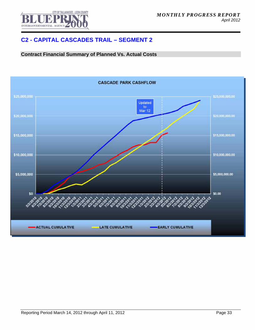
Contract Financial Summary of Planned Vs. Actual Costs
MONTHLY PROGRESS REPORT April 2012
Reporting Period March 14, 2012 through April 11, 2012 Page 34
C3 & C4 - CAPITAL CASCADES TRAIL – SEGMENTS 3 AND 4 DESIGN
Project Description: Phase 2 tasks have been authorized and include the following major elements:
Design and permitting for a box culvert between South Monroe Street and Adams Street Design and permitting for Coal Chute Pond 60% Construction documents for Black Swamp Nature Park Design and permitting Segment 3 in conjunction with COT FAMU Extension
Project Personnel: Blueprint 2000: Planning Manager: David Bright Program Manager: Dave Snyder Project Manager: Gary Phillips Kimley-Horn: Project Manager: Richard Barr Contract Cost & Schedule Status - Agreement No. 1736/ LOA #1 - As of 4/11/2012 Contract Commencement: 01Jun08 Contract Completion: 7/25/2012 Percent of Work Performed: 90.0% Original Contract Amount: $ 1,057,759.98Executed Supplemental Agreements: $ 1,748,116.00Pending Supplemental Agreements: $ 0.00Current Contract Amount: $ 2,805,875.98Invoiced to Date: $ 2,535,212.25Remaining Contract Amount: $ 270,663.73Percent of Contract Amount Complete: 90.4% Original Contract Time: 365 Days Contract Time Extensions: 1150 Days Current Contract Time: 1515 Days Contract Time Expended: 1401 Days Contract Time Remaining: 114 Days Percent Contract Time Expended: 92.5% Schedule Milestones: IMC Approval 27May08 Contract Executed 29May09 Phase 2 Kick-Off Meeting 11Aug09 Coal Chute Pond Construction Plans 27Jan12 Segment 3A Construction Plans 28Feb12 Segment 3 - 30% Design Plans 30Apr12
MONTHLY PROGRESS REPORT April 2012
C3 & C4 - CAPITAL CASCADES TRAIL – SEGMENTS 3 AND 4 DESIGN
Reporting Period March 14, 2012 through April 11, 2012 Page 35
Design Subconsultant Contract Amt % of Design Expended FY Year Participation: Contract To Date To Date Tampa Bay Engineering Utility Investigation $ 80,445.89 2.87 $ 70,963.19 $ 0.003DS Surveying/Right-of-Way Services $ 454,950.00 16.21 $ 467,104.50 $ 0.00Cheryl Johnson Model Review $ 14,750.00 0.53 $ 5,148.00 $ 0.00In-Situ Stream Gage installation and monitoring
$ 32,000.00 1.14 $ 32,000.00 $ 0.00
Biological Research & Associates Environmental $ 48,500.00 1.73 $ 48,500.00 $ 0.00CDM Stormwater Modeling and Design $ 286,381.00 10.21 $ 244,938.92 $ 0.00Kimley-Horn Prime - Data Collection, Environmental , Project M
$ 1,791,602.09 63.85 $ 1,615,557.73 $ 220,846.71
EGS Geotechnical $ 92,916.00 3.31 $ 50,999.91 $ 0.00Search Cultural Resources $ 4,331.00 0.15 $ 0.00 $ 0.00
Total Design Contract: $ 2,805,875.98 100.00% $ 2,535,212.25 $ 220,846.71
Design MBE Goal: $ 434,910.78 15.50%
Design MBE to Date: $ 518,104.41 20.44%
MONTHLY PROGRESS REPORT April 2012
C3 & C4 - CAPITAL CASCADES TRAIL – SEGMENTS 3 AND 4 DESIGN
Reporting Period March 14, 2012 through April 11, 2012 Page 36
Project Status and Right-of-Way Status Report: The proposed Coal Chute Pond is a downtown regional stormwater facility that will be an integral part of the proposed redevelopment of central Tallahassee. The pond will be an offline facility that provides retrofit stormwater treatment and aids in flood control for the watershed, as well as providing treatment volume and attenuation for approximately 43 acres of new downtown development. Coal Chute Pond will be permitted through the City of Tallahassee and Northwest Florida Water Management District or the Florida Department of Environmental Protection as a regional stormwater facility allowing redevelopment stormwater capacity to be allocated for future use by redevelopment along the Gaines Street corridor, within the adjacent Railroad Square, and along the future FAMU Way corridor. As the proposed redevelopment occurs, the developer will submit a Capacity Accounting Record to the permitting agency updating the amount of stormwater used to date and the remaining amount available on the basis of impervious surface. The capacity of the pond may potentially be extended to additional redevelopment areas through the use of incentives for sustainable development that encourages onsite capture of stormwater and use of innovative technology, such as pervious pavement and green roofs, to reduce onsite impervious surfaces. Blueprint identified ten parcels of land which needed to be acquired for the construction of Coal Chute Pond. As of this date, all parcels are owned by Blueprint except for three parcels that will be going to suit. A hearing will be scheduled for June with title expected on the three outstanding parcels. Activities Since Last Period:
1. Prepared schedule of bids and specifications package for Coal Chute Pond IFB 2. Submitted Coal Chute permit plans and design report packages to COT and DEP 3. Coordinated with COT Underground Utilities about replacing SS and determined location
for re-use water line Planned Activities for Next Period:
1. Submit responses to DEP's RAI for Segment 3A 2. Continue modeling Segment 3 using most recent model which includes Franklin Boulevard
Improvements and Cascades Park 3. Prepare several concept designs for Van Buren Pond 4. Determine size and location for Stilling Ponds 5. Schedule meeting with CSX in Jacksonville on Segment 3 design
MONTHLY PROGRESS REPORT April 2012
C3 & C4 - CAPITAL CASCADES TRAIL – SEGMENTS 3 AND 4 DESIGN
Reporting Period March 14, 2012 through April 11, 2012 Page 37
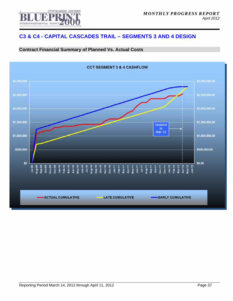
Contract Financial Summary of Planned Vs. Actual Costs
MONTHLY PROGRESS REPORT April 2012
Reporting Period March 14, 2012 through April 11, 2012 Page 38
FB - FRANKLIN BOULEVARD FLOOD RELIEF PROJECT (FB)
Project Description: Franklin Boulevard Drainage Improvements Design & Permitting project has received funding assistance from the U.S. Department of Housing and Urban Development (HUD). It is Segment No. 1 (out of 4) of the Capital Cascades Trail project, and the elements of this project will be designed and permitted as primary drainage improvements along this Trail Segment. The project will provide drainage improvements to approximately 2,300 feet of existing, undersized and hydraulically insufficient open stormwater conveyance; provide a hydraulic connection to the existing conveyance under East Tennessee Street and the existing storm sewer system at Leon High School. The existing open drainage conveyance on Franklin Boulevard will be replaced with a continuous concrete box culvert designed to provide flood relief along Franklin Boulevard. Some road improvements on Franklin Boulevard will also be made. Project Personnel: Blueprint 2000: Program Manager: David Snyder Project Manager: Marek Romanowski Genesis Group: Project Principal: Mark Llewellyn Design Project PM: Echo Gates Contract Cost & Schedule Status - As of 4/9/2012 Contract Commencement: 04Jan11 Contract Completion: 6/13/2012 Percent of Work Performed: 87.8% Original Contract Amount: $ 671,294.51Executed Supplemental Agreements: $ 298,804.91Pending Supplemental Agreements: $ 0.00Current Contract Amount: $ 970,099.42Invoiced to Date: $ 851,424.15Remaining Contract Amount: $ 118,675.27Percent of Contract Amount Complete: 87.8% Original Contract Time: 466 Days Contract Time Extensions: 60 Days Current Contract Time: 526 Days Contract Time Expended: 461 Days Contract Time Remaining: 65 Days Percent Contract Time Expended: 87.6%
MONTHLY PROGRESS REPORT April 2012
FB - FRANKLIN BOULEVARD FLOOD RELIEF PROJECT (FB)
Reporting Period March 14, 2012 through April 11, 2012 Page 39
Schedule Milestones: Contract commencement 05Jan11 Design Contract completion date 02Jan12 Post-design services completion date 29Jun12 Design Subconsultant Contract Amt % of Design Expended FY Year Participation: Contract To Date To Date EGS Geotechnical $ 58,144.08 5.99 $ 56,417.96 $ 56,417.96Garcia Bridge Engineers Bridge Design $ 40,653.50 4.19 $ 25,884.84 $ 25,884.84 Genesis Engineering Engineering $ 832,824.82 85.85 $ 744,156.83 $ 349,495.06Genesis Survey-for-Design Design $ 21,277.02 2.19 $ 21,277.02 $ 0.00Hydra Engineers FEMA CLOMR Modification $ 17,200.00 1.77 $ 3,687.50 $ 3,687.50
Total Design Contract: $ 970,099.42 100.00% $ 851,424.15 $ 435,485.36
Design MBE Goal: $ 150,365.41 15.50%
Design MBE to Date: $ 85,990.30 10.10%
MONTHLY PROGRESS REPORT April 2012
FB - FRANKLIN BOULEVARD FLOOD RELIEF PROJECT (FB)
Reporting Period March 14, 2012 through April 11, 2012 Page 40
Project Status: The Federal Environmental Assessment process is complete and the environmental permit coordination is in progress. The Natural Features Inventory Report was approved by the City on 4/08/11. The Environmental Impact Assessment (EIA) Report was submitted to the City GM and is presently being actively reviewed. A "fast track permitting" status was obtained from COT GM. East Tennessee Street drainage connection permit has been obtained from FDOT, and Joint Permit Application for FDEP (ERP) and USACE (Wetland) permits were submitted to FDEP for approval. The ERP permit has been applied for. The FDEP reviewed the ERP application and provided comments. The EOR is presently preparing a response to these comments, including drainage modeling for Segments 1 (Franklin Boulevard), 2 (Capital Cascades Park) and 3A (first section of Segment 3, immediately downstream of CCP. The geotechnical investigations are complete, including additional soil investigation for sheet piling construction option, and pavement design for road reconstruction. Drainage design, including Franklin Boulevard box culvert modeling and side streets flooding relief is complete in accordance with the project scope for the interim drainage improvement on Franklin Boulevard. The results of the water surface modeling on Franklin Boulevard met requirements of the permitting agencies, including FEMA, and were approved by Leon County and COT Public Works Departments for Segment 1 Franklin Boulevard of the Capital Cascades Trail project. The FDEP drainage permit (ERP), has been applied for and the permit notice period ends on April 14, 2012. Utility coordination continues. The utility relocation main activities for the project were based on relocation of City Electric’s power distribution line, relocation of high pressure gas line, replacement of the existing terracotta clay pipe sanitary sewer, and replacement of the water supply system on Franklin Boulevard. The advanced relocation of COT Gas and Electric utilities reduced disruption to the existing utilities during installation of the proposed Franklin Boulevard box culvert. Additional Subsurface Utility Engineering (SUE) investigations have been conducted in critical areas, allowing for selection of cost effective typical road pavement design, suitable for soil conditions on the project. The management of traffic on Franklin Boulevard and traffic lane/road closures during construction is being coordinated with Leon County and the City. The approved initial project schedule has been met, and the Invitation For Bids (IFB) for the 4-lane roadway option was advertised on 9/25/2011. The bids were opened on 11/08/11 and M of Tallahassee was selected as the lowest bidder and awarded the contract on 12/16/2011. Due to requests from the public, local residents and some of the project stakeholders, a special Intergovernmental Agency meeting was held on 11/14/11 to address the requests for the 2-lane roadway option with bike lanes and pedestrian amenities. The Franklin Boulevard 2-lane roadway option was approved for implementation, and this revision is being negotiated as a change order to the contract with M of Tallahassee, Inc. The plan revision for implementing the 2-lane roadway options with bike lanes and pedestrian amenities are in progress. The Contractor will provide the updated construction schedule once the revised plans are complete. Based on the revised and approved MOT plans, the existing traffic pattern in the project area was changed in the week of 1/09/12. Blueprint issued a limited Notice to Proceed on January 2, 2012 to the Contractor to provide MOT facilities for utility relocation and to install a section of the 12'x8' CBC under CPP Segment 2 permit. Upon completion of CBC installation past the Franklin Boulevard/Pensacola Street intersection, the roadwork has been advanced at this intersection to complete construction of concrete curbs, sidewalk, trail, base course and structural asphalt.
MONTHLY PROGRESS REPORT April 2012
FB - FRANKLIN BOULEVARD FLOOD RELIEF PROJECT (FB)
Reporting Period March 14, 2012 through April 11, 2012 Page 41
Activities Since Last Period:
1. Continued construction documentation for 2-lane roadway option with pedestrian amenities
2. Incorporated FDEP comments and permit conditions into the ERP permit application and submitted final permit application
3. Coordinated 21-day permit petition period with FDEP and addressed public requests for information in April 2012
4. Coordinated with Leon County and COT regarding temporary road closures and MOT for same
5. Continued to coordinate with COT Utilities during final stages of relocation of COT Electric distribution line and COT Gas high pressure line
6. Completed design work on COT Water Utility replacement of the 15"/18" sanitary sewer on the existing Franklin Boulevard southbound lanes
7. Responded to contractor's Request for Additional Information during installation of the first 250 ft. of concrete box culvert north of the project's southern limit (construction permitted together with CCP, Seg 2)
8. Continued to coordinate with COT and Leon County Public Works regarding side streets and off-site drainage design requirements
9. Provided assistance to contractor during replacement of the 15"/18" sanitary sewer between Pensacola Street and Park Avenue on the west side of Right-of-Way
Planned Activities for Next Period:
1. Complete design of the 2-lane roadway option with associated drainage revisions and submit final construction package to Blueprint
2. Continue coordination with COT Electric Utility, and COT Water/Sewer facilities relocation 3. Coordinate with Leon County, COT and Department of Economic Opportunities (DEO)
regarding project esthetic, expenditures and schedules 4. Obtain FDEP permit (ERP) 5. Obtain the Environmental Impact Assessment (EIA) approval from the COT GM 6. Prepare construction project schedule based on completed construction documentation 7. Prepare Linear Infrastructure Variance and submit it to COT for approval 8. Assist in negotiations of the Project's change order for construction of 2-lane road
MONTHLY PROGRESS REPORT April 2012
FB - FRANKLIN BOULEVARD FLOOD RELIEF PROJECT (FB)
Reporting Period March 14, 2012 through April 11, 2012 Page 42
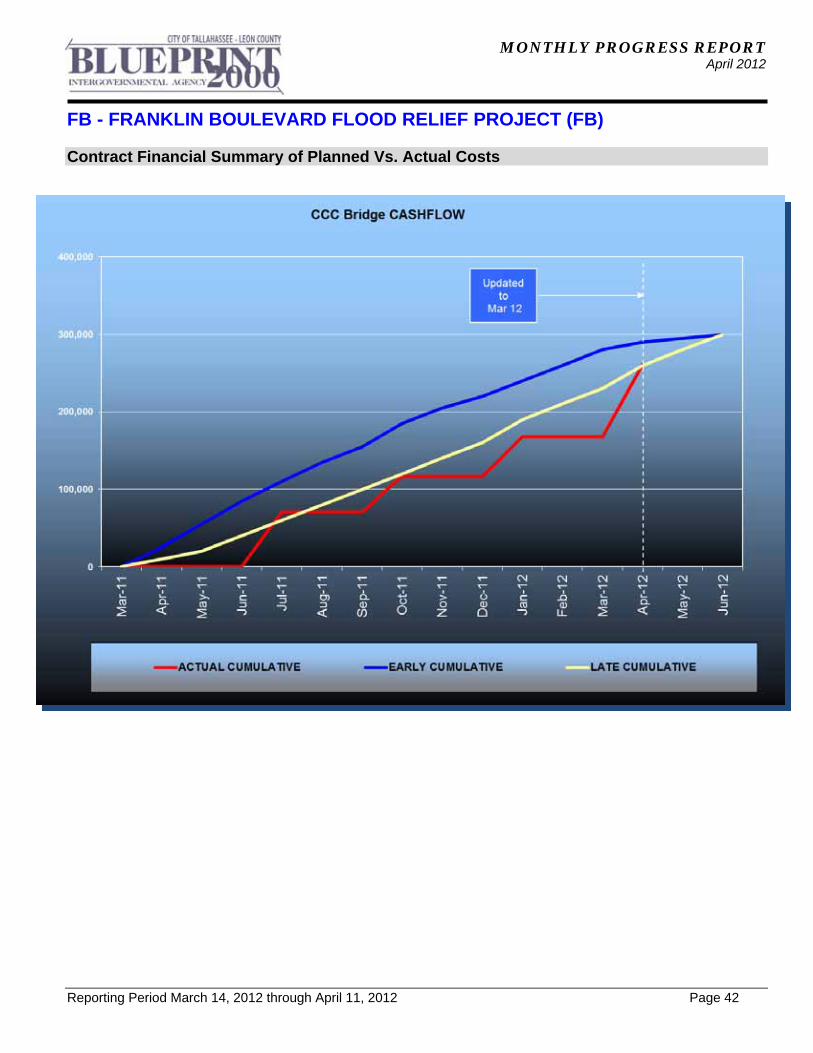
Contract Financial Summary of Planned Vs. Actual Costs
MONTHLY PROGRESS REPORT April 2012
Reporting Period March 14, 2012 through April 11, 2012 Page 43
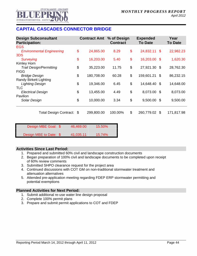
CAPITAL CASCADES CONNECTOR BRIDGE
Project Description: The Capital Cascades Connector Bridge will cross over South Monroe Street (SR 61) and connect the Capital Cascades Trail - Segment 2 (Cascades Park) with Capital Cascades Trail - Segment 3. The project limits extend from the end of CCT- Segment 2 just south of Van Buren Electric Building parking area on the west side of Gadsden Street to east side of South Adams Street, a distance of approximately 1,150 feet. The project is in two phases. Phase 1 is 30% design and Phase II is 100% design and permitting. Project Personnel: Blueprint 2000: Project Manager: Gary Phillips Program Manager: David Snyder FIGG: Design Project Manager: Jeff Walters Contract Cost & Schedule Status - Agreement No. 2428/Authorization LOA - As of 4/11/2012 Contract Commencement: 10Mar11 Contract Completion: 5/18/2012 Percent of Work Performed: 85.0% Original Contract Amount: $ 250,000.00Executed Supplemental Agreements: $ 49,800.00Pending Supplemental Agreements: $ 0.00Current Contract Amount: $ 299,800.00Invoiced to Date: $ 260,779.02Remaining Contract Amount: $ 39,020.98Percent of Contract Amount Complete: 87.0% Original Contract Time: 265 Days Contract Time Extensions: 170 Days Current Contract Time: 435 Days Contract Time Expended: 389 Days Contract Time Remaining: 46 Days Percent Contract Time Expended: 89.4% Schedule Milestones: Kick-off Meeting 13Apr11 Design Charrette 14May11 60% Design 30Nov11 Final Plans 15Feb12
MONTHLY PROGRESS REPORT April 2012
CAPITAL CASCADES CONNECTOR BRIDGE
Reporting Period March 14, 2012 through April 11, 2012 Page 44
Design Subconsultant Contract Amt % of Design Expended Year Participation: Contract To Date To Date EGS Environmental Engineering $ 24,865.00 8.29 $ 24,832.11 $ 22,982.233DS Surveying $ 16,203.00 5.40 $ 16,203.00 $ 1,620.30Kimley Horn Trail Design/Permitting $ 35,223.00 11.75 $ 27,921.30 $ 28,762.30FIGG Bridge Design $ 180,708.00 60.28 $ 159,601.21 $ 86,232.15Randy Birkett Lighting Lighting Design $ 19,346.00 6.45 $ 14,648.40 $ 14,648.00TLC Electrical Design $ 13,455.00 4.49 $ 8,073.00 $ 8,073.00Pavilion Solar Design $ 10,000.00 3.34 $ 9,500.00 $ 9,500.00
Total Design Contract: $ 299,800.00 100.00% $ 260,779.02 $ 171,817.98
Design MBE Goal: $ 46,469.00 15.50%
Design MBE to Date: $ 41,035.11 15.74%
Activities Since Last Period:
1. Prepared and submitted 60% civil and landscape construction documents 2. Began preparation of 100% civil and landscape documents to be completed upon receipt
of 60% review comments 3. Submitted SHPO clearance request for the project area 4. Continued discussions with COT GM on non-traditional stormwater treatment and
attenuation alternatives 5. Attended pre-application meeting regarding FDEP ERP stormwater permitting and
potential exemptions Planned Activities for Next Period:
1. Submit additional re-use water line design proposal 2. Complete 100% permit plans 3. Prepare and submit permit applications to COT and FDEP
MONTHLY PROGRESS REPORT April 2012
CAPITAL CASCADES CONNECTOR BRIDGE
Reporting Period March 14, 2012 through April 11, 2012 Page 45
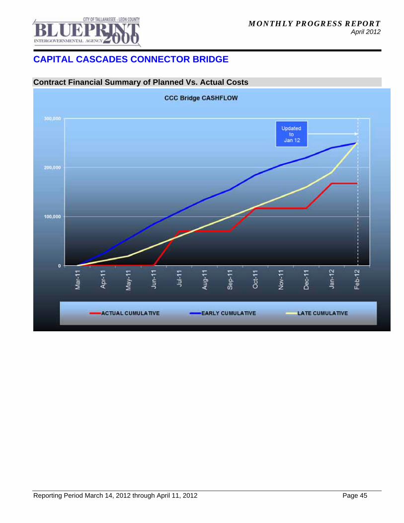
Contract Financial Summary of Planned Vs. Actual Costs

MONTHLY PROGRESS REPORT April 2012
Reporting Period March 14, 2012 through April 11, 2012 Page 46
ACRONYM GLOSSARY
ACRONYM GLOSSARY ACOE Army Corps of Engineers
ARRA American Recovery and Reinvestment Act
CAC Citizens Advisory Committee
CDM Camp, Dresser & McKee Inc.
CEI Construction Engineering & Inspection
CLOMR Conditional Letter of Map Revision
COT City of Tallahassee
CR Community Representative
CRA Community Redevelopment Agency
CRCDD Capital Region Community Development District
CRTPA Capital Region Transportation Planning Agency
DB Design-Build
DHR Department of Historical Resources
DMS Department of Management Services
DRB Dispute Resolution Board
ECMP Environmental Construction Management Plan
EIA Environmental Impact Assessment
EIS Environmental Impact Study
EMP Environmental Management Permit
ERP Environmental Resource Permit
ETD Earned to Date
ETDM Efficient Transportation Decision Making
FCT Florida Communities Trust
FDEP Florida Department of Environmental Protection
FDOT Florida Department of Transportation
FEMA Federal Emergency Management Agency
FHWA Federal Highway Administration
FWC Florida Fish & Wildlife Conservation Commission
MONTHLY PROGRESS REPORT April 2012
Reporting Period March 14, 2012 through April 11, 2012 Page 47
ACRONYM GLOSSARY
ACRONYM GLOSSARY FY Fiscal Year (For BLUEPRINT 2000, October to September)
GEC General Engineering Consultant
GM Growth Management
HASP Health and Safety Plan
IA Intergovernmental Agency
IC/RC Institutional Controls/Restrictive Covenants
IFB Invitation For Bid
ITE Institute of Transportation Engineers
JPA Joint Participation Agreement
LAP Local Agency Program
LCPWD Leon County Public Works Department
LDCA Location Design Concept Approval
LOA Letter of Authorization
LOMR Letter of Map Revision
M/WBE Minority/Women Business Enterprise
MOT Maintenance of Traffic
MSE Mechanically Stabilized Earth
MSSW Management and Storage of Surface Waters
NFI Natural Features Inventory
NTP Notice to Proceed
NWFWMD Northwest Florida Water Management District
OT Order of Taking
PD&E Project Development and Environmental
RFP Request for Proposals
RFQ Request for Qualifications
ROW Right-of-Way
RW Retaining Wall
SAB St. Augustine Branch
MONTHLY PROGRESS REPORT April 2012
Reporting Period March 14, 2012 through April 11, 2012 Page 48
ACRONYM GLOSSARY
ACRONYM GLOSSARY SFMP Stormwater Facility Management Plan
SHPO State Historic Preservation Officer
SUE Subsurface Utility Engineering
SWPPP Stormwater Pollution Prevention Plan
TCC Technical Coordinating Committee
TCE Temporary Construction Easement
TIITF Trustees of the Internal Improvement Trust Fund
UAO Utility Agency/Owner
USEPA United States Environmental Protection Agency
USFS United States Forest Service
USFWS US Fish and Wildlife Service
VE Value Engineering
YTD Year to Date


