Morlais, Menter Mon. Registered Address: Llangefni Town Hall, Anglesey, Wales, LL77 7LR, UK Unauthorised copies of this document are NOT to be made Company registration No: 03160233 Requests for additional copies shall be made to Morlais Project
Document Title: Morlais ES Non-Technical Summary Document Reference: PB5034-ES-000 Version Number: F3.0
Menter Môn Morlais Project Page | ii
TABLE OF CONTENTS
TABLE OF PLATES ................................................................................................................ IV
GLOSSARY OF ABBREVIATIONS .......................................................................................... V
GLOSSARY OF TERMINOLOGY ............................................................................................ V
1. INTRODUCTION ............................................................................................................ 1 1.1. ABOUT THIS DOCUMENT ............................................................................................ 1
1.2. THE PROJECT .............................................................................................................. 1
1.3. THE DEVELOPER ......................................................................................................... 2
1.4. THE NEED FOR THE PROJECT ................................................................................... 2
3. TOPICS CONSIDERED IN THE ENVIRONMENTAL IMPACT ASSESSMENT .......... 15 3.1. CHAPTER 7: METOCEAN CONDITIONS AND COASTAL PROCESSES ................. 15
3.2. CHAPTER 8: MARINE WATER AND SEDIMENT QUALITY ....................................... 16
3.3. CHAPTER 9: BENTHIC AND INTERTIDAL ECOLOGY .............................................. 17
3.4. CHAPTER 10: FISH AND SHELLFISH ECOLOGY ..................................................... 19
5. CONTACT US .............................................................................................................. 37
Document Title: Morlais ES Non-Technical Summary Document Reference: PB5034-ES-000 Version Number: F3.0
Menter Môn Morlais Project Page | iv
TABLE OF PLATES Plate 2-1 Generic Tidal Device Exemplar 1 – Floating or Surface Emergent Tidal Device, Comprised of TEC, Support Structure, Mooring Cables / Anchor Chains and Anchors / Foundations ...................... 11 Plate 2-2 Generic Tidal Device Exemplar 2 – Mid Water Column Tidal Device, Comprised of TEC, Support Structure, Mooring Cables / Anchor Chain, and Anchor / Foundation. Note this device is shown facing into direction of current flow ...................................................................................................... 12 Plate 2-3 Generic Tidal Device Exemplar 3 – Seabed Mounted Sub Surface Tidal Device with TEC Supporting Structure and Foundation .................................................................................................. 12 Plate 2-4 Illustration of Horizontal (Left) and Vertical (Right) Axis TEC Types .................................... 13
Document Title: Morlais ES Non-Technical Summary Document Reference: PB5034-ES-000 Version Number: F3.0
Menter Môn Morlais Project Page | v
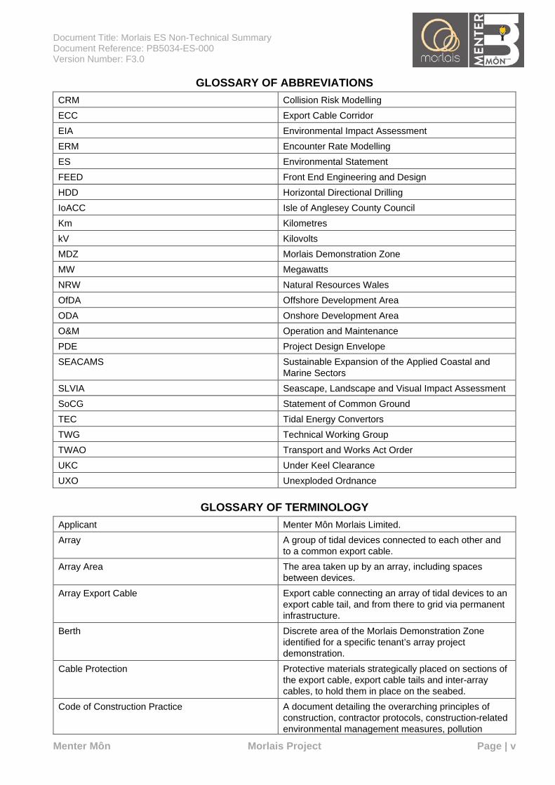
GLOSSARY OF ABBREVIATIONS CRM Collision Risk Modelling ECC Export Cable Corridor EIA Environmental Impact Assessment ERM Encounter Rate Modelling ES Environmental Statement FEED Front End Engineering and Design HDD Horizontal Directional Drilling IoACC Isle of Anglesey County Council Km Kilometres kV Kilovolts MDZ Morlais Demonstration Zone MW Megawatts NRW Natural Resources Wales OfDA Offshore Development Area ODA Onshore Development Area O&M Operation and Maintenance PDE Project Design Envelope SEACAMS Sustainable Expansion of the Applied Coastal and
Marine Sectors SLVIA Seascape, Landscape and Visual Impact Assessment SoCG Statement of Common Ground TEC Tidal Energy Convertors TWG Technical Working Group TWAO Transport and Works Act Order UKC Under Keel Clearance UXO Unexploded Ordnance
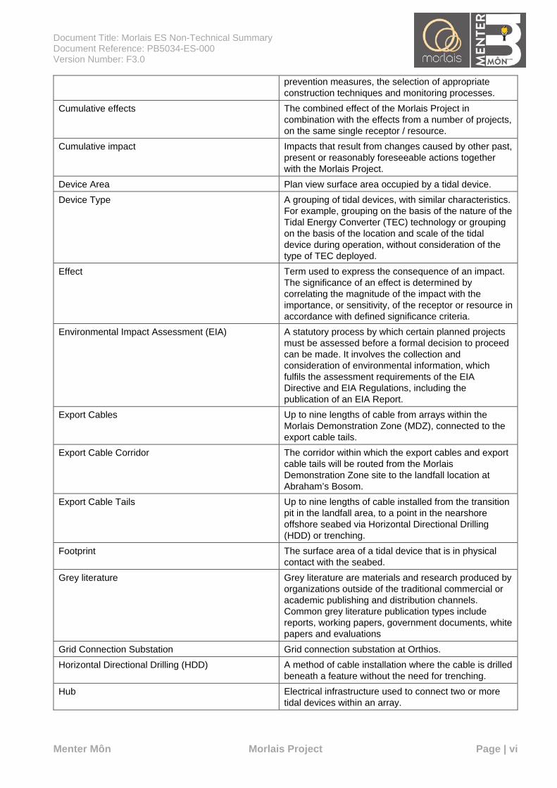
GLOSSARY OF TERMINOLOGY Applicant Menter Môn Morlais Limited. Array A group of tidal devices connected to each other and
to a common export cable. Array Area The area taken up by an array, including spaces
between devices. Array Export Cable Export cable connecting an array of tidal devices to an
export cable tail, and from there to grid via permanent infrastructure.
Berth Discrete area of the Morlais Demonstration Zone identified for a specific tenant’s array project demonstration.
Cable Protection Protective materials strategically placed on sections of the export cable, export cable tails and inter-array cables, to hold them in place on the seabed.
Code of Construction Practice A document detailing the overarching principles of construction, contractor protocols, construction-related environmental management measures, pollution
Document Title: Morlais ES Non-Technical Summary Document Reference: PB5034-ES-000 Version Number: F3.0
Menter Môn Morlais Project Page | vi
prevention measures, the selection of appropriate construction techniques and monitoring processes.
Cumulative effects The combined effect of the Morlais Project in combination with the effects from a number of projects, on the same single receptor / resource.
Cumulative impact Impacts that result from changes caused by other past, present or reasonably foreseeable actions together with the Morlais Project.
Device Area Plan view surface area occupied by a tidal device. Device Type A grouping of tidal devices, with similar characteristics.
For example, grouping on the basis of the nature of the Tidal Energy Converter (TEC) technology or grouping on the basis of the location and scale of the tidal device during operation, without consideration of the type of TEC deployed.
Effect Term used to express the consequence of an impact. The significance of an effect is determined by correlating the magnitude of the impact with the importance, or sensitivity, of the receptor or resource in accordance with defined significance criteria.
Environmental Impact Assessment (EIA) A statutory process by which certain planned projects must be assessed before a formal decision to proceed can be made. It involves the collection and consideration of environmental information, which fulfils the assessment requirements of the EIA Directive and EIA Regulations, including the publication of an EIA Report.
Export Cables Up to nine lengths of cable from arrays within the Morlais Demonstration Zone (MDZ), connected to the export cable tails.
Export Cable Corridor The corridor within which the export cables and export cable tails will be routed from the Morlais Demonstration Zone site to the landfall location at Abraham’s Bosom.
Export Cable Tails Up to nine lengths of cable installed from the transition pit in the landfall area, to a point in the nearshore offshore seabed via Horizontal Directional Drilling (HDD) or trenching.
Footprint The surface area of a tidal device that is in physical contact with the seabed.
Grey literature Grey literature are materials and research produced by organizations outside of the traditional commercial or academic publishing and distribution channels. Common grey literature publication types include reports, working papers, government documents, white papers and evaluations
Grid Connection Substation Grid connection substation at Orthios. Horizontal Directional Drilling (HDD) A method of cable installation where the cable is drilled
beneath a feature without the need for trenching. Hub Electrical infrastructure used to connect two or more
tidal devices within an array.
Document Title: Morlais ES Non-Technical Summary Document Reference: PB5034-ES-000 Version Number: F3.0
Menter Môn Morlais Project Page | vii
Inter-Array Cables Offshore cables which link the arrays to each other and the offshore electrical platforms, these cables will include fibre optic cables.
Joint Pits Underground structures constructed at regular intervals along the onshore cable route to join sections of cable and facilitate installation of the cables into buried ducts within the road.
Landfall The area (from Mean Low Water Springs) where the offshore export cables would make contact with land and connect to the onshore cables.
Landfall Substation Landfall substation at Ty-Mawr. Morlais Demonstration Zone (MDZ) Defined by The Crown Estate Lease boundary, the
area within which the tidal devices/arrays will be deployed along with associated infrastructure such as inter-array cables, export cables, marker buoys, site monitoring equipment and electrical connections to the export cables. An offshore area of 35km2 within which the Project will deploy arrays of tidal devices and associated infrastructure.
Nacelle A cover that houses all of the generating components in a TEC, including the generator, gearbox, drive train, and brake assembly
Offshore Development Area (OfDA) The combined area of the Morlais Demonstration Zone and the Export Cable Corridor.
Offshore Infrastructure All offshore infrastructure including tidal devices, foundations or anchors, inter array cables, hubs, export cables, export cable tails and cable protection.
Onshore cables The cables which take the electricity from the landfall transition pit to the grid connection substation.
Onshore Cable Corridor The area within which the onshore cables and associated infrastructure such as joint bays, will be located.
Onshore Development Area (ODA) The area including the intertidal landfall location at Abraham’s Bosom, the short onshore cable route between landfall and the landfall substation infrastructure (up to and including landfall substation/control room), and the onshore cable route to the grid connection substation.
Project Design Envelope (PDE) The parameters within which the potential maximum extent of the project in terms of materials, scale, time and location can be described. Sometimes referred to as the ‘Rochdale envelope’.
Repowering The removal of a tenant’s infrastructure at the end of a demonstration period and replacement with new tenant infrastructure.
Safety Zones A marine area declared for the purposes of safety around a renewable energy, installation or works / construction area under the Energy Act 2004, the Electricity (Offshore Generating Stations) (Safety Zones) (Application Procedures and Control of Access) Regulations 2007 and the Transport and Works Act 1992.
Document Title: Morlais ES Non-Technical Summary Document Reference: PB5034-ES-000 Version Number: F3.0
Menter Môn Morlais Project Page | viii
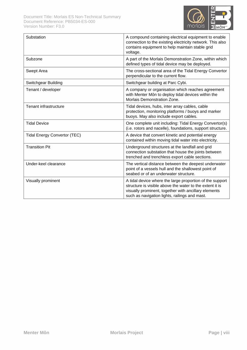
Substation A compound containing electrical equipment to enable connection to the existing electricity network. This also contains equipment to help maintain stable grid voltage.
Subzone A part of the Morlais Demonstration Zone, within which defined types of tidal device may be deployed.
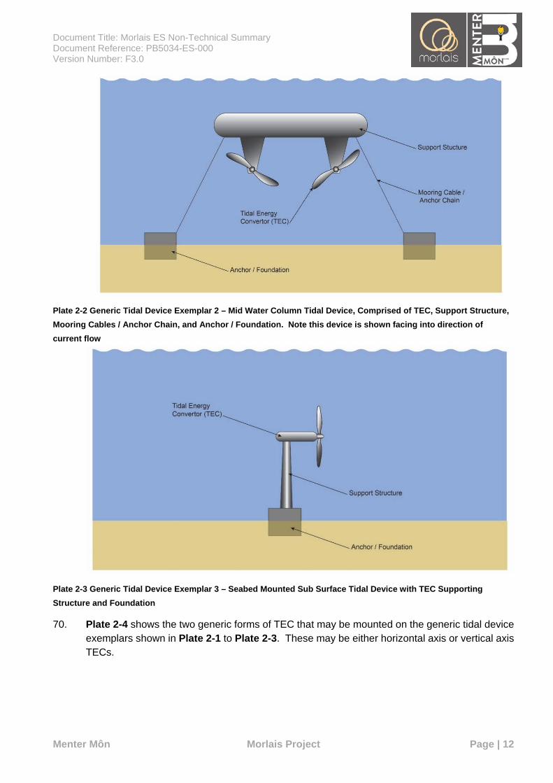
Swept Area The cross-sectional area of the Tidal Energy Convertor perpendicular to the current flow.
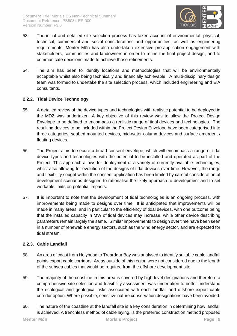
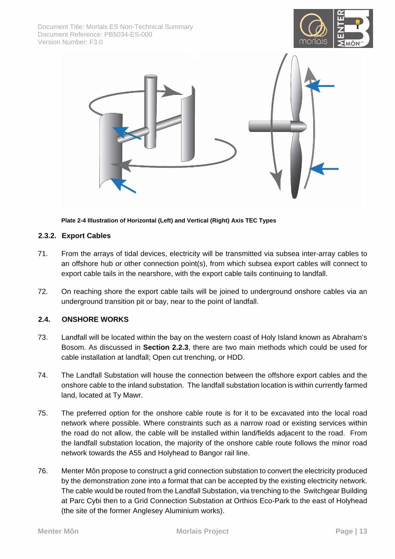
Switchgear Building Switchgear building at Parc Cybi. Tenant / developer A company or organisation which reaches agreement
with Menter Môn to deploy tidal devices within the Morlais Demonstration Zone.
Tenant infrastructure Tidal devices, hubs, inter array cables, cable protection, monitoring platforms / buoys and marker buoys. May also include export cables.
Tidal Device One complete unit including: Tidal Energy Convertor(s) (i.e. rotors and nacelle), foundations, support structure.
Tidal Energy Convertor (TEC) A device that convert kinetic and potential energy contained within moving tidal water into electricity.
Transition Pit Underground structures at the landfall and grid connection substation that house the joints between trenched and trenchless export cable sections.
Under-keel clearance The vertical distance between the deepest underwater point of a vessels hull and the shallowest point of seabed or of an underwater structure.
Visually prominent A tidal device where the large proportion of the support structure is visible above the water to the extent it is visually prominent, together with ancillary elements such as navigation lights, railings and mast.
Document Title: Morlais ES Non-Technical Summary Document Reference: PB5034-ES-000 Version Number: F3.0
Menter Môn Morlais Project Page | 1
1. INTRODUCTION
1.1. ABOUT THIS DOCUMENT
1. This document is the Non-Technical Summary (NTS) of the Environmental Statement (ES) for the proposed Morlais Project (henceforth referred to as ‘the Project’). It provides a summary of the Project, the site selection process and the key findings of the Environmental Impact Assessment (EIA).
2. The NTS is a standalone document which aims to use non-technical language, where possible, to describe the background and the need for the proposed Project. It describes the proposed scheme, the baseline environmental conditions, and the recommended mitigation measures that are to be put in place to prevent or reduce significant adverse impacts.
3. The NTS summarises the ES and, although its format broadly follows that of the ES, some changes have been made so as to provide a more readable and concise summary. Figures have been included to illustrate certain points or features.
4. This section of the NTS (Section 1) provides an introduction to the Project, while Section 2 provides further detail on the project description.
5. Section 3 summarises the predicted impacts of the proposed Project on the onshore and offshore physical, ecological and human environment, provides details of the potential positive and adverse impacts and gives the reader an understanding of how these impacts were established. All predicted impacts and proposed mitigation measures are presented in a summary table (Chapter 27, Summary in Volume I of the ES).
6. Finally, Section 4 presents the overall conclusions of the EIA process.
1.2. THE PROJECT
7. The Project is being developed by Menter Môn Morlais Limited (Menter Môn), the applicant, a not for profit social enterprise company. When consented, the Project will have a generating capacity of up to 240 MW of tidal stream generating capacity.
8. The Project is located within one of several marine energy demonstration zones located around the United Kingdom (UK) coast, which were leased out for 45 years by The Crown Estate (TCE) in 2014 in a bid to encourage and accelerate the marine energy industry. The Project is located within the West Anglesey Demonstration Zone (WADZ), a zone primarily selected for its tidal stream resource. Menter Môn has been appointed as the manager of the WADZ by The Crown Estate. In this ES, the WADZ is referred to as the Morlais Demonstration Zone (MDZ).
9. After an assessment of the distribution of tidal stream resource within the MDZ, in 2015, Menter Môn asked TCE if the MDZ could be moved to the north, to better capture the main areas of significant tidal stream flow to the west of Anglesey. Menter Môn consulted stakeholders on the proposed move and TCE approved the change in 2016.
10. The development of the Project will provide a consented tidal technology demonstration zone, specifically designed for the installation and commercial demonstration of multiple arrays of tidal
Document Title: Morlais ES Non-Technical Summary Document Reference: PB5034-ES-000 Version Number: F3.0
Menter Môn Morlais Project Page | 2
energy devices. The Project will include communal infrastructure for tidal technology developers which provides a shared route to a local grid connection via nine export cable tails, an onshore landfall substation, and an onshore electrical cable route to a grid connection via a grid connection substation.
11. The Project will be authorised via the following principal consents:
A Transport and Works Act Order under the Transport and Works Act 1992; and
A Marine Licence under the Marine and Coastal Access Act 2009 (MCAA).
1.3. THE DEVELOPER
12. Development of the MDZ is being led by Menter Môn who have been allocated funding from European Union (EU) Structural Funds prioritised for marine energy in Wales. Menter Môn is a not for profit, third sector social enterprise, delivering socioeconomic development projects across North Wales. Menter Môn fulfils an enabling role for the Project and does not act as a technology developer.
13. Menter Môn’s motivation for the Project is to position itself as a community organisation at the centre of renewable energy innovation, and to establish Anglesey as a marine energy hub, thereby securing maximum added value for the local economy and community.
14. The design of much of the Project infrastructure will be undertaken with a view to maximising local content and developing locally based skills, with social value (including sub-contracts) an important consideration in the procurement strategy. During development of the procurement strategy, efforts will be made to identify local suppliers and contractors who could undertake each contract.
15. Menter Môn has identified the following project objectives:
Generation of long-term financial income / resources for reinvestment in socio-economic and environmental projects to support the wider community;
Development of locally based skills;
Attracting investment to the area;
Becoming a centre of excellence for tidal stream technologies;
Providing a world class facility for tidal stream technology development;
Preserving the environment; and
Securing a sustainable energy supply for the area.
1.4. THE NEED FOR THE PROJECT
16. Climate change is a global issue as a result of carbon emissions released into the atmosphere due to human activity. Generating and harnessing energy from low carbon, renewable sources such as tidal stream energy is one of the solutions available to substantially reduce carbon emissions, whilst answering the challenges of meeting energy demand as part of a balanced energy portfolio. Targets for CO2 reduction and the use of renewable energy sources are discussed further in Chapter 2, Policy and Legislation in Volume I of the ES).
Document Title: Morlais ES Non-Technical Summary Document Reference: PB5034-ES-000 Version Number: F3.0
Menter Môn Morlais Project Page | 3
17. The Environment (Wales) Act 2016 requires Welsh Government to reduce greenhouse gas emissions in Wales by at least 80 % by the year 2050. In March 2019, the Welsh Government published a new Low Carbon Plan, which aims to reach targets to deliver clean growth, protect the environment and ensure a healthier society for future generations (Welsh Government, 2019). Achieving a low carbon pathway for Wales ensures maximisation of the seven national well-being goals and the Welsh Government’s well-being objectives.
18. In June 2019, the UK Government (and Welsh Government) committed to a new emissions target for the UK of net-zero greenhouse gases by 2050. Tidal stream energy is a clean, renewable and highly predictable source of energy. The EU has identified tidal stream energy, and more widely ocean energy (tidal and wave combined), as having the potential to contribute significantly to climate change reduction, socio-economic and energy security objectives. The Project would therefore contribute to a significant reduction in greenhouse gas emissions in Wales.
19. In allowing long-term commercial demonstration of different technologies and small arrays of tidal devices, the Project is an important step in developing the tidal stream energy industry within the UK and internationally, with significant potential socio-economic benefits (see Chapter 25, Socioeconomics, Tourism and Recreation in Volume I of the ES) as well as contributing towards the reduction of greenhouse gas emissions and greater security of energy supply. The Project will have an installed capacity of up to 240 MW, enough to provide electricity to the equivalent of over 180,000 homes. For context, there are around 30,600 households in Isle of Anglesey, 52,500 in Gwynedd and 51,200 in Conwy.
20. Development of the Project will support those objectives of the 2017 Anglesey and Gwynedd Joint Local Development Plan, aimed at promoting the development of renewable or low carbon energy technologies (Isle of Anglesey County Council and Gwynedd Council, 2017). The Project will prioritise maximising opportunities for local communities directly via employment and indirectly via the establishment of a local supply chain.
1.5. CONSULTATION
21. Menter Môn recognises that effective and meaningful consultation is an integral part of its development activities and is committed to ensuring an open and transparent approach to engagement and consultation with stakeholders. All newsletters advertising public consultation events were published bilingually, and attendees could communicate in both Welsh and English with project representatives.
22. Early engagement of local communities, local authorities and statutory consultees aims to bring about the following shared benefits:
To allow the public to influence how the Project is developed and how it is integrated in the community by providing the Morlais development team with feedback on potential options;
To help local people and stakeholders understand better what the Project means for them;
Document Title: Morlais ES Non-Technical Summary Document Reference: PB5034-ES-000 Version Number: F3.0
Menter Môn Morlais Project Page | 4
To obtain important information about the economic, social and environmental impacts of the Project – helping Morlais to identify unsuitable Project options as early as possible;
To enable potential mitigating measures to be considered and, where appropriate, built into the Project before the application is submitted; and
To identify new ways in which the Project could support wider strategic and/or local objectives.
23. Public engagement and consultation was undertaken to engage with user groups, communities and individuals potentially affected by the Project. These groups were provided with Project details, an explanation of the EIA process and an overview of studies and surveys being undertaken. This process provided the framework for expression of opinions, information sharing and stakeholder feedback.
24. Consultation with communities, stakeholders, landowners and statutory bodies has been undertaken since Menter Môn were awarded the Agreement for Lease in July 2014. The results of consultation to date have informed the approach to each assessment, as well as the alternatives considered and the site selection process.
25. Scoping reports were submitted in 2015 and 2017 to Natural Resources Wales (NRW), the Marine Management Organisation (MMO) and the Isle of Anglesey County Council (IoACC) in support of earlier (lower capacity) versions of the Project. However, since those reports were submitted the proposed installed capacity of the Project has been increased in response to industry demand and the project is now seeking consent for up to 240 MW capacity.
26. A further request for scoping opinion, for the current 240 MW capacity Project, was submitted to the Welsh Government and NRW in April 2018, superseding the earlier scoping requests. The Welsh Government and NRW provided a detailed scoping opinion, which has been the starting point for consultation on the project. Consultation with the Welsh Government and NRW has been ongoing throughout the EIA in order to inform and help shape the EIA of the Project, scope and design parameters, and to agree methodologies and approaches used for environmental surveys and topics to be considered during the EIA (see Chapter 6, Consultation in Volume I of the ES).
27. Menter Môn has developed a Consultation Report (Document MOR/RHDHV/DOC/0066, Consultation Report) which sets out the pre-application engagement and consultation undertaken in relation to the Project, including statutory and non-statutory interests.
1.6. THE EIA PROCESS
28. For each topic, a detailed description of the current baseline has been identified through a combination of desk based studies, consultation and a variety of surveys commissioned to inform the EIA.
29. All potential impacts of the construction, operation, repowering and decommissioning of the project have been identified, and an assessment made on the severity of each potential impact.
Document Title: Morlais ES Non-Technical Summary Document Reference: PB5034-ES-000 Version Number: F3.0
Menter Môn Morlais Project Page | 5
30. Where significant environmental impacts are identified, mitigation measures are proposed to avoid or reduce impacts to acceptable levels.
31. The process also considers:
Inter-relationships, where impacts to one receptor can have a subsequent impact on another (for example an impact on a fish population may lead to reduced prey for birds and marine mammals);
Cumulative impacts, where the project will be considered alongside the predicted impacts of other sizable construction projects in the nearby area (for example another offshore wind farm or a road development); and
Transboundary impacts, where activities in other countries may be impacted (for example shipping routes and fishing activities).
32. An essential element of any EIA is defining the project description against which impacts will be assessed. Due to the nature of the Project and the evolving nature of the tidal stream energy sector, full details of the offshore element of the proposed development cannot be fixed at the time of the application. For example, the tidal devices to be installed are dependent on a subzone selection process, and the detailed installation method is dependent on the tidal device type and the availability/procurement of vessels at the time of installation. Therefore, the project description and methods upon which this application for consent is based, fall within a range of defined criteria – an envelope of potential development – which describes the potential extent and nature of the development. This approach allows a degree of flexibility in determining the final specific project details, while still meeting the requirements of the EIA process. This approach is known and the Project Design Envelope (PDE) approach and is often referred to as the ‘Rochdale Envelope’ approach.
33. The PDE approach defines a series of realistic maximum extents and magnitudes for the description of a development (an envelope), of which the impacts are assessed. In this way a realistic ‘worst case scenario’ is assessed. Post consent, a detailed design of the scheme can vary within that envelope and the parameters assessed, without rendering the EIA inadequate. By adopting this approach, the ES can conclude that the environmental impact of the Project will be no greater than that set out in the ES and may be less.
1.7. ROLE OF POLICY AND LEGISLATION IN THE DECISION MAKING PROCESS
34. The ES identifies the key National and European legislative and policy drivers and commitments in areas of climate change and renewable energy which are relevant to the Project. Each technical topic within the ES outlines how the development of the Project will comply with the requirements of national legislation and policy, local plans and technical guidance.
35. The ES provides consideration of the key legislation, including the Well Being of Future Generations (Wales) Act 2015, which promotes improvement of the social, economic, environmental and cultural well-being of Wales. Menter Mon will be undertaking a Welsh language assessment for the Project.
36. The developers of the Project also have a desire to increase and diversify employment and economic development opportunities across the communities. The Project will have no
Document Title: Morlais ES Non-Technical Summary Document Reference: PB5034-ES-000 Version Number: F3.0
Menter Môn Morlais Project Page | 6
significant negative impact on health and wellbeing and is expected to have a minor beneficial impact to a number of receptors. The Project will also increase Menter Môn’s ability to develop more local community and environment focussed projects.
37. Each technical chapter within the ES also provides details on the policies of the and Gwynedd Joint Local Development Plan (JLDP) and signposts where these have been addressed.
38. National Policy Statements are produced by Government and comprise the Government’s objectives for the development of projects in a particular sector. Those relevant to the Project, e.g. the Marine Policy Statement (MPS), Planning Policy Wales (PPW) and the draft Welsh National Marine Plan (WNMP) give reasons for the policy set out in the statement and include an explanation of how the policy takes account of Government policy relating to the mitigation of, and adaptation to, climate change. Consideration has also been given to particular policies for renewable energy projects for larger scale projects as a best practice measure for the Morlais Project.
39. The MPS supports marine renewable developments and suggests that adaptation and mitigation methods for these technologies may be supported by detailed monitoring programmes and co-ordinated research initiatives, including post deployment of devices. This approach is being followed by Menter Môn, with the intention to supply a detailed environmental monitoring and mitigation plan.
40. PPW outlines the Welsh Government’s approach to ensuring that the planning system contributes to the delivery of sustainable development and improves the social, economic, environmental and cultural well-being of Wales.
41. The draft WNMP outlines the following aspects that Menter Môn should be undertaking to ensure that the Project is in accordance with the plan:
Engage early across and between relevant stakeholders;
Apply the general cross-cutting and sector-specific policies set out in this plan to guide proposals;
Consider the potential beneficial and adverse impacts of their proposed activity on the economy, society and the environment; minimise adverse effects and maximise opportunities for coexistence and securing multiple benefits;
Supply the information required for the relevant public authorities to assess their proposal(s) including fit with relevant planning policy; and
Ensure that evidence provided is sound and proportionate given the development in question and its associated risks.
Document Title: Morlais ES Non-Technical Summary Document Reference: PB5034-ES-000 Version Number: F3.0
Menter Môn Morlais Project Page | 7
2. PROJECT DESCRIPTION
2.1. OVERVIEW
42. The Project will provide a consented area for the installation and commercial demonstration of multiple arrays of tidal energy devices, to a maximum installed capacity of 240 Megawatts (MW). The Project will also provide communal infrastructure through the provision of electrical infrastructure, including substations and onshore electrical cable route to grid connection. The Project will provide the supporting electrical infrastructure to connect tidal energy converters (TECs) within the MDZ and export the electricity generated to grid.
43. The Project comprises two development areas, as follows:
Offshore Development Area: including all intertidal and offshore areas where offshore infrastructure may be placed and encompassing the MDZ (covering an area of 35 km²), and the export cable corridor (covering an area of 4.75 km²). The Offshore Development Area is shown in Figure 2-1 (Volume II of the ES).
Onshore Development Area: including all intertidal and onshore areas where infrastructure may be placed (covering an area of 1 km²). The Onshore Development Area is shown in Figure 2-2 (Volume II of the ES).
44. Following consent award, tidal device developers will be allocated locations or “berths” within the MDZ, within which they will be able to deploy anything from one device to arrays of multiple tidal devices.
45. As a pre-consented and grid connected commercial demonstration zone, a number of different tidal devices and array configurations may be deployed at the Project over its 37-year lifetime. This period includes time required for construction, commissioning, repowering and decommissioning.
46. Repowering is the replacement of one array of tidal devices with another array of tidal devices, normally with a different, newer or / and updated technology. Array deployments will vary in duration; therefore, the allocation of berths may be repeated throughout the life of the Project, as one berth is removed, its capacity within the Project become available, and a new array is then be deployed, either at the same berth or at a different location.
47. The key components of the offshore works associated with the Project include:
Tidal Devices, Tidal Energy Convertors (TEC) and inter-array cables within the MDZ (see Section 2.3.1 for an overview of tidal device structures);
Up to nine export cable tails (shared with onshore components);
Navigation and environmental monitoring equipment;
Mooring and foundation structures; and
Offshore electrical infrastructure, including submerged, floating or surface emergent hubs.
Document Title: Morlais ES Non-Technical Summary Document Reference: PB5034-ES-000 Version Number: F3.0
Menter Môn Morlais Project Page | 8
48. The key components of the onshore works associated with the Project include:
Cable landfall works, including;
• Up to nine HDD ducts or trenched equivalents,
• Up to nine transition pits or bays, and
• Up to nine export cable tails (shared with offshore components).
A landfall substation at Ty-Mawr (hereafter referred to as Landfall Substation);
A switchgear building at Parc Cybi (hereafter referred to as Switchgear Building);
A grid connection substation at the existing Orthios Eco-Park to the east of Holyhead (the site of the former Anglesey Aluminium works) (hereafter referred to as Grid Connection Substation);
Onshore cable route installed between Landfall Substation, Switchgear Building and Grid Connection Substation; and,
2.2. SITE SELECTION AND ASSESSMENT OF ALTERNATIVES
2.2.1. Morlais Demonstration Zone
49. Isle of Anglesey County Council (IoACC) established The Anglesey Energy Island Programme in 2010, a collective effort between several stakeholders within the public, private and third sectors working in partnership, putting Anglesey at the forefront of low carbon energy research and development, production and servicing, and bringing with it potentially huge economic rewards. A feasibility study commissioned by Isle of Anglesey County Council (IoACC) (Feasibility Study for a Marine Energy Programme – a Marine Energy Sector Development Programme 2013) described the marine energy sector as “a major opportunity for transformational economic growth” for North Wales and recognised the importance of “supporting and encouraging local marine skills capability and supply chain capacity…to create positive regional impacts and benefits.”
50. Menter Môn has a strong local presence on Anglesey and a passion for developing low carbon energy on the Island, and to increase and diversify employment and economic development opportunities.
51. Shortly after appointment as managers of the MDZ, Menter Môn began the process of the siting, design and refinement of the Project. The first step resulted in a move of the MDZ to the north, to include an area of greater tidal resource.
52. The MDZ has been provisionally divided into eight indicative subzones. Each subzone should have the potential to be developed with up to 30 MW of installed capacity in terms of resource availability and physical space for deployment. However, the eventual installed capacity of each subzone will vary based on the nature of environmental constraints, potential requirements for phasing of deployment and the needs of specific tidal device developers. The Project Design Envelope is designed to represent a realistic worst-case scenario, incorporating the technologies most likely to be deployed, at a capacity and in a location that is realistic.
Document Title: Morlais ES Non-Technical Summary Document Reference: PB5034-ES-000 Version Number: F3.0
Menter Môn Morlais Project Page | 9
53. The initial and detailed site selection process has taken account of environmental, physical, technical, commercial and social considerations and opportunities, as well as engineering requirements. Menter Môn has also undertaken extensive pre-application engagement with stakeholders, communities and landowners in order to refine the final project design, and to communicate decisions made to achieve those refinements.
54. The aim has been to identify locations and methodologies that will be environmentally acceptable whilst also being technically and financially achievable. A multi-disciplinary design team was formed to undertake the site selection process, which included engineering and EIA consultants.
2.2.2. Tidal Device Technology
55. A detailed review of the device types and technologies with realistic potential to be deployed in the MDZ was undertaken. A key objective of this review was to allow the Project Design Envelope to be defined to encompass a realistic range of tidal devices and technologies. The resulting devices to be included within the Project Design Envelope have been categorised into three categories: seabed mounted devices, mid-water column devices and surface emergent / floating devices.
56. The Project aims to secure a broad consent envelope, which will encompass a range of tidal device types and technologies with the potential to be installed and operated as part of the Project. This approach allows for deployment of a variety of currently available technologies, whilst also allowing for evolution of the designs of tidal devices over time. However, the range and flexibility sought within the consent application has been limited by careful consideration of development scenarios designed to rationalise the likely approach to development and to set workable limits on potential impacts.
57. It is important to note that the development of tidal technologies is an ongoing process, with improvements being made to designs over time. It is anticipated that improvements will be made in many areas, and in particular to the efficiency of tidal devices, with one outcome being that the installed capacity in MW of tidal devices may increase, while other device describing parameters remain largely the same. Similar improvements to design over time have been seen in a number of renewable energy sectors, such as the wind energy sector, and are expected for tidal stream.
2.2.3. Cable Landfall
58. An area of coast from Holyhead to Trearddur Bay was analysed to identify suitable cable landfall points export cable corridors. Areas outside of this region were not considered due to the length of the subsea cables that would be required from the offshore development site.
59. The majority of the coastline in this area is covered by high level designations and therefore a comprehensive site selection and feasibility assessment was undertaken to better understand the ecological and geological risks associated with each landfall and offshore export cable corridor option. Where possible, sensitive nature conservation designations have been avoided.
60. The nature of the coastline at the landfall site is a key consideration in determining how landfall is achieved. A trenchless method of cable laying, is the preferred construction method proposed
Document Title: Morlais ES Non-Technical Summary Document Reference: PB5034-ES-000 Version Number: F3.0
Menter Môn Morlais Project Page | 10
for the landfall, given the presence of cliffs, reefs, dunes and other sensitive habitats as well as hard rocky strata. Horizontal Directional Drilling (HDD) is a minimal impact trenchless method of installing cables along a prescribed underground path using a surface-launched drilling rig. However, the methods of pinning cables to the cliff or laid in a trench on the foreshore are also assessed, as a back-up should HDD be found to be technically infeasible at a later stage.
61. The final cable landfall site selection took into account conservation designations, visual impacts, ground conditions, impacts to nearby residents, engineering feasibility, landowner considerations and the expected route to grid connection.
2.2.4. Onshore Cable Route
62. Given the rural nature of the project, the location of the AONB, public perception and consultation with IoACC, it was decided that overhead cables would not be appropriate. The cables will be trenched into the local road network, so much as is practicable to avoid impacts to adjacent habitats during construction and will minimise disruption to local landowners.
63. A number of criteria were considered for the onshore cable route; the general space or corridor width available for cable construction works along the road; localised constraints which the cable route would need to cross via open cut trenching, or in some instances more specialised trenchless methods; whether additional crossings are required to avoid assets such as underground electricity cables, gas pipelines, telecommunication lines, and water or sewage mains; ease of access for construction, such as distances for parts of the cable route from major transportation networks; and, consideration of ecological and land use constraints, including nature conservation designations.
2.2.5. Grid Connection
64. A grid connection point Orthios Eco-Park is the closest suitable connection point for the full capacity of the project and there are multiple options for cable routing in minor roads or cross country to minimise disruption during construction. The location is a brownfield site and already developed therefore there would be no significant change to the nature of the surroundings with further development.
65. Other nearby grid connection points in Valley and Caergeilliog were considered but removed due to potential for disruption to major roads during construction.
66. Although the infrastructure of a smaller connection point at Parc Cybi is not sufficient to accommodate the full project capacity, this would offer connection to the local electricity network. Therefore, this location is selected as a suitable location for a switchgear building. The two connections provide flexibility in supporting the connection of the Project to the existing electricity supply and in the way in which the Project can best suit the demand for capacity and consumers.
Document Title: Morlais ES Non-Technical Summary Document Reference: PB5034-ES-000 Version Number: F3.0
Menter Môn Morlais Project Page | 11
2.3. OFFSHORE WORKS
2.3.1. Tidal Devices
67. Tidal devices comprise of the TEC (which comprises the rotor and housing structure for generating components), the supporting structure, and the anchor or foundation. Several representative tidal stream technologies have been considered in order to capture the likely range of TECs that may be demonstrated within the MDZ.
68. Using three generic types of tidal device as exemplars shown in Plate 2-1, Plate 2-2 and Plate 2-3, the TEC support structure may be seabed mounted and submerged, buoyant and mid-water column or floating. The TECs to be installed will fall into one of two main types as shown in Plate 2-4 horizontal axis (axial flow) rotors; or vertical axis (cross flow) rotors.
69. Note that the actual form of tidal devices and numbers of TECs supported will differ between the technologies deployed.
Plate 2-1 Generic Tidal Device Exemplar 1 – Floating or Surface Emergent Tidal Device, Comprised of TEC, Support Structure, Mooring Cables / Anchor Chains and Anchors / Foundations
Document Title: Morlais ES Non-Technical Summary Document Reference: PB5034-ES-000 Version Number: F3.0
Menter Môn Morlais Project Page | 12
Plate 2-2 Generic Tidal Device Exemplar 2 – Mid Water Column Tidal Device, Comprised of TEC, Support Structure, Mooring Cables / Anchor Chain, and Anchor / Foundation. Note this device is shown facing into direction of current flow
Plate 2-3 Generic Tidal Device Exemplar 3 – Seabed Mounted Sub Surface Tidal Device with TEC Supporting Structure and Foundation
70. Plate 2-4 shows the two generic forms of TEC that may be mounted on the generic tidal device exemplars shown in Plate 2-1 to Plate 2-3. These may be either horizontal axis or vertical axis TECs.
Document Title: Morlais ES Non-Technical Summary Document Reference: PB5034-ES-000 Version Number: F3.0
Menter Môn Morlais Project Page | 13
Plate 2-4 Illustration of Horizontal (Left) and Vertical (Right) Axis TEC Types
2.3.2. Export Cables
71. From the arrays of tidal devices, electricity will be transmitted via subsea inter-array cables to an offshore hub or other connection point(s), from which subsea export cables will connect to export cable tails in the nearshore, with the export cable tails continuing to landfall.
72. On reaching shore the export cable tails will be joined to underground onshore cables via an underground transition pit or bay, near to the point of landfall.
2.4. ONSHORE WORKS
73. Landfall will be located within the bay on the western coast of Holy Island known as Abraham’s Bosom. As discussed in Section 2.2.3, there are two main methods which could be used for cable installation at landfall; Open cut trenching, or HDD.
74. The Landfall Substation will house the connection between the offshore export cables and the onshore cable to the inland substation. The landfall substation location is within currently farmed land, located at Ty Mawr.
75. The preferred option for the onshore cable route is for it to be excavated into the local road network where possible. Where constraints such as a narrow road or existing services within the road do not allow, the cable will be installed within land/fields adjacent to the road. From the landfall substation location, the majority of the onshore cable route follows the minor road network towards the A55 and Holyhead to Bangor rail line.
76. Menter Môn propose to construct a grid connection substation to convert the electricity produced by the demonstration zone into a format that can be accepted by the existing electricity network. The cable would be routed from the Landfall Substation, via trenching to the Switchgear Building at Parc Cybi then to a Grid Connection Substation at Orthios Eco-Park to the east of Holyhead (the site of the former Anglesey Aluminium works).
Document Title: Morlais ES Non-Technical Summary Document Reference: PB5034-ES-000 Version Number: F3.0
Menter Môn Morlais Project Page | 14
77. At certain locations where specific features need to be crossed or avoided, such as the A55 and Holyhead to Bangor rail line, trenchless techniques such as drilling under the feature would be used to install ducts, minimising environmental impacts and disruption.
78. Further detail on the Project design is included in Chapter 4, Project Description in Volume I of the ES.
Document Title: Morlais ES Non-Technical Summary Document Reference: PB5034-ES-000 Version Number: F3.0
Menter Môn Morlais Project Page | 15
3. TOPICS CONSIDERED IN THE ENVIRONMENTAL IMPACT ASSESSMENT
79. The Morlais EIA assesses the topics which were included within the Welsh Government’s Scoping Opinion. Each of those topics have been summarised as part of this NTS in the following sections.
3.1. CHAPTER 7: METOCEAN CONDITIONS AND COASTAL PROCESSES
3.1.1. Existing Environment
80. This chapter provides an assessment of the physical marine environment, including properties such as the waves, tides and currents as well as the nature of the sediments on the seabed and coastline.
81. The chapter incorporates metocean data collected by Partrac (2014), seabed survey data collected by Ocean Ecology (2018) and geophysical data collected by Partrac (2018), as well as numerical modelling outputs from HR Wallingford (2019).
82. Most of the sea bed comprises large areas of solid underlying rock with little surface sediment. Where there is sediment in these areas, it is sparse, and predominantly gravel, cobbles and rock boulders, which are too heavy to be suspended in the water column and therefore will not form part of a sediment plume even if disturbed during construction.
83. The ES has considered the effects of global warming, specifically the impact of projected sea-level and extreme water level rise. With an indicative design life of the Project of 37 years, and both onshore and offshore infrastructure is set far enough from the coast, the projected increases in sea level to 2050 will not change significantly through the design life of the Project.
3.1.2. Potential Impacts and Effects
84. The assessment considered the construction, operation, and decommissioning phases of the project and its potential effects on relevant features. The assessment considers the impacts of the Project on waves, currents and movement of sediment, both in the water column and along the seabed.
85. Consideration of the potential effects of the Project is carried out over the following spatial scales:
Near-field: the area within the immediate vicinity (tens or hundreds of metres) of the Project and along the offshore ECC; and
Far-field: the wider area that might also be affected indirectly by the Project (e.g. due to disruption of waves, tidal currents or sediment pathways).
86. The maximum envisaged effect associated with sediment plumes arising from the foundation installation activities will cause only very minor enhancements in suspended sediment concentration (typically less than 1 mg/l a short distance from the release point) over only a small geographical area (a few hundred metres). The effects will be temporary, with a return to very low background concentrations occurring rapidly upon cessation of installation activities
Document Title: Morlais ES Non-Technical Summary Document Reference: PB5034-ES-000 Version Number: F3.0
Menter Môn Morlais Project Page | 16
(i.e. the effect is temporary only). Deposited sediments would be very quickly re-suspended and redistributed across a wide area in low quantities.
87. Overall, the effects of the proposed Project on these processes are predicted to be small scale, localised and temporary. Hence, they are categorised as low, negligible or no impact.
88. . Potential cumulative impacts with one other project, the Deep Green (DG) Holyhead Deep Tidal Array project, was identified in the assessment. However, any (minor) sediment plumes arising from construction from either project will not coalesce because of: (i) the alignment of principal tidal flows; and (ii) likely different construction programmes. The effects of either project would be small scale, only observed within a few hundreds of metres of the project, and temporary in nature, generally restricted to a few days.
89. The Metocean Conditions and Coastal Processes chapter was used as a basis for the assessments of many of the following marine topics.
3.2. CHAPTER 8: MARINE WATER AND SEDIMENT QUALITY
3.2.1. Existing Environment
90. The data and information presented in this section uses information collated for Chapter 7, Metocean Conditions and Coastal Processes. Data sources include information from existing nearby projects, such as the Deep Green (DG) Holyhead Deep Project Phase I (0.5 MW) Environmental Statement (Minesto, 2016) and Wylfa Newydd Project (Horizon Nuclear Power, 2018), as well as published literature.
91. A number of site-specific surveys have also been used in this assessment; a high-resolution survey of the water depth and seabed topography, seabed texture and features, and sub-seabed geology; a drop-down camera and grab samples at selected suitable sites; and, an Unmanned Aerial Vehicle (UAV) survey and intertidal walkover.
92. With respect to any site-specific sediment contaminant sampling, following review of the local seabed conditions in the MDZ and ECC, it was clear that given the area’s very high tidal energy and limited sediment cover, as well as the absence of any history of, or any apparent mechanism for, contaminant inputs, the potential for sediment contamination was low. In addition, the highly limited presence of sediment would limited opportunity for any sediment samples to be collected.
93. The MDZ lies in close proximity to two Welsh Water Framework Directive (WFD) Coastal Water Bodies. The Caernarfon Bay North water body is classified as having good status overall. Data reported by Horizon Nuclear Power (2018) show that biological quality elements are at good status (based on benthic invertebrates); the classification of physico-chemical quality elements is high (based on dissolved oxygen, copper and zinc); the hydromorphological supporting elements are classified as ‘supports good’ (based on morphology); and the chemical assessment is good (based on an assessment of priority substances).
94. There are six bathing water beaches along the west coast of Anglesey, all of which meet the higher water quality standard and have consistently met the higher standard since 2010. The water catchment areas have a mix of rural, residential and commercial use but are predominantly rural in nature. Water catchment areas typically have a low level of sewage and
Document Title: Morlais ES Non-Technical Summary Document Reference: PB5034-ES-000 Version Number: F3.0
Menter Môn Morlais Project Page | 17
industrial run-off. Based on the classifications reviewed as part of this assessment, there are no known issues with agricultural run-off.
3.2.2. Potential Impacts
95. The desk-based and site specific assessment work undertaken showed that the water quality within the offshore study area is expected to be good, and the seabed sediments do not contain levels of pollution that would be of concern.
96. The assessment considers the impacts of the release of sediment, as well as the potential for the release of pollutants which may already be present within the seabed that may be disturbed when constructing the project.
97. The study area has a large physical scale and a high degree of temporal and spatial variance. Whilst conservation designations are present within the study area, the sensitivity of the surrounding offshore marine environment with respect to water quality is low. However, the landfall and near shore element of the cable route is located close to designated bathing water sites and therefore the sensitivity of the water for the landfall area is considered to be high.
98. Through the commitment to mitigation, impacts have been assessed as negligible or minor adverse significance.
99. Changes to water quality have the potential to affect ecological receptors and are therefore considered further in the relevant chapters (e.g. Chapter 9, Benthic and Intertidal Ecology, Chapter 10, Fish and Shellfish Ecology, Chapter 11, Ornithology and Chapter 12, Marine Mammals (Volume I of the ES).
100. Overall, no significant impacts on marine water and sediment quality were identified in the assessment, and through the application of standard measures to reduce the risk of potential pollution, all potential impacts to water and sediment quality are not significant and considered to be small scale, localised and temporary.
101. Potential cumulative impacts with one other project, the DG Holyhead Deep Tidal Array project, was identified in the assessment. The one area where potential cumulative impact may occur were if construction activities were to occur simultaneously on both projects, which could produce a cumulative impact via spill events and accidental discharges of liquids/materials. If this cumulative impact occurred, a major adverse impact on local marine water quality could be produced. However, both projects would independently adopt standard best practice measures with respect to spill prevention and response and as such, the significance of this potential cumulative impact would be reduced to a negligible level.
3.3. CHAPTER 9: BENTHIC AND INTERTIDAL ECOLOGY
3.3.1. Existing Environment
102. To characterise the habitats and species associated within the areas of seabed within the MDZ and ECC, subtidal and intertidal surveys were conducted capturing ecological data. A broad scale survey of the seabed and intertidal ecology of the MDZ and surrounding environment was undertaken in 2018. Due to the hard substrate across the survey area, very few samples were
Document Title: Morlais ES Non-Technical Summary Document Reference: PB5034-ES-000 Version Number: F3.0
Menter Môn Morlais Project Page | 18
acquired during the subtidal and intertidal surveys demonstrating the limited extent of sediment habitats across MDZ. These studies included a combination of samples taken from the seabed using a sediment grab and underwater video imagery.
103. As the intertidal zone was dominated by hard substrate, the majority of the sampling was conducted using a quadrat with the collection of two core samples.
104. The samples that were collected contained very few species, with a maximum of nine individuals recorded in any one sample. The benthic communities around the Project are typically common in the Anglesey area and the wider Welsh coastal regions. These communities are typically comprised of common worms, shellfish and starfish.
105. The intertidal survey area was found to support a wide variety of rock biotopes interspersed with shingle and occasional areas of sandy sediment. Habitats and species within the intertidal zone were those which are typically associated with a high energy intertidal area and rockpools, such as Blue mussel, barnacles and brown seaweed.
106. The presence of habitats of conservation importance in the wider survey area were recorded, including the three Annex I reef habitats. The tube-dwelling Ross worm was recorded as forming biogenic reefs. The quality of the reefs and the levels of ‘reefiness’ varied, however typically present in ‘low’ to ‘medium’ levels of reefiness. Additionally, extensive areas of both stony reef and bedrock reef were recorded.
3.3.2. Potential Impacts
107. Given the worst-case construction scenario, seabed footprint of the project could result in the temporary loss and disturbance of the seabed within the MDZ and ECC. Given the high percentage coverage of similar habitat types available within the MDZ and the low level of overall temporary habitat disturbance or loss that will occur in the construction phase, this impact is of minor significance.
108. Topic-specific mitigation will be conducted to ensure minimal disturbance and loss of habitats and species during construction. For example, following consent, pre-construction surveys could be carried out to check for the presence of any rare or protected habitats and species such as biogenic reefs. Following these surveys, micro-siting of the cable would be used to mitigate impacts to these receptors where possible.
109. Potential impacts considered include temporary disturbance of habitats, temporary loss of habitat, changes in water quality and increases in suspended sediments. The MDZ does not overlap with any international nature conservation sites which are designated for subtidal or intertidal features. The impacts on benthic ecology associated with construction, operation, repowering and decommissioning are anticipated to result in changes of minor adverse or negligible significance.
110. No cumulative impacts with other projects were identified in the assessment. This is due to the small scale of the effects and their temporary nature.
Document Title: Morlais ES Non-Technical Summary Document Reference: PB5034-ES-000 Version Number: F3.0
Menter Môn Morlais Project Page | 19
3.4. CHAPTER 10: FISH AND SHELLFISH ECOLOGY
3.4.1. Existing Environment
111. Information from existing research of fish and shellfish, as discerned from local and regional published and ‘grey literature’ data was used to characterise the baseline environment. Fish and shellfish species were taken forward for assessment based on their ecological value and value to commercial fishermen.
112. The study area is characterised as having many species living on or near the seabed (demersal), dominated by plaice, dab and sole, as revealed by otter trawls. Other demersal species may include; Such species include bass, brill, cod, conger eel, flounder, gurnards, haddock, john dory, lemon sole, ling, monkfish, mullet species, pollock, turbot and whiting.
113. Fish species living in the water column across the MDZ may include sprat, herring, Atlantic mackerel and horse mackerel.
114. Species of shellfish that have been landed from the wider area are squid, crab (including specifically velvet swimming crab), European lobster, scallops (including specifically queen scallop), whelks, common prawns, and Norway lobster
115. The wider study area lies within the eastern Irish Sea. The bathymetry of the Irish Sea is defined by a deep (up to 150 m) channel orientated north-south in the western part. This channel forms a boundary at the western edge of the extensive, shallow coastal shelf upon which the Project is located. The channel is thought to play an important role in the ecology of the demersal fish in the area, creating a divide between populations and consequent differences in their life history traits, and also allowing for the occurrence of deep water fish from the Celtic Sea and north west Scotland.
116. There are several species of fish which spend part of their life cycle in the marine environment and the other in the freshwater environment, including Atlantic salmon, lamprey and shad. Whilst they are in the marine environment they may have the potential to overlap with the Project.
117. Each of the species identified as overlapping the Project needs to be assessed for its protected status as well as the presence of any spawning, nursery or feeding grounds for the impact assessment
3.4.2. Potential Impacts
118. The chapter identifies potential impacts on the fish and shellfish receptor species that can arise through the Project phases, presents an impact assessment and associated results, and where applicable proposes mitigation measures.
119. The impact assessment took into consideration the information and results presented within the commercial fisheries, marine physical processes, seabed ecology and underwater noise assessments carried out for the Project.
120. Overall, the assessment concluded that the Project could result in a range of small scale effects on fish and shellfish ecology (such as temporary habitat loss and disturbance). The effects on
Document Title: Morlais ES Non-Technical Summary Document Reference: PB5034-ES-000 Version Number: F3.0
Menter Môn Morlais Project Page | 20
fish and shellfish ecology associated with construction, operation and decommissioning are anticipated to have impacts of minor adverse significance to all receptors.
121. The main potential cumulative and in-combination impacts from the combination of projects are underwater noise, physical disturbance of habitats and habitat loss, and increased suspended sediment concentration and sediment deposition. In summary, significant cumulative impacts are not expected from the Project in combination with any other reasonably foreseeable plans or projects in the wider study area. This is applicable throughout the lifecycle of the Project, as the pathways for impacts may arise during all phases (construction through to decommissioning). Cumulative impacts are assessed as not significant due to the temporary nature and geographically small-scale of impacts.
3.5. CHAPTER 11: MARINE ORNITHOLOGY
3.5.1. Existing Environment
122. The importance of the MDZ and export cable corridor for seabirds and the potential effects of the Project have been assessed using two years of monthly boat-based visual surveys, undertaken between November 2016 and October 2018. Also, a desk study has drawn on both peer reviewed scientific literature and ‘grey literature’ such as project submissions and reports. It includes information on seabird ecology and distribution, and the potential impacts of tidal stream development on marine ornithology.
123. Drawing upon experience from applications for major offshore wind farms, Menter Môn is applying a technical working group (TWG) and “statement of common ground” (SoCG) approach to management of key environmental issues for the Project, including marine ornithology. This approach has enabled the transfer of knowledge between technical experts drawn from Natural Resources Wales (NRW) and ornithology experts Royal HaskoningDHV, on behalf of Menter Môn. The SoCG records discussion and resolution of key issues.
124. All species of seabird recorded were assessed with regard to their nature conservation value and sensitivity to effects. Species of particular interest included red-throated diver, common tern, gannet, guillemot and razorbill.
125. Effects assessed for the construction, operation, repowering and decommissioning included disturbance and displacement, collision risk, barriers to movement and indirect effects (e.g. those on prey species etc.). The analysis followed industry best practice methods, including the use of collision risk modelling to fully assess the potential impacts of the proposed development.
3.5.2. Potential Impacts
126. For the operational phase of the project, collision risk for all regularly diving seabird species recorded on the sea within the MDZ has been assessed using two methods, Encounter Rate Modelling (ERM) and Collision Risk Modelling (CRM), as per published guidance and discussions with the Ornithology TWG during the preparation of the chapter.
127. Effects on offshore ornithology are anticipated to result in impacts of minor adverse to negligible significance, with minor beneficial impacts for some species.
Document Title: Morlais ES Non-Technical Summary Document Reference: PB5034-ES-000 Version Number: F3.0
Menter Môn Morlais Project Page | 21
128. Effects on the relevant designated sites have been screened into the Habitats Regulations Assessment (HRA) and will therefore be considered further in the Information for the Habitats Regulations Assessment Report which has been submitted as part of the TWAO application.
129. An assessment was undertaken considering the collision risk and airborne noise and visual disturbance for the Project and nearby projects. This assessment concluded that the collision risk during operational phase of the project was no greater than a minor adverse cumulative impact. The significance of the cumulative impact from airborne noise and disturbance during construction and operation was found to be negligible.
3.6. CHAPTER 12: MARINE MAMMALS
3.6.1. Existing Environment
130. The status and activity of marine mammals known to occur within or adjacent to the MDZ is considered in the context of regional population dynamics at the relevant scale, depending on the data available for each species and the extent of the agreed reference population.
131. Twenty-four surveys were conducted during two years of baseline marine mammal surveys of the MDZ between November 2016 and October 2018. The chapter also incorporates survey data collected by SEACAMS (eighteen surveys conducted between January 2015 and December 2016) and density estimates analysed by SEACAMS.
132. In addition to the site-specific surveys, a range of other relevant data sources and information has been reviewed to provide information on the marine mammal species that could be present in and around the proposed Project.
133. Marine mammals are highly mobile and transient in nature; therefore, the assessment included species occurrence not only within the proposed MDZ, but also over the wider region, including the west of Scotland and Irish waters.
134. A review of the Atlas of Marine Mammals of Wales indicates that nineteen marine mammal species have been recorded in Welsh waters since 1990 (Baines and Evans, 2012). The most regular visitors are harbour porpoise, bottlenose dolphin, grey seal, common dolphin, Risso’s dolphin and minke whale. Species recorded more rarely include fin whale, sei whale and humpback whale. Grey seal are also regularly recorded around Wales (Baines and Evans, 2012; SCOS, 2017).
135. As per the approach to Marine Ornithology, the SoCG and TWG approach has been used for the management of key issues regarding Marine Mammals, using technical experts from NRW and Royal HaskoningDHV, on behalf of Menter Môn.
3.6.2. Potential Impacts
136. Throughout the construction, operation and maintenance, repowering, and decommissioning phases, taking into account the proposed mitigation, the impact on marine mammals is considered to be of negligible or minor adverse significance.
Document Title: Morlais ES Non-Technical Summary Document Reference: PB5034-ES-000 Version Number: F3.0
Menter Môn Morlais Project Page | 22
137. The only exception is the potential collision risk of bottlenose dolphin with operational turbines, which has been precautionarily assessed as potentially minor to moderate adverse. This reflects the small number of individuals in the area, however, the potential risk is likely to be lower as bottlenose dolphins have not been recorded in the MDZ and are more likely to move along the coast than through the MDZ array area. Furthermore, the approach taken within the EIA is highly precautionary throughout. In over 15 years of tidal stream operation in the UK, there have been no records of marine mammal collisions with tidal turbines or any other evidence to suggest negative impact.
3.7. CHAPTER 13: OFFSHORE ARCHAEOLOGY AND CULTURAL HERITAGE
3.7.1. Existing Environment
138. A wide variety of information sources and reference materials have been consulted to inform the assessment of the nature, extent and significance of the known and potential heritage resource. Information has been collated from five heritage databases. Additionally, a site-specific geophysical survey data across the MDZ has been undertaken to inform the assessment.
139. There are a number of items of potential archaeological interest located within the study area, identified using the geophysical data and these have been allocated archaeological potential. All items of high archaeological potential were identified as wrecks. Historic records were also used to identify any areas of potential and were cross referenced with these items. The items of medium archaeological potential were identified as mounds, debris and magnetic anomalies.
Mitigation by micro-siting and adoption of archaeological exclusion zones (AEZs) around known wreck sites and medium potential geophysical anomalies;
Where possible, mitigation by micro-siting and avoidance or modification of construction foundation design for potential channel areas should be carried out (unless reporting is able to be undertaken or the archaeological value confirmed as low);
141. Additional mitigation for minimisation of direct physical impacts during construction includes:
Creation of a Written Scheme of Investigation (WSI);
Geoarchaeological assessment should accompany any geotechnical campaigns which may take place within the site;
Implement the Protocol for Archaeological Discoveries (PAD), as part of the WSI, for Offshore Renewables Projects (The Crown Estate 2014), for the duration of the Project; and
A watching brief to be conducted in the intertidal zone.
Document Title: Morlais ES Non-Technical Summary Document Reference: PB5034-ES-000 Version Number: F3.0
Menter Môn Morlais Project Page | 23
142. Through the implementation of embedded and additional mitigation, the effects on offshore archaeology associated with construction, operation, repowering and decommissioning (including cumulative and transboundary impacts) are anticipated to result in impacts of negligible or minor adverse significance.
3.8. CHAPTER 14: COMMERCIAL FISHERIES
3.8.1. Existing Environment
143. Based on review of official Marine Management Organisation landings and activity data, combined with feedback from local consultation, review of registered vessel lists (March 2019) and data from project-specific marine traffic (radar/visual) surveys, there is a low level of commercial fishing activity within the MDZ/ECC compared to other areas off the Welsh coast.
144. Trawling is concentrated offshore, north, south and west of the MDZ, as is scallop dredging. There appears to be targeted whelk fishery (static gear) within the MDZ but this is limited in scale compared to other fisheries for this species elsewhere off the Welsh coast. It should be noted that there appears to be limited appropriate habitat for whelks in the MDZ, therefore this may be an artefact of the scale of data collection.
145. Within the study area (ICES rectangle 35E5), the key commercial species, based on weight and value of landings are whelk, scallops, crab and lobster. These same species are also the main ones landed at the three most important local ports, namely Holyhead, Amlwch and Morfa Nefyn.
146. The nearshore region supports a relatively high intensity of <10m vessels deploying static gear for crab/lobster, and there is specific activity within the landfall/nearshore region (Abraham’s Bosom).
3.8.2. Potential Impacts
147. Effects on commercial fisheries associated with construction, operation and decommissioning are anticipated to result in impacts of negligible to minor adverse significance.
148. The vast majority of the impacts to commercial fisheries receptors throughout the various stages of development are likely to be of minor adverse significance. Some potential moderate adverse impacts are predicted but with successful implementation of appropriate mitigation measures, these will be reduced to minor adverse/negligible significance.
149. These assessment conclusions reflect the fact that even though commercial fishing activity has been assumed to be completely excluded from the main MDZ array site for the lifetime of the project, only a low level of activity currently occurs in this area, therefore, exclusion will not create significant impacts on vessels who will be able to target alternative grounds (as they currently do).
150. Potential beneficial impacts may arise on commercial fishing receptors via opportunities to support marine operations at all project stages. A detailed review of these opportunities was presented in a study commissioned by Menter Môn in 2015 (MarineSpace, 2015).
Document Title: Morlais ES Non-Technical Summary Document Reference: PB5034-ES-000 Version Number: F3.0
Menter Môn Morlais Project Page | 24
3.9. CHAPTER 15: SHIPPING AND NAVIGATION
3.9.1. Existing Environment
151. The shipping and navigation assessment considers the transport of goods or persons by vessel, for either commercial or recreational purposes, in addition to any navigational aspects of marine activities, for example fishing, marine aggregates, or oil/gas.
152. Project-specific summer and winter marine traffic surveys which collected Automatic Information System (AIS), radar and visual data were undertaken in 2017 and 2019. These surveys collected data over two week periods in the summer and winter, in line with MGN543 recommendations. Further information was gathered through consultation with key stakeholders including representatives of recreational and fishing organisations, and the local harbour master.
153. Six months of AIS data from between October 2017 and March 2018 were additionally sourced to account for any seasonal variances in ferry activity and usage of the poor weather routes.
154. The impacts presented in Chapter 15, Shipping and Navigation were identified and quantified via a formal Navigational Risk Assessment (NRA) process (Appendix 15.1, Volume III of the ES). The assessment included allision / collision risk modelling (including the Under Keel Clearance (UKC)) and a formal safety assessment for all phases of the developments, as well as an assessment of cumulative and in-combination effects.
155. A Formal Safety Assessment (FSA) was also carried out. This combined expert opinion and local knowledge from consultation meetings, which took place in late 2018 and early 2019. Following identification of both future case impacts and the outcomes of the FSA, an impact assessment in line with EIA guidance has been undertaken. This impact assessment screens the identified impacts from the NRA with effective pathways.
3.9.2. Potential Impacts
156. In line with the terminology adopted by the NRA and presented in Chapter 15, Shipping and Navigation, severity of consequence and frequency of occurrence are used rather than magnitude of effect and sensitivity of receptor.
157. Identified impacts include vessel displacement, an increase in vessel to vessel collision risk, the potential for a vessel to interact with the tidal device structures or subsea infrastructure (cables and mooring lines). Also considered is the potential restrictions on Search and Rescue resources. With suitable mitigation measures implemented where necessary (such as construction vessel routeing and entry/exit points into the MDZ), impacts were considered to be within acceptable or tolerable risk levels.
158. Furthermore, with suitable mitigation in place, all cumulative impacts were considered to be at acceptable levels.
Document Title: Morlais ES Non-Technical Summary Document Reference: PB5034-ES-000 Version Number: F3.0
Menter Môn Morlais Project Page | 25
3.10. CHAPTER 16: MARINE INFRASTRUCTURE AND OTHER USERS
3.10.1. Existing Environment
159. This assessment considered offshore wind farm projects, oil and gas activity, marine aggregate extraction, marine disposal sites, military exercise areas, telecommunications and electricity cables, pipelines, port developments, capital and maintenance dredging, a coal and brine consultation area and unexploded ordnance (UXO).
160. Whilst the MDZ is in close proximity to the CeltixConnect active telecommunications cable, Chapter 9, Metocean Conditions and Coastal Processes demonstrates that only very minor changes are expected, to scour and sediment plumes in the vicinity of the active telecommunications cable even under the worst-case scenarios. However, to prevent interaction with the cables a proposed 500 m safety buffer will be implemented.
161. Given the location of the MDZ, there is potential to expose and disturb UXO. Mitigation will be put in place to reduce the risk from UXO encountered.
3.10.2. Potential Impacts
162. Potential impacts during construction, operation and decommissioning include impacts on subsea cable and pipelines, aggregate dredging activities disposal sites, and oil and gas exploration and production and these were assessed as negligible to minor adverse significance.
163. Impacts would largely be avoided, as there is a requirement for industries to co-operate and operate in a safe manner. Agreements with relevant operators would be put in place as embedded mitigation and ongoing consultation with developers would ensure impacts would remain of low significance.
164. The assessment highlights that due to the MDZ being located outside of the Military Aerodrome Traffic Zone (MATZ) any potential for impact during all phases of the MDZ project are likely to negligible.
3.11. CHAPTER 17: WATER RESOURCES AND FLOOD RISK
3.11.1. Existing Environment
165. To inform the impact assessment, a desk based review of publicly available data was undertaken. The onshore cable route crosses or runs adjacent to, a number of un-named ordinary watercourses comprising small, spring-fed drains and streams. Fourteen surface water features have been identified as potentially being crossed or interacted with by the Project. As the surface water features within the onshore development area comprise small streams and drainage ditches and are ordinary watercourses, there is no available data relating to their water quality.
166. The cable landfall is located in an area of the coastal fringe which drains into the sea, therefore two WFD coastal water bodies are considered; Caernarfon Bay North and Holyhead Strait. Data presented in the NRW Cycle 2 Rivers and water bodies WFD Data Download spreadsheet
Document Title: Morlais ES Non-Technical Summary Document Reference: PB5034-ES-000 Version Number: F3.0
Menter Môn Morlais Project Page | 26
(accessed March 2019), indicate that water quality in the Caernarfon Bay North coastal water body is good, and that in the Holyhead Strait coastal water body is moderate.
167. The NRW Development Advice Map shows that the onshore development area is located within Zone A (considered to be at little or no risk of fluvial or tidal / coastal flooding), apart from four small areas on the foreshore at landfall which are within Zone C2 (areas of the floodplain without significant flood defence infrastructure) and are without significant flood defence infrastructure.
168. There are no records of historical flooding from rivers, the sea, groundwater or surface water across the Onshore Development Area. The coastal frontage at landfall includes four areas classified as being low risk chance of flooding from the sea each year. Areas of medium risk include an area to the east of Ty-Mawr Farm and along the road at Dafarch North. A more detailed description of the baseline flood risk in the onshore works area is provided in the Flood Risk Consequence (FRC) Assessment (Appendix 17.1, Volume III of the ES).
169. There are no Source Protection Zones (SPZs) in the works area, suggesting that the groundwater is not abstracted for public water supply. There are Private Water Supplies (PWS) on Holy Island, however, none are present within 250m of the onshore development area.
3.11.2. Potential Impacts
170. The impact assessment considered potential impacts upon water resources and flood risk including direct disturbance of groundwater and surface water bodies, increased flood risk, soils entering watercourses, and accidental spills of fuels, oils and lubricants during construction.
171. Chapter 17, Water Resources and Flood Risk (in Volume I of the ES) demonstrates that, post mitigation, all impacts have a maximum residual impact of minor adverse. There will therefore be no impacts resulting from the Project that are considered to be significant in EIA terms (i.e. moderate or major adverse).
172. Cumulative impacts with other relevant projects during construction phase and operational phase have been scoped out. This is due to the small scale of the effects and their temporary nature.
3.12. CHAPTER 18: GROUND CONDITIONS AND CONTAMINATION
3.12.1. Existing Environment
173. To inform the impact assessment, a desk based review of publicly available data and a walk over was undertaken. The onshore study area is largely agricultural in nature, which represents potential for both diffuse and point sources of pollution to be present in relation to current agricultural activities. Settlements within or adjacent to the proposed onshore development include the Kingsland area within Holyhead Town, developed areas also have the potential for historic sources of ground contamination.
174. The proposed development is located within an area which has a number of sensitive land uses including an Area of Outstanding Natural Beauty (AONB), Environmentally Sensitive Areas, Sites of Special Scientific Interest (SSSIs), Special Protection Areas (SPAs) and Special Areas
Document Title: Morlais ES Non-Technical Summary Document Reference: PB5034-ES-000 Version Number: F3.0
Menter Môn Morlais Project Page | 27
of Conservation (SACs). In addition to these sensitive land uses, the whole of the Island of Anglesey is a designated UNESCO Geopark.
175. The Landfall for the project is located within Abraham’s Bosom on Holy Island, this area consists of an exposed rocky shore, backed by a hinterland of coastal heath and farmland. The landfall station is currently farmed land. From the landfall substation, the onshore cable route mainly follows the minor road network to the A55 and Holyhead to Bangor railway line. From there, the grid connection will be achieved at Parc Cybi and be routed via HDD to a substation at Orthios Eco-Park to the east of Holyhead (the site of the former Anglesey Aluminium Works).
176. A Preliminary Risk Assessment (PRA) was undertaken to determine whether or not the project poses potentially unacceptable risks to sensitive receptors (Appendix 18.1, Volume III of the ES). The PRA is a desk-based study that forms the initial step in the assessment of potentially contaminated land.
177. Additionally, a Waste Assessment Report was also compiled to consider the reuse or removal of material arising during the construction, operation and decommissioning of the Project (Appendix 18.2, Volume III of the ES).
3.12.2. Potential Impacts
178. The assessment demonstrates that provided mitigation measures (both embedded and additional) are in place to prevent impacts on receptors the project is anticipated to be negligible in relation to ground conditions and contamination.
179. There are unlikely to be any pathway cumulative impacts from the operation of the project. Routine O&M activities will follow standard procedures therefore minimising any potential impacts.
180. Cumulative impacts with other relevant projects during construction phase and operational phase were not considered in the assessment. This is due to the small scale of the effects and their temporary nature.
3.13. CHAPTER 19: ONSHORE ECOLOGY
3.13.1. Existing Environment
181. The Onshore Ecology assessment has been informed by an extensive suite of ecological surveys in 2018. Initial Phase 1 habitat survey work was carried out in April and May. This was followed by more detailed survey of ponds for Great Crested Newt, and Extended Phase 1 Habitat Survey (EP1HS) as the route became more refined. A detailed desk study was also undertaken. The Study Area incorporates a wide range of habitats; grassland, heathland, scrub, cliff vegetation, wetland vegetation, ponds/waterbodies, woodland, field boundaries, urban/built-up areas.
182. There are two SSSIs (Tre Wilmot and Beddmanarch-Cymyran) within 2 km of the onshore development area. There are five non-statutory Local Wildlife Sites (LWS) and ten Ancient Woodland Sites (AWS) within the Ecological Study Area. The Onshore Development Area also borders South Stack Cliffs Royal Society for the Protection of Birds (RSPB) reserve. All sites
Document Title: Morlais ES Non-Technical Summary Document Reference: PB5034-ES-000 Version Number: F3.0
Menter Môn Morlais Project Page | 28
designated for their nature conservation value, have been avoided, where possible, during the site selection process. Ancient woodland and woodland parcels have been avoided and the majority of the onshore cable route will be located within the existing road network to minimise disturbance to adjacent habitats.
183. Where avoidance was not possible, for example the landfall location at the Glannau Ynys Gybi/ Holy Island Coast SAC/SPA/SSSI, which is designated for two primary habitats; ‘Vegetated sea cliffs of the Atlantic and Baltic Coasts’ and ‘European dry heath’. At this location, alternative construction techniques are preferred to avoid impacts (e.g. trenchless techniques to pass beneath the feature).
184. The SPA supports a resident population of chough, which use the heathland for breeding and foraging. Following the site selection process to define the working footprint of the Project, neither wet or dry heath was recorded during surveys within the Onshore Development Area and are therefore absent from the locations where the landfall activities will be undertaken. Construction works at the landfall during the breeding season may cause disturbance to nesting chough.
185. As per the approach to Marine Ornithology, the SoCG and TWG approach has been used for the management of key issues regarding Onshore Ornithology, using technical experts from NRW and Royal HaskoningDHV, on behalf of Menter Môn.
3.13.2. Potential Impacts
186. The main potential impacts of the Project on onshore ecological receptors have been identified. These have included impacts to statutory and non-statutory designated sites, temporary and permanent habitat loss and fragmentation, and potential injury or killing of protected and notable species during the construction phase of the Project. Species-specific mitigation has been identified for these impacts, which includes pre-construction surveys (to confirm if populations have changed), micro-siting, reinstatement of lost habitats and precautionary methods of working.
187. To avoid adverse effects of construction activities at the landfall and the onshore cable route on breeding chough, no construction works will take place within 500 m of an active chough nest during the breeding season.
188. Potential impacts during operation may arise from maintenance and operational lighting at the onshore project substation. Operational lighting will be designed to conform with best practice guidance such as that set out in the Bat Conservation Trust’s Artificial Lighting and Wildlife Guidance to minimise disturbance to light-sensitive species.
189. Potential impacts during the construction phase, without mitigation, were considered to range from negligible to major adverse significance, under a worst case scenario. Following the adoption of the recommended best practice guidance and mitigation measures, the residual impacts to the majority of ecological receptors from construction of the Project will be of negligible to minor adverse significance in the short to medium term whilst disturbed habitats re-establish following habitat reinstatement.
Document Title: Morlais ES Non-Technical Summary Document Reference: PB5034-ES-000 Version Number: F3.0
Menter Môn Morlais Project Page | 29
190. The preference for bringing the cables ashore at landfall is to use HDD technology. Under this scenario, there will be no impact to the Glannau Ynys Gybi / Holy Island Coast SSSI/SPA/SAC or its designated / notified species or habitats. Should HDD not be viable, for technical or commercial reasons, there will be temporary impacts up to moderate adverse in significance to the vegetated sea cliffs of the Atlantic Coast habitat in the footprint of the cable trenching and associated construction buffer during construction and recovery of this vegetation type.
3.14. CHAPTER 20: ONSHORE ARCHAEOLOGY AND CULTURAL HERITAGE
3.14.1. Existing Environment
191. To assess impacts to onshore archaeology and cultural heritage from the Project, the presence of known heritage assets and the potential for as-yet unknown heritage assets, including designated (e.g. Scheduled Monuments) and non-designated assets, needs to be identified. To compile this data-set, a desk-based assessment (DBA) was undertaken by Wessex Archaeology (2019). An initial heritage setting assessment was also undertaken as part of the DBA.
192. The onshore archaeological and cultural heritage interests within the area include both designated and non-designated heritage assets and includes both below ground archaeological remains and above ground built heritage assets. The baseline also considers the historic landscape character of the Project area.
193. The chapter includes an assessment of potential impacts of the construction and operation of the Project upon the historic environment, principally designated and non-designated heritage assets, as as-yet unknown buried archaeological remains and their setting.
3.14.2. Potential Impacts
194. In summary, a number of heritage-specific impacts could occur due to the Project. Principally, potential archaeological remains could be partially or completely removed due to excavation works during construction, whilst a number of designated and non-designated heritage assets could be indirectly impacted due to a change in their setting during construction and operation.
195. Currently, heritage considerations have fed into the design process for the project. HDD is the preferred option to make landfall, to reduce the need for open-cut trenching, whilst the landfall substation location has been situated at such a location in the landscape to make it as visually neutral as possible, with limited views to it from designated heritage assets. Similarly, the route chosen for the onshore cable route is to utilise the existing road network as much as reasonably possible, in part due to this location having less archaeological potential than if it were situated within the open pastoral fields of the island. Furthermore, the Grid Connection Substation at Orthios is located within the former Anglesey Aluminium works. This area is one where there is no identified impact to the setting of heritage assets, whilst also having less potential for archaeological remains, due to the previous development works.
196. At this stage of the Project, a commitment is made to undertake geophysical survey of the Project to further inform Menter Môn and stakeholders on the Project’s archaeological potential. This work will be undertaken prior to the decision on the application being made, to feed into the
Document Title: Morlais ES Non-Technical Summary Document Reference: PB5034-ES-000 Version Number: F3.0
Menter Môn Morlais Project Page | 30
decision-making process. Following geophysical survey, trial trenching of high-potential areas may be undertaken following consultation with key stakeholders.
3.15. CHAPTER 21: NOISE AND VIBRATION
3.15.1. Existing Environment
197. To inform the noise and vibration impact assessment, a baseline noise survey was undertaken to quantify the existing noise environment in the vicinity of proposed onshore project area. Noise modelling was undertaken to inform several subsequent assessments in order to determine any potential impacts relating to the construction and operation of the Project at receptor location, agreed through consultation with IoACC.
198. Potential impacts from noise were identified as arising from construction works in a small number of locations along the onshore cable route. Provided mitigation measures are in place, the Project is predicted to have no significant impacts in relation to noise.
199. Impacts associated with offshore aspects of the Project were not assessed further, as it was considered that there was limited potential for effects onshore.
200. Daytime, evening and night-time calculations are presented for the landfall onshore substation and grid end connection substation receptors closest to the HDD works as there may be the requirement to undertake construction activity over a 24 hour/7-day week programme during these works.
201. The assessment of construction generated noise is based on worst case assumptions. It should be noted that most noisy construction activities within the onshore cable route will be of relatively short duration as the work progresses along the onshore cable route in sections, rather than works taking place throughout the onshore area for the duration of construction.
3.15.2. Potential Impacts
202. With construction noise mitigation measures in place, negligible impacts at most are predicted during the construction, operation and decommissioning phases of the Project. Noise levels from proposed construction activities along the cable corridor/route were found to have no impact.
203. Impacts associated with offshore aspects of the project were scoped out of the assessment, as it was considered that there was limited potential for effects at receptors onshore.
204. Evening and night-time calculations are also presented for the landfall onshore substation and grid end connection substation receptors closest to the trenchless crossing works as there may be the requirement to undertake construction activity over a 24 hour/7-day week programme during trenchless crossing operations.
205. The assessment of construction generated noise is based on worst case assumptions. It should be noted that most noisy construction activities within the onshore cable route adjacent to each respective receptor will be of relatively short duration as the active work fronts progress along
Document Title: Morlais ES Non-Technical Summary Document Reference: PB5034-ES-000 Version Number: F3.0
Menter Môn Morlais Project Page | 31
the onshore cable route in sections, rather than works taking place throughout the onshore area for the duration of construction.
206. Given that the predicted traffic flows associated with the construction of the Project were well below the relevant thresholds, it is not anticipated that additional traffic associated with cumulative projects would give rise to a significant noise impacts. Furthermore, the Project will generate the largest amount of traffic during the construction phase, which is temporary in nature, and therefore the potential for any significant impacts to occur would be limited to a relatively short duration.
3.16. CHAPTER 22: AIR QUALITY
3.16.1. Existing Environment
207. A desk-based assessment to establish existing pollution levels was carried out using air quality monitoring data from within the study area collated by the North Wales Combined Authority, as well as pollution maps provided by the Department of Environment, Food and Rural Affairs (Defra). Site-specific baseline air quality monitoring surveys were not considered to be required for the project, given its size, the rural nature of the surrounding area and the number of sensitive receptors in the vicinity of the works. Baseline dust deposition monitoring data collected by IoACC were provided for use in the baseline assessment.
3.16.2. Potential Impacts
208. The assessment of potential impacts associated with construction phase dust and particulate matter emissions was undertaken in accordance with the latest air quality guidance.
209. Impacts associated with offshore aspects of the project were scoped out of the assessment, as it was considered that there was limited potential for negative impacts to air quality onshore.
210. In accordance with air quality guidance, a suite of best-practice mitigation measures has been identified (such as dampening down the running track during dry periods to minimise dust generation), which are in proportion with the level of dust risk of the construction activities. With the implementation of the mitigation measures, dust impacts can be considered to be not significant and cumulative impacts with other relevant projects are also assessed as being not significant.
211. Given that the predicted traffic flows associated with the construction of the Project were well below the relevant thresholds, it is not anticipated that additional traffic associated with cumulative projects would give rise to a significant air quality impacts.
Document Title: Morlais ES Non-Technical Summary Document Reference: PB5034-ES-000 Version Number: F3.0
Menter Môn Morlais Project Page | 32
3.17. CHAPTER 23: TRAFFIC AND TRANSPORT
3.17.1. Existing Environment
212. Characterisation of the existing environment has been informed through a number of sources, including desktop studies, traffic count data from the Department for Transport (DfT), site specific traffic surveys and personal injury collision data sourced utilising open source data.
213. The traffic and transport assessment for the project is based on forecasts of background levels of traffic for 2021, as the realistic construction start date for the purpose of the assessment of environmental impacts.
3.17.2. Potential Impacts
214. A total of 13 highway links within the traffic and transport study area have been assessed for the effects of severance, pedestrian amenity, road safety and driver delay. With the application of mitigation measures, the project is predicted to have no greater than moderate adverse impacts in relation to traffic and transport. A moderate adverse impact has only been identified during construction for driver delay (road closures) where direct access cannot be maintained, to properties that would be within the road closures.
215. A Traffic Management Plan (TMP) and Travel Plan (TP) containing specific commitments to managing HGV movements and employee traffic will be developed for the Project.
3.18. CHAPTER 24: SEASCAPE, LANDSCAPE AND VISUAL IMPACT
3.18.1. Existing Environment
216. This assessment has been undertaken on key seascape, landscape and visual issues identified and agreed in consultation with NRW and IoACC and has been informed through desk-based assessment, field surveying and reporting following good practice guidance.
217. The Study Area extends 15 km from the MDZ, with a more focussed Study Area of 3 km around each substation site. These have been determined using professional judgment in agreement with NRW and the IoACC.
218. Seascape and Landscape designations are important in the context of the SLVIA with regard to the potential effects of the Project on the seascape/landscape value and visual amenity of designated areas within the Study Area and there are a number of national and regional designations. The details of these designations include; Isle of Anglesey Area of Outstanding Natural Beauty; Holyhead Mountain Heritage Coast; Mynydd Mechell Special Landscape Area (SLA); Registered Park and Gardens; and Conservation Areas within Holyhead and Bodedern.
219. As per the approach to Marine Ornithology and Marine Mammals, the SoCG and TWG approach has been used for the management of key issues regarding SLVIA, using technical experts from NRW, IoACC and SLR Consulting, on behalf of Menter Môn.
Document Title: Morlais ES Non-Technical Summary Document Reference: PB5034-ES-000 Version Number: F3.0
Menter Môn Morlais Project Page | 33
3.18.2. Potential Impacts
220. Construction phase impacts to seascape and landscape are considered to be relatively small in extent and of short duration, with the restoration of disturbed land and reinstatement of landscape features following completion of the work. As such construction phase impacts are not considered in any further detail.
221. In terms of seascape, significant impacts (moderate to major adverse) have been identified for the Seascape Character Areas of Holyhead Mountain, Rhoscolyn and West of Anglesey due to their remote locations and the introduction of man-made elements would be apparent. It is predicted that the onshore components of the Project, would not result in significant adverse effects on seascape or landscape character for any of the 14 SCAs and LCAs identified in the baseline assessment, including the Rhoscolyn and Holyhead SCAs in which the substations would be located due to sympathetic locations and design.
222. A locally significant impact of moderate adverse significance is identified for the area of the Isle of Anglesey AONB designation and a major adverse impact is predicted to the area of the Holy Island Heritage Coast designation closest to the project (Abraham’s Bosom). However, no overall significant effect is predicted for the whole of the AONB or the other sections of Heritage Coast in the Study Area.
223. Major to moderate adverse impacts are predicted on dispersed residential properties and on users of minor roads within north west Holy Island. Impacts on recreational users in the closest part of the coastline, visiting the Anglesey Coastal Path/Wales Coast Path, cycle routes, RSPB South Stack Visitor Centre and the beach at Abrahams Bosom are all assessed as moderate/major adverse.
224. In order to mitigate impacts on receptors to the north west of Holyhead Mountain, visually prominent devices will not be placed in indicative subzones 1 – 3 and the northern parts of indicative subzones 4 and 8 (which overlay the yellow and purple shaded areas on Figure 4-1 (Volume II of the ES). A minimum distance of 1 km would be applied from the coastline for visually prominent devices and floating elements will be minimised elsewhere within sub-zones to ensure the composition of offshore elements is a simple as possible. Further consideration during the detailed design stage will be given to the colour of the devices, navigational lighting and the layout configurations.
225. The Project has an overall lifespan of 37 years and following decommissioning the devices and structures would be removed, reversing the potential effects identified in the SLVIA.
3.19. CHAPTER 25: SOCIO-ECONOMICS, TOURISM AND RECREATION
3.19.1. Existing Environment
226. All baseline characterisation and impact assessment work carried out as part of Chapter 25, Socio-economics, Tourism and Recreation is based on best practice and best available data and has considered the potential social and economic impacts of the Project on a local (Anglesey), regional (North Wales) and national level (Wales).
Document Title: Morlais ES Non-Technical Summary Document Reference: PB5034-ES-000 Version Number: F3.0
Menter Môn Morlais Project Page | 34
227. Given that tidal energy development at the scale proposed by the Project is relatively new and that the underpinning economic basis for the sector is continually under review, there are few references that can be used to provide a definitive prediction of possible socio-economic outcomes for the Project. To address this evidence gap, direct anecdotal information from other existing areas of tidal energy development activity have been used along with a number of publicly available data and supporting studies.
228. The existing socio-economic environment was assessed wherever appropriate at local, regional and national level. Baseline statements have been created for the following; Population and Demographics; Employment and Gross Value Added (GVA); Skills, Training and Education; Housing and Accommodation; Commercial Fisheries; Shipping and Navigation; Tourism; Recreation; and Cultural Heritage.
3.19.2. Potential Impacts
229. The construction and operation of the Project has been assessed to give rise to moderate and major beneficial effects on socio-economics, tourism and recreation through increased local expenditure across Wales and for up-skilling of the workforce, decarbonisation, strengthening of the ‘green credentials’ of the locality and providing energy security for the local, regional and UK energy supply. The creation of over 400 job opportunities is predicted during the operational phase. Additionally, Menter Môn will be undertaking a Welsh language assessment.
230. In terms of cumulative effects with other projects, the assessment strongly suggests that developing a common, strategic approach to the development of tidal stream energy and other related energy projects in the local/regional and national area is likely to be important and beneficial.
Document Title: Morlais ES Non-Technical Summary Document Reference: PB5034-ES-000 Version Number: F3.0
Menter Môn Morlais Project Page | 35
4. CONCLUSIONS
231. For onshore and offshore topics, the assessments conclude that the Project will not result in significant impacts once appropriate mitigation has been implemented, with the exception of traffic and transport, marine mammals, onshore ecology, SLVIA and onshore archaeology and cultural heritage, under a precautionary worst case scenario. It should be noted that identified significant residual impacts are predominantly localised, temporary effects, which are reversible after the completion of construction or which will reduce to not significant over time.
232. Moderate adverse impacts have been identified during construction in Chapter 23, Traffic and Transport (Volume I of the ES) for driver delay (road closures) where direct access cannot be maintained, particularly at Links 6, 11 and Mill Road, for the three properties that would be within the road closures.
233. Moderate adverse impacts have been identified during operation in Chapter 12, Marine Mammals (Volume I of the ES) for collision risk with operational turbines, on bottlenose dolphins. This has been precautionarily assessed as potentially minor to moderate adverse. This reflects the small number of individuals in the area; however, the potential risk is likely to be lower as bottlenose dolphins have not been recorded in the MDZ and are more likely to move along the coast than through the MDZ array area. Consultation to agree mitigation and monitoring will be undertaken throughout the development of the final design of the project to allow the best available practices to be implemented.
234. Moderate adverse impacts have been identified during construction in Chapter 19, Onshore Ecology (Volume I of the ES) for habitat loss and disturbance of features of statutory designated nature conservation designated sites. Under a worst-case scenario where HDD at landfall is not possible for technical / engineering reasons, landfall activities will involve trenching the cabling through a narrow coastal strip of the Holy Island SSSI, SPA, SAC designation. This will involve disturbance and temporary habitat loss of up to 0.07 % of the designated site. Following the implementation of mitigation including associated habitat reinstatement, the temporarily disturbed designated habitats by the coast are anticipated to recover over a number of seasons and will be monitored through post construction surveys with consultation with NRW of results. Therefore, the impact to the Glannau Ynys Gybi / Holy Island Coast SSSI/SPA/SAC is assessed to be reduced to moderate adverse in significance should the cables be trenched at landfall. If HDD technology is used, there will be no impact to the Glannau Ynys Gybi / Holy Island Coast SPA/SAC/SSSI.
235. Some potentially significant impacts have been identified in Chapter 24, Seascape, Landscape and Visual Impact Assessment (Volume I of the ES), within localised extents of certain components of the project. The SLVIA has demonstrated that the significant effects would occur in relatively contained parts of the study area. The tidal energy devices would not become a defining feature of seascape or landscape character and would comprise small components within the open views that can be seen over the Irish Sea.
236. Moderate adverse impacts have been identified during operation in Chapter 20, Onshore Archaeology and Cultural Heritage (Volume I of the ES) for indirect impacts to the setting of important heritage features due to offshore infrastructure at South Stack Lighthouse.
Document Title: Morlais ES Non-Technical Summary Document Reference: PB5034-ES-000 Version Number: F3.0
Menter Môn Morlais Project Page | 36
237. Sensitive site selection alongside mitigation, as appropriate, will deliver a project that avoids the vast majority of the potential impacts assessed entirely. Potential adverse impacts identified through the worst case assessment are of (minor to moderate) adverse significance and are typically temporally and geographically limited.
238. Chapter 25, Socio-economics, Tourism and Recreation (Volume I of the ES) demonstrates a number of beneficial impacts resulting from the project, including direct employment, direct spending in the locality, training opportunities and the development of the local supply chain.
Document Title: Morlais ES Non-Technical Summary Document Reference: PB5034-ES-000 Version Number: F3.0
Menter Môn Morlais Project Page | 37
5. CONTACT US
239. This document provides a summary of the issues which are being considered as part of the Environmental Impact Assessment for the Project. For more detailed information, the Morlais Project ES is available online at the following link:
https://www.mentermon.com/
240. If you have any further questions on the EIA process, please feel free to get in touch.
Visit our project website: http://www.morlaisenergy.com/ and register your interest in the project to receive updates.