Multi-Parameter Decision Support with Data Transmission over GSM/GPRS Network: a Case Study of Landslide Monitoring Satyajit Rath, B. P. S. Sahoo, S. K. Pandey and D. P. Sandha Computer Networking & e-Management Division CSIR-Institute of Minerals and Materials Technology Bhubaneswar, Odisha, India - 751 013 E-mail: [email protected]Abstract—The planet Earth has hundreds of impact events, with some occurrences causing both in terms of human casualty as well as economic losses. Such attitudes of earth pushed the frontiers to develop innovative monitoring strategies for the earth system. To make that real, although, will require coherent and real-time data by observing the earth behaviour contiguously. Wireless Sensor Network (WSN) appears to be the best suitable infrastructure to sense environmental parameters of our interests. In this event of earth observation, another important issue is the monitoring system with high level of precision. There are different types of sensors to measure the behavioural aspects of earth. The sensors integrated with WSN, provide an accurate and contiguous data for analysis and interpretation. This paper briefly addresses earth observation and areas of critical importance to people and society. A case study has also been carried out for disaster like Landslide in the North Eastern region of India. Application software has been developed for the said study for online data acquisition and analysis with pre-disaster early warning system. The system monitors the changing geo-technical condition of this region using various geo-technical sensors like Rain gauge, In- place Inclinometer, Tilt-meter, Piezo-meter and Crack meter. This paper also touches upon the aspects of data transmission over Global System for Mobile Communication (GSM) / General Packet Radio Service (GPRS) to a remote data center. I. I NTRODUCTION Disaster prevention and mitigation are integral to devel- opment activities. Major natural disasters can and do have sever negative short-run economic impacts. Natural disasters cause significant loss both in terms of human casualty as well as budgetary development. In the recent years, the death and damage in natural disasters have increased. Hence, in this context there is good reason to study and analyse the sensational aspects of disasters. There may have some general principles which creates this irregularity which results in disasters. In this irregularity, whether some general principles exist or not, the answer may be yes. Therefore it is necessary to gather information about earths physical, chemical and biological changes in a global scale. India is being affected by hydro-geological hazards like landslide since years ago. History depicts that, it has happened mostly in Himalayan regions, Hill ranges of Northeast, West- ern & Eastern Ghats of India. The North East (NE) region of India is badly affected by bewildering varieties of landslides; specifically the state of Arunachal Pradesh. The entire hilly region of the state is geologically very young and unstable. This make the landslide monitoring as an important aspects and challenges for the geo-scientists in India. Most of the landslides in India are primarily caused due to heavy rainfall. Depending on meteorological and physiographical conditions, individual rainfall events can cause slope failures in areas of limited extent or in large regions. Developing an early warning system for the monitoring of landslides requires its domain expertise, not just to build the instruments but to use them properly and interpret their output for rational purpose. Knowing the occurrences of this event is a difficult task to tackle and requires a thorough study of past activities of the geo-technical condition as well as the local calamities. However, this event can possibly be predicted if proper geo- technical investigations of the triggering parameters are per- formed. Currently, no system exists for NE region of India to identify the triggering of landslides, largely due to lack of observing the changing conditions of the geology at this region. Apart from the landslides, the state is also prone to various other hazards such as earthquake, floods, forest fires, cyclones, etc. Due to high seismicity, high annual rainfall and geological fragility of the region, almost all parts of the state experience one or more of these disasters every year [1]. In this paper, we proposed a framework to develop a real- time monitoring and prediction system looking at the causing parameters around NE region of India with global approach. This paper first articulates the real-time rainfall observations to assess landslide hazards. The goal of this system is to acquire a global view rather than the site specific view to design a fully functional application software module for landslide monitoring. A pilot study has been made at the deployment site to identify the causing parameters and subsequently their corresponding thresholds from the past event that has resulted in landslides. II. SITE I NVESTIGATION In this section we will discuss the location of site where the proposed monitoring base station is to be place and the geo-technical condition of this area. The loss and damage due arXiv:1312.4179v3 [cs.NI] 1 Aug 2014
Transcript
Multi-Parameter Decision Support with DataTransmission over GSM/GPRS Network: a Case
Study of Landslide MonitoringSatyajit Rath, B. P. S. Sahoo, S. K. Pandey and D. P. Sandha
Computer Networking & e-Management DivisionCSIR-Institute of Minerals and Materials Technology
Abstract—The planet Earth has hundreds of impact events,with some occurrences causing both in terms of human casualtyas well as economic losses. Such attitudes of earth pushed thefrontiers to develop innovative monitoring strategies for the earthsystem. To make that real, although, will require coherent andreal-time data by observing the earth behaviour contiguously.Wireless Sensor Network (WSN) appears to be the best suitableinfrastructure to sense environmental parameters of our interests.In this event of earth observation, another important issue is themonitoring system with high level of precision. There are differenttypes of sensors to measure the behavioural aspects of earth. Thesensors integrated with WSN, provide an accurate and contiguousdata for analysis and interpretation. This paper briefly addressesearth observation and areas of critical importance to peopleand society. A case study has also been carried out for disasterlike Landslide in the North Eastern region of India. Applicationsoftware has been developed for the said study for online dataacquisition and analysis with pre-disaster early warning system.The system monitors the changing geo-technical condition ofthis region using various geo-technical sensors like Rain gauge,In- place Inclinometer, Tilt-meter, Piezo-meter and Crack meter.This paper also touches upon the aspects of data transmissionover Global System for Mobile Communication (GSM) / GeneralPacket Radio Service (GPRS) to a remote data center.
I. INTRODUCTION
Disaster prevention and mitigation are integral to devel-opment activities. Major natural disasters can and do havesever negative short-run economic impacts. Natural disasterscause significant loss both in terms of human casualty aswell as budgetary development. In the recent years, the deathand damage in natural disasters have increased. Hence, inthis context there is good reason to study and analyse thesensational aspects of disasters. There may have some generalprinciples which creates this irregularity which results indisasters. In this irregularity, whether some general principlesexist or not, the answer may be yes. Therefore it is necessaryto gather information about earths physical, chemical andbiological changes in a global scale.
India is being affected by hydro-geological hazards likelandslide since years ago. History depicts that, it has happenedmostly in Himalayan regions, Hill ranges of Northeast, West-ern & Eastern Ghats of India. The North East (NE) region ofIndia is badly affected by bewildering varieties of landslides;
specifically the state of Arunachal Pradesh. The entire hillyregion of the state is geologically very young and unstable.This make the landslide monitoring as an important aspectsand challenges for the geo-scientists in India. Most of thelandslides in India are primarily caused due to heavy rainfall.Depending on meteorological and physiographical conditions,individual rainfall events can cause slope failures in areas oflimited extent or in large regions. Developing an early warningsystem for the monitoring of landslides requires its domainexpertise, not just to build the instruments but to use themproperly and interpret their output for rational purpose.
Knowing the occurrences of this event is a difficult taskto tackle and requires a thorough study of past activities ofthe geo-technical condition as well as the local calamities.However, this event can possibly be predicted if proper geo-technical investigations of the triggering parameters are per-formed. Currently, no system exists for NE region of Indiato identify the triggering of landslides, largely due to lackof observing the changing conditions of the geology at thisregion. Apart from the landslides, the state is also prone tovarious other hazards such as earthquake, floods, forest fires,cyclones, etc. Due to high seismicity, high annual rainfall andgeological fragility of the region, almost all parts of the stateexperience one or more of these disasters every year [1].
In this paper, we proposed a framework to develop a real-time monitoring and prediction system looking at the causingparameters around NE region of India with global approach.This paper first articulates the real-time rainfall observations toassess landslide hazards. The goal of this system is to acquirea global view rather than the site specific view to designa fully functional application software module for landslidemonitoring. A pilot study has been made at the deploymentsite to identify the causing parameters and subsequently theircorresponding thresholds from the past event that has resultedin landslides.
II. SITE INVESTIGATION
In this section we will discuss the location of site wherethe proposed monitoring base station is to be place and thegeo-technical condition of this area. The loss and damage due
arX
iv:1
312.
4179
v3 [
cs.N
I] 1
Aug
201
4
TABLE ILANDSLIDE INCIDENCES IN ARUNACHAL PRADESH, INDIA
TIME LOSS CAUSE14/06/2008 15 death Heavy rainfall25/07/2008 20 death Heavy rainfall30/07/2009 Unknown 3 days continuous rain02/04/2010 7 death 7 days continuous rain21/04/2010 12 death Heavy rainfall04/10/2010 10 death Heavy rainfall22/11/2010 Unknown Heavy rainfall16/07/2011 Unknown Heavy rainfall16/08/2011 Unknown Heavy rainfall
Source: Survey of India
to this life-threatening event for a period of three years i.e.from 2008 to 2011 is summarized also.
A. Site Location and Geo-technical Conditions
The site selected for monitoring purpose is located inKarshingsa, on the National Highway (NH) 52(A) to Itanagar,capital of Arunachal Pradesh. A long distance of road fromBanderdewa to Naharlagun, the worst affected road section ofthis NH, runs on the hill with river Dikrong flowing in oneside. This NH52(A) is only the suitable communication way tocommunicate with the neighbouring state Assam. The trafficmovement to Itanagar gets badly affected by any disruption tothe this highway.
The NE region of India falls under the category of veryhigh and high hazardous area in Landslide Hazard Zones inIndia [2]. The India Govt. has found five landslides sitesviz. Powari, Nathpa Landslide, Himachal Pradesh; SherkaDanda Slide, Nainital, Uttar Pradesh; Chanmari, Sikkim; Kars-ingsa, Arunachal Pradesh, for detailed geological and geo-technical investigations. Karsingsa hill region comprises ofsome Hillocks, which are composed of some unique form ofsoil successions with the river Dikrong flowing just adjacentto the NH. Most of the landslides in Karsingsa occur everyyear during the month of June-July and normally triggeredby the toe erosion at river bank due to action of rain andriver water of Dikrong [3]. An in-depth geo-technical studyhas been performed to cognize the soil structure and gradientof the deployment site. As per the study, the grade of the soilstructure is very unstable and weak; hence prone to slack.
B. Damage and Loss Perspective
A large scale and long duration landslide of continuousnature was occurred during 1998 which created havoc and lossof life and property and interrupted the surface communicationfor a period of three months. Many places within the capitalcomplex near Karsingsa sinking zone, Lekhi village, A-sectorof Naharlagun, Papunallah area has also been severely affectedby the landslide. These prototype events demand the needfor methods to have an alarming system for rainfall-inducedlandslides at Karsingsa. Table ?? lists a few incidences of thislife-threatening event in this area.
C. Sensor Identified for Monitoring
The detailed geo-technical field investigation reveals, therainfall, as the most influencing factor for the occurrence ofthe Landslide at this area. The study also enjoins that thepore-water pressure as an essential ingredient for accurateprediction of onset landslides. It has been shown from sixteenyears of direct observation in lower Himalayan region pertain-ing to Arunachal Pradesh; in general, most of the landslideoccurred due to heavy rainfall [3]. The geo-technical surveyand further detailed investigations shows the importance ofsoil displacement measure and the inclination of the steepalong with the rainfall and pore-water pressure records, formore accuracy of detecting the event. To end with, the geo-technical investigation and the geo-physically condition of thedeployment site suggests four parameters for the purpose ofmonitoring and an instrumentation setup with wireless networkto gather the required parameter values through sensor devices.Data collected from the instrumentation setup are transmittedto the base station for further analysis. The parameters to bemonitored and corresponding sensors are the following:
• Rainfall intensity (Rain Gauge)• Pore water pressure (Piezometer)• Displacement of rock masses (Extensometer)• Inclination of natural slopes (Inclinometer / Tilt meter)
To monitor the behaviour of the soil deformation round theclock, above five numbers of sensors are installed at the site.In-place inclinometer, tiltmeter and piezometer are grouted inthe boreholes, where as other two are placed on its appropriateposition above the soil to measure the changing effects.Rain-gauge measures the rainfall intensity in millimetres thatoccurs over a unit area. In-place inclinometer and tiltmeterdetermines the inclination of the steep with the movements anddeformation of the soil mass. The piezometer observes the porewater pressure using vibrating wires and the soil displacementis measured with Crack meter.
Fig. 1. Sensor node deployed at site.
The figure 1 shows deployment site where the above sensornodes are grouted or deployed.
III. RELATED WORKS
The researchers around the globe are working to find out apotential solution to address this high economic and naturalloss due to landslides. So far wireless sensor network isthe best suited technology to deal with these sensitive andrisk areas [10] [9]. Paper [4] reports a real implementation
and deployment system for monitoring in the Northern ItalyApennines; and analyses the problems and inherent limitationsthey had faced in developing and deploying such a system.In the similar line, [5] deployed a wireless sensor networkbased landslide detection system at Idukki, the Southern stateof Kerala, India. An effective method for data collection andaggregation by implementing threshold alert levels has beendeveloped in [6]. A monitoring system based on NationalInstrument LabView software and an A/D (analogue/digital)converter with internal processor, geophones, pressure trans-ducer and a rain gauge has been prepared by the authors in[7]. Jotisankasa and Hunsachainan in [3] reports on the devel-opment of an early warning system for landslide monitoringfor the site at Thadan dam, Nakhonnayok province, Thailandbased on the values of rainfall, pore water pressure and shearstrains. A framework for developing an experimental real-timeprediction system to identify the rainfall-triggered landslideshas been proposed in [2] by combining the surface landslidesusceptibility and a real-time space-based rainfall analysissystem. Ken Tsutsui et al has presented a new technique todetect large-scale landslides as well as to estimate their volumebased on the elevation changes of digital elevation modelsextracted from high resolution satellite stereo imagery in [8].The authors in [12] discussed the problem of landslide inmining area and propose a landslide prediction model basedon support vector machine. A spatial data mining has beenintroduced to make landslide spatial prediction; and a suitablespatial data mining algorithm for landslide prediction has beenproposed in [13] based on cloud model and data field.
The study does not illustrate a monitoring system whichaddresses every aspects of the monitoring system. Most of thework is targeting to the initial data accumulation and store.In this contribution, an approach of data communication overGeneral Packet Radio Systems (GPRS) network, data analysisand event prediction is clearly presented for a complete systemprototype.
IV. SENSOR DATA TRANSMISSION OVER GPRS NETWORK
This section describes the detail architecture of the datatransmission from deployment site to local monitoring station.The collected sensor data is sent to the local station overwireless medium. The data repository server at the local stationreceives the transmitted sensor data and stored them in adatabase server for further analysis.
A. Technology Used
As mentioned the data is being transfer over a wirelessmedium, we found the GPRS technology can be the one,among other available technologies for mobile data transfer.GPRS is a non-voice value added service that allows voiceand data to be sent and received across a mobile telephonenetwork. Though it is already a proved technology for datatransfer for which we do not need new infrastructures. We canbuild the application on the existing technology and resourcesavailable to us.
The data rates of GPRS is up to 115 kbps [11], which wouldbe well supported for our amount of data to be transmitted.The objective of the adoption of this technology is to reducethe effort to build new wireless infrastructure and investment.The most important advantages of this technology used hereis, we can place the monitoring station at any place in anycorner as per the availability of GPRS network. Hence thisis most suited wireless data transmission technology whichsignificantly meet our purpose.
To enable this above said technology we have usedGSM/GPRS modem at each end and developed a algorithmicmodule for encoding and decoding before transmitting andreceiving respectively.
B. Deployment Site GPRS Unit
The system is designed by ensuring self configuration andcommunication over the GPRS network. At the deploymentsite, the sensors units are connected to a micro controllerboard (MCB) with proper power connection from solar panel.An GPRS modem is also placed on the the MCB. When thethis MCB unit boots, it initiates a signal to read/write to theGPRS modem. Immediately then, MCB requests the InternetService Provider (ISP) for an Internet Protocol (IP) addressby sending a REQIP packet. The micro controller waits untilthe modem is not assigned with an IP. Soon after an IP isbeing assigned to the modem, micro controller sends this IPto the monitoring station via a text message and requests forserver IP by sending SENDIP packet. After receiving the IP ofdata repository server it requests for a connection by sendingREQCONN packet. After the connection establishment, theMCB sends the sensor data by heading SENDDATA packet.During the transmission of sensor data, the MCB also checksthe connection status. If it founds the connection has beenbroke then it re-establish the connection and repeat the se-quence again.
C. Monitoring Station GPRS Unit
At the base station, an GPRS modem (here after calledserver-modem) is connected to RS232 port of the data-serversystem. An application module always reads the RS232 portfor a new connection to establish. When it receives the textmessage from client-modem it extract the IP address fromthe text message add into the client list. Then on receivingthe SENDIP packet from the client-modem, it sends his ownIP address to the client-modem. Then it receives a connectionrequest from the client-modem, and then accept the connectionrequest for data transmission purpose. Finally, after the con-nection establishment it receives sensor data by recognizingSENDDATA packet. The technology used in this work isinfluenced from the work presented in [11], where author usedGPS, GSM technology for location tracking and monitoring.
This connection initiation, establishment, re-establishmentand sending data are executed with the help of pre-specifiedAT commands for GPRS modem.
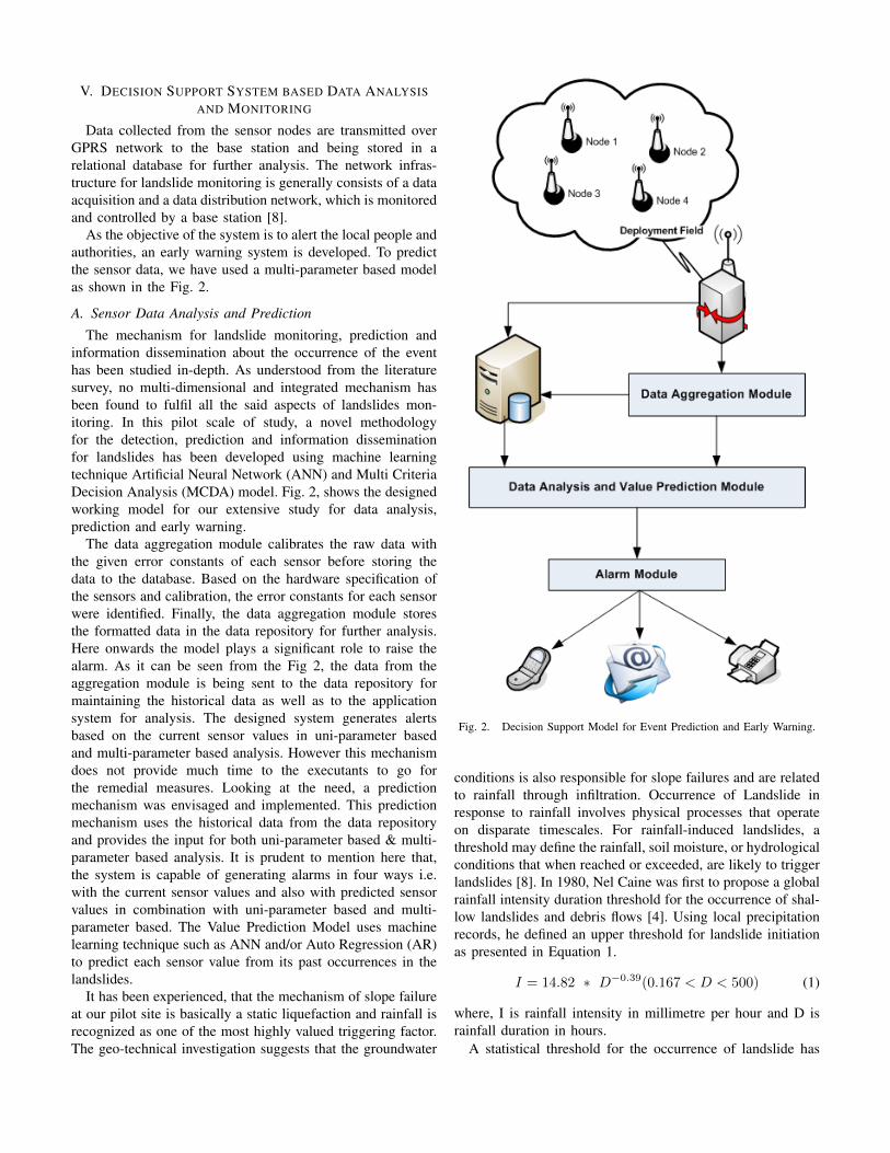
V. DECISION SUPPORT SYSTEM BASED DATA ANALYSISAND MONITORING
Data collected from the sensor nodes are transmitted overGPRS network to the base station and being stored in arelational database for further analysis. The network infras-tructure for landslide monitoring is generally consists of a dataacquisition and a data distribution network, which is monitoredand controlled by a base station [8].
As the objective of the system is to alert the local people andauthorities, an early warning system is developed. To predictthe sensor data, we have used a multi-parameter based modelas shown in the Fig. 2.
A. Sensor Data Analysis and Prediction
The mechanism for landslide monitoring, prediction andinformation dissemination about the occurrence of the eventhas been studied in-depth. As understood from the literaturesurvey, no multi-dimensional and integrated mechanism hasbeen found to fulfil all the said aspects of landslides mon-itoring. In this pilot scale of study, a novel methodologyfor the detection, prediction and information disseminationfor landslides has been developed using machine learningtechnique Artificial Neural Network (ANN) and Multi CriteriaDecision Analysis (MCDA) model. Fig. 2, shows the designedworking model for our extensive study for data analysis,prediction and early warning.
The data aggregation module calibrates the raw data withthe given error constants of each sensor before storing thedata to the database. Based on the hardware specification ofthe sensors and calibration, the error constants for each sensorwere identified. Finally, the data aggregation module storesthe formatted data in the data repository for further analysis.Here onwards the model plays a significant role to raise thealarm. As it can be seen from the Fig 2, the data from theaggregation module is being sent to the data repository formaintaining the historical data as well as to the applicationsystem for analysis. The designed system generates alertsbased on the current sensor values in uni-parameter basedand multi-parameter based analysis. However this mechanismdoes not provide much time to the executants to go forthe remedial measures. Looking at the need, a predictionmechanism was envisaged and implemented. This predictionmechanism uses the historical data from the data repositoryand provides the input for both uni-parameter based & multi-parameter based analysis. It is prudent to mention here that,the system is capable of generating alarms in four ways i.e.with the current sensor values and also with predicted sensorvalues in combination with uni-parameter based and multi-parameter based. The Value Prediction Model uses machinelearning technique such as ANN and/or Auto Regression (AR)to predict each sensor value from its past occurrences in thelandslides.
It has been experienced, that the mechanism of slope failureat our pilot site is basically a static liquefaction and rainfall isrecognized as one of the most highly valued triggering factor.The geo-technical investigation suggests that the groundwater
Fig. 2. Decision Support Model for Event Prediction and Early Warning.
conditions is also responsible for slope failures and are relatedto rainfall through infiltration. Occurrence of Landslide inresponse to rainfall involves physical processes that operateon disparate timescales. For rainfall-induced landslides, athreshold may define the rainfall, soil moisture, or hydrologicalconditions that when reached or exceeded, are likely to triggerlandslides [8]. In 1980, Nel Caine was first to propose a globalrainfall intensity duration threshold for the occurrence of shal-low landslides and debris flows [4]. Using local precipitationrecords, he defined an upper threshold for landslide initiationas presented in Equation 1.
I = 14.82 ∗ D−0.39(0.167 < D < 500) (1)
where, I is rainfall intensity in millimetre per hour and D israinfall duration in hours.
A statistical threshold for the occurrence of landslide has
been measured based on the analysis of historical inventory oflandslides events. It has been defined by investigating variousparameters like: total rainfall; antecedent rainfall; rainfallintensity, and rainfall duration.
B. Multi-Parameter Level Early Warning
In our study we have adopted a multi level warning systemto give alert for the onset landslides, which has not been foundin the literature so far. There are two aspects to generate thealarm such as with current sensor value and predicted sensorvalue with uni-parameter based and multi-parameter based. Inuni-parameter based, the alert gets triggered when any one ofthe influencing factor reaches or exceeds its threshold valuewhere as in muti-level based it considers multiple factorsfor the threshold. These alerts also can be triggered on thepredicted sensor value and current sensor value. However, thesystem follows the same mechanism to generate the alarm. Thesystem compares the sensor values (current/predicted) with themonitoring threshold (MT) and works in the following manner:
• Green Signal Warning or No Warning: When all thecaptured sensor value are less than MT, during this periodthe system only shows a green button representing nocurrent risk or everything is in normal situation. This levelis only for the monitoring purpose at the base station.In this situation no warning will be given to the localauthority or local people.
• Yellow Signal or First Level Warning: When the mostvalued triggering factor i.e. rainfall intensity reaches orexceeds the MT(Rain Gauge) value, then the systemshows a orange button in the developed monitoringsoftware interface representing that there is a chance ofoccurrence of landslide in the recent future. During thisperiod a warning is given through beeping sound at themonitoring station and text message / fax to the localauthority.
• Orange Signal or Second Level Warning: The rainfallinduces increase in water table / the pore water pres-sure. Subsequently this triggers the next level of warn-ing. When pore pressure reaches or exceeds the MT(Piezometer) along with MT (Rain Gauge), the systemshows an ORANGE button representing further chance ofoccurrence of landslide in recent future. This also sendsalert SMS to concerned authorities. This level of alertsuggests avoiding going to that region.
• Red Signal or Third Level Warning: Due to increase inpore water pressure, the landmass starts displacing fromits original location and in turn triggers the landslide.When other triggering factor i.e. displacement of masses/ inclination of natural slopes reaches or exceeds theMT(Extensometer) / MT(Inclinometer) respectively alongwith MT (Rain Gauge) and MT (Piezometer), the systemshows a RED button representing a greater chance ofoccurrence of landslide in recent future. During thislevel local people to be alerted about the occurrence oflandslide by louder speaker or sirens. This also sends alertSMS to concerned authorities. This level of alert suggests
the local people to vacate the place or avoid going to thatregion.
VI. CONCLUSION
This paper presents a novel methodology to monitor the oc-currence of landslides and predict the same before it happens.Based on the geo-technical circumstances of the deploymentsite, the possible required parameters were duly selected.Beyond the analysis at local base station, this paper en-lightsthe possibility of data transmission over a GSM/GPRS networkto a remote site. This in turn will help to monitor multiplebase stations placed at far distances. The adopted methodologygives the provision to disseminate the captured data for furtheranalysis and reporting purpose.
This shows the possible ways and means of detecting theany kind of natural disasters by observing the responsible pa-rameters. The software has been developed with its dynamismand can be configured to address any type of sensor basedmonitoring needs.
ACKNOWLEDGMENT
This research is supported and funded by the Ministryof Communication & Information Technology (MCIT), De-partment of Electronics and Information Technology (DeitY),Govt. of India. The authors are thankful to Shri B. M. Baveja,Group Coordinator, CC&BT, DeitY, MCIT, New Delhi. Au-thors are also thankful to the Directors and Scientists ofrespective CSIRs institutes for their kind guidance and support.
REFERENCES
[1] Arun Kumar, Proceeding of the Ninety Eighth Session of The IndianScience Congress, Chennai, 2011.
[2] M. S. Lodhi and K. Mazumdar, Living with Hazards and Dealing withDisastres in Arunachal Pradesh, ENVIS Bulletin: Himalayan Ecology 17,ENVIS Centre, GBPIHED, 2009.
[3] Jotisankasa, A., Hunsachainan, N., Kwankeo, N., Chunrod, P. & Man-charoen, J, ”Development of A Wireless Landslide Monitoring System”,International Conference on Slope 2010 : Geotechnique and Geosynthet-ics for slopes, Chiangmai, Thailand, July, 2010.
[4] Yang Hong, Robert F. Adler, George Huffman, ”An Experimental GlobalPrediction System for Rainfall-Triggered Landslides Using Satellite Re-mote Sensing and Geospatial Datasets”, IEEE Transactions on Geoscienceand Remote Sensing, Vol. 45, No. 6, June 2007.
[5] Leonardo Zan, Gilberto Latini, Evasio Piscina, Giovanni Polloni, Pier-amelio Baldelli, ”Landslides Early Warning Monitoring System”, Geo-science and Remote Sensing Symposium, Pages 188 190, IEEE Interna-tional, 2002.
[6] Maneesha V. Ramesh and P. V. Ushakumari, ”Threshold Based DataAggregation Algorithm To Detect Rainfall Induced Landslides”, 2009.
[7] Fausto Guzzetti, Silvia Peruccacci, Mauro Rossi, Colin P. Stark, ”Therainfall intensityduration control of shallow landslides and debris flows:an update”, Springer-Verlag, 2007.
[8] Richard M. Iverson, ”Landslide triggering by rain infiltration”, WaterResources Research, Vol. 36, No. 7, Pages 18971910, July 2000.
[9] Sahoo, B. P. S., Satyajit Rath, and Deepak Puthal. ”Energy efficient proto-cols for wireless sensor networks: A survey and approach.” InternationalJournal of Computer Applications 44.18 (2012): 43-48.
[10] I.F. Akyildiz, W. Su, Y. Sankarasubramaniam, E. Cayirci, ”Wirelesssensor networks: a survey” , Elsevier, Computer Networks, Vol. 38, Issue4, Pages 393 422, March 2002.
[11] Sahoo, B. P. S., and Satyajit Rath. ”Integrating GPS, GSM andCellular Phone for Location Tracking and Monitoring.” arXiv preprintarXiv:1307.3147 (2013).
[12] Xianguo Cui ,Xiaowen Zhao, Min Ji, Shanshan Wang, Panpan Zhang,”Research On Landslide Prediction Based On Support Vector Model”,The International Archives of the Photogrammetry, Remote Sensing andSpatial Information Sciences, Vol. 38, Part II.
[13] Gaelle Danneels, Eric Pirard, Hans-Balder Havenith, ”Automatic land-
slide detection from remote sensing images using supervised classificationmethods”, Geoscience and Remote Sensing Symposium, Pages 30143017, IEEE International, 2007.