56
Murrah Flora Reserves Draft Final Working Plan Mumbulla, Tanja, Murrah and Bermagui state forests Reserve numbers 187, 188, 189, 190 NSW South Coast Forest Protection Area

Murrah Flora Reserves Draft Final Working Plan
Mumbulla, Tanja, Murrah and Bermagui state forests Reserve numbers 187, 188, 189, 190 NSW South Coast Forest Protection Area

© 2017 State of NSW, Forestry Corporation of NSW and Office of Environment and Heritage
With the exception of photographs, the State of NSW, Forestry Corporation of NSW and Office of
Environment and Heritage are pleased to allow this material to be reproduced in whole or in part for
educational and non-commercial use, provided the meaning is unchanged and its source, publisher
and authorship are acknowledged. Specific permission is required for the reproduction of
photographs.
The Forestry Corporation of NSW (FCNSW) and Office of Environment and Heritage (OEH) has compiled this publication in good faith, exercising all due care and attention. No representation is made about the accuracy, completeness or suitability of the information in this publication for any particular purpose. OEH shall not be liable for any damage which may occur to any person or organisation taking action or not on the basis of this publication. Readers should seek appropriate advice when applying the information to their specific needs.
All content in this publication is owned by OEH and is protected by Crown Copyright, unless credited
otherwise. It is licensed under the Creative Commons Attribution 4.0 International (CC BY 4.0),
subject to the exemptions contained in the licence. The legal code for the licence is available at
Creative Commons.
OEH and FCNSW asserts the right to be attributed as author of the original material in the following
manner:
© State of New South Wales, Forestry Corporation of NSW and Office of Environment and Heritage
2017.
This publication is for discussion and comment only. Publication indicates the proposals are under
consideration and are open for public discussion. Provisions in the final working plan may not be the
same as those in this draft plan.
Acknowledgments
This plan has been jointly prepared by members of the project steering committee and the Gulaga
and Biamanga boards of management, and staff of the NSW National Parks and Wildlife Service
(NPWS), Forestry Corporation of NSW and the Department of Primary Industries.
NPWS acknowledges that Murrah Flora Reserves are in the traditional Country of the Djirringanj Yuin
(Djuwin) People.
For additional information or any inquiries about the reserves or this plan of management, contact the
NPWS Central Area, Far South Coast Region, cnr Graham and Burrawang Streets (PO Box 282),
Narooma 2546, or by telephone on 02 4476 0800.
Cover photo: Koala at Wapengo in an area adjoining Murrah Flora Reserves (Photo: John Marsh).
Published by:
Forestry Corporation of NSW and Office of Environment and Heritage
59 Goulburn Street, Sydney NSW 2000
PO Box A290, Sydney South NSW 1232
Phone: +61 2 9995 5000 (switchboard)
Phone: 131 555 (environment information and publications requests)
Phone: 1300 361 967 (national parks, general environmental enquiries, and publications requests)
Fax: +61 2 9995 5999
TTY users: phone 133 677, then ask for 131 555
Speak and listen users: phone 1300 555 727, then ask for 131 555
Email: [email protected]
Website: www.environment.nsw.gov.au
ISBN 978-1-76039-622-0
OEH 2016/0762
December 2017
iii
Contents
List of figures iv
List of tables iv
1. Introduction 1
2. Governance and partnerships 3
3. Overarching values of the reserves 3
4. Description of the reserves 4
Location 4
Geography 4
Geology and soils 5
Climate 5
Vegetation 5
Vertebrate fauna 8
Utilities and inholdings 9
Encroachments 9
5. History and heritage 10
Aboriginal history and heritage 10
Forest management history and heritage 11
Fire history 11
Other history and heritage 12
6. Current usage 13
7. Management 14
Objectives of management 14
Adaptive management 14
Management actions 15
Koala population 15
Koala habitat improvement 16
Cultural values and Aboriginal involvement in land management 17
Roads and infrastructure 17
Weeds 18
Pest animals 18
Fire 18
Community engagement 19
Encroachments 20
iv
8. Permissible activities 20
Activities not permitted 20
Activities permitted with conditions 20
Activities permitted without approval or conditions 21
9. Monitoring, reporting and review 21
Koala monitoring 21
Koala habitat monitoring 22
General monitoring and reporting 22
10. References 22
Appendix 1: Native plant list 25
Appendix 2: Native animal list 42
Appendix 3: Named vehicle trails, bicycle and horse access, and maintenance of roads and trails 49
Appendix 4: Works program action list 51
List of figures
Figure 1: Location map 2
Figure 2: Elements of an adaptive management process for management plans 15
List of tables
Table 1: Flora reserves subject to this plan 1
Table 2: Description of component reserves 4
Table 3: Percentages of commonly occurring species in each of the reserves 7

Murrah Flora Reserves Draft Final Working Plan
1
1. Introduction
In 2016 the NSW Government dedicated state forest areas between Bega and Bermagui as flora reserves under the Forestry Act 2012. In a unique arrangement, the NSW National Parks and Wildlife Service (NPWS) has been appointed land manager for these reserves.
The primary purpose of this arrangement is to conserve the south coast’s last known koala (Phascolarctos cinereus) population and extend the protection of a natural and cultural landscape incorporating Biamanga and Gulaga national parks, both of which are Aboriginal owned and managed by a majority Aboriginal owner board of management. Under the Forestry Act, flora reserves must be managed for the preservation of native plants and animals in accordance with a working plan.
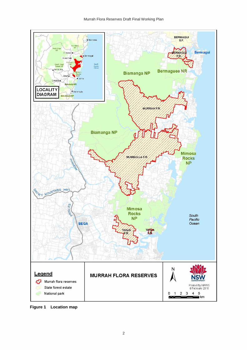
This working plan has been prepared in accordance with section 25 of the Forestry Act for the land parcels shown in Table 1 and Figure 1 (collectively referred to as the Murrah Flora Reserves). The four flora reserves total 11,811 hectares.
Table 1 Flora reserves subject to this plan
State forest Part subject to this plan Area (ha)
Mumbulla State Forest No. 605 Mumbulla Flora Reserve No. 187 6,146
Tanja State Forest No. 544 Tanja Flora Reserve No. 188 868
Murrah State Forest No. 140 Murrah Flora Reserve No. 189 4,223
Bermagui State Forest No. 142 Bermagui Flora Reserve No. 190 574
Source: NSW Government Gazette
Background information on these parcels has been aggregated from Forestry Corporation of New South Wales (FCNSW) records and consultations, input from the working plan steering committee and NPWS project staff. This information has been used to develop the management objectives and actions outlined in this working plan.
The objectives and actions deliver landscape management that integrates the Murrah Flora Reserves with adjoining land uses. They include basic stewardship activities such as managing roads, pests, weeds, fire, visitor facilities, visitor safety and boundary issues, as well as specific actions to improve koala habitat and promote Aboriginal cultural values and participation.
The plan is couched in the emerging policy and science of the NSW Government’s whole-of-government NSW Koala Strategy (on public exhibition at the time of writing). An adaptive approach will be applied so that lessons learnt and information arising can be used to adjust this plan as required.
The working plan will be finalised following consideration of public comment on this draft.
Murrah Flora Reserves Draft Final Working Plan
2
Figure 1 Location map

Murrah Flora Reserves Draft Final Working Plan
3
2. Governance and partnerships
Flora reserves offer similar conservation and public use benefits to those offered through the national park estate managed by NPWS. The dedication of the Murrah Flora Reserves provides important connections between adjoining Aboriginal-owned lands and national park estate held sacred by the traditional owners. It also provides the opportunity to integrate management programs to aid the recovery of the koala population and manage other significant ecological and cultural features valued by the community.
To facilitate this management the Chief Executive, Office of Environment and Heritage (OEH) has been appointed as land manager of the Murrah Flora Reserves by the Minister for Primary Industries under s.57(3) of the Forestry Act. This will enable NPWS (under the direction of the Chief Executive, OEH) to manage the land in accordance with this working plan.
In preparing this plan NPWS has sought neighbour and stakeholder input including FCNSW, NSW Rural Fire Service (RFS), Local Land Services, Crown Lands and other agencies. The boards of management for the Aboriginal-owned Biamanga and Gulaga national parks were engaged and continue to provide essential co-management and partnership advice for the ongoing management of the flora reserves.
The area of the Murrah Flora Reserves directly south of Gugunyal Road (formally Mumbulla Trig Road) is already declared as part of the Biamanga Aboriginal Place. The boards aspire to have the remaining areas of Murrah Flora Reserves recognised for their cultural heritage values under an Aboriginal place declaration, and the Murrah Flora Reserves ultimately added to Biamanga National Park. This plan is written in a way that can be used by NPWS to support this aspiration.
3. Overarching values of the reserves
The Murrah Flora Reserves contain the following overarching values requiring conservation and management.
• Habitat for a range of threatened native plant and animal species. This, along with adjoining forested lands, supports the only koala population known to persist in the coastal forests between the Illawarra and the Victorian border.
• A rich Aboriginal heritage and cultural landscape, including traditional pathways, that are significant to traditional owners and the wider community.
• Coastal lagoon, river and creek catchments with high quality conservation, recreation and aquaculture values.
• Tourism potential from its location in the northern portion of Australia’s Coastal Wilderness as designated by the Australian Government’s National Landscapes Program (DEE 2016).
These overarching values are broken down in more detail in the following sections. To make the document clear and easy to use, natural and cultural heritage, park use and threats to values are dealt with individually but their interrelationships are recognised.

Murrah Flora Reserves Draft Final Working Plan
4
4. Description of the reserves
Location
The Murrah Flora Reserves are located on the south coast of New South Wales, east of the Princes Highway and west of the Bermagui/Tathra Road, and stretch for over 30 kilometres from Bermagui in the north to near Tathra in the south. Along with the surrounding forested private lands and national park estate, including Bermaguee Nature Reserve, Biamanga National Park and Mimosa Rocks National Park, they form a continuous native forest between the foothills and the coast (see Figure 1).
The Murrah Flora Reserves are made up of the four state forest reserves shown in Figure 1 and described in Table 2 below.
Table 2 Description of component reserves
State forest reserve Description
Mumbulla Flora Reserve No. 187
15 kilometres north of Tathra, is bounded in part by Murrah Flora Reserve (north), Biamanga National Park (west) and Mimosa Rocks National Park (south). Private land also neighbours parts of the boundary in the south-west, north and east.
Tanja Flora Reserve No. 188
4 kilometres north and north-west of Tathra, immediately south of Mimosa Rocks National Park. It is bordered to the east, south and west by private land. It comprises two disjunct portions, the smaller portion located just west of the Tathra–Bermagui Road. The larger portion lies about 2 kilometres further west.
Murrah Flora Reserve No. 189
10 kilometres south-west of Bermagui and 4 kilometres east of Quaama. It is bounded to the west, north and south by Biamanga National Park and Mumbulla Flora Reserve. Private land neighbours the reserve to the east and south. The Murrah River forms the boundary between Murrah and Mumbulla flora reserves.
Bermagui Flora Reserve No. 190
3 kilometres west of Bermagui. It is bounded in the south by Bermaguee Nature Reserve. To the north, across the Bermagui River, lies Bermagui State Forest. Private property neighbours the western, eastern and parts of the southern boundary.
Geography
The Murrah Flora Reserves are located in the South East Corner Bioregion (IBRA 2012) within a landscape of coastal foothills and ridges. In the east there are some areas of coastal lowland and floodplain associated with the major river systems and estuaries.
Elevations range from over 350 metres above sea level in areas along the western edge of Murrah and Mumbulla flora reserves to the mean high tide mark in the eastern sections closest to the coastline. Tanja and Bermagui reserves are generally lower in elevation than Murrah and Mumbulla flora reserves.
The Murrah Flora Reserves occur in nine catchment areas including (from north to south) Bermagui River, Mangans Creek and Baragoot Lake, Cuttagee Creek and Lake, Murrah River, Bunga Lagoon, Wapengo Creek and Lagoon, Middle Lagoon, Nelsons Creek and Lagoon and the Bega River.
The reserves lie within the administrative regions of the South Coast Forest Protection Area of NSW, South East Region Local Land Services, Merrimans and Bega Local Aboriginal Land Councils, NPWS South Coast Branch, FCNSW Southern Region and Bega Valley Shire Council.

Murrah Flora Reserves Draft Final Working Plan
5
Geology and soils
Government records (AGG 2016) show the dominant geology of the reserves is sedimentary from the Ordovician period, including slate, siltstone, sandstone, shale and greywacke of the Adaminaby Group. Devonian period granites of the Mumbulla Suite group occur as intrusions in association with a number of mountain peaks in the area, including Mumbulla Mountain (Mumbulla Flora Reserve) and Doctor George Mountain (Mumbulla and Tanja flora reserves).
Soils are mostly yellow podosols, moderately shallow and well-drained. The south-west area of Mumbulla Flora Reserve has a mixture of red podosol soils and yellow earths. Very small areas of red earths occur in both Murrah and Mumbulla flora reserves. Small areas of saline soils are associated with the river and estuarine landscapes, particularly in Bermagui Flora Reserve. The steeper slopes are susceptible to erosion if disturbed (Tulau 1997).
Evidence from koala surveys over the past 10 years (DECCW 2010; OEH 2016b) suggests the most important koala habitat occurs on sedimentary, rather than granitic geology.
Climate
Bureau of Meteorology summaries for the period 1961–1998 from the Merimbula Airport automatic weather station (AWS) show the mean maximum temperature was 24.6°C in January and the mean minimum temperature was 4.4°C in July. The mean annual rainfall was 829 millimetres, the wettest month being March and the driest July (BOM 2016).
Summaries for the period since 1998 (when the recording process changed) show the mean maximum temperature as 24.7°C in January and the mean minimum temperature as 4.2°C in July. The mean annual rainfall is 767 millimetres, the wettest month being February and the driest August. While mean temperatures have not changed significantly, it appears there is an overall reduction in mean annual rainfall since 1998 (BOM 2016).
Being inland it is expected that the Murrah Flora Reserves’ climate differs slightly from that of coastal Merimbula. For example, the reserves’ foothill environments are likely to be warmer during the day in summer and cooler overnight in winter.
The working plan uses Merimbula AWS data instead of Bega AWS as Merimbula affords a closer (but probably cooler) climatic representation of the reserves.
Based on long-term (1910–2011) observations, temperatures in the South East and Tablelands Region have been increasing since about 1960, with higher temperatures experienced in recent decades. The region currently experiences considerable rainfall variability across the region and from year-to-year, and this variability is also reflected in the projections. Current predictions are that soon (i.e. by 2039) the region will experience an increase in temperatures, a decrease in spring and winter rainfall and an increase in fire weather (OEH 2016c).
Vegetation
Forest types
Vegetation mapping undertaken by the then Forestry Commission of NSW using forest type classifications developed by Baur (1965) indicated that the predominant forest types in the Murrah Flora Reserves were the yellow stringybark, yellow stringybark – gum, coastal stringybark, silvertop ash and silvertop ash – stringybark groups.
Vegetation mapping based on floristic assemblages and their relationship with land cover pattern, substrate, climatic and terrain variables was subsequently undertaken by Keith and

Murrah Flora Reserves Draft Final Working Plan
6
Bedward (1999)1 for the Comprehensive Regional Assessment Process. The predominant communities mapped in the Murrah Flora Reserves were:
• Type 32: coastal dry shrub forest
• Type 34: coastal gully shrub forest
• Type 13: hinterland wet fern forest
• Type 47: Eden dry shrub forest
• Type 48: Mumbulla dry shrub forest
• Type 6: coastal warm temperate rainforest.
Threatened ecological communities
In 2016 an assessment was undertaken in the coastal Crown forest estate on a subset of threatened ecological communities (TECs) listed under the Threatened Species Conservation Act 1995. Coastal Saltmarsh, Swamp Oak Floodplain Forest and River-flat Eucalypt Forest TECs are assessed as occurring in low lying areas of the reserves.
It is possible that small patches of TECs not part of the assessment, such as Freshwater Wetlands on Coastal Floodplains, could occur in the reserves.
Forest condition
Records show that most accessible areas of the Murrah Flora Reserves have been previously harvested (FCNSW 2016). Agency staff and contractors working on koala surveys (1996–98, 2007–09 and 2012–14) observe that in many areas few senescent or hollow-bearing trees remain. They also observe that intensively harvested and impacted areas appear to have an altered mix of tree species, with less of the slower-growing species, such as woollybutt (Eucalyptus longifolia) and ironbark (E. tricarpa) and more of the rapidly growing species that favour disturbance, such as black she-oak (Allocasuarina littoralis), silvertop ash (E. sieberi) and yellow stringybark (E. muelleriana).
Mid storey structure and composition varies across the reserves, with a key management issue being the extent of black she-oak regrowth and other disturbance-generated tree and shrub species. These contribute to increased vertical fuel loads and prevent germination and regeneration of preferred koala species, particularly woollybutt.
In areas where less disturbance has occurred, the ridges and slopes are usually more open, with ground cover dominated by grasses and forbs.
Forest condition or ‘health’ is a complex issue and monitoring of this and its interaction with the conservation programs planned for the reserves is an objective of this working plan.
Tree species
The koala survey undertaken in 2012–14 (OEH 2016b) assessed 456 grid sites at 500-metre intervals across the Murrah Flora Reserves. These provided detailed information on the distribution and abundance of tree species, with the relative proportions of commonly occurring trees provided in Table 3 below.
1 Enhanced by Beukers and Miles (2006) in surrounding national parks and near coastal strip.

Murrah Flora Reserves Draft Final Working Plan
7
Table 3 Percentages of commonly occurring species in each of the reserves
Tree species Flora reserve name
Botanical name Common name Bermagui Murrah Mumbulla Tanja
Eucalyptus muelleriana Yellow stringybark 13% 20% 16% 35%
Allocasuarina littoralis Black she-oak 6% 17% 13% 4%
Eucalyptus sieberi Silvertop ash 7% 11% 16% 2%
Eucalyptus longifolia Woollybutt 16% 10% 11% 14%
Eucalyptus globoidea White stringybark 9% 6% 9% 1%
Angophora floribunda Rough-barked applebox 4% 5% 4% 4%
Eucalyptus agglomerata Blue-leaved stringybark 3% 6% 2% 4%
Eucalyptus tricarpa Red ironbark 3% 3% 3% 3%
Eucalyptus bosistoana Coast grey box 6% 1% 3% 9%
Corymbia maculata Spotted gum 11% 1% 0% 0%
Acacia falciformis Broad-leaved hickory 0% 4% 2% 7%
Eucalyptus cypellocarpa Monkey gum 4% 4% 1% 3%
Backhousia myrtifolia Cinnamon myrtle 4% 1% 1% 0%
Corymbia gummifera Red bloodwood 5% 0% 0% 0%
Percentage of total trees sampled 91% 86% 86% 86%
*Note: rarer tree species not included, only common ones; thus totals do not add to 100%.
Of these common species, yellow stringybark, woollybutt and black she-oak occur throughout the reserves. White stringybark is also widespread, but has a more localised distribution in the Murrah Flora Reserves (occurring more in the eastern parts) and Tanja Flora Reserve (occurring more in the western parts).
Due to disturbance, silvertop ash often occurs in extensive single-species stands in various parts of Mumbulla Flora Reserve, contributing to the relatively high proportion of this tree recorded across this reserve. Koalas rarely utilise silvertop ash within these extensive single-species stands, however they routinely use silvertop ash in areas of high eucalypt diversity.
Other common tree species include monkey gum, which occurs throughout the reserves, generally in gullies and moister south-facing slopes. Coast grey box has a higher proportion in Tanja Flora Reserve than elsewhere. Spotted gum (Corymbia maculata) occurs in small patches along the eastern fringe of Bermagui, Tanja and Murrah flora reserves.
Of these eucalypts, woollybutt, white stringybark and monkey gum are most preferred by koalas (OEH 2016b) in the study area.
Rainforest also occurs in the larger gullies throughout the reserves. This community often merges into wetter eucalypt forest types that also generally have an understory of shrubs, vines and herbaceous ground covers. These areas were not directly impacted by previous harvesting and may include remnants of Dry Rainforest of the South East Forests TEC.
A native plant list showing species recorded in the reserves is provided at Appendix 1, sourced from NSW BioNet, Atlas of NSW Wildlife (OEH 2016a).
Threatened native plants
Three threatened plants are recorded as occurring in the reserves. They are narrow-leafed wilsonia (Wilsonia backhousei), Bega wattle (Acacia georgensis) and chef's cap correa

Murrah Flora Reserves Draft Final Working Plan
8
(Correa baeuerlenii). Narrow-leafed wilsonia is at its southern limit of distribution in New South Wales and is listed as vulnerable under the Threatened Species Conservation Act. Bega wattle and chef’s cap correa occur across a similar range and are listed as vulnerable under both the Threatened Species Conservation Act and the Commonwealth Environment Protection and Biodiversity Conservation Act 1999.
Vertebrate fauna
Overall there are 175 animal species recorded in the Murrah Flora Reserves (Appendix 2). Of these 29 are listed as threatened under the Threatened Species Conservation Act and/or the Environment Protection and Biodiversity Conservation Act. This list includes 10 mammals, such as the koala, long-nosed potoroo (Potorous tridactylus), greater glider (Petauroides volans) and spotted-tailed quoll (Dasyurus maculatus), and 13 birds including the regent honeyeater (Anthochaera phrygia). Four other birds recorded in the Murrah Flora Reserves are listed under Commonwealth bilateral migratory bird agreements. Three threatened frog species have been recorded, including the stuttering frog (Mixophyes balbus) and green and golden bell frog (Litoria aurea). These species may no longer persist due to the spread and effects of the Chytrid fungus.
Koala
The koala, listed as vulnerable under both the Threatened Species Conservation Act and the Environment Protection and Biodiversity Conservation Act, occurs across the reserves. The listed threats to the koala most relevant to the Far South Coast population are fire, drought and extreme temperatures, habitat modification, predation by dogs and exacerbating impacts associated with climate change (DECC 2008b).
In 2016 the NSW Chief Scientist released an independent review on the status of koalas in New South Wales. It recommended that selectively across the state koala numbers should be stabilised and then increased by protecting, rehabilitating and connecting koala habitat and by managing and mitigating threats to koalas. The study estimated that a 26% decline has occurred in the NSW population over the past three koala generations (15–21 years) and predicts a similar decline for the next three generations (CSEO 2016).
Analysis of reported sightings by residents in the Bermagui-Cobargo area (DECCW 2008a) reveals a decline in koala numbers in recent decades in forests to the north of the Bermagui River. Surveys managed by the NSW Office of Environment and Heritage in the periods 2007–09 and 2012–14 (DECCW 2010; OEH 2016b) suggest that koala numbers were at least stable in that period and that the Murrah Flora Reserves form a key part of the habitat sustaining the remaining koala population.
The 2007–09 survey was undertaken and funded by NPWS and FCNSW. The 2012–14 survey was undertaken by the Corridors and Core Habitat for Koalas on the NSW Far South Coast project (hereinafter referred to as the Koala Project), a NSW interagency program funded by the Australian Government’s Biodiversity Fund. Both surveys used community-based survey contractors and volunteers.
The survey results suggested that the population recorded in the Murrah Flora Reserves is the last one known to persist on the south coast, consisting of between 30 and 60 koalas. Although extinction of this population is a real possibility, consistent results from each survey period give some confidence that the population is stable and capable of recovery (DECCW 2010; OEH 2016b).
The survey results were consistent with the findings of Hindell and Lee (1987) and Jurskis and Potter (1997) suggesting that koalas prefer larger trees. The discontinuation of timber harvesting in the Murrah Flora Reserves is expected to improve this aspect of the koala’s habitat.

Murrah Flora Reserves Draft Final Working Plan
9
Koalas are also known to select feed trees based on leaf chemistry. The koala surveys have been recording leaf chemistry of occupied and unoccupied trees. The results show, however, that there are no measurable differences in leaf chemistry between trees at occupied and unoccupied sites. It is concluded that the range and density of the koala population is not significantly limited by leaf chemistry and therefore it is possible that the existing low-density koala population is capable of expanding to unoccupied forest if threats are controlled (Stalenberg et al. 2014).
The aim is that with the cessation of forestry and some specific management actions, koala recovery in the Murrah Flora Reserves and adjacent forest can be realised over time. This will be tested in the long term by monitoring and evaluation within an adaptive management framework.
Long-nosed potoroo
The Murrah Flora Reserves support the long-nosed potoroo, which is listed as vulnerable under both the Threatened Species Conservation Act and the Environment Protection and Biodiversity Conservation Act. The reserves’ potoroos are part of an important, but fractured, coastal population that is the focus of a Local Land Services (LLS) cross-tenure conservation program. The program has established and undertaken monitoring at more than 50 plots on private properties adjoining and near to the reserves, and is providing community education about the conservation of the species. In work that complements NPWS wild dog/fox control on park estate, LLS is undertaking control programs on private properties including some near to the Murrah Flora Reserves as part of the potoroo program.
Utilities and inholdings
Telstra subsurface phone lines run throughout the reserves and are marked in numerous locations. A National Broadband Network tower and town water supply tanks are located adjacent to the Bermagui Flora Reserve between Nutleys Creek Road and Alexander Drive.
The reserves have 149 neighbouring private lots, 23 of which are inholdings. The number of adjoining lots per reserve are as follows:
• Bermagui Flora Reserve: 21 private lots and one lot owned by Bega Valley Shire Council
• Murrah Flora Reserve: 30 private neighbouring lots of which 8 are inholdings
• Mumbulla Flora Reserve: 66 neighbouring lots of which 15 are inholdings
• Tanja Flora Reserve: 32 neighbouring private lots.
Approximately 59 of these lots obtain primary access through the network of reserve roads and trails.
Encroachments
A number of encroachments have been identified within the reserves that require further investigation to determine their legal status and define strategies to manage each issue. The encroachments detected include fences, gates, miscellaneous private materials and buildings. Copies of all relevant Forestry Commission and FCNSW documentation will be provided to NPWS to facilitate the management of these issues, for example any practical access and user agreements.

Murrah Flora Reserves Draft Final Working Plan
10
5. History and heritage
Aboriginal history and heritage
The lands that are the Murrah Flora Reserves lie within the traditional Country of the Djirringanj Yuin (Djuwin) People. These lands and the surrounding landscape contain many important and sacred sites to the Yuin people and other Aboriginal groups that were forced or chose to come to this area.
For much of the year, Aboriginal people lived along the shores of the coastal lakes and estuaries where food and game were plentiful as evidenced from the many shell middens that line the waterways and estuaries. They frequently travelled through the lower-altitude coastal forests of the reserves to reach special hunting and ceremonial areas, all the while managing the landscape with fire and ceremony. These linkages through the coastal forests, along with native species and habitats, form part of a single cultural landscape (OEH 2014). Egloff et al. (2005) document evidence of cultural grouping and ceremonial interaction for the purposes of trade, ceremony and kinship between Djirringanj and more broadly the Yuin Nation and adjoining nations. These nations included the Bidwell, Ngarigo, Ngunawal, Gundungurra and Tharawal peoples.
Since the early 1900s many Aboriginal people have worked in the timber industry in south-east New South Wales, which provided employment, stability and a connection with Country. Feary (2008) documented a broad Aboriginal involvement in the timber industry noting that:
… they (Aboriginal workers) told me that during the 1950s and 1960s on the south coast, forestry was a major employer of Aboriginal people, in the sawmills and as fallers in the forests; they were ‘friends of the Kooris’, at a time when racism and inequality denied many Aboriginal people employment in the mainstream economy.
This history of involvement, both Aboriginal and European, is not well-documented across the forested landscape but many Elders within the communities still hold this knowledge as oral history. For this reason, the working plan recommends the commissioning of a research report based on interviewing local Elders from both the Aboriginal and non-Aboriginal community, to be conducted as soon as practical.
Following a long campaign by the local Aboriginal community, the Biamanga Aboriginal Place was declared in 1980 over an area of Mumbulla State Forest. Most of the place became included in Biamanga National Park, reserved in 1998 through the Eden Regional Forest Agreement process; however, a small area is contained in Mumbulla Flora Reserve.
Biamanga National Park was formally handed back to its traditional owners in May 2006. The Aboriginal community, by way of a majority Aboriginal owner board of management, has full care, control and management of this park, under Part 4A of the National Parks and Wildlife Act 1974. Plans of management have been developed for both Biamanga and Gulaga national parks, and they continue to be jointly managed through a lease agreement with NPWS.
Plan of Management Yuin Bangguri (Mountain) Parks – incorporating Gulaga National Park and Biamanga National Park states it is a priority to manage the mountains as a single landscape and increase the connectivity and protection of land between them. Given this desire, and the strong cultural connections Aboriginal people have with this area, this working plan supports a close and effective partnership with the Biamanga and Gulaga national parks boards that encourages Aboriginal connection to Country.
It is a clear and consistent aspiration of the local Aboriginal owners that the reserves become part of Biamanga National Park and are managed under the Yuin Bangguri (Mountain) Parks Plan of Management (OEH 2014).
Murrah Flora Reserves Draft Final Working Plan
11
Forest management history and heritage
The state forests that comprise the Murrah Flora Reserves were first dedicated as follows:
• Mumbulla State Forest on 2 November 1917
• Bermagui and Murrah state forests on 4 November 1914
• Tanja State Forest on 28 September 1917.
Timber cutting in the region was well underway by the 1890s with the operation of a large mill at Tanja. A glimpse of the timber-cutting history was provided by Henry Lawson who wrote in his poem Bermagui – In a Strange Sunset (1910) that there were ‘stacks of sleepers, sleepers, sleepers and sawn timber along the darkening clay road’.
Originally operations included mostly selective harvesting (often referred to as ‘logging’) for the largest and straightest logs, but over time the market for wood products changed, and more intensive operations became the norm (Lunney & Moon 1988). Railway sleeper-cutting ceased in about 1968 and sawlog-only operations not long after.
With more intensive operations came the policy of Timber Stand Improvement (TSI) targeting the removal of older trees thought to be competing with desired regeneration of straight, millable sawlogs. This is known to have been undertaken in some areas of the Murrah Flora Reserves. TSI was a more intensive operation than selective harvesting. Lunney & Moon (1988) documented 1100 hectares of TSI within the Mumbulla State Forest undertaken between 1964 and 1973.
‘Integrated’ harvesting, where both sawlogs and pulpwood is taken, commenced in Mumbulla State Forest in the 1970s. These operations involved intensive harvesting in alternate coupes, which aimed to spread the impacts throughout the forest, and returning to harvest the adjoining coupes after a period of regeneration. Within most of the reserves only the first round of alternate coupe harvesting was ever undertaken, leaving a patchwork of regenerating and mature forest throughout. Integrated harvesting continued into the 1990s although there have been few such operations in the Murrah Flora Reserves since 1997.
Disturbance by harvesting interwoven with other factors has influenced the current condition of these forests. Thick stands of regenerating black she-oak and other dense regrowth are now a management concern because of their apparent incompatibility with known koala habitat characteristics.
Fire history
Yuin community groups living in and around the coastal forests between Bermagui and Tathra used traditional fire management for a variety of reasons and one fire could serve a number of complex purposes or fulfil a single purpose. The Yuin Bangguri (Mountain) Parks Plan of Management records that:
Fire was an integral part of ‘cleaning up Country’ [opening up the mid storey by reducing fuel loads] over the thousands of years of Aboriginal land management. Fires were lit for many reasons: to make travelling easier; to protect sacred areas; to protect food resources from later fires; to clear around camp sites; to signal to others; and to fulfil spiritual and cultural obligations. These burning practices had the effect of promoting suitable habitats for a range of different plants and animals, and have shaped ecosystems including the dry sclerophyll forests of south eastern Australia. There were also areas which were not burnt, including areas around sacred sites and rainforest. (OEH 2014)
Advice provided by the boards of management for the Aboriginal-owned Biamanga and Gulaga national parks, derived from oral histories, suggests a traditional burning regime was used, and in some areas continued well after colonisation. This would have had the effect of opening up or keeping open many local sclerophyll forests and woodlands.

Murrah Flora Reserves Draft Final Working Plan
12
Aboriginal owners of the Biamanga and Gulaga national parks will have opportunities to undertake traditional burning within the Murrah Flora Reserves.
It is accepted that past Aboriginal burning practices and their ecological outcomes may have varied considerably. Although the exact historical situation may never be known, it is quite possible that much of the forests within the Murrah Flora Reserves are now structurally different to those originally inhabited by Aboriginal people and change in fire regime is likely to be a major contributing factor.
Much has been written on the condition and structure of Australia’s vegetation prior to European settlement and the changes in it since then. While it is generally accepted that the structure and composition of remnant forests on the NSW far south coast have changed since European settlement as a result of fire and other factors, this would have varied from place to place and there may be no fixed pattern to this change. Nonetheless it is interesting context to the working plan and for this reason some texts are summarised below.
The use of fire by Yuin people was first recorded by Europeans when HMS Endeavour sailed up the coast on 18 April 1770. As the ship passed Mount Dromedary (Gulaga) Joseph Banks, Australia’s first recognised naturalist, recorded smoke from small fires presumably set by Aborigines ‘a little way inland and in the evening several more’ (Beaglehole 1963).
Post-colonisation, Howitt (1890) recorded a rapid thickening of woodlands and forests in the Gippsland of Victoria and associated this with the vast reduction in Aboriginal burning and the new fire regime imposed by the European settlers. Gott (2005) notes that early European descriptions emphasised the open nature of dry sclerophyll forests, and cites observations of dense revegetation where traditional Aboriginal land uses, such as periodic burning, had ceased. Romanin et al. (2016) broadly support the notion that Aboriginal land management maintained eucalypt savanna and that European disruption of Aboriginal management resulted in changed fire regimes and associated ecological changes. Rose (1996) writes that ‘Aboriginal burning practices are based on patch-burning with low intensity fires over a number of years to create a mosaic of habitats’.
The more recent fire history has been established from spatial datasets gathered by NPWS, FCNSW and RFS. Wildfire events in NSW far south coast reserves were mostly unrecorded before 1950. The large and devastating fires in the Bega Valley in 1952 probably affected the reserves but the extent is unknown. A large wildfire burnt across Murrah, Mumbulla and Tanja precincts in November 1980. Fire records improved after 1980 and have been maintained since that time for both wildfire events and controlled burns (for post-harvesting regeneration or hazard reduction). Wildfire is recorded as occurring in the Mumbulla precinct in 1968, and in Biamanga National Park in 2002 and 2004. No significant wildfires have been recorded in the reserves area since 1980 (OEH 2011).
Fire has been and continues to be a complex management issue in the reserves. Inappropriate fire regimes can have deleterious effects on forest health, including increased risk to threatened native plants and animals, their food sources and shelter, but also soil condition, hydrology and other environmental conditions. High frequency fire is listed as a key threatening process under the Threatened Species Conservation Act (NSW SC 2000).
The reserves’ fire history shows us that the threat of wildfire is present and unpredictable and the current draft fire management strategy (OEH 2017a) aims to reduce these risks to life, property and biodiversity in the Murrah Flora Reserves and surrounding parks.
Other history and heritage
Alluvial goldmining occurred in the area of the reserves particularly around Tanja Flora Reserve until the early 1900s. Reef mining also occurred throughout the region but was short lived.
Murrah Flora Reserves Draft Final Working Plan
13
The fur trade was at its peak in the late 19th century and koala-skinning operations were undertaken in the Bega Valley (Eco Logical Australia 2006). Koalas were protected from hunting in 1927. Recreational hunting of native animals in the reserves has been illegal since 1974 and has not been recorded as a management issue in recent times.
A detailed history of Mumbulla State Forest (Lunney & Moon 1988), together with other publications detailing the results of ecological research in that forest was undertaken in the 1970s and early 1980s. It provides a rich archive of scientific material which, when compared to today’s known distribution of species, would seem to indicate some ongoing biodiversity decline across the Bega district and surrounds. In particular, several frog species have declined since the 1980s presumably following the spread of Chytrid fungus, while many small terrestrial mammal species have declines beginning around 1900.
People from nearby towns, communities and farms have harvested timber from the reserves for generations, mainly for firewood, fence posts and building. Although now illegal, this harvesting continues at a small scale, with tree felling and collection of fallen timber documented during the winter of 2016.
6. Current usage
At the time of reservation the following activities and uses occurred in the Murrah Flora Reserves:
• Wapengo trigonometric station located in Mumbulla Flora Reserve
• eight beehive set-down locations with apiary (beekeeping) permits located across all reserves
• utility occupation permits for three powerlines (Essential Energy) traversing the northern part of Bermagui Flora Reserve and the southern and easternmost sections of Mumbulla Flora Reserve and for a water main in Bermagui Flora Reserve
• an asset protection zone (buffer) within Tanja Flora Reserve covered by an occupation permit
• an NBN tower located in the eastern section of Bermagui Flora Reserve
• a permit providing for access through Mumbulla Flora Reserve to a telecommunications tower located on Mumbulla Mountain in the neighbouring Biamanga National Park
• seven research plots located within Mumbulla Flora Reserve and a number of areas marked for arboreal mammal survey. These are historic research plots that can be re-measured in future if required in line with activities permitted with conditions
• Aboriginal cultural practices.
No formal visitor facilities exist in the Murrah Flora Reserves but there are informal opportunities on the Bermagui River for camping and picnicking. There has been recent interest in cycling within Tanja and Mumbulla flora reserves and a number of mountain bike race events have been held under a special-purpose permit, each involving over 100 participants.
There is a limited amount of four-wheel driving and car touring use in the reserves. Some roads are used as thoroughfares and connections, as well as being primary access to private properties. Access agreements with FCNSW to inholdings and neighbours exist. An action of this working plan is to validate these agreements and provide certainty to those landholders. Biamanga Cultural Area (Aboriginal Place) is accessed through the reserves.
A limited amount of horse riding occurs in the reserves, mainly undertaken by adjoining landholders. Bushwalking and dog-walking occurs but is also limited to areas adjoining

Murrah Flora Reserves Draft Final Working Plan
14
private properties. There is evidence of illegal firewood cutting and unregistered trail-bike riding in the reserves.
An important ongoing activity is the koala monitoring program, which has recorded koala occupancy and activity levels and other ecological data throughout the reserves and adjoining areas.
A wild dog (Canis lupus familiaris / dingo) and fox (Vulpes vulpes) ground-baiting program to reduce predation of native animals (including koalas and potoroos) is continuing and has been expanded outside of reserved lands. ‘1080’ baits are prepared by LLS and managed across 39 stations by NPWS and over 50 properties by private landholders.
NPWS is aware of a number of private encroachments into the reserves. NPWS will work with the Department of Primary Industries (DPI) and FCNSW to resolve all such encroachments.
7. Management
Objectives of management
The Murrah Flora Reserves will be managed by NPWS as land manager in accordance with the principles, objectives and legislative framework of the Forestry Act. Within this context, the objectives of management will be to:
• implement the koala monitoring program and contribute to the enhancement of koala habitat
• provide for Aboriginal community participation in the conservation of natural and cultural values and practices
• manage wildfire, fuel loads and response capabilities in partnership with fire authorities, surrounding landowners and NPWS wildlife ecologists
• integrate reserve management with adjoining land management programs
• maintain a road and trail network and other infrastructure that can support the required management activities and visitor enjoyment of the reserves
• provide for community engagement in management planning and operations
• deliver on the current regional pest management strategy
• increase knowledge of the reserves and their natural and cultural values.
• improve biodiversity.
Murrah Flora Reserves is a large forested area now excluded from timber harvesting. With time and adaptive management koala habitat quality and biodiversity should improve. If this is not apparent after an appropriate evaluation period, then a change in management strategy would occur, or the objectives of management as expressed in this working plan would be changed.
An interim working plan was developed by NPWS and approved by FCNSW and has been in place since reservation. This draft final working plan builds on that original work.
Adaptive management
Management of the reserves will be undertaken in accordance with the Adaptive Management Position Statement. In simple terms this means implementing safe and suitable management actions while learning about which actions and techniques are most effective at achieving the required objectives.
Murrah Flora Reserves Draft Final Working Plan
15
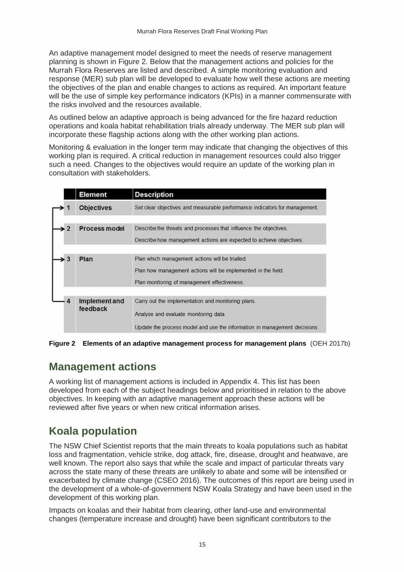
An adaptive management model designed to meet the needs of reserve management planning is shown in Figure 2. Below that the management actions and policies for the Murrah Flora Reserves are listed and described. A simple monitoring evaluation and response (MER) sub plan will be developed to evaluate how well these actions are meeting the objectives of the plan and enable changes to actions as required. An important feature will be the use of simple key performance indicators (KPIs) in a manner commensurate with the risks involved and the resources available.
As outlined below an adaptive approach is being advanced for the fire hazard reduction operations and koala habitat rehabilitation trials already underway. The MER sub plan will incorporate these flagship actions along with the other working plan actions.
Monitoring & evaluation in the longer term may indicate that changing the objectives of this working plan is required. A critical reduction in management resources could also trigger such a need. Changes to the objectives would require an update of the working plan in consultation with stakeholders.
Figure 2 Elements of an adaptive management process for management plans (OEH 2017b)
Management actions
A working list of management actions is included in Appendix 4. This list has been developed from each of the subject headings below and prioritised in relation to the above objectives. In keeping with an adaptive management approach these actions will be reviewed after five years or when new critical information arises.
Koala population
The NSW Chief Scientist reports that the main threats to koala populations such as habitat loss and fragmentation, vehicle strike, dog attack, fire, disease, drought and heatwave, are well known. The report also says that while the scale and impact of particular threats vary across the state many of these threats are unlikely to abate and some will be intensified or exacerbated by climate change (CSEO 2016). The outcomes of this report are being used in the development of a whole-of-government NSW Koala Strategy and have been used in the development of this working plan.
Impacts on koalas and their habitat from clearing, other land-use and environmental changes (temperature increase and drought) have been significant contributors to the

Murrah Flora Reserves Draft Final Working Plan
16
decline of koalas in the Eden region (Lunney et al. 2014). Within this context wildfire (and associated reactive management) and predation are probably the most immediate and major threats to the Murrah koala population. However, should the higher temperatures and more severe periods of drought predicted for the region (OEH 2016c) occur, additional declines are likely to occur, particularly due to wildfire, degradation of browse quality (Lawler et al. 1997) and defoliation (Jaggers 2004). Changes in other more complex threats such as dieback are less clear.
Disease (particularly Chlamydia spp.) is documented as a threat to koalas (DECC 2008b), and may be a significant factor contributing to low koala numbers in the Murrah landscape. There are numerous strains occurring across the koala’s range, some of which may be more virulent than others. There is likely to be varying levels of resilience to the disease in different populations. There is currently no information about the disease status of the Murrah Flora Reserves population. A research project with the University of Sydney is currently underway, analysing fresh koala pellets from the local area. It may provide knowledge of the prevalence and strains of Chlamydia affecting the Murrah population.
The monitoring of koala distribution and occupancy rates will continue with a regular number of grid sites reassessed annually. Data analysis comparing this with previous results will be undertaken by the University of Canberra.
All fresh pellet and tissue samples opportunistically collected will be and are being provided to the Koala Health Hub to assist research into the genetics and disease status of the population.
This monitoring and emerging techniques or technologies may generate the need for new or changed management actions as per the adaptive management framework.
Koala habitat improvement
Agency staff and contractors working on koala surveys (1996–98, 2007–09 and 2012–14) have repeatedly observed that many areas throughout the Murrah Flora Reserves have a modified floristic composition and structure apparently due to disturbances including harvesting and fire. These areas are dominated by dense black she-oak, silvertop ash and/or stringybark regrowth, which contributes to higher vertical fuel-loads and supresses the regeneration of koala browse species, particularly woollybutt.
The NSW Saving our Species Iconic Koala Project is supporting a research program trialling combinations of silvicultural and regeneration techniques at designated treatment plots to test their effectiveness in enabling the regeneration of eucalypt species preferred by koalas. Most of the research plots are in the reserves. A Review of Environmental Factors and Determination has been approved for the project (EnviroKey 2017), the Statewide Koala Advisory Committee has been advised and treatment applications in the plots are currently underway.
Treatments are being undertaken in 30 20m x 20m plots. The treatment matrix includes the application of fire, thinning, raking away ground litter and direct seeding, with some plots containing mature seed trees of the preferred species and some where these are absent. In the case of the thinning plots an additional 10m strip to the north is also thinned, to assist with light penetration.
This monitoring may generate the need for new or changed management action as per the adaptive management framework.
Murrah Flora Reserves Draft Final Working Plan
17
Cultural values and Aboriginal involvement in land
management
Gulaga and Biamanga boards of management were invited into a partnership to develop opportunities for complementary cultural and ecological management of the reserves. The boards of management and Aboriginal owners have provided a significant contribution to the development of this plan.
Ongoing community discussions are planned to enable cultural aspirations to be integrated with other reserve operations, promote Aboriginal cultural values (i.e. knowledge, appreciation, sites and landscapes) and support increased Aboriginal employment in the management of the reserves. These initiatives are likely to involve the Biamanga and Gulaga national parks boards of management, Merrimans and Bega local Aboriginal land councils and other community groups and individuals.
The boards aspire to reintroduce traditional fire management practices, while also contributing to meeting hazard reduction targets. The boards have stated (OEH 2014) that they are keenly interested in such an approach and can adapt and apply their practices as appropriate to meet strategic and safety requirements.
An action in this working plan is for NPWS and RFS staff to provide fire management training to the Aboriginal community to the NSW standards. This training will help them to safely implement traditional fire management practices and achieve greater connection with Country.
Roads and infrastructure
There are over 200 kilometres of roads and trails in the reserves. An assessment was completed to determine those roads needed for management and public access and the standard to which they should be maintained. Those roads no longer required at the current standard are to be downgraded or closed.
The roads assessment has shown the existing road network provides more than adequate access to the Murrah Flora Reserves. Therefore, construction of new roads will be permitted only in exceptional circumstances and consistent with the following principles:
• no practical alternative is available
• the values of the Murrah Flora Reserves will not be significantly affected
• opportunity is provided for public comment on any proposal.
An additional part of this assessment will be undertaken to determine if any of the roads requiring closure could be re-used for other recreational purposes such as walking tracks and horse riding or mountain bike trails. This will require consultation with local recreation groups and NPWS staff.
A number of quarries are located in the reserves that provide materials for road maintenance operations. An action of this plan is for NPWS to ensure the legality and continuity of such gravel sources.
NPWS will continue to maintain and upgrade signage for the reserves.
NPWS will investigate and seek external funding to help conserve existing informal recreational areas, such as at popular river sites.
NPWS will follow standard road maintenance and rehabilitation procedures, including soil hygiene protocols when using machinery, to reduce the risk of weed infestation and the introduction of Phytophthora cinnamomi, an exotic soil-borne water fungus that causes dieback in susceptible native plants.
An inventory of the reserves’ road infrastructure is located at Appendix 3.

Murrah Flora Reserves Draft Final Working Plan
18
Weeds
No significant weed threats in the reserves have been identified, although there are some minor weed infestations of blackberry (Rubus fruticosus agg.), spear thistle (Cirsium vulgare), groundsel bush (Baccharis halimifolia), fireweed (Senecio madagascariensis), cape ivy (Delairea odorata), creeping oxalis (Oxalis corniculata) and a range of succulents. Periwinkle (Littorina litorea) and willows (Silax spp.) have also been reported in some areas of the reserve.
Dumping of garden waste (and the weeds it brings) has been identified as a threat to the reserves, especially on roadsides near to neighbouring communities.
Native plants not endemic to the reserves have been observed in disturbed areas although they are not yet determined to be invasive.
Weeds will be managed in accordance with the NPWS regional pest management strategy (OEH 2012), which includes specific actions for the Murrah Flora Reserves.
Pest animals
There have been extensive fox and wild dog baiting programs undertaken by FCNSW, OEH and LLS as part of a permanent landscape-scale predator control program across the reserves and adjoining areas. Ongoing monitoring as part of this program has revealed only scattered occurrences of dogs and foxes. Cats and deer have also been recorded in the reserves.
Pest animals will be managed in accordance with the NPWS regional pest management strategy (OEH 2012), including actions for the Murrah Flora Reserves which support the regional landscape-scale predator control program.
Fire
The draft Murrah Landscape Fire Management Strategy (FMS) (OEH 2017a) applies to 32,094 hectares across Biamanga National Park, Bermaguee Nature Reserve, Mimosa Rocks National Park and Murrah Flora Reserves. It extends across the landscape and provides protection for koala populations and habitat and human life and property. Specifically, it delineates strategic fire advantage zones (SFAZ) where low to moderate fuel levels are maintained primarily by the repeated application of fire at appropriate intensities. Outside of these zones fire management is focused on protecting koalas and generally meeting the guidelines for ecologically sustainable fire management for this forest type (NPWS 2004).
The Biamanga board originally led the development of a fire koala protocol that aimed to exclude the application of fire from koala activity cells. This was adopted in the now subsumed Biamanga National Park and Bermaguee Nature Reserve Fire Management Strategy (OEH 2011). In its management plan the Gulaga and Biamanga boards stated:
Fire is a major threat to koalas. We will help protect them from fire by applying low intensity burns in small patches in appropriate locations surrounding identified areas of koala activity to provide low-fuel buffers against wildfire. Our traditional burning practices will help us achieve this. We will also carefully consider the location of koala activity areas when planning responses to wildfire and try to minimise the impacts of wildfire and back-burning in these areas. (OEH 2014)
In the development of the new Murrah Landscape FMS, the University of Melbourne was engaged by the Koala Project to assess various options for hazard reduction, developed jointly by a team of RFS, OEH and FCNSW staff. The project used a computer-based fire simulator (Phoenix Rapidfire Fire Simulator) to predict where hot and intense wildfires were likely to cause most damage to property and koalas, and then assess the relative benefits of each option compared with what was predicted to occur with no hazard reduction burning.

Murrah Flora Reserves Draft Final Working Plan
19
In this way the most cost effective option to reduce the risk of fire to all these assets was identified. This option involves expanding the existing national park SFAZs into adjoining areas along the western side of the new flora reserves. This SFAZ option has been adopted as an important part of the FMS.
The project results were evaluated by a joint agency steering committee and input sought from local RFS brigades, the Biamanga National Park Board of Management and landholder participants in the ‘Hotspots’ program. The resulting FMS for the coastal forests between Bermagui and Tathra, which includes the Murrah Flora Reserves, Biamanga National Park and Mimosa Rocks National Park, is being finalised by the Bega Valley Bush Fire Management Committee and incorporated into the Bega Valley Bush Fire Risk Management Plan. The FMS informs all fire management planning and operations in the strategy area, including hazard reduction, habitat restoration and cultural burning.
A key additional initiative in this bush fire risk management plan will be increased agency support to landholders and residents to improve asset protection, neighbourhood support networks, and capacity for carefully considered responses in the event of wildfire. RFS will be available to assist landholders through a range of programs.
An action of this plan is to deliver the FMS in the Murrah Flora Reserves.
The draft of the bushfire management section of the whole-of-government NSW Koala Strategy recommends further research to improve our understanding of the impacts of fire (and the impacts of the absence of fire) on koalas and koala habitat and to ascertain the risk factors to inform the situations that would place a koala population at risk.
The monitoring programs assessing koala population trends and habitat rehabilitation treatments both in the reserves and in the Murrah landscape more broadly will contribute to the broader research program being developed by the strategy.
Community engagement
[Consultation with the local community, interest groups and key stakeholders on this draft final plan will be undertaken to seek input on the proposed management of the Murrah Flora Reserves before finalisation of the working plan.]
The local community has a high level of interest in the Murrah Flora Reserves, particularly its koala population, with some groups having campaigned for tenure change and koala conservation outcomes in this area for many years. Other users and residents have been more sceptical about the land-use and management change.
The Koala Project survey and monitoring program has significant Aboriginal and non-Aboriginal community involvement, which is contributing to knowledge of the distribution, habitat preferences and conservation status of the resident koala population.
An important action included in this plan is to continue and expand community involvement in the planning and management of the reserves, particularly regarding koala monitoring and habitat rehabilitation. The outcomes of this plan will be shared with the community at key milestones, and feedback will be considered before any significant changes are made.
Other community engagement activities for the reserves include:
• NPWS and RFS engaging with the Aboriginal community on fire management planning and implementation
• NPWS engaging with surrounding landholders through Hotspots workshops to inform the community about NPWS fire management activities
• RFS (and NPWS) providing support through the RFS state mitigation program to help neighbours and landholders prepare asset protection zones and implement burning on private land

Murrah Flora Reserves Draft Final Working Plan
20
• NPWS processing permits for the community and interest groups for activities outlined in Section 8 ‘Activities permitted with conditions’
• NPWS continuing to work with LLS on a range of conservation projects including the potoroo project
• NPWS continuing to work with Bega Valley Shire Council to manage surrounding development, public road links, invasive species and illegal dumping
• NPWS helping to build the capacity of volunteer conservation organisations to foster community understanding of the reserve’s values and the threats to these.
Encroachments
NPWS is aware of a number of private encroachments into the flora reserves. Following a review of their legal status NPWS will work with DPI and FCNSW to resolve all such encroachments. This could include removal of illegal structures.
8. Permissible activities
In accordance with the general rules for flora reserves under the Forestry Act, and the need to protect koala habitat and the cultural landscape, permission and approval for activities within the Murrah Flora Reserves will apply as follows:
Activities not permitted
The following activities will not be permitted in the Murrah Flora Reserves:
• commercial timber harvesting
• removal of forest products and materials (except for approved actions under the koala habitat rehabilitation plan)
• grazing by domestic stock
• mineral fossicking
• hunting of any native, game or pest species
• use of unregistered vehicles
• off-trail use of any vehicle
• domestic dogs, except under the conditions outlined below
• solid-fuel fires (e.g. camp fires).
Activities permitted with conditions
Many activities will generally be permitted subject to assessment and, if granted, conditions applied by the land manager (NPWS) consistent with the Forestry Act and policies and guidelines. Permits can only be issued for activities within flora reserves following approval by the OEH Chief Executive under s.61(1) of the Forestry Act.
Activities only allowed by permit include:
• Scientific studies (e.g. native animal or plant surveys).
• Maintenance of existing roads and fire trails, including the operation of existing quarries for road maintenance purposes.

Murrah Flora Reserves Draft Final Working Plan
21
• Reserve management activities, including unsafe tree removal, fencing, signage, infrastructure maintenance, habitat rehabilitation and pest animal and noxious weed control.
• Group recreational activities involving more than 20 people.
• Prescribed burning and other fire management operations in accordance with the reserve fire management strategy.
• Koala habitat rehabilitation and fire risk mitigation work to prevent harm and encourage preferred koala tree species.
• Beekeeping (renewal, transferral or reallocation of existing permits [sites] only, no new sites will be approved). This is currently managed by FCNSW under a local agreement with NPWS.
Activities permitted without approval or conditions
The following activities are permitted in the Murrah Flora Reserves:
• nature-based activities such as picnicking, bushwalking, and photography
• horse riding and cycling on the publicly accessible, formed roads and trails, as permitted in Appendix 3
• dog walking on-lead on publicly accessible formed roads and trails (to protect native plants and animals)
• use of registered motor vehicles operated by licensed drivers on publicly accessible roads and trails
• group recreational activities (less than 20 people)
• Aboriginal cultural activities not requiring a permit
• activities allowed by a continuing valid permit.
9. Monitoring, reporting and review
Koala monitoring
Koala survey and monitoring has been undertaken since 2007 prior to the reservation of the Murrah Flora Reserves. This original work was used as a base for the design of the current koala monitoring program. The current program meets the koala conservation objectives of this working plan and can be adapted as information arises. In the long term the monitoring should also inform the outcomes of the habitat rehabilitation trials discussed in Section 7.
The current monitoring program has been carefully designed with assistance from University of Canberra biometricians to optimise survey effort and statistical return. The Murrah landscape has been divided into five sub-areas containing 416 grid sites to be assessed over a six-year period. The first phase of this program was completed in June 2017 and may result in further refinements of the design for the final five years of monitoring. The work from 2017 to 2023 is to be undertaken by contractors (including those provided by local Aboriginal land councils), volunteers and OEH staff, under the NSW Saving our Species program.
NPWS will continue to work consistent with emerging science and policy under the whole-of-government NSW Koala Strategy and with other agencies such as DPI that also undertake research and management of koalas at the landscape scale.

Murrah Flora Reserves Draft Final Working Plan
22
Koala habitat monitoring
As discussed in Section 7, the koala habitat rehabilitation trials will include a core vegetation monitoring component. If this monitoring records that regeneration of koala feed species has been triggered by the trials, then broader rehabilitation actions will be planned based on this success. Community participation and ‘on-Country’ cultural activities will be integrated into these programs where possible.
General monitoring and reporting
A five-year review cycle is proposed for this working plan; however, this does not restrict an earlier review if significant new information becomes available. In addition to the koala program monitoring the following general monitoring will occur:
• An annual check of road and other infrastructure conditions, particularly regarding road downgrades, closures and re-use.
• NSW State of the Parks reporting. This occurs every three years and reports in general terms on the condition of natural and cultural values within the NPWS park system.
• Any ecologically sustainable forest management (ESFM) reporting that is required under the Forestry Act.
• Reporting on overall fuel loads and hazard reduction event outcomes (post-burn assessment reporting).
A list of actions for this working plan, including monitoring, is included in Appendix 4.
10. References
AGG 2016, Legacy Reports, Australian Stratigraphic Units Database, Australian Government Geoscience, Canberra.
Baur GN 1965, Research Note 17: Forest Types in New South Wales, Forestry Commission of NSW, Sydney.
Beaglehole JC 1963, The Endeavour Journal of Joseph Banks 1768–1771, Volume II, Angus and Robertson, Sydney.
Beukers M & Miles J 2005, ‘Vegetation Classification and Maps for Far South Coast of NSW’, internal document, Office of Environment and Heritage, Sydney.
Blay J 2015, On Track: Searching out the Bundian Way, University of NSW Press, Sydney.
BOM 2016, Climate Data Online for Merimbula, Australian Government Bureau of Meteorology, Canberra, viewed November 2016, www.bom.gov.au/climate/averages/tables/cw_069093.shtml.
CSEO 2016, Report of the Independent Review into the Decline of Koala Populations in Key Areas of NSW, Chief Scientist and Engineers Office, NSW Government, Sydney.
DECC 2008a, ‘Koalas in forests to the west and south-west of Bermagui: a summary of information provided by local residents regarding the low-density koala population occupying forests to the west and south west of Bermagui’, unpublished report to the Department of Environment and Climate Change by Chris Allen.
DECC 2008b, Recovery plan for the koala (Phascolarctos cinereus), Department of Environment and Climate Change, Sydney.
Murrah Flora Reserves Draft Final Working Plan
23
DECCW 2010, Koala surveys in the coastal forests of the Bermagui–Mumbulla area: 2007–09 – An interim report, Department of Environment, Climate Change and Water NSW, Sydney.
DEE 2016, National Landscapes, Department of the Environment and Energy, Canberra, viewed 2016, www.environment.gov.au/topics/national-parks/national-landscapes-0.
Eco Logical Australia 2006, Far South Coast Koala Management Framework, report prepared for the NSW Department of Environment and Conservation, Sydney.
Egloff B, Peterson N & Wesson S 2005, Biamanga and Gulaga Aboriginal cultural association with Biamanga and Gulaga National Parks, University of Canberra, Canberra.
EnviroKey 2017, Review of Environmental Factors: Proposed Koala Habitat Rehabilitation, South East Coastal Forests, a report prepared by EnviroKey for NSW Office of Environment & Heritage, Report no. 17, REF-014, Version 1.0, 30 March 2017.
FCNSW 2016, ‘Logging records for Mumbulla, Tanja, Murrah and Bermagui State Forests, Reserve numbers 187, 188, 189 and 190’, unpublished records compiled by the Forestry Commission of NSW, Eden.
Feary S 2008, Social Justice in the forest: Aboriginal engagement with Australia’s forest industries, Transforming Cultures eJournal 3(1): 265–290.
Gammage B 2011, The biggest estate on earth, Allen and Unwin, Sydney.
Gott B 2005, Aboriginal fire management in south-eastern Australia: Aims and frequency, Journal of Biogeography 32(7):1203–1208.
Howitt AW 1890, The Eucalypts of Gippsland: influence of settlement on the Eucalyptus forests, The Transactions of the Royal Society of Victoria.
Hindell MA & Lee AK 1987, Habitat use and tree preferences of koalas in a mixed eucalypt forest, Australian Wildlife Research 14: 349–360.
IBRA 2012, Interim Biogeographic Regionalisation for Australia Version 7, Department of the Environment and Energy, Canberra.
Jaggers J 2004, Estimating the extent of declining forest in south-east New South Wales, Research Division, South East Region, State Forests of NSW, Sydney.
Jurskis V & Potter B 1997, Koala Surveys, Ecology and Conservation at Eden, State Forests of NSW, Beecroft.
Keith DA & Bedward M 1999, Native vegetation of the South East Forests region, Eden, New South Wales, Cunninghamia 6(1): 1–218.
Lawler IR,·Foley WJ, Woodrow IE &Cork SJ 1997, The effects of elevated CO2 atmospheres on the nutritional quality of Eucalyptus foliage and its interaction with soil nutrient and light availability, Oecologia 109: 59–68.
Lunney D & Moon C 1988, ‘An Ecological View of the History of Logging and Fire in Mumbulla State Forest on the South Coast of New South Wales’, Australia's ever-changing forests: Proceedings of the First National Conference on Australian forest history, University of New South Wales, University College, Australian Defence Force Academy.
Lunney D, Stalenberg E, Santika T & Rhodes JR 2014, Extinction in Eden: identifying the role of climate change in the decline of the koala in south-eastern NSW, Wildlife Research 41: 22–34.
NPWS 2004, Guidelines for Ecologically Sustainable Fire Management, NSW National Parks and Wildlife Service, Sydney.
NSW SC 2000, Final Determination to List High Frequency Fire Resulting in the Disruption of Life Cycle Processes in Plants and Animals and Loss of Vegetation Structure and

Murrah Flora Reserves Draft Final Working Plan
24
Composition as a Key Threatening Process on Schedule 3 of the TSC Act, New South Wales Scientific Committee, www.environment.nsw.gov.au/threatenedSpeciesApp/profile.aspx?id=20014.
OEH 2011, Biamanga National Park and Bermaguee Nature Reserve Fire Management Strategy, Office of Environment and Heritage, Sydney.
OEH 2012, Regional Pest Management Strategy 2012–17: Far South Coast Region: A new approach for reducing impacts on native species and park neighbours, Office of Environment and Heritage, Sydney.
OEH 2014, Plan of Management Yuin Bangguri (Mountain) Parks incorporating Gulaga National Park and Biamanga National Park, Office of Environment and Heritage, Sydney.
OEH 2016a, NSW BioNet: Atlas of NSW Wildlife, Office of Environment and Heritage, Sydney, viewed 2016, www.bionet.nsw.gov.au.
OEH 2016b, Report on surveys conducted in 2012–14 for Koalas in coastal forests in the Bermagui/Mumbulla area of south-eastern NSW – Corridors and core habitat for koalas, Office of Environment and Heritage, Sydney.
OEH 2016c, South East and Tablelands Climate Change Downloads, Office of Environment and Heritage, Sydney, viewed 22 June 2017, http://climatechange.environment.nsw.gov.au/Climate-projections-for-NSW/Climate-projections-for-your-region/South-East-and-Tablelands-Climate-Change-Downloads.
OEH 2017a, ‘Draft Murrah Landscape Fire Management Strategy’, unpublished draft in preparation, Office of Environment and Heritage, Merimbula.
OEH 2017b, Office of Environment and Heritage Adaptive Management Position Statement, Office of Environment and Heritage, Sydney, viewed 22 June 2017, www.environment.nsw.gov.au/research/adaptive-management.htm.
Romanin L, Hopf F, Haberle S & Bowman D 2016, Fire regime and vegetation change in the transition from Aboriginal to European land management in a Tasmanian eucalypt savanna, Australian Journal of Botany 64(5): 427–440.
Rose D 1996, Nourishing Terrains: Australian Aboriginal Views of Landscape and Wilderness, Australian Heritage Commission, Canberra.
Stalenberg E, Wallis IR, Cunningham RB, Allen C & Foley WJ 2014, Nutritional Correlates of Koala Persistence in a Low-Density Population, PLOS ONE 9(12): e113930.
Tulau MJ 1997, Soil Landscapes of the Bega-Goalen Point: 1:100,000 Sheet, map and report by the NSW Department of Land and Water Conservation, Sydney.
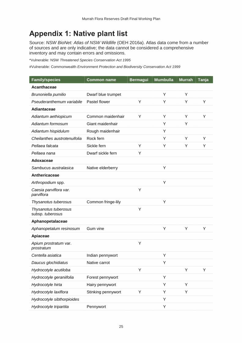
Murrah Flora Reserves Draft Final Working Plan
25
Appendix 1: Native plant list Source: NSW BioNet: Atlas of NSW Wildlife (OEH 2016a). Atlas data come from a number of sources and are only indicative; the data cannot be considered a comprehensive inventory and may contain errors and omissions.
*Vulnerable: NSW Threatened Species Conservation Act 1995
#Vulnerable: Commonwealth Environment Protection and Biodiversity Conservation Act 1999
Family/species Common name Bermagui Mumbulla Murrah Tanja
Acanthaceae
Brunoniella pumilio Dwarf blue trumpet Y Y
Pseuderanthemum variabile Pastel flower Y Y Y Y
Adiantaceae
Adiantum aethiopicum Common maidenhair Y Y Y Y
Adiantum formosum Giant maidenhair Y Y
Adiantum hispidulum Rough maidenhair Y
Cheilanthes austrotenuifolia Rock fern Y Y Y
Pellaea falcata Sickle fern Y Y Y Y
Pellaea nana Dwarf sickle fern Y
Adoxaceae
Sambucus australasica Native elderberry Y
Anthericaceae
Arthropodium spp. Y
Caesia parviflora var. parviflora
Y
Thysanotus tuberosus Common fringe-lily Y
Thysanotus tuberosus subsp. tuberosus
Y
Aphanopetalaceae
Aphanopetalum resinosum Gum vine Y Y Y
Apiaceae
Apium prostratum var. prostratum
Y
Centella asiatica Indian pennywort Y
Daucus glochidiatus Native carrot Y
Hydrocotyle acutiloba Y Y Y
Hydrocotyle geraniifolia Forest pennywort Y
Hydrocotyle hirta Hairy pennywort Y Y
Hydrocotyle laxiflora Stinking pennywort Y Y Y
Hydrocotyle sibthorpioides Y
Hydrocotyle tripartita Pennywort Y
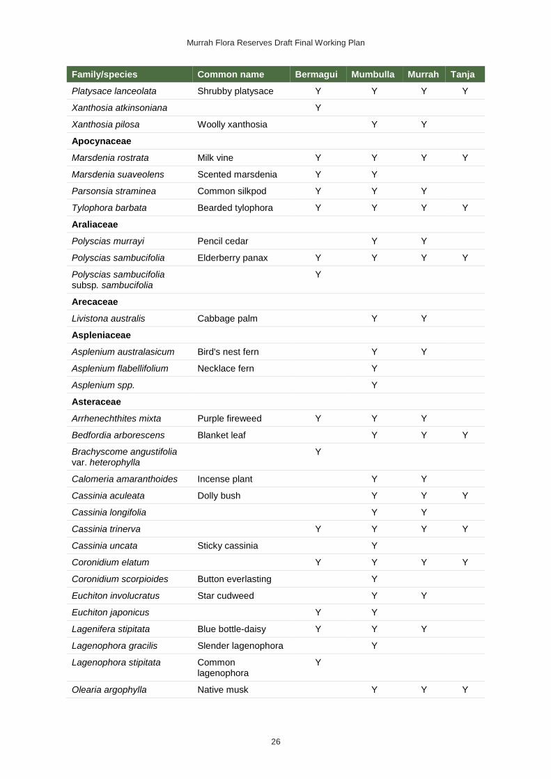
Murrah Flora Reserves Draft Final Working Plan
26
Family/species Common name Bermagui Mumbulla Murrah Tanja
Platysace lanceolata Shrubby platysace Y Y Y Y
Xanthosia atkinsoniana Y
Xanthosia pilosa Woolly xanthosia Y Y
Apocynaceae
Marsdenia rostrata Milk vine Y Y Y Y
Marsdenia suaveolens Scented marsdenia Y Y
Parsonsia straminea Common silkpod Y Y Y
Tylophora barbata Bearded tylophora Y Y Y Y
Araliaceae
Polyscias murrayi Pencil cedar Y Y
Polyscias sambucifolia Elderberry panax Y Y Y Y
Polyscias sambucifolia subsp. sambucifolia
Y
Arecaceae
Livistona australis Cabbage palm Y Y
Aspleniaceae
Asplenium australasicum Bird's nest fern Y Y
Asplenium flabellifolium Necklace fern Y
Asplenium spp. Y
Asteraceae
Arrhenechthites mixta Purple fireweed Y Y Y
Bedfordia arborescens Blanket leaf Y Y Y
Brachyscome angustifolia var. heterophylla
Y
Calomeria amaranthoides Incense plant Y Y
Cassinia aculeata Dolly bush Y Y Y
Cassinia longifolia Y Y
Cassinia trinerva Y Y Y Y
Cassinia uncata Sticky cassinia Y
Coronidium elatum Y Y Y Y
Coronidium scorpioides Button everlasting Y
Euchiton involucratus Star cudweed Y Y
Euchiton japonicus Y Y
Lagenifera stipitata Blue bottle-daisy Y Y Y
Lagenophora gracilis Slender lagenophora Y
Lagenophora stipitata Common lagenophora
Y
Olearia argophylla Native musk Y Y Y

Murrah Flora Reserves Draft Final Working Plan
27
Family/species Common name Bermagui Mumbulla Murrah Tanja
Olearia lirata Snowy daisy-bush Y
Olearia ramulosa Twiggy daisy-bush Y Y Y
Olearia spp. Y
Olearia stellulata Y Y Y
Olearia tomentosa Toothed daisy-bush Y Y Y
Ozothamnus argophyllus Y Y Y Y
Ozothamnus cuneifolius Wedge everlasting Y
Ozothamnus diosmifolius White dogwood Y Y Y Y
Ozothamnus ferrugineus Tree everlasting Y Y Y
Ozothamnus obcordatus Y
Ozothamnus obcordatus subsp. major
Grey everlasting Y
Picris angustifolia subsp. angustifolia
Y
Senecio bipinnatisectus Y
Senecio linearifolius Fireweed groundsel Y Y Y
Senecio minimus Y
Senecio prenanthoides Y
Senecio velleioides Y Y Y
Sigesbeckia orientalis subsp. orientalis
Indian weed Y Y Y
Vernonia cinerea var. cinerea
Y Y
Xerochrysum bracteatum Golden everlasting Y Y Y
Athyriaceae
Diplazium australe Austral lady fern Y
Bignoniaceae
Pandorea pandorana Wonga wonga vine Y Y Y Y
Blechnaceae
Blechnum cartilagineum Gristle fern Y Y Y
Blechnum nudum Fishbone water fern Y
Blechnum patersonii Strap water fern Y Y
Doodia aspera Prickly rasp fern Y Y Y Y
Boraginaceae
Austrocynoglossum latifolium
Y
Ehretia acuminata var. acuminata
Koda Y
Callitrichaceae

Murrah Flora Reserves Draft Final Working Plan
28
Family/species Common name Bermagui Mumbulla Murrah Tanja
Callitriche muelleri Y
Campanulaceae
Wahlenbergia gracilis Sprawling bluebell Y Y
Wahlenbergia littoricola Y
Wahlenbergia spp. Bluebell Y Y
Wahlenbergia stricta Tall bluebell Y
Wahlenbergia stricta subsp. stricta
Tall bluebell Y
Caryophyllaceae
Stellaria flaccida Y Y Y Y
Casuarinaceae
Allocasuarina littoralis Black she-oak Y Y Y Y
Allocasuarina spp. Y
Casuarina spp. Y
Chenopodiaceae
Sarcocornia quinqueflora subsp. quinqueflora
Y
Suaeda australis Y
Clusiaceae
Hypericum gramineum Small St John's wort Y Y
Hypericum japonicum Y
Colchicaceae
Burchardia umbellata Milkmaids Y
Convolvulaceae
Calystegia marginata Y
Dichondra repens Kidney weed Y Y Y Y
Wilsonia backhousei*Vulnerable Narrow-leafed wilsonia
Y
Cunoniaceae
Bauera rubioides River rose Y
Schizomeria ovata Crabapple Y
Cyatheaceae
Cyathea australis Rough treefern Y Y Y Y
Cyperaceae
Carex appressa Tall sedge Y Y
Carex longebrachiata Y Y Y
Carex polyantha Y
Cyperus lucidus Leafy flat sedge Y

Murrah Flora Reserves Draft Final Working Plan
29
Family/species Common name Bermagui Mumbulla Murrah Tanja
Eleocharis sphacelata Tall spike rush Y
Gahnia aspera Rough saw-sedge Y Y
Gahnia clarkei Tall saw-sedge Y Y Y
Gahnia melanocarpa Black fruit saw-sedge
Y Y Y Y
Gahnia radula Y Y
Gahnia sieberiana Red-fruit saw-sedge Y
Lepidosperma filiforme Y
Lepidosperma gunnii Y
Lepidosperma laterale Variable sword-sedge
Y Y Y Y
Lepidosperma neesii Y
Lepidosperma urophorum Y Y Y
Schoenus maschalinus Y
Schoenus melanostachys Y
Schoenus spp. Y
Davalliaceae
Arthropteris tenella Y
Rumohra adiantiformis Y
Dennstaedtiaceae
Dennstaedtia davallioides Lacy ground fern Y Y
Histiopteris incisa Bat's wing fern Y
Hypolepis glandulifera Downy ground fern Y
Hypolepis muelleri Harsh ground fern Y Y
Pteridium esculentum Bracken Y Y Y Y
Dicksoniaceae
Calochlaena dubia Rainbow fern Y Y Y Y
Dicksonia antarctica Soft tree fern Y Y
Dilleniaceae
Hibbertia aspera Rough guinea flower Y Y Y Y
Hibbertia dentata Twining guinea flower
Y Y Y
Hibbertia empetrifolia subsp. empetrifolia
Y Y Y
Hibbertia obtusifolia Hoary guinea flower Y Y
Droseraceae
Drosera auriculata Y Y
Dryopteridaceae
Lastreopsis acuminata Shiny shield fern Y

Murrah Flora Reserves Draft Final Working Plan
30
Family/species Common name Bermagui Mumbulla Murrah Tanja
Lastreopsis decomposita Trim shield fern Y
Lastreopsis microsora subsp. microsora
Creeping shield fern Y Y Y
Elaeocarpaceae
Elaeocarpus reticulatus Blueberry ash Y Y Y
Tetratheca thymifolia Black-eyed Susan Y Y Y Y
Ericaceae
Epacris impressa Common heath Y Y Y Y
Leucopogon juniperinus Prickly beard-heath Y Y Y
Leucopogon lanceolatus Y Y Y Y
Leucopogon lanceolatus var. lanceolatus
Y Y Y
Monotoca scoparia Y Y
Euphorbiaceae
Amperea xiphoclada Y Y
Amperea xiphoclada var. xiphoclada
Y
Beyeria lasiocarpa Y Y Y
Claoxylon australe Brittlewood Y Y Y
Homalanthus populifolius Y Y
Eupomatiaceae
Eupomatia laurina Bolwarra Y Y Y
Fabaceae (Caesalpinioideae)
Cassia spp. Y
Fabaceae (Faboideae)
Bossiaea obcordata Spiny bossiaea Y Y Y Y
Bossiaea prostrata Y
Bossiaea scolopendria Y
Daviesia mimosoides Y Y Y
Daviesia mimosoides subsp. mimosoides
Y Y Y
Daviesia spp. Y Y Y
Daviesia ulicifolia Gorse bitter pea Y Y Y
Desmodium gunnii Slender tick-trefoil Y Y
Desmodium varians Slender tick-trefoil Y Y Y
Glycine clandestina Twining glycine Y Y Y Y
Gompholobium latifolium Golden glory pea Y
Goodia lotifolia Y Y Y Y
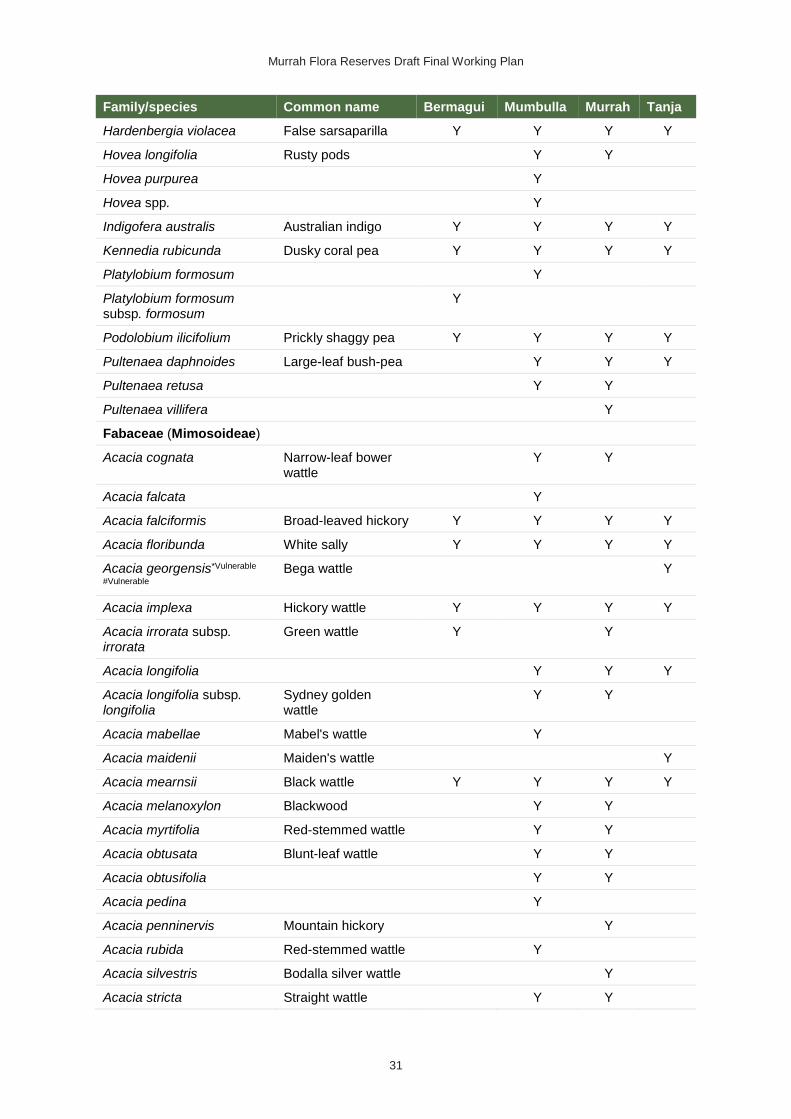
Murrah Flora Reserves Draft Final Working Plan
31
Family/species Common name Bermagui Mumbulla Murrah Tanja
Hardenbergia violacea False sarsaparilla Y Y Y Y
Hovea longifolia Rusty pods Y Y
Hovea purpurea Y
Hovea spp. Y
Indigofera australis Australian indigo Y Y Y Y
Kennedia rubicunda Dusky coral pea Y Y Y Y
Platylobium formosum Y
Platylobium formosum subsp. formosum
Y
Podolobium ilicifolium Prickly shaggy pea Y Y Y Y
Pultenaea daphnoides Large-leaf bush-pea Y Y Y
Pultenaea retusa Y Y
Pultenaea villifera Y
Fabaceae (Mimosoideae)
Acacia cognata Narrow-leaf bower wattle
Y Y
Acacia falcata Y
Acacia falciformis Broad-leaved hickory Y Y Y Y
Acacia floribunda White sally Y Y Y Y
Acacia georgensis*Vulnerable
#Vulnerable
Bega wattle Y
Acacia implexa Hickory wattle Y Y Y Y
Acacia irrorata subsp. irrorata
Green wattle Y Y
Acacia longifolia Y Y Y
Acacia longifolia subsp. longifolia
Sydney golden wattle
Y Y
Acacia mabellae Mabel's wattle Y
Acacia maidenii Maiden's wattle Y
Acacia mearnsii Black wattle Y Y Y Y
Acacia melanoxylon Blackwood Y Y
Acacia myrtifolia Red-stemmed wattle Y Y
Acacia obtusata Blunt-leaf wattle Y Y
Acacia obtusifolia Y Y
Acacia pedina Y
Acacia penninervis Mountain hickory Y
Acacia rubida Red-stemmed wattle Y
Acacia silvestris Bodalla silver wattle Y
Acacia stricta Straight wattle Y Y
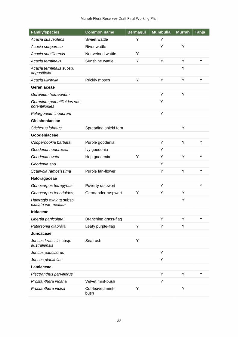
Murrah Flora Reserves Draft Final Working Plan
32
Family/species Common name Bermagui Mumbulla Murrah Tanja
Acacia suaveolens Sweet wattle Y Y
Acacia subporosa River wattle Y Y
Acacia subtilinervis Net-veined wattle Y
Acacia terminalis Sunshine wattle Y Y Y Y
Acacia terminalis subsp. angustifolia
Y
Acacia ulicifolia Prickly moses Y Y Y Y
Geraniaceae
Geranium homeanum Y Y
Geranium potentilloides var. potentilloides
Y
Pelargonium inodorum Y
Gleicheniaceae
Sticherus lobatus Spreading shield fern Y
Goodeniaceae
Coopernookia barbata Purple goodenia Y Y Y
Goodenia hederacea Ivy goodenia Y
Goodenia ovata Hop goodenia Y Y Y Y
Goodenia spp. Y
Scaevola ramosissima Purple fan-flower Y Y Y
Haloragaceae
Gonocarpus tetragynus Poverty raspwort Y Y
Gonocarpus teucrioides Germander raspwort Y Y Y
Haloragis exalata subsp. exalata var. exalata
Y
Iridaceae
Libertia paniculata Branching grass-flag Y Y Y
Patersonia glabrata Leafy purple-flag Y Y Y
Juncaceae
Juncus kraussii subsp. australiensis
Sea rush Y
Juncus pauciflorus Y
Juncus planifolius Y
Lamiaceae
Plectranthus parviflorus Y Y Y
Prostanthera incana Velvet mint-bush Y
Prostanthera incisa Cut-leaved mint-bush
Y Y

Murrah Flora Reserves Draft Final Working Plan
33
Family/species Common name Bermagui Mumbulla Murrah Tanja
Prostanthera lasianthos Victorian Christmas bush
Y Y Y
Prostanthera spp. Y Y
Scutellaria mollis Soft skullcap Y
Lauraceae
Cassytha pubescens Downy dodder-laurel Y Y Y Y
Lindsaeaceae
Lindsaea linearis Screw fern Y
Lindsaea microphylla Lacy wedge fern Y Y
Lobeliaceae
Pratia purpurascens Whiteroot Y Y Y Y
Loganiaceae
Logania albiflora Y
Logania pusilla Y Y Y
Mitrasacme polymorpha Y
Lomandraceae
Lomandra confertifolia Mat-rush Y
Lomandra confertifolia subsp. leptostachya
Y
Lomandra confertifolia subsp. rubiginosa
Y Y Y
Lomandra confertifolia subsp. similis
Y Y Y Y
Lomandra cylindrica Y Y
Lomandra filiformis Wattle matt-rush Y Y
Lomandra filiformis subsp. coriacea
Wattle matt-rush Y
Lomandra filiformis subsp. filiformis
Y
Lomandra filiformis subsp. flavior
Wattle matt-rush Y
Lomandra glauca Pale mat-rush Y Y
Lomandra longifolia Spiny-headed mat-rush
Y Y Y Y
Lomandra multiflora subsp. multiflora
Many-flowered mat-rush
Y Y Y Y
Loranthaceae
Amyema congener subsp. congener
Y Y Y
Amyema pendula Y Y Y
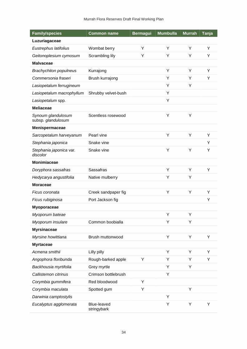
Murrah Flora Reserves Draft Final Working Plan
34
Family/species Common name Bermagui Mumbulla Murrah Tanja
Luzuriagaceae
Eustrephus latifolius Wombat berry Y Y Y Y
Geitonoplesium cymosum Scrambling lily Y Y Y Y
Malvaceae
Brachychiton populneus Kurrajong Y Y Y
Commersonia fraseri Brush kurrajong Y Y Y
Lasiopetalum ferrugineum Y Y
Lasiopetalum macrophyllum Shrubby velvet-bush Y
Lasiopetalum spp. Y
Meliaceae
Synoum glandulosum subsp. glandulosum
Scentless rosewood Y Y
Menispermaceae
Sarcopetalum harveyanum Pearl vine Y Y Y
Stephania japonica Snake vine Y
Stephania japonica var. discolor
Snake vine Y Y Y
Monimiaceae
Doryphora sassafras Sassafras Y Y Y
Hedycarya angustifolia Native mulberry Y Y
Moraceae
Ficus coronata Creek sandpaper fig Y Y Y
Ficus rubiginosa Port Jackson fig Y
Myoporaceae
Myoporum bateae Y Y
Myoporum insulare Common boobialla Y Y
Myrsinaceae
Myrsine howittiana Brush muttonwood Y Y Y
Myrtaceae
Acmena smithii Lilly pilly Y Y Y
Angophora floribunda Rough-barked apple Y Y Y Y
Backhousia myrtifolia Grey myrtle Y Y
Callistemon citrinus Crimson bottlebrush Y
Corymbia gummifera Red bloodwood Y
Corymbia maculata Spotted gum Y Y
Darwinia camptostylis Y
Eucalyptus agglomerata Blue-leaved stringybark
Y Y Y

Murrah Flora Reserves Draft Final Working Plan
35
Family/species Common name Bermagui Mumbulla Murrah Tanja
Eucalyptus baueriana Blue box Y Y Y Y
Eucalyptus bosistoana Coast grey box Y Y Y
Eucalyptus botryoides Bangalay Y Y Y
Eucalyptus cypellocarpa Monkey gum Y Y Y Y
Eucalyptus elata River peppermint Y Y Y
Eucalyptus globoidea White stringybark Y Y Y Y
Eucalyptus longifolia Woollybutt Y Y Y Y
Eucalyptus maidenii Maiden's gum Y
Eucalyptus muelleriana Yellow stringybark Y Y Y Y
Eucalyptus pilularis Blackbutt Y
Eucalyptus pseudoglobulus Bastard eurabbie Y
Eucalyptus radiata subsp. radiata
Y Y
Eucalyptus sieberi Silvertop ash Y Y Y Y
Eucalyptus smithii Ironbark peppermint Y Y Y
Eucalyptus spp. Y Y Y
Eucalyptus tereticornis Forest red gum Y
Eucalyptus tricarpa Y Y Y Y
Kunzea ambigua Tick bush Y
Leptospermum continentale Prickly tea-tree Y
Leptospermum emarginatum
Twin-flower tea-tree Y
Leptospermum juniperinum Prickly tea-tree Y
Leptospermum polygalifolium subsp. polygalifolium
Y
Leptospermum trinervium Slender tea-tree Y Y Y
Melaleuca ericifolia Swamp paperbark Y
Melaleuca squarrosa Scented paperbark Y
Sannantha pluriflora Y Y
Tristaniopsis collina Mountain water gum Y
Tristaniopsis laurina Kanooka Y Y
Oleaceae
Notelaea venosa Veined mock-olive Y Y Y Y
Orchidaceae
Acianthus exsertus Mosquito orchid Y
Calochilus paludosus Red beard orchid Y
Cymbidium suave Snake orchid Y Y Y
Dendrobium pugioniforme Dagger orchid Y

Murrah Flora Reserves Draft Final Working Plan
36
Family/species Common name Bermagui Mumbulla Murrah Tanja
Dendrobium speciosum Rock lily Y Y Y
Dipodium punctatum Y
Dipodium variegatum Y
Plectorrhiza tridentata Tangle orchid Y Y
Pterostylis parviflora Tiny greenhood Y
Sarcochilus australis Butterfly orchid Y
Sarcochilus falcatus Orange blossom orchid
Y
Sarcochilus parviflorus Lawyer orchid Y
Thelymitra ixioides var. ixioides
Dotted sun orchid Y
Oxalidaceae
Oxalis chnoodes Y
Oxalis exilis Y Y
Oxalis perennans Y Y
Oxalis spp. Y Y
Passifloraceae
Passiflora cinnabarina Red passionfruit Y Y
Phormiaceae
Dianella caerulea Blue flax-lily Y Y Y Y
Dianella caerulea var. caerulea
Y Y Y
Dianella revoluta Blueberry lily Y Y
Dianella revoluta var. revoluta
A blue flax lily Y
Stypandra glauca Nodding blue lily Y Y
Phyllanthaceae
Breynia oblongifolia Coffee bush Y Y Y
Phyllanthus gunnii Y Y Y
Phyllanthus hirtellus Thyme spurge Y
Poranthera microphylla Small poranthera Y Y
Pittosporaceae
Billardiera scandens Hairy apple berry Y Y Y Y
Bursaria spinosa Native blackthorn Y Y Y
Bursaria spinosa subsp. lasiophylla
Native blackthorn Y
Pittosporum multiflorum Orange thorn Y Y
Pittosporum revolutum Rough fruit pittosporum
Y Y Y Y

Murrah Flora Reserves Draft Final Working Plan
37
Family/species Common name Bermagui Mumbulla Murrah Tanja
Pittosporum undulatum Sweet pittosporum Y Y Y Y
Rhytidosporum procumbens
Y Y
Plantaginaceae
Plantago debilis Shade plantain Y
Veronica calycina Hairy speedwell Y
Veronica notabilis Forest speedwell Y
Veronica plebeia Trailing speedwell Y Y
Plumbaginaceae
Limonium australe Native sea lavender Y
Poaceae
Anisopogon avenaceus Oat speargrass Y
Austrostipa pubescens Y
Austrostipa stipoides Coast spear-grass Y
Austrostipa verticillata Slender bamboo grass
Y
Cymbopogon refractus Barbed wire grass Y
Deyeuxia monticola var. monticola
Y
Dichelachne micrantha Shorthair plumegrass
Y
Dichelachne rara Y Y
Echinopogon caespitosus Bushy hedgehog-grass
Y
Echinopogon ovatus Forest hedgehog grass
Y Y
Entolasia marginata Bordered panic Y Y Y
Entolasia stricta Wiry panic Y Y Y
Hierochloe rariflora Scented holygrass Y
Imperata cylindrica Blady grass Y Y
Microlaena stipoides Weeping grass Y Y Y
Microlaena stipoides var. stipoides
Weeping grass Y Y Y
Oplismenus aemulus Y
Oplismenus imbecillis Y Y Y Y
Panicum simile Two-colour panic Y
Poa affinis Y
Poa ensiformis Purple-sheathed tussock-grass
Y Y Y
Poa labillardierei var. labillardierei
Tussock Y Y Y Y

Murrah Flora Reserves Draft Final Working Plan
38
Family/species Common name Bermagui Mumbulla Murrah Tanja
Poa meionectes Y Y Y Y
Poa sieberiana var. sieberiana
Snowgrass Y
Poa tenera Slender tussock-grass
Y
Rytidosperma longifolium Long-leaved wallaby grass
Y Y
Rytidosperma pallidum Silvertop wallaby grass
Y Y Y Y
Rytidosperma pilosum Smooth-flowered Wallaby grass
Y Y
Rytidosperma racemosum Wallaby grass Y
Sporobolus virginicus Y
Tetrarrhena juncea Wiry ricegrass Y Y
Themeda triandra Y Y Y Y
Zoysia macrantha Prickly couch Y
Polygalaceae
Comesperma volubile Y Y
Polygonaceae
Rumex brownii Swamp dock Y
Polypodiaceae
Microsorum pustulatum Kangaroo fern Y
Microsorum scandens Fragrant fern Y Y
Pyrrosia rupestris Rock felt fern Y Y Y
Proteaceae
Banksia serrata Old-man banksia Y Y
Banksia spinulosa var. spinulosa
Y Y
Hakea eriantha Y
Hakea macraeana Willow needlewood Y Y Y
Hakea sericea Needlebush Y
Hakea spp. Y
Lomatia ilicifolia Holly lomatia Y Y Y
Lomatia myricoides River lomatia Y Y
Persoonia linearis Narrow-leaved geebung
Y Y Y Y
Pteridaceae
Cheilanthes sieberi subsp. sieberi
Rock fern Y
Pteris tremula Tender brake Y Y

Murrah Flora Reserves Draft Final Working Plan
39
Family/species Common name Bermagui Mumbulla Murrah Tanja
Pteris umbrosa Jungle brake Y
Ranunculaceae
Clematis aristata Old man's beard Y Y Y
Clematis glycinoides Headache vine Y Y Y Y
Clematis glycinoides var. glycinoides
Y Y
Ranunculus plebeius Forest buttercup Y
Rhamnaceae
Pomaderris aspera Hazel pomaderris Y Y Y
Pomaderris cinerea Y Y Y
Pomaderris elliptica subsp. elliptica
Y Y Y
Pomaderris ferruginea Y Y Y
Pomaderris intermedia Y
Pomaderris lanigera Woolly pomaderris Y Y
Pomaderris ligustrina Privet pomaderris Y
Ripogonaceae
Ripogonum album White supplejack Y Y
Rosaceae
Acaena novae-zelandiae Bidgee-widgee Y
Rubus moluccanus var. trilobus
Molucca bramble Y Y
Rubus parvifolius Native raspberry Y Y Y Y
Rubus rosifolius Rose-leaf bramble Y Y Y Y
Rubiaceae
Coprosma quadrifida Prickly currant bush Y Y Y Y
Galium binifolium Y Y
Galium leiocarpum Y Y
Galium liratum Y
Morinda jasminoides Sweet morinda Y Y Y Y
Opercularia aspera Coarse stinkweed Y Y
Opercularia diphylla Stinkweed Y
Opercularia hispida Hairy stinkweed Y
Opercularia varia Variable stinkweed Y Y Y
Pomax umbellata Pomax Y Y Y
Psychotria loniceroides Hairy psychotria Y Y Y
Rutaceae
Acronychia oblongifolia White aspen Y Y Y

Murrah Flora Reserves Draft Final Working Plan
40
Family/species Common name Bermagui Mumbulla Murrah Tanja
Correa baeuerlenii*Vulnerable
#Vulnerable
Chef's cap correa Y Y
Correa reflexa Native fuschia Y Y Y Y
Correa reflexa var. reflexa Native fuschia Y Y Y
Crowea exalata subsp. exalata
Y Y
Leionema carruthersii Y
Leionema coxii Y
Philotheca trachyphylla Rock waxflower Y Y Y
Zieria smithii Sandfly zieria Y Y Y
Santalaceae
Exocarpos cupressiformis Cherry ballart Y Y Y
Exocarpos strictus Dwarf cherry Y Y Y
Leptomeria acida Sour currant bush Y
Santalum obtusifolium Sandalwood Y
Sapindaceae
Alectryon subcinereus Wild quince Y Y
Dodonaea triquetra Large-leaf hop-bush Y Y Y Y
Dodonaea truncatiales Angular hop-bush Y Y
Scrophulariaceae
Gratiola peruviana Australian brooklime Y
Smilacaceae
Smilax australis Lawyer vine Y Y Y Y
Solanaceae
Solanum aviculare Kangaroo apple Y Y Y
Solanum brownii Violet nightshade Y
Solanum prinophyllum Forest nightshade Y Y Y
Solanum pungetium Eastern nightshade Y Y Y
Solanum stelligerum Devil's needles Y Y
Symplocaceae
Symplocos thwaitesii Buff hazelwood Y
Thymelaeaceae
Pimelea axiflora Y Y Y
Pimelea axiflora subsp. axiflora
Y Y Y
Pimelea linifolia subsp. linifolia
Y Y

Murrah Flora Reserves Draft Final Working Plan
41
Family/species Common name Bermagui Mumbulla Murrah Tanja
Ulmaceae
Trema tomentosa var. aspera
Native peach Y Y Y
Urticaceae
Dendrocnide excelsa Giant stinging tree Y
Urtica incisa Stinging nettle Y Y
Uvulariaceae
Schelhammera undulata Y Y Y Y
Violaceae
Melicytus dentatus Tree violet Y Y
Viola banksii Y Y
Viola hederacea Ivy-leaved violet Y Y Y
Vitaceae
Cissus antarctica Water vine Y
Cissus hypoglauca Giant water vine Y Y Y
Xanthorrhoeaceae
Xanthorrhoea concava Y Y Y
Xanthorrhoea resinosa Y Y Y Y
Zamiaceae
Macrozamia communis Burrawang Y Y Y
Zosteraceae
Zostera muelleri subsp. capricorni
Y
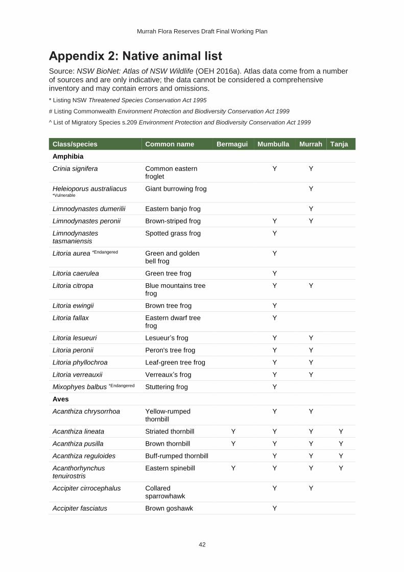
Murrah Flora Reserves Draft Final Working Plan
42
Appendix 2: Native animal list Source: NSW BioNet: Atlas of NSW Wildlife (OEH 2016a). Atlas data come from a number of sources and are only indicative; the data cannot be considered a comprehensive inventory and may contain errors and omissions.
* Listing NSW Threatened Species Conservation Act 1995
# Listing Commonwealth Environment Protection and Biodiversity Conservation Act 1999
^ List of Migratory Species s.209 Environment Protection and Biodiversity Conservation Act 1999
Class/species Common name Bermagui Mumbulla Murrah Tanja
Amphibia
Crinia signifera Common eastern froglet
Y Y
Heleioporus australiacus *Vulnerable
Giant burrowing frog Y
Limnodynastes dumerilii Eastern banjo frog Y
Limnodynastes peronii Brown-striped frog Y Y
Limnodynastes tasmaniensis
Spotted grass frog Y
Litoria aurea *Endangered Green and golden bell frog
Y
Litoria caerulea Green tree frog Y
Litoria citropa Blue mountains tree frog
Y Y
Litoria ewingii Brown tree frog Y
Litoria fallax Eastern dwarf tree frog
Y
Litoria lesueuri Lesueur’s frog Y Y
Litoria peronii Peron's tree frog Y Y
Litoria phyllochroa Leaf-green tree frog Y Y
Litoria verreauxii Verreaux’s frog Y Y
Mixophyes balbus *Endangered Stuttering frog Y
Aves
Acanthiza chrysorrhoa Yellow-rumped thornbill
Y Y
Acanthiza lineata Striated thornbill Y Y Y Y
Acanthiza pusilla Brown thornbill Y Y Y Y
Acanthiza reguloides Buff-rumped thornbill Y Y Y
Acanthorhynchus tenuirostris
Eastern spinebill Y Y Y Y
Accipiter cirrocephalus Collared sparrowhawk
Y Y
Accipiter fasciatus Brown goshawk Y

Murrah Flora Reserves Draft Final Working Plan
43
Class/species Common name Bermagui Mumbulla Murrah Tanja
Aegotheles cristatus Australian owlet-nightjar
Y Y Y
Alisterus scapularis Australian king-parrot
Y Y Y
Anas castanea Chestnut teal Y
Anthochaera carunculata Red wattlebird Y Y Y
Anthochaera phrygia *Critically
endangered #Critically endangered
Regent honeyeater Y
Aquila audax Wedge-tailed eagle Y Y Y
Ardea ibis^ Cattle egret Y
Artamus cyanopterus *Vulnerable
Dusky woodswallow Y Y
Cacatua galerita Sulphur-crested cockatoo
Y
Cacomantis flabelliformis Fan-tailed cuckoo Y Y Y Y
Cacomantis variolosus Brush cuckoo Y Y
Caligavis chrysops Yellow-faced honeyeater
Y Y Y Y
Callocephalon fimbriatum *Vulnerable
Gang-gang cockatoo Y Y Y
Calyptorhynchus funereus Yellow-tailed black-cockatoo
Y
Calyptorhynchus lathami *Vulnerable
Glossy black-cockatoo
Y Y
Chalcites basalis Horsfield’s bronze-cuckoo
Y
Chalcites lucidus Shining bronze-cuckoo
Y Y Y
Chenonetta jubata Australian wood duck
Y
Chroicocephalus novaehollandiae
Silver gull Y
Cinclosoma punctatum Spotted quail-thrush Y Y
Climacteris erythrops Red-browed treecreeper
Y Y
Climacteris picumnus victoriae *Vulnerable
Brown treecreeper (eastern subspecies)
Y
Colluricincla harmonica Grey shrike-thrush Y Y Y
Coracina novaehollandiae Black-faced cuckoo-shrike
Y Y Y
Coracina papuensis White-bellied cuckoo-shrike
Y Y
Coracina tenuirostris Cicadabird Y Y

Murrah Flora Reserves Draft Final Working Plan
44
Class/species Common name Bermagui Mumbulla Murrah Tanja
Cormobates leucophaea White-throated treecreeper
Y Y Y Y
Corvus coronoides Australian raven Y Y Y
Cracticus torquatus Grey butcherbird Y Y
Dacelo novaeguineae Laughing kookaburra Y Y Y
Daphoenositta chrysoptera *Vulnerable
Varied sittella Y Y Y
Dicaeum hirundinaceum Mistletoebird Y Y Y
Eopsaltria australis Eastern yellow robin Y Y Y Y
Eurostopodus mystacalis White-throated nightjar
Y Y Y
Falco peregrinus Peregrine falcon Y
Falcunculus frontatus frontatus
Eastern shrike-tit Y Y
Gallinago hardwickii^ Latham's snipe Y
Gerygone mouki Brown gerygone Y Y Y
Glossopsitta pusilla *Vulnerable Little lorikeet Y
Grallina cyanoleuca Magpie-lark Y
Haliaeetus leucogaster^ White-bellied sea-eagle
Y Y
Haliastur sphenurus Whistling kite Y Y
Hieraaetus morphnoides *Vulnerable
Little eagle Y
Hirundapus caudacutus^ White-throated needletail
Y Y
Hirundo neoxena Welcome swallow Y Y
Leucosarcia melanoleuca Wonga pigeon Y Y Y Y
Lophoictinia isura *Vulnerable Square-tailed kite Y
Macropygia amboinensis Brown cuckoo-dove Y Y
Malurus cyaneus Superb fairy-wren Y Y Y
Manorina melanophrys Bell miner Y Y Y
Meliphaga lewinii Lewin's honeyeater Y Y Y
Melithreptus brevirostris Brown-headed honeyeater
Y Y Y
Melithreptus lunatus White-naped honeyeater
Y Y Y Y
Menura novaehollandiae Superb lyrebird Y Y Y Y
Microcarbo melanoleucos Little pied cormorant Y
Microeca fascinans Jacky winter Y Y
Monarcha melanopsis Black-faced monarch Y Y Y Y
Myiagra cyanoleuca Satin flycatcher Y

Murrah Flora Reserves Draft Final Working Plan
45
Class/species Common name Bermagui Mumbulla Murrah Tanja
Myiagra rubecula Leaden flycatcher Y Y Y
Neochmia temporalis Red-browed finch Y Y Y Y
Nesoptilotis leucotis White-eared honeyeater
Y Y
Ninox novaeseelandiae Southern boobook Y Y Y
Ninox strenua *Vulnerable Powerful owl Y Y Y
Nycticorax caledonicus Nankeen night heron Y
Oriolus sagittatus Olive-backed oriole Y Y Y
Pachycephala pectoralis Golden whistler Y Y Y Y
Pachycephala rufiventris Rufous whistler Y Y Y
Pardalotus punctatus Spotted pardalote Y Y Y
Pardalotus striatus Striated pardalote Y Y Y
Petrochelidon ariel Fairy martin Y Y
Petrochelidon nigricans Tree martin Y
Petroica boodang *Vulnerable Scarlet robin Y Y Y
Petroica phoenicea *Vulnerable Flame robin Y
Petroica rosea Rose robin Y Y Y
Phaps elegans Brush bronzewing Y
Philemon corniculatus Noisy friarbird Y Y
Phylidonyris novaehollandiae
New Holland honeyeater
Y Y Y
Phylidonyris pyrrhoptera Crescent honeyeater Y Y Y Y
Platycercus elegans Crimson rosella Y Y Y
Podargus strigoides Tawny frogmouth Y Y
Psophodes olivaceus Eastern whipbird Y Y Y
Ptilonorhynchus violaceus Satin bowerbird Y Y Y
Pycnoptilus floccosus Pilotbird Y Y
Rhipidura albiscapa Grey fantail Y Y Y Y
Rhipidura rufifrons Rufous fantail Y Y Y
Sericornis frontalis White-browed scrubwren
Y Y Y Y
Sericornis magnirostra Large-billed scrubwren
Y Y
Sericulus chrysocephalus Regent bowerbird Y
Smicrornis brevirostris Weebill Y
Strepera graculina Pied currawong Y Y Y
Todiramphus sanctus Sacred kingfisher Y Y Y
Trichoglossus haematodus Rainbow lorikeet Y Y
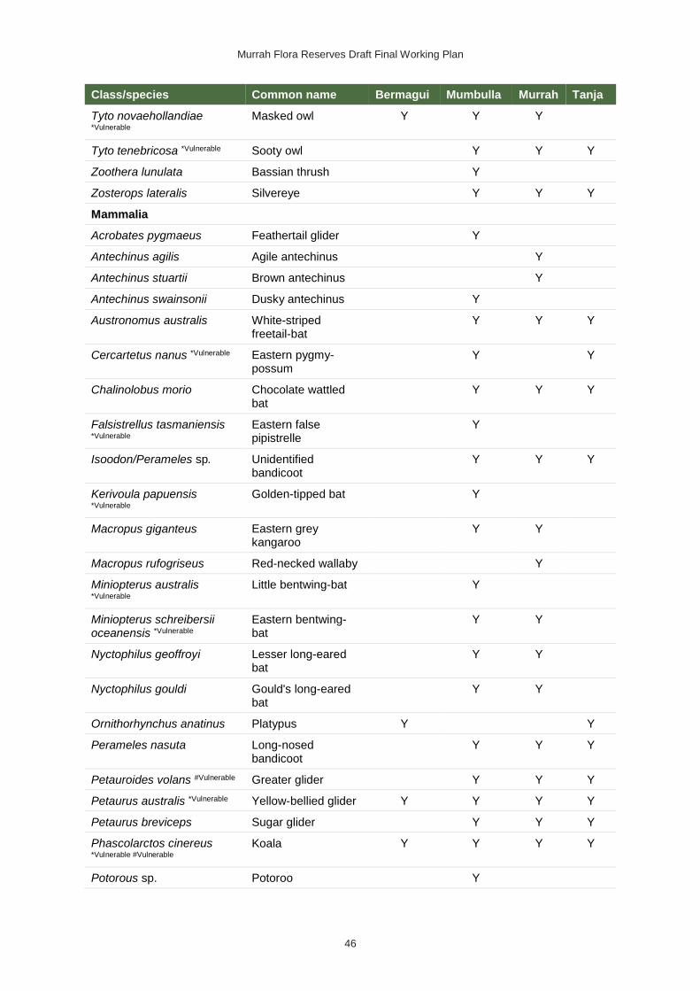
Murrah Flora Reserves Draft Final Working Plan
46
Class/species Common name Bermagui Mumbulla Murrah Tanja
Tyto novaehollandiae *Vulnerable
Masked owl Y Y Y
Tyto tenebricosa *Vulnerable Sooty owl Y Y Y
Zoothera lunulata Bassian thrush Y
Zosterops lateralis Silvereye Y Y Y
Mammalia
Acrobates pygmaeus Feathertail glider Y
Antechinus agilis Agile antechinus Y
Antechinus stuartii Brown antechinus Y
Antechinus swainsonii Dusky antechinus Y
Austronomus australis White-striped freetail-bat
Y Y Y
Cercartetus nanus *Vulnerable Eastern pygmy-possum
Y Y
Chalinolobus morio Chocolate wattled bat
Y Y Y
Falsistrellus tasmaniensis *Vulnerable
Eastern false pipistrelle
Y
Isoodon/Perameles sp. Unidentified bandicoot
Y Y Y
Kerivoula papuensis *Vulnerable
Golden-tipped bat Y
Macropus giganteus Eastern grey kangaroo
Y Y
Macropus rufogriseus Red-necked wallaby Y
Miniopterus australis *Vulnerable
Little bentwing-bat Y
Miniopterus schreibersii oceanensis *Vulnerable
Eastern bentwing-bat
Y Y
Nyctophilus geoffroyi Lesser long-eared bat
Y Y
Nyctophilus gouldi Gould's long-eared bat
Y Y
Ornithorhynchus anatinus Platypus Y Y
Perameles nasuta Long-nosed bandicoot
Y Y Y
Petauroides volans #Vulnerable Greater glider Y Y Y
Petaurus australis *Vulnerable Yellow-bellied glider Y Y Y Y
Petaurus breviceps Sugar glider Y Y Y
Phascolarctos cinereus *Vulnerable #Vulnerable
Koala Y Y Y Y
Potorous sp. Potoroo Y

Murrah Flora Reserves Draft Final Working Plan
47
Class/species Common name Bermagui Mumbulla Murrah Tanja
Potorous tridactylus *Vulnerable
#Vulnerable
Long-nosed potoroo Y Y
Pseudocheirus peregrinus Common ringtail possum
Y Y Y
Pteropus sp. Flying-fox Y Y Y
Rattus fuscipes Bush rat Y Y
Rattus lutreolus Swamp rat Y Y
Rhinolophus megaphyllus Eastern horseshoe-bat
Y Y
Scoteanax rueppellii *Vulnerable
Greater broad-nosed bat
Y
Scotorepens orion Eastern broad-nosed bat
Y
Sminthopsis crassicaudata Fat-tailed dunnart Y
Sminthopsis leucopus *Vulnerable
White-footed dunnart Y
Tachyglossus aculeatus Short-beaked echidna
Y Y
Trichosurus sp. Brushtail possum Y Y Y
Trichosurus vulpecula Common brushtail possum
Y Y Y
Vespadelus darlingtoni Large forest bat Y
Vespadelus regulus Southern forest bat Y
Vespadelus vulturnus Little forest bat Y Y Y
Vombatus ursinus Common wombat Y Y
Wallabia bicolor Swamp wallaby Y Y
Reptilia
Acanthophis antarcticus Common death adder
Y Y
Acritoscincus platynota Red-throated skink Y
Amphibolurus muricatus Jacky lizard Y
Cryptophis nigrescens Eastern small-eyed snake
Y
Drysdalia rhodogaster Mustard-bellied snake
Y Y
Egernia saxatilis Black rock skink Y
Egernia saxatilis intermedia Y
Eulamprus heatwolei Yellow-bellied water-skink
Y
Eulamprus tenuis Barred-sided skink Y
Intellagama lesueurii howitti Gippsland water dragon
Y

Murrah Flora Reserves Draft Final Working Plan
48
Class/species Common name Bermagui Mumbulla Murrah Tanja
Lampropholis delicata Dark-flecked garden sunskink
Y
Lampropholis guichenoti Pale-flecked garden sunskink
Y
Notechis scutatus Tiger snake Y
Saproscincus mustelinus Weasel skink Y
Tiliqua scincoides Eastern blue-tongue Y Y
Varanus varius Lace monitor Y

Murrah Flora Reserves Draft Final Working Plan
49
Appendix 3: Named vehicle trails, bicycle and horse access, and maintenance of roads and trails
Roads and trails Length (km)
Capacity / Class Access category
Horse Bicycle
Tanja Flora Reserve
Goats Knob Road Cat 7 Essential Public Yes Yes
Quarry Road Cat 7 Essential Public Yes Yes
Reedy Swamp Road Cat 1 Important Public Yes Yes
Vimy Ridge Road Cat 1 and 7 Imp. Public Yes Yes
Mumbulla Flora Reserve
Mumbulla Creek Road Cat 1 Essential Public Yes Yes
Gugunyal (Mumbulla Trig) Road
Cat 1 Essential Public and Management
No No
Clarks Road Cat 1 Essential Management No No
Doctor George Fire Trail Cat 7 Important Public Yes Yes
Warlands Road Dormant Not classified Yes Yes
Tea Ridge Road Cat 1 Essential Public Yes Yes
Lizard Road Cat 1 Essential Public Yes Yes
Smiths Road Cat 1 Important Public Yes Yes
Knights Creek Road Cat 1 Essential Public Yes Yes
Benny Gowings Road Cat 1 Important Public Yes Yes
Whittles Road Cat 1 Important Public Yes Yes
Nobby Trail Dormant Public Yes Yes
Bumble Trail Cat 9 Important Management Yes Yes
Conquestron Trail Cat 9 Important Management Yes Yes
Caldecots Link Cat 9 Important Management Yes Yes
Bunga Pinch Road Cat 1 Important Public Yes Yes
Bunga Pinch Fire Trail Cat 7 Important Public Yes Yes
Mountain Trail Cat 7 Important Public Yes Yes
Ridge Trail Cat 1 Important Public Yes Yes
Brockelos Trail Cat 1 Important Public Yes Yes
Williams Trail Cat 9 Important Management Yes Yes
Back River Road Cat 1 Essential Public Yes Yes
Wyuna Trail Dormant Closed No No
Darby Trail Cat 7 Important Management Yes Yes
Murrah Flora Reserve
Murrah River Road Cat 1 Essential Public Yes Yes

Murrah Flora Reserves Draft Final Working Plan
50
Roads and trails Length (km)
Capacity / Class Access category
Horse Bicycle
Horse Head Road Cat 7 Important Public Yes Yes
Honeymoon Ridge Road Cat 7 Important Public Yes Yes
Honeymoon Fire Trail Cat 7 Essential Public Yes Yes
Number One Trail Cat 9 Important Management Yes Yes
Number Two Trail Dormant Management Yes Yes
Number Three Trail Cat 9 Important Management Yes Yes
Number Four Trail Dormant Management Yes Yes
Number Five Trail Dormant Management Yes Yes
Number Six Trail Dormant Management Yes Yes
Number Seven Trail Cat 7 Important Management Yes Yes
Number Eight Trail Dormant Management Yes Yes
Correa Road Dormant Management Yes Yes
Chefs Hat Road Cat 7 Important Public Yes Yes
Cuttagee Creek Track Cat 9 Important Management Yes Yes
Clearwaters Road Cat 7 Important Public Yes Yes
Tradewinds Road Cat 7 Important Public Yes Yes
Tranquility Road Cat 7 Important Public Yes Yes
Four Winds Drive Cat 9 Important Public Yes Yes
Bermagui Flora Reserve
Nutleys Creek Road Cat 1 Essential Public Yes Yes
Alexander Drive Cat 1 Essential Public Yes Yes
Black Marlin Drive Cat 1 Essential Public Yes Yes
River Road Cat 1 Important Public Yes Yes
Pigs Crossing Road Cat 1 Important Public Yes Yes
Freds Trail Cat 9 Important Management Yes Yes
Dusky Ridge or Barret’s Trail
Cat 7 Important Public Yes Yes
Mangans Creek Road Cat 1 Important Public Yes Yes
Home Farm Trail Cat 9 Important Public Yes Yes
For explanation of fire trail category and carrying capacity classifications see:
Bush Fire Coordinating Committee Policy No. 1/2003 – Fire Trails

Murrah Flora Reserves Draft Final Working Plan
51
Appendix 4: Works program action list
No. Proposed actions Priority
1 Koala survey and monitoring
Refine and deliver a scientifically designed and robust koala monitoring and research program building on past success.
The monitoring of koala distribution and occupancy rates will continue with a minimum of 80 grid sites reassessed annually. Data analysis comparing the results derived from these surveys with those from previous surveys will be undertaken using the ikoala data management tool developed by the University of Canberra.
All fresh pellet and tissue samples opportunistically collected will be provided to the Koala Health Hub (University of Sydney) to assist research into the genetics and disease status of the population.
1
2 Koala habitat rehabilitation
Develop small-scale rehabilitation trials for areas dominated by thick Allocasuarina and other regrowth that would appear to be restricting koala feed species regeneration.
Apply the most successful rehabilitation methods to larger areas and monitor the outcomes.
1
3 Fire management
Deliver, monitor and evaluate the Murrah components of the landscape fire management strategy with an emphasis on fuel management approaches that do not potentially limit the koala population’s recovery.
Undertake planned hazard reduction and fire suppression operations as necessary, in consultation with the koala monitoring project manager and Biamanga National Park Board of Management.
1
4 Aboriginal involvement
Engage with the Aboriginal community via the Biamanga National Park Board of Management and the Bega and Merrimans local Aboriginal land councils to enable their involvement in cultural land management practices including ‘on Country’ activities.
Initiate and support the production of an oral history of Aboriginal involvement in the south-east forests timber industry and traditional land management.
Establish integration with adjoining Biamanga National Park and other Aboriginal land conservation management programs.
Provide preferential tendering to Aboriginal organisations for delivery of culturally relevant projects.
1
5 Pest management
Continue management of the reserves in accordance with legislative requirements, NPWS guidelines and the regional pest management plan, with an emphasis on the recurrent wild dog control program.
1
6 Community involvement
Invite community engagement and feedback on the management of the Murrah Flora Reserves and investigate further opportunities for volunteer work, particularly for koala survey and monitoring programs.
2

Murrah Flora Reserves Draft Final Working Plan
52
No. Proposed actions Priority
7 Roads
Complete the assessment of roads to determine those roads essential for management or needed for public and neighbour access, and the standard to which they should be maintained.
Assess road closures for potential non-motorised recreational use.
Maintain the roads, trails and associated infrastructure to the agreed standards.
Ensure quarry sources meet legislative and policy requirements.
2
8 Encroachment issues
Produce an inventory of encroachment issues, their status, their priority and approach, required management action and timetable to resolution.
2
9 Monitoring and reporting, plan review and adaption
Produce an MER sub plan to provide a single source for monitoring, reporting and adaption of the working plan’s actions.
Concisely summarise and aggregate annually the outcomes from the actions.
Implement a five-year review cycle with intermediate updates allowed when new and significant information arises. All such reviews will include a synthesis of outcomes and reporting from this plan and stakeholder consultation.
2
10 Assets and infrastructure
Develop an infrastructure register for the reserves and append it to this working plan at the next review.
Investigate and seek external funding for the development of suitable minor recreational nodes in high-use areas, such as at river locations.
2
11 Ecological knowledge
Opportunistically undertake native animal and plant and vegetation community surveys and assessments of the reserves, prioritising threatened entities. Update the species list in this working plan at the next review cycle.
3
12 Documentation of FCNSW and BVSC user agreements
Produce an inventory of user agreements, their status and renewal / replacement requirements.
3


